Embed Size (px)
Citation preview
N. Apache Trail
#58
#56
#56
#56
#53
#57
Park Boundary Fence
22
23
2426
25
27
29
3234
3331
14
28
30
15
1197 5
31
10
86
4 2
201917
16
21
18
#58
#53
#56
35
36
37
38
39 40
41 43
44 45
47
46
49
48
51
50
53
52
55
54
57
56
58 60
62
64 61
63
65
67
42
NativePlantTrail
DiscoveryInterpretive
Trail
59
70
71 72
Apache
Junction
To Campground
Canyon
Lake
Please RecycleMap not to scale
SaguaroDay Use
ChollaDay Use
Group UseCampground
Siphon DrawTrailhead
Jacob’s Crosscut Trail(.85 mi.)
Treasure Loop Trail(2.4 mi.)
Prospector’s View Trail(.7 mi.)
TontoNationalForest
To FirstWater Road
(1 mi.)
To BroadwayTrailhead(4.5 mi.)
(2 mi. to Basin)(3 mi. to Flatiron)
SiphonDraw Trail
PaloVerde
107108
109110
112 116
111113 114
115117
118
119
120
122
121
124126131133134
130132
106
128127125 123129
HostOverflow
LegendRanger StationRest RoomsWater TapParkingShowersDump StationAmphitheaterGroup Camp
Group Ramada
Mtn. Bike Trail
Hiking Trail
(Reservable)
(Reservable)
(4 Mile Loop)
RangerResidencesEmergenciesOnly
RangerStation
Hiker/BikerCampsites
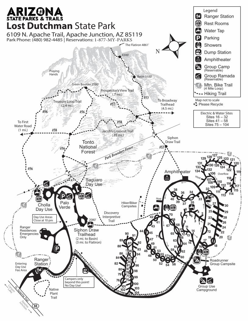
Campers only beyond this point!No Day Use!
Green Boulder 2580'
PrayingHands
The Flatiron 4861'
4300'
Basin 3100'
2080'
Entering Day UseFee Area
Electric & Water Sites Sites 16 – 32Sites 41 – 58
Sites 75 – 104
Host
86 84
82
80 79
76
88
89
90 91
92
93 94
96 98
99
100 103 104
101 102
Day Use AreasClose at 10 pm
RoadrunnerGroup Campsite
Host
69 68
661312
Amphitheater
75 77 78 97 81 83 85
95
87
Lost Dutchman State Park6109 N. Apache Trail, Apache Junction, AZ 85119Park Phone: (480) 982-4485 | Reservations: 1-877-MY-PARKS
6109 N. Apache Trail Apache Junction, AZ 85119 Park:
(480) 982-4485 | Reservations: 1-877-MY-PARKS
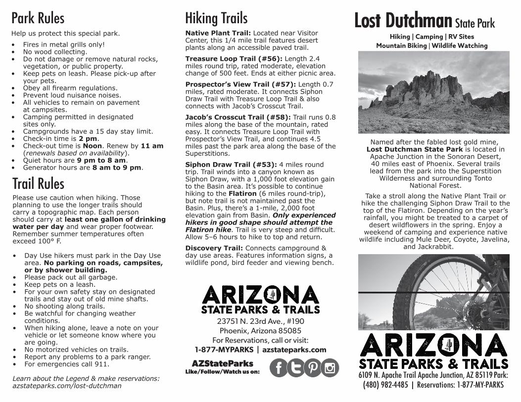
Named after the fabled lost gold mine,
Lost Dutchman State Park is located in
Apache Junction in the Sonoran Desert,
40 miles east of Phoenix. Several trails
lead from the park into the Superstition
Wilderness and surrounding Tonto
National Forest.
Take a stroll along the Native Plant Trail or
hike the challenging Siphon Draw Trail to the
top of the Flatiron. Depending on the year’s
rainfall, you might be treated to a carpet of
desert wildflowers in the spring. Enjoy a
weekend of camping and experience native
wildlife including Mule Deer, Coyote, Javelina,
and Jackrabbit.
Hiking | Camping | RV Sites Mountain Biking | Wildlife Watching
Park RulesHelp us protect this special park.
• Fires in metal grills only!
• No wood collecting.
• Do not damage or remove natural rocks,
vegetation, or public property.
• Keep pets on leash. Please pick-up after
your pets.
•
• Prevent loud nuisance noises.
• All vehicles to remain on pavement
at campsites.
• Camping permitted in designated
sites only.
• Campgrounds have a 15 day stay limit.
• Check-in time is 2 pm.
• Check-out time is Noon. Renew by 11 am(renewals based on availability).
• Quiet hours are 9 pm to 8 am.
• Generator hours are 8 am to 9 pm.
Hiking TrailsNative Plant Trail: Located near Visitor
Center, this 1/4 mile trail features desert
plants along an accessible paved trail.
Treasure Loop Trail (#56): Length 2.4
miles round trip, rated moderate, elevation
change of 500 feet. Ends at either picnic area.
Prospector’s View Trail (#57): Length 0.7
miles, rated moderate. It connects Siphon
Draw Trail with Treasure Loop Trail & also
connects with Jacob’s Crosscut Trail.
Jacob’s Crosscut Trail (#58): Trail runs 0.8
miles along the base of the mountain, rated
easy. It connects Treasure Loop Trail with
Prospector’s View Trail, and continues 4.5
miles past the park area along the base of the
Superstitions.
Siphon Draw Trail (#53): 4 miles round
trip. Trail winds into a canyon known as
Siphon Draw, with a 1,000 foot elevation gain
to the Basin area. It’s possible to continue
hiking to the Flatiron (6 miles round-trip),
but note trail is not maintained past the
Basin. Plus, there’s a 1-mile, 2,000 foot
elevation gain from Basin. Only experienced
hikers in good shape should attempt the
Flatiron hike
Allow 5–6 hours to hike to top and return.
Discovery Trail: Connects campground &
day use areas. Features information signs, a
wildlife pond, bird feeder and viewing bench.
Trail RulesPlease use caution when hiking. Those
planning to use the longer trails should
carry a topographic map. Each person
should carry at least one gallon of drinking
water per day and wear proper footwear.
Remember summer temperatures often
exceed 100° F.
• Day Use hikers must park in the Day Use
area. No parking on roads, campsites,or by shower building.
• Please pack out all garbage.
• Keep pets on a leash.
• For your own safety stay on designated
trails and stay out of old mine shafts.
• No shooting along trails.
• Be watchful for changing weather
conditions.
• When hiking alone, leave a note on your
vehicle or let someone know where you
are going.
• No motorized vehicles on trails.
• Report any problems to a park ranger.
• For emergencies call 911.
Learn about the Legend & make reservations: azstateparks.com/lost-dutchman
Make Reservations at AZStateParks.com or call (520) 586-2283, 7 days a week,
from 8 am to 5 pm MST.
AS
P 1
-16
23751 N. 23rd Ave., #190Phoenix, Arizona 85085 1-877-MY-PARKS
AZStateParks.com
Search: AZStateParks toLike/Follow/Watch us on:
23751 N. 23rd Ave., #190 Phoenix, Arizona 85085
For Reservations, call or visit:1-877-MYPARKS | azstateparks.com
AZStateParksLike/Follow/Watch us on: