Embed Size (px)
Citation preview

Lecture 10
Web GIS
Tomislav Sapic GIS Technologist
Faculty of Natural Resources Management Lakehead University

• Web GIS is a form of a distributed GIS. • One way of describing distributed GIS is through locations of its components:
o U – the location of the user. o D – the location of the data.
o P – the location where the data are processed.
o S – the area that is the focus of a GIS project.
Web GIS
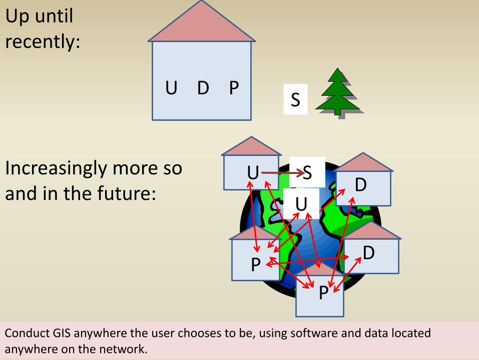
Up until recently:
U D P
Increasingly more so and in the future:
S
Conduct GIS anywhere the user chooses to be, using software and data located anywhere on the network.
U D
P
S
P
D
U
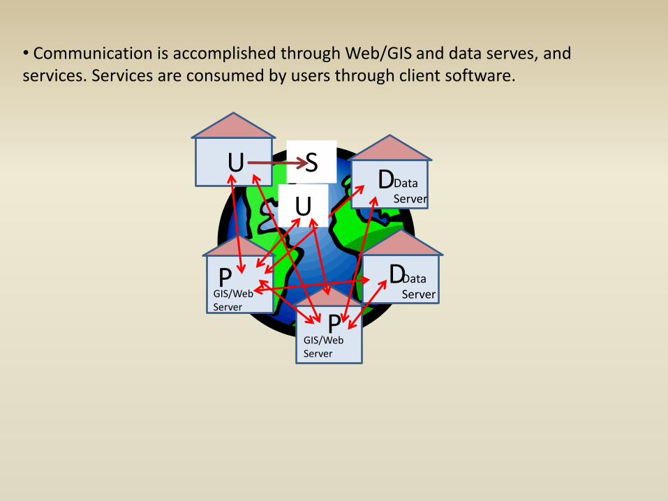
• Communication is accomplished through Web/GIS and data serves, and services. Services are consumed by users through client software.
U D
P
S
P
D
U
Data Server
Data Server
GIS/Web Server
GIS/Web Server
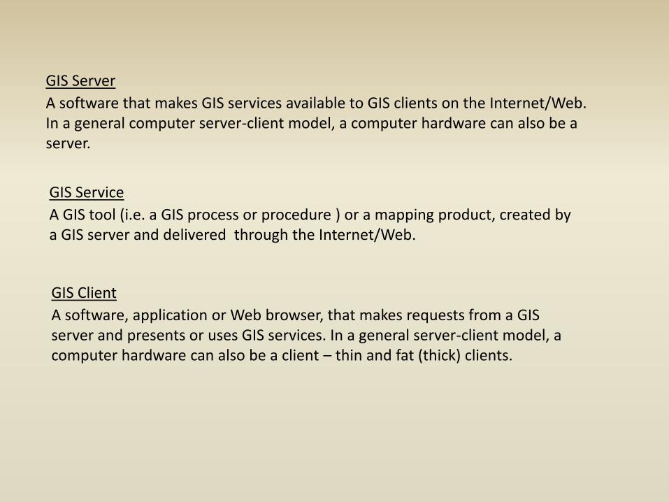
GIS Server
A software that makes GIS services available to GIS clients on the Internet/Web. In a general computer server-client model, a computer hardware can also be a server.
GIS Service
A GIS tool (i.e. a GIS process or procedure ) or a mapping product, created by a GIS server and delivered through the Internet/Web.
GIS Client
A software, application or Web browser, that makes requests from a GIS server and presents or uses GIS services. In a general server-client model, a computer hardware can also be a client – thin and fat (thick) clients.
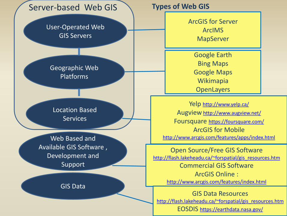
User-Operated Web GIS Servers
Geographic Web Platforms
Web Based and Available GIS Software ,
Development and Support
ArcGIS for Server ArcIMS
MapServer
Google Earth Bing Maps
Google Maps Wikimapia OpenLayers
Open Source/Free GIS Software http://flash.lakeheadu.ca/~forspatial/gis_resources.htm
Commercial GIS Software ArcGIS Online :
http://www.arcgis.com/features/index.html
Types of Web GIS
Location Based Services
Yelp http://www.yelp.ca/
Augview http://www.augview.net/
Foursquare https://foursquare.com/
ArcGIS for Mobile http://www.arcgis.com/features/apps/index.html
GIS Data GIS Data Resources
http://flash.lakeheadu.ca/~forspatial/gis_resources.htm
EOSDIS https://earthdata.nasa.gov/
Server-based Web GIS
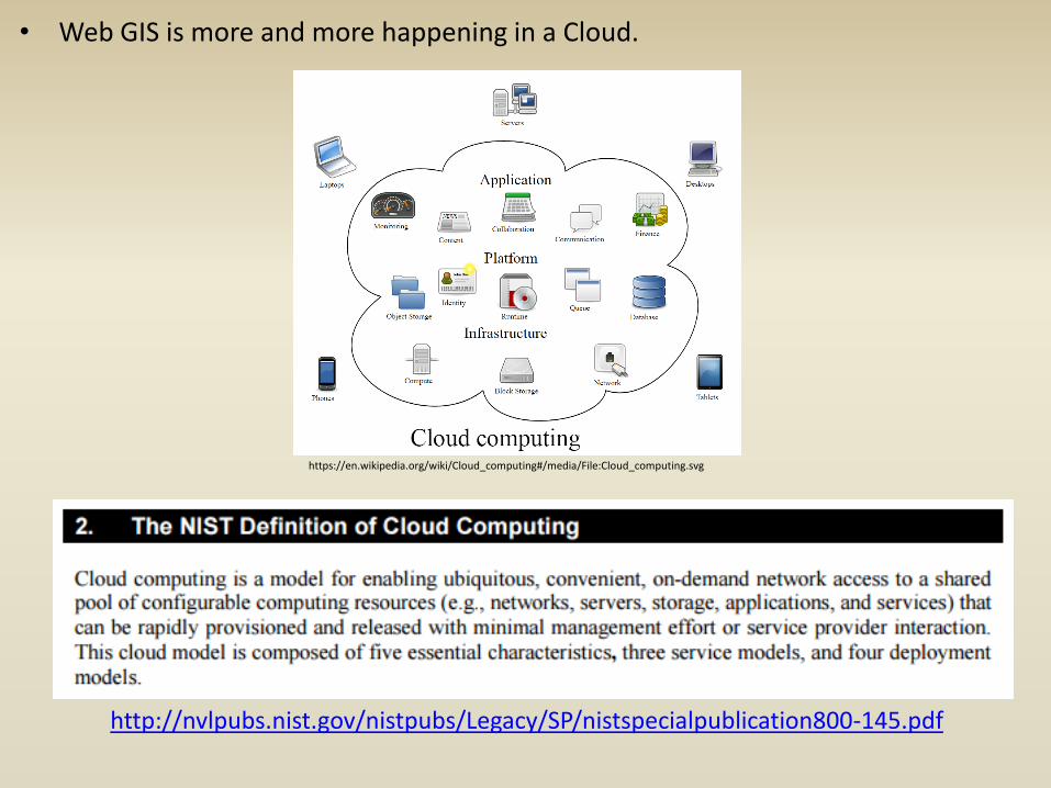
• Web GIS is more and more happening in a Cloud.
https://en.wikipedia.org/wiki/Cloud_computing#/media/File:Cloud_computing.svg
http://nvlpubs.nist.gov/nistpubs/Legacy/SP/nistspecialpublication800-145.pdf
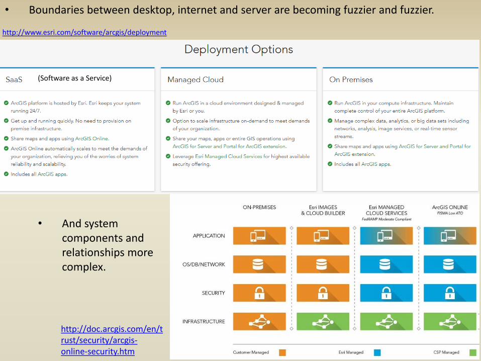
• Boundaries between desktop, internet and server are becoming fuzzier and fuzzier.
http://www.esri.com/software/arcgis/deployment
• And system components and relationships more complex.
http://doc.arcgis.com/en/trust/security/arcgis-online-security.htm
(Software as a Service)
Mobile vs. Web GIS
• Not every mobile GIS is Web GIS, or more particularly, LBS GIS. • Mobile GIS can be GIS software on a GPS unit, for example, not using Web-based resources at all. • ArcPad software, used for data collection with GPS units, is an example of a mobile, non-Web GIS.
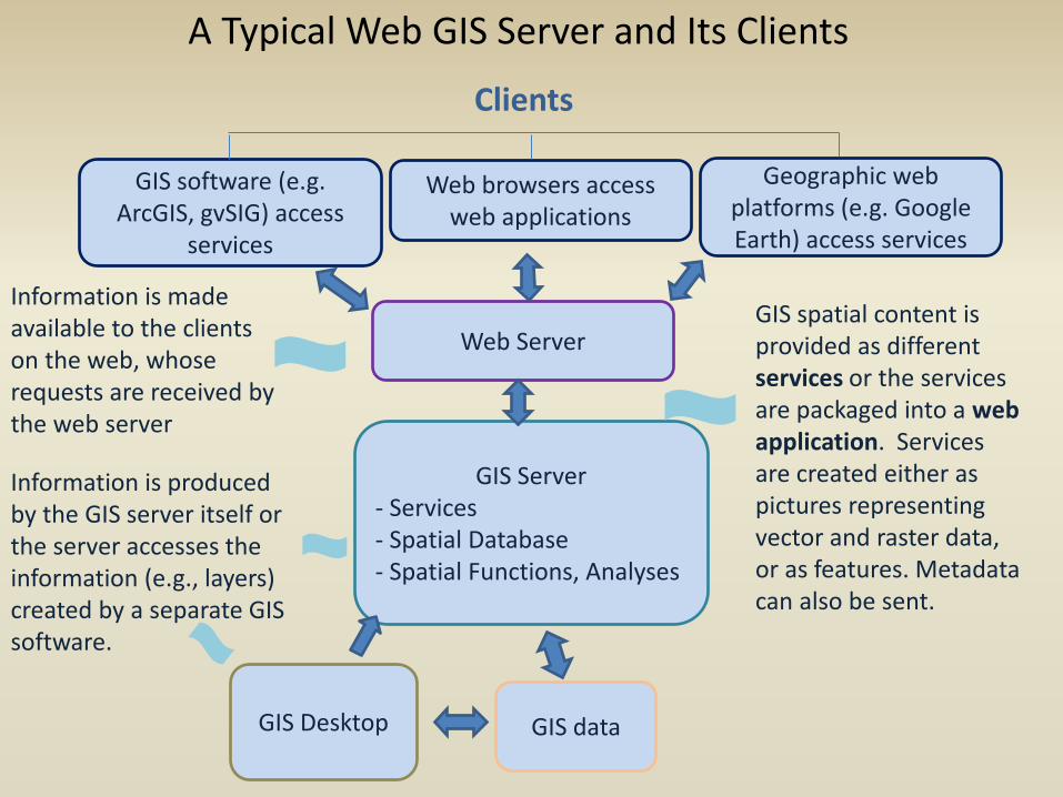
Web Server
GIS Server - Services - Spatial Database - Spatial Functions, Analyses
GIS software (e.g. ArcGIS, gvSIG) access
services
Web browsers access web applications
Geographic web platforms (e.g. Google Earth) access services
Information is produced by the GIS server itself or the server accesses the information (e.g., layers) created by a separate GIS software.
Information is made available to the clients on the web, whose requests are received by the web server
GIS spatial content is provided as different services or the services are packaged into a web application. Services are created either as pictures representing vector and raster data, or as features. Metadata can also be sent.
A Typical Web GIS Server and Its Clients
GIS Desktop GIS data
Clients
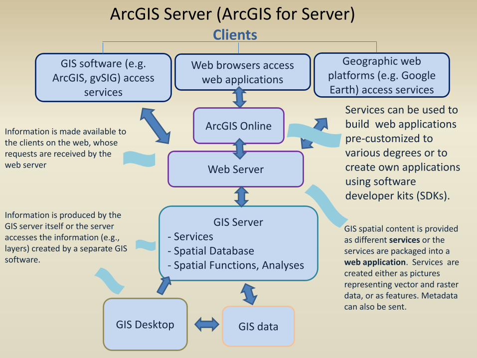
Web Server
GIS Server - Services - Spatial Database - Spatial Functions, Analyses
GIS software (e.g. ArcGIS, gvSIG) access
services
Web browsers access web applications
Geographic web platforms (e.g. Google Earth) access services
Information is produced by the GIS server itself or the server accesses the information (e.g., layers) created by a separate GIS software.
Information is made available to the clients on the web, whose requests are received by the web server
GIS spatial content is provided as different services or the services are packaged into a web application. Services are created either as pictures representing vector and raster data, or as features. Metadata can also be sent.
ArcGIS Server (ArcGIS for Server)
GIS Desktop GIS data
Clients
ArcGIS Online
Services can be used to build web applications pre-customized to various degrees or to create own applications using software developer kits (SDKs).
Gaining importance:
• Standards • Metadata
• Scalability/ Bandwidth

GIS Server Name Comments
ArcIMS (no longer supported by ESRI but
many published services still existing)
- Created by ESRI. - Creates its own map services. - Publishes various services, including feature, image, and metadata services. - Creates web applications.
ArcGIS for Server http://server.arcgis.com/en/server/
- Created by ESRI. - Uses ArcMap projects as map services. - Capable of publishing numerous services, including feature, map, image, geoprocessing, OGC* services, and so on. - Creates web applications.
MapServer http://mapserver.org/
- Open source, free. - Created by OGC*. - It can publish various services, including WMS and WFS.
Manifold IMS http://www.manifold.net/info/ims.sh
tml
- Low cost. - Doesn’t require a separate GIS software to create services. - Offers template and customized web applications. - Through programming web applications can contain GIS analyses such as navigation, geocoding, terrains.
* Open Geospatial Consortium – an international voluntary standards organization.
Some Common Web GIS Server Software
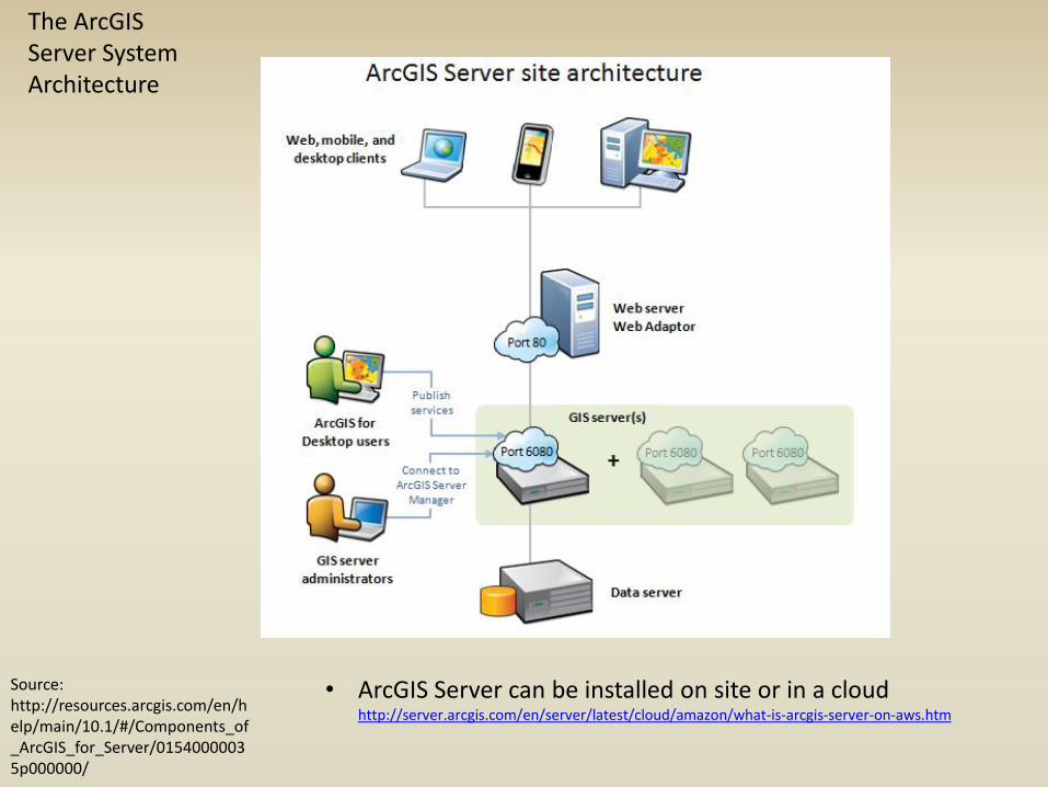
The ArcGIS Server System Architecture
Source: http://resources.arcgis.com/en/help/main/10.1/#/Components_of_ArcGIS_for_Server/01540000035p000000/
• ArcGIS Server can be installed on site or in a cloud http://server.arcgis.com/en/server/latest/cloud/amazon/what-is-arcgis-server-on-aws.htm
ArcGIS for Server
Services
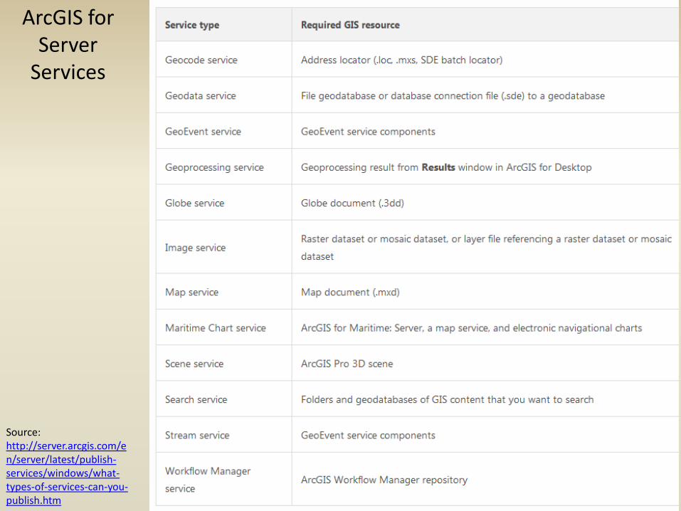
Source: http://server.arcgis.com/en/server/latest/publish-services/windows/what-types-of-services-can-you-publish.htm
ArcGIS for Server Services
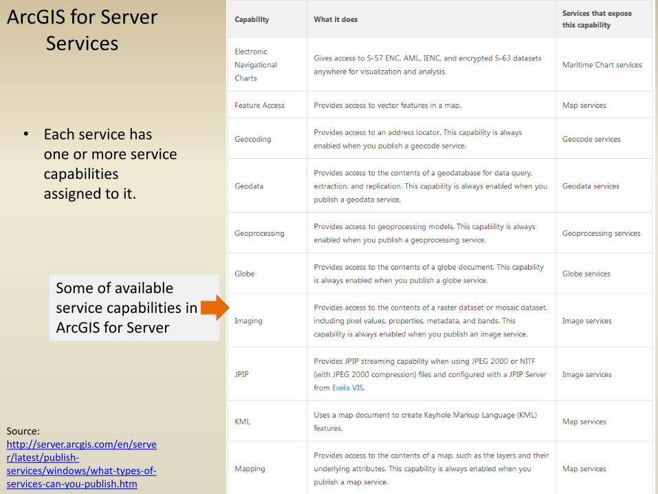
• Each service has one or more service capabilities assigned to it.
Some of available service capabilities in ArcGIS for Server
Source: http://server.arcgis.com/en/server/latest/publish-services/windows/what-types-of-services-can-you-publish.htm
ArcGIS for Server Services
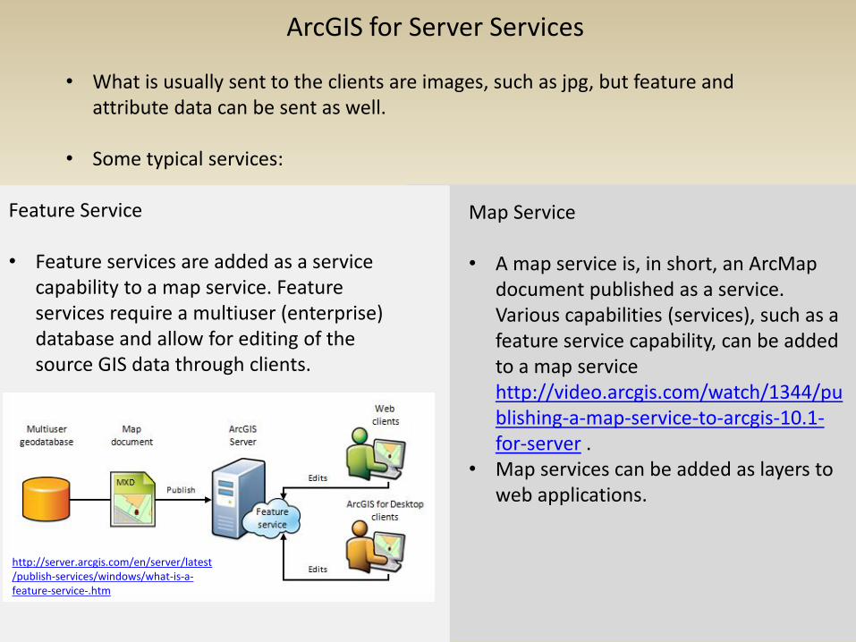
• What is usually sent to the clients are images, such as jpg, but feature and attribute data can be sent as well.
• Some typical services:
Feature Service • Feature services are added as a service
capability to a map service. Feature services require a multiuser (enterprise) database and allow for editing of the source GIS data through clients.
Map Service • A map service is, in short, an ArcMap
document published as a service. Various capabilities (services), such as a feature service capability, can be added to a map service http://video.arcgis.com/watch/1344/publishing-a-map-service-to-arcgis-10.1-for-server .
• Map services can be added as layers to web applications.
http://server.arcgis.com/en/server/latest/publish-services/windows/what-is-a-feature-service-.htm
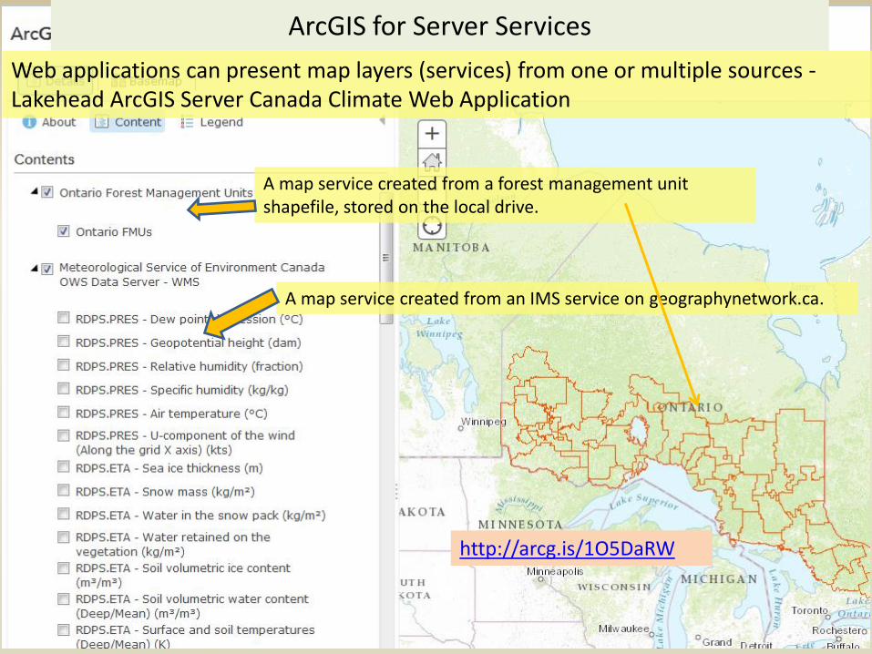
A map service created from a forest management unit shapefile, stored on the local drive.
A map service created from an IMS service on geographynetwork.ca.
Web applications can present map layers (services) from one or multiple sources -Lakehead ArcGIS Server Canada Climate Web Application
http://arcg.is/1O5DaRW
ArcGIS for Server Services
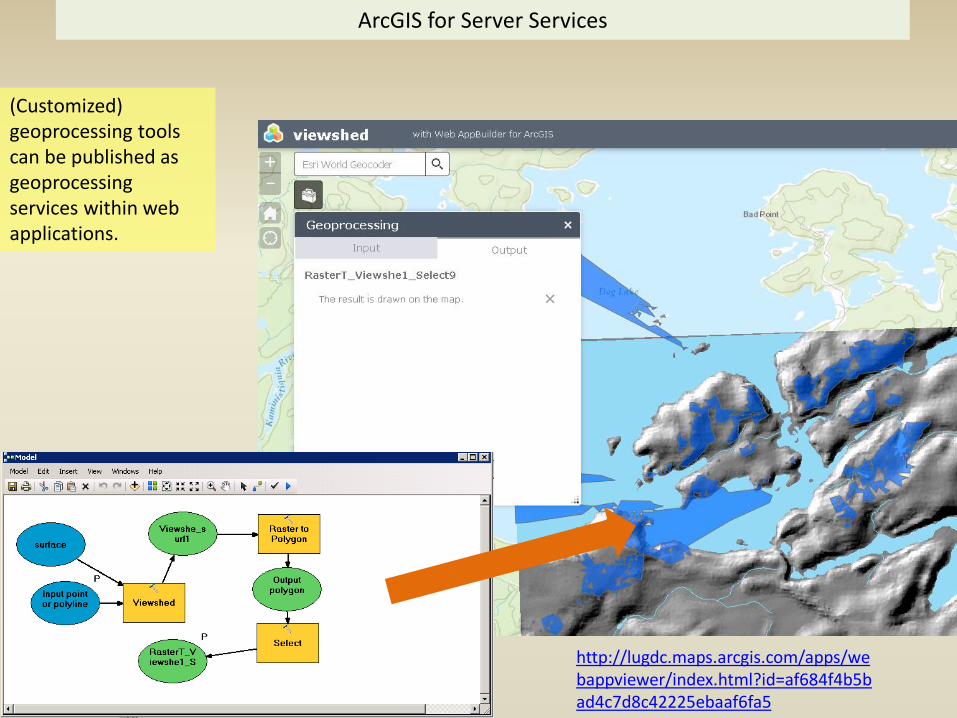
(Customized) geoprocessing tools can be published as geoprocessing services within web applications.
ArcGIS for Server Services
http://lugdc.maps.arcgis.com/apps/webappviewer/index.html?id=af684f4b5bad4c7d8c42225ebaaf6fa5
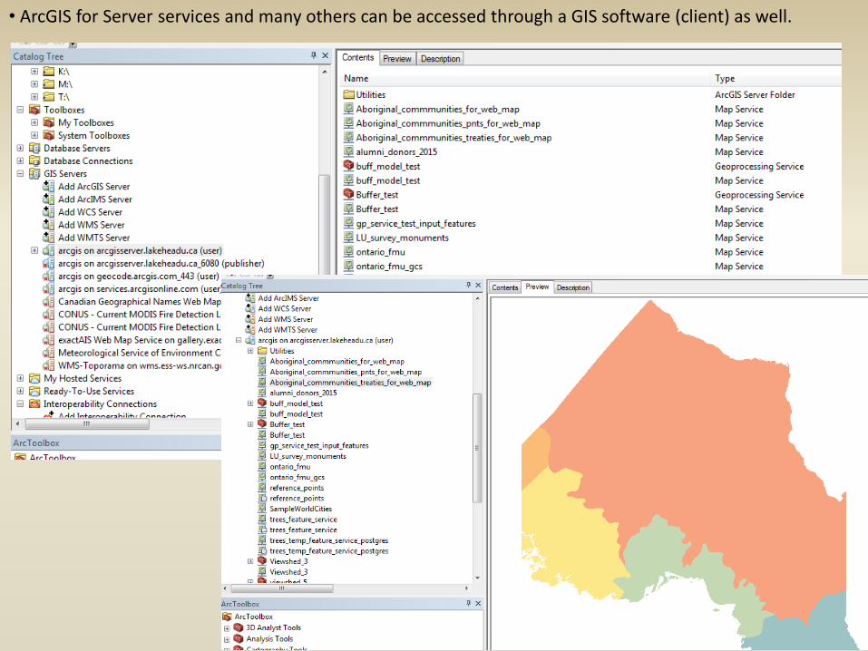
• ArcGIS for Server services and many others can be accessed through a GIS software (client) as well.
http://arcg.is/1X8IhkA
http://lugdc.maps.arcgis.com/apps/Viewer/index.html?appid=581f2944044c411d970b328bf869d4c5
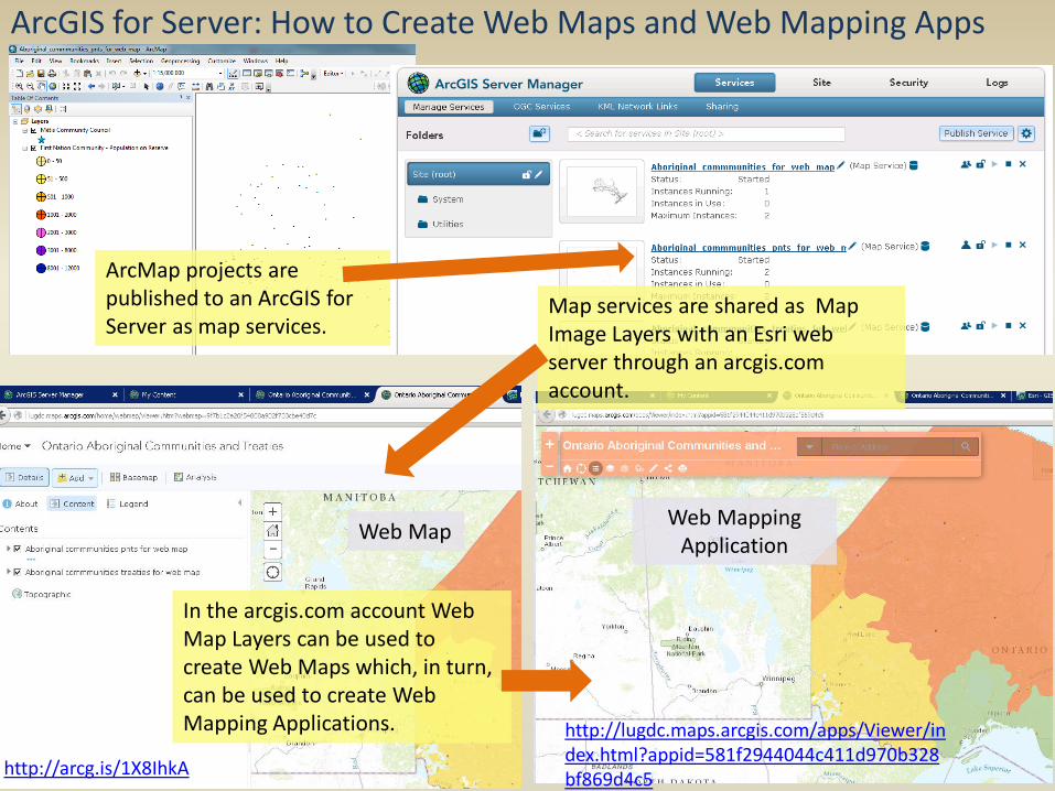
ArcMap projects are published to an ArcGIS for Server as map services.
ArcGIS for Server: How to Create Web Maps and Web Mapping Apps
Map services are shared as Map Image Layers with an Esri web server through an arcgis.com account.
In the arcgis.com account Web Map Layers can be used to create Web Maps which, in turn, can be used to create Web Mapping Applications.
Web Map Web Mapping
Application
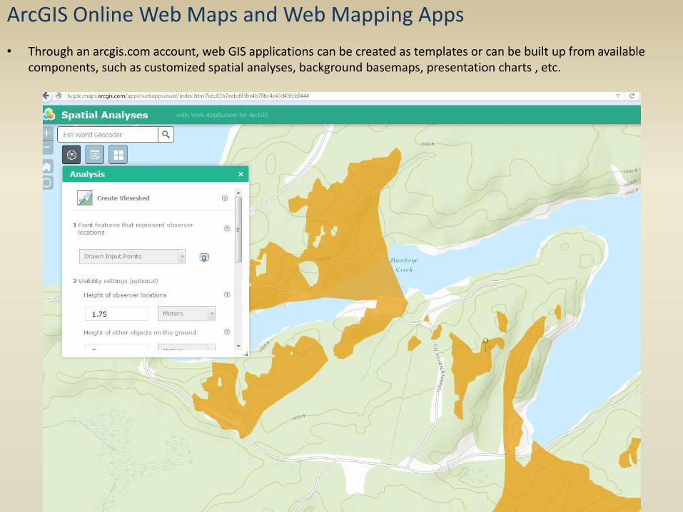
ArcGIS Online Web Maps and Web Mapping Apps
• Through an arcgis.com account, web GIS applications can be created as templates or can be built up from available components, such as customized spatial analyses, background basemaps, presentation charts , etc.
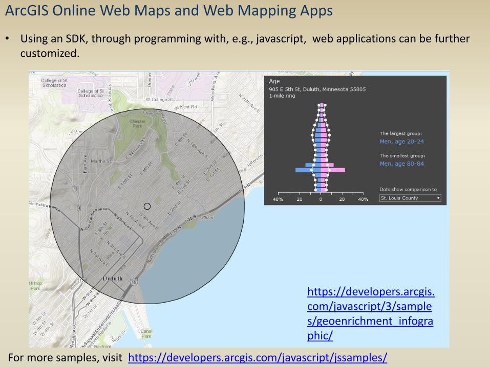
ArcGIS Online Web Maps and Web Mapping Apps
For more samples, visit https://developers.arcgis.com/javascript/jssamples/
• Using an SDK, through programming with, e.g., javascript, web applications can be further customized.
https://developers.arcgis.com/javascript/3/samples/geoenrichment_infographic/

ArcGIS Online Web Maps and Web Mapping Apps
ArcGIS Collector ArcGIS Explorer
• Several apps available on Android and Apple mobile devices.
• Personal/group maps on ArcGIS Online can be accessed as well as many other publicly available and Esri maps/layers.
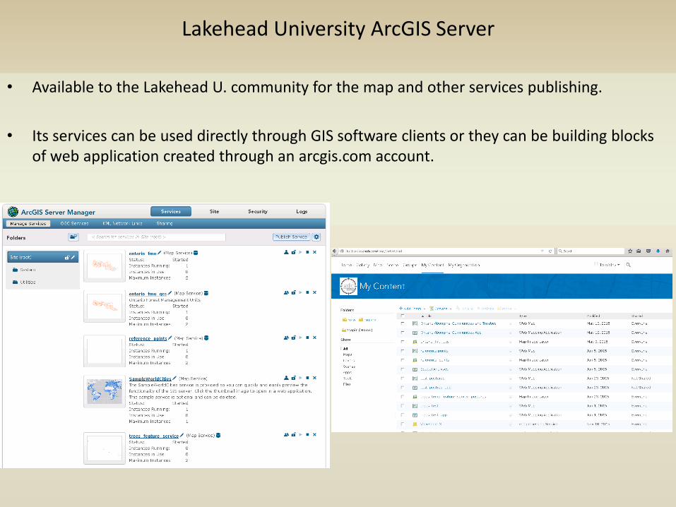
• Available to the Lakehead U. community for the map and other services publishing.
• Its services can be used directly through GIS software clients or they can be building blocks of web application created through an arcgis.com account.
Lakehead University ArcGIS Server
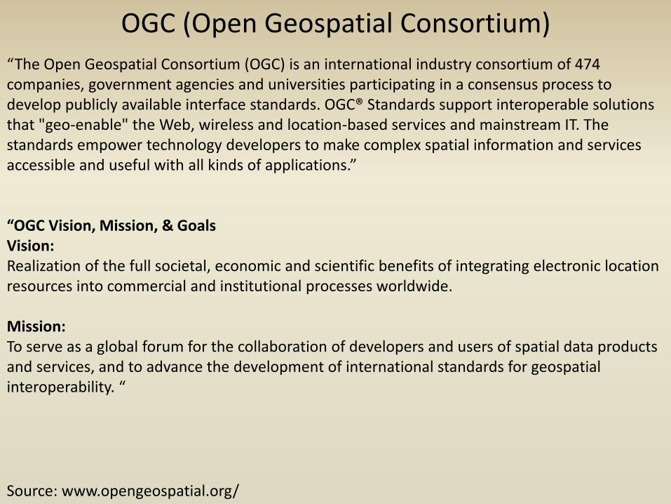
OGC (Open Geospatial Consortium) “The Open Geospatial Consortium (OGC) is an international industry consortium of 474 companies, government agencies and universities participating in a consensus process to develop publicly available interface standards. OGC® Standards support interoperable solutions that "geo-enable" the Web, wireless and location-based services and mainstream IT. The standards empower technology developers to make complex spatial information and services accessible and useful with all kinds of applications.” “OGC Vision, Mission, & Goals Vision: Realization of the full societal, economic and scientific benefits of integrating electronic location resources into commercial and institutional processes worldwide. Mission: To serve as a global forum for the collaboration of developers and users of spatial data products and services, and to advance the development of international standards for geospatial interoperability. “
Source: www.opengeospatial.org/
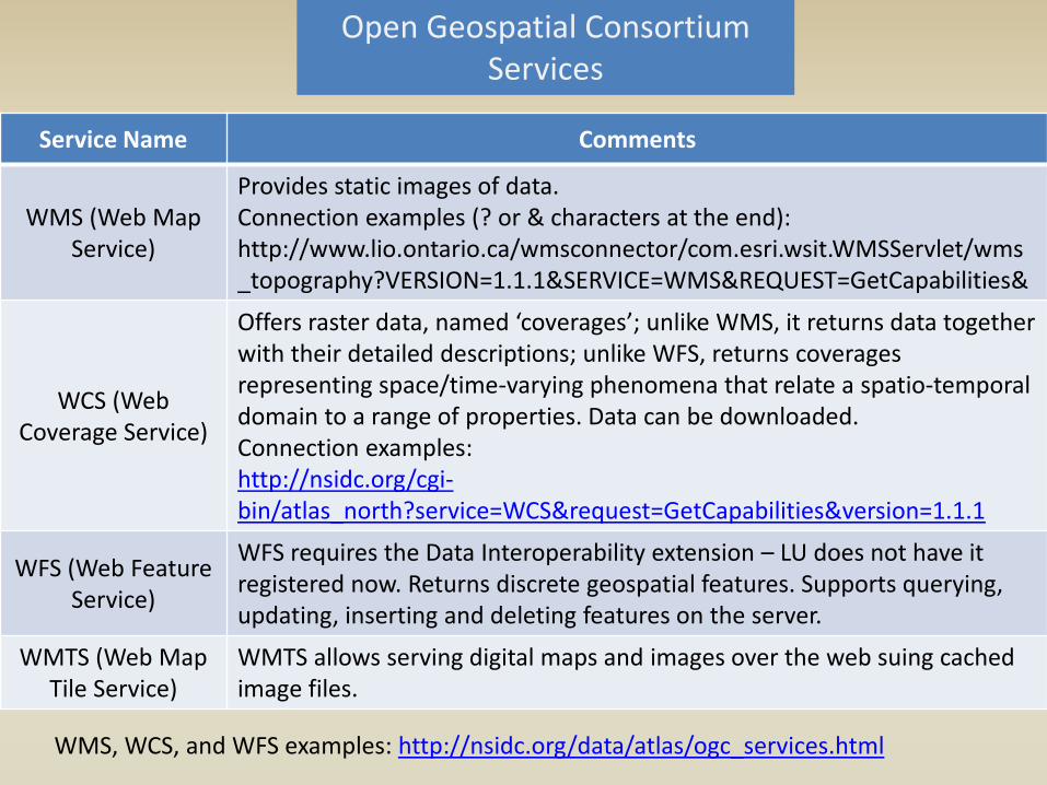
Service Name Comments
WMS (Web Map Service)
Provides static images of data. Connection examples (? or & characters at the end): http://www.lio.ontario.ca/wmsconnector/com.esri.wsit.WMSServlet/wms_topography?VERSION=1.1.1&SERVICE=WMS&REQUEST=GetCapabilities&
WCS (Web Coverage Service)
Offers raster data, named ‘coverages’; unlike WMS, it returns data together with their detailed descriptions; unlike WFS, returns coverages representing space/time-varying phenomena that relate a spatio-temporal domain to a range of properties. Data can be downloaded. Connection examples: http://nsidc.org/cgi-bin/atlas_north?service=WCS&request=GetCapabilities&version=1.1.1
WFS (Web Feature Service)
WFS requires the Data Interoperability extension – LU does not have it registered now. Returns discrete geospatial features. Supports querying, updating, inserting and deleting features on the server.
WMTS (Web Map Tile Service)
WMTS allows serving digital maps and images over the web suing cached image files.
Open Geospatial Consortium Services
WMS, WCS, and WFS examples: http://nsidc.org/data/atlas/ogc_services.html

Six different servers/services can be connected to in ArcGIS Desktop: • ArcGIS Server • ArcIMS Server
• OGC WMS (Web Map Service) • OGC WCS (Web Coverage Service) • OGC WMTS (Web Map Tile Service) • OGC WFS (Web Feature Service) (requires a special extension)
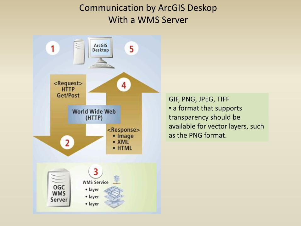
Communication by ArcGIS Deskop With a WMS Server
GIF, PNG, JPEG, TIFF • a format that supports transparency should be available for vector layers, such as the PNG format.
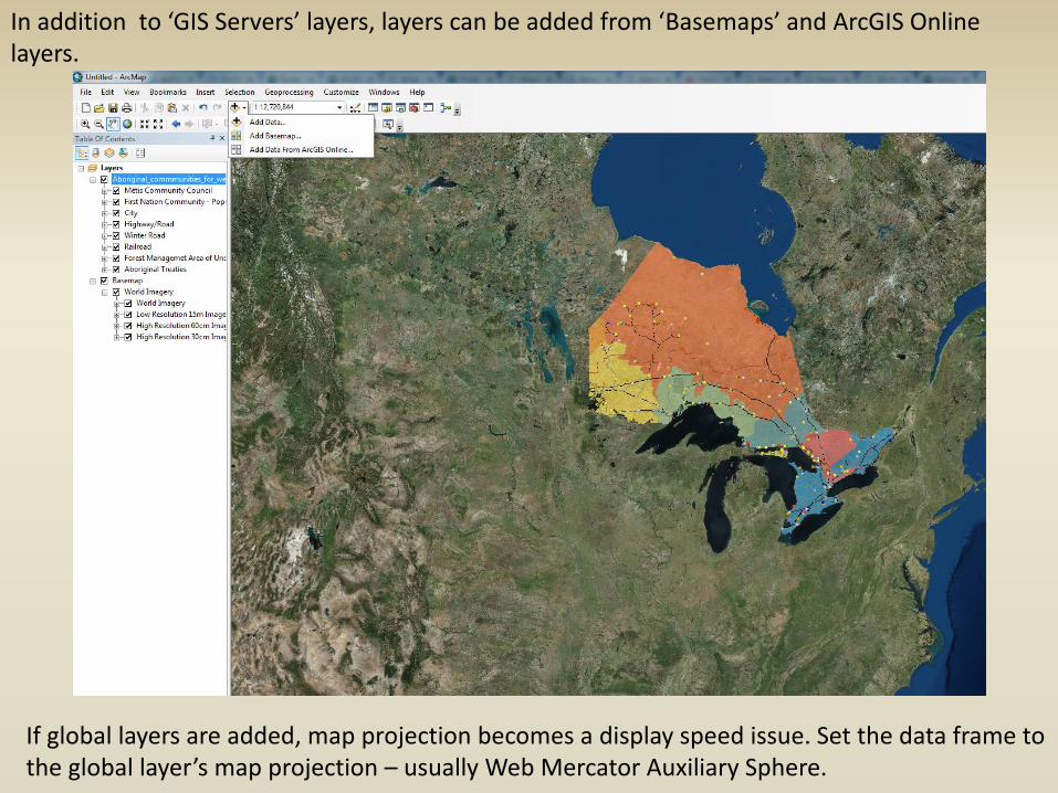
In addition to ‘GIS Servers’ layers, layers can be added from ‘Basemaps’ and ArcGIS Online layers.
If global layers are added, map projection becomes a display speed issue. Set the data frame to the global layer’s map projection – usually Web Mercator Auxiliary Sphere.
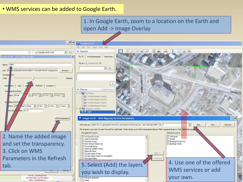
• WMS services can be added to Google Earth.
1. In Google Earth, zoom to a location on the Earth and open Add -> Image Overlay
2. Name the added image and set the transparency. 3. Click on WMS Parameters in the Refresh tab.
4. Use one of the offered WMS services or add your own.
5. Select (Add) the layers you wish to display.
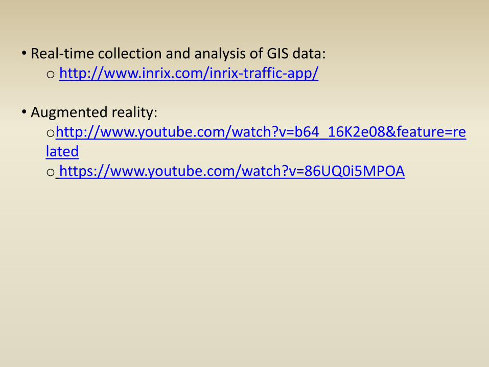
• Real-time collection and analysis of GIS data: o http://www.inrix.com/inrix-traffic-app/
• Augmented reality:
ohttp://www.youtube.com/watch?v=b64_16K2e08&feature=related o https://www.youtube.com/watch?v=86UQ0i5MPOA
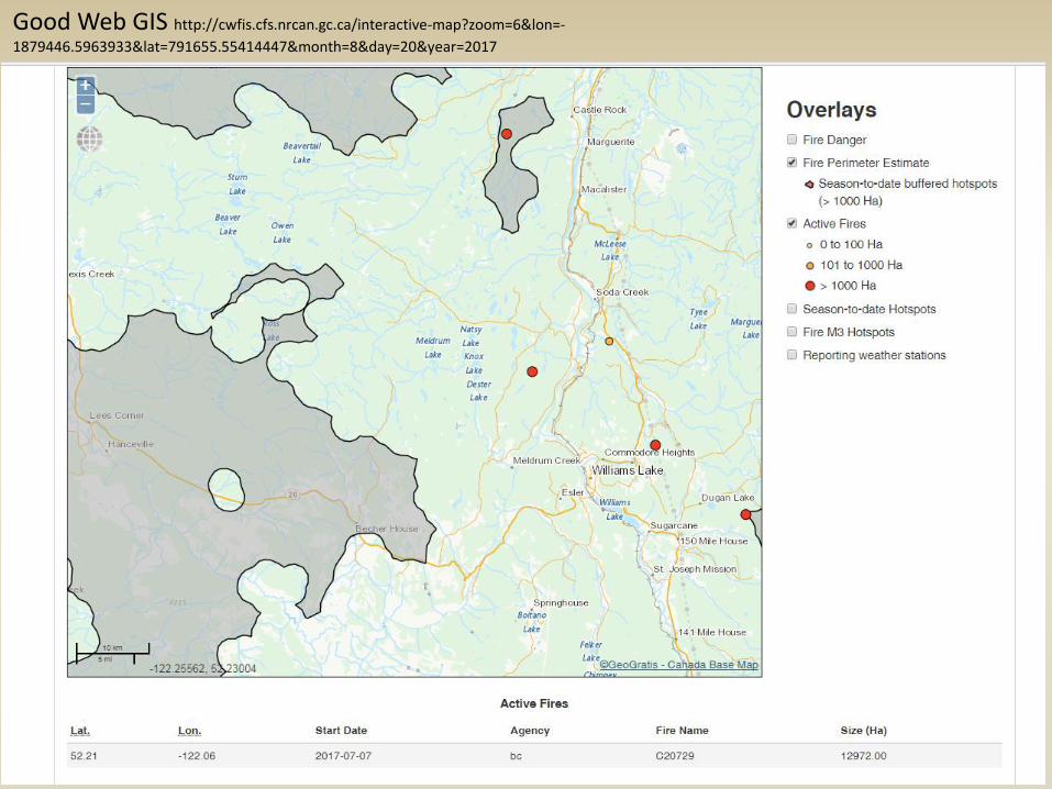
Good Web GIS http://cwfis.cfs.nrcan.gc.ca/interactive-map?zoom=6&lon=-
1879446.5963933&lat=791655.55414447&month=8&day=20&year=2017
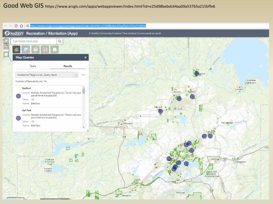
Good Web GIS https://www.arcgis.com/apps/webappviewer/index.html?id=e25d98bebdc64aa09a53765a215bffe6
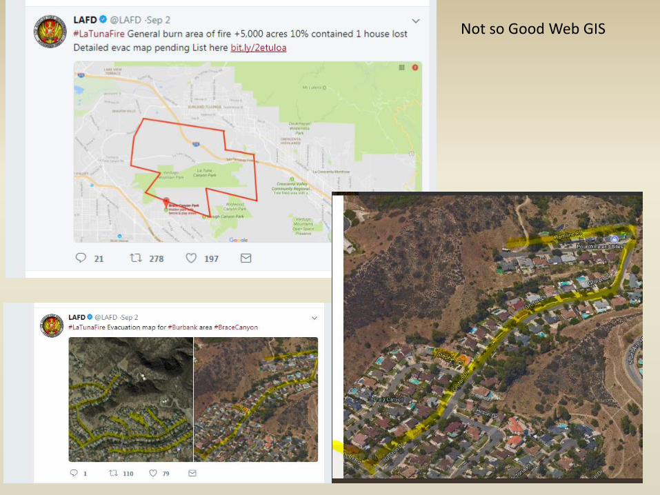
Not so Good Web GIS
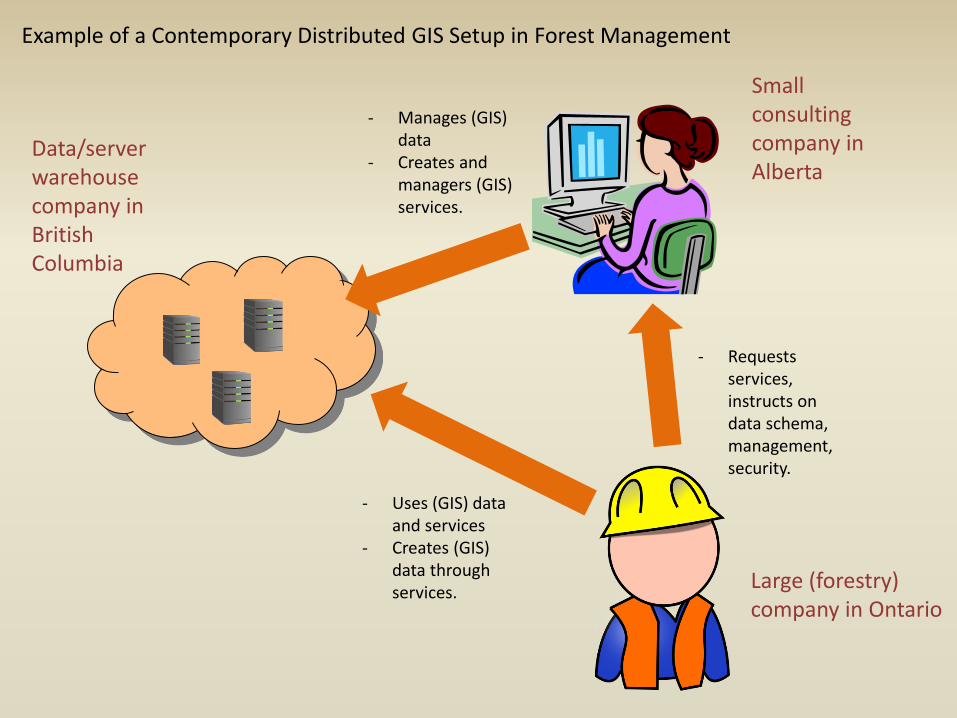
- Manages (GIS) data
- Creates and managers (GIS) services.
- Uses (GIS) data and services
- Creates (GIS) data through services.
- Requests services, instructs on data schema, management, security.
Large (forestry) company in Ontario
Small consulting company in Alberta
Data/server warehouse company in British Columbia
Example of a Contemporary Distributed GIS Setup in Forest Management

XML (EXtensible Markup Language)
http://www.w3schools.com/xml/xml_whatis.asp • XML is designed to transport and store data. • It is not designed to display data, the way HTML is. XML Tree: http://www.w3schools.com/xml/xml_tree.asp XML Syntax: http://www.w3schools.com/xml/xml_syntax.asp XML Elements: http://www.w3schools.com/xml/xml_elements.asp XML Attributes: http://www.w3schools.com/xml/xml_attributes.asp
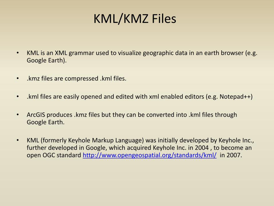
KML/KMZ Files
• KML is an XML grammar used to visualize geographic data in an earth browser (e.g. Google Earth).
• .kmz files are compressed .kml files.
• .kml files are easily opened and edited with xml enabled editors (e.g. Notepad++)
• ArcGIS produces .kmz files but they can be converted into .kml files through Google Earth.
• KML (formerly Keyhole Markup Language) was initially developed by Keyhole Inc., further developed in Google, which acquired Keyhole Inc. in 2004 , to become an open OGC standard http://www.opengeospatial.org/standards/kml/ in 2007.

KML/KMZ Files
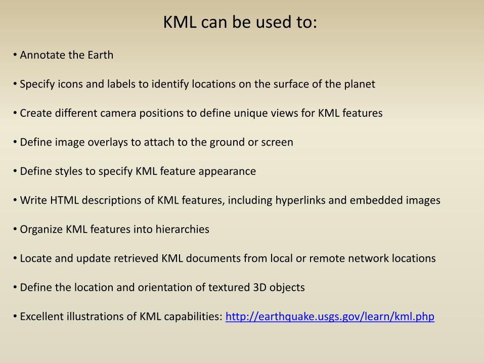
KML can be used to: • Annotate the Earth • Specify icons and labels to identify locations on the surface of the planet • Create different camera positions to define unique views for KML features • Define image overlays to attach to the ground or screen • Define styles to specify KML feature appearance • Write HTML descriptions of KML features, including hyperlinks and embedded images • Organize KML features into hierarchies • Locate and update retrieved KML documents from local or remote network locations • Define the location and orientation of textured 3D objects • Excellent illustrations of KML capabilities: http://earthquake.usgs.gov/learn/kml.php
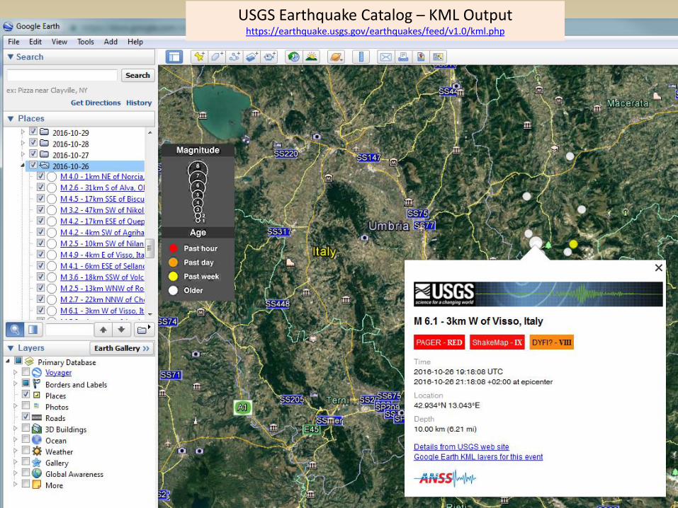
USGS Earthquake Catalog – KML Output https://earthquake.usgs.gov/earthquakes/feed/v1.0/kml.php
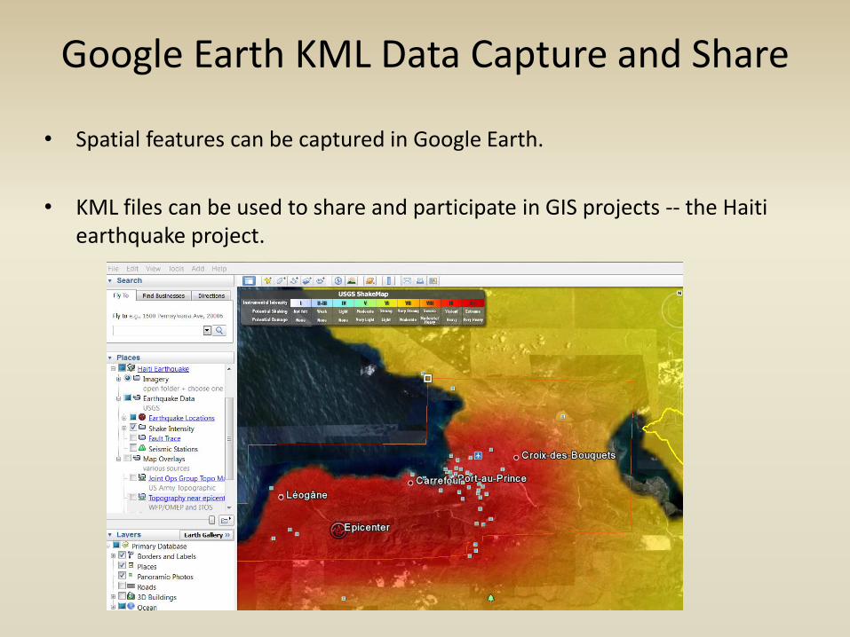
Google Earth KML Data Capture and Share
• Spatial features can be captured in Google Earth.
• KML files can be used to share and participate in GIS projects -- the Haiti earthquake project.
Presentation Resources:
Longley, P. A., M. F. Goodchild, D. J. Maguire, D. W. Rhind. 2011. Geographic Information Systems & Science.
OGC. 2010. Web Map Service. http://www.opengeospatial.org/standards/wms
OGC. 2010. Web Coverage Service. http://www.opengeospatial.org/standards/wcs
OGC. 2010. Web Feature Service. http://www.opengeospatial.org/standards/wfs
OGC KML. http://www.opengeospatial.org/standards/kml/
World Wide Web Consortium (W3C) – XML. http://www.w3schools.com/xml/xml_whatis.asp