Embed Size (px)
Citation preview
PolarTREC Lesson Plan Name of Person Submitting Lesson: Stan SkotnickiDate: 10-30-16
Title: SEASONAL PATH OF THE SUN AND LATITUDE
Topic: During this lab activity, students will study the seasonal apparent path of the Sun above the Arctic Circle. Topics covered in this unit are coordinate location, insolation, celestial motions of Earth and the Sun, Seasons.
Region: This lesson is more designed for the Arctic region, but can easily be modified for regions of the Antarctic
Completion Time: This lesson would take either an 80-minute block or two 40-minute class periods.
Permission: Download share and remix: Viewer may download the submission, use it as needed, share it with others, and change components to suit their needs. Additional changed versions of the submission can be resubmitted to the Learning Resources.
Grade Level: High School
Overview: This lesson is a modification of what Dave Hess and I, Stan Skotnicki, use in our Earth Science classes at Cheektowaga Central High School. It is an extension of our lesson on Celestial Motions as we track the apparent path of the sun across the sky at different latitudes. Prior to this Lab activity they would have already created hemisphere models of 42 North (mid-latitudes) and at the Equator 0.
Working with Mike Loranty in Siberia during the summer of 2016 we experienced full sunlight for 24 hours and has been a topic of conversation in class, which inspired me to extend our Apparent Path of the Sun lab to include latitudes at the arctic circle.
Objectives: Explain how latitude affects the seasonal path of the Sun.
Materials:

Clear plastic hemisphere model: Something like thishttps://www.wardsci.com/store/product/8889458/sun-tracking-hemisphere-kit
External protractor for model Dry erase markers – Two different colors Can be modified for additional latitudes with data sets taken from
http://aa.usno.navy.mil/data/docs/AltAz.php
Lesson Preparation: Prior to this lesson, students would have learned about the general motions between the Sun and Earth in relation to each other. The Apparent Path that the sun takes across the sky. There are also two other hemisphere model labs that would have been done before this one, which are available on contact. The first model would have been created for 42 North and the other for the Equator at 0.
Procedure: Complete procedures for the activity are listed on page three of the Lab. (Page 9 of this document)
Extension: Additional hemisphere model labs have been created for 42 North and the Equator at 0. They can also be modified for any latitude desired.
Resources: For data at any latitude at any interval: http://aa.usno.navy.mil/data/docs/AltAz.php
For an animation of the Apparent Path of the Sun at any Latitude:http://astro.unl.edu/naap/motion3/animations/sunmotions.swf
Assessment: This activity will be assessed as part of New York States minimum lab requirement for Regents credit.
Author / Credits:Created by Stan Skotnicki and Dave Hess from Cheektowaga Central [email protected]
File Attachments: Word document file name: 20162017 Path of Sun Comparison.docx
Standards: Select the appropriate standards addressed in your lesson plan.

New York State Physical Setting/Earth Science Core Curriculum
STANDARD 6 Interconnectedness: Common Themes MODELS:Key Idea 2: Models are simplified representations of objects, structures, or systems used in analysis, explanation, interpretation, or design.
STANDARD 4 Key Idea 1: The Earth and celestial phenomena can be described by principles of relative motion and perspectiveMajor Understandings: 1.1a Most objects in the solar system are in regular and predictable motion. • These motions explain such phenomena as the day, the year, seasons, phases of the moon, eclipses, and tides1.1c Earth’s coordinate system of latitude and longitude, with the equator and prime meridian as reference lines, is based upon Earth’s rotation and our observation of the Sun and stars.

National Science Education StandardsContent Standards, Grades K-4
Content Standards, Grades 9-12
Content Standard A: Science As Inquirya. Abilities necessary to do scientific inquiryb. Understandings about scientific inquiry
Content Standard B: Physical Sciencea. Structure of atomsb. Structure and properties of matterc. Chemical reactionsd. Motions and forcese. Conservation of energy and increase in disorderf. Interactions of energy and matter
Content Standard C: Life Sciencea. The cellb. Molecular basis of heredityc. Biological evolutiond. Interdependence of organismse. Matter, energy, and organization in living systemsf. Behavior of organisms
Content Standard D: Earth and Space Sciencea. Energy in the earth systemb. Geochemical cyclesc. Origin and evolution of the earth systemd. Origin and evolution of the universe
Content Standard E: Science and Technologya. Abilities of technological designb. Understandings about science and technology
Content Standard F: Science In Personal and Social Perspectivesa. Personal and community healthb. Population growthc. Natural resourcesd. Environmental qualitye. Natural and human-induced hazardsf. Science and technology in local, national, and global challenges
Content Standard G: History and Nature of Science
a. Science as a human endeavorb. Nature of scientific knowledgec. Historical Perspective
********************************************************************************
Topic(s): For tagging on PolarTREC website (Highlight or Bold all that apply) Archaeology and Anthropology
- General Archaeology and Anthropology- History of Archeology or Anthropology- Tools and Methods- Language & Communication- Subsistence- Human Evolution- Climate Change
Life Science- General Life Science- History of Biology and Life Sciences
4

- Tools and Methods- Ecology- Evolution and Diversity - Genetics and Heredity- Organisms and Their Environments- Oceanography- Structure and Function- Regulation and Behavior - Paleo-science - Climate Change
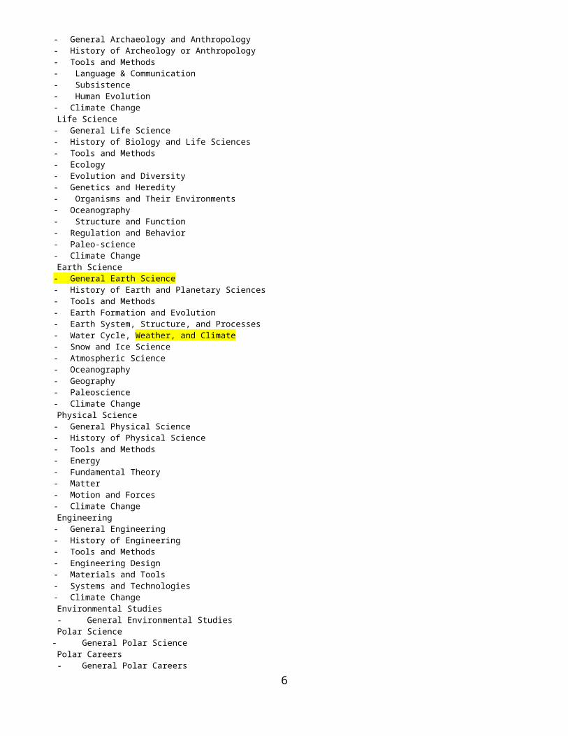
Earth Science- General Earth Science- History of Earth and Planetary Sciences- Tools and Methods- Earth Formation and Evolution- Earth System, Structure, and Processes- Water Cycle, Weather, and Climate- Snow and Ice Science- Atmospheric Science- Oceanography- Geography - Paleoscience - Climate Change
Physical Science- General Physical Science- History of Physical Science- Tools and Methods- Energy- Fundamental Theory- Matter- Motion and Forces- Climate Change
Engineering- General Engineering- History of Engineering- Tools and Methods- Engineering Design- Materials and Tools- Systems and Technologies- Climate Change
Environmental Studies - General Environmental Studies Polar Science - General Polar Science Polar Careers - General Polar Careers
5
6

NAME;
PERIOD; DATE;
LAB #SEASONAL PATH OF THE SUN AND
LATITUDEHemisphere Model #3
at the Arctic Circle
I) Path of the Sun and Latitude.
7

In the previous activity we observed that the Sun’s path across the sky varies with the seasons. As its path changes, so too does the position of sunrise and sunset, the altitude of the noon sun, and the duration of sunlight (length of daylight). In New York State, the Winter Solstice (on December 21), marks the time when the noon sun is lowest in the sky and the period of daylight is the shortest. The Summer Solstice (on June 21), is the day when the noon sun is highest in the sky and the duration of daylight is the greatest. Although the noon sun is highest on this date, the sun will never be directly overhead (zenith position) in New York State. In only place where the sun is ever in the zenith position (90o altitude), is in the tropics. The tropics is anywhere between 23.5oN and 23.5oS latitude. The path of the sun during the equinoxes lies between the paths for the solstices. The equinoxes (equal nights) are the only time when the sun rises due east and set due west. It is also the date when the entire Earth experiences 12 hours of sunlight, regardless of your location.
OBJECTIVEExplain how latitude affects the seasonal path of the Sun.
Is the path of the Sun the same in New York as it is at the Arctic Circle, or at the equator? Does latitude (distance north or south from the equator) affect the path that the sun takes across the sky? Above the Arctic Circle, is there still 12 hours of daylight during the equinoxes? What will the duration of sunlight be like during the Solstices?
By comparing three locations; NY (mid-latitudes), the Arctic Circle (66.5o), and the equator (0o) a conclusion can be made for how latitude affects the duration of sunlight for each season.
8
PROCEDURESetting up the hemisphere model.
1) Turn to the last page of this lab. There should be a circle and the words “azimuth” on this page. Remove this page and tape it onto your piece of cardboard.
2) Label this piece of paper with your class period and all the members of your lab group.
3) Carefully place the hemisphere model on the circle. The hemisphere model should line up with the circle on the paper.
4) Use masking tape to fasten the hemisphere model to the cardboard. Place the tape at NE, SE, SW and NW.
Marking the path of the Sun at 66.5 The Arctic Circle)
1) Find Data Table 1 (Azimuth and Altitude at a latitude of 90o The North Pole)
Notice that there are only two available sets of data this time.- One set for both March and September 21 (the sun follows the same path on these days) – the “Spring Equinox” and the “Autumn Equinox” (First Day of Spring and the Frist Day of Autumn).- One set for June 21 – the first Day of Summer.
2) You will plot two lines on the hemisphere model – one for each set of data (each season).
3) Start with a green wet erase marker and plot the path of the sun for March/September 21.
- For March/September 21the first set of data occurs at 6:00am; AZIMUTH 88o and ALTITUDE 1o
- Azimuth values are listed along the circle.
- Find the location for 0o (North) azimuth on the circle, move clockwise until you find 88o.
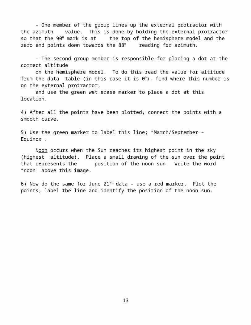
- One member of the group lines up the external protractor with the azimuth value. This is done by holding the external protractor so that the 90o mark is
at the top of the hemisphere model and the zero end points down towards the 88o reading for azimuth.
- The second group member is responsible for placing a dot at the correct altitude
9
on the hemisphere model. To do this read the value for altitude from the data table (in this case it is 0o), find where this number is on the external
protractor, and use the green wet erase marker to place a dot at this location.
4) After all the points have been plotted, connect the points with a smooth curve.
5) Use the green marker to label this line; “March/September – Equinox”.Noon occurs when the Sun reaches its highest point in the sky (highest altitude). Place a small drawing of the sun over the point that represents the position of the noon sun. Write the word “noon” above this image.
6) Now do the same for June 21st data – use a red marker. Plot the points, label the line and identify the position of the noon sun.
10

11
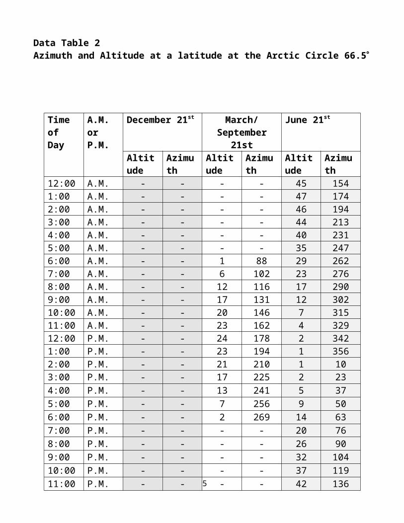
Data Table 2Azimuth and Altitude at a latitude at the Arctic Circle 66.5
Apparent Path of the Sun in Jamestown, NY 42N – Mid-Latitudes
12
Time of Day
A.M. or P.M.
December 21st March/September 21st
June 21st
Altitude Azimuth Altitude Azimuth Altitude Azimuth12:00 A.M. - - - - 45 1541:00 A.M. - - - - 47 1742:00 A.M. - - - - 46 1943:00 A.M. - - - - 44 2134:00 A.M. - - - - 40 2315:00 A.M. - - - - 35 2476:00 A.M. - - 1 88 29 2627:00 A.M. - - 6 102 23 2768:00 A.M. - - 12 116 17 2909:00 A.M. - - 17 131 12 30210:00 A.M. - - 20 146 7 31511:00 A.M. - - 23 162 4 32912:00 P.M. - - 24 178 2 3421:00 P.M. - - 23 194 1 3562:00 P.M. - - 21 210 1 103:00 P.M. - - 17 225 2 234:00 P.M. - - 13 241 5 375:00 P.M. - - 7 256 9 506:00 P.M. - - 2 269 14 637:00 P.M. - - - - 20 768:00 P.M. - - - - 26 909:00 P.M. - - - - 32 10410:00 P.M. - - - - 37 11911:00 P.M. - - - - 42 136
Apparent Path of the Sun at the Equator 0
13

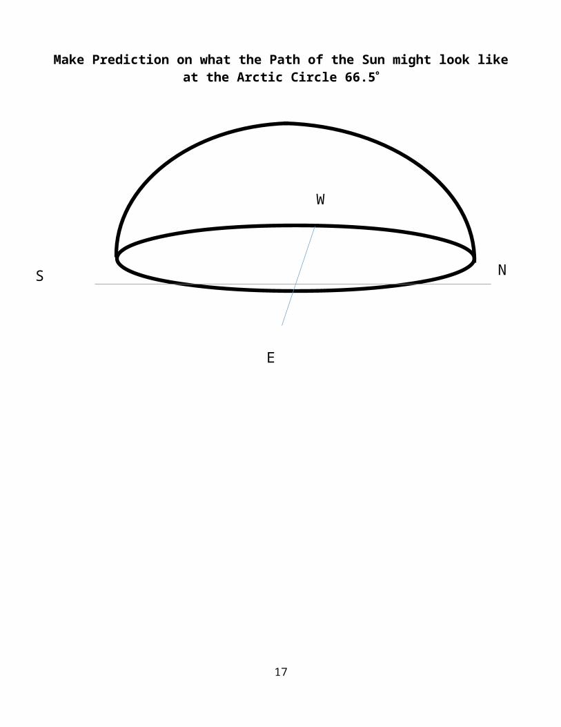
Make Prediction on what the Path of the Sun might look like at the Arctic Circle 66.5
14
NS
E
W
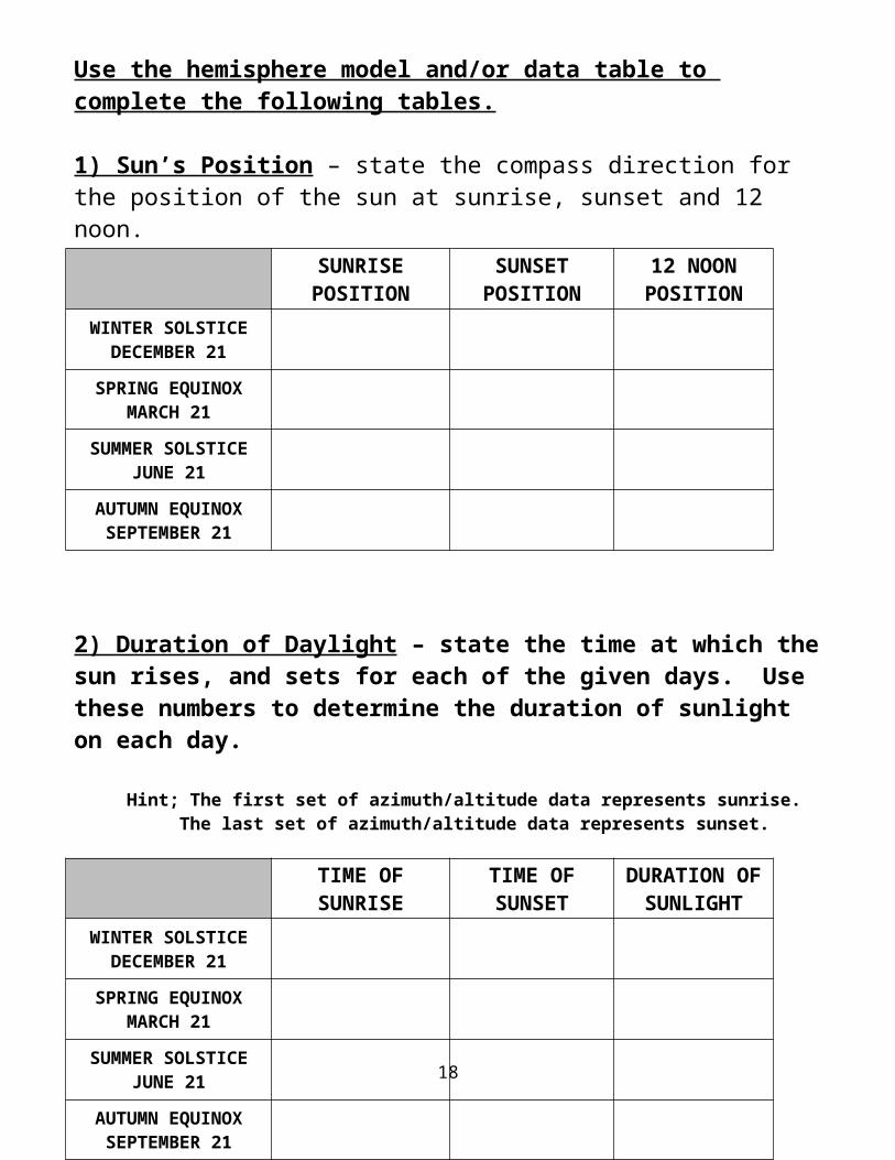
Use the hemisphere model and/or data table to complete the following tables.
1) Sun’s Position – state the compass direction for the position of the sun at sunrise, sunset and 12 noon.
2) Duration of Daylight – state the time at which the sun rises, and sets for each of the given days. Use these numbers to determine the duration of sunlight on each day.
Hint; The first set of azimuth/altitude data represents sunrise.The last set of azimuth/altitude data represents sunset.
15
SUNRISEPOSITION
SUNSETPOSITION
12 NOONPOSITION
WINTER SOLSTICEDECEMBER 21
SPRING EQUINOXMARCH 21
SUMMER SOLSTICEJUNE 21
AUTUMN EQUINOXSEPTEMBER 21
TIME OFSUNRISE
TIME OF SUNSET
DURATION OF
SUNLIGHTWINTER SOLSTICE
DECEMBER 21
SPRING EQUINOXMARCH 21
SUMMER SOLSTICEJUNE 21
AUTUMN EQUINOXSEPTEMBER 21

VOCABULARYNeatly write the definition for the following words.
duration –
zenith –
tropics –
equinox –
latitude –
arctic circle –
16
CONCLUSIONS
1) State the date for the Winter Solstice.
2) State the date for the Spring Equinox.
3) State the date for the Summer Solstice.
4) State the date for the Autumn Equinox.
5) What is the name for the position in the sky that is directly overhead?
6) During which season is the duration of sunlight the longest in NY state?
7) During which season is the duration of sunlight the shortest in NY state?
8) During which season is the noon sun at its highest point in NY state?
9) During which season is the noon sun at its lowest point in NY state?
10) During which seasons is the duration of sunlight 12 hours everywhere on the planet?
11) On which date does the North Pole receive 24 hours of sunlight?
12) On which date does the North Pole receive 0 hours of sunlight?
Position of Sunrise and Sunset at the Equator 13) Examine the three paths of the Sun. On average, for a location at the equator, in which compass direction does the sun rise?
14) On average, in which compass direction does the sun set at the equator?
15) “Due East” means exactly in the east (azimuth 90o). State the date, or dates, when sun will rise “due east” and set “due west” at the equator.
17
16) For a person located at the equator, where would they have to look to see the noon sun during the Equinoxes?
17) Describe the shape of the Sun’s path.
18) Describe the direction in which the Sun moves across the sky.
19) As the seasons change, explain what happens to the duration of sunlight at the equator?
Position of Sunrise and Sunset at the North Pole
20) As the seasons change, explain what happens to the duration of sunlight at the North Pole?
21) How does the Path of the Sun at the North Pole differ from the Equator and Jamestown, NY?
22) For a person located at the North Pole, would they ever see the Noon Sun at their Zenith point?
23) Describe the shape of the Sun’s path.
24) Describe the direction in which the Sun moves across the sky.
18

25) To complete the table, fill in the duration of sunlight during each season, for the North Pole, Jamestown NY and the Equator. For New York state, fill in the equinoxes first then remember the rule of threes.
26) As latitude increases what happens to the duration of sunlight on the Winter Solstice?
27) Explain the relationship between latitude and duration of sunlight on the Summer Solstice.
28) Describe how latitude affects the duration of sunlight on the Equinoxes.
29) At which of these locations is the Noon sun usually highest in the sky?
30) At which of these locations is the Noon Sun usually low in the sky?
31) Explain how the altitude of the noon sun affects the temperature of a region.
19
NORTHPOLE(90oN)
JAMESTOWNNY
(42oN)EQUATOR
(0o)
WINTER SOLSTICEDECEMBER 21
SPRING EQUINOXMARCH 21
SUMMER SOLSTICEJUNE 21
AUTUMN EQUINOXSEPTEMBER 21

20

21