Embed Size (px)
Citation preview
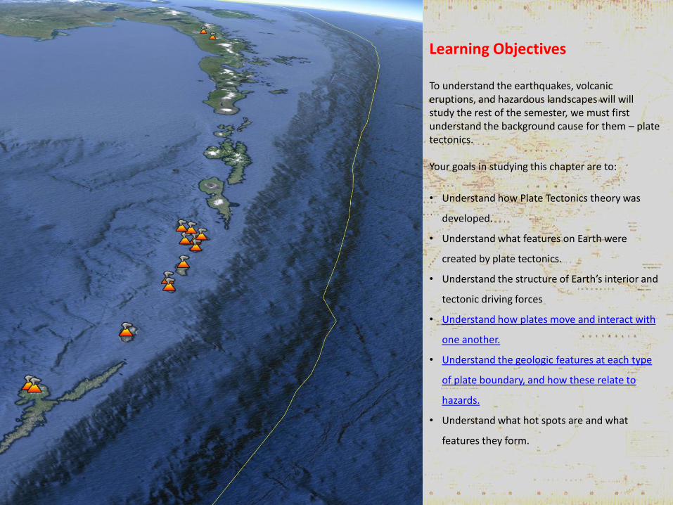
Learning Objectives To understand the earthquakes, volcanic eruptions, and hazardous landscapes will will study the rest of the semester, we must first understand the background cause for them – plate tectonics. Your goals in studying this chapter are to:
• Understand how Plate Tectonics theory was
developed.
• Understand what features on Earth were
created by plate tectonics.
• Understand the structure of Earth’s interior and
tectonic driving forces
• Understand how plates move and interact with
one another.
• Understand the geologic features at each type
of plate boundary, and how these relate to
hazards.
• Understand what hot spots are and what
features they form.
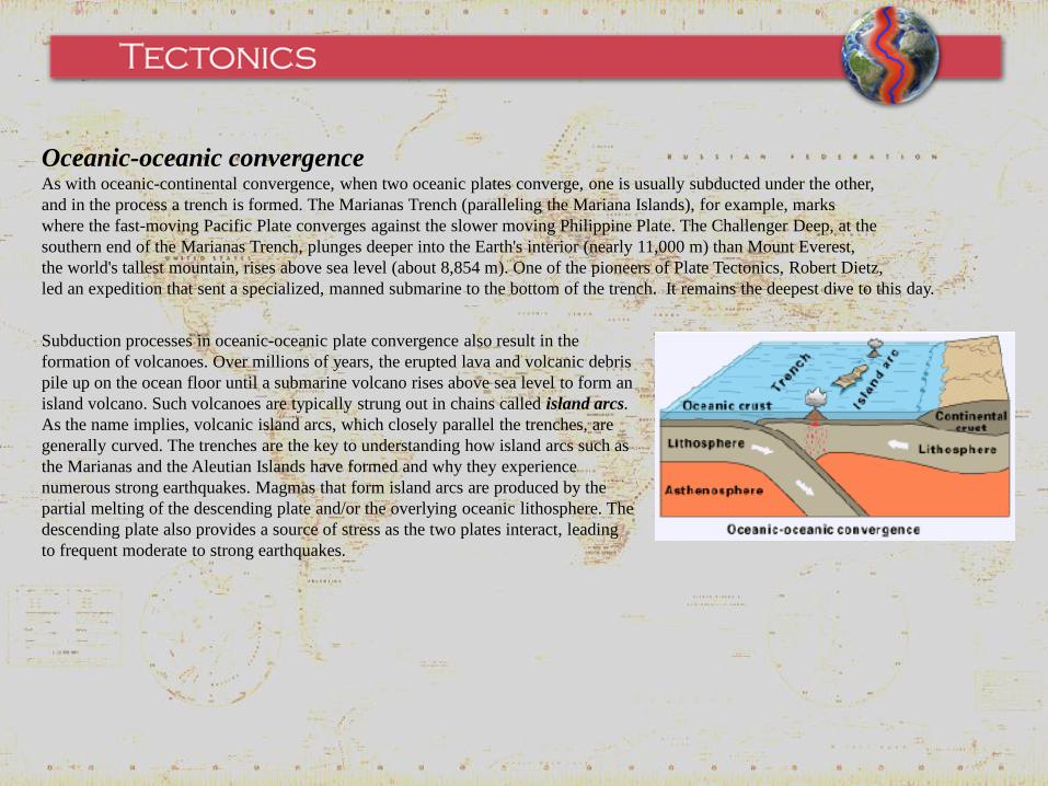
Oceanic-oceanic convergence As with oceanic-continental convergence, when two oceanic plates converge, one is usually subducted under the other,
and in the process a trench is formed. The Marianas Trench (paralleling the Mariana Islands), for example, marks
where the fast-moving Pacific Plate converges against the slower moving Philippine Plate. The Challenger Deep, at the
southern end of the Marianas Trench, plunges deeper into the Earth's interior (nearly 11,000 m) than Mount Everest,
the world's tallest mountain, rises above sea level (about 8,854 m). One of the pioneers of Plate Tectonics, Robert Dietz,
led an expedition that sent a specialized, manned submarine to the bottom of the trench. It remains the deepest dive to this day.
Subduction processes in oceanic-oceanic plate convergence also result in the
formation of volcanoes. Over millions of years, the erupted lava and volcanic debris
pile up on the ocean floor until a submarine volcano rises above sea level to form an
island volcano. Such volcanoes are typically strung out in chains called island arcs.
As the name implies, volcanic island arcs, which closely parallel the trenches, are
generally curved. The trenches are the key to understanding how island arcs such as
the Marianas and the Aleutian Islands have formed and why they experience
numerous strong earthquakes. Magmas that form island arcs are produced by the
partial melting of the descending plate and/or the overlying oceanic lithosphere. The
descending plate also provides a source of stress as the two plates interact, leading
to frequent moderate to strong earthquakes.
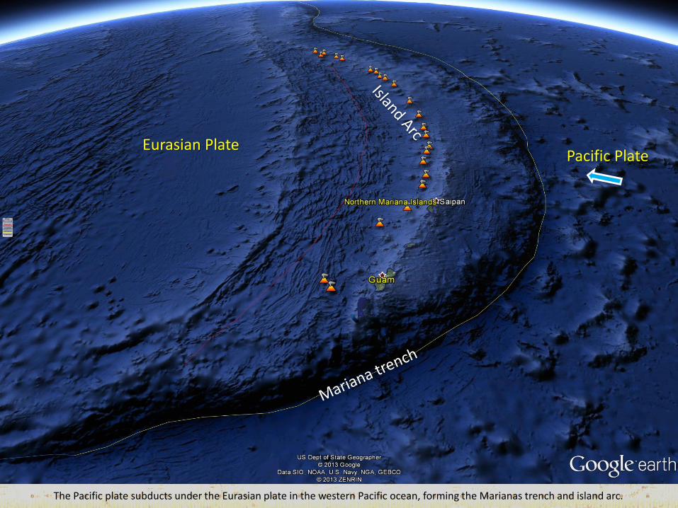
Eurasian Plate
The Pacific plate subducts under the Eurasian plate in the western Pacific ocean, forming the Marianas trench and island arc.
Pacific Plate
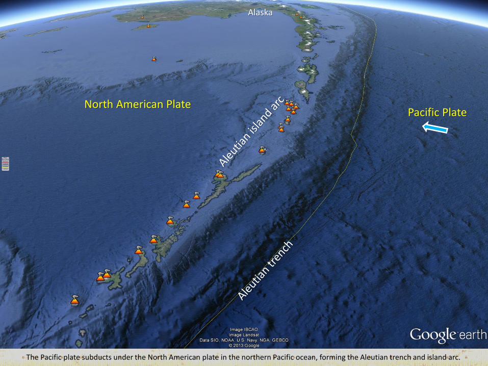
The Pacific plate subducts under the North American plate in the northern Pacific ocean, forming the Aleutian trench and island arc.
Pacific Plate North American Plate
Alaska
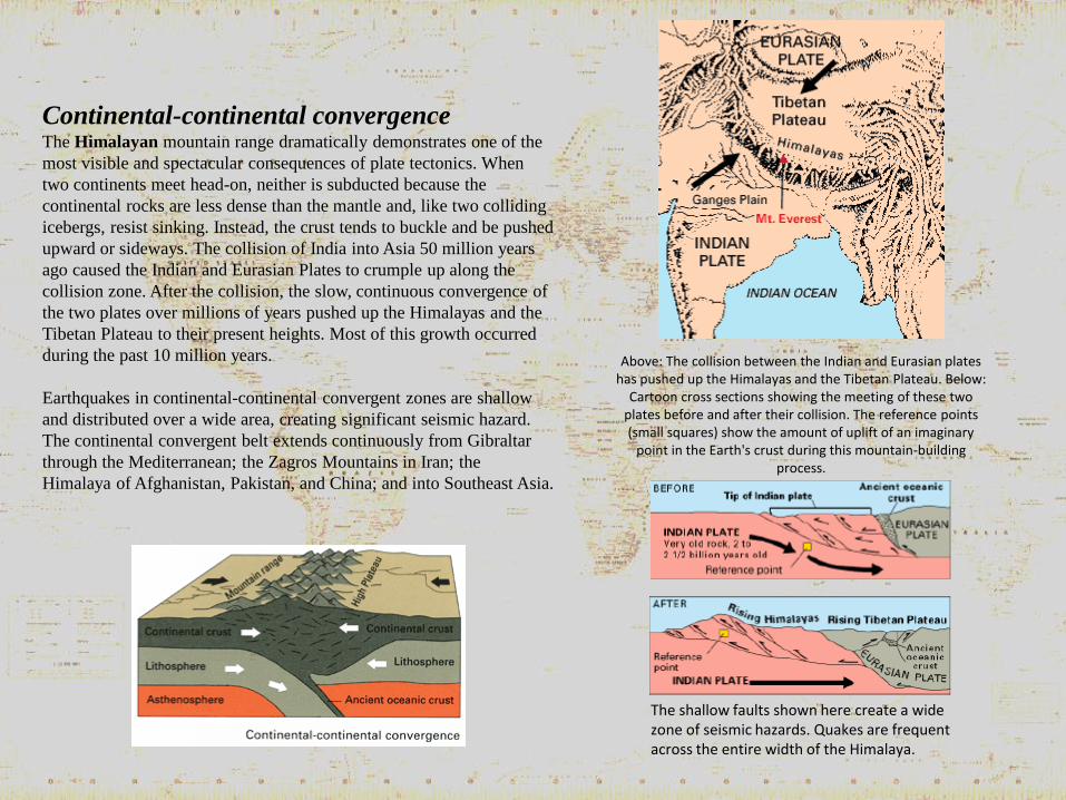
Continental-continental convergence The Himalayan mountain range dramatically demonstrates one of the
most visible and spectacular consequences of plate tectonics. When
two continents meet head-on, neither is subducted because the
continental rocks are less dense than the mantle and, like two colliding
icebergs, resist sinking. Instead, the crust tends to buckle and be pushed
upward or sideways. The collision of India into Asia 50 million years
ago caused the Indian and Eurasian Plates to crumple up along the
collision zone. After the collision, the slow, continuous convergence of
the two plates over millions of years pushed up the Himalayas and the
Tibetan Plateau to their present heights. Most of this growth occurred
during the past 10 million years.
Earthquakes in continental-continental convergent zones are shallow
and distributed over a wide area, creating significant seismic hazard.
The continental convergent belt extends continuously from Gibraltar
through the Mediterranean; the Zagros Mountains in Iran; the
Himalaya of Afghanistan, Pakistan, and China; and into Southeast Asia.
Above: The collision between the Indian and Eurasian plates has pushed up the Himalayas and the Tibetan Plateau. Below:
Cartoon cross sections showing the meeting of these two plates before and after their collision. The reference points (small squares) show the amount of uplift of an imaginary
point in the Earth's crust during this mountain-building process.
The shallow faults shown here create a wide zone of seismic hazards. Quakes are frequent across the entire width of the Himalaya.
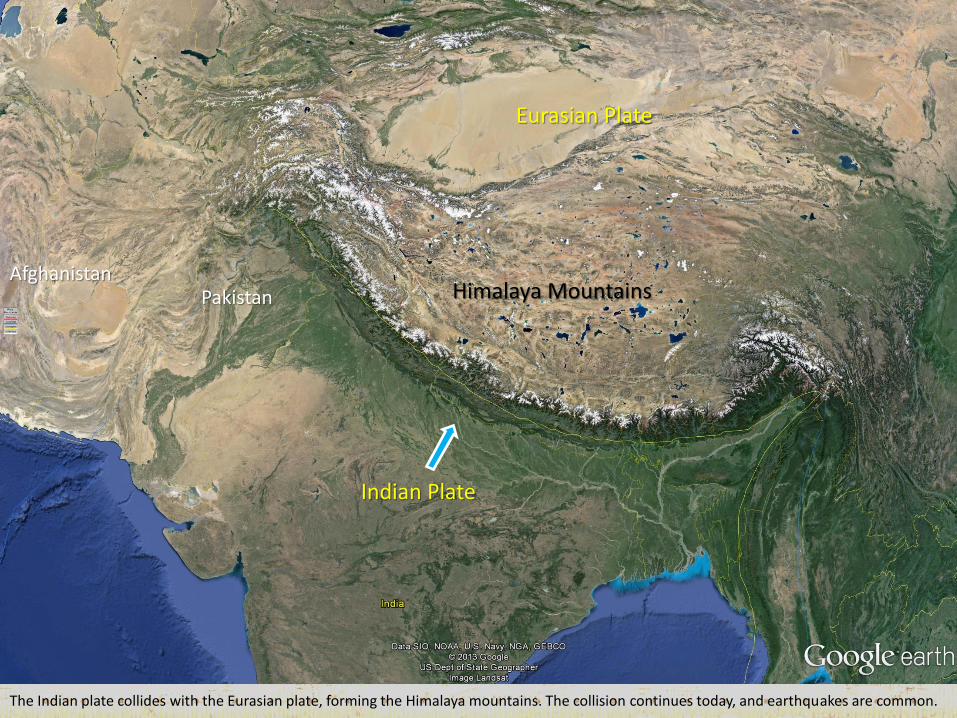
The Indian plate collides with the Eurasian plate, forming the Himalaya mountains. The collision continues today, and earthquakes are common.
Eurasian Plate
Himalaya Mountains
Indian Plate
Pakistan Afghanistan
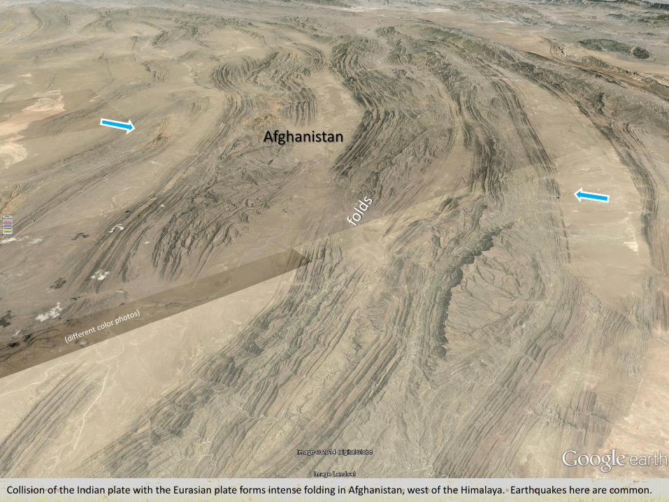
Collision of the Indian plate with the Eurasian plate forms intense folding in Afghanistan, west of the Himalaya. Earthquakes here are common.
Afghanistan
The Indian plate collides with the Eurasian plate, forming the Himalaya mountains. The collision continues today, and earthquakes are common.
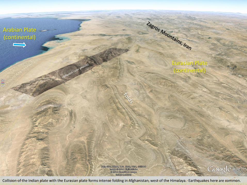
Collision of the Indian plate with the Eurasian plate forms intense folding in Afghanistan, west of the Himalaya. Earthquakes here are common.
Arabian Plate (continental)
Eurasian Plate (continental)
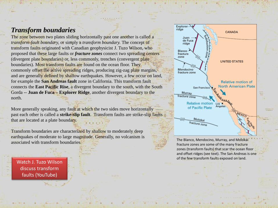
Transform boundaries The zone between two plates sliding horizontally past one another is called a
transform-fault boundary, or simply a transform boundary. The concept of
transform faults originated with Canadian geophysicist J. Tuzo Wilson, who
proposed that these large faults or fracture zones connect two spreading centers
(divergent plate boundaries) or, less commonly, trenches (convergent plate
boundaries). Most transform faults are found on the ocean floor. They
commonly offset the active spreading ridges, producing zig-zag plate margins,
and are generally defined by shallow earthquakes. However, a few occur on land,
for example the San Andreas fault zone in California. This transform fault
connects the East Pacific Rise, a divergent boundary to the south, with the South
Gorda -- Juan de Fuca – Explorer Ridge, another divergent boundary to the
north.
More generally speaking, any fault at which the two sides move horizontally
past each other is called a strike-slip fault. Transform faults are strike-slip faults
that are located at a plate boundary.
Transform boundaries are characterized by shallow to moderately deep
earthquakes of moderate to large magnitude. Generally, no volcanism is
associated with transform boundaries. The Blanco, Mendocino, Murray, and Molokai fracture zones are some of the many fracture zones (transform faults) that scar the ocean floor and offset ridges (see text). The San Andreas is one of the few transform faults exposed on land.
Watch J. Tuzo Wilson discuss transform faults (YouTube)
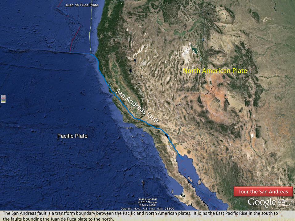
The San Andreas fault is a transform boundary between the Pacific and North American plates. It joins the East Pacific Rise in the south to the faults bounding the Juan de Fuca plate to the north.
North American Plate
Tour the San Andreas
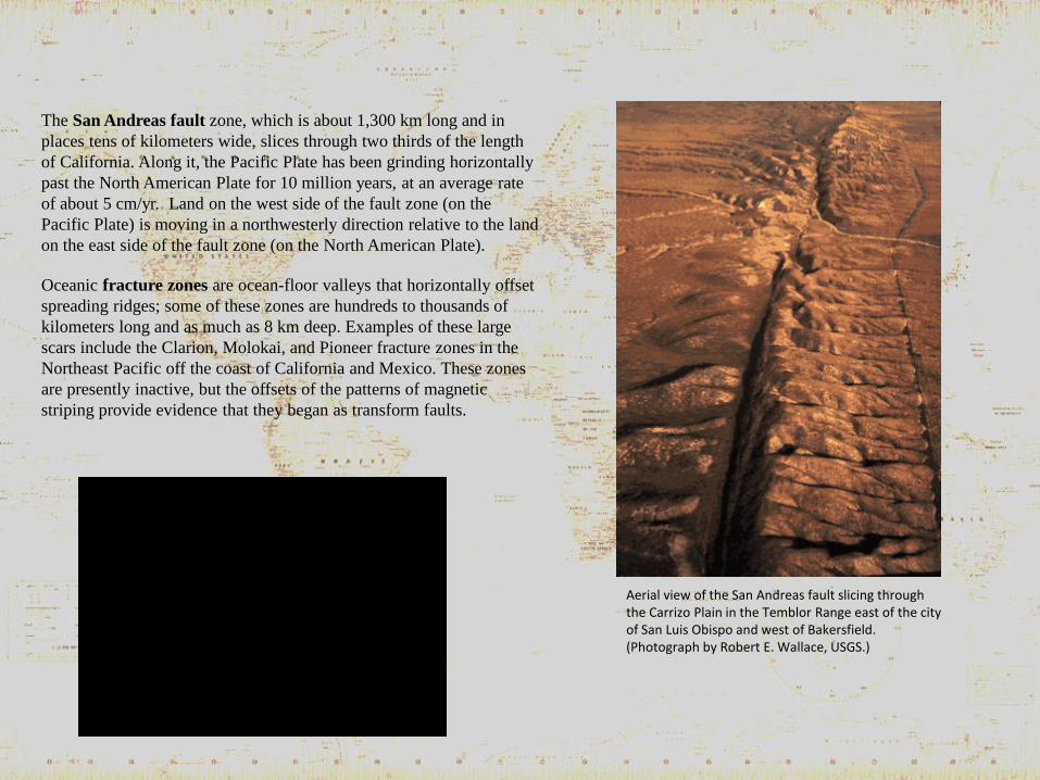
The San Andreas fault zone, which is about 1,300 km long and in
places tens of kilometers wide, slices through two thirds of the length
of California. Along it, the Pacific Plate has been grinding horizontally
past the North American Plate for 10 million years, at an average rate
of about 5 cm/yr. Land on the west side of the fault zone (on the
Pacific Plate) is moving in a northwesterly direction relative to the land
on the east side of the fault zone (on the North American Plate).
Oceanic fracture zones are ocean-floor valleys that horizontally offset
spreading ridges; some of these zones are hundreds to thousands of
kilometers long and as much as 8 km deep. Examples of these large
scars include the Clarion, Molokai, and Pioneer fracture zones in the
Northeast Pacific off the coast of California and Mexico. These zones
are presently inactive, but the offsets of the patterns of magnetic
striping provide evidence that they began as transform faults.
Aerial view of the San Andreas fault slicing through the Carrizo Plain in the Temblor Range east of the city of San Luis Obispo and west of Bakersfield. (Photograph by Robert E. Wallace, USGS.)
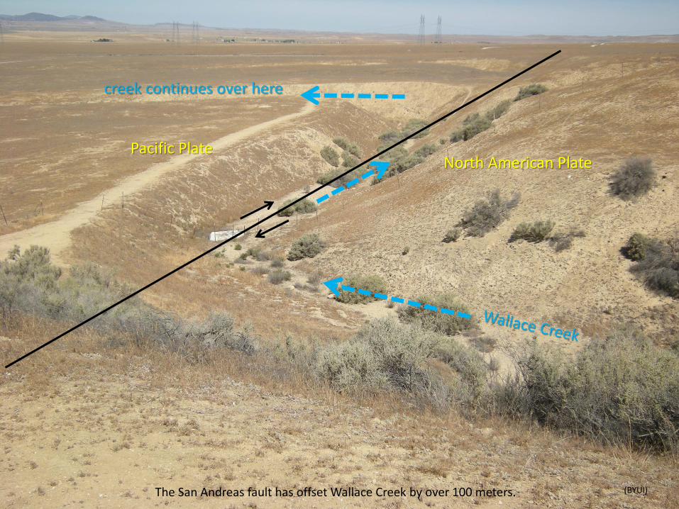
The San Andreas fault has offset Wallace Creek by over 100 meters.
North American Plate Pacific Plate
creek continues over here
(BYUI)
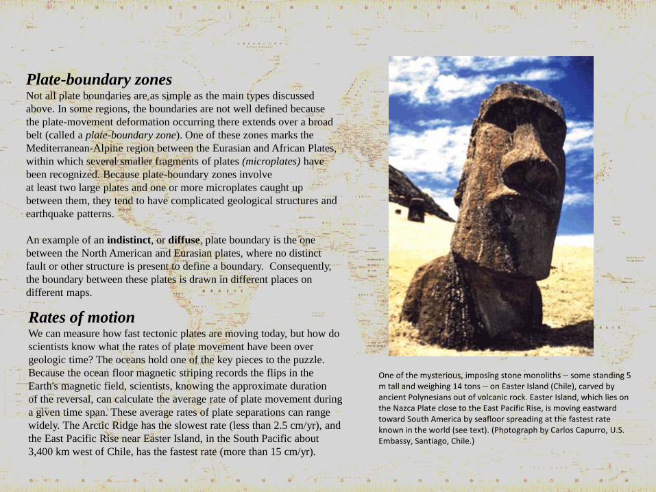
Plate-boundary zones Not all plate boundaries are as simple as the main types discussed
above. In some regions, the boundaries are not well defined because
the plate-movement deformation occurring there extends over a broad
belt (called a plate-boundary zone). One of these zones marks the
Mediterranean-Alpine region between the Eurasian and African Plates,
within which several smaller fragments of plates (microplates) have
been recognized. Because plate-boundary zones involve
at least two large plates and one or more microplates caught up
between them, they tend to have complicated geological structures and
earthquake patterns.
An example of an indistinct, or diffuse, plate boundary is the one
between the North American and Eurasian plates, where no distinct
fault or other structure is present to define a boundary. Consequently,
the boundary between these plates is drawn in different places on
different maps.
Rates of motion We can measure how fast tectonic plates are moving today, but how do
scientists know what the rates of plate movement have been over
geologic time? The oceans hold one of the key pieces to the puzzle.
Because the ocean floor magnetic striping records the flips in the
Earth's magnetic field, scientists, knowing the approximate duration
of the reversal, can calculate the average rate of plate movement during
a given time span. These average rates of plate separations can range
widely. The Arctic Ridge has the slowest rate (less than 2.5 cm/yr), and
the East Pacific Rise near Easter Island, in the South Pacific about
3,400 km west of Chile, has the fastest rate (more than 15 cm/yr).
One of the mysterious, imposing stone monoliths -- some standing 5 m tall and weighing 14 tons -- on Easter Island (Chile), carved by ancient Polynesians out of volcanic rock. Easter Island, which lies on the Nazca Plate close to the East Pacific Rise, is moving eastward toward South America by seafloor spreading at the fastest rate known in the world (see text). (Photograph by Carlos Capurro, U.S. Embassy, Santiago, Chile.)
Evidence of past rates of plate movement also can be obtained from
geologic mapping studies. If a rock formation of known age -- with
distinctive composition, structure, or fossils -- mapped on one side of a
plate boundary can be matched with the same formation on the other
side of the boundary, then measuring the distance that the formation
has been offset can give an estimate of the average rate of plate motion.
This simple but effective technique has been used to determine the
rates of plate motion at divergent boundaries, for example the Mid-
Atlantic Ridge, and transform boundaries, such as the San Andreas
Fault.
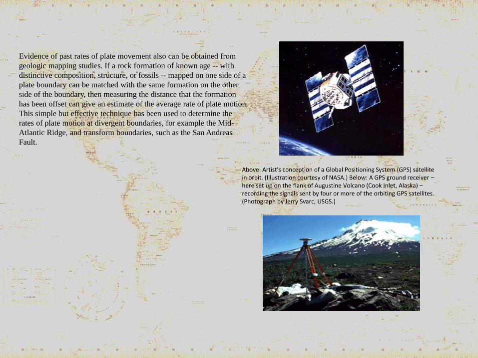
Above: Artist's conception of a Global Positioning System (GPS) satellite in orbit. (Illustration courtesy of NASA.) Below: A GPS ground receiver – here set up on the flank of Augustine Volcano (Cook Inlet, Alaska) – recording the signals sent by four or more of the orbiting GPS satellites. (Photograph by Jerry Svarc, USGS.)
Current plate movement is tracked directly by means of ground-based or space-based geodetic measurements. Geodesy is the
science of the size and shape of the Earth. Ground-based measurements are taken with conventional but
very precise ground-surveying techniques, using laser-electronic instruments. However, because plate motions are
global in scale, they are best measured by satellite-based methods. The late 1970s witnessed the rapid growth of space
geodesy, a term applied to space-based techniques for taking precise, repeated measurements of carefully chosen
points on the Earth's surface separated by hundreds to thousands of kilometers. The three most commonly used space-
geodetic techniques -- very long baseline interferometry (VLBI), satellite laser ranging (SLR), and the Global
Positioning System (GPS) -- are based on technologies developed for military and aerospace research, notably radio
astronomy and satellite tracking.
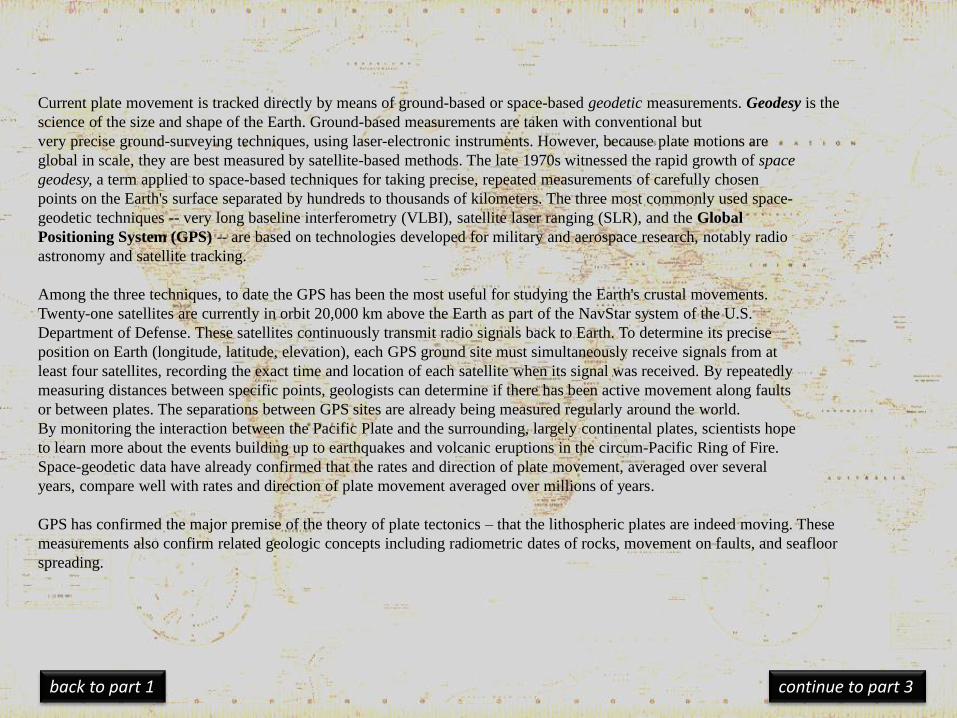
Among the three techniques, to date the GPS has been the most useful for studying the Earth's crustal movements.
Twenty-one satellites are currently in orbit 20,000 km above the Earth as part of the NavStar system of the U.S.
Department of Defense. These satellites continuously transmit radio signals back to Earth. To determine its precise
position on Earth (longitude, latitude, elevation), each GPS ground site must simultaneously receive signals from at
least four satellites, recording the exact time and location of each satellite when its signal was received. By repeatedly
measuring distances between specific points, geologists can determine if there has been active movement along faults
or between plates. The separations between GPS sites are already being measured regularly around the world.
By monitoring the interaction between the Pacific Plate and the surrounding, largely continental plates, scientists hope
to learn more about the events building up to earthquakes and volcanic eruptions in the circum-Pacific Ring of Fire.
Space-geodetic data have already confirmed that the rates and direction of plate movement, averaged over several
years, compare well with rates and direction of plate movement averaged over millions of years.
GPS has confirmed the major premise of the theory of plate tectonics – that the lithospheric plates are indeed moving. These
measurements also confirm related geologic concepts including radiometric dates of rocks, movement on faults, and seafloor
spreading.
continue to part 3 back to part 1