Embed Size (px)
Citation preview
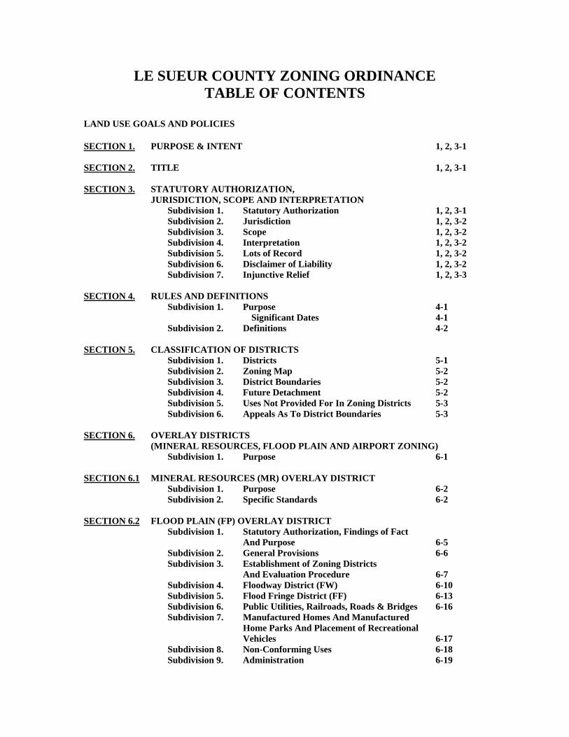
LE SUEUR COUNTY ZONING ORDINANCE TABLE OF CONTENTS
LAND USE GOALS AND POLICIES SECTION 1. PURPOSE & INTENT 1, 2, 3-1 SECTION 2. TITLE 1, 2, 3-1 SECTION 3. STATUTORY AUTHORIZATION, JURISDICTION, SCOPE AND INTERPRETATION Subdivision 1. Statutory Authorization 1, 2, 3-1 Subdivision 2. Jurisdiction 1, 2, 3-2 Subdivision 3. Scope 1, 2, 3-2 Subdivision 4. Interpretation 1, 2, 3-2 Subdivision 5. Lots of Record 1, 2, 3-2 Subdivision 6. Disclaimer of Liability 1, 2, 3-2 Subdivision 7. Injunctive Relief 1, 2, 3-3 SECTION 4. RULES AND DEFINITIONS Subdivision 1. Purpose 4-1 Significant Dates 4-1 Subdivision 2. Definitions 4-2 SECTION 5. CLASSIFICATION OF DISTRICTS Subdivision 1. Districts 5-1 Subdivision 2. Zoning Map 5-2 Subdivision 3. District Boundaries 5-2 Subdivision 4. Future Detachment 5-2 Subdivision 5. Uses Not Provided For In Zoning Districts 5-3 Subdivision 6. Appeals As To District Boundaries 5-3 SECTION 6. OVERLAY DISTRICTS (MINERAL RESOURCES, FLOOD PLAIN AND AIRPORT ZONING) Subdivision 1. Purpose 6-1 SECTION 6.1 MINERAL RESOURCES (MR) OVERLAY DISTRICT Subdivision 1. Purpose 6-2 Subdivision 2. Specific Standards 6-2 SECTION 6.2 FLOOD PLAIN (FP) OVERLAY DISTRICT Subdivision 1. Statutory Authorization, Findings of Fact And Purpose 6-5 Subdivision 2. General Provisions 6-6 Subdivision 3. Establishment of Zoning Districts And Evaluation Procedure 6-7 Subdivision 4. Floodway District (FW) 6-10 Subdivision 5. Flood Fringe District (FF) 6-13 Subdivision 6. Public Utilities, Railroads, Roads & Bridges 6-16 Subdivision 7. Manufactured Homes And Manufactured Home Parks And Placement of Recreational Vehicles 6-17 Subdivision 8. Non-Conforming Uses 6-18 Subdivision 9. Administration 6-19
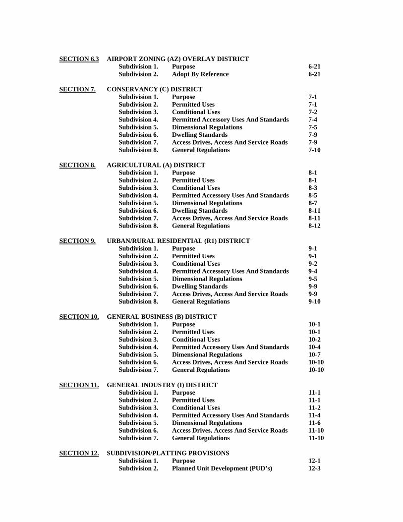
SECTION 6.3 AIRPORT ZONING (AZ) OVERLAY DISTRICT Subdivision 1. Purpose 6-21 Subdivision 2. Adopt By Reference 6-21 SECTION 7. CONSERVANCY (C) DISTRICT Subdivision 1. Purpose 7-1 Subdivision 2. Permitted Uses 7-1 Subdivision 3. Conditional Uses 7-2 Subdivision 4. Permitted Accessory Uses And Standards 7-4 Subdivision 5. Dimensional Regulations 7-5 Subdivision 6. Dwelling Standards 7-9 Subdivision 7. Access Drives, Access And Service Roads 7-9 Subdivision 8. General Regulations 7-10 SECTION 8. AGRICULTURAL (A) DISTRICT Subdivision 1. Purpose 8-1 Subdivision 2. Permitted Uses 8-1 Subdivision 3. Conditional Uses 8-3 Subdivision 4. Permitted Accessory Uses And Standards 8-5 Subdivision 5. Dimensional Regulations 8-7 Subdivision 6. Dwelling Standards 8-11 Subdivision 7. Access Drives, Access And Service Roads 8-11 Subdivision 8. General Regulations 8-12 SECTION 9. URBAN/RURAL RESIDENTIAL (R1) DISTRICT Subdivision 1. Purpose 9-1 Subdivision 2. Permitted Uses 9-1 Subdivision 3. Conditional Uses 9-2 Subdivision 4. Permitted Accessory Uses And Standards 9-4 Subdivision 5. Dimensional Regulations 9-5 Subdivision 6. Dwelling Standards 9-9 Subdivision 7. Access Drives, Access And Service Roads 9-9 Subdivision 8. General Regulations 9-10 SECTION 10. GENERAL BUSINESS (B) DISTRICT Subdivision 1. Purpose 10-1 Subdivision 2. Permitted Uses 10-1 Subdivision 3. Conditional Uses 10-2 Subdivision 4. Permitted Accessory Uses And Standards 10-4 Subdivision 5. Dimensional Regulations 10-7 Subdivision 6. Access Drives, Access And Service Roads 10-10 Subdivision 7. General Regulations 10-10 SECTION 11. GENERAL INDUSTRY (I) DISTRICT Subdivision 1. Purpose 11-1 Subdivision 2. Permitted Uses 11-1 Subdivision 3. Conditional Uses 11-2 Subdivision 4. Permitted Accessory Uses And Standards 11-4 Subdivision 5. Dimensional Regulations 11-6 Subdivision 6. Access Drives, Access And Service Roads 11-10 Subdivision 7. General Regulations 11-10 SECTION 12. SUBDIVISION/PLATTING PROVISIONS Subdivision 1. Purpose 12-1 Subdivision 2. Planned Unit Development (PUD’s) 12-3
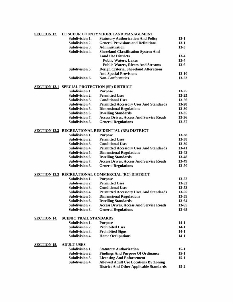
SECTION 13. LE SUEUR COUNTY SHORELAND MANAGEMENT Subdivision 1. Statutory Authorization And Policy 13-1 Subdivision 2. General Provisions and Definitions 13-1 Subdivision 3. Administration 13-3 Subdivision 4. Shoreland Classification System And Land Use Districts 13-4 Public Waters, Lakes 13-4 Public Waters, Rivers And Streams 13-6 Subdivision 5. Design Criteria, Shoreland Alterations And Special Provisions 13-10 Subdivision 6. Non-Conformities 13-23 SECTION 13.1 SPECIAL PROTECTION (SP) DISTRICT Subdivision 1. Purpose 13-25 Subdivision 2. Permitted Uses 13-25 Subdivision 3. Conditional Uses 13-26 Subdivision 4. Permitted Accessory Uses And Standards 13-28 Subdivision 5. Dimensional Regulations 13-30 Subdivision 6. Dwelling Standards 13-35 Subdivision 7. Access Drives, Access And Service Roads 13-36 Subdivision 8. General Regulations 13-37 SECTION 13.2 RECREATIONAL RESIDENTIAL (RR) DISTRICT Subdivision 1. Purpose 13-38 Subdivision 2. Permitted Uses 13-38 Subdivision 3. Conditional Uses 13-39 Subdivision 4. Permitted Accessory Uses And Standards 13-41 Subdivision 5. Dimensional Regulations 13-43 Subdivision 6. Dwelling Standards 13-48 Subdivision 7. Access Drives, Access And Service Roads 13-49 Subdivision 8. General Regulations 13-50 SECTION 13.3 RECREATIONAL COMMERCIAL (RC) DISTRICT Subdivision 1. Purpose 13-52 Subdivision 2. Permitted Uses 13-52 Subdivision 3. Conditional Uses 13-53 Subdivision 4. Permitted Accessory Uses And Standards 13-55 Subdivision 5. Dimensional Regulations 13-59 Subdivision 6. Dwelling Standards 13-64 Subdivision 7. Access Drives, Access And Service Roads 13-65 Subdivision 8. General Regulations 13-65 SECTION 14. SCENIC TRAIL STANDARDS Subdivision 1. Purpose 14-1 Subdivision 2. Prohibited Uses 14-1 Subdivision 3. Prohibited Signs 14-1 Subdivision 4. Home Occupations 14-1 SECTION 15. ADULT USES Subdivision 1. Statutory Authorization 15-1
Subdivision 2. Findings And Purpose Of Ordinance 15-1 Subdivision 3. Licensing And Enforcement 15-1
Subdivision 4. Allowed Adult Use Locations By Zoning District And Other Applicable Standards 15-2

SECTION 16. ANIMAL FEEDLOT AND MANURE MANAGEMENT Subdivision 1. Purpose 16-1 Subdivision 2. Adoption By Reference Of State Regulations 16-1 Subdivision 3. Scope And Applicability 16-1 Subdivision 4. Exempt From Regulations 16-4 Subdivision 5. Permit Requirements 16-5 Subdivision 6. Inspections 16-5 Subdivision 7. General Requirements 16-6 Subdivision 8. Conditional Uses 16-6 Subdivision 9. Standards For Conditional Use Permits 16-7 Subdivision 10. Required Setbacks For New Animal Feedlots, Expansion Of Existing Animal Feedlots, And Manure Storage Structures 16-8 Subdivision 11. Manure Management 16-9 Subdivision 12. Severability 16-11 Subdivision 13. Variance 16-11 Subdivision 14. Non-Conforming Use 16-12 Subdivision 15. Fees 16-13 SECTION 17. SUBSURFACE SEWAGE TREATMENT SYSTEMS (SSTS) Subdivision 1. Purpose And Authority 17-1 Subdivision 2. General Provisions 17-2 Subdivision 3. General Requirements 17-4 Subdivision 4. SSTS Standards 17-6 Setbacks 17-9 Subdivision 5. SSTS Permitting 17-10 Subdivision 6. Management Plans 17-15 Subdivision 7. Compliance Inspection Program 17-16 Subdivision 8. Enforcement 17-20 SECTION 18. ENVIRONMENTAL PERFORMANCE STANDARDS Subdivision 1. Wetland Conservation 18-1 Subdivision 2. Bluff Regulations 18-2 Subdivision 3. Grading, Excavating, Or Filling Standards 18-3 Subdivision 4. Abatement of Environmental Hazards 18-6 Subdivision 5. Forest Management And Natural Vegetation Preservation 18-7 Subdivision 6. Spreading of Contaminated Soil 18-8 Subdivision 7. Erosion Control 18-9 Subdivision 8. Drainage 18-14 SECTION 19. LAND USE PERFORMANCE STANDARDS Subdivision 1. Purpose 19-1 Subdivision 2. Application 19-1 Subdivision 3. General Standards 19-3 Subdivision 4. Access Drives, Access And Service Roads 19-4 Subdivision 5. Parking And Loading Standards 19-5 Subdivision 6. Landscaping And Screening 19-9 Subdivision 7. Sign Standards 19-10 Subdivision 8. Outdoor Lighting Standards 19-14 Subdivision 9. Nuisance Control 19-15 Subdivision 10. Relocating Structures 19-17 Subdivision 11. Right To Farm 19-17 Subdivision 12. Specific Land Uses 19-18
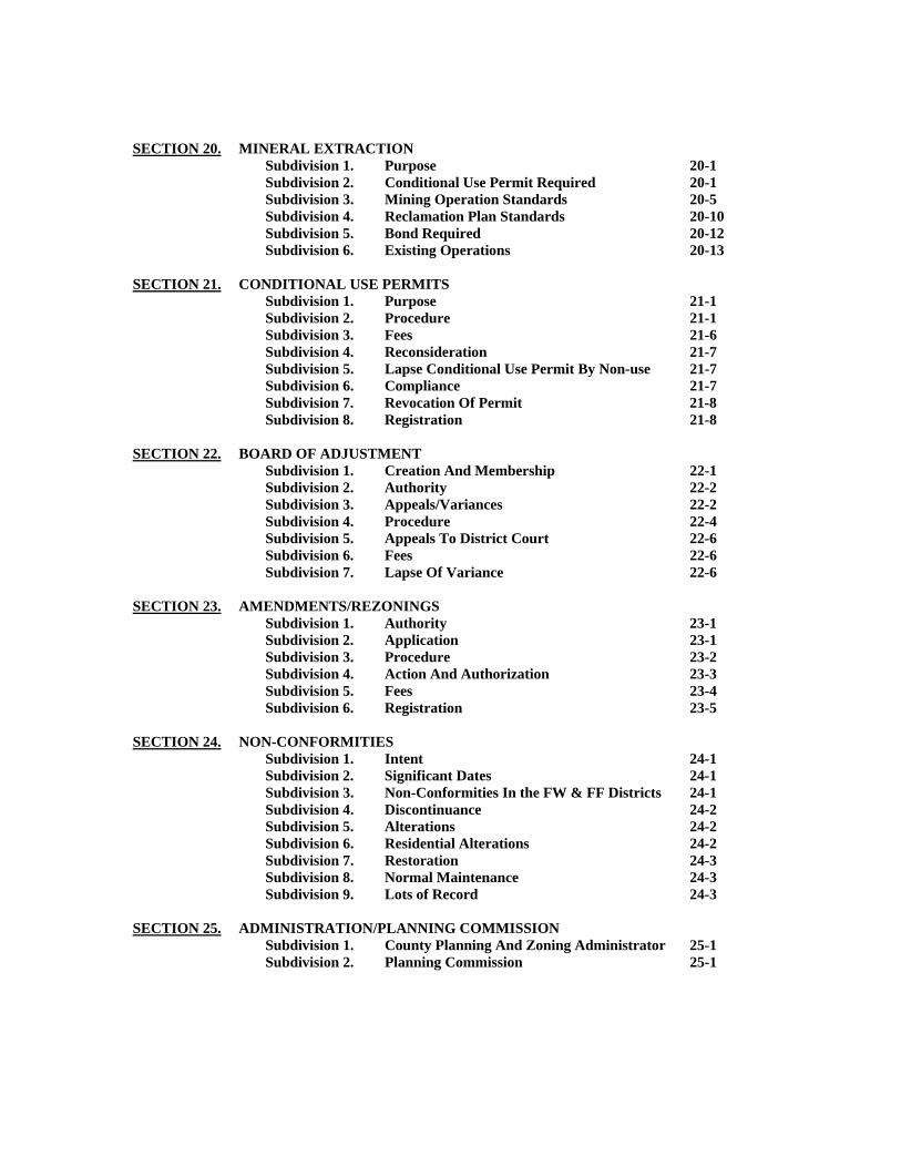
SECTION 20. MINERAL EXTRACTION Subdivision 1. Purpose 20-1 Subdivision 2. Conditional Use Permit Required 20-1
Subdivision 3. Mining Operation Standards 20-5 Subdivision 4. Reclamation Plan Standards 20-10 Subdivision 5. Bond Required 20-12 Subdivision 6. Existing Operations 20-13 SECTION 21. CONDITIONAL USE PERMITS Subdivision 1. Purpose 21-1 Subdivision 2. Procedure 21-1 Subdivision 3. Fees 21-6 Subdivision 4. Reconsideration 21-7 Subdivision 5. Lapse Conditional Use Permit By Non-use 21-7 Subdivision 6. Compliance 21-7 Subdivision 7. Revocation Of Permit 21-8 Subdivision 8. Registration 21-8 SECTION 22. BOARD OF ADJUSTMENT Subdivision 1. Creation And Membership 22-1 Subdivision 2. Authority 22-2 Subdivision 3. Appeals/Variances 22-2 Subdivision 4. Procedure 22-4 Subdivision 5. Appeals To District Court 22-6 Subdivision 6. Fees 22-6 Subdivision 7. Lapse Of Variance 22-6 SECTION 23. AMENDMENTS/REZONINGS Subdivision 1. Authority 23-1 Subdivision 2. Application 23-1 Subdivision 3. Procedure 23-2 Subdivision 4. Action And Authorization 23-3 Subdivision 5. Fees 23-4 Subdivision 6. Registration 23-5 SECTION 24. NON-CONFORMITIES Subdivision 1. Intent 24-1 Subdivision 2. Significant Dates 24-1 Subdivision 3. Non-Conformities In the FW & FF Districts 24-1 Subdivision 4. Discontinuance 24-2 Subdivision 5. Alterations 24-2 Subdivision 6. Residential Alterations 24-2 Subdivision 7. Restoration 24-3 Subdivision 8. Normal Maintenance 24-3 Subdivision 9. Lots of Record 24-3 SECTION 25. ADMINISTRATION/PLANNING COMMISSION Subdivision 1. County Planning And Zoning Administrator 25-1 Subdivision 2. Planning Commission 25-1
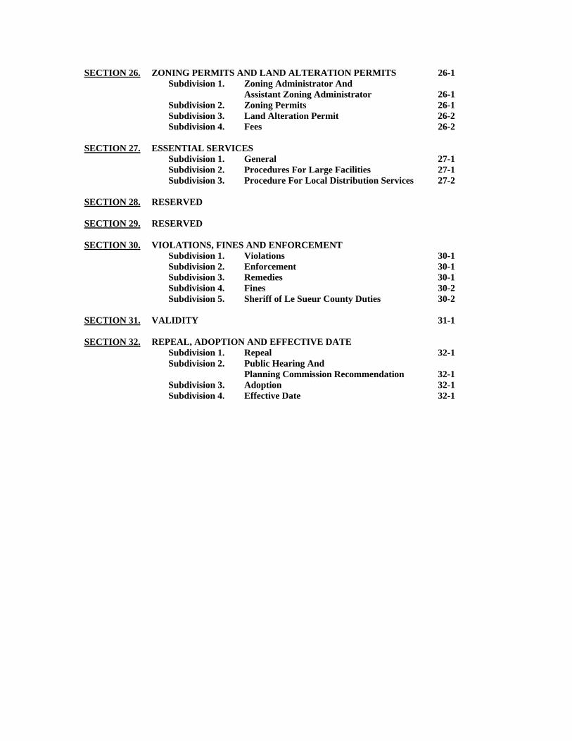
SECTION 26. ZONING PERMITS AND LAND ALTERATION PERMITS 26-1 Subdivision 1. Zoning Administrator And Assistant Zoning Administrator 26-1 Subdivision 2. Zoning Permits 26-1 Subdivision 3. Land Alteration Permit 26-2 Subdivision 4. Fees 26-2 SECTION 27. ESSENTIAL SERVICES Subdivision 1. General 27-1 Subdivision 2. Procedures For Large Facilities 27-1 Subdivision 3. Procedure For Local Distribution Services 27-2 SECTION 28. RESERVED SECTION 29. RESERVED SECTION 30. VIOLATIONS, FINES AND ENFORCEMENT Subdivision 1. Violations 30-1 Subdivision 2. Enforcement 30-1 Subdivision 3. Remedies 30-1 Subdivision 4. Fines 30-2 Subdivision 5. Sheriff of Le Sueur County Duties 30-2 SECTION 31. VALIDITY 31-1 SECTION 32. REPEAL, ADOPTION AND EFFECTIVE DATE Subdivision 1. Repeal 32-1 Subdivision 2. Public Hearing And Planning Commission Recommendation 32-1 Subdivision 3. Adoption 32-1 Subdivision 4. Effective Date 32-1
07-24-07 1
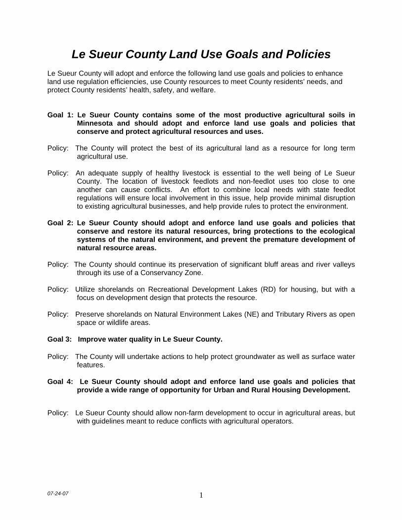
Le Sueur County Land Use Goals and Policies
Le Sueur County will adopt and enforce the following land use goals and policies to enhance land use regulation efficiencies, use County resources to meet County residents’ needs, and protect County residents’ health, safety, and welfare. Goal 1: Le Sueur County contains some of the most productive agricultural soils in
Minnesota and should adopt and enforce land use goals and policies that conserve and protect agricultural resources and uses.
Policy: The County will protect the best of its agricultural land as a resource for long term
agricultural use. Policy: An adequate supply of healthy livestock is essential to the well being of Le Sueur
County. The location of livestock feedlots and non-feedlot uses too close to one another can cause conflicts. An effort to combine local needs with state feedlot regulations will ensure local involvement in this issue, help provide minimal disruption to existing agricultural businesses, and help provide rules to protect the environment.
Goal 2: Le Sueur County should adopt and enforce land use goals and policies that
conserve and restore its natural resources, bring protections to the ecological systems of the natural environment, and prevent the premature development of natural resource areas.
Policy: The County should continue its preservation of significant bluff areas and river valleys
through its use of a Conservancy Zone. Policy: Utilize shorelands on Recreational Development Lakes (RD) for housing, but with a
focus on development design that protects the resource. Policy: Preserve shorelands on Natural Environment Lakes (NE) and Tributary Rivers as open
space or wildlife areas. Goal 3: Improve water quality in Le Sueur County. Policy: The County will undertake actions to help protect groundwater as well as surface water
features. Goal 4: Le Sueur County should adopt and enforce land use goals and policies that
provide a wide range of opportunity for Urban and Rural Housing Development.
Policy: Le Sueur County should allow non-farm development to occur in agricultural areas, but
with guidelines meant to reduce conflicts with agricultural operators.
07-24-07 2
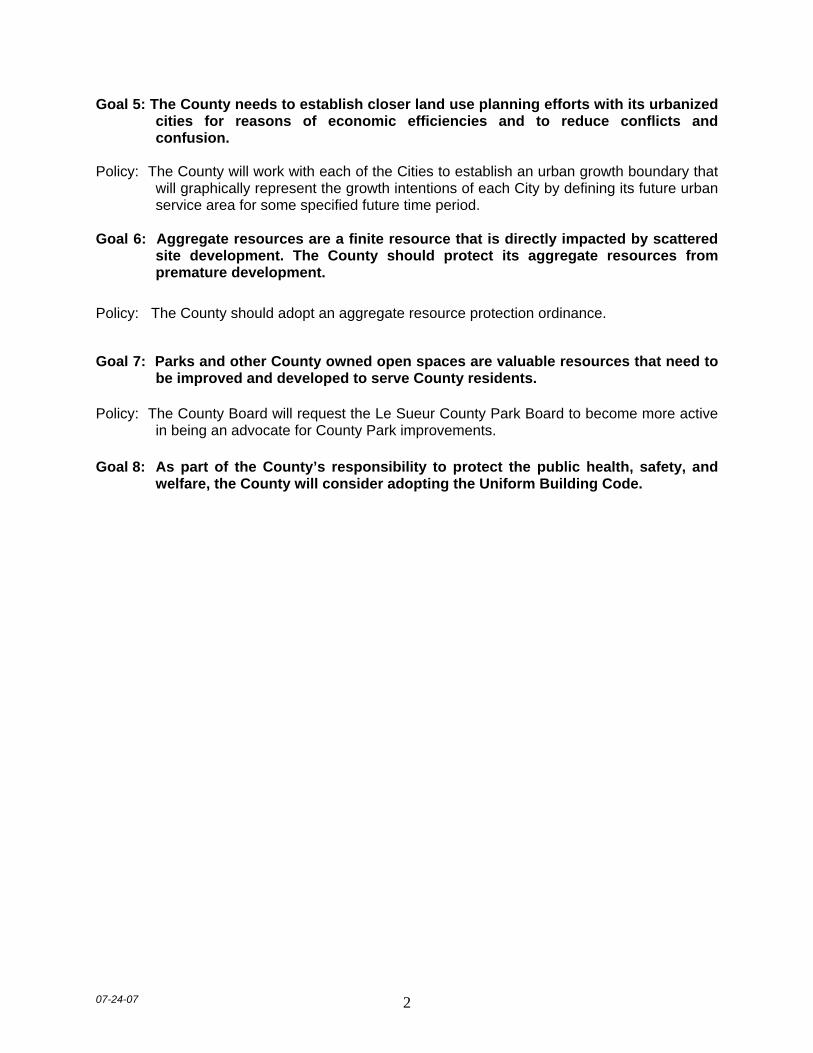
Goal 5: The County needs to establish closer land use planning efforts with its urbanized cities for reasons of economic efficiencies and to reduce conflicts and confusion.
Policy: The County will work with each of the Cities to establish an urban growth boundary that
will graphically represent the growth intentions of each City by defining its future urban service area for some specified future time period.
Goal 6: Aggregate resources are a finite resource that is directly impacted by scattered
site development. The County should protect its aggregate resources from premature development.
Policy: The County should adopt an aggregate resource protection ordinance.
Goal 7: Parks and other County owned open spaces are valuable resources that need to
be improved and developed to serve County residents. Policy: The County Board will request the Le Sueur County Park Board to become more active
in being an advocate for County Park improvements. Goal 8: As part of the County’s responsibility to protect the public health, safety, and
welfare, the County will consider adopting the Uniform Building Code.
02-01-13 1, 2, 3-1
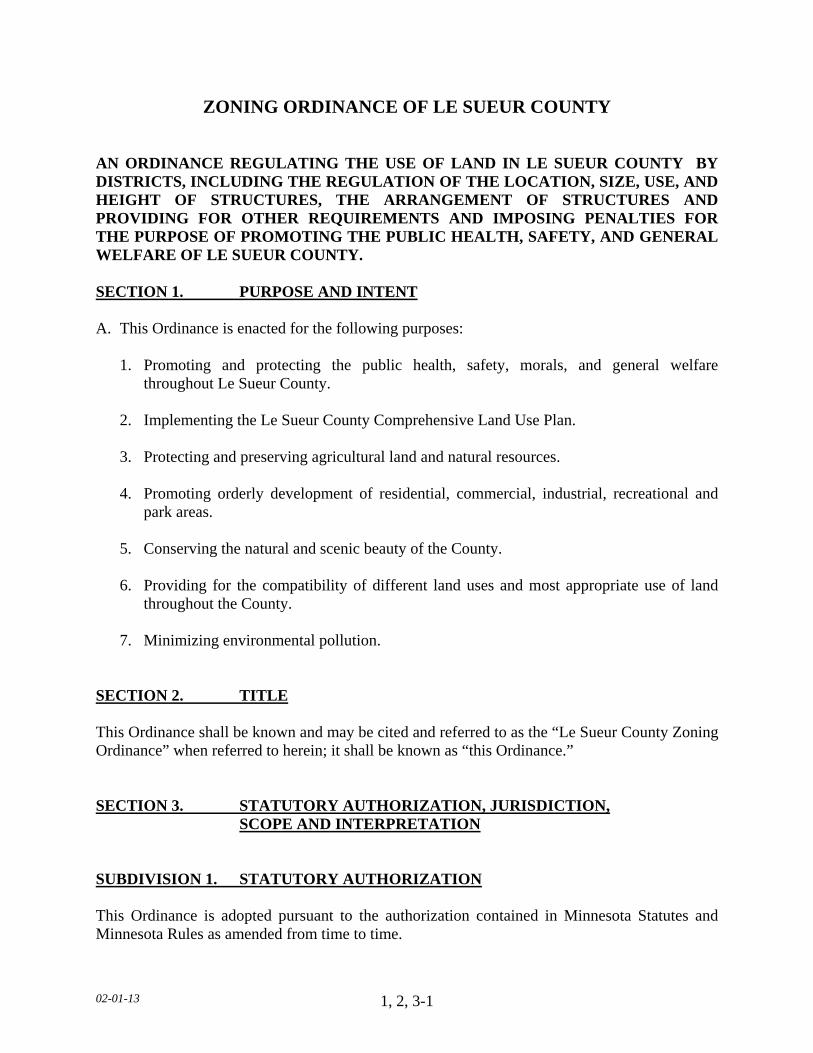
ZONING ORDINANCE OF LE SUEUR COUNTY AN ORDINANCE REGULATING THE USE OF LAND IN LE SUEUR COUNTY BY DISTRICTS, INCLUDING THE REGULATION OF THE LOCATION, SIZE, USE, AND HEIGHT OF STRUCTURES, THE ARRANGEMENT OF STRUCTURES AND PROVIDING FOR OTHER REQUIREMENTS AND IMPOSING PENALTIES FOR THE PURPOSE OF PROMOTING THE PUBLIC HEALTH, SAFETY, AND GENERAL WELFARE OF LE SUEUR COUNTY. SECTION 1. PURPOSE AND INTENT A. This Ordinance is enacted for the following purposes: 1. Promoting and protecting the public health, safety, morals, and general welfare
throughout Le Sueur County. 2. Implementing the Le Sueur County Comprehensive Land Use Plan. 3. Protecting and preserving agricultural land and natural resources. 4. Promoting orderly development of residential, commercial, industrial, recreational and
park areas. 5. Conserving the natural and scenic beauty of the County. 6. Providing for the compatibility of different land uses and most appropriate use of land
throughout the County.
7. Minimizing environmental pollution.
SECTION 2. TITLE This Ordinance shall be known and may be cited and referred to as the “Le Sueur County Zoning Ordinance” when referred to herein; it shall be known as “this Ordinance.” SECTION 3. STATUTORY AUTHORIZATION, JURISDICTION,
SCOPE AND INTERPRETATION SUBDIVISION 1. STATUTORY AUTHORIZATION This Ordinance is adopted pursuant to the authorization contained in Minnesota Statutes and Minnesota Rules as amended from time to time.

02-01-13 1, 2, 3-2
SUBDIVISION 2. JURISDICTION The jurisdiction of this Ordinance shall apply to all the area of Le Sueur County outside the incorporated limits of cities. SUBDIVISION 3. SCOPE From and after the effective date of this Ordinance, the use of all land and every structure or portion of a structure erected, altered in respect to height and area, added to or relocated, and every use within a structure or use accessory thereto in Le Sueur County shall be in conformity with the provisions of this Ordinance. Any lawful existing structure and any lawful existing use of properties not in conformity with the regulations herein prescribed shall be regarded as non-conforming, but may be continued, extended or changed, subject to the special regulations herein provided with respect to non-conforming properties or uses. SUBDIVISION 4. INTERPRETATION In interpreting and applying the provisions of this Ordinance, they shall be held to the minimum requirements for the promotion of the public health, safety, comfort, convenience and general welfare. Where the provisions of this Ordinance impose greater restrictions than those of any statute, other ordinance or regulation, the provisions of this Ordinance shall be controlling. Where the provisions of any statute, other ordinance or regulation impose greater restrictions than this Ordinance, the provisions of such statute, other ordinance or regulation shall be controlling. SUBDIVISION 5. LOTS OF RECORD All lots which are a part of a subdivision legally recorded with the County Recorder, and all lots, parcels, tracts, and other legally described land to which the deed has been recorded prior to July 9, 2009, shall be considered Lots of Record. Lots of Record shall be legally developable for the purpose of single-family dwelling construction, provided all applicable standards and requirements of this Ordinance can be met at the time of development. SUBDIVISION 6. DISCLAIMER OF LIABILITY The Flood Plain Overlay District herein established is intended to provide a reasonable approach to flood control based on present information. As additional information becomes available, the extent of the various boundaries shall be so altered to maintain this reasonableness. This Ordinance does not imply that areas beyond the district limits will be free from flooding; nor shall this Ordinance, or districts established herein, create a liability on the part of, or cause action against Le Sueur County or any office or employee thereof, for any flood damage that may result from reliance upon this Ordinance or flood district so established.

02-01-13 1, 2, 3-3
SUBDIVISION 7. INJUNCTIVE RELIEF The Department, upon authorization by the Board of County Commissioners, shall have the authority to petition the District Court for injunctive relief against continued violations of any of the provisions of this Ordinance.

02-01-13 4-1
SECTION 4. RULES AND DEFINITIONS
SUBDIVISION 1. PURPOSE
A. WORD USAGE For purposes of this Ordinance, words used in the present tense shall include the future; words in the singular shall include the plural, and the plural the singular; the word “lot" shall include the word "plot" and the word “shall” is mandatory and not discretionary. B. PERMITTED USES 1. Permitted uses of land or structures, as hereinafter listed, shall be allowed in the districts
indicated under the conditions specified. No structure or land shall be devoted to any use other than a use permitted hereinafter in the zoning district in which such structure or land shall be located, except for the following exceptions:
a. Uses lawfully established prior to the effective date of this Ordinance. b. Conditional Uses allowed in accordance with Subdivision 1.C of this Ordinance. c. Essential services erected, constructed, altered, or maintained by public utilities or by
governmental departments or commissions, subject only to the permit requirements as set forth in this Ordinance.
C. CONDITIONAL USES Conditional Uses of land or structures, as hereinafter listed, may be allowed in the districts indicated, subject to the issuance of Conditional Use Permits, in accordance with the provisions of this Ordinance. Whenever a conditional use is named as a major category, it shall be deemed to include all and only those itemized uses listed. D. SIGNIFICANT DATES: (TABLE ON NEXT PAGE)
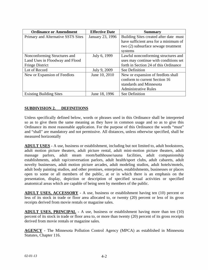
02-01-13 4-2
Ordinance or Amendment Effective Date Summary
Primary and Alternative SSTS Sites January 23, 1996 Building Sites created after date must have sufficient area for a minimum of two (2) subsurface sewage treatment systems
Nonconforming Structures and Land Uses in Floodway and Flood Fringe District
July 6, 1999 Lawful nonconforming structures and uses may continue with conditions set forth in Section 24 of this Ordinance
Lot of Record July 9, 2009 See Definition New or Expansion of Feedlots
June 10, 2010
New or expansion of feedlots shall conform to current Section 16 standards and Minnesota Administrative Rules
Existing Building Sites June 18, 1996 See Definition SUBDIVISION 2. DEFINITIONS Unless specifically defined below, words or phrases used in this Ordinance shall be interpreted so as to give them the same meaning as they have in common usage and so as to give this Ordinance its most reasonable application. For the purpose of this Ordinance the words “must” and “shall" are mandatory and not permissive. All distances, unless otherwise specified, shall be measured horizontally ADULT USES - A use, business or establishment, including but not limited to, adult bookstores, adult motion picture theaters, adult picture rental, adult mini-motion picture theaters, adult massage parlors, adult steam room/bathhouse/sauna facilities, adult companionship establishments, adult rap/conversation parlors, adult health/sport clubs, adult cabarets, adult novelty businesses, adult motion picture arcades, adult modeling studios, adult hotels/motels, adult body painting studios, and other premises, enterprises, establishments, businesses or places open to some or all members of the public, at or in which there is an emphasis on the presentation, display, depiction or description of specified sexual activities or specified anatomical areas which are capable of being seen by members of the public. ADULT USES, ACCESSORY - A use, business or establishment having ten (10) percent or less of its stock in trade or floor area allocated to, or twenty (20) percent or less of its gross receipts derived from movie rentals or magazine sales. ADULT USES, PRINCIPAL - A use, business or establishment having more than ten (10) percent of its stock in trade or floor area to, or more than twenty (20) percent of its gross receipts derived from movie rentals or magazine sales. AGENCY - The Minnesota Pollution Control Agency (MPCA) as established in Minnesota Statutes, Chapter 116.

02-01-13 4-3
AGGREGATED PROJECTS - Aggregated projects are those which are developed and operated in a coordinated fashion, but which have multiple entities separately owning one or more of the individual WECS within the larger project. Associated infrastructure such as power lines and transformers that service the facility may be owned by a separate entity but are also included as part of the aggregated project (Minnesota County Model Wind Ordinance) AGRICULTURAL BEST MANAGEMENT PRACTICES (BMP) - An agricultural BMP is broadly defined as an economically sound practice that is capable of minimizing nutrient contamination of surface and ground waters. Specific BMP practices are described in Minnesota Extension Service Bulletins AG-FO-6125, AG-FO-6l27 and AG-FO3553. AGRICULTURE - The use of land for agricultural purposes, including farming, dairying, pasturage agriculture, horticulture, floriculture, viticulture, and animal and poultry husbandry and the necessary accessory uses for packing, treating or storing the agricultural product provided, however, that the operation of any such accessory uses shall be secondary to that of primary agricultural activities. AGRICULTURE, VALUE ADDED - An agriculture product in which value is added to an agriculture crop, poultry, or livestock grown on a site owned or operated by the applicant by the process of changing, combining or transforming its original state to a more valuable state. ANIMAL CREMATORIUM - A place in which deceased animals are cremated through the use of properly installed and certified apparatus. ANIMAL, DOMESTIC PETS - Dogs, cats, birds and similar animals kept in a residence. Animals considered wild, exotic, or non domestic, such as lions, bears, wolves, and similar animals, shall not be considered domestic pets. ANIMAL FEEDLOT - A lot or structure or combination of lots and structures intended for the feeding, breeding, raising, or holding of animals and specifically designed as a structure or area in which animals may accumulate, or where the concentration of animals is such that a vegetative cover cannot be maintained within the enclosure. Open lots used for the feeding and rearing of poultry (poultry ranges) shall be considered to be animal feedlots. Pastures shall not be considered animal feedlots. ANIMAL FEEDLOT, CERTIFICATE OF COMPLIANCE - A letter from the Agency or the County Feedlot Officer to the owner of an animal feedlot stating that the feedlot meets the Agency standards, and that the livestock operation does not create or maintain a potential pollution hazard, or if a potential pollution hazard existed, it has been corrected to meet the Agency requirements.
02-01-13 4-4
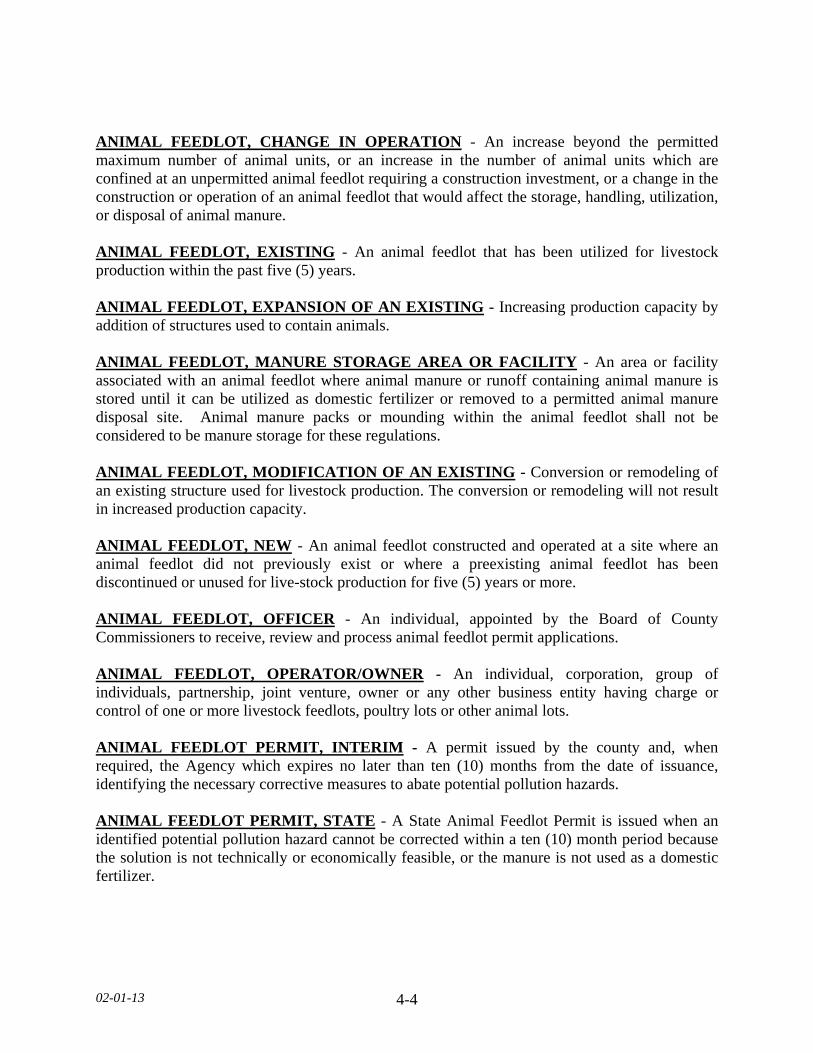
ANIMAL FEEDLOT, CHANGE IN OPERATION - An increase beyond the permitted maximum number of animal units, or an increase in the number of animal units which are confined at an unpermitted animal feedlot requiring a construction investment, or a change in the construction or operation of an animal feedlot that would affect the storage, handling, utilization, or disposal of animal manure. ANIMAL FEEDLOT, EXISTING - An animal feedlot that has been utilized for livestock production within the past five (5) years. ANIMAL FEEDLOT, EXPANSION OF AN EXISTING - Increasing production capacity by addition of structures used to contain animals. ANIMAL FEEDLOT, MANURE STORAGE AREA OR FACILITY - An area or facility associated with an animal feedlot where animal manure or runoff containing animal manure is stored until it can be utilized as domestic fertilizer or removed to a permitted animal manure disposal site. Animal manure packs or mounding within the animal feedlot shall not be considered to be manure storage for these regulations. ANIMAL FEEDLOT, MODIFICATION OF AN EXISTING - Conversion or remodeling of an existing structure used for livestock production. The conversion or remodeling will not result in increased production capacity. ANIMAL FEEDLOT, NEW - An animal feedlot constructed and operated at a site where an animal feedlot did not previously exist or where a preexisting animal feedlot has been discontinued or unused for live-stock production for five (5) years or more. ANIMAL FEEDLOT, OFFICER - An individual, appointed by the Board of County Commissioners to receive, review and process animal feedlot permit applications. ANIMAL FEEDLOT, OPERATOR/OWNER - An individual, corporation, group of individuals, partnership, joint venture, owner or any other business entity having charge or control of one or more livestock feedlots, poultry lots or other animal lots. ANIMAL FEEDLOT PERMIT, INTERIM - A permit issued by the county and, when required, the Agency which expires no later than ten (10) months from the date of issuance, identifying the necessary corrective measures to abate potential pollution hazards. ANIMAL FEEDLOT PERMIT, STATE - A State Animal Feedlot Permit is issued when an identified potential pollution hazard cannot be corrected within a ten (10) month period because the solution is not technically or economically feasible, or the manure is not used as a domestic fertilizer.
02-01-13 4-5
ANIMAL FEEDLOT, POTENTIAL POLLUTION HAZARD - A condition which indicates a potential for pollution of the land or waters of the state including, but not limited to: 1. An animal feedlot or manure storage area whose boundaries are located within shoreland
or floodplain, or are located in an area draining directly to a sinkhole or draining to an area with shallow soils overlaying a fractured or cavernous rock, or are located within one hundred (100) feet of a water well; or
2. An animal feedlot or manure storage area whose construction or operation will allow a
discharge of pollutants to surface or groundwater of the state in excess of applicable standards, including, but not limited to, MN Rules Chapters 7050 and 7055, during a rainstorm event of less magnitude than the twenty five (25) year, (4.9 inches), twenty four (24) hour event, or will violate any applicable state rules.
ANIMAL FEEDLOT, SUITABLE AREA - The area remaining on a lot or parcel of land that is capable of sustaining animal units after land defined as bluffs, steep slopes, wetlands, and land below the ordinary high water level are subtracted. ANIMAL HOSPITAL AND VETERNINARY CLINIC - A facility maintained by or for the use of a licensed veterinarian in the diagnosis, treatment, or prevention of animal diseases and where animals may be boarded for their treatment. ANIMAL MANURE - Poultry, livestock, or other animal excreta or a mixture of excreta with feed, bedding, or other materials. ANIMAL SHELTER - A facility used to house or contain stray, homeless, abandoned, or unwanted animals and that is owned by a private citizen, public body, humane society or other non-profit organization devoted to the welfare, protection, and humane treatment of animals. ANIMAL UNIT - A unit of measure used to compare differences in the production of animal manures that employs as a standard the amount of manure produced on a regular basis by a slaughter steer or heifer. ANTENNA - Any structure or device used for the purpose of collecting or radiating electromagnetic waves, including but not limited to directional antennas, such as panels, microwave dishes, and satellite dishes, and omni-directional antennas, such as whip antennas. ANTIQUE STORE - A place offering antiques for sale. An antique, for purposes of this Ordinance, shall be a work of art, piece of furniture, decorative object, or the like, of or belonging to the past, at least thirty (30) years old. APPLICANT - A person, property owner, or entity that submits an application for a permit, development approval, or land use action which includes but not limited to a variance, conditional use permit, rezoning, ordinance amendment, or plat.
02-01-13 4-6
APPLICATION DEADLINE - The date, as established by the Department, by which an applicant must submit an application for consideration by the Planning and Zoning Advisory Commission or the Board of Adjustment. AS-BUILTS - A construction drawing prepared after completion of a project which depicts the site as it has been actually constructed. An As-Built may include structures, parking and topographic elevations. AUTOMOBILE WRECKING - See Junk/SalvageYards. AVERAGE DAILY TRIP - The average number of vehicles using a traveled way for a 24-hour period determined by dividing the total number of vehicles for a stated period by the number of days in that time period. In calculating vehicle trips, trucks with trailers shall be adjusted to a passenger car equivalent. BASEMENT - Any area or a structure, including crawl spaces, having its floor or base subgrade (below ground level) on all four sides, regardless of the depth of excavation below ground level. BEACH SAND BLANKET - An amount of sand allowable by County and State regulations that is placed on a lakeshore to make a beach area. BED AND BREAKFAST INN - An owner-occupied dwelling unit where short-term lodging rooms with or without meals, are provided for compensation. BLOCK - An area of land within a subdivision that is entirely bounded by streets, or by streets and the exterior boundary or boundaries of the subdivision, or a combination of the above with a river or lake. BLUFF - A topographic feature such as a hill, cliff, or embankment in which the slope rises at least fifteen (15) feet from the toe of the bluff to the top of the bluff and the grade of the slope from the toe of the bluff to the top of the bluff averages 18 percent or greater. The percent of the slope is defined as the change in elevation (rise) over a distance (run). BLUFF, TOE - The toe of the bluff shall be determined to be the lower end of the lowest ten (10) foot segment that exceeds eighteen (18) percent slope. BLUFF, TOP - The top of the bluff shall be determined to the upper end of the highest ten (10) foot segment that exceeds eighteen (18) percent. BLUFF IMPACT ZONE - Land located within 30 feet from the top or toe of a bluff. BOARD OF COUNTY COMMISSIONERS - Le Sueur County Board of Commissioners. BOAT HOUSE - A structure for storage of boat or lake sporting and recreational equipment. BUILDING - See Structure
02-01-13 4-7
BUILDABLE LOT AREA - The portion of a lot or parcel remaining after the deletion of floodplain, wetlands, bluffs or steep slopes and/or below ordinary high water level. CABIN - A structure used seasonally or intermittently as a single-family dwelling. CALCAREOUS FENS - Calcareous fens, a rare type of wetland as identified by the commissioner by written order published in the State Register, are regulated under the WCA but the responsibility for their regulation is assigned to the DNR and which may not be filled, drained, or otherwise degraded, wholly or partially, by any activity, unless the Commissioner, under an approved management plan, decides some alteration is necessary, as defined in MN Statutes, §103G.223. CAMPER - See Travel Trailer. CAMPGROUND - An area of property used on a daily, nightly or weekly basis upon which a tent, pickup camper, motor home, pop-up camper, or trailer, made for camping where proper sanitation facilities and spacing of camp units are provided and maintained. CANDELAS PER SQUARE METER (cd/m2) - The standard unit of luminance (also called NITS). 1 CDM is equal to 1 NIT. CARTAGE AND EXPRESS FACILITIES - A facility which receives packages and materials from another customer and transports those packages and materials to another location. CHURCH - A structure that is used for the assembling of people for religious purposes. CLASS V INJECTION WELL - A shallow well used to place a variety of fluids directly below the land surface. This includes SSTS that are designed to receive sewage or nonsewage from a two-family dwelling or greater or receive sewage or nonsewage from another establishment that serves more than 20 persons per day. The US Environmental Protection Agency and delegated state groundwater programs permit these wells to inject wastes below the ground surface provided they meet certain requirements and do not endanger underground sources of drinking water. Class V motor vehicle waste disposal wells and large-capacity cesspools are specifically prohibited (see 40 CFR Parts 144 & 146). CLUSTER DEVELOPMENT - A pattern of subdivision development which places housing units into compact groupings while providing a network of commonly owned or dedicated open space. CLUSTER SYSTEM - A wastewater collection and treatment system under some form of common ownership that collects wastewater from two or more dwellings or structures and conveys it to a treatment and dispersal system located on an acceptable site near the dwellings or structures.
02-01-13 4-8
COMMERCIAL BUSINESS - The selling or vending of any good or service including but not limited to food, beverages, souvenirs, craft items, repair or rental services, or any other salable item or service. COMMERCIAL GRAIN ELEVATOR - A facility with a group of structures and grain storage facilities that purchases grain from agricultural producers. The facility stores and at times may process grain on site before transporting grain off site. COMMERCIAL GRAIN STORAGE - A facility with a group of structures and grain storage facility that is used by agricultural cooperative or agribusiness. COMMERCIAL RECREATIONAL AREA, INDOOR - Recreational uses conducted indoors, including; but not limited to, archery, miniature golf, firing ranges, paintball, laser tag, motorized cart tracks, water parks, and similar uses. COMMERCIAL RECREATIONAL AREA, OUTDOOR - Recreational uses conducted outdoors, including; golf driving ranges (not associated with a golf course),archery, miniature golf, firing ranges, paintball, laser tag, motorized cart tracks, water parks, amusement parks, and similar uses. COMMERCIAL USE - The principal use of land or structures for the sale, lease, rental, or trade of products, goods, and services. COMMISSIONER - Minnesota Commissioner of Natural Resources. COMMUNITY CENTER - A place, structure, area, or other facility used for and providing religious, fraternal, social, and/or recreational programs generally open to the public and designed to accommodate and serve significant segments of the community. COMMUNITY WATER AND SEWER SYSTEMS - Utilities systems serving a group of structures, lots, or an area of the County with the design and construction of such utility systems as approved by the County Engineering Department and the State of Minnesota. COMPLIANCE INSPECTION - An evaluation, investigation, inspection, or other such process for the purpose of issuing a certificate of compliance or notice of noncompliance. CONDITIONAL USE - A land use or development as defined by this Ordinance that would not be appropriate generally but may be allowed with appropriate restrictions as provided by official controls upon a finding that certain conditions as detailed in this Ordinance exist, the use or development conforms to the comprehensive land use plan of Le Sueur County, and the use is compatible with the surrounding area. CORNER LOT - A lot situated at the junction of and fronting on two (2) or more roads or highways.
02-01-13 4-9
CORRECTIVE ACTION - Any action required by the Department to ensure compliance or conformance with this Ordinance and State regulations. CORRECTIVE OR PROTECTIVE MEASURE - A practice, structure, condition, or combination thereof which prevents or reduces the discharge of pollutants from an animal feedlot to a level in conformity with Agency rules. COUNTRY CLUB - A golfing club equipped with a golf course and a club house. COUNTY - Le Sueur County, Minnesota. DEADLINE DATE - The date as established by the Department in reference to an application for the Planning and Zoning Advisory Commission or the Board of Adjustment . DECK - A horizontal, unenclosed platform with or without attached railings, seats, trellises, or other features, attached or functionally related to a principal use or site and which exceeds thirty-two (32) square feet. DEPARTMENT - The Le Sueur County Environmental Services Department. DEPTH OF LOT - The mean horizontal distance between the mean front street and the mean rear property line. The greater frontage of a corner lot is its depth, and its lesser frontage is its width. DEPTH OF REAR YARD - The mean horizontal distance between the rear structure line and the rear property line. DESIGN FLOW - The daily volume of wastewater for which an onsite/cluster system is designed to treat and discharge. DEVELOPMENT - Any building, construction, renovation, mining, extraction, dredging, filling, excavation, or drilling activity or operation; any material change in the use or appearance of any structure or in the land itself; the division of land into parcels; any change in the intensity or use of land, such as an increase in the number of dwelling units in a structure or a change to a commercial or industrial use from a less intensive use; any activity that alters a shore, beach, seacoast, river, stream, lake, pond, canal, marsh, dune area, woodlands, wetland, endangered species habitat, aquifer or other resource area, including coastal construction or other activity. DIRECT LINE OF FIRE - For the purposes of Outdoor Firing Ranges this is the straight horizontal line from the muzzle of a weapon in the direction of the axis of the bore, just prior to firing. DISTRICT - A section of the County for which the regulations governing the height, area, use of structures and premises are the same.
02-01-13 4-10
DNR, SCENIC TRAIL - That strip of land one hundred (100) feet wide which was formerly the Chicago and North Western railroad that extends from the Rice County line on the east (Waterville Township) to the Blue Earth County line on the west (Elysian Township). DOMESTIC FERTILIZER - For the purposes of this Ordinance domestic fertilizer means animal manure that is put on or into the soil to improve the quality or quantity of plant growth; or animal manure that is used as compost, soil conditioners, or specialized plant beds. DOMESTICATED FOWL - Any domesticated bird, including, but not limited to, chickens, turkeys, waterfowl, ratites, and game birds. DUPLEX, TRIPLEX, AND QUAD - A dwelling structure on a single lot, having two, three, and four units respectively, being attached by common walls and each unit equipped with separate sleeping, cooking, eating, living and sanitation facilities. DWELLING UNIT - Any structure or part thereof which is designed or used exclusively for residential purposes by one or more human beings, either permanently or transiently; short or long term living quarters for one or more persons, including rental or time-share accommodations such as motel, hotel, cabins, and resort rooms are considered dwelling units. A recreational vehicle, travel trailer, or tent shall not be considered a dwelling for the purposes of this Ordinance. DWELLING, MULTIPLE - A dwelling designed for or occupied by two (2) or more families. DWELLING, SINGLE FAMILY DETACHED - A dwelling structure designed for or occupied exclusively by one (1) family, not attached to another dwelling, meeting all of the following standards: 1. A permanent masonry or concrete foundation extending below frost level, 2. A minimum of seven hundred sixty (760) square feet of floor area on the ground floor, 3. The minimum dwelling width excluding porches, decks, or other similar attachments
shall be twenty (20) feet except in the cases of temporary dwellings. 4. Open space on the same lot to surround dwelling.
DWELLING SITE - A designated location for residential use. DWELLING SITE, PERMITTED - A site that was permitted by the Department for a single-family dwelling.
02-01-13 4-11
DWELLING, TEMPORARY - Temporary dwellings are defined as manufactured homes that are less than twenty (20) feet wide, excluding decks or entry vestibules, and not on a permanent foundation. All manufactured homes shall bear a State seal as verification of construction and inspection to ANSI A119.1 standards during original construction (issued for manufactured homes built between July 1, 1972 to June 14, 1976) or, for manufactured homes built after that date a Federal seal in accordance with HUD CFR 3280 Construction Standards. EASEMENT - A grant by a landowner for the use of a parcel of land for the purpose of construction and maintaining utilities, including but not limited to sanitary sewers, water mains, electric lines, telephone lines, storm sewer or storm drainage ways and gas lines. EQUAL DEGREE OF ENCROACHMENT - A method of determining the location of floodway boundaries so that flood plain lands on both sides of a stream are capable of conveying a proportionate share of flood flows. ESSENTIAL SERVICES - Overhead or underground electrical, gas, steam or water transmission or distribution systems and structures; or collection, communication, supply or disposal systems and structures, used by public utilities or governmental departments or commissions; or as are required for protection of the public health, safety or general welfare, including towers, poles, wires, mains, drains, sewers, pipes, conduits, cables, fire alarm boxes, police call boxes, and accessories in connection therewith, but not including structures. EXISTING BUILDING SITE - A permitted dwelling site or an area that has an existing access to a public road right of way and at least one of the following is presently on the premises: a windbreak, water well, accessory structures or a dwelling. In addition, the area must be non-cultivated and have existed prior to June 18, 1996. EXTRACTION PIT - Any artificial excavation of the earth exceeding fifty (50) square feet of surface area or two (2) feet in depth, excavated or made by the removal from the natural surface of the earth, of sod, soil, sand, gravel, stone or other natural matter; or made by turning, or breaking or undermining the surface of the earth. Excavations ancillary to other construction of any installation erected or to be erected, built, or placed thereon in conjunction with or immediately following such excavation shall be exempted, if a permit has been issued for such construction for installation. EXTRACTIVE USE - The use of land for surface or subsurface removal of sand, gravel, rock, industrial minerals, other nonmetallic minerals, and peat not regulated under Minnesota statutes, sections 93.44 to 93.51 and as amended from time to time. FAILURE TO PROTECT GROUNDWATER - A SSTS that does not protect groundwater such as a seepage pit, cesspool, drywell, leaching pit, or other pit; a SSTS with less than the required vertical separation distance described in Minn. R. 7080.1500, subps. 4(D) and 4(E); and a system not abandoned in accordance with Minn. R. 7080.2500. The determination of the threat to groundwater for other conditions must be made by a qualified employee or a licensed inspection business.

02-01-13 4-12
FARM - A tract of land, which is principally used for agricultural production of cash crop, livestock, or poultry farming. Such farm may include accessory structures and structures necessary to the operation of the farm. FARM, HOBBY - An area used as a limited farm operation where the income from the farm is incidental to the residential use of the property. FARMING - The cultivation of the soil and all activities incidental thereto; agriculture. FARMLAND - Any land used in conjunction with a farming operation. FARMSTEAD - Property on which structures and a farm dwelling are located for management, storage, livestock, etc. for a farm operation. FLOOD - A temporary increase in the flow or stage of a stream or in the stage of a wetland or lake that results in the inundation of normally dry areas. FLOOD FREQUENCY - The frequency for which it is expected that a specific flood stage or discharge may be equaled or exceeded. FLOOD FRINGE - That portion of the flood plain outside the floodway. Flood fringe is synonymous with the term "floodway fringe" used in the Flood Insurance Study for Le Sueur County. FLOOD PLAIN - The beds proper and the areas adjoining a wetland, lake or watercourse which have been or hereafter may be covered by the regional flood. FLOOD-PROOFING - A combination of structural provisions, changes, or adjustments to properties and structures subject to flooding, primarily for the reduction or elimination of flood damages. FLOODWAY - The bed of a wetland or lake and the channel of the watercourse and those portions of the adjoining flood plains which are reasonably required to carry or store the regional flood discharge. FLOOR AREA - The sum of the gross horizontal areas of the several floors of a structure measured from the exterior walls, including basements and attached accessory structures. FLORIST STORE - A retail business within an enclosed structure whose principal activity is the selling of cut flowers and plants which are not grown on the site. FOOTCANDLE - A unit of measurement that calculates lighting illumination levels.
02-01-13 4-13
FOREST LAND CONVERSION - Clear cutting of forested lands to prepare for a new land use other than reestablishment of a subsequent forest stand. FOREST MANAGEMENT - A process by which the proper care so that a forest stand remains healthy and vigorous. FUR FARM - An area used for keeping and/or raising fur-bearing animals. GARAGE, PRIVATE - A detached or attached accessory structure or carport which is used primarily for storing of private vehicles. GARAGE, PUBLIC - Any premises, except those described as a private garage, used for the storage or care of power-driven vehicles, or where any such vehicles are equipped for operation, repair or are kept for remuneration, hire or sale. GREENHOUSE/NURSERY - A retail business for the growth, display, and/or sale of plants, shrubs, trees, and materials used in indoor or outdoor planting, conducted inside or outside an enclosed structure. GOLF COURSE - A tract of land laid out with at least nine (9) holes for playing a game of golf and improved with tees, greens, fairways, and hazards. A golf course includes a clubhouse and shelters as accessory uses. GOLF COURSE, MINATURE - A theme-oriented recreational facility, typically comprised of nine (9) or eighteen (18) putting greens, each with a “cup” or “hole,” where patrons in groups of one to four pay a fee to move in consecutive order from the first hole to the last. GROUNDWATER - Water contained below the surface of the earth in a saturated zone. GUEST COTTAGE - A structure used as a dwelling unit that may contain sleeping spaces and kitchen and bathroom facilities in addition to those provided in the primary dwelling unit on a lot. HIGHWAY - Any public thoroughfare or vehicular right-of-way with a Federal or State numerical route designation; any public thoroughfare or vehicular, right-of-way with a Le Sueur County numerical route designation. HISTORIC SITE - A location set aside for no other purpose than to commemorate a historical event, activity, or person having local, regional, statewide, or national historic significance. HOME OCCUPATION - Any owner-occupied dwelling which includes an occupation of a service character clearly secondary to the main use of the premises as a dwelling place but does not change the character thereof or have any exterior evidence. There are two (2) levels; Level I and Level II.

02-01-13 4-14
IMMINENT THREAT TO PUBLIC HEALTH AND SAFETY - A SSTS with a discharge of sewage or sewage effluent to the ground surface, drainage systems, ditches, or storm water drains or directly to surface water; SSTS that cause a reoccurring sewage backup into a dwelling or other establishment; SSTS with electrical hazards; sewage tanks with unsecured, damaged, or weak maintenance access covers; or any other situation with the potential to immediately and adversely affect or threaten public health or safety. The determination of protectiveness for other conditions must be made by a qualified employee or a licensed inspection business. IMPERVIOUS SURFACE - A constructed hard surface that either prevents or retards the entry of water into the soil and causes water to run off the surface in greater quantities and at an increased rate of flow than prior to development. Examples include but are not limited to, rooftops, sidewalks, patios, decks, driveways, parking lots, storage areas and concrete, asphalt, or gravel roads, or tightly compacted soils. Surface area of a lot physically separated by a public or private road right-of-way or access shall not be included for the purposes of the impervious surface calculation. INCORPORATION - The mixing of manure or septage with the topsoil, concurrent with the application or immediately thereafter, by means such as discing, plowing, rototilling, injection or other mechanical means. INSLOPE - The area from the bottom of ditch to the adjacent roadway elevation. INSPECTOR - An individual qualified to review proposed plans and inspect on-site sewage treatment systems and who has been issued a license from the Agency. INTENSIVE VEGETATION CLEARING - The complete removal of trees or shrubs in a contiguous patch, strip, row, or block. JUNK/SALVAGE YARD - A place maintained for keeping, storing, or piling in commercial quantities, whether temporarily, irregularly, or continually; buying or selling at retail or wholesale any old, used, or second hand material of any kind, including used motor vehicles, machinery of any kind, and/or parts thereof, cloth, rugs, clothing, paper, rubbish, bottles, rubber, iron, or other metals, or articles which from its worn condition render it practically useless for the purpose for which it was made and which is commonly classed as junk. This shall include a lot or yard for the keeping of unlicensed motor vehicles or the remains thereof for the purpose of dismantling, sale of parts, sale as scrap, storage or abandonment. Provided further, that the storage of ten (10) or more inoperable motor vehicles for a period in excess of three (3) months shall also be considered a salvage yard. KENNEL - Any place where there are more than the permitted number of dogs or cats, in accordance with the applicable zoning district regulations for the subject property.
02-01-13 4-15
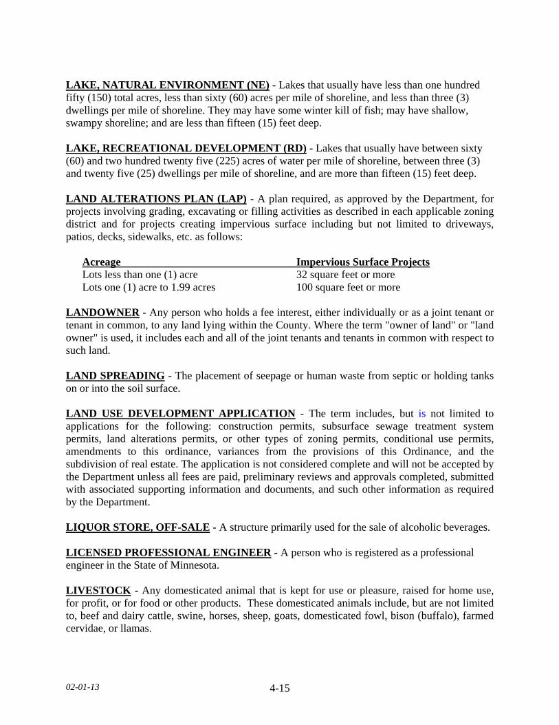
LAKE, NATURAL ENVIRONMENT (NE) - Lakes that usually have less than one hundred fifty (150) total acres, less than sixty (60) acres per mile of shoreline, and less than three (3) dwellings per mile of shoreline. They may have some winter kill of fish; may have shallow, swampy shoreline; and are less than fifteen (15) feet deep. LAKE, RECREATIONAL DEVELOPMENT (RD) - Lakes that usually have between sixty (60) and two hundred twenty five (225) acres of water per mile of shoreline, between three (3) and twenty five (25) dwellings per mile of shoreline, and are more than fifteen (15) feet deep. LAND ALTERATIONS PLAN (LAP) - A plan required, as approved by the Department, for projects involving grading, excavating or filling activities as described in each applicable zoning district and for projects creating impervious surface including but not limited to driveways, patios, decks, sidewalks, etc. as follows:
Acreage Impervious Surface Projects Lots less than one (1) acre 32 square feet or more Lots one (1) acre to 1.99 acres 100 square feet or more
LANDOWNER - Any person who holds a fee interest, either individually or as a joint tenant or tenant in common, to any land lying within the County. Where the term "owner of land" or "land owner" is used, it includes each and all of the joint tenants and tenants in common with respect to such land. LAND SPREADING - The placement of seepage or human waste from septic or holding tanks on or into the soil surface. LAND USE DEVELOPMENT APPLICATION - The term includes, but is not limited to applications for the following: construction permits, subsurface sewage treatment system permits, land alterations permits, or other types of zoning permits, conditional use permits, amendments to this ordinance, variances from the provisions of this Ordinance, and the subdivision of real estate. The application is not considered complete and will not be accepted by the Department unless all fees are paid, preliminary reviews and approvals completed, submitted with associated supporting information and documents, and such other information as required by the Department. LIQUOR STORE, OFF-SALE - A structure primarily used for the sale of alcoholic beverages. LICENSED PROFESSIONAL ENGINEER - A person who is registered as a professional engineer in the State of Minnesota. LIVESTOCK - Any domesticated animal that is kept for use or pleasure, raised for home use, for profit, or for food or other products. These domesticated animals include, but are not limited to, beef and dairy cattle, swine, horses, sheep, goats, domesticated fowl, bison (buffalo), farmed cervidae, or llamas.
02-01-13 4-16
LIVESTOCK WASTE LAGOON - A diked enclosure for disposal of livestock wastes by natural processes. LOGGING - The cutting of timber on any public or private land of one (1) acre or more for the purpose of selling the timber for a profit. This shall not include the selective cutting of trees by the property owner for the purpose of removing dead or diseased trees. LOT - A parcel of land designated by plat, metes, and bounds, registered land survey, auditors plat, or other accepted means and separated from other parcels or portions by said description for the purpose of sale, lease, or separation. LOT AREA - The lot area is the land area within the property lines. LOT AREA PER FAMILY - The lot area per family is the lot area required by this Ordinance to be provided for each family in a dwelling. LOT DEPTH - The mean horizontal distance between the mean front road and the mean rear property line. The greater frontage of a corner lot is its depth and its lesser frontage is its width. LOT, DOUBLE FRONTAGE - An interior lot having frontage on two (2) streets. LOT, INTERIOR - A lot other than a corner lot. LOT OF RECORD - All lots which are a part of a subdivision legally recorded with the County Recorder, and all lots, parcels, tracts, and other legally described land to which the deed has been recorded prior to July 9, 2009, shall be considered Lots of Record. Lots of Record shall be legally developable for the purpose of single-family dwelling construction, provided all applicable standards and official controls of this Ordinance can be met at the time of development. LOT WIDTH - The horizontal distance between the side lot lines measured at the building setback line. In addition, minimum lot widths at road right of ways and shorelands are required. LOWEST FLOOR - The lowest floor of the lowest enclosed area, including basement. MANUFACTURED HOME - A structure, transportable in one (1) or more sections, which in the traveling mode, is eight (8) body feet or more in width or forty (40) body feet or more in length, or, when erected on site, is 320 or more square feet, and which is built on a permanent chassis and designed to be used as a dwelling with or without a permanent foundation when connected to the required utilities, and includes the plumbing, heating, air conditioning, and electrical systems contained therein to be used as a single-family dwelling; except that the term includes any structure which meets all the requirements and with respect to which the manufacturer voluntarily files a certification required by the secretary, as defined in Minnesota Statute 327.31, subd. 18, and complies with the standards established under this chapter.
02-01-13 4-17
MANUFACTURED HOME (IN FLOOD PLAIN DISTRICTS) - A structure, transportable in one (1) or more sections, which is built on a permanent chassis and is designed for use with or without a permanent foundation when attached to the required utilities. The term” manufactured home” does not include the term “recreational vehicle.” MANUFACTURED HOME, DEPENDENT - A manufactured home which does not have a self-contained sanitary system. One that is hooked to an outside sanitary system. METES AND BOUNDS - A method of property description by means of their direction and distance from an easily identifiable point. MINOR - A person under eighteen (18) years of age. MINOR REPAIR - The repair or replacement of an existing damaged or faulty component/part of an SSTS that will return the SSTS to its operable condition. The repair shall not alter the original area, dimensions, design, specifications, or concepts of the SSTS. MODULAR HOME - A non-mobile housing unit that is basically fabricated at a central factory and transported to a dwelling site, to be used as a single-family dwelling. MOTEL - A structure or group of structures used primarily for the temporary residence of motorists or travelers. MOTOR HOME - See Recreational Vehicle. MPCA - Minnesota Pollution Control Agency. Referred to as “the Agency” throughout this Ordinance. MUNICIPALITY - Any incorporated city or township within the boundaries of Le Sueur County, Minnesota. NATIONAL POLLUTANT DISCHARGE ELIMINATION SYSTEM (NPDES) - A permit issued by the Agency for the purpose of regulating the discharge of pollutants from point sources including concentrated animal feeding operations. NONCONFORMING LOT - Any lot that does not meet the zoning district regulations for minimum lot width, lot depth and/or lot size. NONCONFORMING STRUCTURE - Any structure that does not meet zoning district regulations for structure size, structure height, lot coverage, or setback. NONCONFORMING STRUCTURE, EXPANSION - Any expansion of a structure that does not meet zoning district regulations for building size, structure height, lot coverage, or setback. NONCONFORMING USE - A use of land that does not comply with the use regulations of this Ordinance.
02-01-13 4-18
NONCONFORMING USE, EXPANSION - Intensifying a use of land that does not comply with the use regulations of this Ordinance. NONCONFORMITY - Any legal use, structure or parcel of land already in existence, recorded, or authorized before the adoption of official controls or amendments thereto that would not have been permitted to become established under the terms of the official controls as now written, if the official controls had been in effect prior to the date it was established, recorded or authorized. NON-WATER CARRIED SEWAGE SYSTEMS - A device for the disposal of human excreta in a structure designed to treat sewage utilizing methods that significantly reduce or eliminate the addition of water to the sewage. These systems include, but are not limited to, privies, chemical toilets, recirculating toilets, combustion toilets, composting toilets, oil flush toilets, and portable toilets. OBSTRUCTION (WATERWAY) - Any dam, wall, wharf, embankment, levee, dike, pile, abutment, projection, excavation, channel modification, building, wire, fence, stockpile, refuse, fill, structure, or matter in, along, across or projecting into any channel, watercourse or regulatory flood plain which may impede, retard or change the direction of the flow of water, either in itself or by catching or collecting debris carried by such water, or that is placed where the flow of water might carry the same downstream to the damage of life or property. ORCHARD - A non-natural group of fruit trees that are grown planted, managed, and renewed by the land owner or farmer. ORCHARD, COMMERCIAL - A group of fruit trees, grown and cultivated for revenue and fruit from the trees is processed on site. ORDINARY HIGH WATER LEVEL, (OHWL) - The boundary of public waters and wetlands, that is an elevation delineating the highest water level which has been maintained for a sufficient period of time to leave evidence upon the landscape, commonly that point where the natural vegetation changes from predominately aquatic to predominantly terrestrial. For watercourses, the ordinary high water level is the elevation of the top bank of the channel. For reservoirs and flowages, the ordinary high water level is the operating elevation of the normal summer pool as defined in MN Statutes, §103G.005, subd 14, as amended from time to time . ORGANIZED GROUP CAMP - Premises and facilities used occasionally or periodically for the accommodation of members of groups or associations for outdoor recreational activities. ORGANIZED MOTOR SPORTS - A commercial operation that involves ATV Trails, motorcycle tracks, trails or go cart tracks. OTHER ESTABLISHMENT - Any public or private structure other than a dwelling that generates sewage that discharges to an SSTS.
02-01-13 4-19
OUTDOOR LIGHT FIXTURE - Outdoor electrically powered illuminating devices, outdoor lighting or reflective surfaces, lamps and similar devices, permanently installed or portable, used for illumination or advertisement. Such devices shall include, but are not limited to: search, spot, and floodlights for structures; recreational areas; parking lot lighting; landscape lighting; billboards and other signs; street lighting; product display area lighting; structure overhangs and open canopies. PARK - A public or private area of land, with or without structures intended for outdoor active or passive recreational uses. PASTURES - Areas where grass or other growing plants are used for grazing and where the concentration of animals is such that a vegetation cover is maintained during the growing season except in the immediate vicinity of temporary supplemental feeding or water devices. PERMIT, ZONING - A document issued by the Department to permit construction or the establishment of certain uses of land, including but not limited to: all structures, structure additions, towers, and subsurface sewage treatment systems. PERMITTEE - Any person who obtains a permit from the County pursuant to this Ordinance. A person is a permittee only for the term of the permit. PERSONS - Any individual, firm, partnership, corporation, company, association, joint stock association or body politic; includes any trustee, receiver, assignee or other similar representative thereof. PLANNED UNIT DEVELOPMENT - A type of development characterized by a unified site design for a number of dwelling units or dwelling sites on a parcel, whether for sale, rent, or lease, and also usually involving clustering of these units or sites to provide areas of common open space, density increases, and a mix of structure types and land uses. These developments may be organized and operated as condominiums, time-share condominiums, cooperatives, full fee ownership, commercial enterprises, or any residential condominiums, townhouses, apartment buildings, campgrounds, recreational vehicle parks, resorts, hotels, motels and conversions of structures and land uses to these uses. PLANNED UNIT DEVELOPMENT, COMMERCIAL - Typically uses that provide transient, short-term lodging spaces, rooms or parcels and their operations are essentially service-oriented. For example, hotel/motel accommodations, resorts, recreational vehicle, camping parks, and other primarily service-oriented activities are commercial planned unit developments. PLANNED UNIT DEVELOPMENT, RESIDENTIAL - A use where the nature of residency is non-transient and the major or primary focus of the development is not service-oriented. For example, residential apartments, manufactured home parks, time-share condominiums, townhouses, cooperatives and full fee ownership residences would be considered as residential planned unit developments.
02-01-13 4-20
PLAT, FINAL - A drawing or map of a subdivision, meeting all the requirements of the County and in such form as required by the County for purposes of recording. PLAT, PRELIMINARY - A tentative drawing or map of a proposed subdivision, meeting requirements herein enumerated. PLATTED BUSINESS SUBDIVISION - The creation of two (2) or more lots in a General Business Zoning District under the provisions of the County Subdivision Ordinance. PLATTED INDUSTRIAL SUBDIVISION - The creation of two (2) or more lots in a General Industry Zoning District under the provisions of the County Subdivision Ordinance. PLATTED RESIDENTIAL SUBDIVISION - The creation of two (2) or more lots in a Residential District under the provisions of the County Subdivision Ordinance. PLATTED SUBDIVISION - The creation of two (2) or more lots under the provisions of the County Subdivision Ordinance. PLOT - A tract, other than one unit, of a recorded plat or subdivision and occupied and used or intended to be occupied and used as an individual site and improved or intended to be improved by the erection thereon of buildings, and having a frontage on a public road or highway upon a traveled or used road and including as a minimum such open spaces as required under this section. POOL, PERMANENT - pools constructed in the ground; in a structure, or surrounded by a permanent structure in such a manner that the pool cannot be readily disassembled; and contains more than three thousand (3,000) gallons and with a depth of water over three and one-half (3 1/2) feet. PREMISES - A lot or plot with the required front, side and rear yards for a dwelling or other use as allowed. PRINCIPAL USE OR STRUCTURE - All uses or structures that are not accessory uses or structures. PUBLIC NUISANCES - Any condition which is generally objectionable to people in the direct area and as regulated in this Ordinance. PUBLIC UTILITY - Persons, corporations, or governments, supplying gas, electric, transportation, water, sewer, or land line telephone service to the general public. For purposes of this Ordinance wireless telecommunication services shall not be considered utility uses, and are defined separately. PUBLIC WATERS - Any waters that have been determined to be public waters or navigable waters as defined in MN Statutes, §103G.005, subd 15.
02-01-13 4-21
PUBLIC WATERS WETLANDS - All types of 3, 4, and 5 wetlands, as defined in United States Fish and Wildlife Service Circular No. 39 (1971 edition), as well as public waters that are ten (10) or more acres in size in unincorporated areas and two point five (2.5) or more acres in incorporated areas, as defined in MN Statutes, §103G.005, subd 15a. RAIN GARDENS - A shallow depression filled with flood-tolerant shrubs, flowers and grasses used to collect and filter stormwater runoff. RAIN GARDENS, LARGE CAPACITY - A rain garden as defined by this Ordinance that is larger than one hundred (100) square feet. RAIN GARDENS, SMALL CAPACITY - A rain garden as defined by this Ordinance that is one hundred (100) square feet or less. REACH - A hydraulic engineering term to describe longitudinal segments of a stream or river influenced by a natural or man-made obstruction. In an urban area, the segment of a stream or river between two consecutive bridge crossings would most typically constitute a reach. RECLAMATION - Activity which is taken during and after a mining operation to return the area to a natural state as much as possible or take actions that would substantially reduce adverse environmental effects from occurring. RECORD DRAWING - Drawings and documentation specifying the final in-place location, size, and type of all septic system components. These records identify the results of materials testing and describe conditions during construction and shall contain a certified statement. RECREATIONAL AREA - Any public park, playground, trail, athletic field, picnic ground, swimming beach, or fairground. RECREATIONAL VEHICLE - A vehicle that is built on a single chassis, is our hundred (400) square feet or less when measured at the largest projection, is designed to be self-propelled or permanently towable by a light duty truck, and is designed primarily not for use as a permanent dwelling but as temporary living quarters for recreational, camping, travel, or seasonal use. For the purposes of this Ordinance, the term recreational vehicle shall be synonymous with the term travel trailer/travel vehicle. REGIONAL FLOOD - A flood which is representative of large floods known to have occurred generally in Minnesota and reasonably characteristic of what can be expected to occur on an average frequency in the magnitude of the one hundred (100) year recurrence interval. Regional flood is synonymous with the term “Base Flood" used in the Flood Insurance Study. REGULATORY FLOOD PROTECTION ELEVATION - An elevation no lower than one (1) foot above the elevation of the regional flood plus any increases in flood elevation caused by encroachments on the flood plain that result from designation of a floodway.

02-01-13 4-22
RESTAURANTS - A structure with its primary activity being the preparation and sale of food and beverages. RESORT - A structure or group of structures containing guest rooms, with a large portion of the site devoted to recreational activities. RETAIL SALES AND SERVICES - Establishments that are retail operations and that carry an assortment of merchandise from varied categories. Such establishments may include, but are not limited to, department stores, discount stores, farm stores, and similar establishments. RIDING ACADEMY - An establishment where horses are boarded and cared for and such facilities may include instructional riding courses. RIPARIAN - Land contiguous to the bank of a stream, the shore of a lake, or the edge of a wetland. RIVER, AGRICULTURAL - Rivers located in intensively cultivated areas of the County. For purposes of this Ordinance the Minnesota River and Cannon River are considered as Agricultural Rivers. RIVER, TRANSITIONAL - Rivers located in a mixture of cultivated, pasture, and forested lands. ROAD - A public or private right-of-way affording primary access by pedestrians and vehicles to abutting properties, whether designated as a street, highway, thoroughfare, parkway, throughway, road, avenue, boulevard, land, place or however otherwise designated. ROAD AUTHORITY - The Commissioner, as to trunk highways; the County Board, as to county state-aid highways and county highways; and the town board, as to town roads. ROAD RIGHT-OF-WAY - Any United States, county, municipal, or township highway, or road including any shoulder and drainage alongside the road. SALVAGE VEHICLE - Any unlicensed and/or inoperable, self-propelled, motorized vehicle or equipment/parts. SEASONAL HIGH WATER TABLE - The highest elevation in the soil where all voids are filled with water, as evidenced by presence of water or soil mottling or other information. SEASONAL PRODUCE STAND - A temporary stand, structure or place that is used for the seasonal selling of agricultural produce. SECTION - An area approximately one (1) mile square containing more or less six hundred and forty (640) acres.
02-01-13 4-23
SELF-SERVICE STORAGE FACILITY - A commercial structure or group of structures that contain varying sizes of individual compartmentalized and controlled access stalls or lockers for the storage of customers' items. SEMIPUBLIC USE - The use of land by a private or nonprofit organization to provide a public service that is ordinarily open to some persons outside the regular constituency of the organization. SENSITIVE RESOURCE MANAGEMENT - The preservation and management of areas unsuitable for development in their natural state due to constraints such as shallow soils over groundwater or bedrock, highly erosive or expansive soils, steep slopes, susceptibility to flooding, or occurrence of flora or fauna in need of special protection. SEPTAGE - Those solids and liquids removed during periodic maintenance of a subsurface sewage treatment system or those solids or liquids which are removed from toilet waste treatment devices or a holding tank. SETBACK - Minimum horizontal distance between a structure, sewage treatment system, or other facility and an ordinary high water level, top of a bluff, road, highway, property line, or other facility. SEWAGE - Waste produced by toilets, bathing, laundry, or culinary operations or the floor drains associated with these sources, and includes household cleaners, medications, and other constituents in sewage restricted to amounts normally used for domestic purposes SHORE IMPACT ZONE - Land located between the ordinary high water level of public waters and a line parallel to it at a setback of fifty (50) percent of the structure setback. SHORELAND - The land located within the following distances from public waters: 1. One thousand (1,000) feet from the ordinary high water level of a lake, pond, or flowage. 2. Three hundred (300) feet from a river or stream, or the landward extent of a flood plain
designated by this Ordinance on such a river or stream, whichever is greater. 3. The practical limits of shorelands may be less than the statutory limits wherever the
waters involved are bounded by natural topographic divides which extend landward from the waters for lesser distances and when approved by the Commissioner.
SIGN - A name, identification, description, display, illustration or device which is affixed to or represented directly or upon a structure or land in view of the general public and which directs attention to a product, place, activity, person, institution or business. SIGN, ADDRESS - A sign for single-family dwellings or multi dwelling units identifying the occupant or street address. Such signs shall be at a maximum of three (3) square feet.
02-01-13 4-24
SIGN, BUSINESS - A sign which directs attention to a business or profession or to a commodity, service, or entertainment sold or offered on the premises where such sign is located. SIGN, DIRECTIONAL BUSINESS - Twelve (12) square feet or less with directional arrows or information of a business or other use for the purpose of guiding vehicular and pedestrian traffic. SIGN, ELECTRONIC GRAPHIC DISPLAY/DYNAMIC - A sign or portion of a sign that displays electronic text and/or images using different combinations of LED’s, fiber optics or other illumination devises. SIGN, ELECTRONIC MESSAGEBOARD - A sign or portion of a sign that displays electronic text using different combinations of LED’s, fiber optics or other illumination devises. SIGN, FLASHING - Any illuminated sign on which such illumination is not kept stationary or constant in intensity and color at all times when such sign is in use. SIGN, GROUND/PYLON - A freestanding sign, including the structure needed to support such sign. SIGN, HEIGHT - The sign shall be measured from ground grade elevation to the highest point of said sign. SIGN, HOME OCCUPATION - A sign that denotes the name of a Home Occupation Business. LEVEL I Home Occupations: a maximum size of three (3) Square feet. LEVEL II Home Occupations: a maximum size of sixteen (16) square feet. SIGN, ILLUMINATED - Any sign which has characters, letters, figures, designs, or outlines illuminated by electric lights or luminous tubes as a part of the sign. SIGN, NONCONFORMING - A sign which lawfully existed at the time of the adoption of this Ordinance and does not conform to the requirements thereof. SIGN, OFF PREMISES/BILLBOARD - A sign advertising a business, commodity, service, or entertainment conducted, sold, or offered elsewhere other than upon the property where the sign is maintained. SIGN, ROTATING - A sign which revolves or rotates on its axis by mechanical means. SIGN, SURFACE OF - The entire area within a single, continuous perimeter enclosing the extreme limits of the actual sign surface. It does not include any structural elements outside the limits of such sign and not forming an integral part of the display. Only one side of a double-face V-type sign structure shall be used in computing total surface area. SIGN, WALL - A sign affixed to the exterior wall of a structure.
02-01-13 4-25
SIGNIFICANT SITE, HISTORIC - Any archaeological site, standing structure, or other property that meets the criteria for eligibility to the National Register of Historic Places or is listed in the State Register of Historic Sites, or is determined to be an unplatted cemetery that falls under the provisions of Minnesota Statutes, section 307.08. A historic site meets these criteria if it is presently listed on either register or if it is determined to meet the qualifications for listing after review by the Minnesota state archaeologist or the director of the Minnesota Historical Society. All unplatted cemeteries are automatically considered to be significant historic sites. SPECIAL EVENT - The use of privately owned land, structures for a gathering at any location, for any purpose that will result in attendance of more than three hundred (300) people. Private gatherings are exempt. 1. Special Events include, but are not limited to: Carnivals, Circuses, Concerts, Fund-
raisers, Flea markets, Craft fairs, or markets. a. Farmers markets or stands for sale of seasonal products when sold other than on the
site where the product is grown. 2. Special Events do not include gatherings at any regularly established place of assembly
or other similar permanently established place of assembly provided that such place is being used for its established and normal use allowed by this Ordinance and the applicant/landowner meets all applicable County, State and Federal regulations, shall include but not limited to:
a. Permanent place of worship, stadiums, athletic fields, auditoriums, picnic or camping
areas, sale or auction of agricultural lands or personal property, polling places for special or general elections,
STABLE - A structure that is used to house horses, ponies, mules or donkeys in individual stalls or compartments. STATE - the State of Minnesota. STEEP SLOPE - Land where agricultural activity or development is either not recommended or described as poorly suited due to slope steepness and the site's soil characteristics, as mapped and described in available county soil surveys or other technical reports, unless appropriate design and construction techniques and farming practices are used in accordance with the provisions of this section. Where specific information is not available, steep slopes are lands having average slopes between twelve (12) and eighteen (18) percent, as measured over horizontal distances of fifty (50) feet or more. STORY - That portion of a structure included between the surface of any floor and the surface of the next floor above it or, if there is no floor above it, the space between the floor and the ceiling next above it.

02-01-13 4-26
STORY, HALF - That portion of a structure under a gable, hip, or gambrel roof, the wall plates of which, on at least two (2) opposite exterior walls, are not more than two (2) feet above the floor of such story. STREAM, INTERMITTENT - A stream that only flows during wet periods and only flows in a well-defined channel. STREAM, PERENNIAL - A stream or river (channel) that has continuous flow in parts of its bed all year round during years of normal rainfall. STREAM, TRIBUTARY - Other streams in the Protected (Public) Waters Inventory that do not have a specific classification. STRUCTURAL ALTERATIONS - Any change in the supporting members of a structure such as bearing walls, columns, beams, or girders. STRUCTURE - Anything constructed or erected on the ground or attached to the ground or on-site utilities, including, but not limited to, structures, structure additions, pools, basements, water wells, factories, sheds, decks or similar elevated platforms, detached garages, cabins, manufactured homes. Retaining walls and fences shall be exempt from this definition. STRUCTURE, ACCESSORY - A structure on the same lot with, and of a nature customarily incidental and subordinate to the principal structure. An accessory structure shall not contain living space. STRUCTURE HEIGHT - The vertical distance between the lowest ground elevation at the structure and the highest point of a gable, pitched, mansard, flat, or hipped roof. Structure height shall not be measured on any side of a structure where the structure foundation is exposed more than four (4) feet. STRUCTURE SETBACK LINE - A line within a lot or other parcel of land parallel to a public road or street or highway right-of-way or ordinary high water level, defining a portion of the lot between said setback line and said right-of-way in which structures may not be placed. STRUCTURE, WATER-ORIENTED ACCESSORY - A small, above ground structure or other improvement, except stairways, fences, docks, and retaining walls, which, because of the relationship of its use to a surface water feature, reasonably needs to be located closer to public waters than the normal structure setback. Examples of such structures and facilities include boathouses, gazebos, screen houses, fish houses, pump houses, and detached decks. SUBDIVISION - A tract of land which is to be or has been divided into two (2) or more lots or plots for the purpose of sale, rent, lease, or of building development. SUBDIVISION ORDINANCE - A separate set of regulations covering Subdivisions of land.

02-01-13 4-27
SUBSTANDARD SHORELAND USE - Any legal use of shorelands existing prior to the date of enactment of this Ordinance which is permitted within the applicable zoning district but does not meet the minimum lot area and length of water frontage, structure setbacks or other dimensional standards of this Ordinance. SUBSTANTIAL DAMAGE - Damage of any origin sustained by a structure where the cost of restoring the structure to its before damaged condition would equal or exceed fifty (50) percent of the estimated market value of the structure before the damage occurred. SUBSTANTIAL IMPROVEMENT - Within any consecutive three hundred and sixty five (365) day period, any reconstruction, rehabilitation (including normal maintenance and repair), repair after damage, addition, or other improvement of a structure, the cost of which equals or exceeds fifty (50) percent of the estimated market value of the structure before the “start of construction” of the improvement. This term includes structures which have incurred “substantial damages,” regardless of the actual repair work performed. The term does not, however, include either:
1. Any project for improvement of a structure to correct existing violations of state or local health, sanitary, or safety code specifications which have been identified by the local code enforcement official and which are the minimum necessary to assure safe living conditions.
2. Any alteration of an “historic structure,” provided that the alteration will not preclude the
structure’s continued designation as an “historic structure.” For the purpose of this Ordinance, “historic structure” shall be as defined in 44 Code of Federal Regulations, Part 59.1 as amended from time to time.
SUBSURFACE SEWAGE TREATMENT SYSTEM (SSTS) - Is either an individual subsurface sewage treatment system (ISTS) or a midsized subsurface sewage treatment system (MSTS) as defined in Chapters 7080 and 7081. SUBSURFACE SEWAGE TREATMENT SYSTEM, CERTIFICATE OF COMPLIANCE - A document, written after a compliance inspection, certifying that a system is in compliance with applicable requirements at the time of the inspection. SUBSURFACE SEWAGE TREATMENT SYSTEM, TREATMENT LEVEL - Means treatment system performance levels as defined in Minn. R. 7083.4030, Table III for testing of proprietary treatment products. SUBSURFACE SEWAGE TREATMENT SYSTEM, INDIVIDUAL - As defined in Minnesota Rules, Chapter 7080, subpart 41, as amended from time to time. SUBSURFACE SEWAGE TREATMENT SYSTEM, MIDSIZED - As defined in Minnesota Rules, Chapter 7081, subpart 4, as amended from time to time.
02-01-13 4-28
SUBSURFACE SEWAGE TREATMENT SYSTEM, TYPE I SYSTEM - A SSTS designed according to Minn. R. 7080.2200 through Minn. R. 7080.2240, as may be amended. SUBSURFACE SEWAGE TREATMENT SYSTEM, TYPE II SYSTEM - A SSTS designed according to Minn. R. parts 7080.2250 to 7080.2290, as may be amended. SUBSURFACE SEWAGE TREATMENT SYSTEM, TYPE III SYSTEM - A SSTS designed according to Minn. R. 7080.2300, as may be amended. SUBSURFACE SEWAGE TREATMENT SYSTEM, TYPE IV SYSTEM - A SSTS designed according to Minn. R. 7080.2350, as may be amended. SUBSURFACE SEWAGE TREATMENT SYSTEM, TYPE V SYSTEM - A SSTS designed according to Minn. R. 7080.2400, as may be amended. SURFACE WATER-ORIENTED COMMERCIAL USE - The use of land for commercial purposes, where access to and use of a surface water feature is an integral part of the normal conductance of business. Marinas, resorts, and restaurants with transient docking facilities are examples of such use. TAVERN - A place primarily used for the consumption of alcoholic beverages on site by the public. TECHNICAL EVALUATION PANEL (TEP) - The TEP consists of at least three technical professionals appointed by Le Sueur County, Board of Soil and Water Resources (BWSR), and the local Soil and Water Conservation District (SWCD). For projects impacting or adjacent to public waters or public waters wetlands, the TEP also includes a technical professional employee of the Department of Natural Resources (DNR). TOWER - Any ground or roof mounted pole, spire, structure, or combination thereof taller than fifteen (15) feet, including supporting lines, cables, wires, braces, and masts, intended primarily for the purpose of mounting an antenna, meteorological device, or similar apparatus above grade (except amateur radio antennas). TRANSFER OF PROPERTY - The act of a party by which the title to property is conveyed from one person to another. The sale and every other method, direct or indirect, of disposing or parting with property, or with an interest therein, or with the possession thereof, absolutely or conditionally, voluntarily or involuntarily, by or without judicial proceedings, as a conveyance, sale, mortgage, gift, or otherwise. TRAVEL TRAILER - A trailer, mounted on wheels, that is designed to provide temporary living quarters during recreation, camping or travel, does not require a special highway movement permit based on its size or weight when towed by a motor vehicle, and does not exceed eight and one half (8.5) feet in width or forty (40) feet in length. TREE FARM - A parcel of land that is used to raise trees for the purpose of transporting them to be replanted off-site or for the purpose of harvesting them for wood products.

02-01-13 4-29
UNINCORPORATED AREA - The area outside a city. USE - The purpose for which land or premises or a structure thereon is designated, arranged or intended, or for which it is or may be occupied or maintained. USE, ACCESSORY - A use on the same lot with, and of a nature customarily incidental and subordinate to the principal use. VARIANCE - A modification of a specific development standard in an official control including this Ordinance to allow an alternative development standard not stated as acceptable in the official control, but only as applied to a particular property for the purpose of alleviating a practical difficulty as defined in Minnesota Statues, Chapter 394.27. WATER SUPPLY PURPOSE - Includes any uses of water for domestic, commercial, industrial, or agricultural purposes. WATERS OF THE STATE - Surface or underground waters, except surface waters that are not confined but are spread and diffused over the land. Waters of the state includes boundary and inland waters. WIND ENERGY CONVERSION SYSTEMS (WECS) - An electrical generating facility comprised of one or more wind turbines and accessory facilities, including but not limited to: power lines, transformers, substations and metrological towers that operate by converting kinetic energy of the wind into electrical energy. The energy may be used on-site or transferred off-site via transmission lines
1. WECS, COMMERCIAL - A WECS of equal or greater than forty (40) kW in total name plate generating capacity with not more than five (5) MW.
2. WECS, NON-COMMERCIAL - A WECS of less than forty (40) kW in total name
plate generating capacity, not to exceed a maximum height of one hundred fifty (150) feet.
3. WECS, TOTAL HEIGHT - Overall height of a WEC measured as the height of the tip
of a blade extended at apex of rotation above the local ground level.
4. WECS, ROTOR DIAMETER - The diameter of the circle described by the moving rotor blades.
5. WECS, AGGREGATED PROJECTS - Aggregated projects are those which are
developed and operated in a coordinated fashion, but which have multiple entities separately owning one or more of the individual WECS within the larger project. Associated infrastructure such as power lines and transformers that service the facility may be owned by a separate entity but are also included as part of the aggregated project.
02-01-13 4-30
WETLAND - Lands transitional between terrestrial and aquatic systems where the water table is usually at or near the surface or the land is covered by shallow water. For purposes of this definition, wetlands must have the following three attributes:
1. Have a predominance of hydric soils. 2. Are inundated or saturated by surface or ground water at a frequency and duration
sufficient to support a prevalence of hydrophytic vegetation typically adapted for life in saturated soil conditions.
3. Under normal circumstances support a prevalence of such vegetation. Wetlands are
further defined in the Wetland Conservation Act, Minnesota Statutes, § 103G.005, subd. 19.
WETLAND BOUNDARY - Area delineating wetland as determined using the methodologies in the United States Army Corps of Engineers Wetlands Delineation Manual (January 1987), including subsequent updates and supplements, and guidance provided by the board, per MN Rules 8420. WETLAND TYPE - Refers to a classification system according to Wetlands of the United States, US Fish and Wildlife Service Circular 39 (1971 edition). As summarized in this subdivision and as defined in MN Statutes, §103G.005, subd. 17b as amended from time to time.
1. Type 1 wetlands are seasonally flooded basins or flats in which soil is covered with water or is waterlogged during variable seasonal periods but usually is well-drained during much of the growing season. Type 1 wetlands are located in depressions and in overflow bottomlands along watercourses, and in which vegetation varies greatly according to season and duration of flooding and includes bottomland hardwoods as well as herbaceous growths.
2. Type 2 wetlands are inland fresh meadows in which soil is usually without standing
water during most of the growing season but is waterlogged within at least a few inches of surface. Vegetation includes grasses, sedges, rushes, and various broad-leafed plants. Meadows may fill shallow basins, sloughs, or farmland sags, or these meadows may border shallow marshes on the landward side.
3. Type 3 wetlands are inland shallow fresh marshes in which soil is usually waterlogged
early during a growing season and often covered with as much as six (6) inches or more of water. Vegetation includes grasses, bulrushes, spikerushes, and various other marsh plants such as cattails, arrowheads, pickerelweed, and smartweeds. These marshes may nearly fill shallow lake basins or sloughs, or may border deep marshes on the landward side and are also common as seep areas on irrigated lands.
02-01-13 4-31
4. Type 4 wetlands are inland deep fresh marshes in which soil is usually covered with six (6) inches to three (3) feet or more of water during the growing season. Vegetation includes cattails, reeds, bulrushes, spikerushes, and wild rice. In open areas, pondweeds, naiads, coontail, water milfoils, waterweeds, duckweeds, waterlilies, or spatterdocks may occur. These deep marshes may completely fill shallow lake basins, potholes, limestone sinks, and sloughs, or they may border open water in such depressions.
5. Type 5 wetlands are inland open fresh water, shallow ponds, and reservoirs in which
water is usually less than ten (10) feet deep and is fringed by a border of emergent vegetation similar to open areas of type 4 wetland.
6. Type 6 wetlands are shrub swamps in which soil is usually waterlogged during growing
season and is often covered with as much as six (6) inches of water. Vegetation includes alders, willows, buttonbush, dogwoods, and swamp-privet. This type occurs mostly along sluggish streams and occasionally on floodplains.
7. Type 7 wetlands are wooded swamps in which soil is waterlogged at least to within a
few inches of the surface during growing season and is often covered with as much as one (1) foot of water. This type occurs mostly along sluggish streams, on floodplains, on flat uplands, and in shallow basins. Trees include tamarack, arborvitae, black spruce, balsam, red maple, and black ash. Northern evergreen swamps usually have a thick ground cover of mosses. Deciduous swamps frequently support beds of duckweeds and smartweeds
8. Type 8 wetlands are bogs in which soil is usually waterlogged and supports a spongy
covering of mosses. This type occurs mostly in shallow basins, on flat uplands, and along sluggish streams. Vegetation is woody or herbaceous or both. Typical plants are heath shrubs, sphagnum moss, and sedges. In the north, leatherleaf, Labrador-tea, cranberries, carex, and cottongrass are often present. Scattered, often stunted, black spruce and tamarack may occur.
WIRELESS TELECOMMUNICATION TOWERS - Include cellular, personal communications services (PCS), specialized mobilized radio (SMR), enhanced specialized mobilized (ESMR), paging, and similar services that are marketed to the general public. YARD - Any space in the same lot with a structure, open and unobstructed from the ground to the sky. YARD, FRONT - A yard extending along the full width of the front property line between side property lines and extending from the adjacent road right-of-way line to depth required in the setback regulations for the zoning district in which such lot is located. YARD, REAR - An open space unoccupied except for accessory structures on the same lot with the principal structure between the rear line of the principal structure and the rear property line and extending the full width of the lot.

02-01-13 4-32
YARD, SIDE - An open unoccupied space between the structure and the side line of the lot and extending from the front lot line to the rear lot line.
02-01-13 5-1
SECTION 5. CLASSIFICATION OF DISTRICTS SUBDIVISION 1. DISTRICTS For the purpose of this section, Le Sueur County is hereby divided into classes of districts, which shall be designated as follows; A. AGRICULTURE DISTRICT
A Agriculture B. CONSERVATION DISTRICT
C Conservancy SP Special Protection (Shoreland)
C. RESIDENCE DISTRICTS
Rl Urban/Rural Residential RR Recreational Residential (Shoreland)
D. SHORELAND DISTRICTS
SP Special Protection RR Recreational Residential RC Recreational Commercial
E. COMMERCIAL DISTRICTS
RC Recreational Commercial (Shoreland) B General Business
F. INDUSTRY DISTRICT
I General Industry
G. OVERLAY DISTRICTS MR Mineral Resources FP Flood Plain
FW Floodway FF Flood Fringe AZ Airport Zoning
02-01-13 5-2
SUBDIVISION_2._ ZONING MAP The location and boundaries of the districts established by this Ordinance are hereby set forth on the zoning maps to include the Mineral Resources Overlay map, the Airport Zoning Overlay map, and the Flood Plain Overlay map, which shall include the Flood Insurance Study and the Flood Insurance Rate Map (FIRM) panels for Le Sueur County Minnesota and Incorporated Areas. Said maps are hereby made a part of this Ordinance and shall be known as the “Official Zoning Maps” Said maps, consisting of sheets and all notations, references, and data shown thereon are hereby incorporated by reference into this Ordinance and shall be as much a part of it as if all were fully described herein. It shall be the responsibility of the Department to maintain said maps, and amendments thereto shall be recorded on said Official Zoning Maps within forty five (45) calendar days after official adoption and publication of such amendments. The official Zoning Maps shall be kept on file in the County Auditor's office. SUBDIVISION 3. DISTRICT_BOUNDARIES A. The boundaries between districts are, unless otherwise indicated, the center lines of
highways, roads, streets, alleys, or railroad right-of-way or such lines extended or lines parallel or perpendicular thereto; or section, half section, quarter section, quarter-quarter-section or other fractional section lines of the United States public land surveys, as established by law. Where figures are shown on the Official Zoning Map between a road and a district boundary line, they indicate that the district boundary line runs parallel to the road center line at a distance therefrom equivalent to the number of feet so indicated, unless otherwise indicated.
B. Boundaries indicated as following shorelines shall be construed to follow such shorelines,
and in the event of a change in a shoreline, the boundary shall be construed as moving with the actual shoreline of a river, stream and tributary and the Ordinary High Water Level (OHWL) of a lake.
SUBDIVISION 4. FUTURE DETACHMENT Any land detached from an incorporated municipality and placed under the jurisdiction of this Ordinance in the future shall be placed under the Agriculture (A) District, until placed in another district by action of the Board of County Commissioners after recommendation of the Planning Commission.

02-01-13 5-3
SUBDIVISION 5. USES NOT PROVIDED FOR IN ZONING DISTRICTS
Whenever in any Zoning District a use is neither specifically permitted or conditional use, the use shall be considered prohibited. In such case the Board of County Commissioners and/or Planning Commission, upon the application of the property owner or Department, may conduct a study to determine if the use is acceptable and, if so, what Zoning District would be most appropriate, and the determination as to conditions and standards relating to the development of the use. The Board of County Commissioners and Planning Commission may also initiate an amendment to the Zoning Ordinance, if appropriate, to provide for the particular use under consideration or shall find that the use is not compatible within certain Zoning Districts SUBDIVISION 6. APPEALS AS TO DISTRICT BOUNDARIES Appeals from the Department’s determination of the exact location of district boundary lines shall be heard by the Board of Adjustment for a judgment as to the location of the district boundaries. A judgment by the Commissioner of Natural Resources may also be sought in the event that agreement relative to precise location of shoreland and flood plain district boundaries cannot be obtained.

02-01-13
6-1
SECTION 6. OVERLAY DISTRICTS (MINERAL RESOURCES, FLOOD PLAIN AND AIRPORT ZONING)
SUBDIVISION 1. PURPOSE A. The overlay districts shall be considered an overlay zoning district to all existing zoning
districts of the County. B. Each overlay district shall specify what uses are permitted in the overlay. All other uses may
be permitted only if allowed by the established underlying zoning district. C. The requirements of this Section shall apply in addition to other legally established
regulations of the County. D. Two (2) overlay districts may occur in the same area. Where two (2) overlay districts occupy
the same area, the requirements that impose greater restrictions shall apply. E. The overlay districts consist of the following:
1. Mineral Resources (MR) Overlay District. 2. Flood Plain (FP) Overlay District. 3. Airport Zoning (AZ) Overlay District.
02-01-13
6-2
SECTION 6.1 MINERAL RESOURCES (MR) OVERLAY DISTRICT SUBDIVISION 1. PURPOSE A. The Mineral Resources Overlay District is intended to protect areas with existing significant
mineral resources including sand, gravel, limestone and sandstone deposits, as shown in the Le Sueur County Aggregate Resources Inventory completed pursuant to Minnesota Statutes Chapter 84.94.
B. This Mineral Resources Overlay District shall not prohibit mining in other areas of the
County not identified within the Mineral Resources Overlay District boundaries as shown on the Official Zoning Map.
SUBDIVISION 2. SPECIFIC STANDARDS A. The following specific standards shall apply in the Mineral Resources Overlay District and
shall preempt any conflicting standards for any base district underlying the Mineral Resources Overlay district:
1. The maximum number of dwellings allowed per quarter-quarter section shall be one (1),
provided the following conditions are met: a. The minimum lot size shall be five (5) acres of which forty thousand (40,000) square
feet shall be buildable area. b. New improvements including structures, wells, and subsurface sewage treatment
systems (SSTS) shall be set back at least one hundred fifty (150) feet from the property boundary adjacent to any existing or permitted mining parcel.
c. New improvements on parcels adjacent to existing or permitted mining parcels shall
prevent all surface water runoff from entering the mining parcel. 2. Prior to submittal of any conditional use permit applications and/or proposed
subdivisions, significant site determination is required in the Mineral Resources Overlay District to determine the quality of those potential resources. Information shall be submitted to the County during the informational stage of the development process, prior to any application submitted.
B. SIGNIFICANT MINERAL RESOURCE DETERMINATION 1. To determine an area within the Mineral Resources Overlay District, the following
information shall be provided by the Applicant and/or Landowner and considered:
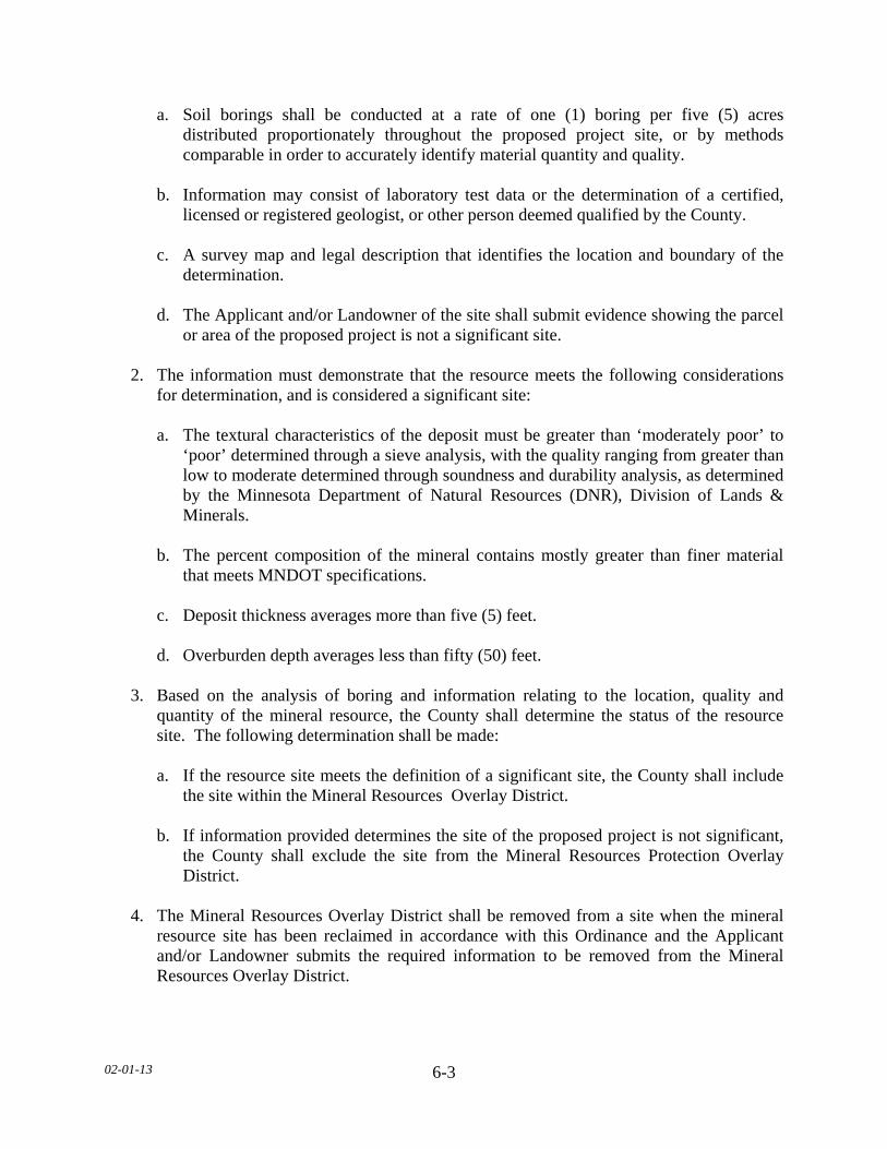
02-01-13
6-3
a. Soil borings shall be conducted at a rate of one (1) boring per five (5) acres distributed proportionately throughout the proposed project site, or by methods comparable in order to accurately identify material quantity and quality.
b. Information may consist of laboratory test data or the determination of a certified,
licensed or registered geologist, or other person deemed qualified by the County. c. A survey map and legal description that identifies the location and boundary of the
determination. d. The Applicant and/or Landowner of the site shall submit evidence showing the parcel
or area of the proposed project is not a significant site. 2. The information must demonstrate that the resource meets the following considerations
for determination, and is considered a significant site: a. The textural characteristics of the deposit must be greater than ‘moderately poor’ to
‘poor’ determined through a sieve analysis, with the quality ranging from greater than low to moderate determined through soundness and durability analysis, as determined by the Minnesota Department of Natural Resources (DNR), Division of Lands & Minerals.
b. The percent composition of the mineral contains mostly greater than finer material
that meets MNDOT specifications. c. Deposit thickness averages more than five (5) feet. d. Overburden depth averages less than fifty (50) feet. 3. Based on the analysis of boring and information relating to the location, quality and
quantity of the mineral resource, the County shall determine the status of the resource site. The following determination shall be made:
a. If the resource site meets the definition of a significant site, the County shall include
the site within the Mineral Resources Overlay District. b. If information provided determines the site of the proposed project is not significant,
the County shall exclude the site from the Mineral Resources Protection Overlay District.
4. The Mineral Resources Overlay District shall be removed from a site when the mineral
resource site has been reclaimed in accordance with this Ordinance and the Applicant and/or Landowner submits the required information to be removed from the Mineral Resources Overlay District.

02-01-13
6-4
C. LAND USE NOTIFICATION
1. No permit for the construction of, or addition to, a dwelling unit located within the Mineral Resources Overlay District shall be issued until the Applicant and/or Landowner signs a “Mineral Resources Land Use Notification Form” provided by the Department. These Forms shall inform the applicant and /or landowner of the following:
a. The land that is the subject of the permit or development is located within the Mineral
Resources Overlay District, where Le Sueur County and the DNR have determined mineral resources are an important resource in this area.
b. Mineral extraction operations may be accompanied by noise, dust, odor, light, and
other off-site impacts. c. Mineral extraction is given preference over residential uses within the Mineral
Resources Overlay District. d. Residents have a right to live in the Mineral Resources Overlay District, however;
residents shall be prepared to accept that mineral extraction operations and accompanying impacts associated with this use are a normal and necessary aspect of living in the Mineral Resources Overlay District.
2. Said form shall be filed with the Le Sueur County Recorder at the expense of the
Applicant and/or Landowner and shall include the legal description of the property involved.
02-01-13
6-5
SECTION 6.2 FLOOD PLAIN (FP) OVERLAY DISTRICT SUBDIVISION 1. STATUTORY AUTHORIZATION, FINDINGS OF FACT AND
PURPOSE A. STATUTORY AUTHORIZATION The legislature of the State of Minnesota has, in Minnesota Statutes Chapter l03F and 394, delegated the authority to local government units to adopt regulations designed to minimize flood losses. Minnesota Statute Chapter 103F further stipulates that communities subject to recurrent flooding must participate and maintain eligibility in the National Flood Insurance Program. Therefore, the Board of Commissioners of Le Sueur County, Minnesota does ordain as follows: B. FINDINGS OF FACT
1. The flood hazard areas of Le Sueur County, Minnesota, are subject to periodic inundation which results in potential loss of life, loss of property, health and safety hazards, disruption of commerce and governmental services, extraordinary public expenditures for flood protection and relief, and impairment of the tax base, all of which adversely affect the public health, safety, and general welfare.
2. Methods Used to Analyze Flood Hazards. This Ordinance is based upon a reasonable
method of analyzing flood hazards which is consistent with the standards established by the Minnesota Department of Natural Resources.
3. National Flood Insurance Program Compliance. This Ordinance is adopted to comply
with the rules and regulations of the National Flood Insurance Program codified as 44 Code of Federal Regulations Parts 59 -78, as amended, so as to maintain the community’s eligibility in the National Flood Insurance Program.
C. PURPOSE It is the purpose of this Section to designate an overlay district that will maintain the County’s eligibility in the National Flood Insurance Program and to minimize potential loss of life, loss of property, health and safety hazards, disruption of commerce and governmental services, extraordinary public expenditures for flood protection and relief and impairment of the tax base, all of which adversely affect the public health, safety, and general welfare of the County. D. SEVERABILITY
If any section, clause, provision, or portion of this Section is adjudged unconstitutional or invalid by a court of competent jurisdiction, the remainder of this Ordinance shall not be affected thereby.

02-01-13
6-6
SUBDIVISION 2. GENERAL PROVISIONS A. ADOPTION OF FLOOD INSURANCE RATE MAPS AND STUDY. The Official Zoning Map together with all materials attached thereto is hereby adopted by reference and declared to be part of this Section. The attached material shall include the Flood Insurance Study and the Flood Insurance Rate Map (FIRM) panels for Le Sueur County, Minnesota And Incorporated Areas prepared by the Federal Emergency Management Agency (FEMA) dated July 21, 1999 therein indicated on the FIRM Index for Le Sueur County dated July 21, 1999, as well as the Letter of Map Revisions (LOMR) dated October 16, 1999. B. LANDS TO WHICH THIS SECTION APPLIES This Section shall apply to all lands within the jurisdiction of Le Sueur County and to all lands designated as within the Flood Plain Overlay District. C. REGULATORY FLOOD PROTECTION ELEVATION The Regulatory Flood Protection Elevation (RFPE) shall be an elevation no lower than one (1) foot above the elevation of the regional flood, plus any increases in flood elevation caused by encroachments on the flood plain that result from designation of a floodway. D. INTERPRETATION
1. In their interpretation and application, the provisions of this Section shall be held to be minimum requirements and shall be liberally construed in favor of the Governing Body and shall not be deemed a limitation or repeal of any other powers granted by state statutes.
2. The boundaries of the Flood Plain Overlay District shall be determined by scaling
distances on the Official Zoning Map. Where interpretation is needed as to the exact location of the boundaries of the Flood Plain District, the Department shall make the necessary interpretations based on elevations on the regional (100-year) flood profile, if available. If 100-year flood elevations are not available, the County shall require one (1) of the following:
a. A flood plain evaluation consistent with Subdivision 3 of this Section to determine a
100-year flood elevation for the site. b. Base its decision on available hydraulic/hydrologic or site elevation survey data
which demonstrates the likelihood the site is within or outside of the flood plain. c. Set the 100-year flood elevation on outletted lakes at three (3) feet above the ordinary
high water level (OHWL) provided available supporting data include an extensive water level history or documentation of high water levels associated with a severe hydrologic event (e.g., a 100-year event or larger).

02-01-13
6-7
E. ABROGATION AND GREATER RESTRICTIONS
The Flood Plain Overlay District shall be considered a zoning district overlaying and superseding all existing land use regulations of Le Sueur County. It is not intended by this Section to repeal, abrogate, or impair any existing easements, covenants, or deed restrictions. However, where this Section imposes greater restrictions, the provisions of this Section shall prevail. All other Sections of this Ordinance inconsistent with this Section, are hereby repealed to the extent of the inconsistencies only. F. WARNING AND DISCLAIMER OF LIABILITY This Section does not imply that areas outside the flood plain districts or land uses permitted within such districts will be free from flooding or flood damages. This Section shall not create liability on the part of Le Sueur County or any officer or employee thereof for Le Sueur County any flood damages that result from reliance on this Section or any administrative decision lawfully made thereunder. G. DETACHMENTS The Flood Insurance Rate Map panels adopted in this Section include floodplain areas that currently lie within the corporate boundaries of cities in Le Sueur County at the time of adoption of this Ordinance. If any of these floodplain lands are detached from a city after the date of adoption of this Ordinance and come under the jurisdiction of Le Sueur County, the newly detached floodplain lands shall be subject to the provisions of this Ordinance immediately upon the date of detachment from the city SUBDIVISION 3. ESTABLISHMENT OF ZONING DISTRICTS AND EVALUATION
PROCEDURE A. FLOOD PLAIN OVERLAY DISTRICT
1. The Flood Plain Overlay district shall be considered an overlay zoning district to all existing zoning districts of the County. The requirements of this Section shall apply in addition to other legally established regulations of the County.
2. The Flood Plain Overlay District shall include those areas designated as Zone A and
Zone AE on the Food Insurance Rate Map adopted in this Section.
B. PERMITTED USES IN THE FLOOD PLAIN OVERLAY DISTRICT
1. The uses listed in Subdivision 4.A.1 of this Section shall be permitted uses. 2. All other uses shall be subject to the floodway/flood fringe evaluation criteria pursuant to
this Section. Subdivision 4.0 shall apply if the proposed use is in the Floodway District and Subdivision 5.0 shall apply if the proposed use is in the Flood Fringe District.
02-01-13
6-8
C. PROCEDURES FOR FLOODWAY AND FLOOD FRINGE DETERMINATIONS
WITHIN THE FLOOD PLAIN OVERLAY DISTRICT
1. Floodway (FW) District: Shall include those areas designated as floodway on the Flood Insurance Rate Map (FIRM) panels adopted in this Section. For lakes, wetlands and other basins, the Floodway District shall include those areas designated as Zone A and Zone AE (that do not have a floodway designated) on the Flood Insurance Rate Map panels adopted in this Section that are at or below the ordinary high water level as defined in Minnesota Statutes, Section 103G.005, subdivision 14, as amended from time to time.
2. Flood Fringe (FF) District: The Flood Fringe District shall include those areas designated as
floodway fringe, which shall include the areas shown on the Flood Insurance Rate Map, adopted in this Section as being within Zone AE but being located outside of the floodway. For lakes, wetlands and other basins (that do not have a floodway designated), the Flood Fringe District shall include those areas designated as Zone A and Zone AE on the Flood Insurance Rate Map panels adopted in this Section that are below the one percent (1%) annual chance flood elevation (100-year flood elevation) but above the ordinary high water level as defined in Minnesota Statutes, Section 103G.005, subdivision 14, as amended from time to time.
3. Upon receipt of an application for a permit or other approval for a use within the Flood
Plain Overlay District and the floodway and flood fringe boundaries are not able to be determined in accordance with this Subdivision, the applicant shall be required to furnish such of the following information as is deemed necessary by the Department for the determination of the regulatory flood protection elevation and whether the proposed use is within the Floodway or Flood Fringe District.
a. A typical valley cross-section(s) showing the channel of the stream, elevation of land
areas adjoining each side of the channel, cross-sectional areas to be occupied by the proposed development, and high water information.
b. Plan (surface view) showing elevations or contours of the ground, pertinent structure,
fill, or storage elevations, the size, location, and spatial arrangement of all proposed and existing structures on the site, and the location and elevations of streets.
c. Photographs showing existing land uses, vegetation upstream and downstream, and
soil types. d. Profile showing the slope of the bottom of the channel or flow line of the stream for
at least five hundred (500) feet in either direction from the proposed development.
02-01-13
6-9
4. The applicant shall be responsible to submit one copy of the above information to a designated engineer or other expert person or agency for technical assistance in determining whether the proposed use is in the Floodway or Flood Fringe District and to determine the regulatory flood protection elevation. If a 100-year flood elevation is provided in the Flood Insurance Study adopt in Subdivision 2, then this elevation must be used in calculating the regulatory flood protection elevation. Procedures consistent with Minnesota Regulations 1983, Parts 6120.5000 - 6120.6200, as amended from time to time, and 44 Code of Federal Regulations Part 65, as amended from time to time, shall be followed in this expert evaluation. The designated engineer or expert is strongly encouraged to discuss the proposed technical evaluation methodology with the respective Department of Natural Resources' Area Hydrologist prior to commencing the analysis. The designated engineer or expert shall:
a. Estimate the peak discharge of the regional flood. b. Calculate the water surface profile of the regional flood based upon a hydraulic
analysis of the stream channel and overbank areas. c. Compute the floodway necessary to convey or store the regional flood without
increasing flood stages more than 0.5 foot. A lesser stage increase than .5' shall be required if, as a result of the additional stage increase, increased flood damages would result. An equal degree of encroachment on both sides of the stream within the reach shall be assumed in computing floodway boundaries.
5. The Department shall present the technical evaluation and findings of the designated engineer or expert to the Board of County Commissioners. The Board of County Commissioners must formally accept the technical evaluation and the recommended Floodway and/or Flood Fringe District boundary or deny the permit application. The Board of County Commissioners, prior to official action, may submit the application and all supporting data and analyses to the Federal Emergency Management Agency, the Department of Natural Resources or the Planning Commission for review and comment. Once the Floodway and Flood Fringe District Boundaries have been determined, the Board of County Commissioners shall refer the matter back to the Department who shall process the permit application consistent with the applicable provisions of this Section.
6. Procedures for Determining one percent (1%) Annual Chance Flood Elevations (100-
Year Flood Elevations) for Lakes, Wetlands and Other Basins Located in Zone A:
a. Upon receipt of an application for a permit or other approval within a Zone A for a lake, wetland, or other basin, the Department will use the one percent (1%) annual chance flood elevation for that basin that has previously been determined in accordance with approved FEMA methods, if available. If the one percent
(1%) annual chance flood elevation has not been previously determined, the applicant shall be required to furnish all necessary information as deemed necessary by the Department for the determination for the one percent (1%) annual chance flood elevation in accordance with approved FEMA methods.

02-01-13
6-10
b. The applicant shall be responsible to submit one copy of the above information to a designated engineer or other expert person or agency for technical assistance in determining the one percent (1%) annual chance flood elevation (100-year flood elevation). Procedures consistent with Minnesota Regulations, Parts 6120.5000 - 6120.6200, as amended from time to time, and 44 Code of Federal Regulations Part 65, as amended from time to time, shall be followed in this expert evaluation. The designated engineer or expert is strongly encouraged to discuss the proposed technical evaluation methodology with the respective Department of Natural Resources' Area Hydrologist prior to commencing the analysis.
c. Once the one percent (1%) annual chance flood elevation (100-year flood elevation)
has been determined, the Department shall process the permit application consistent with the applicable provisions of this Section.
D. COMPLIANCE
1. No new structure or land shall hereafter be used and no structure shall be constructed, located, extended, converted, or structurally altered without full compliance with the terms of this Section and other applicable regulations which apply to uses within the jurisdiction of this Section. Within the Flood Plain Overlay District, all uses not listed as permitted uses or conditional uses shall be prohibited. In addition, a caution is provided here that:
a. New manufactured homes, replacement manufactured homes and certain campers and
recreational vehicles are subject to the general provisions of this Section. b. Modifications, additions, structural alterations, normal maintenance and repair, or
repair after damage to existing non-conformities are regulated by the general provisions of this Section.
c. As-Built elevations for elevated structures must be certified with elevation surveys
and must be designed and certified by a licensed professional engineer or surveyor as specified in this Section.
E. PROHIBITED USES WITHIN THE FLOOD PLAIN OVERLAY DISTRICT The placement of Wind Energy Conversion Systems (WECS) shall be specifically prohibited within the Flood Plain Overlay District. SUBDIVISION 4. FLOODWAY DISTRICT(FW) The following are uses permitted within the Floodway (FW)District if not prohibited in the underlying zoning district and are in compliance with the provisions of this Section:
02-01-13
6-11
A. PERMITTED USES 1. Any use of land which does not involve a structure, an addition to the outside dimension
of an existing structure or an obstruction to flood flows such as fill, excavation, or storage of materials or equipment. This may include the following:
a. General farming, pasture, grazing, outdoor plant nurseries, horticulture, truck
farming, forestry, sod farming, and wild crop harvesting, b. Industrial-commercial loading areas, parking areas, and airport landing strips. c. Private and public golf courses, tennis courts, driving ranges, archery ranges, picnic
grounds, boat launching ramps, swimming areas, parks, wildlife and nature preserves, game farms, fish hatcheries, shooting preserves, target ranges, trap and skeet ranges, hunting and fishing areas, and single or multiple purpose recreational trails.
d. Residential lawns, gardens, parking areas, and play areas.
B. STANDARDS FOR FLOODWAY PERMITTED USES
1. The use shall have a low flood damage potential. 2. The use shall be permissible in the underlying zoning district. 3. The use shall not obstruct flood flows or increase flood elevations and shall not involve
structures, fill, obstructions, excavations, or storage of materials or equipment. C. CONDITIONAL USES
1. Mineral Extraction including the extraction and storage of sand, gravel, and other
materials. 2. Marinas, boat rentals, docks, piers, wharves, and water control structures. 3. Storage yards for equipment, machinery, or materials. 4. Placement of fill and construction of fences. 5. Recreational vehicles either on individual lots of record or in existing subdivisions or
commercial campgrounds, subject to the exemptions and provisions of this Section. 6. Structural works for flood control such as levees, dikes and floodwalls constructed to any
height where the intent is to protect individual structures and levees or dikes where the intent is to protect agricultural crops for a frequency flood event equal to or less than the ten (10) year frequency flood event.

02-01-13
6-12
7. All Utilities including transmission lines and pipelines, and transportation infrastructure,
including railroad tracks, roads, bridges and associated fill, shall be subject to minimum state flood plain management standards set by the DNR and the Minnesota Department of Transportation (MNDOT) contained in MN Rules 6120.500-6120.6200, as amended from time to time, as well as this Section.
D. STANDARDS FOR FLOODWAY CONDITIONAL USES
1. All Uses. No fill (including fill for roads and levees), deposit, obstruction, storage of materials or equipment, or other uses may be allowed as a conditional use that will cause any increase in the stage of the 100-year or regional flood or cause an increase in flood damages in the reach or reaches affected.
2. All floodway conditional uses shall be subject to the procedures and standards contained
in this Ordinance. 3. The conditional use shall be permissible in the underlying zoning district. 4. Fill, including storage of sand, gravel and other materials:
a. Fill, dredge spoil, and all other similar materials deposited or stored in the floodway
shall be protected from erosion by vegetative cover, mulching, riprap or other acceptable method.
b. Dredge spoil sites and sand and gravel operations shall not be allowed in the
floodway unless a long-term site development plan is submitted which includes an erosion/sedimentation prevention element to the plan.
c. As an alternative, and consistent with (b.) listed immediately above, dredge spoil
disposal and sand and gravel operations may allow temporary, on-site storage of fill or other materials which would have caused an increase to the stage of the 100-year or regional flood but only after the Board of County Commissioners has received an appropriate plan which assures the removal of the materials from the floodway based upon the flood warning time available. The conditional use permit must be title registered with the property in the Office of the County Recorder.
5. Storage of Materials and Equipment
a. The storage or processing of materials that are, in time of flooding, flammable, explosive, or potentially injurious to human, animal, or plant life is prohibited.
b. Storage of other materials or equipment may be allowed if readily removable from
the area within the time available after a flood warning and in accordance with a plan approved by the Governing Body.
02-01-13
6-13
6. Structural works for flood control that will change the course, current or cross section of
protected wetlands or public waters shall be subject to the provisions of Minnesota Statute, Chapter 103G, as amended from time to time. Community-wide structural works for flood control intended to remove areas from the regulatory flood plain shall not be allowed in the floodway.
7. A levee, dike or floodwall constructed in the floodway shall not cause an increase to the
100-year or regional flood and the technical analysis must assume equal conveyance or storage loss on both sides of a stream.
SUBDIVISION 5. FLOOD FRINGE DISTRICT (FF) The following are uses permitted within the Flood Fringe (FF) portion of the Flood Plain Overlay District if not prohibited in the underlying zoning district and are in compliance with the provisions of this Section. A. PERMITTED USES
1. The permitted uses shall be those uses of land or structures listed as permitted uses in the underlying zoning use district(s).
2. All permitted uses shall comply with the standards for Flood Fringe “Permitted Uses”
listed and the "Standards for all Flood Fringe Uses" listed below. B. STANDARDS FOR FLOOD FRINGE PERMITTED USES 1. Any use of land involving the construction of new structures, the placement or
replacement of manufactured homes, the addition to the outside dimension of an existing structure or obstruction such as fill or storage of materials or equipment are subject to the flood plain evaluation criteria of this Section for determining Floodway and Flood Fringe Districts.
2. All structures, including accessory structures, must be elevated on fill so that the lowest
floor including basement floor is at or above the regulatory flood protection elevation. The finished fill elevation for structures shall be no lower than one (1) foot below the regulatory flood protection elevation and the fill shall extend at such elevation at least fifteen (15) feet beyond the outside limits of the structure erected thereon.
a. Any proposed fill shall be designed following the guidelines on pages 5-12 in the
FEMA Technical Bulletin ‘Ensuring that Structures Build on Fill In or Near Special Flood Hazard Areas are Reasonably Safe From Flooding (FIA-TB-10), as amended from time to time.
b. Any proposed fill shall be properly compacted and the slopes shall be properly
protected by the use of riprap, vegetative cover, or other acceptable methods.
02-01-13
6-14
3. The storage of any materials or equipment shall be elevated on fill to the regulatory flood protection elevation.
4. For times of flooding, the storage or processing of materials that are flammable,
explosive, toxic or potentially injurious to human, animal, or plant life is prohibited. 5. All new principal structures must have vehicular access at or above an elevation not more
than two (2) feet below the regulatory flood protection elevation. If a variance to this requirement is granted, the Board of Adjustment must specify limitations on the period of use or occupancy of the structure for times of flooding and only after determining that adequate flood warning time and local flood emergency response procedures exist.
C. CONDITIONAL USES 1. Any structure that is not elevated on fill and or any use of land that does not comply with
the standards for permitted uses in this Section shall only be allowable as a conditional use.
2. The provisions listed below under ‘Standards for All Flood Fringe Conditional Uses’
shall also apply. D. STANDARDS FOR ALL FLOOD FRINGE CONDITIONAL USES 1. The conditional use shall be subject to the procedures and standards contained in this
Ordinance. 2. The conditional uses shall be those uses of land or structures listed as conditional uses in
the underlying zoning use district(s) and are in compliance with the provisions of this Section.
3. Alternative elevation methods other than the use of fill may be utilized to elevate a
structure's lowest floor above the regulatory flood protection elevation. These alternative methods may include the use of stilts, pilings, parallel walls, etc. and they shall not create and enclosed area such as a tuck under garage, walkout basement, crawl space, or enclosed stairwell, The above-noted alternative elevation methods are subject to the following additional standards:
a. Comply with FEMA Standards. b. Design and Certification - The structure's design and as-built condition must be
certified by a registered professional engineer or architect as being in compliance with the general design standards as regulated by FEMA. This specifically includes all electrical, heating, ventilation, plumbing and air conditioning equipment and other service facilities must be at or above the regulatory flood protection elevation or be designed to prevent flood water from entering or accumulating within these components during times of flooding.
02-01-13
6-15
4. Storage of Materials and Equipment: a. The storage or processing of materials that are, in time of flooding, flammable,
explosive, or potentially injurious to human, animal, or plant life is prohibited. b. Storage of other materials or equipment may be allowed if readily removable from
the area within the time available after a flood warning and in accordance with a plan approved by the Governing Body.
5. All new principal structures must have vehicular access at or above an elevation not more
than two (2) feet below the regulatory flood protection elevation. If a variance to this requirement is granted, the Board of Adjustment must specify limitations on the period of use or occupancy of the structure for times of flooding and only after determining that adequate flood warning time and local flood emergency response procedures exist.
E. STANDARDS FOR ALL FLOOD FRINGE USES 1. Commercial, Manufacturing, and Industrial Uses a. Accessory land uses, such as yards, railroad tracks, and parking lots may be at
elevations lower than the RFPE. b. Measures shall be taken to minimize interference with normal business operations,
especially along streams having protracted flood durations. c. A permit for such facilities to be used by the employees or the general public shall not
be granted in the absence of a flood warning system that provides adequate time for evacuation if the area would be inundated to a depth greater than two (2) feet or be subject to flood velocities greater than four (4) feet per second upon occurrence of the regional flood.
d. When considering applications, due consideration shall be given to needs of an
industry whose business requires that it be located in flood plain areas. 2. Fill shall be properly compacted and the slopes shall be properly protected by the use of
riprap, vegetative cover or other acceptable method. The Federal Emergency Management Agency (FEMA) has established criteria for removing the special flood hazard area designation for certain structures properly elevated on fill above the 100-year flood elevation - FEMA's requirements incorporate specific fill compaction and side slope protection standards for multi-structure or multi-lot developments. These standards should be investigated prior to the initiation of site preparation if a change of special flood hazard area designation will be requested.
02-01-13
6-16
3. Flood plain developments shall not adversely affect the hydraulic capacity of the channel and adjoining flood plain of any tributary watercourse or drainage system where a floodway or other encroachment limit has not been specified on the Official Zoning Map.
4. Standards for recreational vehicles are contained in Subdivision 7. 5. All manufactured homes must be securely anchored to an adequately anchored
foundation system that resists flotation, collapse and lateral movement. Methods of anchoring may include, but are not to be limited to, use of over-the-top or frame ties to ground anchors. This requirement is in addition to applicable state or local anchoring requirements for resisting wind forces.
6. Certification. The applicant shall be required to submit certification by a registered
professional engineer, registered architect, or registered land surveyor that the finished fill and building elevations were accomplished in compliance with the provisions of this Ordinance. Flood proofing measures shall be certified by a registered professional engineer or registered architect.
7. Record of First Floor Elevation. The Department shall maintain a record of the elevation
of the lowest floor (including basement) of all new structures and alterations or additions to existing structures in the flood plain. The Department shall also maintain a record of the elevation to which structures or alterations and additions to structures are flood proofed.
SUBDIVISION 6. PUBLIC UTILITIES, RAILROADS, ROADS, AND BRIDGES A. PUBLIC UTILITIES All public utilities and facilities such as gas, electrical, sewer, and water supply systems to be located in the flood plain shall be elevated to above the regulatory flood protection elevation. B. PUBLIC TRANSPORTATION FACILITIES Railroad tracks, roads, and bridges to be located within the flood plain shall comply with standards listed in Subdivision 4.0 and 5.0 of this Section. Elevation to the regulatory flood protection elevation shall be provided where failure or interruption of these transportation facilities would result in danger to the public health or safety or where such facilities are essential to the orderly functioning of the area. Minor or auxiliary roads or railroads may be constructed at a lower elevation where failure or interruption of transportation services would not endanger the public health or safety.
02-01-13
6-17
C. ON-SITE SUBSURFACE SEWAGE TREATMENT SYSTEMS (SSTS) AND WATER SUPPLY SYSTEMS
1. For those areas in the Flood Plain Overlay District where public utilities are not provided,
the following requirements shall be met: a. On-site water supply systems must be designed to minimize or eliminate infiltration
of flood waters into the systems; and b. New or replacement individual sewage treatment systems must be designed to
minimize or eliminate infiltration of flood waters into the systems and discharges from the systems into flood waters and shall not be subject to impairment or contamination during times of flooding.
c. Any SSTS designed in accordance with the current statewide standards for individual
SSTS shall be determined to be in compliance with this Section and Section 17 of this Ordinance.
SUBDIVISION 7. MANUFACTURED HOMES AND MANUFACTURED HOME PARKS
AND PLACEMENT OF RECREATIONAL VEHICLES. A. MANUFACTURED HOME & HOME PARKS New manufactured home parks and expansions to existing manufactured home parks are prohibited. B. RECREATIONAL VEHICLES 1. Recreational vehicles that do not meet the exemption criteria specified in the Exemptions
listed below shall be subject to the provisions of this Section. 2. Exemption - Recreational vehicles are exempt from the provisions of this Section if they
are placed in any of the areas listed in below and further they meet the following criteria: a. Have current licenses required for highway use. b. Are highway ready meaning on wheels or the internal jacking system, are attached to
the site only by quick disconnect type utilities commonly used in campgrounds and recreational vehicle parks and the recreational vehicle has no permanent structural type additions attached to it.
c. The recreational vehicle and associated use must be permissible in any pre-existing,
underlying zoning use district. 3. Areas Exempted For Placement of Recreational Vehicles:
02-01-13
6-18
a. Individual lots or parcels of record. b. Existing commercial recreational vehicle parks or campgrounds. c. Existing condominium type associations. 4. Recreational vehicles exempted lose this exemption when development occurs on the
parcel exceeding five hundred dollars ($500) for a structural addition to the recreational vehicle or exceeding five hundred dollars ($500) for an accessory structure such as a garage or storage building. The recreational vehicle and all additions and accessory structures will then be treated as a new structure and shall be subject to the elevation requirements and the use of land restrictions specified in this Section. There shall be no development or improvement on the parcel or attachment to the recreational vehicle that hinders the removal of the recreational vehicle to a flood free location should flooding occur.
5. New commercial recreational vehicle parks or campgrounds and new residential type
subdivisions and condominium associations and the expansion of any existing similar use exceeding five (5) units or dwelling sites shall be subject to the following:
a. Any new or replacement recreational vehicle will be allowed in the Flood Plain
Overlay District provided said recreational vehicle and its contents are placed on fill above the regulatory flood protection elevation and proper elevated road access to the site exists in accordance with this Section. No fill placed in the floodway to meet the requirements of this Section shall increase flood stages of the 100-year or regional flood.
b. All new or replacement recreational vehicles not meeting the criteria of (a) above are
prohibited. SUBDIVISION 8. NON-CONFORMING USES A. Any non-conformity which was lawful before July 6, 1999 which is not in conformity with
the provisions of this Section may be continued subject to the following conditions: 1. No such use shall be expanded, changed, enlarged, or altered in a way which increases its
non-conformity. 2. Any structural alteration or addition to a non-conforming structure or non-conforming
use which would result in increasing the flood damage potential of that structure or use shall be in accordance with the elevation on fill standards in this Section, except as further restricted below.
02-01-13
6-19
3. The cost of all structural alterations or additions to any nonconforming structure over the life of the structure shall not exceed fifty (50) percent of the market value of the structure unless the conditions of this Section are satisfied. The cost of all structural alterations and additions must include all costs such as construction materials and a reasonable cost placed on all manpower or labor. If the cost of all previous and proposed alterations and additions exceeds fifty (50) percent of the market value of the structure, then the structure must meet the standards of this Section for new structures depending upon whether the structure is in the Floodway or Flood Fringe District, respectively.
4. For any non-conformity that is discontinued or its normal operation is stopped for a
period of one (1) year; the use of the same shall thereafter conform to the regulations of the district in which it is located. The Assessor shall notify the Department in writing of instances of nonconforming uses that have been discontinued for a period of one (1) year.
5. If any non-conforming use or structure, is substantially damaged as defined in Section 4
of this Ordinance, it shall be reconstructed except in conformity with the provisions of this Section. The applicable provisions for establishing new uses or new structures in this Section will apply depending upon whether the use or structure is in the Floodway or Flood Fringe District, respectively.
6. If a substantial improvement occurs, as defined in Section 4 of this Ordinance, from any
combination of a building addition to the outside dimensions of the existing building or a rehabilitation, reconstruction, alteration, or other improvement to the inside dimensions of an existing nonconforming building, then the building addition and the existing nonconforming building must meet the requirements of this Section for new structures, depending upon whether the structure is in the Floodway or Flood Fringe District, respectively.
SUBDIVISION 9. ADMINISTRATION A. NOTIFICATION FOR WATERCOURSE ALTERATIONS The Department shall notify, in riverine situations, adjacent communities and the Commissioner of the Department of Natural Resources prior to the community authorizing any alteration or relocation of a watercourse. If the applicant has applied for a permit to work in the beds of public waters pursuant to Minnesota Statute, Chapter 103G, this shall suffice as adequate notice to the Commissioner of Natural Resources. A copy of said notification shall also be submitted to the Chicago Regional Office of the Federal Emergency Management Agency (FEMA). B. NOTIFICATION TO FEMA WHEN PHYSICAL CHANGES INCREASE OR DECREASE
THE 100-YEAR FLOOD ELEVATION As soon as is practicable, but not later than six (6) months after the date such supporting information becomes available, the Department shall notify the Chicago Regional Office of FEMA of the changes by submitting a copy of said technical or scientific data.

02-01-13
6-20
C. AMENDMENTS TO FLOOD PLAIN OVERLAY DISTRICT The flood plain designation on the Official Zoning Map shall not be removed from flood plain areas unless it can be shown that the designation is in error or that the area has been filled to or above the elevation of the regulatory flood protection elevation and is contiguous to lands outside the flood plain. Special exceptions to this rule may be permitted by the Commissioner of Natural Resources if he determines that, through other measures, lands are adequately protected for the intended use. D. AMENDMENTS TO THIS SECTION All amendments to this Section, including amendments to the Official Zoning Map, must be submitted to and approved by the Commissioner of Natural Resources prior to adoption. Changes in the Official Zoning Map must meet the Federal Emergency Management Agency's (FEMA) Technical Conditions and Criteria and must receive prior FEMA approval before adoption. The Commissioner of Natural Resources must be given ten (10) days written notice of all hearings to consider an amendment to this Ordinance and said notice shall include a draft of the Ordinance amendment or technical study under consideration. E. STATE AND FEDERAL PERMITS Prior to processing or granting any land use permit the Department shall determine whether the applicant has obtained all necessary state and federal permits.
F. PERMIT REQUIRED
1. Any land use permit issued by the Department in conformity with the provisions of this ordinance shall be required prior to:
a. The erection, addition, modification, rehabilitation (including normal maintenance
and repair), or alteration of any structure, or portion thereof. b. The use or change of use of a structure, or land. c. The construction of a dam, fence, or on-site septic system. d. The change or extension of a nonconforming use. e. The repair of a structure that has been damaged by flood, fire, or tornado, or any other
source. f. The placement of fill, excavation of materials, or the storage of materials or
equipment.
02-01-13
6-21
SECTION 6.3. AIRPORT ZONING (AZ) OVERLAY DISTRICT SUBDIVISION 1. PURPOSE The Airport Overlay District is intended to protect and recognize existing and future regulations for airports within the County which regulate the location and height of structures and vegetation around airports. SUBDIVISION 2. ADOPT BY REFERENCE A. The Airport Zoning Regulations adopted by the Joint Airport Zoning Boards are hereby
adopted by reference and as amended from time to time. The Joint Airport Zoning Boards consist of: 1. Mankato Regional Airport: Mankato, Blue Earth County, St. Peter, Nicollet County and
Le Sueur County. 2. City of Le Sueur Municipal Airport: City of Le Sueur, Le Sueur County, Nicollet
County, and Sibley County.
02-01-13 7-1
SECTION 7. CONSERVANCY (C) DISTRICT SUBDIVISION 1. PURPOSE The Conservancy (C) District is established for areas that typically contain significant water courses and associated features such as bluffs, woods and flood plain that are best left mostly in existing natural ground cover. Dwellings, livestock production, and other intense land uses should be kept to a minimum. Housing density should be the same as in the Agriculture (A) District. Rezoning should only be considered on the zone's borders in order to maintain the Zoning integrity with the Conservancy (C) District. However, transfer of development rights may be utilized to exceed the permitted housing density of one dwelling per quarter-quarter section (40 acres), provided the density does not exceed four dwellings per quarter-quarter section in the receiving quarter-quarter section. Lots of Record shall be exempt from density standards. SUBDIVISION 2. PERMITTED USES The following uses shall be permitted within the Conservancy (C) District: A. Agriculture, including crop production and pasturing, utilizing agricultural best management
practices and accessory structures. B. One (1) single-family dwelling per existing building site, Lot of Record, or per quarter-
quarter section. C. One (1) temporary dwelling per lot that will be occupied for one (1) year or less. D. Home Occupations, Level I. E. Seasonal produce stand. F. Sensitive resource management of hiking trails, nature areas, wildlife preserves, official
wetland areas and forest preserves owned or operated by governmental agencies. G. Flood control, watershed structures, erosion control, and fish and game hatcheries. H. Forest management. I. Nurseries and tree farms. J. Non-Commercial Wind Energy Conversion Systems. K. Grading, excavating or filling activities involving the movement of fifty (50) cubic yards or
less of material that is not in connection with another permitted use. Activities associated with the maintenance or improvements of public roads are exempt.
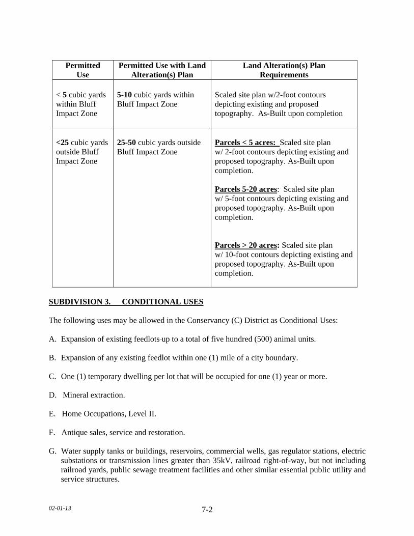
02-01-13 7-2
SUBDIVISION 3. CONDITIONAL USES The following uses may be allowed in the Conservancy (C) District as Conditional Uses: A. Expansion of existing feedlots up to a total of five hundred (500) animal units. B. Expansion of any existing feedlot within one (1) mile of a city boundary. C. One (1) temporary dwelling per lot that will be occupied for one (1) year or more. D. Mineral extraction. E. Home Occupations, Level II. F. Antique sales, service and restoration. G. Water supply tanks or buildings, reservoirs, commercial wells, gas regulator stations, electric
substations or transmission lines greater than 35kV, railroad right-of-way, but not including railroad yards, public sewage treatment facilities and other similar essential public utility and service structures.
Permitted Use
Permitted Use with Land Alteration(s) Plan
Land Alteration(s) Plan Requirements
< 5 cubic yards within Bluff Impact Zone <25 cubic yards outside Bluff Impact Zone
5-10 cubic yards within Bluff Impact Zone 25-50 cubic yards outside Bluff Impact Zone
Scaled site plan w/2-foot contours depicting existing and proposed topography. As-Built upon completion Parcels < 5 acres: Scaled site plan w/ 2-foot contours depicting existing and proposed topography. As-Built upon completion. Parcels 5-20 acres: Scaled site plan w/ 5-foot contours depicting existing and proposed topography. As-Built upon completion. Parcels > 20 acres: Scaled site plan w/ 10-foot contours depicting existing and proposed topography. As-Built upon completion.
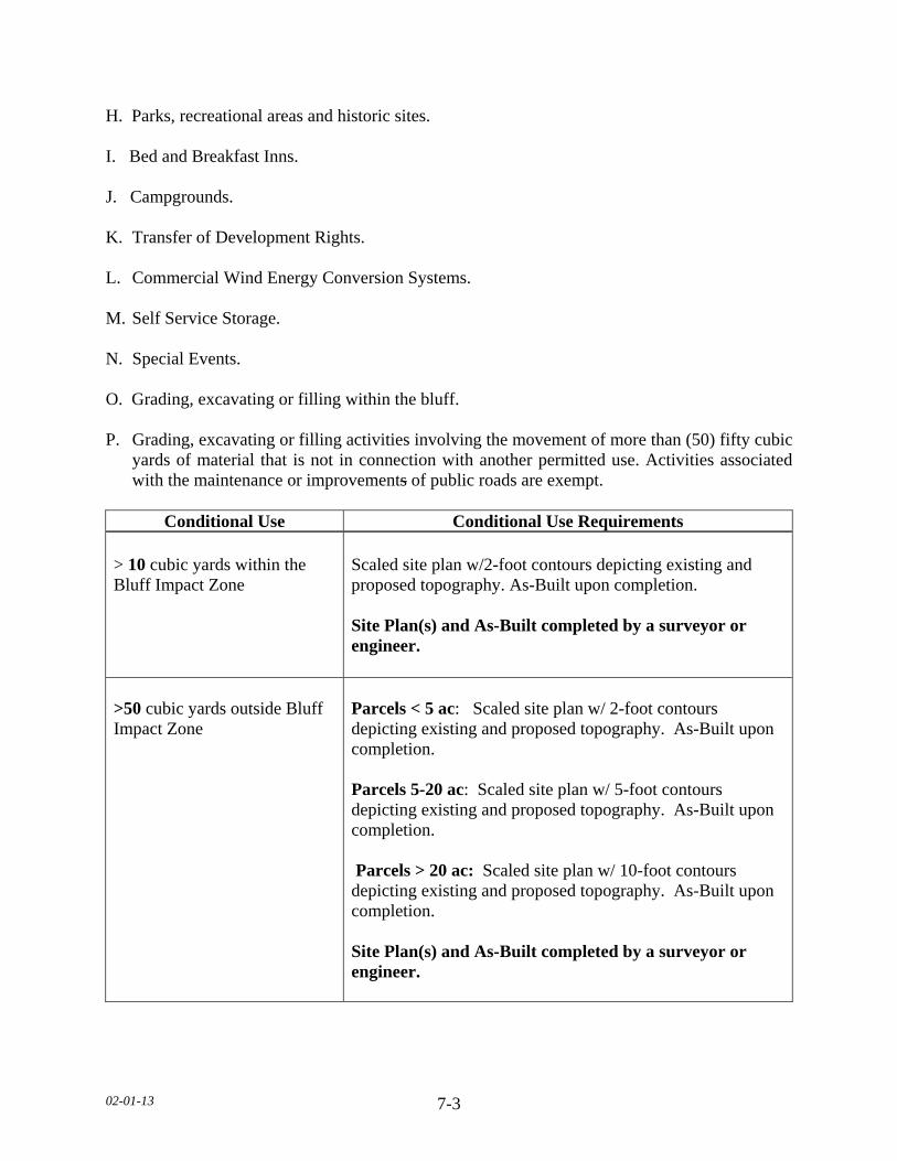
02-01-13 7-3
H. Parks, recreational areas and historic sites. I. Bed and Breakfast Inns. J. Campgrounds. K. Transfer of Development Rights. L. Commercial Wind Energy Conversion Systems. M. Self Service Storage. N. Special Events. O. Grading, excavating or filling within the bluff. P. Grading, excavating or filling activities involving the movement of more than (50) fifty cubic
yards of material that is not in connection with another permitted use. Activities associated with the maintenance or improvements of public roads are exempt.
Conditional Use Conditional Use Requirements
> 10 cubic yards within the Bluff Impact Zone >50 cubic yards outside Bluff Impact Zone
Scaled site plan w/2-foot contours depicting existing and proposed topography. As-Built upon completion. Site Plan(s) and As-Built completed by a surveyor or engineer. Parcels < 5 ac: Scaled site plan w/ 2-foot contours depicting existing and proposed topography. As-Built upon completion. Parcels 5-20 ac: Scaled site plan w/ 5-foot contours depicting existing and proposed topography. As-Built upon completion. Parcels > 20 ac: Scaled site plan w/ 10-foot contours depicting existing and proposed topography. As-Built upon completion. Site Plan(s) and As-Built completed by a surveyor or engineer.

02-01-13 7-4
SUBDIVISION 4. PERMITTED ACCESSORY USES AND STANDARDS The following uses shall be permitted accessory uses within the Conservancy (C) District. A. Having no more than two (2) boarders by a resident family. B. ACCESSORY STRUCTURES
1. In the Conservancy (C) District that have lot sizes less than five (5) acres shall conform to the following structure areas and maximum structure heights.
2. Outside wall dimensions shall be used to determine maximum structure area, except where a roof projects out further than two (2) feet from the sidewall; roof area shall be used to determine maximum structure area.
C. SWIMMING POOL. PERMANENT 1. No pool shall be located within ten (10) feet of a septic tank/drain field. 2. No pool shall be located beneath overhead electrical lines or over underground utility
lines of any type. 3. No pool shall be located within any private or public utility, walkway, drainage, or other
easement. 4. Lighting for the pool shall be oriented so as not to cast light onto adjacent properties. 5. A fence of at least five (5) feet in height shall completely enclose the pool area and the
access to the pool area shall be controlled. D. HEIGHT AND SEPARATION REGULATIONS
1. For parcels greater than five (5) acres, there shall be a maximum height limitation of one hundred and fifty (150) feet on all structures. Any structure including but not limited to tower, spire and similar type structure, only after obtaining a letter of clearance from the Federal Aeronautics Administration and the Airport Commission for any airport located within ten (10) miles of the structure proposed to exceed the height limitation.
Lot Size Maximum Structure Area Maximum Structure Height
Less than 1 acre 2,000 square feet 20 feet 1-1.99 acres 3,600 square feet 20 feet 2-4.99 acres 4,000 square feet 25 feet
02-01-13 7-5
2. An accessory structure shall not be closer than five (5) feet to the principal structure. a. In case an accessory structure is attached to the principal structure, it shall be made
structurally a part of the principal structure and shall comply in all respects with the requirements of this Ordinance applicable to the principal structure.
E. DRAINAGE Adequate drainage shall be provided and the drainage shall be directed away from adjacent private property.
F. Other accessory uses customarily incidental to the uses permitted in Subdivision 2 and 3 of
this Section. SUBDIVISION 5. DIMENSIONAL REGULATIONS A. SETBACK EXEMPTIONS/STRUCTURE EXPANSIONS 1. Where proposed additions do not encroach further into the front, side, or rear yard than
the existing structure, such additions will be permitted provided the use and the structure are in conformance with the following restrictions:
a. The use of the structure is conforming to the zoning district in which it is located. b. The expansion of the structure shall not be located closer to the property line than the
existing structure or at least one-half (1/2) of the required setback, whichever is greater.
c. The expansion of the structure will not reduce any other required setback below the
minimum standards of this Ordinance. d. The expansion of the structure will conform to all other restrictions of this Ordinance,
including but not limited to, density, lot coverage, and structure height. e. The height of the expansion shall not be greater than the existing structure at the
existing building line. B. FRONT YARD SETBACKS 1. There shall be a front yard setback of not less than eighty five (85) feet from the right-of-
way of State-Federal trunk arterials, expressways and State collector arterials. 2. There shall be a front yard setback of not less than seventy five (75) feet from the right-
of-way of County Highways.
02-01-13 7-6
3. There shall be a front yard setback of not less than sixty five (65) feet from a township or any other public or private right-of-way.
4. When a lot is located at the intersection of two (2) or more roads, there shall be a front
yard setback on each road right-of-way. 5. All components of an onsite Subsurface Sewage Treatment System (SSTS) shall be
twenty (20) feet from all road right-of-ways. 6. All components of an onsite Subsurface Sewage Treatment System (SSTS) for a non-
conforming Lot of Record shall be ten (10) feet from all road right-of-ways. 7. The required front yard of a corner lot shall be unobstructed above a height of three (3)
feet in a triangular area, two (2) sides of which are the lines running parallel along the right of way lines between the road intersection and a point fifty (50) feet from the intersection, and the third site of which is the line between the latter two (2) points.
8. No trees or shrubs shall be planted within ten (10) feet from any right-of-way. C. SIDE YARD SETBACKS All structures shall have a side yard setback of not less than fifty (50) feet. D. REAR YARD SETBACKS All structures shall have a rear yard setback of not less than fifty (50) feet. E. BLUFF SETBACKS 1. All structures shall be set back from the top and/or toe of the bluff: a. Thirty (30) feet for bluffs with slopes eighteen (18) to thirty (30) percent. b. Fifty (50) feet for bluffs with slopes greater than thirty (30) percent.
c. Existing Building Sites. All structures shall be set back thirty (30) feet from the top or toe of the bluff.
2. SSTS shall be set back thirty (30) feet from the top or toe of the bluff. a. SSTS upgrade and/or replacement for an existing dwelling:
1. Shall be exempt from bluff setback. 2. May be located within the bluff impact zone. 3. Shall not be located within the bluff.
02-01-13 7-7
3. If the adjacent bluff is actively eroding, the Department may increase the setback requirement.
4. Structures and accessory facilities, except stairways and landings, must not be placed
within bluff impact zones. F. WETLAND SETBACKS All structures shall be setback a minimum of seventy five (75) feet from the wetland boundary of any Type three (3) through eight (8) wetland. G. ADDITIONAL SETBACKS
1. When more than one (1) setback applies to a site, structures must be located to meet all setbacks.
2. All structures shall be setback fifty (50) feet from a cemetery.
H. FEEDLOT & ANIMAL REQUIRMENTS 1. Effective June 10, 2010 any new school, park, golf course, licensed campground, or
residential zoning district shall be separated from an existing animal feedlot by the following:
a. 10-50 AU 500 feet b. 51-2000 AU 1000 feet c. Greater than 2000 AU 1500 feet 2. All new dwellings shall be separated from an existing animal feedlot by the following: a. 10-50 AU 500 feet b. 51-2000 AU 1000 feet c. Greater than 2000 AU 1500 feet 3. The animal feedlot owner’s dwelling is exempt from these requirements. 4. Any expansion of an existing animal feedlot shall conform to the lot requirement as
follows: a. Up to 100 AU 5 acres b. 101-500 AU 10 acres
5. In the Conservancy (C) District, the following standards shall be applicable for allowable animal units:
(TABLE ON NEXT PAGE)
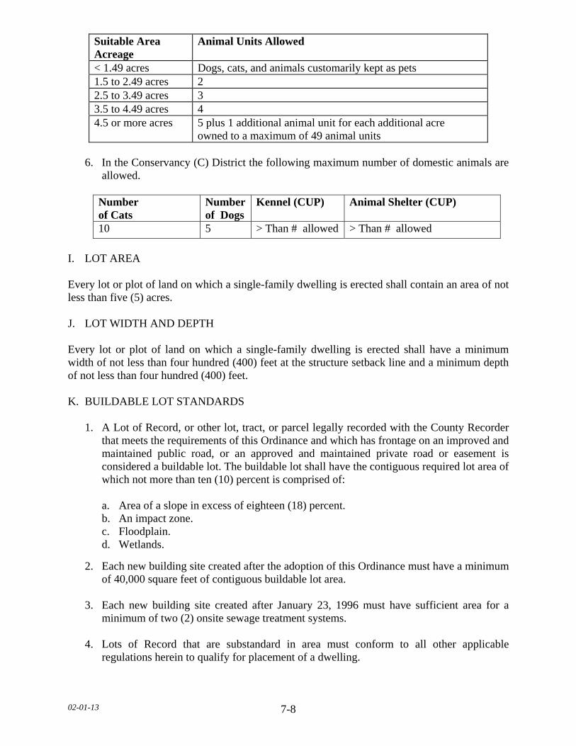
02-01-13 7-8
6. In the Conservancy (C) District the following maximum number of domestic animals are
allowed.
Number of Cats
Number of Dogs
Kennel (CUP) Animal Shelter (CUP)
10 5 > Than # allowed > Than # allowed
I. LOT AREA Every lot or plot of land on which a single-family dwelling is erected shall contain an area of not less than five (5) acres. J. LOT WIDTH AND DEPTH Every lot or plot of land on which a single-family dwelling is erected shall have a minimum width of not less than four hundred (400) feet at the structure setback line and a minimum depth of not less than four hundred (400) feet. K. BUILDABLE LOT STANDARDS 1. A Lot of Record, or other lot, tract, or parcel legally recorded with the County Recorder
that meets the requirements of this Ordinance and which has frontage on an improved and maintained public road, or an approved and maintained private road or easement is considered a buildable lot. The buildable lot shall have the contiguous required lot area of which not more than ten (10) percent is comprised of:
a. Area of a slope in excess of eighteen (18) percent. b. An impact zone. c. Floodplain. d. Wetlands.
2. Each new building site created after the adoption of this Ordinance must have a minimum of 40,000 square feet of contiguous buildable lot area.
3. Each new building site created after January 23, 1996 must have sufficient area for a
minimum of two (2) onsite sewage treatment systems.
4. Lots of Record that are substandard in area must conform to all other applicable regulations herein to qualify for placement of a dwelling.
Suitable Area Acreage
Animal Units Allowed
< 1.49 acres Dogs, cats, and animals customarily kept as pets 1.5 to 2.49 acres 2 2.5 to 3.49 acres 3 3.5 to 4.49 acres 4 4.5 or more acres 5 plus 1 additional animal unit for each additional acre
owned to a maximum of 49 animal units
02-01-13 7-9
SUBDIVISION 6. DWELLING STANDARDS A. PROHIBITED DWELLINGS No garage, tent, trailer, or accessory structure shall at any time be used as a dwelling. B. DWELLING REGULATIONS 1. No more than one (1) dwelling shall be placed on a lot except in the cases of temporary
dwellings. 2. All dwellings shall be on foundations or piles or other foundation systems below the frost
line, as approved by the Department. 3. The minimum dwelling width excluding porches, decks, or other similar attachments
shall be twenty (20) feet except in the cases of temporary dwellings. 4. All dwellings must conform with the sewage treatment regulations of this Ordinance. No
zoning permits will be issued for new dwellings prior to sewage treatment system approval.
5. Manufactured homes shall bear a State seal as verification of construction and inspection
to ANSI A119.1 standards during original construction (issued for manufactured homes built between July 1, 1972 to June 14, 1976) or, for manufactured homes built after that date, a Federal seal in accordance with HUD CFR 3280 Construction Standards.
6. All dwellings shall have a minimum of seven hundred sixty (760) square feet of floor
area on the ground floor. 7. Dwellings shall not exceed two and one-half (2 1/2) stories or thirty five (35) feet in
height. 8. Outside wall dimensions shall be used to determine maximum structure area, except
where a roof projects out further than two (2) feet from the sidewall; roof area shall be used to determine maximum structure area.
SUBDIVISION 7. ACCESS DRIVES, ACCESS AND SERVICE ROADS A. Access drives onto any public roads shall require a review by the Road Authority. The Road
Authority shall determine the appropriate location, size, and design of such access drives along public roads and may limit the number of access drives in the interest of public safety and efficient traffic flow.
B. Access drives shall be constructed and maintained to meet all of the following: 1. A minimum driving surface width of fourteen (14) feet.
02-01-13 7-10
2. Inslope no greater than 4 to 1, as measured horizontal to vertical. 3. Base material depth sufficient to support access by emergency vehicles. 4. Unobstructed width of not less than twenty (20) feet. 5. Unobstructed vertical clearance of not less than thirteen (13) feet, six (6) inches. C. Access drives in excess of one hundred fifty (150) feet in length shall provide a minimum
turn-around of sixty (60) feet in width by sixty (60) feet in length. D. Access drives shall have a twenty (20) foot long flat grade directly adjacent to the road that
the drive accesses. E. All lots or parcels with dwellings shall have direct physical access of adequate size for
emergency vehicles along the frontage of the lot or parcel from either an existing or dedicated public roadway.
F. All roads serving more than two (2) lots or parcels with dwellings shall be built to township
road specifications or at least sixty six (66) feet wide with a minimum driving surface width of twenty four (24) feet.
G. Access drives shall not be located within the bluff impact zone. SUBDIVISION 8. GENERAL REGULATIONS All land uses and development shall follow all other applicable regulations of this Ordinance.
02-01-13 8-1
SECTION 8. AGRICULTURE (A) DISTRICT SUBDIVISION 1. PURPOSE The Agriculture (A) District is established for areas where agriculture uses are seen as the best and highest long term use of the land. The land itself needs to be preserved for primarily agricultural activities. These areas should avoid existing cities, residential zones and subdivisions. They should be large contiguous land areas with mostly prime soils. Rezoning should only be considered on the zone's borders in order to maintain the Zoning integrity of the District. Dwellings that are allowed should be on the edges of the open farmland where possible or utilize existing abandoned farm sites. The total number of Dwellings shall not exceed sixteen (16) per section of land with the exception of Transfer of Development Right and lots of record. Transfer of development rights may be utilized to exceed the permitted housing density of one dwelling per quarter-quarter section (40 acres), provided that the density does not exceed four dwellings per quarter-quarter section in the receiving quarter-quarter section. Lots of Record, shall be exempt from density standards. SUBDIVISION 2. PERMITTED USES The following uses shall be permitted within the Agriculture (A) District: A. Agriculture, including crop production, pasturing utilizing agricultural best management
practices, and accessory structures. B. Feedlots up to a total of three hundred (300) animal units, located more than one (1) mile
from city boundaries. C. One (1) single-family dwelling per existing building site, Lot of Record, or per quarter-
quarter section. D. One (1) temporary dwelling per lot that will be occupied for one (1) year or less. E. Seasonal produce stand. F. Parks, recreational areas, wildlife areas, historic sites, game refuges and forest preserves
owned or operated by governmental agencies. G. Flood management and control, watershed structures, erosion control and fish and game
hatcheries. H. Forest management. I. Wireless Telecommunications Service Antenna when located on existing towers. J. Public Utility and Service Structures.
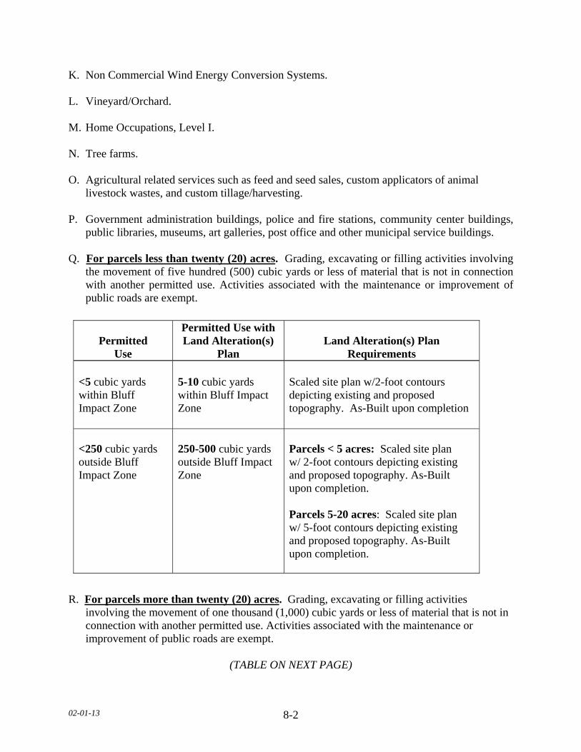
02-01-13 8-2
K. Non Commercial Wind Energy Conversion Systems. L. Vineyard/Orchard. M. Home Occupations, Level I. N. Tree farms. O. Agricultural related services such as feed and seed sales, custom applicators of animal
livestock wastes, and custom tillage/harvesting. P. Government administration buildings, police and fire stations, community center buildings,
public libraries, museums, art galleries, post office and other municipal service buildings. Q. For parcels less than twenty (20) acres. Grading, excavating or filling activities involving
the movement of five hundred (500) cubic yards or less of material that is not in connection with another permitted use. Activities associated with the maintenance or improvement of public roads are exempt.
R. For parcels more than twenty (20) acres. Grading, excavating or filling activities
involving the movement of one thousand (1,000) cubic yards or less of material that is not in connection with another permitted use. Activities associated with the maintenance or improvement of public roads are exempt.
(TABLE ON NEXT PAGE)
Permitted Use
Permitted Use with Land Alteration(s)
Plan Land Alteration(s) Plan
Requirements <5 cubic yards within Bluff Impact Zone <250 cubic yards outside Bluff Impact Zone
5-10 cubic yards within Bluff Impact Zone 250-500 cubic yards outside Bluff Impact Zone
Scaled site plan w/2-foot contours depicting existing and proposed topography. As-Built upon completion Parcels < 5 acres: Scaled site plan w/ 2-foot contours depicting existing and proposed topography. As-Built upon completion. Parcels 5-20 acres: Scaled site plan w/ 5-foot contours depicting existing and proposed topography. As-Built upon completion.

02-01-13 8-3
SUBDIVISION 3. CONDITIONAL USES The following uses may be allowed in the Agriculture (A) District as Conditional Uses. A. All feedlots three hundred and one to three thousand (301 to 3,000) animal units. B. A new feedlot or expansion of an existing feedlot within one (1) mile of a city boundary. C. Agriculture and Industrial machinery sales and service. D. Fertilizer and chemical sales. E. Value Added Agriculture. F. Commercial grain storage facilities. G. One (1) temporary dwelling per lot that will be occupied for more than one (1) year. H. Riding academies and stables. I. Organized group camps. J. Water supply tanks or buildings, reservoirs, commercial wells, gas regulator stations, electric
substations or transmission lines greater n 35kV, railroad right-of-way, but not including railroad yards, public sewage treatment facilities and other similar essential public utility and service structures.
K. Mineral extraction. L. Home occupations, Level II.
Permitted Use
Permitted Use with Land Alteration(s)
Plan Land Alteration(s) Plan
Requirements < 5 cubic yards within Bluff Impact Zone <500 cubic yards outside Bluff Impact Zone
5-10 cubic yards within Bluff Impact Zone 500-1000 cubic yards outside Bluff Impact Zone
Scaled site plan w/2-foot contours depicting existing and proposed topography. As-Built upon completion Scaled site plan w/10-foot contours depicting existing and proposed topography. As-Built upon completion.
02-01-13 8-4
M. Public or private schools, churches, cemeteries and memorial gardens. N. Antique sales, service and restoration. O. Retail nursery and garden supplies and greenhouses. P. Animal hospitals, veterinary clinics, animal crematoriums and related facilities for the care
and breeding of animals including kennels. Q. Campgrounds. R. Bed and Breakfast Inns. S. Wireless telecommunication towers. T. Contractors and Construction Companies along with Shops and Yards. U. Commercial Orchards. V. Winery. W. Indoor/Outdoor Commercial Recreational Areas. X. Self Service Storage. Y. Commercial Wind Energy Conversion System. Z. Commercial Grain Elevators.
AA. Transfer of Development Rights. BB. Special Events.
CC. Forest Land Conversion. DD. Grading, excavating or filling within the bluff. EE. Parcels less than twenty (20) acres. Grading, excavating or filling activities involving the
movement of more than five hundred (500) cubic yards of material that is not in connection with another permitted use. Activities associated with the maintenance or improvement of public roads are exempt.
(TABLE ON NEXT PAGE)
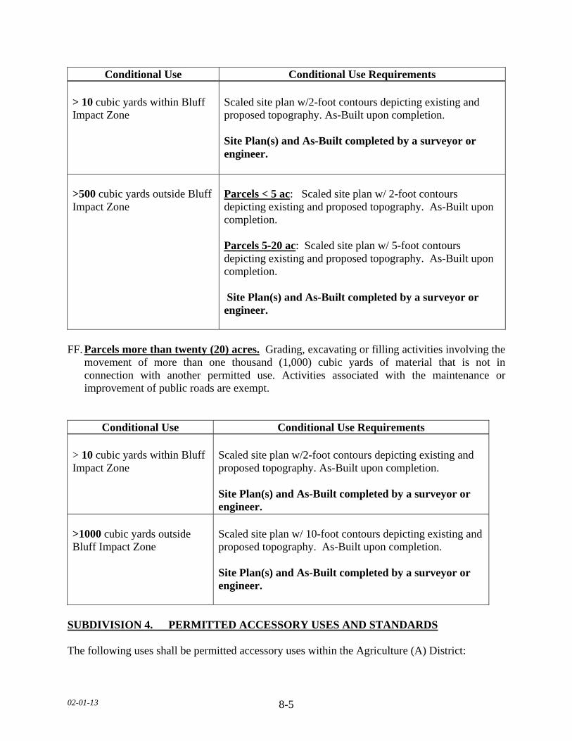
02-01-13 8-5
Conditional Use Conditional Use Requirements > 10 cubic yards within Bluff Impact Zone >500 cubic yards outside Bluff Impact Zone
Scaled site plan w/2-foot contours depicting existing and proposed topography. As-Built upon completion. Site Plan(s) and As-Built completed by a surveyor or engineer. Parcels < 5 ac: Scaled site plan w/ 2-foot contours depicting existing and proposed topography. As-Built upon completion. Parcels 5-20 ac: Scaled site plan w/ 5-foot contours depicting existing and proposed topography. As-Built upon completion. Site Plan(s) and As-Built completed by a surveyor or engineer.
FF. Parcels more than twenty (20) acres. Grading, excavating or filling activities involving the
movement of more than one thousand (1,000) cubic yards of material that is not in connection with another permitted use. Activities associated with the maintenance or improvement of public roads are exempt.
Conditional Use Conditional Use Requirements > 10 cubic yards within Bluff Impact Zone >1000 cubic yards outside Bluff Impact Zone
Scaled site plan w/2-foot contours depicting existing and proposed topography. As-Built upon completion. Site Plan(s) and As-Built completed by a surveyor or engineer. Scaled site plan w/ 10-foot contours depicting existing and proposed topography. As-Built upon completion. Site Plan(s) and As-Built completed by a surveyor or engineer.
SUBDIVISION 4. PERMITTED ACCESSORY USES AND STANDARDS The following uses shall be permitted accessory uses within the Agriculture (A) District:

02-01-13 8-6
A. Having no more than two (2) boarders or roomers by a resident family. B. Light aircraft, unpaved landing fields used solely by the property owner.
C. ACCESSORY STRUCTURES 1. Accessory structures in the Agriculture (A) District that have lot sizes less than five (5)
acres shall conform to the following structure areas and maximum structure heights.
2. Outside wall dimensions shall be used to determine maximum structure area, except
where a roof projects out further than two (2) feet from the sidewall; roof area shall be used to determine maximum structure area.
D. SWIMMING POOL. PERMANENT 1. No pool shall be located within ten (10) feet of a septic tank/drain field. 2. No pool shall be located beneath overhead electrical lines or over underground utility
lines of any type. 3. No pool shall be located within any private or public utility, walkway, drainage, or other
easement. 4. Lighting for the pool shall be oriented so as not to cast light onto adjacent properties. 5. A fence of at least five (5) feet in height shall completely enclose the pool area and the
access to the pool area shall be controlled. E. HEIGHT AND SEPARATION REGULATIONS
1. For parcels greater than five (5) acres, there shall be a maximum height limitation of one hundred and fifty (150) feet on all structures.. Any structure including but not limited to tower, spire and similar type structure, only after obtaining a letter of clearance from the Federal Aeronautics Administration and the Airport Commission for any airport located within ten (10) miles of the structure proposed to exceed the height limitation.
2. An accessory structure shall not be closer than five (5) feet to the principal structure. a. In case an accessory structure is attached to the principal structure, it shall be made
structurally a part of the principal structure and shall comply in all respects with the requirements of this Ordinance applicable to the principal structure.
Lot Size Maximum Structure Area Maximum Structure Height Less than 1 acre 2,000 square feet 20 feet 1-1.99 acres 3,600 square feet 20 feet 2-4.99 acres 4,000 square feet 25 feet
02-01-13 8-7
F. DRAINAGE Adequate drainage shall be provided and the drainage shall be directed away from adjacent private property. G. Other accessory uses customarily incidental to the uses permitted in Subdivision 2 and 3 of
this Section. SUBDIVISION 5. DIMENSIONAL REGULATIONS A. SETBACK EXEMPTIONS/STRUCTURE EXPANSIONS 1. Where proposed additions do not encroach further into the front, side, or rear yard than
the existing structure, such additions will be permitted provided the use and the structure are in conformance with the following restrictions:
a. The use of the structure is conforming to the zoning district in which it is located. b. The expansion of the structure shall not be located closer to the property line than the
existing structure or at least one-half (1/2) of the required setback, whichever is greater.
c. The expansion of the structure will not reduce any other required setback below the
minimum standards of this Ordinance. d. The expansion of the structure will conform to all other restrictions of this Ordinance,
including but not limited to, density, lot coverage, and structure height. e. The height of the expansion shall not be greater than the existing structure at the
existing building line. B. FRONT YARD SETBACKS 1. There shall be a front yard setback of not less than eighty five (85) feet from the right-of-
way of State-Federal trunk arterials, expressways and State collector arterials. 2. There shall be a front yard setback of not less than seventy five (75) feet from the right-
of-way of County Highways. 3. There shall be a front yard setback of not less than sixty five (65) feet from a township or
any other public or private right-of-way. 4. When a lot is located at the intersection of two (2) or more roads, there shall be a front
yard setback on each road right-of-way.

02-01-13 8-8
5. All components of an onsite Subsurface Sewage Treatment System (SSTS) shall be twenty (20) feet from all road right-of-ways.
6. All components of an onsite Subsurface Sewage Treatment System (SSTS) for a non-
conforming Lot of Record shall be ten (10) feet from all road right-of-ways. 7. The required front yard of a corner lot shall be unobstructed above a height of three (3)
feet in a triangular area, two (2) sides of which are the lines running parallel along the right of way lines between the road intersection and a point fifty (50) feet from the intersection, and the third site of which is the line between the latter two (2) points.
8. No trees or shrubs shall be planted within ten (10) feet from any right-of-way.
C. SIDE YARD SETBACKS 1. All structures shall have a side yard setback of not less than fifty (50) feet. 2. Accessory structures shall have a side yard setback of not less than fifteen (15) feet. D. REAR YARD SETBACKS 1. All structures shall have a rear yard setback of not less than fifty (50) feet. 2. Accessory structures shall have a rear yard setback of not less than fifteen (15) feet.
E. BLUFF SETBACKS 1. All structures shall be set back from the top and/or toe of the bluff: a. Thirty (30) feet for bluffs with slopes eighteen (18) to thirty (30) percent. b. Fifty (50) feet for bluffs with slopes greater than thirty (30) percent. c. Existing Building Sites. All structures shall be set back thirty (30) feet from the top
or toe of the bluff.
2. SSTS shall be set back thirty (30) feet from the top or toe of the bluff. a. SSTS upgrade and/or replacement for an existing dwelling:
1. Shall be exempt from bluff setback. 2. May be located within the bluff impact zone. 3. Shall not be located within the bluff.
3. If the adjacent bluff is actively eroding, the Department may increase the setback requirement.
02-01-13 8-9
4. Structures and accessory facilities, except stairways and landings, must not be placed within bluff impact zones.
F. WETLAND SETBACKS All structures shall be setback a minimum of seventy five (75) feet from the wetland boundary of any Type three (3) through eight (8) wetland. G. ADDITIONAL SETBACKS
1. When more than one (1) setback applies to a site, structures must be located to meet all setbacks.
2. All structures shall be setback fifty (50) feet from a cemetery.
H. FEEDLOT AND ANIMAL REQUIREMENTS 1. Effective June 10, 2010, all new animal feedlots shall be separated from a school, park,
golf course, licensed campground, or residential zoning district, and conversely, a new school, park, golf course, licensed campground, or residential zoning district shall be separated from an existing animal feedlot by the following:
a. 10-50 AU 500 feet b. 51-2000 AU 1000 feet c. Greater than 2000 AU 1500 feet 2. All new animal feedlots shall be separated from an existing dwelling and conversely, all
new dwellings shall be separated from an existing animal feedlot by the following: a. 10-50 AU 500 feet b. 51-2000 AU 1000 feet c. Greater than 2000 AU 1500 feet 3. The animal feedlot owner’s dwelling is exempt from these requirements.
4. Any new animal feedlot or expansion of an existing animal feedlot shall conform to the
lot requirement as follows:
a. Up to 100 AU 5 acres b. 101-2000 AU 10 acres c. 2001-3000 AU 15 acres
5. In the Agriculture (A) District, the following standards shall be applicable for allowable animal units:
(TABLE ON NEXT PAGE
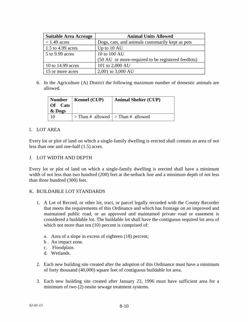
02-01-13 8-10
6. In the Agriculture (A) District the following maximum number of domestic animals are
allowed.
Number Of Cats & Dogs
Kennel (CUP) Animal Shelter (CUP)
10 > Than # allowed > Than # allowed
I. LOT AREA Every lot or plot of land on which a single-family dwelling is erected shall contain an area of not less than one and one-half (1.5) acres. J. LOT WIDTH AND DEPTH Every lot or plot of land on which a single-family dwelling is erected shall have a minimum width of not less than two hundred (200) feet at the setback line and a minimum depth of not less than three hundred (300) feet. K. BUILDABLE LOT STANDARDS 1. A Lot of Record, or other lot, tract, or parcel legally recorded with the County Recorder
that meets the requirements of this Ordinance and which has frontage on an improved and maintained public road, or an approved and maintained private road or easement is considered a buildable lot. The buildable lot shall have the contiguous required lot area of which not more than ten (10) percent is comprised of:
a. Area of a slope in excess of eighteen (18) percent; b . An impact zone. c. Floodplain. d. Wetlands. 2. Each new building site created after the adoption of this Ordinance must have a minimum
of forty thousand (40,000) square feet of contiguous buildable lot area. 3. Each new building site created after January 23, 1996 must have sufficient area for a
minimum of two (2) onsite sewage treatment systems.
Suitable Area Acreage Animal Units Allowed < 1.49 acres Dogs, cats, and animals customarily kept as pets 1.5 to 4.99 acres Up to 10 AU 5 to 9.99 acres 10 to 100 AU
(50 AU or more-required to be registered feedlots) 10 to 14.99 acres 101 to 2,000 AU 15 or more acres 2,001 to 3,000 AU

02-01-13 8-11
4. Lots of record that are substandard in area must conform to all other applicable regulations to qualify for placement of a dwelling.
SUBDIVISION 6. DWELLING STANDARDS A. PROHIBITED DWELLINGS No garage, tent, trailer, or accessory structure shall at any time be used as a dwelling. B. DWELLING REGULATIONS 1. No more than one (1) dwelling shall be placed on a lot except in the cases of temporary
dwellings. 2. All dwellings shall be on foundations or piles or other foundation systems extending
below the frost line, as approved by the Department. 3. The minimum dwelling width excluding porches, decks, or other similar attachments
shall be twenty (20) feet except in the cases of temporary dwellings. 4. All dwellings must conform with the sewage treatment regulations of this Ordinance. No
zoning permits will be issued for new dwellings prior to sewage treatment system approval.
5. Manufactured homes shall bear a State seal as verification of construction and inspection
to ANSI A119.1 standards during original construction (issued for manufactured homes built between July 1, 1972 to June 14, 1976) or, for manufactured homes built after that date, a Federal seal in accordance with HUD CFR 3280 Construction Standards.
6. All dwellings shall have a minimum of seven hundred sixty (760) square feet of floor
area on the ground floor.
7. Dwellings shall not exceed two and one-half (2 1/2) stories or thirty five (35) feet in height.
8. Outside wall dimensions shall be used to determine maximum structure area, except
where a roof projects out further than two (2) feet from the sidewall; roof area shall be used to determine maximum structure area.
SUBDIVISION 7. ACCESS DRIVES, ACCESS AND SERVICE ROADS A. Access drives onto any public roads shall require a review by the Road Authority. The Road
Authority shall determine the appropriate location, size, and design of such access drives along public roads and may limit the number of access drives in the interest of public safety and efficient traffic flow.
02-01-13 8-12
B. Access drives shall be constructed and maintained to meet all of the following: 1. A minimum driving surface width of fourteen (14) feet. 2. Inslope no greater than 4 to 1, as measured horizontal to vertical. 3. Base material depth sufficient to support access by emergency vehicles. 4. Unobstructed width of not less than twenty (20) feet. 5. Unobstructed vertical clearance of not less than thirteen (13) feet, six (6) inches. C. Access drives in excess of one hundred fifty (150) feet in length shall provide a minimum
turn-around of sixty (60) feet in width by sixty (60) feet in length. D. Access drives shall have a twenty (20) foot long flat grade directly adjacent to the road that
the drive accesses. E. All lots or parcels with dwellings shall have direct physical access of adequate size for
emergency vehicles along the frontage of the lot or parcel from either an existing or dedicated public roadway.
F. All roads serving more than two (2) lots or parcels with dwellings shall be built to township
road specifications or at least sixty six (66) feet wide with a minimum driving surface width of twenty four (24) feet.
G. Access drives shall not be located within the bluff impact zone. SUBDIVISION 8. GENERAL REGULATIONS. All land uses and development shall follow all other applicable regulations of this Ordinance.
02-01-13 9-1
SECTION 9. URBAN/RURAL RESIDENTIAL (R1) DISTRICT SUBDIVISION 1. PURPOSE The Urban/ Rural Residential (R1) District is established for areas that will allow residential development that will not be in conflict with agricultural uses, city growth, or destroy important natural resource areas. SUBDIVISION 2. PERMITTED USES The following uses shall be permitted within the Urban/Rural Residential (R1) District; A. One (1) single-family dwelling per existing building site, Lot of Record, platted lot or parcel. B. Home Occupations, Level I. C. Existing agricultural land uses. D. Grading, excavating or filling activities involving the movement of fifty (50) cubic
yards or less of material that is not in connection with another permitted use. Activities associated with the maintenance or improvement of public roads are exempt.
(TABLE ON NEXT PAGE)

02-01-13 9-2
SUBDIVISION 3. CONDITIONAL USES The following uses may be allowed in the Urban/Rural Residential (R1) District as Conditional Uses. A. Platted Residential Subdivisions subject to Le Sueur County Subdivision Regulations. B. Government administration buildings, police and fire stations, community center buildings,
public libraries, museums, art galleries, post office and other municipal service buildings. C. Any change in agricultural practice that constitutes an intensification of present agricultural
use. D. Water supply buildings, reservoirs, commercial wells, elevated tanks, gas regulator stations,
electrical substations, and similar essential service structures. E. Golf courses, and any structures normally associated with golf courses.
Permitted Use
Permitted Use with Land
Alteration(s) Plan
Land Alteration(s) Plan Requirements
< 5 cubic yards within Bluff Impact Zone <25 cubic yards outside Bluff Impact Zone
5-10 cubic yards within Bluff Impact Zone 25-50 cubic yards outside Bluff Impact Zone
Scaled site plan w/2-foot contours depicting existing and proposed topography. As-Built upon completion. Parcels < 5 acres: Scaled site plan w/ 2-foot contours depicting existing and proposed topography. As-Built upon completion. Parcels 5-20 acres: Scaled site plan w/ 5-foot contours depicting existing and proposed topography. As-Built upon completion. Parcels > 20 acres: Scaled site plan w/ 10-foot contours depicting existing and proposed topography. As-Built upon completion.
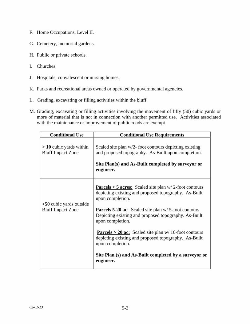
02-01-13 9-3
F. Home Occupations, Level II. G. Cemetery, memorial gardens. H. Public or private schools. I. Churches. J. Hospitals, convalescent or nursing homes. K. Parks and recreational areas owned or operated by governmental agencies. L. Grading, excavating or filling activities within the bluff. M. Grading, excavating or filling activities involving the movement of fifty (50) cubic yards or
more of material that is not in connection with another permitted use. Activities associated with the maintenance or improvement of public roads are exempt.
Conditional Use Conditional Use Requirements > 10 cubic yards within Bluff Impact Zone >50 cubic yards outside Bluff Impact Zone
Scaled site plan w/2- foot contours depicting existing and proposed topography. As-Built upon completion. Site Plan(s) and As-Built completed by surveyor or engineer. Parcels < 5 acres: Scaled site plan w/ 2-foot contours depicting existing and proposed topography. As-Built upon completion. Parcels 5-20 ac: Scaled site plan w/ 5-foot contours Depicting existing and proposed topography. As-Built upon completion. Parcels > 20 ac: Scaled site plan w/ 10-foot contours depicting existing and proposed topography. As-Built upon completion. Site Plan (s) and As-Built completed by a surveyor or engineer.

02-01-13 9-4
SUBDIVISION 4. PERMITTED ACCESSORY USES AND STANDARDS The following uses shall be permitted accessory uses within an Urban/Rural Residential (R1) District A. ACCESSORY STRUCTURES 1. In the Urban/Rural Residential (R1) District that have lot sizes less than five (5) acres
shall conform to the following structure areas and maximum structure heights.
Lot Size Maximum Structure Area Maximum Structure Height Less than 1 acre 2,000 square feet 20 feet 1-1.99 acres 3,600 square feet 20 feet 2-4.99 acres 4,000 square feet 25 feet
2. Outside wall dimensions shall be used to determine maximum structure area, except
where a roof projects out further than two (2) feet from the sidewall; roof area shall be used to determine maximum structure area.
3. No accessory structure or use shall be constructed or developed on a lot prior to
construction of the principal dwelling. B. SWIMMING POOL. PERMANENT 1. No pool shall be located within ten (10) feet of a septic tank/drain field. 2. No pool shall be located beneath overhead electrical lines or over underground utility
lines of any type. 3. No pool shall be located within any private or public utility, walkway, drainage, or other
easement. 4. Lighting for the pool shall be oriented so as not to cast light onto adjacent properties. 5. A fence of at least five (5) feet in height shall completely enclose the pool area and the
access to the pool area shall be controlled. C. HEIGHT AND SEPARATION REGULATIONS
1. For parcels greater than five (5) acres, there shall be a maximum height limitation of one
hundred and fifty (150) feet on all structures. Any structure including but not limited to tower, spire and similar type structure, only after obtaining a letter of clearance from the Federal Aeronautics Administration and the Airport Commission for any airport located within ten (10) miles of the structure proposed to exceed the height limitation.
02-01-13 9-5
2. An accessory structure shall not be closer than five (5) feet to the principal structure a. In case an accessory structure is attached to the principal structure, it shall be made
structurally a part of the principal structure and shall comply in all respects with the requirements of this Ordinance applicable to the principal structure.
D. DRAINAGE Adequate drainage shall be provided and the drainage shall be directed away from adjacent private property. E. Other accessory uses customarily incidental to the uses permitted in Subdivision 2 and 3 of
this Section. SUBDIVISION 5. DIMENSIONAL REGULATIONS. A. SETBACK EXEMPTIONS/STRUCTURE EXPANSIONS 1. Where proposed additions do not encroach further into the front, side, or rear yard than
the existing structure, such additions will be permitted provided the use and the structure are in conformance with the following restrictions:
a. The use of the structure is conforming to the zoning district in which it is located. b. The expansion of the structure shall not be located closer to the property line than the
existing structure or at least one-half (1/2) of the required setback, whichever is greater.
c. The expansion of the structure will not reduce any other required setback below the
minimum standards of this Ordinance. d. The expansion of the structure will conform to all other restrictions of this Ordinance,
including but not limited to, density, lot coverage and structure height. e. The height of the expansion shall not be greater than the existing structure at the
existing building line. f. The proposed addition is not located in shore or bluff impact zones. B. FRONT YARD SETBACKS 1. There shall be a front yard setback of not less than eighty five (85) feet from the right-of-
way of State-Federal trunk arterials, expressways and State collector arterials. 2. There shall be a front yard setback of not less than seventy five (75) feet from the right-
of-way of County Highways.
02-01-13 9-6
3. There shall be a front yard setback of not less than sixty five (65) feet from a township or
any other public or private right-of-way. 4. When a lot is located at the intersection of two (2) or more roads, there shall be a front
yard setback on each road right-of-way. 5. All components an onsite Subsurface Sewage Treatment System (SSTS) shall be twenty
(20) feet from all road right-of-ways. 6. All components an onsite Subsurface Sewage Treatment System (SSTS) for a non-
conforming Lot of Record shall be ten (10) feet from all road right-of-ways. 7. The required front yard of a corner lot shall be unobstructed above a height of three (3)
feet in a triangular area, two (2) sides of which are the lines running parallel along the right of way lines between the road intersection and a point fifty (50) feet from the intersection, and the third site of which is the line between the latter two (2) points.
8. No trees or shrubs shall be planted within ten (10) feet from any right-of-way.
9. A new dwelling constructed on a nonconforming Lot of Record may have a reduced front
yard setback with the following restrictions: a. There shall be an existing dwelling located on each side on the adjacent lots. b. The new dwelling shall not be located closer to the road right-of-way than the
existing dwellings located on the adjacent lots, or at least one-half of the required setback, whichever is greater.
c. The structure is not located in a bluff impact zone. 10. A new dwelling constructed on a nonconforming Lot of Record may have a reduced front
yard setback if the adjacent lot is vacant with the following restrictions: a. There shall be an existing dwelling located on one side of the lot. b. The setback for the Lot of Record shall be the setback of the dwelling on the
adjoining lot plus one half the difference between the setback of the non-conforming dwelling and the setback required by the Ordinance.
c. The structure is not located in a bluff impact zone. 11. All fencing shall have a front yard setback of not less than ten (10) feet from a road right-
of-way.

02-01-13 9-7
C. SIDE YARD SETBACKS
1. All structures shall have a side yard setback of not less than fifteen (15) feet. 2. Nonconforming Lots of Record shall be allowed a ten (10) foot side yard setback. D. REAR YARD SETBACKS 1. All dwellings there shall be a rear yard setback of not less than forty (40) feet. 2. All accessory structures there shall be a rear yard setback of not less than fifteen (15) feet. E. BLUFF SETBACKS 1. All structures shall be from the top and/or toe of the bluff:
a. Thirty (30) feet for bluffs with slopes eighteen (18) to thirty (30) percent. b. Fifty (50) feet for bluffs with slopes greater than thirty (30) percent, c. Existing Building Sites. All structures shall be set back thirty (30) feet from the top
or toe of the bluff.
2. SSTS shall be set back thirty (30) feet from the top or toe of the bluff. a. SSTS upgrade and/or replacement for an existing dwelling:
1. Shall be exempt from bluff setback. 2. May be located within the bluff impact zone. 3. Shall not be located within the bluff.
3. If the adjacent bluff is actively eroding, the Department may increase the setback
requirement. 4. Structures and accessory facilities, except stairways and landings, must not be placed
within bluff impact zones. 5. Fencing shall not be placed within the bluff. F. WETLAND SETBACKS All structures shall be setback a minimum of seventy five (75) feet from the wetland boundary of any Type three (3) through eight (8) wetland. G. ADDITIONAL SETBACKS
1. When more than one (1) setback applies to a site, structures must be located to meet all setbacks.
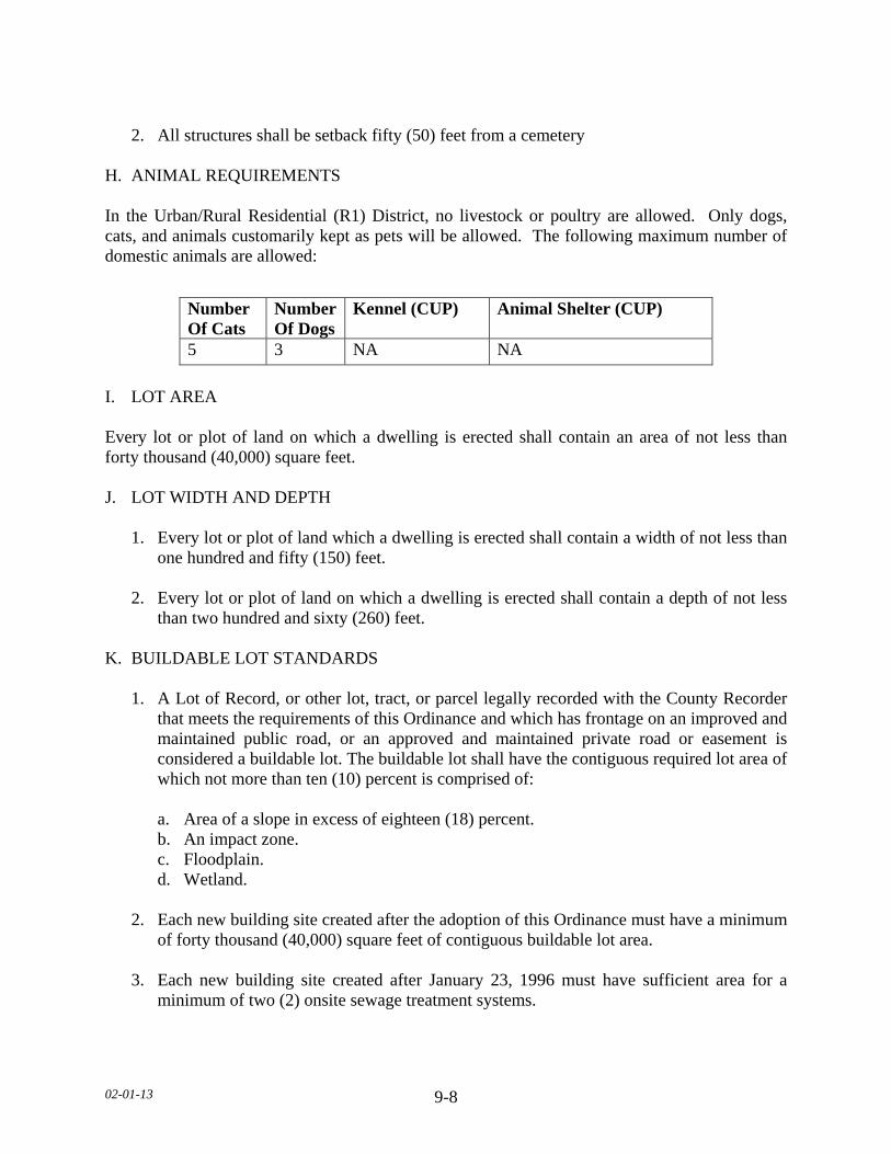
02-01-13 9-8
2. All structures shall be setback fifty (50) feet from a cemetery H. ANIMAL REQUIREMENTS In the Urban/Rural Residential (R1) District, no livestock or poultry are allowed. Only dogs, cats, and animals customarily kept as pets will be allowed. The following maximum number of domestic animals are allowed:
I. LOT AREA Every lot or plot of land on which a dwelling is erected shall contain an area of not less than forty thousand (40,000) square feet. J. LOT WIDTH AND DEPTH 1. Every lot or plot of land which a dwelling is erected shall contain a width of not less than
one hundred and fifty (150) feet.
2. Every lot or plot of land on which a dwelling is erected shall contain a depth of not less than two hundred and sixty (260) feet.
K. BUILDABLE LOT STANDARDS 1. A Lot of Record, or other lot, tract, or parcel legally recorded with the County Recorder
that meets the requirements of this Ordinance and which has frontage on an improved and maintained public road, or an approved and maintained private road or easement is considered a buildable lot. The buildable lot shall have the contiguous required lot area of which not more than ten (10) percent is comprised of:
a. Area of a slope in excess of eighteen (18) percent. b. An impact zone. c. Floodplain. d. Wetland. 2. Each new building site created after the adoption of this Ordinance must have a minimum
of forty thousand (40,000) square feet of contiguous buildable lot area. 3. Each new building site created after January 23, 1996 must have sufficient area for a
minimum of two (2) onsite sewage treatment systems.
Number Of Cats
Number Of Dogs
Kennel (CUP) Animal Shelter (CUP)
5 3 NA NA

02-01-13 9-9
4. Lots of Record that are substandard in area must conform to all other applicable regulations to qualify for placement of a dwelling.
SUBDIVISION 6. DWELLING STANDARDS A. PROHIBITED DWELLINGS No garage, tent, trailer, or accessory structure shall at any time be used as a dwelling. B. DWELLING REGULATIONS 1. No more than one (1) dwelling shall be placed on a lot except in the cases of temporary
dwellings. 2. All dwellings shall be on foundations or piles or other foundation systems extending
below the frost line, as approved by the Department. 3. The minimum dwelling width excluding porches, decks, or other similar attachments
shall be twenty (20) feet except in the cases of temporary dwellings. 4. All dwellings must conform with the sewage treatment regulations of this Ordinance. No
zoning permits will be issued for new dwellings prior to sewage treatment system approval.
5. Manufactured homes shall bear a State seal as verification of construction and inspection
to ANSI A119.1 standards during original construction (issued for manufactured homes built between July 1, 1972 to June 14, 1976) or, for manufactured homes built after that date, a Federal seal in accordance with HUD CFR 3280 Construction Standards.
6. All dwellings shall have a minimum of seven hundred sixty (760) square feet of floor
area on the ground floor.
7. Dwellings shall not exceed two and one-half (2 1/2) stories or thirty five (35) feet in height.
8. Outside wall dimensions shall be used to determine maximum structure area, except
where a roof projects out further than two (2) feet from the sidewall; roof area shall be used to determine maximum structure area.
SUBDIVISION 7. ACCESS DRIVES, ACCESS AND SERVICE ROADS A. Access drives onto any public roads shall require a review by the Road Authority. The Road
Authority shall determine the appropriate location, size, and design of such access drives along public roads and may limit the number of access drives in the interest of public safety and efficient traffic flow.
02-01-13 9-10
B. Access drives shall be constructed and maintained to meet all of the following: 1. A minimum driving surface width of fourteen (14) feet. 2. Inslope no greater than 4 to 1, as measured horizontal to vertical. 3. Base material depth sufficient to support access by emergency vehicles. 4. Unobstructed width of not less than twenty (20) feet. 5. Unobstructed vertical clearance of not less than thirteen (13) feet, six (6) inches. C. Access drives in excess of one hundred fifty (150) feet in length shall provide a minimum
turn-around of sixty (60) feet in width by sixty (60) feet in length. D. Access drives shall have a twenty (20) foot long flat grade directly adjacent to the road that
the drive accesses. E. All lots or parcels with dwellings shall have direct physical access of adequate size for
emergency vehicles along the frontage of the lot or parcel from either an existing or dedicated public roadway.
F. All roads serving more than two (2) lots or parcels with dwellings shall be built to township
road specifications or at least sixty six (66) feet wide with a minimum driving surface width of twenty four (24) feet.
G. Access drives shall not be located within the bluff impact zone. SUBDIVISION 8. GENERAL REGULATIONS A. STORAGE OF MATERIALS 1. All materials and equipment shall be either stored within a structure or be fully screened
so as not to be visible from adjoining properties, except for the following: a. Recreational equipment. b. Laundry drying equipment. c. Off-street parking of licensed passenger vehicles and pickup trucks.
d. Boats and unoccupied travel trailers, less than twenty (20) feet in length, are permissible if stored in the rear yard more than ten (10) feet from the property line.
2. No underground gasoline storage shall be permitted.
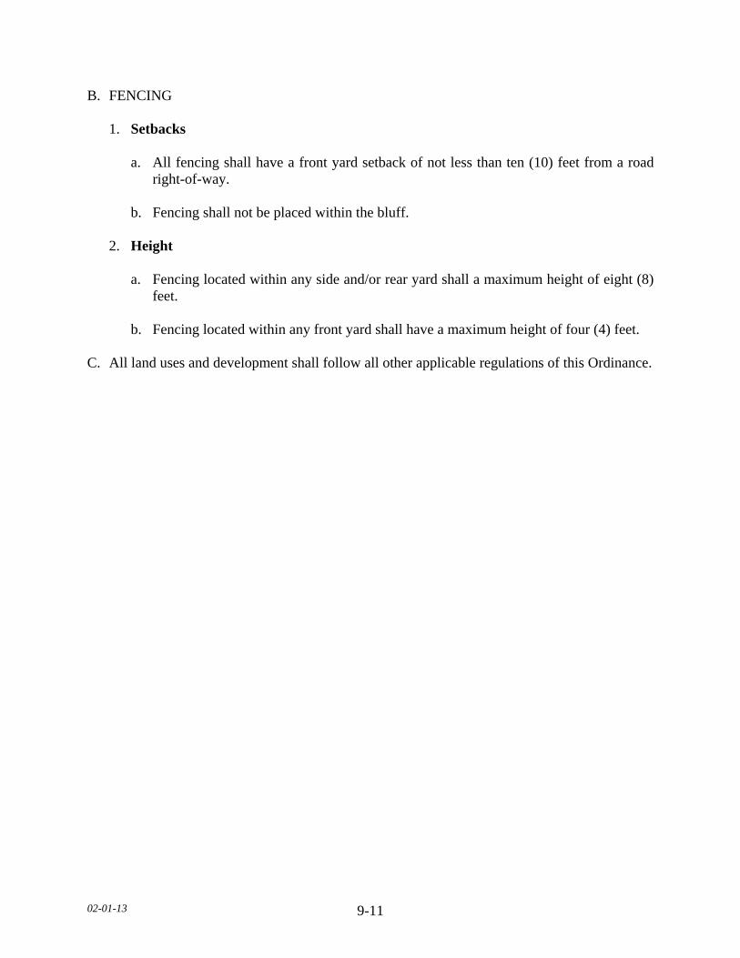
02-01-13 9-11
B. FENCING 1. Setbacks a. All fencing shall have a front yard setback of not less than ten (10) feet from a road
right-of-way. b. Fencing shall not be placed within the bluff. 2. Height a. Fencing located within any side and/or rear yard shall a maximum height of eight (8)
feet. b. Fencing located within any front yard shall have a maximum height of four (4) feet. C. All land uses and development shall follow all other applicable regulations of this Ordinance.
02-01-13 10-1
SECTION 10. GENERAL BUSINESS (B) DISTRICT SUBDIVISION 1. PURPOSE The General Business (B) District is established for areas that allows for a wide range of services and goods in compact and convenient limited highway-oriented businesses which are close to existing urban areas or major transportation routes. Such business developments are to be developed at standards that will not impair the traffic carrying capabilities of abutting roads and highways. SUBDIVISION 2. PERMITTED USES The following uses shall be permitted within the General Business (B) District. A. Agriculture. B. Bowling alleys. C. Drive-in restaurants, drive-in theaters or similar uses that provide goods and services to
patrons in automobiles. D. Florist shops, greenhouses and nurseries. E. Motel and Hotels. F. Professional, governmental offices and buildings. G. Restaurants. H. Retail sales and service. I. Wireless Telecommunications Service Antenna when located on existing towers. J. Antique sales, service and restoration. K. Seasonal produce stand. L. Sporting goods establishments, outfitters and bait shops. M. Building materials and sales. N. Self-Service Storage Facilities. O. Public Utility and Service Structures.
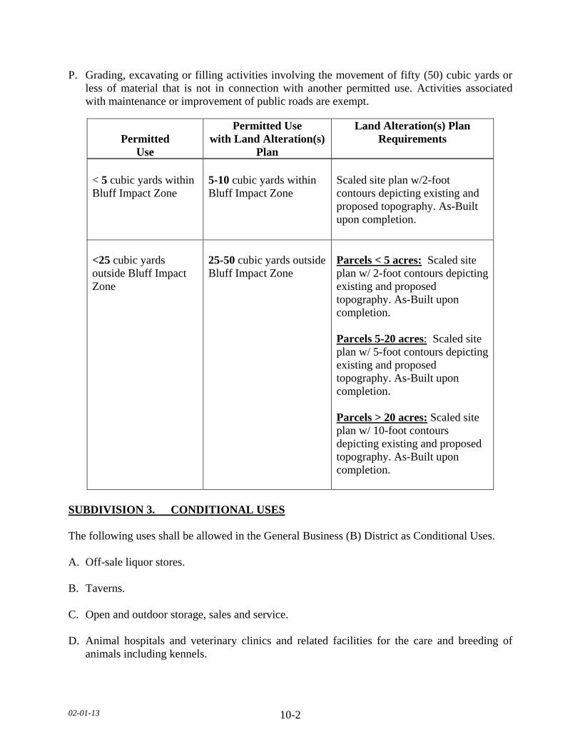
02-01-13 10-2
P. Grading, excavating or filling activities involving the movement of fifty (50) cubic yards or less of material that is not in connection with another permitted use. Activities associated with maintenance or improvement of public roads are exempt.
SUBDIVISION 3. CONDITIONAL USES The following uses shall be allowed in the General Business (B) District as Conditional Uses. A. Off-sale liquor stores. B. Taverns. C. Open and outdoor storage, sales and service. D. Animal hospitals and veterinary clinics and related facilities for the care and breeding of
animals including kennels.
Permitted Use
Permitted Use with Land Alteration(s)
Plan
Land Alteration(s) Plan Requirements
< 5 cubic yards within Bluff Impact Zone <25 cubic yards outside Bluff Impact Zone
5-10 cubic yards within Bluff Impact Zone 25-50 cubic yards outside Bluff Impact Zone
Scaled site plan w/2-foot contours depicting existing and proposed topography. As-Built upon completion. Parcels < 5 acres: Scaled site plan w/ 2-foot contours depicting existing and proposed topography. As-Built upon completion. Parcels 5-20 acres: Scaled site plan w/ 5-foot contours depicting existing and proposed topography. As-Built upon completion. Parcels > 20 acres: Scaled site plan w/ 10-foot contours depicting existing and proposed topography. As-Built upon completion.

02-01-13 10-3
E. Agriculture and Industrial machinery sales and service. F. Auditoriums. G. Automobile Sales, Service Stations and Repair. H. Medical Clinics and Hospitals. I. Car Washes. J. Commercial Orchards. K. Contractors and Construction Companies along with Shops and Yards. L. One (1) Temporary Dwelling for watchmen, supervisors, and their families, located on the
premises where they are employed in such capacity provided the dwelling is under the same ownership as the principal use.
M. Mineral Extraction. N. Winery. O. Indoor/Outdoor Commercial Recreational Area. P. Adult Uses. Q. Special Events. R. Non-Commercial Wind Energy Conservation Systems.
S. Platted Business Subdivisions.
T. Other business activities similar to those listed under the permitted uses in this Section and
deemed suitable by the Department or appeals process and subject to all conditions imposed thereon.
U. Off Premises Signs/Billboards. V. Illuminated Signs. W. Grading, excavating or filling activities within the bluff. X. Grading, excavating or filling activities involving the movement of more than (50) fifty cubic
yards of material that is not in connection with another permitted use. Activities associated with maintenance or improvement of public roads are exempt.
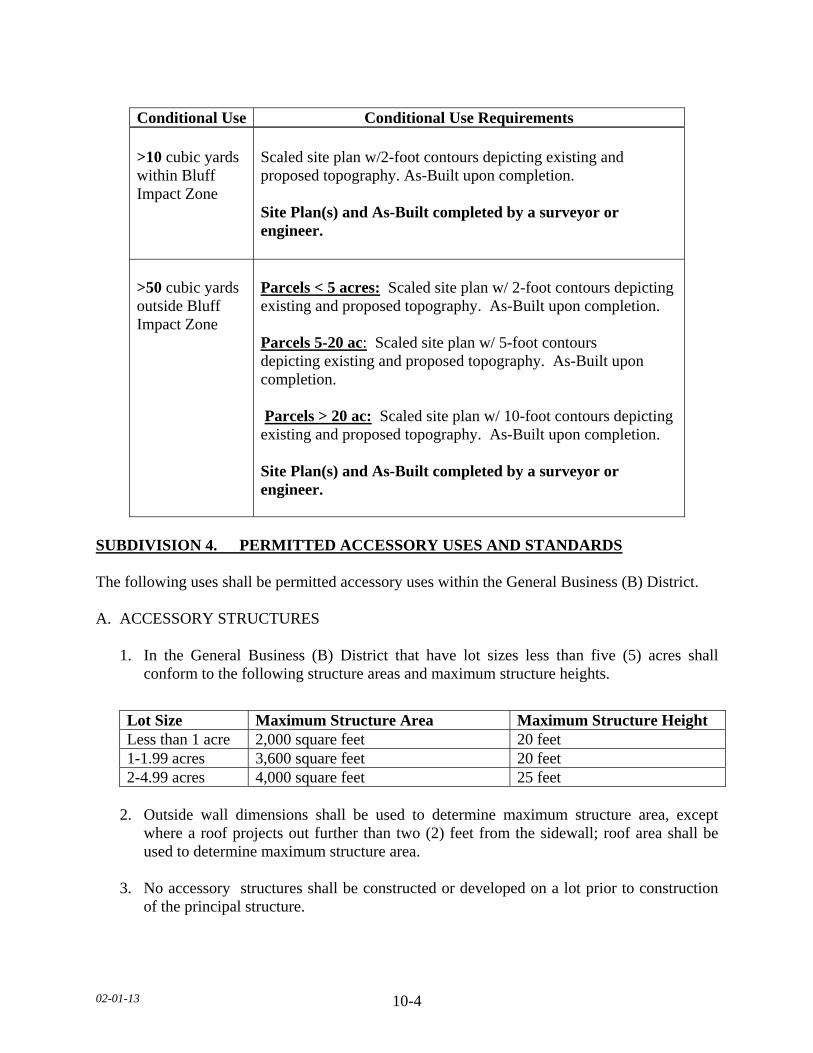
02-01-13 10-4
SUBDIVISION 4. PERMITTED ACCESSORY USES AND STANDARDS The following uses shall be permitted accessory uses within the General Business (B) District. A. ACCESSORY STRUCTURES 1. In the General Business (B) District that have lot sizes less than five (5) acres shall
conform to the following structure areas and maximum structure heights.
2. Outside wall dimensions shall be used to determine maximum structure area, except
where a roof projects out further than two (2) feet from the sidewall; roof area shall be used to determine maximum structure area.
3. No accessory structures shall be constructed or developed on a lot prior to construction
of the principal structure.
Conditional Use Conditional Use Requirements >10 cubic yards within Bluff Impact Zone >50 cubic yards outside Bluff Impact Zone
Scaled site plan w/2-foot contours depicting existing and proposed topography. As-Built upon completion. Site Plan(s) and As-Built completed by a surveyor or engineer. Parcels < 5 acres: Scaled site plan w/ 2-foot contours depicting existing and proposed topography. As-Built upon completion. Parcels 5-20 ac: Scaled site plan w/ 5-foot contours depicting existing and proposed topography. As-Built upon completion. Parcels > 20 ac: Scaled site plan w/ 10-foot contours depicting existing and proposed topography. As-Built upon completion. Site Plan(s) and As-Built completed by a surveyor or engineer.
Lot Size Maximum Structure Area Maximum Structure Height Less than 1 acre 2,000 square feet 20 feet 1-1.99 acres 3,600 square feet 20 feet 2-4.99 acres 4,000 square feet 25 feet

02-01-13 10-5
4. Commercial or business structures for use accessory to the principal use but not
exceeding thirty (30) percent of the floor space of the principal use and meeting all other setback and parking requirements of this section.
B. SEPARATION REGULATIONS
1. In case an accessory structure is attached to the principal structure, it shall be made
structurally a part of the principal structure and shall comply in all respects with the requirements of this Ordinance applicable to the principal structure.
2. An accessory structure shall not be closer than five (5) feet to the principal structure. a. In case an accessory structure is attached to the principal structure, it shall be made
structurally a part of the principal structure and shall comply in all respects with the requirements of this Ordinance applicable to the principal structure.
C. SWIMMING POOL. PERMANENT 1. No pool shall be located within ten (10) feet of a septic tank/drain field. 2. No pool shall be located beneath overhead electrical lines or over underground utility
lines of any type. 3. No pool shall be located within any private or public utility, walkway, drainage, or other
easement. 4. Lighting for the pool shall be oriented so as not to cast light onto adjacent properties. 5. A fence of at least five (5) feet in height shall completely enclose the pool area and the
access to the pool area shall be controlled. D. DRAINAGE Adequate drainage shall be provided and the drainage shall be directed away from adjacent private property. E. PARKING Off-street parking and loading. F. LANDSCAPING AND SCREENING
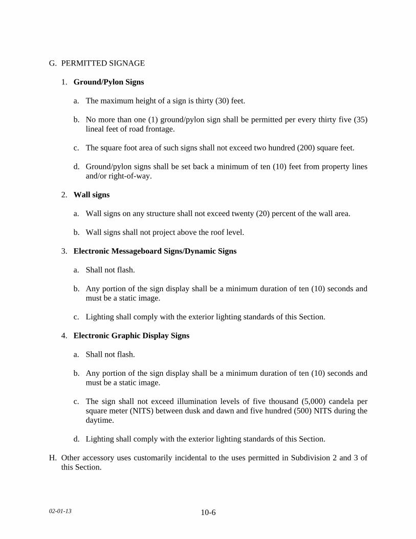
02-01-13 10-6
G. PERMITTED SIGNAGE 1. Ground/Pylon Signs a. The maximum height of a sign is thirty (30) feet. b. No more than one (1) ground/pylon sign shall be permitted per every thirty five (35)
lineal feet of road frontage. c. The square foot area of such signs shall not exceed two hundred (200) square feet. d. Ground/pylon signs shall be set back a minimum of ten (10) feet from property lines
and/or right-of-way. 2. Wall signs a. Wall signs on any structure shall not exceed twenty (20) percent of the wall area.
b. Wall signs shall not project above the roof level. 3. Electronic Messageboard Signs/Dynamic Signs a. Shall not flash. b. Any portion of the sign display shall be a minimum duration of ten (10) seconds and
must be a static image. c. Lighting shall comply with the exterior lighting standards of this Section. 4. Electronic Graphic Display Signs a. Shall not flash. b. Any portion of the sign display shall be a minimum duration of ten (10) seconds and
must be a static image. c. The sign shall not exceed illumination levels of five thousand (5,000) candela per
square meter (NITS) between dusk and dawn and five hundred (500) NITS during the daytime.
d. Lighting shall comply with the exterior lighting standards of this Section. H. Other accessory uses customarily incidental to the uses permitted in Subdivision 2 and 3 of
this Section.
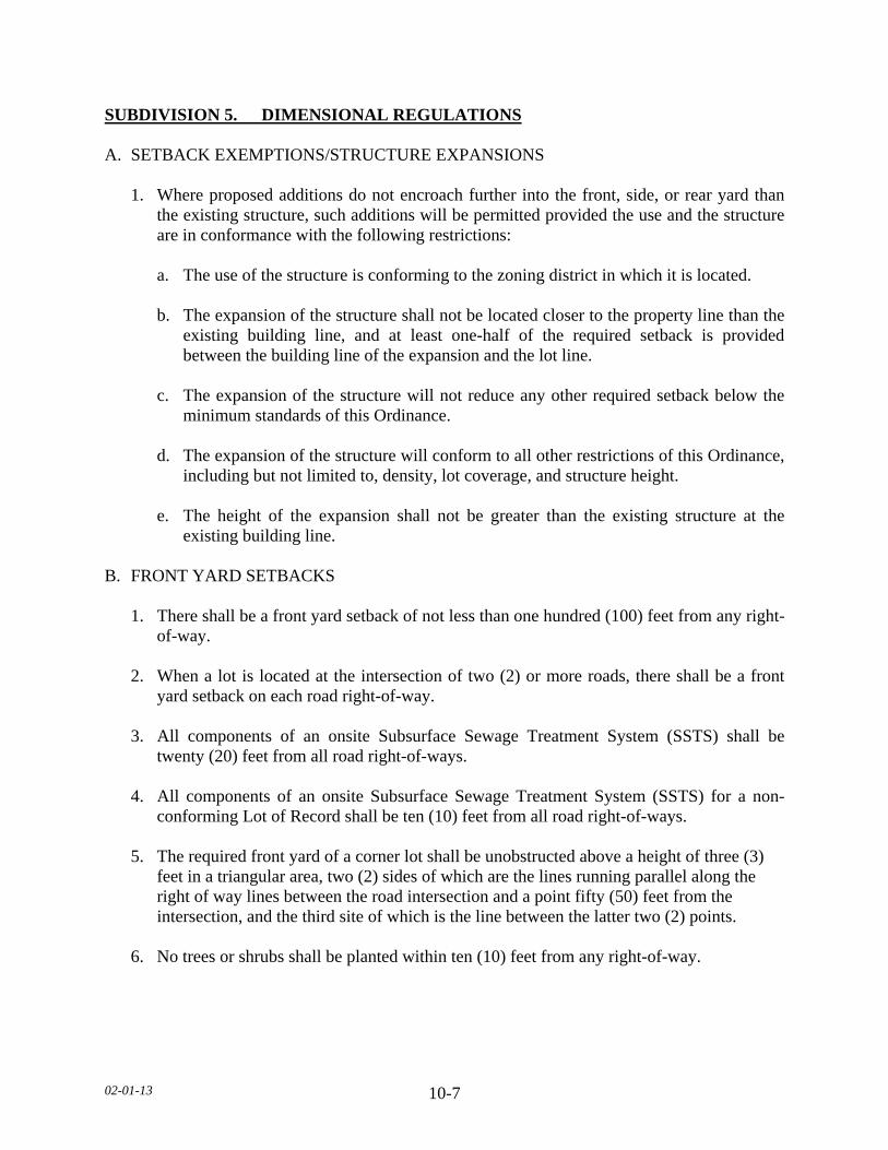
02-01-13 10-7
SUBDIVISION 5. DIMENSIONAL REGULATIONS A. SETBACK EXEMPTIONS/STRUCTURE EXPANSIONS 1. Where proposed additions do not encroach further into the front, side, or rear yard than
the existing structure, such additions will be permitted provided the use and the structure are in conformance with the following restrictions:
a. The use of the structure is conforming to the zoning district in which it is located. b. The expansion of the structure shall not be located closer to the property line than the
existing building line, and at least one-half of the required setback is provided between the building line of the expansion and the lot line.
c. The expansion of the structure will not reduce any other required setback below the
minimum standards of this Ordinance. d. The expansion of the structure will conform to all other restrictions of this Ordinance,
including but not limited to, density, lot coverage, and structure height. e. The height of the expansion shall not be greater than the existing structure at the
existing building line. B. FRONT YARD SETBACKS 1. There shall be a front yard setback of not less than one hundred (100) feet from any right-
of-way. 2. When a lot is located at the intersection of two (2) or more roads, there shall be a front
yard setback on each road right-of-way. 3. All components of an onsite Subsurface Sewage Treatment System (SSTS) shall be
twenty (20) feet from all road right-of-ways. 4. All components of an onsite Subsurface Sewage Treatment System (SSTS) for a non-
conforming Lot of Record shall be ten (10) feet from all road right-of-ways. 5. The required front yard of a corner lot shall be unobstructed above a height of three (3)
feet in a triangular area, two (2) sides of which are the lines running parallel along the right of way lines between the road intersection and a point fifty (50) feet from the intersection, and the third site of which is the line between the latter two (2) points.
6. No trees or shrubs shall be planted within ten (10) feet from any right-of-way.
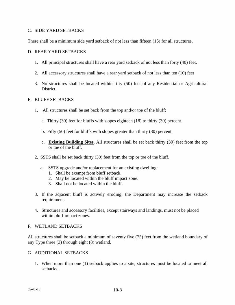
02-01-13 10-8
C. SIDE YARD SETBACKS There shall be a minimum side yard setback of not less than fifteen (15) for all structures. D. REAR YARD SETBACKS 1. All principal structures shall have a rear yard setback of not less than forty (40) feet. 2. All accessory structures shall have a rear yard setback of not less than ten (10) feet 3. No structures shall be located within fifty (50) feet of any Residential or Agricultural
District. E. BLUFF SETBACKS 1. All structures shall be set back from the top and/or toe of the bluff:
a. Thirty (30) feet for bluffs with slopes eighteen (18) to thirty (30) percent. b. Fifty (50) feet for bluffs with slopes greater than thirty (30) percent,
c. Existing Building Sites. All structures shall be set back thirty (30) feet from the top or toe of the bluff.
2. SSTS shall be set back thirty (30) feet from the top or toe of the bluff. a. SSTS upgrade and/or replacement for an existing dwelling:
1. Shall be exempt from bluff setback. 2. May be located within the bluff impact zone. 3. Shall not be located within the bluff.
3. If the adjacent bluff is actively eroding, the Department may increase the setback requirement.
4. Structures and accessory facilities, except stairways and landings, must not be placed
within bluff impact zones. F. WETLAND SETBACKS All structures shall be setback a minimum of seventy five (75) feet from the wetland boundary of any Type three (3) through eight (8) wetland. G. ADDITIONAL SETBACKS
1. When more than one (1) setback applies to a site, structures must be located to meet all setbacks.
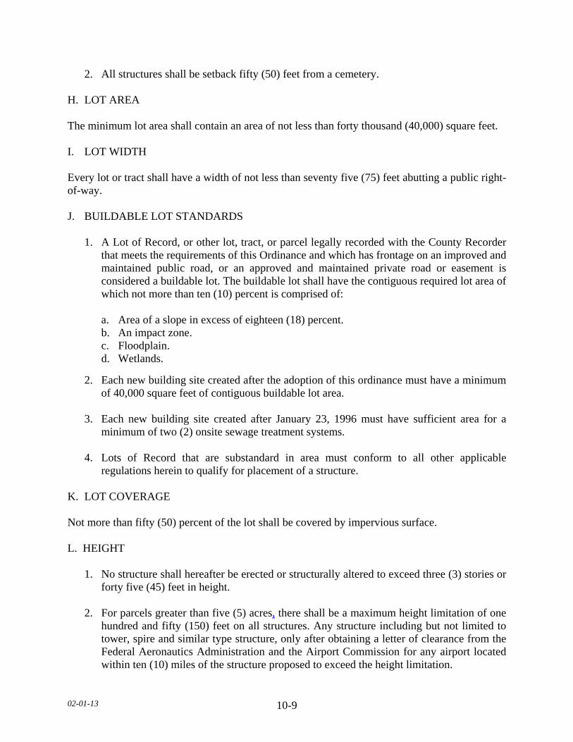
02-01-13 10-9
2. All structures shall be setback fifty (50) feet from a cemetery. H. LOT AREA The minimum lot area shall contain an area of not less than forty thousand (40,000) square feet. I. LOT WIDTH Every lot or tract shall have a width of not less than seventy five (75) feet abutting a public right-of-way. J. BUILDABLE LOT STANDARDS 1. A Lot of Record, or other lot, tract, or parcel legally recorded with the County Recorder
that meets the requirements of this Ordinance and which has frontage on an improved and maintained public road, or an approved and maintained private road or easement is considered a buildable lot. The buildable lot shall have the contiguous required lot area of which not more than ten (10) percent is comprised of:
a. Area of a slope in excess of eighteen (18) percent. b. An impact zone. c. Floodplain. d. Wetlands.
2. Each new building site created after the adoption of this ordinance must have a minimum of 40,000 square feet of contiguous buildable lot area.
3. Each new building site created after January 23, 1996 must have sufficient area for a
minimum of two (2) onsite sewage treatment systems. 4. Lots of Record that are substandard in area must conform to all other applicable
regulations herein to qualify for placement of a structure. K. LOT COVERAGE Not more than fifty (50) percent of the lot shall be covered by impervious surface. L. HEIGHT
1. No structure shall hereafter be erected or structurally altered to exceed three (3) stories or
forty five (45) feet in height. 2. For parcels greater than five (5) acres, there shall be a maximum height limitation of one
hundred and fifty (150) feet on all structures. Any structure including but not limited to tower, spire and similar type structure, only after obtaining a letter of clearance from the Federal Aeronautics Administration and the Airport Commission for any airport located within ten (10) miles of the structure proposed to exceed the height limitation.
02-01-13 10-10
M. STRUCTURE AREA
Outside wall dimensions shall be used to determine maximum structure area, except where a roof projects out further than two (2) feet from the sidewall; roof area shall be used to determine maximum structure area.
SUBDIVISION 6. ACCESS DRIVES, ACCESS AND SERVICE ROADS A. Access drives onto any public roads shall require a review by the Road Authority. The Road
Authority shall determine the appropriate location, size, and design of such access drives along public roads and may limit the number of access drives in the interest of public safety and efficient traffic flow.
B. Access drives shall be constructed and maintained to meet all of the following: 1. A minimum driving surface width of fourteen (14) feet. 2. Inslope no greater than 4 to 1, as measured horizontal to vertical. 3. Base material depth sufficient to support access by emergency vehicles. 4. Unobstructed width of not less twenty (20) feet. 5. Unobstructed vertical clearance of not less than thirteen (13) feet, six (6) inches. C. Access drives in excess of one hundred fifty (150) feet in length shall provide a minimum
turn-around of sixty (60) feet in width by sixty (60) feet in length. D. Access drives shall have a twenty (20) foot long flat grade directly adjacent to the road that
the drive accesses. E. All lots or parcels with dwellings shall have direct physical access of adequate size for
emergency vehicles along the frontage of the lot or parcel from either an existing or dedicated public roadway.
F. A service road shall be constructed when two (2) or more General Business (B) properties
are contiguous and when required by the Road Authority. G. Access drives shall not be located within the bluff impact zone. SUBDIVISION 7. GENERAL REGULATIONS A. All land uses and development shall follow all other applicable regulations of this Ordinance.

02-01-13 11-1
SECTION 11. GENERAL INDUSTRY (I) DISTRICT SUBDIVISION 1. PURPOSE The General Industry (I) District is established for areas that allows for a wide range of compact, warehousing and industrial uses closely related to existing urban areas or major transportation routes. Such industrial uses are to be governed by standards that will not impair the traffic carrying capabilities of abutting roads and highways. SUBDIVISION 2. PERMITTED USES The following uses shall be permitted in the General Industry (I) District. A. Building material and sales. B. Cartage and express facilities. C. Contractor, architect, and engineers' offices, shops and yards, such as building, cement,
electrical, heating, ventilating and air conditioning, masonry, painting, plumbing, refrigeration and roofing.
D. Agriculture and Industrial machinery sales and service. E. Grain Elevators. F. Public utility and service structures. G. Wireless Telecommunication Towers. H. Automobile Sales, Service Stations and Repair. I. Warehousing of bulk goods or goods produced on the premises. J. Agriculture. K. Agricultural related services such as feed and seed sales, custom applicators of animal
livestock wastes, and custom tillage/harvesting. L. Car Washes. M. Commercial grain storage facilities.
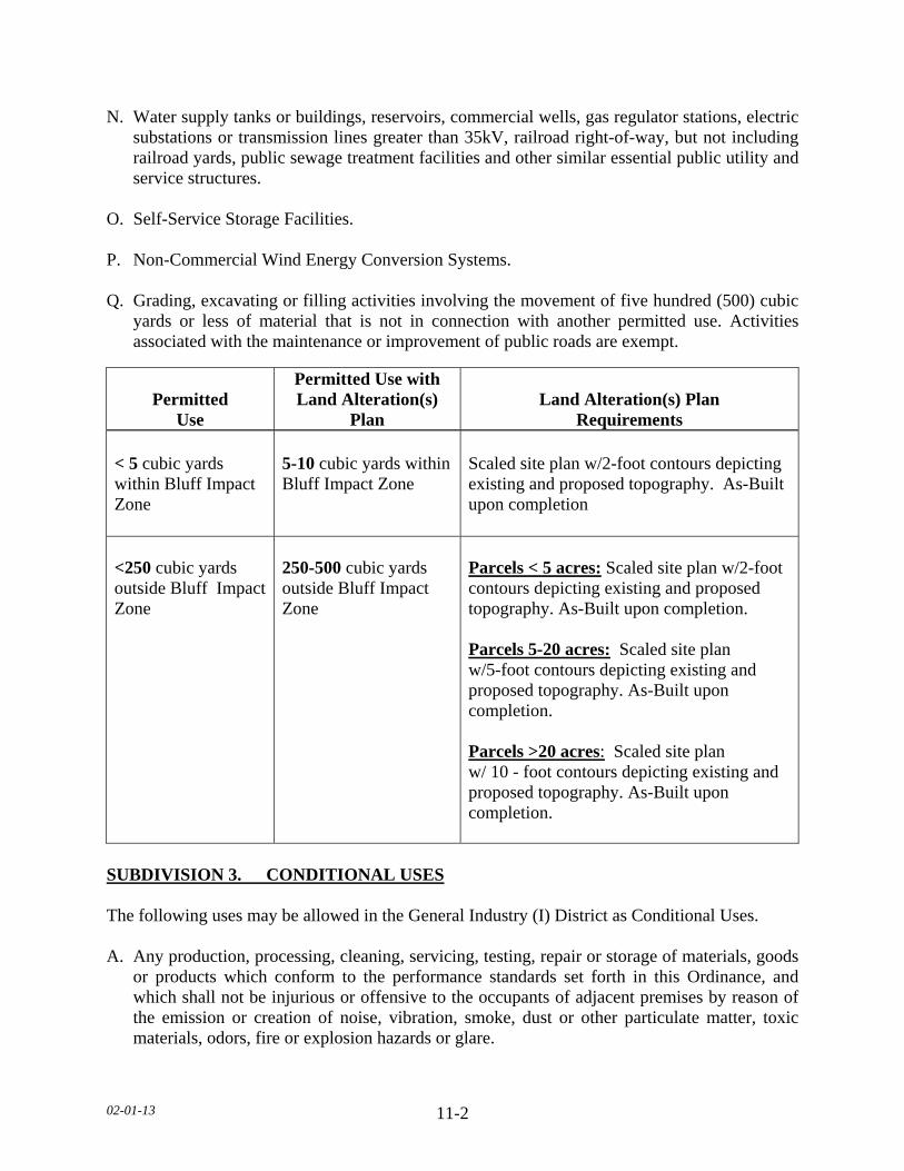
02-01-13 11-2
N. Water supply tanks or buildings, reservoirs, commercial wells, gas regulator stations, electric substations or transmission lines greater than 35kV, railroad right-of-way, but not including railroad yards, public sewage treatment facilities and other similar essential public utility and service structures.
O. Self-Service Storage Facilities. P. Non-Commercial Wind Energy Conversion Systems. Q. Grading, excavating or filling activities involving the movement of five hundred (500) cubic
yards or less of material that is not in connection with another permitted use. Activities associated with the maintenance or improvement of public roads are exempt.
SUBDIVISION 3. CONDITIONAL USES The following uses may be allowed in the General Industry (I) District as Conditional Uses. A. Any production, processing, cleaning, servicing, testing, repair or storage of materials, goods
or products which conform to the performance standards set forth in this Ordinance, and which shall not be injurious or offensive to the occupants of adjacent premises by reason of the emission or creation of noise, vibration, smoke, dust or other particulate matter, toxic materials, odors, fire or explosion hazards or glare.
Permitted Use
Permitted Use with Land Alteration(s)
Plan Land Alteration(s) Plan
Requirements < 5 cubic yards within Bluff Impact Zone <250 cubic yards outside Bluff Impact Zone
5-10 cubic yards within Bluff Impact Zone 250-500 cubic yards outside Bluff Impact Zone
Scaled site plan w/2-foot contours depicting existing and proposed topography. As-Built upon completion Parcels < 5 acres: Scaled site plan w/2-foot contours depicting existing and proposed topography. As-Built upon completion. Parcels 5-20 acres: Scaled site plan w/5-foot contours depicting existing and proposed topography. As-Built upon completion. Parcels >20 acres: Scaled site plan w/ 10 - foot contours depicting existing and proposed topography. As-Built upon completion.
02-01-13 11-3
B. Airports, heliports, landing fields, flying schools, hangers, transportation terminals, switching
yards, freight terminals, automobile testing grounds, or associated maintenance facilities. C. Refuse collection facilities, recycling facilities, sanitary landfills, car refuse, and junk or
salvage yards and livestock sales. D. Fuel, fertilizer (containerized or bulk) processing and storage. E. Mineral Extraction. F. One (1) Temporary Dwelling for watchmen, supervisors, and their families, located on the
premises where they are employed in such capacity provided the dwelling is under the same ownership as the principal use.
G. Fertilizer and chemical sales. H. Indoor/Outdoor Commercial Recreation. I. Winery. J. Special Events. K. Commercial Wind Energy Conversion System. L. Animal Crematorium. M. Off Premises Signs/Billboards. N. Illuminated signs. O. Platted Industrial Subdivisions. P. Grading, excavating or filling activities within the bluff. Q. Grading, excavating or filling activities involving the movement of more than five hundred
(500) cubic yards of material that is not in connection with another permitted use. Activities associated with the maintenance or improvement of public roads are exempt.
(TABLE ON NEXT PAGE)

02-01-13 11-4
Conditional Use Conditional Use Requirements > 10 cubic yards within Bluff Impact Zone >500 cubic yards outside Bluff Impact Zone
Scaled site plan w/2-foot contours depicting existing and proposed topography. As-Built upon completion. Site Plan (s) and As-Built completed by a surveyor or engineer. Parcels < 5 acres: Scaled site plan w/ 2-foot contours depicting existing and proposed topography. As-Built upon completion. Parcels 5-20 ac: Scaled site plan w/ 5-foot contours depicting existing and proposed topography. As-Built upon completion. Parcels > 20 ac: Scaled site plan w/ 10-foot contours depicting existing and proposed topography. As-Built upon completion. Site Plan(s) and As-Built completed by a surveyor or engineer.
SUBDIVISION 4. PERMITTED ACCESSORY USES AND STANDARDS The following uses shall be permitted accessory uses within the General Industry (I) District. A. ACCESSORY STRUCTURES
1. Accessory structures in the General Industry (I) District that have lot sizes less than five
(5) acres shall conform to the following structure areas and maximum structure heights. 2. Outside wall dimensions shall be used to determine maximum structure area, except
where a roof projects out further than two (2) feet from the sidewall, roof area shall be used to determine maximum structure area.
3. No accessory structures such as but not limited to: Offices, retail and service structures
shall be constructed or developed on a lot prior to construction of the principal use.
Lot Size Maximum Structure Area Maximum Structure Height Less than 1 acre 2,000 square feet 20 feet 1-1.99 acres 3,600 square feet 20 feet 2-4.99 acres 4,000 square feet 25 feet
02-01-13 11-5
B. SEPARATION REGULATIONS
1. In case an accessory structure is attached to the principal structure, it shall be made structurally a part of the principal structure and shall comply in all respects with the requirements of this Ordinance applicable to the principal structure.
2. An accessory structure shall not be closer than five (5) feet to the principal structure. a. In case an accessory structure is attached to the principal structure, it shall be made
structurally a part of the principal structure and shall comply in all respects with the requirements of this Ordinance applicable to the principal structure.
C. DRAINAGE Adequate drainage shall be provided and the drainage shall be directed away from adjacent private property. D. PARKING Off-street parking and loading. E. LANDSCAPING AND SCREENING F. OPEN, OUTDOOR SALES, SERVICE AND STORAGE G. PERMITTED SIGNAGE 1. Ground/Pylon Signs. a. The maximum height of a sign is thirty (30) feet. b. No more than one (1) ground/pylon sign shall be permitted per every thirty five (35) lineal
feet of road frontage. c. The square foot area of such signs shall not exceed two hundred (200) square feet. d. Ground/pylon signs shall be set back a minimum of ten (10) feet from property lines and/or
right-of-way. 2. Wall Signs. a. Wall signs on any structure shall not exceed twenty (20) percent of the wall area. b. Wall signs shall not project above the roof level.

02-01-13 11-6
3. Electronic Messageboard Signs/Dynamic Signs a. Shall not flash.
b. Any portion of the sign display shall be a minimum duration of ten (10) seconds and must be a static image.
c. Lighting shall comply with the exterior lighting standards of this Section. 4. Electronic Graphic Display Signs a. Shall not flash. b. Any portion of the sign display shall be a minimum duration of ten (10) seconds and
must be a static image. c. The sign shall not exceed illumination levels of five thousand (5,000) candela per
square meter (NITS) between dusk and dawn and five hundred (500) NITS during the daytime.
d. Lighting shall comply with the exterior lighting standards of this Section. H. Accessory uses customarily incidental to the permitted uses in Subdivision 2 and 3 of this
Section. SUBDIVISION 5. DIMENSIONAL REGULATIONS A. SETBACK EXEMPTIONS/STRUCTURE EXPANSIONS 1. Where proposed additions do not encroach further into the front, side, or rear yard than
the existing structure, such additions will be permitted provided the use and the structure are in conformance with the following restrictions:
a. The use of the structure is conforming to the zoning district in which it is located. b. The expansion of the structure shall not be located closer to the property line than the
existing structure or at least one-half (1/2) of the required setback, whichever is greater.
c. The expansion of the structure will not reduce any other required setback below the
minimum standards of this Ordinance. d. The expansion of the structure will conform to all other restrictions of this Ordinance,
including but not limited to, density, lot coverage, and structure height.
02-01-13 11-7
e. The height of the expansion shall not be greater than the existing structure at the existing building line.
B. FRONT YARD SETBACKS 1. There shall be a front yard setback of not less than one hundred (100) feet from any right-
of-way. 2. When a lot is located at the intersection of two (2) or more roads, there shall be a front
yard setback on each road right-of-way. 3. All component of an onsite subsurface sewage treatment system (SSTS) shall be a
minimum of twenty (20) feet from all road right-of-ways. 4. All components of an onsite subsurface sewage treatment system (SSTS) for a non-
conforming Lot of Record shall be ten (10) feet from all road right-of-ways. 5. The required front yard of a corner lot shall be unobstructed above a height of three (3)
feet in a triangular area, two (2) sides of which are the lines running parallel along the right of way lines between the road intersection and a point fifty (50) feet from the intersection, and the third site of which is the line between the latter two (2) points.
6. No trees or shrubs shall be planted within ten (10) feet from any right-of-way.
C. SIDE YARD SETBACKS 1. There shall be a minimum side yard setback of not less than fifteen (15) feet for all
structures. 2. For the purposes of emergency access, no storage of material shall be allowed within five
(5) feet of side yard property lines. 3. No structures shall be located within fifty (50) feet of any Residential or Agricultural
District. 4. Where a use has railroad side trackage abutting the side or rear of a site, a railroad
loading facility may be constructed closer to the lot line than specified in other provisions of this Ordinance, subject to approval by the Planning Commission and Board of County Commissioners.
D. REAR YARD SETBACKS 1. There shall be a minimum rear yard setback of fifteen (15) for all structures. 2. Except no structures shall be located within fifty (50) feet of any Residential or
Agricultural District.
02-01-13 11-8
3. For the purposes of emergency access, no storage of any material shall be allowed within
five (5) feet of the rear property line. 4. Where a use has railroad side trackage abutting the side or rear of a site, a railroad
loading facility may be constructed closer to the lot line than specified in other provisions of this Ordinance, subject to approval by the Planning Commission and Board of County Commissioners.
E. BLUFF SETBACKS 1. All structures shall be set back from the top and/or toe of the bluff: a. Thirty (30) feet for bluffs with slopes eighteen (18) to thirty (30) percent. b. Fifty (50) feet for bluffs with slopes greater than thirty (30) percent, c. Existing Building Sites. All structures shall be set back thirty (30) feet from the top
or toe of the bluff.
2. SSTS shall be set back thirty (30) feet from the top or toe of the bluff. a. SSTS upgrade and/or replacement for an existing dwelling:
1. Shall be exempt from bluff setback. 2. May be located within the bluff impact zone. 3. Shall not be located within the bluff.
3. If the adjacent bluff is actively eroding, the Department may increase the setback
requirement.
4. Structures and accessory facilities, except stairways and landings, must not be placed within bluff impact zones.
F. WETLAND SETBACKS All structures shall be setback a minimum of seventy five (75) feet from the wetland boundary of any Type three (3) through eight (8) wetland. G. ADDITIONAL SETBACKS
1. When more than one (1) setback applies to a site, structures must be located to meet all setbacks.
2. All structures shall be setback fifty (50) feet from a cemetery.
02-01-13 11-9
H. LOT AREA The minimum lot area shall contain an area of not less than one and one-half (1.5) acres. I. LOT WIDTH Every lot or tract shall have a width of not less than one hundred (100) feet abutting a public right-of-way. J. LOT COVERAGE Not more than sixty (60) percent of the lot shall be covered by impervious surface. K. BUILDABLE LOT STANDARDS 1. A lot of record, or other lot, tract, or parcel legally recorded with the County Recorder
that meets the requirements of this Ordinance and which has frontage on an improved and maintained public road, or an approved and maintained private road or easement is considered a buildable lot. The buildable lot shall have the contiguous required lot area of which not more than ten (10) percent is comprised of:
a. Area of a slope in excess of eighteen (18) percent. b. An impact zone. c. Floodplain. d. Wetlands. 2. Each new building site created after the adoption of this Ordinance must have a minimum
of 40,000 square feet of contiguous buildable lot area. 3. Each new building site created after January 23, 1996 must have sufficient area for a
minimum of two (2) onsite sewage treatment systems. 4. Lots of Record that are substandard in area must conform to all other applicable
regulations herein to qualify for placement of a structure. L. HEIGHT There shall be a maximum height limitation of one hundred and fifty (150) feet on all structures within the County. Any structure including but not limited to tower, spire and similar type structure, that exceeds this height requires a Conditional Use Permit, and then only after obtaining a letter of clearance from the Federal Aeronautics Administration and the Airport Commission for any airport located within ten (10) miles of the structure proposed to exceed the height limitation.
02-01-13 11-10
M. STRUCTURE AREA Outside wall dimensions shall be used to determine maximum structure area, except where a roof projects out further than two (2) feet from the sidewall; roof area shall be used to determine maximum structure area. SUBDIVISION 6. ACCESS DRIVES, ACCESS AND SERVICE ROADS A. Access drives onto any public roads shall require a review by the Road Authority. The Road
Authority shall determine the appropriate location, size, and design of such access drives along public roads and may limit the number of access drives in the interest of public safety and efficient traffic flow.
B. Access drives shall be constructed and maintained to meet all of the following: 1. A minimum driving surface width of fourteen (14) feet. 2. Inslope no greater than 4 to 1, as measured horizontal to vertical. 3. Base material depth sufficient to support access by emergency vehicles. 4. Unobstructed width of not less than twenty (20) feet. 5. Unobstructed vertical clearance of not less than thirteen (13) feet, six (6) inches. C. Access drives in excess of one hundred fifty (150) feet in length shall provide a minimum
turn-around of sixty (60) feet in width by sixty (60) feet in length. D. Access drives shall have a twenty (20) foot long flat grade directly adjacent to the road that
the drive accesses. E. All lots or parcels with dwellings shall have direct physical access of adequate size for
emergency vehicles along the frontage of the lot or parcel from either an existing or dedicated public roadway.
F. A service road shall be constructed when two (2) or more General Industrial (I) properties are
contiguous and when required by the Road Authority. G. Access drives shall not be located within the bluff impact zone.
SUBDIVISION 7. GENERAL REGULATIONS A. All land uses and development shall follow all other applicable regulations of this Ordinance.
02-01-13 12-1
SECTION 12. SUBDIVISION/PLATTING PROVISIONS SUBDIVISION 1. PURPOSE Subdivision is the process of dividing land into separate parcels for uses including residential, industrial, and commercial sites in accordance with the standards that will protect the general health, safety and welfare of the public. The County is authorized by Minn. Stat. Chs. 394 and 505 to regulate the subdivision and platting of lands. A. LAND SUITABILITY 1. Each lot created through subdivision, including planned unit developments (PUD’s)
authorized in this Ordinance, must be suitable in its natural state for the proposed use with minimal alteration.
2 Suitability analysis by the local unit of government shall consider susceptibility to
flooding, existence of wetlands, soil and rock formations with severe limitations for development, severe erosion potential, steep topography, inadequate water supply, or sewage treatment capabilities, near-shore aquatic conditions unsuitable for water-based recreation, important fish and wildlife habitat, presence of significant historic sites, or any other feature of the natural land likely to be harmful to the health, safety, or welfare of future residents of the proposed subdivision of the community.
3. For areas within the Flood Plain Overlay District, the following Flood Plain management
provisions shall be as follows: a. All lots within the floodplain shall be able to contain a building site outside of the
floodway district at or above the regulatory flood protection elevation; b. All subdivisions shall have road access both to the subdivision and to the individual
building sites no lower than two (2) feet below the regulatory flood protection elevation;
c. For all subdivisions in the floodplain, the floodway and flood fringe district
boundaries, the regulatory flood protection elevation, and the required elevation of all access roads shall be clearly labeled on all required subdivision drawings and platting documents; and
d. In the Floodplain Overlay District, applicants shall provide the information in Section
6.2, Subdivision 3.D of this Ordinance to determine the 100-year flood elevation, the floodway and flood fringe district boundaries, and the regulatory flood protection elevation for the site.
02-01-13 12-2
B. CONSISTENCY WITH OTHER CONTROLS 1. Subdivisions must conform to all other official controls of the County. 2. A subdivision will not be approved where a later variance from one or more standards in
official controls would be needed to use the lots for their intended purpose. 3. In areas not served by publicly owned sewer and water systems, a subdivision will not be
approved unless domestic water supply is available and a sewage treatment system consistent with this Ordinance can be provided for every lot.
4. Each lot shall meet the minimum lot size and dimensional requirements of this Ordinance
including buildable area
5. Lots that would require use of holding tanks shall not be approved. C. INFORMATION REQUIREMENTS 1. Sufficient information must be submitted by the applicant for the County Planning
Commission to make a determination of land suitability. The information shall include at least the following:
a. Topographic contours at two (2) foot intervals or less from United States Geological
Survey maps or more accurate sources, showing limiting site characteristics. b. The surface water features required in Minnesota Statutes, Chapter 505.02,
Subdivision 1, to be shown on plats, obtained from United States Geological Survey quadrangle topographic maps or more accurate sources.
c. Adequate soils information to determine suitability for building and on-site sewage
treatment capabilities for every lot from the most current existing sources or from field investigations such as soil borings, percolation tests, or other methods.
d. Information regarding adequacy of domestic water supply; extent of anticipated
vegetation and topographic alterations; near-shore aquatic conditions, including depths, types of bottom sediments, and aquatic vegetation; and proposed methods for controlling stormwater runoff and erosion, both during and after construction activities.
e. Location of 100-year floodplain areas and floodway districts from existing adopted
maps or data. f. A line or contour representing the ordinary high water level, the toe and the top of
bluffs, and the minimum building setback distances from the top of the bluff and the lake or stream.
02-01-13 12-3
D. DEDICATIONS When a land or easement dedication is a condition of subdivision approval, the approval must provide easements over natural drainage or ponding areas for management of stormwater and significant wetlands. E. PLATTING All subdivisions that create two (2) or more lots or parcels that are less than five (5) acres in size shall be processed as a plat in accordance with Minnesota Statutes, Chapter 505. No permit for construction of buildings or sewage treatment systems shall be issued for lots created after enactment of official shoreland controls unless the lot was created in compliance with official county subdivision controls. F. CONTROLLED ACCESS OR RECREATIONAL LOTS Lots intended as controlled accesses to public waters or for recreational use areas for use by nonriparian lots within a subdivision must meet or exceed the sizing criteria in this Ordinance. SUBDIVISION 2. PLANNED UNIT DEVELOPMENTS (PUD’s) A. TYPES OF PUD’S PERMISSIBLE PUD’s may be allowed for new projects on undeveloped land, redevelopment of previously built sites, or conversions of existing buildings and land. The land use districts in which they are an allowable use are identified in the land use district descriptions in this Ordinance and the official zoning map. B. PROCESSING OF A PUD PUD’s shall be processed as a conditional use. C. APPLICATION FOR A PUD 1. The applicant for a PUD must submit the following documents prior to final action being
taken on the application request: a. A site plan and/or plat for the project showing locations of property boundaries,
surface water features, existing and proposed structures and other facilities, land alterations, sewage treatment and water supply systems (where public systems will not be provided), and topographic contours at ten (10) foot intervals or less. When a PUD is a combined commercial and residential development, the site plan and/or plat must indicate and distinguish which buildings and portions of the project are residential, commercial, or a combination of the two.
02-01-13 12-4
b. A property owner’s association agreement (for residential PUD’s) with mandatory membership, and all in accordance with the requirements this Ordinance.
c. Deed restrictions, covenants, permanent easements, or other instruments that: 1. Properly address future vegetation and topographic alterations, construction of
additional buildings, beaching of watercraft, and construction of commercial buildings in a residential PUD; and
2. Ensure the long-term preservation and maintenance of open space in accordance
with the criteria and analysis specified in this Ordinance. d. When necessary, a master plan/drawing describing the project and the floor plan for
all commercial structures to be occupied. e. Those additional documents as requested by the Planning Commission that are
necessary to explain how the PUD will be designed and will function. D. SITE SUITABLE AREA EVALUATION 1. Proposed new or expansions to an existing PUD‘s must be evaluated using the following
procedures and standards to determine the suitable area for the dwelling unit/dwelling site density evaluation in this Ordinance.
2. The project parcel must be divided into tiers by locating one or more lines approximately
parallel to a line that identifies the OHWL. Each tier shall be at least two hundred sixty seven (267) feet in depth.
3. The suitable area within each tier is next calculated by excluding from the tier area all
wetlands, bluffs, or land below the OHWL of public waters. This suitable area and the proposed project are then subjected to either the residential or commercial PUD density evaluation steps to arrive at an allowable number of dwelling units or sites.
E. RESIDENTIAL AND COMMERCIAL PUD DENSITY EVALUATION 1. The procedures for determining the "base” density of a PUD and density increase
multipliers are as follows. Allowable densities may be transferred from any tier further from the water body, but must not be transferred to any other tier closer.
2. Residential PUD Base Density Evaluation a. The suitable area within each tier is divided by the single residential lot size standard
for lakes or, for rivers, the single residential lot width standard times the tier depth, unless the local unit of government has specified an alternative minimum lot size for rivers which shall then be used to yield a base density of dwelling units or sites for each tier.
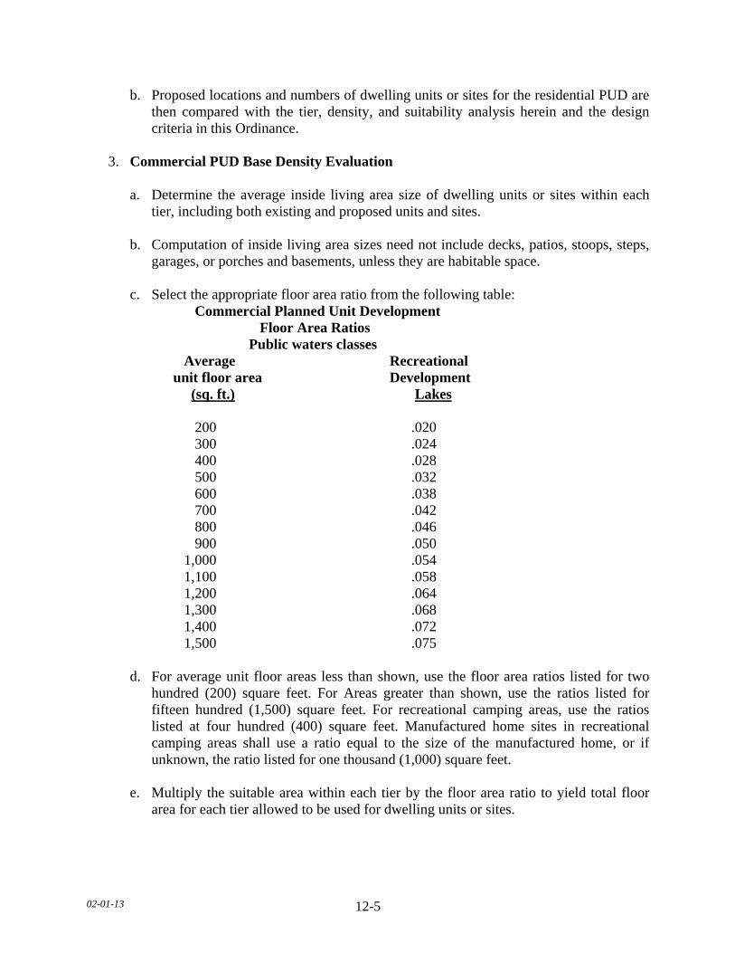
02-01-13 12-5
b. Proposed locations and numbers of dwelling units or sites for the residential PUD are then compared with the tier, density, and suitability analysis herein and the design criteria in this Ordinance.
3. Commercial PUD Base Density Evaluation a. Determine the average inside living area size of dwelling units or sites within each
tier, including both existing and proposed units and sites. b. Computation of inside living area sizes need not include decks, patios, stoops, steps,
garages, or porches and basements, unless they are habitable space. c. Select the appropriate floor area ratio from the following table: Commercial Planned Unit Development Floor Area Ratios Public waters classes Average Recreational unit floor area Development (sq. ft.) Lakes 200 .020 300 .024 400 .028 500 .032 600 .038 700 .042 800 .046 900 .050 1,000 .054 1,100 .058 1,200 .064 1,300 .068 1,400 .072 1,500 .075 d. For average unit floor areas less than shown, use the floor area ratios listed for two
hundred (200) square feet. For Areas greater than shown, use the ratios listed for fifteen hundred (1,500) square feet. For recreational camping areas, use the ratios listed at four hundred (400) square feet. Manufactured home sites in recreational camping areas shall use a ratio equal to the size of the manufactured home, or if unknown, the ratio listed for one thousand (1,000) square feet.
e. Multiply the suitable area within each tier by the floor area ratio to yield total floor
area for each tier allowed to be used for dwelling units or sites.
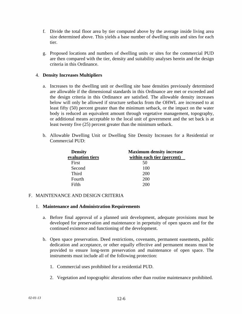
02-01-13 12-6
f. Divide the total floor area by tier computed above by the average inside living area size determined above. This yields a base number of dwelling units and sites for each tier.
g. Proposed locations and numbers of dwelling units or sites for the commercial PUD
are then compared with the tier, density and suitability analyses herein and the design criteria in this Ordinance.
4. Density Increases Multipliers a. Increases to the dwelling unit or dwelling site base densities previously determined
are allowable if the dimensional standards in this Ordinance are met or exceeded and the design criteria in this Ordinance are satisfied. The allowable density increases below will only be allowed if structure setbacks from the OHWL are increased to at least fifty (50) percent greater than the minimum setback, or the impact on the water body is reduced an equivalent amount through vegetative management, topography, or additional means acceptable to the local unit of government and the set back is at least twenty five (25) percent greater than the minimum setback.
b. Allowable Dwelling Unit or Dwelling Site Density Increases for a Residential or
Commercial PUD:
Density Maximum density increase evaluation tiers within each tier (percent) First 50 Second 100 Third 200 Fourth 200 Fifth 200 F. MAINTENANCE AND DESIGN CRITERIA 1. Maintenance and Administration Requirements a. Before final approval of a planned unit development, adequate provisions must be
developed for preservation and maintenance in perpetuity of open spaces and for the continued existence and functioning of the development.
b. Open space preservation. Deed restrictions, covenants, permanent easements, public
dedication and acceptance, or other equally effective and permanent means must be provided to ensure long-term preservation and maintenance of open space. The instruments must include all of the following protection:
1. Commercial uses prohibited for a residential PUD. 2. Vegetation and topographic alterations other than routine maintenance prohibited.

02-01-13 12-7
3. Construction of additional buildings or storage of vehicles and other materials
prohibited. 4. Uncontrolled beaching of watercraft prohibited. c. Development organization and functioning. Unless equally effective alternative
community framework is established, when applicable, all residential PUD’s must use an owners association with the following features:
1. Membership must be mandatory for each dwelling unit or site purchaser and any
successive purchasers; 2. Each member must pay a pro rate share of the association's expenses, and unpaid
assessments can become liens on units or sites; 3. Assessments must be adjustable to accommodate hanging conditions; and 4. The association must be responsible for insurance, taxes, and maintenance of all
commonly owned property and facilities. G. OPEN SPACE REQUIREMENTS PUD’s must contain open space meeting of all the following criteria: 1. At least fifty (50) percent of the total project area must be preserved as open space. 2. Dwelling units or sites, road right-of-way, or land covered by road surfaces, parking
areas, or structures, except water-oriented accessory structures or facilities, are developed areas and shall not be included in the computation of minimum open space.
3. Open space must include areas with physical characteristics unsuitable for development
in their natural state, and areas containing significant historic sites or unplatted cemeteries.
4. Open space may include outdoor recreational facilities for use by owners of dwelling
units or sites, by guests staying in commercial dwelling units or sites, and by the general public.
5. Open space may include subsurface sewage treatment systems if the use of the space is
restricted to avoid adverse impacts on the systems. 6. Open space must not include commercial facilities or uses, but may contain water--
oriented accessory structures or facilities.
02-01-13 12-8
7. The appearance of open space areas, including topography, vegetation, and allowable uses, must be preserved by the use of restrictive deed covenants, permanent easements, public dedication and acceptance, or other equally effective and permanent means.
8. The shore impact zone, based on normal structure setbacks, must be included as open
space. a. For a residential PUD, at least fifty (50) percent of the shore impact zone area of
existing developments or at least seventy (70) percent of the shore impact zone area of new developments must be preserved in its natural or existing state.
b. For a commercial PUD at least fifty (50) percent of the shore impact zone must be
preserved in its natural state. H. EROSION CONTROL AND STORMWATER MANAGEMENT Erosion control and stormwater management plans must be developed and the PUD must: 1. Be designed, and the construction managed, to minimize the likelihood of serious erosion
occurring either during or after construction. This must be accomplished by limiting the amount and length of time of bare ground exposure. Temporary ground covers, sediment entrapment facilities, vegetated buffer strips, or other appropriate techniques must be used to minimize erosion impacts on surface water features. Erosion control plans approved by a SWCD may be required if project size and site physical characteristics warrant.
2. Be designed and constructed to effectively manage reasonably expected quantities and
qualities of stormwater runoff. 3. Impervious surface coverage within any tier must not exceed twenty five (25) percent of
the tier area, except that for commercial PUD's thirty five (35) percent impervious surface coverage may be allowed in the first tier of Recreational Development lakes with an approved stormwater management plan and consistency with this Ordinance.
I. CENTRALIZATION AND DESIGN OF FACILITIES Centralization and design of facilities and structures must be done according to the following standards: 1. PUD’s must be connected to publicly owned water supply and sewer systems, if
available. On-site water supply and subsurface soil treatment systems must be centralized and designed and installed to meet or exceed applicable standards or rules of the Minnesota Department of Health and this Ordinance. Subsurface soil sewage treatment systems must be located on the most suitable areas of development, and sufficient lawn area free of limiting factors must be provided for a replacement subsurface soil treatment system for each sewage system.
02-01-13 12-9
2. Dwelling units or sites must be clustered into one (1) or more groups and located on
suitable areas of development. They must be designed and located to meet or exceed the following dimensional standards for the relevant shoreland classification: setback from the OHWL, elevation above the surface water features, and maximum height. Setbacks from the OHWL must be increased in accordance with this Ordinance for developments with density increases.
3. Shore recreation facilities, including but not limited to swimming areas, docks, and
watercraft mooring areas and launching ramps, must be centralized and located in areas suitable for them. Evaluation of suitability must include consideration of land slope, water depth, vegetation, soils, depth of groundwater and bedrock, or other relevant factors. The number of spaces provided for continuous beaching, mooring, or docking of watercraft must not exceed one for each allowable dwelling unit or site in the first tier notwithstanding existing mooring sites in an existing commercially used harbor). Launching ramp facilities, including a small dock for loading and unloading equipment, may be provided for use by occupants of dwelling units of sites located in other tiers.
4. Structures, parking areas, and other facilities must be treated to reduce visibility as
viewed from public waters and adjacent shorelands by vegetation, topography, increased setbacks, color, or other means acceptable to the local unit of government, assuming summer, leaf-on conditions. Vegetative and topographic screening must be preserved, if existing, or may be required to be provided.
5. Accessory structures and facilities except water-oriented accessory structures, must meet
the required principal structure setback and must be centralized. 6. Water-oriented accessory structures and facilities may be allowed if they meet or exceed
design standards contained in this Ordinance and are centralized. J. CONVERSIONS Local governments may allow existing resorts or other land uses and facilities to be converted to a residential PUD if all of the following standards are met: 1. Proposed conversions must be initially evaluated using the same procedures for a
residential PUD involving all new construction. Inconsistencies between existing features of the development and these standards must be identified.
2. Deficiencies involving water supply and sewage treatment, structure color, impervious
coverage, open space, and shore recreation facilities must be corrected as part of the conversion or as specified in the conditional use permit.
3. Shore and bluff impact zone deficiencies must be evaluated and reasonable
improvements made as part of the conversion. These improvements must include, where applicable, the following:
02-01-13 12-10
a. Removal of extraneous building, docks, or other facilities that no longer need to be
located in shore or bluff impact zones. b. Remedial measures to correct erosion sites and improve vegetation cover and
screening of buildings and other facilities as viewed from the water. c. If existing dwelling units are located in shore or bluff impact zones, conditions are
attached to approvals of conversions that preclude exterior expansions in any dimensions or substantial alterations. The conditions must also provide for future relocation of dwelling units, where feasible, to other locations, meeting all setback elevation requirements when they are rebuilt or replaced.
4. Existing dwelling unit or dwelling site densities that exceed standards in this Ordinance
may be allowed to continue but must not be allowed to be increased, either at the time of conversion or in the future. Efforts must be made during the conversion to limit impacts of high densities by requiring seasonal use, improving vegetative screening, centralizing shore recreational facilities, installing new sewage treatment systems, or other means.
02-1-13 13-1
SECTION 13. LE SUEUR COUNTY SHORELAND MANAGEMENT SUBDIVISION 1. STATUTORY AUTHORIZATION AND POLICY A. STATUTORY AUTHORIZATION This Section regarding the regulation of shoreland is adopted pursuant to the authorization and policies contained in Minnesota Statutes, Chapter 103F, Minnesota Regulations, Parts 6120.2500 & 6120.3900, and the planning and zoning enabling legislation in Minnesota Statutes, Chapter 394, as amended from time to time. B. POLICY The uncontrolled use of shorelands of Le Sueur County, Minnesota affects the public health, safety and general welfare not only by contributing to pollution of public waters, but also by impairing the local tax base. Therefore, it is in the best interests of the public health, safety and welfare to provide for the wise subdivision, use and development of shorelands of public waters. The Legislature of Minnesota has delegated responsibility to local governments of the state to regulate the divisions, use and development of the shorelands of public waters and thus preserve and enhance the quality of surface waters, conserve the economic and natural environmental values of shorelands, and provide for the wise use of waters and related land resources. This responsibility is hereby recognized by Le Sueur County. SUBDIVISION 2. GENERAL PROVISIONS AND DEFINITIONS A. SHORELAND The land located within the following distances from public waters:
1. One thousand (1,000) feet from the ordinary high water level of a lake, pond or flowage. 2. Three hundred (300) feet from a river or stream, or the landward extent of a flood plain
designated by this Ordinance on such a river or stream, whichever is greater. 3. The practical limits of shorelands may be less than the statutory limits wherever the
waters involved are bounded by natural topographic divides which extend landward from the waters for lesser distances and when approved by the Commissioner.
B. JURISDICTION The provisions of this Section shall apply to the shorelands of the public water bodies as classified in this Section. Pursuant to Minnesota Regulations, Parts 6120.2500-6120.3900, no lake, pond, or flowage less than twenty five (25) acres in size in unincorporated areas need be regulated in a local government's shoreland regulations. A body of water created by a private user where there was no previous shoreland may, at the discretion of the governing body, be exempt from this Section.
02-1-13 13-2
C. COMPLIANCE The use of any shoreland of public waters; the size and shape of lots; the use, size, type and location of structures on lots; the installation and maintenance of water supply and waste treatment systems, the grading and filling of any shoreland area; the cutting of shoreland vegetation; and the subdivision of land shall be in full compliance with the terms of this Section and other applicable regulations. D. ENFORCEMENT The Department is responsible for the administration and enforcement of this Section. Any violation of the provisions of this Section or failure to comply with any of its requirements (including violations of conditions and safeguards established in connection with grants of variances or conditional uses) shall constitute a misdemeanor and shall be punishable as defined by law. Violations of this Section can occur regardless of whether or not a permit is required for a regulated activity pursuant to this Section. E. INTERPRETATION In their interpretation and application, the provisions of this Section shall be held to be minimum requirements and shall be liberally construed in favor of the governing body and shall not be deemed a limitation or repeal of any other powers granted by State Statutes. F. SEVERABILITY In any subdivision, clause, provision, or portion of this Section is adjudged unconstitutional or invalid by a court of competent jurisdiction; the remainder of this Section shall not be affected thereby. G. ABROGATION AND GREATER RESTRICTIONS It is not intended by this Section to repeal, abrogate, or impair any existing easements, covenants, or deed restrictions. However, where this Section imposes greater restrictions, the provisions of this Section shall prevail. All other ordinances inconsistent with this Section are hereby repealed to the extent of the inconsistency only. H. INJUNCTIVE RELIEF The Department upon certification by the Board of County Commissioners, shall have the authority to petition the District Court for injunctive relief against continued violations of any of the provisions of this Section. I. DEFINITIONS See Section 4, of this Ordinance for definitions.
02-1-13 13-3
SUBDIVISION 3. ADMINISTRATION A. PERMITS REQUIRED 1. A permit is required for the construction of any structure, structure additions, or
enclosure of existing decks, (and including such related activities as construction of decks and signs), the installation and/or alteration of sewage treatment systems, vegetative alteration, and those grading, excavating or filling activities not exempted by this Section. Freestanding accessory structures less than one hundred (100) square feet in area and less than eight (8) feet high do not require a permit, but shall meet all setback requirements and all other provisions as required by this Section.
2. Application for a permit shall be made to the Department on the forms provided. The
application shall include the necessary information so that the Department can determine the site's suitability for the intended use and that a complying sewage treatment system will be provided.
3. A permit authorizing any of the activities stated in this Section shall stipulate that an
identified failed sewage treatment system, as defined by Section 17, shall be reconstructed or replaced in accordance with the provisions of this Section and this Ordinance.
B. VARIANCES 1. Variances may only be granted in accordance with the standards in Minnesota Statutes,
Chapter 394. A variance may not circumvent the general purposes and intent of this Section. No variance may be granted that would allow any use that is prohibited in the zoning district in which the subject property is located. Conditions may be imposed in the granting of a variance to ensure compliance and to protect adjacent properties and the public interest. In considering a variance request, the Board of Adjustment must also consider whether the property owner has reasonable use of the land without the variance, whether future sewage treatment system site location is available on the properties before additional development is approved, whether the property is used seasonally or year-round, whether the Variance is being requested solely on the basis of economic considerations, and the characteristics of development on adjacent properties.
2. The Board of Adjustment shall hear and decide requests for variances in accordance with
the rules that it has adopted for the conduct of business. When a variance is approved after the Department of Natural Resources has formally recommended denial in the hearing record, the notification of the approved variance required in this Ordinance shall also include the Board of Adjustment's summary of the public record/testimony and the findings of facts and conclusions which supported the issuance of the variance.
3. For existing developments, the application for variance must clearly demonstrate whether
a conforming sewage treatment system is present for the intended use of the property.

02-1-13 13-4
C. NOTIFICATIONS TO THE DEPARTMENT OF NATURAL RESOURCES 1. Copies of all notices of any public hearings to consider variances, amendments, or
conditional uses under local shoreland management controls must be sent to the commissioner or the commissioner's designated representative and postmarked at least ten (10) days before the hearings. Notices of hearings to consider proposed subdivisions/plats must include copies of the subdivision/plat.
2. A copy of approved amendments and subdivision/plats, and final decisions granting
variances or conditional uses under local shoreland management controls must be sent to the commissioner or the commissioner’s designated representative and postmarked within ten (10) days of final action.
SUBDIVISION 4. SHORELAND CLASSIFICATION SYSTEM AND LAND USE
DISTRICTS A. SHORELAND CLASSIFICATION SYSTEMS 1. The public waters of Le Sueur County have been classified below consistent with the
criteria found in Minnesota Regulations, Part 6120.3300, and the Public Waters Inventory Map for Le Sueur County, Minnesota.
2. Definition of Shoreland terminology. The shoreland area for the water bodies listed in
this Section shall be defined in Section 4, of this Ordinance and as shown on the Official Zoning Map.
3. Public Waters, Lakes
a. Natural Environment Lakes (NE) Inventory I.D. #
Querums (Quiram's) Slough 40-3 Goose 40-8 Sunfish 40-9 Dora 40-10 Mabel 40-11
---- 40-12 Diamond 40-13 Sabre 40-14 Rice 40-16 Borer 40-19 Mud 40-26 Sanborn 40-27 Pepin 40-28 Eggert 40-29 Dietz 40-30 Cherry 40-35 Rice 40-37

02-1-13 13-5
Natural Environment Lakes (NE) con’t Inventory I.D. # ---- 40-38 Roemhildts 40-39 ---- 40-41 Steele 40-44 Fish 40-51 Perch 40-54 Swains 40-55 Round 40-59 Tustin 40-61 Sander’s Slough 40-62 ---- 40-64 ---- 40-67 Sleepy Eye 40-68 ---- 40-69 Hecort's Marsh 40-70 Goose 40-72 Bossuot 40-73 Mud 40-74 Hackridge 40-77 Mary 40-78 Beiser 40-81 ---- 40-82 Mud 40-83 Tyler 40-84 Sautter 40-87 Renneberg 40-88 Sheas 40-90 School 40-91 Harriman Slough 40-93 Thomas 40-95 ---- 40-96
---- 40-97 ---- 40-98
---- 40-99 ---- 40-100 ---- 40-102 Henry 40-104 Silver 40-106 Savidge 40-107 South Goldsmith 40-108 Scotch 40-109 Huoy 40-110 Dog 40-112 Rice 40-114
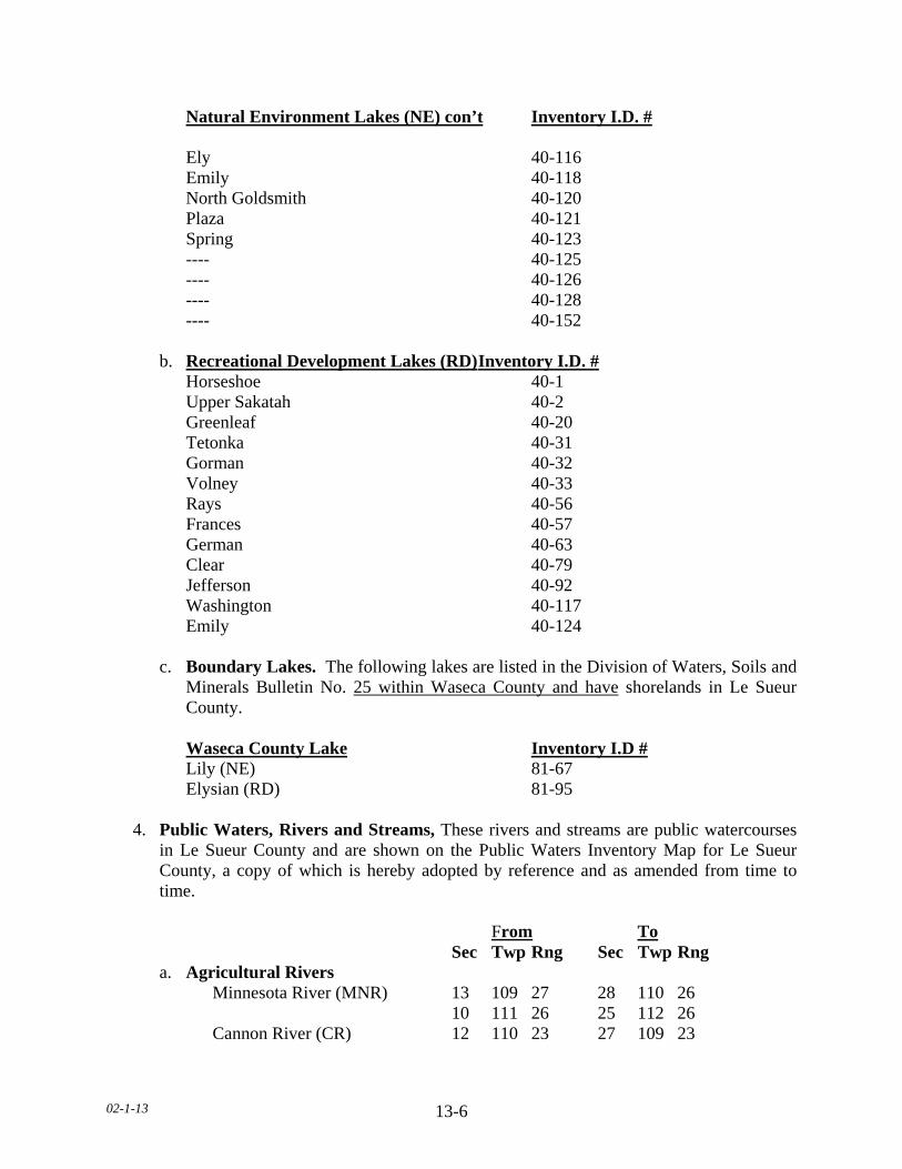
02-1-13 13-6
Natural Environment Lakes (NE) con’t Inventory I.D. # Ely 40-116 Emily 40-118
North Goldsmith 40-120 Plaza 40-121 Spring 40-123 ---- 40-125 ---- 40-126 ---- 40-128 ---- 40-152
b. Recreational Development Lakes (RD) Inventory I.D. #
Horseshoe 40-1 Upper Sakatah 40-2 Greenleaf 40-20 Tetonka 40-31 Gorman 40-32 Volney 40-33 Rays 40-56 Frances 40-57 German 40-63 Clear 40-79 Jefferson 40-92 Washington 40-117 Emily 40-124
c. Boundary Lakes. The following lakes are listed in the Division of Waters, Soils and
Minerals Bulletin No. 25 within Waseca County and have shorelands in Le Sueur County.
Waseca County Lake Inventory I.D # Lily (NE) 81-67 Elysian (RD) 81-95 4. Public Waters, Rivers and Streams, These rivers and streams are public watercourses
in Le Sueur County and are shown on the Public Waters Inventory Map for Le Sueur County, a copy of which is hereby adopted by reference and as amended from time to time.
From To Sec Twp Rng Sec Twp Rng a. Agricultural Rivers Minnesota River (MNR) 13 109 27 28 110 26 10 111 26 25 112 26 Cannon River (CR) 12 110 23 27 109 23
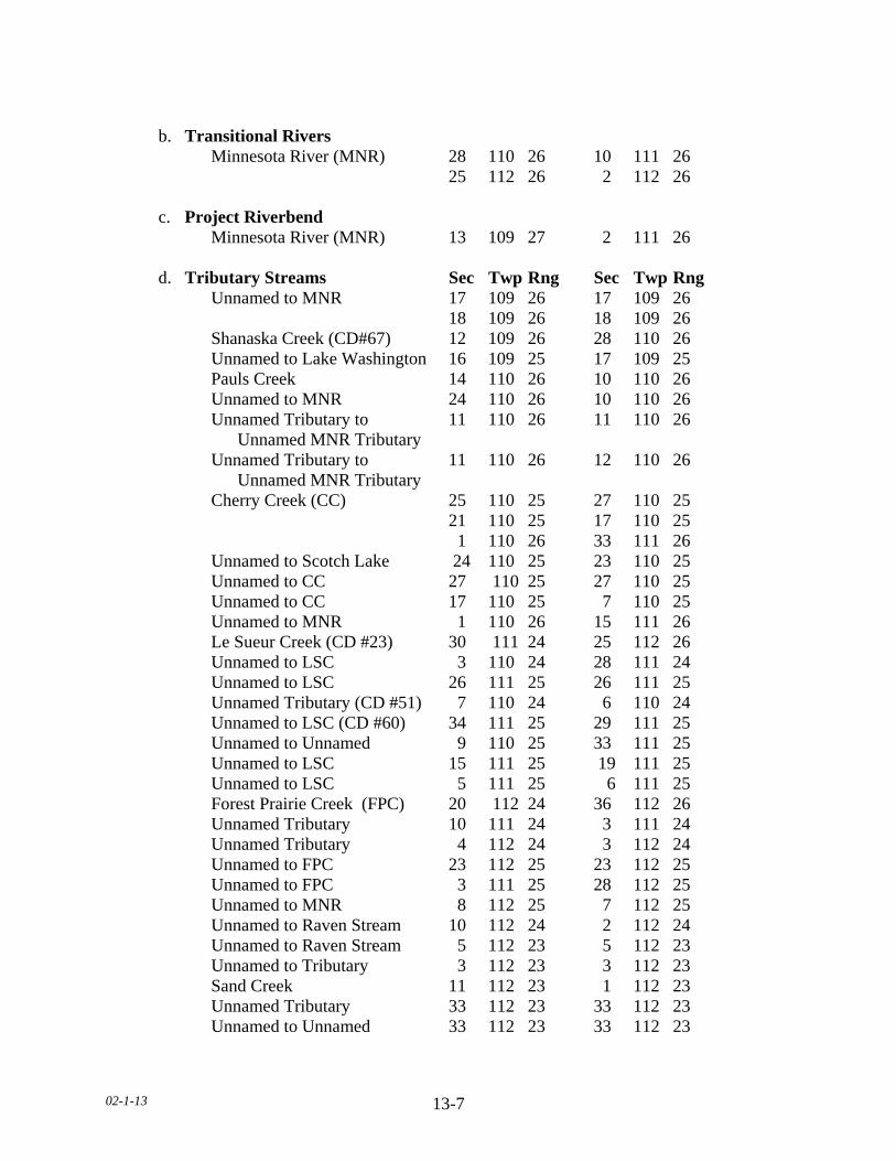
02-1-13 13-7
b. Transitional Rivers Minnesota River (MNR) 28 110 26 10 111 26 25 112 26 2 112 26 c. Project Riverbend Minnesota River (MNR) 13 109 27 2 111 26 d. Tributary Streams Sec Twp Rng Sec Twp Rng Unnamed to MNR 17 109 26 17 109 26
18 109 26 18 109 26 Shanaska Creek (CD#67) 12 109 26 28 110 26 Unnamed to Lake Washington 16 109 25 17 109 25 Pauls Creek 14 110 26 10 110 26 Unnamed to MNR 24 110 26 10 110 26 Unnamed Tributary to 11 110 26 11 110 26
Unnamed MNR Tributary Unnamed Tributary to 11 110 26 12 110 26 Unnamed MNR Tributary
Cherry Creek (CC) 25 110 25 27 110 25 21 110 25 17 110 25 1 110 26 33 111 26 Unnamed to Scotch Lake 24 110 25 23 110 25 Unnamed to CC 27 110 25 27 110 25 Unnamed to CC 17 110 25 7 110 25 Unnamed to MNR 1 110 26 15 111 26 Le Sueur Creek (CD #23) 30 111 24 25 112 26 Unnamed to LSC 3 110 24 28 111 24 Unnamed to LSC 26 111 25 26 111 25 Unnamed Tributary (CD #51) 7 110 24 6 110 24 Unnamed to LSC (CD #60) 34 111 25 29 111 25 Unnamed to Unnamed 9 110 25 33 111 25 Unnamed to LSC 15 111 25 19 111 25 Unnamed to LSC 5 111 25 6 111 25 Forest Prairie Creek (FPC) 20 112 24 36 112 26 Unnamed Tributary 10 111 24 3 111 24 Unnamed Tributary 4 112 24 3 112 24 Unnamed to FPC 23 112 25 23 112 25 Unnamed to FPC 3 111 25 28 112 25 Unnamed to MNR 8 112 25 7 112 25 Unnamed to Raven Stream 10 112 24 2 112 24 Unnamed to Raven Stream 5 112 23 5 112 23 Unnamed to Tributary 3 112 23 3 112 23 Sand Creek 11 112 23 1 112 23 Unnamed Tributary 33 112 23 33 112 23 Unnamed to Unnamed 33 112 23 33 112 23

02-1-13 13-8
Tributary Streams con’t Sec Twp Rng Sec Twp Rng Unnamed to Lake Pepin 32 112 23 32 112 23 Unnamed to Lake Sanborn 4 109 24 4 109 24 Unnamed From Sanborn to 35 112 23 2 111 23 Rice Lake Unnamed to Rice Lake 1 111 23 1 111 23 Unnamed to CR 10 110 23 11 110 23 Unnamed to Lake Dora 24 111 23 25 111 23 3 110 23 3 110 23 Unnamed to Gorman Lake 12 110 24 6 110 23 Little Cannon River 25 110 23 25 110 23 Unnamed Tributary 35 110 24 31 110 23 Unnamed to Lake Jefferson 14 109 25 12 109 25 Unnamed to German Lake 5 109 24 5 109 24 Unnamed to German Lake 33 110 24 4 109 24 Unnamed to Lake Sanborn 4 109 24 4 109 24 White Water Creek 34 109 23 26 109 23 Waterville Creek 36 109 23 27 109 23
B. LAND USE DISTRICT DESCRIPTIONS
1. Criteria for Designation
The shoreland districts in this Ordinance, and the delineation of a land use district's boundaries on the Official Zoning Map, must be consistent with the goals, policies, and objectives of the comprehensive land use plan and the following criteria, considerations, and objectives:
2. General Considerations and Criteria for All Land Uses a. Preservation of natural areas. b. Present ownership and development of shoreland areas. c. Shoreland soil types and their engineering capabilities. d. Topographic characteristics. e. Vegetative cover. f. In-water physical characteristics, values, and constraints. g. Recreational use of the surface water. h. Road and service center accessibility.
02-1-13 13-9
i. Socioeconomic development needs and plans as they involve water and related land
resources. j. The land requirements of industry which, by its nature, requires location in shoreland
areas. k. The necessity to preserve and restore certain areas having significant historical or
ecological value.
3. Factors and Criteria for Planned Unit Developments a. Existing recreational use of the surface waters and likely increases in use associated
with planned unit developments. b. Physical and aesthetic impacts of increased density. c. Suitability of lands for the planned unit development approach. d. Level of current development in the area. e. Amounts and types of ownership of undeveloped lands. 4. Shoreland District Descriptions a. The land use districts provided below, and the allowable land uses therein for the
given classifications of water bodies, shall be properly delineated on the Official Zoning Map for shorelands of this community. These shoreland districts are in conformance with the criteria specified in Minnesota Regulation, Part 6120.3200, Subp. 3.
b. The intent of the Special Protection (SP) District is to guide the wise development
and utilization of shorelands of public waters for the preservation of water quality, natural characteristics, economic values and the general health, safety and welfare of all public waters in the unincorporated areas of the County. Further, the purpose of this district is to manage areas unsuitable for development due to wet soils, steep slopes or large areas of exposed bedrock; and to manage areas of unique natural and biological characteristics in accordance with compatible uses.
c. The intent of the Recreational Residential (RR) District is to preserve areas which
have natural characteristics suitable for both passive and active recreational usage. Also, it is the intent of this district to manage areas suitable for residential development of varying types, including permanent and seasonal housing. Some non-residential uses with minimal impacts on residential uses are allowed if properly managed under conditional use procedures.
02-1-13 13-10
d. The intent of the Recreational Commercial (RC) District is to provide suitable locations for, and to encourage the development of, water orientated commercial recreation facilities in those areas of Le Sueur County which benefit the recreational needs of both residents and tourists, to avoid land use conflicts with residential areas and restrict incompatible commercial and industrial uses.
SUBDIVISION 5. DESIGN CRITERIA, SHORELAND ALTERATIONS AND
SPECIAL PROVISIONS A. DESIGN CRITERIA 1. Subdivisions a. Platted subdivisions with dwelling unit densities exceeding those specified in
Sections 13.1 & 13.2 may only be allowed if designed and approved as residential planned unit developments under this Section.
b. Only land above the ordinary high water level of public waters may be used to meet
lot area standards, and lot width standards must be met at both the ordinary high water level and at the setback line.
c. Subdivisions of duplexes, triplexes, and quads on Recreational Development Lakes
must also meet the following standards: 1. Each structure must be set back at least one hundred (100) feet from the ordinary
high water level. 2. Each structure must have common sewage treatment and water systems in one (1)
location and serve all dwelling units in the structure. .
3. Watercraft docking facilities for each lot must be centralized in one (1) location and serve all dwelling units in the structure.
4. No more than twenty five (25) percent of a lake’s shoreline can be in duplex,
triplex, or quad developments. 2. Guest Cottages a. One (1) guest cottage may be allowed as a Conditional Use per lot. b. The lot must meet the minimum width, depth, area and buildable lot requirements for
single residential lots.
c. A guest cottage must not cover more than seven hundred (700) square feet of land surface and must not exceed fifteen (15) feet in height.
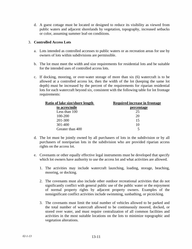
02-1-13 13-11
d. A guest cottage must be located or designed to reduce its visibility as viewed from public waters and adjacent shorelands by vegetation, topography, increased setbacks or color, assuming summer leaf-on conditions.
3. Controlled Access Lots a. Lots intended as controlled accesses to public waters or as recreation areas for use by
owners of lots within subdivisions are permissible. b. The lot must meet the width and size requirements for residential lots and be suitable
for the intended uses of controlled access lots. c. If docking, mooring, or over-water storage of more than six (6) watercraft is to be
allowed at a controlled access lot, then the width of the lot (keeping the same lot depth) must be increased by the percent of the requirements for riparian residential lots for each watercraft beyond six, consistent with the following table for lot frontage requirements:
Ratio of lake size/shore length Required increase in frontage to acres/mile percentage Less than 100 25 100-200 20 201-300 15 301-400 10 Greater than 400 5 d. The lot must be jointly owned by all purchasers of lots in the subdivision or by all
purchasers of nonriparian lots in the subdivision who are provided riparian access rights on the access lot.
e. Covenants or other equally effective legal instruments must be developed that specify
which lot owners have authority to use the access lot and what activities are allowed. 1. The activities may include watercraft launching, loading, storage, beaching,
mooring, or docking. 2. The covenants must also include other outdoor recreational activities that do not
significantly conflict with general public use of the public water or the enjoyment of normal property rights by adjacent property owners. Examples of the nonsignificant conflict activities include swimming, sunbathing, or picnicking.
3. The covenants must limit the total number of vehicles allowed to be parked and
the total number of watercraft allowed to be continuously moored, docked, or stored over water, and must require centralization of all common facilities and activities in the most suitable locations on the lots to minimize topographic and vegetation alterations.

02-1-13 13-12
4. The covenants must also require all parking areas, storage structures, and other
facilities to be screened by vegetation or topography as much as practical from view from the public water, assuming summer, leaf-on conditions.
4. High Water Elevations a. Structures must be placed in accordance with any floodplain regulations applicable to
the site. Where these controls do not exist, the elevation to which the lowest floor, including basement, is placed or flood-proofed must be determined as follows:
1. For lakes, by placing the lowest floor at a level at least three (3) feet above the
highest known water level, or three (3) feet above the ordinary high water level, whichever is greater.
2. For rivers and streams there are three possible approaches. a. Place the lowest floor at least three (3) feet above the flood of record, if data
are available. b. If data are not available, place the lowest floor at least three (3) feet above the
ordinary high water level. c. Or, by conducting a technical evaluation to determine effects of proposed
construction upon flood stages and flood flows and to establish a flood protection evaluation. Under all three approaches, technical evaluations must be done by a licensed professional engineer or hydrologist consistent with parts 6120.5000 to 6120.6200 of Minnesota Regulations, as amended from time to time, governing the management of flood plain areas.
d. If more than one (1) approach is used, the highest flood protection elevation
determined must be used for placing structures and other facilities. b. Water-oriented accessory structures may have the lowest floor placed lower than the
elevation determined in this item if the structure is constructed of flood-resistant materials to the elevation, electrical and mechanical equipment is placed above the elevation and, if long duration flooding is anticipated, the structure is built to withstand ice action and wind-driven waves and debris.
5. Water-oriented Accessory Structures a. Each lot may have one (1) water-oriented accessory structure.
02-1-13 13-13
b. Water-oriented accessory structures used solely for watercraft storage, and including
storage of related boating and water-oriented sporting equipment (boathouses), may occupy an area up to four hundred (400) square feet on Recreational Development (RD) lakes only, provided the maximum width of the structure is twenty (20) feet as measured parallel to the configuration of the shoreline.
c. Water-oriented accessory structures must not exceed two hundred fifty (250) square
feet on Natural Environment Lakes (NE) provided the maximum width of the structure is twenty (20) feet as measured parallel to the configuration of the shoreline.
d. The water-oriented accessory structure must not exceed ten (10) feet in height,
exclusive of safety rails, and cannot occupy an area greater than two hundred fifty (250) square feet provided the maximum width of the structure is twenty (20) feet as measured parallel to the configuration of the shoreline.
e. Detached decks must not exceed eight (8) feet above grade at any point and cannot
occupy an area greater than two hundred fifty (250) square feet provided the maximum width of the structure is twenty five (25) feet as measured parallel to the configuration of the shoreline.
f. The setback of the structure from the ordinary high water level must be at least ten
(10) feet. g. For conforming lots, all water orientated accessory structures shall be set back fifteen
(15) feet from side yard property lines. h. For non-conforming Lots of Record, all water orientated accessory structures shall be
set back ten (10) feet from side yard property lines.
i. No water-oriented accessory structure shall be designed or used for human habitation and must not contain water supply or sewage treatment facilities.
j. The roof may be used as a deck with safety rails, but must not be enclosed or used as
a storage area. k. The structure or facility must be treated to reduce visibility as viewed from public
waters and adjacent shorelands by vegetation, topography, increased setbacks or color, assuming summer, leaf-on conditions;
6. Stairways, Lifts, Landings and Paths a. Stairways, lifts and paths must not exceed four (4) feet in width on residential lots.
One (1) wider stairway may be used, up to six (6) feet, for commercial properties, public open-space recreational properties, and planned unit developments.

02-1-13 13-14
b. Landings for stairways and lifts on residential lots must not exceed thirty two (32) square feet in area. One (1) larger landing may be used, up to ninety six (96) square feet, for commercial properties, public open-space recreational properties, and planned unit developments.
c. Canopies or roofs are not allowed. d. Stairways, lifts, and landings may be either constructed above the ground on posts or
pilings, or placed into the ground, provided they are designed and built in a manner that ensures control of soil erosion;
e. Stairways, lifts, landings and paths must be located in the most visually
inconspicuous portions of lots, as viewed from the surface of the public water assuming summer, leaf-on conditions, whenever practical; and
f. Facilities such as ramps, lifts, or mobility paths for physically handicapped persons
are also allowed for achieving access to shore areas, provided that the dimensional and performance standards set forth herein are complied with in addition to the requirements of Minnesota Regulations, Chapter 1340 as amended from time to time.
7. Retaining Walls
a. Permitted Use 1. Retaining walls located outside the shore impact zone; three (3) feet in height or
less; twenty five (25) feet in length or less as measured parallel to the configuration of the shoreline; or on slopes less than twelve (12) percent.
2. Land Alteration Plan is required as approved by the department.
3. Scaled site plan with 2-foot contours depicting existing topography. As-Built
upon completion. 4. Inconspicuous location and vegetative screening as viewed from the water,
assuming summer, leaf-on conditions. 5. A row of boulders, more than thirty (30) inches in diameter, shall be considered a
retaining wall. b. Conditional Use 1. Retaining walls located within the shore impact zone or outside the shore impact
zone, but greater than three (3) feet in height or greater than twenty five (25) feet in length as measured parallel to the configuration of the shoreline or on steep slopes.
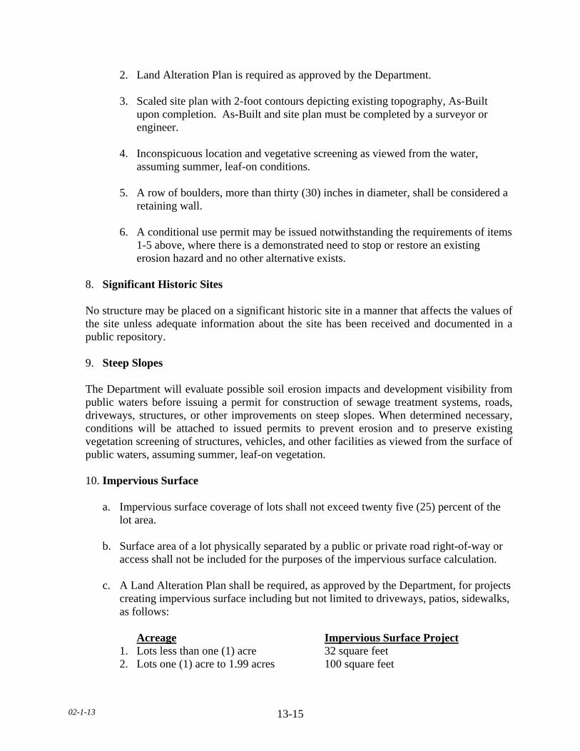
02-1-13 13-15
2. Land Alteration Plan is required as approved by the Department. 3. Scaled site plan with 2-foot contours depicting existing topography, As-Built
upon completion. As-Built and site plan must be completed by a surveyor or engineer.
4. Inconspicuous location and vegetative screening as viewed from the water,
assuming summer, leaf-on conditions. 5. A row of boulders, more than thirty (30) inches in diameter, shall be considered a
retaining wall. 6. A conditional use permit may be issued notwithstanding the requirements of items
1-5 above, where there is a demonstrated need to stop or restore an existing erosion hazard and no other alternative exists.
8. Significant Historic Sites No structure may be placed on a significant historic site in a manner that affects the values of the site unless adequate information about the site has been received and documented in a public repository.
9. Steep Slopes The Department will evaluate possible soil erosion impacts and development visibility from
public waters before issuing a permit for construction of sewage treatment systems, roads, driveways, structures, or other improvements on steep slopes. When determined necessary, conditions will be attached to issued permits to prevent erosion and to preserve existing vegetation screening of structures, vehicles, and other facilities as viewed from the surface of public waters, assuming summer, leaf-on vegetation.
10. Impervious Surface a. Impervious surface coverage of lots shall not exceed twenty five (25) percent of the
lot area. b. Surface area of a lot physically separated by a public or private road right-of-way or
access shall not be included for the purposes of the impervious surface calculation. c. A Land Alteration Plan shall be required, as approved by the Department, for projects
creating impervious surface including but not limited to driveways, patios, sidewalks, as follows:
Acreage Impervious Surface Project 1. Lots less than one (1) acre 32 square feet 2. Lots one (1) acre to 1.99 acres 100 square feet
02-1-13 13-16
d. Impervious surface shall not be allowed in the shore impact zone, except for
stairways, lifts, landings, paths and water-oriented accessory structures. e. Direct drainage away from the lake and into pervious, grassed yards through site
grading, rain gutters and downspouts shall be implemented for stormwater management.
f. Constructed facilities used for stormwater management shall be designed and
installed consistent with the field office technical guide of the Le Sueur County SWCD or the Agency Stormwater Manual.. Accepted practices including but not limited to, gutters, rain gardens, grassed swales, permeable pavers, bioretention basins, underground storage, rain barrels and vegetated buffers.
g. Newly constructed stormwater outfalls to public waters must provide for filtering or
settling of suspended solids and skimming of surface debris before discharge in accordance with Best Management Practices.
B. SHORELAND ALTERATIONS 1. Alterations of vegetation and topography will be regulated per Minnesota Rule
6120.3300, Subpart 4, to prevent erosion into public waters, fix nutrients, preserve shoreland aesthetics, preserve historic values, prevent bank slumping, and protect fish and wildlife habitat.
2. Vegetation Alterations. Removal or alteration of vegetation, except for agricultural and
forest management uses as regulated in this Section, is allowed by permit subject to the following standards:
a. Vegetation alterations located within a shore or bluff impact zone. 1. Vegetation alterations within the shore or bluff impact zones may be allowed with
a Land Alteration Plan as approved by the Department. 2. Removal of trees, shrubs, limbs or branches shall not be allowed other than those
that are invasive species, dead, diseased or pose a safety hazard. 3. Pruning and trimming of the lower branches of trees is allowed to provide a view
of the lake from the lower story windows of the principal structure. 4. Trimming and/or removal of trees is allowed if in connection with another
permitted use.
b. Vegetation alterations located between the shore or bluff impact zone and the required structure setback line.
02-1-13 13-17
1. Removal of up to twenty five (25) percent of the trees and up to fifty (50) percent shrubs is allowed.
2. Except as provided in item 1 above, removal of trees, shrubs, limbs or branches
shall not be allowed other than those that are invasive species, dead, diseased or pose a safety hazard.
3. Pruning and trimming of the lower branches of trees is allowed to provide a view
of the lake from the lower story windows of the principal structure. 4. Trimming and/or removal of trees is allowed if in connection with another
permitted use.
c. All vegetative alterations are subject to the following conditions.
1. Exposed bare soil shall be covered with mulch or similar materials within twenty four (24) hours.
2. A permanent vegetation cover shall be established within fourteen (14) days of
completion of the project through a re-vegetation plan as approved by the Department.
3. Removal of vegetation shall not be greater than fifteen (15) feet in width in any
contiguous strip. 4. Screening of structures or other improvements, including but not limited to
parking areas as viewed from the water, assuming summer, leaf-on conditions, shall not be substantially reduced.
5. Along rivers, existing shading of water surfaces must be preserved. 6. All cutting shall be by hand at ground level. Topsoil shall not be disturbed and
the root system must remain in place. 7. Erosion control and stormwater control methods as indicated by the Le Sueur
County SWCD shall be implemented. 3. Topographic Alterations/Grading, Excavating or Filling a. All grading, excavating or filling activities, including but not limited to, rip rap, sand
and gravel, shall comply with all applicable standards in this Ordinance.
02-1-13 13-18
b. Grading, excavating or filling activities necessary for the construction of structures,
sewage treatment systems, and driveways under validly issued construction permits for these facilities do not require the issuance of a separate grading, excavating or filling permit. However, the grading, excavating or filling standards in this Ordinance must be incorporated into the issuance of permits for construction of structures, sewage treatment systems, and driveways.
c. The following considerations and conditions must be adhered to during the issuance
of construction permits, grading, excavating or filling permits, conditional use permits, variances and subdivision approvals:
1. Fill or excavated material must not be placed in bluff impact zones. 2. Any alterations below the ordinary high water level of public waters must be
authorized by the commissioner under Minnesota Statutes, Section 103G.245. 3. Alterations of topography must only be allowed if they are accessory to permitted
or conditional uses and do not adversely affect adjacent or nearby properties. 4. Grading or filling in any type 2, 3, 4, 5, 6, 7, or 8 wetland must be evaluated to
determine how extensively the proposed activity would affect the following functional qualities of the wetland:
a. Sediment and pollutant trapping and retention. b. Storage of surface runoff to prevent or reduce flood damage. c. Fish and wildlife habitat. d. Recreational use. e. Shoreline or bank stabilization, f. Noteworthiness, including special qualities such as historic significance,
critical habitat for endangered plants and animals, or others. g. This evaluation must also include a determination of whether the wetland
alteration being proposed complies with the Minnesota Wetland Conservation Act, as amended or requires permits, reviews, or approvals by other local, state, or federal agencies such as a watershed district, the Minnesota Department of Natural Resources, or the United States Army Corps of Engineers. The applicant will be so advised.
5. Alterations must be designed and conducted in a manner that ensures only the
smallest amount of bare ground is exposed for the shortest time possible.
02-1-13 13-19
6. Mulches or similar materials must be used, where necessary, for temporary bare soil coverage, and a permanent vegetation cover must be established as soon as possible.
7. Methods to minimize soil erosion and to trap sediments before they reach any
surface water feature must be used for any development of one (1) acre or larger. Guidelines for sediment control contained within the Board of Water and Soil Resources' "Minnesota Construction Site Erosion and Sediment Control Planning Handbook" should be utilized.
8. Altered areas must be stabilized to acceptable erosion control standards consistent
with the field office technical guides of the local SWCD and the United States Natural Resource Conservation Service.
9. Fill or excavated material must not be placed in a manner that creates an unstable
slope. 10. Plans to place fill or excavated material on steep slopes must be reviewed by
qualified professionals as approved by the Department for continued slope stability and must not create finished slopes of thirty (30) percent or greater.
11. Placement of natural rock riprap, including associated grading of the shoreline
and placement of a filter blanket, is permitted if the finished slope does not exceed three (3) feet horizontal to one (1) foot vertical, the landward extent of the riprap is within ten (10) feet of the ordinary high water level, and the height of the riprap above the ordinary high water level does not exceed three (3) feet.
d. Public roads and parking areas as regulated by this Ordinance. e. Excavations where the intended purpose is a connection to public waters, such as boat
slips, canals, lagoons, and harbors, must be controlled by local shoreland controls. Permission for excavations may be given only after the commissioner has approved the proposed connection to public waters.
4. Placement and Design of Roads, Driveways, and Parking Areas a. Public and private roads and parking areas must be designed to take advantage of
natural vegetation and topography to achieve maximum screening from view from public waters. Documentation must be provided by a qualified individual as approved by the Department that all roads and parking areas are designed and constructed to minimize and control erosion to public waters consistent with the field office technical guides of Le Sueur County SWCD, or other applicable technical materials.
b. Roads, driveways, and parking areas must not be placed within bluff and shore
impact zones.

02-1-13 13-20
c. Public and private watercraft access ramps, approach roads, and access-related parking areas may be placed within shore impact zones with a conditional use permit, provided the vegetation screening and erosion control conditions are met and must be designed to minimize adverse impacts.
d. For private facilities, the grading, excavating or filling provisions of this Ordinance
must be met. 5. Riprap a. Land Alteration Plan is required as approved by the Department. b. Riprap is allowed only where there is a demonstrated need to stop existing erosion or
to restore an eroded shoreline. c. Installation shall meet all grading, filling and excavating standards as regulated by
this Ordinance. d. Only natural rock, excluding limestone and similar erosive materials, shall be used
that is free of debris that may cause pollution or siltation. e. Rock riprap cannot average less than six (6) inches or more than thirty (30) inches in
diameter. f. A filter of crushed rock, gravel, excluding limestone or other erosive materials, or
filter fabric material shall be placed underneath the rock riprap. g. The minimum finished slope above the OHWL shall not be steeper than 3 to1, as
measured horizontal to vertical. h. The riprap shall conform to the natural alignment of the shore. i. Live cuttings and plant plugs may be planted within riprap. j. For lakes, the riprapped area shall be two hundred (200) linear feet or less of
shoreline along lakes and wetlands. k. For streams, the riprapped area shall be less than five (5) times the average width of
the affected watercourse. l. The site must not be a posted fish spawning area or designated trout stream. m. Any activity below the ordinary high water level shall meet all DNR standards
02-1-13 13-21
6. Beach Sand Blanket a. Land Alteration Plan is required as approved by the Department. b. The sand or gravel layer, excluding limestone or other erosive materials, may be up to
six (6) inches thick; up to fifty (50) feet wide along the shoreline or one-half (1/2) the width of the lot, whichever is less; and does not extend more than ten (10) feet above the ordinary high water level.
c. No plant barrier, liner or filter fabric material shall be placed underneath the beach
sand blanket. d. Beach sand blanket shall meet all grading, filling and excavating standards as
regulated by this Ordinance. e. Any activity below the ordinary high water level shall meet all DNR standards. 7. Rain Gardens a. Constructed rain gardens shall be designed and installed consistent with the field
office technical guide of the Le Sueur County SWCD or the Agency Stormwater Manual.
b. Set back no less than ten (10) feet from structures with foundations or basements. c. Set back no less than ten (10) feet from a sewage tank and twenty (20) feet from a
septic drainfield. d. Shall not be located on slopes twelve (12) percent or greater. e. Land Alteration Plan is required as approved by the Department. C. SPECIAL PROVISIONS 1. Commercial, Public and Semipublic Uses a. Surface water-oriented uses that need to have access to and use of public waters may
be located on parcels or lots with frontage on public waters, and must meet the following standards:
1. In addition to meeting all other zoning standards in this section, the uses must be
designed to incorporate topographic and vegetative screening of parking areas and structures.

02-1-13 13-22
2. Uses that require short-term watercraft mooring for patrons must centralize these
facilities and design them to avoid obstructions or navigation and to be the minimum size necessary to meet the need.
3. Uses that depend on patrons arriving by watercraft may use signs and lighting to
convey needed information to the public, subject to the sign and lighting standards of this Ordinance.
2. Agricultural Uses a. Agricultural uses are permitted uses if steep slopes and shore and bluff impact zones
are maintained in permanent vegetation or operated under an approved conservation plan consistent with the field office technical guides of the Le Sueur County SWCD or the United States Natural Resource Conservation Service, as provided by a qualified individual or agency.
b. The shore impact zone for parcels with permitted agricultural land uses is equal to a
line parallel to and fifty (50) feet from the ordinary high water level. 3. Conditional Uses
The following additional evaluation criteria and conditions apply to conditional uses within shoreland areas:
a. Evaluation criteria. A thorough evaluation of the water body and the topographic,
vegetation, and soils conditions on the site must be made to ensure: 1. The prevention of soil erosion or other possible pollution of public waters, both
during and after construction. 2. The visibility of structures and other facilities as viewed from public waters is
limited. 3. The site is adequate for water supply and on-site sewage treatment. 4. The types, uses, and numbers of watercraft that the project will generate are
compatible in relation to the suitability of public waters to safely accommodate this watercraft.
b. Conditions attached to Conditional Use Permits. The Board of County
Commissioners, upon consideration of the criteria listed above and the purposes of this Ordinance, shall attach such conditions to the issuance of the conditional use permits as it deems necessary to fulfill the purposes of this Ordinance. Such conditions may include, but are not limited to, the following:
02-1-13 13-23
1. Increased setbacks from the ordinary high water level. 2. Limitations on the natural vegetation to be removed or the requirement that
additional vegetation be planted. 3. Special provisions for the location, design, and use of structures, sewage
treatment system, watercraft, launching and docking areas, and vehicle parking areas.
SUBDIVISION 6. NONCONFORMITIES A. See Section 24 of this Ordinance for further non-conformity requirements.
B. All legally established nonconformities as of June 18, 1996 may continue, but they will be
managed according to applicable state statutes, rules, and other regulations of this county for the subjects of alterations and additions, repair after damage, discontinuance of use, and intensification of use, except that the following standards will also apply in shoreland areas.
1. In accordance with Minnesota State Statute 394.36, as amended from time to time, the
following shall apply to existing Nonconforming Lots in Shoreland Areas. a. This subdivision applies to shoreland lots of record in the office of the County
Recorder on the date of adoption of local shoreland controls that do not meet the requirements for lot size or lot width. The County shall regulate the use of nonconforming lots of record and the repair, replacement, maintenance, improvement, or expansion of nonconforming uses and structures in shoreland areas with the following regulations:
b. A nonconforming single lot of record located within a shoreland area may be
allowed as a building site without variances from lot size requirements, provided that:
1. All structure and septic system setback distance requirements can be met. 2. A Type 1 sewage treatment system consistent with Minnesota Rules, chapter
7080, can be installed or the lot is connected to a public sewer. 3. The impervious surface coverage does not exceed twenty five (25) percent
of the lot. c. In a group of two (2) or more contiguous lots of record under a common
ownership, an individual lot must be considered as a separate parcel of land for the purpose of sale or development, if it meets the following requirements:
02-1-13 13-24
1. The lot must be at least sixty six (66) percent of the dimensional standard for lot width and lot size for the shoreland classification consistent with Minnesota Rules, chapter 6120.
2. The lot must be connected to a public sewer, if available, or must be suitable
for the installation of a Type 1 sewage treatment system consistent with Minnesota Rules, chapter 7080, and local government controls.
3. Impervious surface coverage must not exceed twenty five (25) percent of
each lot. 4. Development of the lot must be consistent with an adopted comprehensive
plan. d. A lot subject to paragraph (c) not meeting the requirements of paragraph (c)
must be combined with the one or more contiguous lots so they equal one or more conforming lots as much as possible.
e. Notwithstanding paragraph (c), contiguous nonconforming lots of record in
shoreland areas under a common ownership must be able to be sold or purchased individually if each lot contained a habitable residential dwelling at the time the lots came under common ownership and the lots are suitable for, or served by, a sewage treatment system consistent with the requirements of section 115.55 and Minnesota Rules, chapter 7080, or connected to a public sewer.
f. In evaluating all variances, zoning permit applications, or conditional use
requests, the Department shall require the property owner to address, when appropriate, storm water runoff management, reducing impervious surfaces, increasing setback, restoration of wetlands, vegetative buffers, sewage treatment and water supply capabilities, and other conservation-designed actions.
g. A portion of a conforming lot may be separated from an existing parcel as long
as the remainder of the existing parcel meets the lot size and sewage system requirements of the zoning district for a new lot and the newly created parcel is combined with an adjacent parcel.
02-1-13 13-25
SECTION 13.1 SPECIAL PROTECTION (SP) DISTRICT SUBDIVISION 1. PURPOSE Lands within this Zoning District include shoreland areas adjacent to Recreational Development (RD) and Natural Environment (NE) lakes, agricultural and transitional rivers and tributary streams where agriculture or open space is the predominant use. The water feature needs protection from development and agriculture uses should utilize best management practices that prevent or reduce nonpoint source pollution to surface or groundwater. Housing density should be the same as in the Agriculture (A) District. Dwellings, livestock production and other intense land uses should be kept to a minimum. However, transfer of development rights may be utilized to exceed the permitted housing density of one dwelling per quarter-quarter section (40 acres), providing that the density does not exceed four dwellings per quarter-quarter section in the receiving quarter-quarter section. Lots of record shall be exempt from density standards. SUBDIVISION 2. PERMITTED USES The following uses shall be permitted within the Special Protection (SP) District: A. Agriculture, including crop production and pasturing utilizing agricultural best management
practices. B. Existing feedlots as of June 18, 1996. C. Accessory structures within existing building sites. D. Sensitive resource management of nature areas, hiking trails, wildlife preserves, or
designated official wetland areas and forest preserves owned or operated by governmental agencies.
E. Forest management outside shore and bluff impact zones. F. One (1) single-family dwelling per existing building site, Lot of Record or quarter-quarter
section. G. One (1) temporary dwelling per lot that will be occupied for one (1) year or less.
H. Home occupations, Level I.
I. Non-Commercial Wind Energy Conversion System. J. Retaining walls located outside the shore impact zone; three (3) feet in height or less; twenty
five (25) feet in length or less as measured parallel to the configuration of the shoreline; or on slopes less than twelve (12) percent.
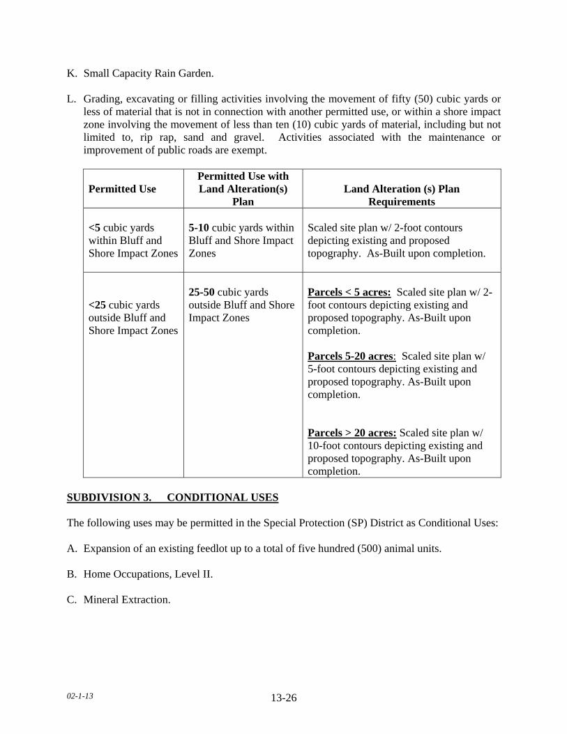
02-1-13 13-26
K. Small Capacity Rain Garden. L. Grading, excavating or filling activities involving the movement of fifty (50) cubic yards or
less of material that is not in connection with another permitted use, or within a shore impact zone involving the movement of less than ten (10) cubic yards of material, including but not limited to, rip rap, sand and gravel. Activities associated with the maintenance or improvement of public roads are exempt.
Permitted Use
Permitted Use with Land Alteration(s)
Plan Land Alteration (s) Plan
Requirements <5 cubic yards within Bluff and Shore Impact Zones
5-10 cubic yards within Bluff and Shore Impact Zones
Scaled site plan w/ 2-foot contours depicting existing and proposed topography. As-Built upon completion.
<25 cubic yards outside Bluff and Shore Impact Zones
25-50 cubic yards outside Bluff and Shore Impact Zones
Parcels < 5 acres: Scaled site plan w/ 2-foot contours depicting existing and proposed topography. As-Built upon completion. Parcels 5-20 acres: Scaled site plan w/ 5-foot contours depicting existing and proposed topography. As-Built upon completion. Parcels > 20 acres: Scaled site plan w/ 10-foot contours depicting existing and proposed topography. As-Built upon completion.
SUBDIVISION 3. CONDITIONAL USES The following uses may be permitted in the Special Protection (SP) District as Conditional Uses: A. Expansion of an existing feedlot up to a total of five hundred (500) animal units. B. Home Occupations, Level II. C. Mineral Extraction.
02-1-13 13-27
D. Water supply tanks or buildings, reservoirs, commercial wells, gas regulator stations, electric substations or transmission lines greater than 35kV, railroad right-of-way, but not including railroad yards, public sewage treatment facilities and other similar essential public utility and service structures.
E. Parks, recreational areas and historic sites. F. Retaining walls located within the shore impact zone or greater than three feet in height or
greater than twenty five (25) feet in length as measured parallel to the configuration of the shoreline or on steep slopes.
G. Forest management within the shore and bluff impact zones. H. One (1) temporary dwelling per lot that will be occupied for one (1) year or more. I. Bed and Breakfast Inns. J. Special Events. K. Transfer of Development Rights. L. Commercial Wind Energy Conversion System. M. Large Capacity Rain Garden. N. Grading, excavating or filling activities within the bluff. O. Grading, excavating or filling activities, excluding small capacity rain gardens, involving the
movement of more than fifty (50) cubic yards of material that is not in connection with another permitted use, or within shore or bluff impact zones involving the movement of more than ten (10) cubic yards of material, including but not limited to, rip rap, sand and gravel. Activities associated with the maintenance or improvement of public roads are exempt.
(TABLE ON NEXT PAGE)
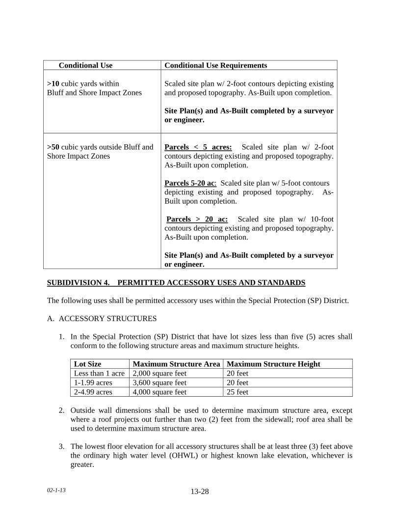
02-1-13 13-28
SUBIDIVISION 4. PERMITTED ACCESSORY USES AND STANDARDS The following uses shall be permitted accessory uses within the Special Protection (SP) District. A. ACCESSORY STRUCTURES 1. In the Special Protection (SP) District that have lot sizes less than five (5) acres shall
conform to the following structure areas and maximum structure heights.
Lot Size Maximum Structure Area Maximum Structure Height Less than 1 acre 2,000 square feet 20 feet 1-1.99 acres 3,600 square feet 20 feet 2-4.99 acres 4,000 square feet 25 feet
2. Outside wall dimensions shall be used to determine maximum structure area, except
where a roof projects out further than two (2) feet from the sidewall; roof area shall be used to determine maximum structure area.
3. The lowest floor elevation for all accessory structures shall be at least three (3) feet above
the ordinary high water level (OHWL) or highest known lake elevation, whichever is greater.
Conditional Use Conditional Use Requirements >10 cubic yards within Bluff and Shore Impact Zones
Scaled site plan w/ 2-foot contours depicting existing and proposed topography. As-Built upon completion. Site Plan(s) and As-Built completed by a surveyor or engineer.
>50 cubic yards outside Bluff and Shore Impact Zones
Parcels < 5 acres: Scaled site plan w/ 2-foot contours depicting existing and proposed topography. As-Built upon completion. Parcels 5-20 ac: Scaled site plan w/ 5-foot contours depicting existing and proposed topography. As-Built upon completion. Parcels > 20 ac: Scaled site plan w/ 10-foot contours depicting existing and proposed topography. As-Built upon completion. Site Plan(s) and As-Built completed by a surveyor or engineer.
02-1-13 13-29
4. No accessory structure or use shall be constructed or developed on a lot prior to
construction of the principal dwelling. B. SWIMMING POOL. PERMANENT 1. No pool shall be located within ten (10) feet of a septic tank/drain field. 2. No pool shall be located beneath overhead electrical lines or over underground utility
lines of any type. 3. No pool shall be located within any private or public utility, walkway, drainage, or other
easement. 4. Lighting for the pool shall be oriented so as not to cast light onto adjacent properties. 5. A fence of at least five (5) feet in height shall completely enclose the pool area and the
access to the pool area shall be controlled. C. HEIGHT AND SEPARATION REGULATIONS
1. For parcels greater than five (5) acres, there shall be a maximum height limitation of one
hundred and fifty (150) feet on all structures. Any structure including but not limited to tower, spire and similar type structure, only after obtaining a letter of clearance from the Federal Aeronautics Administration and the Airport Commission for any airport located within ten (10) miles of the structure proposed to exceed the height limitation.
2. In case an accessory structure is attached to the principal structure, it shall be made structurally a
part of the principal structure and shall comply in all respects with the requirements of this Ordinance applicable to the principal structure.
3. An accessory structure shall not be closer than five (5) feet to the principal structure. a. In case an accessory structure is attached to the principal structure, it shall be made
structurally a part of the principal structure and shall comply in all respects with the requirements of this Ordinance applicable to the principal structure.
D. DRAINAGE Adequate drainage shall be provided and the drainage shall be directed away from adjacent private property. E. Other accessory uses customarily incidental to the uses permitted in Section 13.1.
02-1-13 13-30
SUBDIVISION 5. DIMENSIONAL REGULATIONS A. SETBACK EXEMPTIONS/STRUCTURE EXPANSIONS 1. In such cases, where proposed additions do not encroach further into the front, side, or
rear yard than the existing structure, such additions will be permitted provided the use and the structure are in conformance with the following restrictions:
a. The use of the structure is conforming to the zoning district in which it is located. b. The expansion of the structure shall not be located closer to the property line than the
existing structure or at least one-half (1/2) of the required setback, whichever is greater.
c. The expansion of the structure will not reduce any other required setback below the minimum standards of this Ordinance.
d. The expansion of the structure will conform to all other restrictions of this Ordinance,
including but not limited to, density, lot coverage and structure height. e. The height of the expansion shall not be greater than the existing structure at the
existing building line. f. The proposed addition is not located in shore or bluff impact zones. B. FRONT YARD SETBACKS
1. There shall be a front yard setback of not less than eighty five (85) feet from the right-of-
way of State-Federal trunk arterials, expressways and State collector arterials. 2. There shall be a front yard setback of not less than seventy five (75) feet from the right-
of-way of County Highways. 3. There shall be a front yard setback of not less than sixty five (65) feet from a township or
any other public or private right-of-way. 4. When a lot is located at the intersection of two (2) or more roads, there shall be a front
yard setback on each road right-of-way. 5. All components an onsite Subsurface Sewage Treatment System (SSTS) shall be twenty
(20) feet from all road right-of-ways. 6. All components of an onsite Subsurface Sewage Treatment System (SSTS) for a non-
conforming Lot of Record shall be ten (10) feet from all road right-of-ways.

02-1-13 13-31
7. The required front yard of a corner lot shall be unobstructed above a height of three (3) feet in a triangular area, two (2) sides of which are the lines running parallel along the right of way lines between the road intersection and a point fifty (50) feet from the intersection, and the third site of which is the line between the latter two (2) points.
8. No trees or shrubs shall be planted within ten (10) feet from any right-of-way. 9. On nonconforming Lots of Record, accessory structures with a door six (6) feet wide or
greater which faces any road right-of-way shall be set back a minimum of twenty five (25) feet. All other accessory structures shall be set back a minimum of ten (10) feet from the road right-of-way.
C. SIDE YARD SETBACKS
1. All structures shall have a side yard setback of not less than fifty (50) feet. 2. For conforming lots, all water orientated accessory structures shall be set back fifteen
(15) feet from side yard property lines. 3. For nonconforming Lots of Record, all water orientated accessory structures shall be set
back ten (10) feet from side yard property lines.
D. REAR YARD SETBACKS
All structures shall have a rear yard setback of not less than fifty (50) feet.
E. ORDINARY HIGH WATER LEVEL (OHWL) SETBACKS 1. Structure and Subsurface Sewage Treatment System (SSTS) setbacks from Ordinary
High Water Level (OHWL). Classification Structure SSTS NE Lake 250 feet 200 feet RD Lake 150 feet 100 feet Agricultural River 150 feet 100 feet Transitional River 150 feet 100 feet Tributary River 150 feet 100 feet 2. A new dwelling constructed on a nonconforming Lot of Record may have a reduced
OHWL setback with the following restrictions: a. There shall be an existing dwelling located on each side of the lot. b. The new dwelling shall not be located closer to the OHWL than the existing
dwellings located on the adjacent, or at least one-half of the required set back whichever is greater.
02-1-13 13-32
c. The structure is not located in a shore impact zone or in a bluff impact zone. 3. A new dwelling constructed on a nonconforming Lot of Record may have a reduced
OHWL setback if one of the adjacent lots is vacant with the following restrictions: a. There shall be an existing dwelling located on one side of the lot. b. The setback for the Lot of Record shall be the setback of the dwelling on the adjacent
lot plus one half (1/2) the difference between the setback of the adjacent dwelling and the setback required by the Ordinance.
c. The structure is not located in a shore impact zone or in a bluff impact zone.
4. One (1) water-oriented accessory structure designed in accordance with this Section shall
be set back a minimum distance of ten (10) feet from the ordinary high water level. 5. No expansion or modification of existing feedlots shall result in encroachment closer to
the ordinary high water level than the existing setback or three hundred (300) feet, whichever is greater.
F. BLUFF SETBACKS 1. All structures shall be set back from the top and/or toe of the bluff:
a. Thirty (30) feet for bluffs with slopes eighteen (18) to thirty (30) percent. b. Fifty (50) feet for bluffs with slopes greater than thirty (30) percent. c. Existing Building Sites. All structures shall be set back thirty (30) feet from the top
or toe of the bluff. 2. SSTS shall be set back thirty (30) feet from the top or toe of the bluff. a. SSTS upgrade and/or replacement for an existing dwelling:
1. Shall be exempt from bluff setback. 2. May be located within the bluff impact zone. 3. Shall not be located within the bluff.
3. If the adjacent bluff is actively eroding, the Department may increase the setback
requirement.
4. Structures and accessory facilities, except stairways and landings, must not be placed within bluff impact zones.
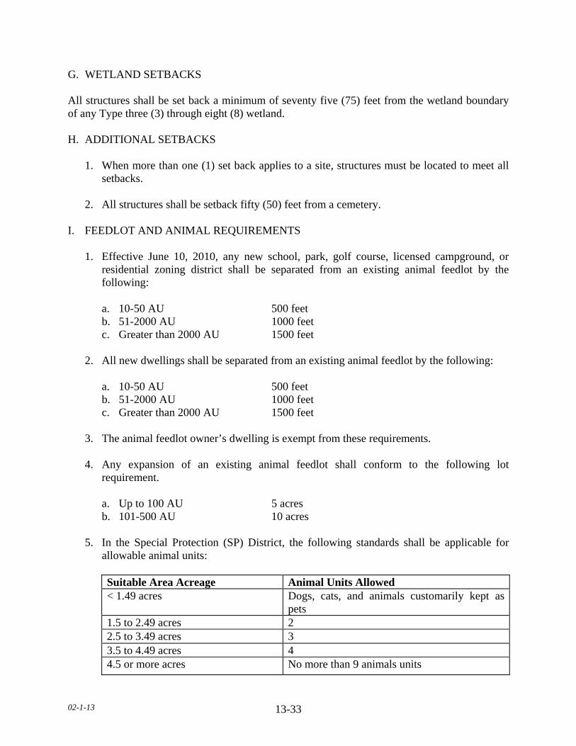
02-1-13 13-33
G. WETLAND SETBACKS All structures shall be set back a minimum of seventy five (75) feet from the wetland boundary of any Type three (3) through eight (8) wetland. H. ADDITIONAL SETBACKS
1. When more than one (1) set back applies to a site, structures must be located to meet all setbacks.
2. All structures shall be setback fifty (50) feet from a cemetery.
I. FEEDLOT AND ANIMAL REQUIREMENTS 1. Effective June 10, 2010, any new school, park, golf course, licensed campground, or
residential zoning district shall be separated from an existing animal feedlot by the following:
a. 10-50 AU 500 feet b. 51-2000 AU 1000 feet c. Greater than 2000 AU 1500 feet 2. All new dwellings shall be separated from an existing animal feedlot by the following: a. 10-50 AU 500 feet b. 51-2000 AU 1000 feet c. Greater than 2000 AU 1500 feet 3. The animal feedlot owner’s dwelling is exempt from these requirements. 4. Any expansion of an existing animal feedlot shall conform to the following lot
requirement. a. Up to 100 AU 5 acres b. 101-500 AU 10 acres 5. In the Special Protection (SP) District, the following standards shall be applicable for
allowable animal units:
Suitable Area Acreage Animal Units Allowed < 1.49 acres Dogs, cats, and animals customarily kept as
pets 1.5 to 2.49 acres 2 2.5 to 3.49 acres 3 3.5 to 4.49 acres 4 4.5 or more acres No more than 9 animals units

02-1-13 13-34
6. In the Special Protection (SP) District the following maximum number of domestic
animals are allowed:
Number Of Cats
NumberOf Dogs
Kennel (CUP) Animal Shelter (CUP)
5 3 NA NA
J. LOT AREA, WIDTH & DEPTH 1. Lot standards for all single-family dwelling lots in sewered and unsewered, riparian and
nonriparian lots.
2. Lakes. On Natural Environment (NE) and Recreational Development (RD) Lakes the minimum lot area (in square feet) and minimum lot width at the setback line from the ordinary high water level (OHWL) and road right-of-way and depth standards (in feet) shall be as follows:
3. Area Width Depth a. NE Lake 217,800 400 400 b. RD Lake 80,000 200 320
3. Rivers. On rivers, or streams classified as Agricultural, Transitional or Tributary the minimum lot area (in square feet and minimum lot width and depth standards (in feet) shall be the same as on a Natural Environment Lake.
4. Impervious surface of lots must not exceed twenty five (25) percent of the lot area. K. HEIGHT For parcels greater than five (5) acres, there shall be a maximum height limitation of one hundred and fifty (150) feet on all structures. Any structure including but not limited to tower, spire and similar type structure, only after obtaining a letter of clearance from the Federal Aeronautics Administration and the Airport Commission for any airport located within ten (10) miles of the structure proposed to exceed the height limitation.
L. BUILDABLE LOT STANDARDS 1. A Lot of Record, or other lot, tract, or parcel legally recorded with the County Recorder
that meets the requirements of this Ordinance and which has frontage on an improved and maintained public road, or an approved and maintained private road or easement is considered a buildable lot. The buildable lot shall have the contiguous required lot area of which not more than ten (10) percent is comprised of:
02-1-13 13-35
a. Area of a slope in excess of eighteen (18) percent. b. An impact zone. c. Floodplain. d. Wetland. e. Below the Ordinary High Water Level (OHWL). 2. Each new building site created after the adoption of this Ordinance must have a minimum
of forty thousand (40,000) square feet of contiguous buildable lot area. 3. Each new building site created after January 23, 1996 must have sufficient area for a
minimum of two (2) onsite sewage treatment systems.
4. Lots of Record that are substandard in area must conform to all other applicable regulations to qualify for placement of a dwelling.
SUBDIVISION 6. DWELLING STANDARDS A. PROHIBITED DWELLINGS No garage, tent, trailer, or accessory structure shall at any time be used as a dwelling. B. DWELLING REGULATIONS 1. No more than one (1) dwelling shall be placed on a lot except in the cases of temporary
dwellings. 2. All dwellings shall be on foundations or piles or other foundation systems extending
below the frost line, as approved by the Department. 3. The minimum dwelling width excluding porches, decks, or other similar attachments
shall be twenty (20) feet except in the cases of temporary dwellings. 4. All dwellings must conform with the sewage treatment regulations of this Ordinance. No
zoning permits will be issued for new dwellings prior to sewage treatment system approval.
5. Manufactured homes shall bear a State seal as verification of construction and inspection
to ANSI A119.1 standards during original construction (issued for manufactured homes built between July 1, 1972 to June 14, 1976) or, for manufactured homes built after that date, a Federal seal in accordance with HUD CFR 3280 Construction Standards.
6. All dwellings shall have a minimum of seven hundred sixty (760) square feet of floor
area on the ground floor.
7. Dwellings shall not exceed two and one-half (2 1/2) stories or thirty five (35) feet in height.

02-1-13 13-36
8. For all dwellings the lowest floor elevation shall be at least three (3) feet above the ordinary high water level (OHWL) or highest known lake elevation, whichever is greater.
9. Outside wall dimensions shall be used to determine maximum structure area, except
where a roof projects out further than two (2) feet from the sidewall; roof area shall be used to determine maximum structure area.
SUBDIVISION 7. ACCESS DRIVES, ACCESS AND SERVICE ROADS A. Access drives onto any public roads shall require a review by the Road Authority. The Road
Authority shall determine the appropriate location, size, and design of such access drives along public roads and may limit the number of access drives in the interest of public safety and efficient traffic flow.
B. Access drives shall be constructed and maintained to meet all of the following: 1. A minimum driving surface width of fourteen (14) feet. 2. Inslope no greater than 4 to 1, as measured horizontal to vertical. 3. Base material depth sufficient to support access by emergency vehicles. 4. Unobstructed width of not less than twenty (20) feet. 5. Unobstructed vertical clearance of not less than thirteen (13) feet, six (6) inches. C. Access drives in excess of one hundred fifty (150) feet in length shall provide a minimum
turn-around of sixty (60 feet in width by sixty (60) feet in length. D. Access drives shall have a twenty (20) foot long flat grade directly adjacent to the road that
the drive accesses. E. All lots or parcels with dwellings shall have direct physical access of adequate size for
emergency vehicles along the frontage of the lot or parcel from either an existing or dedicated public roadway.
F. All roads serving more than two (2) lots or parcels with dwellings shall be built to township road specifications or at least sixty six (66) feet wide with a minimum driving surface width of twenty four (24) feet.
G. Access drives shall not be located within the bluff or shore impact zones.
02-1-13 13-37
SUBDIVISION 8. GENERAL REGULATIONS A. STORAGE OF MATERIALS 1. All materials and equipment shall be stored within a structure or fully screened so as not
to be visible from adjoining properties, except for the following: a. Recreational equipment. b. Laundry drying equipment. c. Off-street parking of licensed passenger vehicles and pickup trucks.
d. Boats and unoccupied travel trailers, less than twenty (20) feet in length, are permissible if stored in the rear yard more than ten (10) feet from the property line.
2. No underground gasoline storage shall be permitted. 3. All land uses and development shall follow all other applicable regulations of this
Ordinance.

02-1-13 13-38
SECTION 13.2 RECREATIONAL RESIDENTIAL (RR) DISTRICT SUBDIVISION 1. PURPOSE A District, adjacent to Recreational Development (RD) and Natural Environment (NE) lakes, to preserve areas which have natural characteristics suitable for both passive and active recreational usage. Also, it is the intent of this District to manage areas suitable for residential development of varying types, including permanent and seasonal housing. Some non-residential uses with minimal impacts on residential uses may be allowed. SUBDIVISION 2. PERMITTED USES The following uses shall be permitted within the Recreational Residential (RR) District: A. Sensitive resource management, of nature areas, hiking trails, wildlife preserves, or
designated official wetland areas. B. One (1) single-family dwelling per existing building site, Lot of Record, platted lot or parcel. C. One (1) temporary dwelling per lot that will be occupied for one (1) year or less. D. Agriculture, including crop production and pasturing utilizing agricultural best management
practices, existing feedlots as of June 18, 1996, and accessory structures within existing building sites.
E. Forest management outside shore and bluff impact zones. F. Retaining walls located outside the shore impact zone; three (3) feet in height or less; twenty
five (25) feet in length or less as measured parallel to the configuration of the shoreline; or on slopes less than twelve (12) percent.
G. Small Capacity Rain Garden. H. Grading, excavating or filling activities involving the movement of fifty (50) cubic yards or
less of material that is not in connection with another permitted use, or within a shore impact zone involving the movement of less than ten (10) cubic yards of material including but not limited to, rip rap, sand and gravel. Activities associated with the maintenance or improvement of public roads are exempt.
(TABLE ON NEXT PAGE)
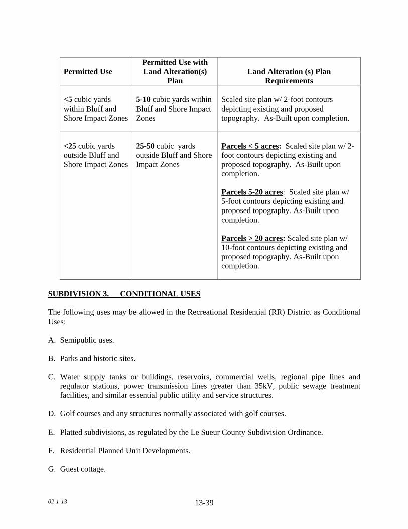
02-1-13 13-39
Permitted Use
Permitted Use with Land Alteration(s)
Plan Land Alteration (s) Plan
Requirements <5 cubic yards within Bluff and Shore Impact Zones
5-10 cubic yards within Bluff and Shore Impact Zones
Scaled site plan w/ 2-foot contours depicting existing and proposed topography. As-Built upon completion.
<25 cubic yards outside Bluff and Shore Impact Zones
25-50 cubic yards outside Bluff and Shore Impact Zones
Parcels < 5 acres: Scaled site plan w/ 2-foot contours depicting existing and proposed topography. As-Built upon completion. Parcels 5-20 acres: Scaled site plan w/ 5-foot contours depicting existing and proposed topography. As-Built upon completion. Parcels > 20 acres: Scaled site plan w/ 10-foot contours depicting existing and proposed topography. As-Built upon completion.
SUBDIVISION 3. CONDITIONAL USES The following uses may be allowed in the Recreational Residential (RR) District as Conditional Uses: A. Semipublic uses. B. Parks and historic sites. C. Water supply tanks or buildings, reservoirs, commercial wells, regional pipe lines and
regulator stations, power transmission lines greater than 35kV, public sewage treatment facilities, and similar essential public utility and service structures.
D. Golf courses and any structures normally associated with golf courses. E. Platted subdivisions, as regulated by the Le Sueur County Subdivision Ordinance. F. Residential Planned Unit Developments. G. Guest cottage.
02-1-13 13-40
H. Duplex, triplex, and quad residential dwellings on RD Lakes. I. Expansion of an existing animal feedlot up to a total of three hundred (300) animal units. J. Boat or vehicle access ramps in shore impact zone. K. Retaining walls located within the shore impact zone or greater than three (3) feet in height
or greater than twenty five (25) feet in length as measured parallel to the configuration of the shoreline or on steep slopes.
L. Forest management within the bluff & shore impact zones. M. Large Capacity Rain Garden. N. Grading, excavating or filling activities within the bluff. O. Grading, excavating or filling activities, excluding small capacity rain gardens, involving the
movement of more than fifty (50) cubic yards of material that is not in connection with another permitted use, or within shore or bluff impact zones involving the movement of more than ten (10) cubic yards of material, including but not limited to, rip rap, sand and gravel. Activities associated with the maintenance or improvement of public roads are exempt.
(TABLE ON NEXT PAGE)
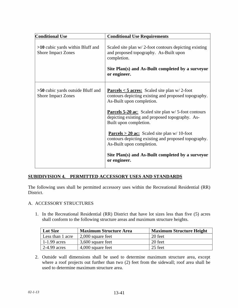
02-1-13 13-41
Conditional Use Conditional Use Requirements
>10 cubic yards within Bluff and Shore Impact Zones
Scaled site plan w/ 2-foot contours depicting existing and proposed topography. As-Built upon completion. Site Plan(s) and As-Built completed by a surveyor or engineer.
>50 cubic yards outside Bluff and Shore Impact Zones
Parcels < 5 acres: Scaled site plan w/ 2-foot contours depicting existing and proposed topography. As-Built upon completion. Parcels 5-20 ac: Scaled site plan w/ 5-foot contours depicting existing and proposed topography. As-Built upon completion. Parcels > 20 ac: Scaled site plan w/ 10-foot contours depicting existing and proposed topography. As-Built upon completion. Site Plan(s) and As-Built completed by a surveyor or engineer.
SUBIDIVISION 4. PERMITTED ACCESSORY USES AND STANDARDS The following uses shall be permitted accessory uses within the Recreational Residential (RR) District. A. ACCESSORY STRUCTURES 1. In the Recreational Residential (RR) District that have lot sizes less than five (5) acres
shall conform to the following structure areas and maximum structure heights. 2. Outside wall dimensions shall be used to determine maximum structure area, except
where a roof projects out further than two (2) feet from the sidewall; roof area shall be used to determine maximum structure area.
Lot Size Maximum Structure Area Maximum Structure Height Less than 1 acre 2,000 square feet 20 feet 1-1.99 acres 3,600 square feet 20 feet 2-4.99 acres 4,000 square feet 25 feet
02-1-13 13-42
3. The lowest floor elevation for all accessory structures shall be at least three (3) feet above the ordinary high water level (OHWL) or highest known lake elevation, whichever is greater.
4. No accessory structure or use shall be constructed or developed on a lot prior to
construction of the principal dwelling. B. SWIMMING POOL. PERMANENT 1. No pool shall be located within ten (10) feet of a septic tank/drain field. 2. No pool shall be located beneath overhead electrical lines or over underground utility
lines of any type. 3. No pool shall be located within any private or public utility, walkway, drainage, or other
easement. 4. Lighting for the pool shall be oriented so as not to cast light onto adjacent properties. 5. A fence of at least five (5) feet in height shall completely enclose the pool area and the
access to the pool area shall be controlled. C. HEIGHT AND SEPARATION REGULATIONS 1. For parcels greater than five (5) acres, there shall be a maximum height limitation of one
hundred and fifty (150) feet on all structures. Any structure including but not limited to tower, spire and similar type structure, only after obtaining a letter of clearance from the Federal Aeronautics Administration and the Airport Commission for any airport located within ten (10) miles of the structure proposed to exceed the height limitation.
2. In case an accessory structure is attached to the principal structure, it shall be made
structurally a part of the principal structure and shall comply in all respects with the requirements of this Ordinance applicable to the principal structure.
3. An accessory structure shall not be closer than five (5) feet to the principal structure. a. In case an accessory structure is attached to the principal structure, it shall be made
structurally a part of the principal structure and shall comply in all respects with the requirements of this Ordinance applicable to the principal structure.
D. DRAINAGE Adequate drainage shall be provided and the drainage shall be directed away from adjacent private property. E. Other accessory uses customarily incidental to the uses permitted in Section 13.2.
02-1-13 13-43
SUBDIVISION 5. DIMENSIONAL REGULATIONS A. SETBACK EXEMPTIONS/STRUCTURE EXPANSIONS 1. In such cases, where proposed additions do not encroach further into the front, side, or
rear yard than the existing structure, such additions will be permitted provided the use and the structure are in conformance with the following restrictions:
a. The use of the structure is conforming to the zoning district in which it is located. b. The expansion of the structure shall not be located closer to the property line than the
existing structure or at least one-half (1/2) of the required setback, whichever is greater.
c. The expansion of the structure will not reduce any other required setback below the
minimum standards of this Ordinance. d. The expansion of the structure will conform to all other restrictions of this Ordinance,
including but not limited to, density, lot coverage, building height. e. The height of the expansion shall not be greater than the existing structure at the
existing building line. f. The proposed addition is not located in shore or bluff impact zones. B. FRONT YARD SETBACKS 1. There shall be a front yard setback of not less than eighty five (85) feet from the right-of-
way of State-Federal trunk arterials, expressways and State collector arterials. 2. There shall be a front yard setback of not less than seventy five (75) feet from the right-
of-way of County Highways. 3. There shall be a front yard setback of not less than sixty five (65) feet from a township or
any other public or private right-of-way. 4. When a lot is located at the intersection of two (2) or more roads, there shall be a front
yard setback on each road right-of-way. 5. All components an onsite Subsurface Sewage Treatment System (SSTS) shall be twenty
(20) feet from all road right-of-ways. 6. All components an onsite Subsurface Sewage Treatment System (SSTS) for a non-
conforming Lot of Record shall be ten (10) feet from all road right-of-ways.

02-1-13 13-44
7. The required front yard of a corner lot shall be unobstructed above a height of three (3) feet in a triangular area, two (2) sides of which are the lines running parallel along the right of way lines between the road intersection and a point fifty (50) feet from the intersection, and the third site of which is the line between the latter two (2) points.
8. No trees or shrubs shall be planted within ten (10) feet from any right-of-way.
9. On nonconforming Lots of Record, accessory structures with a door six (6) feet wide or
greater which faces any road right-of-way shall be setback a minimum of twenty five (25) feet. All other accessory structures shall be setback a minimum of ten (10) feet from the road right-of-way.
10. A new dwelling constructed on a nonconforming Lot of Record may have a reduced front
yard setback with the following restrictions: a. There shall be an existing dwelling located on each side on the adjacent lots. b. The new dwelling shall not be located closer to the road right-of-way than the
existing dwellings located on the adjacent lots, or at least one-half of the required setback, whichever is greater.
c. The structure is not located in a shore impact zone or in a bluff impact zone. 11. A new dwelling constructed on a nonconforming Lot of Record may have a reduced front
yard setback if the adjacent lot is vacant with the following restrictions: a. There shall be an existing dwelling located on one side of the lot. b. The setback for the Lot of Record shall be the setback of the dwelling on the
adjoining lot plus one half the difference between the setback of the non-conforming dwelling and the setback required by the Ordinance.
c. The structure is not located in a bluff impact zone.
12. All fencing shall have a front yard setback of not less than ten (10) feet from a road right-
of-way. C. SIDE YARD SETBACKS
1. All structures shall have a side yard setback of not less than fifteen (15) feet.
2. Non-conforming Lots of Record shall be allowed a ten (10) foot side yard setback. 3. For conforming lots, all water orientated accessory structures shall be set back fifteen
(15) feet from side yard property lines.
02-1-13 13-45
4. For non-conforming Lots of Record, all water orientated accessory structures shall be set back ten (10) feet from side yard property lines.
D. REAR YARD SETBACKS All structures shall have a rear yard setback of not less than fifteen (15) feet.
E. ORDINARY HIGH WATER LEVEL (OHWL) SETBACKS 1. Structure and Subsurface Sewage Treatment System (SSTS) setbacks from Ordinary
High Water Level (OHWL). Classification Structure SSTS NE Lake 250 feet 200 feet RD Lake 100 feet 75 feet 2. A new dwelling constructed on a nonconforming Lot of Record may have a reduced
OHWL setback with the following restrictions: a. There shall be an existing dwelling located on each side of the lot. b. The new dwelling shall not be located closer to the OHWL than the existing
dwellings located on the adjacent, or at least one-half of the required set back whichever is greater.
c. The structure is not located in a shore impact zone or in a bluff impact zone. 3. A new dwelling constructed on a nonconforming Lot of Record may have a reduced
OHWL setback if one of the adjacent lots is vacant with the following restrictions: a. There shall be an existing dwelling located on one side of the lot. b. The setback for the Lot of Record shall be the setback of the dwelling on the adjacent
lot plus one half (1/2) the difference between the setback of the adjacent dwelling and the setback required by the Ordinance.
c. The structure is not located in a shore impact zone or in a bluff impact zone. 4. One (1) water-oriented accessory structure designed in accordance with this Section shall
be setback a minimum distance of ten (10) feet from the ordinary high water level. 5. No expansion or modification of existing feedlots shall result in encroachment closer to
the ordinary high water level than the existing setback or three hundred (300) feet, whichever is greater.
6. Fencing shall not be placed within the shore impact zone.
02-1-13 13-46
F. BLUFF SETBACKS 1. All structures shall be set back from the top and/or toe of the bluff:
a. Thirty (30) feet for bluffs with slopes eighteen (18) to thirty (30) percent. b. Fifty (50) feet for bluffs with slopes greater than thirty (30) percent,
c. Existing Building Sites. All structures shall be set back thirty (30) feet from the top
or toe of the bluff.
2. SSTS shall be set back thirty (30) feet from the top or toe of the bluff. a. SSTS upgrade and/or replacement for an existing dwelling: 1. Shall be exempt from bluff setback. 2. May be located within the bluff impact zone. 3. Shall not be located within the bluff.
3. If the adjacent bluff is actively eroding, the Department may increase the setback
requirement.
4. Structures and accessory facilities, except stairways and landings, must not be placed within bluff impact zones.
5. Fencing shall not be placed within the bluff. G. WETLAND SETBACKS: All structures shall be set back a minimum of seventy five (75) feet from the wetland boundary of any Type three (3) through eight (8) wetland. H. ADDITIONAL SETBACKS 1. When more than one (1) setback applies to a site, structures must be located to meet all
setbacks. 2. All structures shall be set back fifty (50) feet from a cemetery. I. FEEDLOT AND ANIMAL REQUIREMENTS 1. Effective June 10, 2010, any new school, park, golf course, licensed campground, or
residential zoning district shall be separated from an existing animal feedlot by the following:
02-1-13 13-47
a. 10-50 AU 500 feet b. 51-2000 AU 1000 feet c. Greater than 2000 AU 1500 feet 2. All new dwellings shall be separated from an existing animal feedlot by the following: a. 10-50 AU 500 feet b. 51-2000 AU 1000 feet c. Greater than 2000 AU 1500 feet 3. The animal feedlot owner’s dwelling is exempt from these requirements.
4. Any expansion of an existing animal feedlot shall conform to the lot following
requirement:
a. Up to 100 AU 5 acres b. 101-300 AU 10 acres
5. In the Recreational Residential (RR) District only dogs, cats, and animals customarily
kept as pets will be allowed. The following maximum number of domestic animals are allowed:
Number Of Cats
NumberOf Dogs
Kennel (CUP) Animal Shelter (CUP)
5 3 NA NA
J. LOT AREA, WIDTH & DEPTH 1. Lot standards for all single-family dwelling lots in sewered and unsewered, riparian and
nonriparian lots. 2. On Natural Environment (NE) and Recreational Development (RD) Lakes, the minimum
lot area (in square feet) and minimum lot width at the setback line from the ordinary high water level (OHWL) and road right-of-way and depth standards (in feet) for single, duplex, triplex and quad residential lots shall be as follows:
a. RD Lakes Riparian Lots Non-riparian Lots Dwelling Area Width Depth Area Width Depth Single 40,000 150 260 40,000 150 260 Duplex 80,000 225 260 80,000 265 260 Triples 120,000 300 260 120,000 375 260 Quad 160,000 375 260 160,000 490 260
02-1-13 13-48
b. NE Lakes. Riparian and non-riparian lots shall have a minimum lot area of eighty thousand (80,000) square feet, minimum lot width at the setback line from the ordinary high water level (OHWL) and road right-of-way of two hundred (200) feet and minimum lot depth of three hundred twenty (320) feet.
3. Impervious surface of lots must not exceed twenty five (25) percent of the lot area. K. HEIGHT For parcels greater than five (5) acres, there shall be a maximum height limitation of one hundred and fifty (150) feet on all structures. Any structure including but not limited to tower, spire and similar type structure, only after obtaining a letter of clearance from the Federal Aeronautics Administration and the Airport Commission for any airport located within ten (10) miles of the structure proposed to exceed the height limitation.
L. BUILDABLE LOT STANDARDS 1. A Lot of Record, or other lot, tract, or parcel legally recorded with the County Recorder
that meets the requirements of this Ordinance and which has frontage on an improved and maintained public road, or an approved and maintained private road or easement is considered a buildable lot. The buildable lot shall have the contiguous required lot area of which not more than ten (10) percent is comprised of:
a. Area of a slope in excess of eighteen (18) percent. b. An impact zone. c. Floodplain. d. Wetland. e. Below the Ordinary High Water Level (OHWL). 2. Each new building site created after the adoption of this Ordinance must have a minimum
of forty thousand (40,000) square feet of contiguous buildable lot area. 3. Each new building site created after January 23, 1996 must have sufficient area for a
minimum of two (2) onsite sewage treatment systems.
4. Lots of Record that are substandard in area must conform to all other applicable regulations to qualify for placement of a dwelling.
SUBDIVISION 6. DWELLING STANDARDS A. PROHIBITED DWELLINGS No garage, tent, trailer, or accessory structure shall at any time be used as a dwelling.
02-1-13 13-49
B. DWELLING REGULATIONS 1. No more than one (1) dwelling shall be placed on a lot except in the cases of temporary
dwellings. 2. All dwellings shall be on foundations or piles or other foundation systems extending
below the frost line, as approved by the Department. 3. The minimum dwelling width excluding porches, decks, or other similar attachments
shall be twenty (20) feet except in the cases of temporary dwellings. 4. Manufactured homes less than twenty (20) feet in width shall be allowed as a single-
family dwelling in the Recreational Residential (RR) District. 5. All dwellings must conform with the sewage treatment regulations of this Ordinance. No
zoning permits will be issued for new dwellings prior to sewage treatment system approval.
6. Manufactured homes shall bear a State seal as verification of construction and inspection
to ANSI A119.1 standards during original construction (issued for manufactured homes built between July 1, 1972 to June 14, 1976) or, for manufactured homes built after that date, a Federal seal in accordance with HUD CFR 3280 Construction Standards.
7. All dwellings shall have a minimum of seven hundred sixty (760) square feet of floor
area on the ground floor. 8. Dwellings shall not exceed two and one-half (2 1/2) stories or thirty five (35) feet in
height.
9. For all dwellings the lowest floor elevation shall be at least three (3) feet above the ordinary high water level (OHWL) or highest known lake elevation, whichever is greater.
10. Outside wall dimensions shall be used to determine maximum structure area, except
where a roof projects out further than two (2) feet from the sidewall; roof area shall be used to determine maximum structure area.
SUBDIVISION 7. ACCESS DRIVES, ACCESS AND SERVICE ROADS A. Access drives onto any public roads shall require a review by the Road Authority. The Road
Authority shall determine the appropriate location, size, and design of such access drives along public roads and may limit the number of access drives in the interest of public safety and efficient traffic flow.
B. Access drives shall be constructed and maintained to meet all of the following: 1. A minimum driving surface width of fourteen (14) feet.

02-1-13 13-50
2. Inslope no greater than 4 to 1, as measured horizontal to vertical. 3. Base material depth sufficient to support access by emergency vehicles. 4. Unobstructed width of not less than twenty (20) feet. 5. Unobstructed vertical clearance of not less than thirteen (13) feet, six (6) inches. C. Access drives in excess of one hundred fifty (150) feet in length provide a minimum turn-
around of sixty (60) feet in width by sixty (60) feet in length. D. Access drives shall have a twenty (20) foot long flat grade directly adjacent to the road that
the drive accesses. E. All lots or parcels with dwellings shall have direct physical access of adequate size for
emergency vehicles along the frontage of the lot or parcel from either an existing or dedicated public roadway.
F. All roads serving more than two (2) lots or parcels with dwellings shall be built to township
road specifications or at least sixty six (66) feet wide with a minimum driving surface width of twenty four (24) feet.
G. Access drives shall not be located within the bluff or shore impact zones. SUBDIVISION 8. GENERAL REGULATIONS A. STORAGE OF MATERIALS 1. All materials and equipment shall be stored within a structure or fully screened so as not
to be visible from adjoining properties, except for the following: a. Recreational equipment. b. Laundry drying equipment. c. Off-street parking of licensed passenger vehicles and pickup trucks.
d. Boats and unoccupied travel trailers, less than twenty (20) feet in length, are permissible if stored in the rear yard more than ten (10) feet from the property line.
2. No underground gasoline storage shall be permitted.
02-1-13 13-51
B. FENCING 1. Setbacks a. All fencing shall have a front yard setback of not less than ten (10) feet from a road
right-of-way. b. Fencing shall not be placed within the bluff and shore impact zones. c. Fencing shall not be placed within the bluff. 2. Height a. Fencing located within any side and/or rear yard shall a maximum height of eight (8)
feet. b. Fencing located within any front yard shall have a maximum height of four (4) feet. C. All land uses and development shall follow all other applicable regulations of this Ordinance.

02-1-13 13-52
SECTION 13.3 RECREATIONAL COMMERCIAL (RC) DISTRICT SUBDIVISION 1. PURPOSE A District, adjacent to Recreational Development (RD) lakes, Natural Environment (NE) lakes, agricultural and transitional rivers and tributary streams, to provide suitable locations for, and to encourage the development of, water orientated commercial recreation facilities in those areas of Le Sueur County which benefit the recreational needs of both residents and tourists, to avoid land use conflicts with residential areas and restrict incompatible commercial and industrial uses. SUBDIVISION 2. PERMITTED USES The following uses shall be permitted within the Recreational Commercial (RC) District: A. Restaurants without transient docking facilities. B. Sporting goods establishments, outfitters and suppliers, bait shops. C. Retaining walls located outside the shore impact zone; three (3) feet in height or less; twenty
five (25) feet in length or less as measured parallel to the configuration of the shoreline; or on slopes less than twelve (12) percent.
D. Small Capacity Rain Garden. E. Grading, excavating or filling activities involving the movement of fifty (50) cubic yards or
less of material that is not in connection with another permitted use, or within a shore impact zone involving the movement of less than ten (10) cubic yards of material including but not limited to, rip rap, sand and gravel. Activities associated with the maintenance or improvement of public roads are exempt.
(TABLE ON NEXT PAGE)
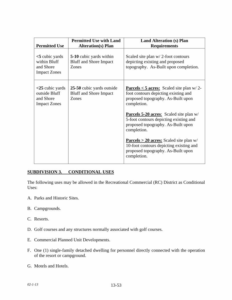
02-1-13 13-53
Permitted Use Permitted Use with Land
Alteration(s) Plan Land Alteration (s) Plan
Requirements
<5 cubic yards within Bluff and Shore Impact Zones
5-10 cubic yards within Bluff and Shore Impact Zones
Scaled site plan w/ 2-foot contours depicting existing and proposed topography. As-Built upon completion.
<25 cubic yards outside Bluff and Shore Impact Zones
25-50 cubic yards outside Bluff and Shore Impact Zones
Parcels < 5 acres: Scaled site plan w/ 2-foot contours depicting existing and proposed topography. As-Built upon completion. Parcels 5-20 acres: Scaled site plan w/ 5-foot contours depicting existing and proposed topography. As-Built upon completion. Parcels > 20 acres: Scaled site plan w/ 10-foot contours depicting existing and proposed topography. As-Built upon completion.
SUBDIVISION 3. CONDITIONAL USES The following uses may be allowed in the Recreational Commercial (RC) District as Conditional Uses: A. Parks and Historic Sites. B. Campgrounds. C. Resorts. D. Golf courses and any structures normally associated with golf courses. E. Commercial Planned Unit Developments. F. One (1) single-family detached dwelling for personnel directly connected with the operation
of the resort or campground. G. Motels and Hotels.
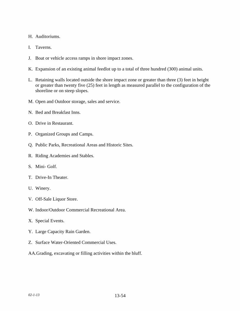
02-1-13 13-54
H. Auditoriums. I. Taverns. J. Boat or vehicle access ramps in shore impact zones. K. Expansion of an existing animal feedlot up to a total of three hundred (300) animal units. L. Retaining walls located outside the shore impact zone or greater than three (3) feet in height
or greater than twenty five (25) feet in length as measured parallel to the configuration of the shoreline or on steep slopes.
M. Open and Outdoor storage, sales and service. N. Bed and Breakfast Inns. O. Drive in Restaurant. P. Organized Groups and Camps. Q. Public Parks, Recreational Areas and Historic Sites. R. Riding Academies and Stables. S. Mini- Golf. T. Drive-In Theater. U. Winery. V. Off-Sale Liquor Store. W. Indoor/Outdoor Commercial Recreational Area. X. Special Events. Y. Large Capacity Rain Garden. Z. Surface Water-Oriented Commercial Uses. AA.Grading, excavating or filling activities within the bluff.
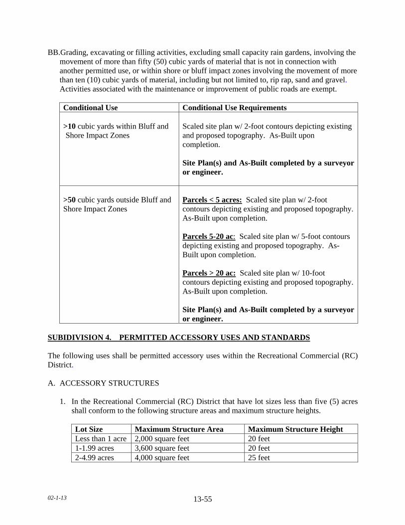
02-1-13 13-55
BB.Grading, excavating or filling activities, excluding small capacity rain gardens, involving the movement of more than fifty (50) cubic yards of material that is not in connection with another permitted use, or within shore or bluff impact zones involving the movement of more than ten (10) cubic yards of material, including but not limited to, rip rap, sand and gravel.
Activities associated with the maintenance or improvement of public roads are exempt.
Conditional Use Conditional Use Requirements
>10 cubic yards within Bluff and Shore Impact Zones
Scaled site plan w/ 2-foot contours depicting existing and proposed topography. As-Built upon completion. Site Plan(s) and As-Built completed by a surveyor or engineer.
>50 cubic yards outside Bluff and Shore Impact Zones
Parcels < 5 acres: Scaled site plan w/ 2-foot contours depicting existing and proposed topography. As-Built upon completion. Parcels 5-20 ac: Scaled site plan w/ 5-foot contours depicting existing and proposed topography. As-Built upon completion. Parcels > 20 ac: Scaled site plan w/ 10-foot contours depicting existing and proposed topography. As-Built upon completion. Site Plan(s) and As-Built completed by a surveyor or engineer.
SUBIDIVISION 4. PERMITTED ACCESSORY USES AND STANDARDS The following uses shall be permitted accessory uses within the Recreational Commercial (RC) District. A. ACCESSORY STRUCTURES
1. In the Recreational Commercial (RC) District that have lot sizes less than five (5) acres shall conform to the following structure areas and maximum structure heights.
Lot Size Maximum Structure Area Maximum Structure Height Less than 1 acre 2,000 square feet 20 feet 1-1.99 acres 3,600 square feet 20 feet 2-4.99 acres 4,000 square feet 25 feet
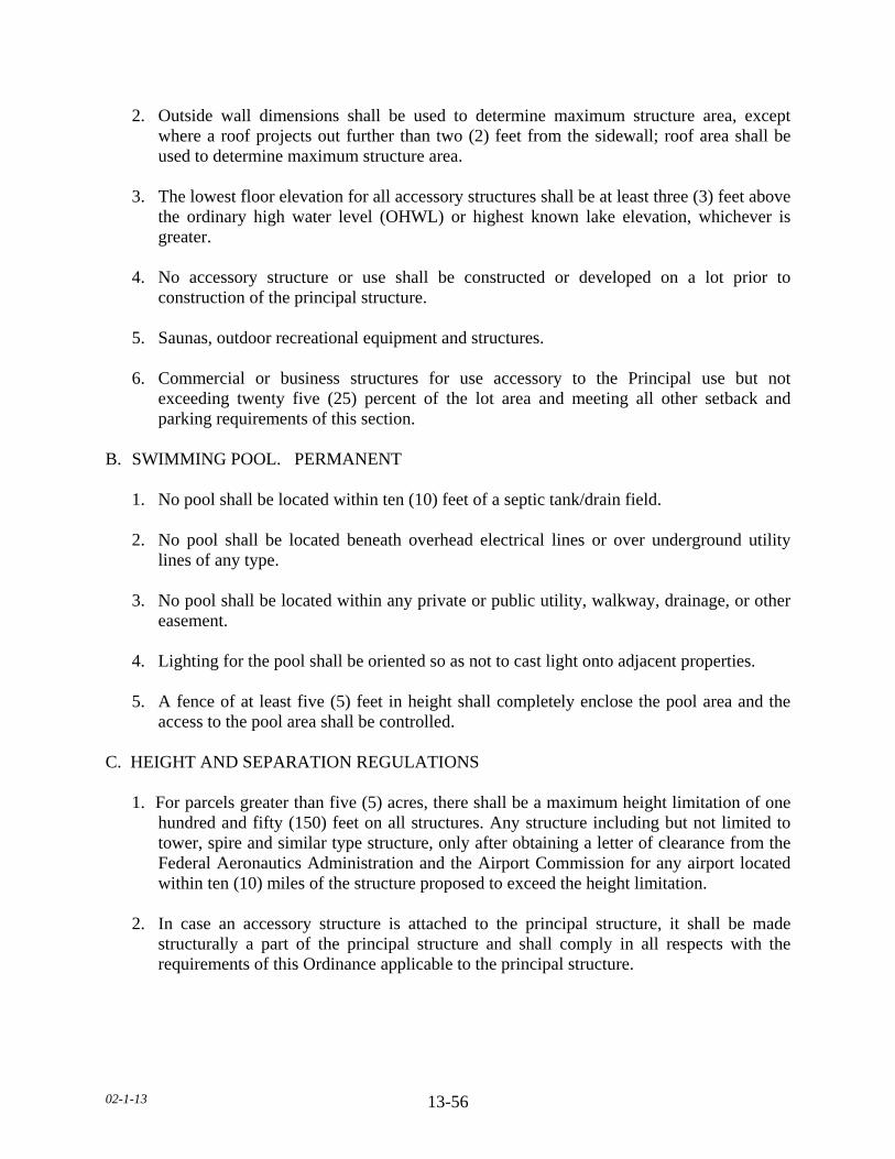
02-1-13 13-56
2. Outside wall dimensions shall be used to determine maximum structure area, except where a roof projects out further than two (2) feet from the sidewall; roof area shall be used to determine maximum structure area.
3. The lowest floor elevation for all accessory structures shall be at least three (3) feet above
the ordinary high water level (OHWL) or highest known lake elevation, whichever is greater.
4. No accessory structure or use shall be constructed or developed on a lot prior to
construction of the principal structure. 5. Saunas, outdoor recreational equipment and structures. 6. Commercial or business structures for use accessory to the Principal use but not
exceeding twenty five (25) percent of the lot area and meeting all other setback and parking requirements of this section.
B. SWIMMING POOL. PERMANENT 1. No pool shall be located within ten (10) feet of a septic tank/drain field. 2. No pool shall be located beneath overhead electrical lines or over underground utility
lines of any type. 3. No pool shall be located within any private or public utility, walkway, drainage, or other
easement. 4. Lighting for the pool shall be oriented so as not to cast light onto adjacent properties. 5. A fence of at least five (5) feet in height shall completely enclose the pool area and the
access to the pool area shall be controlled. C. HEIGHT AND SEPARATION REGULATIONS
1. For parcels greater than five (5) acres, there shall be a maximum height limitation of one
hundred and fifty (150) feet on all structures. Any structure including but not limited to tower, spire and similar type structure, only after obtaining a letter of clearance from the Federal Aeronautics Administration and the Airport Commission for any airport located within ten (10) miles of the structure proposed to exceed the height limitation.
2. In case an accessory structure is attached to the principal structure, it shall be made
structurally a part of the principal structure and shall comply in all respects with the requirements of this Ordinance applicable to the principal structure.
02-1-13 13-57
3. An accessory structure shall not be closer than five (5) feet to the principal structure. a. In case an accessory structure is attached to the principal structure, it shall be made
structurally a part of the principal structure and shall comply in all respects with the requirements of this Ordinance applicable to the principal structure.
D. DRAINAGE Adequate drainage shall be provided and the drainage shall be directed away from adjacent private property. E. PARKING Off-street parking and loading. F. LANDSCAPING AND SCREENING 1. It is the intent of this Section to provide that uses of land and structures shall be
established and maintained with proper appearance from streets and adjoining properties and to provide that each permitted and conditional use shall be a good neighbor to adjoining properties by the control of the following:
2. All required yards shall either be landscaped and green areas or be left in a natural state.
If any yards are to be landscaped, they shall be landscaped attractively with lawn, trees, shrubs, etc. Any areas left in a natural state shall be properly maintained in a well kept condition. Where any business (structure, parking or storage) is adjacent to property zoned or developed for residential use, that business or industry shall provide screening along the boundary of the residential property. Screening shall also be provided where a business, parking lot, or industry is located across the street from a residential zone, but not on that side of a business or industry considered to be the front.
3. All exterior storage shall be screened. The exceptions are: a. Merchandise being displayed for sale, b. Materials and equipment presently being used for construction on the premises. c. Merchandise located on service station pump islands. 4. The screening required may consist of fences and/or landscaping. Plans of such screen
shall be submitted for approval as a part of the site plan and installed prior to occupancy of any tract in the district.
5. All open storage yards, shall be screened with buffer planting and screen fences. Plans of
such screens shall be submitted for approval by the Planning Commission.
02-1-13 13-58
6. Landscaping Maintenance. All structures and areas requiring landscaping and fences
shall be maintained so as not to be unsightly or present harmful health or safety conditions.
G. PERMITTED SIGNAGE 1. Ground/Pylon Signs a. The maximum height of a sign is twenty (20) feet. b. No more than one (1) ground/pylon sign shall be permitted per every thirty five (35) lineal
feet of road frontage. c. The square foot area of such signs shall not exceed one hundred (100) square feet. d. Ground/pylon signs shall be set back a minimum of ten (10) feet from property lines and/or
right-of-way. 2. Wall Signs a. Wall signs on any structure shall not exceed twenty (20) percent of the wall area. b. Wall signs shall not project above the roof level. 3. Signs may be placed, when necessary, within the shore impact zone if they are designed
and sized to meet the following standards. a. The signs must only convey the location and name of the establishment and the
general types of goods or services available. b. The signs must not contain other detailed information such as product brands and
prices. c. The signs must not be located higher than ten (10) feet above the ground, and must
not exceed thirty two (32) square feet in size. d. If illuminated by artificial light, the lights must be shielded or directed to prevent
illumination out across public waters and meet lighting standards in this Ordinance. H. OUTSIDE LIGHTING Other outside lighting may be located within the shore impact zone or over public waters if it is used primarily to illuminate potential safety hazards and is shielded or otherwise directed to prevent direct illumination out across public waters. This does not preclude use of navigational lights.
02-1-13 13-59
I. Other accessory uses customarily incidental to the uses listed in Section 13.3. SUBIDIVISION 5. DIMENSIONAL REGULATIONS A. SETBACK EXEMPTIONS/STRUCTURE EXPANSIONS 1. In such cases, where proposed additions do not encroach further into the front, side, or
rear yard than the existing structure, such additions will be permitted provided the use and the structure are in conformance with the following restrictions:
a. The use of the structure is conforming to the zoning district in which it is located. b. The expansion of the structure shall not be located closer to the property line than the
existing structure or at least one-half (1/2) of the required setback, whichever is greater.
c. The expansion of the structure will not reduce any other required setback below the
minimum standards of this Ordinance. d. The expansion of the structure will conform to all other restrictions of this Ordinance,
including but not limited to, density, lot coverage, building height. e. The height of the expansion shall not be greater than the existing structure at the
existing building line. f. The proposed addition is not located in shore or bluff impact zones. B. FRONT YARD SETBACKS
1. There shall be a front yard setback of not less than one hundred (100) feet from the right-
of-way of State-Federal trunk arterials, expressways and State collector arterials. 2. There shall be a front yard setback of not less than one hundred (100) feet from the right-
of-way of County Highways. 3. There shall be a front yard setback of not less than one hundred (100) feet from a
township or any other public or private right-of-way. 4. When a lot is located at the intersection of two (2) or more roads, there shall be a front
yard setback on each road right-of-way. 5. All components an onsite Subsurface Sewage Treatment System (SSTS) shall be twenty
(20) feet from all road right-of-ways. 6. All components an onsite Subsurface Sewage Treatment System (SSTS) for a non-
conforming Lot of Record shall be ten (10) feet from all road right-of-ways.
02-1-13 13-60
7. The required front yard of a corner lot shall be unobstructed above a height of three (3)
feet in a triangular area, two (2) sides of which are the lines running parallel along the right of way lines between the road intersection and a point fifty (50) feet from the intersection, and the third site of which is the line between the latter two (2) points.
8. No trees or shrubs shall be planted within ten (10) feet from any right-of-way.
9. On nonconforming Lots of Record, accessory structures with a door six (6) feet wide or greater which faces any road right-of-way shall be set back a minimum of twenty five (25) feet. All other accessory structures shall be set back a minimum of ten (10) feet from the road right-of-way.
10. Except that no structure within a Recreational Commercial (RC) District shall be located
within fifty (50) feet of any side lot line adjoining any Residential or Agricultural District.
C. SIDE YARD SETBACKS 1. All structures shall have a side yard setback of not less than fifteen (15) feet. 2. No structure within a Recreational Commercial (RC) District shall be located within fifty
(50) feet of any side yard lot line adjoining any Residential or Agricultural District. 3. For conforming lots, all water orientated accessory structures shall be set back fifteen
(15) feet from side yard property lines. 4. For non-conforming Lots of Record, all water orientated accessory structures shall be set
back ten (10) feet from side yard property lines. D. REAR YARD SETBACKS 1. Principal structures shall have a rear yard setback of not less than forty (40) feet.
2. Accessory structures shall have a rear yard setback of not less than ten (10) feet.
3. No structure within a Recreational Commercial (RC) District shall be located within fifty (50) feet of any rear yard lot line adjoining any Residential or Agricultural District.
E. ORDINARY HIGH WATER LEVEL (OHWL) SETBACKS 1. All structures shall be set back one hundred (100) feet from the Ordinary High Water
Level (OHWL). 2. Subsurface Sewage Treatment Systems (SSTS) shall be set back seventy five (75) feet
from the Ordinary High Water Level (OHWL).
02-1-13 13-61
3. A new dwelling constructed on a nonconforming Lot of Record may have a reduced OHWL setback with the following restrictions:
a. There shall be an existing dwelling located on each side of the lot. b. The new dwelling shall not be located closer to the OHWL than the existing
dwellings located on the adjacent lots, or at least one-half of the required set back whichever is greater.
c. The structure is not located in a shore impact zone or in a bluff impact zone. 4. A new dwelling constructed on a nonconforming Lot of Record may have a reduced
OHWL setback if one of the adjacent lots is vacant with the following restrictions: a. There shall be an existing dwelling located on one side of the lot. b. The setback for the Lot of Record shall be the setback of the dwelling on the adjacent
lot plus one half (1/2) the difference between the setback of the adjacent dwelling and the setback required by the Ordinance.
c. The structure is not located in a shore impact zone or in a bluff impact zone. 5. One (1) water-oriented accessory structure designed in accordance with this Section shall
be set back a minimum distance of ten (10) feet from the ordinary high water level. 6. No expansion or modification of existing feedlots shall result in encroachment closer to
the ordinary high water level than the existing setback or three hundred (300) feet, whichever is greater.
F. BLUFF SETBACKS 1. All structures shall be set back from the top and/or toe of the bluff:
a. Thirty (30) feet for bluffs with slopes eighteen (18) to thirty (30) percent. b. Fifty (50) feet for bluffs with slopes greater than thirty (30) percent, c. Existing Building Sites. All structures shall be set back thirty (30) feet from the top
or toe of the bluff.
2. SSTS shall be set back thirty (30) feet from the top or toe of the bluff. a. SSTS upgrade and/or replacement for an existing dwelling: 1. Shall be exempt from bluff setback. 2. May be located within the bluff impact zone. 3. Shall not be located within the bluff.

02-1-13 13-62
3. If the adjacent bluff is actively eroding, the Department may increase the setback requirement.
4. Structures and accessory facilities, except stairways and landings, must not be placed
within bluff impact zones. G. WETLAND SETBACKS All structures shall be set back a minimum of seventy five (75) feet from the wetland boundary of any Type three (3) through eight (8) wetland. H. ADDITIONAL SETBACKS
1. When more than one (1) setback applies to a site, structures must be located to meet all setbacks.
2. All structures shall be set back fifty (50) feet from a cemetery.
I. FEEDLOT AND ANIMAL REQUIREMENTS 1. Effective June 10, 2010 any new school, park, golf course, licensed campground, or
residential zoning district shall be separated from an existing animal feedlot by the following:
a. 10-50 AU 500 feet b. 51-2000 AU 1000 feet c. Greater than 2000 AU 1500 feet 2. All new dwellings shall be separated from an existing animal feedlot by the following: a. 10-50 AU 500 feet b. 51-2000 AU 1000 feet c. Greater than 2000 AU 1500 feet 3. The animal feedlot owner’s dwelling is exempt from these requirements. 4. Any expansion of an existing animal feedlot shall conform to the following lot
requirement: a. Up to 100 AU 5 acres b. 101-300 AU 10 acres
5. In the Recreational Commercial (RC) District, the following standards shall be applicable for allowable animal units:
(TABLE ON NEXT PAGE)
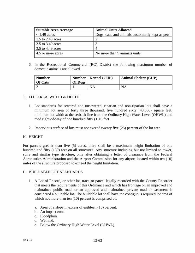
02-1-13 13-63
Suitable Area Acreage Animal Units Allowed < 1.49 acres Dogs, cats, and animals customarily kept as pets 1.5 to 2.49 acres 2 2.5 to 3.49 acres 3 3.5 to 4.49 acres 4 4.5 or more acres No more than 9 animals units
6. In the Recreational Commercial (RC) District the following maximum number of
domestic animals are allowed.
Number Of Cats
NumberOf Dogs
Kennel (CUP) Animal Shelter (CUP)
2 1 NA NA
J. LOT AREA, WIDTH & DEPTH 1. Lot standards for sewered and unsewered, riparian and non-riparian lots shall have a
minimum lot area of forty three thousand, five hundred sixty (43,560) square feet, minimum lot width at the setback line from the Ordinary High Water Level (OHWL) and road right-of-way of one hundred fifty (150) feet.
2. Impervious surface of lots must not exceed twenty five (25) percent of the lot area. K. HEIGHT For parcels greater than five (5) acres, there shall be a maximum height limitation of one hundred and fifty (150) feet on all structures. Any structure including but not limited to tower, spire and similar type structure, only after obtaining a letter of clearance from the Federal Aeronautics Administration and the Airport Commission for any airport located within ten (10) miles of the structure proposed to exceed the height limitation. L. BUILDABLE LOT STANDARDS 1. A Lot of Record, or other lot, tract, or parcel legally recorded with the County Recorder
that meets the requirements of this Ordinance and which has frontage on an improved and maintained public road, or an approved and maintained private road or easement is considered a buildable lot. The buildable lot shall have the contiguous required lot area of which not more than ten (10) percent is comprised of:
a. Area of a slope in excess of eighteen (18) percent. b. An impact zone. c. Floodplain. d. Wetland. e. Below the Ordinary High Water Level (OHWL).

02-1-13 13-64
2. Each new building site created after the adoption of this Ordinance must have a minimum of forty thousand (40,000) square feet of contiguous buildable lot area.
3. Each new building site created after January 23, 1996 must have sufficient area for a
minimum of two (2) onsite sewage treatment systems.
4. Lots of Record that are substandard in area must conform to all other applicable regulations to qualify for placement of a dwelling.
SUBDIVISION 6. DWELLING STANDARDS A. PROHIBITED DWELLINGS No garage, tent, trailer, or accessory structure shall at any time be used as a dwelling. B. DWELLING REGULATIONS 1. No more than one (1) dwelling shall be placed on a lot except in the case of temporary
dwellings. 2. All dwellings shall be on foundations or piles or other foundation systems extending
below the frost line, as approved by the Department.
3. The minimum dwelling width excluding porches, decks, or other similar attachments shall be twenty (20) feet except in the cases of temporary dwellings.
4. For Resorts, manufactured homes less than twenty (20) feet in width shall be allowed as a
single-family dwelling or for seasonal occupancy in the Recreational Commercial (RC) District.
5. All dwellings must conform with the sewage treatment regulations of this Ordinance. No
zoning permits will be issued for new dwellings prior to sewage treatment system approval.
6. Manufactured homes shall bear a State seal as verification of construction and inspection
to ANSI A119.1 standards during original construction (issued for manufactured homes built between July 1, 1972 to June 14, 1976) or, for manufactured homes built after that date, a Federal seal in accordance with HUD CFR 3280 Construction Standards.
7. All dwellings shall have a minimum of seven hundred sixty (760) square feet of floor
area on the ground floor.
8. Dwellings shall not exceed two and one-half (2 1/2) stories or thirty five (35) feet in height.
9. For all dwellings the lowest floor elevation shall be at least three (3) feet above the
ordinary high water level (OHWL) or highest known lake elevation, whichever is greater.
02-1-13 13-65
10. Outside wall dimensions shall be used to determine maximum structure area, except
where a roof projects out further than two (2) feet from the sidewall; roof area shall be used to determine maximum structure area.
SUBDIVISION 7. ACCESS DRIVES, ACCESS AND SERVICE ROADS A. Access drives onto any public roads shall require a review by the Road Authority. The Road
Authority shall determine the appropriate location, size, and design of such access drives along public roads and may limit the number of access drives in the interest of public safety and efficient traffic flow.
B. Access drives shall be constructed and maintained to meet all of the following: 1. A minimum driving surface width of fourteen (14) feet. 2. Inslope no greater than 4 to 1, as measured horizontal to vertical. 3. Base material depth sufficient to support access by emergency vehicles. 4. Unobstructed width of not less than twenty (20) feet. 5. Unobstructed vertical clearance of not less than thirteen (13) feet, six (6) inches. C. Access drives in excess of one hundred fifty (150) feet shall provide a minimum turn-around
of sixty (60) feet in width by sixty (60) feet in length. D. Access drives shall have a twenty (20) foot long flat grade directly adjacent to the road that
the drive accesses. E. All lots or parcels with dwellings shall have direct physical access of adequate size for
emergency vehicles along the frontage of the lot or parcel from either an existing or dedicated public roadway.
F. A service road shall be constructed for two (2) or more contiguous properties in the
Recreational Commercial (RC) District or when required by the Road Authority. G. Access drives shall not be located within the bluff or shore impact zones. SUBDIVISION 8. GENERAL REGULATIONS A. STORAGE OF MATERIALS 1. All materials and equipment shall be stored within a structure or fully screened so as not
to be visible from adjoining properties, except for the following:
02-1-13 13-66
a. Recreational equipment. b. Laundry drying equipment. c. Off-street parking of licensed passenger vehicles and pickup trucks. d. Boats and unoccupied travel trailers, less than twenty (20) feet in length, are
permissible if stored in the rear yard more than ten (10) feet from the property line. 2. No underground gasoline storage shall be permitted.
3. All land uses and development shall follow all other applicable regulations of this section.
02-01-13 14-1
SECTION_14. SCENIC TRAIL STANDARDS SUBDIVISION 1. PURPOSE These standards are intended to allow for the orderly development of the land surrounding Government-owned Trails. SUBDIVISION 2. PROHIBITED USES A. There shall be no commercial, industrial or agricultural business or structures located within
fifty (50) feet of the right-of-way of Government-owned Trails with the exception of those facilities permitted before the effective date of adoption of this Ordinance.
B. All structures shall be set back a minimum of fifty (50) feet from the right-of- way of
Government-owned Trails except for the replacement of a dwelling that was constructed before the effective date of adoption of this Ordinance.
SUBDIVISION 3. PROHIBITED SIGNS A. There shall be no signs within fifty (50) feet of the right-of-way of Government-owned
Trails, unless such signs are of the type and nature which conform to the natural appearance of its surrounding.
1. All signs shall utilize only white, green or brown colors. 2. No sign so permitted shall have an area greater than two hundred (200) square inches or
be at a total height greater than five (5) feet above grade. 3. Only one (1) sign shall be placed within fifty (50) feet of Government-owned Trails per
Lot of Record as of the date of adoption of this Ordinance. SUBDIVISION 4. HOME OCCUPATIONS The establishment of a home occupation or other type of commercial business within a single-family dwelling existing within fifty (50) feet of the right-of-way of Government-owned Trails may be established only if such proposed activity conforms with all requirements of this Ordinance.

02-01-13 15-1
SECTION 15. ADULT USES SUBDIVISION 1. STATUTORY AUTHORIZATION This Section is adopted pursuant to the authority delegated to the county by Minnesota Statutes. SUBDIVISION 2. FINDINGS AND PURPOSE OF ORDINANCE A. This Section is intended to regulate "adult uses," those premises, enterprises, establishments,
businesses or places open to some or all members of the public, at or in which there is an emphasis on the presentation, display, depiction or description of "specified sexual activities" or "specified anatomical areas" which are capable of being seen by members of the public.
B. The nature of adult uses is such that they are recognized as having adverse secondary
impacts, based upon studies of the impacts that adult establishments have on their surrounding communities.
C. The adverse secondary impacts found in the studies include increased crime rates, decreased
property values, increased transiency, neighborhood blight, and potential health risks. These impacts are particularly apparent when they are accessible to minors and located near residential properties or residential uses such as schools, day care centers, libraries or parks. The nature of the adult uses requires that they be allowed within certain zoning districts, or set back a minimum distance from each other, or other residential uses. Special regulation of these uses is necessary to ensure that the adverse secondary effects would not contribute or enhance criminal activity in the area of such uses, nor will it contribute to the blighting or downgrading of the surrounding property and lessening of its value.
D. It is therefore in the best interest of the public health, safety and general welfare of the
citizens of the county that certain types of activities, as set forth in this Section, are prohibited upon the premises of licensed liquor, wine and beer establishments so as to best protect and assist the owners and operators and employees of these premises, as well as patrons and the public, in general. Further, the county intends that the standards in this Section reflect the prevailing community standards in the county. This Section is intended to prevent harm stemming from the physical immediacy and combination of alcohol, nudity, and sex. The Board of County Commissioners also desires to prevent any subliminal endorsement of sexual harassment or activities likely to lead to the possibility of various acts of criminal conduct such as prostitution, sexual assault and disorderly conduct.
SUBDIVISION 3. LICENSING AND ENFORCEMENT Adult Uses shall be regulated by the Le Sueur County Adult Use Ordinance per the requirements set forth by the Le Sueur County Board of Commissioners as amended from time to time as well as the standards of this Section.

02-01-13 15-2
SUBDIVISION 4. ALLOWED ADULT USE LOCATIONS BY ZONING DISTRICT AND OTHER APPLICABLE STANDARDS
A. ADULT USE, PRINCIPAL - ALLOWED LOCATIONS 1. Adult use, principal, shall only be allowed as a conditional use in the General Business
(B) District, and parking, screening, lighting and other relevant site-related criteria for all adult uses shall be as set forth in this Ordinance.
2. Adult use, principal, shall be located at least 1,000 linear feet, as measured in a straight
line from the closest point of the structure within which the adult use, principal, is located to the property line of:
a. Any residentially used or zoned property. b. Any licensed day care center. c. Any public or private educational facility classified as an elementary, junior high or
senior high school. d. Any hotel or motel. e. Any public park or trails system. f. Any nursing home. g. Any community center. h. Any church or church-related organization. i. Another adult establishment. No adult use, principal, shall be located in or upon the
same property as another adult use, principal. j. Establishments licensed to serve alcoholic beverages. k. Hospitals/Clinics. 3. Hours of operation. Hours of operation for adult uses, principal, shall be from 9:00 a.m.
to 1:00 a.m. A differing time schedule may be approved by the Board of County Commissioners if it can be satisfactorily demonstrated to the Board of County Commissioners that all of the following apply:
a. The use does not adversely impact or affect uses or activities within 1,000 feet. b. The use will not result in increased policing and related service calls.
02-01-13 15-3
c. A different time schedule is critical to the operation of the business. 4. Sign regulations. Adult use, principal, shall adhere to the following sign regulations in
addition to those set forth in this Ordinance. a. A sign message shall be generic in nature and shall only identify the name and type of
business. Signs shall not be pictorial. b. Signs shall be limited to the size and number of signs permitted in the district in
which the use is located. B. ADULT USE, ACCESSORY - ALLOWED LOCATIONS 1. Adult use, accessory, shall be a conditional use in the General Business (B) District,
provided that the accessory use conforms with the provisions of this section. Adult use, accessory, shall:
a. Comprise of no more than ten (10) percent of the floor area of the establishment in
which it is located. b. Comprise of no more than twenty (20) percent of the gross receipts of the entire
business operation. c. Not involve or include any activity except the sale or rental of merchandise. 2. Separation of areas. Adult use, accessory, shall be restricted from, and prohibit access to,
minors, by physically separating the following and similar items from areas of general public access:
a. Movie rental display areas shall be restricted from general view and shall be located
within a separate room, the access of which is in clear view of, and under the control of, the persons responsible for the operation.
b. Magazines or publications classified as adult uses shall not be physically accessible to
minors and shall be covered with a wrapper or other means to prevent display of any material other than the publication title.
c. Other adult uses not specifically cited shall comply with the intent of this Section. d. Advertising. Adult use, accessory, shall be prohibited from both internal and external
advertising and signing of adult materials and products. 3. Nonconforming adult uses shall be subject to the provisions of this Ordinance.
02-01-13 16-1
SECTION 16 ANIMAL FEEDLOT AND MANURE MANAGEMENT SUBDIVISION 1. PURPOSE A. An adequate supply of healthy livestock, domesticated fowl, and other animals is essential to
the well-being of Le Sueur County citizens and the State of Minnesota. These domesticated animals provide our daily source of meat, milk, eggs, and fiber. Their efficient, economic production must be the concern of all consumers if we are to have a continued abundance of high-quality, wholesome food and fiber at reasonable prices.
B. Livestock, domesticated fowl, and other animals produce manure, which may, where
improperly stored, transported, or disposed, negatively affect Le Sueur County’s environment.
C. The following regulations for the control of livestock, domesticated fowl, and other animal
feedlot and manure application has been promulgated to provide protection against pollution caused by manure from domesticated animals. However, these rules recognize that animal manure provides beneficial qualities to the soil and to the production of agriculture crops.
D. These rules provide for a cooperative program between Le Sueur County and the MPCA
(hereinafter Agency). Pollution control measures, where deemed necessary by the Agency, should be individually designed and developed to provide the site-specific controls needed for the operation in question. Therefore, a joint county-state program is desirable as it will ensure local involvement, minimal disruption to agricultural operations, and protect the environment from further degradation. These rules comply with the policy and purpose of the State of Minnesota in regard to the control of pollution set forth in Minnesota Statutes, Chapter 115, Water Pollution Control, and Chapter 116, Pollution Control Agency.
SUBDIVISION 2. ADOPTION BY REFERENCE OF STATE REGULATIONS Pursuant to Minnesota Statutes, Section 394.25, Subdivision 8, the Board of County Commissioners hereby adopts by reference Minnesota Administrative Rules, Chapter 7020 Relating to Animal Feedlots as amended. Provisions of these rules shall be as much a part of this section as if they had been set out in full herein when adopted by this reference. To the extent this Ordinance contains more restrictive requirements, the more restrictive requirements shall apply. SUBDIVISION 3. SCOPE AND APPLICABILITY A. The provisions of Minnesota Administrative Rules, Chapter 7020 govern the storage,
transportation, disposal, and utilization of animal manure and the application for the issuance of permits for construction and operation of animal manure management, disposal, or utilization systems for the protection of the environment.

02-01-13 16-2
B. From and after June 10, 2010, all proposed new animal feedlots or expansion of existing animal feedlots shall be in conformity with the provisions of this section and Minnesota Administrative Rules, Chapter 7020.
C. No person shall permit or allow their land or property under their control to be used for any
new animal feedlot or expansion of an existing animal feedlot within Le Sueur County unless in compliance with the provisions of this Section.
D. All animal feedlots within Le Sueur County shall manage manure in compliance with this
Section and Minnesota Administrative Rules, Chapter 7020. E. Animal Units Conversions:
(TABLE ON NEXT PAGE)
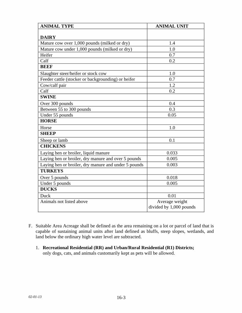
02-01-13 16-3
F. Suitable Area Acreage shall be defined as the area remaining on a lot or parcel of land that is
capable of sustaining animal units after land defined as bluffs, steep slopes, wetlands, and land below the ordinary high water level are subtracted.
1. Recreational Residential (RR) and Urban/Rural Residential (R1) Districts; only dogs, cats, and animals customarily kept as pets will be allowed.
ANIMAL TYPE ANIMAL UNIT DAIRY
Mature cow over 1,000 pounds (milked or dry) 1.4 Mature cow under 1,000 pounds (milked or dry) 1.0 Heifer 0.7 Calf 0.2 BEEF
Slaughter steer/heifer or stock cow 1.0 Feeder cattle (stocker or backgrounding) or heifer 0.7 Cow/calf pair 1.2 Calf 0.2 SWINE
Over 300 pounds 0.4 Between 55 to 300 pounds 0.3 Under 55 pounds 0.05 HORSE
Horse 1.0 SHEEP
Sheep or lamb 0.1 CHICKENS
Laying hen or broiler, liquid manure 0.033 Laying hen or broiler, dry manure and over 5 pounds 0.005 Laying hen or broiler, dry manure and under 5 pounds 0.003 TURKEYS
Over 5 pounds 0.018 Under 5 pounds 0.005 DUCKS
Duck 0.01 Animals not listed above Average weight
divided by 1,000 pounds
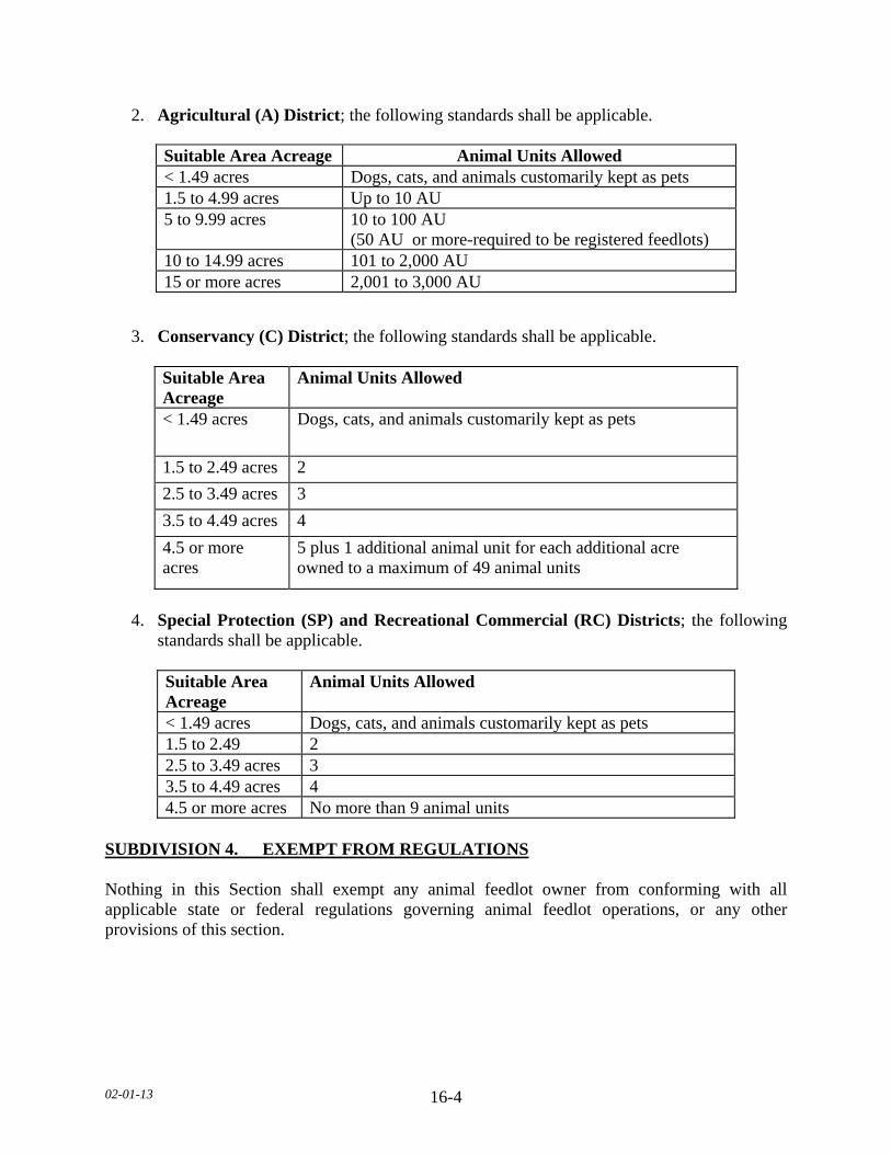
02-01-13 16-4
2. Agricultural (A) District; the following standards shall be applicable.
3. Conservancy (C) District; the following standards shall be applicable.
Suitable Area Acreage
Animal Units Allowed
< 1.49 acres Dogs, cats, and animals customarily kept as pets
1.5 to 2.49 acres 2
2.5 to 3.49 acres 3
3.5 to 4.49 acres 4
4.5 or more acres
5 plus 1 additional animal unit for each additional acre owned to a maximum of 49 animal units
4. Special Protection (SP) and Recreational Commercial (RC) Districts; the following
standards shall be applicable.
Suitable Area Acreage
Animal Units Allowed
< 1.49 acres Dogs, cats, and animals customarily kept as pets 1.5 to 2.49 2 2.5 to 3.49 acres 3 3.5 to 4.49 acres 4 4.5 or more acres No more than 9 animal units
SUBDIVISION 4. EXEMPT FROM REGULATIONS Nothing in this Section shall exempt any animal feedlot owner from conforming with all applicable state or federal regulations governing animal feedlot operations, or any other provisions of this section.
Suitable Area Acreage Animal Units Allowed < 1.49 acres Dogs, cats, and animals customarily kept as pets 1.5 to 4.99 acres Up to 10 AU 5 to 9.99 acres 10 to 100 AU
(50 AU or more-required to be registered feedlots) 10 to 14.99 acres 101 to 2,000 AU 15 or more acres 2,001 to 3,000 AU

02-01-13 16-5
SUBDIVISION 5. PERMIT REQUIREMENTS Applications for locating and operating an animal feedlot within Le Sueur County shall be governed by the following procedures: A. The owner of a proposed animal feedlot or existing animal feedlot shall apply for a Le Sueur
County feedlot permit and shall be constructed and operated in accordance with the provisions of this Section and the requirements of Minnesota Administrative Rules, Chapter 7020 when the animal feedlot meets one of the following:
1. Capable of housing fifty (50) or more animal units outside a shoreland district. 2. Capable of housing ten (10) or more animal units within a shoreland district. 3. Non-conforming. B. All animal feedlot operations permitted in Le Sueur County shall provide to the Department a
manure management plan meeting the requirements of Minnesota Administrative Rules, Chapter 7020.
C. Notice of application for livestock feedlot permit as regulated by Minnesota Statutes, Chapter
116. SUBDIVISION 6. INSPECTIONS A. COMPLIANCE INSPECTIONS The Department shall conduct compliance inspections for county- permitted animal feedlots. The animal feedlot owner shall be informed of an inspection either by written request or telephone call. However, the Department need not comply with the notice requirement if the Department determines a public health threat or emergency makes such notice impractical. B. BIOSECURITY It shall be the responsibility of the Department and the animal feedlot owner to communicate any biosecurity guidelines for the animal feedlot. The guidelines can be submitted in either written or verbal form. C. CONCRETE PIT INSPECTIONS The Department shall be notified (via telephone, fax, or in person) by the animal feedlot owner at least three days prior to the backfilling of a concrete pit utilized for manure storage to allow for inspection.

02-01-13 16-6
D. CONCRETE PIT OR EARTHEN BASIN CLOSURE 1. The Department shall be notified (via telephone, electronically, or in person) by the
animal feedlot owner at least three (3) days prior to the completion of the closure of a concrete pit or earthen basin that had previously been utilized for manure storage.
2. The Department shall inspect all concrete pits or earthen basins to verify removal of all
manure and document manure application, meeting Minnesota Administrative Rules, Chapter 7020. Said documentation shall be provided to the Department.
3. All grading, excavating or filling activities shall comply with all applicable standards in
this Ordinance. SUBDIVISION 7. GENERAL REQUIREMENTS The following requirements shall apply to all animal feedlots within Le Sueur County. A. No animal feedlot or manure storage structure shall be constructed, located, or operated so as
to create or maintain a potential pollution hazard. B. Transportation of manure shall be in accordance with Minnesota Administrative Rules,
Chapter 7020. C. All newly constructed manure storage areas shall provide for a minimum of twelve (12)
months storage. D. Disposal of animal mortalities shall be in compliance with Minnesota Administrative Rules,
Chapter 1719. E. The animal feedlot owner shall allow the Department or assigned representative to inspect
the site whenever necessary upon notification to the animal feedlot owner. F. A perimeter fence shall be installed around any open earthen or concrete manure slurry basin. 1. Fencing shall be a minimum of five (5) feet high and be impenetrable by children. 2. Fencing shall be posted with signs every one hundred (100) feet stating “DANGER.” G. Emergency mitigation plans, as determined by the Department, shall be followed in such
cases when emergency winter applications are necessary. SUBDIVISION 8. CONDITIONAL USES The following described animal feedlot operations, whether existing or proposed, shall require a conditional use permit issued by the County.

02-01-13 16-7
A. Any new animal feedlot greater than four hundred forty nine (449) animal units or an expansion of an existing animal feedlot that exceeds four hundred forty nine (449) animal units to a total of three thousand (3,000) animal units in the Agricultural (A) District.
B. Any expansion of an existing animal feedlot up to a total of five hundred (500) animal units
in the Conservancy (C) District or the Special Protection (SP) District. C. Any expansion of an existing animal feedlot to a total of three hundred (300) animal units in
the Recreational Residential (RR) District. D. Any new animal feedlot or expansion of an existing animal feedlot located within one (1)
mile of a city boundary. E. When the Agency requires a National Pollutant Discharge Elimination System Permit
(NPDES). F. Use of irrigation to spread manure. SUBDIVISON 9. STANDARDS FOR CONDITIONAL USE PERMITS A. The County may impose, in addition to the standards and requirements set forth in this
Section, additional conditions which the Board of County Commissioners considers necessary to protect the public health, safety, and general welfare.
B. All animal feedlots shall prepare an odor management plan. C. All animal manure from the operation shall be utilized in accordance with the manure
management plan requirements of Minnesota Administrative Rules, Chapter 7020. Additionally, all liquid manure shall be injected or incorporated within twenty four (24) hours.
D. No animals may be brought into the facility until all conditions have been met. E. Upon abandonment, termination, or non-renewal of any permit necessary to operate the
animal feedlot, or failure to operate the animal feedlot in any manner consistent with the federal, state, or county regulations, the landowner(s), owner(s), and operator of this animal feedlot shall remain responsible for all the costs of closure, cleanup, or other costs necessary to bring the property into compliance with all federal, state, and county regulations. Restoration of the property to a condition acceptable by the Board of County Commissioners, Department or the Agency, may be required.
F. Applicant shall properly seal any abandoned wells on the site prior to construction. G. Applications for a conditional use permit must also provide information as required in this Ordinance.
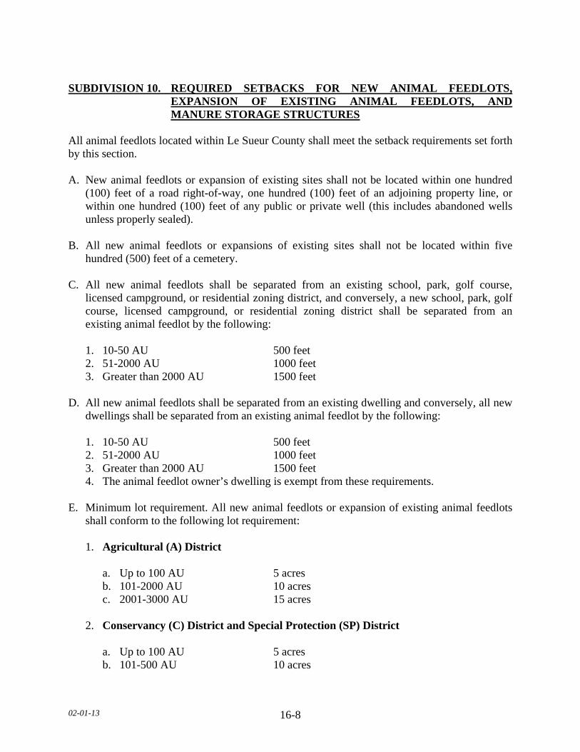
02-01-13 16-8
SUBDIVISION 10. REQUIRED SETBACKS FOR NEW ANIMAL FEEDLOTS,
EXPANSION OF EXISTING ANIMAL FEEDLOTS, AND MANURE STORAGE STRUCTURES
All animal feedlots located within Le Sueur County shall meet the setback requirements set forth by this section. A. New animal feedlots or expansion of existing sites shall not be located within one hundred
(100) feet of a road right-of-way, one hundred (100) feet of an adjoining property line, or within one hundred (100) feet of any public or private well (this includes abandoned wells unless properly sealed).
B. All new animal feedlots or expansions of existing sites shall not be located within five
hundred (500) feet of a cemetery. C. All new animal feedlots shall be separated from an existing school, park, golf course,
licensed campground, or residential zoning district, and conversely, a new school, park, golf course, licensed campground, or residential zoning district shall be separated from an existing animal feedlot by the following:
1. 10-50 AU 500 feet 2. 51-2000 AU 1000 feet 3. Greater than 2000 AU 1500 feet D. All new animal feedlots shall be separated from an existing dwelling and conversely, all new
dwellings shall be separated from an existing animal feedlot by the following: 1. 10-50 AU 500 feet 2. 51-2000 AU 1000 feet 3. Greater than 2000 AU 1500 feet 4. The animal feedlot owner’s dwelling is exempt from these requirements. E. Minimum lot requirement. All new animal feedlots or expansion of existing animal feedlots
shall conform to the following lot requirement: 1. Agricultural (A) District a. Up to 100 AU 5 acres b. 101-2000 AU 10 acres c. 2001-3000 AU 15 acres 2. Conservancy (C) District and Special Protection (SP) District a. Up to 100 AU 5 acres b. 101-500 AU 10 acres

02-01-13 16-9
3. Recreational Commercial (RC) District and Recreational Residential (RR) District a. Up to 100 AU 5 acres b. 101-300 AU 10 acres SUBDIVISION 11. MANURE MANAGEMENT A. Manure generated within Le Sueur County or originating outside the County and transported
into the County for use as domestic fertilizer shall conform with the standards contained herein and with the rules or statutes of the State of Minnesota or federal government that apply to animal feedlots and/or manure management.
1. Any person located outside the jurisdiction of Le Sueur County that transports manure to
Le Sueur County with the intent of spreading the manure within Le Sueur County shall: a. Notify the Department of the location by township, range, section and quarter section prior to transportation of manure into Le Sueur County. b. Within ninety (90) days of application, that person shall provide to the Department
the required records based on the animal unit size of the animal feedlot. B. Manure application setbacks from sensitive features shall conform to the setbacks listed in
this Section. 1. Winter Setbacks. (See following table.) 2. Non-Winter Setbacks. (See following table.)
a. Surface application with NO incorporation within twenty four (24) hours. b. Injection or incorporation within twenty four (24) hours AND phosphorus (P)
management. c. Injection or incorporation within twenty four (24) hours with NO phosphorus
management. d. Phosphorus (P) management means that the application rate and frequency over a six
(6) year period will not result in soil P build-up where soil P already exceeds 21 ppm Bray or 16 ppm Olsen.
3. Lakes, public waters, rivers and streams. Setbacks may be reduced from three hundred
(300) feet to one hundred (100) feet if permanent vegetative buffer of one hundred (100) feet wide is planted along the waters.
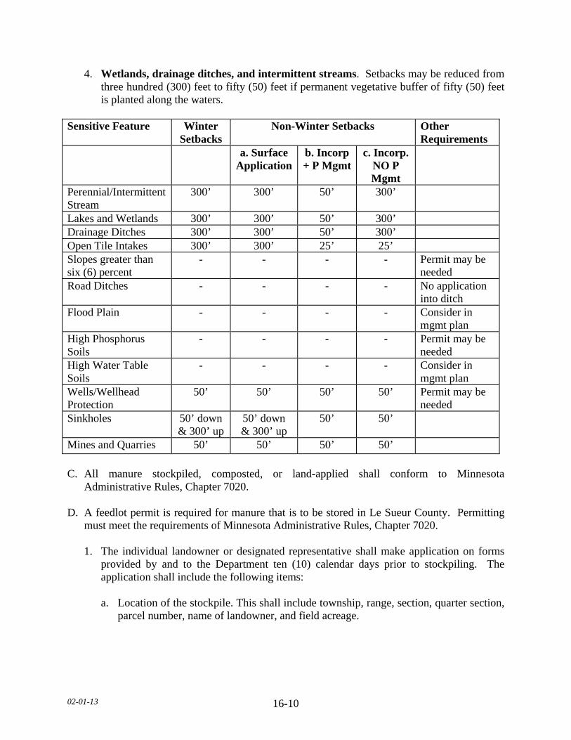
02-01-13 16-10
4. Wetlands, drainage ditches, and intermittent streams. Setbacks may be reduced from three hundred (300) feet to fifty (50) feet if permanent vegetative buffer of fifty (50) feet is planted along the waters.
Sensitive Feature Winter
Setbacks Non-Winter Setbacks Other
Requirements a. Surface
Applicationb. Incorp + P Mgmt
c. Incorp. NO P Mgmt
Perennial/Intermittent Stream
300’ 300’ 50’ 300’
Lakes and Wetlands 300’ 300’ 50’ 300’ Drainage Ditches 300’ 300’ 50’ 300’ Open Tile Intakes 300’ 300’ 25’ 25’ Slopes greater than six (6) percent
- - - - Permit may be needed
Road Ditches - - - - No application into ditch
Flood Plain - - - - Consider in mgmt plan
High Phosphorus Soils
- - - - Permit may be needed
High Water Table Soils
- - - - Consider in mgmt plan
Wells/Wellhead Protection
50’ 50’ 50’ 50’ Permit may be needed
Sinkholes 50’ down & 300’ up
50’ down & 300’ up
50’ 50’
Mines and Quarries 50’ 50’ 50’ 50’
C. All manure stockpiled, composted, or land-applied shall conform to Minnesota
Administrative Rules, Chapter 7020. D. A feedlot permit is required for manure that is to be stored in Le Sueur County. Permitting
must meet the requirements of Minnesota Administrative Rules, Chapter 7020. 1. The individual landowner or designated representative shall make application on forms
provided by and to the Department ten (10) calendar days prior to stockpiling. The application shall include the following items:
a. Location of the stockpile. This shall include township, range, section, quarter section,
parcel number, name of landowner, and field acreage.

02-01-13 16-11
b. An aerial map or sketch of the stockpile location. The map or sketch shall have labeled the location of the stockpile and any distinguishing physical features such as field road entrances, structures, tree lines, or road crossings.
c. Any deviations from the above listed requirements shall be provided to the
Department within twenty four (24) hours of the subsequent change. 2. The Department shall review the proposed stockpile location to determine if all state and
county requirements have been met. The individual landowner or designated representative shall be notified (by telephone, fax, and/or letter) as to the county’s approval of the stockpiling location.
3. The stockpiled manure shall be land-applied within twelve (12) months of establishment. 4. The manure shall be land-applied and records kept according to Minnesota
Administrative Rules, Chapter 7020 and county land application setbacks to sensitive features.
5. The manure applicator and/or landowner shall notify the Department (by telephone)
twenty four (24) hours prior to land application. 6. Within ninety (90) calendar days after land application and/or incorporation, the
landowner or designated representative shall provide the following information to the Department:
a. The application and incorporation dates. b. Amount of manure applied (total and amount per acre). c. Name of commercial applicator, if applicable. SUBDIVISION 12. SEVERABILITY If a provision of Minnesota Administrative Rules, Chapter 7020 or the application of any person or circumstances held to be invalid, such invalidity shall not affect other provisions or parts of Minnesota Administrative Rules, Chapter 7020 or application of any other part, which can be given effect without application of the invalid provision. To this end the provisions of all parts and subparts herein and the various applications thereof are declared to be severable. SUBDIVISION 13. VARIANCE Any person may apply for a variance from any requirements of Minnesota Administrative Rules, Chapter 7020. Such variance shall be applied for and acted upon by the Agency in accordance with Minnesota Statutes, Section 116.07, Subdivision 5 and other applicable statutes and rules.
02-01-13 16-12
SUBDIVISION 14. NON-CONFORMING USE A. Any animal feedlot use or occupancy as of June 10, 2010 that does not conform to the
provisions of the Ordinance, is a non-conforming use. A county feedlot permit is required for all non-conforming animal feedlots greater than ten (10) animal units located within Le Sueur County.
B. CONTINUED, RESTORED, OR ABANDONED 1. A non-conforming animal feedlot shall not be enlarged, but may be continued or restored
in accordance with this Section. 2. Any non-conforming animal feedlot which is abandoned or which is discontinued for a
period of one (1) year shall not be resumed, and any future use or occupancy of the land shall conform to this section.
C. ALTERATION OR MOVING 1. A non-conforming use or occupancy may be altered, provided such alterations do not
intensify or physically expand or extend the non-conforming use. 2. A non-conforming structure moved to a different location on a single parcel of land shall
be brought into conformance with this section. D. DAMAGE AND DESTRUCTION When a non-conforming animal feedlot is destroyed by fire or other peril to the extent of fifty (50) percent of its market value, as determined by the County Assessor, any subsequent use or occupancy of the land or premises shall conform to this section. E. RESTORATION AND REPAIR 1. A non-conforming animal feedlot may be restored or repaired as follows: a. To comply with all county, state and federal guidelines. b. If damage to less than fifty (50) percent of its market value, as determined by the
County Assessor. c. To effect repairs and necessary maintenance, which are non-structured and incidental
to the use or occupancy, provided such repairs do not constitute more than fifty (50) percent of its market value, as determined by the County Assessor.

02-01-13 16-13
SUBDIVISION 15. FEES Animal feedlot permit fees and other fees, as may be established by resolution of the Board of County Commissioners, shall be collected by the Department for deposit with the County and credited to a fund as directed by the Board of County Commissioners. All fees are payable when an application is filed.
02-01-13
17-1
SECTION 17. SUBSURFACE SEWAGE TREATMENT SYSTEMS SUBDIVISION 1. PURPOSE AND AUTHORITY A. This Section authorizes and provides for sewage treatment and soil dispersal in unsewered
areas of the county. It establishes: 1. Minimum standards for and regulation of individual subsurface sewage treatment systems
(ISTS) and mid-sized subsurface sewage treatment systems (MSTS) (collectively referred to as subsurface sewage treatment systems or SSTS) in unsewered incorporated and unincorporated areas of Le Sueur County incorporating by reference minimum standards established by Minnesota statutes and administrative rules of the Minnesota Pollution Control Agency (Agency).
2. Requirements for issuing permits for installation, alteration, repair, or expansion of an
SSTS. 3. Requirements for all SSTS permitted under the revised Minnesota Rules, Chapters 7080
and 7081 to be operated under an approved management plan. 4. Standards for upgrade, repair, replacement, or abandonment of an SSTS. 5. Penalties for failure to comply with these provisions. 6. Provisions for enforcement of these requirements, and 7. Standards which promote the health, safety, and welfare of the public as reflected in
Minnesota Statutes, Sections 115.55; 145A.05; 375.51; 394.21 through 394.37; and 471.82 and the Le Sueur County Land Use Plan and Zoning Ordinance.
B. PURPOSE The purpose of this Section is to establish minimum requirements for regulation of ISTS and MSTS for the treatment and dispersal of sewage and standards for septage removal, transport, treatment, and disposal within the applicable jurisdiction of the County to protect public health and safety, surface and groundwater quality, and to prevent or eliminate the development of public nuisances. It is intended to serve the best interests of the County’s citizens by protecting its health, safety, general welfare, and natural resources. C. INTENT It is intended by the County that this Section will promote the following:
02-01-13
17-2
1. The protection of lakes, rivers and streams, wetlands, and groundwater in Le Sueur County essential to the promotion of public health, safety, welfare, socioeconomic growth, and development of the County.
2. The regulation of proper SSTS construction, reconstruction, repair, and maintenance to
prevent the entry and migration of contaminants, thereby protecting the degradation of surface and groundwater quality.
3. The establishment of minimum standards for SSTS placement, design, construction,
reconstruction, repair, and maintenance to prevent contamination, and, if contamination is discovered, the identification and control of its consequences and the abatement of its source and migration.
4. The appropriate utilization of privy vaults and other non-water carried sewage collection
and storage facilities. 5. The provision of technical assistance and education, plan review, inspections, SSTS
surveys, and complaint investigations to prevent and control water-borne diseases, lake degradation, groundwater related hazards, and public nuisance conditions.
D. AUTHORITY This Section is adopted pursuant to Minnesota Statutes, Section 115.55; Minnesota Statutes, Sections 145A.01 through 145A.08; Minnesota Statutes, Section 375.51; or successor statutes; and Minnesota Rules, Chapters 7080 through 7083; or successor rules. E. EFFECTIVE DATE The provisions set forth in this Section shall become effective February 3, 2010. SUBDIVISION 2. GENERAL PROVISIONS A. SCOPE This Section regulates the siting, design, installation, alterations, operation, maintenance, monitoring, and management of all SSTS within the County’s applicable jurisdiction including, but not necessarily limited to, individual SSTS, cluster or community SSTS, privy vaults, and other non-water carried SSTS. All sewage generated in unsewered areas of the County shall be treated and dispersed by an approved SSTS that is sited, designed, installed, operated, and maintained in accordance with the provisions of this Section or by a system that has been permitted by the Agency.

02-01-13
17-3
B. JURISDICTION The jurisdiction of this Section shall include all lands of the County except for incorporated areas that administer an SSTS program by Ordinance within their incorporated jurisdiction, which is at least as strict as this Section and has been approved by the County. The Department shall keep a current list of local jurisdictions within the County administering an SSTS program. C. ADMINISTRATION
1. County
The Department shall administer the SSTS program and all provisions of this Section. The County shall review, revise, and update this Section as necessary. The County shall employ or retain under contract qualified and appropriately licensed professionals to administer and operate the SSTS program.
2. State of Minnesota a. Where a single SSTS or group of SSTS under single ownership within one-half mile
of each other has a design flow greater than 10,000 gallons per day, the SSTS owner or owner’s agent shall make application for and obtain a State Disposal System permit from the Agency. A State Disposal System permit is required for any SSTS with a measured daily flow that equals or exceeds 10,000 gallons per day for a consecutive seven-day time period.
b. SSTS serving establishments or facilities licensed or otherwise regulated by the State
shall conform to the requirements of this Section. 3. Cities and Townships Any jurisdiction within the County that regulates SSTS shall comply with the standards
and requirements of this Section. The standards and ordinance of the jurisdiction may be administratively and technically more restrictive than this Section.
D. VALIDITY The validity of this Section shall not be affected by any invalid part or parts of this Ordinance. E. LIABILITY Any liability or responsibility shall not be imposed upon the Department or Agency or any of its officials, employees, or other contract agent, its employees, agents, or servants thereof for damage resulting from the defective construction, operation, or abandonment of any onsite or cluster treatment system regulated under this rule by reason of standards, requirements, or inspections authorized hereunder.
02-01-13
17-4
SUBDIVISION 3. GENERAL REQUIREMENTS A. RETROACTIVITY 1. All SSTS All provisions of this Section shall apply to any SSTS regardless of the date it was
originally permitted. 2. SSTS on Lots Created After January 23, 1996 All lots created after January 23, 1996 must have a minimum of two (2) soil treatment
and dispersal areas that can support trenches, seepage beds, mounds, and at-grade systems as described in Minnesota Rules, Chapters 7080.2200 through 7080.2260 or site conditions described in 7081.0270, Subp. 3 through 7.
B. UPGRADE, REPAIR, REPLACEMENT, AND ABANDONMENT 1. SSTS Capacity Expansions Expansion of an existing SSTS must include any system upgrades that are necessary to
bring the entire system into compliance with the prevailing provisions of this Section at the time of the expansion.
2. Failure to Protect Groundwater An SSTS that is determined not to be protective of groundwater, in accordance with
Minnesota Rules, Chapter 7080.1500, Subp.4.B, shall be upgraded, repaired, replaced, or abandoned by the owner in accordance with the provisions of this Section within one (1) year of receipt of a Notice of Noncompliance.
3. Imminent Threat to Public Health or Safety An SSTS that is determined to be an imminent threat to public health or safety, in
accordance with Minnesota Rules, Chapter 7080.1500, Subp.4A, shall be upgraded, repaired, replaced, or abandoned by the owner in accordance with the provisions of this Section within six (6) months of receipt of a Notice of Noncompliance.
4. Abandonment Any SSTS, or any component thereof, which is no longer intended to be used, must be
abandoned by a licensed installation business and in accordance with Minnesota Rules, Chapter 7080.2500.
02-01-13
17-5
C. SSTS IN FLOODPLAINS An SSTS shall not be located in a floodway, and wherever possible, location within any part of a floodplain, shall be avoided. If no option exists to locate an SSTS outside of a floodplain, location within the flood fringe is allowed if the requirements in Minnesota Rules, Chapter 7080.2270 and all relevant local requirements are met. D. CLASS V INJECTION WELLS All owners of new or replacement SSTS that are considered to be Class V injection wells, as defined in the Code of Federal Regulations, title 40, parts 144 and 146, are required by the federal government to submit SSTS inventory information to the Environmental Protection Agency as described in CFR40, part 144. Further, SSTS owners are required to identify all Class V injection wells in property transfer disclosures.
E. SSTS PRACTITIONER LICENSING 1. No person shall engage in site evaluation, inspection, design, installation, construction,
alteration, extension, repair, maintenance, or pumping of an SSTS without an appropriate and valid license issued by the Agency in accordance with Minnesota Rules, Chapter 7083 except as exempted in 7083.0700.
a. Minnesota Rules, Chapter 7083.0700.B: The County will allow homeowners to install
their own systems provided they are non-pressurized systems. b. The system shall be inspected by the Department (Pictures, and/or record drawings in
lieu of Department inspection shall be prohibited). F. PROHIBITIONS 1. Occupancy or Use of a Structure without a Compliant SSTS It is unlawful for any person to maintain, occupy, or use any structure intended for
habitation that is not provided with a wastewater treatment system that disposes of wastewater in a manner that does not comply with the provisions of this Section.
2. Sewage Discharge to Ground Surface or Surface Water
It is unlawful for any person to construct, maintain, or use any SSTS system regulated
under this Section that results in raw or partially treated wastewater seeping to the ground surface or flowing into any surface water. Any surface discharging system must be permitted under the National Pollutant Discharge Elimination System (NPDES) program by the Agency.

02-01-13
17-6
3. Sewage Discharge to a Well or Boring
It is unlawful for any person to discharge raw or treated wastewater into any well or boring as described in Minnesota Rules, Chapter 4725.2050, or any other excavation in the ground that is not in compliance with this Section.
4. Discharge of Hazardous Materials
It is unlawful for any person to discharge into any sewage treatment system regulated
under this Section any hazardous material that adversely affects the treatment or dispersal performance of the system or groundwater quality.
SUBDIVISION 4. SSTS STANDARDS A. STANDARDS ADOPTED BY REFERENCE The County hereby adopts by reference Minnesota Rules, Chapters 7080 and 7081 in their entirety as now constituted and as amended from time to time. This adoption does not supersede the County’s right or ability to adopt local standards that are in compliance with Minnesota Statute, Section 115.55.
B. AMENDMENTS TO THE ADOPTED STANDARDS 1. List of Adopted Standards a. Type V Systems will not be allowed. b. Three (3) feet of vertical separation shall be required for all SSTS. c. Systems deemed as failing to protect groundwater shall be updated within one (1)
year of receiving a Notice of Non Compliance (NONC). d. Systems deemed an Imminent Threat to Public Health (ITPH) shall be updated within
six (6) months of NONC. e. Septic designs must be submitted to the Department within twenty (20) calendar days
after receipt of NONC or ITPH. f. Request to the Department for a septic inspection or soil verification must be received
one (1) calendar day prior to the inspection. g. Record drawings must be submitted to the Department within five (5) calendar days. h. Property transfers with a NONC must be updated within one (1) year of the NONC or
within one year of the transfer, whichever occurs first.
02-01-13
17-7
i. If compliance inspections cannot be performed between November 1 and April 30 due to soil conditions and/or weather conditions for property transfers and/or permit requirements, the compliance inspection is required to be submitted to the Department by the following June 1.
1. If the SSTS is determined not to be protective of groundwater, the landowner
shall submit a certificate of compliance by the following September 30th. 2. If the SSTS is determined to be an imminent threat to public health or safety, the
landowner shall submit a certificate of compliance by the following June 30th. 3. Permits and/or variances may be issued by the County during this period in the
County’s sole discretion . j. The Compliance Inspection shall be the responsibility of the landowner. k. In all non-shoreland Zoning Districts, any zoning permits requested for the principal
structure shall require a compliance inspection. l. In all shoreland Zoning Districts, any zoning permits requested shall require a
compliance inspection. m. A fifty (50) foot setback is required from the top of the drainage ditch or waters of the
state, unless otherwise designated. n. A seventy-five (75) foot setback from Type 3 through 8 wetlands. o. A ten (10) foot setback from a pool. p. No SSTS shall be constructed within thirty (30) feet from the top or the toe of a bluff,
SSTS upgrade and/or replacement for an existing dwelling shall be exempt from this standard, however, must not be located within the bluff.
q. Continued use of an existing treatment tank shall be exempt from the required setback
to a structure provided the tank meets all requirements of this Section and shall not be located under or within a structure or other impermeable surface.
r. Abandonment of an SSTS shall be performed by a licensed installation business. 2. Determination of Hydraulic Loading Rate and SSTS Sizing Table IX from Minnesota Rules, Chapter 7080.2150, Subp. 3(E) entitled “Loading Rates
for Determining Bottom Absorption Area and Absorption Ratios Using Detail Soil Descriptions” and herein adopted by reference shall be used to determine the hydraulic loading rate and infiltration area for all SSTS permitted under this Section.
02-01-13
17-8
3. Compliance Criteria for Existing SSTS a. An SSTS built before April 1, 1996, outside of areas designated as shoreland areas,
wellhead protection areas, or an SSTS providing sewage treatment for food, beverage, or lodging establishments, must have at least two (2) feet of vertical separation between the bottom of the dispersal system and the periodically saturated soil or bedrock.
b. An SSTS built after March 31, 1996 or an SSTS located in a shoreland area, wellhead
protection area, or serving a food, beverage, or lodging establishment as defined under 7080.1100, Subp. 84 shall have three (3) feet of vertical separation between the bottom of the dispersal system and the periodically saturated soil or bedrock. An existing system may be considered compliant under this Section if there is less than a fifteen (15) percent reduction in vertical separation (a separation distance of no less 30.6 inches) to account for the settling of sand or soil, normal variation of separation distance measurements, and interpretation of limiting layer characteristics.
c. The vertical separation measurement described above shall be measured outside the
area of system influence but in an area of similar soil as required in Minnesota Rules, Chapter 7080.1500, Subp.4.
4. Holding Tanks a. Holding tanks shall be installed in accordance with Minnesota Rules, Chapter
7080.2290 and Chapter 7081.0240, Subp. 2.E b. Holding tanks may be allowed for areas only where it can be shown conclusively that
a Type 1 SSTS, permitted under this Section, cannot be feasibly installed without a variance.
c. Holding tanks shall not be allowed for any other wastewater applications except for
the following: 1. Other Establishments 2. Conforming Accessory Structures. C. VARIANCES 1. Variance Requests A landowner may request a variance from the standards as specified in this Ordinance
pursuant to county policies and procedures. The standards for the granting of a variance shall be those in this Ordinance, and any additional standards set forth in pertinent statutes and rules of the Agency.
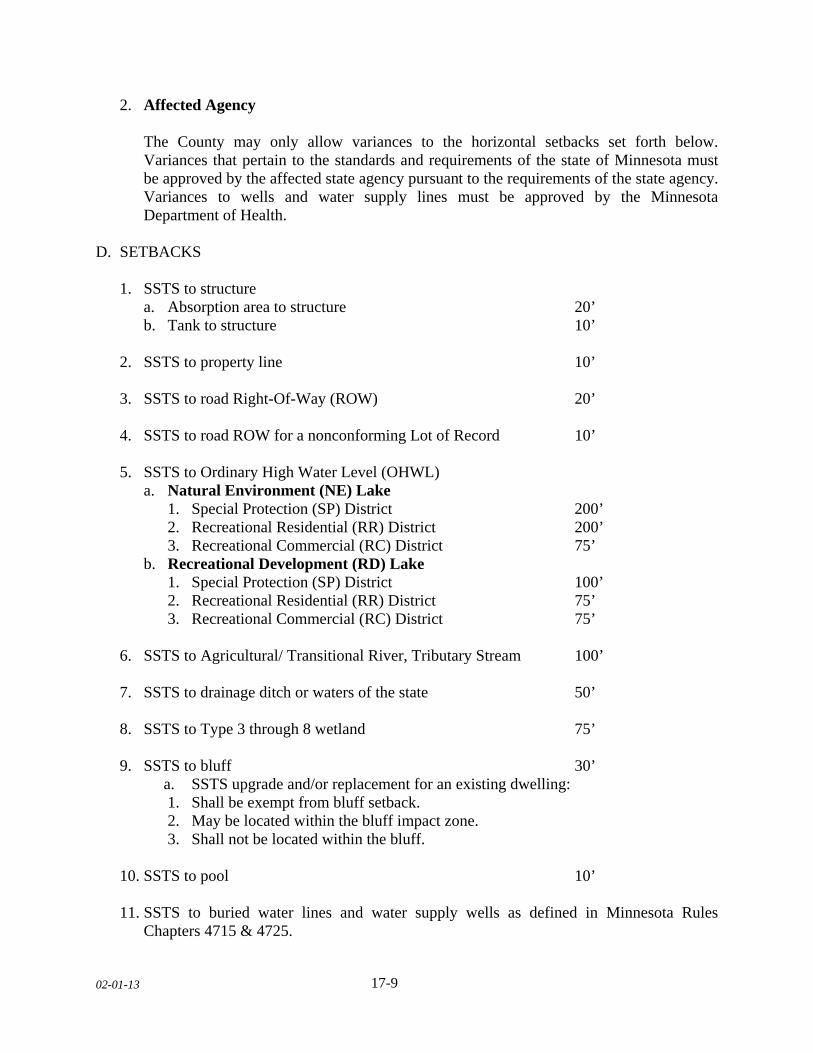
02-01-13
17-9
2. Affected Agency The County may only allow variances to the horizontal setbacks set forth below.
Variances that pertain to the standards and requirements of the state of Minnesota must be approved by the affected state agency pursuant to the requirements of the state agency. Variances to wells and water supply lines must be approved by the Minnesota Department of Health.
D. SETBACKS 1. SSTS to structure a. Absorption area to structure 20’ b. Tank to structure 10’ 2. SSTS to property line 10’ 3. SSTS to road Right-Of-Way (ROW) 20’ 4. SSTS to road ROW for a nonconforming Lot of Record 10’ 5. SSTS to Ordinary High Water Level (OHWL)
a. Natural Environment (NE) Lake 1. Special Protection (SP) District 200’
2. Recreational Residential (RR) District 200’ 3. Recreational Commercial (RC) District 75’ b. Recreational Development (RD) Lake 1. Special Protection (SP) District 100’ 2. Recreational Residential (RR) District 75’ 3. Recreational Commercial (RC) District 75’
6. SSTS to Agricultural/ Transitional River, Tributary Stream 100’ 7. SSTS to drainage ditch or waters of the state 50’ 8. SSTS to Type 3 through 8 wetland 75’ 9. SSTS to bluff 30’
a. SSTS upgrade and/or replacement for an existing dwelling: 1. Shall be exempt from bluff setback. 2. May be located within the bluff impact zone. 3. Shall not be located within the bluff.
10. SSTS to pool 10’ 11. SSTS to buried water lines and water supply wells as defined in Minnesota Rules
Chapters 4715 & 4725.
02-01-13
17-10
SUBDIVISION 5. SSTS PERMITTING A. PERMIT REQUIRED It is unlawful for any person to construct, install, modify, replace, or operate an SSTS without the appropriate permit from the Department. The issuing of any zoning permit, variance, or conditional use under the provisions of this Ordinance shall not absolve the applicant of responsibility to obtain any other required permit. B. PERMIT 1. The SSTS owner or owner’s agent shall obtain a zoning permit from the Department
prior to the installation, construction, replacement, modification, alteration, repair, or capacity expansion of an SSTS. The purpose of this permit is to ensure that the proposed activity is sited, designed, and constructed in accordance with the provisions of this Section by appropriately certified and/or licensed practitioner(s).
2. Activities Requiring a Permit A zoning permit is required for installation of a new SSTS, for replacement of an existing
SSTS, or for any repair or replacement of components that will alter the original function of the system, change the treatment capacity of the system, change the location of the system, or otherwise change the original system’s design, layout, or function.
3. Activities Not Requiring a Permit A zoning permit is not required for minor repairs or replacements of system components
that do not alter the original function of the system, change the treatment capacity of the system, change the location of the system, or otherwise change the original system’s design, layout, or function.
4. Permit Required An SSTS design must be submitted and approved prior to the issuance of a zoning permit
for SSTS activity.
5. Conformance to Prevailing Requirements
a. Any activity involving an existing system that requires a zoning permit shall require that the entire system be brought into compliance with this Section.
b. Continued use of an existing treatment tank shall be exempt from the required setback
to a structure provided the following: 1. The tank meets tank integrity requirements.
02-01-13
17-11
2. Tank integrity documentation must be submitted by an appropriately certified and/or licensed practitioner.
3. Shall not be located under or within a structure or other impermeable surface.
6. Monitoring and Disposal Contract
a. Owners of holding tanks shall provide to the Department a copy of a valid monitoring
and disposal contract executed between the owner and a licensed maintenance business, which guarantees the removal of the holding tank contents in a timely manner that prevents an illegal discharge in accordance with Minnesota Rules, Chapter 7082.0100, Subp. 3G.
1. This requirement is waived if the SSTS owner is a farmer who is exempt from licensing under Minnesota Statutes, section 115.56, subdivision 3, paragraph (b), clause (3).
7. Permit Requirements for ISTS a. Owner name, mailing address, and telephone number. b. Property Identification Number and address or other description of property location. c. Site Evaluation Report as described in Minnesota Rules, Chapter 7080.1730. d. Design Report as described in Minnesota Rules, Chapter 7080.2430. e. Management Plan as described in Minnesota Rules, Chapter 7082.0600. f. Additional information as deemed necessary by the Department. 8. Permit Requirements for MSTS a. Owner name, mailing address, and telephone number. b. Property Identification Number and address or other description of property location. c. Soil and Site Report as described in Minnesota Rules, Chapter 7081.0200. d. Groundwater Investigation as described in Minnesota Rules, Chapter 7081.0210. e. Design Report as described in Minnesota Rules, Chapter 7081.0270, Subp. 11. f. Operation and Maintenance Plan as described in Minnesota Rules, Chapter 7080.2450
and Chapter 7081.0290.
02-01-13
17-12
g. Management Plan as described in Minnesota Rules, Chapter 7082.0600. h. Additional information as deemed necessary by the Department.
9. Application Review and Response
a. The Department shall review the permit application and supporting documents. b. Upon satisfaction that the proposed work will conform to the provisions of this
Section, the SSTS owner or owner’s agent shall obtain a zoning permit authorizing construction of the SSTS as designed.
c. In the event the designer makes a significant change to the approved design
documentation, the designer must file an amended documentation detailing the changed conditions for approval prior to initiating or continuing construction, modification, or operation for approval or denial.
1. The Department shall the review of the amended design. 2. Upon satisfaction that the amended design will conform to the provisions of this
Section, the SSTS owner or owner’s agent shall obtain a new zoning permit authorizing construction of the SSTS as designed.
d. If the design, is incomplete or does not meet the requirements of this Section, the
Department shall deny the design. A notice of denial shall be provided to the designer, which must state the reason for the denial.
10. Appeal
The SSTS owner or designer may appeal the Department’s decision to deny the permit in accordance with the County’s established policies and appeal procedures.
C. OPERATING PERMIT 1. SSTS Requiring an Operating Permit
a. An operating permit shall be required of all owners of new MSTS, Type IV, or any
other system deemed by the Department to require operational oversight. b. An operating permit shall be required of all owners of existing MSTS, Type IV, or
any other system deemed by the Department to require operational oversight upon the following:
1. Transfer of ownership. 2. Any replacement, modification or expansion requiring a zoning permit.
02-01-13
17-13
3. Following any SSTS enforcement action. c. The SSTS owner shall be responsible for the operating permit.
2. Operating Permit Application Requirements a. Application for an operating permit shall be made as provided by the Department
including: 1. SSTS owner name, mailing address, and telephone number. 2. Property Identification Number. 3. Permit reference number and date of issuance. 4. Record drawings. 3. Department Response If the submitted documents fulfill the requirements, the Department shall issue an
operating permit. 4. Operating Permit Terms and Conditions The operating permit shall comply with Minnesota Rules, Chapter 7082.0600, Subp.2.B.
5. Operating Permit Expiration and Renewal
a. Operating permits shall be valid for three (3) years from date of Certificate of
Compliance. The Department shall notify the holder of an operating permit at least ninety (90) calendar days prior to expiration.
b. An operating permit must be renewed thirty (30) days prior to its expiration. If not
renewed, the Department will issue a Notice of Noncompliance. c. Application shall be made as provided by the Department. 6. Amendments to Existing Operating Permits The Department may not amend an existing operating permit to reflect changes in this
Section until the operating permit term has expired and is renewed, unless an amendment is necessary to eliminate an imminent threat to public health or safety.
02-01-13
17-14
7. Transfers The operating permit may be transferred to the new landowner. 8. Suspension or Revocation a. The Department may suspend or revoke any operating permit issued under this
Section for any false statements or misrepresentations of facts on which the operating permit was issued.
b. Notice of suspension or revocation and the reasons for revocation shall be conveyed
in writing to the SSTS owner. c. If suspended or revoked, the Department will issue a Notice of Noncompliance. d. At the Department’s discretion, the operating permit may be reissued upon the SSTS
owner taking appropriate corrective actions. 9. Compliance Monitoring
a. Performance monitoring of an SSTS shall be performed by a licensed service
provider hired by the holder of the operating permit in accordance with the monitoring frequency and parameters stipulated in the permit.
b. A monitoring report shall be prepared and certified by a licensed service provider.
The report shall be submitted to the Department on or before the compliance reporting date stipulated in the operating permit. The report shall contain a description of all maintenance and servicing activities performed since the last compliance monitoring report as described below:
1. SSTS owner name, mailing address, and telephone number. 2. Property Identification Number. 3. Operating permit number. 4. Average daily flow since last compliance monitoring report. 5. Description of type of maintenance and date performed. 6. If required, analytical laboratory used and results of analyses. 7. Problems noted with the system and actions proposed or taken to correct them. 8. Name, signature, and certification and license number of the licensed professional
who performed the work.

02-01-13
17-15
D. ABANDONMENT CERTIFICATION 1. Purpose The purpose of the abandonment certification is to ensure that a treatment system no
longer in service is abandoned within a reasonable time following decommissioning and in a manner that protects public health, safety, and water quality. It also terminates all permits associated with the system.
2. Abandonment Requirements a. Whenever the use of an SSTS or any system component is discontinued as the result
of a system repair, modification, replacement, or decommissioning following connection to a municipal or private sanitary sewer or condemnation or demolition of a structure served by the system, further use of the system or any system component for any purpose under this Section, shall be prohibited.
b. Continued use of a treatment tank, where the tank is to become an integral part of a
replacement system or a sanitary sewer system, requires a written statement by an appropriately certified and/or licensed practioner.
c. An owner of an SSTS must retain a licensed installation business to abandon all
components of the treatment system. Abandonment shall be completed in accordance with Minnesota Rules, Chapter 7080.2500.
d. A report of abandonment certified by the licensed installation business shall be
submitted to the Department within fifteen (15) calendar days of completed system abandonment.
3. Certificate of Abandonment The Department shall keep on file a copy of the Certificate of Abandonment as submitted
by a licensed installation business. SUBDIVISION 6. MANAGEMENT PLANS A. PURPOSE The purpose of management plans is to describe how a particular SSTS is intended to be operated and maintained to sustain the performance required. The plan is to be provided by the certified designer to the SSTS owner when the treatment system is designed.
02-01-13
17-16
B. MANAGEMENT PLAN REQUIREMENTS 1. SSTS Requiring Management Plans Management plans are required for all new or replacement SSTS. The management plan
shall be submitted to the Department with the permit for review and approval. The Department shall be notified of any system modifications made during construction, and the management plan revised and resubmitted at the time of final construction certification.
2. Required Contents of a Management Plan a. Management Plans shall contain all the information required by Minnesota Rules,
Chapter 7082.0600, Subp.1. b. Other requirements as determined by the Department. 3. Requirements for Systems not Operated under a Management Plan as described in
Minnesota Rules, Chapter 7082.0100, Subp. 3.(L). a. SSTS that are not operated under a management plan or operating permit must have
their treatment tanks inspected and provide for the removal of solids accumulation at least once every three (3) years as described in Minnesota Rules, Chapter 7080.2450.
SUBDIVISION 7. COMPLIANCE INSPECTION PROGRAM A. COMPLIANCE INSPECTION
1. SSTS compliance inspections must be performed:
a. To ensure compliance with applicable requirements. b. Prior to issuance of a zoning permit within Shoreland Zoning Districts. c. Prior to issuance of a zoning permit for single family dwellings or any change in the
principle structure in all non-shoreland Zoning districts. d. For all new SSTS construction replacement. e. At any time as required by this Section or when the Department deems appropriate,
such as upon receipt of a complaint or other notice of a system malfunction.
02-01-13
17-17
2. It shall constitute a compliance inspection when a party who is not the SSTS owner conducts an evaluation, investigation, inspection, recommendation, or other process used to prepare a disclosure statement. This process shall be conducted in accordance with Minnesota Rules, Chapter 7082.0700 using the SSTS inspection report forms provided by the Agency.
B. DEPARTMENT RESPONSIBILITY
1. It is the responsibility of the Department, or its agent, to perform various SSTS
compliance inspections on new SSTS, for replacement of an existing SSTS, or for any repair or replacement of components that will alter the original function of the system, change the location of the system, or otherwise change the original system’s design, layout, or function to assure that the requirements of this Section are met.
2. The Department shall be given access to enter a property at any reasonable time to
inspect the SSTS system. As used in this paragraph, “property” does not include a residence or private structure.
3. No person shall hinder or otherwise interfere with the Department’s employees in the
performance of their duties and responsibilities pursuant to this Ordinance. Refusal to allow reasonable access to the property by the Department shall be deemed a separate and distinct offense.
C. NEW CONSTRUCTION OR REPLACEMENT
1. Compliance inspections must be performed on new or replacement SSTS to determine
compliance with Minnesota Rules, Chapters 7080 or 7081. All compliance inspections must be performed and signed by qualified employees. An SSTS found to be noncompliant with other applicable requirements must be repaired or replaced according to the Department’s requirements.
2. Soil Verifications-Periodically Saturated Soils Dispute Procedures between a certified
licensed business and the Department shall: a. Meet on-site with designer; b. If not resolved, meet on-site with another qualified employee from the Department
along with the designer; c. If not resolved, hire a Minnesota licensed professional soil scientist who is a certified
SSTS designer or inspector at the landowner’s expense to make the final judgment. 3. It is the responsibility of the SSTS owner or the owner’s agent to notify the Department,
one (1) calendar day prior to soil verification and/or inspection of the SSTS.
02-01-13
17-18
4. The Department will conduct up to three (3) inspections during construction of the SSTS at such time to assure that the system has been constructed per submitted and approved design.
a. If proper notice is received and the Department does not appear for an inspection
within two (2) hours after time set, the permittee may complete the installation. b. The permittee shall then file a signed record drawing including photographs of the
system prior to covering with the Department within five (5) calendar days that the work was installed in accordance with the submitted design, permit conditions, and that it was free from defects.
5. Signed record drawings shall be submitted to the Department within five (5) calendar
days.
6. The Department shall issue a Certificate of Compliance for new SSTS construction or replacement, which shall be valid for five (5) years. The Department must have reasonable assurance that the system was built in accordance with the applicable requirements as specified in the design and permit. The Certificate of Compliance shall become invalid if the Department finds evidence of noncompliance.
7. The Certificate of Compliance must include a certified statement by a certified, licensed
inspector or qualified employee who conducted the inspection that the SSTS is or is not in compliance with the Section requirements. If the SSTS is determined not to be in compliance with the applicable requirements, a Notice of Noncompliance shall be issued to the SSTS owner, which includes a statement specifying those Section provisions with which the SSTS does not comply.
8. The Department shall issue the Certificate of Compliance or Notice of Noncompliance to
the SSTS owner or the owner’s agent within fifteen (15) calendar days of receipt all necessary documentation from the septic installer.
D. EXISTING SYSTEMS
1. Compliance inspections shall be required when any of the following conditions occur:
a. Prior to issuance of a zoning permit within Shoreland Zoning Districts. b. Prior to issuance of a zoning permit requested for all single-family dwellings or
change in the principal structure for all non-shoreland Zoning districts. c. Upon receipt of a variance and/or conditional use permit application. d. When a construction permit is required to repair, modify, or upgrade an existing
system.
02-01-13
17-19
e. Any time there is a change in use of the property and/or expansion of the structure being served by an existing SSTS, which may impact the performance of the system.
f. Prior to property sale or transfer. g. At any time as required by this Section or the Department deems appropriate such as
upon receipt of a complaint or other notice of a system malfunction. 2. All property conveyances subject to this Section occurring during the period between
November 1 and April 30, or when an SSTS compliance cannot be determined due to frozen soil conditions, shall require a compliance inspection by the following June 1 by a licensed inspection business.
a. If the SSTS is determined not to be protective of groundwater, the landowner shall
submit a certificate of compliance by the following September 30th. b. If the SSTS is determined to be an imminent threat to public health or safety, the
landowner shall submit a certificate of compliance by the following June 30th. 3. Compliance inspections of an existing SSTS shall be documented on the inspection report
forms provided by the Agency. Requirements for inspection reports are described in Minnesota Rules, Chapter 7082.0700. Requirements for inspection reports are described in Minnesota Rules, Chapter 7082.0700, Subp. 4(B).
4. Periodically saturated soils dispute procedure between two (2) certified, licensed
businesses as described in Minnesota Rules 7082.0700, Subp. 5. 5. SSTS that are determined to have operational or monitoring deficiencies must
immediately be maintained, monitored, or otherwise managed according to the operating permit.
6. The Certificate of Compliance must include a certified statement by a qualified employee
or licensed inspection business, indicating whether the SSTS is in compliance with the Section requirements. If the SSTS is determined not to be in compliance with the applicable requirements, a Notice of Noncompliance must include a statement specifying those Section provisions with which the SSTS does not comply. A permit application must be submitted to the Department if required. The Certificate of Compliance or Notice of Noncompliance must be submitted to the Department and to the SSTS owner or the owner’s agent from the licensed inspection business no later than fifteen (15) calendar days after the date the inspection was performed.
7. Certificates of Compliance for existing SSTS shall remain valid for three (3) years from
the date of issue unless the Department finds evidence of noncompliance.
02-01-13
17-20
E. TRANSFER OF PROPERTIES
1. Whenever a conveyance of land occurs upon which a structure is located that has an existing SSTS, a Compliance Inspection shall be provided by the seller to the buyer at or before the closing date, unless there is a valid Certificate of Compliance on file with the Department.
2. The compliance inspection need not be completed if the sale or transfer involves the
following circumstances: a. The affected tract of land is without structures or contains no structures with
plumbing fixtures. b. The transfer does not require the filing of a Certificate of Real Estate Value, as
described in Minnesota Statutes, Section 272.115, Subdivision 1. c. The sale or transfer completes a contract for deed or purchase agreement entered into
prior to June 18,1996. This subsection applies only to the original vendor and vendee on such a contract.
d. Any structures that are connected exclusively to a municipal wastewater treatment
system; any structures that are located within the jurisdiction of the County with an approved agreement requiring exclusive connection to a municipal wastewater treatment system; or, any structures that are connected exclusively to an approved wastewater treatment facility other than an individual sewage treatment system.
3. The responsibility of upgrading the non-complying SSTS shall be that of the landowner. SUBDIVISION 8. ENFORCEMENT A. VIOLATIONS 1. Cause to Issue a Notice of Violation Any person, firm, agent, or corporation who violates any of the provisions of this Section,
or who fails, neglects, or refuses to comply with the provisions of this Section, including violations of conditions and safeguards, or who knowingly makes any material false statement or knowing omission in any document required to be submitted under the provisions hereof, shall be guilty of a misdemeanor and upon conviction thereof, shall be punishable as defined by Minnesota State Statutes. Each day that a violation exists shall constitute a separate offense.
2. Notice of Violation
a. The Department shall serve, in person or by mail, a Notice of Violation (NOV) to any
person determined to be violating provisions of this Section. The NOV shall contain:
02-01-13
17-21
1. A statement documenting the findings of fact determined through observations,
inspections, or investigations. 2. A list of specific violation(s) of this Section. 3. Specific requirements for correction or removal of the specified violation(s). 4. A mandatory time schedule for correction, removal and compliance with this
Section. 3. Cease and Desist Orders Cease and desist orders may be issued when the Department has probable cause that an
activity regulated by this Section or any other Section of this Ordinance is being or has been conducted without a permit or in violation of a permit. When work has been stopped by a cease and desist order, the work shall not resume until the reason for the work stoppage has been completely satisfied, any fees paid as deemed necessary by the Department, and the cease and desist order lifted.
B. PROSECUTION In the event of a violation or threatened violation of any part of this Section, the County shall enforce the provisions of this Section as provided for and described in this Ordinance. C. NOTIFICATION OF VIOLATION The Department shall notify the Agency of any inspection, installation, design, construction, alteration, or repair of an SSTS by a licensed/certified person or any septage removal by a licensed maintainer that is performed in violation of the provisions of this Section or Minnesota Rules, Chapters 7080 or 7081. D. RECORD KEEPING The County shall maintain current record records as described in Minnesota Rules, Chapter 7082.0300, Subp.4. E. FEES From time to time, the County Board shall, by resolution, establish fees for activities undertaken by the Department pursuant to this Ordinance. Fees shall be due and payable at a time and in a manner to be determined by the Department.
02-01-13
17-22
F. INTERPRETATION In their interpretation and application, the provisions of this Section shall be held to be minimum requirements and shall be liberally construed in favor of the County and shall not be deemed a limitation or repeal of any other powers granted by Minnesota Statutes. G. SEVERABILITY If any subdivision, clause, provision, or portion of this Section is adjudged unconstitutional or invalid by a court of law, the remainder of this Ordinance shall not be affected and shall remain in full force.
H. ABROGATION AND GREATER RESTRICTIONS It is not intended by this Section to repeal, abrogate, or impair any other existing County Ordinance, easements, covenants, or deed restrictions. However, where this Section imposes greater restrictions, the provisions of this Section shall prevail. All other Sections and/or Ordinances inconsistent with this Section, are hereby repealed to the extent of the inconsistency only.

02-01-13 18- 1
SECTION 18. ENVIRONMENTAL PERFORMANCE STANDARDS SUBDIVISION 1. WETLAND CONSERVATION A. PURPOSE The County finds that wetlands provide a variety of benefits. Wetlands maintain water quality by filtering and absorbing polluted surface water runoff, reduce flooding and soil erosion, recharge groundwater, provide fish and wildlife habitat, provide open space, and are an integral part of the County’s environment. Wetlands are important physical, educational, ecological, aesthetic, recreational, and economic assets to the County. They are critical to the County’s stormwater management and other aspects of the public health, safety, and general welfare. Regulating wetlands and the land uses around them are therefore in the public interest. B. AUTHORITY The Wetland Conservation Act (WCA) of 1991, shall be adopted by reference, as amended from time to time. Le Sueur County designates the administrative responsibilities as the local government unit (LGU) to Le Sueur County Soil and Water Conservation Districts (SWCD) who will be responsible for the implementation of WCA in order for Le Sueur County to fulfill their responsibilities as the LGU. C. PRESERVATION To the extent possible, all wetlands shall be retained in their natural state. Alterations to wetlands shall require review by the Le Sueur County SWCD. The following provisions apply to wetlands in Le Sueur County. D. WETLAND BOUNDARY OR TYPE APPLICATIONS An applicant and/or landowner may apply for a wetland boundary or type decision from the Le Sueur County SWCD or submit a wetland boundary or type decision by a certified wetland delineator. The applicant and/or landowner is responsible for submitting proof necessary to make the decision. Applications for approval of wetland boundary or type must include information in accordance with wetland delineation report submittal guidelines provided. A wetland boundary or type application may be submitted independently or as part of a no-loss, exemption, sequencing, replacement plan, or banking application. E. GENERAL STANDARDS The following regulations shall apply in all Districts: 1. New Structures or additions to existing structures shall be set back seventy five (75) feet
from the wetland boundary of any Type three (3) through Type eight (8).
02-01-13 18- 2
2. No part of any sewage treatment system shall be located closer than seventy five (75) feet from the wetland boundary of any Type three (3) through Type eight (8) or ordinary high water level.
3. Organic waste which would normally be disposed of at a solid waste treatment site or
which would normally be discharged into a sewage treatment system or sewer shall not be directly or indirectly discharged to a wetland.
SUBDIVISION 2. BLUFF REGULATIONS A. GENERAL STANDARDS
1. All development shall conform to the natural limitations presented by the topography and
soil as to create the best potential for preventing soil erosion. 2. No structure shall be constructed in any bluff or bluff impact zone as defined in this
Ordinance. Essential Services shall be exempt from this standard. 3. Filling and cutting activity in any bluff or bluff impact zone shall be considered a
conditional use. In no case shall cutting or filling be allowed for the purpose of establishing a site for the erection of a structure.
4. If the adjacent bluff is actively eroding, the Department may increase the setback
requirement. 5. Development on steep slopes with a grade between eight (8) to eighteen (18) percent
shall be carefully reviewed to insure adequate measures have been taken to prevent erosion, sedimentation, and structural damage.
B. BLUFF SETBACKS 1. All structures shall be set back from the top and/or toe of the bluff:
a. Thirty (30) feet for bluffs with slopes eighteen (18) to thirty (30) percent. b. Fifty (50) feet for bluffs with slopes greater than thirty (30) percent. c. Existing Building Sites. All structures shall be set back thirty (30) feet from the top
or toe of the bluff. 2. SSTS shall be set back thirty (30) feet from the top or toe of the bluff.
a. SSTS upgrade and/or replacement for an existing dwelling:
1. Shall be exempt from bluff setback. 2. May be located within the bluff impact zone. 3. Shall not be located within the bluff.
02-01-13 18- 3
3. If the adjacent bluff is actively eroding, the Department may increase the setback
requirement.
4. Structures and accessory facilities, except stairways and landings, must not be placed within bluff impact zones.
SUBDIVISION 3. GRADING, EXCAVATING, OR FILLING STANDARDS A. APPLICABILITY 1. Grading, excavating or filling activities that involve topographic alterations in all districts
shall conform to the following standards of this Section, with the following exceptions. a. Grading, excavating, or filling activities necessary for the construction of structures,
sewage treatment systems, and driveways under validly issued zoning permits shall be exempt from this standard.
b. Public roads and land alterations for agricultural purposes shall be exempt from this
standard. 2. Grading, excavating or filling activities within the bluff shall be a conditional use.
B. STANDARDS 1. There shall be no substantial environmental impact or that such impact shall be alleviated
through the County’s Erosion Control Standards and other conditions of the permit. 2. There shall be no substantial adverse impact on surrounding properties. 3. Grading, excavating or filling activities within a shoreland district shall conform to the
regulations of this Ordinance. 4. Grading, excavating or filling activities in any type of wetland shall be evaluated in
accordance with the WCA regulations, as administered by the Le Sueur County SWCD. C. PERMIT REQUIREMENTS 1. Plans shall be submitted by the applicant and/or landowner as indicated in the following
table for review by the Department. The Department may request review by the SWCD. 2. Erosion control measures shall be required. Erosion and siltation of the surrounding area
shall be prohibited. 3. The proposed grading, excavating or filling activities shall occur within one (1) year of
permit issuance.
02-01-13 18- 4
4. The permit shall specify what operations are to occur in the permitted area and what
general types of equipment may be used in the operation. 5. A National Pollution Discharge Elimination System (NPDES) permit shall be obtained if
the land disturbance is greater than one (1) acre. 6. Refer to the following table for permitting requirements for grading, excavating or filling
activities in each zoning district.
(TABLE ON NEXT PAGE)
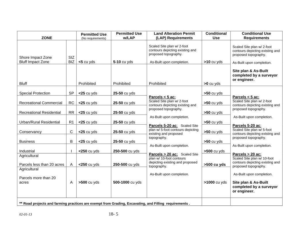
02-01-13 18- 5
ZONE Permitted Use (No requirements)
Permitted Use w/LAP
Land Alteration Permit (LAP) Requirements
Conditional Use
Conditional Use Requirements
Shore Impact Zone Bluff Impact Zone
SIZ BIZ <5 cu yds 5-10 cu yds
Scaled Site plan w/ 2-foot contours depicting existing and proposed topography. As-Built upon completion. >10 cu yds
Scaled Site plan w/ 2-foot contours depicting existing and proposed topography. As-Built upon completion. Site plan & As-Built completed by a surveyor or engineer. Bluff Prohibited Prohibited Prohibited >0 cu yds
Special Protection SP <25 cu yds 25-50 cu yds Parcels < 5 ac: Scaled Site plan w/ 2-foot contours depicting existing and proposed topography. As-Built upon completion. Parcels 5-20 ac: Scaled Site plan w/ 5-foot contours depicting existing and proposed topography. As-Built upon completion. Parcels > 20 ac: Scaled Site plan w/ 10-foot contours depicting existing and proposed topography. As-Built upon completion.
>50 cu yds Parcels < 5 ac: Scaled Site plan w/ 2-foot contours depicting existing and proposed topography. As-Built upon completion. Parcels 5-20 ac: Scaled Site plan w/ 5-foot contours depicting existing and proposed topography. As-Built upon completion. Parcels > 20 ac: Scaled Site plan w/ 10-foot contours depicting existing and proposed topography. As-Built upon completion. Site plan & As-Built completed by a surveyor or engineer.
Recreational Commercial RC <25 cu yds 25-50 cu yds >50 cu yds
Recreational Residential RR <25 cu yds 25-50 cu yds >50 cu yds
Urban/Rural Residential R1 <25 cu yds 25-50 cu yds >50 cu yds
Conservancy C <25 cu yds 25-50 cu yds >50 cu yds
Business B <25 cu yds 25-50 cu yds >50 cu yds
Industrial I <250 cu yds 250-500 cu yds >500 cu yds Agricultural Parcels less than 20 acres A <250 cu yds 250-500 cu yds >500 cu yds Agricultural Parcels more than 20 acres
A
>500 cu yds
500-1000 cu yds
>1000 cu yds
** Road projects and farming practices are exempt from Grading, Excavating, and Filling requirements .
02-01-13 18- 6
D. ASSURANCE REQUIREMENTS 1. A performance bond, letter of credit, or other improvement security satisfactory to the
County shall be required to be filed with the Department for grading, excavating or filling activities involving the movement of more than fifteen hundred (1500) cubic yards of material.
a. The County shall specify the amount and type of assurance required. b. The assurance shall be used to reimburse the County for any monies, labor, or
materials expended to bring the operation into compliance with the conditions of the permit. This includes, but is not limited to cover all costs of improvements, landscaping, maintenance of improvements, engineering, inspection and professional fee and consultant costs.
c. The assurance may be used in the event of failure to execute any phase of the
restoration plan specifically scheduled as required in the permit. d. This option may be executed one hundred and eighty (180) days after written notice
of non-compliance to the applicant and/or landowner.
2. The applicant and/or landowner shall acquire and keep in force for the duration of the permit, liability insurance specifically covering the project.
3. The applicant and/or landowner shall provide certification of insurance. SUBDIVISION 4. ABATEMENT OF ENVIRONMENTAL HAZARDS. A. Final plats shall not be approved until all known environmental hazards situated on the
subject property have been abated in a manner prescribed by law. Environmental hazards include, but not limited to the following:
1. Unused or improperly sealed wells, cisterns, pits, tanks, and similar hazards. 2. Unapproved sites where man made articles are stored, abandoned or discarded. 3. Discarded appliances. 4. Inoperative, or unlicensed motor vehicles, combustion engines and parts. 5. Any hazardous waste materials. 6. Abandoned, dilapidated, or burned out structures.
7. Other uses similar to those listed above.
02-01-13 18- 7
SUBDIVISION 5. FOREST MANAGEMENT AND NATURAL VEGETATION PRESERVATION
A. FOREST MANAGEMENT STANDARDS 1. The harvesting of timber and associated reforestation or conversion of forested use to a
nonforested use must be conducted consistent with the following standards: a. Timber harvesting and associated reforestation shall be conducted consistent with the
provisions of the Minnesota Nonpoint Source Pollution Assessment-Forestry and the provisions of Water Quality in Forest Management "Best Management Practices in Minnesota."
B. NATURAL VEGETATION STANDARDS 1. Natural vegetation, including ground cover and trees, shall be preserved and maintained
to the greatest extent possible in order to control erosion and runoff, preserve habitat, and maintain a buffer between land uses.
2. Structures shall be located in such a manner that the maximum number of trees shall be
preserved. 3. Prior to the granting of a zoning permit, it shall be the responsibility of the applicant
and/or landowner to demonstrate that there are no feasible or prudent alternatives to the cutting of trees on the site.
4. A Tree Inventory and Replacement Plan shall be required if the applicant and/or
landowner will be cutting or removing trees on site. A tree inventory shall be submitted by the property owner and identify all trees with a caliper of six (6) inches or greater (measured at four and one-half (4.5) feet above ground level.
a. No trees shall be cleared or in any way removed from the site unless replaced with
one (1) trees for every tree that is removed and a variety of trees shall be used. b. Replacement trees shall have a minimum caliper of two (2) inches measured at four
and one-half (4.5) feet above ground level. 5. Residential development shall not disturb or remove more than one-half (1/2) acre of
healthy tree cover for the building pad, accessory structure, driveway, septic system, firebreak, well or for any other purpose without first providing a tree replanting plan for the site.
6. Commercial or industrial development shall not disturb more than one (1) acre of healthy
tree cover for the building pad, accessory structure, driveway, septic system, firebreak, well or for any other purpose without first providing a tree replanting plan for the site.
7. Timing of tree removal shall be as such to minimize tree loss.
02-01-13 18- 8
C. GENERAL STANDARDS 1. Shore and bluff impact zones shall not be intensively cleared of vegetation. 2. An erosion and sediment control plan shall be developed and approved by the Le Sueur
County SWCD before issuance of a conditional use permit for the conversion. 3. Forestation, reforestation or landscaping shall utilize a variety of tree species and shall
not utilize any species presently under disease epidemic. Native species are recommended, however species planted shall be hardy under local conditions and compatible with the local landscape.
4. The root zone of existing trees shall be preserved and protected during development
including grading and contouring, so that the trees will not be adversely affected by the work.
5. The removal of trees seriously damaged by storms or other natural causes, or diseased
trees shall be allowed. 6. As a mitigating measure, where trees are to be removed, the applicant and/or landowner
shall prepare a tree planting plan to be approved by the Department. SUBDIVISION 6. SPREADING OF CONTAMINATED SOIL A. Soil that has been determined by the Agency to be contaminated with petroleum, or soil that
has been determined by the Minnesota Department of Agriculture (MDA) to be contaminated with agricultural pesticides, may be land spread if the following have been met.
1. The Agency or MDA has granted approval for the land spreading of contaminated soil on
the proposed site. 2. The Applicant and/or Landowner shall provide documentation that the Township Board
has received notification. 3. The Department has reviewed and approved the proposal. The County may impose
conditions to assure compliance with this Ordinance. 4. Shall abide by all grading and filling standards as set forth in this Ordinance.

02-01-13 18- 9
SUBDIVISION 7. EROSION CONTROL A. Le Sueur County hereby adopts by reference Minnesota Statute Chapters 103B, 105, 462,
and 497, Minnesota Rules, Parts 6120.2500-6120.3900, and Minnesota Rules Chapters 8410 and 8420, as amended from time to time, for the purpose of setting forth the minimum requirements to control or eliminate storm water pollution along with soil erosion and sedimentation within the County. It establishes standards and specifications for conservation practices and planning activities designed to minimize nonpoint source pollution, soil erosion and sedimentation.
B. GENERAL CRITERIA FOR STORMWATER POLLUTION PREVENTION PLAN (SWPPP)
Any construction activity disturbing surface vegetation of one (1) acre or more shall not take place without the implementation of an approved SWPPP meeting the requirements of the Agency’s National Pollutant Discharge Elimination System Stormwater Program (NPDES), unless by Agency exception.
C. EROSION AND SEDIMENT CONTROL 1. Erosion and siltation control measures shall be coordinated with the different stages of
development. 2. Appropriate control measures shall be installed prior to development, when necessary to
control erosion. 3. The County may require a storm water drainage and erosion control plan prepared by a
licensed professional engineer on all development that has less than one (1) acre of disturbed area.
4. For all areas that have one (1) acre or more of disturbed area, SWPPP and NPDES
permits are required. The SWPPP shall be prepared by a licensed professional engineer. 5. The following restrictions shall apply: a. Land shall be developed in increments of workable size such that adequate erosion
and siltation controls can be provided as construction progresses. b. The smallest practical area of land shall be exposed at any one period of time. c. The drainage system shall be constructed and operational as quickly as possible
during construction. d. Natural vegetation shall be retained and protected when feasible, and the amount of
exposed soil shall be minimized.
02-01-13 18- 10
e. Where the topsoil is removed, sufficient desirable soil shall be set aside for respreading over the developed area. The soil shall be restored to a depth of four (4) inches and shall be of a quality at least equal to the soil quality prior to development.
f. Perimeter sediment control measures shall be properly installed before construction
activity begins. Such structures may be adjusted during dry weather to accommodate short term activities, such as those that require very large vehicles. As soon as this activity is finished or before rainfall, the erosion and sediment control structures must be returned to the configuration specified by the Agency.
g. The natural drainage shall be used when feasible for storage and flow of runoff. h. Temporary storage areas or retention basins scattered throughout developed areas
shall be encouraged to reduce peak flow, erosion damage, and construction costs. i. Inlet protection shall be placed on culverts, tile inlets and storm sewer inlets. j. Pipe outlets shall have energy dissipation installed to a surface water for outlet
protection within twenty four (24) hours of connection. D. EXPOSED SLOPES 1. All exposed soil areas with a continuous positive slope that are within two hundred (200)
lineal feet of any surface water, or any conveyance (stormwater inlet, drainage ditch, etc.) to a surface water, must have temporary or permanent cover year round. The area shall be stabilized if it has not been worked within the following:
a. Seven (7) days on slopes greater than three feet horizontal to one foot vertical (3:1). b. Fourteen (14) days on slopes ranging from 3:1 to 10:1. c. Twenty one (21) days for flatter slopes. d. On sensitive sites or sites with special waters, as defined by the Agency, exposed soil
areas with a greater than 3:1 slope. 2. At the foot of each exposed slope, a channel and berm shall be constructed to control
runoff. The channelized water shall be diverted to a sedimentation basin (debris basin, silt basin, or silt trap), before being allowed to enter the natural drainage system.
3. For exposed slopes on stockpiles greater than ten (10) cubic yards the toe must be more
than twenty five (25) feet from a road, drainage channel or stormwater inlet. a. If left exposed for more than seven (7) days, it must be stabilized with mulch,
vegetation, tarps or other means.
02-01-13 18- 11
b. If left exposed for less than seven (7) days, erosion must be controlled with perimeter control devices such as a silt fence.
c. If for any reason an exposed slope or stockpile is located closer than twenty five (25)
feet from a road, drainage channel or stormwater inlet, it must be controlled with perimeter control devices immediately.
4. Exposed slopes shall be protected by whatever means which will effectively prevent
erosion considering the degree of slope, soil material, and expected length of exposure. Slope protection shall consist of but not limited to, mulch, sheets of plastic, burlap or jute netting, sod blanket, erosion mat, fast growing grasses or temporary seedlings of annual grasses.
a. Mulch consists of hay, straw, wood chips, corn stalks, bark or other protective
material. b. Mulch shall be anchored to slopes with liquid asphalt, stakes and netting or worked
into the soil to provide additional slope stability. 5. Control measures, other than those specifically stated in this Subdivision, may be used in
place of the above measures if it can be demonstrated that they will as effectively protect exposed slopes.
E. PRESERVATION OF NATURAL DRAINAGE WAYS 1. Waterways a. The natural drainage system shall be used, when feasible, for storage and flow of
runoff water. b. Untreated stormwater drainage may be discharged to retention basins or other
treatment facilities. c. Only treated stormwater may be discharged to wetlands, marshlands or swamps. d. Diversion of treated stormwater to wetlands, marshlands or swamps shall be
considered for existing or planned surface drainage. e. Marshlands and swamps used for treated stormwater shall provide for natural or
artificial water level control. f. Temporary storage areas or retention basins scattered throughout developed areas
shall be encouraged in order to reduce peak flow, erosion damage and construction cost.

02-01-13 18- 12
g. The widths of a constructed waterway shall be sufficiently large enough to adequately channel runoff from a ten (10) year storm event as determined by the Agency. Adequacy shall be determined by the expected runoff when full development of the drainage area is reached.
h. A report prepared by a licensed professional engineer may be required in order to
prove waterway adequacy on sites that disturb less than one (1) acre. i. An NPDES permit and report prepared by a licensed professional engineer shall be
required in order to prove waterway adequacy on all sites that disturb more than one (1) acre.
j. No fences or structures that will reduce or restrict the flow of water shall be
constructed across the waterway. k. The banks of the waterway shall be protected with permanent vegetation. l. The banks of the waterway shall not exceed 3:1 in gradient. m. The gradient of the waterway bed shall not exceed a grade that will result in a
velocity that will cause erosion to the banks of the waterway. n. When possible, existing natural watercourses and vegetated soil surfaces shall be used
to convey, store, filter and retain runoff before discharge into public waters or a stormwater conveyance system.
o. If the waterway must be constructed, the bed of the waterway should be protected
with natural vegetation, sod, or designed in accordance with the DNR’s Best Practices for Meeting DNR General Public Waters Work Permit GP2004-001 Manual.
1. If sod will not function properly, rip rap may be used. 2. Rip rap shall consist of only natural rock excluding limestone and other similar
erosive materials. 3. The rip rap shall be no smaller than two (2) inches square or no larger than two
(2) feet square, except along a public waterway in which shoreland rules apply. 4. Any other forms of rip rap shall require a conditional use permit. p. If the flow velocity in the waterway is such that erosion of the vegetated sidewall will
occur and said velocity cannot be decreased via velocity control structures, then other materials may be placed on the side walls.
q. Either gravel or rip rap, excluding limestone and other similar erosive materials shall
be allowed to prevent erosion at these points.
02-01-13 18- 13
r. A buffer strip of a minimum of sixteen and one-half (16 ½) feet shall be maintained in permanent native vegetation on each side of the waterway.
2. Waterway Velocity a. The flow of runoff in waterways shall be controlled to a velocity that will not cause
erosion of the waterway. b. Flow velocity shall be controlled through the installation of diversions, berm, slope
drains, and other similarly effective velocity control structures. 3. Sediment Control a. To prevent sedimentation from entering waterways, pervious and impervious
sediment traps and other sediment control structures shall be incorporated throughout the contributing watershed.
b. Temporary pervious sediment traps shall consist of a construction of bales of hay
with a low spillway embankment section of sand and gravel or specifically designed fabric fences or other means approved by the Department that will allow a slow movement of water while filtering sediment. Such structures may serve as temporary sediment control feature during the construction state of development.
c. Permanent impervious sediment control structures consist of sediment basins (debris
basins, settling basins, or silt traps), and shall be utilized to remove sediment from runoff prior to its disposal in any permanent body of water.
F. MAINTENANCE OF EROSION CONTROL SYSTEMS 1. The erosion and velocity control structures shall be maintained in a condition that will
insure continuous functioning according to the provisions of this Section. 2. A minimum eight (8) foot wide access shall be provided to erosion and velocity control
structures, along with a maintenance plan identifying who will be responsible for future maintenance of the system.
3. Sediment basins shall be maintained as the need occurs to insure continuous desilting
action. All sediment basins shall have a minimum of three (3) feet of depth below the outlet.
4. The areas utilized for runoff waterways and sediment basins shall not be allowed to exist
in an unsightly condition. The banks of the sediment basins and waterways shall be landscaped.
5. Prior to the approval of any plat for development, the developer shall make provisions for
continued maintenance on the erosion and sediment control system until project completion.
02-01-13 18- 14
SUBDIVISION 8. DRAINAGE A. Drainage requirements within the County shall meet the standards of Minnesota Statute
103E, as amended from time to time, when applicable, along with the following standards.
B. The use of public road right-of-ways for the purpose of subsoil drainage outlet for artificial drainage tile drains shall be prohibited without approval by the Road Authority. Approval must be granted prior to any installation of artificial drainage tile.
C. A drainage plan shall be submitted and approved for all new commercial developments,
industrial developments, and platted subdivisions. D. Any proposed development of land shall not increase the runoff rate of stormwater so as to
cause an adverse effect upon adjacent lands. E. Erosion control measures shall make maximum use of natural in-place vegetation rather than
the placing of new vegetation on-site as erosion control measures. When possible, existing natural drainage ways, natural or created wetlands, and vegetated soil surfaces shall be used to convey, store, filter, and retain storm water runoff.
F. Development shall be planned in a manner that will minimize the extent of disturbed areas,
runoff velocities and erosion potential. Disturbed areas shall be stabilized and protected in conformance with all applicable County, State and Federal regulations.
G. When development density, topographic features and/or soil and vegetation conditions are
not sufficient to adequately handle stormwater runoff using natural features, various types of constructed facilities such as, but not limited to, diversions, settling basins, skimming devices, dikes, waterways, and ponds shall be required.
H. Preference shall be given to designs using surface drainage, vegetation, and infiltration rather
than buried pipes and manmade materials and facilities. I. Settling basins to intercept urban runoff shall be sized to a minimum of a 100-year storm
event. J. When constructed facilities are used for stormwater management, documentation shall be
provided from a licensed professional engineer such that facilities are designed and installed consistent with all applicable State standards.
K. New constructed stormwater outfalls to public waters must provide for filtering or settling of
suspended solids and skimming of surface debris before discharge. L. A management and maintenance plan shall be submitted and approved for all new
commercial developments, industrial developments, and platted subdivisions.
02-01-13 18- 15
M. The management and maintenance plan shall include plans for ownership, management and maintenance of drainage and storm water control features.
N. Any public tile that is affected by development activity shall be replaced in accordance with
Minnesota Statute 103, as amended from time to time when applicable. O. Any private tile line that is impacted by development activity shall be repaired and rerouted
with the same or larger pipe size and pipe grade as the existing tile.
02-01-13
19-1
SECTION 19. LAND USE PERFORMANCE STANDARDS SUBDIVISION 1. PURPOSE A. The performance standards established in this Section are designed to encourage a high
standard of development. All future development in all districts shall be required to meet these standards and the standards shall also apply to existing development where so stated. The Department shall be responsible for enforcing the standards.
B. Before any permitted use or conditional use is approved, the Department and/or Board of
County Commissioners shall determine whether the proposed use will conform to the performance standards. The applicant and/or landowner shall supply data necessary to demonstrate such conformance.
SUBDIVISION 2. APPLICATION A. Land Use Development Applications shall not be accepted until all of the following have
been completed: 1. A pre-application meeting with the Department during which the appropriate application
procedures, requirements and applicable provisions are reviewed and explained. 2. When a Land Use Development Application requires a public hearing, the proposer shall
notify the Board of the Township in which the action is proposed prior to the application with the Department.
3. All applicable County application forms relating to the use being requested, shall be
submitted to the Department. 4. All supporting documentation shall be submitted to include, but not limited to the
following: a. Name and address of applicant and landowner. b. Legal description and property address. c. Proposed days and hours of operation. d. Estimated number of persons to attend place of business/location on a daily or weekly
basis.

02-01-13
19-2
e. List of all public health plans: 1. Water supply 2. Solid waste collection 3. Toilet facilities 4. Other f. Fire prevention and emergency medical services plan, if applicable. g. Any security plans, if applicable. h. Retail sales that may take place. i. Food or alcohol that may be served or sold. j. Describe if the applicant may request the County to alter vehicular traffic or
pedestrian traffic patterns. k. Describe if the applicant may request the County to provide any services or County
personnel. l. Describe if there will be any sound amplification, public address system, playing of
music or musical instruments. m. Exterior lighting. n. Parking and Loading. o. Signage. p. Access as required by this Section and approved by the Road Authority. q. A certificate of insurance, if applicable, shall be filed with the Department prior to the
issuance of the conditional use permit. Insurance coverage shall be maintained for the duration of the conditional use permit.
1. Insurance coverage shall be a commercial general liability policy. 2. The minimum limits shall be at least $1,000,000. 3. If alcoholic beverages are to be sold or distributed on-site, the policy shall also
include an endorsement for liquor liability. 4. The County may require additional endorsements depending upon the type of
activities.
r. Meet all other applicable county, state and federal regulations.

02-01-13
19-3
SUBDIVISION 3. GENERAL STANDARDS A. PURPOSE It is the intent of this Subdivision to provide that uses of land and structures shall be established and maintained with proper appearance from streets and adjoining properties. B. EMISSION STANDARDS Emission or creation of noise, odors, heat, glare, vibration, smoke, toxic or noxious fumes and dust or other particulate matter shall conform to standards established by the Agency. Detailed plans relating to the proposed use and operation may be required before issuance of a zoning permit to insure compliance with these regulations. C. NOISE Noise shall be measured at the property line of the parcel of land on which the operation is located, and shall be muffled so as not to become objectionable due to interference, beat frequency, shrillness or intensity as regulated by the Agency. Noise generated by agricultural use shall be exempt. D. ODORS Any use established, enlarged, or remodeled shall be so operated as to prevent the emission of odorous matter of such quantity as to be readily detectable at any point beyond the property line of the parcel of land on which such use is located and such use shall meet requirements of the Agency. Detailed plans for the prevention of odors crossing property lines may be required before the issuance of a zoning permit. Odors from permitted agricultural activities are exempt. E. WATER POLLUTION All uses shall conform to the water pollution standards and controls enforced by Le Sueur County and those adopted by the Agency, DNR, and other agencies and governing bodies which have such powers and controls. F. VIBRATION Any use creating periodic earth-shaking vibrations shall be prohibited if such vibrations are perceptible beyond the property line of the parcel of land on which the use is located and such use shall meet the requirements of the Agency. The standard shall not apply to vibrations created during the process of construction and/or permitted mineral extraction operations.
02-01-13
19-4
G. SMOKE AND PARTICULATE MATTER Any use established, enlarged or remodeled shall be so operated as to control the emission of smoke or particulate matter to the degree that it is not detrimental to nor shall it endanger the public health, safety, or general welfare of the public and comply with Agency standards. H. DUST Solid or liquid particulate shall not be emitted at any point in concentrations exceeding State of Minnesota standards. I. TOXIC OR NOXIOUS MATTER Any use established shall not discharge to the surface, air or through percolation into the subsoil or soil, toxic or noxious matter in such concentration as to be detrimental to and/or endanger the public health, safety, and general welfare, or exceed Agency standards. J. EXPLOSIVES Any use requiring warehousing, utilization, or manufacturing of explosive products which could degrade and become unstable shall comply with the Minnesota State Fire and Safety Rules as outlined by the Minnesota Department of Public Safety, and shall not be located less than four hundred (400) feet from any dwelling and/or Residential District. K. COMPLIANCE 1. In order to insure compliance with the performance standards in this Section, the
Department and/or Board of County Commissioners may require the Applicant and/or Landowner of any permitted or conditional use to have made such investigations and tests as may be required to show adherence to the performance standards.
2. Such investigation and tests may be required to be carried out by an independent testing
organization at the applicant and/or landowner’s expense as may be selected by the County.
SUBDIVISION 4. ACCESS DRIVES, ACCESS AND SERVICE ROADS A. Access drives onto any public roads shall require a review by the Road Authority. The Road
Authority shall determine the appropriate location, size, and design of such access drives and may limit the number of access drives in the interest of public safety and efficient traffic flow.
B. Access drives shall be constructed and maintained to meet all of the following: 1. A minimum driving surface width of fourteen (14) feet.
02-01-13
19-5
2. Inslope no greater than 4 to 1, as measured horizontal to vertical. 3. Base material depth sufficient to support access by emergency vehicles. 4. Unobstructed width of not less than twenty (20) feet. 5. Unobstructed vertical clearance of not less than thirteen (13) feet, six (6) inches. C. Access drives in excess of one hundred fifty (150) feet in length shall provide a minimum
turn-around of sixty (60) feet in width by sixty (60) feet in length. D. Access drives shall have a twenty (20) foot long flat grade directly adjacent to the road that
the drive accesses. E. All lots or parcels with dwellings shall have direct physical access of adequate size for
emergency vehicles along the frontage of the lot or parcel from either an existing or dedicated public roadway.
F. All roads serving more than two (2) lots or parcels with dwellings shall be built to township
road specifications or at least sixty six (66) feet wide with a minimum driving surface width of twenty four (24) feet.
G. A service road shall be constructed when two (2) or more General Business (B), General
Industrial (I), or Recreational Commercial (RC) properties are contiguous and when required by the Road Authority.
H. Access drives shall not be located within the bluff or shore impact zones. SUBDIVISION 5. PARKING AND LOADING STANDARDS A. PARKING 1. All on-site parking hereafter constructed or maintained shall conform with the provisions
of this Subdivision and any other Ordinances or Regulations of the County. 2. Size Requirements a. Each parking space shall contain a minimum area of not less than three hundred
(300) square feet, including access drives, a width of not less than eight and one-half (8 ½ ) feet and a depth of not less than twenty (20) feet.
b. Handicap parking requirements shall be in accordance with the Americans with
Disabilities Act as amended, from time to time. c. Each parking space shall be adequately served by access drives.
02-01-13
19-6
3. Reduction of Parking Space On-site parking facilities shall not subsequently be reduced below the requirements of
this Subdivision. 4. Location of Parking Facilities and Combined Facilities Required on-site parking space shall be provided on the same lot as the principal structure
or use, except combined or joint parking facilities may be provided for one (1) or more structures or uses in the General Business (B), Recreational Commercial (RC) and in the General Industry (I) districts provided that the total number of spaces shall equal the sum of the requirements for each structure or use.
5. Computing Requirements. In computing the number of such parking spaces required,
the following rules shall apply: a. Floor space shall mean the gross floor area of the specific use. b. Where fractional spaces result, the parking spaces required shall be constructed to be
the nearest whole number. c. The parking space requirement for a use not specifically mentioned herein shall be
the same as required for a use of similar nature, as determined by the Department. d. In places of public assembly in which patrons occupy benches, pews or similar
facilities, every twenty two (22) inches of such seating facility shall be counted as one (1) seat for the purposes of determining these requirements.
6. Required Number of On-Site Parking Spaces a. On-site parking areas of sufficient size to provide parking for patrons, customers,
suppliers, visitors and employees shall be provided on the premises of each use. b. The minimum number of required on-site parking spaces for the following uses shall
be as follows: 1. Single family dwelling. Two (2) parking spaces. No attached garage shall be
converted into living space unless other acceptable on-site parking space is provided.
2. Multiple dwelling or manufactured home park. Two (2) parking spaces per
dwelling unit, apartment or manufactured home. 3. Churches. One (1) parking space for each four (4) seats, based on the design
capacity of the main seating area.
02-01-13
19-7
4. Hospitals. One (1) parking space for each two (2) hospital beds plus one (1) parking space for each employee on the major shift.
5. Convalescent, rest or nursing homes, or assisted living facilities. One (1)
parking space for each four (4) beds for which accommodations are offered. 6. Schools. Two (2) parking spaces for each classroom. 7. Administration buildings, community center, public library, museum, art
galleries, post office and other public service buildings. One (1) parking space for each five hundred (500) square feet of floor area in the principal structure.
8. Indoor/Outdoor Recreational Areas. One (1) parking space for each four (4)
occupants based upon design capacity. The number of parking spaces may be increased with the conditional use permit review process.
9. Medical and dental clinics and animal hospital. One (1) parking space for each
five hundred (500) square feet of floor area. 10. Office buildings. One (1) parking space for each three hundred (300) square feet
of floor area. 11. Automobile service station. Four (4) parking spaces plus two (2) parking spaces
required for each gas pump area. 12. Auto sales, trailer sales, marine and boat sales, implement sales, garden
supply store, building materials sales and auto repair. Six (6) parking spaces plus one (1) parking space for each five hundred (500) square feet of floor area over one thousand (1,000) square feet.
13. Bowling alley. Five (5) parking spaces for each bowling lane. 14. Drive-in restaurant. One (1) parking space per each four (4) seats and one (1)
parking space for each employee on the major shift. 15. Restaurant, cafe, tavern, bar, or adult use establishment. One (1) parking
space per each four (4) seats and one (1) space for each two (2) employees on the major shift.
16. Motel or hotel. One (1) parking space for each rental room or suite, and one (1)
space for each employee on any shift. 17. Assembly or exhibition hall, auditorium, theater or sports arena. One (1)
parking space for each four (4) seats, based upon design capacity.
02-01-13
19-8
18. Retail stores and service establishments. One (1) parking space for each two
hundred fifty (250) square feet of retail floor area. 19. Research, experimental or testing stations. Three (3) parking spaces, plus one
(1) per employee on the major shift. 20. Storage, wholesale or warehouse establishments. Three (3) parking spaces,
plus one (1) per employee on the major shift. 21. Manufacturing or processing plant. Three (3) parking spaces, plus one (1) per
employee on the major shift. B. LOADING 1. All loading spaces shall be sufficient to meet the requirements of each use and shall
provide adequate space for storage and maneuvering of the vehicle they are designed to serve.
2. Each loading space shall contain a minimum area of not less than five hundred (500)
square feet. 3. The required area for loading space shall not be used for storage of goods or for storage
of vehicles that are inoperable or for sale or rent. C. PARKING & LOADING GENERAL STANDARDS
1. Yards a. No parking or loading space shall be located within ten (10) feet of any property line
or any road right-of-way, except those that are strictly of a residential use. b. No parking or loading space shall be located within bluff or shore impact zones. 2. Buffers, Fences and Planting Screens On-Site parking and loading in General Business (B), General Industrial (I), or
Recreational Commercial (RC) Districts, shall be screened from eye-level view from adjacent lands by a buffer fence of adequate design or a planting buffer screen.
3. Access a. Parking and loading spaces shall have proper access from a road right-of-way. b. The number and width of access drives shall be so located as to minimize traffic
congestion and traffic hazards.
02-01-13
19-9
c. Frontage roads or service roads may be required when such service roads are
necessary to maintain traffic safety as deemed necessary by the Road Authority. d. Vehicular access to business or industrial uses across property in any Residential
District shall be prohibited. 4. Construction and Maintenance a. In the General Business (B), General Industry (I) and the Recreational Commercial
(RC) Districts, parking and loading areas and access drives shall be covered with a dust-free, all-weather surface or an adequate aggregate base with proper surface drainage, as required by the Road Authority.
b. The operator of the principal structure or use shall maintain parking and loading
areas, access drives and yard areas in a well-kept manner. SUBDIVISION 6. LANDSCAPING AND SCREENING A. It is the intent of this Subdivision to provide that uses of land and structures shall be
established and maintained. B. All required yards shall either be landscaped and green areas or be left in a natural state. If
any yards are to be landscaped, they shall be landscaped to include but not limited to; lawns, trees, shrubs etc. Any areas left in a natural state shall be maintained. Where any business (structure, parking or storage) is adjacent to property zoned or developed for residential use, that business or industry shall provide screening along the boundary of the residential property. Screening shall also be provided where a business, parking lot, or industry is located across the street from a residential zone, but not on that side of a business or industry considered to be the front.
C. All exterior storage shall be screened. The exceptions are: 1. Merchandise being displayed for sale. 2. Materials and equipment presently being used for construction on the premises. D. The screening required may consist of fences and/or landscaping. Plans of such screen shall
be submitted for approval as a part of the site plan and installed prior to occupancy of any tract in the district.
E. All junk yards, salvage yards, and open storage yards, shall be screened with buffer planting
and screen fences. Plans of such screens shall be submitted for approval. F. Landscaping Maintenance. All structures and areas requiring landscaping and fences shall be
maintained.
02-01-13
19-10
SUBDIVISION 7. SIGN STANDARDS A. PURPOSE The intent of this subdivision is to provide for necessary visual communications and to preserve and promote a pleasant physical environment within the County by regulating the type, number, size, height, lighting, maintenance, and erection of sign structures. B. GENERAL SIGN STANDARDS 1. All signs hereafter erected or maintained, except official, public, traffic and street signs,
shall conform to the provisions of this subdivision and any other Ordinance or regulations of Le Sueur County.
2. No sign shall be erected, re-erected, or altered unless adhering to the rules outlined in this
subdivision. 3. A zoning permit shall be required for signs larger than thirty two (32) square feet and all
Off-Premises Signs/Billboards. 4. Application for a zoning permit shall be made to the Department on forms to be furnished
by the County and must be signed by the applicant and/or landowner. In addition, a sign plan must be submitted with the application for each sign and shall include the following:
a. The face of the sign and the type of sign materials to be used. b. The size and height of the sign. c. A site plan with required setbacks, which displays the location of the sign on the
property or structure. d. All parts of a sign and support structure shall be set back at least ten (10) feet from
any property line. e. Any sign and any support mechanism of the sign, shall not project more than six (6)
feet from the face of the structure. f. For Off-Premises Signs/Billboards proposed greater than twelve (12) feet in height, a
structural footing detail plan shall be submitted which shall be approved and signed by a Licensed Professional Engineer.
5. All signs shall be constructed and maintained in a manner so as to be safe to the general
public. A sign shall be repainted whenever its paint begins to fade, chip or discolor and defective parts shall be replaced.
02-01-13
19-11
6. All parts of a sign and support structure shall be removed by the landowner from the property within thirty (30) calendar days after termination of the use for which the sign was installed.
7. If the Department shall find that any sign is unsafe, a detriment to the public, not
maintained, or constructed, erected or maintained in violation of the provisions of this Section, the Department shall give written notice to the landowner thereof.
8. All electrical wiring of signs shall comply with the provisions of the State Electrical
Code. C. EXEMPTED SIGNS - NO PERMIT 1. The following signs are exempt from permitting requirements, but shall conform with the
standards of this Subdivision. a. Address signs. b. Public signs, street signs, warning signs, railroad crossing signs, as required by any
governmental agency, or signs of public service companies for the purpose of promoting safety.
c. Home Occupation Signs. d. Directional Business Signs. e. Any sign less than thirty two (32) square feet in size and less than ten (10) feet in
height. D. PROHIBITED SIGNS 1. Signs that resemble any official marker installed by a government agency by reason of
position, shape, or color, which would interfere with the proper function of a traffic sign, signal or are misleading to vehicular traffic.
2. Signs within a public right-of-way or easement, except for signs installed by any
government agency. 3. Off-Premises Signs/Billboards located on a roof. 4. Off-Premises Signs/Billboards in the form of an Illuminated sign. E. NON-CONFORMING SIGNS 1. Any sign legally existing on the effective date of this Ordinance which does not conform
to the requirements set forth shall be considered a non-conforming sign.
02-01-13
19-12
2. Normal maintenance including the repair, replacement and repainting of a sign face or
lettering of a non-conforming sign shall be allowed. F. GENERAL BUSINESS (B) DISTRICT AND GENERAL INDUSTRIAL (I) DISTRICT 1. Ground/Pylon Signs a. No more than one (1) sign shall be permitted per every thirty five (35) lineal feet of
road frontage. b. All parts of a sign shall be set back a minimum of ten (10) feet from property lines
and all road right-of-ways. c. The maximum height shall not exceed thirty (30) feet. d. The maximum area shall not exceed two hundred (200) square feet. 2. Wall Signs a. The signs shall not exceed twenty (20) percent of the wall area. b. The signs shall not project above the roof level. 3. Electronic Messageboard Signs/Dynamic Signs a. Shall not flash. b. Any portion of the sign display shall be a minimum duration of ten (10) seconds and
must be a static image. c. Lighting shall comply with the exterior lighting standards of this Section. 4. Electronic Graphic Display Signs a. Shall not flash. b. Any portion of the sign display shall be a minimum duration of ten (10) seconds and
must be a static image. c. The sign shall not exceed illumination levels of five thousand (5,000) candela per
square meter (also known as NITS) between dusk and dawn and five hundred (500) NITS during the daytime.
d. Lighting shall comply with the exterior lighting standards of this Section.
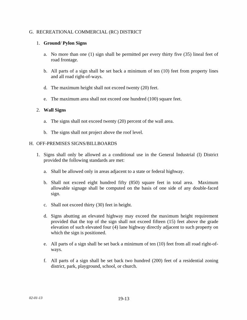
02-01-13
19-13
G. RECREATIONAL COMMERCIAL (RC) DISTRICT 1. Ground/ Pylon Signs a. No more than one (1) sign shall be permitted per every thirty five (35) lineal feet of
road frontage. b. All parts of a sign shall be set back a minimum of ten (10) feet from property lines
and all road right-of-ways. d. The maximum height shall not exceed twenty (20) feet. e. The maximum area shall not exceed one hundred (100) square feet. 2. Wall Signs a. The signs shall not exceed twenty (20) percent of the wall area. b. The signs shall not project above the roof level. H. OFF-PREMISES SIGNS/BILLBOARDS 1. Signs shall only be allowed as a conditional use in the General Industrial (I) District
provided the following standards are met: a. Shall be allowed only in areas adjacent to a state or federal highway. b. Shall not exceed eight hundred fifty (850) square feet in total area. Maximum
allowable signage shall be computed on the basis of one side of any double-faced sign.
c. Shall not exceed thirty (30) feet in height. d. Signs abutting an elevated highway may exceed the maximum height requirement
provided that the top of the sign shall not exceed fifteen (15) feet above the grade elevation of such elevated four (4) lane highway directly adjacent to such property on which the sign is positioned.
e. All parts of a sign shall be set back a minimum of ten (10) feet from all road right-of-
ways. f. All parts of a sign shall be set back two hundred (200) feet of a residential zoning
district, park, playground, school, or church.

02-01-13
19-14
g. All parts of a sign shall be set back a minimum of one thousand three hundred and twenty (1,320) feet from areas designated as Minnesota River Valley Scenic Byway as designated by the Federal Highway Administration.
h. All parts of a sign shall have a minimum separation distance of fifteen hundred
(1,500) lineal feet from another Off-Premises Sign/Billboard. i. Off-Premises Signs/Billboards located on a roof or in the form of an Illuminated sign
shall be prohibited. j. The support structure shall be monopole design. The exposed upright or
superstructure shall be painted an earth-tone color. k. Lighting shall comply with the exterior lighting standards of this Section.
l. The Applicant and/or Landowner shall identify the financial resources that will be available to pay for the removal of the Off-Premises Sign/Billboard. The County may require financial security in the form of a letter of credit, a cash escrow account, a performance bond, or other financial means acceptable to the County.
I. NON-COMMERCIAL SPEECH Notwithstanding any other provisions of this subdivision to the contrary, all signs of any size containing non-commercial speech may be posted from August 1 in any general election year until ten (10) days following the general election and thirteen (13) weeks prior to an special election until ten (10) days following the special election. SUBDIVISION 8. OUTDOOR LIGHTING STANDARDS A. PURPOSE The intent of this Subdivision is to create standards for outdoor light so that its use does not interfere with the reasonable use and enjoyment of property. B. APPLICABILITY All outdoor, electrically-powered illuminating devices shall be installed in conformance with the provisions of this Subdivision and the state electrical code. C. STANDARDS 1. In all districts, any exterior lighting used to illuminate an off-street parking area, sign, or
structure, shall be arranged as to deflect light away from any adjoining residential district and all road right-of-ways.
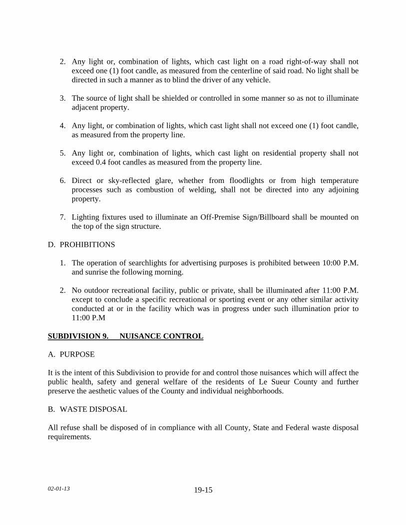
02-01-13
19-15
2. Any light or, combination of lights, which cast light on a road right-of-way shall not
exceed one (1) foot candle, as measured from the centerline of said road. No light shall be directed in such a manner as to blind the driver of any vehicle.
3. The source of light shall be shielded or controlled in some manner so as not to illuminate
adjacent property. 4. Any light, or combination of lights, which cast light shall not exceed one (1) foot candle,
as measured from the property line. 5. Any light or, combination of lights, which cast light on residential property shall not
exceed 0.4 foot candles as measured from the property line. 6. Direct or sky-reflected glare, whether from floodlights or from high temperature
processes such as combustion of welding, shall not be directed into any adjoining property.
7. Lighting fixtures used to illuminate an Off-Premise Sign/Billboard shall be mounted on
the top of the sign structure. D. PROHIBITIONS 1. The operation of searchlights for advertising purposes is prohibited between 10:00 P.M.
and sunrise the following morning. 2. No outdoor recreational facility, public or private, shall be illuminated after 11:00 P.M.
except to conclude a specific recreational or sporting event or any other similar activity conducted at or in the facility which was in progress under such illumination prior to 11:00 P.M
SUBDIVISION 9. NUISANCE CONTROL A. PURPOSE It is the intent of this Subdivision to provide for and control those nuisances which will affect the public health, safety and general welfare of the residents of Le Sueur County and further preserve the aesthetic values of the County and individual neighborhoods. B. WASTE DISPOSAL All refuse shall be disposed of in compliance with all County, State and Federal waste disposal requirements.

02-01-13
19-16
C. RODENT CONTROL 1. At any time when there is found to exist on any property rodents which are detrimental or
present a public health threat, the landowner of said property shall be given notice of the nuisance and shall within thirty (30) calendar days correct the rodent problem found to exist.
2. The method of correction may be extermination utilizing means acceptable to the County
and the Agency and/or may include, but not limited to, the removal of the source, i.e. debris piles, unprotected storage areas or lumber piles.
3. If, within thirty (30) calendar days, the nuisance is not corrected, the County may take
corrective action as provided elsewhere in this Ordinance. D. NOXIOUS WEEDS In all Zoning Districts each landowner shall be responsible to control noxious weeds to the greatest degree possible. Enforcement of this provision shall be coordinated with the County Agricultural Inspector. E. RESTRICTED STORAGE 1. In all zoning districts, all waste material or refuse, with the exception of crop residue
debris, shall be kept in an enclosed structure or properly contained in a closed container designed for such purposes.
2. The landowner shall be responsible for keeping such land free of refuse. F. SALVAGE VEHICLES, AGRICULTURAL/INDUSTRIAL EQUIPMENT AND PARTS 1. In all non-residential districts, no more than five (5) salvage vehicles shall be kept or
stored outside, unless specifically permitted as a conditional use salvage yard. 2. In residential districts no more than one (1) salvage vehicle shall be kept or stored
outside. 3. All such vehicles, equipment and/or parts shall be screened from eye-level view from
adjacent properties and all roads. 4. All fluids and batteries shall be removed and recycled in accordance with all County,
State and Federal guidelines. 5. Any vehicle or agricultural/industrial equipment or part which is in violation of this
Subdivision is hereby declared to be a public nuisance.

02-01-13
19-17
G. ABATEMENT 1. The County may enter upon the land where the public nuisance is located and remove
and dispose of such public nuisance, after a hearing as provided by law, and after thirty (30) days notice to the landowner.
2. If the County receives any proceeds from the removal and disposal of the public nuisance
the County shall first apply the proceeds to reimburse the County for any expenses incurred, and refund the remainder to the Landowner.
3. Any costs incurred by the County in the removal and disposal of the public nuisance
which are not reimbursed may be assessed as a special assessment against the property upon which the public nuisance was located.
SUBDIVISION 10. RELOCATING STRUCTURES A. PERMIT REQUIRED 1. Zoning Permit. No person shall move any structure without first obtaining a zoning
permit. 2. Moving Permit. Every licensed house mover shall, in each and every instance, before
raising, holding up or moving any structure, obtain a permit hereafter from the Road Authority.
SUBDIVISION 11. RIGHT TO FARM A. PURPOSE It is the intent of this Subdivision that farmers have the right to farm, provided all County, State, and Federal regulations are adhered to, regardless if development is taking place around them, without unreasonable restrictions, regulations or harassment. B. ADOPT BY REFERENCE The County adopts by reference Section 561.19 of Minnesota State Statutes as amended from time to time. C. COMPLAINTS Complaints against the operations of farms shall be considered to be unwarranted and frivolous as long as the farming activities are being conducted according to generally accepted agricultural standards.
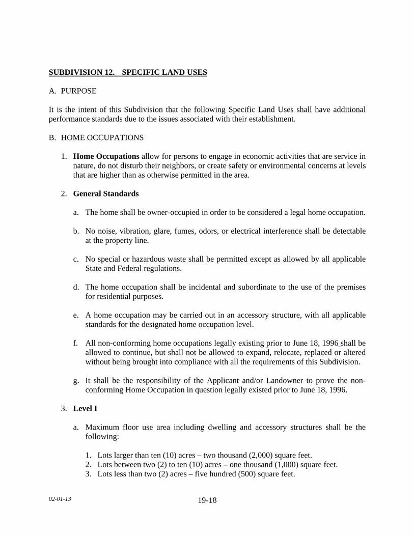
02-01-13
19-18
SUBDIVISION 12. SPECIFIC LAND USES A. PURPOSE It is the intent of this Subdivision that the following Specific Land Uses shall have additional performance standards due to the issues associated with their establishment. B. HOME OCCUPATIONS 1. Home Occupations allow for persons to engage in economic activities that are service in
nature, do not disturb their neighbors, or create safety or environmental concerns at levels that are higher than as otherwise permitted in the area.
2. General Standards a. The home shall be owner-occupied in order to be considered a legal home occupation. b. No noise, vibration, glare, fumes, odors, or electrical interference shall be detectable
at the property line. c. No special or hazardous waste shall be permitted except as allowed by all applicable
State and Federal regulations. d. The home occupation shall be incidental and subordinate to the use of the premises
for residential purposes. e. A home occupation may be carried out in an accessory structure, with all applicable
standards for the designated home occupation level. f. All non-conforming home occupations legally existing prior to June 18, 1996 shall be
allowed to continue, but shall not be allowed to expand, relocate, replaced or altered without being brought into compliance with all the requirements of this Subdivision.
g. It shall be the responsibility of the Applicant and/or Landowner to prove the non-
conforming Home Occupation in question legally existed prior to June 18, 1996. 3. Level I a. Maximum floor use area including dwelling and accessory structures shall be the
following: 1. Lots larger than ten (10) acres – two thousand (2,000) square feet. 2. Lots between two (2) to ten (10) acres – one thousand (1,000) square feet. 3. Lots less than two (2) acres – five hundred (500) square feet.
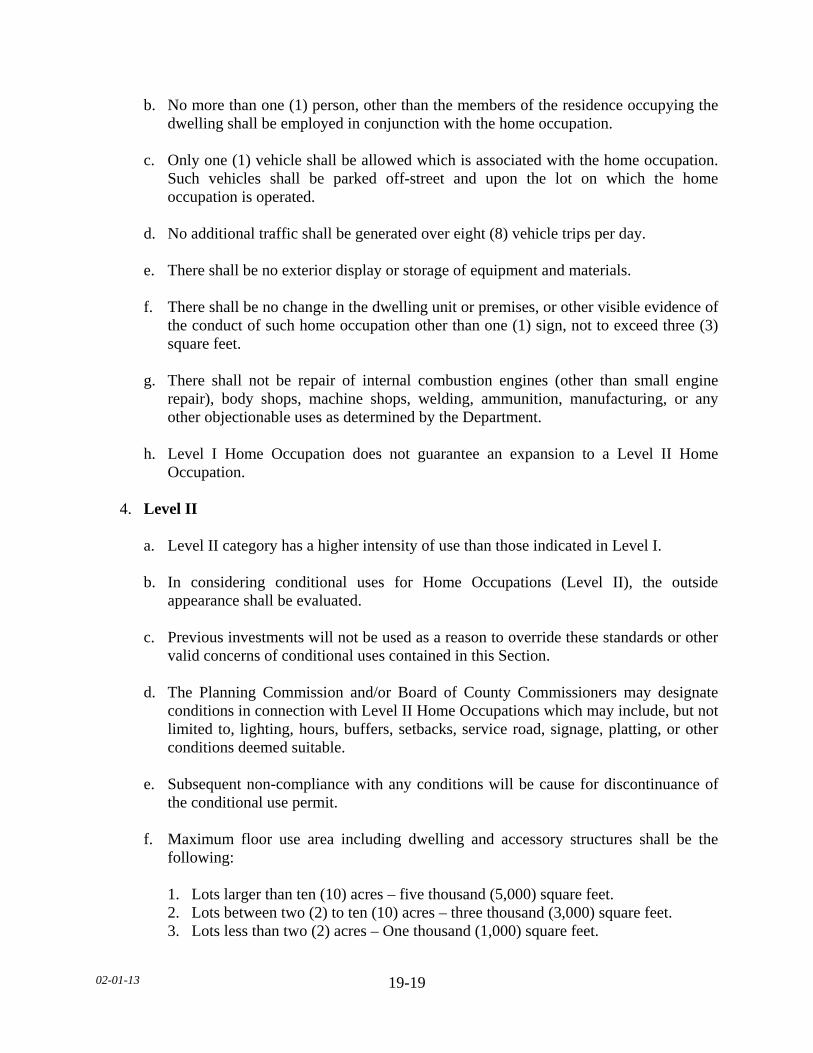
02-01-13
19-19
b. No more than one (1) person, other than the members of the residence occupying the dwelling shall be employed in conjunction with the home occupation.
c. Only one (1) vehicle shall be allowed which is associated with the home occupation.
Such vehicles shall be parked off-street and upon the lot on which the home occupation is operated.
d. No additional traffic shall be generated over eight (8) vehicle trips per day. e. There shall be no exterior display or storage of equipment and materials. f. There shall be no change in the dwelling unit or premises, or other visible evidence of
the conduct of such home occupation other than one (1) sign, not to exceed three (3) square feet.
g. There shall not be repair of internal combustion engines (other than small engine
repair), body shops, machine shops, welding, ammunition, manufacturing, or any other objectionable uses as determined by the Department.
h. Level I Home Occupation does not guarantee an expansion to a Level II Home
Occupation. 4. Level II a. Level II category has a higher intensity of use than those indicated in Level I. b. In considering conditional uses for Home Occupations (Level II), the outside
appearance shall be evaluated. c. Previous investments will not be used as a reason to override these standards or other
valid concerns of conditional uses contained in this Section. d. The Planning Commission and/or Board of County Commissioners may designate
conditions in connection with Level II Home Occupations which may include, but not limited to, lighting, hours, buffers, setbacks, service road, signage, platting, or other conditions deemed suitable.
e. Subsequent non-compliance with any conditions will be cause for discontinuance of
the conditional use permit. f. Maximum floor use area including dwelling and accessory structures shall be the
following: 1. Lots larger than ten (10) acres – five thousand (5,000) square feet. 2. Lots between two (2) to ten (10) acres – three thousand (3,000) square feet. 3. Lots less than two (2) acres – One thousand (1,000) square feet.
02-01-13
19-20
g. No more than six (6) persons, other than the members of the residence occupying the
dwelling, shall be employed in conjunction with the home occupation. h. No additional traffic shall be generated over an estimated sixteen (16) vehicle trips
per day. i. There shall be no change in the dwelling unit or premises, or other visible evidence of
the conduct of such home occupation other than one (1) sign, not to exceed sixteen (16) square feet.
C. TEMPORARY DWELLINGS 1. Temporary dwelling applicants must demonstrate a need for housing of elderly, farm use,
or occupants of principal dwelling during construction or repair of principal dwelling. 2. The use must be secondary to the primary dwelling use. 3. A condition of the Conditional Use Permit shall be designated as to when the use of the
temporary dwelling, as stated in the Conditional Use Permit, is no longer necessary, At that designated time, the temporary dwelling shall be removed from the property.
4. All dwelling standards and dimensional standards apply, except: a. The subsurface sewage treatment system of the main dwelling can be utilized if it is
up to present standards and has enough capacity; otherwise it shall be brought into conformity and/or enlarged.
b. The temporary dwelling cannot be placed on a separate lot with no other dwelling
intended. c. There are no minimum width requirements. d. There are no foundation requirements, but the dwelling must be secure to the ground. e. In cases of use for the elderly, the temporary dwelling may be attached to the
principal dwelling. f. Detached temporary dwellings for farm use are only allowed where the lot size for the
primary dwelling is forty (40) or more acres. D. TRANSFER OF DEVELOPMENT RIGHTS 1. Development rights may be transferred to a contiguous quarter-quarter section in the
Agriculture (A), Conservancy (C), and Special Protection (SP) districts, upon obtaining a conditional use permit.
02-01-13
19-21
2. For the purpose of this Subdivision, contiguous shall mean quarter-quarter sections that
are touching along a boundary or at a point. Quarter-quarter sections that are separated by a road shall be considered contiguous.
3. Development rights shall not be transferable from one township to another township. 4. The sending quarter-quarter shall have a building eligibility, as defined by this
Ordinance, in order to transfer development rights. 5. The transferred development right shall meet the registered feedlot separation
requirements of this Ordinance, including transferred Lot of Record building eligibilities. 6. The transfer shall not allow the establishment of more than four (4) dwellings in a
quarter-quarter section, with the exception of non-transferred lots of record and existing building sites.
7. There shall be no maximum number of building eligibilities in the sending quarter-
quarter section. 8. Upon approval of the Conditional Use Permit for transfer of development rights, the
building site shall not be required to be established and shall be exempt from the one (1) year completion requirement for conditional use permits as set forth in this Ordinance.
9. The transfer shall be memorialized in a document that is recorded against both the
sending and the receiving property. E. WIRELESS TELECOMMUNICATION TOWERS AND ANTENNAS 1. Purpose. The following regulations are necessary in order to: a. Accommodate the communication needs of the community while protecting the
public health, safety, and general welfare of Le Sueur County. b. Facilitate provision of wireless communications services. c. Minimize adverse visual effects of towers through careful design and siting standards; d. Avoid potential damage to adjacent properties from tower failure through structural
standards and setback requirements; and, e. Maximize the use of existing and approved towers and structures to accommodate
new wireless telecommunication antennas in order to reduce the number of towers needed to serve the community.
02-01-13
19-22
2. Siting Criteria a. In making siting decisions for new towers, applicants shall be sensitive to the location
of a tower near a densely settled residential area. b. Wireless telecommunication towers are prohibited in all shoreland, residential and
conservancy districts. 3. Co-location Requirements. All applications for wireless telecommunication towers
erected, constructed, or located within the County shall comply with the following requirements:
a. Provide documentation of the area to be served including maps demonstrating size of
communication cells and search rings for the antenna location. b. Provide a narrative describing a search ring of not less than one (1) mile radius for the
requested site, clearly explaining why the site was selected and why alternative site locations are inadequate.
c. Provide documentation that the communications equipment planned for the proposed
tower cannot be accommodated on an existing or approved tower or structure within the search ring of the service area due to one or more of the following reasons:
1. The planned equipment would exceed the structural capacity of the existing or
approved tower or structure, as documented by a licensed professional radio frequency (RF) engineer, and the existing or approved tower cannot be reinforced or modified to accommodate planned equipment at a reasonable cost.
2. The planned equipment would cause interference with other existing or planned
equipment at the tower or structure, as documented by a licensed professional RF engineer, and the interference cannot be prevented as a reasonable cost.
3. No existing or approved towers or commercial/industrial structures within a one
(1) mile radius meet the RF design criteria. 4. Existing or approved towers and commercial/industrial structures within a one (1)
mile radius cannot accommodate the planned equipment at a height necessary to function reasonably as documented by a licensed professional RF engineer.
5. The applicant must demonstrate that a good faith effort to co-locate on existing
towers and structures within a one (1) mile radius was made, but an agreement could not be reached.
6. Other unforeseen reasons that make it infeasible to locate the planned
telecommunications equipment upon an existing or approved tower or structure.

02-01-13
19-23
d. Any proposed commercial wireless telecommunication service tower shall be
designed, structurally, electrically, and in all respects to accommodate both the applicant's antennas and comparable antennas for at least two (2) additional users if the tower is over one hundred (100) feet in height or for at least one (1) additional user if the tower is between sixty (60) and one hundred (100) feet in height. Towers must be designed to allow for future rearrangement of antennas upon the tower and to accept antennas mounted at varying heights.
e. An agreement stating that the site will be designed for not less than three (3) users
with the applicant and Landowner commitment to co-location, whereby, any prohibition of additional users on a tower will be considered a violation of the permit and this Subdivision.
1. The agreement shall also include a statement that any unused or obsolete tower
shall be removed by the Applicant and/or Landowner, as specified in this Ordinance.
2. Said agreement shall be signed by the applicant and the landowner and shall be
attached to and become a part of the permit. 4. Minimum conditions for a zoning permit shall include, but not be limited to the
following: a. An agreement providing for co-location and removal of unused and/or obsolete
towers, as specified in this Ordinance, shall be attached and become part of the permit.
b. The tower shall be set back a minimum distance of one hundred ten (110) percent of
the tower height from all property lines and/or right-of-ways. c. All accessory structures shall be set back a minimum of fifty (50) feet from all side
yard and rear yard property lines and/or road right-of-ways. d. All anchoring structures shall be set back at least ten (10) feet from all property lines
and/or road right-of-ways. e. The applicant shall obtain Federal Aeronautics Administration (FAA) approval and/or
provide documentation that FAA approval is not needed, prior to issuance of a zoning permit.
f. Zoning Permits shall be obtained prior to commencing any construction. g. Applicant must obtain Federal Communications Commission (FCC) licensure and
approval as required for various communications applications.

02-01-13
19-24
1. No interference with local television and radio reception will be allowed. 2. No interference with public safety reception will be allowed. 3. No wireless telecommunications tower shall be permitted that causes any
interference with commercial or private use and enjoyment of other legally operating communications devices including, but not limited to the following: radios, televisions, personal computers, telephones, personal communications devices, garage door openers, security systems, and other electronic equipment and devices.
4. The applicant must furnish a licensed professional engineer’s certification that no
such interference will occur or identify what interference may occur and how the applicant will mitigate any potential interference that may occur.
h. Proof that towers and their antennas have been designed in accordance with the
manufacturer’s specifications, and following completion of construction were inspected by a licensed professional engineer at the applicant's and/or landowner’s expense to conform to applicable state structural building standards and all other applicable reviewing agencies and to conform with accepted electrical engineering methods and practices as specified in applicable provisions of the State Electrical Code.
i. The addition of antennas and associated equipment of an additional provider to an
existing permitted tower shall be considered co-location and shall require a zoning permit and site plan approval. An amendment to a conditional use permit shall not be required.
j. All towers shall be reasonably protected against unauthorized access. 1. The area around the base of the tower and guy wire anchors shall be enclosed by a
fence with a minimum height of six (6) feet chain link fence with a locked gate. 2. A minimum of three (3) strands of barbed or razor wire shall be installed on top of
the chain link fencing. k. Metal towers shall be constructed of, or treated with, corrosive resistant material. l. All towers and their antennas shall utilize building materials, colors, textures,
screening and landscaping that effectively blend the tower facilities within the surrounding natural setting.
m. No advertising or identification of any kind intended to be visible from the ground or
other structures is permitted, except applicable warning and equipment information signage required by the manufacturer and shall meet all applicable County, State and Federal regulations.

02-01-13
19-25
n. Towers and their antennas shall not be illuminated by artificial means, except for
camouflage purposes or the illumination is specifically required by the FAA or other authority.
o. All obsolete or unused towers and accompanying accessory facilities including
concrete base shall be removed within six (6) months of the cessation of operations at the site.
p. After the facilities are removed, the site shall be restored to its original or an
improved state. Electronic equipment shall not be removed in advance of removal of obsolete or unused towers.
q. The County shall require financial security in the form of a letter of credit, a cash
escrow account, a performance bond, or other financial means acceptable to the County. The assurance shall be used to reimburse the County for any monies, labor, or material expended to bring the operation into compliance with the conditions of the permit. This includes, but is not limited to cover all costs of improvements, landscaping, maintenance of improvements, engineering and inspection costs.
5. Existing Towers and Antennas a. Antennas and towers in any residential, shoreland, Conservancy (C) or General
Business (B) districts and in existence prior to June 18, 1996 which do not conform to or comply with this Subdivision are subject to the following provisions:
1. Towers may continue but may not be replaced or structurally altered without
complying in all respects with this Subdivision. 2. If such towers are hereafter damaged or destroyed due to any reason or cause the
tower may be repaired and restored to its former use, location, and physical dimensions upon obtaining a zoning permit.
F. WIND ENERGY CONVERSION SYSTEMS (WECS) 1. Purpose The intent of this Subdivision is the establishment of regulations to provide for the
installation and operation of Wind Energy Conversion Systems (WECS) up to a maximum of 5 Mega Watts (MW) within Le Sueur County.
2. Procedure. The application for all WECS shall include the following information: a. The names and addresses of project applicant and/or landowner. b. The name and address of the project owner.
02-01-13
19-26
c. The legal description and address of the project. d. A description of the project including: number, type, name plate generating capacity,
tower height, rotor diameter, and total height of all wind turbines and means of interconnecting with the electrical grid.
e. Site layout, including the location of property lines, wind turbines, electrical wires,
interconnection points with the electrical grid, and all related accessory structures. The site layout shall include distances and be drawn to scale.
f. A signed statement regarding the restoration or payment for the damages as agreed to
by the applicable Road Authority sufficient to restore the roads, bridges, and any drainage systems to preconstruction conditions.
g. Recorded easement agreement, if applicable. h. Location of wetlands, scenic by-ways, scenic and natural areas (including bluffs)
within 1,320 feet of the proposed WECS. i. Decommissioning Plan. 3. Aggregated Projects a. Aggregated Projects may jointly submit a single application and be reviewed under
joint proceedings, including notices, hearings, reviews and, as appropriate, approvals. Permits will be issued and recorded separately.
b. Joint applications will be assessed fees as one project. c. Aggregated projects having a combined capacity greater than five (5) MW shall be
under the review of the applicable state agency. 4. District Regulations
a. WECS will be permitted, conditionally permitted, or prohibited based on the generating capacity and land use district as established in the following table:
(TABLE ON NEXT PAGE)
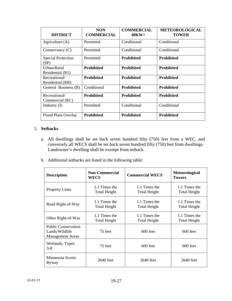
02-01-13
19-27
DISTRICT
NON COMMERCIAL
COMMERCIAL 40KW+
METEOROLOGICAL TOWER
Agriculture (A) Permitted Conditional Conditional
Conservancy (C) Permitted Conditional Conditional
Special Protection (SP)
Permitted Prohibited Prohibited
Urban/Rural Residential (R1)
Prohibited Prohibited Prohibited
Recreational/ Residential (RR)
Prohibited Prohibited Prohibited
General Business (B) Conditional Prohibited Prohibited
Recreational/ Commercial (RC)
Prohibited Prohibited Prohibited
Industry (I) Permitted Conditional Conditional
Flood Plain Overlay Prohibited Prohibited Prohibited
5. Setbacks a. All dwellings shall be set back seven hundred fifty (750) feet from a WEC, and
conversely all WECS shall be set back seven hundred fifty (750) feet from dwellings. Landowner’s dwelling shall be exempt from setback.
b. Additional setbacks are listed in the following table:
Description Non-Commercial WECS
Commercial WECS Meteorological Towers
Property Lines 1.1 Times the Total Height
1.1 Times the Total Height
1.1 Times the Total Height
Road Right-of-Way 1.1 Times the Total Height
1.1 Times the Total Height
1.1 Times the Total Height
Other Right-of-Way 1.1 Times the Total Height
1.1 Times the Total Height
1.1 Times the Total Height
Public Conservation Lands/Wildlife Management Areas
75 feet 600 feet 600 feet
Wetlands, Types 3-8
75 feet 600 feet 600 feet
Minnesota Scenic Byway
2640 feet 2640 feet 2640 feet
02-01-13
19-28
c. The setback shall be measured from future rights-of-way if a planned change or expanded right-of-way is known.
d. All accessory structures shall be set back a minimum of fifty (50) feet from all
property lines.
e. All anchoring structures shall be set back at least ten (10) feet from all property lines. f. Additional setbacks may be set upon the separation of Commercial WECS to other
existing WECS taking into consideration the following, to include but not limited to: 1. Size of existing WECS. 2. Alignment of WECS. 3. Predominant Winds. 4. Topography. 5. Property Setbacks. 6. Extent of interference. 6. Requirements and Standards a. All WECS
1. A licensed professional shall certify that the turbine, foundation and tower design and access roads to individual turbines of the WECS is within accepted professional standards, given local soil and climate conditions.
2. Rotor blades or airfoils must maintain at least twenty (20) feet of clearance
between their lowest point and the ground.
3. For all guyed towers, visible and reflective objects, such as plastic sleeves, reflectors or tape, shall be placed on the guy wire anchor points and along the outer and innermost guy wires up to a height of eight (8) feet above the ground. Visible fencing shall be installed around anchor points of guy wires.
4. Shall be white, grey or another non-obtrusive color. Blades may be black in order
to facilitate de-icing. Finishes shall be matte or non-reflective.
5. Red strobe lights are preferred for night-time illumination to reduce impacts on migrating birds.
6. Red pulsating incandescent lights shall not be allowed.
7. Lighting, including lighting intensity and frequency of strobe, shall adhere to
requirements established by FAA permits and regulations.
02-01-13
19-29
b. Non-Commercial WECS
1. Shall have a maximum height of less than two hundred (200) feet.
2. May be installed with a lattice or tubular, monopole type tower. c. Commercial WECS
1. Engineer’s certification of the manufacturer’s specifications.
2. The latitude and longitude of proposed individual commercial WECS.
3. A United States Geological Survey (USGS) topographical map, or map with
similar data, of the property and surrounding area, including any other WECS within ten (10) rotor diameters of the proposed WECS.
4. Acoustic Analysis. 5. FAA Permit Application. 6. Location of all known Communications Towers within two (2) miles of the
proposed commercial WECS. 7. Identification and condition of all county, city or township roads, bridges and
drainage systems to be crossed for the purpose of transporting WECS, substation parts, cement, and equipment for construction, operation or maintenance of the WECS and obtain applicable weight and size permits from the impacted road authority prior to construction. This shall include photographs and a written agreement to document the condition of the public facility.
8. Description of potential impacts on nearby WECS and wind resources on adjacent
properties and, if required by the County, a turbulence study. 9. A sign or signs shall be posted on the tower, transformer and substation of all
Commercial WECS warning of high voltage. Signs with emergency contact information shall also be posted on the turbine or at another suitable point.
10. Shall be installed with a tubular, monopole type tower.
02-01-13
19-30
7. Meteorological Towers a. Meteorological towers may be guyed. b. All meteorological towers shall be white, grey or another non-obtrusive color.
Exceptions may be made by the County for metrological towers, where concerns exist.
c. For guyed towers, visible and reflective objects, such as plastic sleeves, reflectors or
tape, shall be placed on the guy wire anchor points and along the outer innermost guy wires up to a height of eight (8) feet above the ground. Additional consideration shall be given to painted aviation warnings on metrological towers of less than two hundred (200) feet in height.
d. Lighting of towers shall be considered where concerns exist for towers less than two
hundred (200) feet in height. e. All met towers, structures, foundations and anchor footings shall be removed within
six (6) months of met tower discontinuance. 8. Compliance a. Provide adequate signage on-site to insure compliance with this Ordinance b. All communications and feeder lines, equal to or less than 34.5 kVA in capacity,
installed as part of a WECS shall be buried where feasible. Feeder lines installed as part of a WECS shall not be considered an essential service.
c. All WECS shall comply with noise regulations as defined in Minnesota Rules 7030,
as amended from time to time. 9. Decommissioning a. All WECS shall be considered a discontinued use after one (1) year without energy
production. b. All WECS and accessory facilities shall be removed within six (6) months of the
discontinuation of use. c. All WECS shall have a decommissioning plan outlining the anticipated means and
cost of removing WECS at the end of their serviceable life or upon becoming a discontinued use.
1. The cost estimates shall be made by a licensed professional engineer.
02-01-13
19-31
2. The plan shall identify the financial resources that will be available to pay for the decommissioning and removal of the WECS and accessory facilities.
3. The County may require financial security in the form of a letter of credit, a cash
escrow account, a performance bond, or other financial means acceptable to the County.
4. The plan shall also address road maintenance during and after completion of the
decommissioning. d. Upon issuance of a conditional use permit, all Commercial WECS shall notify the
Environmental Quality Board (EQB) of the project location and details on the survey form specified by the EQB.
e. Applicant must obtain Federal Communications Commission (FCC) licensure and
approval as required for WEC applications. 1. No interference with local television and radio reception will be allowed. 2. No WEC shall be permitted that causes any interference with commercial or
private use and enjoyment of other legally operating communications devices including, but not limited to the following: radios, televisions, personal computers, telephones, personal communications devices, garage door openers, security systems, and other electronic equipment and devices.
3. The applicant must furnish a licensed professional engineer’s certification that no
such interference will occur or identify what interference may occur and how the applicant will mitigate any potential interference that may occur.
G. CAMPGROUNDS AND RESORTS 1. Campgrounds and Resorts shall be regulated by the Le Sueur County Manufactured
Home Park and Recreational Camping Area Ordinance, as administered by Le Sueur County Community Health Department and as amended from time to time.
2. Any non-conformities with existing Campgrounds and Resorts will be allowed to
continue in accordance with provisions of Sections 4, 13, and 24 of this Ordinance. The expansion of the campgrounds and resorts will require a Conditional Use Permit and will require the implementation of the following standards in the expansion area.
a. If located within a flood plain, the applicant shall submit an emergency plan for the
safe evacuation of all vehicles and people in the event of a one hundred (100) year flood event. Said plan shall be prepared by a licensed professional engineer or surveyor and shall demonstrate that adequate time and personnel exist to carry out the evacuation.
02-01-13
19-32
b. The applicant shall provide a written plan for the safe evacuation in times of severe weather conditions and shall be submitted to the Emergency Management Director and Community Health Department to have on file with the County.
c. A responsible attendant or caretaker shall be in charge of the recreational camping
area and the duties of said attendant or caretaker shall be to maintain records of the park, and keep the facilities and the equipment in a clean, orderly and sanitary condition. The caretaker or attendant shall be the owner or operator of the camping area, or his/her appointed representative.
d. One single-family dwelling shall be allowed for the owner in the Campground and/or
Resort. e. One (1) temporary dwelling shall be allowed for the attendant/caretaker. f. For Resorts, manufactured homes less than twenty (20) feet in width shall be allowed
as a single-family dwelling or for seasonal occupancy in the Recreational Commercial (RC) District.
g. The campground and/or resort shall meet the Planned Unit Development standards as
described in this Ordinance. h. A drainage plan shall be approved by the County Engineer. i. Decks abutting campers located within the shore impact zone may be allowed with
the following restrictions: 1. Decks shall not be placed on permanent footings. 2. Decks shall not exceed the door sill height of the camper, exclusive of safety rails,
and cannot occupy an area greater than three hundred (300) square feet.
3. Decks abutting campers located in a licensed campground shall be set back a minimum of twenty five (25) feet from the OHWL.
j. Decks abutting campers located outside the shore impact zone may be allowed with
the following restrictions:
1. Decks shall not be placed on permanent footings. 2. Decks shall not exceed the door sill height of the camper, exclusive of safety rails,
and cannot occupy an area greater than three hundred (300) square feet.
k. Campers located in a licensed campground shall be set back a minimum of twenty five (25) feet from the OHWL.
02-01-13
19-33
H. RIDING ACADEMY AND/OR BOARDING STABLE 1. The property on which the stable is located shall be at least five (5) acres in size. 2. The riding and/or boarding stable requirements shall meet the animal and manure
management regulations as described in this Ordinance. I. ORGANIZED GROUP CAMPS The applicant shall provide for a storm shelter for the safe evacuation in times of severe weather conditions. J. SPECIAL EVENT STANDARDS 1. Event activities shall be set back a minimum of twenty (20) feet from any Road right-of-
way. 2. Event activities shall be set back a minimum of twenty (20) feet from all property lines. K. OPEN AND OUTDOOR STORAGE, SALES AND SERVICE 1. Landscaping and screening shall be required for all storage, sales, and service areas as
described in this Section. 2. The storage, sales and service areas shall not take up parking and loading spaces as
described in this Section. 3. The sales area is grassed or surfaced to control dust. L. INDUSTRIAL PLANTS 1. Industrial plants utilizing cool-water processing within their operations shall: a. Safeguard against impeding the natural flow of the immediate stream and
polluting, including thermal pollution. b. Assure that no lighting will create a hazard to navigation. c. Obtain all necessary permits from the DNR and the Agency as needed. M. WINERY The site shall have direct access to a paved road.
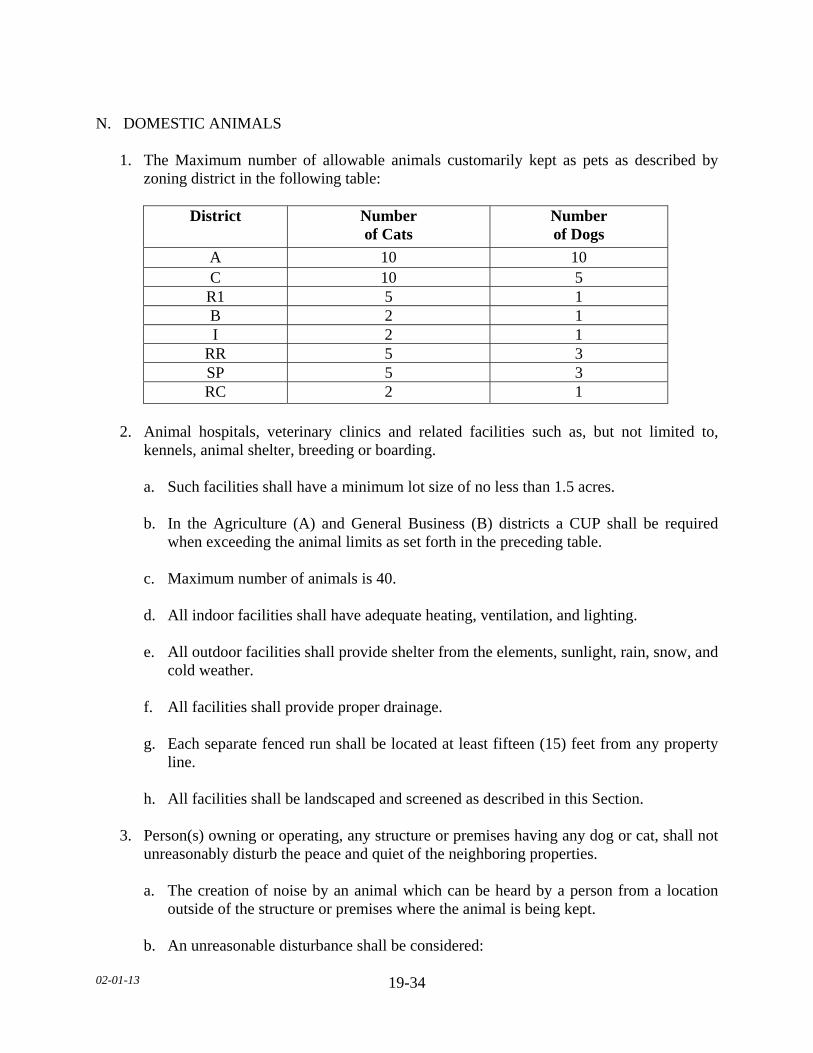
02-01-13
19-34
N. DOMESTIC ANIMALS 1. The Maximum number of allowable animals customarily kept as pets as described by
zoning district in the following table:
District Number of Cats
Number of Dogs
A 10 10 C 10 5 R1 5 1 B 2 1 I 2 1
RR 5 3 SP 5 3 RC 2 1
2. Animal hospitals, veterinary clinics and related facilities such as, but not limited to,
kennels, animal shelter, breeding or boarding.
a. Such facilities shall have a minimum lot size of no less than 1.5 acres. b. In the Agriculture (A) and General Business (B) districts a CUP shall be required
when exceeding the animal limits as set forth in the preceding table. c. Maximum number of animals is 40. d. All indoor facilities shall have adequate heating, ventilation, and lighting. e. All outdoor facilities shall provide shelter from the elements, sunlight, rain, snow, and
cold weather. f. All facilities shall provide proper drainage. g. Each separate fenced run shall be located at least fifteen (15) feet from any property
line. h. All facilities shall be landscaped and screened as described in this Section. 3. Person(s) owning or operating, any structure or premises having any dog or cat, shall not
unreasonably disturb the peace and quiet of the neighboring properties. a. The creation of noise by an animal which can be heard by a person from a location
outside of the structure or premises where the animal is being kept. b. An unreasonable disturbance shall be considered:

02-01-13
19-35
1. Repeatedly over at least a seven-minute (7) period of time with one (1) minute or
less lapse of time between each animal noise during the seven-minute (7) period, or,
2. Repeatedly over at least a fourteen-minute (14) period of time, at an average of at
least twelve (12) animal noises per minute. O. BED AND BREAKFAST INN 1. The facility shall be located in a single-family, owner-occupied dwelling. 2. All dwellings shall comply with subsurface sewage treatment standards as regulated in
this Ordinance. 3. Guest-stays shall be limited to seven (7) consecutive days. P. OUTDOOR FIRING RANGES 1. The National Rifle Association (NRA) Range Source Book as amended, from time to
time shall be used as a guidance document in the design of Outdoor Firing Ranges. 2. The range shall be set back a minimum of five hundred (500) feet from adjoining
properties. 3. A minimum separation distance of one thousand five hundred (1,500) feet from all
structures. 4. Shall be set back a minimum of one thousand five hundred (1,500) feet from residential
zoning districts. 5. Shall be set back a minimum of five hundred (500) feet from any road right-of-way. 6. Shall not be sited within 7,920 feet of residences located in the direct line of fire, unless
the range is below ground or shooting lanes are confined by approved means. a. For the purpose of this Section, “direct line of fire” is defined by the straight
horizontal line from the muzzle of a weapon in the direction of the axis of the bore, just prior to firing.
7. The range shall be designed to provide protection from accidental or stray ammunition
discharge onto surrounding properties and to minimize noise. 8. Landscaping and screening as described in this Section.

02-01-13
19-36
9. Only firearms, rifles, shotguns, and pistols shall be discharged at the range. No cannons, artillery or rockets shall be discharged.
10. Access shall be controlled by a locked gate. 11. Warning signs identifying the range perimeter shall be located at intervals of no less than
four hundred (400) feet. 12. The use shall comply with the outside noise standards and lead management requirements
of the Agency. 13. The operation shall be limited to dawn to dusk unless otherwise specified in the
conditional use permit. 14. If retail sale and repair of weapons and/or ammunition is conducted on the premises, the
management shall comply with all licensing and operations requirements of the Federal Bureau of Alcohol, Tobacco, and Firearms.
Q. INDOOR FIRING RANGE 1. The NRA Range Source Book as amended, from time to time, shall be used as a guidance
document in the design of Indoor Firing Ranges. 2. Shall be set back a minimum of fifty (50) feet from all property lines. 3. Only firearms, rifles, shotguns, and pistols shall be discharged at the range. No cannons,
artillery or rockets shall be discharged. 4. The use, occupancy and construction of the structure shall be of materials that will
contain all fired rounds within the confines of the structure. a. The design and construction of the firing range shall be certified by a licensed
professional engineer. b. The certified plans shall include the specifications and construction of the bullet traps,
ceilings, exterior and interior walls, and floors. c. The certified plans shall state what type and caliber of ammunition the range is
designed to totally confine. 5. The use shall conform with the applicable Agency, Environmental Protection Agency
(EPA) and Occupational Safety and Health Administration (OSHA) standards for indoor ventilation, emissions into the atmosphere, indoor sound levels, lead containment and outside noise standards.

02-01-13
19-37
6. If retail sale and repair of weapons and/or ammunition is conducted on the premises, the management shall comply with all licensing and operations requirements of the Federal Bureau of Alcohol, Tobacco, and Firearms.
7. Landscaping and screening as described in this Section. R. OUTDOOR ARCHERY RANGE 1. The NRA Range Source Book as amended, from time to time, shall be used as a guidance
document in the design of Outdoor Archery Ranges. 2. Shall be set back a minimum of three hundred (300) feet from all properties. 3. Shall be set back a minimum of one thousand (1,000) feet from all structures. 4. Shall be set back a minimum of one thousand (1,000) feet from Residential zoning
districts. 5. Shall be set back a minimum of three hundred (300) feet from any road right-of-way. 6. Landscaping and screening as described in this Section. 7. The range shall be designed to provide protection from accidental or stray discharge for
surrounding properties. 8. Only bow and arrows shall be discharged at the range. 9. Access shall be controlled by a locked gate. 10. Warning signs identifying the range perimeter shall be located at intervals of no less than
four hundred (400) feet. 11. The operation of the range shall be limited to dawn to dusk unless otherwise specified in
the conditional use permit. 12. If retail sale and repair of archery equipment is conducted on the premises, the
management shall comply with all state and federal licensing and operations requirements.
S. INDOOR ARCHERY RANGE 1. The NRA Range Source Book as amended, from time to time, shall be used as a guidance
document in the design of Indoor Archery Ranges. 2. The archery range shall not be located within fifty (50) feet of the property line.

02-01-13
19-38
3. Only bow and arrows shall be discharged at the range. 4. The use, occupancy and construction of the structure shall be of materials that will
contain all arrows within the confines of the structure. a. The design and construction of the archery range shall be certified by a licensed
professional engineer. b. The certified plans shall include the specifications and construction of the ceilings,
exterior and interior walls, and floors. c. The certified plans shall state what type of arrows the range is designed to totally
confine. 5. The use shall conform with the applicable Agency, EPA and OSHA standards for indoor
ventilation, emissions into the atmosphere, indoor sound levels, lead containment and outside noise standards.
6. If retail sale and repair of archery equipment is conducted on the premises, the
management shall comply with all state and federal licensing and operations requirements.
7. Landscaping and screening as described in this Section. T. PAINTBALL COURSE 1. The shooting areas shall be set back one hundred fifty (150) feet from all property lines. 2. The shooting areas shall be set back one hundred fifty (150) feet from any road right-of-
way. 3. Setbacks may be increased if the travel distance of the paintballs is greater than one
hundred fifty (150) feet. 4. Noise shall comply with Minnesota state noise standards at the nearest property line. 5. Landscaping and screening as described in this Section. 6. The site shall have direct access to a paved road. U. DRIVING RANGE AND MINIATURE GOLF 1. The operation shall be limited to dawn to dusk unless otherwise specified in the
conditional use permit. 2. There shall be a minimum setback of two hundred (200) feet from all property lines.
02-01-13
19-39
3. There shall be a minimum setback of two hundred (200) feet from any road right-of-way. 4. The site shall be large enough so that safety netting is not necessary to keep golf balls on
the property. 5. No exterior lighting shall be allowed with the exception of security lighting. 6. Landscaping and screening shall be required as described in this Section. 7. The site shall have direct access to a paved road. V. ORGANIZED MOTOR SPORTS 1. Erosion control plans for trails shall be required. No trails are allowed within the bluff
and bluff impact zones. 2. Tracks and trails shall be set back a minimum of one thousand five hundred (1500) feet
from existing residences and/or residentially zoned districts. 3. Tracks and trails shall be set back a minimum five hundred (500) feet from any road
right-of-way. 4. Tracks and trails shall be set back a minimum five hundred (500) feet from all property
lines. 5. Noise shall comply with Minnesota state noise standards at the nearest property line. 6. The site shall have direct access to a paved road with a locked gate. 7. Landscaping and screening as described in this Section. W. DRIVE-IN RESTAURANTS 1. Landscaping and screening shall be constructed along the property line when abutting a
Residential zoning district. 2. Parking areas shall have a paved surface. X. OFF-SALE LIQUOR STORES AND TAVERNS Landscaping and screening shall be constructed along the property lines when abutting a Residential zoning district.
02-01-13
19-40
Y. AUTOMOBILE SERVICE STATION AND AUTO REPAIR 1. Any gas island canopy, weather protection, pump island or structure shall meet the
minimum required structure setback specified for the district.
2. A minimum twenty five (25) feet of landscaped yard shall be provided along all abutting public rights-of-way lines, except where approved driveways occur.
3. When a service station abuts a residential lot, a solid screen not less than six (6) feet in
height shall be constructed and maintained along the property line that abuts the residential lot.
4. A maximum of five (5) unlicensed vehicles shall be allowed on site. All other vehicles
parked or stored on the site shall display a current license plate with current license tab. 5 Outdoor storage of automotive parts is prohibited. 6. All repairs shall be performed within a structure. 7. Venting of odors, gas and fumes shall be directed away from residential uses. All storage
tanks shall be equipped with vapor-tight fittings to preclude the escape of gas vapors.
8. Landscaping and screening as described in this Section. 9. Additional controls may be established to control noise during the operation of the
facility, including controls of hours of operation for repairs and service. Z. REFUSE COLLECTION FACILITIES 1. All sales and display areas shall be landscaped and screened from adjacent properties and
road right-of-ways. 2. A drainage plan shall be approved by the County Engineer. 3. Provisions shall be made to reduce or control noise. 4. Vehicular access points shall create a minimum of conflict though traffic movement and
shall be subject to the approval of the Road Authority. 5. All landfills shall meet County Solid Waste Ordinance and State Landfill Regulations.

02-01-13
19-41
AA. FUEL, FERTILIZER (CONTAINERIZED OR BULK) PROCESSING AND STORAGE 1. Comply with all EPA, Agency and Department of Agriculture regulations. 2. Landscaping and screening shall be provided as described in this section. 3. The storage area shall be grassed or surfaced to control dust.

02-01-13 20-1
SECTION 20. MINERAL EXTRACTION SUBDIVISION 1. PURPOSE It is declared to be the policy of Le Sueur County to provide for the reclamation of land disturbed by mining in order to encourage productive use to include, but not limited to, the planting of forests; the seeding of grasses and legumes for grazing purposes; the planting of crops for harvest; the enhancement of wildlife and aquatic resources; the establishment of recreational residential and industrial sites; and for the conservation, development, management and appropriate use of all the natural resources of such areas for compatible multiple purposes; to aid in maintaining or improving the tax base; and protecting the public health, safety and general welfare of the people, as well as the natural beauty and aesthetic values, in the affected areas of the County. SUBDIVISION 2. CONDITIONAL USE PERMIT REQUIRED A. No person, firm, or corporation shall hereafter engage in the mining and/or processing of
sand, gravel, limestone or other minerals on any land within Le Sueur County, located outside the boundaries of any city, village or incorporated town without first obtaining from the County a Conditional Use Permit. The Conditional Use permit shall be filed with the Le Sueur County Recorder.
B. JURISDICTION 1. Any excavation, quarrying or removal of surface material for the purpose of extracting
minerals, stone, gravel, sand, soil, clay or other material as the function of such excavation shall be conducted subject to the requirements of this Section. Any processing of extracted material shall be subject to the requirements of this Section.
2. Excavations for purposes of residential, commercial, or industrial development or land
alterations for agricultural purposes shall be exempt from the provisions of this Section. C. APPLICATION FOR PERMIT
1. Any person, firm, or corporation desiring to commence or expand the mining and/or processing of sand, gravel, limestone or other minerals shall make written application for a Conditional Use Permit to the Department.
2. Application for such permit shall be made upon a form furnished by the Department
Applicant shall provide the following items:
a. Applicant and/or landowner name and address.
b. A statement that the applicant has the right to ownership or lease to mine and to reclaim that land described.
02-01-13 20-2
c. Legal description of the parcel of land. d. Number of acres to be mined. e. A statement containing an estimate of the life expectancy of the proposed operation.
Estimate shall include a starting date and the anticipated completion date. 3. An Existing Conditions Map shall be submitted at the time of application to include, but
not limited to, the following: a. Existing topographical features at ten (10) foot contour intervals. b. Location and elevations of water courses, drainage systems, water tables and
impounded waters. c. Outline of the maximum area to be excavated and total surficial acres to be
excavated. d. Vertical profile of area to be excavated indicating overburden, water tables, and other
geological layers to the extent known. e. Location and names of existing roads, trails, railroads, structures, utility rights-of-
way, vegetation, wells and other cultural features within and immediately adjacent five hundred (500 feet) to the proposed excavation area.
f. Access routes within one (1) mile of the site. 4. Proposed Mining Operations Plan shall be submitted at the time of application to include,
but not limited to, the following: a. The location of any structures, signage, equipment storage areas, stockpiles,
screening, berms, fences, operation areas, site access, mitigation measures, and any other uses incorporated in the excavation process.
b. The aerial extent, geologic composition and depth of mineral deposit, the distribution,
thickness and the type of topsoil. c. Approximate proposed volume of excavation and anticipated timeline of excavation,
volume removed over time. d. Method of stripping and location for stripped material not leaving the site.
e. Description of all processing that would occur on site.
f. Information available on ecological and biological resources, plant communities, and
wildlife use at and adjacent to the proposed site.

02-01-13 20-3
g. Soil erosion and sediment control plans meeting the Agency standards under Construction Activity and the Industrial Stormwater Program.
h. Dust and noise control plan meeting the Agency standards. i. Recycling plan for concrete or other forms of aggregate. j. Storage and location of any on-site fuel storage and a copy of the Spill Prevention
Control and Countermeasures (SPCC) Plan, if required per the Environmental Protection Agency (EPA) guidelines.
5. Reclamation Plan shall be submitted at the time of application as described in this
Section. 6. Hydrogeology Plan, if excavation proposed will occur below the groundwater table, shall
be submitted at the time of application to include, but not limited to, the following: a. Identify the lowest excavation point and the elevation of the groundwater table in any
area excavated below the groundwater table. b. Identify any streams, springs, and groundwater within one-half (½) mile and provide
the location, elevation, natural flow direction and volume. c. Identify any surface water or headwater within one-half (½) mile and provide the
location and elevation. d. Identify all groundwater users within one (1) mile. 7. Dewatering plan, shall be submitted at the time of application, if needed, for any
stormwater or groundwater encountered on the site in accordance with the DNR and the Agency to include the following specifications:
a. Identify the proposed outlet location and receiving ditches and bodies of water within
one-half (½) mile. b. Identify the maximum discharge velocities and flows from the specified location. c. Include a groundwater model, forecasting the anticipated cone of depression from
dewatering activities. d. Establish a groundwater monitoring program, as needed, in accordance with the
Minnesota Department of Health, DNR, and the Agency. 8. A bond meeting the requirements set forth in this section.
02-01-13 20-4
9. Any other information requested by the Department, Planning Commission, or Board of County Commissioners.
D. TERM OF PERMIT 1. The Conditional Use Permit approved shall be filed with the Le Sueur County Recorder
and effective from and after the date of approval, provided the requirements and conditions of the Conditional Use Permit are met.
2. However, upon determination by the Department, or the Board of County
Commissioners, that the operation is in violation of the provisions of the Conditional Use Permit or other County Ordinances, a hearing may be held to review the existence of any alleged violations.
3. Failure to restore the site immediately as provided for in the reclamation plan or failure to restore depleted and idle portions of the site on a phased basis in accordance with this Section shall result in the County exercising the bond to restore and properly close the site.
4. An examination of the premises may be made by the Department at any time. 5. An annual report shall be prepared and submitted to the Department no later than June 1st
This report shall include, but is not limited to, the following information: a. The excavation volume (in cubic yards and tons) sold and/or transported from the
excavation site, as indicated by Minnesota Statute 298.75 for the Aggregate Material Removal Production Tax.
b. An updated timeline. c. Total acres of active, unvegetated, and/or unreclaimed area. d. Total acres being mined. e. Total acres reclaimed and an updated percent completion. f. Any hazards or unexpected items encountered in that year. g. Any fees due for unreclaimed lands. h. Any responses to citizen complaints. 6. When an Environmental Review is affiliated with the mining operation, the annual report
shall be reviewed by the Board of County Commissioners.
7. When an Environmental Review is not affiliated with the mining operation, the annual report shall be reviewed by the Department.
02-01-13 20-5
SUBDIVISION 3. MINING OPERATION_STANDARDS A. GENERAL REQUIREMENTS 1. Each person, firm, or corporation engaged in mining upon lands described in the
conditional use permit is subject to the following regulations.
2. Overview Mining operations shall be conducted in compliance with the laws of the county, state
and federal government, especially as related to safety standards, and Ordinances and resolutions of Le Sueur County, as amended from time to time, and in compliance with and upon approval of the reclamation plan for the affected land.
3. Timing No excavation shall begin until all required county, state, and federal permits have been
obtained by the applicant/landowner, unless otherwise specified in the plan.
4. Clearing a. Clearing of the mining site shall conform to the development and reclamation plan,
whenever possible, unless otherwise specified in the plan. b. Existing trees and shrubs shall remain in their natural state whenever possible and not
prematurely stripped. c. Existing vegetation shall be preserved, maintained, and supplemented for the depth of
the required setbacks. d. The amount of overburden to be removed shall not be in excess of that required to
undertake operations in an economically feasible manner. Less than ten (l0) acres shall be considered economically feasible. Development toward the final plan shall be carried on as excavation progresses. Where ground cover or other planting is indicated on the approved plan, such planting shall be made in areas where excavation is completed and land is not being used for material storage.
5. Vegetative and Other Screening a. Adequate screening, including either natural and/or supplied screening in the form of
plantings, fencing and/or berming shall be provided along all public roads adjacent to the property involved and adjacent properties where improvements are located, unless otherwise specified in the plan. This includes the following:
02-01-13 20-6
1. Adequate screening is defined as screening the mining operation from public view as seen by either standing from the center of the road or at the adjacent property boundary.
2. Natural screening consists of existing features which are located within fifty (50)
feet of the boundary of the site and which screen the view of mining activities. 3. Supplied screening includes planting, fencing, or berming. Density of plantings
used for supplied screening shall not be required to exceed a density of alternating rows of conifer trees six (6) feet on center and a height of six (6) feet at the commencement of mining.
4. Screening with berms shall be stabilized with native vegetative cover. 6. Access a. Ingress and egress access points from or onto any road or highway shall be clearly
indicated, and only those indicated access points shall be utilized. b. All access points must be approved by the appropriate Road Authority having
jurisdiction, and shall preferably be located along a secondary road. c. All access points shall be located so as to avoid the routing of vehicles to and from
the mining operation over streets that primarily serve abutting residential development.
d. Precautions must be taken to minimize the deposit of dirt and mined material from
trucks onto the public roads or highways. e. All access roads intersecting a paved city, township, county, or state road/highway
shall be paved a minimum of fifty (50) feet from the paved road. f. A lockable gate across the access road to the pit is required. 7. Hauling a. Trucks used in hauling materials from the site or excavation shall be loaded in such a
manner as to minimize spillage onto public highways. b. Any spillage resulting from overloading or from adhering to truck tires shall be
removed daily.
8. Signage
a. Adequate signage for the following shall be provided:

02-01-13 20-7
1. Site signage indicating site name, applicant and/or landowner, and contact phone number.
2. Signage for public safety, such as “Trucks Hauling” signs. 9. Dust and Noise Operating procedures shall be utilized to control dust and noise so as not to be in conflict
with adjoining property, and shall meet the Agency standards.
10. Blasting
a. If explosives are allowed by the conditional use permit, the applicant and/or landowner shall take all necessary precautions to safeguard life and to protect property.
b. The method of storing and handling explosives shall conform with all laws and
regulations relating thereto. 11. Accessory Uses a. Temporary/Portable washing, crushing, hot mix asphalt, and ready mix plants if
allowed by the conditional use permit, excluding permanent sites, may be brought to the site in the future on an as needed basis for specific jobs.
b. The applicant shall notify the Department prior to the placement of this equipment. 12. Hours a. The general hours of operation for all mining and processing operations shall be
between of 6:00 AM and 7:00 PM, Monday through Saturday, unless otherwise specified in the plan.
b. The excavation, drilling, hauling, sawing, crushing, and other physical activities of
mining cannot proceed until one hour after the initial start time. 13. Water Resources a. The mining operation shall not be allowed to interfere with surface water drainage
beyond the boundaries of the mining operation. b. The mining operation shall not adversely affect the quantity or quality of surface or
groundwater resources.
02-01-13 20-8
c. Surface water originally outside and passing through the mining site shall, at its point of departure from the mining site, be of equal quality to the water at the point where it enters the mining site.
d. The applicant and/or landowner shall perform any water treatment necessary to
comply with this provision. 14. Reclamation a. Proposed graded or backfilled areas or banks as conforming to the approved
reclamation plan shall be covered with stockpiled topsoil, to provide for re-vegetation.
b. No topsoil is to be removed from the site.
c. When back sloping is proposed on the reclamation plan, the rate of slope shall not be
less than four (4) feet horizontal to one (1) foot vertical or a slope to provide a stable and safe condition.
d. Proposed banks shall be covered with topsoil and seeded, except where such banks
provide a beach area to a proposed recreational lake as indicated on the approved reclamation plan.
e. Operator shall keep pit or excavation in a condition that insures banks do not cave or
slide to insure stability. f. When the reclamation plan includes a water impoundment, the approved final grade
at the edge of a body of water shall extend vertically six (6) feet below the lowest seasonal water level.
g. Upon replacement of the topsoil, trees, shrubs, legumes, grasses, or other ground
cover shall be planted upon the area in order to avoid erosion, in accordance with the approved reclamation plan.
h. Quantifiable standards for adequate revegetation to show that a sustainable stand of
vegetation has been established which will support the approved reclamation of the site will be provided and utilized for assessing completion of successful reclamation.
i Standards for revegetation may be based on the percent cover, productivity, plant
density, diversity, or other applicable measures. 15. Upon completion of excavation, all structures, processing plants, and equipment shall be
removed within six (6) months, unless such structures, processing plants, and equipment will be used in the reclamation process.

02-01-13 20-9
16. Applicant and/or landowner shall be assessed costs as determined by the Road Authority any damage, repair to County or Township roads attributable to mineral extraction from the site.
17. The County Engineer and DNR shall review the reclamation proposal. 18. Additional conditions or modifications of mining operation standards deemed necessary
by the Board of County Commissioners shall apply. B. SETBACK REQUIREMENTS 1. Mining operations shall not be conducted closer than: a. One hundred (100) feet to the boundary of any district where such operations are not
permitted. b. Two hundred (200) feet to the following, unless the written consent of the owner of
such adjoining property is first secured.: 1. A residential dwelling, 2. The property boundary of any adjoining parcel less than five (5) acres with a
residential dwelling. 3. The property boundary of any adjoining parcel in a Residential Zoning District. c. Fifty (50) feet to the boundary of an adjoining property line, unless the written
consent of the owner of such adjoining property is first secured. d. Excavation or stockpiling shall not be conducted closer than one hundred (100) feet
to the right-of-way of any existing or platted street, road, or highway. e. One hundred (100) feet from the ordinary high water level (OHWL) of any public
water. f. Dust and noise producing processing or loading shall not be conducted closer than
three hundred (300) feet to the boundary of any residential or commercial structures existing prior to the commencement of mining and processing operations without written consent of all owners and residents of said structures.
2. Temporary/Portable ready-mix cement plants, asphalt batch plants, and associated
processing facilities and structures, if allowed by the conditional use permit, shall be set back the following distances:
a. Fifty (50) feet to the boundary of any district where such operations are not permitted.
02-01-13 20-10
b. Five hundred (500) feet to the property boundary of any adjoining parcel with a residential structure and/or residential zoning district.
c. Five hundred (500) feet to the boundary of an adjoining property line, unless the
written consent of the owner of such adjoining property is first secured. d. Fifty (50) feet to the right-of-way of any existing or platted street, road, or highway. e. Five hundred (500) feet from the OHWL of any public water. 3. New improvements including structures, wells, and subsurface sewage treatment systems
(SSTS) shall be set back at least one hundred fifty (150) feet from the property boundary adjacent to any existing mining parcel. New improvements on parcels adjacent to existing mining parcels shall prevent all surface water runoff from entering the mining parcel.
SUBDIVISION 4. RECLAMATION PLAN STANDARDS A. A reclamation plan shall be prepared for the planned after-use of affected areas and the
nature and extent of reclamation. B. Reclamation shall be conducted to minimize the area disturbed by mineral mining and to
restore, to the extent practical, the land to a condition at least as suitable as that which existed before the lands were affected by mineral extraction operations.
C. A detailed reclamation map shall be provided, designating which parts of the land shall be
reclaimed for forest, pasture, crop, dwelling site, recreational, industrial, or other uses including food, shelter, and ground cover for wildlife.
D. The reclamation plan and map shall include but not limited to, the following: 1. Proposed Topographical features and elevations at ten (10) foot contour intervals and any
water impoundments. 2. Vertical profile of the reclaimed area indicating the following: a. Depth of restored topsoil. b. Type, volume and source of fill, if fill is proposed. c. Water-table. d. Any other applicable features.
02-01-13 20-11
E. TYPE OF PLANTING AND RESTORATION 1. Type of planting, or if natural re-vegetation is proposed, it shall so be stated. 2. End use of the impacted land shall be in accordance with the desires of the applicant
and/or landowner. 3. Use of land after completion of mining will determine method of reclamation. 4. Seed and mulch plan per the Agency, DNR and MNDOT specifications. F. ESTIMATED PROGRESS AND COMPLETION DATES Reclamation activities shall progress on a phased basis; for every ten (10) acres of additional mining operations, the previously exhausted ten (10) acres must be reclaimed, unless otherwise specified in the plan. G. RECLAMATION PLAN REVISIONS 1. In the event the applicant and/landowner find the characteristics of the mining area to be
different than what was previously determined, changes may be made in the original reclamation plan by amending the approved Conditional Use Permit.
2. A written statement containing an explanation for the revision to the approved
reclamation plan to include, but not limited to, the following: a. The character of the site to be mined as well as the surrounding territory.
b. An explanation of the schedule of development which shall include phase
development.
c. If a development schedule cannot feasibly be prepared, it shall be so stated with written reasons submitted.
3. The Department shall determine whether the requirements of filing a reclamation plan
have been met. Applications which propose no reclamation and reuse of an area shall be submitted to the Planning Commission accompanied by a report by the Department concerning the desirability of such reuse.
4. The Board of County Commissioners shall have final authority to require a revised
reclamation plan.
02-01-13 20-12
H. FINAL RECLAMATION ASSESSMENT 1. A final assessment of successful reclamation upon completion of the site shall be
conducted in order to release the site from fees, overlay, and financial assurance according to the details specified in the reclamation plan approved pursuant to this Section.
2. Compliance with the revegetation success standards in the approved reclamation plan
shall be determined by a combination of inspections and reports as follows: a. On-site inspection by the County or its agent; b. Reports presenting results obtained during reclamation evaluations shall include, but
not limited to, summarized data on revegetation, photo documentation and other evidence that the criteria approved in the reclamation plan to ascertain success have been met.
3. In those cases where the post mining land use specified in the reclamation plan requires a
return to natural condition, the applicant and/or landowner shall obtain baseline data on the existing plant community for use in the evaluation of reclamation success pursuant to this section.
4. Revegetation success may be determined by: a. Comparison to an appropriate reference area. b. Comparison to baseline data acquired at the site prior to its being affected by the
mine. c. Comparison to an approved alternate technical standard. 5. Revegetation using a variety of plants indigenous to the area is preferred.
SUBDIVISION 5. BOND REQUIRED A. The bond herein required shall be filed with the County Treasurer and a copy to the
Department. 1. Such bond shall be payable to the County and the amount shall be set by the Board of
County Commissioners and reported and reviewed with the annual report. 2. The bond shall guarantee that either upon termination of the permit or of the operations,
the ground surface of the land used shall be restored in conformity with the reclamation plan filed with the Conditional Use Permit.
02-01-13 20-13
3. The applicant and/or landowner shall furnish proof to the County yearly that the bond has been renewed.
4. Failure to renew the bond shall result in immediate cancellation of the Conditional Use
Permit. 5. The performance bond protecting the restored acreage shall be returned to the applicant at
such time the portions of the bonded property are completely rehabilitated in accordance with the reclamation plan and the reclamation criteria in this Section.
SUBDIVISION 6. EXISTING OPERATIONS A. Any active mining operations:
1. May continue in terms of the nature of the operation, however said mining operations may not expand beyond the legally described parcel, recorded in the office of the County Recorder prior to June 18, 1996, in which the mining operation is located.
2. Any change in terms of the nature of the operation, shall require the operation to come
into full compliance with the rules and regulations of this Ordinance.
B. Within five (5) years of the effective date of this Ordinance, all existing non-permitted mining, extraction, and/or excavation operations that have not been permitted under this Ordinance and for which this Ordinance would apply, shall be required to register with the Department. Information required for registration shall include, but not be limited to:
1. Name, address, and signature of applicant and/or landowner. 2. Accurate legal description and map of the existing operations including boundary lines
and mining extraction boundaries and excavation depths.
3. Any processing, recycling, temporary asphalt or concrete plants onsite with location identified.
4. Blasting conducted or proposed, if applicable. 5. Existing wells. 6. Existing State and Federal permits, if applicable. 7. Existing structures.
8. Reclamation plan and narrative. 9. Reclamation bond required.
02-01-13 21-1
SECTION 21. CONDITIONAL USE PERMITS SUBDIVISION 1. PURPOSE A. The purpose of this Section is to provide Le Sueur County with discretion in determining the
suitability of certain designated uses within each district upon the public health, safety and general welfare.
B. In making this determination, whether or not the conditional use is to be allowed, the County
may consider the nature of the land upon which the use is to be located, the nature of the adjoining land or structures, whether or not a similar use is already in existence and located on the same premises, or on any adjoining roads, and all such other further factors as the County shall deem a requisite of consideration in determining the effect of such use of the public health, safety, and general welfare.
SUBDIVISION 2. PROCEDURE A. An application for a new Conditional Use Permit, extension, or amendment of an existing
Conditional Use Permit shall be filed with the Department on an official application form. The application shall:
1. Include the name and address of the applicant and/or landowner of the site and any
architect, professional engineer and contractor employed by the applicant. 2. Shall be accompanied by such plans, elevations and site plans as prescribed by the
Planning Commission and shall be filed at least twenty (20) days prior to the hearing. 3. Include any copies of any necessary State and Federal Permits. B. Upon receipt of the application and other prescribed materials, a time and place shall be set
by the Department for a public hearing before the Planning Commission. The Planning Commission shall hold at least one (1) public hearing on the proposed Conditional Use Permit. All such hearings shall be held after the requirements of proper notice are complied with.
C. All landowners of record within five hundred (500) feet of the affected property in
incorporated areas and in unincorporated areas, owners within one-quarter (1/4) mile of the affected property, or to the ten (10) properties nearest to the affected property, whichever provides the greatest number of owners, and the affected Town Board and any municipality within two (2) miles of the affected property shall be given notice of time, date, place and purpose of the hearing on the Conditional Use Permit application at least ten (10) days, but not more than thirty (30) days, prior to the hearing. A copy of all conditional use permit applications within the Shoreland and Flood Plain Overlay districts shall be forwarded to the Commissioner within ten (10) days of such action.

02-01-13 21-2
D. The current records on file in the office of the County Treasurer shall be deemed sufficient
for notification purposes. E. The failure of any landowner to receive notification or defects in the notice shall not
invalidate the proceedings, provided a bona fide attempt to comply with the notification requirements has been made.
F. The Department shall also give notice of the time, place, and purpose of such hearing by
publication in a newspaper of general circulation in the town, municipality, or other area concerned, and in the official newspaper of the County, at least ten (10) days before the hearing.
G. The applicant or a representative thereof shall appear before the Planning Commission in
order to answer questions concerning the proposed conditional use. H. The Planning Commission and staff shall consider possible adverse effects of the proposed
conditional use and what additional requirements may be necessary to reduce such adverse effects. Its judgment shall be based upon the following factors to include, but not limited to:
1. Relationship to County plans. 2. The geographical area involved. 3. Whether such use will negatively affect surrounding properties in the area in which it is
proposed. 4. The character of the surrounding area. 5. The demonstrated need for such use. 6. Whether the proposed use would cause odors, dust, flies, vermin, smoke, gas, noise, or
vibration or would impose hazards to life or property in the neighborhood. 7. Whether such use would inherently lead to or encourage disturbing influences in the
neighborhood. 8. Whether stored equipment or materials would be screened and whether there would be
continuous operation within the visible range of surrounding residences. 9. Abatement of Environmental Hazards as regulated in this Ordinance 10. Other factors impacting the public health, safety and welfare.
02-01-13 21-3
I. The Planning Commission and/or the Department shall have the authority to request
additional information from the applicant and/or landowner concerning operational factors or to retain expert testimony with the consent and at the expense of the applicant and/or landowner concerning operational factors, said information to be declared necessary to establish performance conditions in relation to all pertinent Sections of this Ordinance.
J. The Conditional Use Permit, which in the opinion of the Planning Commission may result in
a material adverse affect on the environment, may be required by the Planning Commission to demonstrate the nature and extent of the effect.
K. The Planning Commission shall recommend such conditions relating to the granting of said
Conditional Use Permit, as they deem necessary to carry out the intent and purpose of this Ordinance or recommend that the request be denied. Such recommendation shall be in writing. The conditions may include, but are not limited to the following:
1. Increasing the required lot size or yard dimension. 2. Limiting the height, size, or location of the structures. 3. Controlling the location, size, and number of vehicle access points. 4. Increasing the street width. 5. Increasing the number of required off-street parking space. 6. Limiting the number, size, location, or lighting of signs. 7. Requiring diking, fencing, screening, landscaping or other facilities to protect
adjacent or nearby property. 8. Designating sites for open space. L. The following additional evaluation criteria and conditions apply within the Shoreland and
Flood Plain Overlay Districts of the County. 1. Shoreland District. Evaluation criteria. A thorough evaluation of the water body and
the topographic, vegetation, and soils conditions on the site must be made to ensure: a. The prevention of soil erosion or other possible pollution of public waters, both
during and after construction. b. The visibility of structures and other facilities as viewed from public waters is
limited. c. The site is adequate for water supply and on-site sewage treatment.
02-01-13 21-4
d. The types, uses, and numbers of watercraft that the project will generate are
compatible in relation to the suitability of public waters to safely accommodate this watercraft.
2. Shoreland District. Conditions attached to Conditional Use Permits. The Board of
County Commissioners, upon consideration of the criteria listed above and the purposes of this Ordinance, shall attach such conditions to the issuance of the conditional use permits as it deems necessary to fulfill the purposes of this Ordinance. Such conditions may include, but are not limited to, the following:
a. Increased setbacks from the ordinary high water level. b. Limitations on the natural vegetation to be removed or the requirement that additional
vegetation be planted. c. Special provisions for the location, design, and use of structures, sewage treatment
system, watercraft, launching and docking areas, and vehicle parking areas.
3. Flood Plain District. Evaluation Criteria. In passing upon conditional use applications, the Le Sueur County Board of Commissioners shall consider all relevant factors specified in this Ordinance, and the following:
a. The danger to life and property due to increased flood heights or velocities caused by
encroachments. b. The danger that materials may be swept onto other lands or downstream to the injury
of others or they may block bridges, culverts or other hydraulic structures. c. The proposed water supply and sanitation systems and the ability of these systems to
prevent disease, contamination, and unsanitary conditions. d. The susceptibility of the proposed facility and its contents to flood damage and the
effect of such damage on the individual owner. e. The importance of the services provided by the proposed facility to the community. f. The requirements of the facility for a waterfront location. g. The availability of alternative locations not subject to flooding for the proposed use. h. The compatibility of the proposed use with existing development and development
anticipated in the foreseeable future. i. The relationship of the proposed use to the comprehensive plan and floodplain
management program for the area.
02-01-13 21-5
j. The safety of access to the property in times of flood for ordinary and emergency
vehicles. k. The expected heights, velocity, duration, rate of rise, and sediment transport of the
floodwaters expected at the site. l. Such other factors which are relevant to the purpose of this Ordinance. 4. Flood Plain Overlay District. Conditions attached to Conditional Use Permits.
Upon consideration of the factors listed above and the purpose of this Ordinance, the Board of County Commissioners, shall attach such conditions to the granting of conditional use permits as it deems necessary to fulfill the purpose of this Ordinance. Such conditions may include, but are not limited to the following:
a. Modification of waste treatment and water supply facilities. b. Limitations on period of use, occupancy, and operation. c. Imposition of operational controls, sureties, and deed restrictions. d. Requirements for construction of channel modifications, compensatory storage, dikes,
levees, and other protective measures. M. The Board of County Commissioners shall not grant a Conditional Use Permit until it
receives a report from the Department and a recommendation from the Planning Commission.
N. For Conditional Use Permits recommended for approval, the Board of County
Commissioners shall find all of the following: 1. The conditional use will not be injurious to the use and enjoyment of other property in the
immediate vicinity for the purposes already permitted, nor substantially diminishes and impairs property values within the immediate vicinity.
2. The establishment of the conditional use will not impede the normal and orderly
development and improvement of surrounding vacant property for uses predominant in the area.
3. The adequate utilities, access roads, drainage and other facilities have been or are being
provided. 4. The adequate measures have been or will be taken to provide sufficient off-street parking
and loading space to serve the proposed use.
02-01-13 21-6
5. The adequate measures have been or will be taken to prevent and control offensive odor,
fumes, dust, noise and vibration, so that none of these will constitute a nuisance, and to control lighted signs and other lights in such a manner that no disturbance to neighboring properties will result.
O. Following the closing of the public hearing and formulation of the Planning Commission's recommendation, the Department shall report the findings and recommendations of the Planning Commission to the Board of County Commissioners, at a regularly scheduled Board Meeting.
1. Following receipt of the findings and recommendations by the Planning Commission and
notwithstanding any other law to the contrary, the Board of County Commissioners shall take action on the Conditional Use Permit within the assigned period of time as stated in Minnesota Statutes Chapter 15.99, as amended from time to time.
2. The Board of County Commissioners shall, upon receiving no report from the Planning
Commission place the request on the Board of County Commissioners agenda and decide the issue within the assigned period of time as stated in Minnesota Statutes 15.99, as amended from time to time.
3. The Board of County Commissioners shall have the option to set and hold a public
hearing in accordance with this Section, if deemed necessary, and may impose any condition it considers necessary to protect the public health, safety and general welfare.
4. Said action of a Conditional Use Permit shall require a simple majority by the members
of the Board of County Commissioners. 5. The applicant and/or landowner for the Conditional Use Permit shall be notified in
writing by the Department of the Board of Commissioner’s action or decision for no action.
P. A copy of all decisions for Conditional Use Permits within the Shoreland and Flood Plain
Overlay districts shall be forwarded to the Commissioner of Natural Resources within ten (10) days of such action.
SUBDIVISION 3. FEES A. A Conditional Use Permit, extension, and/or amendment fee shall be as established by the
Board of County Commissioners, payable when the application is filed. B. Any outside costs for consulting services to aid the Planning Commission and/or Board of
County Commissioners in making a decision on the Conditional Use Permit shall be paid by the applicant and/or landowner. Such fee shall be as determined by the Board of County Commissioners.
02-01-13 21-7
C. Any additional expenses incurred by the County regarding the Environmental Review process shall be reimbursed by the applicant and/or landowner, such as but not limited to, per diems and mileage. Such fee shall be determined by the Board of County Commissioners.
SUBDIVISION 4. RECONSIDERATION Whenever an application for a Conditional Use Permit has been considered and denied by the Board of County Commissioners, a similar application for a Conditional Use Permit affecting the same property shall not be considered again by the Planning Commission or Board of County Commissioners for at least one (1) year from the date of its denial. SUBDIVISION 5. LAPSE_CONDITIONAL USE PERMIT BY NON-USE A. After granting a Conditional Use Permit, if the work as permitted by the permit shall not
have been completed within one (1) year.
1. Such permit shall become null and void unless a petition for extension of time in which to complete the work has been granted by the Board of County Commissioners.
2. Such extension shall be requested in writing and filed with the Department at least thirty
(30) days before the expiration of the original Conditional Use Permit.
3. The request for extension shall state facts showing a good faith attempt to complete the work permitted in the Conditional Use Permit.
4. Such petition shall be presented to the Planning Commission and Board of County
Commissioners for decision. B. In the event a Conditional Use Permit is discontinued or its approved operation is stopped for
a period of one (1) year, the Conditional Use Permit shall become null and void. SUBDIVISION 6. COMPLIANCE A. Any use permitted under the terms of any Conditional Use Permit shall be established and
conducted in conformity with the terms of such permit and of any condition designated in connection therewith.
B. All Conditional Use Permits shall be reviewed when it is brought to the attention of the
Planning Commission that the applicant is deviating from any conditions or uses approved for such Conditional Use Permit. Any deviation from the conditions or uses approved shall be considered reasons for cancellation of the Conditional Use Permit by the Board of County Commissioners at a duly called public hearing.
C. A request for a change in conditions attached to the granting of a Conditional Use Permit or a
request to carry out activities not allowed by the Conditional Use Permit shall be subject to reapplication and to the procedures required for a new Conditional Use Permit application.
02-01-13 21-8
SUBDIVISION 7. REVOCATION OF PERMIT A. Upon failure by the applicant and/or landowner, of an approved Conditional Use Permit pursuant to
the provisions of this Ordinance to fully comply with the provisions contained herein. B. When same has been certified by the Department to the Board of County Commissioners. C. The Department shall give notice to the applicant and/or landowner setting forth the provisions of
this Ordinance being violated. D. The Department shall set a time and place of a hearing to be held by the Planning Commission to
consider such violation of provisions of this Ordinance. E. If said Planning Commission find that provisions of this Ordinance have not been complied with by
the permit holder, the Planning Commission may recommend revocation or suspension of the said permit to the Board of County Commissioners for final determination.
SUBDIVISION 8. REGISTRATION A certified copy of any Conditional Use Permit shall be filed with the Le Sueur County Recorder by the Department. The Conditional Use Permit shall include the legal description of the property involved, owner's name, and any conditions stipulated upon approval by the Board of County Commissioners.
02-01-13
22-1
SECTION 22. BOARD OF ADJUSTMENT
SUBDIVISION 1. CREATION AND MEMBERSHIP A. A Board of Adjustment is hereby established and vested with such authority as is hereinafter
provided and as provided by Minnesota Statutes 394.21 through 394.37, and shall consist of the following:
1. Five (5) members of which at least one (1) shall be a member of the Planning
Commission, whose term shall coincide with the term on the Planning Commission. 2. There shall also be at least one (1) member from the unincorporated area of the County. B. The Board of Adjustment terms shall coincide with the term of the Board of County
Commissioners. C. Any elected officer of the County or employee of the Board of County Commissioners shall
be excluded from membership on the Board of Adjustment. D. The Board members shall be appointed by the Board of County Commissioners. E. Any question of whether a particular issue involves a conflict of interest sufficient to
disqualify a regular Board member from voting thereon shall be decided by majority vote of all regular Board members except the member who is being challenged.
F. The Board of Adjustment may recommend removal of any of its members for
nonperformance of duty or misconduct in office, and it may fill vacancies for any unexpired term, subject to approval by the Board of County Commissioners. The members of such Board of Adjustment may be paid compensation in an amount determined by the Board of County Commissioners and may be paid their necessary expenses in attending meetings of the Board and in the conduct of the business of the Board.
G. The appointed Board of Adjustment member that serves on the Planning Commission shall
act as Chairperson of the Board of Adjustment. H. The Board of Adjustment shall elect a Vice Chairperson from among its members. It may
adopt rules for the transaction of its business and shall keep a public record of its transactions, findings, and determinations.
I. The Department shall act as Secretary of the Board of Adjustment.

02-01-13
22-2
SUBDIVISION 2. AUTHORITY The Board of Adjustment shall have the authority to order the issuance of variances, hear and decide appeals from and review any order, requirement, decision or determination made by any administrative official charged with enforcing any ordinances adopted pursuant to the provision of sections 394.21-394.37, order the issuance of permits for structures in areas designated for future public use on an official map and perform such other duties as required by the official controls. Such appeal may be made by any person aggrieved or by any officer, department, board or bureau of a town, municipality, county or state. SUBDIVISION 3. APPEALS/VARIANCES A. An appeal from any order, requirement, decision, or determination of the Department shall be
taken in such time as shall be prescribed by this Ordinance creating the Board of Adjustment by filing with the Board of Adjustment a notice of appeal specifying the grounds thereof.
1. The Board of Adjustment shall set a reasonable time for the hearing of the appeal and
give due notice thereof to the appellant and the officer from whom the appeal is taken and to the public and decide the same within a reasonable time.
2. An appeal stays all proceedings in furtherance of the action appealed from, unless the
Board of Adjustment to whom the appeal is taken certifies that by reason of the facts stated in the certificate a stay would cause imminent peril to life or property.
3. The Board of Adjustment may reverse or affirm wholly or partly, or may modify the
order, requirement, decision, or determination appealed from and to that end shall have all the powers of the officer from whom the appeal was taken and may direct the issuance of a permit. The reasons for the Board's decision shall be stated in writing.
B. The Board of Adjustment shall have the exclusive power to order the issuance of variances
from the terms of the official controls including restrictions placed on nonconformities. 1. Variances shall only be permitted when they are in harmony with the general purposes
and intent of the official controls in all cases when there are practical difficulties in the way of carrying out the strict letter of the official controls and when the terms of the variance are consistent with the comprehensive plan.
2. An area variance may be granted only where the strict enforcement of the official
controls will result in a practical difficulty. A determination that a practical difficulty exists upon the consideration of the following criteria:
a. Whether the property owner proposes to use the property in a reasonable manner. b. Whether the plight of the landowner is due to circumstances unique to the property
not created by the landowner.

02-01-13
22-3
c. Whether the variance will alter the essential character of the locality. d. Involvement of more than economic considerations. e. Without of variance, whether the applicant/landowner will have reasonable use of the
property. 3. An After-The-Fact variance shall also be subject to additional criteria when determining
whether a practical difficulty exists upon the consideration of the following: a. Whether the applicant/landowner acted in good faith to obtain a variance or comply
with the applicable requirements prior to commencing work. b. Whether the applicant/landowner attempted to comply with the official controls by
obtaining the proper permits prior to commencing work. 4. For the Flood Plain Overlay District, no variance shall have the effect of allowing in any
district uses prohibited in that district, permit a lower degree of flood protection than the regulatory flood protection elevation for the particular area, or permit standards lower than those required by state law. The following additional variance criteria of FEMA must be satisfied:
a. Variances shall not be issued by the County within any designated regulatory
floodway if any increase in flood levels during the base flood discharge would result. b. Variances shall only be issued by the County upon the following: 1. A showing of good and sufficient cause, 2. A determination that failure to grant the variance would result in exceptional
hardship to the applicant; 3. A determination that the granting of a variance will not result in increased flood
heights, additional threats to public safety, extraordinary public expense, create nuisances, cause fraud on or victimization of the public, or conflict with existing local laws or ordinances.
c. Variances shall only be issued upon a determination that the variance is the minimum
necessary, considering the flood hazard, to afford relief. C. The Board of Adjustment shall not grant a variance or an appeal unless they can determine
whether a practical difficulty exist. The following shall also be considered at the hearing where the applicant and/or landowner shall present a statement and evidence in such form as the Board of Adjustment may require:

02-01-13
22-4
1. There are special circumstances or conditions affecting the land, structures or use referred to in the appeal.
2. The granting of the application will not be a detriment to the public health, safety, and
general welfare or injurious to property or improvements in the area adjacent to the property of the applicant/landowner.
3. Consider sewage treatment and water supply capabilities or constraints of the lot and
shall deny the variance if adequate facilities cannot be provided. 4. Abatement of Environmental Hazards as regulated in the official controls. 5. The applicant has obtained all necessary County, State and Federal permits. SUBDIVISION 4. PROCEDURE A. An application for a variance, appeal, extension, and/or amendment of an approved variance
shall be filed with the Department on an official application form and shall be accompanied by a certified land survey and any detailed written or graphic material necessary for the explanation of the request.
B. Upon receipt of the application and other prescribed materials, the Department shall set a
time and place for the public hearing before the Board. C. All property owners of record within five hundred (500) feet of the affected property in
incorporated areas, and in unincorporated areas owners within five hundred (500) feet of the affected property or to the ten (10) properties nearest to the affected property, whichever provides the greatest number of owners, and the affected town board and any municipality within two (2) miles of the affected property shall be given written notice of the time, date, place and purpose of the hearing on the variance or appeal at least ten (10) days but not more than thirty (30) days prior to the hearing.
1. The current records on file in the Office of the County Treasurer shall be deemed
sufficient for notification purposes. The failure of any property owner to receive notification or defects in the notice shall not invalidate the proceedings provided a bona fide attempt to comply with the notification requirements has been made.
D. The Department shall also give notice of the time, place, and purpose of such hearing by
publication in a newspaper of general circulation in the town, municipality or other area concerned, and in the official newspaper of the County, at least ten (10) days but not more than thirty (30) days before the hearing.
E. Upon receipt of an application for a variance or appeal within the Flood Plain Overlay and
Shoreland districts, the Department shall forward a copy of such application to the Commissioner sufficiently in advance so that the Commissioner will receive at least ten (10) days notice of any hearing to consider such application.
02-01-13
22-5
F. The meeting of the Board of Adjustment shall be held at the call of the Chairman and at such
other times as the Board in its rules of procedure may specify. G. The applicant, or a representative thereof, must appear before the Board of Adjustment in
order to answer questions concerning the requested variance or appeal. H. The applicant/landowner for a variance or appeal which, in the opinion of the Board of
Adjustment, may result in a material adverse effect on the environment may be required by the Board to demonstrate the nature and the extent of the effect.
I. The Board of Adjustment and the Department shall have the authority to request additional
information from the applicant/landowner concerning operational factors or to retain expert testimony with the consent and at the expense of the applicant concerning operational performance conditions in relation to all pertinent sections of the official controls.
J. In granting any variance or appeal, the Board of Adjustment may designate such conditions
in connection that will, in its opinion, secure substantially the objectives of this ordinance, regulation or provision to which the application is granted. Conditions must be directly related to and bear a rough proportionally to the impact created by the variance.
K. The applicant/landowner for the variance or appeal shall be notified in writing of the Board
of Adjustment's action by the Department. L. A copy of all decisions regarding a variance or an appeal within the Shoreland and Flood
Plain Overlay districts shall be forwarded to the Commissioner within ten (10) days of such action.
M. A certified copy of any order issued by the Board of Adjustment acting upon an appeal from
an order, requirement, decision, or determination by the Department, or a request for a variance, shall be filed with the Le Sueur County Recorder.
1. The order issued by the Board of Adjustment shall include the legal description of the
property involved, the nature of the variance or appeal and any conditions attached to approval.
2. The Department shall be responsible for meeting these filing requirements.
N. Flood Insurance Notice and Record Keeping. A variance or appeal within the Flood Plain
Overlay District will require the Department to notify the applicant for a variance that: 1. The issuance of a variance to construct a structure below the base flood level will result
in increased premium rates for flood insurance up to amounts as high as twenty five dollars ($25.00) for one hundred dollars ($100.00) of insurance coverage and
02-01-13
22-6
2. Such construction below the 100-year or regional flood level increases risks to life and property. Such notification shall be maintained with a record of all variance actions. The Department shall maintain a record of all variance actions, including justification for their issuance, and report such variances issued in its annual or biennial report submitted to the Administrator of the National Flood Insurance Program.
SUBDIVISION 5. APPEALS TO DISTRICT COURT All decisions by the Board of Adjustment in granting the variances or in hearing appeals from any administrative order, requirements, decision or determination shall be final except that any aggrieved person or persons, or any department, board of commission of the jurisdiction or of the state shall have the right to appeal as set forth in M.S. 394.27 Subdivision 9. SUBDIVISION 6. FEES The application for a Board of Adjustment hearing shall be accompanied by a fee as established by the Board of County Commissioners. SUBDIVISION 7. LAPSE OF VARIANCE A. Whenever within one (1) year after granting a variance or appeal the work, as permitted by
the variance or appeal, has not been completed, then such variance or appeal shall become null and void unless a petition for extension of time in which to complete the work has been granted by the Board of Adjustment.
B. Such extension shall be requested in writing and filed with the Department at least thirty (30)
days before the expiration of the original variance or appeal. The request for extension shall state facts showing a good faith attempt to complete the work permitted in the variance or appeal.
C. Such petition shall be presented to the Board of Adjustment for a decision.
02-01-13 23-1
SECTION 23. AMENDMENTS/REZONINGS
SUBDIVISION 1. AUTHORITY Whenever the public necessity, convenience, general welfare, or good land use require such amendment, the Board of County Commissioners may by this Ordinance, amend, extend, or add to the regulations of this Ordinance in accord with the applicable provisions of Minnesota Statutes 394.21 to 394.37. SUBDIVISION 2. APPLICATION A. The County, on its own prerogative, at any time may initiate proceedings to amend this
Ordinance or the rezoning of properties. Upon petition from a resident or residents living within the jurisdiction of this Ordinance, an application for rezoning or amendment may be filed with the Department.
B. Said application shall be filed at least twenty (20) days prior to the hearing thereof. C. An application for an amendment not initiated by the Planning Commission shall be referred
to the Planning Commission for study and report and may not be acted upon by the Board of County Commissioners until it has received the recommendation of the Planning Commission.
D. AMENDMENT
1. Required information accompanying application to amend the wording of this Ordinance
shall contain the following: a. Stated reason for the amendment requested. b. Statement on compatibility to the Le Sueur County Land Use Plan. c. Text of the portion of the existing ordinance to be amended. d. Proposed amended text and statements outlining any other effects that the amendment
may have on other areas of this Ordinance. e. Any additional information as may be requested by the Department and/or Planning
Commission. E. REZONING
1. Required information accompanying applications to change district boundaries shall contain the following:

02-01-13 23-2
a. The names and addresses of the petitioner(s) and their signatures to the petition. b. A specific description of the area proposed to be rezoned, and the names and
addresses of all landowners lying within such area, and a description of the property owned by each.
c. The present district classification of the area and the proposed district classification. d. Proposed use of the land (a statement of the type, extent, area, etc.). e. Concept Plan. f. Compatibility with the Le Sueur County Land Use Plan and a statement of conditions
warranting changes in zoning. g. A legal description of the property (ies) to be rezoned. h. A certified land survey of the property to be rezoned (showing location, dimensions,
zoning of adjacent properties, existing uses and structures of adjacent properties within five hundred (500) feet in incorporated areas, and one-half (1/2) mile in unincorporated areas).
i. Any additional information as may be requested by the Department and/or Planning
Commission. SUBDIVISION 3. PROCEDURE A. Upon receipt of the proper application and other requested material for amendment or
rezoning, the Planning Commission shall hold a public hearing in a location to be prescribed. 1. Such public hearings may be continued from time to time and additional hearings may be
held. B. The Department shall also give notice of time, place, and purpose of such hearing by
publication in a newspaper of general circulation in the town, municipality, or other area concerned, and in the official newspaper of the County, at least ten (10) days before the hearing.
C. For district boundary changes written notice of public hearings shall be sent by letter to all
landowners of record within five hundred (500) feet of the affected property in incorporated areas, and one-half (1/2) mile in unincorporated areas, the affected Town Board and any municipality within two (2) miles of the affected property.

02-01-13 23-3
D. The current records on file with the County Treasurer shall be deemed sufficient for
notification purposes. The failure of any landowner to receive notification or defects in the notice shall not invalidate the proceedings provided a bona fide attempt to comply with the notification requirements has been made.
E. All proposed changes in zoning use, district boundaries, or amendments to this Ordinance, when requested by the Planning Commission, shall be reviewed by the Le Sueur County Soil and Water Conservation District (SWCD), County Surveyor, County Highway Engineer, County Board of Health and Sanitarian to determine the adequacy to accommodate the change requested.
F. Upon receipt of an application for a rezoning or amendment within the flood plain and
shoreland districts, the Department shall forward a copy of such application to the Commissioner of Natural Resources sufficiently in advance so that the Commissioner will receive at least ten (10) days notice of any hearing to consider such application. A copy of all decisions regarding a rezoning or amendment within the shoreland and Flood Plain districts shall be forwarded to the Commissioner within ten (10) days of such action.
SUBDIVISION 4. ACTION AND AUTHORIZATION A. The applicant or a representative thereof shall appear before the Planning Commission in
order to answer questions concerning the proposed rezoning or amendment. B. In making their determination, the Planning Commission and Board of County
Commissioners shall consider the following criteria:
1. The proposal reflects and is consistent with the goals and polices of the Le Sueur County Land Use Plan.
2. The proposal is compatible with the overall character of existing development in the
immediate vicinity of the affected property. Consideration shall be made if there are similar land uses nearby or if the proposed use would be isolated.
3. The proposal will not have an adverse effect on the value of adjacent properties. 4. The proposal will not be injurious to the use and enjoyment of other property in the
immediate vicinity for the uses already permitted. 5. The proposal will not impede the normal and orderly development of surrounding vacant
property for predominant uses in the area. 6. The density of the proposal is not greater than the density of the surrounding
neighborhood or density indicated by the applicable Zoning District.
02-01-13 23-4
7. Adequate utilities, access roads, drainage, and other necessary infrastructure are being provided.
8. Soil conditions are adequate to accommodate the proposal. 9. The proposal will not create a potential pollution hazard. 10. The proposal will not degrade the water quality of the County. 11. The proposal will not have a negative impact upon natural resource areas such as bluffs,
wetlands, water bodies, agricultural land, woodlands, and aggregate resource deposits. 12. The proposal will not negatively affect the protection of the public health, safety, and
general welfare. C. Following the closing of the public hearing, the Planning Commission shall request the
Department to report its findings and recommendations on the proposed amendment or rezoning to the Board of County Commissioners at a regularly scheduled Board meeting.
D. The Board of County Commissioners shall take action on the proposed amendment or rezone
within sixty (60) days from the date of completed application following receipt of the recommendations by the Planning Commission. Said action for approval by the Board of County Commissioners shall not be less than a simple majority vote of its members. If no report or recommendation is transmitted by the Planning Commission within sixty (60) days after the hearing, the Board of County Commissioners may take action without such recommendation. The person making application for the amendment shall be notified in writing of the Board's action.
E. A copy of all decisions for amendments and rezones within the Shoreland and Flood Plain
Overlay districts shall be forwarded to the Commissioner within ten (10) days of such action. F. In the event the proposed change in the zoning use district boundaries is denied by the Board
of County Commissioners, no request for the same district change on the same property will be considered for at least one (1) year from date of denial.
G. If a rezoning involves the approval of a Final Plat, and the Final Plat is not filed within one
(1) year from the date of the rezoning approval, the rezone reverts back to the original zoning classification.
SUBDIVISION 5. FEES
A. All applications for a zoning district boundary change or amendment to this Ordinance shall
be accompanied by a fee in the amount set by the Board of County Commissioners, payable when the application is filed.
02-01-13 23-5
B. Additional fees may be charged to the applicant and/or landowner for actual costs incurred by the County for legal, engineering, and planning consultant assistance necessary for proper review and consultation to assist the Planning Commission and/or the Board of County Commissioners in its decision-making. Such fee shall be determined by the Board of County Commissioners.
SUBDIVISION 6. REGISTRATION A certified copy of any Rezoning or Amendment shall be filed with the Le Sueur County Recorder and Auditor by the Department. The Rezoning shall include the legal description of the property involved, owner's name, and any conditions stipulated upon approval by the Board of County Commissioners.
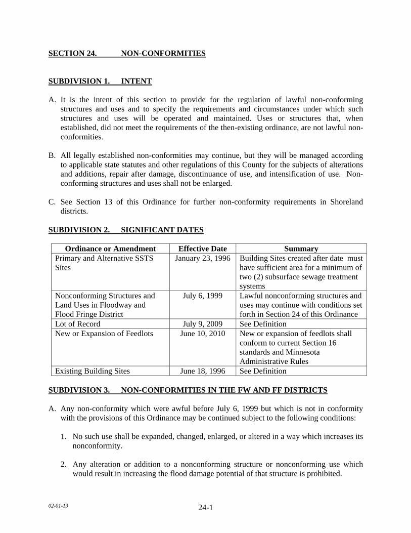
02-01-13 24-1
SECTION 24. NON-CONFORMITIES SUBDIVISION 1. INTENT A. It is the intent of this section to provide for the regulation of lawful non-conforming
structures and uses and to specify the requirements and circumstances under which such structures and uses will be operated and maintained. Uses or structures that, when established, did not meet the requirements of the then-existing ordinance, are not lawful non-conformities.
B. All legally established non-conformities may continue, but they will be managed according
to applicable state statutes and other regulations of this County for the subjects of alterations and additions, repair after damage, discontinuance of use, and intensification of use. Non-conforming structures and uses shall not be enlarged.
C. See Section 13 of this Ordinance for further non-conformity requirements in Shoreland
districts. SUBDIVISION 2. SIGNIFICANT DATES
Ordinance or Amendment Effective Date Summary
Primary and Alternative SSTS Sites
January 23, 1996 Building Sites created after date must have sufficient area for a minimum of two (2) subsurface sewage treatment systems
Nonconforming Structures and Land Uses in Floodway and Flood Fringe District
July 6, 1999 Lawful nonconforming structures and uses may continue with conditions set forth in Section 24 of this Ordinance
Lot of Record July 9, 2009 See Definition New or Expansion of Feedlots
June 10, 2010
New or expansion of feedlots shall conform to current Section 16 standards and Minnesota Administrative Rules
Existing Building Sites June 18, 1996 See Definition SUBDIVISION 3. NON-CONFORMITIES IN THE FW AND FF DISTRICTS A. Any non-conformity which were awful before July 6, 1999 but which is not in conformity
with the provisions of this Ordinance may be continued subject to the following conditions: 1. No such use shall be expanded, changed, enlarged, or altered in a way which increases its
nonconformity. 2. Any alteration or addition to a nonconforming structure or nonconforming use which
would result in increasing the flood damage potential of that structure is prohibited.
02-01-13 24-2
SUBDIVISION 4. DISCONTINUANCE If any non-conforming use of any structure or premises is discontinued or its normal operation is stopped for a period of more than one (1) year, the use of same shall thereafter conform to the regulations of the district in which it is located.
SUBDIVISION 5. ALTERATIONS A. The lawful use of a non-conforming structure or use may be continued, although such use
goes not conform with the provisions thereof. B. Once a non-conforming use has been changed to a conforming use or a substandard structure
has been altered so as to comply with the following, including but not limited to: lot area, setbacks height, access and any other applicable provisions of this Ordinance, it shall not revert back to non-conforming use.
SUBDIVISION 6. RESIDENTIAL ALTERATIONS A. Alterations may be made to a residential structure containing non-conforming residential
units when they will improve the livability of such units, provided however, they do not increase the number of dwelling units in the structure or the physical dimensions of the structure.
B. Homestead and non-homestead residential real estate and seasonal residential real estate
occupied for recreational purposes. 1. A residential non-conformity, as listed above, including the lawful use or occupation of
land or premises existing prior to June 18, 1996, may be continued, including through repair, replacement, restoration, maintenance, or improvement, but not including expansion.
2. A residential nonconformity, as listed above, or occupancy that is discontinued for a
period of more than one (1) year, or any non-conforming structure is destroyed by fire or other peril to the extent of fifty (50) percent of its estimated market value, and no zoning permit has been applied for within 180 days of when the property is damaged any subsequent use or occupancy of the land or premises must be a conforming use or occupancy. This standard shall not apply to the Flood Plain Overlay District.
3. A residential nonconformity, as listed above, that is destroyed by fire or other peril to the
extent of fifty (50) percent of its market value, the Board of County Commissioners may impose reasonable conditions upon a permit in order to mitigate any newly created impact on adjacent property.

02-01-13 24-3
SUBDIVISION 7. RESTORATION
Any nonconforming use or structure, except residential and seasonal real estate listed below, that has been damaged by fire, explosion, or natural disaster, as designated by the Board of County Commissioners, to the extent of more than fifty (50) percent of its value, as determined by the County Assessor, shall be restored in conformity with the regulations of this Ordinance. SUBDIVISION 8. NORMAL MAINTENANCE Maintenance of structures containing or used by a non-conforming use will be permitted when it includes necessary, non-structural repairs and incidental alterations, which do not extend or intensify the non-conforming structure or use. SUBDIVISION 9. LOTS OF RECORD A. All lots which are a part of a subdivision legally recorded with the County Recorder, and all
lots, parcels, tracts and other legally described land to which the deed has been recorded prior to July 09, 2009, which met the requirements of the then existing ordinance at the time of conveyance, shall be considered to be Lots of Record.
B. Lots of Record which do not meet the requirements of this Ordinance such as, but not limited
to, lot area, width and depth, may be allowed as building sites without variances from lot size requirements provided the following:
1. The use is permitted in the zoning district.
2. The lot has been separated from abutting lands at all times since it became substandard.
3. Was created compliant with official controls in effect at the time.
4. Sewage treatment requirements of this Ordinance are met. 5. Setback requirements of this Ordinance are met. 6. The Applicant and/or Landowner shall submit evidence of the recorded deed.
7. All other applicable standards and official controls can be met at the time of development.
C. In a group of two (2) or more contiguous lots or parcels of land under the same ownership,
any individual lot or parcel of land does not meet the requirements of this Ordinance, the lot or parcel of land must not be considered as a separate lot or parcel of land for the purposes of sale or development. The lot shall be considered combined with the one or more contiguous lots or parcels of land so they equal one or more lots or parcels of land, each meeting the requirements of this Ordinance as much as possible.
02-01-13 24-4
1. In accordance with Minnesota State Statute 394.36 as amended from time to time the following shall apply to existing Non-conforming Lots in Shoreland Areas.
a. This subdivision applies to shoreland lots of record in the office of the County
Recorder on the date of adoption of local shoreland controls that do not meet the requirements for lot size or lot width. The County shall regulate the use of nonconforming lots of record and the repair, replacement, maintenance, improvement, or expansion of nonconforming uses and structures in shoreland areas with the following regulations:
b. A non-conforming single lot of record located within a shoreland area may be
allowed as a building site without variances from lot size requirements, provided that:
1. All structure and septic system setback distance requirements can be met. 2. A Type 1 sewage treatment system consistent with Minnesota Rules, chapter
7080, can be installed or the lot is connected to a public sewer. 3. The impervious surface coverage does not exceed twenty five (25) percent
of the lot. c. In a group of two (2) or more contiguous lots of record under a common
ownership, an individual lot must be considered as a separate parcel of land for the purpose of sale or development, if it meets the following requirements:
1. The lot must be at least sixty six (66) percent of the dimensional standard
for lot width and lot size for the shoreland classification consistent with Minnesota Rules, chapter 6120.
2. The lot must be connected to a public sewer, if available, or must be suitable
for the installation of a Type 1 sewage treatment system consistent with Minnesota Rules, chapter 7080, and local government controls.
3. Impervious surface coverage must not exceed twenty five (25) percent of
each lot. 4. Development of the lot must be consistent with an adopted comprehensive
plan. d. A lot subject to paragraph (c) not meeting the requirements of paragraph (c)
must be combined with the one or more contiguous lots so they equal one or more conforming lots as much as possible.

02-01-13 24-5
e. Notwithstanding paragraph (c), contiguous nonconforming lots of record in
shoreland areas under a common ownership must be able to be sold or purchased individually if each lot contained a habitable residential dwelling at the time the lots came under common ownership and the lots are suitable for, or served by, a sewage treatment system consistent with the requirements of section 115.55 and Minnesota Rules, chapter 7080, or connected to a public sewer.
f. In evaluating all variances, zoning permit applications, or conditional use
requests, the Department shall require the property owner to address, when appropriate, storm water runoff management, reducing impervious surfaces, increasing setback, restoration of wetlands, vegetative buffers, sewage treatment and water supply capabilities, and other conservation-designed actions.
g. A portion of a conforming lot may be separated from an existing parcel as long
as the remainder of the existing parcel meets the lot size and sewage system requirements of the zoning district for a new lot and the newly created parcel is combined with an adjacent parcel.
2. Substandard Lots of Record in all districts except Shoreland districts shall be considered
buildable only as permitted provided all other applicable standards and official controls can be met at the time of development.
3. A new dwelling constructed in a shoreland district on a non-conforming Lot of Record
may have a reduced OHWL setback with the following restrictions: a. There shall be an existing dwelling located on each side of the lot. b. The new dwelling shall not be located closer to the OHWL than the existing building
line of the adjacent dwellings. c. The dwelling is not located within a shore or bluff impact zone. 4. A new dwelling constructed in a shoreland district on a non-conforming Lot of Record
may have a reduced OHWL setback if the adjacent lot is vacant with the following restrictions:
a. There shall be an existing dwelling located on one (1) side of the lot. b. The setback for the Lot of Record shall be the setback of the dwelling on the
adjoining lot plus one half (the difference between the setback of the non-conforming dwelling and the setback required by the Ordinance.
02-01-13 24-6
5. A new dwelling constructed on a non-conforming Lot of Record may have a reduced
front yard setback with the following restrictions: a. There shall be an existing dwelling located on each side on the adjacent lots. b. The new dwelling shall not be located closer to the road right-of-way than the
existing dwellings located on the adjacent lots, or at least one-half of the required setback, whichever is greater.
02-01-13 25-1
SECTION 25. ADMINISTRATION/PLANNING COMMISSION
SUBDIVISION 1. COUNTY PLANNING AND ZONING ADMINISTRATOR
A. The office of the County Planning and Zoning Administrator is hereby established, for which the Board of County Commissioners may appoint an Administrator and such other personnel necessary to discharge the duties of the Department.
B. The duties of the Department shall include the following: 1. Be in direct administration of the Zoning Ordinance, Shoreland Regulations, Flood Plain
Regulations, Feedlot Regulations, Subsurface Sewage Treatment System Regulations, and the Subdivision Ordinance.
2. Enforcement of the Zoning Ordinance. If the Department finds a violation of the
provisions of this Ordinance they shall notify the person responsible for such violation in accordance with the procedures stated in this Ordinance.
3. Issue zoning permits and any other permits as required by the terms of this Ordinance. 4. Receive and forward all applications, documents and actions to the Board of County
Commissioners, Planning Commission, Board of Adjustment and other appropriate agencies as required or appropriate by State of Minnesota Statutes.
5. Keep or supervise the keeping of all necessary records. 6. Act as secretary to the Board of Adjustment and also act as advisor to the Planning
Commission. 7. Provide and maintain a public information bureau relative to matters of the Zoning
Ordinance, Shoreland Regulations, Flood Plain Regulations, Feedlot Regulations, Subsurface Sewage Treatment System Regulations, and the Subdivision Ordinance.
8. Report on a regular basis to the Board of County Commissioners the recommendations,
findings and decisions of the Planning Commission, boards and committees for final action where necessary.
SUBDIVISION 2. PLANNING COMMISSION A. The Board of County Commissioners hereby establishes the Planning Commission. Such
Planning Commission shall consist of eleven (11) members appointed by the Chairman of the Board of County Commissioners and ratified by the Board of County Commissioners.
B. No more than four (4) members shall be residents of the incorporated communities of
Le Sueur County.
02-01-13 25-2
C. The term of each member shall coincide with the term of the Commissioners District in which they represent.
D. Each member may be eligible for reappointment at the discretion of the Board of County
Commissioners.
E. No more than one (1) voting member of the Planning Commission shall be an officer or employee of the County.
F. The Board of County Commissioners may designate any county officer or employee as an
ex officio member of the Planning Commission.
G. The Board of County Commissioners may call for the removal of any Planning Commission member for non-performance of duty or misconduct in office.
H. Should any vacancy occur among the members of this Planning Commission by reason of
death, resignation, disability or otherwise, immediate notice thereof shall be given to the Chairman of the Board of County Commissioners by the Department. Should any vacancy occur among the members of the Planning Commission, the vacancy shall be filled in accordance with the bylaws of this Subdivision, such member to serve the unexpired term of the office in which such vacancy shall occur.
I. The members of the Planning Commission may be compensated in an amount as determined
by the Board of County Commissioners
J. The Board of County Commissioners may assign additional duties and responsibilities to the Planning Commission by this Ordinance. The Planning Commission may also be required to review or develop any comprehensive plans or official controls which will aid in the future planning and development within the County, upon the direction of the Board of County Commissioners.
02-01-13
26-1
SECTION 26._ ZONING PERMITS AND LAND ALTERATION PERMITS SUBDIVISION 1. ZONING ADMINISTRATOR AND ASSISTANT ZONING
ADMINISTRATOR The Office of the County Planning and Zoning Administrator, for which the Board of County Commissioners shall appoint such employee or employees as deemed necessary, has the authority to administer, enforce and interpret this Ordinance through the proper legal channels, issue zoning permits and maintain records thereof, and provide a public information bureau relative to this Ordinance. SUBDIVISION 2. ZONING PERMITS A. No person shall erect, alter, or move any structures or part thereof without first securing a
zoning permit, including but not limited to, all structures structure additions, manufactured homes, towers, basements, footings, liquid manure storage area, authorized signs, sewer systems, and repair of sewer systems.
B. Application for a zoning permit shall be made to the Department on forms to be furnished by
the County and must be signed by the applicant and landowner if the applicant is not the landowner. Each application for a permit to construct or alter a structure shall be accompanied by a site plan to include, but not limited to the following:
1. Property lines, lot dimensions, road right-of-way, proposed structure location and size,
existing structures, septic and well locations, road right-of-way setbacks, property line setbacks, access location and size, waterbody and if located in a Shoreland or Flood Plain Overlay District, impervious surface calculations.
C. Applications for a zoning permit shall contain such other information as may be deemed
necessary for the proper enforcement of this Ordinance. D. The Department shall issue the zoning permit only after determining that the building plans,
together with any other required information comply with the planning of future road construction, which information shall be furnished by the County Engineer. If needed, a variance from setback requirements must be obtained prior to the issuance of a zoning permit.
E. Any zoning permit is void if the permitted activity is not completed within one (1) year from
the date the permit was issued.

02-01-13
26-2
SUBDIVISION 3. LAND ALTERATION PERMIT A. No person shall alter any land or part thereof without first securing a land alteration permit,
for activities including but not limited to, farm and wildlife ponds, earth excavations, grading and filling, retaining walls, rip rap, vegetation alterations, rain gardens, and impervious surface.
B. Application for a land alteration permit shall be made to the Department on forms to be
furnished by the County and must be signed by the applicant and/or landowner. Each application for a permit shall be accompanied by a site plan, to include, but not limited to the following:
1. Project description, property lines, lot dimensions, road right-of-way, existing structures,
septic and well locations, road right-of-way setbacks, property line setbacks, access location and size, waterbody, and if located in a Shoreland or Flood Plain Overlay District, impervious surface calculations.
C. Applications for a land alteration permit shall contain such other information as may be
deemed necessary for the proper enforcement of this Ordinance. D. The Department shall issue the land alteration permit only after determining that the land
alteration plans, together with any other required information comply with the planning of future road construction, which information shall be furnished by the County Engineer. If needed, a variance from setback requirements must be obtained prior to the issuance of a land alteration permit.
E. Any land alteration(s) permit is void if the permitted activity is not completed within one (1)
year from the date the permit was issued. SUBDIVISION 4. FEES Permit fees and other fees as may be established by resolution of the Board of County Commissioners shall be collected by the Department for deposit with the County and credited to a fund as directed by the Board of County Commissioners. Permits are not valid until the required fee is paid.
02-01-13
27-1
SECTION 27. ESSENTIAL SERVICES SUBDIVISION 1. GENERAL A. Essential and transmission services as defined by this Ordinance may have an effect upon
urbanizing areas of the county, county land uses, highway location, park and recreation areas, preservation of natural environmental areas, lakes, streams, and rivers. The proposed location of all such essential and transmission services in any land use district shall be filed with the County prior to commencement of any condemnation action or construction.
B. All essential services including large facilities and those for local distribution, or other
similar facilities as determined by the County Engineer, shall be located entirely within a public road right-of-way, or shall meet setbacks as required for principal structures in all districts.
SUBDIVISION 2. PROCEDURES FOR LARGE FACILITIES A. Transmission services, to include but not limited to, utility service such as high voltage
(35kVA, Kilo Voltage Amps or greater), electrical power or bulk gas or fuel being transferred from station to station and not intended for enroute consumption shall follow the following procedure:
1. The owner shall file with the County Engineer and the Department such maps indicating
the location, alignment, and type of service proposed as well as an Environmental Impact Statement indicating areas of conflict and solutions to such environmental conflicts as shall be required.
2. All maps and accompanying data submitted to the Department shall be forwarded to the
Planning Commission along with the Engineer's report for review and recommendation to the Board of County Commissioners.
3. Upon receipt of the report of the Planning Commission of the planned essential
transmission services, the Board of County Commissioners shall consider the maps and accompanying data and shall indicate to the owner its approval, denial, or modifications considered desirable under this Ordinance.
B. Recognizing a need for timely and adequate service by owners of essential services, the
County shall act upon all information filing within sixty (60) days of receipt by the Department and County Engineer. In the process or deliberation, the County can call upon such sources of information, public or private, as they deem necessary to clarify problems and otherwise provide information necessary to their decision.

02-01-13
27-2
SUBDIVISION 3._ PROCEDURE FOR LOCAL DISTRIBUTION SERVICES A. Applications for a permit for essential services, to include but not limited to, services such as
power, gas, fuel, or lines for data transmission, for immediate local distribution to the public, shall follow the following procedure:
1. The applicant shall file an application with the County Engineer, on forms supplied by
the County, with maps showing the location, alignment, and type of service proposed. 2. The application and accompanying data shall be reviewed by the County Engineer, who
may issue the permit after determining that the application is acceptable. 3. The County Engineer may require, in conjunction with the issuance of each permit: a. The applicant submits as-built drawings of the essential services after construction. b. The applicants construct the essential services to take into consideration contemplated
widening, regrading, or relocation of a county highway or county state aid highway. 4. Recognizing the need for adequate and timely services by owners of essential services,
the County Engineer shall act upon all information filings or permit applications at the earliest opportunity.

02-01-13 28-1
SECTION 28, RESERVED

02-01-13 29-1
SECTION 29. RESERVED
02-01-13
30-1
SECTION 30. VIOLATIONS, FINES AND ENFORCEMENT SUBDIVISION 1. VIOLATIONS Any person, firm or corporation who shall violate any of the provisions of this Ordinance or failure to comply with any of its provisions hereof, or who shall make any false statement in any document required to be submitted under the provisions hereof, including violations of conditions and safeguards established in connection with grants of variances, or conditional uses, zoning permits, or other certificates or permits issued pursuant to the provisions of this Ordinance, shall constitute a misdemeanor and shall be punishable as defined by law. SUBDIVISION 2. ENFORCEMENT This Ordinance shall be administered and enforced by the Department. In the event of a violation or threatened violation of this Ordinance, the Board of County Commissioners and/or Department or any member thereof, in addition to other remedies, may institute appropriate actions or proceedings to prevent, restrain, correct, or abate such violations or threatened violations and it shall be the duty of the County Attorney to institute such action. SUBDIVISION 3. REMEDIES A. Nothing herein contained shall prevent the County from taking such other lawful action as is
necessary to prevent or remedy any violation. Such actions may include but are not limited to:
1. In responding to a suspected violation of this Ordinance, the County may utilize the full
array of enforcement actions available to it, including but not limited to the following: a. Prosecution and fines, injunctions, after-the-fact permits and orders for corrective
measures. b. Or if the property is in the Flood Plain Overlay District, a request to the National
Flood Insurance Program for denial of flood insurance availability to the guilty party. 2. When a suspected violation of this Ordinance is either discovered by or brought to the
attention of the Department, the Department shall investigate the situation to determine if there is a violation. If a violation has occurred, the Department shall document the nature and extent of the violation of the official control. When land is located in Flood Plain Overlay or Shoreland Districts, as soon as is reasonably possible this information will be submitted to the appropriate DNR and FEMA office as appropriate, along with the County's plan of action to correct the violation to the degree possible.
02-01-13
30-2
3. The Department shall notify the suspected party of the requirements of this Ordinance and all other official controls and the nature and extent of the suspected violation of these controls. If the structure and/or use is under construction or development, the Department may order the construction or development immediately halted until a proper permit or approval is granted by the County. If the construction or development is already completed, the Department may either:
a. Issue an order identifying the corrective actions that must be made within a specified
time period to bring the use or structure into compliance with the official controls. The responsible party must respond within thirty (30) days of notice with corrective action plan, Or:
b. Notify the responsible party to apply for an after-the-fact permit and/or land use
development application approval within a specified period of time not to exceed thirty (30) days. The fee for after-the-fact applications shall be established by the Board of County Commissioners.
4. If the responsible party does not appropriately respond to the Department within the
specified period of time, each additional day that lapses shall constitute an additional violation of this Ordinance and shall be prosecuted accordingly. The Department shall also upon the lapse of the specified response period notify the landowner to restore the land to the condition, which existed prior to the violation of this Ordinance.
SUBDIVISION 4. FINES All fines for violations shall be paid to the County and shall be credited to the General Revenue Fund. SUBDIVISION 5. SHERIFF OF LE SUEUR COUNTY DUTIES It shall be the duty of the Sheriff of Le Sueur County, when called upon by the Department or Board of County Commissioners to perform such duties as may be necessary to enforce the provisions of this Ordinance.

02-01-13
31-1
SECTION 31. VALIDITY Should any section or provision of this Ordinance be declared by a court of competent jurisdiction to be invalid, such decision shall not affect the validity of this Ordinance as a whole or any part thereof other than the part so declared to be invalid.

02-01-13
32-1
SECTION 32. REPEAL, ADOPTION AND EFFECTIVE DATE SUBDIVISION 1. REPEAL The Le Sueur County Zoning Ordinance, adopted, June 18, 1996 as amended, is hereby repealed in its entirety on the effective date of adoption of this Ordinance. The adoption of this Ordinance, however, shall not affect nor prevent any pending or future prosecution of, or action to abate, any existing violation of said Le Sueur County Zoning Ordinance, adopted, June 18, 1996 as amended, if the violation is also a violation of this Ordinance. SUBDIVISION 2. PUBLIC HEARING AND PLANNING COMMISSION RECOMMENDATION The Planning Commission, after proper notice and publication, held public hearings on the adoption of this Ordinance on November 27, 2012 and December 3, 2012. After hearing public testimony and with due deliberation, the Planning Commission voted to recommend adoption of this Ordinance to the Board of County Commissioners. SUBDIVISION 3. ADOPTION The Board of County Commissioners, after proper notice and publication, held public hearings on the adoption of this Ordinance on December 11, 2012 and December 27, 2012, at the Le Sueur County Courthouse and with due deliberation, the Board of County Commissioners voted 4 Yes and 1 Nay to adopt this Ordinance. SUBDIVISION 4. EFFECTIVE DATE This Ordinance shall be in full force and effect from and after its passage and publication. Passed on this date: December 27, 2012 with an effective date of February 1, 2013. ___________________________________ Chairperson, Board of County Commissioners ATTEST: _________________________________ County Administrator