Embed Size (px)
Citation preview
Hounslow
| Context &
Character
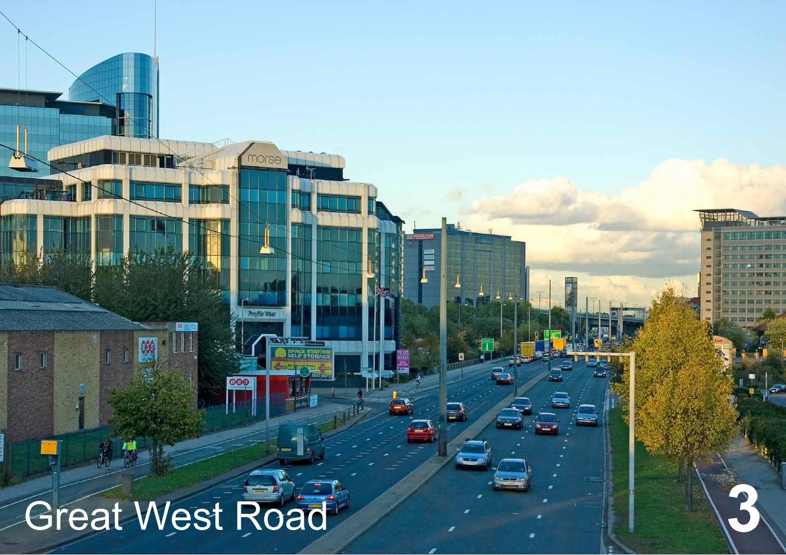
1Great West Road 3
2
Hou
nslo
w |
Con
text
& C
hara
cter
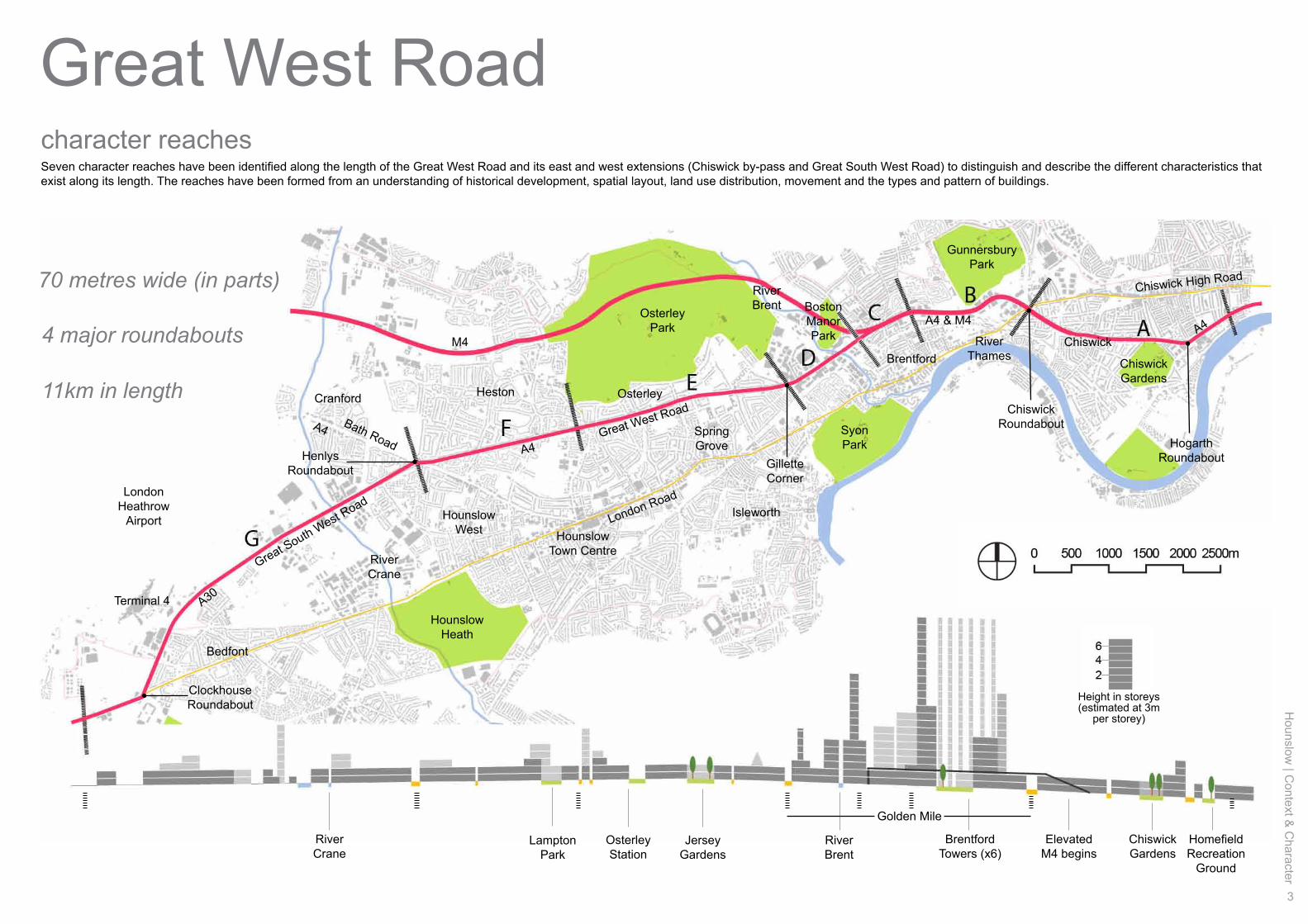
Great West RoadThe Great West Road (part of the A4) enters the borough in the east, 1km from the Hammersmith flyover. It continues 11km westwards, through Chiswick, Brentford, Osterley and Heston until the Bath Road (Henlys) roundabout. The Great South West Road continues the route past Hatton Cross and south of Heathrow Airport. East of Hammersmith, the A4 passes through up-market Kensington, Knightsbridge and Mayfair before reaching Piccadilly Circus. The width of the highway ranges from between 30m to 70m. The height of buildings that line the road range from between 2 to 25 storeys, with 2 to 3 storeys being the most common. Many of the taller buildings do not enhance their immediate environment and compromise the quality of their widersurroundings. The elevated section of the M4 motorway begins just east of the Chiswick Roundabout and shadows the GWR as far as Boston Manor Park, where it veers northwest.
Along the GWR there is a variety of land uses, with residential and business being predominant. There are small pockets of retail, commerce, restaurants and hotels but on the whole these are scattered and few. Most of the town centres (Chiswick, Brentford and Hounslow) lie on the older, historic thoroughfare of London Road which runs almost parallel to the south of the GWR and is crossed by it at Chiswick and Clockhouse Roundabouts. The GWR has come to function as a by-pass for the town centres of the entire borough, diverting traffic away from these economic centres.
Historically known as the Golden Mile, the Brentford stretches of the GWR have been and remain home to a number of major national and international companies which provide employment for many people living inside and outside the area. However, by the late 1980s traffic congestion, relatively poor public transport accessibility and more restrictive parking standards limited the appeal of the Golden Mile for further office based employment, resulting in a number of large former employment sites becoming vacant. This situation persisted until the commercial and mixed-use renaissance of recent years.
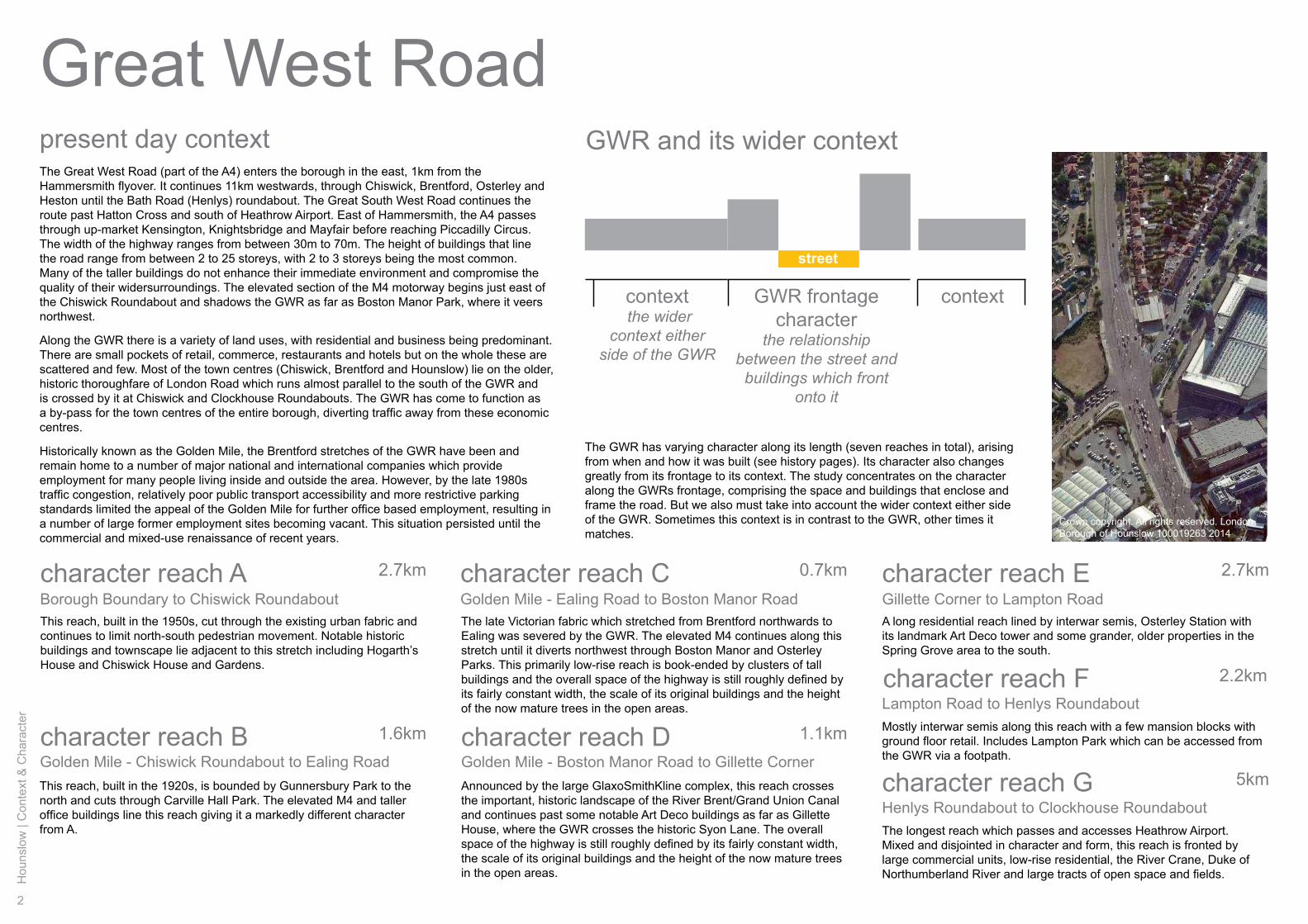
present day context GWR and its wider context
GWR frontage character
the relationship between the street and
buildings which front onto it
context the wider
context either side of the GWR
street
The GWR has varying character along its length (seven reaches in total), arising from when and how it was built (see history pages). Its character also changes greatly from its frontage to its context. The study concentrates on the character along the GWRs frontage, comprising the space and buildings that enclose and frame the road. But we also must take into account the wider context either side of the GWR. Sometimes this context is in contrast to the GWR, other times it matches.
context
A long residential reach lined by interwar semis, Osterley Station with its landmark Art Deco tower and some grander, older properties in the Spring Grove area to the south.
Mostly interwar semis along this reach with a few mansion blocks with ground floor retail. Includes Lampton Park which can be accessed from the GWR via a footpath.
The longest reach which passes and accesses Heathrow Airport. Mixed and disjointed in character and form, this reach is fronted by large commercial units, low-rise residential, the River Crane, Duke of Northumberland River and large tracts of open space and fields.
character reach A 2.7km
1.6km
Golden Mile - Ealing Road to Boston Manor RoadBorough Boundary to Chiswick Roundabout
Golden Mile - Chiswick Roundabout to Ealing Road Golden Mile - Boston Manor Road to Gillette Corner
Gillette Corner to Lampton Road
Lampton Road to Henlys Roundabout
Henlys Roundabout to Clockhouse Roundabout
2.2km
5km
2.7km
1.1km character reach B
character reach E
character reach F
character reach G
This reach, built in the 1950s, cut through the existing urban fabric and continues to limit north-south pedestrian movement. Notable historic buildings and townscape lie adjacent to this stretch including Hogarth’s House and Chiswick House and Gardens.
0.7km character reach CThe late Victorian fabric which stretched from Brentford northwards to Ealing was severed by the GWR. The elevated M4 continues along this stretch until it diverts northwest through Boston Manor and Osterley Parks. This primarily low-rise reach is book-ended by clusters of tall buildings and the overall space of the highway is still roughly defined by its fairly constant width, the scale of its original buildings and the height of the now mature trees in the open areas.
character reach D
Announced by the large GlaxoSmithKline complex, this reach crosses the important, historic landscape of the River Brent/Grand Union Canal and continues past some notable Art Deco buildings as far as Gillette House, where the GWR crosses the historic Syon Lane. The overall space of the highway is still roughly defined by its fairly constant width, the scale of its original buildings and the height of the now mature trees in the open areas.
This reach, built in the 1920s, is bounded by Gunnersbury Park to the north and cuts through Carville Hall Park. The elevated M4 and taller office buildings line this reach giving it a markedly different character from A.
Crown copyright. All rights reserved. London Borough of Hounslow 100019263 2014
Hounslow
| Context &
Character
3
Great West Road
M4
A4
A4A4 & M4
A30
A4
OsterleyPark
BostonManorPark
SyonPark
Hounslow Heath
Chiswick Gardens
Gunnersbury Park
Chiswick High Road
London Road
Bath Road
Great South West Road
Great West Road
character reaches
Golden Mile
BrentfordTowers (x6)
Elevated M4 begins
Height in storeys(estimated at 3m
per storey)
RiverBrent
RiverCrane
Chiswick Gardens
JerseyGardens
OsterleyStation
HomefieldRecreation
Ground
LamptonPark
11km in length
4 major roundabouts
70 metres wide (in parts)
Seven character reaches have been identified along the length of the Great West Road and its east and west extensions (Chiswick by-pass and Great South West Road) to distinguish and describe the different characteristics that exist along its length. The reaches have been formed from an understanding of historical development, spatial layout, land use distribution, movement and the types and pattern of buildings.
Hogarth Roundabout
Chiswick Roundabout
GilletteCorner
HenlysRoundabout
RiverCrane
RiverBrent
RiverThames
ClockhouseRoundabout
LondonHeathrow
Airport
Terminal 4
BrentfordChiswick
HestonCranford
Bedfont
HounslowWest Hounslow
Town Centre
Isleworth
Osterley
SpringGrove
4
Hou
nslo
w |
Con
text
& C
hara
cter
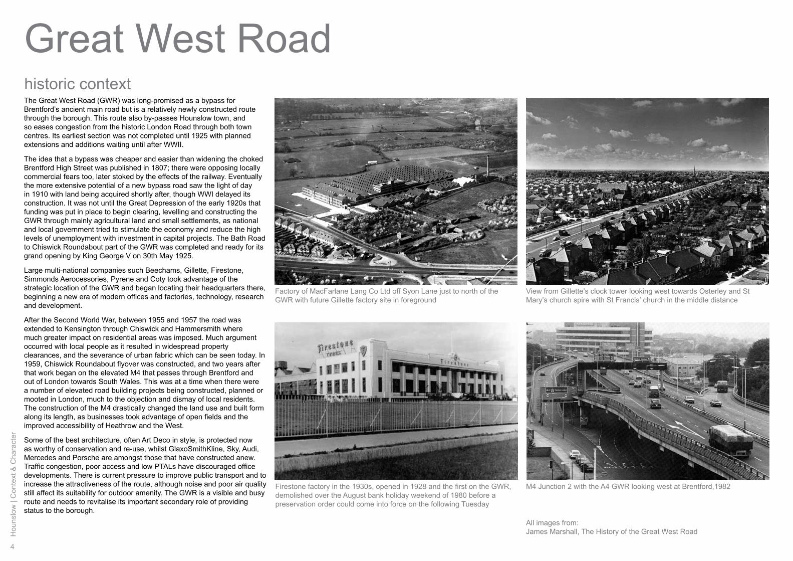
Great West RoadThe Great West Road (GWR) was long-promised as a bypass for Brentford’s ancient main road but is a relatively newly constructed route through the borough. This route also by-passes Hounslow town, and so eases congestion from the historic London Road through both town centres. Its earliest section was not completed until 1925 with planned extensions and additions waiting until after WWII.
The idea that a bypass was cheaper and easier than widening the choked Brentford High Street was published in 1807; there were opposing locally commercial fears too, later stoked by the effects of the railway. Eventually the more extensive potential of a new bypass road saw the light of day in 1910 with land being acquired shortly after, though WWI delayed its construction. It was not until the Great Depression of the early 1920s that funding was put in place to begin clearing, levelling and constructing the GWR through mainly agricultural land and small settlements, as national and local government tried to stimulate the economy and reduce the high levels of unemployment with investment in capital projects. The Bath Road to Chiswick Roundabout part of the GWR was completed and ready for its grand opening by King George V on 30th May 1925.
Large multi-national companies such Beechams, Gillette, Firestone, Simmonds Aerocessories, Pyrene and Coty took advantage of the strategic location of the GWR and began locating their headquarters there, beginning a new era of modern offices and factories, technology, research and development.
After the Second World War, between 1955 and 1957 the road was extended to Kensington through Chiswick and Hammersmith where much greater impact on residential areas was imposed. Much argument occurred with local people as it resulted in widespread property clearances, and the severance of urban fabric which can be seen today. In 1959, Chiswick Roundabout flyover was constructed, and two years after that work began on the elevated M4 that passes through Brentford and out of London towards South Wales. This was at a time when there were a number of elevated road building projects being constructed, planned or mooted in London, much to the objection and dismay of local residents. The construction of the M4 drastically changed the land use and built form along its length, as businesses took advantage of open fields and the improved accessibility of Heathrow and the West.
Some of the best architecture, often Art Deco in style, is protected now as worthy of conservation and re-use, whilst GlaxoSmithKline, Sky, Audi, Mercedes and Porsche are amongst those that have constructed anew. Traffic congestion, poor access and low PTALs have discouraged office developments. There is current pressure to improve public transport and to increase the attractiveness of the route, although noise and poor air quality still affect its suitability for outdoor amenity. The GWR is a visible and busy route and needs to revitalise its important secondary role of providing status to the borough.
historic context
View from Gillette’s clock tower looking west towards Osterley and St Mary’s church spire with St Francis’ church in the middle distance
Firestone factory in the 1930s, opened in 1928 and the first on the GWR, demolished over the August bank holiday weekend of 1980 before a preservation order could come into force on the following Tuesday
Factory of MacFarlane Lang Co Ltd off Syon Lane just to north of the GWR with future Gillette factory site in foreground
M4 Junction 2 with the A4 GWR looking west at Brentford,1982
All images from:James Marshall, The History of the Great West Road
Hounslow
| Context &
Character
5
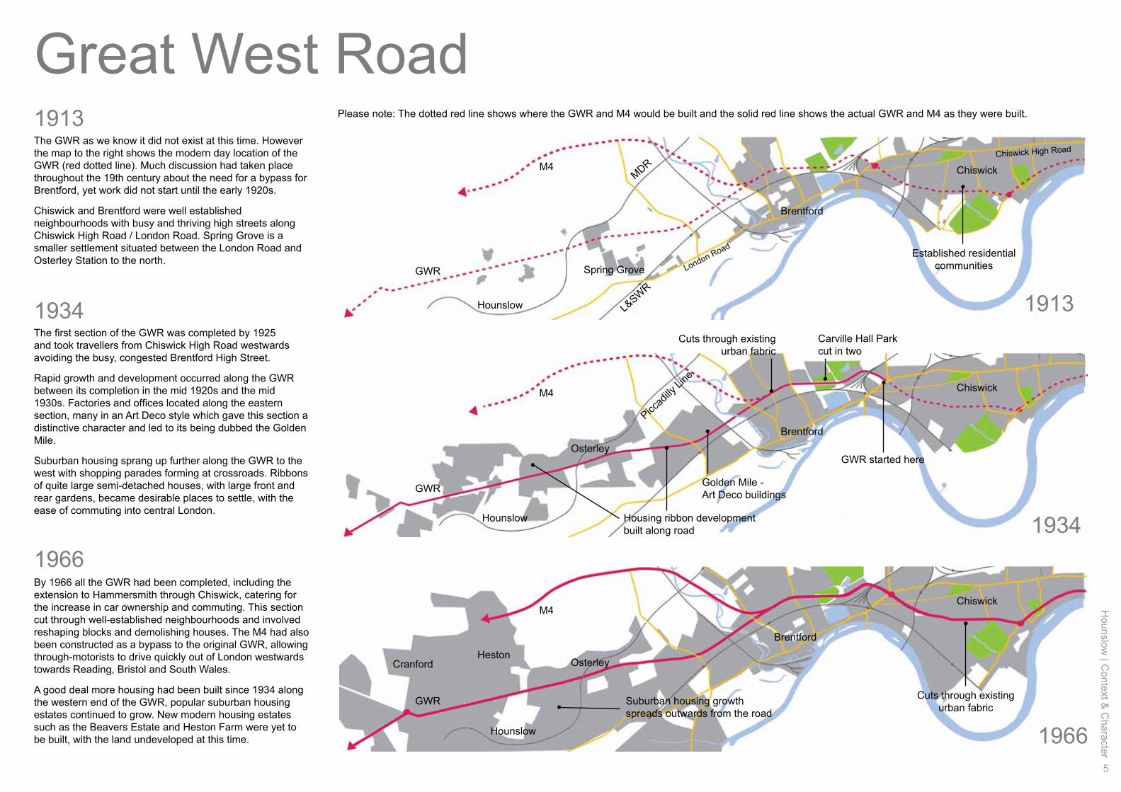
1913
1934
1966
Great West RoadThe GWR as we know it did not exist at this time. However the map to the right shows the modern day location of the GWR (red dotted line). Much discussion had taken place throughout the 19th century about the need for a bypass for Brentford, yet work did not start until the early 1920s.
Chiswick and Brentford were well established neighbourhoods with busy and thriving high streets along Chiswick High Road / London Road. Spring Grove is a smaller settlement situated between the London Road and Osterley Station to the north.
The first section of the GWR was completed by 1925 and took travellers from Chiswick High Road westwards avoiding the busy, congested Brentford High Street.
Rapid growth and development occurred along the GWR between its completion in the mid 1920s and the mid 1930s. Factories and offices located along the eastern section, many in an Art Deco style which gave this section a distinctive character and led to its being dubbed the Golden Mile.
Suburban housing sprang up further along the GWR to the west with shopping parades forming at crossroads. Ribbons of quite large semi-detached houses, with large front and rear gardens, became desirable places to settle, with the ease of commuting into central London.
By 1966 all the GWR had been completed, including the extension to Hammersmith through Chiswick, catering for the increase in car ownership and commuting. This section cut through well-established neighbourhoods and involved reshaping blocks and demolishing houses. The M4 had also been constructed as a bypass to the original GWR, allowing through-motorists to drive quickly out of London westwards towards Reading, Bristol and South Wales.
A good deal more housing had been built since 1934 along the western end of the GWR, popular suburban housing estates continued to grow. New modern housing estates such as the Beavers Estate and Heston Farm were yet to be built, with the land undeveloped at this time.
Spring Grove
Hounslow
Hounslow
Osterley
OsterleyHeston
Cranford
Hounslow
Brentford
Please note: The dotted red line shows where the GWR and M4 would be built and the solid red line shows the actual GWR and M4 as they were built.
Brentford
Golden Mile - Art Deco buildings
Housing ribbon development built along road
Suburban housing growth spreads outwards from the road
Carville Hall Park cut in two
Cuts through existing urban fabric
Cuts through existing urban fabric
Established residential communities
GWR started here
Brentford
M4
M4
M4
MDR
Piccad
illy Li
ne
L&SWR
GWR
GWR
GWR
Chiswick
Chiswick
Chiswick
Chiswick High Road
London Road
1913
1934
1966
6
Hou
nslo
w |
Con
text
& C
hara
cter
Great West Road character reach A
Chiswick Roundabout
Harvard Hill Recreation
Ground
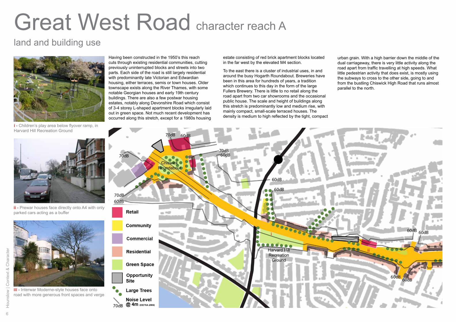
land and building useHaving been constructed in the 1950’s this reach cuts through existing residential communities, cutting previously uninterrupted blocks and streets into two parts. Each side of the road is still largely residential with predominantly late Victorian and Edwardian housing, either terraces, semis or town houses. Older townscape exists along the River Thames, with some notable Georgian houses and early 19th century buildings. There are also a few postwar housing estates, notably along Devonshire Road which consist of 3-4 storey L-shaped apartment blocks irregularly laid out in green space. Not much recent development has occurred along this stretch, except for a 1980s housing
urban grain. With a high barrier down the middle of the dual carriageway, there is very little activity along the road apart from traffic travelling at high speeds. What little pedestrian activity that does exist, is mostly using the subways to cross to the other side, going to and from the bustling Chiswick High Road that runs almost parallel to the north.
estate consisting of red brick apartment blocks located in the far west by the elevated M4 section.
To the east there is a cluster of industrial uses, in and around the busy Hogarth Roundabout. Breweries have been in this area for hundreds of years, a tradition which continues to this day in the form of the large Fullers Brewery. There is little to no retail along the road apart from two car showrooms and the occasional public house. The scale and height of buildings along this stretch is predominantly low and medium rise, with mainly compact, small-scale terraced houses. The density is medium to high reflected by the tight, compact
ii
i
i - Children’s play area below flyover ramp, in Harvard Hill Recreation Ground
ii - Prewar houses face directly onto A4 with only parked cars acting as a buffer
iii - Interwar Moderne-style houses face onto road with more generous front spaces and verge
Hounslow
| Context &
Character
7
Borough Boundary to Chiswick Roundabout
Chiswick Gardens
Chiswick
Mall
Hogarth Roundabout
Homefield Recreation
Ground
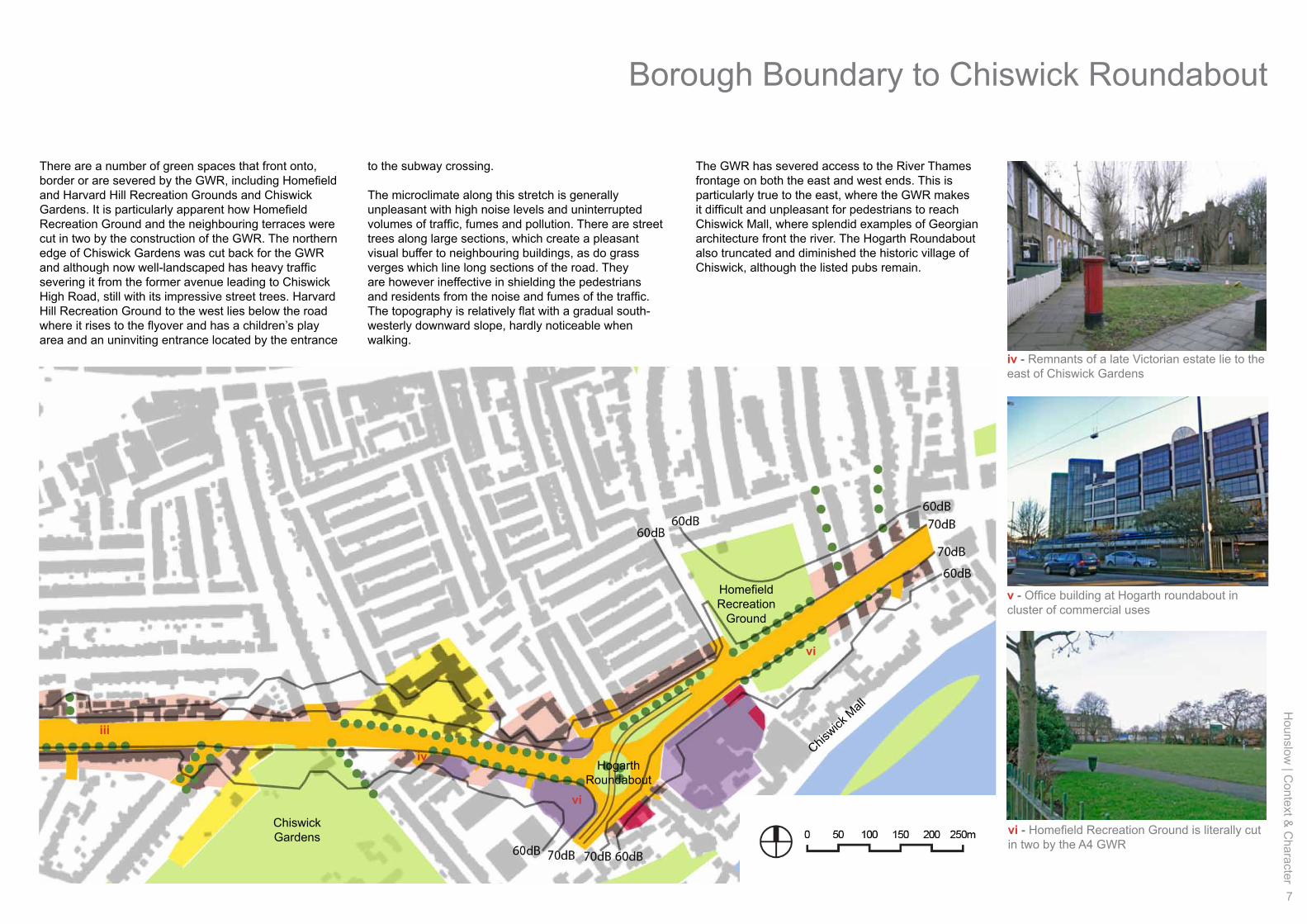
There are a number of green spaces that front onto, border or are severed by the GWR, including Homefield and Harvard Hill Recreation Grounds and Chiswick Gardens. It is particularly apparent how Homefield Recreation Ground and the neighbouring terraces were cut in two by the construction of the GWR. The northern edge of Chiswick Gardens was cut back for the GWR and although now well-landscaped has heavy traffic severing it from the former avenue leading to Chiswick High Road, still with its impressive street trees. Harvard Hill Recreation Ground to the west lies below the road where it rises to the flyover and has a children’s play area and an uninviting entrance located by the entrance
The GWR has severed access to the River Thames frontage on both the east and west ends. This is particularly true to the east, where the GWR makes it difficult and unpleasant for pedestrians to reach Chiswick Mall, where splendid examples of Georgian architecture front the river. The Hogarth Roundabout also truncated and diminished the historic village of Chiswick, although the listed pubs remain.
to the subway crossing.
The microclimate along this stretch is generally unpleasant with high noise levels and uninterrupted volumes of traffic, fumes and pollution. There are street trees along large sections, which create a pleasant visual buffer to neighbouring buildings, as do grass verges which line long sections of the road. They are however ineffective in shielding the pedestrians and residents from the noise and fumes of the traffic. The topography is relatively flat with a gradual south-westerly downward slope, hardly noticeable when walking.
v - Office building at Hogarth roundabout in cluster of commercial uses
iv - Remnants of a late Victorian estate lie to the east of Chiswick Gardens
vi - Homefield Recreation Ground is literally cut in two by the A4 GWR
vi
iv
vi
iii
8
Hou
nslo
w |
Con
text
& C
hara
cter
Great West Road character reach Amovement and legibility
Building heights
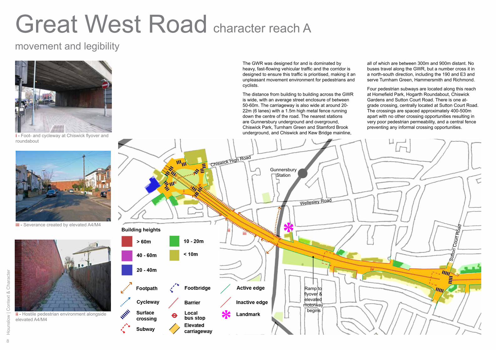
The GWR was designed for and is dominated by heavy, fast-flowing vehicular traffic and the corridor is designed to ensure this traffic is prioritised, making it an unpleasant movement environment for pedestrians and cyclists.
The distance from building to building across the GWR is wide, with an average street enclosure of between 50-60m. The carriageway is also wide at around 20-22m (6 lanes) with a 1.5m high metal fence running down the centre of the road. The nearest stations are Gunnersbury underground and overground, Chiswick Park, Turnham Green and Stamford Brook underground, and Chiswick and Kew Bridge mainline,
all of which are between 300m and 900m distant. No buses travel along the GWR, but a number cross it in a north-south direction, including the 190 and E3 and serve Turnham Green, Hammersmith and Richmond.
Four pedestrian subways are located along this reach at Homefield Park, Hogarth Roundabout, Chiswick Gardens and Sutton Court Road. There is one at-grade crossing, centrally located at Sutton Court Road. The crossings are spaced approximately 400-500m apart with no other crossing opportunities resulting in very poor pedestrian permeability, and a central fence preventing any informal crossing opportunities.
Wellesley Road
GunnersburyStation
Ramp to flyover &elevatedmotorway begins
Sutto
n C
ourt
Roa
d
Chiswick High Road
i - Foot- and cycleway at Chiswick flyover and roundabout
ii - Hostile pedestrian environment alongside elevated A4/M4
iii - Severance created by elevated A4/M4
i
ii iii
iv
Hounslow
| Context &
Character
9
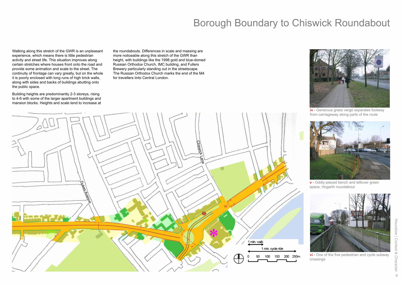
Walking along this stretch of the GWR is an unpleasant experience, which means there is little pedestrian activity and street life. This situation improves along certain stretches where houses front onto the road and provide some animation and scale to the street. The continuity of frontage can vary greatly, but on the whole it is poorly enclosed with long runs of high brick walls, along with sides and backs of buildings abutting onto the public space.
Building heights are predominantly 2-3 storeys, rising to 4-6 with some of the larger apartment buildings and mansion blocks. Heights and scale tend to increase at
the roundabouts. Differences in scale and massing are more noticeable along this stretch of the GWR than height, with buildings like the 1998 gold and blue-domed Russian Orthodox Church, IMC building, and Fullers Brewery particularly standing out in the streetscape. The Russian Orthodox Church marks the end of the M4 for travellers iinto Central London.
Dukes Avenue
Chisw
ick Lane
Borough Boundary to Chiswick Roundabout
iv - Generous grass verge separates footway from carriageway along parts of the route
v - Oddly-placed bench and leftover green space, Hogarth roundabout
vi - One of the five pedestrian and cycle subway crossings
vi
v
10
Hou
nslo
w |
Con
text
& C
hara
cter
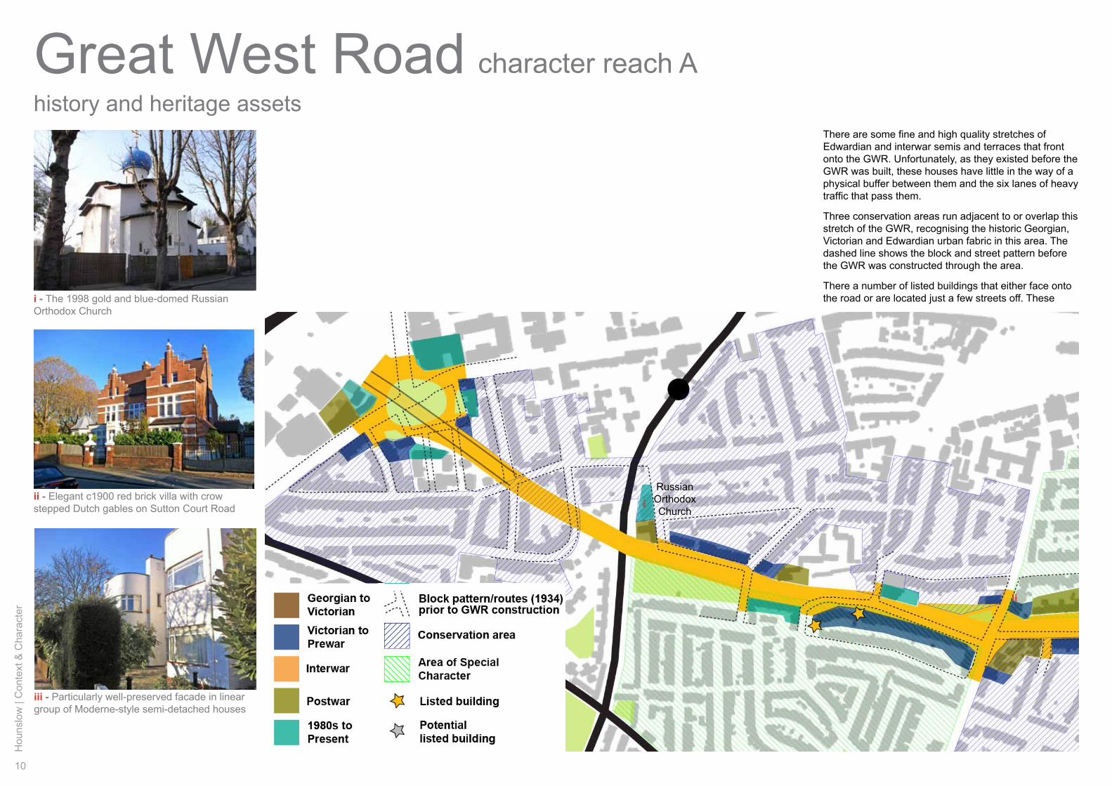
Great West Road character reach Ahistory and heritage assets
There are some fine and high quality stretches of Edwardian and interwar semis and terraces that front onto the GWR. Unfortunately, as they existed before the GWR was built, these houses have little in the way of a physical buffer between them and the six lanes of heavy traffic that pass them.
Three conservation areas run adjacent to or overlap this stretch of the GWR, recognising the historic Georgian, Victorian and Edwardian urban fabric in this area. The dashed line shows the block and street pattern before the GWR was constructed through the area.
There a number of listed buildings that either face onto the road or are located just a few streets off. These
RussianOrthodoxChurch
i - The 1998 gold and blue-domed Russian Orthodox Church
iii - Particularly well-preserved facade in linear group of Moderne-style semi-detached houses
i
ii
ii - Elegant c1900 red brick villa with crow stepped Dutch gables on Sutton Court Road
Hounslow
| Context &
Character
11
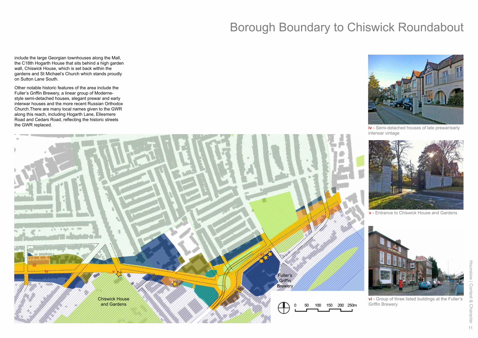
include the large Georgian townhouses along the Mall, the C18th Hogarth House that sits behind a high garden wall, Chiswick House, which is set back within the gardens and St Michael’s Church which stands proudly on Sutton Lane South.
Other notable historic features of the area include the Fuller’s Griffin Brewery, a linear group of Moderne-style semi-detached houses, elegant prewar and early interwar houses and the more recent Russian Orthodox Church.There are many local names given to the GWR along this reach, including Hogarth Lane, Ellesmere Road and Cedars Road, reflecting the historic streets the GWR replaced.
Chiswick House and Gardens
Fuller’sGriffin
Brewery
Borough Boundary to Chiswick Roundabout
v - Entrance to Chiswick House and Gardens
vi - Group of three listed buildings at the Fuller’s Griffin Brewery
iviii
vi
v
iv - Semi-detached houses of late prewar/early interwar vintage
12
Hou
nslo
w |
Con
text
& C
hara
cter
Great West Road character reach Astreetscape
Public highway
a’a
b b’
c c’
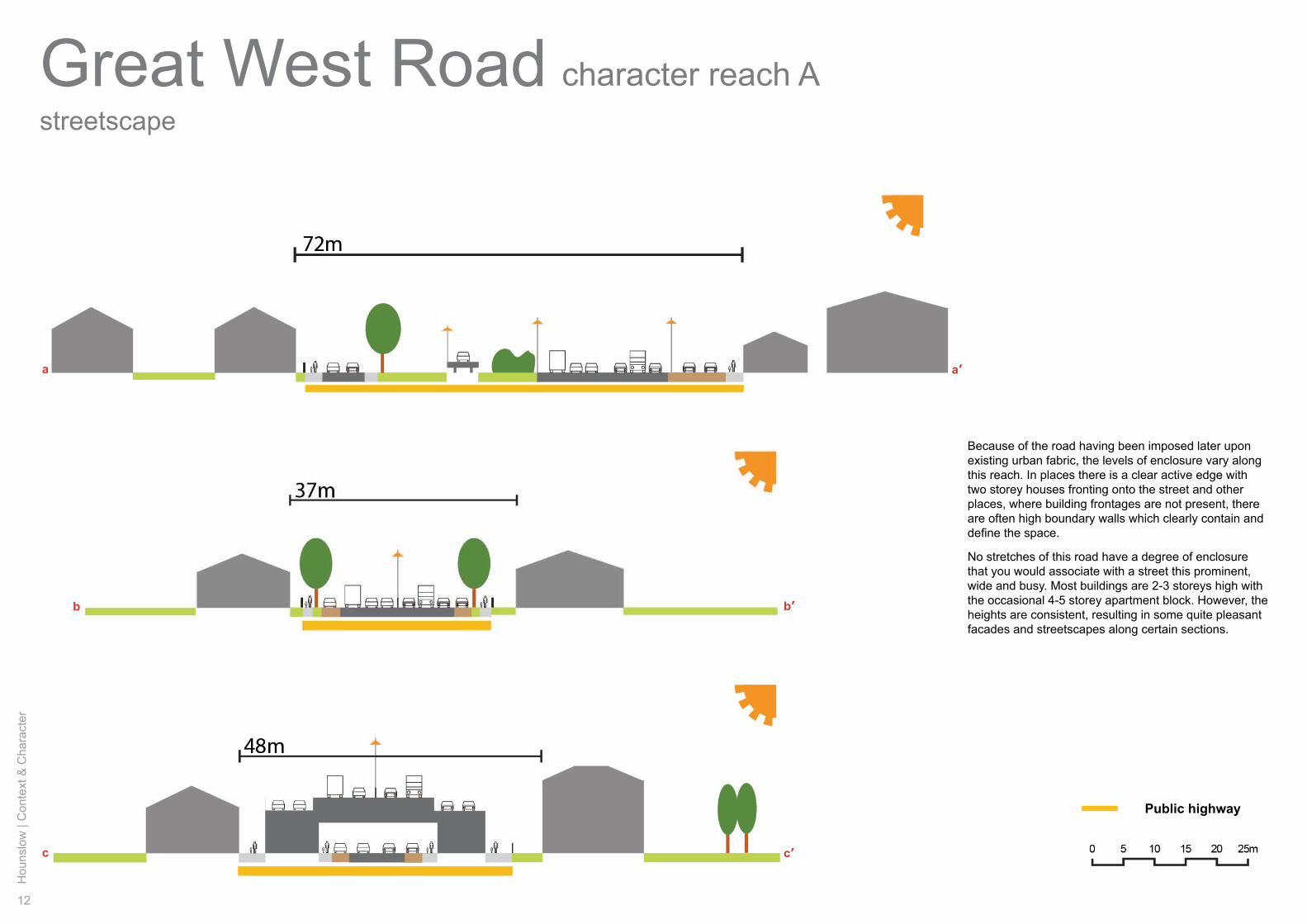
Because of the road having been imposed later upon existing urban fabric, the levels of enclosure vary along this reach. In places there is a clear active edge with two storey houses fronting onto the street and other places, where building frontages are not present, there are often high boundary walls which clearly contain and define the space.
No stretches of this road have a degree of enclosure that you would associate with a street this prominent, wide and busy. Most buildings are 2-3 storeys high with the occasional 4-5 storey apartment block. However, the heights are consistent, resulting in some quite pleasant facades and streetscapes along certain sections.
Hounslow
| Context &
Character
13
a
i
iiiii
iv
v vi
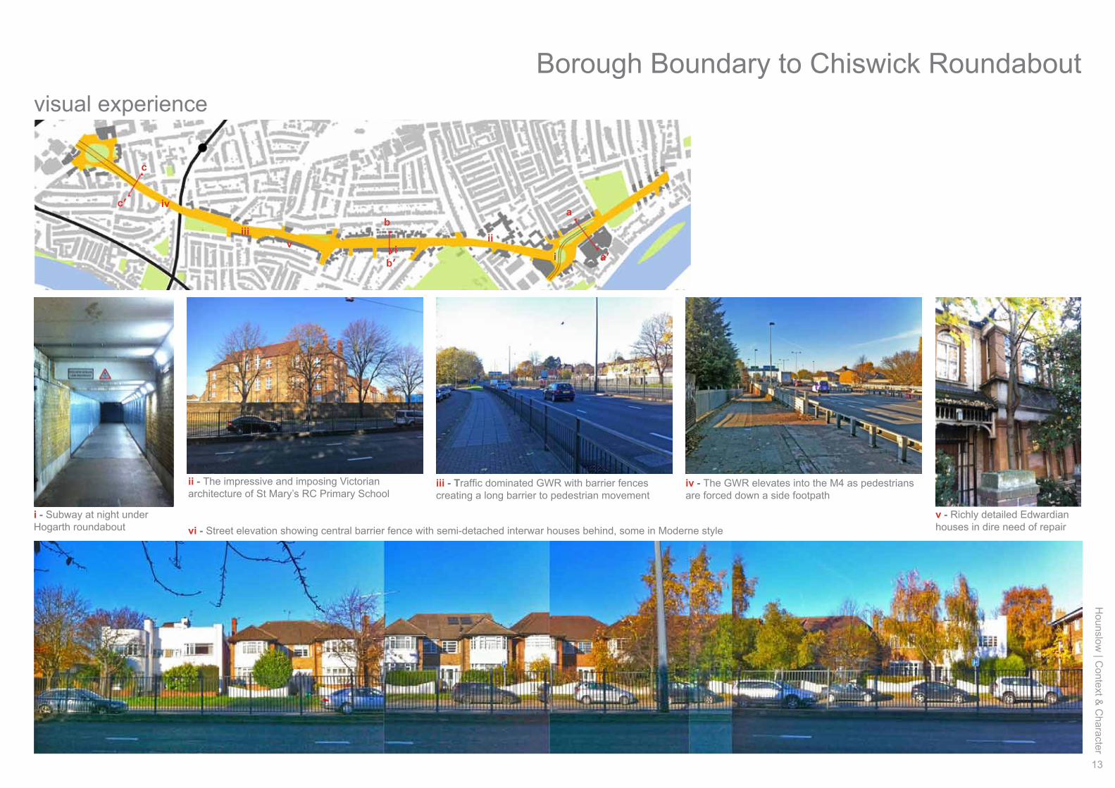
i - Subway at night under Hogarth roundabout
ii - The impressive and imposing Victorian architecture of St Mary’s RC Primary School
iv - The GWR elevates into the M4 as pedestrians are forced down a side footpath
iii - Traffic dominated GWR with barrier fences creating a long barrier to pedestrian movement
v - Richly detailed Edwardian houses in dire need of repairvi - Street elevation showing central barrier fence with semi-detached interwar houses behind, some in Moderne style
a’
b
b’
c
c’
visual experience
Borough Boundary to Chiswick Roundabout
14
Hou
nslo
w |
Con
text
& C
hara
cter
Great West Road
Sutto
n C
ourt
Roa
d
land and building use
character reach B
Chiswick Roundabout
Gunnersbury Park
VantageWest
GWQ
ii
iii
iv
v
vi
i
Carville Hall Park South
Carville Hall Park North
Hounslow
| Context &
Character
15
i - Low-rise trading estate and business park at eastern end
ii - Highly visible Vantage West office tower beyond the re-clad 1930s clock tower
iv - Trading estate boxes buffer residential areas from GWR and M4 noise
v - 2010s mixed use Great West Quarter (GWQ) development, and emerging local centre
iii - Environmentally poorly located children’s play area, Carville Hall Park North
vi - Audi car showroom - innovative design for the spectacle of motorway travellers
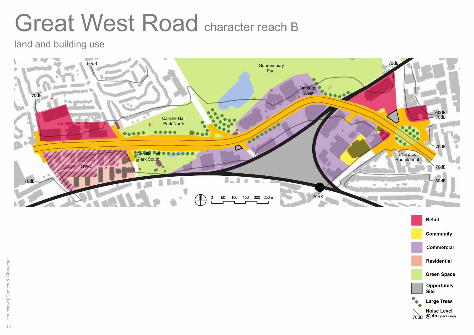
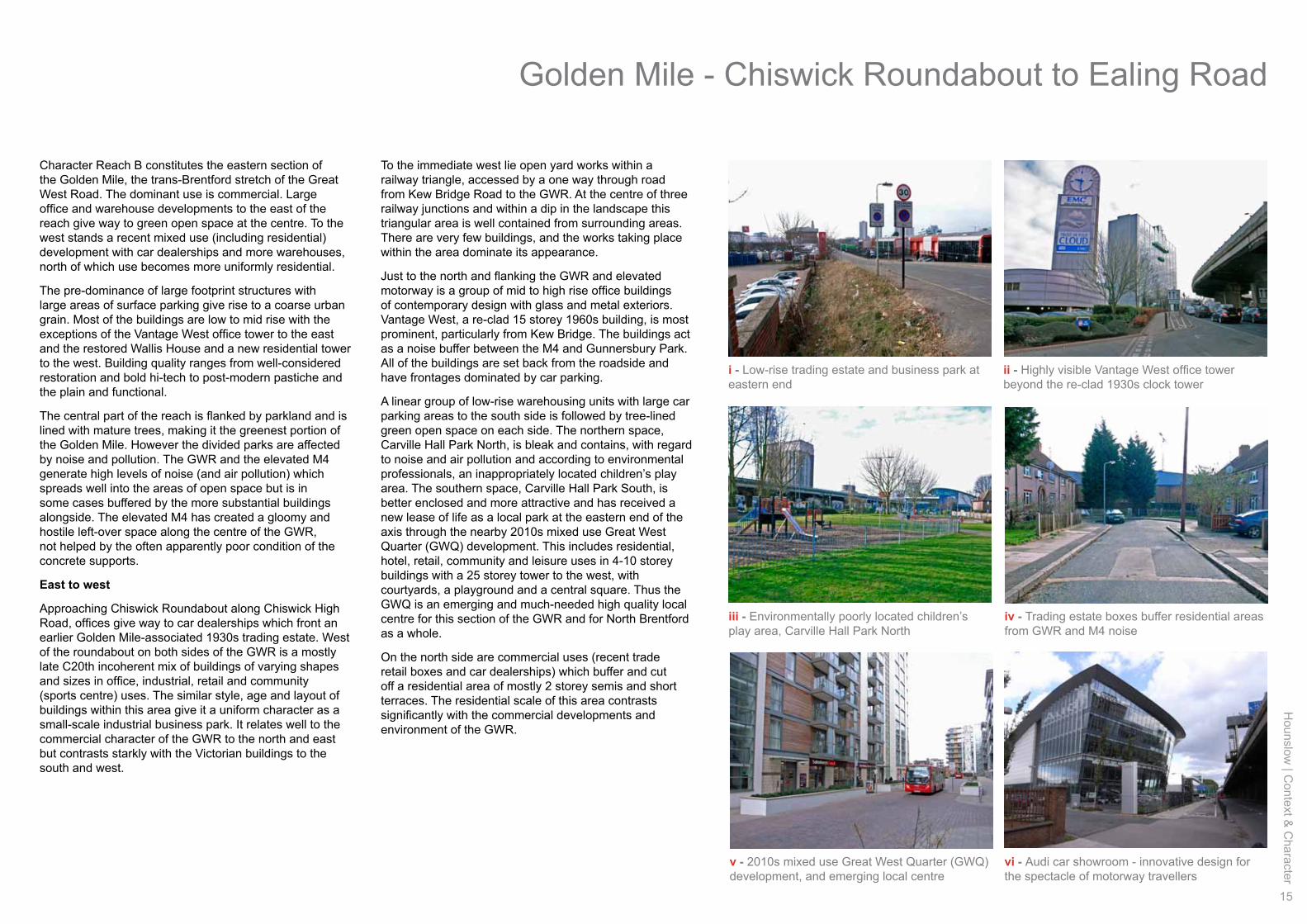
Character Reach B constitutes the eastern section of the Golden Mile, the trans-Brentford stretch of the Great West Road. The dominant use is commercial. Large office and warehouse developments to the east of the reach give way to green open space at the centre. To the west stands a recent mixed use (including residential) development with car dealerships and more warehouses, north of which use becomes more uniformly residential.
The pre-dominance of large footprint structures with large areas of surface parking give rise to a coarse urban grain. Most of the buildings are low to mid rise with the exceptions of the Vantage West office tower to the east and the restored Wallis House and a new residential tower to the west. Building quality ranges from well-considered restoration and bold hi-tech to post-modern pastiche and the plain and functional.
The central part of the reach is flanked by parkland and is lined with mature trees, making it the greenest portion of the Golden Mile. However the divided parks are affected by noise and pollution. The GWR and the elevated M4 generate high levels of noise (and air pollution) which spreads well into the areas of open space but is in some cases buffered by the more substantial buildings alongside. The elevated M4 has created a gloomy and hostile left-over space along the centre of the GWR, not helped by the often apparently poor condition of the concrete supports.
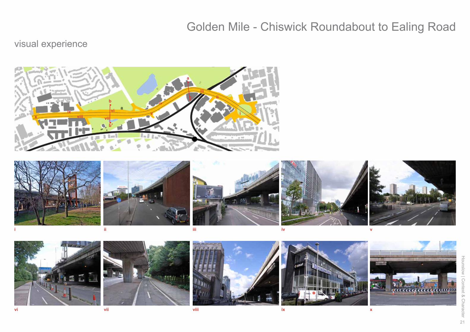
East to west
Approaching Chiswick Roundabout along Chiswick High Road, offices give way to car dealerships which front an earlier Golden Mile-associated 1930s trading estate. West of the roundabout on both sides of the GWR is a mostly late C20th incoherent mix of buildings of varying shapes and sizes in office, industrial, retail and community (sports centre) uses. The similar style, age and layout of buildings within this area give it a uniform character as a small-scale industrial business park. It relates well to the commercial character of the GWR to the north and east but contrasts starkly with the Victorian buildings to the south and west.
To the immediate west lie open yard works within a railway triangle, accessed by a one way through road from Kew Bridge Road to the GWR. At the centre of three railway junctions and within a dip in the landscape this triangular area is well contained from surrounding areas. There are very few buildings, and the works taking place within the area dominate its appearance.
Just to the north and flanking the GWR and elevated motorway is a group of mid to high rise office buildings of contemporary design with glass and metal exteriors. Vantage West, a re-clad 15 storey 1960s building, is most prominent, particularly from Kew Bridge. The buildings act as a noise buffer between the M4 and Gunnersbury Park. All of the buildings are set back from the roadside and have frontages dominated by car parking.
A linear group of low-rise warehousing units with large car parking areas to the south side is followed by tree-lined green open space on each side. The northern space, Carville Hall Park North, is bleak and contains, with regard to noise and air pollution and according to environmental professionals, an inappropriately located children’s play area. The southern space, Carville Hall Park South, is better enclosed and more attractive and has received a new lease of life as a local park at the eastern end of the axis through the nearby 2010s mixed use Great West Quarter (GWQ) development. This includes residential, hotel, retail, community and leisure uses in 4-10 storey buildings with a 25 storey tower to the west, with courtyards, a playground and a central square. Thus the GWQ is an emerging and much-needed high quality local centre for this section of the GWR and for North Brentford as a whole.
On the north side are commercial uses (recent trade retail boxes and car dealerships) which buffer and cut off a residential area of mostly 2 storey semis and short terraces. The residential scale of this area contrasts significantly with the commercial developments and environment of the GWR.
Golden Mile - Chiswick Roundabout to Ealing Road
16
Hou
nslo
w |
Con
text
& C
hara
cter
Great West Roadmovement and legibility
character reach B
Building heights
Lionel Road South
M4 Junction 2
Kew BridgeStation
ii
iii
iv
vvi
i
Ealing Road
North
CircularR
oad
Hounslow
| Context &
Character
17
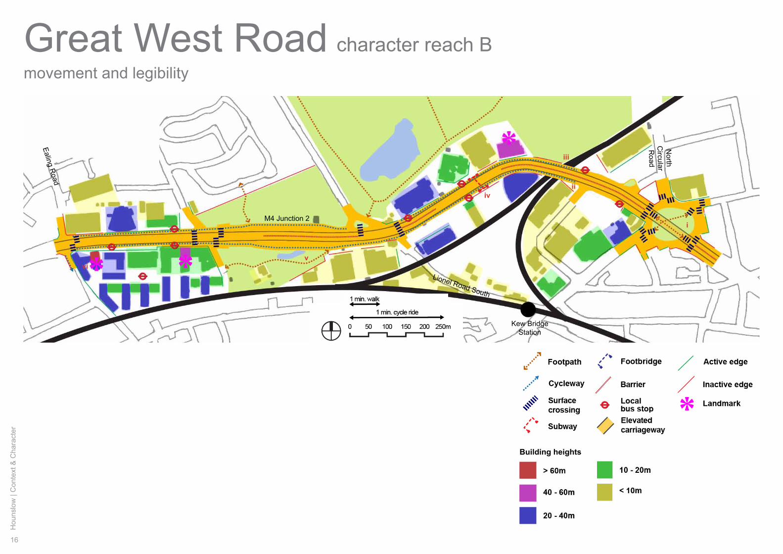
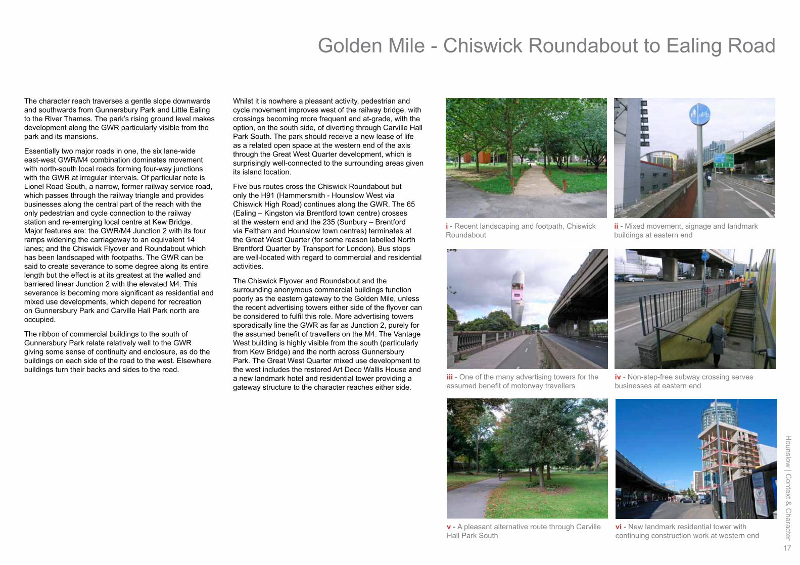
The character reach traverses a gentle slope downwards and southwards from Gunnersbury Park and Little Ealing to the River Thames. The park’s rising ground level makes development along the GWR particularly visible from the park and its mansions.
Essentially two major roads in one, the six lane-wide east-west GWR/M4 combination dominates movement with north-south local roads forming four-way junctions with the GWR at irregular intervals. Of particular note is Lionel Road South, a narrow, former railway service road, which passes through the railway triangle and provides businesses along the central part of the reach with the only pedestrian and cycle connection to the railway station and re-emerging local centre at Kew Bridge. Major features are: the GWR/M4 Junction 2 with its four ramps widening the carriageway to an equivalent 14 lanes; and the Chiswick Flyover and Roundabout which has been landscaped with footpaths. The GWR can be said to create severance to some degree along its entire length but the effect is at its greatest at the walled and barriered linear Junction 2 with the elevated M4. This severance is becoming more significant as residential and mixed use developments, which depend for recreation on Gunnersbury Park and Carville Hall Park north are occupied.
The ribbon of commercial buildings to the south of Gunnersbury Park relate relatively well to the GWR giving some sense of continuity and enclosure, as do the buildings on each side of the road to the west. Elsewhere buildings turn their backs and sides to the road.
i - Recent landscaping and footpath, Chiswick Roundabout
iii - One of the many advertising towers for the assumed benefit of motorway travellers
iv - Non-step-free subway crossing serves businesses at eastern end
vi - New landmark residential tower with continuing construction work at western end
ii - Mixed movement, signage and landmark buildings at eastern end
v - A pleasant alternative route through Carville Hall Park South
Whilst it is nowhere a pleasant activity, pedestrian and cycle movement improves west of the railway bridge, with crossings becoming more frequent and at-grade, with the option, on the south side, of diverting through Carville Hall Park South. The park should receive a new lease of life as a related open space at the western end of the axis through the Great West Quarter development, which is surprisingly well-connected to the surrounding areas given its island location.
Five bus routes cross the Chiswick Roundabout but only the H91 (Hammersmith - Hounslow West via Chiswick High Road) continues along the GWR. The 65 (Ealing – Kingston via Brentford town centre) crosses at the western end and the 235 (Sunbury – Brentford via Feltham and Hounslow town centres) terminates at the Great West Quarter (for some reason labelled North Brentford Quarter by Transport for London). Bus stops are well-located with regard to commercial and residential activities.
The Chiswick Flyover and Roundabout and the surrounding anonymous commercial buildings function poorly as the eastern gateway to the Golden Mile, unless the recent advertising towers either side of the flyover can be considered to fulfil this role. More advertising towers sporadically line the GWR as far as Junction 2, purely for the assumed benefit of travellers on the M4. The Vantage West building is highly visible from the south (particularly from Kew Bridge) and the north across Gunnersbury Park. The Great West Quarter mixed use development to the west includes the restored Art Deco Wallis House and a new landmark hotel and residential tower providing a gateway structure to the character reaches either side.
Golden Mile - Chiswick Roundabout to Ealing Road
18
Hou
nslo
w |
Con
text
& C
hara
cter
Great West Roadhistory and heritage assets
character reach B
ii
iii
iv
v
vi
i
Fiat Clock Tower
Gunnersbury ParkGatehouse
Potomac LakeBoathouse
Carville HallWallis House
Hounslow
| Context &
Character
19
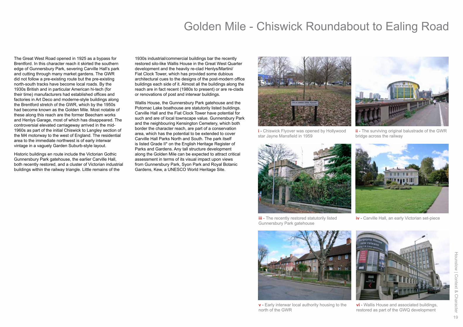
i - Chiswick Flyover was opened by Hollywood star Jayne Mansfield in 1959
iii - The recently restored statutorily listed Gunnersbury Park gatehouse
iv - Carville Hall, an early Victorian set-piece
vi - Wallis House and associated buildings, restored as part of the GWQ development
ii - The surviving original balustrade of the GWR bridge across the railway
v - Early interwar local authority housing to the north of the GWR
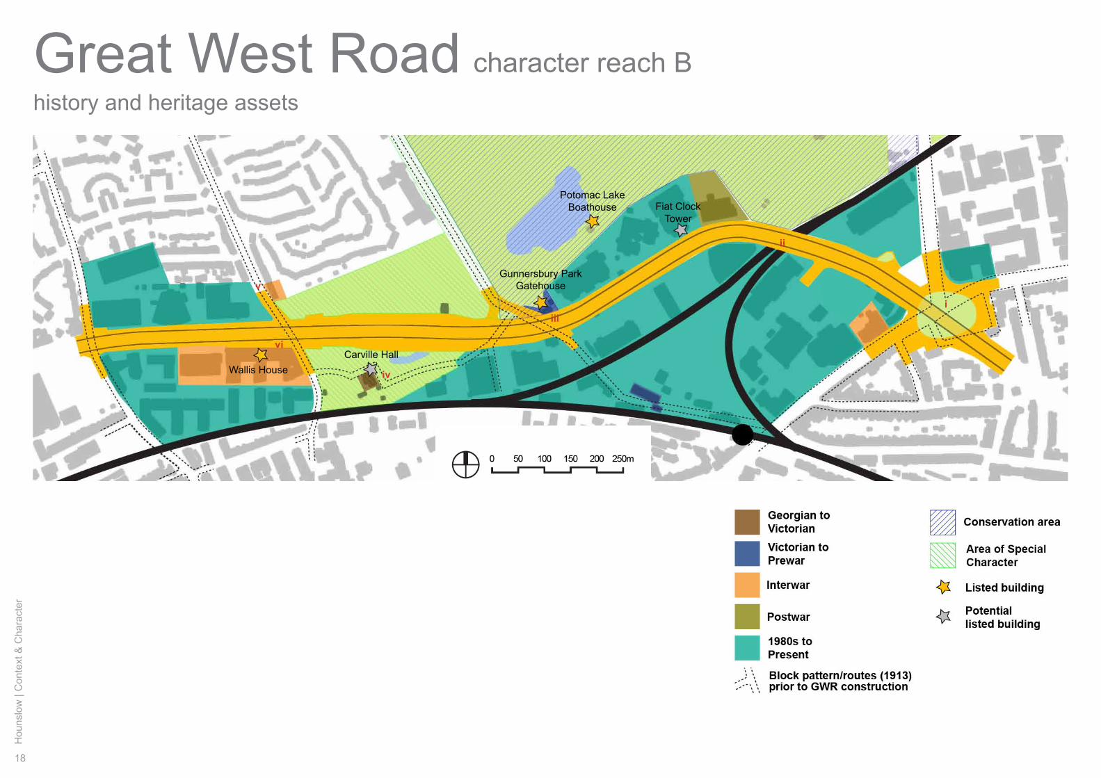
The Great West Road opened in 1925 as a bypass for Brentford. In this character reach it skirted the southern edge of Gunnersbury Park, severing Carville Hall’s park and cutting through many market gardens. The GWR did not follow a pre-existing route but the pre-existing north-south tracks have become local roads. By the 1930s British and in particular American hi-tech (for their time) manufacturers had established offices and factories in Art Deco and moderne-style buildings along the Brentford stretch of the GWR, which by the 1950s had become known as the Golden Mile. Most notable of these along this reach are the former Beecham works and Henlys Garage, most of which has disappeared. The controversial elevated carriageway arrived in the mid-1960s as part of the initial Chiswick to Langley section of the M4 motorway to the west of England. The residential area to the immediate northwest is of early interwar vintage in a vaguely Garden Suburb-style layout.
Historic buildings en route include the Victorian Gothic Gunnersbury Park gatehouse, the earlier Carville Hall, both recently restored, and a cluster of Victorian industrial buildings within the railway triangle. Little remains of the
1930s industrial/commercial buildings bar the recently restored silo-like Wallis House in the Great West Quarter development and the heavily re-clad Henlys/Martini/Fiat Clock Tower, which has provided some dubious architectural cues to the designs of the post-modern office buildings each side of it. Almost all the buildings along the reach are in fact recent (1980s to present) or are re-clads or renovations of post and interwar buildings.
Wallis House, the Gunnersbury Park gatehouse and the Potomac Lake boathouse are statutorily listed buildings. Carville Hall and the Fiat Clock Tower have potential for such and are of local townscape value. Gunnersbury Park and the neighbouring Kensington Cemetery, which both border the character reach, are part of a conservation area, which has the potential to be extended to cover Carville Hall Parks North and South. The park itself is listed Grade II* on the English Heritage Register of Parks and Gardens. Any tall structure development along the Golden Mile can be expected to attract critical assessment in terms of its visual impact upon views from Gunnersbury Park, Syon Park and Royal Botanic Gardens, Kew, a UNESCO World Heritage Site.
Golden Mile - Chiswick Roundabout to Ealing Road
20
Hou
nslo
w |
Con
text
& C
hara
cter
Great West Roadstreetscape
Public highway
a’a
b b’
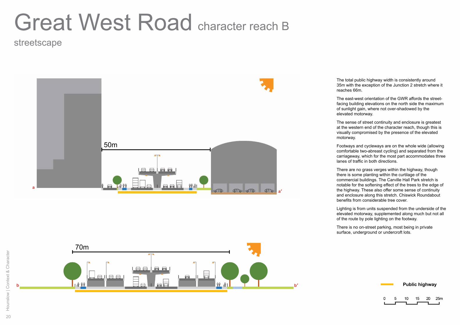
The total public highway width is consistently around 35m with the exception of the Junction 2 stretch where it reaches 66m.
The east-west orientation of the GWR affords the street-facing building elevations on the north side the maximum of sunlight gain, where not over-shadowed by the elevated motorway.
The sense of street continuity and enclosure is greatest at the western end of the character reach, though this is visually compromised by the presence of the elevated motorway.
Footways and cycleways are on the whole wide (allowing comfortable two-abreast cycling) and separated from the carriageway, which for the most part accommodates three lanes of traffic in both directions.
There are no grass verges within the highway, though there is some planting within the curtilage of the commercial buildings. The Carville Hall Park stretch is notable for the softening effect of the trees to the edge of the highway. These also offer some sense of continuity and enclosure along this stretch. Chiswick Roundabout benefits from considerable tree cover.
Lighting is from units suspended from the underside of the elevated motorway, supplemented along much but not all of the route by pole lighting on the footway.
There is no on-street parking, most being in private surface, underground or undercroft lots.
50m
70m
character reach B
Hounslow
| Context &
Character
21
visual experience
a’ iiiii
iv
vvi
viiviiiix
xi
a
b
b’
ii iv v
vii ix x
i iii
vi viii
Golden Mile - Chiswick Roundabout to Ealing Road
22
Hou
nslo
w |
Con
text
& C
hara
cter
Great West Roadland and building use
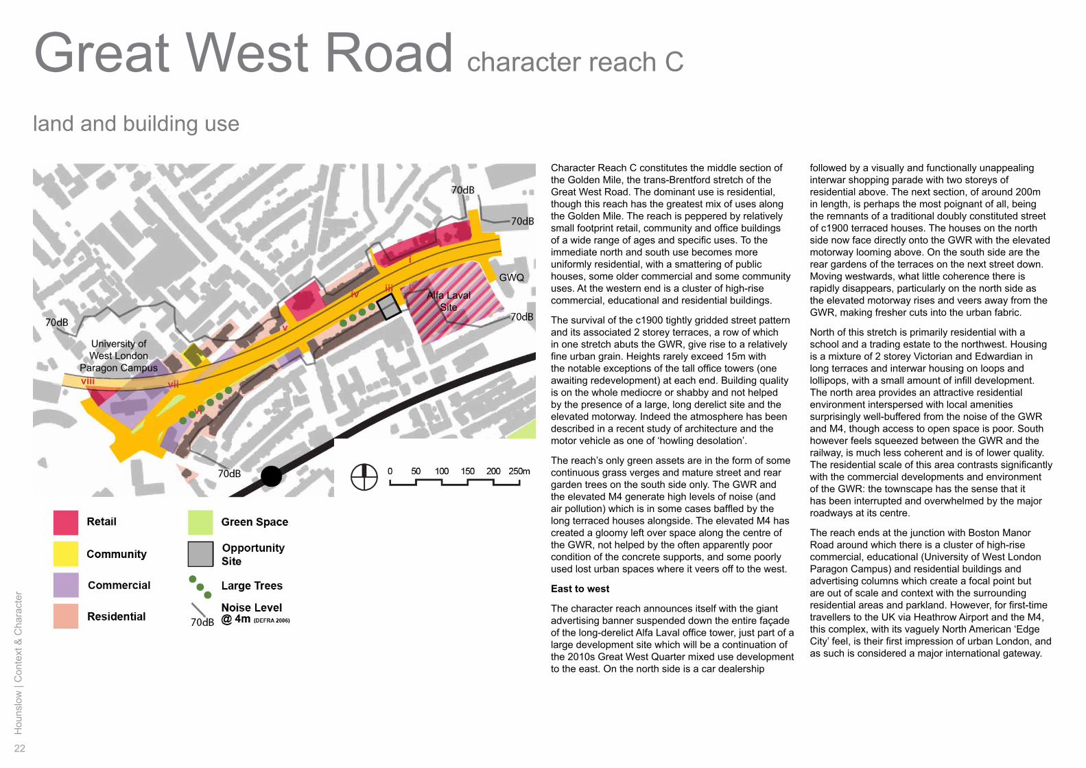
character reach C
Character Reach C constitutes the middle section of the Golden Mile, the trans-Brentford stretch of the Great West Road. The dominant use is residential, though this reach has the greatest mix of uses along the Golden Mile. The reach is peppered by relatively small footprint retail, community and office buildings of a wide range of ages and specific uses. To the immediate north and south use becomes more uniformly residential, with a smattering of public houses, some older commercial and some community uses. At the western end is a cluster of high-rise commercial, educational and residential buildings.
The survival of the c1900 tightly gridded street pattern and its associated 2 storey terraces, a row of which in one stretch abuts the GWR, give rise to a relatively fine urban grain. Heights rarely exceed 15m with the notable exceptions of the tall office towers (one awaiting redevelopment) at each end. Building quality is on the whole mediocre or shabby and not helped by the presence of a large, long derelict site and the elevated motorway. Indeed the atmosphere has been described in a recent study of architecture and the motor vehicle as one of ‘howling desolation’.
The reach’s only green assets are in the form of some continuous grass verges and mature street and rear garden trees on the south side only. The GWR and the elevated M4 generate high levels of noise (and air pollution) which is in some cases baffled by the long terraced houses alongside. The elevated M4 has created a gloomy left over space along the centre of the GWR, not helped by the often apparently poor condition of the concrete supports, and some poorly used lost urban spaces where it veers off to the west.
East to west
The character reach announces itself with the giant advertising banner suspended down the entire façade of the long-derelict Alfa Laval office tower, just part of a large development site which will be a continuation of the 2010s Great West Quarter mixed use development to the east. On the north side is a car dealership
followed by a visually and functionally unappealing interwar shopping parade with two storeys of residential above. The next section, of around 200m in length, is perhaps the most poignant of all, being the remnants of a traditional doubly constituted street of c1900 terraced houses. The houses on the north side now face directly onto the GWR with the elevated motorway looming above. On the south side are the rear gardens of the terraces on the next street down. Moving westwards, what little coherence there is rapidly disappears, particularly on the north side as the elevated motorway rises and veers away from the GWR, making fresher cuts into the urban fabric.
North of this stretch is primarily residential with a school and a trading estate to the northwest. Housing is a mixture of 2 storey Victorian and Edwardian in long terraces and interwar housing on loops and lollipops, with a small amount of infill development. The north area provides an attractive residential environment interspersed with local amenities surprisingly well-buffered from the noise of the GWR and M4, though access to open space is poor. South however feels squeezed between the GWR and the railway, is much less coherent and is of lower quality. The residential scale of this area contrasts significantly with the commercial developments and environment of the GWR: the townscape has the sense that it has been interrupted and overwhelmed by the major roadways at its centre.
The reach ends at the junction with Boston Manor Road around which there is a cluster of high-rise commercial, educational (University of West London Paragon Campus) and residential buildings and advertising columns which create a focal point but are out of scale and context with the surrounding residential areas and parkland. However, for first-time travellers to the UK via Heathrow Airport and the M4, this complex, with its vaguely North American ‘Edge City’ feel, is their first impression of urban London, and as such is considered a major international gateway.
iiiiiiv
v
vi
viiviii
i
Alfa Laval Site
University ofWest London
Paragon Campus
GWQ
Hounslow
| Context &
Character
23
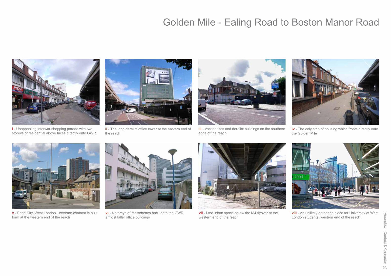
i - Unappealing interwar shopping parade with two storeys of residential above faces directly onto GWR
ii - The long-derelict office tower at the eastern end of the reach
iv - The only strip of housing which fronts directly onto the Golden Mile
v - Edge City, West London - extreme contrast in built form at the western end of the reach
vii - Lost urban space below the M4 flyover at the western end of the reach
iii - Vacant sites and derelict buildings on the southern edge of the reach
vi - 4 storeys of maisonettes back onto the GWR amidst taller office buildings
viii - An unlikely gathering place for University of West London students, western end of the reach
Golden Mile - Ealing Road to Boston Manor Road
24
Hou
nslo
w |
Con
text
& C
hara
cter
Great West Roadmovement and legibility
character reach C
BrentfordStation
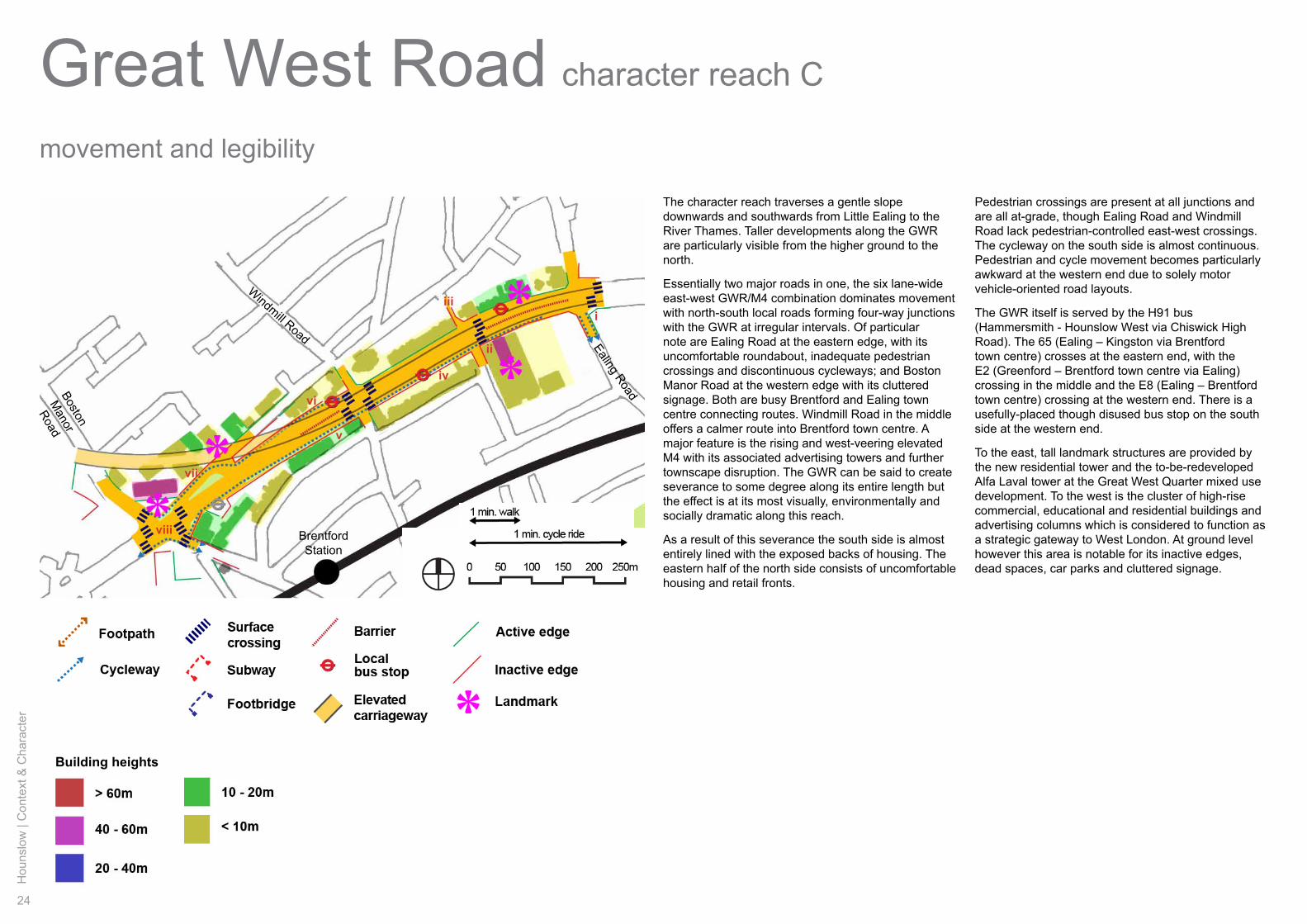
The character reach traverses a gentle slope downwards and southwards from Little Ealing to the River Thames. Taller developments along the GWR are particularly visible from the higher ground to the north.
Essentially two major roads in one, the six lane-wide east-west GWR/M4 combination dominates movement with north-south local roads forming four-way junctions with the GWR at irregular intervals. Of particular note are Ealing Road at the eastern edge, with its uncomfortable roundabout, inadequate pedestrian crossings and discontinuous cycleways; and Boston Manor Road at the western edge with its cluttered signage. Both are busy Brentford and Ealing town centre connecting routes. Windmill Road in the middle offers a calmer route into Brentford town centre. A major feature is the rising and west-veering elevated M4 with its associated advertising towers and further townscape disruption. The GWR can be said to create severance to some degree along its entire length but the effect is at its most visually, environmentally and socially dramatic along this reach.
As a result of this severance the south side is almost entirely lined with the exposed backs of housing. The eastern half of the north side consists of uncomfortable housing and retail fronts.
Pedestrian crossings are present at all junctions and are all at-grade, though Ealing Road and Windmill Road lack pedestrian-controlled east-west crossings. The cycleway on the south side is almost continuous. Pedestrian and cycle movement becomes particularly awkward at the western end due to solely motor vehicle-oriented road layouts.
The GWR itself is served by the H91 bus (Hammersmith - Hounslow West via Chiswick High Road). The 65 (Ealing – Kingston via Brentford town centre) crosses at the eastern end, with the E2 (Greenford – Brentford town centre via Ealing) crossing in the middle and the E8 (Ealing – Brentford town centre) crossing at the western end. There is a usefully-placed though disused bus stop on the south side at the western end.
To the east, tall landmark structures are provided by the new residential tower and the to-be-redeveloped Alfa Laval tower at the Great West Quarter mixed use development. To the west is the cluster of high-rise commercial, educational and residential buildings and advertising columns which is considered to function as a strategic gateway to West London. At ground level however this area is notable for its inactive edges, dead spaces, car parks and cluttered signage.
Building heights
ii
iii
iv
v
vi
vii
viii
i
Boston
Manor
Road
Ealing Road
Windmill Road
Hounslow
| Context &
Character
25
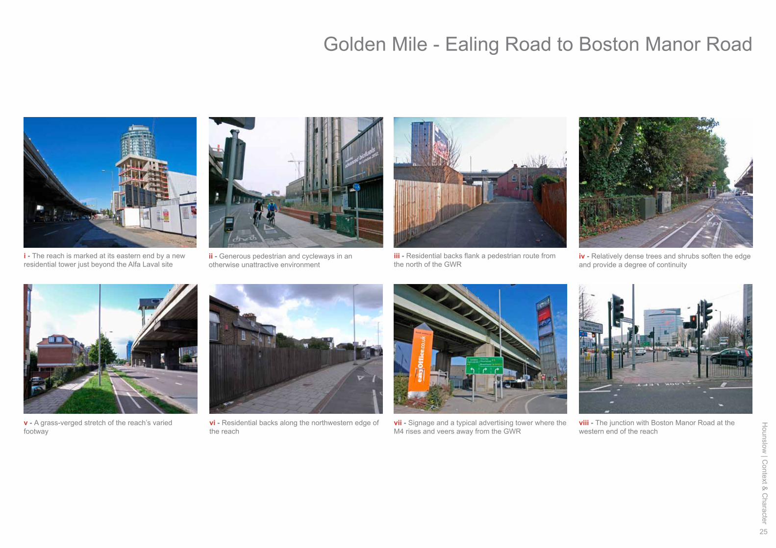
i - The reach is marked at its eastern end by a new residential tower just beyond the Alfa Laval site
ii - Generous pedestrian and cycleways in an otherwise unattractive environment
iv - Relatively dense trees and shrubs soften the edge and provide a degree of continuity
v - A grass-verged stretch of the reach’s varied footway
vii - Signage and a typical advertising tower where the M4 rises and veers away from the GWR
iii - Residential backs flank a pedestrian route from the north of the GWR
vi - Residential backs along the northwestern edge of the reach
viii - The junction with Boston Manor Road at the western end of the reach
Golden Mile - Ealing Road to Boston Manor Road
26
Hou
nslo
w |
Con
text
& C
hara
cter
Great West Roadhistory and heritage assets
character reach C
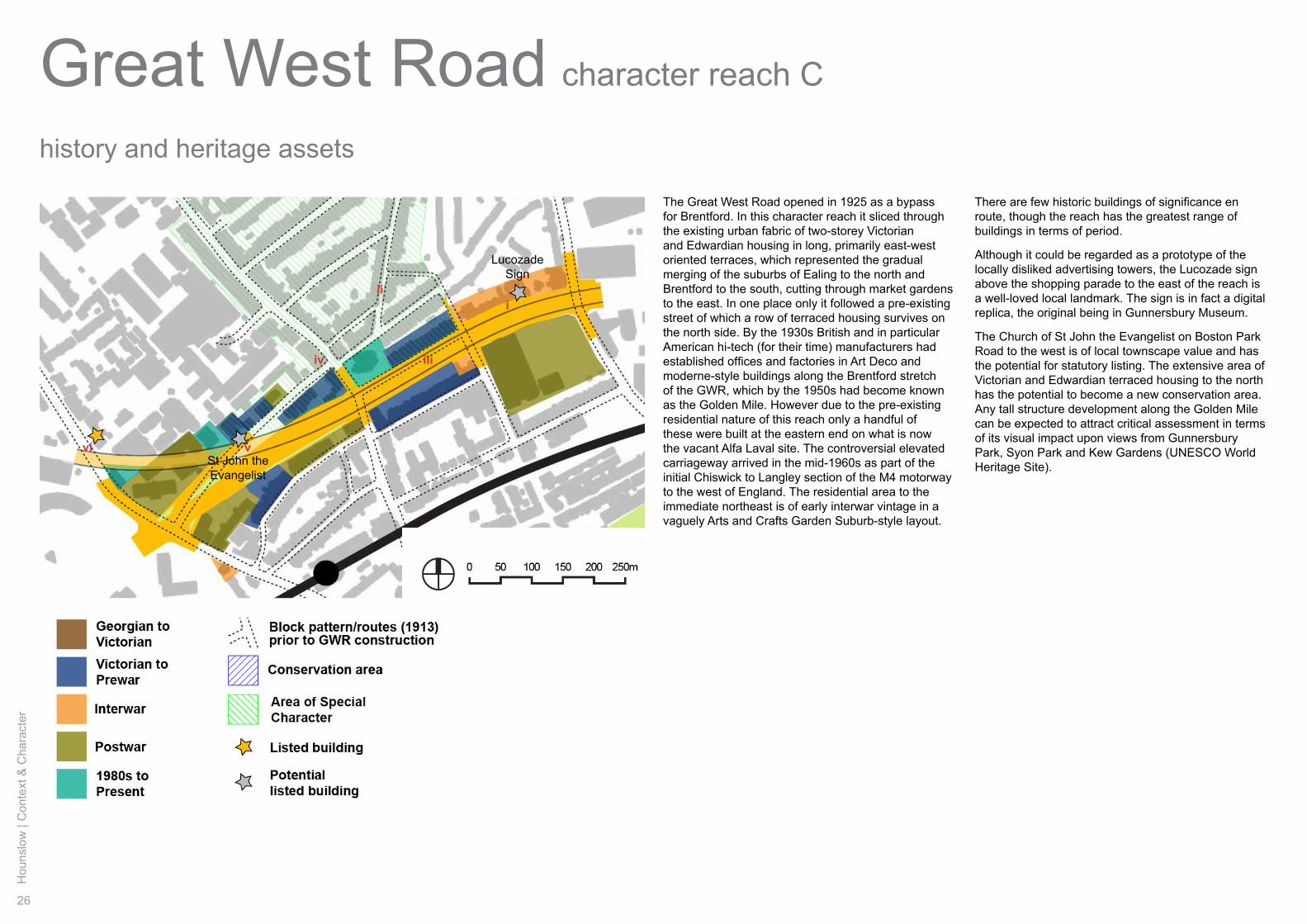
The Great West Road opened in 1925 as a bypass for Brentford. In this character reach it sliced through the existing urban fabric of two-storey Victorian and Edwardian housing in long, primarily east-west oriented terraces, which represented the gradual merging of the suburbs of Ealing to the north and Brentford to the south, cutting through market gardens to the east. In one place only it followed a pre-existing street of which a row of terraced housing survives on the north side. By the 1930s British and in particular American hi-tech (for their time) manufacturers had established offices and factories in Art Deco and moderne-style buildings along the Brentford stretch of the GWR, which by the 1950s had become known as the Golden Mile. However due to the pre-existing residential nature of this reach only a handful of these were built at the eastern end on what is now the vacant Alfa Laval site. The controversial elevated carriageway arrived in the mid-1960s as part of the initial Chiswick to Langley section of the M4 motorway to the west of England. The residential area to the immediate northeast is of early interwar vintage in a vaguely Arts and Crafts Garden Suburb-style layout.
ii
iiiiv
vvi
i
St John the Evangelist
LucozadeSign
There are few historic buildings of significance en route, though the reach has the greatest range of buildings in terms of period.
Although it could be regarded as a prototype of the locally disliked advertising towers, the Lucozade sign above the shopping parade to the east of the reach is a well-loved local landmark. The sign is in fact a digital replica, the original being in Gunnersbury Museum.
The Church of St John the Evangelist on Boston Park Road to the west is of local townscape value and has the potential for statutory listing. The extensive area of Victorian and Edwardian terraced housing to the north has the potential to become a new conservation area. Any tall structure development along the Golden Mile can be expected to attract critical assessment in terms of its visual impact upon views from Gunnersbury Park, Syon Park and Kew Gardens (UNESCO World Heritage Site).

Hounslow
| Context &
Character
27
i - The much-admired Lucozade sign at its present home
ii - Row of c1900 terraced houses in the residential area to the north
iii - C1900 Adelaide Terrace, on the north side of the reach, its facing terrace obliterated by the GWR
iv - One of a number of nearby local corner pubs for which Brentford is famous
v - The Church of St John the Evangelist on Boston Park Road to the west
vi - Listed Georgian town house seems lost amid the elevated motorway and high-rise buildings
Golden Mile - Ealing Road to Boston Manor Road
28
Hou
nslo
w |
Con
text
& C
hara
cter
Great West Roadstreetscape
a’a
b b’
Public highway
38m
48m
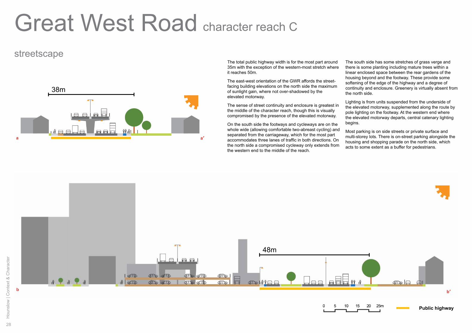
The total public highway width is for the most part around 35m with the exception of the western-most stretch where it reaches 50m.
The east-west orientation of the GWR affords the street-facing building elevations on the north side the maximum of sunlight gain, where not over-shadowed by the elevated motorway.
The sense of street continuity and enclosure is greatest in the middle of the character reach, though this is visually compromised by the presence of the elevated motorway.
On the south side the footways and cycleways are on the whole wide (allowing comfortable two-abreast cycling) and separated from the carriageway, which for the most part accommodates three lanes of traffic in both directions. On the north side a compromised cycleway only extends from the western end to the middle of the reach.
character reach C
The south side has some stretches of grass verge and there is some planting including mature trees within a linear enclosed space between the rear gardens of the housing beyond and the footway. These provide some softening of the edge of the highway and a degree of continuity and enclosure. Greenery is virtually absent from the north side.
Lighting is from units suspended from the underside of the elevated motorway, supplemented along the route by pole lighting on the footway. At the western end where the elevated motorway departs, central catenary lighting begins.
Most parking is on side streets or private surface and multi-storey lots. There is on-street parking alongside the housing and shopping parade on the north side, which acts to some extent as a buffer for pedestrians.
Hounslow
| Context &
Character
29
visual experience
ii iv v
vii ix x
i iii
vi viii
a’
aii
iiiiv
vvi
viiviii
x
ix
i
b
b’
Golden Mile - Ealing Road to Boston Manor Road
30
Hou
nslo
w |
Con
text
& C
hara
cter
Great West Roadland and building use
character reach D
GilletteCorner
Boston Manor Park
GSK
GWH
Sky
ii
iii
iv
v
vi
i
River Brent/
Grand Union Canal
Hounslow
| Context &
Character
31
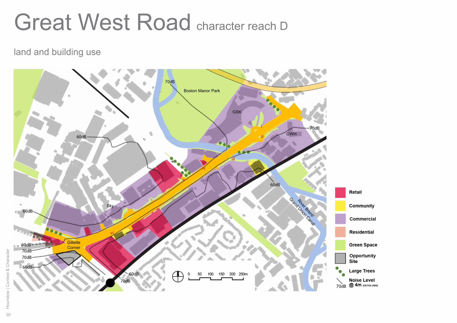
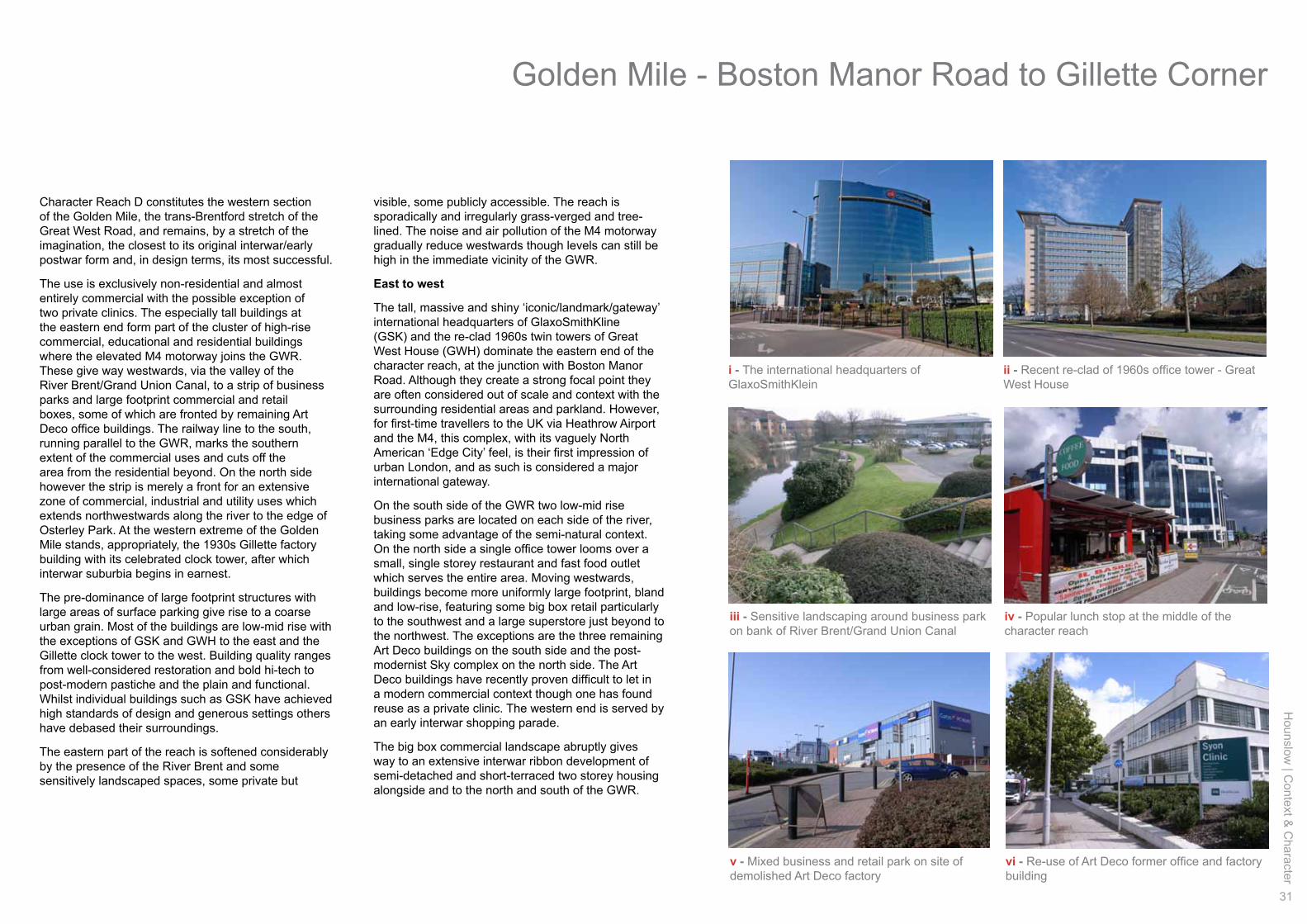
Character Reach D constitutes the western section of the Golden Mile, the trans-Brentford stretch of the Great West Road, and remains, by a stretch of the imagination, the closest to its original interwar/early postwar form and, in design terms, its most successful.
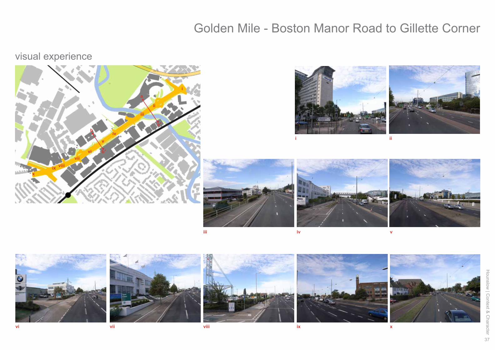
The use is exclusively non-residential and almost entirely commercial with the possible exception of two private clinics. The especially tall buildings at the eastern end form part of the cluster of high-rise commercial, educational and residential buildings where the elevated M4 motorway joins the GWR. These give way westwards, via the valley of the River Brent/Grand Union Canal, to a strip of business parks and large footprint commercial and retail boxes, some of which are fronted by remaining Art Deco office buildings. The railway line to the south, running parallel to the GWR, marks the southern extent of the commercial uses and cuts off the area from the residential beyond. On the north side however the strip is merely a front for an extensive zone of commercial, industrial and utility uses which extends northwestwards along the river to the edge of Osterley Park. At the western extreme of the Golden Mile stands, appropriately, the 1930s Gillette factory building with its celebrated clock tower, after which interwar suburbia begins in earnest.
The pre-dominance of large footprint structures with large areas of surface parking give rise to a coarse urban grain. Most of the buildings are low-mid rise with the exceptions of GSK and GWH to the east and the Gillette clock tower to the west. Building quality ranges from well-considered restoration and bold hi-tech to post-modern pastiche and the plain and functional. Whilst individual buildings such as GSK have achieved high standards of design and generous settings others have debased their surroundings.
The eastern part of the reach is softened considerably by the presence of the River Brent and some sensitively landscaped spaces, some private but
visible, some publicly accessible. The reach is sporadically and irregularly grass-verged and tree-lined. The noise and air pollution of the M4 motorway gradually reduce westwards though levels can still be high in the immediate vicinity of the GWR.
East to west
The tall, massive and shiny ‘iconic/landmark/gateway’ international headquarters of GlaxoSmithKline (GSK) and the re-clad 1960s twin towers of Great West House (GWH) dominate the eastern end of the character reach, at the junction with Boston Manor Road. Although they create a strong focal point they are often considered out of scale and context with the surrounding residential areas and parkland. However, for first-time travellers to the UK via Heathrow Airport and the M4, this complex, with its vaguely North American ‘Edge City’ feel, is their first impression of urban London, and as such is considered a major international gateway.
On the south side of the GWR two low-mid rise business parks are located on each side of the river, taking some advantage of the semi-natural context. On the north side a single office tower looms over a small, single storey restaurant and fast food outlet which serves the entire area. Moving westwards, buildings become more uniformly large footprint, bland and low-rise, featuring some big box retail particularly to the southwest and a large superstore just beyond to the northwest. The exceptions are the three remaining Art Deco buildings on the south side and the post-modernist Sky complex on the north side. The Art Deco buildings have recently proven difficult to let in a modern commercial context though one has found reuse as a private clinic. The western end is served by an early interwar shopping parade.
The big box commercial landscape abruptly gives way to an extensive interwar ribbon development of semi-detached and short-terraced two storey housing alongside and to the north and south of the GWR.
i - The international headquarters of GlaxoSmithKlein
iii - Sensitive landscaping around business park on bank of River Brent/Grand Union Canal
iv - Popular lunch stop at the middle of the character reach
vi - Re-use of Art Deco former office and factory building
ii - Recent re-clad of 1960s office tower - Great West House
v - Mixed business and retail park on site of demolished Art Deco factory
Golden Mile - Boston Manor Road to Gillette Corner
32
Hou
nslo
w |
Con
text
& C
hara
cter
Great West Roadmovement and legibility
character reach D
Building heights
Boston
Manor
Road
To Brentford Town Centre
& River Thames
Brentford Freight Line
M4
SyonLane
iiiii
iv
v
vi
i
Hounslow
| Context &
Character
33
i - View from the bridge - looking eastwards towards the Boston Manor Road junction
iv - The little used non-step-free footbridge
v- Street-view in the middle of the character reach
iii - Steps down to the canal tow path
ii - Street condition alongside GSK
vi - Many prefer to risk informal crossing than use the sparsely located formal crossings
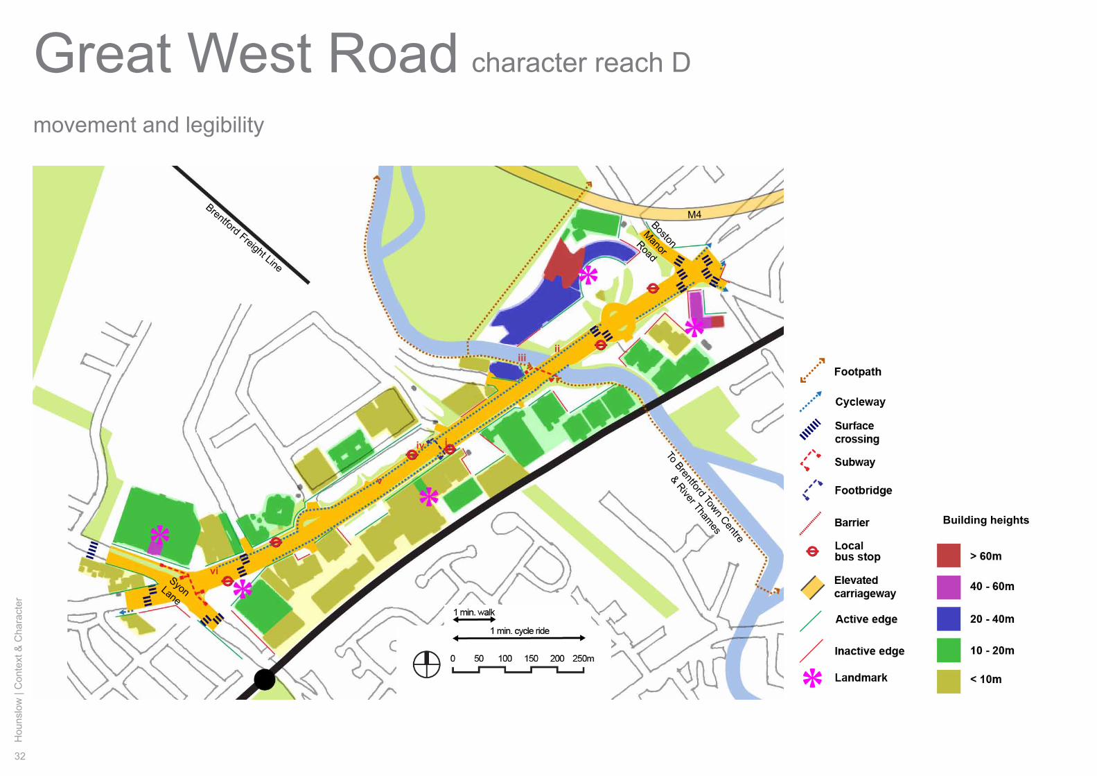
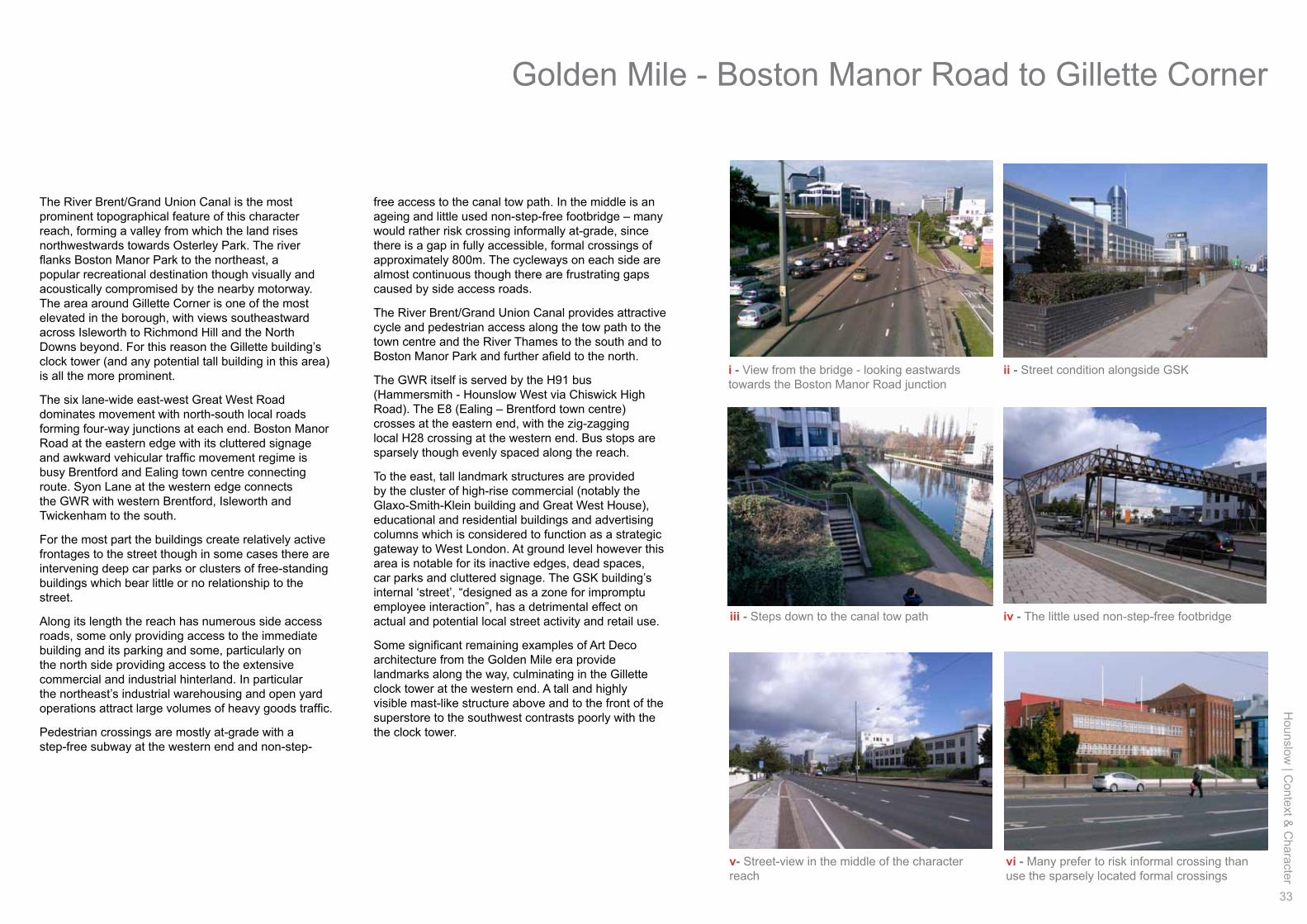
The River Brent/Grand Union Canal is the most prominent topographical feature of this character reach, forming a valley from which the land rises northwestwards towards Osterley Park. The river flanks Boston Manor Park to the northeast, a popular recreational destination though visually and acoustically compromised by the nearby motorway. The area around Gillette Corner is one of the most elevated in the borough, with views southeastward across Isleworth to Richmond Hill and the North Downs beyond. For this reason the Gillette building’s clock tower (and any potential tall building in this area) is all the more prominent.
The six lane-wide east-west Great West Road dominates movement with north-south local roads forming four-way junctions at each end. Boston Manor Road at the eastern edge with its cluttered signage and awkward vehicular traffic movement regime is busy Brentford and Ealing town centre connecting route. Syon Lane at the western edge connects the GWR with western Brentford, Isleworth and Twickenham to the south.
For the most part the buildings create relatively active frontages to the street though in some cases there are intervening deep car parks or clusters of free-standing buildings which bear little or no relationship to the street.
Along its length the reach has numerous side access roads, some only providing access to the immediate building and its parking and some, particularly on the north side providing access to the extensive commercial and industrial hinterland. In particular the northeast’s industrial warehousing and open yard operations attract large volumes of heavy goods traffic.
Pedestrian crossings are mostly at-grade with a step-free subway at the western end and non-step-
free access to the canal tow path. In the middle is an ageing and little used non-step-free footbridge – many would rather risk crossing informally at-grade, since there is a gap in fully accessible, formal crossings of approximately 800m. The cycleways on each side are almost continuous though there are frustrating gaps caused by side access roads.
The River Brent/Grand Union Canal provides attractive cycle and pedestrian access along the tow path to the town centre and the River Thames to the south and to Boston Manor Park and further afield to the north.
The GWR itself is served by the H91 bus (Hammersmith - Hounslow West via Chiswick High Road). The E8 (Ealing – Brentford town centre) crosses at the eastern end, with the zig-zagging local H28 crossing at the western end. Bus stops are sparsely though evenly spaced along the reach.
To the east, tall landmark structures are provided by the cluster of high-rise commercial (notably the Glaxo-Smith-Klein building and Great West House), educational and residential buildings and advertising columns which is considered to function as a strategic gateway to West London. At ground level however this area is notable for its inactive edges, dead spaces, car parks and cluttered signage. The GSK building’s internal ‘street’, “designed as a zone for impromptu employee interaction”, has a detrimental effect on actual and potential local street activity and retail use.
Some significant remaining examples of Art Deco architecture from the Golden Mile era provide landmarks along the way, culminating in the Gillette clock tower at the western end. A tall and highly visible mast-like structure above and to the front of the superstore to the southwest contrasts poorly with the the clock tower.
Golden Mile - Boston Manor Road to Gillette Corner
34
Hou
nslo
w |
Con
text
& C
hara
cter
Great West Roadhistory and heritage assets
character reach D
Currys
Pyrene
Firestone(site)
Coty
Gillette
iiiii
iv
v
vi
i
Route of former
Southall to Brentford Town and Docks
Great Western Railway
West London Branch Line
Hounslow
| Context &
Character
35
i - 1930s Art Deco former Currys factory
iii - Remains of 1930s Art Deco Firestone factory iv - Northern European Expressionist-style interwar bank building at western end
vi - The celebrated landmark Gillette building and clock tower at the western extreme
ii - 1930s Art Deco former Pyrene factory
v - Early example of a pedestrian subway at western end
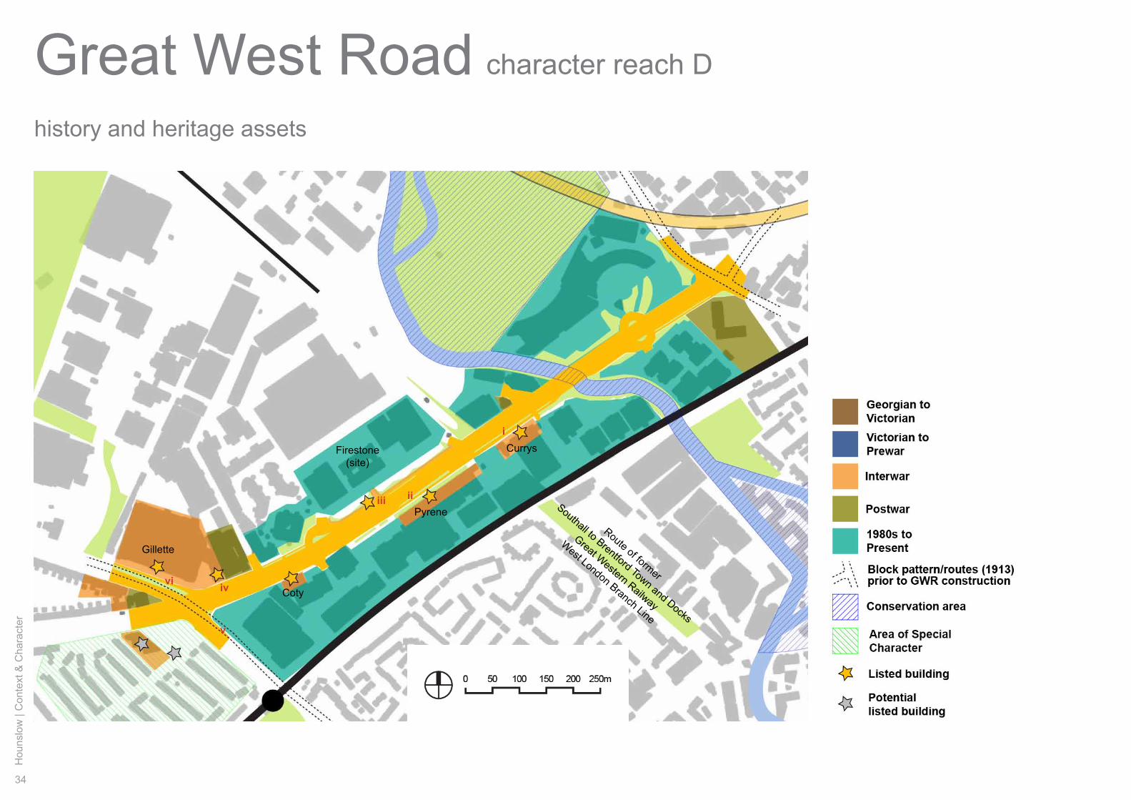
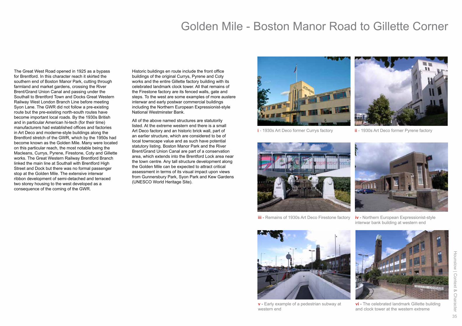
The Great West Road opened in 1925 as a bypass for Brentford. In this character reach it skirted the southern end of Boston Manor Park, cutting through farmland and market gardens, crossing the River Brent/Grand Union Canal and passing under the Southall to Brentford Town and Docks Great Western Railway West London Branch Line before meeting Syon Lane. The GWR did not follow a pre-existing route but the pre-existing north-south routes have become important local roads. By the 1930s British and in particular American hi-tech (for their time) manufacturers had established offices and factories in Art Deco and moderne-style buildings along the Brentford stretch of the GWR, which by the 1950s had become known as the Golden Mile. Many were located on this particular reach, the most notable being the Macleans, Currys, Pyrene, Firestone, Coty and Gillette works. The Great Western Railway Brentford Branch linked the main line at Southall with Brentford High Street and Dock but there was no formal passenger stop at the Golden Mile. The extensive interwar ribbon development of semi-detached and terraced two storey housing to the west developed as a consequence of the coming of the GWR.
Historic buildings en route include the front office buildings of the original Currys, Pyrene and Coty works and the entire Gillette factory building with its celebrated landmark clock tower. All that remains of the Firestone factory are its fenced walls, gate and steps. To the west are some examples of more austere interwar and early postwar commercial buildings including the Northern European Expressionist-style National Westminster Bank.
All of the above named structures are statutorily listed. At the extreme western end there is a small Art Deco factory and an historic brick wall, part of an earlier structure, which are considered to be of local townscape value and as such have potential statutory listing. Boston Manor Park and the River Brent/Grand Union Canal are part of a conservation area, which extends into the Brentford Lock area near the town centre. Any tall structure development along the Golden Mile can be expected to attract critical assessment in terms of its visual impact upon views from Gunnersbury Park, Syon Park and Kew Gardens (UNESCO World Heritage Site).
Golden Mile - Boston Manor Road to Gillette Corner
36
Hou
nslo
w |
Con
text
& C
hara
cter
Great West Roadstreetscape
character reach D
Public highway
a’a
b b’
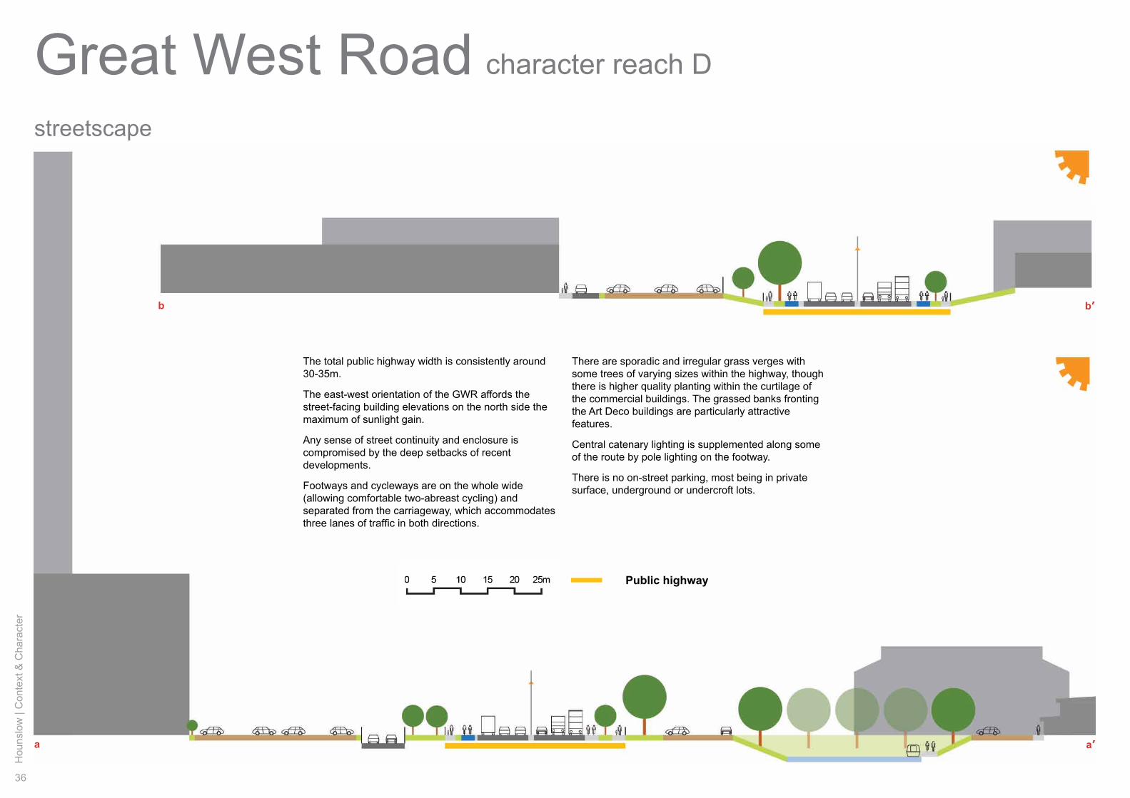
The total public highway width is consistently around 30-35m.
The east-west orientation of the GWR affords the street-facing building elevations on the north side the maximum of sunlight gain.
Any sense of street continuity and enclosure is compromised by the deep setbacks of recent developments.
Footways and cycleways are on the whole wide (allowing comfortable two-abreast cycling) and separated from the carriageway, which accommodates three lanes of traffic in both directions.
There are sporadic and irregular grass verges with some trees of varying sizes within the highway, though there is higher quality planting within the curtilage of the commercial buildings. The grassed banks fronting the Art Deco buildings are particularly attractive features.
Central catenary lighting is supplemented along some of the route by pole lighting on the footway.
There is no on-street parking, most being in private surface, underground or undercroft lots.
Hounslow
| Context &
Character
37
visual experience
ii
iii
ivv
vivii
viiiixx
i
ii
iv v
vii ix x
i
iii
vi viii
a’
a
b
b’
Golden Mile - Boston Manor Road to Gillette Corner

38
Hou
nslo
w |
Con
text
& C
hara
cter