Embed Size (px)
Citation preview
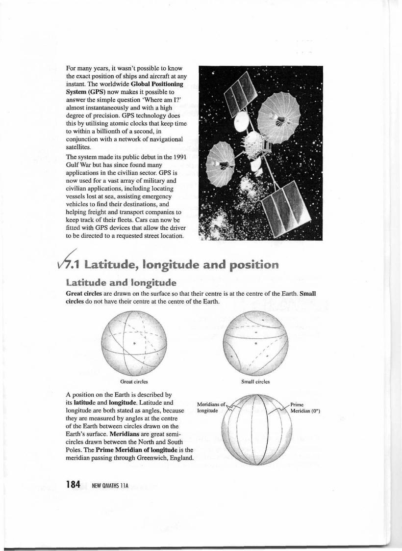
For many years, it wasn't possible to knowthe exact position of ships and aircraft at anyinstant. The worldwide Global PositioningSystem (GPS) now makes it possible toanswer the simple question 'Where am I?'almost instantaneously and with a highdegree of precision. GPS technology doesthis by utilising atomic clocks that keep timeto within a billionth of a second, inconjunction with a network of navigationalsatellites.
The system made its public debut in the 1991Gulf War but has since found manyapplications in the civilian sector. GPS isnow used for a vast array of military andcivilian applications, including locatingvessels lost at sea, assisting emergencyvehicles to find their destinations, andhelping freight and transport companies tokeep track of their fleets. Cars can now befitted with GPS devices that allow the driverto be directed to a requested street location.
^1Latitude, longitude and positionLatitude and longitudeGreat circles are drawn on the surface so that their centre is at the centre of the Earth. Smallcircles do not have their centre at the centre of the Earth.
Great circles
A position on the Earth is described byits latitude and longitude. Latitude andlongitude are both stated as angles, becausethey are measured by angles at the centreof the Earth between circles drawn on theEarth's surface. Meridians are great semi-circles drawn between the North and SouthPoles. The Prime Meridian of longitude is themeridian passing through Greenwich, England.
Small circles
Meridians oflongitude
PrimeMeridian (0°)
184 NEWQMATHS11A
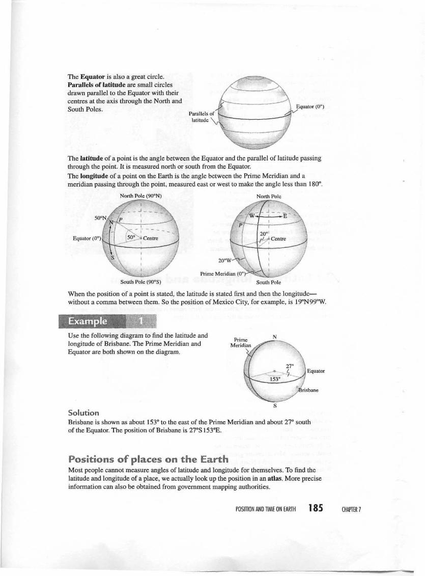
The Equator is also a great circle.Parallels of latitude are small circlesdrawn parallel to the Equator with theircentres at the axis through the North andSouth Poles.
Parallels oflatitude
Equator (0°)
The latitude of a point is the angle between the Equator and the parallel of latitude passingthrough the point. It is measured north or south from the Equator.The longitude of a point on the Earth is the angle between the Prime Meridian and ameridian passing through the point, measured east or west to make the angle less than 180°.
North Pole (90°N) North Pole
Equator (0°)
20°W
Prime Meridian (0°
South Pole (90°S) South Pole
When the position of a point is stated, the latitude is stated first and then the longitude—without a comma between them. So the position of Mexico City, for example, is 19°N99°W.
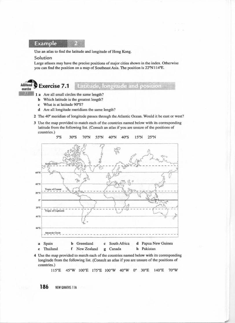
ExampleUse the following diagram to find the latitude andlongitude of Brisbane. The Prime Meridian andEquator are both shown on the diagram.
PrimeMeridian
SolutionBrisbane is shown as about 153° to the east of the Prime Meridian and about 27° southof the Equator. The position of Brisbane is 27°S 153°E.
Positions of places on the EarthMost people cannot measure angles of latitude and longitude for themselves. To find thelatitude and longitude of a place, we actually look up the position in an atlas. More preciseinformation can also be obtained from government mapping authorities.
POSITION AND TIME ON EARTH 185 CHAPTER?
ExampleUse an atlas to find the latitude and longitude of Hong Kong.
SolutionLarge atlases may have the precise positions of major cities shown in the index. Otherwiseyou can find the position on a map of Southeast Asia. The position is 22°N 114°E.
Additionalexercise
Exercise 7.1 Latitude, longitude and posra Are all small circles the same length?b Which latitude is the greatest length?c What is at latitude 90°S?d Are all longitude meridians the same length?
The 40° meridian of longitude passes through the Atlantic Ocean. Would it be east or west?
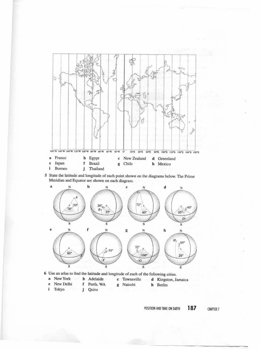
Use the map provided to match each of the countries named below with its correspondinglatitude from the following list. (Consult an atlas if you are unsure of the positions ofcountries.)
5°S 30°S 70°N 55°N 40°N 40°S 15°N 25°N
60°N
*—
&•
>><»t*
20'N j
20"S
40-S
filFS
Tropic of Cancer ^jk J" \ f ^ '̂ -.....̂
"%^-._ v^^ ^ x
"l""- \ ^\ • i \ A
Tropic of Capricorn ( V
— ̂ — ^j-- *- — — -
A ^2,/•'̂ v- i '̂
V^ "it'— ̂ / %IfAntarctic Circle
a Spain b Greenland c South Africa d Papua New Guineae Thailand f New Zealand g Canada h Pakistan
4 Use the map provided to match each of the countries named below with its correspondinglongitude from the following list. (Consult an atlas if you are unsure of the positions ofcountries.)
115°E 45°W 100°E 175°E 100°W 40°W 0° 30°E 140°E 70°W
186 NEWQMATHS11A
H^QiJ L-sf-XJ.
I? ^4W T"i,
Xl
r?C£m,m
C
5°
V
\
y^&
1 1 1 1
20"E 40°E 60°E 80°E 100'E 120"E 140'E 166'E 180'E
>
ISO'W 160"W 140'W 120°W 100'W 80'W 60'W 40°W 20'W
a France b Egypt c New Zealand d Greenlande Japan f Brazil g Chile h Mexicoi Borneo j Thailand
5 State the latitude and longitude of each point shown on the diagrams below. The PrimeMeridian and Equator are shown on each diagram.
a N b N c N d
6 Use an atlas to find the latitude and longitude of each of the following cities.a New York b Adelaide c Townsville d Kingston, Jamaicae New Delhi f Perth, WA g Nairobi h Berlini Tokyo j Quito
POSITION AND TIME ON EARTH 187 CHAPTER 7
and problem solving7 The angle between the vertical and the direction of the
Sun is called the azimuth. At point P on the diagram, theazimuth is A". At midday on 21 March and 21 Septemberthe Sun is directly overhead at the Equator.At this time in Brisbane, the azimuth is 27°.a What is the latitude of Brisbane?b What is the azimuth for New York (41°N74°W) at the
same time?
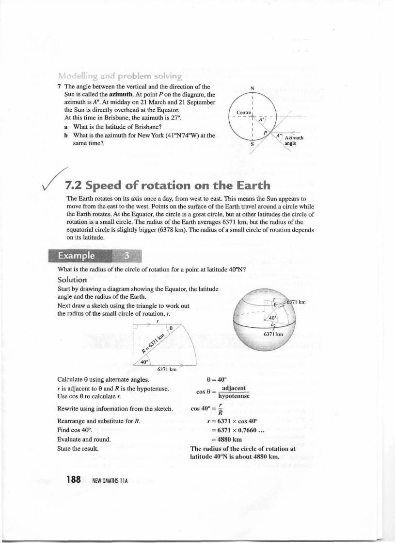
7.2 Speed of rotationThe Earth rotates on its axis once a day, from west to east. This means the Sun appears tomove from the east to the west. Points on the surface of the Earth travel around a circle whilethe Earth rotates. At the Equator, the circle is a great circle, but at other latitudes the circle ofrotation is a small circle. The radius of the Earth averages 6371 km, but the radius of theequatorial circle is slightly bigger (6378 km). The radius of a small circle of rotation dependson its latitude.
ExampleWhat is the radius of the circle of rotation for a point at latitude 40°N?
SolutionStart by drawing a diagram showing the Equator, the latitudeangle and the radius of the Earth.Next draw a sketch using the triangle to work outthe radius of the small circle of rotation, r.
6371 km
6371 km
Calculate 9 using alternate angles.r is adjacent to 6 and R is the hypotenuse.Use cos 0 to calculate r.
Rewrite using information from the sketch.
Rearrange and substitute for R.Find cos 40°.Evaluate and round.State the result.
9 = 40"„ adjacentcos 6 = -—±-
hypotenuse
cos 40" =R
r = 6371 x cos 40"= 6371x0,7660...=• 4880 km
The radius of the circle of rotation atlatitude 40"N is about 4880 km.
188 NEWQMATHS11A
Once you know the radius of the circle of rotation, you can work out the distance travelledin a day and the speed of rotation of a point on the surface of the Earth on that circle.
Example
Calculate the circumference of the circle of rotation of a point at latitude 40°N and thespeed of rotation of points on this circle of rotation.
SolutionFrom Example 3, the radius of the circle of rotation at latitude 40°N is about 4880 km.
Write down the rule for circumference (C). C = 2ivr
Substitute for r. C = 2 x n x 4880 kmEvaluate and round. ~ 30 662 kmAny point on the Earth travels around it in 24 hours.
distanceWrite down the rule for speed.
Substitute for known values.
Evaluate and round.State the result.
Speedtime
» 30 662 km* 24 h= 1278 km/h
A point at latitude 40"N has a circle ofrotation of about 30 662 km circumferenceand rotates at about 1278 km/h.
Exercise 7.2
Calculate the radius of the circle of rotation, its circumference and the speed of rotation forthese places.a Brisbane (27°S153°E) b Townsville (19°S147°E)c Cape Canaveral (28°N 81°W) d Bamaga on Cape York (11°S142°E)e Hobart(43°S147°E) f Jakarta (6°S107°E)
Investigation Speeds at different latitudes
Work in groups of two or three for this activity.
1 Calculate the speeds of rotation of points at different latitudes 0°, 10°, 20°, 30°, .... 90° onthe Earth's surface.
2 Draw up a table for speeds at these latitudes.
Now consider die following questions.• At what latitude is the speed the greatest?• Between what latitudes does die speed change the most?• What are the implications of your table for launching a spacecraft?• Why do you think die Cape Canaveral rocket-launching facility is positioned in the
southern American state of Florida?• What would be a suitable location for launching spacecraft in Australia? Why?
POSITION AND TIME ON EARTH 189 CHAPTER/
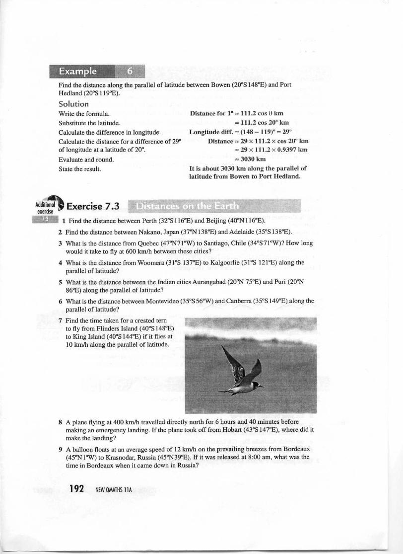
7.3 Distances on the EarthThe shortest distance between two points is a straight line.However, we cannot tunnel through the Earth to make astraight-line path between positions on the surface of theEarth. The shortest distance on the surface of the Earth willbe directly above the line going through the Earth. It will bea curve following a great circle route, because the straightline is a chord of the great circle directly above it.
The shortest distance between any two points on Earth is part of a great circle.
Investigation Great circle routes
1 Visit the websites of major international airlines to see if their air routes are displayed. Otherwebsites, such as the Great Circle Mapper, http://gc.kls2.com/. allow you to find great circleair routes by identifying the departure and destination locations. This website was used tofind the route from Brisbane to London as shown.
2 Try to find the routes from Hawaii to Sydney, San Francisco and Tokyo. What shape are theroutes as they appear on the map?
3 Find the route from London to San Francisco. Why does it seem to go off the top of the map?
Now work with a partner, using a small globe.
4 Use a piece of string to find the shortest surface routes between different places on the Earth.What do you find about the routes?
5 Compare with your findings from examination of maps of air routes. What do you conclude?
190 NEWQMATHS11A
Did you know?The Earth is round but it is also very big — it has a circumference of about 40 000 km. This^eaos^hat for distances on the Earth's surface of less tfian 20 km we can treat this Earth asbeing 'flat* and use flat-Earth formulas such as Pythagoras*s Theorem to find the distancebetween points.
Points that lie on the same meridian are on a great circle. We can calculate the distancebetween them using the difference in their latitudes. Great circles have a radius of about6371 km, so their circumference is
2 X T C X 6 3 7 1 =40030 kmTravel through an angle of 1 degree on a great circle will involve a distance of l/360th ofthe circumference. Dividing 40030 km by 360, we find that:
On a great circle l ° = l l l k m
ExampleFind the distance between Auckland Island (51°S 166°E) and Noumea (22°S 166°E). Findthe time it would take to travel in a boat averaging 15 km/h.
SolutionSince the two positions have the same longitude they are on the same meridian, which is agreat circle. The angle travelled is given by the difference in latitudes.Calculate the difference in latitudes.
Calculate the distance.
Evaluate
Write down rule for speed.
Substitute known values.
Rearrange.
Evaluate and round.
State the result.
Latitude difference = (51 - 22)"
= 29"
Distance = 111 x 29 km
= 3219 kmdistance
Speed =
15 km/h
time3219 km
time
3219 km1 line « ~~r-——
Izs km/h= 215 h
The distance is about 3219 km and thetrip would about take about 215 hours(almost 9 days).
You have previously seen how to calculate the radius of a parallel of latitude as a circleof rotation. The radius can be used to calculate the distance for travel through 1 degree oflongitude along a parallel of latitude. This is also given by the following formula.
On a parallel of latitude 1° = 111.2 cos 0 km where 9 is the angle of latitude.
POSITION AND TIME ON EARTH 191 CHAPTER?
ExampleFind the distance along the parallel of latitude between Bowen (20°S 148°E) and PortHedland(20°S119°E).
SolutionWrite the formula.Substitute the latitude.Calculate the difference in longitude.Calculate the distance for a difference of 29°of longitude at a latitude of 20°.
Evaluate and round.State the result.
Distance for 1" = 111.2 cos 0 km= 111.2 cos 20° km
Longitude ditf. = (148 - 119)" = 29"Distance = 29 x 1.11.2 x cos 20" km
= 29x111.2x0.9397 km= 3030 km
It is about 3030 km along the parallel oflatitude from Bowen to Port Hedland.
Additionalexercise
Exercise 7.3 * . .. i i—• j_ista nces on the Eart*
1 Find the distance between Perth (32°S 116°E) and Beijing (40°N 116°E).
2 Find the distance between Nakano, Japan (37°N 138°E) and Adelaide (35°S 138°E).
3 What is the distance from Quebec (47°N71°W) to Santiago, Chile (34°S71°W)? How longwould it take to fly at 600 km/h between these cities?
4 What is the distance from Woomera (31°S 137°E) to Kalgoorlie (31°S 121°E) along theparallel of latitude?
5 What is the distance between the Indian cities Aurangabad (20°N 75°E) and Puri (20°N86°E) along the parallel of latitude?
6 What is the distance between Montevideo (35°S 56°W) and Canberra (35°S 149°E) along theparallel of latitude?
7 Find the time taken for a crested temto fly from Flinders Island (40°S 148°E)to King Island (40°S 144°E) if it flies at10 km/h along the parallel of latitude.
8 A plane flying at 400 km/h travelled directly north for 6 hours and 40 minutes beforemaking an emergency landing. If the plane took off from Hobart (43"S 147°E), where did itmake the landing?
9 A balloon floats at an average speed of 12 km/h on the prevailing breezes from Bordeaux(45°N1°W) to Krasnodar, Russia (45°N39°E). If it was released at 8:00 am, what was thetime in Bordeaux when it came down in Russia?
192 NEWQMATHS11A
Investigation Shortest distances
You have seen how to calculate distances along meridians and along parallels of latitude.The distance along a parallel of latitude is not actually the shortest distance between points.That is always along a great circle route. The formula below can be used to calculate thegreat circle distance d between any two points A (LatiLonj) and B (Lat2Lon2).
d ~ 111.2 x cos"1 [cos (ALon) cos Latj cos Lat2 + sin Latj sin Lat2lALon is the difference between longitudes. ALon must be less than 180°.For example, the shortest distance between Flinders Island (40CS 148°E) and Perth(32°S116°E)isgivenby:
d = 111.2 x cos"1 [cos (148° - 116°) x cos 40° x cos 32° + sin 40° x sin 32°]~ 111.2 x cos"1 [cos 32° x cos 40° x cos 32° + sin 40° x sin 32°]= 111.2 X cos-1 [0.550 928 + 0.340 626]= 111.2x26.930868= 2995
So the distance from Flinders Island to Perth is about 2995 km.
1 Work with a partner to calculate the shortest distances between different positions on theEarth. Compare the distance along the parallel of latitude with the shortest distancebetween:• Bowen (20°S 148°E) and Port Hedland (20°S 119°E)• Shanghai (31°N 121°E) and Jerusalem (32°N35°E)• Canberra (35.5°S 149°E) and Montevideo (35°S56°W)• Los Angeles (34°N 118°W) and Tokyo (36°N 140°E)
2 Discuss the differences in distance with your partner.
The week was originally part of the Jewish calendar but is now used throughout the worldas a convenient unit of time. In different cultures the days have had different names. Thepresent English names are derived from the names of the Sun, Moon, planets and Norsegods. The days of the week gradually cycle through the dates of the year, so that NewYear's Day can fall on any day of the week, depending on the year. A perpetual calendarshows the days of the week for any date in any year. There are many perpetual calendarwebsites, such as www.calendarhome.com/tyc/. which has a 10000-year calendar.
Extramaterial
Seasons andcalendars
Investigation Days of the week
1 Work in groups of three or four to find the day of the week:a for your birthday this yearb for your birthday next yearc on which you were actually bornd on which Christmas (25 December) will fall this yeare on which Australia Day (26 January) fell this yearf on which the summer solstice falls this year.
2 Use a perpetual calendar to check your answers to question 1.
POSITION AND TIME ON EAR1H 193 CHAPTER?
Did you know?The ancient Babylonians believed that the complete cycle of seasons tasted 360 days.Because they deduced that seasons were like circles, they divided circles into the 360 sectionswe now call degrees. Of course, we know that a year (the cycle of the seasons) is a little rnor™than 365 days, but the slight error of die Babylonians was the bask of modem geometrjfi
There are 365 days in a year. Because 365 = 52 x 7 + 1 and 366 = 52 x 7 + 2, the day of theweek on which New Year's Day falls moves through the week as the years advance. If theprevious year was a leap year, it advances by 2 days; otherwise it advances by 1 day.
ExampleIn 2001, New Year's Day was a Monday. On what day of the week will it occur in 2007?
SolutionIt is easiest to work it out year by year.
2002—It moves on 1 day to Tuesday.2003—It moves on 1 day to Wednesday.2004—Thursday2005—It moves on 2 days because the previous year is a leap year, so it will be Saturday.2006—Sunday2007—Monday
So New Year's Day in the year 2007 will be on a Monday.
Exercise 7.4
1 Work out the day of the week for New Year's Day in:a 2010 b 1990 c 1975 d
2 Work out the day of the week for Christmas Day in:a 2009 b 1989 c 1974
1970 1950
3 Find the day of the week for your birthday this year. Work out the day for your birthday in:a 2012 b 1993 c 2040
, simsetThe Earth rotates on an imaginary axis passing throughthe North and South Poles. This axis is tilted at about23.5° to the vertical. The tilt in the axis causes the seasonsbecause it permits the Sun's rays to shine more directlyand for longer periods on certain locations on the Earth'ssurface at different times of the year. In this way, when itis summer in the Northern Hemisphere the Sun's rays aremore directly overhead and more intense than in theSouthern Hemisphere, where it is winter at this time.
194 NEWQMATHS11A
The length of the day changes during the year. The lengths of day and night are the samefor an equinox. For the Southern Hemisphere, the autumn equinox occurs on 21 March andthe spring (vernal) equinox occurs on 22 September. The longest and shortest days of theyear occur at the summer and winter solstices—22 December and 21 June respectively inthe Southern Hemisphere.
Arctic Circle23.5°N
Equatorjuuior
Arctic Circle has24 hours of 1 ight.
Arctic Circle has24 hours of darkness.
Antarctic Circle has24 hours of light.
Antarctic Circle has24 hours of darkness
June solsticepheci •iiwlieht ui *
The following table gives the approximate day length for various latitudes at differenttimes of the year.
Approximate day length
Latitude
Southern Hemisphere: read down
21 March
12h12 h12 h12 h12 h12 h12 h12 h12 h12 h
21 March 21 June 22 September
Northern Hemisphere: read up
ititude
0°10°20°30°40°50°60°70°80°90°
22 September
12h12h12 h12 h12h12 h12 h12 h12 h12 h
22 Decemb
12.0 h12.6 h13.2 h13.9 h14.9616.3 h18.4 h
2 months4 months6 months
21 June
12.0 h11,4 h10.8 h10.1 h9.1 h7.7 h5.6 hOhOhOh
22 December
ExampleWhat is the approximate day length in Camooweal (20°S 138°E) in the middle of winter?
SolutionCamooweal is in the Southern Hemisphere, so the middle of winter is at 21 June.
Look up the table of day lengths. Day length = 10.8 h
The exact lengths of the days change in a very complicated way between these extremesbecause of the fact that the speed of the Earth in its orbit is not constant. The lengths of thelongest and shortest days depend on the latitude.
POSITION AND TIME ON EARTH 195 CHAPTER?
I For a latitude 0< 66.5°:Daylight minutes of shortest day = 8 x cos"1 (0.4338 x tan 0)Daylight minutes of longest day = 1440 - 8 x cos"1 (0.4338 x tan 6)
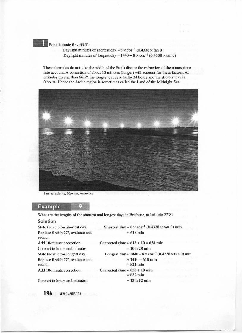
These formulas do not take the width of the Sun's disc or the refraction of the atmosphereinto account. A correction of about 10 minutes (longer) will account for these factors. Atlatitudes greater than 66.5°, the longest day is actually 24 hours and the shortest day is0 hours. Hence the Arctic region is sometimes called the Land of the Midnight Sun.
Summer solstice, Mawson, Antarctica
ExampleWhat are the lengths of the shortest and longest days in Brisbane, at latitude 27°S?
SolutionShortest day = 8 x cos"1 (0.4338 x tan 9) min
« 618 minState the rule for shortest day.Replace 6 with 27°, evaluate andround.Add 10-minute correction.Convert to hours and minutes.State the rule for longest day.Replace 9 with 27°, evaluate andround.Add 10-minute correction.
Convert to hours and minutes.
Corrected time = 618 + 10 = 628 min= 10 h 28 min
Longest day = 1440 - 8 x cos"1 (0.4338 x tan 9) min» 1440 - 618 min= 822 min
Corrected time » 822 + 10 min= 832 min= 13 h 52 min
196 NEWQMATHS11A
Solar noon is the time when the Sun is at its highest point in the sky. It is not always at12 o'clock because of variation in the Earth's orbit and differences in longitude betweenplaces in the same time zone. However, solar noon is always halfway between sunrise andsunset. If you know the latitude and time when the Sun rises, from the length of the day youcan work out the time when the Sun will set and the time when it will be highest in the sky.
ExampleOn 3 April the Sun rises at 5:59 am in Brisbane and the day is 11 h 46 min in length. Atwhat times are solar noon and sunset?
SolutionCalculate the half-day length. Length of i day = ^ of 11 h 46 min
= 5 h 53 minSince solar noon is halfway through the day, it will occur 5 h 53 min after sunrise.Calculate when solar noon occurs. Solar noon = 5:59 am + 5 h 53 min
= 11:52 amCalculate when sunset occurs. Sunset = 5:59 am + 11 h 46 min
= 5:45 pm
.5 -x1 Use the table on page 195 to find the approximate day length in:
a Brussels (50°N) on 22 Decemberb Walgett (30°S) on 21 Junec Quito (0°) in late Juned Flinders Island (40°S) in the middle of the southern wintere Bowen (20°S) in the middle of the southern summerf Cairo (30°N) in the middle of the northern winterg Oslo (60°N) in the middle of the northern summer
2 a What are the lengdis of the shortest and longest days in Hobart (43°S)?b If sunrise is at 7:48 am on the shortest day in Hobart, at what times are solar noon
and sunset?
3 a What are the lengths of the shortest and longest days on Cape York (11°S)?b If sunrise is at 5:25 am on the longest day on Cape York, when is sunset?
4 What are the lengths of the shortest and longest days at the Equator?
5 What are the lengths of the shortest and longest days in London, England (51°N)?
6 What is the difference between the shortest and longest days in Anchorage, Alaska (61°N)?
Moc. II ig - id -:.:;jiem solving7 Which city receives more intense sunlight in June: Sydney (34°S 151°E) or Quebec
(47°N71°W)?Why?
8 What would happen to the seasons if the Earth were tilted 40° instead of its current 23.5°?
9 What would happen to the seasons if the Earth were tilted at 23.5° in the oppositedirection?
POSITION AND TIME ON EARTH 1 9 7 CHAPTER 7
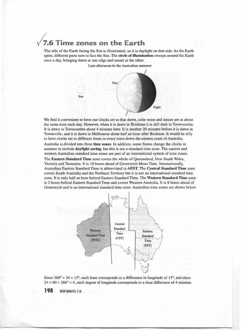
7.6 Time zones on the EarthThe side of the Earth facing the Sun is illuminated, so it is daylight on that side. As the Earthspins, different parts turn to face the Sun. The circle of illumination sweeps around the Earthonce a day, bringing dawn at one edge and sunset at the other.
Late afternoon in the Australian summer
Day/
Sun
Night
We find it convenient to have our clocks set so that dawn, solar noon and sunset are at aboutthe same time each day. However, when it is dawn in Brisbane it is still dark in Toowoomba.It is dawn in Toowoomba about 4 minutes later. It is another 20 minutes before it is dawn inTownsville, and it is dawn in Melbourne about half an hour after Brisbane. It would be sillyto have clocks set to different times in every town down the eastern coast of Australia.Australia is divided into three time zones. In addition, some States change the clocks insummer to include daylight saving, but this is not a standard time zone. The eastern andwestern Australian standard time zones are part of an international system of time zones.The Eastern Standard Time zone covers the whole of Queensland, New South Wales,Victoria and Tasmania. It is 10 hours ahead of Greenwich Mean Time. Internationally,Australian Eastern Standard Time is abbreviated to AEST. The Central Standard Time zonecovers South Australia and the Northern Territory but it is not an international standard timezone. It is only half an hour behind Eastern Standard Time. The Western Standard Time zoneis 2 hours behind Eastern Standard Time and covers Western Australia. It is 8 hours ahead ofGreenwich and is an international standard time zone. Australian time zones are shown below.
WesternStandard Time
(WST)
f
Since 360° -s- 24 = 15°, each hour corresponds to a difference in longitude of 15°; and since24 x 60 -e- 360° = 4, each degree of longitude corresponds to a time difference of 4 minutes.
198 NEWQMATHS11A
1 h s 15° of longitude1° of longitude = 4 minutes
The world is divided into standard time zones with the clocks set 1 hour apart inneighbouring time zones.
The clocks in a time zone are set so that solar noon is at 12 o'clock in the middle of the zone.The date is changed at the International Date Line, which passes through the middle of thePacific Ocean. All time zones are referred to Greenwich (at 0° longitude). Areas with easternlongitudes are ahead of Greenwich, and areas with western longitudes are behind Greenwich.Throughout the world, time zone boundaries are modified to state and country boundaries.There are a few countries, such as Saudi Arabia, which do not use the appropriate standardtime zone. A map of the time zones of different areas of the world is often given in an atlas.Time differences for various countries are also listed in the back of the White Pagestelephone directory to help you avoid ringing people overseas at inappropriate times. It liststhe time difference for each country in the form AEST — x hours. For example, Denmark isAEST — 9 hours and the USA is AEST — 15—21 hours. The diagram on page 200 showsworld time zones referred to Greenwich.
Investigation Time zones and the telephone
The theoretical time difference between two places on the Earth can be worked out fromthe difference in longitude. Every degree of longitude makes a difference of 4 minutes.The difference in longitude between Townsville (19°S 146°E) and Wellington, NewZealand (41°S 174°E) is 174° - 146° = 28°. Thus the theoretical time difference betweenTownsville and Wellington is 28 x 4 minutes =112 minutes. The time difference shown inthe White Pages is 2 hours.1 Work in groups of three or four with an atlas and a copy of the White Pages to find the
theoretical and actual time differences between your area and New York, London, Paris,Moscow, Tokyo, Jakarta, San Francisco and Johannesburg.
There are many websites that give the time and date of places relative to Greenwich MeanTime, such as www.timeanddate.com/worldclock/ and www.worldtimezone.com/.
2 Use a website of your choice to investigate the time differences between places of interestto you.
POSITION AND TIME ON EAR1H 199 CHAPTER /
-1 0 +1 +2 ''+3 +4 +5 + 6 + 7 +8 *'+9 +10 +11 +12•""i „, , j ^^ .. . . „,,_ _ j ' _;_;~, _ -iC"*'*'-/ ' ""' ?~'/ . P.. ;
if ' VJ /"•• * \
\ : /O''' f""^ } ; <> D <^
/ / f ^ .̂ > t V™"»J1\O' ,•••._
j | ^ tf}f VS ; V • ,, 1 '•/"? » :
. _ J '""--̂ ' \S i -. \ \ \ X/ ""V * u- ̂ — -, . C-? . .,,j^ ' ^"s_ -i ci"N x 1 1 • • V~- s ";~--"--v •*3 \ '"L •/" '""̂ v i^1 : • \ V
^ ,/ o v ^ . . ' . cjf^>C t (,.lo : . ^./"f---'' ''
t'\ I /' M x' ' "~ "y ( 'Belfast »S\ ^"Ci-^ 'Moscow ; / / j < '
' -~L*l;/~ Berlin. : '1(\ \/ sLoriSSn . prankfurt /|f
v. ^ ^
r-\~~-\s. <r!fS ^v ^ : ^'' £> ' |tN.-c__-«3r\iiAth.ens O • : <C2'i,\: .̂ Tokyo ' 'J,/ — I "'- ' * Tehran ( U /:;-;.." ' i »
'/ ^^ ^-.Hyderabad Hong 4^ Pacific ||i * V . / '-I /A . f<~-~ i a' V\ -^ !i -i Lc "' P i-lV-^x, ^ V7 •H"*°JkJ
/^ ce" !|
( ^ x " Smgapo1*^)* ,-' rf** !^rv | j|
/ 1 /") Indian /-,/""! !V Fiji v^' \ (•"' / / X r "" \ ' * • c'r '
\ yiu^ O^on J^ V-"ane ' jCape Town >«._-" i Fern' ?, -^j^ ^Sydney uc]<|
: Melbourne?' H7
• \ji -', '1; : Hobart New//' ,
Zealand '
6.26 7.26 8.26 9.26 10.26 11.26 12.26 1.26 2.26 3.26 4.26 5.26 6.26 7.26pm pm pm pm pm pm am am am am am am am am
-1 1 -10 ' i-9 -8 -7 -6 -5 <"? -4 *' -3 -2
W A '^'rl r ''" ' ''i^topcsp^,, ^, ^* ^?: ^ U. ̂ ^ '̂
o v:\rr<t/^ y.^Jf f? ° ̂ GV^-^ ?L, fP^" '̂ ti;cfr;:~) " \ . ;
: . . . t^W\^j[/((i'®U V ^
/" "^^-'•f""*A~~^-f:?. f^:ty>\ "^~f\ ''i ^ -*\ *=3^~J^l \ \ '$*> 'K Is f-r
} ' C, 7f\ rj| 'v-' I, X <^-
x ^-s. (*J p rs\/..v v/\ i Uvv S
i pP A^oston, San Francisco ^ New York
"^Los Angeles ^ Atlantic
« Honolulu I'Vi /'" ','.•̂ \ 1 -
^._~i Ja^daica\TJ ~~''\^^
If ' ' ^V,_,:,
r*l -iRiode
/ .../ Ianeir°( J v:
i ' v > " • '
1 (/ >V./ o
8.26 9.26 10.26 11.26 12.26 1.26 2.26 3.26 4.26 5.26ain am am am pm pm pm P1^ P^ p^
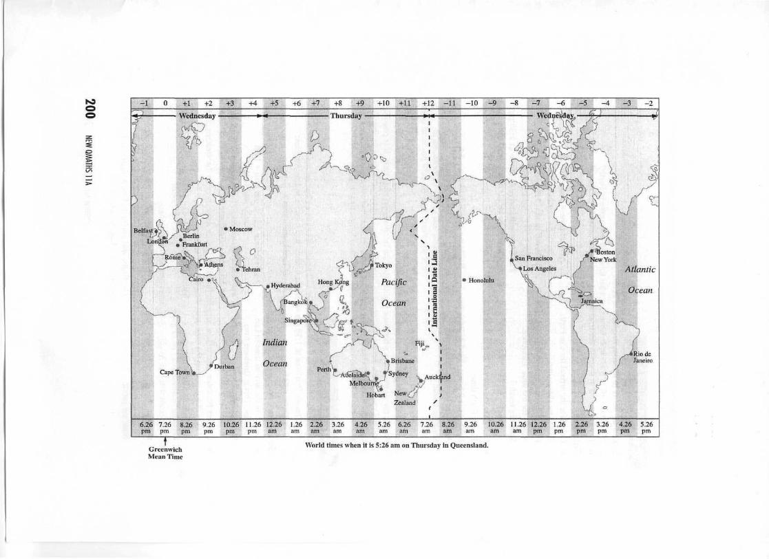
GreenwichMean Time
World limes when it is 5:26 am on Thursday in Queensland.
The following example demonstrates that differences in time zones need to be taken intoconsideration when travelling long distances.
Example
It takes 6^ hours to fly from Brisbane to Perth.
a If you take off at 8 am in Brisbane, at what time will you arrive in Perth?b If you take off at 8 am in Perth, at what time will you arrive in Brisbane?
Solution•i
a Calculate the arrival time in Perth.This is Brisbane time.Perth is 2 hours behind Brisbane time.Adjust for the time difference.State the result.
Calculate the arrival time in Brisbane.This is Perth time.Brisbane is 2 hours ahead of Perth time.Adjust for the time difference.State the result.
Arrival time = 8 am + 6- h= 2:30 pm "
Perth time = 2:30 pm - 2 h= 12:30 pm
The flight will arrive in Perth at 2:30 pmBrisbane time or 12:30 pm local time.
Arrival time = 8 am + 6 - h= 2:30 pm
Brisbane time = 2:30 pm + 2 h= 4:30 pm
The flight will arrive in Brisbane at2:30 pm Perth time or 4:30 pm local time.
International air flights are sufficiently fast to cause problems with time zones. It can beconfusing for air travellers when their flights cross the International Date Line. It is possibleto land in Los Angeles 'before' taking off in Brisbane—provided you refer to local time. Ifyou visit the website of Qantas (www.qantas.com.auA) or other international airlines you willbe able to compare departure and arrival dates and times for overseas flights.
ExampleA flight from Brisbane to Los Angeles takes 17 hours including a stopover at Honolulu. Ifthe flight leaves Brisbane at 1:30 pm on Sunday, when will it arrive in Los Angeles:a in Brisbane time?
Solutiona Calculate the arrival time in Los
Angeles. This is Brisbane time.State the result.
b in Los Angeles time?
Arrival time = 1:30 pm Sun + 17 h= 6:30 am Mon
The flight will arrive in Los Angeles at 6:30 amon Monday—Brisbane time.
b Convert Brisbane time to Los Angeles (local) time. Los Angeles is on the western coastof the USA. Look up the time zone diagram on page 200.Calculate the time difference Time difference = (-8) - (+10)between Brisbane and Los Angeles. =—18 hoursThis means that Los Angeles is 18 hours behind Brisbane time.Convert arrival time to local time. Arrival time = 6:30 am Mon - 18 hours
= 12:30 pm SunState the result. The flight will arrive in Los Angeles at 12:30 pm
on Sunday—Los Angeles time.
POSITION AND TIME ON EARTH 201 CHAPTER/
Example 12 shows that travellers on the flight between Brisbane and Los Angeles arrive inLos Angeles an hour before leaving Brisbane (in local time)! Travelling across time zonesmay cause people to suffer from 'jet lag', which can make it difficult for them to adjust theirsleep patterns.
"*̂
You will need to refer to detailed time zone diagrams to answer the following questions.Depending on your knowledge of geography, you may also need to refer to a world atlas tofind the time zones of various locations.
1 Calculate the time in Queensland when it is:a 5 am in Perth, WA b 7:30 pm in Adelaidec 12 noon in Hobart d 6:15 pm in Londone 10 pm in Auckland.
2 An email is sent at 9:00 am on Monday from Brisbane. Assuming that there are notransmission delays, work out the time and day when it will arrive in:a Auckland b Londonc Berlin d Los Angelese New York f Tokyog Moscow h Hyderabad, Pakistan.
lodeSI i| J problem so!3 A plane leaves Brisbane at 7:00 am on Saturday for Narita airport, Tokyo. The direct flight
takes 9 hours 30 minutes. When it arrives, what will be the day and time:a in Brisbane? b in Tokyo?
4 A plane leaves Sydney at 1:20 pm on Tuesday for Heathrow airport, London. The flighttakes 25 hours 45 minutes including a stopover at Changi airport, Singapore. When itarrives, what will be the day and time:a in Sydney? b in London?
5 Answer the following questions in local time (i.e. the time at the destination).a It takes 8 i hours to fly from Sydney to Honolulu. If a plane leaves Sydney at 4:30 pm,
at what time will it arrive in Honolulu? Remember the International Date Line!
b It takes 4 hours and 45 minutes to fly from San Francisco to Honolulu. If an Americansurfer leaves San Francisco at 8 am, at what time will her flight reach Honolulu?
c It takes 7 hours 50 minutes to fly from Hong Kong to Sydney. If a flight leaves HongKong at 8 pm, at what time will it arrive in Sydney?
d A direct flight from Los Angeles to Brisbane takes 12 hours and 25 minutes. At whattime will a flight leaving Los Angeles at 10 am arrive in Brisbane?
e It takes 24^ hours, including stopovers, to fly from Frankfurt in Germany to Brisbane.When would a flight leaving Frankfurt at 7 am on Wednesday arrive in Brisbane?
A flight leaves Brisbane at 4:30 pm on Tuesday and flies to Rome. When does it arrive ifthe flight takes 23 hours 45 minutes (including stopovers).
202 NEWQMATHS11A
New QMaths 11A CD-ROMSummary: chapter 7
Summary 7
Great circles are drawn on the surface so that theircentre is at the centre of the Earth. Small circles donot have their centre at the centre of the Earth.
SmaII circle
i»Ceptre
Great'circle
Parallels of latitude are smallcircles drawn parallel (north andsouth) to the Equator (0°).Meridians of longitude are greatsemicircles drawn between theNorth and South Poles. ThePrime Meridian (0°) passesthrough Greenwich, England.The position of a point on theEarth is stated in terms ofdegrees north or south of theEquator and east or west of thePrime Meridian.
PrimeMeridian (0°)
Parallel oflatitude
Meridians oflongitude
Equator (0°)
Parallellatitude
The Earth rotates on its axis once a day, from west to east. The speed of rotation of pointson the surface of the Earth decreases the further they are away from the Equator.The radius of the Earth varies but averages 6371 km.The shortest distance on the surface of the Earth is part of a great circle. On a great circle,1°= 111 km. On a parallel of latitude, 1°== 111.2 cos 0 where 0 is the angle of latitude.The length of the day changes during the year. The lengths of day and night are the samefor an equinox (21 March and 22 September), while the shortest and longest days occur atthe summer and winter solstices (22 December and 21 June respectively in the SouthernHemisphere).The exact lengths of the days change in a very complicated way between these extremesbecause the speed of the Earth in its orbit is not constant. The lengths of the longest andshortest days vary depending on the latitude (0). For a latitude 0 < 66.5°:
Daylight minutes of shortest day = 8 x cos"1 (0.4338 x tan 0)Daylight minutes of longest day = 1440 - 8 x cos"1 (0.4338 x tan 0)
The world is divided into standard time zones with the clocks set 1 hour apart inneighbouring time zones. Each hour corresponds to a difference in longitude of 15°, andeach 1° of longitude corresponds to a time difference of 4 minutes. The date changes at theInternational Date Line, which passes through the middle of the Pacific Ocean. All timezones are referred to Greenwich (at 0° longitude), with eastern longitudes 'ahead' ofGreenwich and western longitudes 'behind' Greenwich.
Australia is divided into three time zones: Eastern Standard, Central Standard andWestern Standard. Some states change the clocks in summer to include daylight saving,but this is not a standard time zone.
©RBRODIE AND S SWIFT 2001
CHAPTER 7fcxercise 7,1
1 a No—they become smaller as you moveaway from the Equator.
b The Equator is the longest,c The South Poled Yes—they are all great semicircles.
2 West3 a 40°N b 70°N
c 15°N f40°S
4 a 0° b 30°Ee 140°E f45°Wi 115°E j 100°E
5 a 50°N78°Ec 72°N40°We 0°N86°Eg 52°S100°W
6 a 41°N74°Wc I9°S147°Ee 29°N77°Eg 1°S37°Ei 36°N140°E
7 a 27°S
c 30°S dg 55°N h
c 175°E dg 70°W h
b 20°N35°Wd40°S95°Ef35°SO°Eh 60°N28°Wb 35°S 139°Ed 18°S77°Wf32°S116°Eh53°N13°Ej 0°S79°Wb41°
5°S25°N
40°W100°W
Exercise 7,2a 5677 km, 35 667 km,b 6024 km, 37 849 km,c 5625 km, 35 345 km,d 6254km, 39295km,e 4659km, 29276km,
1486 km/h1577km/h1473 km/h1637 km/h1220 km/h
f 6336 km, 39 811 km, 1659 km/h
Exercise 7,31 7992 km 2 7992 km3 8991 km; about 15 h4 1525 km 5 1149 km6 14118km 734h8 19°S147°E(Townsville)9 About 6 am, 11 days after its release
Exercise 7.41 a Friday
c Wednesdaye Sunday
2 a Fridayc Wednesday
3 Answers will vary—check a perpetualcalendar.
b Mondayd Thursday
b Monday
Exercise 7.5
d9 .1h1 a 7.7 h b 10.1 h c 12 hc 13.2 h f 10.1 h g 18.4 h
2 a 539 min = 8 h 59 min and 921 min = 15 h21 min
b About 12:17 pm and 4:47 pm3 a 691 min = 11 h 31 min and
769 min = 12 h 49 minb 6:14 pm
4 They are the same: 730 min = 12 h 10 min.5 471 min = 7 h 51 min and
989 min = 16 h 29 min6 824 min = 13 h 44 min7 The sunlight is more intense at Quebec as it
is in the Northern Hemisphere, havingsummer, because the Earth is tilted so thatthe Sun is more directly overhead there.
8 The seasons would be more pronounced.Latitudes greater than 40° would be in 24hours of darkness or sunlight at the winterand summer solstices respectively.
9 The seasons would be reversed. The winterand summer solstices would occur on22 December and 21 June respectively in theSouthern Hemisphere.
Exercise 7.61 a 7 am
c 12 noone 8 pm
2 a 11:00 am Monday b 11:00 pm Sundayc Midnight Sunday d 3:00 pm Sundaye 6:00 pm Sunday f 8:00 am Mondayg 2:00 am Monday h 4:00 am Monday
3 a 4:30 pm Saturdayb 3:30 pm Saturday
4 a 3:05 pm Wednesdayb 5:05 am Wednesday
5 a 5:00 am the same dayb 10:45 am the same dayc 5:50 am the next dayd 4:25 pm the next daye 4:45 pm Thursdayf 7:15 am Wednesday
b 8 pmd 4:15 am the next day