Embed Size (px)
Citation preview

University of Nebraska - LincolnDigitalCommons@University of Nebraska - Lincoln
USGS Staff -- Published Research US Geological Survey
2015
Late Quaternary sea-level history and the antiquityof mammoths (Mammuthus exilis and Mammuthuscolumbi), Channel Islands National Park, California,USADaniel R. MuhsU.S. Geological Survey, [email protected]
Kathleen R. SimmonsU.S. Geological Survey
Lindsey T. GrovesNatural History Museum of Los Angeles County
John McGeehinUS Geological Survey
R. Randall SchumannU.S. Geological Survey
See next page for additional authorsFollow this and additional works at: http://digitalcommons.unl.edu/usgsstaffpub
Part of the Geology Commons, Oceanography and Atmospheric Sciences and MeteorologyCommons, Other Earth Sciences Commons, and the Other Environmental Sciences Commons
This Article is brought to you for free and open access by the US Geological Survey at DigitalCommons@University of Nebraska - Lincoln. It has beenaccepted for inclusion in USGS Staff -- Published Research by an authorized administrator of DigitalCommons@University of Nebraska - Lincoln.
Muhs, Daniel R.; Simmons, Kathleen R.; Groves, Lindsey T.; McGeehin, John; Schumann, R. Randall; and Agenbroad, Larry D.,"Late Quaternary sea-level history and the antiquity of mammoths (Mammuthus exilis and Mammuthus columbi), Channel IslandsNational Park, California, USA" (2015). USGS Staff -- Published Research. 930.http://digitalcommons.unl.edu/usgsstaffpub/930

AuthorsDaniel R. Muhs, Kathleen R. Simmons, Lindsey T. Groves, John McGeehin, R. Randall Schumann, and LarryD. Agenbroad
This article is available at DigitalCommons@University of Nebraska - Lincoln: http://digitalcommons.unl.edu/usgsstaffpub/930

Late Quaternary sea-level history and the antiquity of mammoths(Mammuthus exilis and Mammuthus columbi), Channel Islands NationalPark, California, USA
Daniel R. Muhs a,⁎, Kathleen R. Simmons a, Lindsey T. Groves b, John P. McGeehin c,R. Randall Schumann a, Larry D. Agenbroad d,†
a U.S. Geological Survey, MS 980, Box 25046, Federal Center, Denver, CO 80225, USAb Section of Malacology, Natural History Museum of Los Angeles County, 900 Exposition Blvd., Los Angeles, CA 90007, USAc U.S. Geological Survey, MS 926A, National Center, Reston, VA 20192, USAd Mammoth Site of Hot Springs, South Dakota, Inc., 1800 Highway 18 Truck Route, P.O. Box 692, Hot Springs, SD 57747, USA
a b s t r a c ta r t i c l e i n f o
Article history:Received 1 October 2014Available online 16 April 2015
Keywords:MammothsCalifornia Channel IslandsMarine terracesSea-level historyUranium-series datingRadiocarbon dating
Fossils of Columbian mammoths (Mammuthus columbi) and pygmy mammoths (Mammuthus exilis) have beenreported from Channel Islands National Park, California. Most date to the last glacial period (Marine IsotopeStage [MIS] 2), but a tusk of M. exilis (or immature M. columbi) was found in the lowest marine terrace ofSanta Rosa Island. Uranium-series dating of corals yielded ages from 83.8 ± 0.6 ka to 78.6 ± 0.5 ka, correlatingthe terrace withMIS 5.1, a time of relatively high sea level. Mammoths likely immigrated to the islands by swim-ming during the glacial periodsMIS 6 (~150 ka) orMIS 8 (~250 ka),when sea levelwas low and the island–main-land distance was minimal, as during MIS 2. Earliest mammoth immigration to the islands likely occurred lateenough in the Quaternary that uplift of the islands and the mainland decreased the swimming distance to arange that could be accomplished by mammoths. Results challenge the hypothesis that climate change, vegeta-tion change, and decreased land area from sea-level rise were the causes of mammoth extinction at the Pleisto-cene/Holocene boundary on the Channel Islands. Pre-MIS 2 mammoth populations would have experiencedsimilar or even more dramatic changes at the MIS 6/5.5 transition.
Published by Elsevier Inc. on behalf of University of Washington.
Introduction
Mammoths are one of the most iconic animals of the Pleistocene,both in North America and Eurasia. Interestingly, fossil mammothsand other proboscideans are not limited to just those continents. Fossilproboscideans have been found on islands off North America and Asia,as well as on many islands of the Mediterranean (Fig. 1). On the north-ern Channel Islands of California (Fig. 2), fossil mammoth remains thathave been documented include the Columbianmammoth,Mammuthuscolumbi and the pygmy mammoth, Mammuthus exilis (Orr, 1968;Johnson, 1978, 1979, 1981; Madden, 1981; Roth, 1993; Agenbroad,1998, 2001, 2003, 2012; Agenbroad et al., 1999 ,2005).M. columbi immi-grated from the mainland to the islands and M. exilis evolved from thisancestral stock (Johnson, 1978, 1981; Madden, 1981; Agenbroad,2001, 2012). Based on fossil evidence for mammoths on the ChannelIslands, an absence of other faunal elements, lack of geologic evidencefor a former land bridge, and documentation of swimming abilities ofmodern elephants, Johnson (1978, 1980) concluded that mammoths
likely reached the California Channel Islands from mainland Californiaby swimming.
If swimmingwere themeans bywhichmammoths immigrated to theChannel Islands, a question that arises is the timing of this event or events.Johnson (1978) pointed out that the optimal times for immigrationswould have been during glacial periods, when eustatically lowered sealevels would have minimized the swimming distance from the mainlandto the islands. Radiocarbon ages of either fossil mammoth remains (colla-gen) or materials associated with such remains (charcoal) fall into twoage groups, summarized byAgenbroad (2012). Based on this compilation,and excluding those derived from questionable materials or analysesdone in the early period of radiocarbon dating, the most abundant agesfor mammoths on the Channel Islands date to the last glacial period(~22–12 ka, in cal 14C yr) or Marine Isotope Stage (MIS) 2. A last-glacialage for mammoths on the Channel Islands supports part of Johnson's(1978) hypothesis, because sea level would have been lower during thistime, minimizing the swimming distance from mainland California tothe Channel Islands. Johnson (1978) also proposed, however, that mam-moth immigration to the Channel Islands need not be limited to the lastglacial period, but could occur any time there was a favorable paleogeog-raphy, with lowered sea level. Azzaroli (1981) challenged this proposal,asserting that sea levels prior to the last glacial maximum (LGM) were
Quaternary Research 83 (2015) 502–521
⁎ Corresponding author.E-mail address: [email protected] (D.R. Muhs).
† Deceased October 31, 2014.
http://dx.doi.org/10.1016/j.yqres.2015.03.0010033-5894/Published by Elsevier Inc. on behalf of University of Washington.
Contents lists available at ScienceDirect
Quaternary Research
j ourna l homepage: www.e lsev ie r .com/ locate /yqres

no lower than about −30 m to −50 m, relative to present. It is nowknown, however, that other, pre-LGM glacial periods were characterizedby sea levels well below −30 to −50 m, relative to present, during atleast the two glacial periods prior to the LGM (e.g., Lea et al., 2002;Rohling et al., 2009, 2010). Thus, Johnson's (1978) hypothesis of pre-LGMmammoth immigrations is still a viable one, based on current under-standing of sea-level history.
The second group of mammoth ages derive from charcoal fragmentsassociated with mammoth remains from five localities on Santa RosaIsland and have given ages of N41,000 yr (Agenbroad, 2012). If correct,these ages imply the possibility of mammoth immigrations prior to MIS2. Further, Orr (1960, 1968) reportsfindingmammoth remains inmarinedeposits of the lowest emergent terrace on Santa Rosa Island. These ob-servations raise the possibility of considerable antiquity for the presenceofmammoths on the Channel Islands. There is evidence that pre-LGM im-migrations of proboscideans took place elsewhere, to the Mediterraneanislands of Sardinia, Sicily, and Crete, as well as to the island of Flores inIndonesia (Palombo and Rozzi, 2013). Reported here are newmarine ter-race mapping and geochronology along with two new mammoth findsthat provide a test of Johnson's (1978) hypothesis that pre-last-glacialimmigrations of mammoths to the Channel Islands might have occurred.
Field and laboratory methods
Field methods
Marine terrace deposits and other surficial sediments were mappedon northeastern and northwestern Santa Rosa Island, in part modifiedfrom mapping conducted by Weaver et al. (1969) and in somewhatmore detail than in Muhs et al. (2014a), both of whom mapped theentire island. Unlike Weaver et al. (1969), Muhs et al. (2014a) and thepresent work distinguish between low terraces (less than ~30 m eleva-tion), of late Quaternary age, and high terraces (greater than ~30 melevation), hypothesized to be of middle-to-early Quaternary age.
U-series and amino acid geochronology support the correlation oflow-elevation terraces to high-sea stands of the last interglacial com-plex, MIS 5 (Muhs et al., 2014a). Low-elevation terraces are designatedasmapunit “Qes/Qty” or “Qac/Qty” for Santa Rosa Island. The compositedesignation indicates that young terrace deposits (Qty) are not exposedat the surface, but are covered by still-younger eolian sand (Qes) oralluvium and/or colluvium (Qac). The spatial extent of these units wasdetermined by initial mapping on National Park Service aerial photo-graphs (2002) and U.S. Geological Survey topographic maps (1943),followed by field examination of terrace geomorphology, exposures insea cliffs, and outcrops in shore-normal-trending canyons.
No attempt was made to differentiate different ages of middle-to-early Quaternary marine terraces. Older marine terrace deposits (Qto)on Santa Rosa Island are identified by the presence of rounded, wave-worn gravel clasts, particularly those with evidence of boring by pholadclams, and/or deposits containingmarine invertebrate fossils. Olderma-rine deposits are also typically covered by younger eolian sand (Qes)or alluvium and/or colluvium (Qac). Thus, these older terraces are des-ignated “Qes/Qto” or “Qac/Qto.” Possible marine terraces, mapped asunit “Qtpo,” are old, high-elevation, low-relief surfaces with gentle sea-ward slopes, also identifiable in the field and on aerial photographs andtopographic maps, that lack definitive marine deposits (rounded,pholad-bored gravels and marine fossils). These surfaces, interpretedas ancient wave-cut platforms, have geomorphic evidence of a marineorigin, with possible paleo-sea cliffs and shore-normal surfaces thathave concordant elevations with low-relief surfaces bounded by otherdrainages. Elevations of all localities studied were determined usingdifferential Global Positioning System (GPS) measurements.
Radiocarbon dating of land snails and uranium-series methods of datingmarine terrace corals
On the Channel Islands, fossil land snails are commonly found interrestrial deposits of Quaternary age. Although land snails have, in
SOUTHAMERICA
NORTH
AMERICA EUROPE
AUSTRALIA
AFRICA
90°0°90° 120°120°
45°
0°
45°
15°
30°
15°
30°
60°
75°
60°30° 150°60° 30°
ASIA
150° 180°
Pacific
Ocean
Atlantic
Ocean
Indian
Ocean
Arctic
Ocean
Pacific
Ocean
Arctic OceanGREENLAND
Channel Islands
WrangelIsland
PribilofIslands
Philippines
Indonesia
Taiwan
Sardinia, Crete,
Malta, SicilyCyprus,
Greek islands Ryukyu Islands
LyakhovskyIslands
Japan
Sakhalin
SevernayaZemlya
Mammoths (Mammuthus) Other proboscideans (Elephas, Palaeoloxodon, Stegodon)Mammoths and other proboscideans
Figure 1.Map showing the worldwide distribution of fossil Cenozoic proboscideans found on islands. Distribution from Johnson (1980); Palombo (2001, 2007); Takahashi et al. (2001);Kuzmin et al. (2003); Tikhonov et al. (2003); Guthrie (2004); Poulakakis et al. (2006); Vartanyan et al. (2008); Veltre et al. (2008); Herridge and Lister (2012); Liscaljet (2012); Palomboand Rozzi (2013) and sources therein.
503D.R. Muhs et al. / Quaternary Research 83 (2015) 502–521

the past, been regarded as less-than-perfect materials for radiocarbondating, detailed studies of modern snails show that many species actu-ally show very little age bias, even when they live on a carbonate sub-strate (Pigati et al., 2010). A later study, comparing radiocarbon agesof land snails in loess to ages of the same loess deposits determined in-dependently, either by radiocarbon ages of wood or luminescence agesof sediment, show that at least some species give reliable ages (Pigatiet al., 2013). In the present study, five modern-dead specimens ofHelminthoglypta ayresiana (Newcomb, 1861) were collected for an as-sessment similar to that of the experiments conducted by Pigati et al.(2010). Laboratory procedures follow Pigati et al. (2013) and are sum-marized briefly here. Shells were separated from the host sediment,placed in a beaker of ASTMType 1, 18.2MW(ultrapure)water, and sub-jected to an ultrasonic bath for a few seconds. The shells were then re-peatedly immersed in a second beaker of ultrapure water to removematerial adhering to the shell surface or lodged within the shell itself.This process was repeated until the shells were visibly clean. In mostcases, shells were selectively dissolved or etched briefly using diluteHCl to remove secondary carbonate dust from primary shell material.Etched shells were then washed repeatedly in ultrapure water anddried in an oven overnight at 70°C. Both modern and fossil shells thatwere free of detritus were converted to CO2 using A.C.S. reagent-grade, 85% H3PO4 under vacuum at 50 °C, until the reaction was visiblycomplete (~1 h). The resulting CO2 was split into two aliquots. One
aliquot was converted to graphite, using an iron catalyst and a standardhydrogen reduction process, and submitted to the Center for Accelera-torMass Spectrometry (CAMS) at Lawrence Livermore National Labora-tory. The second aliquot was submitted for δ13C analysis in order tocorrect the measured 14C activity of the shell carbonate for isotopicfractionation.
For marine terrace deposits, fossil corals are used for uranium-seriesdating. All corals,whether colonial or solitary, take upU in isotopic equi-librium with sea water, contain little or no Th, and, under favorable cir-cumstances, behave as closed systemswith respect to 238U and its long-lived daughter products, 234U and 230Th, after death and emergence. Thesolitary coral Balanophyllia elegansVerrill, 1864 presently lives along thePacific Coast of North America from southeastern Alaska to central BajaCalifornia, Mexico and is themost common coral occurring as a fossil inmarine terrace deposits of this region. It is potentially suitable forU-series dating because living specimens incorporate measurable U inisotopic equilibrium with seawater (Muhs et al., 2002a, 2006).
Fossil corals collected frommarine terrace deposits on Santa Rosa Is-landwere cleanedmechanically, washed in distilled water, and X-rayedfor aragonite purity. All samples but one are 100% aragonite; a singlesample is 99% aragonite. Analyses were made of individual coral speci-mens of B. elegans. Sample preparation follows methods outlinedby Ludwig et al. (1992), summarized briefly here. Cleaned corals weredissolved in HNO3, spiked with 229Th, 233U, and 236U (calibrated
IDAHOOREGON
NEVADA
UTAHCALIFORNIA
ARIZONA
114°120°MEXICO
40°
35°
P A C I F I C
O C E A N
San MiguelIsland
Santa Rosa Island
Santa Cruz Island
Anacapa Island
120°00’
34°00’
34°30’
119°00’
33°30’
KILOMETERS
0 50
Santa Barbara
Island
SanNicolas Island33°
00’
118°00’121°00’
SantaCatalina
IslandSan
Clemente Island
Santa Barbara
Ventura
Oxnard Los Angeles
Long Beach
San Diego
Oceanside
MissonViejo
CALIFORNIA
SANTA BARBARA CHANNEL
P A C I F I C
O C E A N
120°00’ 119°30’120°30’
34°00’ San Miguel
Island
Santa Cruz Island
Santa Rosa Island
SANTA BARBARA CHANNEL
P A C I F I C
O C E A N
Mammoth localities
Area shownin map
(b)
Figure 3
(a) (b)
(c)
KILOMETERS
0 25
Figure 6
Figure 2. (a) Index map of the western United States, showing the offshore area of southern California (red rectangle) where the Channel Islands are situated; (b) California ChannelIslands and adjacent areas of mainland southern California; (c) San Miguel Island, Santa Rosa Island, and western Santa Cruz Island, showing localities (red dots) where fossil mammothremains have been located. Mammoth locality data from Johnson (1979); Cushing et al. (1984); Agenbroad (1998, 2012); Agenbroad et al. (1999), and the present study.
504 D.R. Muhs et al. / Quaternary Research 83 (2015) 502–521

primarily with a secular equilibrium standard; see Ludwig et al., 1992)and purifiedwith ion exchangemethods. Purified U and Thwere loadedwith colloidal graphite on separate Re filaments. Isotopic abundanceswere determined by thermal ionization mass spectrometry (TIMS).Ages were calculated using a half-life for 230Th of 75,584 yr and a half-life for 234U of 245,620 yr (Cheng et al., 2013).
Results: marine terrace mapping, fossils, and geochronology
Marine terraces on northwestern Santa Rosa Island
Orr (1960, 1968) conducted the first detailed studies of marine ter-races on Santa Rosa Island. Much of Orr's (1960, 1968) marine terracework in the northwestern part of Santa Rosa Island was based on fieldstudies conducted between Sandy Point and Brockway Point, in CañadaGarañon and Arlington Canyon (Fig. 3). Exposures that were examinedalong the outer part of Cañada Garañon (localities SRI-5D, E, G, H, J inFig. 3) in the present study display two late Quaternary marine terracesthat are believed to be the equivalent of Orr's (1960, 1968) ~7 m and~23 m terraces. Orr (1960, 1968) also proposed formal names for thesediments overlying the ~7 m and ~23 m terraces, the Garañon andFox members of the Santa Rosa Island Formation, respectively. The sed-iments of these formations include both marine deposits associatedwith the wave-cut platforms and younger, overlying terrestrial sedi-ments that include alluvium, colluvium, and eolian sand (Fig. 4). InCañada Garañon, the shoreline angle elevation is 7.4 m for the lowerterrace and ~24 m for the higher terrace (Fig. 5). Hereafter, these arereferred to as the “1st” (~7 m) and “2nd” (~24 m) terraces. Marine de-posits on both terraces are ~0.5–1.0m thick. About 16–17mof alluvium
overliemarine deposits of the 1st terrace and 4–6mof alluvium and eo-lian sand overlie marine deposits of the 2nd terrace (Figs. 4 and 5). The1st terrace can be traced continuously west to Sandy Point (Figs. 3, 5) insea cliff exposures; the 2nd terrace is also likely present along much ofthis reach of coastline, but is obscured by overlying deposits of eoliansand.
Both the 1st and 2nd terraces on the northwest coast of Santa RosaIsland are richly fossiliferous. Deposits of the 2nd terrace, where it isexposed in Cañada Garañon (fossil localities SRI-5D, 5E, and 5J), and incanyons to the east of it (SRI-5F in Fig. 3) contain a typical rocky-shoreassemblage, including Epilucina californica (Conrad, 1837), Cumingiacalifornica Conrad, 1837, Glans sp., Callianax biplicata (Sowerby,1825), Conus californicus Reeve, 1844, Fissurella volcano Reeve, 1849,Chlorostoma sp., Haliotis sp. or spp., Acmaea spp., and other mollusks, aswell as numerous specimens of B. elegans. The 1st terrace in the samearea (SRI-5) has a somewhat less diverse rocky-shore assemblage,consisting of E. californica, Glans carpenteri (Lamy, 1922), F. volcano,Haliotis sp. or spp., Acmaea spp., and rare B. elegans. Orr (1960, 1968)also reported many of the same fossils in deposits of both the 1st and2nd terraces in this area. Fossils in deposits of the 1st terrace a short dis-tance northeast of Sandy Point (SRI-27 in Figs. 3 and 5) are more abun-dant than those at SRI-5, containing many of the same taxa, but alsohosting Mytilus californianus Conrad, 1837, Chlorostoma sp., Serpulorbissquamigeris (Carpenter, 1857) and abundant corals (B. elegans). Basedon amino acid geochronology of Chlorostoma fossils (1st and 2nd ter-races) and a single U-series age on a coral (2nd terrace only), Muhset al. (2014a) correlated the 1st and 2nd terraces on this part of SantaRosa Island to the ~80 ka (MIS 5.1) and ~120 ka (MIS 5.5) high-seastands, respectively.
33°58’30”
34°01’00”
120°15’00” 120°10’00”
0 1 2
KILOMETERS
SANTA BARBARA CHANNEL
P A C I F I C
O C E A N
SandyPoint Qes
Qto
QacQty
QesQty
SRI-27
SRI-12
SRI-5
QesQty SRI-5D,
SRI-5E SRI-5FSRI-5G,SRI-5H
SRI-5J
QesQto
QacQto
Cañada
Tecolote
Arlington
Canyon
Cañada
Tecelotito
CañadaGarañon
QesQto
QacQto
QacQto
QacQto
QacQto
QesQty
QesQty
QacQty
QesQty
QesQty
QacQty
QtpoQtpo
Alluvium/colluvium(Qac) or eolian sand
(Qes) over oldermarine terracedeposits (Qto)
QesQto
QacQto
QacQty
QesQty
Qtpo
Alluvium/colluvium(Qac) or eolian sand(Qes) over younger
marine terrace deposits (Qty)
Marine terraceplatforms (?),
older
Marine terracefossil locality
EXPLANATION
Figure 3.Map of northwestern Santa Rosa Island, showing marine terrace deposits and other surficial deposits, fossil localities, and locations of shore-normal elevation transects or cliffsections.White areas are pre-Quaternary bedrock, in places overlain by alluviumor colluvium. Allmapping doneby the authors except some of the “Qto” delineations are slightlymodifiedfrom Weaver et al. (1969). Note that unit designated as “Qtpo,” possible marine terrace platforms, may or may not have overlying marine and/or terrestrial deposits.
505D.R. Muhs et al. / Quaternary Research 83 (2015) 502–521

Marine terraces on northeastern Santa Rosa Island
On the northeastern coast of Santa Rosa Island (Fig. 6), overlying eo-lian, alluvial and colluvial deposits obscure much of the late Quaternarymarine terrace geomorphology. Based on field studies conducted here,only a single late Quaternary marine terrace can be identified withany degree of confidence inmost outcrops (Muhs et al., 2014a).Wheth-er this feature corresponds to the 1st terrace or 2nd terrace of north-western Santa Rosa Island cannot be determined by field evidencealone. Most terrace deposits in the Bechers Bay area of northeasternSanta Rosa Island are not fossiliferous and corals suitable for uranium-series dating were found only at a single locality, SRI-1 (Fig. 6). At SRI-1, the terrace shoreline angle is not exposed, but the wave-cut platformhas an outer edge elevation of 5 m to 6 m and can be traced aroundCarrington Point. Marine deposits at SRI-1 are ~1 m or more thick and apaleosol has developed in the upper part of these sediments. Thispaleosol is overlain by 14.4 m of mostly eolian sand with occasionalcolluvial gravel. A typical rocky-shore assemblage was found in themarine deposits at SRI-1 including, among other taxa, E. californica,G. carpenteri, M. californianus, C. biplicata, Chlorostoma sp., C. californicus,S. squamigeris, Haliotis rufescens Swainson, 1822, Lottia scabra (Gould,1846), and Hipponix tumens Carpenter, 1864, as well as three specimensof B. elegans. Amino acid geochronology of Chlorostoma fossils from SRI-
1 led Muhs et al. (2014a) to correlate this terrace with either the~120 ka (MIS 5.5) or ~100 ka (MIS 5.3) high-sea stands.
West of Carrington Point (Fig. 6), discontinuous tracts of marine ter-race platforms and overlyingmarine deposits can bemapped, but againshoreline angles are not exposed and only one terrace can be identifiedwith certainty. Inmost places, this terrace has an outer edge elevation of~9 m to ~11 m above sea level. Because only one low-elevation terracecan be found in this area, a working hypothesis is that the terrace plat-form south of Carrington Point (including the one exposed at SRI-1) isequivalent to that found west of Carrington Point. Differences in eleva-tion of outer platform edges (~5–6 m south of Carrington Point vs. ~9–11 m west of Carrington Point) could be due to local displacement byfaults that have been mapped in this area (Weaver et al., 1969), butthis requires further study.
Mammoth remains in terrestrial and marine terrace deposits
West of Carrington Point and east of the mouth of Lobo Canyon, atlocality SRI-1F (Fig. 6), amarine terrace platform cut on Tertiary BechersBay Formation bedrock is exposed (Fig. 7a; coordinates are N34°01′11.5″; W120°05′28.7″). Patchy and weakly cemented marine terracesands and gravels that are sparsely fossiliferous (E. californica and vari-ous limpets) rest on thewave-cut platform, which has an outer edge el-evation of 9.4 m. Overlying the marine terrace deposits are two units ofeolian sand and colluvium, Qes/Qc1 and Qes/Qc2, shown in Figures 7aand b. In the lower unit (Qes/Qc1), a mammoth tusk was found,~0.5 m above the top of the marine terrace deposits. A possible mam-moth tibia was also found in this unit, but higher in the section(Fig. 7b). Whether the possible tibia is related to the tusk is not known.
Tusk measurements of M. exilis and M. columbi given by Agenbroad(2003) permit speculation about which species of mammoth is foundin the marine terrace deposits at SRI-1F. For M. columbi, proximal tuskdiameters have an overall range of ~10–23 cm and a mean value of~18 cm, whereas for M. exilis this range is ~3–8 cm, with a mean valueof 5.4 cm. The tusk at SRI-1F has a proximal diameter of 8 cm and it isinferred that this could be a specimen of M. exilis, a female M. columbi,or an immature M. columbi of either gender.
The age of the tusk at SRI-1F can be constrained by both uranium-series and radiocarbon dating. The tusk is hosted by an eolian/colluvialunit that is stratigraphically younger than the marine terrace deposits.Thus, we use uranium-series ages of fossil corals collected from SRI-1,assumed to be the same age as the terrace at SRI-1F, as a maximum-limiting age for the tusk. Fossil land snails were found below andabove the tusk within the Qes/Qc1 unit, and all are identified asH. ayresiana, which lives today on the northern Channel Islands. Thesesnails were collected for radiocarbon dating.
A more definitive age is possible for another mammoth tusk, foundon the northwestern part of Santa Rosa Island. As alluded to earlier,Orr (1960, 1968) noted the presence of mammoth (Mammuthus sp.)fossils in what he referred to as the Garañon Member of his SantaRosa Island Formation, on the northwestern coast of the island. In theterminology used in the present paper, these are referred to simply asmarine deposits of the 1st terrace. At Cañada Garañon, exposures ofthis terrace were examined carefully and a well-preserved mammothtusk, hosted by marine deposits, was discovered in a sea stack, just off-shore from the main outcrop of the 1st terrace at the mouth of the can-yon (locality SRI-5G; Figs. 3–5). The stratigraphyof the 1st terrace that isexposed on the sea cliff at the mouth of Cañada Garañon is also pre-served on the stack, with the wave-cut bench at an elevation of3.75 m above sea level, identical to that of the wave-cut bench exposedon the sea cliff at the mouth of the canyon (Figs. 4, 5). The tusk wasfound resting directly on the wave-cut platform (Figs. 4, 8) on its sea-ward end and ~2 cm above it on its shoreward end. Although the sedi-ments hosting the tusk are poorly sorted and contain some angularclasts, similar to the overlying 2.0–2.5m of alluvium, clasts with pholadborings were also found, and marine fossils were observed as much as
3.75 mTr
QacWave-cutplatform of1st terrace
Tusk
(a) Lower Cañada Garañon
(b) Sea stack location
Tr
Qty
Modern wave-cut bench
Qac
Tr
Qac
Tr
Shoreline angle of 1st terrace (7.4 m)
Outer edge of 2nd terrace (~17.3 m)
Outer edge of 1st terrace
(3.7 m) Sea stack
Tr
Modern shoreline
angle
Wave-cut bench of 1st terrace
Paleo-sea cliffbetween 1st
and 2nd terraces
Figure 4. (a) Photographof lowerCañadaGarañon, Santa Rosa Island, showingmarine ter-races and overlying deposits and location of sea stack where mammoth tusk was found.(b) Photograph of sea stack illustrated in (a) showing geomorphic features and geologicunits. Qal, alluvium and/or colluvium; Qty, marine terrace deposits, younger; Tr, RinconFormation.
506 D.R. Muhs et al. / Quaternary Research 83 (2015) 502–521

40 cm above the tusk. Marine fossils recovered include the gastropodsF. volcano, L. scabra, and Littorina scutulata (Gould, 1849), all of whichwere also reported by Orr (1960, 1968) from marine deposits of the1st terrace in this area. The deposit also contains marine mammal re-mains. Initial examination of these remains suggested sea otter or sealion bone fragments (Howell Thomas, Natural History Museum of LosAngeles County, personal communication, March, 2014). Later, JamesDines (also of the Natural History Museum of Los Angeles County,personal communication, January 2015) examined these materials
and made comparisons to modern specimens housed in the NaturalHistory Museum of Los Angeles County. He identified the remains asthe sea otter Enhydra lutris (Linnaeus, 1758). Reworked Miocene fossilsfrom the Tertiary Rincon Formation, including Turritella temblorensisWiedey, 1928, were also found in the host sediments, as also noted byOrr (1968). Based on all these observations, the host sediments for thetusk are interpreted to be marine deposits. It is inferred that the tuskwas eroded from land and then transported to the modern surf zoneat the time the wave-cut bench of the 1st terrace was forming.
0 100 200 300 400
0
10
20
30
40
50
20.4 m
20 m
17.9 m
17.3m
7.4 m
6.2 m
Qac or Qes
Tr
QtyQac
Tr
ME
TE
RS
METERS
3.7 m
NORTH
Sea level
(SRI-5G)
2nd terrace (~120 ka)
1st terrace (~80 ka)
~24 m 23
m
29.5 m
Tr Qty
(covered)
Qty
SRI-5D, 5E
SRI-5J
0 100 200
0
10
20M
ET
ER
S
METERS
NORTHWEST
Sea level
Qes(Holocene)
4.6 m
Qty SRI-27
4.0m
Qes(Pleistocene)
Tv
1st terrace (~80 ka)
0
10
20
30
~15 m
Qes
Sea level
2nd terrace (~120 ka)
1st terrace (~80 ka)
(covered)
SRI-5F
0 100 200
METERS
Qac
Tr
Qty
QtySRI-5
4.8 m
21 m
NORTH
ME
TE
RS
Qty (with Mammuthusexilis tusk)
(b) LowerCañada Garañon
Qac (with Mammuthus
columbi tusk)
(a) Northeast of Sandy Point
(c) BetweenCañadaGarañon and CañadaTecelotito
Figure 5. Shore-normal transects (see Fig. 3 for locations) associated with fossil localities [(a) SRI-27; (b) SRI-5J, 5D, 5E; (c) SRI-5, 5F] on northern Santa Rosa Island, showingmarine ter-races, elevations fromGPS surveys, overlying deposits, marine invertebrate fossil localities, andmammoth localities. Qac, alluvium and/or colluvium; Qes, eolian sand; Qty,marine terracedeposits, younger; Tr, Rincon Formation; Tv, tertiary volcanic rocks. Profile data slightly modified from Muhs et al. (2014a).
507D.R. Muhs et al. / Quaternary Research 83 (2015) 502–521

Unfortunately,within themarine depositswhere the tuskwas found, nocorals for U-series dating were found. Nevertheless, the terrace can beeasily traced in sea cliff exposures from Cañada Garañon westward toSandy Point (Fig. 3). At locality SRI-27, ~3 km to the west of the tusk lo-cality, abundant fossil corals were found in deposits of the 1st terrace(Fig. 5), as noted above, and the age of the terrace can be derived fromU-series dating of these corals.
The better exposure of the tusk at SRI-5G at CañadaGarañon permitsa more definitive identification than for the tusk at SRI-1F east of LoboCanyon. The tip-to-base chord length for M. columbi reported byAgenbroad (2003) has an overall range of 95–177 cm and a meanvalue of ~148 cm, whereas M. exilis from the Channel Islands has anoverall range of 7.5–72 cm and a mean value of ~38 cm for this dimen-sion. ForM. columbi, the proximal tusk diameter has an overall range of~10–23 cm and amean value of ~18 cm, whereas forM. exilis this rangeis ~3–8 cm, with a mean value of 5.4 cm. Because the tusk found in thepresent study has a tip-to-base chord length of 62 cm and a proximaltusk diameter of 8 cm (Fig. 8), it is concluded that the specimen from
SRI-5G is likely a pygmy mammoth, M. exilis, although we cannotexclude the possibility that it is a female M. columbi or an immatureM. columbi of either gender.
Elsewhere in the vicinity of the pygmy mammoth specimen at SRI-5G, but stratigraphically above it, another tusk was found, as float(N34°00.356′, W120°12.187′). This tusk was apparently eroded fromthe alluvial deposits that overlie themarine facies of the 1st marine ter-race (Fig. 9). At present, it is situated ~2 m above the top of the marineterrace deposits. Orr (1968) also noted the presence of mammoth re-mains in these deposits (what he referred to as the terrestrial depositsof the Garañon member of the Santa Rosa Island Formation). The spec-imen found in the present study has a length of at least 40 cm (a mini-mum figure, as the tusk is clearly incomplete) and a proximal tuskdiameter of at least 10.5 cm. Based on the criteria described above,this specimen is tentatively identified as M. columbi. Because the tuskis not in place, all that can be ascertained is that it is younger than themarine terrace deposits where the possible M. exilis tusk was found atCañada Garañon.
120°05’00” 120°00’00”
0 1 2
KILOMETERS
SANTA CRUZ
CHANNEL
Skunk Point
Carrington Point
BECHERS BAY
Qtpo
SRI-1
SRI-1B
SRI-1C
SRI-219 Qes Qty
Qac Qty
Qes Qty
Qes Qto
Qac Qty
Qes Qto
Qes Qty
Qac Qty
Qtpo
SRI-1E
SRI-1F
Southeast Anchorage
33° 58’ 30”
34° 01’ 00”
34° 03’ 30”
Qac Qto
Qtpo
Qtpo
Qtpo
Qtpo
Qac Qto
PACIFIC OCEAN
Lobo Canyon
Water Canyon
Canyon Windmill
Cow
C
anyon
Verde
Cañada
Alluvium/colluvium (Qac) or eolian sand
(Qes) over older marine terrace deposits (Qto)
Qtpo Alluvium/colluvium
(Qac) or eolian sand (Qes) over younger
marine terrace deposits (Qty)
Marine terrace platforms (?),
possible, older
Marine terrace fossil locality
Qes Qto
Qac Qto
Qac Qty
Qes Qty SRI-1F
Figure 6.Map of northeastern Santa Rosa Island, showingmarine terrace deposits and other surficial deposits and fossil localities. White areas are pre-Quaternary bedrock, in places over-lain by alluvium or colluvium. All mapping done by the authors except some of the “Qto” delineations are slightlymodified fromWeaver et al. (1969). Note that unit designated as “Qtpo,”possible marine terrace platforms, may or may not have overlying marine and/or terrestrial deposits.
508 D.R. Muhs et al. / Quaternary Research 83 (2015) 502–521

Radiocarbon dating of terrestrial snails and uranium-series dating ofmarine terrace corals
Fossil land snails found in the eolian/colluvial deposits (Qes/Qc1)that host the M. exilis tusk at SRI-1F, east of Lobo Canyon, potentiallyprovide valuable age information. Nevertheless, in order to test whetherH. ayresiana snails from the Channel Islands can be regarded as a specieswith minimal age bias, it is necessary to determine the apparent radio-carbon ages of modern snails. We collected five specimens of modern,dead (but still retaining shell patterning and color) H. ayresiana fromcarbonate substrates (Quaternary eolianite ormarinedeposits) on near-by SanMiguel Island. The choice of carbonate substrates was deliberate,in order to capture a worst-case scenario for the possible “limestoneeffect” in this species, following the approach of Pigati et al. (2010).Results show that these snails are likely biased by ~500 yr to perhapsas much as ~1000 yr (Table 1). This range of values is similar to therange of maximum limestone effect bias exhibited by a couple dozenspecies of land snails studied by Pigati et al. (2010). Thus, any agesderived from fossil H. ayresiana should be regarded as 500–1000 yrtoo old.
With knowledge of the probable age bias, fossil land snails constrainthe age of the tusk found east of Lobo Canyon. Fossil snails SRI-1F-75and SRI-1F-70 were collected 75 cm and 70 cm, respectively, abovethe top of the marine terrace deposits that underlie the tusk-bearingunit, Qes/Qc1. Because the tusk was found at 50 cm above the marineterrace deposits, these snails are therefore only 25 and 20 cm abovethe tusk. Both snails yielded apparent radiocarbon ages of ~41,000–42,000 14Cyr BP (Table 1). About 40 m west of where the tusk was
found (N34°01′11.5″; W120°05′30.4″), other snails were found in thesame Qes/Qc1 unit, but somewhat higher stratigraphically, at100 cm, 127 cm, and 143 cm above the top of the marine terrace de-posits (SRI-1 F-100, 127, and 143, respectively). These snails gaveapparent radiocarbon ages of ~41,000 to ~46,000 14Cyr BP, in broadagreement with the snails somewhat lower in the section (Table 1).As pointed out by Pigati et al. (2007), for materials near or beyondthe limit of radiocarbon dating, only very small amounts of moderncarbon are required to contaminate an infinitely old sample in sucha way as to generate an apparently finite radiocarbon age. Thus, weregard all five radiocarbon ages on these snails as minimum-limiting ages for the tusk.
It is possible to estimate amaximum-limiting age for the tusk east ofLobo Canyon from the age of the marine terrace deposits that underliethe tusk-bearing unit. Although no corals were found in themarine ter-race deposits underlying the tusk at locality SRI-1F, corals (B. elegans)were collected from the lowest emergent terrace on the other side ofCarrington Point, at locality SRI-1 (Fig. 6). It is assumed, for the purposeof the present study, that because both the terrace fragments at SRI-1Fand SRI-1 are the lowest emergent terraces and have similar outeredge elevations (+9.4 and +5.3 m, respectively) that they are correla-tive. This assumption requires more testing, but is presented here as aworking hypothesis. From locality SRI-1, all three corals are 100% arago-nite, indicating no diagenetic alteration to calcite, and all have Ucontents similar to those of modern and fossil B. elegans reported else-where in California and Baja California (Muhs et al., 2002a, 2006,2012), indicating no evidence of U loss (Table 2). Concentrations of232Th are low and 230Th/232Th values are high, indicating no inherited
NORTH
Qto
Qty
Qty
Qty
Qty
Tb
Tb
Tb
(a)
(b)
(c)
Tibia (?)
Hammerfor scale(~35 cm)
Qes/Qc1
Qes/Qc2
Qes/Qc1
Tusk[shownin (c)]8
cm
Areashownin (b)
Figure 7. Photograph ofMammuthus tusk exposed at locality SRI-1F, east of Lobo Canyon shown in Figure 6: (a) tusk location and its relation tomarine (Qty) and overlying terrestrial (Qes/Qc1 and Qes/Qc2) deposits; (b) tusk and possible tibia found in eolian/colluvial deposits; (c) detail of tusk protruding from eolian/colluvial deposits. Qes/Qc, eolian/colluvial deposits; Qty,marine terrace deposits, younger; Tb, Bechers Bay Formation (informal name).
509D.R. Muhs et al. / Quaternary Research 83 (2015) 502–521

230Th derived from detrital silicate minerals. A duplicate analysis of SRI-1-B shows good agreement, within the limits of analytical uncertainty.Ages of the three corals range from 113.1 ± 0.6 ka to 110.5 ± 0.6 ka.All three corals have back-calculated initial 234U/238U values that aresomewhat higher than that of modern seawater, which ranges from~1.141 to ~1.155 and averages ~1.149 (Delanghe et al., 2002). Whenviewed on an isotopic evolution curve, such corals plot somewhathigher on the vertical axis than the idealized evolutionary pathwaythat would be followed by corals that exhibited strictly closed-systemconditions with respect to U-series nuclides (Fig. 10). Based on themodel presented by Gallup et al. (1994), the ages could be biased oldby perhaps asmuch as ~2–3 ka. Thus, when compared to ~120 ka corals(marine isotope stage, or MIS 5.5, following the terminology ofMartinson et al., 1987) from Terrace 2a on San Nicolas Island (Muhset al., 2006, 2012) or the Sea Cave terrace of Punta Banda, Baja California,Mexico (Muhs et al., 2002a), the corals from SRI-1 appear to be slightlyyounger. It is possible that the SRI-1F corals could correlate with thevery youngest part of MIS 5.5, or possibly with MIS 5.3 (~100 ka), inagreement with the amino acid age estimates for mollusks from thislocality (Muhs et al., 2014a). It is unlikely that the corals are as youngas ~80 ka, orMIS 5.1, however (Fig. 10). Therefore, based on the stratig-raphy and combined radiocarbon and U-series dating, the age of thetusk is more than ~46–40 ka but less than ~120 ka, and possibly lessthan ~100 ka.
In order to determine an age for the tusk found in deposits of the 1stterrace at Cañada Garañon, fossil corals were collected from the 1st ter-race at SRI-27, near Sandy Point on the northwestern part of Santa RosaIsland (Figs. 3, 5) and analyzed for U-series dating. With one exceptionnoted above, corals from SRI-27 are 100% aragonite (the other is 99%),indicating nomeasurable alteration to calcite. All corals have U contentssimilar to those of modern and fossil B. elegans described elsewhere
from California and Baja California, Mexico (Muhs et al., 2002a, 2006,2012, 2014a), indicating no significant diagenetic gain or loss of U(Table 2). Concentrations of bulk Th are low and activity ratios of230Th/232Th are high, indicating that there is no significant amount ofinherited 230Th derived from contaminating detrital minerals thatwould bias the corals to older apparent ages. Finally, for all but onecoral, back-calculated initial 234U/238U values range from ~1.143 to~1.154, overlapping the range of 234U/238U found in modern seawater(~1.141 to ~1.155; Delanghe et al., 2002). Sample SRI-27-B has an initial234U/238U value of ~1.158, indicating the possibility of a bias (perhaps asmuch as ~2–3 ka) to a slightly older apparent age, based on the modelsof Gallup et al. (1994) and Thompson et al. (2003). Reduction of the ap-parent age of SRI-27-B by ~2–3 ka would result in an age that is stillwithin the range of ages of the other corals, which is 82.9 ± 0.5 ka to78.6 ± 0.5 ka. Thus, for five of the six corals, the ages are consideredto be reliable with a high degree of confidence. All the coral ages fromSRI-27 fall within the same general range of isotopic composition ascorals from the 1st terrace on San Nicolas Island, California and theLighthouse terrace on Punta Banda, Baja California (Fig. 10). All thesecorals have ages centering on ~80 ka and have a clear correlation toMIS 5.1. A single coral found in deposits of the 2nd terrace of northwest-ern Santa Rosa Island (SRI-5F; Figs. 3, 5) was also analyzed. This coralhas no evidence of U loss or gain or inherited 230Th (Table 2). It does,however, have a back-calculated initial 234U/238U value significantlyhigher than that of modern seawater. Thus, the apparent age of~125 ka is likely a maximum estimate; a true age of as young as~112 ka is possible. If so, the terrace could correlate with either MIS5.5 or MIS 5.3.
Thus, the tusk in marine deposits of the 1st terrace at CañadaGarañon (SRI-5G) can be no younger than ~80 ka. Themaximumpossi-ble age of the tusk is unknown. The mammoth it belonged to could have
8 cm
62 cm
3.75
ma.
s.l.
Tr
Qty
Wave-cut
bench
Tusk
(a) (b)
(c)
Tr
Qty
Tr
Qty
Tr
Figure 8. Photograph ofMammuthus tusk exposed on the side of sea stack shown in Figures 3 and 5b, mouth of Cañada Garañon, Santa Rosa Island: (a) detail of tusk and its relation towave-cut bench and host marine terrace deposits; (b) horizontal dimension of tusk; (c) diameter of inner part of tusk. Qty, marine terrace deposits, younger; Tr, Rincon Formation.
510 D.R. Muhs et al. / Quaternary Research 83 (2015) 502–521

been living on Santa Rosa Island during theMIS 5.1 high-sea stand around80,000 ka, or some earlier time, after which the tusk was reworked intothe marine terrace deposits. The Cañada Garañon tusk and the tusk
found east of LoboCanyon confirm, however, the presence ofMammuthuson the Channel Islands well before the last glacial period, MIS 2.
Discussion
Mammoth chronology, Channel Islands paleogeography, and immigrations
In the Quaternary, North America hosted at least four species ofmammoths, Mammuthus meridionalis Nesti 1825, M. columbi, M. exilis,and Mammuthus primigenius (Blumenbach, 1799) (Agenbroad, 1984,2005) and possibly Mammuthus trogontherii (Lister and Bahn, 2007).M. trogontherii is thought to have arrived in North America around1.5 Ma (Lister and Bahn, 2007). However, mammoths that are likelyolder than 1.5 Ma have been found in the Leisey Shell Bed of Florida(Webb et al., 1989; Webb and Dudley, 1995). The original Sr-isotopicage estimates of shells from the mammoth-bone-bearing bed at Leiseywere 1.8–1.6 Ma (Webb et al., 1989). Using the updated Sr-isotopicage calibration of Howarth and McArthur (1997), we recalculate theseages to be 2.2–1.8 Ma. Thus, mammoths have been in North Americafor much or all of the Quaternary.
According to Lister and Bahn (2007),M. meridionaliswas apparentlythe ancestor ofM. trogontherii (the steppemammoth, found in Eurasia),which in turn was the ancestor of both M. primigenius (the woolymammoth) and M. columbi (the Columbian mammoth). WhereasM. primigenius appears to have been an immigrant to North America,M. columbi apparently evolved in North America, as it is not found onany other continent. Although M. columbi formerly was considered tobe only a late Pleistocene (=Rancholabrean North American LandMammal Age) species (Maglio, 1973; Agenbroad, 1984), it has beenfound in association withM. meridionalis in beds dated to ~1.1–0.9 Main Anza-Borrego Desert State Park, in eastern San Diego County, Califor-nia (McDaniel and Jefferson, 2006). M. exilis, the pygmy mammoth,evolved fromM. columbi, the only mainland mammoth with a fossil re-cord on the Channel Islands (Johnson, 1978;Madden, 1981; Agenbroad,2012).
As alluded to earlier, mammoths most likely reached the ChannelIslands from mainland California by swimming rather than a land-bridge crossing (Johnson, 1978, 1980; Junger and Johnson, 1980;Wenner and Johnson, 1980). Johnson's (1978) inference of mammothsreaching theChannel Islands by swimming is based onmodern observa-tions of the swimming abilities of Asian and Indian elephants, the clos-est living relatives of mammoths. Based on swim duration and speedestimates, Johnson (1978, 1980) documents probable 13–16 km, non-stop swims of modern elephants, with one case of a 48-km traverse,
NORTH
Qty
Hammerfor scale(~35 cm)
Qac
Tuskshownin (a)
Tusk with minimumdiameter of 10.5 cm
Areashownin (a)
Qac
Qty
Qac
(a)
(b)
Figure 9. Photograph of probableMammuthus columbi tusk, not in stratigraphic context, butprobably derived from terrestrial deposits overlying the 1st marine terrace at the mouth ofCañada Garañon, Santa Rosa Island (see Fig. 5b). (a) Close-up of tusk; (b) geologic unitsnear the tusk. Qac, alluvium and/or colluvium; Qty, marine terrace deposits, younger.
Table 1Radiocarbon ages of modern and fossil Helminthoglypta ayresiana, San Miguel Island and Santa Rosa Island.
WW# CAMS# Field # Coordinates Location δ13C (o/oo) 14C age (yr BP) ± Cal yr BP(2 sigma)
Modern9449 161894 SMI-303-1 N34°03.249′ W120°22.077′ San Miguel Island, CA −7.5 1040 25 921–10439450 161895 SMI-303-2 N34°03.249′ W120°22.077′ San Miguel Island, CA −6.0 570 25 531–6419451 161896 SMI-309-1 N34°02.664′ W120°21.108′ San Miguel Island, CA −8.7 810 25 681–7689452 161897 SMI-309-2 N34°02.664′ W120°21.108′ San Miguel Island, CA −9.2 585 25 538–6479453 161898 SMI-309-3 N34°02.664′ W120°21.108′ San Miguel Island, CA −7.4 705 25 569–687
Fossil9849 166108 SRI-1F-75 N34°01.19′ W120°05.48′ Santa Rosa Island, CA −5.4 41,770 620 N/A⁎
9850 166109 SRI-1F-70 N34°01.19′ W120°05.48′ Santa Rosa Island, CA −3.5 40,950 560 N/A⁎
9851 166110 SRI-1F-100 N34°01.19′ W120°05.51′ Santa Rosa Island, CA −6.2 43,460 750 N/A⁎
9852 166111 SRI-1F-127 N34°01.19′ W120°05.51′ Santa Rosa Island, CA −6.2 40,910 550 N/A⁎
9853 166112 SRI-1F-143 N34°01.19′ W120°05.51′ Santa Rosa Island, CA −7.8 46,200 1100 N/A⁎
Samples were processed at the 14C laboratory of the U. S. Geological Survey in Reston, Virginia.14C ages were determined at the Center for Accelerator Mass Spectrometry (CAMS), Lawrence Livermore National Laboratory, Livermore, California.The WW number is the identification assigned to a sample by the USGS 14C laboratory.The 14C ages are in radiocarbon years BP with one-sigma errors. δ13C values are given in per mil relative to VPDB.Calibrated age ranges calculated using CALIB 7.0 software (Stuiver and Reimer, 1993) in conjunction with the INTCAL13 atmospheric data set (Reimer et al., 2013).⁎ Fossil samples are interpreted to be older than the upper age limit for radiocarbon dating.
511D.R. Muhs et al. / Quaternary Research 83 (2015) 502–521

although it was a forced swim. Based on these observations, it is there-fore possible that mammoths could have managed a swim from themainland to the Channel Islands with the present, shortest interglacialmainland–island distances of ~20 km (to East Anacapa Island) or~31 km (to Santa Cruz Island).
Nevertheless, there are more favorable times for mammoth cross-ings by swimming. Johnson (1978) pointed out that the most likelytimes for mammoth immigration to the Channel Islands would be dur-ing glacial periods, when themainland-to-island distance would be at aminimum. The record of submerged fossil coral reefs from Barbadosindicates a eustatic sea-level lowering (relative to present) of ~120 mduring the LGM (Fairbanks, 1989; Bard et al., 1990), or possibly asmuch as ~140m (Peltier and Fairbanks, 2006). It is now known, howev-er, that glacial isostatic adjustment (GIA) effects result in a different rel-ative sea level record on the California coast compared to Barbados.Recent models show an LGM sea-level lowering of only ~95 m, relativeto present, for San Nicolas Island (Muhs et al., 2012) and ~101–111 mon the northern Channel Islands (Clark et al., 2014; Reeder-Myerset al., 2015).
Using two different estimates of LGM sea-level lowering (~120mvs.~100 m below present), two alternative maps of the paleogeography ofthe Channel Islands and the Santa Barbara Channel region during LGMtime were generated. By either estimate of LGM sea-level lowering,the four northern islands would have been connected, comprisinga large, single island that Orr (1968) called “Santarosae” (Fig. 11a).Therewould be little difference in the distance frommainland Californiato Santarosae during the LGM in either of these two paleogeographic re-constructions. Thus, mammoths would have had to swim from themainland only to what is now the eastern end of Anacapa Island, a dis-tance of ~7.2 km. During an interglacial period such as the present one,the mainland-to-island distance increases by about a factor of threefrom the mainland to Anacapa Island. For an interglacial swim toSanta Cruz Island (where mammoth colonization likely would have agreater chance of success compared to tiny Anacapa Island), themainland-to-island distance is greater than the LGM distance by abouta factor of five. Thus, Johnson's (1978) model of a glacial-period timingfor mammoth immigration is supported by either estimate of LGM sea-level lowering. A remaining question, then, is which glacial period setthe stage for the earliest mammoth immigration.
Most previous estimates of the timing of earliest mammoth arrivalon the northern Channel Islands have been of a speculative nature.Valentine and Lipps (1967) referred to mammoth remains that hadbeen found in marine terrace deposits of the Channel Islands, perhapsbased on the Santa Rosa Island observations by Orr (1960), and
suggested that the period of dwarfing (M. columbi to M. exilis) mayhave preceded the Sangamon (=last interglacial = MIS 5) period. Orr(1967) considered that mammoths had been on the Channel Islandssince “Illinoian” time (=penultimate glacial period = MIS 6), but didnot provide any details as to how this age estimate was made. Asdiscussed above, Orr (1960) pointed out that mammoth remainsoccur in what he called the marine facies of the Garañon Memberof the Santa Rosa Island Formation, confirmed by the present study.In a later summary, Orr (1968) considered this marine deposit to be200 ka or more, based on U-series dating of mollusks. However, it isnow known that mollusks are unsuitable for U-series dating (Kaufmanet al., 1971; Edwards et al., 2003) and our new age estimates disagreewith the ≥200 ka age for these deposits. Madden (1981) reportedU-series ages of ~64 ka and ~28 ka for M. columbi remains from theChannel Islands, but U-series ages on bone or teeth are not reliableeither (Schwarcz and Blackwell, 1992). Lister and Bahn (2007) thoughtthat mammoth immigration to the Channel Islands took place sometime after ~100 ka, but gave no information regarding their basis forthis age estimate.
Direct dating of the 1st marine terrace to 80 ka on northwesternSanta Rosa Island confirms that mammoths were present on SantaRosa Island prior to the last glacial period. Supporting data come fromthe tusk east of Lobo Canyon that is at least ~40 ka, but younger than~120–100 ka. These data support the Johnson (1978) model that immi-gration of mammoths to the northern Channel Islands could have takenplace prior to the last glacial period, assuming a favorable paleogeogra-phy. Marine isotope stage 5.1 at ~80 ka was a time of relatively high sealevel. The magnitude of sea level, relative to present, during MIS 5.1varies from coast to coast, depending on GIA effects (Potter andLambeck, 2003; Muhs et al., 2012). At localities relatively close toNorth American ice sheets, such as the U.S. Atlantic Coastal Plain andBermuda, local sea level was above present during MIS 5.1 (Muhset al., 2002b; Wehmiller et al., 2004). Farther from the ice sheets, butstill along North American coasts, marine terrace records from Floridaand California indicate a paleo-sea level of about−15m to−11m dur-ing MIS 5.1 (Toscano and Lundberg, 1999; Muhs et al., 2012). Localitiesdistant from North American ice sheets, such as Barbados, have upliftedcoral reef terrace records indicating a paleo-sea level of about −20 mrelative to present at ~80 ka (Cutler et al., 2003; Potter et al., 2004;Schellmann and Radtke, 2004). Any of these estimates would yield asouthern California coastal paleogeography only slightly different thantoday's, with a significant water gap between the California mainlandand Eastern Anacapa Island. The super-island Santarosae would nothave existed during MIS 5.1.
Table 2U and Th concentrations, isotopic activity ratios (AR) and U-series ages of corals (Balanophyllia elegans), Santa Rosa Island, California.
Sample ID Aragonite(wt. %)
Uppm
+/− 232Thppm
230Th/232ThAR
234U/238UAR
+/− 230Th/238UAR
+/− 230Th/238U age(ka)
+/− 234U/238Uinitial AR
+/−
Western Santa Rosa Island, 1st terraceSRI-27-A 100 4.66 0.11 0.0041 2016 1.1139 0.0019 0.5846 0.0021 79.9 0.5 1.1427 0.0023SRI-27-C 99 4.17 0.12 0.0061 1218 1.1226 0.0016 0.5908 0.0017 80.1 0.4 1.1537 0.0019SRI-27-D 100 4.49 0.14 0.0030 2636 1.1173 0.0015 0.5817 0.0023 78.9 0.5 1.1466 0.0018SRI-27-E 100 3.18 0.11 0.0039 1471 1.1136 0.0020 0.5996 0.0021 82.9 0.5 1.1436 0.0024SRI-27-B 100 3.70 0.11 0.0028 2485 1.1251 0.0025 0.6107 0.0025 83.8 0.6 1.1585 0.0030SRI-27-G 100 3.86 0.13 0.0034 2007 1.1234 0.0030 0.5839 0.0022 78.6 0.5 1.1541 0.0036
Western Santa Rosa Island, 2nd terraceSRI-5 F ≥95 4.59 0.11 0.0164 675 1.1417 0.0014 0.7960 0.0024 125.5 0.8 1.2019 0.0018
Eastern Santa Rosa Island, lowermost terraceSRI-1-B 100 4.19 0.11 0.0027 3419 1.1163 0.0018 0.7303 0.0026 112.7 0.8 1.1599 0.0023SRI-1-B dup #1 100 4.19 0.11 0.0027 3411 1.1166 0.0019 0.7318 0.0031 113.1 0.9 1.1604 0.0025SRI-1-C 100 4.11 0.11 0.0100 902 1.1164 0.0019 0.7219 0.0021 110.5 0.6 1.1590 0.0024SRI-1-D 100 3.41 0.12 0.0060 1256 1.1206 0.0019 0.7347 0.0017 113.1 0.6 1.1659 0.0025
All errors are 2-sigma; all samples analyzed in laboratories of the U.S. Geological Survey, Denver, Colorado USA.Ages calculated with new half-lives of 230Th = 75,584 and 234U = 245,620 (Cheng et al., 2013).
512 D.R. Muhs et al. / Quaternary Research 83 (2015) 502–521

Could mammoths have arrived on the Channel Islands just prior tothe ~80 ka high-sea stand? The southern California sea-levelmodel pre-sented byMuhs et al. (2012) indicates that duringMIS 5.2 (~90–85 ka),
the period just prior to the formation of the tusk-bearing 1st terrace(80 ka) on Santa Rosa Island, paleo-sea level could have been about−29 m, relative to today. A map of the Santa Barbara Channel region
Figure 10. Isotopic evolution curves (dashed lines) showing sympathetic variation in 230Th/238U and 234U/238U activity ratios over time inmaterialswith no initial 230Th andwith differentinitial 234U/238U activity ratios that define the bounds ofmodern seawater. Age in thousands of years (ka) is shown by isochrons (thin, solid diagonal lines). Green ellipses define themea-sured values and 2-sigma uncertainties, as calculated using Isoplot/Ex software (Ludwig, 2001) for fossil corals (Balanophyllia elegans) from the 1st terrace (locality SRI-27; this study),the 2nd terrace (SRI-5F; data from Muhs et al., 2014a), and either the 1st or 2nd terrace (SRI-1; this study) on Santa Rosa Island. Also shown for comparison are (a) measured valuesof fossil corals (also Balanophyllia elegans) from the lowest two marine terraces on western San Nicolas Island (data from Muhs et al., 2006) and (b) measured values from fossil corals(also Balanophyllia elegans) from the 1st (Lighthouse) and 3rd (Sea Cave) terraces at Punta Banda, Baja California, Mexico (data from Muhs et al., 2002a).
513D.R. Muhs et al. / Quaternary Research 83 (2015) 502–521

120°00’ 119°30’ 119°00’
34°00’
34°15’
34°30’
34°45’
120°30’
San Miguel Island
Santa Rosa Island
Santa Cruz Island
Anacapa Island
SANTA BARBARA CHANNELOXNARD
VENTURA
SANTA BARBARA
LOMPOC
Point Conception
Point Arguello
-30 m shoreline
-30 m shoreline
-30 m shoreline
CALIFORNIA
KILOMETERS
0 25
Hueneme Canyon
Mugu Canyon PACIFIC
OCEAN
~20 km
~12
km
(b)
120°00’ 119°30’ 119°00’
34°00’
34°15’
34°30’
34°45’
120°30’
San Miguel Island
Santa Rosa Island
Santa Cruz Island
Anacapa Island
Santarosae Island
SANTA BARBARA CHANNEL
OXNARD
VENTURA
SANTA BARBARA
LOMPOC
Point Conception
Point Arguello
-100 m shoreline
-120 m shoreline
CALIFORNIA
KILOMETERS
0 25
~7.2
km
Hueneme Canyon
Mugu Canyon
PACIFIC
OCEAN
(a)
-100 m shoreline
-120 m shoreline
Figure 11. (a) Paleogeography of the northernChannel Islands regionduring the last glacialmaximum(LGM), ~21 ka, under two scenarios: an LGMsea-level loweringof ~120m, based onthe Barbados submerged reef record (Fairbanks, 1989; Bard et al., 1990) and an alternative LGM sea-level lowering of ~100m, based on a Barbados recordmodeled with glacial-isostatic-adjustment (GIA) effects for southern California (seeMuhs et al., 2012; Clark et al., 2014, and Reeder-Myers et al., 2015). Contours constructed by the authors, using U.S. Geological Surveytopographic maps that include bathymetry. Note that under both LGM scenarios, the shortest swimming distance for mammoths from mainland California to the extended, LGM super-island “Santarosae” is immediately northwest of Hueneme Canyon and is ~7.2 to 7.5 km. (b) Paleogeography of the northern Channel Islands region duringMIS 5.2, ~90 ka to ~85 ka, as-suming a paleo-sea level of about −30 m relative to present (see Muhs et al., 2012). Contours constructed by the authors, using U.S. Geological Survey topographic maps that includebathymetry.
514 D.R. Muhs et al. / Quaternary Research 83 (2015) 502–521
at MIS 5.2 with this lower sea level also yields a paleogeography littledifferent from that of today (Fig. 11b). Santarosae would not haveexisted then and the mainland-to-island distance (to eastern SantaCruz Island) would have been ~20 km.
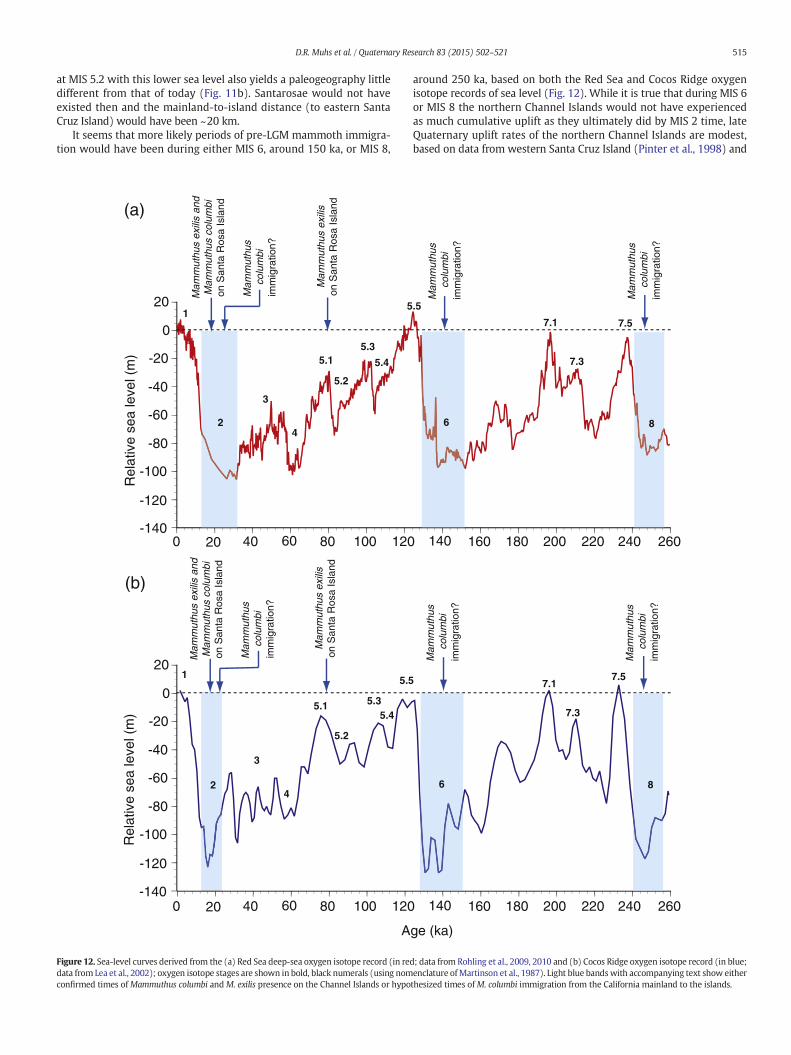
It seems that more likely periods of pre-LGM mammoth immigra-tion would have been during either MIS 6, around 150 ka, or MIS 8,
around 250 ka, based on both the Red Sea and Cocos Ridge oxygenisotope records of sea level (Fig. 12). While it is true that during MIS 6or MIS 8 the northern Channel Islands would not have experiencedas much cumulative uplift as they ultimately did by MIS 2 time, lateQuaternary uplift rates of the northern Channel Islands are modest,based on data from western Santa Cruz Island (Pinter et al., 1998) and
0 20 40 60 80 100 120 140 160 180 200 220 240 260
20
0
-20
-40
-60
-80
-100
-120
Rel
ativ
e se
a le
vel (
m)
0 20 40 60 80 100 120 140 160 180 200 220 240 260
20
0
-20
-40
-60
-80
-100
-120
Age (ka)
Rel
ativ
e se
a le
vel (
m)
-140
-140
5.5
5.15.3
7.1
7.3
7.5
3
42
1
6
Mam
mut
hus
colu
mbi
imm
igra
tion?
8M
amm
uthu
s co
lum
biim
mig
ratio
n?
Mam
mut
hus
colu
mbi
imm
igra
tion?
Mam
mut
hus
exili
s an
dM
amm
uthu
s co
lum
bion
San
ta R
osa
Isla
nd
5.2
5.4
5.5
5.1 5.3
7.1
7.3
7.5
3
42
1
6 8
5.2
5.4
Mam
mut
hus
exili
son
San
ta R
osa
Isla
nd
Mam
mut
hus
colu
mbi
imm
igra
tion?
Mam
mut
hus
colu
mbi
imm
igra
tion?
Mam
mut
hus
colu
mbi
imm
igra
tion?
Mam
mut
hus
exili
s an
dM
amm
uthu
s co
lum
bion
San
ta R
osa
Isla
nd
Mam
mut
hus
exili
son
San
ta R
osa
Isla
nd
(a)
(b)
Figure 12. Sea-level curves derived from the (a) Red Sea deep-sea oxygen isotope record (in red; data from Rohling et al., 2009, 2010 and (b) Cocos Ridge oxygen isotope record (in blue;data from Lea et al., 2002); oxygen isotope stages are shown in bold, black numerals (using nomenclature ofMartinson et al., 1987). Light blue bandswith accompanying text show eitherconfirmed times ofMammuthus columbi andM. exilis presence on the Channel Islands or hypothesized times ofM. columbi immigration from the California mainland to the islands.
515D.R. Muhs et al. / Quaternary Research 83 (2015) 502–521

San Miguel Island and Santa Rosa Island (Muhs et al., 2014a). Becausethe 2nd terrace near Cañada Garañon is likely ~120 ka (Fig. 5c;Table 2) and paleo-sea level at that time was about +6 m (Muhset al., 2002a, 2011), the shoreline angle elevation (+24 m) yields a rel-atively low uplift rate of 0.15 m/ka for this part of Santa Rosa Island.Thus, if the Red Sea and Cocos Ridge records constitute at least first-order approximations of Quaternary sea level fluctuations, and if the es-timates of modest late Quaternary uplift rates for the northern ChannelIslands are correct, the distance frommainland California to the easternend of an ancient Santarosae island during MIS 8 or MIS 6 likely wouldhave been only slightly greater than during MIS 4 or MIS 2. Marine iso-tope stage 6 corresponds to the penultimate, or Illinoian glaciation ofNorth America. During this glacial advance, the Laurentide ice sheetreached its southernmost extent in midcontinental North America(Flint, 1971), consistent with sea level being relatively low during MIS6. Ironically then, Orr's (1967) estimate of the presence of mammothson the Channel Islands since Illinoian time, although based on what isnow known to be an unreliable datingmethod, may actually be correct.
It is worth pointing out, however, that on a tectonically rising conti-nental coast adjacent to tectonically rising islands, mainland-to-islanddistances will necessarily decrease over time. Whereas uplift rates onthe northern Channel Islands are relatively low (Pinter et al., 1998;Muhs et al., 2014a), uplift rates on the mainland opposite the islandsare relatively high (Sarna-Wojcicki et al., 1987; Gurrola et al., 2014).Therefore, a terrace of a given age on themainlandwill be at a higher el-evation than a terrace of the same age on the islands (Fig. 13). Neverthe-less, in the early-to-middle Quaternary, there would have been lesscumulative uplift on both the Channel Islands and the mainland.Hence, swimming distances formammoths, even during glacial periods,would have been greater than during the LGM (Fig. 13). It is not knownwhen conditions of long-term uplift might have finally reached athreshold such that during a glacial period, the mainland-to-islanddistance was short enough that mammoths might have been temptedto make the crossing. Thus, although the work presented here indicatesthat mammoth immigration certainly preceded the LGM, and recentstudies demonstrate thatM. columbi has been in California for upwards
Interglacialterrace #1
Interglacialterrace #1
Interglacialterrace #1
Interglacialterrace #1
Interglacialterrace #2
Interglacialterrace #2
Interglacialterrace #1
Interglacialterrace #1
Interglacialterrace #2
Interglacialterrace #2
Interglacialterrace #3
Interglacialterrace #3
Interglacialterrace #1
Interglacialterrace #1
Interglacialterrace #2
Interglacialterrace #2
Interglacialterrace #3
Interglacialterrace #3
Interglacialterrace #4
Interglacialterrace #4
CHANNEL ISLANDS CALIFORNIA MAINLAND
Santa Barbara Channel
UPLIFT
UPLIFT
UPLIFT
UPLIFT
UPLIFT
UPLIFT
UPLIFT
UPLIFT
NorthSouth
Glacial period sea-level lowstand #1:
Glacial period sea-level lowstand #2:
Glacial period sea-level lowstand #3:
Last glacial period sea-level lowstand:
EA
RLY
QU
AT
ER
NA
RY
LA
TE
QU
AT
ER
NA
RY
Figure 13.Hypothetical model of uplift and sea-level control on conditions favorable for mammoth immigration to the Channel Islands frommainland California. All panels show positionof Santa Barbara Channel during glacial periods, when sea level is low; emergent marine terraces form during interglacial periods and crustal blocks on both islands and mainland expe-rience continuousuplift. Note, however, that terraces representing each interglacial period are at higher relative elevations on themainland compared to theChannel Islands because upliftrates are higher on the mainland (see Sarna-Wojcicki et al., 1987; Gurrola et al., 2014). Time progresses from lower (earliest) to upper (latest) panels; in the lower two panels (“glacialperiod sea-level low stands #1 and #2”), uplift has not proceeded long enough to bring the coasts of the islands and mainland close enough for mammoth immigration. In secondpanel from the top (“glacial period sea-level low stand #3”), uplift has finally brought the two coasts close enough for an acceptable swimming distance for mammoths. In uppermostpanel, continued uplift and last-glacial sea-level lowering has allowed the most recent mammoth immigration to the islands. For simplicity, only the past two hypothesized mammothcrossings are illustrated (MIS 2 and 6), but a mammoth crossing during MIS 8 is also possible (see Fig. 12 and discussion in text).
516 D.R. Muhs et al. / Quaternary Research 83 (2015) 502–521

of amillion years (McDaniel and Jefferson, 2006), it does not necessarilyfollow that mammoth immigrations took place during each glacial peri-od of the Quaternary. In support of this line of reasoning, repeated fieldstudies of pre-MIS 5marine terrace deposits on SanMiguel Island, SantaRosa Island, and Santa Cruz Island over the past decade have failed toyield mammoth remains.
Implications for causes of mammoth extinction
One of the most intriguing questions in the Quaternary history ofNorth America is the cause for the disappearance of large mammals,or megafauna, near the close of the Pleistocene. Among the many gen-era that became extinct at this time in North America are mammoths,with the exception of some lone survivors that date to the mid-Holocene on remote St. Paul Island in the Pribilof Islands of Alaska(Guthrie, 2004; Veltre et al., 2008). The possible causes of megafaunalextinction at the close of the Pleistocene have been hotly debated, andas the literature on this topic is voluminous, only a brief summary isgiven here. Three main mechanisms of extinction have been proposedfor North America: (1) the human arrival hypothesis (Martin, 1967,1984, 2005; Haynes, 2013; Sandom et al., 2014, and references therein),
wherein humans, newly arrived from Asia, extirpated an unwary NorthAmerican fauna; (2) the climate change hypothesis, in which the shiftfrom a glacial to an interglacial climate brought about extraordinarychanges in ecosystems such that megafaunal species were unable toadapt (Graham and Lundelius, 1984; Grayson and Meltzer, 2002, 2003and references therein); and (3) the cosmic catastrophic event hypoth-esis, where an impact or airburst of an extraterrestrial body (comet ormeteor) is thought to have brought about dramatic changes in climate,widespread fires, and demise of human (Clovis culture) and animal(megafauna) populations (Firestone et al., 2007; Kennett et al., 2008,2009). Other investigators have pointed out the possibility of a combi-nation of human-caused and climate-related causes of extinction (seediscussion in Barnosky et al., 2004). Although all three mechanismsare controversial, the extraterrestrial impact hypothesis has received asignificant amount of criticism (e.g., Daulton et al., 2010; Pinter et al.,1998, 2011; Holliday et al., 2014;Meltzer et al., 2014) and is not consid-ered further here. No attempt ismade to discuss the pros and cons of thehuman vs. climate change causes for megafaunal extinction in NorthAmerica, but some of the findings presented here have relevance tothe debate on these two causes for mammoth extinction specificallyon the Channel Islands.
IDAHOOREGON
NEVADA
UTAHCALIFORNIA
ARIZONA
114°120°MEXICO
40°
35°
P A C I F I C
O C E A N
San MiguelIsland
Santa Rosa Island
Santa Cruz Island
Anacapa Island
120°00’
34°00’
34°30’
119°00’
33°30’
KILOMETERS
0 50
Santa Barbara
Island
SanNicolas Island33°
00’
118°00’121°00’
SantaCatalina
Island
SanClemente
Island
Santa Barbara
Ventura
OxnardLos Angeles
San Pedro
San Diego
Oceanside
NewportBeach
CALIFORNIA
SANTA BARBARA CHANNEL
P A C I F I C
O C E A N
Malibu
893A
Localities with warm-water invertebrate faunas or pollen evidence of warm-climate vegetation
34°00’
San MiguelIsland
Santa CruzIsland
Santa RosaIsland
SANTA BARBARA CHANNEL
P A C I F I C
O C E A N
120°00’ 119°30’120°30’
KILOMETERS
0 25
Last interglacial(~120 ka)shorelines
Last interglacial(~120 ka)shorelines
Area shownin map
(b)
(a) (b)
(c)
Figure 14. (a) Index map of the western United States, showing the offshore area of southern California (red rectangle) where the Channel Islands are situated; (b) California ChannelIslands and adjacent areas ofmainland southern California; red dots show localitieswhere pollen and planktonic foraminiferal data (ODP Site 893A) ormarine terrace invertebrate faunaldata indicate warmer-than-present conditions during the peak of the last interglacial period (MIS 5.5, ~120 ka). (c) San Miguel Island, Santa Rosa Island, and western Santa Cruz Island,showing location of last-interglacial (MIS 5.5–120 ka)marine terrace inner edges (red lines). Data (including paleontology and chronology) for (b) are fromKanakoff and Emerson (1959);Valentine (1962); Orr (1960); Vedder and Norris (1963); Addicott (1964); Lipps et al. (1968); Kern (1977); Kennedy et al. (1982, 1992); Muhs et al. (1992, 2002a, 2010, 2012, 2014a,2014b); Heusser (1995, 2000); Kennett and Venz (1995), and Grant et al. (1999). Data for (c) are from Pinter et al. (1998) for Santa Cruz Island and Muhs et al. (2014a) for San MiguelIsland and Santa Rosa Island.
517D.R. Muhs et al. / Quaternary Research 83 (2015) 502–521

There is little question that early humans in North America huntedproboscideans. Indeed, Mammuthus and Mammut are two of the veryfew megafaunal taxa for which there is unequivocal archeological evi-dence indicating human predation, and there are at least a dozen suchsites with mammoth remains in North America (see compilations inGrayson and Meltzer, 2002, 2003). Early investigators on the ChannelIslands emphasized the association of what were interpreted to bepossible human-caused fire areas, primarily on Santa Rosa Island, andsometimes found in association with mammoth remains (Berger andOrr, 1966; Orr and Berger, 1966; Orr, 1968; Berger, 1980). However,there have been objections to the interpretation of these fire areas ashuman-caused (Wendorf, 1982; Rick et al., 2012a; Pigati et al., 2014).Orr and Berger (1966) also report mammoth remains from Santa RosaIsland that show signs of “butchering” and “battering,” although nopho-tographic evidence is offered in this study to support these interpreta-tions. Nevertheless, Agenbroad et al. (2005) point out that within thelimits of analytical uncertainty for radiocarbondating, there is potential-ly a slight temporal overlap between the youngest datedM. exilis on the
Channel Islands and the oldest (thus far) dated human bone in NorthAmerica, also from the Channel Islands.
Despite the possible temporal overlap of humans and mammoths,there is currently no direct evidence that humans hunted mammothson the Channel Islands (Rick et al., 2012b). Martin and Steadman(1999) suggest that a “commando raid” type of scenario is possible forCrete, Ireland,Wrangel Island (Siberia), and the Channel Islands,where-in stone-age hunters overrun an island, slaughter preferred prey (suchas mammoths), quickly discover they cannot sustain an existence, anddepart without leaving any archeological evidence of their visit. In addi-tion, it is important to recognize that with post-glacial sea level rise inthe latest Pleistocene/earliest Holocene, many potentially importantarcheological sites on the northern Channel Islands would now be sub-merged on what are presently the insular shelves (Clark et al., 2014;Reeder-Myers et al., 2015). Nevertheless, Rick et al. (2012b) concludedthat climate change and ecological disturbance were likely the maincauses formammothextinction on theChannel Islands. These investiga-tors also point out that with post-glacial sea level rise, one consequence
0
10
20
30
40
50
60
70
80
90
100
110
120
130
4.2 3.6 3.0 2.4
)ak(eg
A
0 20 40 60 80 0 10 20 30 40 0 10 20 30 40
δ18O (o/oo) Pinus (%) Quercus (%) Compositae (%)
1
2
3
4
5.1
5.3
5.5
6
Mammotharrivalon the ChannelIslands?
Mammothsconfirmedon the ChannelIslands
Youngestdatedmammothon the ChannelIslands
5.2
5.4
(a) (b) (c) (d)
Figure 15. Plots showing changes in (a) oxygen isotope composition in foraminifera and (b, c, d) vegetation in coastal southern California over the past ~130 ka as recorded in cores raisedfromODPHole 893A, Santa Barbara Basin (see Fig. 14b for location). (a) Glacial periods (even numbered oxygen isotope stages 2, 4, and 6 in bold), interglacial periods (shaded; odd num-bered oxygen isotope stages in bold: 1, 5.1, 5.3, 5.5), and an interstadial period (oxygen isotope stage 3 in bold), as seen in the oxygen isotope composition of benthic foraminifera;(b) abundance of pine (Pinus) pollen, a cold-climate indicator; (c) abundance of oak (Quercus) pollen, a warm-climate indicator; and (d) abundance of Compositae (=Asteraceae; “sun-flower” family) pollen (excluding Artemisia), a warm-climate indicator. Oxygen isotope data from Kennett (1995); pollen data from Heusser (1995, 2000). Also shown are times (bluelines) showing occurrence of youngest dated (calibrated radiocarbon years)mammoth on the Channel Islands (Agenbroad et al., 2005); oldest datedmammoth confirmed on the ChannelIslands (U-series age; this study); and hypothesized time of arrival of mammoths on the Channel Islands (this study).
518 D.R. Muhs et al. / Quaternary Research 83 (2015) 502–521

that could adversely affect mammoths would be the breakup ofSantarosae into four islands and overall loss of land area, a scenario re-cently modeled by Reeder-Myers et al. (2015). With post-glacialwarming, one could also add vegetation community change (Heusser,1995, 2000) and alteration of freshwater sources as stressors on mam-moth populations.
An examination of the new evidence for mammoth antiquity onthe Channel Islands, presented here, provides a partial test of the hy-pothesis presented by Rick et al. (2012b) that mammoth extinction onthe Channel Islands was due to climate change, ecological disturbance,and loss of land area. Given the findings reported here that mammothremains are at least as old as ~80 ka, it is possible to consider howglacial–interglacial climate and sea level change could have affectedmammoths in the penultimate Quaternary climate cycle. If mammothimmigration took place as early as MIS 6, ~150 ka, as discussed above,then mammoth colonization of the Channel Islands would have beenfollowed by MIS 5.5, the peak of the last interglacial complex (Fig. 12).Based on records from a number of tectonically stable coastlines, it isknown that MIS 5.5 was characterized by a paleo-sea level that was+6 m to +8 m, relative to present (Muhs et al., 2002a, 2011; Duttonand Lambeck, 2012). Thus, in MIS 5.5 time, mammoths would havebeen faced with a sea level rise more dramatic than during the LGM-to-Holocene transition. Mapping of marine terraces that date to MIS5.5 on the Channel Islands (Pinter et al., 1998; Muhs et al., 2014a)shows that the insular land area during that high-sea stand wouldhave been even more diminished than during the Holocene (Fig. 14).Nevertheless, although island break-up and land loss were more dra-matic than during the Holocene, mammoths apparently survived, atleast until MIS 5.1. Furthermore, fossil marine mollusk data, marineplanktonic data, and pollen data dating toMIS 5.5 from southern Califor-nia indicate that both marine and terrestrial environments were warm-er than present during MIS 5.5 (Fig. 14). Mammoths on the ChannelIslands apparently were able to cope with this climate change and itsassociated vegetation change (Fig. 15), even though it was at least asdramatic as that which mammoths at the Pleistocene–Holocene transi-tion had to contend with.
The long, warm interglacial period of MIS 5.5 would then have beenfollowed by the relatively cool MIS 5.4, 5.3, and 5.2 periods, requiringfurther adaptation by mammoths back to cool conditions and newchanges in vegetation communities (Heusser, 1995, 2000; see Fig. 15).Carbon and nitrogen isotopic evidence from studies of LGM and pre-LGM M. columbi from Arizona indicates that mammoths may have hada considerable adaptability for food resources, utilizing a variety ofsources not only at different points in geologic time, but seasonally, asseen in isotopic variability within individuals (Metcalfe et al., 2011).Thus, changing vegetation communities, from glacial to interglacial cli-mates, need not have been a limiting factor for mammoth survival.
Emphasis is made here that it is not proposed that either humansor an extraterrestrial impact event necessarily had to be the cause ofmammoth extinction on the Channel Islands. The point to be raisedby the foregoing discussion is simply that in order to appeal to glacial–interglacial climate change, vegetation change, and reduction of islandsize as explanations for LGM–Holocene extinction of mammoths onthe Channel Islands, one must also explain how these factors did notcause such extinctions during the previous glacial–interglacial cycle.
Conclusions
Field studies on Santa Rosa Island resulted in the discovery of a well-preserved pygmy mammoth (M. exilis) tusk in deposits of the 1st ter-race, confidently dated byU-seriesmethods on coral to ~80 ka. A secondmammoth tusk, on the other side of Santa Rosa Island, has an ageconstrained to be at least ~40 ka but less than ~120 ka, based on a com-bination of radiocarbon and U-series dating methods. The new findingspresented here establish that mammoths were present on the islandswell before the last glacial period. The presence of mammoths on the
Channel Islands at 80 ka, a time of relatively high sea level, can best beexplained bymammoth immigration (by swimming) during a previousglacial period, when sea level was low and swimming distance from themainland to the islandswasminimal. Themost likely times for such im-migrationswould have been during glacial periodsMIS 6 (~150 ka) or 8(~250 ka). These results support a previous hypothesis that mammothcolonization of the Channel Islands from mainland California couldhave taken place any time during the Quaternarywhen paleogeograph-ic conditions were favorable, not necessarily during only the last glacialperiod. Nevertheless, for mammoth immigration to have taken place,even during glacial periods, sufficient uplift of both the Channel Islandsand the California mainland must have taken place such that themainland-to-island distance was close enough to be within the swim-ming abilities of mammoths.
Finally, the results presented here challenge the hypothesisthat mammoth extinction on the Channel Islands at the Pleistocene–Holocene boundary was due to sea-level rise, loss of land area, andpost-glacial vegetation change. If mammoths reached the ChannelIslands prior to or during the penultimate glacial period (MIS 6), asthe results presented here imply, they would have faced much moredramatic sea-level rise, loss of land area, and vegetation change at thestart of the last interglacial period (MIS 5.5) compared to the beginningof the Holocene.
Acknowledgments
We dedicate this paper to the late Donald Lee Johnson (1934-2013),a great friend and pioneer in the study of mammoths on the CaliforniaChannel Islands. The study was supported by the Climate and LandUse Change Research and Development Program of the U.S. GeologicalSurvey and is a contribution to the “Geologic Records of High Sea Levels”Project. Sincere thanks go to the U.S. National Park Service, ChannelIslands National Park, and Kate Faulkner in particular, for field accessand logistical support. Mark Senning, Lulis Cuevas, Ed Smith, SarahChaney, and Dave Begun (all U.S. National Park Service) were knowl-edgeable and gracious hosts who assisted with field work during ourmany trips to Santa Rosa Island. DeAnna Laurel (Colorado State Univer-sity) assistedwith fossil collecting on Santa Rosa Island andNaomi Porat(Geological Survey of Israel) helped collectmodern snails on SanMiguelIsland. George Jefferson (Anza-Borrego Desert State Park, California)kindly offered helpful comments about the antiquity of Mammuthuscolumbi. Many thanks go to James Dines and Howell Thomas, NaturalHistory Museum of Los Angeles County, for identifying the sea otter re-mains from the mammoth-bearing marine deposit. Linda Heusser(Lamont–Doherty Earth Observatory) very kindly provided digital filesof her pollen data from Santa Barbara Basin, for which we express ourthanks. Jeff Pigati, Gene Ellis, Buddy Schweig, and Keith Lucey (all U.S.Geological Survey) made helpful comments on an earlier version ofthe manuscript, as did two anonymous reviewers and editors DavidMeltzer andDerek Booth,whichwe appreciate. Special thanks go to Jus-tinWilkins, Mammoth Site of Hot Springs, South Dakota, friend and col-league of our late co-author Larry Agenbroad. Because Larry passedaway before the final revisions to this paper were made, Justin kindlyread the entire manuscript to confirm that the ideas presented hereare consistent with what he understood Larry's thoughts to be. Anyuse of trade, product, or firm names is for descriptive purposes onlyand does not imply endorsement by the U.S. Government.
References
Addicott, W.O., 1964. Pleistocene invertebrates from the Dume terrace, western Santa MonicaMountains, California. Bulletin of the Southern California Academy of Sciences 63, 141–150.
Agenbroad, L., 1984. New World mammoth distribution. In: Martin, P., Klein, R. (Eds.), Quater-nary Extinctions: the Search for a Cause. University of Arizona Press, Tucson, pp. 90–108.
Agenbroad, L.D., 1998. New pygmy mammoth (Mammuthus exilis) localities and radiocarbondates from San Miguel, Santa Rosa, and Santa Cruz Islands, California. In: Weigand, P.(Ed.), Contributions to the Geology of the Northern Channel Islands, Southern California.
519D.R. Muhs et al. / Quaternary Research 83 (2015) 502–521

Pacific Section American Association of Petroleum Geologists, Bakersfield, California,pp. 169–175.
Agenbroad, L.D., 2001. Channel Islands (USA) pygmymammoths (Mammuthus exilis) comparedand contrasted with M. columbi, their continental ancestral stock. In: Cavarretta, G., Giolia,F., Mussi, M., Palombo, M.R. (Eds.), La Terra degli Elefanti/TheWorld of Elephants. Proceed-ings of the 1st International Congress. Consiglio Nazionale delle Ricerche, Roma,pp. 473–475.
Agenbroad, L.D., 2003. New absolute dates and comparisons for California's Mammuthus exilis.Deinsea 9, 1–16.
Agenbroad, L.D., 2005. North American proboscideans: Mammoths: the state of knowledge,2003. Quaternary International 126–128, 73–92.
Agenbroad, L.D., 2012. Giants and pygmies: mammoths of Santa Rosa Island, California (USA).Quaternary International 255, 2–8.
Agenbroad, L.D., Morris, D., Roth, L., 1999. Pygmy mammoths Mammuthus exilis from ChannelIslands National Park, California (USA). Deinsea 6, 89–102.
Agenbroad, L.D., Johnson, J.R., Morris, D., Stafford Jr., T.W., 2005. Mammoths and humans as latePleistocene contemporaries on Santa Rosa Island. In: Garcelon, D.K., Schwemm, C.A. (Eds.),Proceedings of the Sixth California Islands Symposium. Institute forWildlife Studies, Arcata,California, pp. 3–7.
Azzaroli, A., 1981. About pigmy [sic] mammoths of the northern Channel Islands and otherisland faunas. Quaternary Research 16, 423–425.
Bard, E., Hamelin, B., Fairbanks, R.G., 1990. U–Th ages obtained by mass spectrometry in coralsfrom Barbados: Sea level during the past 130,000 years. Nature 346, 456–458.
Barnosky, A.D., Koch, P.L., Feranec, R.S., Wing, S.L., Shabel, A.B., 2004. Assessing the causes of latePleistocene extinctions on the continents. Science 306, 70–75.
Berger, R., 1980. Early man on Santa Rosa Island. In: Power, D.M. (Ed.), The California Islands:Proceedings of Multidisciplinary Symposium. Santa Barbara Museum of Natural History,Santa Barbara, California, pp. 73–78.
Berger, R., Orr, P.C., 1966. The fire areas on Santa Rosa Island, II. Proceedings of the NationalAcademy of Sciences 56, 1678–1682.
Cheng, H., Edwards, R.L., Shen, C.-C., Polyak, V.J., Asmerom, Y., Woodhead, J., Hellstrom, J., Wang,Y., Kong, X., Spötl, C., Wang, X., Alexander Jr., E.C., 2013. Improvements in 230Th dating,230Th and 234Uhalf-life values, andU–Th isotopicmeasurements bymulti-collector inductivelycoupled plasma mass spectrometry. Earth and Planetary Science Letters 371–372, 82–91.
Clark, J., Mitrovica, J.X., Alder, J., 2014. Coastal paleogeography of the California–Oregon–Washington and Bering Sea continental shelves during the latest Pleistocene andHolocene:implications for the archaeological record. Journal of Archaeological Science 52, 12–23.
Cushing, J., Daily, M., Noble, E., Roth, V.L., Wenner, A., 1984. Fossil mammoths from Santa CruzIsland, California. Quaternary Research 21, 376–384.
Cutler, K.B., Edwards, R.L., Taylor, F.W., Cheng, H., Adkins, A., Gallup, C.D., Cutler, P.M., Burr, G.S.,Bloom, A.L., 2003. Rapid sea-level fall and deep-ocean temperature change since the lastinterglacial period. Earth and Planetary Science Letters 206, 253–271.
Daulton, T.L., Pinter, N., Scott, A.C., 2010. No evidence of nanodiamonds in Younger–Dryassediments to support an impact event. Proceedings of the National Academy of Sciences107, 16043–16047.
Delanghe, D., Bard, E., Hamelin, B., 2002. New TIMS constraints on the uranium-238 anduranium-234 in seawaters from the main ocean basins and the Mediterranean Sea. MarineChemistry 80, 79–93.
Dutton, A., Lambeck, K., 2012. Ice volume and sea level during the last interglacial. Science 337,216–219.
Edwards, R.L., Gallup, C.D., Cheng, H., 2003. Uranium-series dating of marine and lacustrinecarbonates. Reviews in Mineralogy and Geochemistry 52, 363–405.
Fairbanks, R.G., 1989. A 17,000-year glacio-eustatic sea level record: influence of glacial meltingon the Younger Dryas event and deep-ocean circulation. Nature 342, 637–642.
Firestone, R.B., West, A., Kennett, J.P., Becker, L., Bunch, T.E., Revay, Z.S., Schultz, P.H., Belgya, T.,Kennett, D.J., Erlandson, J.M., Dickenson, O.J., Goodyear, A.A., Harris, R.S., Howard, G.A.,Kloosterman, J.B., Lechler, P., Mayewski, P.A., Montgomery, J., Poreda, R., Darrah, T., QueHee, S.S., Smith, A.R., Stich, A., Topping, W., Wittke, J.H., Wolbach, W.S., 2007. Evidencefor an extraterrestrial impact 12,900 years ago that contributed to the megafaunal extinc-tions and Younger Dryas cooling. Proceedings of the National Academy of Sciences 104,16016–16021.
Flint, R.F., 1971. Glacial and Quaternary Geology. JohnWiley and Sons, Inc., New York (892 pp.).Gallup, C.D., Edwards, R.L., Johnson, R.G., 1994. The timing of high sea levels over the past
200,000 years. Science 263, 796–800.Graham, R.W., Lundelius Jr., E.L., 1984. Coevolutionary disequilibrium and Pleistocene extinc-
tions. In: Martin, P.S., Klein, R.G. (Eds.), Quaternary Extinctions: a Prehistoric Revolution.University of Arizona Press, Tucson, pp. 211–222.
Grant, L.B., Mueller, K.J., Gath, E.M., Cheng, H., Edwards, R.L., Munro, R., Kennedy, G.L., 1999. LateQuaternary uplift and earthquake potential of the San Joaquin Hills, southern Los AngelesBasin, California. Geology 27, 1031–1034.
Grayson, D.K., Meltzer, D.J., 2002. Clovis hunting and large mammal extinction: a critical reviewof the evidence. Journal of World Prehistory 16, 313–359.
Grayson, D.K., Meltzer, D.J., 2003. A requiem for North American overkill. Journal of Archaeolog-ical Science 30, 585–593.
Gurrola, L.D., Keller, E.A., Chen, J.H., Owen, L.A., Spencer, J.Q., 2014. Tectonic geomorphology ofmarine terraces: Santa Barbara fold belt, California. Geological Society of America Bulletin126, 219–233.
Guthrie, R.D., 2004. Radiocarbon evidence of mid-Holocene mammoths stranded on an AlaskanBering Sea island. Nature 429, 746–749.
Haynes, G., 2013. Extinctions in North America's late glacial landscapes. Quaternary Internation-al 285, 89–98.
Herridge, V.L., Lister, A.M., 2012. Extreme insular dwarfism evolved in a mammoth. Proceedingsof the Royal Society B. http://dx.doi.org/10.1098/rspb.2012.0671.
Heusser, L.E., 1995. Pollen stratigraphy and paleoecologic interpretation of the 160- k.y. recordfrom Santa Barbara Basin, Hole 893A. In: Kennett, J.P., Baldauf, J.G., Lyle, M. (Eds.), Proceed-ings of the Ocean Drilling Program. Scientific Results vol. 146. pt. 2, pp. 265–279.
Heusser, L.E., 2000. Rapid oscillations in western North America vegetation and climate duringoxygen isotope stage 5 inferred from pollen data from Santa Barbara Basin (Hole 893A).Palaeogeography, Palaeoclimatology, Palaeoecology 161, 407–421.
Holliday, V.T., Surovell, T., Meltzer, D.J., Grayson, D.K., Boslough, M., 2014. The Younger Dryasimpact hypothesis: a cosmic catastrophe. Journal of Quaternary Science 29, 515–530.
Howarth, R.J., McArthur, J.M., 1997. Statistics for strontium isotope stratigraphy: a robustLOWESSfit to themarine Sr-isotope curve for 0 to 206Ma, with look-up table for derivationof numeric age. Journal of Geology 105, 441–456.
Johnson, D.L., 1978. The origin of island mammoths and the Quaternary land bridge history ofthe northern Channel Islands, California. Quaternary Research 10, 204–225.
Johnson, D.L., 1979. Geology, soils, and erosion. In: Power, D.M. (Ed.), Natural Resources Studyof the Channel Islands National Monument, California. Santa Barbara Museum of NaturalHistory, Santa Barbara, California, pp. 3.1–3.73.
Johnson, D.L., 1980. Problems in the land vertebrate zoogeography of certain islands and theswimming powers of elephants. Journal of Biogeography 7, 383–398.
Johnson, D.L., 1981. More comments on the northern Channel Islands mammoths. QuaternaryResearch 15, 105–106.
Junger, A., Johnson, D.L., 1980. Was there a Quaternary land bridge to the northern ChannelIslands? In: Power, D.M. (Ed.), The California Islands: Proceedings of MultidisciplinarySymposium. Santa Barbara Museum of Natural History, Santa Barbara, California,pp. 33–39
Kanakoff, G.P., Emerson, W.K., 1959. Late Pleistocene invertebrates of the Newport Bay Area,California. Los Angeles County Museum Contributions in Science, no. 31 (47 pp.).
Kaufman, A., Broecker, W.S., Ku, T.-L., Thurber, D.L., 1971. The status of U-series methods of mol-lusk dating. Geochimica et Cosmochimica Acta 35, 1115–1183.
Kennedy, G.L., Lajoie, K.R., Wehmiller, J.F., 1982. Aminostratigraphy and faunal correlations oflate Quaternary marine terraces, Pacific Coast, USA. Nature 299, 545–547.
Kennedy, G.L., Wehmiller, J.F., Rockwell, T.K., 1992. Paleoecology and paleozoogeography of latePleistocene marine-terrace faunas of southwestern Santa Barbara County, California. In:Fletcher III, C.H., Wehmiller, J.F. (Eds.), Quaternary Coasts of the United States: Marineand Lacustrine Systems. SEPM (Society for Sedimentary Geology) Special Publication no.48, pp. 343–361.
Kennett, D.J., Kennett, J.P., West, G.J., Erlandson, J.M., Johnson, J.R., Hendy, I.L., West, A., Culleton,B.J., Jones, T.L., Stafford Jr., T.W., 2008. Wildfire and abrupt ecosystem disruption onCalifornia's northern Channel Islands at the Ållerød–Younger Dryas boundary (13.0–12.9 ka). Quaternary Science Reviews 27, 2530–2545.
Kennett, D.J., Kennett, J.P., West, A., West, G.J., Bunch, T.E., Culleton, B.J., Erlandson, J.M., Que Hee,S.S., Johnson, J.R., Mercer, C., Shen, F., Sellers, M., Stafford Jr., T.W., Stich, A., Weaver, J.C.,Wittke, J.H., Wolbach, W.S., 2009. Shock-synthesized hexagonal diamonds in YoungerDryas boundary sediments. Proceedings of the National Academy of Sciences 106,12623–12628.
Kennett, J.P., 1995. Latest Quaternary benthic oxygen and carbon isotope stratigraphy: hole893A. In: Kennett, J.P., Baldauf, J.G., Lyles, M. (Eds.), Proceedings of the Ocean Drilling Pro-gram. Scientific Results vol. 146. Part 2. Santa Barbara Basin, California, pp. 3–18.
Kennett, J.P., Venz, K., 1995. Late Quaternary climatically related planktonic foraminiferal assem-blage changes: Hole 893A, Santa Barbara Basin, California. In: Kennett, J.P., Baldauf, J.G.,Lyles, M. (Eds.), Proceedings of the Ocean Drilling Program, Scientific Results vol. 146,Part 2, pp. 281–293.
Kern, J.P., 1977. Origin and history of upper Pleistocene marine terraces, San Diego, California.Geological Society of America Bulletin 88, 1553–1566.
Kuzmin, Y.V., Orlova, L.A., Zolnikov, I.D., 2003. Dynamics of the mammoth (Mammuthusprimigenius) population in northern Asia: radiocarbon evidence. Deinsea 9,221–237.
Lea, D.W., Martin, P.A., Pak, D.K., Spero, H.J., 2002. Reconstructing a 350 ky history of sea levelusing planktonic Mg/Ca and oxygen isotope records from a Cocos Ridge core. QuaternaryScience Reviews 21, 283–293.
Lipps, J.E., Valentine, J.W., Mitchell, E., 1968. Pleistocene paleoecology and biostratigraphy, SantaBarbara Island, California. Journal of Paleontology 42, 291–307.
Liscaljet, N., 2012. Napakaliit trompa: new pygmy proboscidean remains from the CagayanValley (Phillipines). Quaternary International 276–277, 278–286.
Lister, A., Bahn, P., 2007. Mammoths: Giants of the Ice Age. University of California Press, Berkeley(192 pp.).
Ludwig, K.R., 2001. Users manual for Isoplot/Ex, rev. 2.49. Special Publication No. 1a. BerkeleyGeochronology Center, Berkeley, California (55 pp.).
Ludwig, K.R., Simmons, K.R., Szabo, B.J., Winograd, I.J., Landwehr, J.M., Riggs, A.C., Hoffman, R.J.,1992. Mass-spectrometric 230Th–234U–238U dating of the Devils Hole calcite vein. Science258, 284–287.
Madden, C.T., 1981. Origin(s) of mammoths from northern Channel Islands, California. QuaternaryResearch 15, 101–104.
Maglio, V.T., 1973. Origin and evolution of the Elephantidae. Transactions of the AmericanPhilosophical Society, New Series 63, 1–149.
Martin, P.S., 1967. Prehistoric overkill. In: Martin, P.S., Wright Jr., H.E. (Eds.), Pleistocene Extinc-tions: the Search for a Cause. Yale University Press, New Haven, pp. 75–120.
Martin, P.S., 1984. Prehistoric overkill: the global model. In: Martin, P.S., Klein, R.J. (Eds.),Pleistocene Extinctions: a Prehistoric Revolution. University of Arizona Press, Tucson,pp. 354–403.
Martin, P.S., 2005. Twilight of theMammoths: Ice Age Extinctions and the Rewilding of America.University of California Press, Berkeley (250 pp.).
Martin, P.S., Steadman, D.W., 1999. Prehistoric extinctions on islands and continents. In:MacPhee, R.D.E. (Ed.), Extinctions in Near Time, Causes, Contexts, and Consequences.Kluwer Academic/Plenum Publishers, New York, pp. 17–55.
Martinson, D.G., Pisias, N.G., Hays, J.D., Imbrie, J., Moore Jr., T.C., Shackleton, N.J., 1987. Age datingand the orbital theory of the ice ages: development of a high-resolution 0 to 300,000-yearchronostratigraphy. Quaternary Research 27, 1–29.
McDaniel Jr., G.E., Jefferson, G.T., 2006. Mammoths in our midst: the proboscideans of Anza-Borrego Desert State Park®, southern California, USA. Quaternary International 142–143,124–129.
Meltzer, D.J., Holliday, V.T., Cannon, M.D., Miller, D.S., 2014. Chronological evidence failsto support claim of an isochronous widespread layer of cosmic impact indicatorsdated to 12,800 years ago. Proceedings of the National Academy of Sciences 111,E2162–E2171.
Metcalfe, J.Z., Longstaffe, F.J., Ballenger, J.A.M., Haynes Jr., C.V., 2011. Isotopic paleoecology ofClovis mammoths from Arizona. Proceedings of the National Academy of Sciences 108,17916–17920.
Muhs, D.R., Miller, G.H.,Whelan, J.F., Kennedy, G.L., 1992. Aminostratigraphy and oxygen isotopestratigraphy of marine-terrace deposits, Palos Verdes Hills and San Pedro areas, Los Angeles
520 D.R. Muhs et al. / Quaternary Research 83 (2015) 502–521

County, California. In: Fletcher III, C.H., Wehmiller, J.F. (Eds.), Quaternary Coasts of theUnited States: Marine and Lacustrine Systems. SEPM (Society for Sedimentary Geology)Special Publication no. 48, pp. 363–376.
Muhs, D.R., Simmons, K.R., Kennedy, G.L., Rockwell, T.K., 2002a. The last interglacial period onthe Pacific Coast of North America: timing and paleoclimate. Geological Society ofAmerica Bulletin 114, 569–592.
Muhs, D.R., Simmons, K.R., Steinke, B., 2002b. Timing and warmth of the last interglacial period:new U-series evidence from Hawaii and Bermuda and a new fossil compilation for NorthAmerica. Quaternary Science Reviews 21, 1355–1383.
Muhs, D.R., Simmons, K.R., Kennedy, G.L., Ludwig, K.R., Groves, L.T., 2006. A cool eastern PacificOcean at the close of the last interglacial complex. Quaternary Science Reviews 25,235–262.
Muhs, D.R., Simmons, K.R., Schumann, R.R., Groves, L.T., DeVogel, S., Patterson, D., Richards, D.V.,2010. Last interglacial sea-level history on Santa Barbara and Anacapa Islands, ChannelIslands National Park, California. Geological Society of America Abstracts with Programs42 (5), 563.
Muhs, D.R., Simmons, K.R., Schumann, R.R., Halley, R.B., 2011. Sea-level history of the past twointerglacial periods: new evidence from U-series dating of reef corals from south Florida.Quaternary Science Reviews 30, 570–590.
Muhs, D.R., Simmons, K.R., Schumann, R.R., Groves, L.T., Mitrovica, J.X., Laurel, D., 2012. Sea-levelhistory during the last interglacial complex on San Nicolas Island, California: implicationsfor glacial isostatic adjustment processes, paleozoogeography and tectonics. QuaternaryScience Reviews 37, 1–25.
Muhs, D.R., Simmons, K.R., Schumann, R.R., Groves, L.T., DeVogel, S.B., Minor, S.A., Laurel, D.,2014a. Coastal tectonics on the eastern margin of the Pacific Rim: Late Quaternary sea-level history and uplift rates, Channel Islands National Park, California, USA. QuaternaryScience Reviews 105, 209–238.
Muhs, D.R., Groves, L.T., Schumann, R.R., 2014b. Interpreting the paleozoogeography and sealevel history of thermally anomalous marine terrace faunas: a case study from the last in-terglacial complex of San Clemente Island, California. Monographs of the Western NorthAmerican Naturalist 7, 82–108.
Orr, P.C., 1960. Late Pleistocene marine terraces on Santa Rosa Island, California. GeologicalSociety of America Bulletin 71, 1113–1120.
Orr, P.C., 1967. Geochronology of Santa Rosa Island, California. In: Philbrick, R.N. (Ed.), Proceed-ings of the Symposium on the Biology of the California Islands. Santa Barbara BotanicGarden, Santa Barbara, California, pp. 317–325.
Orr, P.C., 1968. Prehistory of Santa Rosa Island. Santa Barbara Museum of Natural History, SantaBarbara, California.
Orr, P.C., Berger, R., 1966. The fire areas on Santa Rosa Island, California. Proceedings of theNational Academy of Sciences 56, 1409–1416.
Palombo, M.R., 2001. Endemic elephants of the Mediterranean Islands: knowledge, problemsand perspective. In: Cavarretta, G., Giolia, F., Mussi, M., Palombo, M.R. (Eds.), La Terradegli Elefanti/The World of Elephants. Proceedings of the 1st International Congress.Consiglio Nazionale delle Ricerche, Roma, pp. 486–491.
Palombo, M.R., 2007. How can endemic proboscideans help us understand the “island rule”? Acase study of Mediterranean islands. Quaternary International 169–170, 105–124.
Palombo, M.R., Rozzi, R., 2013. Dwarfing and gigantism in Quaternary vertebrates. In: Elias, S.,Mock, C. (Eds.), Encyclopedia of Quaternary Sciences. Elsevier, Amsterdam, pp. 733–747.
Peltier, W.R., Fairbanks, R.G., 2006. Global glacial ice volume and Last Glacial Maximumdurationfrom an extended Barbados sea level record. Quaternary Science Reviews 25, 3322–3337.
Pigati, J.S., Quade, J., Wilson, J., Jull, A.J.T., Lifton, N.A., 2007. Development of low-backgroundvacuum extraction and graphitization systems for 14C dating of old (40–60 ka) samples.Quaternary International 166, 4–14.
Pigati, J.S., Rech, J.A., Nekola, J.C., 2010. Radiocarbon dating of small terrestrial gastropod shells inNorth America. Quaternary Geochronology 5, 519–532.
Pigati, J.S., McGeehin, J.P., Muhs, D.R., Bettis III, E.A., 2013. Radiocarbon dating late Quaternaryloess deposits using small terrestrial gastropod shells. Quaternary Science Reviews 76,114–128.
Pigati, J.S., McGeehin, J.P., Skipp, G.L., Muhs, D.R., 2014. Evidence of repeated wildfires prior tohuman occupation on San Nicolas Island, California. Monographs of the Western NorthAmerican Naturalist 7, 35–47.
Pinter, N., Lueddecke, S.B., Keller, E.A., Simmons, K.R., 1998. Late Quaternary slip on the SantaCruz Island fault, California. Geological Society of America Bulletin 110, 711–722.
Pinter, N., Scott, A.C., Daulton, T.L., Podoll, A., Koeberl, C., Anderson, R.S., Ishman, S.E., 2011. TheYounger Dryas impact hypothesis: a requiem. Earth-Science Reviews 106, 247–264.
Potter, E.-K., Lambeck, K., 2003. Reconciliation of sea-level observations in the Western NorthAtlantic during the last glacial cycle. Earth and Planetary Science Letters 217, 171–181.
Potter, E.-K., Esat, T.M., Schellmann, G., Radtke, U., Lambeck, K., McCulloch, M.T., 2004.Suborbital-period sea-level oscillations during marine isotope substages 5a and 5c. Earthand Planetary Science Letters 225, 191–204.
Poulakakis, N., Parmakelis, A., Lymberakis, P., Mylonas, M., Zouros, E., Reese, D.S., Glaberman, S.,Caccone, A., 2006. Ancient DNA forces reconsideration of evolutionary history of Mediterra-nean pygmy elephantids. Biology Letters 2, 451–454.
Reeder-Myers, L., Erlandson, J.M., Muhs, D.R., Rick, T.C., 2015. Sea level, paleogeography, andarcheology on California's Northern Channel Islands. Quaternary Research 83, 263–272.
Reimer, P., Bard, E., Bayliss, A., Beck, J., Blackwell, P., Ramsey, C.B., Grootes, P., Guilderson, T.,Haflidason, I., Hajdas, I., et al., 2013. IntCal13 and Marine13 radiocarbon age calibrationcurves, 0–50,000 years cal BP. Radiocarbon 55, 1869–1887.
Rick, T.C., Wah, J.S., Erlandson, J.M., 2012a. Re-evaluating the origins of late Pleistocene fire areason Santa Rosa Island, California, USA. Quaternary Research 78, 353–362.
Rick, T.C., Hofman, C.A., Braje, T.J., Maldonado, J.E., Sillett, T.S., Danchisko, K., Erlandson, J.M.,2012b. Flightless ducks, giant mice and pygmy mammoths: Late Quaternary extinctionson California's Channel Islands. World Archaeology 44, 3–20.
Rohling, E.J., Grant, K., Bolshaw, M., Roberts, A.P., Siddall, M., Hemleben, Ch., Kucera, M., 2009.Antarctic temperature and global sea level closely coupled over the past five glacial cycles.Nature Geoscience 2, 500–504.
Rohling, E.J., Braun, K., Grant, K., Kucera, M., Roberts, A.P., Siddall, M., Trommer, G., 2010.Comparison between Holocene and Marine Isotope Stage-11 sea-level histories. Earthand Planetary Science Letters 291, 97–105.
Roth, V.L., 1993. Dwarfism and variability in the Santa Rosa Island mammoth (Mammuthusexilis): an interspecific comparion of limb-bone sizes and shapes in elephants. In:Hochberg, F.G. (Ed.), Third California Islands Symposium: Recent Advances in Researchon the California Islands. Santa Barbara Museum of Natural History, Santa Barbara, California,pp. 433–442.
Sandom, C., Faurby, S., Sandel, B., Svenning, J.-C., 2014. Global late Quaternarymegafauna extinc-tions linked to humans, not climate change. Proceedings of the Royal Society B 281(20133254. http://dx.doi.org/10.1098/rspb.2013.3254).
Sarna-Wojcicki, A.M., Lajoie, K.R., Yerkes, R.F., 1987. Recurrent Holocene displacement on theJavon Canyon fault—a comparison of fault-movement history with calculated recurrenceintervals. U.S. Geological Survey Professional Paper 1339, 125–135 (Chapter 8).
Schellmann, G., Radtke, U., 2004. A revised morpho- and chronostratigraphy of the Late andMiddle Pleistocene coral reef terraces on southern Barbados (West Indies). Earth-ScienceReviews 64, 157–187.
Schwarcz, H.P., Blackwell, B.A., 1992. Archaeological applications. In: Ivanovich, M., Harmon, R.S.(Eds.), Uranium-series Disequilibrium: Applications to Earth, Marine and EnvironmentalSciences, 2nd edition Clarendon Press, Oxford, pp. 511–552.
Stuiver, M., Reimer, P.J., 1993. Extended 14C database and revised CALIB radiocarbon calibrationprogram. Radiocarbon 35, 215–230.
Takahashi, K., Chang, C.H., Cheng, Y.N., 2001. Proboscidean fossils from the Japanese Archipelagoand Taiwan islands and their relationship with the Chinese mainland. In: Cavarretta, G.,Giolia, F., Mussi, M., Palombo, M.R. (Eds.), La Terra degli Elefanti/The World of Elephants.Proceedings of the 1st International Congress. Consiglio Nazionale delle Ricerche, Roma,pp. 148–151.
Thompson,W.G., Spiegelman,M.W., Goldstein, S.L., Speed, R.C., 2003. An open-systemmodel forU-series age determinations of fossil corals. Earth and Planetary Science Letters 210,365–381.
Tikhonov, A., Agenbroad, L., Vartanyan, S., 2003. Comparative analysis of the mammoth popula-tions on Wrangel Island and the Channel Islands. Deinsea 9, 415–420.
Toscano, M.A., Lundberg, J., 1999. Submerged Late Pleistocene reefs on the tectonically-stableS.E. Florida margin: high-precision geochronology, stratigraphy, resolution of Substage 5asea-level elevation, and orbital forcing. Quaternary Science Reviews 18, 753–767.
Valentine, J.W., 1962. Pleistocene molluscan notes. 4. Older terrace faunas from Palos VerdesHills, California. Journal of Geology 70, 92–101.
Valentine, J.W., Lipps, J.H., 1967. Late Cenozoic history of the southern California Islands. In:Philbrick, R.N. (Ed.), Proceedings of the Symposium on the Biology of the California Islands.Santa Barbara Botanic Garden, Santa Barbara, California, pp. 21–35.
Vartanyan, S.L., Arslanov, K.A., Karhu, J.A., Possnert, G., Sulerzhitsky, L.D., 2008. Collection of ra-diocarbon dates on the mammoths (Mammuthus primigenius) and other genera ofWrangelIsland, northeast Siberia, Russia. Quaternary Research 70, 51–59.
Vedder, J.G., Norris, R.M., 1963. Geology of San Nicolas Island California. U.S. Geological SurveyProfessional Paper 369, 1–65.
Veltre, D.W., Yesner, D.R., Crossen, K.J., Graham, R.W., Coltrain, J.B., 2008. Patterns of faunal ex-tinction and paleoclimatic change from mid-Holocene mammoth and polar bear remains,Pribilof Islands, Alaska. Quaternary Research 70, 40–50.
Weaver, D.W., Doerner, D.P., Nolf, B., 1969. Geology of the Northern Channel Islands. AmericanAssociation of Petroleum Geologists and Society of Economic Paleontologists and Mineral-ogists, Pacific Sections, Special Publication, 200 pp., 3 geologic maps, scale 1:24,000.
Webb, S.D., Dudley, J.P., 1995. Proboscidea from the Leisey Shell Pits, Hillsborough County,Florida. Bulletin of the Florida Museum of Natural History 37 (II), 645–660.
Webb, S.D., Morgan, G.S., Hulbert Jr., R.C., Jones, D.S., MacFadden, B.J., Mueller, P.A., 1989. Geo-chronology of a rich early Pleistocene vertebrate fauna, Leisey Shell Pit, Tampa Bay, Florida.Quaternary Research 32, 96–110.
Wehmiller, J.F., Simmons, K.R., Cheng, H., Edwards, R.L., Martin-McNaughton, J., York, L.L.,Krantz, D.E., Shen, C.-C., 2004. Uranium-series coral ages from the US Atlantic CoastalPlain—the “80 ka problem” revisited. Quaternary International 120, 3–14.
Wendorf, M., 1982. The fire areas of Santa Rosa Island: an interpretation. North AmericanArchaeologist 3, 173–180.
Wenner, A.M., Johnson, D.L., 1980. Land vertebrates on the California Channel Islands: sweep-stakes or bridges? In: Power, D.M. (Ed.), The California Islands: Proceedings of Multidisci-plinary Symposium. Santa Barbara Museum of Natural History, Santa Barbara, California,pp. 497–530.
521D.R. Muhs et al. / Quaternary Research 83 (2015) 502–521