Embed Size (px)
Citation preview

Late Quaternary paleo fluvial system research of Sunda Shelf: A review
Edlic Sathiamurthy* & Md Mostafizur Rahman
School of Marine & Environmental Sciences, Universiti Malaysia Terengganu, Terengganu, Malaysia*Corresponding author email address: [email protected]
Abstract: The paleo fluvial system is considered as an essential stratigraphic attribute for climate history in the shelfal region. Regressive and subsequent lowstand conditions allowed the formation of fluvial networks on the exposed shelf that dissects previous highstand deposits. This paper reviews the research work done concerning the paleo fluvial system on the Sunda Shelf during the late Quaternary since Molengraaff (1921) first introduced the idea of the existence of paleo rivers on the submerged shelf. It was found that in general, most research work was focused on describing channel morphology, evolution, stratigraphic sequences and sedimentary facies in relation to sea level changes. Work on reconstructing channel networks is limited to areas where seismic surveys were conducted for either mining or oil and gas exploration. To date, regional reconstruction is still based on modern sea floor bathymetry. This limitation is probably the reason why there are very few research works that relate paleo fluvial systems with climate change and paleo hydrology. The question concerning the forcing agent that caused variations in paleo fluvial patterns during late Pleistocene transgression is still open.
Keywords: Sunda Shelf, paleo fluvial systems, sea level change, sequence stratigraphy, Quaternary
INTRODUCTION: SEA LEVEL CHANGE AND SHELF EXPOSURE
Sundaland is located in the Southeast Asia, where it forms a very large submerged continental shelf and mainland Asia (Hanebuth & Stattegger, 2004). The Sunda Shelf is one of the largest continental shelves in the world. The maximum width of the shelf reaches up to 800 km with present day average water depth of about 70 m (Hanebuth et al., 2002). The land area of the Sunda region was at or near its maximum about 70 ma BP (Morley, 2002). The region includes extensive shallow seas, and is not significantly elevated. It was previously assumed to have been relatively stable since the Quaternary, however with more advanced research into regional tectonics and sea level change evidences, this area was found to display heterogeneity in subsidence and uplifting (Geyh et al., 1979; Tjia, 1992; Morley, 2002; Hall et al., 2004; Hutchison, 2007; Hall, 2014; Parham, 2016). Nonetheless, the central region of the shelf could be considered as stable because it has insignificant seismicity and is devoid of volcanic activity compared to its margins (Hall, 2014). This heterogeneity implies that sea level fluctuations on the shelf were complex subjected to differential crustal movements apart from eustatic sea level changes. This effect is evident from the sea level rise records in Peninsular Malaysia and Borneo (Kamalludin, 2003; Parham, 2016). This also implies that generalized sea level curve such as proposed by Hanebuth et al. (2000 and 2011) may not be suitable for sub-regional study of paleo fluvial evolution. Nonetheless, their generalized curve is useful in giving a general overview on the effect of marine transgression at a regional scale.
Based on the perspective of a generalized regional sea level change, it could be inferred that a vast land area of the shelf was repetitively exposed during the past glacial cycles.
Lower sea levels allowed an extensive drainage system to develop on the shelf during lowstands (Stattegger et al., 1997; Voris, 2000; Reijenstein et al., 2011; Alqahtani et al., 2015; Bui et al., 2013). Repetitive exposure of the shelf triggered the emergence of an area up to 2.4 million km2 which may have important effects on climate (Pelejero et al., 1999; Sathiamurthy & Voris, 2006). A relative minor change in sea level would have caused a major lateral shift in sedimentary facies because the shelf has very low gradients (Biswas, 1973). The relation between land submergence in correspondence to sea level rise from the last glacial maximum (LGM) to present day was examined by Sathiamurthy & Voris (2006) and could be represented as in Figure 1. As sea level rose, the gradual but profound reduction of shelf area resulting from marine transgression progressively redefined river systems boundaries, modified river/valley morphologies and reorganized drainage networks developed during the lowstand. The phenomenon has become a subject of a Sunda Shelf paleo fluvial system research and is reviewed in this paper.
Figure 1: Shelf exposure and sea level from LGM to present day (adapted from Sathiamurthy &Voris, 2006).
0126-6187 / © 2017 Geological Society of Malaysia. All rights reserved.
Bulletin of the Geological Society of Malaysia, Volume 64, December 2017, pp. 81 – 92
Edlic Sathiamurthy & Md Mostafizur Rahman
Bulletin of the Geological Society of Malaysia, Volume 64, December 201782
SEA LEVEL CHANGES AND DEVELOPMENT OF PALEO FLUVIAL SYSTEMS
During the onset of sea level regressions, drainage systems dissected the exposed shelf and bypassed the sediments to the regressive delta mouth and beyond (Hanebuth & Stattegger, 2004). Paleo fluvial systems are considered as important geologic features in the stratigraphic record particularly in shelfal regions that were sub-aerially exposed during lower sea levels (Blum & Tornqvist, 2000; Blum et al., 2013). Incised valleys are large and fluvial erosive features that typically constitute a single channel system (Blum & Tornqvist, 2000; Posamentier, 2001; Blum et al., 2013; Alqahtani et al., 2015). This erosional surface is characterized by lowstand sequence boundary within the incised valleys as well as the associated floodplains and interfluves.
Incised valleys were formed on the exposed shelf during regression and lowstand conditions (Blum & Tornqvist, 2000). The river down cuts its floodplain significantly during regressive phases and subsequent lowstand conditions. Thus, the flow could not overtop the riverbank during the flood period causing the abandonment of previous active floodplains and were left as interfluves (Blum & Tornqvist, 2000; Posamentier, 2001). Incised valleys can be formed in several ways by (1) dropping of sea level or base level, (2) tectonically tilting of alluvial systems, and (3) significant reduction of fluvial discharges that form underfit channels. However, one or more of the processes can be active during the incised valley formation (Posamentier, 2001). After incision, infilling starts in the later part of the lowstand to early deglacial transgression within the valley (Blum et al., 2013). The infilling continues until the complete submergence of the shelf through deglacial sea level rise. The incision and infilling process in the exposed shelf and the response of channels within the valley system to sea level change and/or climate change depicts the paleo environmental variability.
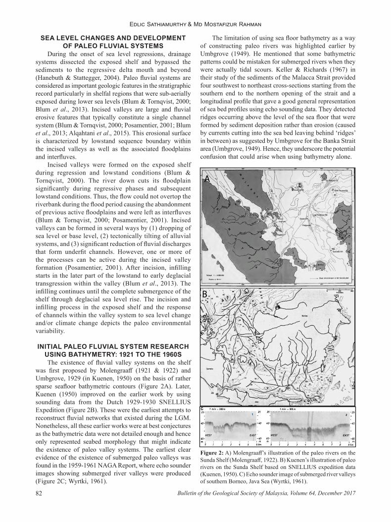
INITIAL PALEO FLUVIAL SYSTEM RESEARCH USING BATHYMETRY: 1921 TO THE 1960SThe existence of fluvial valley systems on the shelf
was first proposed by Molengraaff (1921 & 1922) and Umbgrove, 1929 (in Kuenen, 1950) on the basis of rather sparse seafloor bathymetric contours (Figure 2A). Later, Kuenen (1950) improved on the earlier work by using sounding data from the Dutch 1929-1930 SNELLIUS Expedition (Figure 2B). These were the earliest attempts to reconstruct fluvial networks that existed during the LGM. Nonetheless, all these earlier works were at best conjectures as the bathymetric data were not detailed enough and hence only represented seabed morphology that might indicate the existence of paleo valley systems. The earliest clear evidence of the existence of submerged paleo valleys was found in the 1959-1961 NAGA Report, where echo sounder images showing submerged river valleys were produced (Figure 2C; Wyrtki, 1961).
The limitation of using sea floor bathymetry as a way of constructing paleo rivers was highlighted earlier by Umbgrove (1949). He mentioned that some bathymetric patterns could be mistaken for submerged rivers when they were actually tidal scours. Keller & Richards (1967) in their study of the sediments of the Malacca Strait provided four southwest to northeast cross-sections starting from the southern end to the northern opening of the strait and a longitudinal profile that gave a good general representation of sea bed profiles using echo sounding data. They detected ridges occurring above the level of the sea floor that were formed by sediment deposition rather than erosion (caused by currents cutting into the sea bed leaving behind ‘ridges’ in between) as suggested by Umbgrove for the Banka Strait area (Umbgrove, 1949). Hence, they underscore the potential confusion that could arise when using bathymetry alone.
Figure 2: A) Molengraaff’s illustration of the paleo rivers on the Sunda Shelf (Molengraaff, 1922). B) Kuenen’s illustration of paleo rivers on the Sunda Shelf based on SNELLIUS expedition data (Kuenen, 1950). C) Echo sounder image of submerged river valleys of southern Borneo, Java Sea (Wyrtki, 1961).

Late Quaternary paleo fluvial system research of Sunda Shelf: A review
83Bulletin of the Geological Society of Malaysia, Volume 64, December 2017
UTILIZING 2D PROFILING TECHNIQUE: 1970S ONWARDS
As more advanced technology was used, techniques such as sub-bottom profiling provided clearer interpretations. Aleva et al. (1973) in their tin resource investigation work around the Bangka Islands and Karimata Islands, detected what they termed as ‘sediment gullies’ using a sub-bottom profiler. Their work was probably the earliest case where high resolution shallow seismic was used in this region based on published literature. Their profiled transect added up to 10,240 line kilometers of sub seabed. Hence, a pseudo X-Y plane view of gully patterns could be made. The infilled gullies are not submerged paleo rivers although they resembled infilled rivers. They suggested that these features were tidal scour channels as their pattern is not consistent with a river pattern.
Following earlier research done by Keller & Richards (1967), Emmel & Curray (1982) conducted a more detailed study of the Malacca Strait. Their 2D echo sounder profiles were able to detect features that suggested the existence of a fluvial-delta-fan system during shelf exposure in the late Pleistocene. Features that are associated with shelf exposure under lower sea level conditions such as a delta complex at the northern shelf margin and, incised and infilled channels that occurred in the narrow shallow part of the strait were visible. However, the profiles have low resolutions and sedimentary sequences were not shown in their work. Kudrass & Schluter (1994) in their survey of cassiterite-bearing sediments in the central parts of Malacca Strait discovered a Pleistocene river valley where placer deposits were found. Since they employed high resolution seismic profiling (Boomer), they were able to delineate sedimentary sequences separated by major erosional unconformities. Together with sediment core data, they related the sequences with sea level changes. Their upper sedimentary sequences showed details of the infilled paleo downstream section of the Pleistocene Linggi River and Malacca Estuary.
ln the South China Sea area, investigation of the paleo river system could be traced to the SONNE 24 cruise conducted in 1982 (Stattegger et al., 1997). The cruise investigated the area between Peninsular Malaysia and Sarawak along 20 N, cutting across the claimed Molengraaff River (i.e. North Sunda River). Incised valleys up to 25 m were reported. Their examination of sediments and microfossils indicated a complete early Holocene transgressive sequence covered by recent shelf sediments. About a decade later, shallow seismic surveys were done on the southwestern part of the Sunda shelf under the British Geological Survey (Evans et al. in Stattegger et al., 1997). Sparker profiles revealed Pleistocene incised valley systems with up to 50 m deep infilled channels, Holocene marine sediments cover, and sedimentary sequences. This allowed high resolution studies of the Holocene sedimentary and sea level change history. After that, the SONNE 95 cruise (1994) investigated the furthest part of the Molengraaff delta system by collecting core samples at the bottom parts of the continental slope (Sarnthein et al., 1994). However,
no shallow seismic cross sections were made for the shelf area. They developed a high resolution stratigraphy that included stable isotope stratigraphy and AMS dates for the last 40 ka for this area. The data enabled the estimation of sedimentation rates and better understanding of the paleo delta and shelf sequences. The SONNE 95 cruise was followed by the SONNE 115 cruise in 1996. Unlike previous cruises whether on the South China Sea or other parts of the shelf, SONNE 115 was focused on a detailed spatial and temporal reconstruction of the late Pleistocene-Holocene marine transgression (Stattegger et al., 1997). It is by far, the most extensive study carried out on the Sunda Shelf. It involved close examination of paleo fluvial systems evolution, using more than 8000 line kilometers of shallow seismic (employed Parasound, air-gun and Boomer systems) correlated with core samples taken within detected fluvial features. The cruise transected the Molengraaff Valley between Sarawak and Peninsular Malaysia starting from 20 N, and along the continental margin area. Analysis of seismic data showed a clear cross sectional morphology of the Molengraaff river system; incised valleys that cut into the shelf during lowstand sea levels and infilled during the subsequent transgressions; downlap surfaces interpreted as maximum flooding surfaces; and stacked upper continental slope fans indicating several regression events. This cruise produced several important works that relate sedimentary sequences with sea level changes for this region (e.g. Hanebuth et al., 2000; 2002 & 2011).
REGIONAL SCALE PALEO FLUVIAL SYSTEM RECONSTRUCTION USING BATHYMETRY:
2000 AND 2006Voris (2000) reconstructed the paleo fluvial systems for
the Sunda Shelf and part of the Sahul Shelf following the Molengraaff paleo river system. It was the first attempt after a lapse of almost 50 years since Kuenen (1950) improved on Molengraaff’s work. Voris’ construction of the paleo river system neither used high resolution modern bathymetric sounding techniques nor subsurface seismic analyses of buried fluvial systems, whereas, Sathiamurthy & Voris (2006) used a higher resolution ETOPO 2’ (2 arc minutes lateral resolution) satellite bathymetry data to propose probable submerged paleo lakes with their feeder rivers that could have existed during LGM. Based on information from the Google Scholar database, these two papers have attracted interest from mainly bio-geographers and others in related fields.
In spite of their methodological limitations, reconstructions of the paleo fluvial systems based on modern bathymetry are still well cited as demonstrated by papers published by Voris (2000), and Sathiamurthy & Voris (2006). This is interesting to note given the fact that the technology for studying the sub seabed in detail is available. The reasons for their continual acceptance could be due to the limited spatial coverage of the 2D (two dimensional) and 3D (three dimensional) seismic data and acoustic data (CHIRP, Parasound, Sparkler and Boomer), and a need for a generalized depiction of the paleo fluvial systems.

Edlic Sathiamurthy & Md Mostafizur Rahman
Bulletin of the Geological Society of Malaysia, Volume 64, December 201784
It should be noted that in many cases data are available only for areas where either mining or oil and gas exploration had been conducted and the spatial coverage is thus limited, e.g. Aleva et al. (1973), Kudrass & Schluter (1994). Mineral exploration surveys conducted by government agencies; researches done in Malay Basin, Penyu Basin and West Natuna (e.g. Miall, 2002; Alqahtani et al., 2015; Darmadi, 2005; Darmadi et al., 2007; Kiel & Wood, 2011); and others are discussed in this paper. Apart from resource exploration data, there were data on fluvial systems from cruises that focused on climate and sea level changes, e.g. SONNE cruises 24, 95, 115 and 187 (Sarthein et al., 1994; Stattegger et al., 1997; Wiesner et al., 2006), and Rahman et al. (2016).
UTILIZING 3D SEISMIC AND HIGH FREQUENCY SHALLOW 2D SEISMIC: 1990S
TO PRESENT3D seismic and high frequency seismic systems such
as CHIRP, Parasound, Sparker and Boomer were often used to study submerged paleo fluvial systems from the late 1990s onwards. High frequency systems were able to give high resolution 2D imaging but shallower penetration compared to low frequency systems e.g., 3D seismic data which give deeper penetration at the expense of resolution. The application of 3D seismic for Quaternary studies was somewhat coincidental with oil and gas exploration work. This was because seismic surveys for such exploration were concerned with much deeper older layers, i.e. earlier than Miocene. Hence, studies were limited to specific basins and sometimes the 3D data did not even cover late Quaternary layers. High frequency systems were employed in research that target Quaternary layers, e.g. SONNE cruises. The advantage of 3D seismic was its ability to give both cross-sectional and X-Y plane views. These are vital for the purpose of detecting and interpreting the paleo fluvial networks. The high frequency systems produced 2D cross-sections. While they produced high resolution data, the major setback was that survey transect lines had to be close enough in order to make meaningful interpretations of fluvial networks especially for complex areas.
Posamentier (2001) worked on the paleo incised valley systems that displayed the presence of highly incised tributary systems that existed during lowest sea level conditions (Figures 3I and 4B), and the unincised channel systems that were characterized by lowstand bypasses of the alluvial systems of the southern Java Sea that likely occurred during Miocene to late Pleistocene. The study was based on combined low frequency 3D seismic and high frequency 2D seismic data.
Miall (2002) reconstructed the architecture and sequence stratigraphy of the Pleistocene fluvial systems in the Malay Basin using time series of 3D seismic data (Figure 3C). The study neither used core data nor any vertical sections of the 3D and 2D seismic data to reconstruct the submerged fluvial systems. However, he reconstructed the various paleo fluvial systems ranging from braided channel systems to meander belts and incised valley systems with varied scales.
Hanebuth & Stattegger (2003b & 2004) reconstructed the depositional sequence along the late Pleistocene paleo North Sunda River system using data from SONNE 115 (Figures 3H and 6F). Large delta system foresets were extended basinward subsequent to sea level falling prior to the LGM. The depositional sequences included the prograding deltaic clinoforms characterized by forced regression to normal regression facies and shoreline deposits and soil formation. Transgressive deposits found confined within the valley system (overlain by a thin marine mud cover) were evidence of a rapid back stepping of shoreline during sea level rise.
Likewise, fluvial-deltaic sequence stratigraphy of Pliocene-Recent in the Muda formation in the West Natuna Basin was analyzed using 3D seismic data (Darmadi, 2005; Darmadi et al., 2007) (Figure 3E). A lower thickness of the fluvial-deltaic sequence was found. This was possibly due to its low depositional gradient and low accommodation space. Samorn (2006) reconstructed the internal fluvial morphology and geometry of late Pleistocene sequence in the Gulf of Thailand based on 3D seismic volume data (Figures 3K and 4G). The study depicted both incised and unincised valleys systems that were formed by multiple sea level falls since Pleistocene and fluvial features such as alluvial terraces, channels, neck cutoffs, and point-bars with meander scrolls.
Tjallingii et al. (2010) marked the flooding of the paleo Mekong incised valley by a sharp transition from fluvial-mud to marine dominated carbonate sand sedimentation during 9.5-8.5 ka BP. The river estuary rapidly aggradated and nearly completely filled prior to the flooding and was overlain by a transition layer and shallow marine cover. Similarly, Puchala et al. (2011) interpreted that the incised valley system that
Figure 3: Shaded elevation map of present-day Sundaland with locations of previously studied areas (1990 onwards).Note: The bathymetric elevation data interpolated from National Oceanic and Atmospheric Administration (NOAA). The block with alphabet denotes the previously studied locations. (A) Reijenstein et al., 2011, (B) Puchala et al., 2011, (C) Miall, 2002, (D) Alqahtani et al., 2015, (E) Darmadi et al., 2007, (F) Hanebuth et al., 2002, (G) Hanebuth et al., 2003a, (H) Hanebuth et al., 2004, (I) Posamentier, 2001, (J) Zhuo et al., 2015, and (K) Samorn, 2006.

Late Quaternary paleo fluvial system research of Sunda Shelf: A review
85Bulletin of the Geological Society of Malaysia, Volume 64, December 2017
Figure 4: Time slices of late Quaternary paleo fluvial system of Sunda Shelf.Note: A) 184 ms (Reijenstein et al., 2011); B) 96 ms (Posamentier, 2001); C) 96 ms (Miall, 2002); D) 108 ms (Alqahtani et al., 2015);E) 102 ms (Darmadi et al., 2007); F) 204 ms (Zhuo et al., 2015); G) 160 ms (Samorn, 2006) and H) 450 ms (Sulaiman et al., 2015).
existed in the gulf of Thailand during the last glacial cycle was formed during the regressive phase followed by estuarine and marine transgressive deposits (Figures 3B and 6G). These deposits were interrupted by the delta progradation followed by marine transgression ravinement. The timing might suggest that sea level transgression decelerated and diachronous deposition occurred during last glacial cycle (Yulianto et al., 2005; Puchala et al., 2011; Li et al., 2012). Reijenstein et al. (2011) also identified a single storey
meandering channel system confined within incised valley systems (Figures 3A, 4A and 5D) in the gulf of Thailand based on 3D and 2D seismic data for the lowstand condition within the upper ~80 m succession.
Nguyen et al. (2010) found that the initiation of Mekong River delta progradation that took place during the early Holocene (8.0-7.5) was linked with a sea level stillstand. The Holocene Mekong subaqueous delta progradation was initiated since last 3 ka and had a high rate of sediment
Edlic Sathiamurthy & Md Mostafizur Rahman
Bulletin of the Geological Society of Malaysia, Volume 64, December 201786
deposition with increased wave action (Xue et al., 2010). Additionally, Bui et al. (2013) showed the lowstand sequence boundary formed during LGM which included incised valley systems and inter-fluvial areas on the exposed shelf was followed by transgressive fluvial deposits in the valley and a thin layer of transgressive reworking deposits within the interfluves on the southern Vietnam shelf. This deposition was bounded by a ravinement surface which was underlain by a shallow marine drape. Likewise, Tjallingii et al. (2010) illustrated a rapid marine flooding marked by a sharp transition layer (ravinement surface) both in the valley system and inter fluvial areas during the last transgressive phase of the southern Vietnam shelf (Figure 6E).
Kiel & Wood (2012) correlated 3D seismic attributes with incised valley thicknesses for the recent stratigraphy of West Natuna basin. They attempted to estimate fluvial flow rates of the basin’s recent paleo rivers by constructing the 3D geometry of the paleo channels (Kiel & Wood, 2011).
This attempt was probably the first published attempt for the Sunda shelf area. Alqahtani et al. (2015) worked on the infilling process of a lowstand valley system in the Malay Basin that consisted of a confined meander channel system, and a dendritic pattern feeder incised valley system (Figures 3D, 4D and 5C). They indicated that the incised valley system belongs to the paleo Chao Praya (Siam) river system as hypothesized in earlier researches (Voris, 2000; Sathiamurthy & Voris, 2006). The study also attempted to reconstruct the paleo hydrology of the Malay Basin during late Pleistocene in terms of the probable size and boundary of paleo Chao Praya river basin, and its average discharge following the same method employed by Kiel & Wood (2011).
It should be noted, Kiel & Wood (2011) and Alqathani et al. (2015) were probably the only two attempts made so far to relate the paleo river 3D morphology with paleo discharge. Other research works had been essentially on
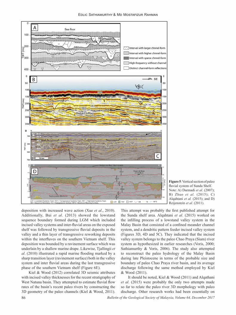
Figure 5: Vertical section of paleo fluvial system of Sunda Shelf.Note: A) Darmadi et al. (2007); B) Zhuo et al. (2015); C) Alqahtani et al. (2015); and D) Reijenstein et al. (2011).

Late Quaternary paleo fluvial system research of Sunda Shelf: A review
87Bulletin of the Geological Society of Malaysia, Volume 64, December 2017
relating sedimentary sequences and incised/infilled paleo channel features with sea level changes. Paleo river discharge estimates are fundamental to the understanding of the impact of paleo climate change on hydrology.
However, the attempts on estimating average flow rate by Kiel & Wood, and Alqathani et al. were based on a simple flow equation (i.e. Manning’s equation) that would not be suitable for large channels with complex flows. Their simplistic assumptions of hydraulic relationships like channel cross section sizes and channel slopes corresponding directly with flow rate magnitude were flawed (Chow et al., 1988). Moreover, the task of making a valid estimate by just having a channel section alone without knowing the paleo river basin rainfall-runoff relation was not possible. Unfortunately, the knowledge of the extent of paleo fluvial networks on the shelf is still very patchy (confined to areas where resource explorations were conducted) and paleo rainfall data at best are semi-quantitative estimates (Partin et al., 2007), hence both paleo river basin size and paleo rainfalls cannot be determined at present. Works done by
Molengraaff (1921), Voris (2000) and Sathiamurthy & Voris (2006) that gave a regional outlook of fluvial networks were at best educated conjectures hence not suitable for discharge estimation.
Sulaiman et al. (2015) studied the late Pleistocene fluvial evolution of Malay Basin (northeast section) and made comparative analysis of four lowstand incised valley systems found (Figure 4H). The authors claimed that the variations of fluvial patterns are caused by the sea level fluctuations under different lowstand sequences. Similarly, Zhuo et al. (2015) illustrated the fluvial patterns including trunk incised valley, medium incised valley, incised tributary, as well as unincised channel system of the northern shelf of the South China Sea that were characterized by four lowstand during middle and late Pleistocene using 3D seismic data (Figures 3J, 4F and 5B).
Paleo valley/channels pattern studies based on 3D seismic data in the Sunda shelf region showed similar fluvial architecture and morphology. In general, the studies agreed that the lowstand fluvial systems were generally wider,
Figure 6: Shallow seismic profiles depicting the buried paleo fluvial system.Note: A) Bui et al. (2013);B) Tjallingii et al., 2010;C) Posamentier (2001);D) Hanebuth et al. (2003a);E) Tjallingii et al. (2014);F) Hanebuth & Stattegger (2004); and G) Puchala et al. (2011).

Edlic Sathiamurthy & Md Mostafizur Rahman
Bulletin of the Geological Society of Malaysia, Volume 64, December 201788
deeper with lower sinuosity associated with braided to meander channel systems characterized by the presence of signatory deep incised tributary systems. Most of the studies concentrated on the fluvial systems of the Pleistocene which most likely occurred during different lowstand cycles. Since the magnitude, frequency and duration of different lowstand conditions were not similar; therefore, the fluvial systems were likely to vary throughout the Pleistocene. In addition, the late Pleistocene-Holocene succession also showed a more or less similar depositional pattern as revealed from the dating of sediment cores from different locations on the Sunda Shelf (Figure 7).
Rahman et al. (2016) published their work on paleo fluvial architecture and morphology for Penyu Basin using high-resolution two-dimensional (2D) CHIRP profiles. Their survey was probably the first extensive shallow seismic profiling done in this basin with 780 line kilometers of transect. The survey was conducted in 2009. Paleo channels (probably submerged and infilled sections of paleo Pahang River) with sedimentary sequences similar to SONNE 115 and Evans et al. (in Stattegger et al., 1997) findings at
almost the same water depth were detected (Figure 8). This suggests that the region between Sarawak and Peninsular Malaysia and offshore of Pahang might share similar fluvial responses to sea level changes in the late Quaternary. It is worth considering the possibility of reconstructing the paleo Siam River in a comparative study with the North Sunda river system with data from work done by Rahman et al. (2016), Alqahtani et al. (2015), Darmadi (2005) and SONNE 115. It should be noted that Malay, Penyu and West Natuna basins shared boundaries that defined the pathway of the paleo Siam River (Madon & Watts, 1998).
Alqahtani et al. (2017) further expand their analysis of Malay basin fluvial systems in their latest work. They identified six channel types based on seismic expressions, sinuosity variations and depths within a stratigraphic succession. They found that the vertical changes in channel types were systematic through eight depositional units they had examined: i.e. from relatively deep, wide, very low to low-sinuosity channels or large incised valleys at the lower depositional units to relatively shallow, narrow, highly sinuous channels with well-developed point-bar deposits dominating the upper units. Towards the top unit, the highly sinuous channels become less sinuous with minimal or no point-bar deposits. Climate driven fluvial discharges and sediment supply changes and sea level changes were identified as the main factors that caused the changes.
DRIVING FORCES OF FLUVIAL CHANGESIt is still debatable as to what forcing agents caused the
paleo fluvial pattern variations during the last transgressive phase of the late Pleistocene (Darmadi et al., 2007; Reijenstein et al., 2011; Miall, 2014; Zhuo et al., 2015; Alqahtani et al., 2017). The main driving component could be divided into three basic components. First is the upstream control that could be characterized by tectonic tilting in the upstream catchment as well as sediment supply and fluvial discharge which were controlled by climatic variability. Second is the mid basin control that was associated with vegetation cover, active tectonics and tributary systems. Third is the downstream control that was also associated with climate-induced sea level changes which were related to orbital forcing mechanism (Posamentier, 2001; Miall, 2002; 2006; Reijenstein et al., 2011; Miall, 2014; Zhuo et al., 2015). Some authors argued in the support of a downstream role that controlled the valley incisions starting from regression until lowstand stages of a eustatic glacial cycle (Dalrymple & Zaitlin, 1994; Darmadi, 2005; Dalrymple & Choi, 2007). However, Posamentier (2001) disagreed and made an assumption that incised valley systems could form after reaching the lowstand condition that was characterized by maximum exposure of the shelf as sea level fell below the shelf-edge. Darmadi (2005) claimed the sea level changes triggered the fluvial changes, while Darmadi et al. (2007) argued for paleo fluvial changes caused by the fluvial discharge and sediment supply and accommodation space. Other authors also argued on the upstream forcing factor, i.e., climate-induced variations in sediment supply and
Figure 7: Comparison of litho-log data of Sunda Shelf region.Note: Reijenstein et al., 2011 in Gulf of Thailand, Posamentier, 2001 at Southern Java sea shelf, Alqahtani et al., 2015 at Malay Basin, Hanebuth & Stattegger, 2004 near to the Natuna island, SCS, Zhuo et al., 2015 at northern South China Sea, Tjallingii et al., 2010 at Offshore, Puchala et al., 2011 at Gulf of Thailand, Mekong River.

Late Quaternary paleo fluvial system research of Sunda Shelf: A review
89Bulletin of the Geological Society of Malaysia, Volume 64, December 2017
fluvial discharge rates (Blum & Törnqvist, 2000; Darmadi et al., 2007; Zhuo et al., 2015). However, the driving force that triggered the paleo fluvial change was very difficult to verify without independent high resolution geochronological data (Blum et al., 2013).
Some researchers suggested the basinward locale that is the fluvial incision was influenced by downstream controls, i.e., the sea level fluctuations, while in the landward regions, tectonic anomaly and climate-induced changes in fluvial discharge and sediment supply might influence the fluvial incision (Posamentier & Allen, 1999; Miall, 2002; Darmadi et al., 2007; Reijenstein et al., 2011; Zhuo et al., 2015). However, Posamentier (2001) and Darmadi et al. (2007) gave importance to the distance to the shelf-break or shoreline which had been considered as a significant parameter to characterize the forcing mechanism. Miall (2002) suggested very strong sea level influences since his project area was far from the shelf-break. However, the fluvial system in a particular area is marked by the upstream condition during lower sea level which in turn might convert into the downstream condition as the shoreline migrates landward during the transgressive cycle, with the reverse scenario for the basinward migration of shoreline during the regressive cycle. Apart from eustatic sea
level variability, shelf physiography such as shelf widths and shelf gradients also could play significant roles to control the fluvial systems in morphology, sinuosity, width/depth ratios and rates of knick point migrations. Moreover, topographic relief could also control channel sinuosity and frequency and the scale of channel avulsion.
Previously, the Sunda Shelf was thought to be relatively stable since the Quaternary, hence tectonics was assumed to be not a major force of fluvial pattern variations (Geyh et al., 1979; Tjia, 1992). However, later studies have shown that there is heterogeneity in tectonic activities (Hall & Morley, 2004; Hall, 2014). Hence, this has made fluvial pattern variations more complicated to explain.
Other climatic changes through geologic time were considered as having a minimal effect (Kienast et al., 2001; Mohtadi et al., 2010; Linsley et al., 2010; Van der Kaars & Dam, 1995; Wang et al., 1999; Sun et al., 2000; Wang et al., 2009; Partin et al., 2007; Griffiths et al., 2009). Both upstream and downstream forcing could have been the causes that shaped the deglacial fluvial pattern during the last glacial cycle. Deglacial climate was slightly warmer than the LGM which suggest an increase in average precipitation, vegetation growth, and fluvial discharge (Van der Kaars,
Figure 8: An incised valley system in Penyu basin (Rahman et al., 2016).Note: Insert map is showing the survey transect and location of the profile.
Edlic Sathiamurthy & Md Mostafizur Rahman
Bulletin of the Geological Society of Malaysia, Volume 64, December 201790
1995; Wang et al., 1999; Sun et al., 2000; Partin et al., 2007; Wang et al., 2009). These climatic changes might also have changed the weathering and erosional activities which, in turn, also might have modified the sediment supplies (Leeder et al., 1998).
CONCLUSIONSea level fluctuations and/or climatic changes had
triggered changes in the fluvial systems on the Sunda shelf throughout geological time. In general, sea level falls caused the exposure of the shelf that favored the drainage to form following the shoreline and also triggered the incision of previously deposited successions. However, both incised and unincised valley systems were dominant in the Sunda shelf region. Later, sea level transgressions triggered the infilling process within the valley systems following the backstepping shorelines and eventually the fluvial systems were submerged. The Sunda shelf was characterized by its vast lateral extension, very low gradient and high sediment supply due to its extreme catchment size. Thus, the paleo fluvial incisions and infilling systems were nearly always well preserved. However, 3D seismic data and high resolution seafloor bathymetric data coverage are still limited to areas of economic prospect. Therefore there is a need for extensive high resolution seismic data to reconstruct the paleo fluvial systems and their response to repetitive exposures and submergences. Furthermore, there is a ‘new’ frontier to explore which is to relate the paleo fluvial systems with paleo hydrology in order to grasp the impact of climate change on hydrology. This is probably going to be one of the most challenging aspects of paleo fluvial system research in this region.
ACKNOWLEDGEMENTThe authors would like to thank the Ministry of Higher
Education, Malaysia, for funding their research work under FRGS 59332. We also thank Kong Yee Hui for her help.
REFERENCESAleva, G.J.J., Bon, E.H., Nossin, J.J. & Sluiter, W.J., 1973. A
contribution to the geology of part of the Indonesian tin belt: the sea areas between Singkep and Bangka Islands and around the Karimata Islands. Bulletin of the Geological Society of Malaysia, 6, 257-271.
Alqahtani, F.A., Johnson, H.D., Jackson, C.A.L. & Som, M.R.B., 2015. Nature, origin and evolution of a late Pleistocene incised valley-fill, Sunda Shelf, Southeast Asia. Sedimentology, 62(4), 1198–1232.
Alqahtani, F.A., Jackson, C.A.L., Johnson, H.D. & Som, M.R.B., 2017. Controls on the geometry and evolution of humid-tropical fluvial systems: insights from 3D seismic geomorphological analysis of the Malay Basin, Sunda Shelf, Southeast Asia. Journal of Sedimentary Research, 87, 17-40.
Biswas, B., 1973. Quaternary changes in sea-level in South China Sea. Bulletin of the Geological Society of Malaysia, 6, 229-256.
Blum, M.D. & Törnqvist, T.E., 2000. Fluvial responses to climate and sea‐level change: a review and look forward. Sedimentology, 47(S1), 2-48.
Blum, M., Martin, J., Milliken, K. & Garvin, M., 2013. Paleovalley
systems: Insights from Quaternary analogs and experiments. Earth-Science Reviews, 116(1), 128–169.
Bui, V.D., Stattegger, K., Thanh, N.T., Van Phach, P., Dung, T.T. & Thong, B.X., 2014. Late Pleistocene–Holocene seismic stratigraphy of Nha Trang shelf, central Vietnam. Marine and Petroleum Geology, 58, 789-800.
Bui, V.D., Stattegger, K., Unverricht, D., Phach, P. Van & Thanh, N.T., 2013. Late Pleistocene-Holocene seismic stratigraphy of the Southeast Vietnam Shelf. Global and Planetary Change, 110 (November 2015), 156–169.
Chow, V.T., Maidment, D.R. & Mays, L.W., 1988. Applied hydrology. McGraw Hill.
Dalrymple, G.B., 1994. The age of the Earth. Stanford University Press.
Dalrymple, R.W. & Zaitlin, B.A., 1994. High‐resolution sequence stratigraphy of a complex, incised valley succession, Cobequid Bay—Salmon River estuary, Bay of Fundy, Canada. Sedimentology, 41(6), 1069-1091.
Dalrymple, R.W. & Choi, K., 2007. Morphologic and facies trends through the fluvial-marine transition in tide-dominated depositional systems: A schematic framework for environmental and sequence-stratigraphic interpretation. Earth-Science Reviews, 81(3-4), 135–174.
Darmadi, Y., 2005. Three-dimensional fluvial-deltaic sequence stratigraphy Pliocene-Recent Muda Formation, Belida field, West Natuna Basin, Indonesia: PhD thesis, Texas A&M University.
Darmadi, Y., Willis, B.J. & Dorobek, S.L., 2007. Three-dimensional seismic architecture of fluvial sequences on the low-gradient Sunda Shelf, offshore Indonesia. Journal of Sedimentary Research, 77(3), 225–238.
Emmel, F.J. & Curray, J.R., 1982. A submerged late Pleistocene delta and other features related to sea level changes in the Malacca Strait. Marine Geology, 47, 197-216.
Geyh, M.A., Kudrass, H.R. & Streif, H., 1979. Sea-level changes during the late Pleistocene and Holocene in the Strait of Malacca. Nature, 278, 441–443.
Griffiths, M.L., Drysdale, R.N., Gagan, M.K., Zhao, J.X., Ayliffe, L.K., Hellstrom, J.C. & Pierre, E.S., 2009. Increasing Australian–Indonesian monsoon rainfall linked to early Holocene sea-level rise. Nature Geoscience, 2(9), 636-639.
Hall, R. & Morley, C.K., 2004. Sundaland basins. In: Clift, P., Kuhnt, W., Wang, P. & Hayes, D. (Eds.), Continent-ocean interactions within East Asian marginal seas. American. Washington DC Geophysical Union Geophysical Monograph Series, 149, 55-85.
Hall, R., 2014. The origin of Sundaland. Procedings of Sundaland Resources 2014. MGEI Annual Convention, 17-18 November 2014, Palembang, South Sumatra, Indonesia.
Hanebuth, T., Stattegger, K. & Grootes, P.M., 2000. Rapid flooding of the Sunda Shelf: a late-glacial sea-level record. Science, 288, 1033-1035.
Hanebuth, T.J.J., Stattegger, K. & Saito, Y., 2002. The stratigraphic architecture of the central Sunda Shelf (SE Asia) recorded by shallow-seismic surveying. Geo-Marine Letters, 22(2), 86–94.
Hanebuth, T.J.J., Stattegger, K., Schimanski, A., Lüdmann, T. & Wong, H.K., 2003a. Late Pleistocene forced-regressive deposits on the Sunda Shelf (Southeast Asia). Marine Geology, 199(1), 139-157.
Hanebuth, T.J.J. & Stattegger, K., 2003b. The stratigraphic evolution of the Sunda Shelf during the past fifty thousand years. Tropical Deltas of Southeast Asia-Sedimentology, Stratigraphy, and Petroleum Geology, 1(1), 189.
Hanebuth, T.J.J. & Stattegger, K., 2004. Depositional sequences on
Late Quaternary paleo fluvial system research of Sunda Shelf: A review
91Bulletin of the Geological Society of Malaysia, Volume 64, December 2017
a late Pleistocene-Holocene tropical siliciclastic shelf (Sunda Shelf, Southeast Asia). Journal of Asian Earth Sciences, 23(1), 113–126.
Hanebuth, T.J.J., Saito, Y., Tanabe, S., Vu, Q.L. & Ngo, Q.T., 2006. Sea levels during late marine isotope stage 3 (or older?) reported from the Red River delta (northern Vietnam) and adjacent regions. Quaternary International, 145-146, 119–134.
Hanebuth, T.J.J., Voris, H.K., Yokoyama, Y., Saito, Y. & Okuno, J.I., 2011. Formation and fate of sedimentary depocentres on Southeast Asia’s Sunda Shelf over the past sea-level cycle and biogeographic implications. Earth-Science Reviews, 104(1), 92-110.
Hutchison, C.S., 2007. Geological evolution of South-East Asia (2nd Ed.). Geological Society of Malaysia, Kuala Lumpur.
Kamaludin, H., 2003. Mid-Holocene to recent sea level changes in Peninsular Malaysia: A tectonic implication. Geological Soc. Malaysia, 46, 313-318.
Keller, G.H. & Richards, A.F., 1967. Sediments of Malacca Strait, Southeast Asia. Journal of Sedimentary Petrology, 37(1), 102-127.
Kiel, B.A. & Wood, L.J., 2011.Three dimensionality, longitudinal profile setting, and paleo discharge capacity of incised valleys in recent stratigraphy of the Sunda Shelf, Indonesia. Zeitschrift fur Geomorphologie, 55(4), 475-491.
Kiel, B.A. & Wood, L.J., 2012. Seismic attributes correlated with incised valley thickness in recent stratigraphy of the Sunda Shelf, Indonesia. Zeitschrift für Geomorphologie, 56(4), 507-524.
Kienast, M., Steinke, S., Stattegger, K. & Calvert, S.E., 2001. Synchronous tropical South China Sea SST change and Greenland warming during deglaciation. Science, 291(5511), 2132-2134.
Kudrass, H.R. & Schluter, H.U., 1994. Development of cassiterite-bearing sediments and their relation to late Pleistocene sea-level changes in the Straits of Malacca. Marine Geology, 120, 175-202.
Kuenen, P.H., 1950. Marine Geology. John Wiley & Sons, Inc., New York.
Leeder, M.R., Harris, T. & Kirkby, M.J., 1998. Sediment supply and climate change: implications for basin stratigraphy. Basin Research, 10(1), 7-18.
Li, Z., Saito, Y., Mao, L., Tamura, T., Song, B., Zhang, Y. & Li, J., 2012. Mid-Holocene mangrove succession and its response to sea-level change in the upper Mekong River delta, Cambodia. Quaternary Research, 78(2), 386-399.
Linsley, B.K., Rosenthal, Y. & Oppo, D.W., 2010. Holocene evolution of the Indonesian throughflow and the western Pacific warm pool. Nature Geoscience, 3(8), 578-583.
Madon, M.B. & Watts, A.B., 1998. Gravity anomalies, subsidence history and the tectonic evolution of the Malay and Penyu Basins (offshore Peninsular Malaysia). Basin Research, 10(4), 75-392.
Mat Isa, Z., Richards, F.W. & Yunus, H., 1992. Integration of 3-D and site survey seismic data in analysis of near-surface hazards to platform location at Dulang Field, Malay Basin. Bulletin of the Geological Society of Malaysia, 32, 165-184.
Miall, A.D., 2002. Architecture and sequence stratigraphy of Pleistocene fluvial systems in the Malay Basin, based on seismic time-slice analysis. AAPG Bulletin, 86(7).
Miall, A.D., 2006. How do we identify big rivers? And how big is big? Sedimentary Geology, 186(1), 39-50.
Miall, A.D., 2014. The facies and architecture of fluvial systems. In: Fluvial Depositional Systems (9-68). Springer International Publishing.
Mohtadi, M., Steinke, S., Lückge, A., Groeneveld, J. & Hathorne, E.C., 2010. Glacial to Holocene surface hydrography of the tropical eastern Indian Ocean. Earth and Planetary Science Letters, 292(1-2), 89–97.
Molengraaff, G.A.F., 1921. Modern deep-sea research in the East Indian Archipelago. The Geographical Journal, 57(2), 95-118.
Molengraaff, G.A.F., 1922. Geologie. In: De Zeeën Van Nederlandsch Oost-Indië, het Koninklijk Nederlandsch Aardrijkskundig Genootschap, Lieden.
Morley, C.K., 2002. A tectonic model for the Tertiary evolution of strike–slip faults and rift basins in SE Asia. Tectonophysics, 347(4), 189-215.
Nguyen, V.L., Ta, T.K.O. & Saito, Y., 2010. Early Holocene initiation of the Mekong River delta, Vietnam, and the response to Holocene sea-level changes detected from DT1 core analyses. Sedimentary Geology, 230(3), 146-155.
Parham, P.R., 2016. Late Cenozoic relative sea-level highstand record from Peninsular Malaysia and Malaysian Borneo: Implications for vertical crustal movements. Bulletin of the Geological Society of Malaysia, 62, 91-115.
Partin, J.W., Cobb, K.M., Adkins, J.F., Clark, B. & Fernandez, D. P., 2007. Millennial-scale trends in west Pacific warm pool hydrology since the Last Glacial Maximum. Nature, 449(7161), 452-455.
Pelejero, C., Kienast, M., Wang, L. & Grimalt, J.O., 1999. The flooding of Sundaland during the last deglaciation: imprints in hemipelagic sediments from the southern South China Sea. Earth and Planetary Science Letters, 171(4), 661-671.
Posamentier, H.W., 2001. Lowstand alluvial bypass systems: incised vs. unincised. AAPG Bulletin, 85(10), 1771-1793.
Posamentier, H.W. & Allen, G.P., 1999. Siliciclastic sequence stratigraphy: concepts and applications (Vol. 7). Tulsa: SEPM (Society for Sedimentary Geology).
Puchala, R.J., Porębski, S.J., Śliwiński, W.R. & August, C.J., 2011. Pleistocene to Holocene transition in the central basin of the Gulf of Thailand, based on geoacoustic survey and radiocarbon ages. Marine Geology, 288(1), 103-111.
Rahman, M.M., Sathiamurthy, E., Zhong, G., Geng, J. & Liu, Z., 2016. CHIRP acoustic characterization of paleo fluvial system of Late-Pleistocene to Holocene in Penyu Basin, Sunda Shelf. Bulletin of the Geological Society of Malaysia, 62, 47-56.
Reijenstein, H.M., Posamentier, H.W. & Bhattacharya, J.P., 2011. Seismic geomorphology and high-resolution seismic stratigraphy of inner-shelf fluvial, estuarine, deltaic, and marine sequences, Gulf of Thailand. AAPG Bulletin, 95(11), 1959-1990.
Samorn, A., 2006. Fluvial reservoir architecture from near surface 3D seismic data. Block B8/32, Gulf of Thailand: MS thesis, Colorado School of Mines, Golden.
Sarthein, M., Pflaumann, U., Wang, P.X. & Wong, H.K., 1994. Preliminary report on the SONNE-95 cruise “Monitor Monsoon” to the South China Sea. Kiel University, Kiel.
Sathiamurthy, E. & Voris, H.K., 2006. Maps of Holocene sea level transgression and submerged lakes on the Sunda Shelf. The Natural History Journal of Chulalongkorn University, Supplement, 2, 1-43.
Stattegger, K., Kuhnt, W. & Wong, H.K., 1997. Cruise Report SONNE 115 SUNDAFLUT. Sequenzstratigraphie, spätpleistozän–holozäne Meeresspiegelschwankungen und hochauflösende Rekonstruktion der postpleistozänen Transgression am Sunda Schelf. Ber.-Rep., Geol.-Palaeontol. Inst. Univ. Kiel, 86, 1-211.
Sulaiman, N., Hamzah, U. & Samsudin, A.R., 2015. 3D seismic geomorphology analysis and evolution of fluvial systems in

Edlic Sathiamurthy & Md Mostafizur Rahman
Bulletin of the Geological Society of Malaysia, Volume 64, December 201792
Manuscript received 11 December 2016Revised manuscript received 26 July 2017
Manuscript accepted 30 August 2017
the Northeast Malay Basin. Electronic Journal of Geotechnical Engineering, 20(27), 13285-13307.
Sun, X., Li, X., Luo, Y. & Chen, X., 2000. The vegetation and climate at the last glaciation on the emerged continental shelf of the South China Sea. Palaeogeography, Palaeoclimatology, Palaeoecology, 160(3), 301-316.
Tjallingii, R., Stattegger, K., Stocchi, P., Saito, Y. & Wetzel, A., 2014. Rapid flooding of the southern Vietnam shelf during the early to mid‐Holocene. Journal of Quaternary Science, 29(6), 581-588.
Tjallingii, R., Stattegger, K., Wetzel, A. & Phach, P. Van, 2010. In filling and flooding of the Mekong River incised valley during deglacial sea-level rise. Quaternary Science Reviews, 29(11-12), 1432–1444.
Tjia, H.D., 1992. Holocene sea-level changes in the Malay-Thai Peninsula, a tectonically stable environment. Bulletin of the Geological Society of Malaysia, 31, 157-176.
Umbgrove, J.H.F., 1949. Structural history of the East Indies. Cambridge University Press, London.
Van der Kaars, W.A. & Dam, M.A.C., 1995. A 135,000-year record of vegetational and climatic change from the Bandung area, West-Java, Indonesia. Palaeogeography, Palaeoclimatology, Palaeoecology, 117(1-2), 55-72.
Voris, H.K., 2000. Maps of Pleistocene sea levels in Southeast Asia: shorelines, river systems and time durations. Journal of Biogeography, 27(5), 1153-1167.
Wang, L., Sarnthein, M., Erlenkeuser, H., Grimalt, J., Grootes, P.,
Heilig, S. & Pflaumann, U., 1999. East Asian monsoon climate during the Late Pleistocene: high-resolution sediment records from the South China Sea. Marine Geology, 156(1), 245-284.
Wang, X., Sun, X., Wang, P. & Stattegger, K., 2009. Vegetation on the Sunda Shelf, South China Sea, during the Last Glacial Maximum. Palaeogeography, Palaeoclimatology, Palaeoecology, 278(1-4), 88–97.
Wiesner, M.G., Stattegger, K., Vob, M., Schwarzer, K. & Pohlmann, T., 2006. Cruise Report RV SONNE 187 Vietnam. Kiel University, Kiel.
Wyrtki, K., 1961. NAGA Report Volume II: Physical Oceanography of the Southeast Asian Waters. Scripps Institution of Oceanography, 8–10.
Xue, Z., Liu, J.P., DeMaster, D., Van Nguyen, L. & Ta, T.K.O., 2010. Late Holocene evolution of the Mekong subaqueous delta, southern Vietnam. Marine Geology, 269(1), 46-60.
Yulianto, E., Rahardjo, A.T., Noeradi, D., Siregar, D.A. & Hirakawa, K., 2005. A Holocene pollen record of vegetation and coastal environmental changes in the coastal swamp forest at Batulicin, South Kalimantan, Indonesia. Journal of Asian Earth Sciences, 25(1), 1-8.
Zhuo, H., Wang, Y., Shi, H., He, M., Chen, W., Li, H. & Yan, W., 2015. Contrasting fluvial styles across the mid-Pleistocene climate transition in the northern shelf of the South China Sea: Evidence from 3D seismic data. Quaternary Science Reviews, 129, 128-146.