Embed Size (px)
Citation preview
LATE QUATERNARY GEOLOGY AND GEOMORPHOLOGY OF THE CHILLIWACK
RIVER VALLEY, BRITISH COLUMBIA
Ian Robert Saunders
B.Sc., University of East Anglia, 1981
THESIS SUBMITTED IN PARTIAL FULFILLMENT OF
THE REQUIREMENTS FOR THE DEGREE OF
MASTER OF SCIENCE
in the Department
of
Geography
@ IanRobertSaunders 1985
SIMON FRASER UNIVERSITY
February, 1985
All rights reserved. This work map not be reproduced in whole or in part, by photocopy
or other means, without permission of the author.
Xame :
Degree:
T i t l e of Thes i s :
E x a m i n b g Committee:
Chairman :
APPROVAL
Ian Rober t Saunders
Master of S c i e n c e
La te Quaternary Geology and Geomorphology of t h e Chi l l iwack River Val ley , B r i t i s h Columbia
A . C . B . Roberts
M.C. Roberts Senior Superv isor . .
E.J. Hickin
A W.G. t3adey
/'
J. J. j ~ l a p e Resqarc l S c ' e n t i s t Ex tyma Examiner
G e o l o g i c ~ l Survey of Canada 100 West Pender S t r e e t
Vancouver, B.C.
Date Approved: 21st February, 1985
PARTIAL COPYRIGHT LICENSE
I hereby g r a n t t o Simon Fraser U n i v e r s i t y t he r i g h t t o lend
my t h e s i s , p r o j e c t o r extended essay ( t h e t i t l e o f which i s shown below)
t o users o f t h e Simon Fraser U n i v e r s i t y L i b r a r y , and t o make p a r t i a l o r
s i n g l e cop ies o n l y f o r such users o r i n response t o a reques t f rom t h e
l i b r a r y o f any o t h e r u n i v e r s i t y , o r o t h e r educa t iona l i n s t i t u t i o n , on
i t s own beha l f o r f o r one o f i t s users. I f u r t h e r agree t h a t permiss ion
f o r m u l t i p l e copy ing o f t h i s work f o r s c h o l a r l y purposes may be granted
by me o r t h e Dean o f Graduate Stud ies. I t i s understood t h a t copy ing
o r p u b l i c a t i o n o f t h i s work f o r f i n a n c i a l g a i n s h a l l no t be a l lowed
w i t h o u t my w r i t t e n permiss ion.
T i t l e o f Thes is /Pro ject /Extended Essay
Late Quaternary Geology and Geomorphology of t h e Chi l l iwack
River Val ley , B r i t i s h Columbia
Author:
( s i g n a t u r e )
I a n Robert Saunders
( name 1
21s t February, 1985.
( da te )
ABSTRACT
The aims of this research were threefold:
(i) to map the geomorphology and the surficial geology,
(ii) to interpret the sedimentary paleoenvironments, and
( i i i ) to establish a comprehensive geochronology.
Ten depositional terrain units were recognized, twelve measured
sections were documented and three new radiocarbon dates were
obtained.
The oldest dated feature in the valley is a sandur
constructed by the Chilliwack Valley glacier at the onset of the
Fraser Glaciation, at about 21-22,000 BP. Subsequently, the
mouth of the valley was blocked by advancing ice in the Fraser
Valley, and a glacial lake formed. Clays deposited in this lake
have an age of 20,190+1000 - BP (SFU-406). The Fraser Valley ice
flowed into the lower Chilliwack Valley for much of the last
glaciation, depositing a thick till unit which underlies the
Ryder Upland. Wood from the centre of this unit was dated at
15,610+130 - BP (BETA-11057).
During late Fraser times, ca. 11-12,000+ BPI another
glacial lake formed, in a similar manner to the early-Fraser
one. The receding Chilliwack Valley glacier deposited a sandur
in the upper valley and a recessional moraine at Chilliwack Lake
("Chilliwack Lake Barrier"). Parts 'of the sandur were
subaqueously deposited. Near the end of the glaciation, ca.
11,300 BPI floodwaters from the adjacent Silverhope-Klesilkwa
basin, probably released catastrophically, drained into the
upper Chilliwack Valley and dissected the Barrier.
At about the same time in the lower valley, drainage from
the glacial lake was diverted southwards into the Nooksack River
by the Fraser Valley ice lobe. Ice-marginal rivers deposited a
kame terrace and a hanging delta near Cultus Lake.
At the close of the Fraser Glaciation, the ice receded and
the glacial lake drained. Stagnant ice masses lay in some parts
of the region at this time. One of these caused the Chilliwack
River to detour into the newly-formed Cultus Lake and construct
a kame delta (Cultus ~ench).
Once the valley was free of ice, vigourous paraglacial
conditions ensued, during which the upper valley sandur was
dissected. Many of the alluvial fans in the area probably
originated at this time. Debris flow activity in the middle
Holocene was responsible for depositing a localized valley fill
(Tamihi Bench) which temporarily dammed the Chilliwack River. A
date of 4270+60 - BP ( G S C - 3 9 6 1 ) was obtained from this landform.
For the latter half of the Holocene, geomorphic activity has
been relatively benign.
ACKNOWLEDGMENTS
I would like to acknowledge the support of my examining
committee, all members of which have at various times
contributed to my progress. Mark Pawson unearthed the wood
sample from site CH3, and stimulated helpful discussion. Some of
my fellow graduate students offered comments and advice. Despite
this, I remain solely responsible for this lucubration.
Financial support for this research was provided by an SFU
Open Graduate Scholarship and a President's Research Stipend.
Radiocarbon dates attained through SFU (those from CH2 and C H ~ )
were paid for by Michael Roberts. The wood sample from CH7 was
dated by Wes Blake, Jr. of the Geological Survey of Canada.

TABLE OF CONTENTS
..................................................... Approval i i
.................................................... Abstract i i i
Acknowledgments ............................................... v . . . List of Tables ............................................. v l i l
.............................................. List of Figures ix
....................................... Chapter 1 : INTRODUCTION 1
General Background ...................................... 1 Research Rationale and Objectives ....................... 2
Chapter 2: THE RESEARCH AREA .................................. 5 Bedrock Geology ......................................... 5
................................... Regional Physiography 7
Depositional Terrain Units .............................. 8 Contemporary Physical Geography ........................ 18
Chapter 3: LITERATURE REVIEW ................................. 24 Late Quaternary History of the Fraser Lowland .......,.. 24
.................. Quaternary Research in the Study Area 30
Chapter 4: METHODOLOGY ....................................... 36 Field Logging .......................................... 36
............................... Geomorphological Mapping 42
Surficial Geology Mapping .............................. 43 Lithofacies Coding ..................................... 43
Chapter 5: THE MEASURED SECTIONS ............................. 48 CHI . Vedder Crossing Gravel Pit ........................ 48
....................................... CH2 . Tamihi Scar 52
CH3 . Allison Pool Scar ................................. 60
CH4 . Upper Bench ....................................... 64 CH5 . Lower Bench ....................................... 69
...................................... CH6 . Cultus Bench 74
CH7 . Tamihi Bench ....................................... 79 CH8 . Thurston Gravel Pit ............................... 87 CH9 . Slesse Creek ...................................... 89 CHI0 . Chipmunk Creek Gravel Pit ....................... 102
..................................... CHI1 . Foley Creek 104
CHI2 . Chilliwack Lake Barrier ......................... 108 Chapter 6: SURFICIAL GEOLOGY AND GEOCHRONOLOGY .............. 112
..................................... Surficial Geology 112
........................... Geomorphological Chronology 118
...................................... Chapter 7: CONCLUSIONS 128
......... Implications for the Fraser Valley Chronology 128
........... Implications for Chilliwack Valley Research 130
.................................. . ~ppendix A Site ~ocations 133
............................... Appendix B . Aerial Photographs 134
.................................................. References 135
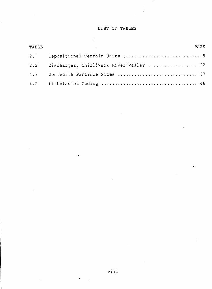
LIST OF TABLES
TABLE PAGE
2.1 Depositional Terrain Units ............................ 9
2.2 Discharges. Chilliwack River Valley .................. 22 4.1 Wentworth Particle Sizes ............................. 37
................................... 4.2 Lithofacies Coding 4 6
viii
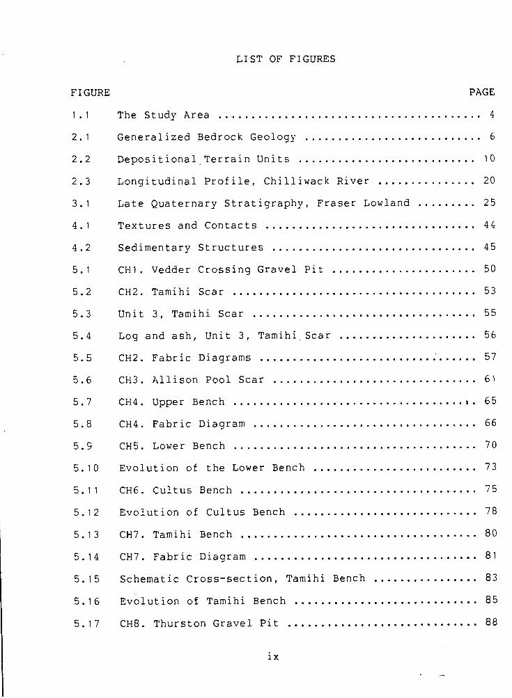
LIST OF FIGURES
FI GURE PAGE
The Study Area ........................................ 4 Generalized Bedrock Geology ........................... 6 Depositional-Terrain Units ........................... 10
Longitudinal Profile. Chilliwack River ............... 20 Late Quaternary Stratigraphy. Fraser Lowland ......... 25 Textures and Contacts ................................ 44 Sedimentary Structures ............................... 45 CHI . Vedder Crossing Gravel Pit ...................... 50 CH2 . Tamihi Scar ..................................... 53 Unit 3. Tamihi Scar .................................. 55 Log and ash. Unit 3. Tamihi Scar ..................... 56 CH2 . Fabric Diagrams ................................. 57 CH3 . Allison Pool Scar ............................... 61 CH4 . Upper Bench ................................... t . 65
CH4 . Fabric Diagram .................................. 66 CH5 . Lower Bench ..................................... 70 Evolution of the Lower Bench ......................... 73 CH6 . Cultus Bench .................................... 75 Evolution of Cultus Bench ............................ 78 CH7 . Tamihi Bench .................................... 80 CH7 . Fabric ~iagram .................................. 81
................ Schematic Cross-section. Tamihi Bench 83
Evolution of Tamihi Bench ............................ 85 ............................. CH8 . Thurston Gravel Pit 88
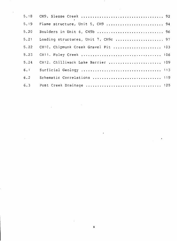
.................................... . CH9 Slesse Creek 92
......................... Flame structure. Unit 5. CH9 9 4
............................. Boulders in Unit 6. CH9b 96
..................... Loading structures. Unit 7. CH9c 97
CHI0 . Chipmunk Creek Gravel Pit ..................... 103 CHI1 . Foley Creek ................................... 106 CHI2 . Chilliwack Lake Barrier ....................... 109 Surficial Geology ................................... 113
.............................. Schematic Correlations 119
Post Creek Drainage ................................. 125
CHAPTER 1: INTRODUCTION
General Backaround
Recent geomorphological research has tended to concentrate
on short-term process studies, but there has been mounting
dissatisfaction with their applicability at a geomorphic
timescale. For example, Church ( 1 9 8 0 ) argued that such studies
do not sample the complete variability of a process, and
suggested that other approaches to the discipline could be
employed to extend the knowledge of geomorphic processes through
time. One of the alternative approaches recommended by him was
followed in this thesis, that of interpreting recent sediments.
~nterpretations of the Quaternary stratigraphic record have
proved to be of great value in geomorphological research. The
analysis of subsurface sebiments enables the corresponding
depositional environments to be inferred from them. The
classification of landforms according to their morphology,
distribution and origins, provides additional information to aid
in elucidating the surficial geology and geochronology. The
combination of the two approaches results in a powerful tool for
geomorphology.
There are limitations to using the stratigraphic record. ~ t !
is inherently imbalanced, for two reasons. Firstly, the
stratigraphic column is incomplete: only the periods and
environments of deposition are documented. Erosional intervals
are represented by unconformities, and very limited amounts of
information can be gleaned from these. This is a maxim of
geology. Secondly, sedimentation is often spasmodic, such that a
brief energetic event mig'ht be responsible for a major
proportion of the stratigraphic record. In the Quaternary, this
concept is exemplified by the paraglacial period (Church &
Ryder, 1972), has been applied to British Columbia by Claque',
and more broadly, was discussed in the context of stratigraphy
and geomorphology by Ager (1973) and Schumm (1976).
Research Rationale and Objectives
In valleys of the British Columbian Coast and Cascade
Mountains, the number of detailed Quaternary studies is quite
limited. Only the Coquitlam River valley has received detailed
attention (Hicock & Armstrong, 1981).
The Chilliwack River valley is only one example of the hany
possible montane valleys in which Quaternary research may be
undertaken. It was chosen as the study area for several reasons.
It is easily accessible from Vancouver, being only 100 km to the
east. There are sufficient numbers of exposures to elucidate a
major proportion of the surficial geology. Previous studies have
already defined some aspects of the late Quaternary history and
provide some basic data from which to build. ------------------ '"The Character and Timing of Sedimentation and Erosion in British Columbia during the Quaternary", lecture presented at the Bill Mathews Symposium, Vancouver, October 1984
This study attempts to map the geomorphology and surficial
geology of the Chilliwack River valley, and consequently
establish a chronology of geomorphic events. So little detail is
known about the geomorphology of the British Columbian Cascade
and Coast Mountains that this contribution to knowledge
represents a step forward in the comprehension of the last
glaciation in the southwestern parts of the province. Also, it
provides a stronger foundation on which future work can be
built, and directly contributes to the understanding of the
Quaternary in the adjacent eastern Fraser Lowland.
Briefly, the aims of the proposed research are as follows:
(i) to map the surficial geology and geomorphology,
(i i ) to interpret the corresponding sedimentary
environments, and
(iii) to establish a comprehensive geochronology.
The research concentrated on extending the presently limited
understanding of the recent evolution of the valley. To thisb
end, new data were sought to infill the gaps in previous
knowledge.
The study area is that part of the Chilliwack River which
lies on the Canadian side of the forty-ninth parallel, and
downstream of Chilliwack Lake (Figure 1.1). The concentration of
preserved unconsolidated deposits in the trunk valley, and
sparsity of similar material in the tributary valleys, means
that this study is necessarily concerned mainly with the valley
fills of the trunk valley.
CHAPTER 2: THE RESEARCH AREA
This chapter reviews the physical characteristics of the
Chilliwack River area, and includes discussions of the bedrock
geology, erosional and depositional physiography, and aspects of
the contemporary environment.
Bedrock Geology
The northern Cascade Mountains consist of a gneissic and
granitic core flanked by sedimentary, metamorphic and volcanic
rocks. The range as a whole is described in some detail by McKee
(1972). and its context within the evolution of the Canadian
Cordillera is set by Monger & Price (1979). The bedrock geology
of the study area was mapped by Monger (1970). and is summarized
below and in Figure 2.1. Lithostratigraphic names have been
taken from Roddick et al. (1979) and from Monger's nomenclature.
The oldest rocks in the study area are probably early
~aleozoic amphibolites and diorites correlative with the Yellow
Aster Complex in Washington, but their exact age is unknown. The
Chilliwack Group, from the late Paleozoic era, is composed of
metamorphosed pelite and sandstone, with minor conglomerate.
pyroclastic rocks, basic volcanic greenstone and limestone. The
rocks exhibit complex folding and faulting. Unconformably
overlying the Chilliwack Group are Triassic and Jurassic pelites , with siltstones, sandstones and breccias, collectively termed
the Cultus Formation. These too, are highly deformed. I
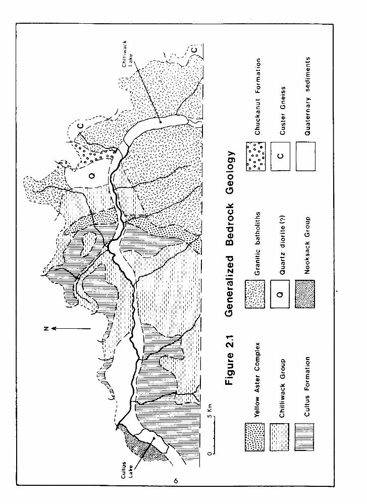
The eastern part of the study area is underlain by the granitic
Chilliwack and Mount Barr Batholiths, both having mid-Tertiary
ages. The detailed composition of these were discussed by
Richards & McTaggart ( 1976').
The granodiorite batholiths, the Chilliwack Group and the
Cultus Formation make up most of the bedrock in the drainage " -
basin (Figure 2.1). The localized occurence of conglomerates
(Chuckanut F'ormation) and Custer gneiss in the vicinity of
Chilliwack Lake, and Cretaceous/Early Tertiary graywackes and
shales of the Nooksack Group at Vedder Mountain (Crickmay &
Pocock, 1963) completes the bedrock geology of the drainage
area.
Reqional Physioqraphy
The deeply dissected topography of the area is typical of
the northern Cascades, and local relief may reach 2000 m. peaks
are usually clustered linearly along high ridges, and the
highest tops in the area are generally of the order of 2100-2500
metres above sea level (masl). Daly (1912) argued for the former
existence of an uplifted peneplain, that he called the Cascade
Plateau, on the grounds of observed summit accordance. This
discussion was expanded by Thompson (1962) to encompass multiple
accordances, or gipfelfluren, in lieu of Daly's simplistic
interpretation.
The drainage pattern of the area is structurally
controlled, and exhibits a quasi-rectangular pattern (Figure
2 . 1 ) . The Columbia Valley is the only other major valley in the
study area in addition to that of the Chilliwack River. It
slopes southward towards the International Boundary. All of the
valleys display classic glacially-eroded cross sections; in the
trunk valley of the Chilliwack River and the Columbia Valley,
valley fills modify the smoothness of the profile.
There are numerous erosional features typical of alpine
glaciation, such as hanging valleys, horns, aretes, truncated
spurs and cirques. Daly ( 1 9 1 2 ) applied the term "tandem cirque"
to describe the compound cirques found in the area. Truncated
spur elevations do not show any distinct accordance, but ice
thicknesses of several hundred metres can invariably be inferred
from them. Most of the land below about 2 0 0 0 m has been rounded
by ice, and even the sharp and rugged high peaks were probably
submerged by ice for a very limited length of time during theb
-- Fraser Glaciation (Waitt, 1977).
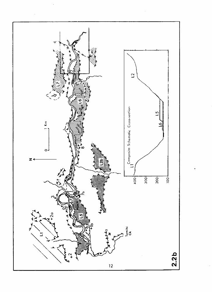
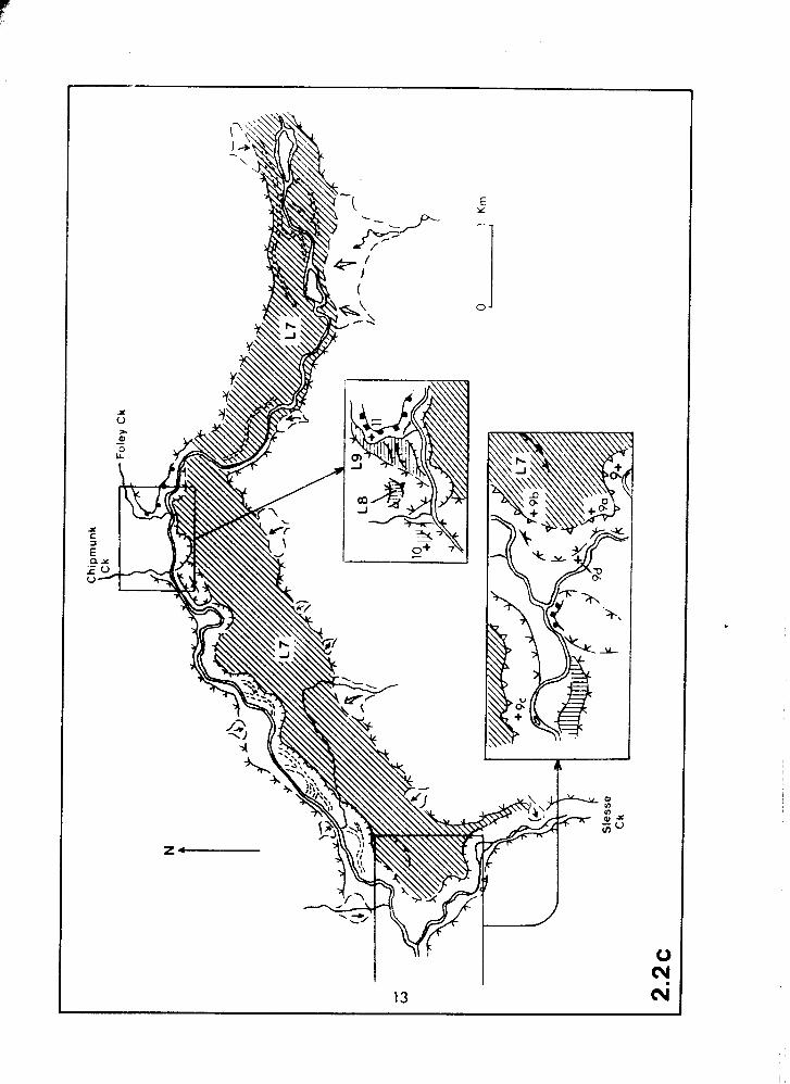
Depositional Terrain Units
Unconsolidated Quaternary deposits occur throughout the
valley and the associated landforms are mapped in Figure 2.2.
The shading on these maps indicates the extent of each surface.
In Figure 2.2~2, two parts of the map are enlarged for greater
clarity. Throughout this and subsequent chapters, the term
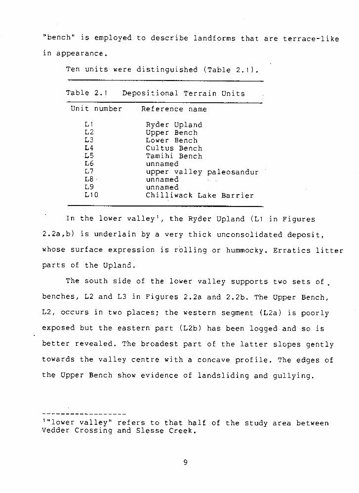
"bench" is employed to describe landforms that are terrace-like
in appearance.
Ten units were distinguished able 2.1 1 .
Table 2.1 Depositional Terrain Units
Unit number Reference name
Ryder Upland Upper Bencn Lower Bench Cultus Bench Tamihi Bench unnamed upper valley paleosandur unnamed unnamed Chilliwack Lake Barrier
In the lower valley', the Ryder Upland (L1 in Figures
2.2a,b) is underlain by a very thick unconsolidated deposit,
whose surface expression is rolling or hummocky. Erratics litter
parts of the Upland.
The south side of the lower valley supports two sets of,
benches, L2 and L3 in Figures 2.2a and 2.2b. The Upper Bench,
L2, occurs in two places; the western segment ( ~ 2 a ) is poorly
exposed but the eastern part (L2b) has been logged and so is
better revealed. The broadest part of the latter slopes gently
towards the valley centre with a concave profile. The edges of
the Upper Bench show evidence of landsliding and gullying.
'"lower valley" refers to that half of the study area between Vedder Crossing and Slesse Creek.
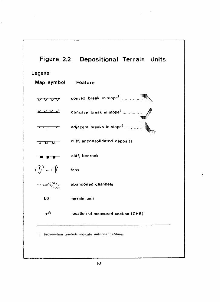
Figure 2.2 Depositional Terrain Units
Legend
Map symbol
/ - ; v and v v
Feature
1 convex break in slope.. ..............
1 . . . . . . . . . . . . . . . . . concave break in slope
. . . . . . adjacent breaks in slope1..
cliff, unconsolidated deposits
cliff, bedrock
fans
abandoned channels
terrain unit
location of measured section (CH6)
--
1. Broken- line symbols ind~cate ~ndistinct features
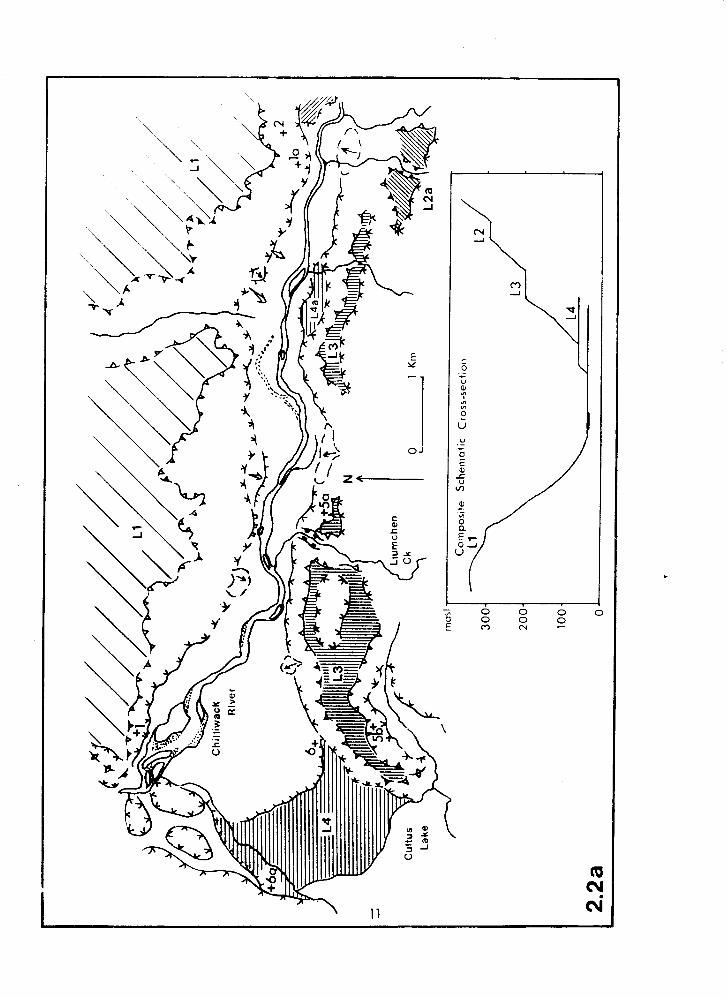
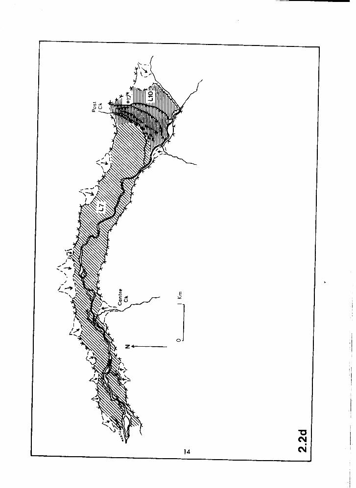
The Lower Bench, L3, resembles a typical alluvial terrace. -
It possesses a flat top, and is clearly defined from the bedrock
valley sides by sharp breaks of slope. Closer inspection reveals
that in places the L3 surface is made up of several different
bench remnants which lie within an elevation range of about 20
m, rather than having one single level. The Bench can be traced
along the south side side of the valley from near Tamihi Creek
to an abrupt terminus near the north end of Cultus ~ake'.
The Cultus Bench, L 4 , dams Cultus Lake and possesses a
smooth, flat surface. Its northern edge is a distinct scarp
adjoining the modern floodplain, whilst the southern one slopes
gently into the lake. Due north of the Cultus Bench, and near
Vedder Crossing, are two very narrow valleys, which may be
ancient river courses. L4a is a very small arcuate bench,
probably a river terrace, which is possibly correlative with L4. ,* , -/
--
Tamihi Bench, L5, has a surface which is hummocky in some
places and relatively flat in others. Relict channels occur '
adjacent to the Chilliwack Lake Road where it crosses this
surface. The Bench is being actively eroded by the Chilliwack
River.
The L6 surface is a low alluvial terrace. It is a
continuous surface (in contrast to L2, L3 and ~ 5 ) , possesses an
undulating expression and 5-10 m higher than the modern
floodplain. The Chilliwack River has cut scarps up to 6 m high
------------------ '"~ultus Lake" refers only to the lake itself, and not the settlement of the same name.
in places. The extent of incision is quite limited, however, and,
the river probably is constrained from further incision by the
downstream control of a bedrock canyon (Figure 2.3). Several
well-defined abandoned channels can be discerned in the aerial
photographs; these appear to be of similar widths and planforms
to the present Chiliiwack River. --
One of the largest surficial features in the study area is
a valley fill in the upper valley3, mapped as L7 in Figure 2.2. -.
It extends unbroken for 16 km from near Chilliwack Lake to
Slesse Creek, and remnants of the same surface can be identified
for a further 3-4 km downstream. The lower part of the fill has
been incised by the Chilliwack River to a depth of 130 m, but
incision has been controlled by a bedrock outcrop at the
Chipmunk Creek confluence. There is minimal incision upstream of
this point. Abandoned channels are common in the middle reaches
of this valley fill, but mostly are absent in the upper and
lower parts.
The L8 and L9 landforms are small, indistinct benches. The
L8 surface occurs at the mouth of Chipmunk Creek about 40 m
above L7, and appears to be a dissected hanging delta. L9 is
lower than L8 and is at the mouth of Foley CReek valley. Its
topmost surface is of a similar elevation to that of L7 in the
trunk valley. The L9 surface has been terraced by the Chilliwack
River as part of the local incision of the L7 surface.
3"upper valley" refers to that half of the study area between Slesse Creek and Chilliwack Lake.
Chilliwack Lake is dammed by a barrier, L10, whose form,
except for an atypically flat surface, resembles that of a
recessional moraine:It has been terraced on its north side by
the minor tributary of post Creek, and on its west side by the
Chilliwack River.
Most of the landforms described here occur on or near to
the floor of the trunk valley. The preservation potential of
deposits higher on the steep valley sides and in the narrow
confines of the tributary valleys probably is sufficiently low
to ensure their rapid removal in postglacial times. It is
therefore not surprising to find a lack of classic alpine
glacial deposits such as terminal and lateral moraines which may
normally be expected in an area of previously vigourous
glaciation. Unlike other parts of the Cascades, such as the
nearby Mount Shuksan area, prominent fresh-looking Holocene
(usually from ~eoglacial advances) moraines are also mostly
absent. Only the Depot and Redoubt Glaciers in the extreme
southeastern part of the drainage area have left such features.
The scarcity of active glacier ice in the Chilliwack Valley has
no doubt contributed to this state of affairs. Most contemporary
glaciers in the area are small pockets of relatively inactive
ice.
Contemporary Physical Geoqraphy
This section describes aspects of the physical geography of
the study area which are not covered in the preceding
discussions, namely geomorphic processes, hydrology, soils and
vegetation.
Geomorphic Processes
Active physical weathering is exemplified by the
frost-shattered rock and talus accumulations in the alpine zone,
while chemical weathering has also been found to be of
significance in these mountains (Reynolds & Johnson, 1972;
Bustin & Mathews, 1 9 7 9 ) . All types of mass movements, whether
involving rock, unconsolidated deposits or snow, are active in
the study area. Most are initiated at the higher elevations, but
occasionally the catastrophic slides and mudflows reach the
valley bottoms. Munshaw ( 1 9 7 6 ) documented a major suite of such
events, produced in December 1975 by failure of waterlogged
slopes.
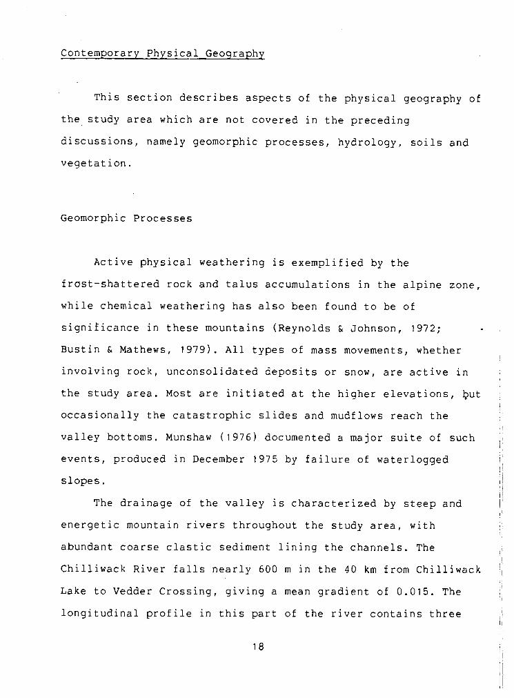
The drainage of the valley is characterized by steep and
energetic mountain rivers throughout the study area, with
abundant coarse clastic sediment lining the channels. The
Chilliwack River falls nearly 600 m in the 40 km from Chilliwack
Lake to Vedder Crossing, giving a mean gradient of 0.015. The
longitudinal profile in this part of the river contains three
roughly concave sections each about 14 km long, separated by
bedrock-controlled knickpoints (Figure 2.3). The planform of the
river is a single channel with straight and meandering reaches;
the lowest 4 km are braided. Upstream of Allison Pool (Figure
1 . 1 ) ~ the channel appears to be reasonably stable. Downstream
frorri this pcint channel change occurs on a yearly timescale, and
recent meander cut-offs, bank failures and shifting bars are
readily apparent. The drainage area upstream of the Vedder -
Crossing bridge is 1230 km2, of which 60-70% lies north of the
International Boundary.
Tributary streams either possess poorly developed
floodplains of limited extent or flow in very steep channels
dominated by bedrock topography. Where there is a floodplain,
these channels are generally unstable. Only two tributary
channels, Slesse and Foley Creeks, are graded to the Chilliwack
River. The remaining streams issue from hanging valleys. Of
these, Liumchen, Tamihi and Chipmunk Creeks have cut narrow
gorges in bedrock, and Nesakwatch and Centre Creeks have built
fans onto the trunk valley floodplain. Fan growth has affected
the course of the Chilliwack River in places by locally
constricting the floodplain. Numerous small fans, mostly
inactive, line the edges of the upper valley (~igures
2.2cr2.2d). Their position atop the late-glacial sandur surface
implies that they are of postglacial age. It is probable that
some were constructed under paraglacial conditions such as those
described by Ryder (1971).
Hydrology
An examination of about 50 years of discharge rceords from
the Chilliwack River revealed that the flow of the river
exhibits typical alpine characterisics (Inland Waters
Directorate, 1983). Monthly discharges are dominated by spring
snowmelt. At the outlet of Chilliwack Lake (the upstream end of
the study area), 92% of maximum monthly flows occur in either
May or June. At Vedder Crossing (the downstream limit of the
catchment), this figure is 77%. The majority of minimum monthly
discharges occur in the four months of February, March,
September and October. Superimposed upon this seasonal regime
are short term fluctuations of daily discharges that reflect
local climatic events. At Chilliwack Lake, 74% of maximum daily
discharges occur in May and June, whereas low flows occur
without preference throughout the months of October to April.
Minimum daily discharges at Vedder crossing are also spread
throughout the same months, though October is a preferred time.
In contrast to the regime at Chilliwack Lake, maximum daily
flows at Vedder Crossing are divided equally between the
May-June melt period and the October-February winter period,
illustrating the importance of storm runoff in the short term
regime of the lower Chilliwack River. Basic hydrological
statistics for all gauging stations within the study area are
summarized in Table 2.2.
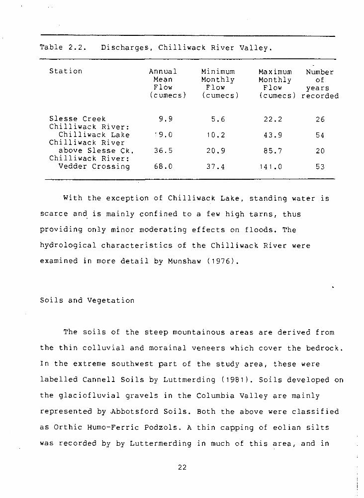
Table 2 . 2 . Discharges, Chilliwack River Valley.
Station
Slesse Creek Chilliwack River:
Chilliwack Lake Chilliwack River
above Slesse Ck. Chilliwack River: Vedder Crossing
Annual Mean Flow (cumecs)
Minimum Maximum Number Monthly Monthly of Flow Flow years (cumecs) (cumecs) recorded
With the exception of Chilliwack Lake, standing water is
scarce and is mainly confined to a few high tarns, thus
providing only minor moderating effects on floods. The
hydrological characteristics of the Chilliwack River were
examined in more detail by Munshaw ( 1 9 7 6 ) .
Soils and Vegetation
The soils of the steep mountainous areas are derived from
the thin colluvial and morainal veneers which cover the bedrock.
In the extreme southwest part of the study area, these were
labelled Cannell Soils by Luttmerding ( 1 9 8 1 ) . Soils developed on
the glaciofluvial gravels in the Columbia Valley are mainly
represented by .Abbotsford Soils. Both the above were classified
as Orthic Humo-Ferric Podzols. A thin capping of eolian silts
was recorded by by Luttermerding in much of this area, and in
fact is typical of the eastern Fraser Lowland. Vegetation is
mostly closed coniferous forest containing hemlock, cedar and
fir. Due to the steep nature of many valley sides, this often
breaks directly into barren rock and snow ridges.
CHAPTER 3: LITERATURE REVIEW
This review first covers the recent evolution of the Fraser
Lowland as a general setting. Focus is then given to the
Quaternary research undertaken in the Chilliwack River area.
Late Quaternary History of the Fraser Lowland
The simplified history of the area, schematically presented
in Figure 3.1, is adapted from Armstrong (1981) and Clague
(1981), and is largely derived from dated deposits in the
central and western parts of the Fraser Lowland. The use of
these stadia1 and interstadial time divisions for the Fraser
Glaciation outside this area is not necessarily valid (Clague
(1981). Of the many studies of the Quaternary geology of the
region, Armstrong et al. ( 1 9 6 5 ) ~ Armstrong (1981) and Clague
(1981) are notable summaries.
Pre-Fraser Glaciation
Before the Fraser Glaciation, there was an interglacial
period - the Olympia Nonglacial Interval. This is represented
lithostratigraphically by the Cowichan Head Formation in the
western part of the Fraser Lowland, and indicates conditions not
unlike those of contemporary times.
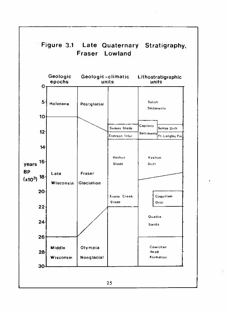
Figure 3.1 Late Quaternary Stratigraphy, Fraser 'Lowland
Geologic Geologic -climatic Lithostratigraphic units units epochs
Holocene
Late
Wisconsin
Middle
Wisconsin
Postg lacial
Fraser
Glaciation
Olympia
Nonglacial
Salish
Sediments
Capilano Sumas Stade Sumas Drift
Sed lments cverson Inter Ft. Langley Fn
Vashon
Stade
Vashon
D r ~ f t
Evans Creek Coqu~t lam
Stade Drift
Quadra
Sands
I Cowichan
Head
Formation
Fluvial activity .in lowlands, minor glacial activity in the
mountains and deltaic and marine environments in the Georgia
Depression were prevalent (~rmstrong & Claque, 1977). A cooling
climate in the latter part 'of this interval was a harbinger to
the Fraser Glaciation.
The Fraser Glaciation - Advance Phase
The onset of the Fraser Glaciation is
lithostratigraphically depicted by the Quadra Sand. This major
unit consists of distal sandy outwash deposited on top of
Olympian estuarine and marine sediments in the Georgia
Strait-Puget Sound area in response to advancing glacier ice
(Clague, 1977). Dated Quadra Sand outcrops record the advance of
piedmont glaciers down the Georgia Depression: 29,000 years
before present (BPI at the north end of the Georgia Strait to . less than 15,000 BP in the Puget Sound.
The Evans Creek Stade, interpreted by Crandell (19631,
occurred in early Fraser times at about 20-22,000 BP. Crandell's
type section, at Evans Creek, Washington, showed moraine
overlain by glaciolacustrine deposits, and marked an advance and
retreat of alpine glaciers, with the subsequent formation of
glacial lakes. Similar events were identified in the Coquitlam
River valley, western Fraser Lowland, by Hicock & Armstrong
( 1 9 8 1 ) ~ and a local stratigraphic name, Coquitlam Drift, applied
to the deposits. Here, outwash was deposited both prior and
subsequent to Coquitlam Drift. The maximum extent of this local
advance occured at 21,000 BP, when valley glaciers flowing out
of the Coast Mountains into the Fraser Lowiand coalesced into a
piedmont lobe. The outwash"was at least partly laid down in a
glacial lake, formed by ice damming the mouth of the Coquitlam
Valley. By about 18,500 BP, the Coast Mountain glaciers had
receded into their valleys (Hicock & Armstrong, 1 9 8 1 ) ~ although
the Cordilleran Ice Sheet maintained a slow but persistent
advance southwards along the Georgia Depression. A millennium
later, the Fraser Lowland was again inundated by ice, with the
development of the Vashon Stade.
Some other mountain valleys fringing the coastal lowlands
probably experienced advances of alpine glaciers at this time.
Hicock et al. (1982br reviewed in Chapter 5 ) and Crandell &
Miller (1974) discuss similar behaviour of alpine glaciers,
respectively in the Chilliwack River valley and on Mount
Rainier.
At about 18,000 BPI much of southern British Columbia was
free of ice. Subalpine forest grew in the northwestern Fraser
Lowland, and existing ice probably underwent a period of
standstill (Hicock et al. 1982a). After 18,000 BP the growth of
the Cordilleran Ice Sheet intensified (Clague et al. 1980),
fuelled by the northward shift of weather patterns that brought
increased precipitation to the region (Hicock et al. 1982a).
Then followed the most extensive episode of glaciation during
the Fraser glacial period, referred to by some workers as the
Vashon Stade . Cordilleran ice extended southwards and westwards from
southwestern British Columbia to fill the Puget Scund and reach
a maximum south of Olympia, Washington, between 14,500-15,000 BP
(~eusser, 1973). At this time, ice filled the Fraser Lowland up
to the 2100 masl level (Mathews et al. 1970). A reconstruction
of the Puget Sound lobe as it stood at this time suggests that
the ice was then in a near-equilibrium state (Thorson, 1980).
Glacial activity during this stade was predominantly
erosional in the Lower Mainland region, and many of the
fresh-looking erosional bedrock landforms that occur can be
ascribed to this period. Thicknesses of Vashon sediments are
often much less than those deposited in the shorter interstade
which was to follow, and in some places where Vashon ice must
have flowed, no Vashon sediments have been left behind
(~rmstrong, 1981).
The Fraser Glaciation - Recessional Phase
Retreat of the ice in the Georgia Depression allowed marine
invasions into the low-lying areas, for example, as far as
Deming at 75 masl on the Nooksack River asterb brook et al.
1975). This period, called the Everson Interstade, lasted for a
little longer than a millenium. Radiocarbon dates indicate that
the period 12,000-13,000 BP was largely ice-free in Fraser
Lowland. Armstrong (1981) believes, however, that the eastern
lowland was occupied by a piedmont lobe, whose ma-rgin fluctuated
and was alternately subaerial and subaqueous. Sedimentation
under marine, glaciomarine and deltaic conditions during this
interstadial resulted in complex stratigraphic relationships;
deposits are termed the Capilano Sediments and the Fort Langley
Formation.
Late in the Fraser Glaciation, ice re-advanced into the
eastern part of the Fraser Lcwland, to terminate a few
kilometres beyond Sumas, washington. Ice reached a maximum
extent at about 11,300 BPI and by 9920 BP recessional outwash
had ceased to be deposited (Claque, 1981). The Fraser Canyon was
clear of ice, or nearly so, after 11,000 BP (Mathewes et al.
1972). The possibility thus exists that ice was not fed by
glaciers flowing down the canyon, but from another source. For
example, Roberts & Mark (1970) suggested that a glacier in the
Stave River valley fed Fraser Lowland ice, although Armstrong et
al. (1971) argued against this in lieu of a Cascade source to
the east. Clague (1981) also believed that ice in this area was
fed from the Fraser Canyon, and underwent a very rapid retreat
immediately following the climax of the advance. Clague also
doubted that the last period of the Fraser Glaciation, labelled
the Sumas Stade, may not in fact be defined as a stadia1 period.
Instead, it represents a minor advance induced by the grounding
of the ice lobe as sea level dropped, and so is not related to
any significant climatic change.
Postglacial Events
Fluvial reworking of the .abundant sediment left by the
retreating glaciers caused rapid aggradation, leading to the
development of floodplains and alluvial fans in the valleys
(Ryder, 1 9 ? 1 ) . These paraglacial conditions persisted for
several thousand years after glaciation (church & Ryder, 1 9 7 2 ) ~
with the glacial influence waning in strength during this time.
For the remaining part of the Holocene, geomorphic activity has
been relatively inert, although minor Neoglacial advances have
occured in the high alpine cirques (Mathews, 1951).
Postglacial sea level changes in southwestern British
Columbia were described in detail by Clague et al. ( 1 9 8 2 ) . The
sea level was about 200 m above the present-day elevation at
13,000 BP. Following deglaciation it quickly stabilized to about
20 m below the contemporary level. Sea level began to rise at
around 7000 BP, and attained the present-day elevation at about I
5000 BP. 1
I
Quaternary Research in the Study Area
Early Work
The first pertinent research was undertaken by Daly (1912)
during a geological survey along the forty-ninth parallel that
concentrated on bedrock mapping. He described the obvious vigour
of Cascade valley glaciers that created the alpine landforms,
and estimated the ice thickness of major Skagit Range ice
streams to be 1200-1500 m at the height of glaciation. In the
Chilliwack Valley, two specific unconsolidated deposits
attracted his attention. Firstly, he described the Chilliwack
Lake Barrier as a bouldery recessional moraine. In the lower
valley, Daly recorded a "thick deposit of glacial clay" forming
a 90 m bench on the north side, from Slesse Creek to Vedder
Crossing, much of this area now being called the Ryder Upland.
Its origin was suggested to be from a Chilliwack Valley glacier,
possibly assisted by ice from the Fraser Lowland.
Armstrong (1960a) presented the next study of the
Quaternary geology of the area, mapping the deposits of Sumas
map-area, which includes part of the Columbia Valley. In this
latter area, Sumas recessional sand and gravel outwash was
ubiquitous on the valley floor, except for limited Holocene
stream deposits near Cultus Lake. The valley sides are mapped as
being exclusively bedrock-dominated. Discussion of the Columbia
Valley sediments was not included in the text. Armstrong also
produced a preliminary survey map of part of the lower
Chilliwack River valley, but without any accompanying discussion
(Armstrong, 1960b). Three different types of deposit were
recognized: (i) "Huntingdon" and "pre-Huntingdon" (pre-Sumas)
gravel, sand and silt exposed in the north side of the lower
valley, (ii) Sumas till on the Ryder Upland, and (iii) modern
floodplain gravel in the valley bottom.
University of British Columbia Theses
Three University British Columbia undergraduates wrote
theses on the Chilliwack Valley. The first of these, Chubb
(1966) studied two exposures in the vicinity of the Slesse
Creek-Chilliwack River confluence. Both sections were similar,
and consisted of a 15 m basal unit of lacustrine clay,
successively overlain by 15 m of well-stratified sand, up to 12
m of cobble gravel, and capped by 12 m of silty sand with clay
lenses. The sandy units were interpreted as slack-water deposits
and the gravel as channel fills. The depositional environment
inferred was a glacial lake into which a sandur was built. The
origin of this lake was not specified, but an ice dam in the
lower valley was implied.
The second thesis was by Munshaw ( 1 9 7 6 ) ~ and included
discussions of the surficial geology, geomorphology and
hydrology of the area. The Chilliwack Lake Barrier was described
in some detail. Landslide and recessional moraine origins were
rejected. Munshaw suggested that either a glacier, or meltwater,
from the Post Creek valley could have deposited this feature.
Although catastrophic floods were inferred, the origins of these
were not clearly explained.
Munshaw correlated the upper valley sandur with the Ryder
Upland, and suggested that this was a continuous valley floor.
No surficial deposits were dated older than the Everson
Interstade. He proposed that Sumas ice deposited till on the
Ryder Upland, and outwash gravel in the Columbia Valley.
Munshaw's interpretations lack solid evidence, and in
places contradict themselves. One of the major objections to his
thesis is the problem of envisaging the thick Sumas-age valley
fill that was removed by the postglacial Chilliwack River.
Gourlay ( 1 9 7 7 ) wrote the third thesis, and concentrated on
the upper valley sandur. This feature was described as being
"constructed by a series of jokulhlaups issuing from Post
Creek", the origin of which was the focus of the study. Maximum
clast size of boulders on the valley surface were measured from
Post Creek to Allison Pool (Figure 1 . 1 ) , and graphed against
downstream distance and valley slope. The results of this were
interpreted somewhat subjectively. Gourlay estimated the
paleodischarge required to transport the largest boulders at the
mouth of Post Creek, and obtained results of the order of l o 5
m3s", which is probably a gross overestimate. The sources of thi
jokulhlaups were not clearly defined. Gourlay suggested that the
Chilliwack Valley glacier ponded water in Post Creek, releasing
it upon retreating. Although conceivable, this would not have
allowed the Chilliwack Lake Barrier to be terraced (see Chapter
2) as ice would have covered this feature at the time.
Recent Publications
Armstrong (1980a,1980b,1981) produced revised maps of the
surficial geology of the lower Chilliwack and Columbia Valleys.
An obvious asymmetry of deposits was apparent along the
Chilliwack River: on the south side, only bedrock and landslide
debris were recorded, whereas the north side contains a variety
of Sumas and pre-Sumas sediments, capped by Sumas till which
forms the surface of the Ryder Upland. Minor amounts of eolian
silt overlay much of the Upland. The valley bottom was mostly
post-glacial alluvium. In the Columbia Valley, Sumas outwash was
mapped as a low bench at the north end of Cultus Lake (the L4
surface), as well as the major valley fill beyond the south end.
Easterbrook et al. (1975) mapped the Columbia Valley
outwash south of the border, to the Nooksack River. The outwash
was believed to be of Sumas age in view of the freshness of the
abandoned channels. The abrupt change in elevation of the valley
just south of Cultus Lake was proposed as an ice-contact face;
the ice would have been at least 100 m thick at the snout to
form this feature. Till in this face was later dated at
11,300+100 - BP (GSC-2523) (Claque & Luternauer, 1982).
Hicock et al. (1982b) conducted a detailed study of
sediments at the Vedder Crossing Gravel Pit, and Claque &
Luternauer (1982) also described this section. These works are
summarized in Chapter 5, since this pit is site CHI of this
study. Clague & Luternauer also included a section from Slesse
Creek (CH9) and the Chilliwack Lake Barrier ( ~ ~ 1 2 ) .
D. M. Mark (1983, pers. comm.) attempted to depict the
Quaternary history of the Chilliwack Valley by assuming that
each set of benches (see Chapter 2) were alluvial terraces and
so represented former valley floors.
Discussion
From this review, many questions emerge unanswered, or
inadequately dealt with, by previous work. In particular, the
composition, origins and correlations of the benches in the
lower valley are not fully understood. The suggestion of a
series of valley fills is not substantiated by field evidence.
The composition of the thick deposit underlying the Ryder Upland
has not been fully elucidated. There is a general lack of detail
in the surficial geology throughout the valley. Armstrong's
(1980at1980b) maps do not cover the valley upstream of Allison
Pool. Only the Vedder Crossing Gravel Pit, Slesse Creek section
and Chilliwack Lake Barrier have been documented with any
thoroughness, and there remains large gaps of poorly known
territory in between.
CHAPTER 4: METHODOLOGY
This chapter describes the techniques used in field logging
of sections, mapping the landforms and surficial geology, and
the lithological coding used.
Field Loqqinq
The ultimate aim of field measurement is to subdivide a
section into definite units, which then form the basis for
interpreting sequential events in the history of sedimentation
at that site.
"A stratigraphic unit is a stratum or assemblage of strata recognized as a unit ... with respect to any of the many ... attributes that rocks possess. Clear definition of a stratigraphic unit is of paramount importance." (~edberg, 1976)
In this study, the basic parameters employed in defining units
were the sedimentary texture and structure, and the lateral
continuity exhibited in the exposure. The latter is important
because individual lenses (which-are not called units here) and
extensive beds (which are described as such) can be separated.
The following information was recorded at each field site,
wherever possible:
(i) thickness of beds,
(ii) textural characteristics,
(iii) types of contact,
(iv) sedimentary structures and fabric, and
(v) additional features.
These, if complete, enable the definition of a limited number
(ideally, only one) of paleoenvironments for each unit.
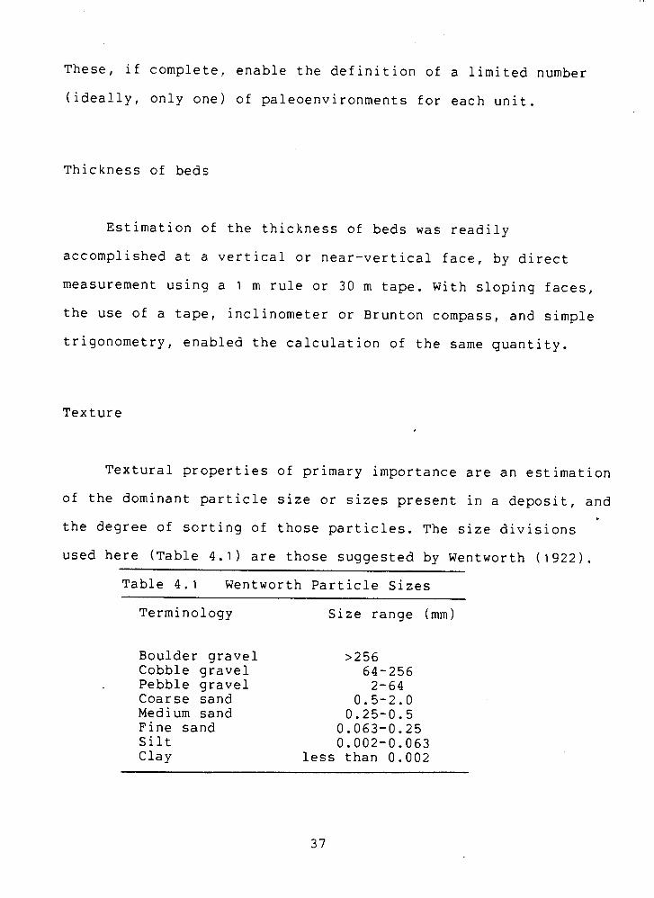
Thickness of beds
Estimation of the thickness of beds was readily
accomplished at a vertical or near-vertical face, by direct
measurement using a 1 m rule or 30 m tape. With sloping faces,
the use of a tape, inclinometer or Brunton compass, and simple
trigonometry, enabled the calculation of the same quantity.
Texture
Textural properties of primary importance are an estimation
of the dominant particle size or sizes present in a deposit, and
the degree of sorting of those particles. The size divisions
used here (Table 4.1) are those suggested by Wentworth (1922).
Table 4.1 Wentworth Particle Sizes
Terminology
Boulder gravel Cobble gravel Pebble gravel Coarse sand Medium sand Fine sand Silt Clay
Size range (mm)
>256 64-256 2-64
0.5-2.0 0.25-0.5 0.063-0.25 0.002-0.063
less than 0.002
All observations of the sedimentary characteristics were
qualitatively made. Field assessment of particle size was
considered to be consistent and sufficiently accurate for
interpretation procedures.
Although more objective in approach, quantitative analyses
of texture were considered to be neit'her necessary nor
practical. Several hundred samples would be needed to
quantitatively assess the Chilliwack Valley sediments. The task
of analysing such a large number of samples was considered to be
beyond the point of diminishing returns in view of the iimited
time available for research. The time and energy expended in
collecting and analysing textural samples would not be rewarded
by signifcant returns in terms of enhanced appreciation of a
deposit and the mode of deposition.
Types of Contact
Contacts may be conformable or unconformable. Conformable
contacts may imply a continuum of deposition and an absence of
an erosional interval. Unconformities represent a break in the
sedimentary record. The implications for the interpretation of
paleoenvironments are that only depositional environments can be
specified in any detail. In the study area, unconformities are
manifested in the form of erosional contacts, and are defined as
such in the text. Without dating control, the length of the
erosional period cannot be accurately defined.
Some contacts in the sections could not be adequately
discerned, due to the poor or limited exposure. Unless other
evidence suggested the contrary, a conformable contact was
assumed for reasons of simplicity.
Sedimentary Structures and Fabric
The terminology used here to describe structure is mostly
standard and self-explanatory. Two potential sources of
ambiguity should be clarified, namely cross-bedding and loading
structures.
(i) Cross-bedding may be manifested in a variety of ways
(Reineck & Singh, 1980). Two main types can be defined: planar
and trough. Where these are not specified in the text, planar
cross-bedding should be inferred.
(ii) Loading stuctures can include flames, convoluted
bedding, small-scale faulting and slumping, and dewatering
structures (~eineck & Singh, 1980; Collinson & Thompson, 1982).
In this study, the term is usually confined to the first two
types listed above, unless otherwise stated. These structures
are mostly of the order of tens of millimetres in size. In
general, diapiric intrusion (invasion of an upper bed by
sediment from the lower bed) is associated with flames. The
causes of such features usually involve rapid loading of
sediments which are still in a semi-plastic state, and may be
assisted by subaqueous conditions.
Under some depositional conditions, clasts tend to show a
preferred orientation, from which an estimation of the direction
of flow of the depositing medium can be made. Glacial, fluvial
and littoral environments may show such "primary fabric"
(Reineck & Singh, 1980). Usually this is most obviously
displayed in gravel-sized material, but finer grains may also
possess this quality. Only gravel fabric was examined in this
study.
Clast-supported gravel units were examined for imbrication,
which indicates the paleoflow of the ancient river. Absence of
imbrication need not, however, mean that a fluvial origin can be
ruled out.
With some matrix-supported diamicts, a fabric analysis was
performed to determine whether preferred clast orientation was
present. The a-axis dip and dip direction was recorded for fifty
elongate stones in a small part of the section, using a Brunton
compass. Care was taken to execute the fabric analysis in
undisturbed, in situ diamict.
The presentation of the directional data was in the form of
rose diagrams, with the data grouped into 10' class sizes. Two
statistical tests were performed in an attempt to ascertain
whether there was a preferred clast orientation, and if so, in
what direction. The former test used the Chi-square technique as
outlined by Andrews ( 1 9 7 1 ) , comparing the observed distribution
with a hypothetical omnidirectional distribution. To determine
the preferred direction of clast orientation (the "resultant
azimuth"), the two-dimensional vector analysis method used by
Curray (1956) was employed. In both tests, a significance level
of 90% was used.
Where clast orientation' was significant, then the resultant
azimuth was used to infer ice flow directions. Ice movement
parallel to the preferred orientation, and in an up-dip
direction, is the conventional interpretation of till fabrics.
Additional Features
Supplementary sediment properties, such as the presence of
organic matter, colour and induration, were also recorded where
applicable.
The presence .of dateable material is of primary importance.
Wood samples collected from the Chilliwack Valley underwent a
minimum of handling and were stored in sealed polythene bags. To
date, three samples have been submitted for radiocarbon
assessment.
A radiocarbon age for wood within a deposit does not
necessarily date that sediment. Potential sources of error
include the possibility of a time lag between the death of the
tree and the incorporation of the wood into a sedimentary
deposit, and past variations in atmospheric radiocarbon
activity. It is assumed here, however, that the errors in dating
are acceptably small.
Colour was not considered to be of importance when
recording the stratigraphy at a section, except when it was in
some way unique. The problems of defining the colour of
sediments were prohibitive: many sediments contain many
different shades and tones, and colour can change with moisture
content and the degree of weathering.
At a majority of Chilliwack Valley sections, sediments were
not indurated. Matrix supported diamicts were the only deposits
to exihibit solid compaction, and this quality was recorded with
stratigraphic data.
Geomorphological Mapping
Two sets of vertical air photgraphs were used, details of
which are in Appendix B. The breaks in slope that define the
limits of the modern floodplain and benches in the study area
were marked directly on 1:15,840-scale photographs. Terrain
units were distinguished and labelled according to their
elevation relative to the modern floodplain, surface
microrelief, and apparent correlation to other similar units. A
standard system of geomorphological mapping deposits does not
exist in Canada (Occhietti, 19741 , so coding based upon that
used by Savigear (1965) was used. A base map was traced from the
marked photographs and subsequently reduced to the 1:50,000
scale.
The elevations of the benches and field sites were
determined using parallax bars on a stereoscope.
Surficial Geoloqy Mapping
The surficial geology was compiled through the examination
of sections and by inferrence from depositional landforms. Using
the geomorphological base map and field observations of
stratigraphy, a second base map was constructed using the
provincial terrain classification system (BC Dept. Env. 1976).
This system enables each individual landform-sediment unit to be
uniquely and succinctly described by coding.
These units were re-classified according to their
lithostratigraphic age (~igure 3.1) and then subdivided into
depositional environments, such as glaciolacustrine, outwash,
and so on. The resulting surficial geology map was reduced to a
1:50,000 scale in the same way as the geomorphological map.
Lithofacies Codinq
Schematic classification and description of measured
sections (used in Chapter 5 ) was accompilshed following the
guidelines laid down by Miall (1978) and Eyles et al. (19833.
Textures and contacts are illustrated diagramatically in Figure
4.1. Typical sedimentary structures encountered in this study
are shown in Figure 4.2.
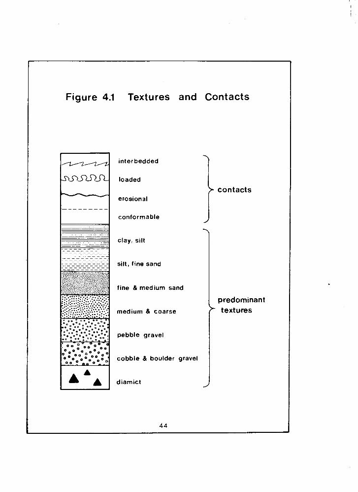
Figure 4.1 Textures and Contacts
inter bedded
loaded
erosional
conformable
clay
silt,
silt
fine sand
fine & medium sand
medium & coarse
pebble gravel
cobble & boulder gravel
diamict
I contacts
predominant
\
textures
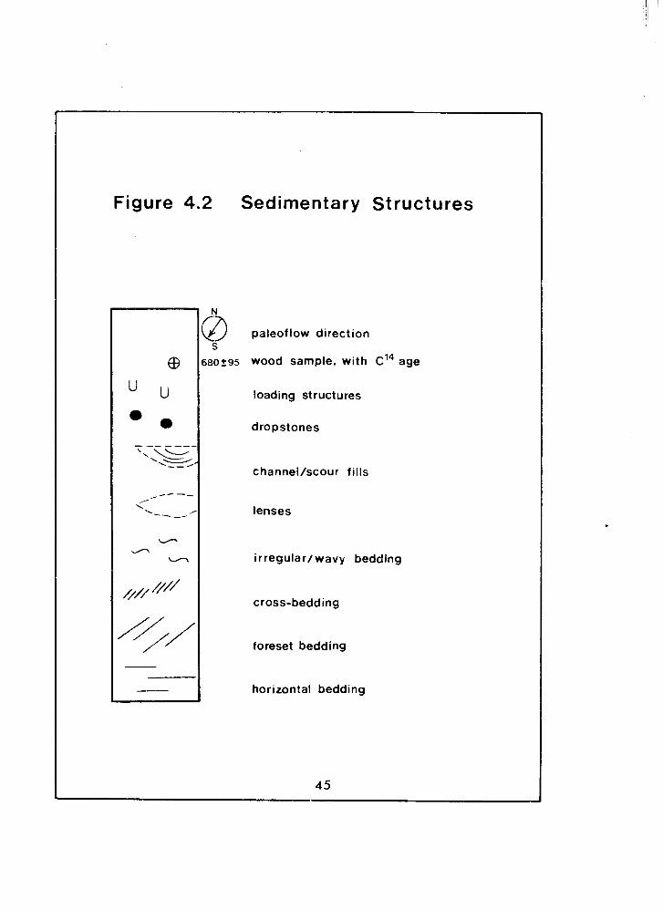
Figure 4.2 Sedimentary Structures
paleof low direction
wood sample, with c ' ~ age
loading structures
dropstones
channel/scour fills
lenses
irregular/wavy bedding
cross-bedding
foreset bedding
horizontal bedding
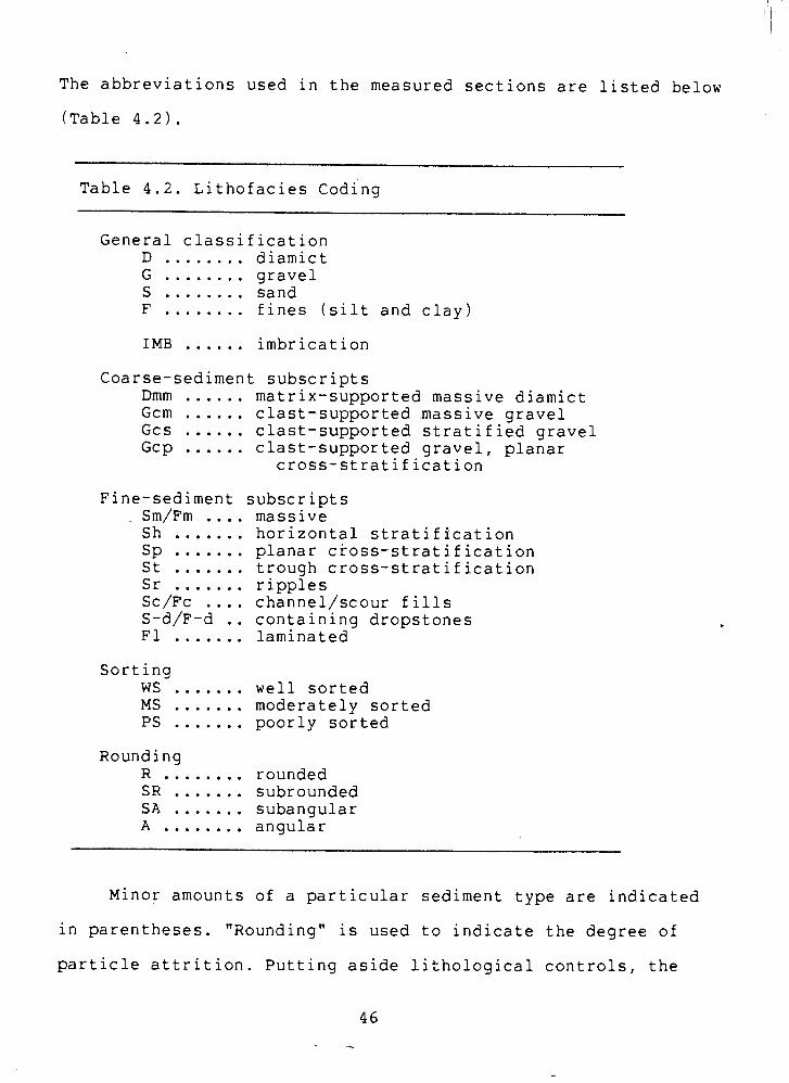
The abbreviations used in the measured sections are listed below
able 4.2).
Table 4.2. Lithofacies coding
General classification ........ D diamict G ........ gravel S ........ sand F ........ fines (silt and clay) IMB ...... imbrication
Coarse-sediment subscripts Dmm ...... matrix-supported massive diamict Gcm ...... clast-supported .massive gravel Gcs ...... clast-supported stratified gravel Gcp ...... clast-supported gravel, pl-anar
cross-stratification
Fine-sediment subscripts
Sorting ....... WS ....... MS ....... PS
Rounding ........ R ....... SR ....... S A ........ A
massive horizontal stratification planar cross-stratification trough cross-stratification ripples channel/scour fills containing dropstones laminated
well sorted moderately sorted poorly sorted
rounded subrounded subangular angular
Minor amounts of a particular sediment type are indicated
in parentheses. "Rounding" is used to indicate the degree of
particle attrition. Putting aside lithological controls, the
roundness of a clast approximately infers the amount of
transportation and reworking that it has undergone.
CHAPTER 5: THE MEASURED SECTIONS
This chapter describes and discusses the major outcrops of
Quaternary deposits in the Chilliwack Valley. The exact map
locations of the sections are listed in Appendix A.
Paleoenvironmental interpretations following the description of
the stratigraphy usually resulted from the combined assessment
of sediments and landforms. For the sake of clarity and brevity,
much of the primary information about the surficial sediments is
presented in schematic form in the figures, the key to which is
defined in the previous chapter.
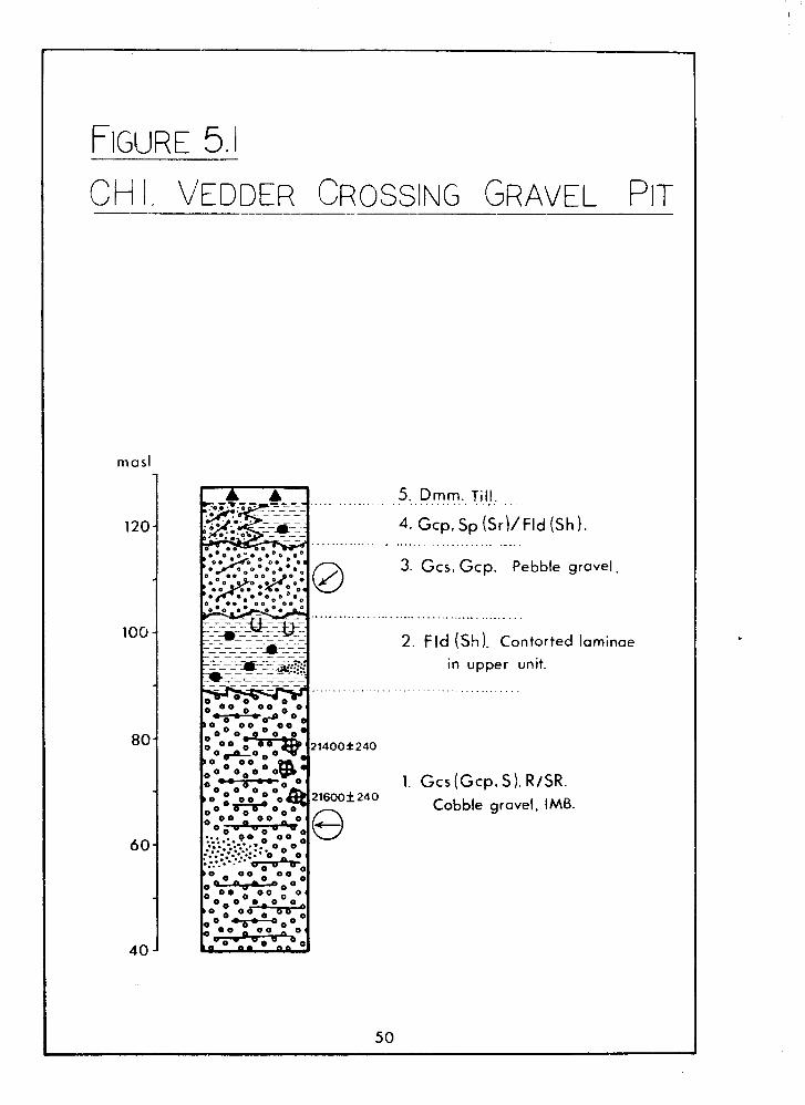
CHI. Vedder Crossinq Gravel Pit.
This pit is 1 km east of the mouth of the Chilliwack River
valley (Figure 2.2a), and is still actively worked in the upper
parts. The stratigraphy here was described by Clague &
Luternauer (1982) and Hicock et al. (1982b) and the measured
section (Figure 5 . 1 ) is summarized from these sources. No
attempt was made in this study to add further detail. This
section shows the unconsolidated deposits which underlie
Promontory Heights (~igure 1.1 1.
Stratigraphy
Unit 1 gravels rest on bedrock and account for half the
exposed sediments. They are mostly horizontally stratified, with
minor cross-bedding. Imbrication indicates a westward paleoflow.
Three mammoth tusks have been dug from the upper parts of this
unit, two of which gave radiocarbon dates of 21,600+240 and - 21,400+240 - BP (respectively SFU-65 and SFU-66, Hicock et al.
l982b).
Unit 2 clayey silts contain freshwater Pediastrum algae in
its upper parts, and some sand and gravel lenses. The upper
contact of shows evidence of catastrophic disturbance: blocks of
silt from this unit have been pulled up and incorporated into
the lower part of Unit 3.
The Unit 1-Unit 2 gravel-silt sequence can be traced
upstream along the north side of the valley to the Tamihi Creek
area, w.here it also outcrops on the south side; the best of
these exposures are at CHla and CHlb (Figure 2.2a,b).
Unit 3 is finer than the lowest gravel (Unit I), and has
better defined cross-bedding and cut-and-fill structures. The
paleoflow of these gravels suggest flow towards the Columbia
Valley.
Unit 4 gravels are interbedded with sand. These grade
eastward into horizontally-laminated silts. unit 4 is
unconformable with Unit 3.
Unit 5 is a mantle of till with a loess veneer.
5. Dmm. Till . . . . . . . . . . . . . . . . . . . . . . .
4. Gcp, Sp ( ~ r ) / ~ l d (Sh 1. ......................... - ...
3. Gcs, Gcp. Pebble gravel,
2. Fld ( ' ~ h ) . Contorted laminae
in upper unit.
. . . . . . . . . . . . . . . . . . . .
1. Gcs (Gcp, S). R/SR. Cobble gravel, IMB.
Interpretations
The basal gravels are a typical coarse gravel-bed river
facies and were deposited as outwash from an advancing
Chiiliwack Valley qlacier. They are correlative in age with the
Coquitlam Drift of Hicock & Armstrong (1981). The paleosurface
of this unit shows a longitudinal profile that is characteristic
of modern valley trains (Hicock et al. 1982b). The sandur
gravels filled the entire width of the Chilliwack River valley
in the Tamihi Creek area, and whilst no other outcrops of them
occur on the south valley side, it is probable that a
valley-wide fill extended downstream to Vedder Crossing, perhaps
into the Columbia Valley as well, and was subsequently removed.
An alternative interpretation of these gravels is that they are
a kame terrace built alongside the advancing glacier.
The lacustrine silts in Unit 2 were deposited in a lake
probably dammed by advancing ice in the Fraser Valley, during
the advance phase of the Fraser Glaciation (Hicock et al. 1982b;
Clague & Luternauer, 1982). The sand and gravel lenses in this
unit were possibly subaqueously deposited from the nearby ice
margin or from floating ice blocks, or alternatively they may
represent fluvial sediments from streams flowing into the
glacial lake.
Hicock et al. (1982b) interpreted the gravels in Unit 3 as
more outwash, intiated by a flood surge which disturbed and
ripped up silt blocks from Unit 2. Such fioods perhaps resulted
from a sudden draining of the glacial lake. Clague & Luternauer
(1982) suggested an alternative origin for these gravels, that
of deposition from a subaqeous ice margin. The absence of till
between Units 3 and 4, which would be expected from the
advancing ice, was explained as a result of a floating ice
margin or later removal. Glaciolacustrine conditions followed,
and the presence of abundant coarse material within Unit 4
suggest that these conditions were ice-marginal, the gravel-silt
grading perhaps representing a proximal-distal fining trend.
Renewed ice growth deposited the till capping. Katabatic winds
blowing off the receding ice masses would be resp~nsible for the
loess veneer.
CH2. Tamihi Scar
This is a major section. A landslide scar has exposed a
thick accumulation of the sediments which underlie the Ryder
Upland (Figures 2.2a,b). The scar, which pre-dates 1966, is
still unstable in wet conditions. The most recent documented
major failure at this site occured in December, 1975 (~unshaw,
1976). Most of the lower half of the section is buried under
mass movement deposits but the upper half is still well-exposed.
Due to the very poor or non-existent exposure in the lower
section, the numbering of units in Figure 5.2 is necessarily
tentative.
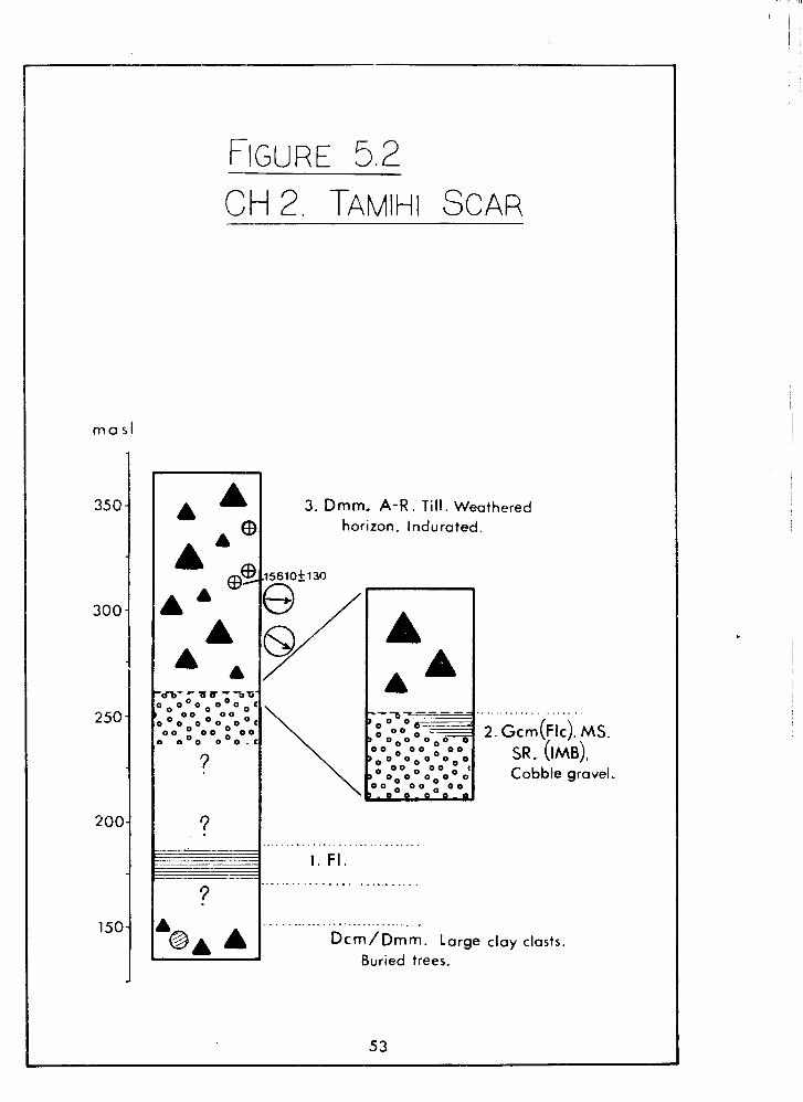
3. Dmm. A-R. Till. Weathered
horizon. Indurated.
. . . . . . . . . . . . . . . .
~ c m ( ~ l c ) . MS. SR. (IMB). Cobble gravel.
.............................
1 . F I ,
..............................
Dcm/Dmm. Large clay ~lasts. Buried trees.
Stratigraphy
Immediately above the road, unsorted gravels are exposed in
a road cut and in the stream bank; several mature trees in the
road cut have been partially buried by this deposit. A few
boulder-sized clasts of laminated silt are contained within
this. This is a recent debris flow deposit.
Unit 1 displays laminated silts, at least 10 m thick, in a
poor exposure in a tributary gully. The contacts are not
visibie.
Unit 2 is composed of massive gravels, with a 1.0 m lens of
laminated silts occuring at the top contact. Localized crude
imbrication indicates a westward paleoflow. The lower contact is
buried.
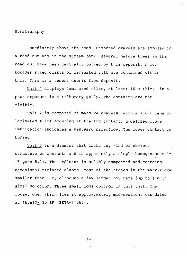
Unit 3 is a diamict that lacks any kind of obvious
structure or contacts and is apparently a single homogenous unit
(Figure 5.3). The sediment is solidly compacted and contains
occasional striated clasts. Most of the stones in the matrix are
smaller than 1 m, although a few larger boulders (up to 4 m in
size) do occur. Three small logs outcrop in this unit. The
lowest one, which lies at approximately mid-section, was dated
at 15,610+130 - BP (BETA-11057).
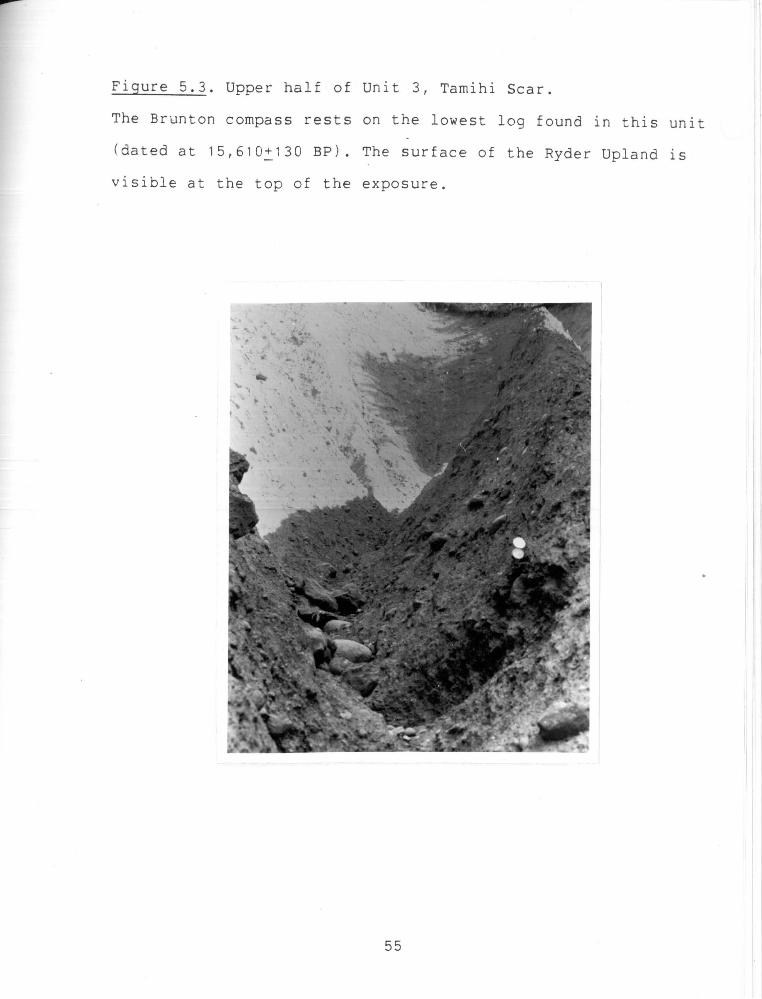
The middle log rests upon a 0.1 rn layer of white silty ash which
appears to have been derived from the log (Figure 5.4). Two
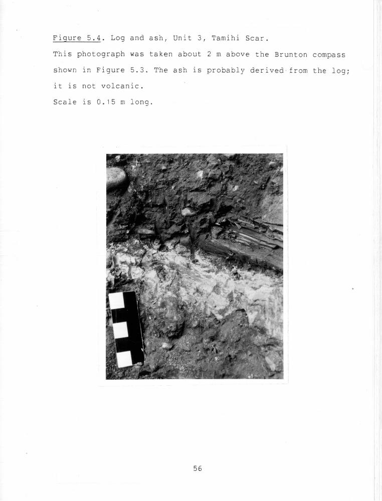
fabric analyses were performed in the lower half of the diamict;
the results (Figure 5.5) show a strong, and statistically
significant, preference for the clasts to dip westward.
Two small road cuts to the east of this site, collectively
called CH2a (Figure 2.2b), lie within the elevation range
occupied by Unit 3, at about 280 masl, and are included to
provide further insight into the nature of this unit. One shows
unsorted clast-supported gravels with few interstitial fines.
The other exposes well-sorted fine and medium sand expressed in
a variety of structures. The sand is generally bedded, with a
low-angle dip toward the southwest. Local ripples and
ripple-drifts indicate a downdip paleoflow direction. Some beds
have been disturbed to produce faint wave-like flames up to 0.4
m high.
Interpretations
Unit 1 is most likely of glaciolacustrine origins and
correlative with similar clays at CHI, CHla and CHlb.
Unit 2 gravel is a fluvial facies; its coarseness, lack of
well-defined bedding, and poor sorting imply a proximal or flood
deposit or both. Its high elevation suggests that ice-marginal
drainage was responsible; it is probably early Fraser outwash
from the Chilliwack Valley glacier. Localized ponding by the ice
would have enabled the clay lens to form.
Unit 3 is till. Ice apparently flowed from the Fraser
Valley, from the west and northwest, for at least the first half
of the depositional period. Given that the central part of Unit
3 is of mid-late Fraser age (15,610+130 - BP), the depositional
period represented by the till probably extended uninterrupted
for the major part of the Fraser Glaciation.
The origin of the ash layer under the middle log in Unit 3
(Figure 5.4) is a curious problem. Deposition of this wood and
ash was shortly after the lower log (dated at 15,610+130 - BP),
and at this time the Ryder Upland was covered by thick ice. A
volcanic origin for the ash therefore seems most unlikely, and
it is probably derived from the adjacent log.
The Ryder Upland represents a major depositional zone for
the ice in the Fraser Valley. The exact cause of this anomaly
(the thickness of Vashon till at CH2 is unmatched anywhere in
this area) can only be speculated. Possibly, deposition was
induced by interaction with the Chilliwack Valley glacier which
would have been active at the same time. Ice flowing into the
Chilliwack Valley from the Fraser Valley may have encountered
this valley glacier and deposited its sediment as a response to
the obstruction.
The sediments at CH2a must in some way be closely related
to a glacial environment, since till occurs just west of this
site. The gravels may merely be a locally stonier part of the
till. The sands are undoubtedly waterlain, so the gravels may
simply be moraine with the fines washed out at the time of
deposition. The sands are current-deposited, and could be either
subaerial or subaqueous. The lack of coarse material, in an
'environment rich with gravel-sized debris, suggests that the
latter is more likely. The absence of similar deposits at the
main section infers that localized ice-marginal lacustrine
conditions existed at CH2a.
CH3. Allison Pool Scar
This section owes its origins to a landslide and is
unstable when waterlogged. It is mostly covered by mudflow
deposits. An abandoned road leads directly to the section. CH3
is not representative of any distinct landform; it merely occurs
at the base of the valley-side slope, without an obvious surface
expression (see Figure 2.2b for location).
Stratigraphy
Unit 1 mostly consists of horizontally laminated clay, with
dropstones (Figure 5.6). In some parts, roots (from modern
vegetation) have destroyed the laminae, and it appears massive.
Unit 2 contains well-sorted fine and medium sands with
minor silt. The sand has massive parts, but is more commonly
bedded, with some ripples and small-scale cross-beds. Many beds
dip gently toward the west.
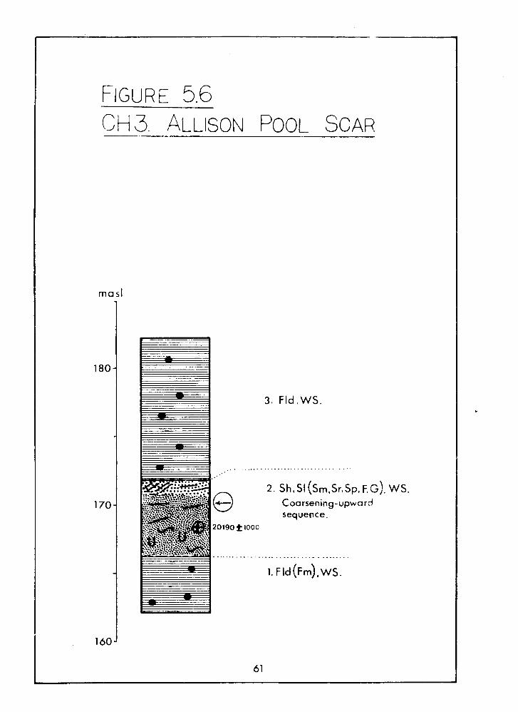
3. Fld .WS.
2. S ~ . S I (srn.sr.sp. F,G Coarsening-upward sequence.
). ws.
Two 0.4 m silt flames occur in the lower parts of the unit, as
do faults and slump structures. Occasional pebble-sized clay
balls can also be found here.
Three small rounded pieces of wood within this unit were
collectively dated (being individually of inadequate size for
radiocarbon assessment). The samples were derived from a
restricted area and were considered to be sufficiently close to
each other to assume a single dateable sample, despite the
possibility that they need not be derived from the same source.
Two pieces were at the same level and about 0.3 m apart, and the
third was less than 0.2 m below these. An age of 20,190+1000 - BP
(SFU-406) resulted.
The roundness of the wood pieces, and the lack of other
wood here, suggest that a period of transportation and
dispersion occured subsequent to the time when the sources log
was eroded. The degree of fluvial attrition of wood pieces has
been found to influence their radiocarbon age: Blong & ~ i l l e s ~ l e
(1978) found that age was inversely proportional to- the size of
wood sample. The radiocarbon age is therefore a maximum for the
Unit 2 sediments.
Unit 2 exhibits a general coarsening-upward sequence, and
the upper metre contains mainly coarse sand with occasional
pebbles; most of the pebbles are concentrated at or near the
upper contact. Faint wavy bedding and planar cross-beds occur.
The contact is sharp and irregularly horizontal with a rippled
appearance.
Unit 3 is very similar to Unit 1 , but contains fewer
massive parts. Laminae are draped over individual clasts at the
lower contact.
Interpretations
Extended glaciolacustrine conditions during the advance
phase of the Fraser Glaciation are inferred from Units 1 and 3;
the presence of dropstones throughout being indicative of such
environments.
The complex variety of structures in Unit 2 probably
results from rapid fluvial sedimentation, possibly accompanied
by subaqueous conditions at times. The concentration of gravel
at the topmost part of the unit suggests that energetic
conditions existed in the latter stage of deposition. The
dipping beds, coarsening-upward nature and the close associationb
with lacustrine sediments, suggest that Unit 2 is a small delta.
The rate of deposition of the Unit 2 sands was probably
much higher than that of the fines. In terms of the total length
of time symbolized by the deposits at CH3, the sands likely
represent a very brief depositional period.
The thickness of the clays at CHI (Unit 2) is 14 m, and
those at CH3 total more than 16 m. Both sets of clays can
readily be interpreted as early Fraser; the latter were dated as
such at 20,190+1000 - (SFU-406). Both sets of clays probably are
derived from the same lake.
Two major glaciolacustrine events occurred in the
Chiliiwack Valley, at ca. 20-21,000 BP and 11-12,000 BP (Clague
& Luternauer, 1982). The date from CH3 places the deposits in
the first event. Given the uncertainty of applying the
radiocarbon date to Unit 2, however, the possibility that these
sediments are significantly younger should be considered.
Specifically, could the CH3 sediments have resulted from the
11-12,000 BP event?
The stratigraphy in this part of the valley suggests that
this could not be the case. The deposits at CH3 lie at an
elevation similar to glaciolacustrine sediments from the ca.
20-21,000 BP event (unit 2, CHI; Hicock et al. 1982b), and which
outcrop in two places 2-3 km away, at CHla and CHlb (Figure
2.2a,2.2b). The morphology of the exposure at CH3, a landslide
in the valley side, is also identical to those at CHla and CHlb.
If the CH3 units were late glacial (i.e. 11-12,000 BP), a more
distinctive surface expression associated with these sediments
might be expected.
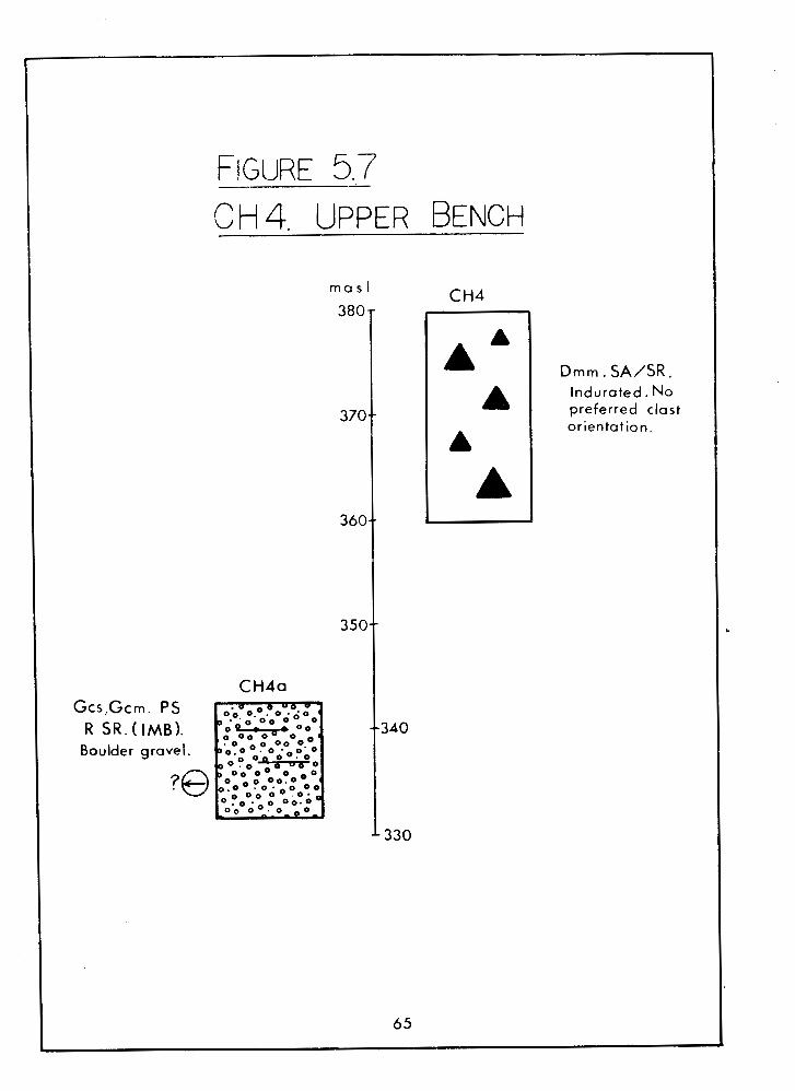
CH4. Upper Bench
Only one usable section, a road cut, was found on the Upper
Bench (Figure 2.2b). The exposure is reasonably clean; access is
by a logging road branching off the Tamihi Creek Road.
D m m . SA/SR, Indurated. No preferred clast orientation.
Stratigraphy
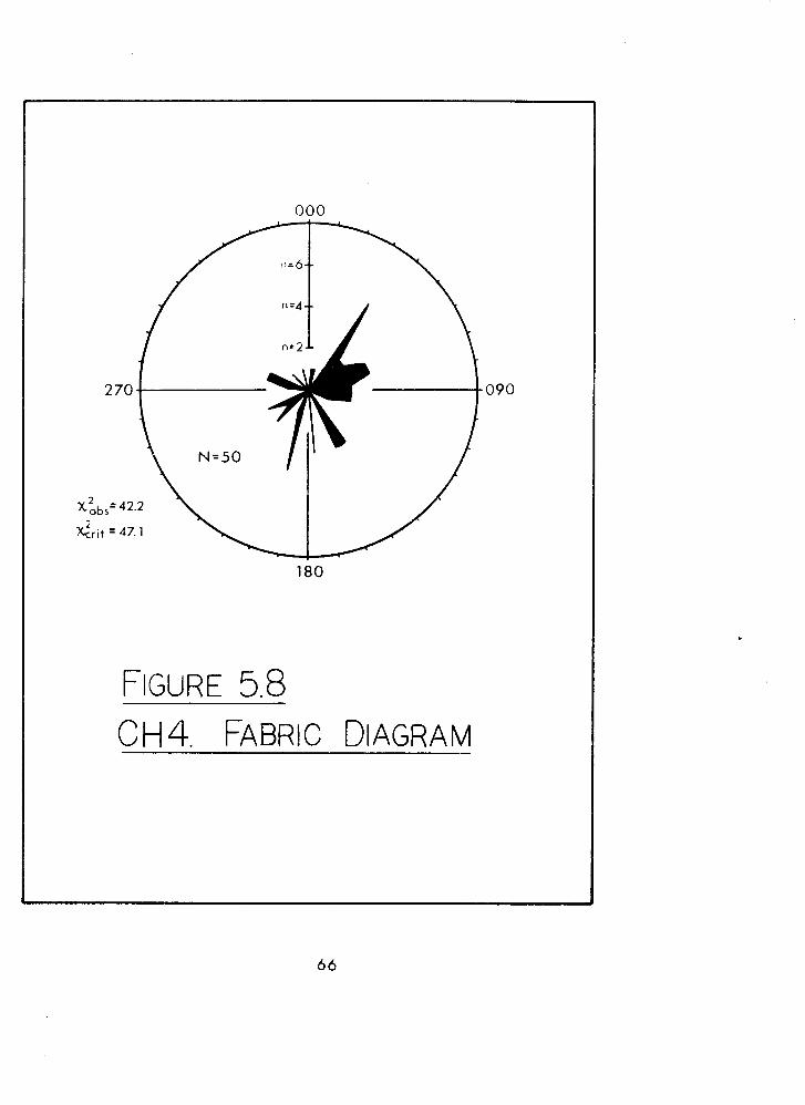
The only sediment in the section is a dark grey, massive,
matrix-supported compacted diamict (Figure 5.7). Clasts up to
about 1 m in size occur, and are occasionally striated. Most are
subrounded or subangular. A fabric analysis executed about 8 m
below the bench surface showed no preferred orientation of
clasts (Figure 5.8). The pebble orientations are not
statistically different from an omnidirectional distribution.
Below the Upper Bench surface, and to the west, there is an
arcuate ridge that blocks the mouth of Tamihi Creek valley
(Figure 2.2b). A road cut in the uppermost part of this ridge,
CH4a (Figure 5.7), reveals coarse gravels and sands, in places
crudely stratified. Poorly defined localized imbrication gives a
westward paleoflow direction.
No evidence was found to suggest that the diamict at CH4
directly overlies the gravels at CH4a: the landforms at each
site are spatially discrete. It is therefore assumed here that
the Upper Bench, as mapped in Figures 2.2a and 2.2b, contains
only diamict .
Interpretations
There are three possible origins for the Upper Bench
sediment. Firstly, it might be basal till similar to that at
Unit 3, CH2, and thus is an extension of the Ryder Upland
surface. But it lacks strong clast orientation; this could be
explained as a result of different modes of glacial deposition
(i.e. other than basal processes), or by post-depositional
disturbance. The main objection to this suggestion are the
problems of defining the spatial limits of such a thick valley
fill, and the fate of the large volume of material that was
subsequently removed. These problems are sufficiently great to
make this origin unli.kely. Secondly, it could be a lateral
moraine. Although its form is not typical of such features (it
lacks ridged topography), post-depositional modification may
have occurred. Thirdly, it could result from a mass movement. I f
a landslide occured whilst ice filled the valley bottom, the
debris would be left stranded on the valley side subsequent to
the retreat of the ice. However, obvious source areas for the
debris upslope of the bench remnants are absent.
The latter two suggestions require a valley glacier to be
present at the time of deposition. The height of the Upper Bench
- above the valley floor demands that this glacier be of
substantial size. Therefore, a mid-Fraser age is most probable.
Of the options listed, the second one seems the most likely.
The sediments at CH4a must be glaciofluvial, given their
location 200 m above the present-day Chilliwack River. The only
reasonable explanation for their origin is ice-marginal
drainage, which had to occur when ice masses existed in both the
Chilliwack and Tamihi Valleys. The arcuate shape of the ridge
may reflect the plan shape of a valley glacier in the Tamihi
Creek valley. The ridge itself might be cored by a terminal or
recessional moraine. However, without additional stratigraphic
data, these suggestions are purely conjectural.
CH5. Lower Bench
Much of the western part of the bench surface has been
disturbed, and there are few good exposures. Two sections (CH5a
and ~ ~ 5 b ) , which are about 2.5 km apart, were measured (~igure
2.2a) and both are portrayed in Figure 5.9.
Stratigraphy
CH5a is a road cut. Pebbly gravels are exposed, some
massive and some in low-angle dipping beds. The dip, and
localized imbrication, exhibit a paleoflow toward 300'. The
gravels rest on bedrock here but are obviously much thicker
under the main bench segments.
mas l
2 001
1. Gcs,S . WS .
R I S R . Foreset bedding.
Note scule changes
70
Fm. Loess . . . . . . . , . . . . . .
G c s , G c m . MS SR .(IMB). Pebbly gravel .
Up to 1 m of reddish loess caps the gravel. Although this
section is a few metres above the general level of the adjacent
bench top, several small pits (now infilled) in the bench
surface showed similar deposits. The loess capping outcrops in
several places in the area.
The second exposure, CH5b, occurs at the westernmost end of
the Lower Bench. This is a disused gravel pit, now regraded. The
exposures are in gullies at the south end and are rapidly
disappearing. Dipping foreset beds of coarse gravels and sands
are exposed. Some of the gravel beds are open framework (no
interstitial matrix). Topset bedding leading into foresets was
briefly revealed in a backhoe excavation in the east side of the
site, but is no longer exposed. A range of textures is present,
from coarse sand to small boulders, but individual beds are well
sorted. The gravels are locally open framework, but mostly
contain interstitial sand.
Interpretations
The gravels at both sites are fluvially-deposited, and the
lack of fines implies an energetic flow. The high elevation of
the bench above the modern floodplain, and the absence of
correlativ-e landforms on the north side of the valley, suggest a
kame terrace. Its freshness and loess veneer point to a late
Pleistocene age.
The ice, against which this terrace was built, flowed into
the lower valley from the Fraser Valley. Lobes of this ice
dammed a lake that extended as far as Slesse Creek (Clague &
Luternauer, 19821 , and also filled the Cultus Lake basin.
Drainage from the lake was confined to the south side of the ice
lobe, leading to a delta built into an ice-marginal lake (Figure
5.10a), eventually connecting with the Nooksack River via the
Columbia Valley. The present-day drainage route was covered by
ice at the time. The ice-marginal lake was mostly confined to
the valley of Smith Falls Creek, as evidenced by its unusually
flat floor.
In places, the Lower Bench has smaller benches a few metres
higher than the general level of this feature (see Chapter 2 ) .
This can be explained either as a result of a fluctuating
glacier margin elevation, or possibly as fluvial terracing by
the ice-marginal river.
Typically, kame terraces are supplied with sediment from
upstream. In the case of the Lower Bench, however, there was a
glacial lake immediately upvalley which would have trapped
sediment being transported by the Chilliwack River (~igure
5.10a). Therefore, the gravels exposed in the CH5 sections must
have been derived from elsewhere. Three possible sources exist.
Firstly, material could have been transported from the surface
of the ice lobe in the lower valley onto the kame terrace by
supraglacial streams.
0,::. : Kame terrace gravel 0 . **o:
Figure 5.10 Evolution of Lower Bench
73
-- -- L
a. ca. 11,300 BP
Glaciolacustrine clay
b. Contemporary
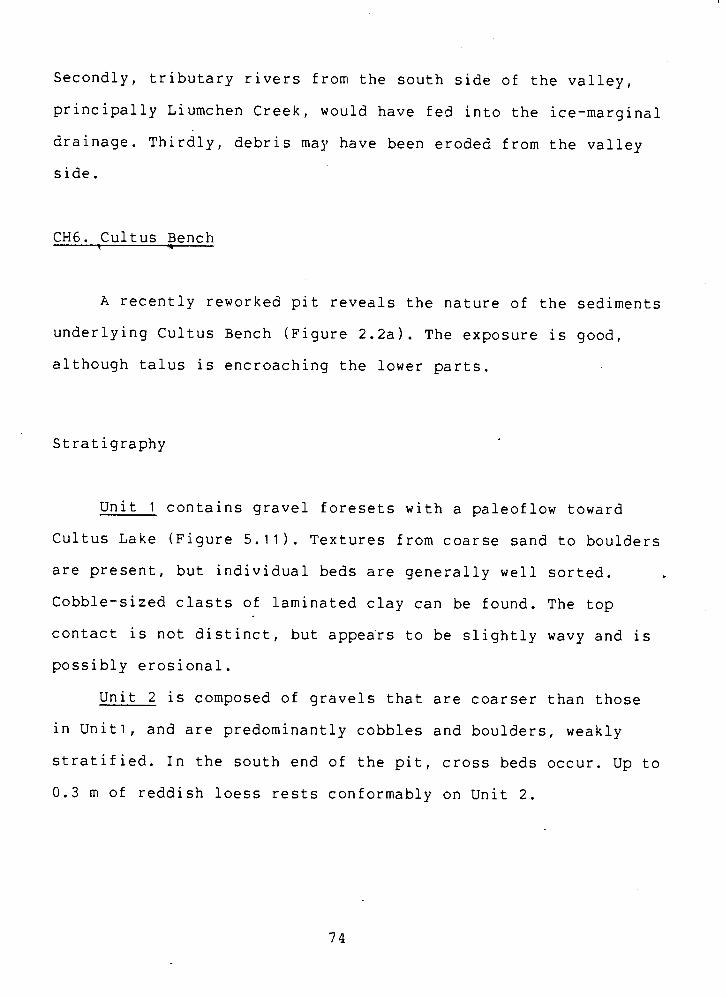
Secondly, tributary rivers from the south side of the valley,
principally Liumchen Creek, would have fed into the ice-marginal
drainage. Thirdly, debris may have been eroded from the valley
side.
CH6. Cultus Bench 1 =.
A recently reworked pit reveals the nature of the sediments
underlying Cultus Bench (Figure 2.2a). The exposure is good,
although talus is encroaching the lower parts.
Stratigraphy
Unit 1 contains gravel foresets with a paleoflow toward
Cultus Lake (Figure 5.11). Textures from coarse sand to boulders
are present, but individual beds are generally well sorted.
Cobble-sized clasts of laminated clay can be found. The top
contact is not distinct, but appea'rs to be slightly wavy and is
possibly erosional.
Unit 2 is composed of gravels that are coarser than those
in Unitl, and are predominantly cobbles and boulders, weakly
stratified. In the south end of the pit, cross beds occur. Up to
0.3 m of reddish loess rests conformably on Unit 2.
2. G c s / G c m ( ~ c p ) MS. SR. Cob bl gravel. Loess
veneer.
Gcs. WS. R/SR. Foreset
bedding. Pebbly gravel.
Small clay clasts.
Interpretations
The Unit 1 gravels are deltaic. I f the ancient lake level
was close to the upper contact of this unit, then it would be
about 10 m above the present-day level of Cultus Lake.
Gravels in Unit 2 result from more vigourous transport than
the foreset gravels and may also have been more proximal. They
are probably subaerial. kt the time of deposition, the lake
level may have been lower than it was when Unit 1 was deposited
or further away from this site. The loess veneer was probably
deposited at the close of the Pleistocene.
Lacking signs of major post-depositional disturbance, the
sediments at CH6, and indeed the whole of Cultus Bench, are
therefore probably of the same age. At this time, however, the
Columbia Valley was filled with outwash deposits and so blocked.
southward drainage. The only other outlet for drainage is via
Vedder Crossing, which requires a complete reversal of flow
directions. It is possible that stagnant ice lay in the
Chilliwack Valley and drainage was diverted around it, entering
and leaving Cultus Lake as it did so (Figure 5.12a). Therefore,
Cultus Bench formed as a kame delta.
Possible evidence for such a flow diversion lies in a
disused pit at CH6a (Figures 2.2ar 5.12) on the west side of
Columbia Valley, at an elevation only a few metres above CH6.
Here, similar gravels to those in Unit 1 are exposed,
horizontally stratified and not dipping. A channel f i l 1 . i ~
evident and gives a paleoflow direction of approximately 020'.
If these gravels are time-correlative to those at CH6, then the
reversal of flow, and the kame-delta, interpretations become
more viable.
The abrupt scarp bounding the north side of the Cultus
Bench may reflect the position of the stagnant ice (Figure
5.12). I t may also have been eroded by the Chilliwack River and
previously extended further than it does today. Extension of the
bench to the north side of the valley (i.e. a valley fill) would
mean that drainage via Vedder Crossing would be free of
blockage, and paleoflows would be towards Cultus Lake.
Therefore, some obstruction in the path of the Chilliwack River
is the preferred interpretation, and this most likely was
stagnant ice.
At some time, drainage at a higher elevation may also have
ran due north from the Cultus Bench (Figure 5.12a) through the
narrow valleys (now dry) near Vedder Crossing (shown in Figure
2.2a).
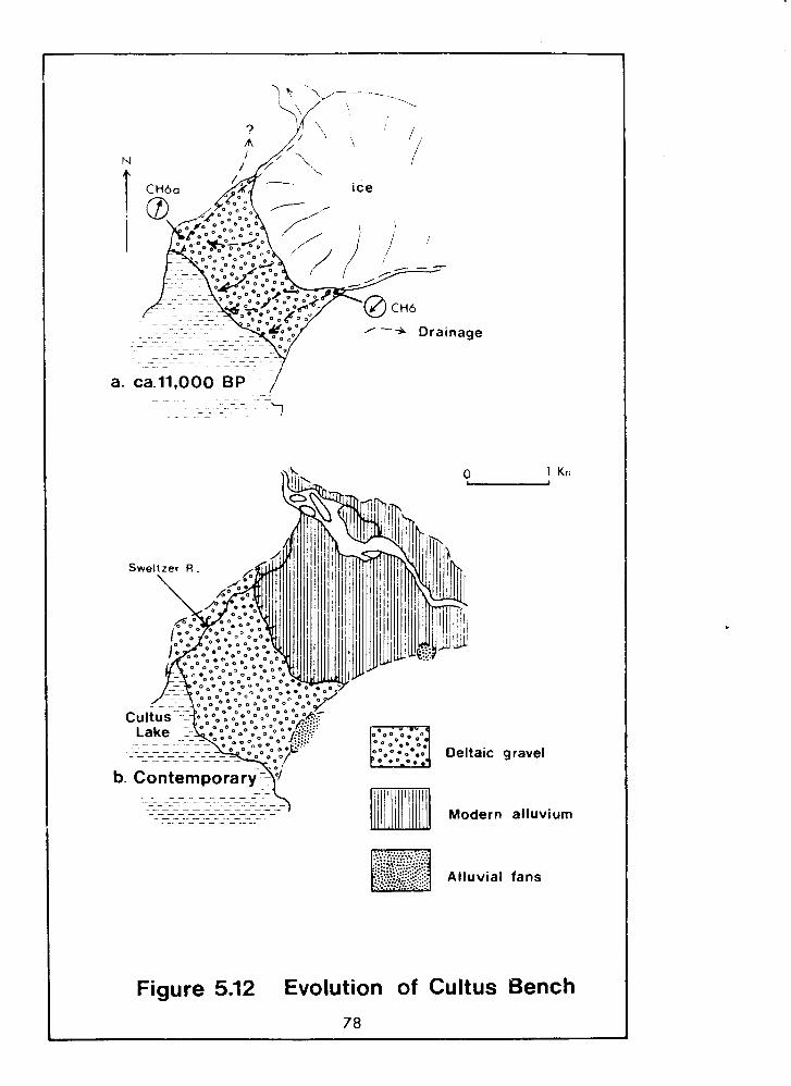
Deltaic gravel
Modern alluvium
Alluvial fans
Figure 5.12 Evolution of Cultus Bench 78
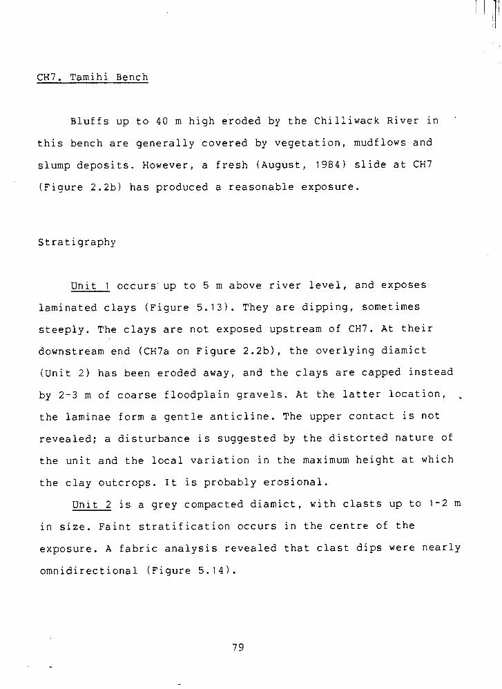
CH7. Tamihi Bench
Bluffs up to 40 m high eroded by the Chilliwack River in '
this bench are generally covered by vegetation, mudflows and
slump deposits. However, a fresh (August, 1984) slide at CH7
(Figure 2.2b) has produced a reasonable exposure.
Stratigraphy
Unit 1 occurs up to 5 m above river level, and exposes
laminated clays (Figure 5.13). They are dipping, sometimes
steeply. The clays are not exposed upstream of CH7. At their
downstream end (CH7a on Figure 2.2b), the overlying diamict
(Unit 2 ) has been eroded away, and the clays are capped instead
by 2-3 m of coarse floodplain gravels. At the latter location,
the laminae form a gentle anticline. The upper contact is not
revealed; a disturbance is suggested by the distorted nature of
the unit and the local variation in the maximum height at which
the clay outcrops. It is probably erosional.
Unit 2 is a grey compacted diamict, with clasts up to 1-2 m
in size. Faint stratification occurs in the centre of the
exposure. A fabric analysis revealed that clast dips were nearly
omnidirectional (Figure 5.14).
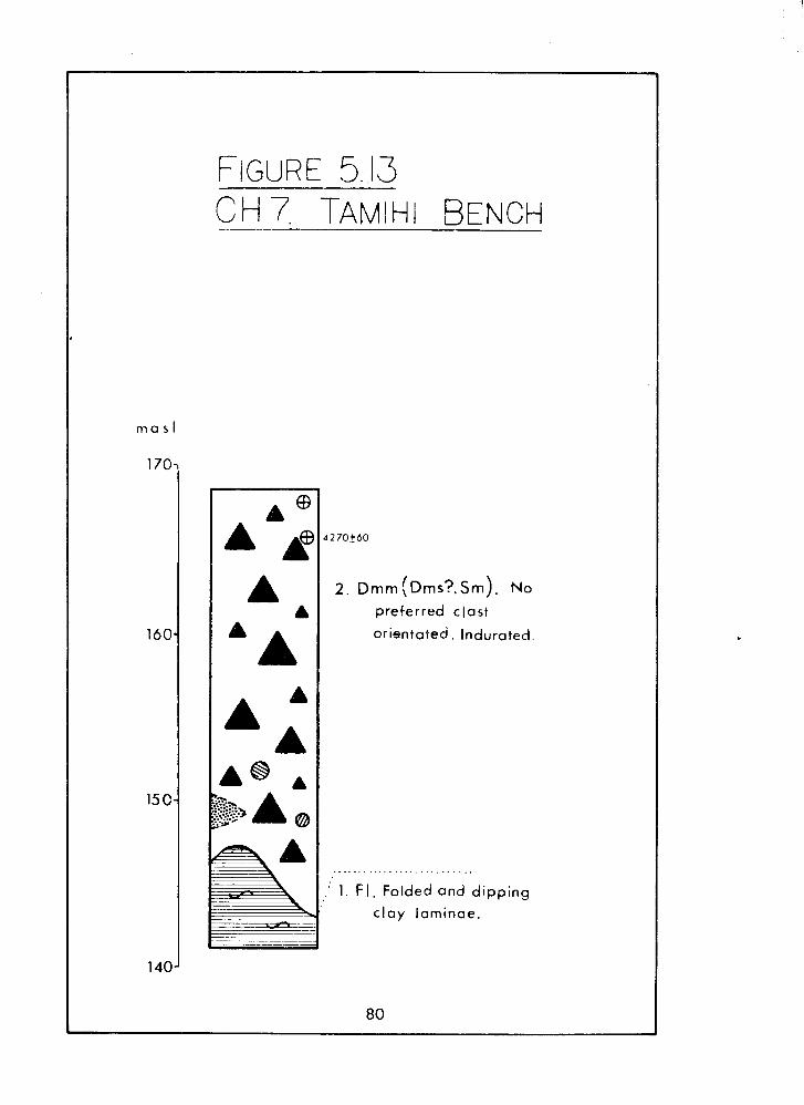
1 2 . ~ r n r n ( ~ r n i ? , ~ r n ) . No
preferred clast
orientated. Indurated.
, .
I. I . Folded and dipping
c lay laminae. -
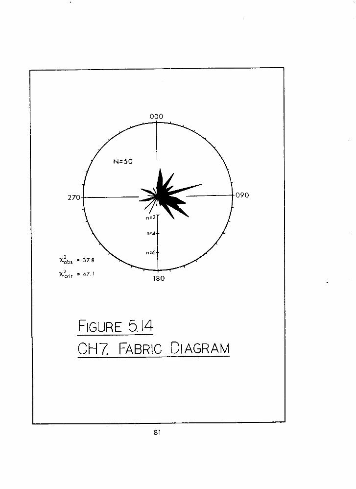
At CH7b (Figure 2.2b) an irregular pocket of massive well-sorted
medium sand at least 3 m in size was observed; its contacts were
sharp, but its true relation with the diamict was not revealed.
Nearby, two boulder-sized laminated-clay clasts were seen in the
same unit. Two logs are held in the bluff at CH7, about 2 and 6
m below the surface. A sample from the latter was dated at
4270+60 - (GSC-39611.
Interpretations
In both the north and south valley sides, early-Fraser
sediments are exposed (at CH3 and CHlb) and the Tamihi Bench
forms a valley fill within these. The probable relation of these
sediments is shown in Figure 5.15.
The CH7 clays (Unit 1 ) are typically glaciolacustrine in
appearance. Their stratigraphic relation to the valley-side
clays implies that they are younger. The two major
glaciolacustrine events in the valley have been dated at about
20,190 BP (from C H ~ ) and 11,900 BP (from CH9, Clague &
Luternauer, 1982). The latter age is therefore the only
realistic option for the CH7 clays.
Figure 5.15 Schematic Cross-section, Tamihi Bench
I I Tarnrhi Bench
I
CHlb I
I
' (CH
Numbe r s refer to representative sections (see text
mi Paleosandur gravel
Laminated silt, clay
The overlying diamict (Unit 2 ) has a mid-Holocene age,
which indicates that a non-glacial origin must be sought for
this deposit: a mass movement is the most likely mode of
deposition. The mass movement was sufficiently energetic to rip
up the underlying clay and incorporate blocks of it within the
diamict. Water was also involved, as suggested by the presence
of the sorted sand pocket and stratification. Based upon this
evidence, a debris flow, or probably a series of flows, is the
most appropriate interpretation of the diamict at CH7.
Although the radiocarbon date indicates a mid-Holocene age,
it is quite probable that the steep slopes fronting the Upper
Bench were unstable since late glacial times (as indeed they
still are). Slope failures have likely occurred throughout the
Holocene, perhaps decreasing in frequency as the slopes
stabilized.
Before the deposition of the diamict, the surface
expression of the clays was probably modified by the chilliwackb
River, contributing to the apparently distorted upper contact.
Debris flow activity deformed the laminae and doubtless
furthered the disruption of the surface of the clays.
The flattish parts of the Tamihi Bench could have resulted
from fluvial planation: assuming that the debris flow sediments
were at one time continous across the valley floor, the
Chilliwack River would have been ponded upstream by the
freshly-deposited plug (Figure 5.16a).
a (top) & b. Mid- Holocene
c. Contemporary
L5 surface
..-......, .*.-.-...?*.. .:... ::::.-.
Modern floodplain
Figure 5.16 Evolution of Tamihi Bench 8 5
The surface of the plug may have been eroded when the river
overtopped the dam. The abandoned channels on the surface of the
Tamihi Bench support this, although the absence of a capping of
alluvial sediments- do not; fluvial gravels were probably trapped
in the temporary lake upstream of the debris plug. Planation of
the bench surface was not widespread, and hummocky parts still
remain. Incision of the bench likely began soon after the debris
flow event(s).
The local history of events as inferred from CH7 and its
relation to adjacent sediments (Figure 5.15) is as follows.
Firstly, deposition of sandur gravels formed a valley fill
during the Fraser advance phase (see CHI, CHla, CHlb), which was
subsequently blanketed by laminated clay under glaciolacustrine
conditions at about 20,190 BP (see CH~). These two units were
subsequently dissected by the Chilliwack Valley glacier. Later,
ca. 11,900 BP, glaciolacustrine conditions were responsible for
depositing a unit of laminated clay (Unit 1 , CH7) in the valley
bottom. Upon deglaciation, the Chilliwack River flowed over, and
modified, this surface. In early and mid-Holocene times, debris
flows from the south side of the valley deposited a plug of
material which temporarily dammed the river. Incision of this
plug, and the underlying clays, followed, and erosion continues
today. The Chilliwack River is currently flowing on a small
gravel fill set within the lowest clay unit.
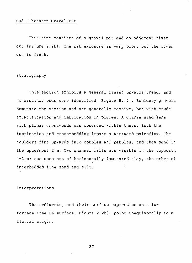
CH8. Thurston Gravel Pit
This site consists of a gravel pit and an adjacent river
cut (Figure 2.2b). The pit exposure is very poor, but the river
cut is fresh.
Stratigraphy
This section exhibits a general fining upwards trend, and
no distinct beds were identified (Figure 5 . 1 ? ) . Bouldery gravels
dominate the section and are generally massive, but with crude
stratification and imbrication in places. A coarse sand lens
with planar cross-beds was observed within these. Both the
imbrication and cross-bedding impart a westward paleoflow. The
boulders fine upwards into cobbles and pebbles, and then sand in
the uppermost 2 m. Two channel fills are visible in the topmost.
1-2 m; one consists of horizontally laminated clay, the other of
interbedded fine sand and silt.
Interpretations
The sediments, and their surface expression as a low
terrace (the L6 surface, Figure 2.2b), point unequivocally to a
fluvial origin.
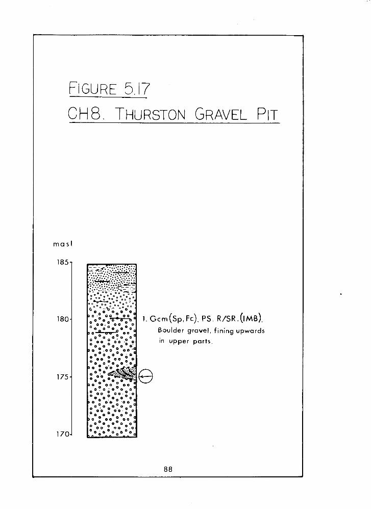
crn (sp. FC). PS Boulder gravel,
in upper parts.
. R/SR .(IMB).
fining upwards
The freshness of the channeled topography (Figure 2.2b),
suggests that deposition was either very late glacial or more
probably postg1acial:The draining of the late Fraser glacial
lake have left the newly-formed upper valley sandur high and
dry, with more than 100 m of relative relief between the upper
and lower valley floors. At the same time, discharges were
inflated by meltwater and fluvial activity was greatly enhanced:
vigourous paraglacial conditions were prevalent. The sandur
would have been rapidly incised creating large amounts of
sediment, some of which was redeposited as the L4 valley fill
and some of which is probably still in the contemporary fluvial
system.
CH9. Slesse Creek
Several sections near the Slesse Creek-Chilliwack River
confluence collectively expose the entire thickness of the upper
valley paleosandur. The main section, CH9, is a large riverside
slump face. Radiocarbon dates from this site are from Claque &
Luternauer (1982). Other exposures of the upper parts of the
sandur (CH9a,CH9b) occur in man-made pits: CH9a refers to
several small exposures near the Slesse Creek Road, and CH9b is
an exposure adjacent to the Chilliwack Lake Road. CH9c is
equivalent to Section 1 of Chubb ( 1 9 6 6 ) ~ of which only the
uppermost few metres remain exposed. CH9d is a minor exposure in
the bank of Slesse Creek. In the section diagram (~igure 5.181,
CH9d appears at a lower elevation than the other sections
because it is further downvalley. Most exposures are relatively
poor. Their locations are shown in Figure 2.2~.
Stratigraphy
Clague & Luternauer (1982) divided CH9 into six units,
which from the base upwards were:
( 1 ) up to 25 m of laminated silt and clay with dropstones, dated
at 11,900+120 - BP ~GSC-3306). The laminae were folded and
overturned. The upper contact was disturbed, and this unit
diapirically intruded the overlying sediments.
(2) 10L30 m of stratified pebble-cobble gravel and sand, dipping
gently westward. Possible foreset bedding.was seen. Sand beds
contained graded bedding.
( 3 1 0.5 m of laminated silt and fine sand, containing dropstonas
and organic debris dated at 11,700+100 - BP (GSC-2966).
(4) 2.5 m of pebble-cobble gravel, poorly sorted.
(5) 6 m of stratified, locally graded, fine and medium sand.
( 6 ) 9 m of interbedded silt, sand and gravel; the finer sediment
was better sorted than the gravel. Buried forest litter and an
in situ tree stump occured 5 m below the surface, and was dated
at 11,400+140 - BP (GSC-3308).
CH9 was reassessed in this study. The basic stratigraphy
remains mostly unchanged, but further details were brought to
light. The reinterpreted section is shown in Figure 5.18. Units.
1-5 correspond to (1)-(5) above, but Claque & Luternauer's
(1982) Unit (6) has been divided here into Units 6 and 7. The
following information is supplementary to that of these authors.
Unit 1. A 1.5 m bed of boulder gravels dissects this unit
at CH9d. These are clast-supported, rounded and imbricated with
a paleoflow toward the northwest. The underlying and overlying
clays dip in opposite directions, indicating that at least two
separate disturbance episodes occured. The clays outcrop along
the river upstream of this point to about 200 m south of the
main section.
Unit 2 gravels are now almost completely buried, but parts
of a large sandy channel fill can still be seen in the centre of
the face; it gives a westward paleoflow. The foreset bedding can
be seen in the gully at the north end of the face. A paleoflow
direction could not be obtained, but a southerly component is
evident.
Unit 3 silts are laterally continuous for the whole width
of the face. In the aforementioned gully, a sand lens splits
these silts.
Unit 4 gravels were found to diaprically intrude the
overlying sands (Unit 5), exemplified by a 1.2 m flame (Figure
5.19).
Unit 5 sands are mostly horizontally laminated, and embrace
occasional stones. They locally contain ripples and small
loading structures in the lower part of the unit.
. G c m . PS IMB.
Unit 6 is composed of interlensing sand and gravel. The
gravels tend to be cobbly or bouldery and poorly sorted; the
sands are coarse with scattered pebbles throughout. A prominent
yellow sand lens contains large planar cross beds with a
northwesterly paleoflow. In the gully, these are stained black
and red.
Unit 7 is characterized by alternating silts and fine
sands. Its lower contact is marked in places by a distinct hard
cemented layer about 5 mm thick. They vary in colour from a
distinctive pale blue to brown and yellow, and contain ripples
and loading strucures, as well as laminated and massive parts. A
capping of pebble gravels occurs. The fines grade into coarser
sands in the northern part of the face, and a gravel bed occurs
within these. The buried forest floor dated at 11,400+140 -
(GSC-3308) by Clague & Luternauer (1982) is immediately above
the lower contact of this unit, and can be found in the southern
end of the face.
CH9a offers better, and more accessible, exposures of Unit
7 than the main site. The Unit 7 fine sands and laminated silts
are displayed in a variety of structures (Figure 5.18). Many of
the silt laminae show convolutions and deformations. Granitic
boulders, some of them larger than 2 m in size, lie on the road
below the section, originally derived from excavations at this
site. Nearby, at CH9b, similar boulders can be seen in situ in
Units 5 and 6.
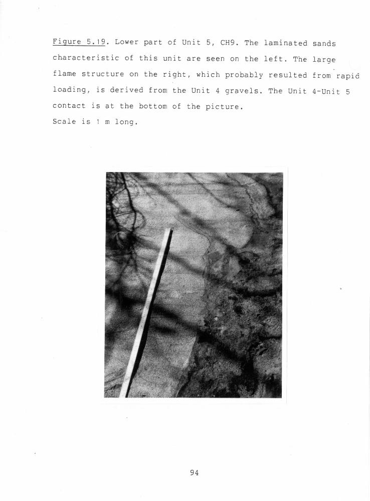
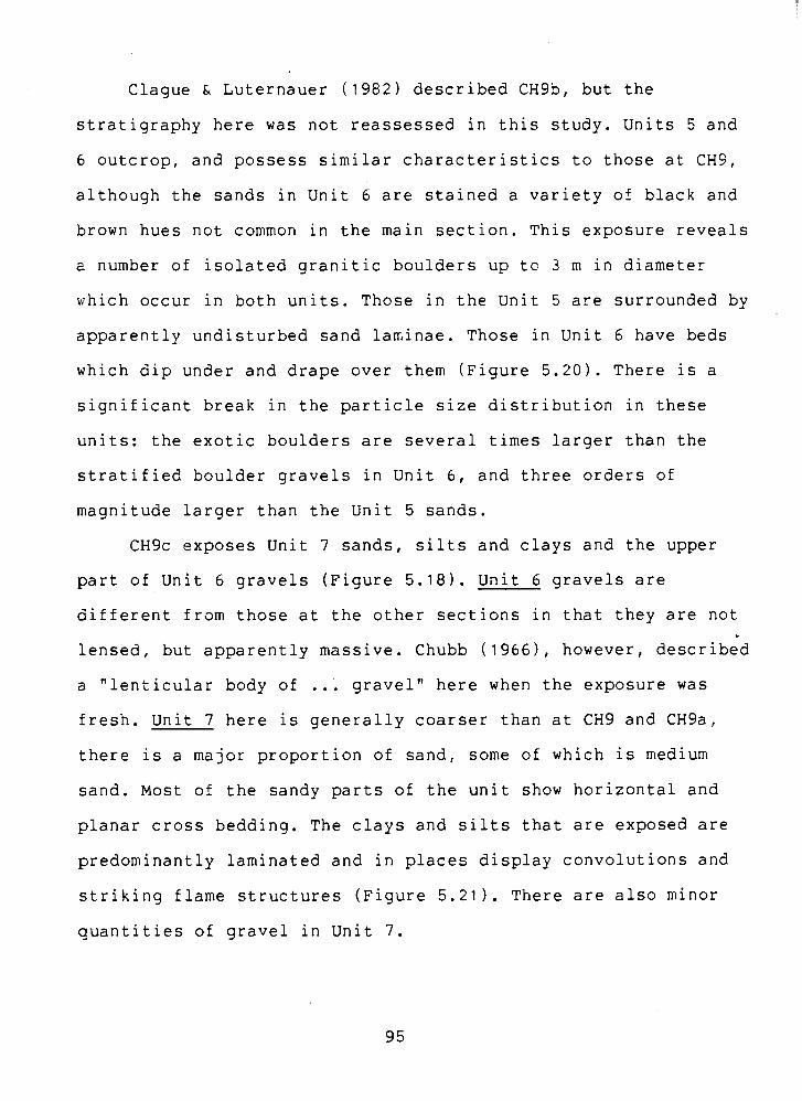
Clague & Luternauer (1982) described CH9S, but the
stratigraphy here was not reassessed in this study. Units 5 and
6 outcrop, and possess similar characteristics to those at CH9,
although the sands in Unit 6 are stained a variety of Slack and
brown hues not common in the main section. This exposure reveals
a number of isolated granitic boulders up to 3 m in diameter
which occur in both units. Those in the Unit 5 are surrounded by
apparently undisturbed sand laninae. Those in Unit 6 have beds
which dip under and drape over them (F'igure 5.20). There is a
significant break in the particle size distribution in these
units: the exotic boulders are several times larger than the
stratified boulder gravels in Unit 6, and three orders of
magnitude larger than the Unit 5 sands.
CH9c exposes Unit 7 sands, silts and clays and the upper
part of Unit 6 gravels (Figure 5.18). Unit 6 gravels are
different from those at the other sections in that they are not
lensed, but apparently massive. Chubb ( 1 9 6 6 ) ~ however, described
a "lenticular body of ..; gravel" here when the exposure was fresh. Unit 7 here is generally coarser than at CH9 and CHga,
there is a major proportion of sand, some of which is medium
sand. Most of the sandy parts of the unit show horizontal and
planar cross bedding. The clays and silts that are exposed are
predominantly laminated and in places display convolutions and
striking flame structures (Figure 5.21). There are also minor
quantities of gravel in Unit 7.
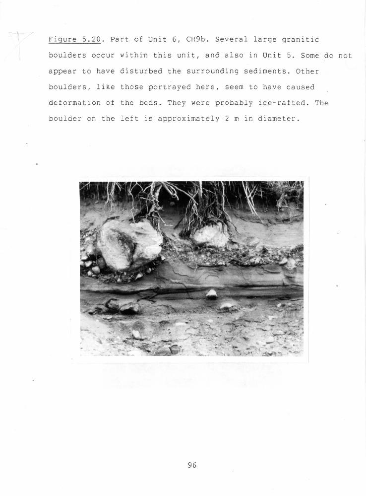
The CH9c Unit 7 was correlated to Unit 7 at CH9 on the grounds
of similar deposits, and stratigraphic position relative to the
sandur sur fac'e .
Interpretations
Clague & Luternauer (1982) considered that Unit 1 was
glaciolacustrine in origin, as were other laminated silts in the
section. The major unit at CH9, Unit 2, was thought to be
deltaic. The disturbed contact between Units 1 and 2 was
suggested to result from an unstable lake level or from shifting
braided river channels or from loading of the lake floor muds by
the overlying gravels. The upper units ( 4 to 6 ) indicated a
general fluvial setting, but the presence of laminated silts and'
graded sand bedding within these led Clague & Luternauer to
believe that some of these sediments were deposited
subaqueously, probably in a deltaic environment. All the units
were deposited within the closing millennium of the Fraser
Glaciation, ca. 11-12,000 BP.
Further details have now been added to the interpretations
of CH9. In Unit 1 , deposition of glaciolacustrine clays was
interrupted by at least one fluvial event, and perhaps more.
Although apparently brief (only 1.5 m of coarse gravels were
deposited), this indicates an unstable lake, and supports Clague
& Luternauer's ( 1982) conclusions.
Unit 2 shows that rapid deposition cf gravels by a
westward-flowing braided river followed, and probably was
outwash from retreating glaciers in the Chilliwack and Slesse
Creek Valleys.
The Unit 3 silts indicate a less active, glaciolacustrine,
period, possibly including a subaerial interval which gave rise
to the organic debris and the sandy lens in the middle of the
unit.
Unit 4 could be either a fluvial or deltaic deposit; it
contains nothing which unequivocally points to one of these
depositional modes.
The Unit 5 sands are glaciolacustrine; the sediment is very
well sorted, and graded bedding and dropstones occur. The
production of the large flame which intrudes this unit from Unit
4 would also be assisted by glaciolacustrine conditions. Lacking
laminated silt or clay, they are probably proximal to the
lake/delta margin.
The gravels in Unit 6 are at least partly fluvial in
origin, and the bouldery nature of some beds (e.9. at CHga,
C ~ 9 b ) indicate very energetic conditions. Some of the gravel
lenses could be interpreted as discrete subaqueous sediment
grsvity flows. These could have been either mass movements from
the delta front or debris released from icebergs. Upon
deposition of an unsorted gravel "parcel", some material was
reworked and became better sorted and structured, but some was
left untouched. This resulted in the different degrees of
sorting noted in the stratigraphy.
Unit 7 indicates that renewed deposition of
glaciolacustrine fines and fluvial sands continue to the end of
the sedimentation period. The buried forest floor at the lower
contact of this unit may represent a period of local stability:
Clague 6 Luternauer's dated stump was at least 100 years old.
Possibly this part of the section was a bar or island that was
unaffected by the geomorphic activity occuring on other parts of
the sandur. The forest floor was drowned by the glacial lake as
it rose to deposit Unit 7.
At CHgb, the exotic boulders in Units 5 and 6 were
suggested by Clague & Luternauer (1982) either to have been
transported from the Chilliwack Lake Barrier by catastrophic
floods, or by icebergs from a calving glacier. They did not
elaborate on the latter possibility. Although these boulders are
reasonably well rounded, normal fluvial processes seem
inadequate to explain the problem of grossly incompatable
competences between them and the finer sands and gravels which
compose the major part of the section.
Ice rafting seems the only plausible explanation. Rounding
of the boulders, either by water or ice, probably occured before
rafting. Deposition of these great stones would have certainly
entailed disturbance of the lake bed sediments, but the sand
laminae in Unit 5 show no signs of disruption. This anomaly can
be explained by assuming that the sand adjacent to the
freshly-deposited boulder was reworked by wave or current
activity and horizontal lamination restored. Continued
sedimentation of sand eventually buried the boulder.
In Unit 6, the story is a little different. Bedding may
have been deformed by the large boulders dropping into them. But
some of the deformed beds beneath the boulders in Unit 6 are
akin in appearance to fluvial scour holes and associated lag
gravels, and so offer an alternative interpretation. A fluvial
scour explanation was given for similar phenomena observed in an
intratill sand layer by Shaw (1982). Shaw proposed that the
boulder was held in basal ice and the scour fill was deposited
subglacially around it. It is conceivable that a grounded
iceberg could have behaved in a similar fashion at CH9b.
The source of the exotic granitic boulders was not
specified by Clague & Luternauer (1982), although they implied
the Chilliwack Batholith at Chilliwack Lake (Figure 2.1).
Another possible source is the Mount Barr Batholith in the Foley
Creek sub-catchment. A valley glacier may have existed in the
lower Foley Creek valley when the sandur/delta in the trunk
valley was being constructed. I f the glacial lake extended as
far as the mouth of the valley (requiring a lake level of - +380
masl), then this glacier could have supplied icebergs, some of
which rafted the boulders in question a few kilometres
downvalley to Slesse Creek. Evidence that might support this
supposition is found at CHI0 and CHII.
If fluvial transport of some of the boulders - did occur,
then the Foley Creek supply is still a viable source area for
coarse sediments at the Slesse Creek sites. The longitudinal
slope of this valley is steeper than that of the Chilliwack
River, and would be more beneficial to the fluvial transport of
large boulders.
Sediments at CH9c can be similarly interpreted to those at
CH9 and CH9a. The generally coarser nature of Unit 7 at this
site suggests that geomorphic activity was a little more
energetic on this part of the sandur/delta front.
Throughout the section, alternate periods of glaciofluvial,
deltaic and glaciolacustrine conditions are evident. The topmost
unit, containing extensive laminated silts and sands, shows that
this lake persisted until very late in the Sumas stade, by which
time the water surface elevation was of the order of 300 masl.
CH10. Chipmunk Creek Gravel Pit
This pit is near the confluence of Chipmunk Creek and
Chilliwack River (Figure 2.2~). Much of the face is buried by
talus, but those sediments that do outcrop are cleanly exposed.
Stratigraphy
The section consists almost entirely of one unit of dipping
(dip 25', towards 210') gravel foreset beds (Figure 5.22).
~ c s ( ~ r n r n ) . WS. S R . Pebbly
gravel. Foreset bedding.
Textures range from coarse sani! to occasional boulders, but as
with similar outcrops in the study area, individual beds are
generally well sorted. Some have open framework gravels.
Paleoflows inferred from the dip indicate flows emanating from
the Chipmunk Creek valley. In the upper few metres of the
section, minor pockets of gravelly diamict occur within the
dipping beds.
The sediments typify deltaic foresets. The elevation of the
lake level would be - +430 mas1 if it was close to the upper limit
of the exposed foresets, so glacial damming must have been
involved. Possibly localized ice-marginal ponding was
responsible, or it may have been built into the late Fraser lake
that was interpreted from CH9b. The diamict lenses in the top
part of the section are probably small sediment gravity flows :
into the lake from the nearby valley side.
CHl1. Foley Creek
A few hundred metres upstream of it's confluence with the
Chilliwack River, Foley Creek has dissected a small bench (L9 in
Figure 2.2~) and exposed the sediments underlying the surface.
The section is approached from the Foley Creek logging road.
Most of the deposits are poorly exposed. Figure 5.23 divides the
100 m wide section into two halves for the sake of clarity, and
the two columns shown are only 50 m apart. The south half of the
exposure has a lower surface elevation due to terracing (see
discussion of this landform in Chapter 2). Units 1 and 2 are not
laterally continuous, but have been truncated in the centre of
the face.
Stratigraphy
Unit 1 gravels are entirely composed of randomly arranged
angular material. The gravels are predominantly from the local
pelitic bedrock (the Cultus Formation). The upper contact of
this unit is probably erosional.
Unit 2 is a grey diamict that is well compacted, and also
outcrops to the northeast of this site. The upper 0.5 m or so
are texturally similar but are pale brown, and probably result,
from weathering. The upper contact is irregular, dips southward
and appears to be eroded.
Unit 3 is composed of gravels which are horizontally
bedded, with two channel fills. Pockets of well-sorted sand
occur in the topmost parts of this unit, and may be further
channel fills. This sand also outcrops in a road cut immediately
above the section, where it displays ripples and loading
structures. Large granitic boulders, rounded and subrounded, are
contained within this unit. Some are concentrated in a layer
resting on the lower contact.
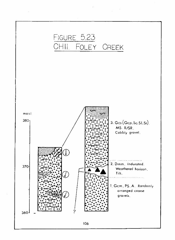
mas i
CHI i FOLEY CREEK
Gcs ( ~ c p . s~ .s I . s~ ) . MS. R/SR . Cobhly gravel,
. . . . . . . . . . . . . . . . . . . . . . . .
Dmm. Indurated.
Weathered horizon.
Till. . . . . . . . . . . . . . . . . . . . . . . . . . . .
Gcm. P S . A . Random
arranged coarse
gravels.
Interpretations
Unit 1 gravels were probably deposited by an advancing
glacier in the Foley Creek valley during the Fraser Glaciation.
The same glacier then deposited till: Unit 2. The weathered
horizon of the till implies a time interval between retreat of
the glacier and deposition of Unit 3. The truncation of Units 1
an 2 must have occured within this interval. Fluvial terracing
is the most probable cause of this erosive event.
Unit 3 was deposited by flows issuing from the Foley Creek
valley. The abundance of rounded material and stratification
suggest reworking of sediment as the river mobilized freshly
deposited morainal sediments left by the receding Foley Creek
glacier. The granitic boulders were derived from the headwaters
of this valley, where the Mount Barr Batholith outcrops; similsr
boulders can be seen still held within till on the slopes above
Foley LBke. Large granitic stones at Slesse Creek were probably
derived from the Foley Creek glacier (see discussion of CH9b).
Unit 3 gravels were likely deposited at the same time as the
uppermost parts of the trunk valley sandur, during late Fraser
times, ca. 11,300 BP.
Subsequent incision of the sandur surface by the Chilliwack
River, probably under paraglacial conditions (see discussion
under CH8), terraced the Unit 3 sediments, whilst Foley Creek
incised a small canyon in them. Incision has been checked by the
downstream bedrock control at the Chipmunk Creek confluence
(Figure 2.3).
CH12. Chilliwack Lake ~arrier
A road cut adjacent to the Chilliwack Lake Road partially
reveals the internal composition of the Chilliwack Lake barrier
(LlG, Figure 2.2d). Gourlay (1977) and Clague & Luternauer
(1982) recorded the stratigraphy at this section, which is
mostly obscured now. A summary of their results is presented
here.
Stratigraphy
Unit 1 is a very coarse diamict (Figure 5.24). Boulders up
to 8 m in diameter occur, though most are less than 1 m in sizf.
Both angular and rounded stones can be found.
Unit 2 caps the section with 1-4 m of cobbly gravel, which
is better sorted, bedded and imbricated than the rest of the
section. Paleoflows from Post Creek are inferred from these
topmost gravels. Granitic rocks make up the vast majority of
lithologies.
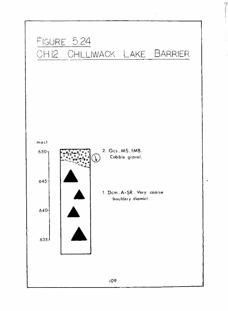
mas l
650.
645
640
635
G c s . MS. IMB. Cobble gravel.
1 . Dcm . A - SR . Very coarse
bouldery diamict.
Interpretations
The core of the barrier is probably a recessional moraine
left by a late Fraser glacier which filled the basin presently
occupied by Chilliwack Lake (Daly, 1912; Claque & Luternauer,
1 9 8 2 ) . It is in lateral contact with the upper valley
paleosandur. The coarse diamict most likely results from glacial
deposition or rockfall or both, in a similar manner to the
bouldery ridge damming Moraine Lake in the Rocky Mountains of
Alberta (Baird, 1 9 7 7 ) . Discharges from Post Creek briefly
deposited a gravel capping on the barrier and subsequently
incised and terraced it, carr~ying boulders eroded from the
moraine for a few kilometres downvalley.
Jokulhlaups draining a glacial lake in the Silverhope
Klesilkwa basin have been suggested as the cause for this actipn
(Gourlay, 1976; Clague & Luternauer, 1 9 8 2 ) . But no unequivocal
supporting evidence has been fowarded. The primary reason for
citing catastrophic discharges is the fact that boulders, some
2-3 m in size, have apparently been transported downvalley from
the Chilliwack Lake Barrier across a gently sloping unconfined
valley floor about 1 km wide. The downstream decrease of maximum
boulder size is very rapid (Gourlay, 1 9 7 6 ) : it is less than 2 m
at 2 km from the barrier, 1.5 m at 3.2 km, and 1 m at 6 km. The
jokulhlaup therefore seems to have been of very short duration.
Caution is needed, how.ever, in accepting the catastrophic
flood hypothesis. The proposed meltwater channel (the Post Creek
valley! is underlain by granite, conglomerate and gneiss. I t
could therefore be expected that discharges of catastrophic
magnitude would have transported boulders of all lithologies
into the Chilliwack River valley. But only granitic boulders are
in evidence, some of which have obviously undergone virtually no
attrition, and cannot have been subjected to much fluvial
transport, if any. It is possible that the terraces in the
Chilliwack Lake Barrier were not cut by catastrophic floods, but
by enhanced meltwater flows. Perhaps a short-lived jokulhlaup
was assisted by such flows in dispersing the bouldery debris
from the Chilliwack Lake Barrier.
CHAPTER 6: SURFICIAL GEOLOGY AND GEOCHRONOLOGY
This chapter presents the surficial geology map and
chronology of geomorphic events for the Chilliwack Valley, as
compiled from the data and i'nterpretations presented in the
previous chapter.
Surficial Geoloav
The combined assessment of surface deposits and associated
landforms was utilized to identify the type and extent of the
surficial geology. The resultant maps are shown in Figure 6.1. A
few additional minor qualifying comments are necessary.
In Figure 6.la, the sediments underlying the meltwater
channels ( ? ) mentioned in the discussion of landforms (Chapter
2) are unknown. Armstrong (1980b) correlated them to pre-Sumas
sediments at CHI, but they might conceivably be younger.
The early Fraser drift mapped at the base of the Ryder
Upland (Figures 6.la,b) is probably largely covered by mass
movement and fan deposits, and its upper boundary is uncertain. --
The composition of the Upper Bench (E'igures 6.1a,b) has
been tentatively mapped as mid-Fraser till, but as discussed in
Chapter 5, this has yet to be confirmed.
The Chilliwack Lake Barrier (Figure 6.1d) has been mapped
as a combination of recessional moraine and outwash. This is an
attempt to distinguish this feature from the sandur surface
immediately downvalley.
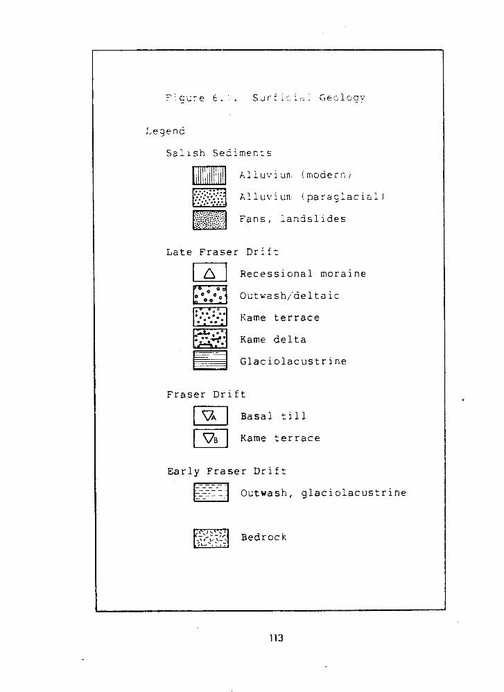
...... :.::.: ... ..: ......... :' Fans, landslides ...... :..: .:.. :...:..... . :.:'
Late Fraser Drift .
Fraser Drift
Recessional moraine
Outwash/deltaic
Kame terrace
Kame delta
Glaciolacustrine
I I Basal till
I T ] Kame terrace Early Fraser Drift
- - - - - - 1-1 - - - - - Outwash, glaciolacustr ine
I , / \ .I
Bedrock t i - - * . 8:
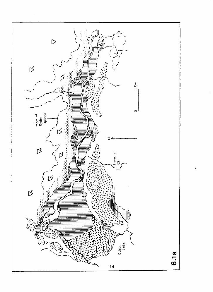
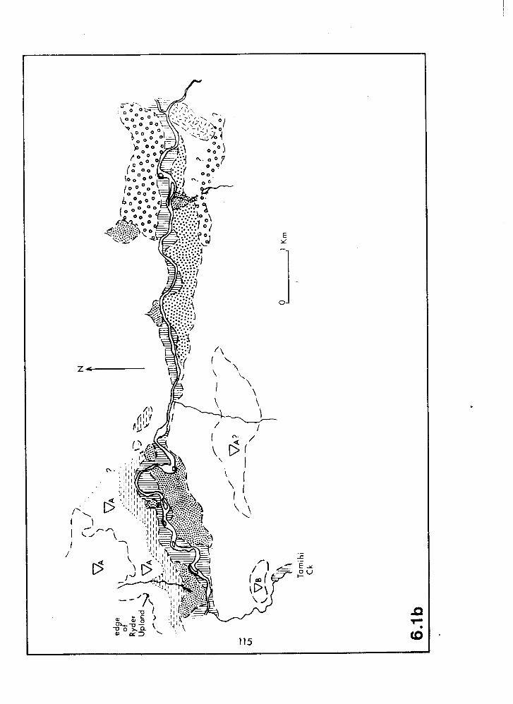
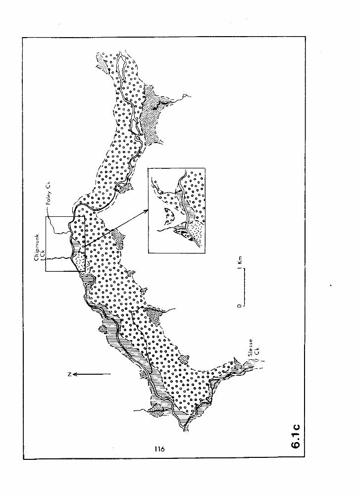
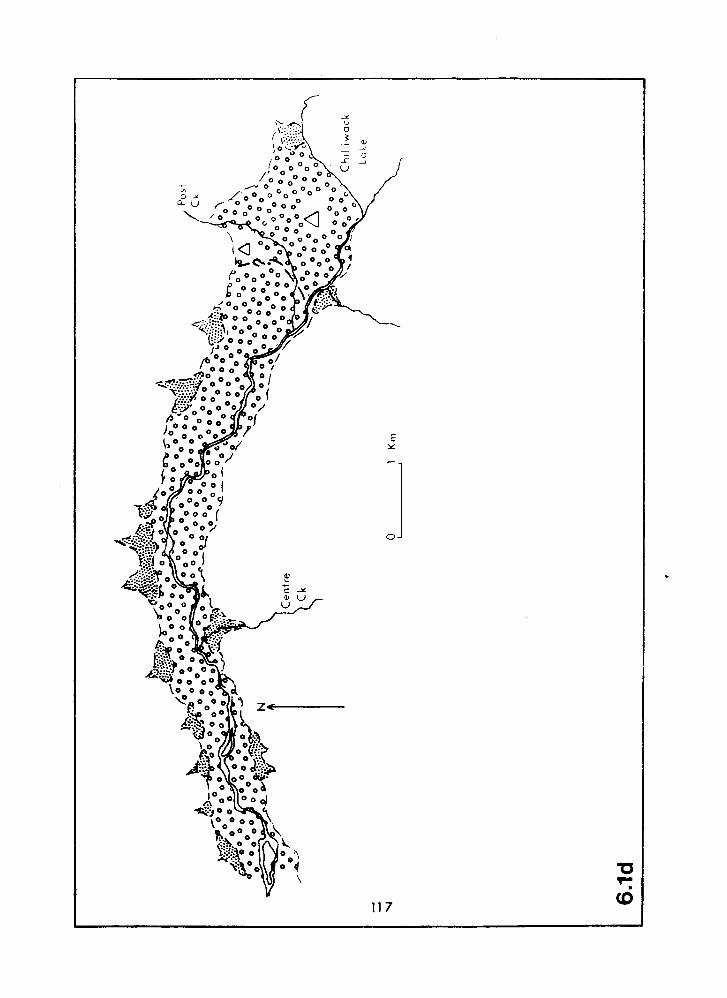
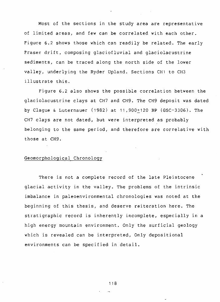
Most of the sections in the study area are representative
of limited areas, and few can be correlated with each other.
Figure 6.2 shows those which can readily be related. The early
Fraser drift, composing glaciofluvial and glaciolacustrine
sediments, can be traced along the north side of the lower
valley, underlying the Ryder Upland. Sections CHI to CH3
illustrate this.
Figure 6.2 also shows the possible correlation between the
glaciolacustrine clays at CH7 and CH9. The CH9 deposit was dated
by Clague & Luternauer (1982) at 11,900+120 - BP (GSC-3306). The
CH7 clays are not dated, but were interpreted as probably
belonging to the same period, and therefore are correlative with
those at CH9.
Geomorphological Chronology
There is not a complete record of the late Pleistocene
glacial activity in the valley. The problems of the intrinsic
imbalance in paleoenvironmental chronologies was noted at the
beginning of this thesis, and deserve reiteration here. The
stratigraphic record is inherently incomplete, especially in a
high energy mountain environment. Only the surficial geology
which is revealed can be interpreted, Only depositional
environments can be specified in detail.
The Fraser Glaciation - Asvance Phase
The paleosandur underlying the Ryder Upland is the oldest I
dated feature in the valley. It was being formed between 21,400
and 21,600 BPI and undoubtedly existed for longer than this. It
probably filled the whole width of the valley, and drainege was
westward to Vedder Crossing. Sediment was derived from local
advances of valley glaciers. No evidence for a pre-Wisconsin
Fraser River has been unearthed (Armstrong, 1981) and so at that
time the Chilliwack River may have emptied into a marine
estuary. Alternatively, if sea levels were dropping at this time
in response to the expanding ice sheets in the Coast Mountains,
the river would have flowed a greater distance before reaching
the sea.
The growth of ice into the eastern Fraser Lowland creat~d a
glacial lake in the lower Chilliwack Valley by blocking the
westward drainage. The position of the ice margin was assumed to
have been proximal to the Vedder Crossing Gravel Pit as shown by
the presence of sand and gravel lenses in Unit 2 at this site.
It is pssible that it flowed into the Columbia Valley.
Glaciolacustrine conditions prevailed until at least
20,190+1000 - BP (SFU-406), and probably for a considerable period
after this, as inferred from CH3. .
Intense glaciation was undoubtedly the ncrm for this phase,
and erosion played a dominant role. Many erosional features
typical of alpine glaciation were left, but there is a dearth of
deposits. The major exception to this in the research area is
the thick bench of unconsolidated sediments which make up the
Ryder Upland, some of which (e.g. Unit 2 at CH2) probably result
from outwash alongside an advancing Chilliwack Valley glacier.
Nearly half of the Upland is composed of till, with a
radiocarbon age of 15,610+130 - BP (BETA-11057) from CH2, which
was deposited from ice flowing into the lower Chilliwack Valley
from the Fraser Valley. A confrontation between this ice mass
and the Chilliwack Valley glacier may have been the catalyst
leading to localized, though intense, deposition of morainal
material forming the bench.
Accepting the arguments against the deposition of a
continuous valley floor between the Ryder Upland and the Upper
Bench (discussed under CH4), it is conceivable that the
Chilliwack Valley glacier lay along the south side of the lower
valley when sedimentation was active in the Ryder Upland area,
thus preventing valley-wide deposition.
The Fraser Glaciation - Recessional Phase
Aithough the Everson Interstade is represented in the
sediments of the central and western Fraser Lowland, it is
apparent that the eastern parts of the area, and the Cascades,
were occupied by ice at this time (Armstrong, 1981). No deposits
that indicate interstadial conditions have been identified in
the Chilliwack Valley. The homogeneity of the thick till unit at
CH2 (Unit 3) suggests that there was no break in deposition from
the Vashon to the Sumas Stade. I t seems likely that during this
period ice was at a standstill or underwent a slow retreat up
the valley. Alternatively, the Chilliwack Valley glacier could
have retreated rapidly, as suggested by Crandell (1965) for
Washington glaciers. It is quite possible that the large Fraser
Valley ice mass remained stationary whilst the valley glacier
retreated.
- Separation of the Fraser Valley and Chilliwack Valley ice
masses allowed a lake to form between them. The lake extended
upvalley to at least Slesse Creek by 11,900+130 BPI and its
presence in the lower valley prevented a late-glacial valley
fill from being deposited (claque & Luternauer, 1982). Laminated
clays at CH7 and CH9 were derived from this lake.
Glaciolacustrine sediments at the Slesse Creek sites suggest
that the lake level was at least 300 masl, but CHlO and CHl1'
interpretations require a lake of 380-430 masl. Ice, in the
lower valley, of sufficient thickness to dam a lake at this
elevation would have flowed over the Ryder Upland. Given the
suggestion of uninterrupted till deposition inferred from Unit 3
at CH2, ice probably persisted on the Upland throughout most of
the Fraser Glaciation.
Drainage along the south side of the lower valley ice lobe
deposited the Lower Bench kame terrace, and flowed into an
ice-marginal lake at Smith Falls Creek (~igure 5.10). The lake
extended to the snout of the Columbia Valley ice lobe, at the I
I south end of Cultus Lake. Drainage from here was southward, down I
the Columbia Valley to join the Nooksack River.
Coeval with these events in the lower valley, a receding
Chilliwack Valley glacier deposited a sanaur in the upper valiey
which terminated in the glacial lake. No evidence of a
re-advance of the Chilliwack Valley glacier has been found, and
it was probably in a state of general retreat during late Fraser
times. It was stationary at Chilliwack Lake for a while, and
deposited a bouldery moraine there.
Tributary valleys discharging onto the sandur surface
undoubtedly contributed meltwater at this time. Only Foley Creek
shows evidence of providing a significant sediment supply in
addition to the trunk velley outwash material. Boulders
littering the sandur surface have been assumed by Gourlay ( 1 9 7 6 )
and Clague & Luternauer ( 1 9 8 2 ) to be solely derived from the
Chilliwack Lake area (specifically the Chillwiack ~atholith);
but in fact those at the downstream end of the sandur were
probably derived from the Mount Barr Batholith at the head of
Foley Creek.
Towards the close of the Pleistocene, water from the
Silverhope-Klesiikwa drainage area crossed the drainage divide
into the Chilliwack River, via Post Creek, briefly depositing a '@'
gravel capping on the Chilliwack Lake Barrier. This feature was
subsequently dissected and terraced, probably by a brief
catastrophic flood, and bouldery debris tranported a few
kiloxetres downvalley. The disposition of ice masses needed to
precipitate catastrophic discharges were not fully clarified by
Gourlay ( 1 9 7 6 ) ana Claque & Luternauer ( 1 9 8 2 ) .
The arrangements of ice necessary for the creation of a
glacial lake in the Silverhope-Klesilkwa valley which would
drain via Post Creek are as follows. Two glaciers are necessary,
one flowing south down the Silverhope Creek valley from the
Fraser Canyon, and the other flowing northwest up the Klesilkwa
River valley from ice in the Skagit drainage area (as portrayed
by Waitt, 1977, for early Fraser glaciers). These two ice lobes
would have impounded a glacial lake between them upon separation
(Figure 6.3a). Putting aside the possibility of ice-marginal
drainage from this lake, the lowest outlet available is through
the Post Creek valley, which was most likely ice-free during
late Fraser times. The immediate precursor to the situation in
Figure 6.3a is for one of the ice lobes to block the eastern end
of the Post Creek valley, thereby raising the water level abobe
the elevation of the drainage divide. Upon retreat of the lobe,
the lake would drain into the Chilliwack Valley via Post Creek.
Detailed supporting evidence for this scenario is not
available. However, exposures of deltaic(?) gravels north and
south of the Silverhope-Klesilkwa Srainage divide show paleoflow
directions convergent on the Post Creek valley. I f these gravels
were deposited at similar times, then the presence of the two
glaciers is proved, and the possibilty of a lake held between
them becomes much greater.
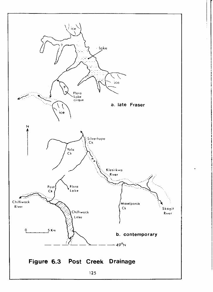
, . . _ J . .
Fraser
C hil l iwack River
R ~ v e r
b. contemporary
Figure 6.3 Post Creek Drainage
125
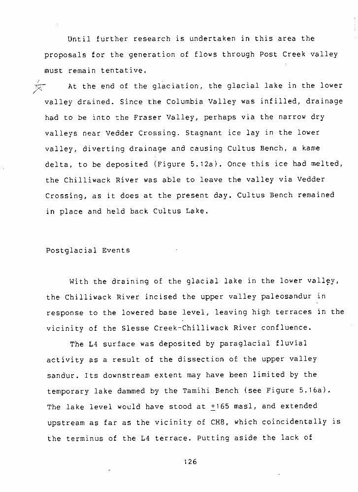
Until further research is undertaken in this area the
proposals for the generation of flows through Post Creek valley
must remain tentative.
&- At the end of the glaciation, the glacial lake in the lower J
valley drained. Since the Columbia Valley was infilled, drainage
had to be into he Fraser Valley, perhaps via the narrow dry
valieys near Vedder Crossing. Stagnant ice lay in the lower
valley, diverting drainage and causing Cultus Bench, a kame
delta, to be deposited (Figure 5.12a). Once this ice had melted,
the Chilliwack River was able to leave the valley via Vedder
Crossing, as it does at the present day. Cultus Bench remained
in place and held back Cultus Lake.
Postglacial Events
With the draining of the glacial lake in the lower vall~y,
the Chilliwack River incised the upper valley paleosandur in
response to the lowered base level, leaving high terraces in the
vicinity of the Slesse Creek-Chilliwack River confluence.
The L4 surface was deposited by paraglacial fluvial
activity as a result of the dissection of the upper valley
sandur. Its downstream extent may have been limited by the
temporary lake dammed by the Tamihi Bench (see Figure 5.16a).
The lake level would have stood at - +I65 masl, and extended
upstream as far as the vicinity of CH8, which coincidentally is
the terminus of the L4 terrace. Putting aside the lack of
stratigraphic evidence for a delta here (no foresets), a
possible evolutionary sequence for this part of the valley was
illustrated in Figure 5.16.
Debris flow activity'on the slopes of the Upper Bench
deposited sediment in the valley bottom and temporarily dammed k
the Chilliwack River, so forming the Tamihi Bench. Slope
failures probably began in late glacial or paraglacial times.
Incision of the Tamihi Bench commenced soon after its formation,
and it is still being actively eroded today.
Many of the fans in the valley probably originated during
paraglacial times. Some fans are inactive today, but those that
are fed by creeks remain active.
Once the glacial influence had waned, the intensity of
geomorphic activity was reduced, and for or at least the second
half of the Holocene, was probably very much as it is today.
Neoglacial advances were apparently not of widespread
importance in the study area: moraines from such events are
limited to the glaciers in the Depot Creek valley. Advances of
other glaciers in the Chilliwack Valley probably did occur, but
their moraines (if any were deposited) must either have been
quickly destroyed, or were very small and so are not apparent in
the contemporary landscape.
CHAPTER 7: CONCLUSIONS
This chapter outlines the implications of the present study
for the Fraser Lowland Quaternary history, and for future
research in the area.
Implications for the Fraser Valley Chronology
Some of the early Fraser drift identified in the Chilliwack
Valley was deposited at the same time as the Coquitlam Drift in
the western Fraser Lowland. Specifically, the lower valley
paleosandur discussed by Hicock et al. (1982b) shows that the
Chilliwack Valley glacier was active at that time. Similar
activity has been reported from Washington by Crandell (1963)
and Crandell & Miller (1974). Advances of alpine glaciers in the
Evans Creek Stade were probably the norm in the Cascades and
southern Coast Mountains at that time.
The glaciolacustrine clays dated at CH3 as 20,190~1000 BP
(SFU-406) infer that Fraser Valley ice was in place at the mouth
of the Chilliwack Valley at this time, and so confirms Hicock &
Armstrong's (1981) tentative 21,000 BP reconstruction of the
eastern Fraser Lowland. Subsequently, both these clays and the
underlying sandur gravels (exposed at CHI, CHla, C ~ l b ) were
eroded by the advance of the Chilliwack valley glacier.
Vashon till is scarce in the Fraser Lowland (Armstrong,
1984). In the Chilliwack Valley a major till unit of this age
was found to underlie the Ryder Upland. This is Unit 3 at CH2.
the above author. The date of 15,610+130 - BP (BETA-11057), and I I the paucity of dates available to mid-Fraser times (Claque, I 1980), makes CH2 an important section. The Ryder Upland was
I
I
apparently a principal deposition site for the Fraser valley ice
lobe. The exact reasons why this should have been could not be
fully ascertained (see interpretation of CH2, Chapter 5 ) .
No sediments relating to the Everson Interstade were
identified in the study area. Instead, ice in the Chilliwack
Valley probably underwent a slow retreat or standstill during
this time, without significant deglaciation. This study supports
the suggestion that interstadial conditions (deglaciation) did
not occur in this area at this time, and that ice persisted in
the eastern Fraser Lowland (Armstrong, 1981).
A broad suite of deposits has been ascribed to the late
Pleistocene in this study: the kame terrace deposits at CH5, the
kame delta (Cultus ~ e n c h ) and glaciolacustrine and deltaic
sediments at CH9. All these depend upon a lobe of the Fraser
Valley glacier existing in the lower Chillwack Valley.
Glaciolacustrine clays at CH9 dated at 11,900+120 - BP (GSC-3306)
mean that Fraser Valley ice existed in the lower Chilliwack and
Columbia Valleys at this time. A till date of 11,300+100 BP
(GSC-2523) from the Cultus Lake ice-contact face suggests that
this ice, and consequently the Chilliwack Valley glacial lake,
persisted until then.
While Clague (1981) argued for a rapid retreat of ice in
the Fraser Valley at the end of this stade, it. is possible that
some stagnant ice masses persisted in the eastern Fraser
Lowland. This was suggested in the interpretation of CH6, and
thus supports Armstrong's (1960a) argument for stagnant ice in
the Sumas Valley at the same time.
Implications for Chilliwack Valley Research
The Quaternary evolution of the Chilliwack River Valley is
now understood in more detail and broader scope as a result of
this research. The implications for past and future research are
discussed here.
Assessment of Previous Research
The previous works can now be reviewed against the new
findings of this study.
Two sections from Slesse Creek were well documented and
competently interpreted by Chubb ( 1 9 6 6 ) ~ but his stratigraphy
was not as detailed as his petrologic work. His four-unit
section was an oversimplification of the complexities documented
later by Claque & Luternauer (1982) and by this author.
Munshaw's (1976) work was broad in scope, but his coverage
of geomorphology and geology was uneven. Munshaw was the only
previous author who described the exposure at CH2, the Tamihi
Scar, and then when it was fresh, but he failed to realise its
significance. His correlation between the upper valley
paleosandur (L7 surface) and the Ryder Upland (Ll) can now be
positively discounted.
Armstrong's (1980b) map has been updated in this study, but
it remains axiomatic. This work deviates from his in two
respects. Firstly, he mapped the Tamihi Bench as outwash sand
and gravel, whereas it was found to be composed largely of
diamict (see CH7). Secondly, he omitted the Lower and Upper
Benches. This study has expanded upon Armstrong's work by
extending the mapping into previously uncharted parts of the
valley.
Clague & Luternauer's (1982) field guidebook remains a
valuable study o f the valley. Of their work at CHI, CH9 and
CH12, that from the latter two sites was expanded upon in this
thesis.
Future Research
The major problem site in the research area is the Upper
Bench. Further studies of the surficial geology of this feature
might reveal a more detailed story, although at the time of this
author's visits, this site was notable for its reluctance to
reveal good exposures of the subsurface sediments.
Detailed reassessments of the remaining Chilliwack Valley
sections would probably also be worthwhile. In particular, the

lithological aspects, given a secondary role in this study,
could provide a basis for provenance studies. Paiynological
research would be well worth pursuing to enrich
paleoenvironmental interpretations, and indeed was used to
advantage by Hicock et al. (1982b) at CHI. The thick till unit
at CH2 presents possibilities for a well-focussed diamict study.
A seismic study of some of the terrain units could prove
interesting. The Ryder Upland, Tamihi Bench and the upper valley
paleosandur might be productively examined in this manner.
Lastly, the surficial geology of the Silverhope-Skagit area
has not yet received any attention. The late Sumas chronology of
the upper Chilliwack River valley will not be complete until
this gap in - knowledge - - is infilled.
APPENDIX A. SITE LOCATIONS
All but one of the following six-figure coordinates are
taken from the 1 :50,000 topographic map sheet 92H/4
(Chilliwack). The exception, CH12, is from sheet 92H/3 (Skagit
River).
Site Grid reference
CH 1 CHla CHlb CH2 CH2a CH3 CH4 CH5a CH5b CH6 CH6a CH7 CH7a CH8 CH9 CH9a CH9b CH9c CH9d CHI 0 CHI 1 CHI 2
APPENDIX B. AERIAL PHOTOGRAPHS --
The following are all vertical air photographs. The
flight-lines in Set 1 run north-south, whilst those in Set 2 are
east-west. These lists include only those photographs used by
the author; there are many other photographs available for this
area.
Set 1
August-September, 1966. Average ,scale, 1:31,680. -- - - - ---
Flight Photograph Location line numbers
- -
Silverhope-Skagit divide Post Creek, Chilliwack Lake Post Creek, L10 upper Foley Creek, L7, Centre Creek lower Foley Creek, L7, L8, L9, Nesakwatch Creek L8, L9, Larsons Bench (17), Slesse Creek Vedder Crossing, L4, Cultus Lake L6, lower Larsons Bench ( ~ 7 ) L2, L5, L6, Tamihi Creek L1, L2, L3, L5, Tamihi Creek L1, L3
Set 2
July, 1973. Average scale, 1;15,840.
Flight Photograph ~ocat ion line numbers
BC7472 074-076 Cultus Lake. 087-101 Cultus Lake, L4, L3, part of L1,
L2, L5, L6, part of L7. 087-101 Vedder Crossing, L1, L5, L6,
whole of L7, L8, L9, LIO. 205-207 L8, L9. 216-217 Post Creek.
REFERENCES
Ager, D. V. (1973) The Nature of the Stratigraphical Record, (New York: John Wiley & Sons), 114 pp.
Andrews, J. T. (1971) Techniques of till fabric analysis, Technical Bulletin, British Geomorpholoqical Research Group, 6, 43 pp.
Armstrong, J. E. (1960a) Surficial geology of Sumas map-area, British Columbia, Geological Survey of Canada, Paper, 59-9, 27 pp.
.(1960b) Surficial geology, Chilliwack map-area (west half), British Columbia, Geological Survey of Canada, Map, 53- 1959.
.(1980a) Surficial geology, Mission map-area, British Columbia, Geoloqical Survey of Canada, Map, 1485A.
.(1980b) Surficial geology, Chilliwack map-area (west half), British Columbia, Geoloqical Survey of Canada, Map,
.(1981) Post-Vashon Wisconsin glaciation, Fraser ,
Lowland, British Columbia, Geological Survey of Canada, Bulletin, 322, 34pp.
.(1984) Environmental and engineering applications of the surficial geology of the Fraser Lowland, British Columbia, Geoloqical Survey of Canada, Paper, 83-23, 54 PP
Armstrong, J. E. & J. J. Clague (1977) Two major Wisconsin lithostratigraphic units in southwestern British Columbia, Canadian Journal of Earth Sciences, 14, 1471-1481.
Armstrong, J. E., D. R. Crandell, D. J. Easterbrook & J. B. Noble (1965) Late Pleistocene stratigraphy and chronology in southwestern British Columbia and northwestern Washington, Bulletin, Geological Society of America, 76, 321-330.
Armstrong, J. E., W. H. Mathews & A. J. Sinclair (1971) Use of trend surfaces in till fabric analysis: discussion, Canadian Journal of Earth Sciences, 8, 1163-1167.
Baird, D. M. (1977) Banff National Park, (Edmonton: Hurtig), 235 PP
Blong, R. L. & R. Gillespie (1378) Fluvially transported
charcoal gives erronous C14 ages for recent deposits, Nature, 271, 739-741.
British Columbia Department of Environment (1976) Terrain Classification System, (Environment and Land Use Committee secretariat), 56 pp.
Bustin, R. M. & W. H. b at hews (1979) Selective weathering of granite clasts, Canadian Journal of Earth Science, 16, 215-223.
Chubb, P. J. (1966) A Detailed Study of Two Exposures of Late Pleistocene Sediments in the Central Chilliwack Valley, British Columbia, BASc. thesis, University of British Columbia, 42 pp.
Church, M. (1980) Records of recent geomorphological events, in: Cullingford, R. A., D. A. Davidson & J. Lewin (eds), Timescales in Geomorphology, ondo don: John Wiley & sons), 13-29.
Church, M. & J. M. Ryder (1972) Paraglacial sedimentation: a consideration of fluvial processes conditioned by glaciation, Bulletin, Geoloqical Society of America, 83, 3059-3072.
Clague, J. J. (1977) Quadra Sand: a study of Late Pleistocene geology and geomorphic history of coastal southwest British Columbia, -Geological Survey of Canada, Paper, 77-17, 24 pp.
.(1980) Late Quaternary geology and geochronology of British Columbia. Part 1: radiocarbon dates, Geological Survey of Canada, Paper, 80-13, 28 pp.
.(1981) Late Quaternary geology and geochronology of British Columbia. Part 2: summary and discussion of radiocarbon-dated Quaternary history, Geological Survey of Canada, Paper, 80-35, 41 pp.
Clague, J. J., J. E. krmstrong & W. H. Mathews (1980) Advance of the late Wisconsin Cordilleran Ice Sheet in southern British Columbia since 22,000 BP, Quaternary Research, 13, 322-326.
Clague, J. J., J. R. Harper, R. J. Hebda & D. E. Howes (1982) Late Quaternary sea levels and crustal movements, coastal British Columbia, Canadian Journal of Earth Sciences, 19, 597-618.
, Clague, J. J. & J. Luternauer (1982) Late Quaternary sedimentary environments, southwestern British Columbia, International Association of Sedimentologists, 11th International
Congress, Field Excursion Guidebook 30A, 167 pp.
Collinson, J. D. & D. B. Thompson (1982) Sedimentary Structures, o on don: George Allen & ~nwin), 194 pp.
Crandell, D. R. (1963) Surficial geology of the Lake Tapps quadrangle, Washington, United States Geoloqical Survey, Professional Paper, 388-A, 84 pp.
.(1965) The glacial history of western Washington and Oregon, in: Wright, H. E. & D. G. Frey (eds), The ,
Quaternary of the United States, (Princeton University press), 341-353.
Crandell, D. R . & R . D. Miller (1974) Quaternary stratigraphy and extent of qlaciation in the Mount Rainier region, Washington, United States Geological Survey, ~rofessional Paper, 847, 59 pp.
Crickmay, C. H. & S. A. J. Pocock (1963) Cretaceous of Vancouver, British Columbia, Canada, Bulletin, American Association of Petroleum Geoloqists, 47, 1928-1942.
Curray, J. R. (1956) The analysis of two-dimensional orientation data, Journal of Geology, 64, 117-131.
Daly. R. A. (1912) Geoloqy of the North American Cordillera at - . the forty-ninth pagallel, Geoloqical Survey of Canada, Memoir. 38. 857 DD.
Easterbrook, D. J., S. C. Porter, R. J. Fulton & J. E. Armstrong (1975) The Last Glaciation, IGCP Guidebook, 124 pp.
Eyles, N., C. H. Eyles & A. D. Miall (1983) ~ithofacies typ6s and vertical profile models; an alternative approach to the description and environmental interpretation of glacial diamict and diamictite sequences, Sedimentoloqy, 30, 393-410.
Gourlay, A. (1977) Valley Train Alluvial Fan Development by Pleistocene Jokulhlaup, Chilliwack Valley, British Columbia, BSc thesis, University of British Columbia, 46 PP
Hedberg, H. D. ied) (1976) International Stratiqraphic Guide, (John Wiley & sons), 200 pp.
Heusser, C. J. (1973) Environmental sequence following the Fraser advance of the Juan de Fuca lobe, Washington, Quaternary Research, 3, 248-306.
Hicock, S. R. & J. E. Armstrong (1981) Coquitlam Drift: a pre-Vashon Fraser glacial formation in the Fraser Lowland,
British Columbia, Canadian Journal of Earth Sciences, 18, 1443-1451.
Hicock, S. R., R. A. Hebda & J. E. Armstrong (1982a) Lag of the Fraser glacial maximum in the Pacific Northwest: pollen and macrofossil evidence from western Fraser owla and, British Columbia, Canadian Journal of Earth Sciences, 19, 2288-2296.
Hicock, S. R., K. Hobson & J. E. Armstrong (1982b) Late Pleistocene proboscideans and early Fraser glacial sedimentation in eastern Fraser Lowland, British Columbia, Canadian Journal of Earth Sciences, 19, 899-906.
Inland Waters Directorate (1983) historical Streamflow Summary, British Columbia, to 1982, (Ottawa: Water Survey of Canada ) , XX pp.
Luttmerding, H. A. (1981) Soil survey of the Langley-Vancouver area, British Columbia Ministry of Environment, Resources and Analysis Branch, Bulletin, 18.
McKee, B:(1972) Cascadia. The Geoloqic Evolution of the Pacific Northwest, (~cGraw- ill), 394 pp.
-Mathewes, R. H., C. E. Borden & G. E. Rouse (1972) New radiocarbon dates from the Yale area of the lower Fraser River canyon, British Columbia, Canadian Journal of Earth Sciences, 9, 1055-1057.
Mathews, W. H. (1951) Historic and prehistoric fluctuations of alpine glaciers in the Mount Garibaldi area, southwestern British Columbia, Journal of Geology, 59, 357-380.
Mathews, W. H., J. G. Fyles & H. W. Nasmith (1970) Postglacial crustal movements in southwestern British Columbia and adjacent washington State, Canadian Journal of Earth Sciences, 7, 690-702.
Miall, A. D. (1978) Lithofacies types and vertical profile models in braided river deposits: a summary, in: Miall, A.D. (ed) Fluvial Sedimentoloqy, (Canadian Society of Petroleum Geologists, Memoir 5), 597-604.
/Monger, J. W. H. (1970) Hope map-area, west half, British Columbia, Geological Survey of Canada, Paper, 69-47, 75 PP
Monger, J. W. H. & R. A. Price (1979) Geodynamic evolution of the Canadian Cordillera, Canadian Journal of Earth Sciences, 16, 770-791.
s ( 2 , Munshaw, E. (1976) The Geomorphology of the Chilliwack River
Valley, unpublished BASc thesis, University of British Columbia, 48 pp.
Occhietti, S. (1974) Normalisation de la cartographie des depots Quaternairie du Canada, Revue de Geoqraphie de Montreal., 28, 123-141.
Heineck, H. E. & I. B. Singh (1980) Depositional Sedimentary Environments, (Springer-Verlag, 2nd edition), 549 pp.
Reynolds, R. C. & N. M. Johnson (1972) Chemical weathering in the temperate glacial environment of the northern Cascade Mountains, Geochimica et Cosmochimica Acta, 36, 537-554.
Richards, T. A. & K. C. McTaggart (1976) Granitic rocks of the southern Coast plutonic Complex and northern Cascades of - British Columbia, Bulletin, Geoloqical Society of America, 87, 935-953.
Roberts, M. C. & D. M. Mark (1970) The use of trend surfaces in till fabric analysis, Canadian Journal of Earth Sciences, 7, 1179-1184.
Roddick, J. A., J. E. Muller and A. V. Okulitch (1979) Fraser River. British Columbia-Washington, Geoloqical Survey of Canada, Map, 1386A.
Ryder, J. M. (1971) The stratigraphy and morphology of paraglacial alluvial fans in south-central British Columbia, Canadian Journal of Earth Sciences, 8, 279-298.
Savigear, R. A. G. (1965) A technique of morphological mapping, Annals, Association of American Geoqraphers, 55, 514-539.
Schumm, S. A. (1976) Episodic erosion: a modification of the geomorphic cycle, in: Melhorn, W. N. & R. C. Flemal (eds) Theories of Landform Development, (SUNY, ~inghamton), 69-85.
Shaw, J. (1982) Melt-out till in the Edmonton area, Alberta, Canada, Canadian Journal of Earth Sciences, 19, 1548-1569.
Thonpson, W. F. (1962) Cascade alp slopes and gipfelfluren as clima-geomorphic phenomena, Erdkunde, 16, 81-94.
Thorson, R. M. (1980) Ice sheet glaciation of the Puget Lowland during the Vashon Stade ate ~leistocene), Quaternary Research, 13, 303-321.
Waitt, R. B. (1977) Evolution of glaciated topography of upper Skagit drainage basin, washington, Arctic and ~lpine Research, 9, 183-192.