Embed Size (px)
Citation preview
Late Pleistocene stratigraphy and sedimentary environments of theSevernaya Dvina-Vychegda region in northwestern Russia
ASTRID LYSÅ, EILIV LARSEN, JAN-PIETER BUYLAERT, OLA FREDIN, MARIA A. JENSEN, DENIS KUZNETSOV,ANDREW S. MURRAY, DMITRY A. SUBETTO AND AURELIEN VAN WELDEN
Lyså, A., Larsen, E., Buylaert, J.-P., Fredin, O., Jensen, M. A., Kuznetsov, D., Murray, A. S., Subetto, D. A. &van Welden, A.: Late Pleistocene stratigraphy and sedimentary environments of the Severnaya Dvina-Vychegdaregion in northwestern Russia. Boreas. 10.1111/bor.12080. ISSN 0300-9483.
The Late Pleistocene stratigraphy from the Severnaya Dvina-Vychegda region of northwestern Russia is revisedbased on investigations of new localities, revisiting earlier localities, introduction of about 110 new OSL dates andburial depth corrections of earlier published OSL dates, in addition to six new radiocarbon dates. Most of the OSLsamples studied here are from fluvial and subaquaeous sediments, which we found to be well bleached. Sixchronostratigraphical units and their sedimentary environment are described, with the oldest unit consisting ofpre-Eemian glacial beds. For the first time, Early Weichselian sediments are documented from the region and afluvial environment with some vegetation and permafrost conditions is suggested to have persisted from the end ofthe Eemian until at least about 92 ka ago. The period in which a Middle Weichselian White Sea Lake could haveexisted is constrained to 67−62 ka, but as the lake level never reached the thresholds of the drainage basin, the lakeprobably existed only for a short interval within this time-span. Blocking and reversal of fluvial drainage startedagain around 21−20 ka ago when the Fennoscandian Ice Sheet advanced into the area, reaching its maximum17−15 ka ago. At that time, an ice-dammed lake reached its maximum water level, which was around 135 m abovepresent sea level. Drainage of the lake started shortly after 15 ka ago, and the lake was emptied within 700 years.Severe periglacial conditions, with permafrost and aeolian activity, prevailed in the area until about 10.7 ka.
Astrid Lyså ([email protected]), Geological Survey of Norway, P.O. Box 6315 Sluppen, N-7491 Trondheim,Norway; Eiliv Larsen, Geological Survey of Norway, P.O. Box 6315 Sluppen, N-7491 Trondheim, Norway andMuseum of Natural History and Archaeology, Norwegian University of Science and Technology, NO-7491Trondheim, Norway; Ola Fredin, Geological Survey of Norway, P.O. Box 6315 Sluppen, N-7491 Trondheim,Norway and Department of Geography, Norwegian University of Science and Technology, NO-7491 Trondheim,Norway; Jan-Pieter Buylaert and Andrew S. Murray, Nordic Laboratory for Luminescence Dating, Department ofGeoscience, Aarhus University, DTU Risø Campus, DK-4000 Roskilde, Denmark; Maria A. Jensen, The UniversityCentre in Svalbard, P.O. Box 156, N-9171 Longyearbyen, Norway; Denis Kuznetsov, Institute of Limnonlogy,Russian Academy of Sciences, Sevastyanova Str. 9, 196105 St. Petersburg, Russia; Dmitry A. Subetto, Departmentof Geography, Herzen State University, Moika 48, 191180 St. Petersburg, Russia; Aurelien van Welden, CGG,Multi-client & New Ventures, Scandinavia-Russia, Hoffsveien 1C, N-0213 Oslo, Norway; received 3rd December2013, accepted 18th March 2014.
Recent research has reconstructed the limits of the Eura-sian ice sheets during the Early to Late Weichselian(Svendsen et al. 2004; Larsen et al. 2006, 2013). It hasbeen shown that the Late Weichselian ice-sheetmaximum of the region (the Local Last GlacialMaximum, LLGM) had a considerably smaller ice-sheet extent than proposed by Grosswald (1980, 1998),but it was significantly larger than proposed by Velichko(1995) and Velichko et al. (1997). The ice-sheet recon-structions by Svendsen et al. (2004) and Larsen et al.(2006) indicate the formation of large, ice-dammed lakesseveral times during the Weichselian due to blockingand re-routing of north-flowing Russian rivers. Ice-dammed lake formation has been demonstrated inearlier works (e.g. Kvasov 1979; Arkhipov et al. 1995;summary in Astakhov 2006). Despite recent detailedinvestigations, there is still conflicting evidence concern-ing ice-sheet and lake history in terms of timing, lakeextent and drainage. Mangerud et al. 2001a, b, 2004)and Heggen et al. (2010) suggested that a huge lake(Lake Komi, around 100−80 ka) developed synchro-nously in western Siberia, in the Pechora region, and thelowlands between the Gulf of Finland and the White
Sea. However, such regional distribution is in conflictwith results from the area west of the Timan Ridgewhere there is evidence of northwards fluvial drainage atthat time (Kjær et al. 2003; Larsen et al. 2006).Although the latest results in the Severnaya Dvina-Vychegda basin (Arkhangelsk-Komi region) (Lysået al. 2011) largely strengthen the reconstructions byLarsen et al. (2006), there are still questions about theold(est) lake age and extent. Sediments from the WhiteSea Lake, which was thought to have existed about70−65 ka based on palaeogeographical reconstructions(Larsen et al. 2006), was recently shown to have aslightly younger age, between 67 and 57 ka (Lyså et al.2011). Furthermore, the water level of this lake, at aminimum of 115 m a.s.l. as suggested in Lyså et al.(2011), indicates that the ice-sheet extent must have beengreater during this phase than proposed by Larsen et al.(2006) because the ice had to block a low pass-pointsouthwest of Arkhangelsk in order to dam the lake tothis level.
The Arkhangelsk region was repeatedly a zone ofconfluence amongst the Fennoscandian, the BarentsSea and the Kara Sea Ice Sheets (Larsen et al. 2006).
bs_bs_banner
DOI 10.1111/bor.12080 © 2014 Collegium Boreas. Published by John Wiley & Sons Ltd
Thus, the sedimentary record of the area has the poten-tial to resolve many remaining questions regardingice-sheet and lake history. Since the stratigraphy andice-sheet history of the region was last compiled(Demidov et al. 2006; Larsen et al. 2006), the lakehistory and LLGM ice extent have been dealt with inseparate papers (Lyså et al. 2011; Larsen et al. 2013).Following this last stratigraphical compilation, newsites have been investigated and some previously inves-tigated sites have been studied in more detail. Most ofthis work has been performed close to or beyond theLLGM ice-sheet margin in contrast to previous work,which was mostly conducted inside this margin (Larsenet al. 2006). In the course of the present work, about110 new OSL dates have been obtained and previousOSL dates (Larsen et al. 2006) have been depth cor-rected. Thus, the aims of this paper are to present a newcompilation of the Late Pleistocene stratigraphy ofthe Severnaya Dvina-Vaga-Vychegda area (theArkhangelsk-Komi region), with a revised chronologi-cal framework and a more nuanced interpretation ofthe sedimentary environment compared with that ofLarsen et al. (2006).
Study area
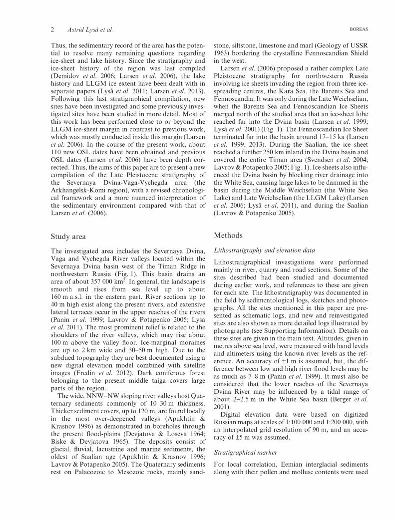
The investigated area includes the Severnaya Dvina,Vaga and Vychegda River valleys located within theSevernaya Dvina basin west of the Timan Ridge innorthwestern Russia (Fig. 1). This basin drains anarea of about 357 000 km2. In general, the landscape issmooth and rises from sea level up to about160 m a.s.l. in the eastern part. River sections up to40 m high exist along the present rivers, and extensivelateral terraces occur in the upper reaches of the rivers(Panin et al. 1999; Lavrov & Potapenko 2005; Lysået al. 2011). The most prominent relief is related to theshoulders of the river valleys, which may rise about100 m above the valley floor. Ice-marginal morainesare up to 2 km wide and 30–50 m high. Due to thesubdued topography they are best documented using anew digital elevation model combined with satelliteimages (Fredin et al. 2012). Dark coniferous forestbelonging to the present middle taiga covers largeparts of the region.
The wide, NNW−NW sloping river valleys host Qua-ternary sediments commonly of 10–30 m thickness.Thicker sediment covers, up to 120 m, are found locallyin the most over-deepened valleys (Apukhtin &Krasnov 1996) as demonstrated in boreholes throughthe present flood-plains (Devjatova & Loseva 1964;Biske & Devjatova 1965). The deposits consist ofglacial, fluvial, lacustrine and marine sediments, theoldest of Saalian age (Apukhtin & Krasnov 1996;Lavrov & Potapenko 2005). The Quaternary sedimentsrest on Palaeozoic to Mesozoic rocks, mainly sand-
stone, siltstone, limestone and marl (Geology of USSR1963) bordering the crystalline Fennoscandian Shieldin the west.
Larsen et al. (2006) proposed a rather complex LatePleistocene stratigraphy for northwestern Russiainvolving ice sheets invading the region from three ice-spreading centres, the Kara Sea, the Barents Sea andFennoscandia. It was only during the Late Weichselian,when the Barents Sea and Fennoscandian Ice Sheetsmerged north of the studied area that an ice-sheet lobereached far into the Dvina basin (Larsen et al. 1999;Lyså et al. 2001) (Fig. 1). The Fennoscandian Ice Sheetterminated far into the basin around 17−15 ka (Larsenet al. 1999, 2013). During the Saalian, the ice sheetreached a further 250 km inland in the Dvina basin andcovered the entire Timan area (Svendsen et al. 2004;Lavrov & Potapenko 2005; Fig. 1). Ice sheets also influ-enced the Dvina basin by blocking river drainage intothe White Sea, causing large lakes to be dammed in thebasin during the Middle Weichselian (the White SeaLake) and Late Weichselian (the LLGM Lake) (Larsenet al. 2006; Lyså et al. 2011), and during the Saalian(Lavrov & Potapenko 2005).
Methods
Lithostratigraphy and elevation data
Lithostratigraphical investigations were performedmainly in river, quarry and road sections. Some of thesites described had been studied and documentedduring earlier work, and references to these are givenfor each site. The lithostratigraphy was documented inthe field by sedimentological logs, sketches and photo-graphs. All the sites mentioned in this paper are pre-sented as schematic logs, and new and reinvestigatedsites are also shown as more detailed logs illustrated byphotographs (see Supporting Information). Details onthese sites are given in the main text. Altitudes, given inmetres above sea level, were measured with hand levelsand altimeters using the known river levels as the ref-erence. An accuracy of ±1 m is assumed, but, the dif-ference between low and high river flood levels may beas much as 7–8 m (Panin et al. 1999). It must also beconsidered that the lower reaches of the SevernayaDvina River may be influenced by a tidal range ofabout 2−2.5 m in the White Sea basin (Berger et al.2001).
Digital elevation data were based on digitizedRussian maps at scales of 1:100 000 and 1:200 000, withan interpolated grid resolution of 90 m, and an accu-racy of ±5 m was assumed.
Stratigraphical marker
For local correlation, Eemian interglacial sedimentsalong with their pollen and mollusc contents were used
2 Astrid Lyså et al. BOREAS
as a stratigraphical marker. These beds are well knownfrom the Russian literature (e.g. Devjatova 1982), andwere later supported by other investigations focusingon molluscs and marine micropalaeontology (Lysået al. 2001; Funder et al. 2002; Grøsfjeld et al. 2006).
Radiocarbon dates
Radiocarbon dates were obtained by accelerator massspectrometry (AMS) at Lund University, Sweden, andby the conventional method at the National Labora-tory for 14C Dating in Trondheim, Norway. For cali-brations, we used the CalPal-2007-Hulu curve, which isextended for ages beyond the Lateglacial (Hughen et al.2006). More details about the radiocarbon dates aregiven in Table 1.
Optical stimulated luminescence (OSL)
Basic methodology. – All OSL samples were taken usingplastic tubes, ∼8 cm in diameter and ∼30 cm long,driven into a freshly cleaned section. The tubes weresealed and sent to the laboratory, where they wereopened under subdued orange light. Approximately5 cm of material from each end of the tube was reservedfor dose rate measurements, and the remainder was wetsieved to give the grain-size range of interest (180–250 μm). The chosen grain size was cleaned using HCland H2O2, before digesting in concentrated HF. Thisstep dissolves any feldspar and etches the surface ofquartz grains. The luminescence purity of the quartzgrains was confirmed using optical stimulation withinfrared (IR) and blue light (in contrast to feldspar,
Fig. 1. Map showing the area investigated in the Dvina basin, northwestern Russia. Reconstructions of the Local Last Glacial Maximum(LLGM) ice-sheet limit are after Demidov et al. (2006) and Larsen et al. 1999, 2006). The 65–70 ka ice-sheet limit is from Larsen et al. (2006)and Lyså et al. (2011). The Saalian ice-sheet limit is after Lavrov & Potapenko (2005). The locations of all the sites cited in the main text andFigs 4 and 9 are shown. The main pass-points in the area are shown by crosses.
Late Pleistocene stratigraphy and sedimentary environments, NW Russia 3BOREAS

quartz is insensitive to IR; both minerals are sensitiveto blue light). Finally, grains were washed in HCl andthe dry grains mounted for measurement on 10-mmdiameter stainless steel discs using silicone oil, appliedthrough an 8-mm diameter spray mask.
OSL measurements were carried out using a RisøOSL/TL reader (model TLDA16 or TLDA20) fittedwith a 90Sr/90Y beta source that delivered a calibrateddose rate to the sample (Bøtter-Jensen et al. 2010).Stimulation used blue (470 nm) light-emitting diodes(∼40 or 80 mW cm−2 at the sample position, dependingon the instrument) and the resulting luminescence wasmeasured through a U-340 glass filter. Equivalent doses(De) were measured using a Single Aliquot Regenera-tive (SAR) dose protocol (Murray & Wintle 2000,2003), with an initial thermal treatment at 260°C for10 s (preheat), followed by heating to 220°C afteradministration of the test dose and then cooling imme-diately (cut heat), blue light optical stimulations for40 s at 125°C, and a final blue light stimulation at290°C for 40 s at the end of each SAR cycle. An addi-tional 100-s IR stimulation at 125°C was used beforeeach blue light stimulation for a single sample (063868,Supporting Information Table S1) because, in this casealone, it was not possible to completely remove allfeldspar by chemical treatment.
Dose rate calculations are based on radionuclideconcentrations measured using high- resolution gammaspectrometry (Murray et al. 1987) and conversionfactors from Olley et al. (1996). All samples wereassumed to be water-saturated during burial (usualfor a permafrost environment), and the dose rateswere modified using the factors described by Aitken(1985). Cosmic ray dose rates, calculated using theobserved burial depth, are based on Prescott & Hutton(1994).
More details about the dates are given in Table S1.
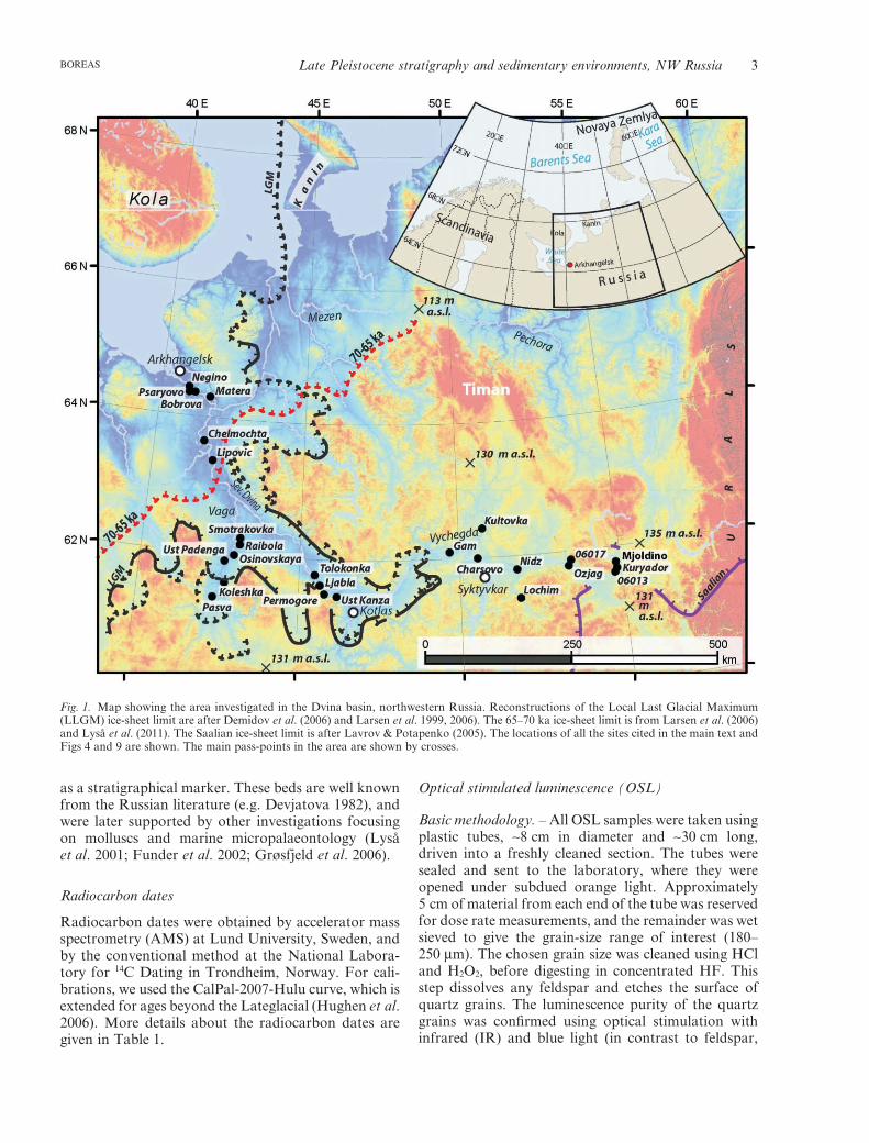
Luminescence characteristics. – Figure 2 shows typicalnatural OSL stimulation curves for four sampleschosen at random, two of which were measured in 2007and two in 2009. These data are considered representa-tive of all samples presented here. In both cases, astimulation curve from an aliquot of Risø calibrationquartz (De ∼5 Gy) is shown for comparison; the OSLfrom this material is known to be dominated by the‘fast component’ (Jain et al. 2003; Singarayer & Bailey2003). All curves were measured on the same instru-ment, but the blue light stimulation power wasincreased during this period, which is why the two setsof curves decay at different rates. It is clear from thesedata that the ‘fast component’ dominates the OSLsignals from these samples; typically it makes up about90% of the initial signal.
Wintle & Murray (2006) set out the various testsavailable to confirm the applicability of a selected SARprotocol to a particular sample (e.g. recycling, recu-T
able
1.R
adio
carb
onda
tes
wit
hon
est
anda
rdde
viat
ion.
The
Cal
Pal
-200
7cu
rve
was
used
for
calib
rati
on(H
ughe
net
al.2
006)
.pM
C=
per
cent
mod
ern
carb
on.
Lab
.ref
.Sa
mpl
eco
deSi
teD
ated
mat
eria
lD
ryw
eigh
t14
Cag
e(a
BP
)C
alib
rate
dag
e(c
al.a
BP
)
LuS
7845
106
-259
6024
-10
(Ust
Kan
za)
Uns
peci
fied
plan
tre
mai
ns,
mos
sfib
res
>20
mg
1529
0±14
018
392±
301
LuS
7846
106
-260
6024
-10
(Ust
Kan
za)
Uns
peci
fied
plan
tre
mai
ns0.
3m
g10
2.4±
0.8
pMC
LuS
7848
106
-276
6025
-3.1
9(T
olok
onka
I)U
nspe
cifie
dpl
ant
rem
ains
>20
mg
>38
000
LuS
7843
1,2
06-2
1060
10-1
80(K
urya
dor)
Tre
e-le
afre
mai
ns10
mg
>40
000
LuS
7844
1,2
06-2
1260
10-1
80(K
urya
dor)
Tre
e-le
afre
mai
ns>2
0m
g27
400±
700
3211
7±70
0L
uS78
471,
206
-274
6026
(Lja
bla)
Smal
lfra
gmen
tsof
woo
dan
dro
ots
6m
g11
4.1±
0.6
pMC
T-1
3321
397
002
8004
(Psa
ryov
o)U
nspe
cifie
dpl
ant
rem
ains
7.4
g11
355±
7013
254±
127
T13
1723
9701
880
03(T
repy
zovo
)P
icea
5g
4260
0+15
50/-
1300
4640
5±18
07/4
634
7±16
40T
-131
733
9702
496
01(C
helm
ocht
a)S
alix
/Pop
ulus
5g
9930
±135
1148
7±21
6T
-131
743
9703
096
01(C
helm
ocht
a)L
arix
/Pic
ea4.
5g
9635
±75
1098
4±15
0T
-131
753
9703
596
01(C
helm
ocht
a)S
alix
/Pop
ulus
1.7
g97
75±1
1511
122±
202
T13
1763
9704
2(1)
9601
(Che
lmoc
hta)
Sal
ix/P
opul
us1.
3g
9630
±125
1096
4±18
0T
1317
7397
042(
2)96
01(C
helm
ocht
a)B
etul
a6.
5g
9750
±135
1109
4±21
8
1 Dat
esob
tain
edat
Lun
dU
nive
rsit
y,Sw
eden
.2 D
ates
publ
ishe
din
Lys
ået
al.(
2011
).3 D
ates
obta
ined
atth
eL
abor
ator
ies
for
Rad
iom
etri
cD
atin
gin
Tro
ndhe
im,N
orw
ay.T
hese
date
sar
efr
omL
arse
net
al.(
1999
).
4 Astrid Lyså et al. BOREAS
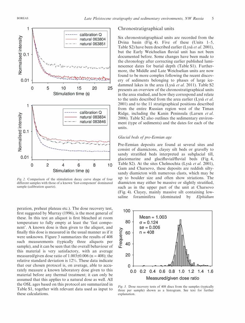
peration, preheat plateau etc.). The dose recovery test,first suggested by Murray (1996), is the most general ofthese. In this test an aliquot is first bleached at roomtemperature to fully empty at least the ‘fast compo-nent’. A known dose is then given to the aliquot, andfinally this dose is measured in the usual manner as if itwere unknown. Figure 3 summarizes the results of 408such measurements (typically three aliquots persample), and it can be seen that the overall behaviour ofthis material is very satisfactory, with an averagemeasured/given dose ratio of 1.003±0.006 (n = 408); therelative standard deviation is 12%. These data indicatethat our chosen protocol is, on average, able to accu-rately measure a known laboratory dose given to thismaterial before any thermal treatment; it can only beassumed that this applies to a natural dose as well. Allthe OSL ages based on this protocol are summarized inTable S1, together with relevant data used as input tothese calculations.
Chronostratigraphical units
Six chronostratigraphical units are recorded from theDvina basin (Fig. 4). Five of these (Units 1–5,Table S2) have been described earlier (Lyså et al. 2001),but the Early Weichselian fluvial unit has not beendocumented before. Some changes have been made tothe chronology after correcting earlier published lumi-nescence dates for burial depth (Table S1). Further-more, the Middle and Late Weichselian units are nowfound to be more complex following the recent discov-ery of sediments belonging to phases of large ice-dammed lakes in the area (Lyså et al. 2011). Table S2presents an overview of the chronostratigraphical unitsin the area studied, and how they correspond and relateto the units described from the area earlier (Lyså et al.2001) and to the 11 stratigraphical positions describedfrom the entire Russian region west of the TimanRidge, including the Kanin Peninsula (Larsen et al.2006). Table S2 also outlines the sedimentary environ-ment (type of sediments) and the dates for each of theunits.
Glacial beds of pre-Eemian age
Pre-Eemian deposits are found at several sites andconsist of diamictons, clayey silt beds or gravelly tosandy stratified beds interpreted as subglacial till,glaciomarine and glacifluvial/fluvial beds (Fig. 4,Table S2). At the sites Chelmochta (Lyså et al. 2001),Gam and Charsovo, these deposits are reddish silty-sandy diamicton with numerous clasts, which may beup to boulder size and often show striations. Thediamicton may either be massive or slightly stratified,such as in the upper part of the unit at Charsovo(Fig. 4). Clayey, mainly massive silt containing low-saline foraminifera (dominated by Elphidium
Fig. 2. Comparison of the stimulation decay curve shape of fourdifferent samples with those of a known ‘fast-component’ dominatedsample (calibration quartz).
Fig. 3. Dose recovery tests of 408 discs from the samples (typicallythree per sample) shown as a histogram. See text for furtherexplanation.
Late Pleistocene stratigraphy and sedimentary environments, NW Russia 5BOREAS
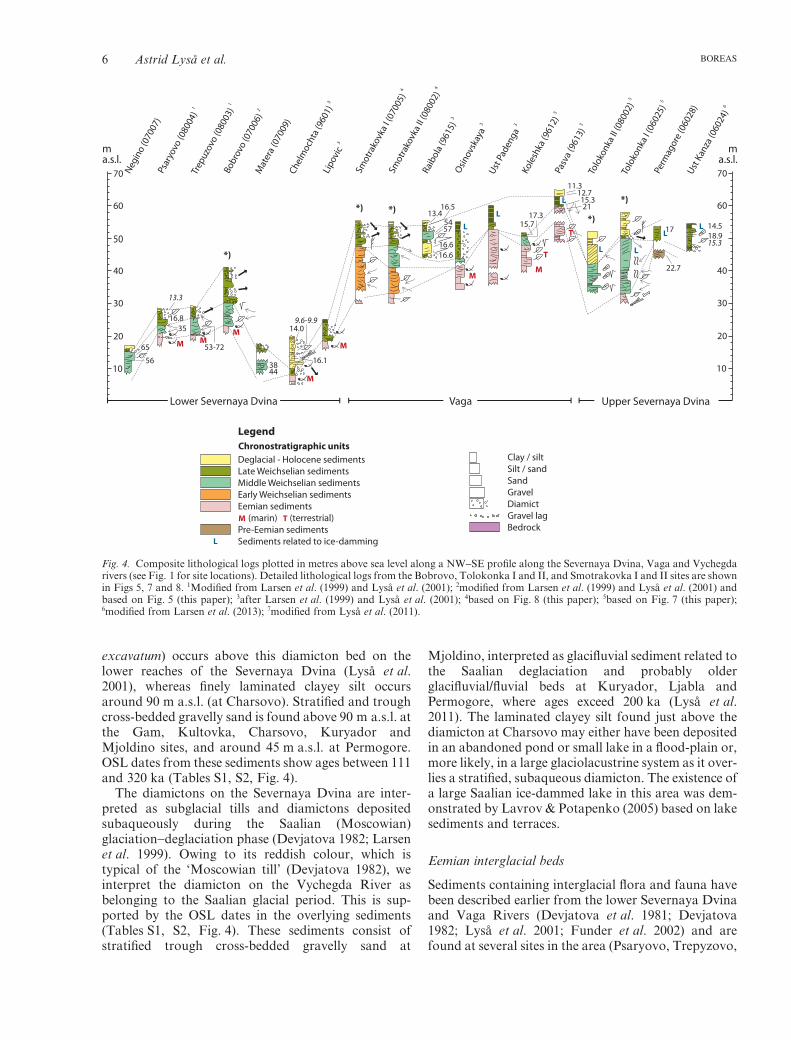
excavatum) occurs above this diamicton bed on thelower reaches of the Severnaya Dvina (Lyså et al.2001), whereas finely laminated clayey silt occursaround 90 m a.s.l. (at Charsovo). Stratified and troughcross-bedded gravelly sand is found above 90 m a.s.l. atthe Gam, Kultovka, Charsovo, Kuryador andMjoldino sites, and around 45 m a.s.l. at Permogore.OSL dates from these sediments show ages between 111and 320 ka (Tables S1, S2, Fig. 4).
The diamictons on the Severnaya Dvina are inter-preted as subglacial tills and diamictons depositedsubaqueously during the Saalian (Moscowian)glaciation−deglaciation phase (Devjatova 1982; Larsenet al. 1999). Owing to its reddish colour, which istypical of the ‘Moscowian till’ (Devjatova 1982), weinterpret the diamicton on the Vychegda River asbelonging to the Saalian glacial period. This is sup-ported by the OSL dates in the overlying sediments(Tables S1, S2, Fig. 4). These sediments consist ofstratified trough cross-bedded gravelly sand at
Mjoldino, interpreted as glacifluvial sediment related tothe Saalian deglaciation and probably olderglacifluvial/fluvial beds at Kuryador, Ljabla andPermogore, where ages exceed 200 ka (Lyså et al.2011). The laminated clayey silt found just above thediamicton at Charsovo may either have been depositedin an abandoned pond or small lake in a flood-plain or,more likely, in a large glaciolacustrine system as it over-lies a stratified, subaqueous diamicton. The existence ofa large Saalian ice-dammed lake in this area was dem-onstrated by Lavrov & Potapenko (2005) based on lakesediments and terraces.
Eemian interglacial beds
Sediments containing interglacial flora and fauna havebeen described earlier from the lower Severnaya Dvinaand Vaga Rivers (Devjatova et al. 1981; Devjatova1982; Lyså et al. 2001; Funder et al. 2002) and arefound at several sites in the area (Psaryovo, Trepyzovo,
7070
6060
4040
50
3030
2020
1010
ma.s.l.
ma.s.l.
Lower Severnaya Dvina Upper Severnaya DvinaVaga
M MM
M
M
MM
T
TL
L
L L
LL
L
Negin
o (0
7007
)
1
Psar
yovo
(080
04)
1
Trep
uzov
o (0
8003
)
3
Chel
moc
hta
(960
1)
3
Lipo
vic
2
Bobr
ovo
(070
06)
Mat
era
(070
09)
4
Smot
rako
vka
I (07
005)
4
Smot
rako
vka
II (08
002)
3
Raib
ola
(961
5) 3
Ust P
aden
ga 3
Osinov
skay
a
3
Kole
shka
(961
2)
3
Pasv
a (9
613)
5
Tolo
konk
a II (
0800
2) 5
Tolo
konk
a I (
0602
5)
Perm
agor
e (0
6028
) 6
Ust K
anza
(060
24)
65
56
16.835
53-72
3844
14.0
16.1
9.6-9.9
13.416.5
5457
16.616.6
15.717.3
11.312.715.321
22.7
14.518.915.3
*)
*) *)*)
*)
17
13.3
L
M T
Clay / siltSilt / sandSandGravelDiamictGravel lagBedrock
Deglacial - Holocene sedimentsLate Weichselian sedimentsMiddle Weichselian sedimentsEarly Weichselian sedimentsEemian sediments (marin) (terrestrial)Pre-Eemian sedimentsSediments related to ice-damming
~ ~~ ~
LegendChronostratigraphic units
Fig. 4. Composite lithological logs plotted in metres above sea level along a NW−SE profile along the Severnaya Dvina, Vaga and Vychegdarivers (see Fig. 1 for site locations). Detailed lithological logs from the Bobrovo, Tolokonka I and II, and Smotrakovka I and II sites are shownin Figs 5, 7 and 8. 1Modified from Larsen et al. (1999) and Lyså et al. (2001); 2modified from Larsen et al. (1999) and Lyså et al. (2001) andbased on Fig. 5 (this paper); 3after Larsen et al. (1999) and Lyså et al. (2001); 4based on Fig. 8 (this paper); 5based on Fig. 7 (this paper);6modified from Larsen et al. (2013); 7modified from Lyså et al. (2011).
6 Astrid Lyså et al. BOREAS
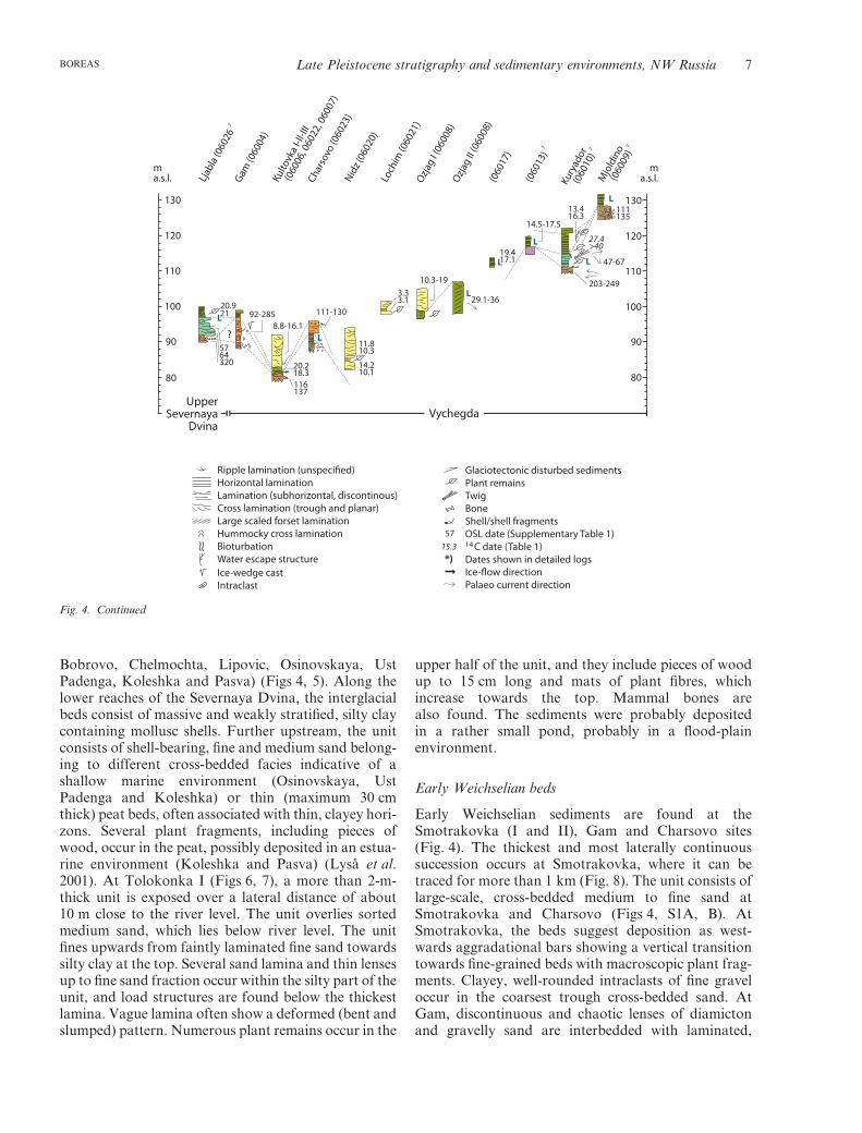
Bobrovo, Chelmochta, Lipovic, Osinovskaya, UstPadenga, Koleshka and Pasva) (Figs 4, 5). Along thelower reaches of the Severnaya Dvina, the interglacialbeds consist of massive and weakly stratified, silty claycontaining mollusc shells. Further upstream, the unitconsists of shell-bearing, fine and medium sand belong-ing to different cross-bedded facies indicative of ashallow marine environment (Osinovskaya, UstPadenga and Koleshka) or thin (maximum 30 cmthick) peat beds, often associated with thin, clayey hori-zons. Several plant fragments, including pieces ofwood, occur in the peat, possibly deposited in an estua-rine environment (Koleshka and Pasva) (Lyså et al.2001). At Tolokonka I (Figs 6, 7), a more than 2-m-thick unit is exposed over a lateral distance of about10 m close to the river level. The unit overlies sortedmedium sand, which lies below river level. The unitfines upwards from faintly laminated fine sand towardssilty clay at the top. Several sand lamina and thin lensesup to fine sand fraction occur within the silty part of theunit, and load structures are found below the thickestlamina. Vague lamina often show a deformed (bent andslumped) pattern. Numerous plant remains occur in the
upper half of the unit, and they include pieces of woodup to 15 cm long and mats of plant fibres, whichincrease towards the top. Mammal bones arealso found. The sediments were probably depositedin a rather small pond, probably in a flood-plainenvironment.
Early Weichselian beds
Early Weichselian sediments are found at theSmotrakovka (I and II), Gam and Charsovo sites(Fig. 4). The thickest and most laterally continuoussuccession occurs at Smotrakovka, where it can betraced for more than 1 km (Fig. 8). The unit consists oflarge-scale, cross-bedded medium to fine sand atSmotrakovka and Charsovo (Figs 4, S1A, B). AtSmotrakovka, the beds suggest deposition as west-wards aggradational bars showing a vertical transitiontowards fine-grained beds with macroscopic plant frag-ments. Clayey, well-rounded intraclasts of fine graveloccur in the coarsest trough cross-bedded sand. AtGam, discontinuous and chaotic lenses of diamictonand gravelly sand are interbedded with laminated,
*)15.3
57
Ripple lamination (unspecified)Horizontal laminationLamination (subhorizontal, discontinous)Cross lamination (trough and planar)Large scaled forset laminationHummocky cross laminationBioturbationWater escape structureIce-wedge castIntraclast
Glaciotectonic disturbed sedimentsPlant remainsTwigBoneShell/shell fragmentsOSL date (Supplementary Table 1) C date (Table 1)Dates shown in detailed logsIce-flow directionPalaeo current direction
~ ~
14
130130
120120
100100
110110
9090
8080
ma.s.l.
ma.s.l.
UpperSevernaya
DvinaVychegda
L
L
L L
L
L
L
7
Ljab
la (0
6026
Gam
(060
04)
Kulto
vka
I-II-I
II
(06
006,
060
22, 0
6007
)
Char
sovo
(060
23)
Loch
im (0
6021
)
Nidz (
0602
0)
Ozjag
I (06
008)
Ozjag
II (06
008)
(060
17)
7
(060
13)
Kury
ador
7
(06
010)
M
jold
ino 7
(06
009)
?
20.921
5764320
92-2858.8-16.1
20.218.3116137
111-130
11.810.3
14.210.1
3.33.1
10.3-19
29.1-36
19.417.1
14.5-17.5
13.416.3
47-67
203-249
111135
27.4>40
Fig. 4. Continued
Late Pleistocene stratigraphy and sedimentary environments, NW Russia 7BOREAS
sorted silt and sand, and a few small ice-wedge casts arefound (Fig. S1C). Palaeocurrent directions indicate awesterly transport direction (Fig. 8). The lower bound-ary is well defined by the lower erosional contact atGam and Charsovo, the latter representing a sharpshift from fine, horizontally laminated, clayey silt. AtSmotrakovka II the lower boundary may be at the baseof the trough cross-bedded sand at 33 m a.s.l. (Fig. 8).This is underlain by clayey silt, a facies that is not foundin the otherwise complex unit at Smotrakovka I and II.This silt might also belong to an older stratigraphical
unit (e.g. the Eemian beds). The upper boundary is alsouncertain, mainly because the overlying sediments are asimilar sedimentary facies (Fig. 8).
The sediments are interpreted as mainly bar depositsin a fluvial channel system where the clayey intraclastssuggest erosion of fine-grained sediments. The morefine-grained silty beds, ripple cross-bedded fine sandand plant fragments indicate a lower-energy environ-ment but still with a high sediment supply. The chaoticlenses of diamicton and gravelly sand in the laminatedsilt and sand at Gam (Fig. S1C) indicate deposition in
22
Notexposed
22
24
?
24
26 26
28 28
30 30
32 32
34 34
36 36
38 38
40 40
m a.s.l.
m a.s.l.
Clay ClaySilt SiltSand SandGravel
River level
Stratig
raphic
unit
Stratig
raphic
unit
Lithology
Lithology
Hol
o-ce
ne
Eem
ian
Late
Wei
chse
lian
Late
Wei
chse
lian
Mid
dle
Wei
chse
lian
18.8±1.558±5
69±853±5
74±7
63±568±6
65±690±12
70±5[Fig. S5C]
69±6
17.7±1.9
Bobrovo (07006)
120 m
~
~~
14.0±0.8
27.4±0.7 C
Legend
Clay and silt
Silt
Sand
Sand and gravel
Peat
Cobbles
Boundaries
Erosional
Sharp
Gradual
Loaded
Horizontal bedding
Crude-weakly laminated
Ripple cross lamination
Large-scaled inclined bedding
Trough cross bedding
Planar cross bedding
Hummocky cross bedding
Load structures
Slump structures
Cryoturbation
Roots
Bioturbation
Ice wedge cast
Water escape structure
Intraclasts
Plant remains
Twig
Mammal bone
Shell/shell fragments
Palaeocurrent direction
OSL age (ka)
C age ka BP1414
~ ~
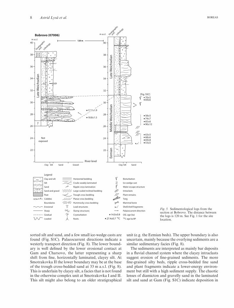
Fig. 5. Sedimentological logs from thesection at Bobrovo. The distance betweenthe logs is 120 m. See Fig. 1 for the sitelocation.
8 Astrid Lyså et al. BOREAS

shallow, slow-flowing water, where unsorted sedimentshave occasionally been available, possibly derivingfrom erosion of the underlying, pre-Eemian, glacialdiamicton unit (Fig. 4).
Ten OSL dates from the unit show ages from 92 to120 ka in addition to the deviant date of 285 ka (Fig. 8,Table S2).
Middle Weichselian beds
Middle Weichselian beds occur at several localitiesthroughout the area (Fig. 4, Table S2). In most placeswhere the lower boundary is exposed, it is irregular,sharp and erosive, with a relative relief up to 50 cm, andoften represented by a lag of cobbles. The boundary isin contact with Eemian beds at the Severnaya Dvinaand Vaga sites, and with pre-Eemian beds at Vychegda(Figs 4, S2). Intraclasts of silt, mollusc fragments,re-deposited whole shells, peat fragments and twigs areoften found enriched in the lower part of the beds (Lysået al. 2001). The boundary is difficult to pinpoint atSmotrakovka, but probably occurs around 38.5 or40 m a.s.l. (Smotrakovka II, Fig. 8).
The Middle Weichselian beds from the lowerSevernaya Dvina usually form trough and planar cross-bedded sandy sediments interbedded with more siltybeds containing pollen from taiga vegetation (unit 3,Lyså et al. 2001). Ice-wedge pseudomorphs originatingfrom different stratigraphical levels occur widely. Newinvestigations of localities along the lower Dvina(Negino, Bobrovo and Matera) show similar sedimen-tary facies and a palaeocurrent direction towards theNW−W (Figs 4, 5).
At Tolokonka II (Fig. 7), beds consist of troughcross-bedded fine and medium sand, interbedded withplanar cross-bedded medium and coarse sand contain-ing intraclasts of clay. In places, the intraclasts arevery angular and appear to occur in a massive toslightly stratified matrix of sorted sand (Fig. S3A, B).The large quantity of angular clayey clasts probably
indicates short transportation following the erosion ofclay beds that might have been earlier fractured byfrost. Beds of wavy, finely laminated silt and veryfine sand and ripple-laminated fine sand are alsointerbedded with the coarser cross-bedded sand(Fig. S3C, D). Ice-wedge casts and cryoturbationstructures occur at different stratigraphical levels(Fig. S3E).
The Middle Weichselian sediments at Tolokonka Idiffer from those at Tolokonka II and show upwardchanges through the unit (Figs 6, 7, S4). In the lowerpart, well-sorted, planar cross-bedded, medium sanddominates, showing a palaeocurrent direction towardsWNW (i.e. parallel with the present river drainage).Upwards, the sand becomes slightly finer with agradual transition into horizontal to wavy, heterolithicbeds of silt and sand. The sand is often ripple cross-bedded and terrestrial plant remains and fragments ofbeetles (not specified) occur frequently in the silty part(Krogh 2010). Horizontally bedded, undulating finesand occurs above a very organic-rich horizon wheretwigs also occur (Fig. S4A). The lamina consist oforganic-rich, silty, very fine sand, often disturbed bybioturbation (Skolithos) and small flame structures.Deformation structures, including folding, stretchingand displacement of sediments occur in thesoutheasternmost part of the section (Fig. S4B).Upwards in the unit, hummocky cross-stratified sand isinterbedded with horizontally stratified sand represent-ing a period of high sediment supply (Fig. S4C). Theupper 4–5 m of the unit consist of large-scale sets ofstratified medium sand with low-angle inclinationtowards SSE to SSW. These beds are interpreted assubaquatic foreset beds (Fig. S4D) deposited trans-verse to the present river valley direction. Thus, allsedimentary data indicate high subaqueous sedimenta-tion from a local source. In the southernmost part ofthe section at Tolokonka I, planar cross-beddedmedium and coarse sands containing intraclasts of claysimilar to the beds at Tolokonka II are found. Lysået al. (2011) described Middle Weichselian beds furtherupstream along the Vychegda at Ljabla and Kuryador(Fig. 4). At Kuryador, the lower boundary of the unit iserosive with a lag of gravel (Fig. S1). The lowermostpart of the unit consists of clayey silt that becomesslightly coarser upwards as the sand content increases.Sand containing terrestrial plant fragments and twigsdominates at the top. The unit was probably depositedin an inundated lake basin after a major erosionalevent. A similar lower boundary was described fromLjabla, but the overlying sediments there are more siltythan at Kuryador and show indication of slumpingrelated to rapid deposition in an aquatic environment.Coarse-grained, planar cross-bedded gravel and sandoccur at the top of this unit at Ljabla. Based on theoverall stratigraphy and palaeogeographical recon-struction from the region, the sediments were inter-
20
10 ?
0 ?
Post LLGM incision
? ?Riverlevel
ma.r.l.
log
0602
5
NW SE
Post White Sea Lake incision
Fig. 6. Schematic drawing of the Tolokonka I section (site 06025)showing the stratigraphical units over a lateral distance of about2 km (not to scale). See Fig. 1 for the site location and the legend inFig. 4 for the colour codes.
Late Pleistocene stratigraphy and sedimentary environments, NW Russia 9BOREAS
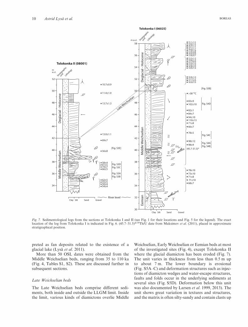
preted as fan deposits related to the existence of aglacial lake (Lyså et al. 2011).
More than 50 OSL dates were obtained from theMiddle Weichselian beds, ranging from 35 to 110 ka(Fig. 4, Tables S1, S2). These are discussed further insubsequent sections.
Late Weichselian beds
The Late Weichselian beds comprise different sedi-ments, both inside and outside the LLGM limit. Insidethe limit, various kinds of diamictons overlie Middle
Weichselian, Early Weichselian or Eemian beds at mostof the investigated sites (Fig. 4), except Tolokonka IIwhere the glacial diamicton has been eroded (Fig. 7).The unit varies in thickness from less than 0.5 m upto about 7 m. The lower boundary is erosional(Fig. S5A–C) and deformation structures such as injec-tions of diamicton wedges and water-escape structures,faults and folds occur in the underlying sediments atseveral sites (Fig. S5D). Deformation below this unitwas also documented by Larsen et al. 1999, 2013). Theunit shows great variation in textures and structures,and the matrix is often silty-sandy and contain clasts up
10.7±0.9
11.4±1.0
13.7±1.3
13.0±1.1
69±7
56±8[Fig. S3E]
[Fig. S5B]
61±5
55±5
14.6±1.5
13.1±1.2
13.5±1.2
17.0±1.8
13.6±1.0
66±5
54±4
14.1±1.1
16.0±1.0
13.7±0.9
13.8±0.712.0±0.8
14.9±1.4
74±7
50±4
16.4±1.2
15.1±0.9
14.6±1.3
14.4±0.9
16.8±2.0
58±4 Fig. S3DFig. S3C
Fig. S3AFig. S3B
Fig. S4D
Fig. S4C
Fig. S4AFig. S4B
62±5
15.1±1.5
10.8±1.0
16.2±1.7
15.0±1.0
>38 C
83±9
82±184±794±10110±1371±866±7
78±5
98±1298±9
(45.7-31.5)*
78±10
68±7
71±873±10
71±10
102±10
14
~ ~~ ~
~ ~
34
36
32
30
38
34
40
38
36
42
40
44
42
46
44
48
46
54
52
50
48
56
52
50
58m a.s.l.
Clay
Clay
Silt
Silt
Sand
Sand
Gravel
Gravel
ma.s.l.
River level
Stratig
raphic
unit
Stratig
raphic
unit
Lithology
Lithology
Mid
dle
Wei
chse
lian
Late Weichselian
Eem
ian
Deg
laci
al -
Hol
ocen
e
Deg
laci
al -
Hol
ocen
eM
iddl
e W
eich
selia
n
Tolokonka II (08001)
Tolokonka I (06025)
~~~
~
~
~
~
~
~
~
~
~
~
~
~
Fig. 7. Sedimentological logs from the sections at Tolokonka I and II (see Fig. 1 for their locations and Fig. 5 for the legend). The exactlocation of the log from Tolokonka I is indicated in Fig. 6. (45.7–31.5)*230Th/U date from Maksimov et al. (2011), placed in approximatestratigraphical position.
10 Astrid Lyså et al. BOREAS

to boulder size. The variations and complexities in thesebeds are mainly seen at the sites where the unit is thick-est, e.g. at the Bobrovo (Fig. 5) and Smotrakovka(Fig. 8) sites. The diamicton often has a massive char-acter (Fig. S6), but may also be stratified with indica-tions of internal deformation (Fig. 6A, B). Stratificationoccurs either as weak lineations in the fine-grainedmatrix with clearly defined, discontinuous lamina ofvery fine, sorted sand (Fig. S6B), or as sorted sedimentinterbeds, often deformed (Fig. S6C, D). Some of thediamicton beds form wedges with trough-shaped orlenticular forms, with a lateral extent of no more than130 m. These beds often show a more sorted and fining-upwards character (Fig. 6E, F). The matrix may be poorin fines, and clasts are enriched in some horizons asdebris bands.
Fabric analyses from the most massive parts of thediamictons (Larsen et al. 1999, 2013) indicate a stressdirection from NW−SW, and deformation structures
measured in sub-diamicton sediments at the Raibolaand Troitsa sites (Larsen et al. 1999, see the location ofthe sites in Fig. 1) indicate a stress direction fromNW−W.
The massive and weakly stratified fine-graineddiamicton beds are interpreted as mainly subglaciallydeposited tills (Larsen et al. 1999, 2013; Lyså et al.2001) beneath an ice sheet advancing from the W−NW(i.e. from Fennoscandia). The trough-shaped and len-ticular, more sorted and graded diamicton beds indi-cate subaqueous deposition, probably as debris flowsdeposited in front of a glacier during advance or retreatinto a lake basin. The southeasternmost observed sitewith Late Weichselian diamicton is Ust Kanza (Figs 4,S5A).
Outside the LLGM limit, the Late Weichselian sedi-ments are mainly laminated, well-sorted clayey silt andvery fine sand. This unit is observed at many sites andhas been described in detail along the Vaga (e.g. the
[Fig. S6F]
[Fig. S5D]
Fig. S6E
Fig. S6D
Fig. S6B
Fig. S1A
Fig. S6C
Fig. S6A
36 36
34 34
32 32
30 30
38 38
40 40
42 42
44 44
46 46
48 48?
?
?
?
?
?
?
?
50 50
52 52
56 56
54 54
Clay ClaySilt SiltSand SandGravel Gravel
Not
exposed
m a.s.l. m a.s.l.
Stratig
raphic
unit
Stratig
raphic
unit
Lithology
Lithology
Late
Wei
chse
lian
Late
Wei
chse
lian
Mid
dle
Wei
chse
lian
Early
Wei
chse
lian
Eem
ian
Early
Wei
chse
lian
Smotrakovka I (07005) Smotrakovka II (08002)
~~
~~~~
~~
~~~
~
~~~
16.8±1.3
120±10
103±8
71±6
20.6±1.6
56±6
110±11
16.5±1.3
109±9
95±9
72±6
17.8±1.3
40±3
92±10
Fig. 8. Sedimentological logs from thesections at Smotrakovka I and II (seeFig. 1 for their location and Fig. 5 forlegend).
Late Pleistocene stratigraphy and sedimentary environments, NW Russia 11BOREAS
Pasva and Koleshka sites; Lyså et al. 2001) and upperSevernaya Dvina Rivers (e.g. the Ljabla, 06013,Kuryador and Mjoldino sites; Lyså et al. 2011; Fig. 4).Sediments belonging to this unit, showing similar sedi-mentary facies, have also been found above thediamicton close to the ice limit (e.g. sites Ust Kanza,Permagore, Ust Padenga, Ossinovskaya andSmotrakovka), being up to 7 m thick and appearing indepressions in the landscape. The sediments comprisemainly rhythmically laminated clay, silt and very finesand (Figs S6F, S7A), interbedded with very fine sandand silt, and having undulating and discontinuousstratification in places (Fig. S7B). Slump, load, fold andwater-escape structures occur in the lower part of theunit at several sites, (e.g. at the Kuryador and Ljablasites (Lyså et al. 2011) and at Tolokonka I (Fig. S5B)).At Kuryador, the lamina becomes fractured and dis-turbed upwards in the unit, being completely crackedand fractured at the top (Fig. S7C). At the Ozjag site(Fig. 4), about 7 m of low-angle inclined stratifiedmedium sand, subaqueously deposited in a SE direction,most likely correlates with this unit. These laminated,fine-grained and sandy sediments have been interpretedas deposited in an aquatic environment related to thedamming of a proglacial lake during the LLGM (Lysået al. 2011). The unit is thought to represent the earlyphase of the glacial lake formation at Smotrakovka,where a fluvial drainage direction opposite to the presentis seen in subtill sediments (Lyså et al. 2001; Larsen et al.2013; see Fig. 8, site 08002 at ∼50 m a.s.l.). Further-more, indications of sudden drowning and subaqueoussliding and slumping as the ice-dammed lake formed arefound in the eastern part of the area at Kuryador (Fig. 4;Lyså et al. 2011). The advance of the glacier into anaquatic lake basin is also indicated along the Vaga River(Smotrakovka site, Fig. 8) from numerous debris flows(Fig. S6B, E, F), and along the Severnaya Dvina River(the Tolokonka site; Figs 4, 7, 8). The drainage phase ofthis lake can be observed at the Kuryador site, herenicely demonstrated by the fracturing and dewatering oflake sediment lamina, and fluvial channel deposits at thetop (Lyså et al. 2011). It is also evident from the lami-nated sediment overlying till at the Ust Kanza site, andin sediment successions at Smotrakovka and Tolokonka(Larsen et al. 2013). These sediments are furtherdescribed below as part of the last deglacial and Holo-cene unit.
OSL and radiocarbon dates from this unit rangefrom 14.5 to 32.1 ka (Tables 1, S1, S2) and these arediscussed further below.
Late Weichselian deglacial and Holocene beds
Sediments from the deglaciation following the ice-sheetmaximum and into the Holocene are found at severalsites, often only as a thin sediment cover above LLGMdiamicton or on top of lake sediments from the under-
lying unit (Fig. 4, Table S2). Thicker beds occur on thelower reaches of the Vychegda River and at theTolokonka and Chelmochta sites, where the thick-nesses exceed 10 m. We emphasize that the boundarybetween the deglacial and Holocene beds and theunderlying Late Weichselian beds is complex, andshould be considered transitional. The sedimentsbelonging to this uppermost unit post-date the LLGMand/or indicate sedimentation in a postglacial or non-glacial environment.
Outside the ice-sheet margin, at Nidz (Fig. 4) the unitconsists of several, up to 3 m thick, beds of well-sorted,fine and medium sand, with an erosional lower bound-ary. The sand is characterized by large-scale cross-bedding forming large (metre-scale) convex-upwardsbar forms, separated by finer intervals of clayey silt andfine sand (Fig. S8A). The latter contain organic mate-rial (peat and twigs), mainly in their upper parts(Fig. S8A). Their geometry shows thin, up to 1 m thick,lenses with a convex base and a horizontal top, andthey have a lateral continuation of up to 400 m. AtLochim (Fig. 4), clayey silt beds above ripple cross-bedded medium sand show a gradual coarseningupwards into horizontal and undulating laminated andinterlayered silt and fine to medium sand. At Ozjag(Figs 4, S8B), 6 m of fine to medium sand are domi-nated by horizontal and undulating bedding andcontain organic material and silt. Small-scale, syn-sedimentary deformation structures such as faults andfolds occur frequently and the bedding shows evidenceof slumping. Skolithos-type trace fossils are found inthese sediments (Fig. S8B). Inside but close to theLLGM, the deglacial and Holocene beds at Tolokonkaresemble the sediments at the Nidz and Lochim sites(Figs 6, 7, S8C). In addition, NW of log 06025 atTolokonka I and at Tolokonka II (Fig. 6), large-scale,gently inclined beds of fine sand dipping towards thewest are incised into the underlying units. Up to 1 m ofwell-sorted, massive fine sand covers the top of thesections at Tolokonka.
Well inside the ice-sheet margin, the beds compriselaterally and vertically complex successions of differentcoexisting facies, including stratified gravel and boulderhorizons, clayey and sandy silt with lamina and lensesof sorted fine sand and, in places, diamicton beds. Lysået al. (2001) described these sediments in more detail,especially from the Chelmochta site, where clayey siltbeds with shells of the freshwater mollusc Anodonta arealso common (Fig. 4).
The sediments at the upper Severnaya Dvina andVychegda sites are believed to have been deposited asfluvial bar deposits, flood-plain sediments and oxbowlake or pond sediments. At Tolokonka, the large-scale,inclined beds were probably deposited during the finaldraining of the LLGM ice-dammed lake when thewater level was at least 15 m above the present riverlevel (Figs 6, 7). The dip direction of the inclined beds
12 Astrid Lyså et al. BOREAS

suggests a depositional direction resembling that of thepresent river.
The mixed and complex facies succession inside theice-sheet margin has been interpreted as depositedduring the deglaciation and early in the Holocene in anenvironment dominated by downwasting stagnant ice(Lyså et al. 2001), and all our new findings support thisinterpretation.
Dates from the deglacial-Holocene unit range from3.1 to 19.1 ka (Tables S1, S2) and are discussed below.
Chronology
The chronology of the succession is based on OSL andradiocarbon dates, along with the assumptions that thediamicton and glaciolacustrine sediments in the upper-most part of the succession represent the LLGM andthe organic-rich beds in the lower part of the successioncan be correlated with the Eemian. Thirteen radiocar-bon dates (Table 1) and 143 OSL dates (Table S1) wereobtained and the stratigraphical positions and localitieswhere these dates belong are shown in Table S2 and inthe detailed sedimentological logs (Figs 5, 7, 8).
Pre-Eemian beds
OSL ages from this unit are between 111 and 320 ka(Tables S1, S2, Figs 4, 9). The youngest ages are fromthe Mjoldino (135±10 and 111±8 ka) and Kultovka(116±9 and 137±11 ka) sites, interpreted to representglacifluvial deposition related to the Saaliandeglaciation.
Eemian beds
No absolute age determinations exist for these bedswithin our investigated sites. We use ages of 130.5 kafor the Saalian/Eemian transition and 119.5 ka for theEemian/Weichselian transition, following Lambecket al. (2006).
Early Weichselian beds
We retrieved 13 OSL ages from these beds assigned anEarly Weichselian age (Tables S1, S2, Figs 4, 9), yield-ing ages between 92 and 130 ka and, in addition, onehighly divergent age of 285 ka. The latter is thestratigraphically uppermost dating at Gam (063835,Table S1), and we reject it as erroneous. The sedimentsfrom Charsovo dated to 111±6, 116±7 and 130±9 kamay alternatively represent the Eemian, as Eemiansediments have returned OSL ages younger than 119.5ka in northwestern Russia (Thomas et al. 2006).However, whether the sediments were deposited duringthe Eemian or at the beginning of the Early Weichselianwill not change the conclusions about the overall stra-tigraphy and the environmental interpretations.
Middle Weichselian beds
More than 50 age determinations were performed fromthe supposedly Middle Weichselian unit (Tables S1, S2,Figs 4, 5). Several of the OSL ages from Tolokonka Iare considered too old as they are from sedimentsstratigraphically overlying strata yielding consistentlyyounger ages (Table S2, Fig. 7). One 230Th/U date frompeat, yielding an age between 45.7 and 31.5 ka (calcu-lated both by analytical data for acidic extraction (L/Lmodel) and for full dissolution (TSD model);Maksimov et al. 2011), supports the suggestion that thesediments are younger than indicated by the OSL dates(Tolokonka I, Fig. 7). For correct determination ofdepositional age, the OSL dating method builds oncomplete bleaching of the sediments at the time ofburial. The age inversion revealed by the two clusters ofdates in the Middle Weichselian sediments atTolokonka I (Fig. 7) might be explained by differencesin depositional environments. As described earlier, thestratigraphically upper strata (older ages at40–50 m a.s.l.) were subaqueously re-deposited,whereas the lower strata (younger ages at 33–37 m a.s.l)were deposited in a fluvial channel environment.Accordingly, we interpret the former sediments not tohave been exposed to light during deposition, thusretaining their older age. The OSL ages of 74±7 and69±7 ka from sediments at Tolokonka II (Fig. 7) arealso considered too old in light of their stratigraphicalposition above the White Sea Lake sediments.
An OSL age of 90±12 ka in the middle part of theBobrovo section (Fig. 5) also deviates from the otherdates and is considered too old. Presumably, the low-ermost date (53±5 ka) should also be considered unre-liable because of its low age compared to the consistentages obtained stratigraphically above (Fig. 5). Boththese ages were also considered unreliable before depthcorrections were carried out (Lyså et al. 2001). The ageof 72±7 ka at Trepuzovo is too old for itsstratigraphical position, and is also rejected, whereasthe radiocarbon age of around 46 ka is considered aminimum age (Table S1, Fig. 9). Inverted ages atNegino (Table S1) suggest that at least one of theseshould be rejected (Fig. 9), but we do not know whichone.
From a combined evaluation of retrieved OSL ages itcan be concluded that the Middle Weichselian bedsdate from between 78 and 35 ka (Fig. 9).
Late Weichselian beds
Age determinations from this unit are either frombelow the LLGM diamicton or from associated ice-dammed lake deposits. Altogether more than 50samples were dated (Fig. 4, Table S2). OSL ages onsediments below the diamicton at the Psaryovo(35±3 ka), Bobrovo (17.7±1.9 ka), Smotrakovka I
Late Pleistocene stratigraphy and sedimentary environments, NW Russia 13BOREAS
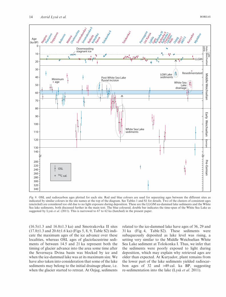
(16.5±1.3 and 16.8±1.3 ka) and Smotrakovka II sites(17.8±1.3 and 20.6±1.6 ka) (Figs 5, 8, 9, Table S2) indi-cate the maximum ages of the ice advance over theselocalities, whereas OSL ages of glaciolacustrine sedi-ments of between 14.5 and 21 ka represent both thetiming of glacier advance into the area some time afterthe Severnaya Dvina basin was blocked by ice andwhen the ice-dammed lake was at its maximum size. Wehave also taken into consideration that some of the lakesediments may belong to the initial drainage phase, i.e.when the glacier started to retreat. At Ozjag, sediments
related to the ice-dammed lake have ages of 36, 29 and31 ka (Fig. 4, Table S2). These sediments weresubaqueously deposited as lake level was rising, asetting very similar to the Middle Weichselian WhiteSea Lake sediment at Tolokonka I. Thus, we infer thatthe sediments were poorly exposed to light duringdeposition, which may explain why retrieved ages areolder than expected. At Kuryador, plant remains fromthe lower part of the lake sediments yielded radiocar-bon ages of 32 and >49 cal. ka BP, suggestingre-sedimentation into the lake (Lyså et al. 2011).
0
Age(ka BP)
10
20
30
40
50
60
70
80
90
100
110
120
130140
200220240260280300320340
Negin
oPs
aryo
voTr
epyz
ovo
Bobr
ovo
Mat
era
Chel
moc
hta
Smot
rako
vka
ISm
otra
kovk
a II
Raib
ola
Kole
shka
Pasv
aTo
loko
nka
II
Tolo
konk
a I
Perm
agor
eUst
Kan
zaLj
abla
GamKulto
vka I
IIKu
ltovk
a II
Kulto
vka
ICh
arso
voLo
chim
Nidz
Ozjag
0601
706
013
Kury
ador
Mjo
ldin
o
OSL
C cal.14
LLGM
LateW
eichselianM
iddle Weichselian
Early Weichselian
Pr e-Eemian
Eemian
Holo -
ceneDownwastingstagnant ice
Minimum age
Post White Sea Lakefluvial incision
LGM Lakesediments
White SeaLake
drainage
White Sea Lakesediments
Resedimentated
Fig. 9. OSL and radiocarbon ages plotted for each site. Red and blue colours are used for separating ages between the different sites asindicated by similar colours in the site names at the top of the diagram. See Tables 1 and S1 for details. Two of the clusters of consistent ages(encircled) are considered too old due to no light exposure during deposition. These are the LLGM ice-dammed lake sediments and the WhiteSea lake sediments, both discussed further in the main text. The blue coloured, double bar indicates the time-span of the White Sea Lake assuggested by Lyså et al. (2011). This is narrowed to 67 to 62 ka (hatched) in the present paper.
14 Astrid Lyså et al. BOREAS

Late Weichselian (deglacial) and Holocene beds
Most of the sediments related to the Late Weichseliandeglaciation phase, which include six radiocarbon and48 OSL ages, yielded ages of 17−16 ka and younger(Tables 1, S1, S2). At Lochim, the youngest Holocenesediments gave ages of 3.1±0.3 and 3.3±0.3 ka. Holo-cene ages also appear in the fluvial sediments atKultovka I (8.6±0.8 and 8.8±0.8 ka). The date of19.1±1 ka from Ozjag in sediments lyingstratigraphically above sediments yielding 10.8±0.8 and10.3±0.8 ka is likely to be erroneous because of the ageinversion and the fact that it is related to non-glacialsediments. For the same reasons we consider the upper-most date at Nidz (14.2±0.9 ka) to be erroneous. Of the20 OSL dates from Tolokonka I, the 10.8±1.0 ka fromthe lower part of the unit is younger than all theretrieved ages, and is therefore rejected (Table S2,Fig. 7). The almost identical age of the uppermost partof the sediment succession at Tolokonka II(10.7±0.9 ka) is considered correct because it comesfrom sediments interpreted as aeolian, which wereprobably well bleached during deposition.
The radiocarbon ages retrieved from sitesChelmochta of around 11 ka BP and from Psaryovo ofaround 13 ka BP are, in contrast with the young sedi-ments described above, related to the deglaciation asthe sediments indicate downwasting of stagnant ice.
From the discussion above we can consider thatretrieved ages representing deglaciation and retreat ofthe LLGM ice range from around 16 to 13 ka. A moredetailed discussion about the deglaciation is givenbelow.
Reliability of OSL ages
Incomplete bleaching is often discussed as a problemwith younger OSL ages. We consider this an unlikelysource of uncertainty in our ages for a variety ofreasons. First of all, it is well known that, in general,modern fluvial sediments record relatively low doses,typically around 2 Gy (Murray & Olley 2002; Wallinga2002; Jain et al. 2004); such sediments might beexpected to be incompletely bleached to some degree.This broad statement is supported in our geographicalregion by studies of known-age sediments (e.g. Murray& Olley 2002; Thomas et al. 2006; Murray et al. 2007).The agreement between measured and independentlyknown ages shows that incomplete bleaching cannot bea major contribution to the De in these samples. Fur-thermore, Arnold & Roberts (2011) compared the useof single-grain and large aliquot dating of samples fromnorthern Siberia. Single-grain analysis is used to iden-tify incomplete bleaching and to correct for it; theeffects of incomplete bleaching cannot be eliminatedfrom large aliquot analysis (such as was used in ourwork). These authors concluded that ‘single-grainanalysis offers significant advantages over multi-grain
approaches only for the very youngest (<5 ka) samples’considered in their work. There is considerable evi-dence from our study to support this statement, andsome evidence to suggest that it may even be conserva-tive. By its nature, incomplete bleaching must be het-erogeneous in space and time. Thus, if two ages fromthe same unit, but separated by some distance vertically(and thus probably by some period of time) or horizon-tally (implying different local deposition environments)give the same age, this is most likely to indicate thatboth samples were sufficiently exposed to light so thatany residual OSL signal was completely bleached atdeposition. For instance, consider those sites for whichwe have duplicate ages younger than 10 ka (Lochim,063827-28: 3.1±0.3 and 3.3±0.3 ka; Kultovka 1,063829-30: 8.8±0.8 and 8.6±0.8 ka, Table S1). Thesedata clearly suggest that all four samples were likely tohave been well bleached at deposition. This conclusionis reinforced if one considers the doses – because thedose rates are significantly different within each pair,the De estimates are also different. Thus, in each pair,one sample (the one with the lower dose) must be moresensitive to any incomplete bleaching than the other.Despite this, the pairs show excellent internal agree-ment, and we can deduce that any residual dose afterbleaching was <<1.7 Gy, the smallest De of the foursamples. A similar argument can be applied to theadmittedly older eight results from Tolokonka 1(083810-17, Table S1), all of which lie in the range 14.1to 17.0 ka (standard deviation 1.1 ka, or 7% of themean) despite a dose range from 10 to 20.5 Gy (stand-ard deviation 4 Gy, or 30% of the mean); the simplesthypothesis to explain this excellent age agreement(despite the large range in doses) is that all sampleswere fully bleached (i.e. any residual dose after bleach-ing was <<10 Gy).
Nevertheless, there are stratigraphical age inversionsin our data from the Tolokonka I and Ozjag sites (asdiscussed above and in the Discussion below). Ratherthan reflecting incomplete bleaching, we argue thatthese represent an almost complete absence of lightexposure. These sediments were subaqueously erodedand deposited in highly turbid water during risingwater level, most likely without any opportunity forsignal resetting. These samples are considered individu-ally below.
Finally, there are two samples (Ljabla, 063858,De = 257±15 Gy and Permogore, 063868,De = 201±23 Gy) for which the De is large (>200 Gy).Wintle & Murray (2006) argued that such samples maywell be close to saturation, and so the resulting agesshould probably be considered as minimum values; thisis the approach taken here. Nevertheless, one age resultfrom Charsovo (063843, 116±7 ka, 182±7 Gy) isstratigraphically consistent with (perhaps even indistin-guishable from) the ages of overlying and underlyingsamples (111±7 and 130±9 ka, respectively), both of
Late Pleistocene stratigraphy and sedimentary environments, NW Russia 15BOREAS
which have substantially lower doses (137±4 and99±4 Gy, respectively). This suggests that doses ofthe order of 200 Gy are probably still useful finiteestimates.
Discussion
The pre-Eemian sedimentary environment
Few deposits older than the Eemian are known fromthe area, and these are mainly associated with theSaalian glaciation (Devjatova 1982). The Saalian gla-ciation had a much greater extent than the Weichselianglaciations, and the limit of the ice sheet crossedVychegda to the east in the investigated area (Fig. 1).At that time, glaciolacustrine sediments were depositedup to the terrace level 145–160 m a.s.l. (Lavrov &Potapenko 2005). Glaciomarine, glaciolacustrine andglacifluvial deposition took place during the retreat ofthe glacier.
The Eemian sedimentary environment
Sediments from the Eemian occur mainly in the lowerparts of the river sections at Severnaya Dvina and Vaga(Fig. 4). This is the classical area of the so called ‘BorealTransgression’ (Murchison et al. 1845) resulting inmarine offshore sediments with a rich interglacialfauna. Later, these deposits were correlated with theEemian interglacial of Europe (Lavrova 1937, 1946;Rudovich 1947). Peat horizons and plant-rich fluvialoverbank-flow sediments along the River Vaga(Koleshka and Pasva sites) have been correlated withthe Eemian climatic optimum (Devjatova 1982). Thesedeposits occur intercalated with and above shallowmarine sediments containing mollusc shells and sparseforaminifera, which were deposited in a shallow marineestuary where peat accumulations could be contempo-rary with fluvial channels and marine beach formation(Lyså et al. 2001). The terrestrial plant-rich clayey sedi-ments at the Tolokonka I site, containing bones andtwigs, most likely also belong to the Eemian interglacial(Figs 6, 7).
A marine inundation of the area took place at thebeginning of the Eemian when the eustatic sea level roseto its maximum (Zagwijn 1983; McCulloch & Esat2000). Between ∼132 and 130 ka a marine passageexisted between the Baltic Basin in the west and theWhite Sea (Funder et al. 2002). The Eemian maximumsea level in the Vaga area, inferred from glacio-isostaticrebound modelling, seems to have been just above40 m a.s.l. (Lambeck et al. 2006), which fits with theobservations at Koleshka (Fig. 4). At Ust Padenga,however, shell-rich (boreal) sediments interpreted asshallow marine (beach) sediments deposited during atransgression, occur up to about 50 m a.s.l. (Lyså et al.2001). Of all the areas in Russia considered for this
ice-sheet rebound modelling, the Vaga area is the onlyone where the inferred transgression took place around131−129 ka ago (Lambeck et al. 2006).
The Early Weichselian environment
Sediments from the Early Weichselian are here for thefirst time described from sections in the Dvina-Vychegda basin. During this period the eustatic sealevel (Waelbroeck et al. 2002) and the relative sea levelfor the area were lower than at present (Lambeck et al.2006; Larsen et al. 2006). The well-markedunconformity, representing a hiatus between Eemianand Middle Weichselian sediments (until about 66 ka;Lyså et al. 2001), was ascribed to erosion during thisperiod of low sea level. In the present paper we showthat parts of the area hosted a fluvial environment withpermafrost conditions and ice-wedge formation (Gam;Fig. 4). Permafrost conditions also occurred in theMezen area to the east (Larsen et al. 2006), wherepollen analyses suggest both open forest, dominated bybirch, spruce and pine, and grass-rich steppe tundra(Houmark-Nielsen et al. 2001). From pollen stratigra-phy, a cooling episode at the beginning of theWeichselian followed by warming has been suggested(Devjatova 1982).
Retrieved OSL ages from the Early Weichselian unitindicate fluvial sedimentation from the end of theEemian until about 92 ka (Fig. 9). Fluvial sedimenta-tion at this time supports reconstructions of the Eura-sian ice sheets with an open passage between theFennoscandian and the Kara Sea Ice Sheets (Larsenet al. 2006). Consequently, these results do not agreewith an ice-dammed Lake Komi extending west ofTiman as proposed by Mangerud et al. 2001a, b) andHeggen et al. (2010).
The Middle Weichselian environment
The oldest Middle Weichselian sediments are dated toabout 78 ka and indicate a fluvial environment withpredominantly northwestward-draining shallow chan-nels and overbank facies, as demonstrated at e.g. theBobrovo and Tolokonka I sites (Figs 5, 7). Peat forma-tions, re-deposition of short-transported peat frag-ments and plant remains, as well as ice-wedgeformation suggesting permafrost condition contempo-rary with fluvial sedimentation, demonstrate a similarsedimentary environment as during the beginning ofthe Early Weichselian. The peat horizon at the Pasvasite (Fig. 4) has been correlated with an early MiddleWeichselian vegetation phase dominated by taiga veg-etation (Devjatova 1982), supporting periglacial sub-arctic permafrost conditions.
Based on a reconstruction of the extent of the MiddleWeichselian ice sheet, Larsen et al. (2006) suggestedthat an ice-dammed lake, the White Sea Lake, existedsouth of the ice-sheet margin in the wide river valleys of
16 Astrid Lyså et al. BOREAS

the Severenaya Dvina basin. However, these authorscould not demonstrate any lake sediments to confirmthe existence of this lake. Recently, however, lake sedi-ments from the Vychegda area were correlated with thisphase (Lyså et al. 2011). The sediments at theKuryador and Ljabla sites (Figs 1, 4) give an agebracket of 67−57 ka for this lake (Lyså et al. 2011),which is slightly younger than the age of 70−65 ka sug-gested by Larsen et al. (2006). Our new data confirmthe existence of this White Sea Lake, although thesubaqueously deposited sediments at the Tolokonka Isite with OSL ages ranging between 110 and 82 ka areconsidered too old (Figs 7, 9). The fluvial succession atTolokonka II (Fig. 7), which indicates incision intoclayey sediments, was probably deposited shortly afterthe lake drainage, and an age between 62 and 50 kaseems likely. An incision into the White Sea Lake sedi-ments is also evident in the Tolokonka I section in thatthe LLGM diamicton unit dips northwestwards(Fig. 6), cutting the southward-dipping subaqueouslydeposited beds. Fluvial sediments of similar ages arealso found at the Raibola, Smotrakovka II, Trepuzovoand Negino sites, whereas slightly younger fluvial sedi-ments from around 35–45 ka are found at Matera andPsaryovo sites (Figs 4, 9). From this, we can concludethat the White Sea Lake was drained about 62 ka ago,constraining the duration of the lake to approximatelybetween 67 and 62 ka, i.e. a shorter duration than pro-posed by Lyså et al. (2011). As the lake reached itsmaximum level around 115 m a.s.l. which is lower thanthe 131 m a.s.l. controlling threshold in the drainagearea (Lyså et al. 2011), we suggest that the lake prob-ably existed in this large drainage area for fewer than5 ka (Fig. 1). Consequently, the age of the White SeaLake of 70−65 ka, as proposed by Larsen et al. (2006),is now constrained to a shorter period between67−62 ka. Details regarding the volume, drainage andspillways associated with this lake are discussed in Lysået al. (2011).
The youngest Middle Weichselian sediments, fromaround 35 ka, are found along the lower reaches of theSevernaya Dvina (Fig. 9). The ensuing hiatus in thestratigraphy, representing nearly 15 ka, was probablycaused by a combination of river incision and glacialerosion during the LLGM.
The Late Weichselian anddeglacial-Holocene environment
Till beds are widespread inside the ice-sheet margin,whereas south of it glaciolacustrine sediments filldepressions in the surface or appear in sections asrather thick units (e.g. the foreset beds at Ozjag and thelaminated sediments at Kuryador (Fig. 4)). Recently ithas been proposed (Larsen et al. 2013) that the LLGMglacier advanced further into the Severnaya Dvinabasin than indicated in most earlier reconstructions
(Krasnov 1971; Larsen et al. 1999; Lyså et al. 2001;Lavrov & Potapenko 2005; Demidov et al. 2006;Fig. 1). This is based on interpretations from remotesensing data (Fredin et al. 2012) and supported by theexistence of glacial sediments (e.g. at Ust Kanza andTolokonka). The Fennoscandian Ice Sheet advancedfrom WNW−NNW, as inferred from clast fabrics intills and glaciotectonic deformation structures in subtillsediments (Larsen et al. 1999, 2013) (Fig. 4).
At Smotrakovka, fluvial drainage is shown to betowards the east (Fig. 8) and at Ozjag large-scale sub-aqueous foreset beds dip towards the southeast (Fig. 4),both directions being opposite to the present drainagedirection. These observations are interpreted as evi-dence of the initial damming of the glacial lake thatformed when the Fennoscandian Ice Sheet advancedinto the area. Glaciolacustrine sediments related to theLLGM, and described mainly from the Vychegda area(Fig. 4), reach up to about 135 m a.s.l. and indicatethat the ice-dammed lake was constrained by the Mylvapass-point (135 m a.s.l.) in the east (Lyså et al. 2011)(Fig. 1). During the LLGM, two small lakes alsoexisted in front of the Fennoscandian Ice Sheet in theVaga valley and south of Kotlas, and both joined thelarger lake during the retreat of the ice sheet (Fig. 1). Asthe glacier continued to retreat, new spillways openedand, meltwater is believed to have flowed into both theKara Sea and the White Sea (Lyså et al. 2011).
The ice-dammed lake probably reached its maximumextent in the Vychegda basin when the FennoscandianIce Sheet reached its maximum position in theSevernaya Dvina basin about 17−15 ka ago (Larsenet al. 1999, 2013). This is supported by the OSL agesfrom the Vychegda area (Lyså et al. 2011) (Fig. 9). AtUst Kanza, the radiocarbon age of about 18.4 cal. kaBP represents the maximum age of the ice advance overthe site. Plant remains found within the diamicton-lakesediment complex also support this (Figs 4, 9, Table 1).The two OSL ages in the lowermost part of the LateWeichselian sediments, but above the till at Ust Kanza,are about 19−18 ka (Figs 4, 9), probably indicating thatthe glacier was over Ust Kanza at this time, approach-ing its maximum position. The first indications of icedamming further east fit well with these observations,as the lake deposits at Kultovka III and site 06017 giveages up to 20−18 and 19−17 ka, respectively (Fig. 9).Dates from around 21 ka at Ljabla, situated along theLLGM ice margin west of Ust Kanza (Fig. 1), alsoindicate lake damming. In the lower reaches of theVaga drainage basin, reversal of the fluvial drainage atSmotrakovka around 21−18 ka gives the first indica-tion of glacier advance and blocking of the northwardriver drainage. However, lake conditions did not existin this area at that time. From all these observations wecan conclude that the river drainage in the SevernayaDvina basin was influenced by an advancingFennoscandian Ice Sheet from about 21−20 ka and the
Late Pleistocene stratigraphy and sedimentary environments, NW Russia 17BOREAS

glacier reached its maximum position around 17−15 ka,as proposed earlier.
It is suggested that the ice-dammed lake drainedstepwise, as discussed above. Based on radiocarbondates of organic materials in palaeochannel in-fills(12.5–13 14C ka BP in Val’chik et al. 1994), the lakedrainage was considered to have started around15.2 cal. ka BP, fitting well with the latest lake phaseindicated in the Kuryador section (Lyså et al. 2011;Figs 4, 9). At Tolokonka I, the existence of many smallponds at different vertical stratigraphical positions fora lateral distance of more than 8 km, overlying theLLGM horizon, most likely indicates a phase justbefore the lake was totally drained (Figs 6, 7). Themany OSL dates from Tolokonka I indicate that drain-age started between 15 and 14 ka ago (Fig. 9). On thelower Severnaya Dvina, a twig in the uppermost part ofthe section at Psaryovo gave a radiocarbon age ofabout 13.3 cal. ka BP, indicating that the lake wasemptied at that time (Table 1). The dating ofglaciomarine sediments located immediately above tillin the southwestern Barents Sea, dated to 14.4±0.4 cal.ka BP (reservoir-corrected and calibrated from 14Cdates in Polyak et al. (1995)), shows that drainage wascomplete at that time. Combining these data, wesuggest that the lake drainage started between 15 and14.7 ka and was completed between 14.7 and 14 ka.Thus the lake was emptied in under 700 years. Duringthis final stage of deglaciation and into the Holocene,the coexistence of different facies in the lower reachesof the Severnaya Dvina has been associated with thedownwasting of stagnant ice and permafrost conditionswith some vegetation cover (Lyså et al. 2001). Thesefacies indicate a shallow aquatic environment withmixed sediment sources in hummocky terrain, leadingto debris-flow deposition into small ponds, slumpdeposits and vegetation cover, often showing aninverted topography. The presence of the freshwatermollusc Anodonta supports a connection with a fresh-water drainage basin (Lyså et al. 2001). Downwastingof the stagnant ice lasted until 10.7 cal. ka BP (Lysået al. 2001), which is compatible with dates fromfurther east (the Pechora area) where such conditionsare also suggested to have prevailed until at least about10.7 cal. ka BP (calibrated age based on 9.4±0.1 uncal.ka BP in Tveranger et al. (1998)). Permafrost condi-tions still prevail not far from the studied area furthereast due to an E−W climate gradient in these northernareas (Astakhov & Isayeva 1988).
Periglacial aeolian conditions also existed in the area,as documented from the capping aeolian sediment atTolokonka II sediment succession (Fig. 7). This is theonly site at which we found evidence of windblownsand. However, we cannot exclude the possibility that itexists elsewhere in the area as it is difficult to identifydue to soil development and plant roots. An OSL ageon the aeolian sand at Tolokonka II is about 10.7 ka.
Thicker units of aeolian sediments are found widelyfurther to the east in the Pechora basin where severeperiglacial conditions lasted until 12 ka (Heggen et al.2010; Svendsen et al. 2010).
Conclusions
• The Late Pleistocene stratigraphy in theArkhangelsk region has been revised based oninvestigations of new localities, new visits to earlierlocalities, about 110 new OSL dates and correctionsof the burial depth of 24 earlier published OSLdates, in addition to six new radiocarbon dates.
• The consistency of ages within chronostrati-graphical units indicate satisfactory bleachingduring sedimentation. Age inversions in two cases(clusters of dates within two sedimentary units) wereprobably caused by complete absence of light expo-sure during deposition (and thus no zeroing ofinherited age), which is in agreement with thesedimentological interpretations.
• Six chronostratigraphical units and their sedimen-tary environments have been described and corre-lated, including the oldest unit consisting of pre-Eemian glacial beds.
• For the first time, Early Weichselian sediments havebeen documented from sections in the area. Thisperiod, when the relative sea level was lower thanthe present, is mainly marked by a hiatus, but sedi-ments indicating fluvial environments with vegeta-tion and permafrost conditions existed from the endof the Eemian until at least about 92 ka ago.
• New localities with sediments from the MiddleWeichselian White Sea Lake have been found andthe period in which the lake could have existed hasbeen constrained to 67−62 ka. The lake probablyexisted for a much shorter time within this period, asits level never reached the thresholds of the drainagebasin.
• During the Late Weichselian renewed blocking andreversal of the fluvial drainage started around21−20 ka ago, indicating the advance of theFennoscandian Ice Sheet into the Severnaya Dvinavalley. The ice sheet reached its maximum positionaround 17−15 ka ago, as proposed earlier.
• The LLGM Lake reached its maximum water levelof around 135 m above present sea level at that time,being constrained by the ice-sheet configuration.During deglaciation, the lake was drained within700 years, shortly after 15 ka.
• After the drainage of the LLGM Lake severeperiglacial conditions prevailed in the area untilabout 10.7 ka ago.
Acknowledgements. − The paper is a contribution to the IPYSciencePub project no. 175937/S30 funded by the Research Councilof Norway (NFR) and the GLACIPET project no. 169291 financed
18 Astrid Lyså et al. BOREAS
by the NFR PETROMAKS programme and Statoil. EvgenijVyatkin, Gudmund Løvø and Russian assistants helped during thefieldwork. Valery Shebotinov and Hilde Krogh participated in thefield group at the Tolokonka site and contributed to fruitful discus-sions. Irene Lundquist prepared the graphics and Anne Dehls andRichard Binns corrected the English language. Very constructivesupport, comments and suggestions from Helena Alexanderson, PerMöller and Jan A. Piotrowski helped to finish and publish this paper.We extend our sincere thanks to all these persons and institutions.
References
Aitken, M. J. 1985: Thermoluminescence Dating. 359 pp. AcademicPress, London.
Apukhtin, N. I. & Krasnov, I. I. 1996: Map of Quaternary deposits ofthe north-western European part of the USSR. Scale 1:2 500 000.In Apukhtin, N. I. & Krasnov, I. I. (eds.): Geology of the North-Western European USSR, p. 344. Nedra, Leningrad (in Russian).
Arkhipov, S. A., Ehlsers, J., Johnson, R. G. & Wright, H. E. Jr 1995:Glacial drainage towards the Mediterranean during the Middleand Late Pleistocene. Boreas 24, 196–206.
Arnold, L. J. & Roberts, R. G. 2011: Optically stimulated lumines-cence (OSL) dating of perennial frozen deposits in north-centralSiberia: OSL characteristics of quartz grains and methodologicalconsiderations regarding their suitability for dating. Boreas 40,389–416.
Astakhov, V. I. 2006: Evidence of Late Pleistocene ice-dammed lakesin West Siberia. Boreas 35, 607–621.
Astakhov, V. I. & Isayeva, L. L. 1988: The ‘ice-hill’: an example of‘retarded deglaciation in Siberia. Quaternary Science Reviews 7,29–40.
Berger, V., Dahle, S., Kosobokova, A., Naumov, A., Ratkova, T.,Savinov, V. & Savinova, T. 2001: White Sea Ecology and Environ-ment. 157 pp. Derzavets Publishers, St. Petersburg.
Biske, G. S. & Devjatova, E. I. 1965: Antropogenovyi period vArktike i Subarktike. Trudy Nauchno-Issledovatelskogo InstitutaGeologii Arktiki Gosudarstvennogo Geologichyeskogo KomitetaSSSR 43, 155–176 (in Russian with English summary).
Bøtter-Jensen, L., Thomsen, K. J. & Jain, M. 2010: Review of opti-cally stimulated luminescence (OSL) instrumental developmentsfor retrospective dosimetry. Radiation Measurements 45, 253–257.
Demidov, I. N., Houmark-Nielsen, M., Kjær, K. H. & Larsen, E.2006: The last Scandinavian Ice Sheet in northwestern Russia: iceflow patterns and decay dynamics. Boreas 35, 425–443.
Devjatova, E. I. 1982: Late Pleistocene Environment as Related toHuman Migrations in the Dvina Basin and in Karelia. 156 pp.Karelia, Petrozavodsk (in Russian).
Devjatova, E. I. & Loseva, E. I. 1964: Stratigrafia i paleogeografiachetvertichnogo perioda v basseine r. Mezeni. 105 pp. Komi FilialInstitut Geologii, Academy Nauk SSSR, Moscow.
Devjatova, E. I., Ruakas, A. V., Rajmae, R. A. & Hyutt, G. I. 1981:Upper Pleistocene deposits in the Pasva profile (r. Vaga,Arkhangelsk region) and their stratigraphic interpretation.Byulleten komissi po izucheniyu chetvertichnogo perioda 51, 38–50(in Russian).
Fredin, O., Rubensdotter, L., van Welden, A., Larsen, E. & Lyså, A.2012: Distribution of ice marginal moraines in NW Russia. Journalof Maps 8, 236–241.
Funder, S., Demidov, I. & Yelovicheva, Y. 2002: Hydrography andmollusc faunas of the Baltic and the White Sea-North Sea seawayin the Eemian. Palaeogeography, Palaeoclimatology,Palaeoecology 184, 275–304.
Geology of USSR 1963: Map of Mineral resources of Arkhangelsk,Vologda Areas and Komi ASSR, scale 1:2 500 000. In Zoricheva,A. I. & Volkov, C. N. (eds.): Geology of the USSR II, Part 1, p.1079. Nedra, Moscow (in Russian).
Grøsfjeld, K., Funder, S., Seidenkrantz, M.-S. & Glaister, C. 2006:Last Interglacial marine environment in the White Sea region,northwest Russia. Boreas 35, 493–520.
Grosswald, M. G. 1980: Late Weichselian ice sheets of northernEurasia. Quaternary Research 13, 1–32.
Grosswald, M. G. 1998: Late-Weichselian ice-sheets in Arctic andPacific Siberia. Quaternary International 45/46, 3–18.
Heggen, H. P., Svendsen, J.-I. & Mangerud, J. 2010: River sections atthe Byzovaya Palaeolithic site – keyholes into the late Quaternaryof northern European Russia. Boreas 39, 116–130.
Houmark-Nielsen, M., Demidov, I., Funder, S., Grøsfjeld, K., Kjær,K. H., Larsen, E., Lavrovo, N., Lyså, A. & Nielsen, J. K. 2001:Early and Middle Valdaian glaciations, ice dammed lakes andperioglacial interstadials in northwest Russia: new evidence fromthe Pyoza River area. Global Planetary Change 31, 215–237.
Hughen, K., Southon, J., Lehman, S., Bertrand, C. & Turnbull, J.2006: Marine-derived 14C calibration and activity record for thepast 50,000 years updated from the Caricao Basin. QuaternaryScience Reviews 25, 3216–3227.
Jain, M., Murray, A. S. & Bøtter-Jensen, L. 2003: Characterisation ofblue-light stimulated luminescence components in different quartzsamples: implications for dose measurement. Radiation Measure-ments 37, 441–449.
Jain, M., Murray, A. S. & Bøtter-Jensen, L. 2004: Optically stimu-lated luminescence dating: how significant is incomplete light expo-sure in fluvial environments? Quaternaire 15, 143–157.
Kjær, K. H., Demidov, I. N., Larsen, E. & Nielsen, J. K. 2003: MezenBay – a key area for establishing a glacial event stratigraphy for theWeichselian in Northern Russia. Journal of Quaternary Science 18,73–93.
Krasnov, I. I. 1971: Map of the Quaternary Deposits of the EuropeanUSSR and Adjacent Regions, Scale 1: 1 500 000. VSEGEI, Lenin-grad, 16 sheets.
Krogh, H. 2010: Sedimentær arkitektur og facies i lakustrinedeltaavsetninger fra weichsel i NV-Russland. M.Sc. thesis, Univer-sity of Tromsø, 115 pp.
Kvasov, D. D. 1979: Late-Quaternary history of large lakes andinland seas of Eastern Europe. Annales Academiae ScientiarumFennicae AIII, 1–71.
Lambeck, K., Purcell, A., Funder, S., Kjær, K. H., Larsen, E. &Möller, P. 2006: Constraints on the Late Saalian to early MiddleWeichselian ice sheets of Eurasia from field data and reboundmodelling. Boreas 35, 539–575.
Larsen, E., Fredin, O., Jensen, M., Kuznetzov, D., Lyså, A. &Subetto, D. in press: Subglacial sediment, proglacial lake-level andtopographic controls on ice extent and lobe geometries during thelast Glacial maximum in NW Russia. Quaternary Science Reviews(2013), http://dx.doi.org/10.1016/j.quascirev.2013.02.018.
Larsen, E., Kjær, K. H., Demidov, I. N., Funder, S., Grøsfjeld, K.,Houmark-Nielsen, M., Jensen, M., Linge, H. & Lyså, A. 2006:Late Pleistocene glacial and lake history of northwestern Russia.Boreas 35, 394–424.
Larsen, E., Lyså, A., Demidov, I. N., Funder, S., Houmark-Nielsen,M., Kjær, K. H. & Murray, A. S. 1999: Age and extent of theScandinavian ice sheet in northwest Russia. Boreas 28, 115–132.
Lavrov, A. C. & Potapenko, L. M. 2005: Neopleistocene of the North-eastern Russian Plain. 229 pp. Aerogeologia, Moscow (in Russian).
Lavrova, M. A. 1937: On the stratigraphy of the Severnaya DvinaQuaternary from River Vaga mouth down to Konetsgorye. TrudySovetskoi sektsii AICHPE 1, 152–177 (in Russian).
Lavrova, M. A. 1946: On geographical limits of the Boreal Sea and itsenvironments. Trudy Instituta Geografii, Academy of Science,USSR 37, 64–79.
Lyså, A., Demidov, I. N., Houmark-Nielsen, M. & Larsen, E. 2001:Late Pleistocene stratigraphy and sedimentary environment of theArkhangelsk area, northwest Russia. Global and Planetary Change31, 179–199.
Lyså, A., Jensen, M. A., Larsen, E., Fredin, O. & Demidov, I. N.2011: Ice-distal landscape and sediment signatures evidencingdamming and drainage of large pro-glacial lakes, northwestRussia. Boreas 40, 481–497.
Maksimov, F. E., Kuznetsov, V. Y., Zaretskaya, N. E., Subetto, D.A., Shebotinov, V. V., Zherebtsov, I. E., Levchenko, S. B.,Kuznetsov, D. D., Larsen, E., Lyså, A. & Jensen, M. 2011: Thefirst case study of 230Th/U and 14C dating of Mid-Valdai organicdeposits. Doklady Akademii Nauk 438, 222–226.
Late Pleistocene stratigraphy and sedimentary environments, NW Russia 19BOREAS
Mangerud, J., Astakhov, V., Murray, A. & Svendsen, J.-I. 2001b:The chronology of a large ice-dammed lake and the Barents – KaraIce Sheet advances, Northern Russia. Global and Planetary Change31, 319–334.
Mangerud, J., Astakhov, V., Murray, A. S. & Svendsen, J.-I. 2001a:Huge Ice-age lakes in Russia. Journal of Quaternary Science 16,773–777.
Mangerud, J., Jacobsson, M., Alexanderson, H., Astakhov, V.,Clarke, G. C. K., Henriksen, M., Hjort, C., Krinnerm, G.,Lunkkja, J.-P., Möller, P., Murray, A., Nikolskaya, O., Saarnisto,M. & Svendsen, J.-I. 2004: Ice-dammed lakes and rerouting of thedrainage of northern Eurasia during the Last Glaciation. Quater-nary Science Reviews 23, 1313–1332.
McCulloch, M. T. & Esat, T. 2000: The coral record of last intergla-cial sea levels and sea surface temperatures. Chemical Geology 169,107–129.
Murchison, R. I., de Verneuil, E. & von Keyserling, A. 1845: TheGeology of Russia and the Ural Mountains. 700 pp. Murray,London.
Murray, A., Marten, R., Johnston, A. & Martin, P. 1987: Analysisfor naturally occurring radionuclides at environmental concentra-tions by gamma spectrometry. Journal of Radioanalytical andNuclear Chemistry 115, 263–288.
Murray, A. S. 1996: Developments in optically transferred lumines-cence and photo-transferred thermoluminescence dating: applica-tion to a 2000-year sequence of flood deposits. Geochimica etCosmochimica Acta 60, 565–576.
Murray, A. S. & Olley, J. M. 2002: Precision and accuracy in theoptically stimulated luminescence dating of sedimentary quartz.Geochronometria 21, 1–16.
Murray, A. S. & Wintle, A. G. 2000: Luminescence dating of quartzusing an improved single-aliquot regenerative-dose protocol.Radiation Measurements 32, 57–73.
Murray, A. S. & Wintle, A. G. 2003: The single aliquot regenerativedose protocol: potential for improvements in reliability. RadiationMeasurement 37, 377–381.
Murray, A. S., Svendsen, J. I., Mangerud, J. & Astakhov, V. I. 2007:Testing the accuracy of quartz OSL dating using a known-ageEemian site on the River Sula, northern Russia. QuaternaryGeochronology 2, 102–109.
Olley, J. M., Murray, A. & Roberts, R. G. 1996: The effects ofdisequilibria in the uranium and thorium decay chains on burialdose rates in fluvial sediments. Quaternary Science Reviews 15,751–760.
Panin, A. V., Sidorchuk, A. Y. & Chernov, A. V. 1999: Historicalbackground to floodplain morphology: examples from the EastEuropean Plain. In Marriott, S. B. & Alexander, J. (eds.): Flood-plains: Interdisciplinary Approaches, 217–229. Geological Society,London, Special Publications 163.
Polyak, L., Lehman, S. J., Gataullin, V. & Timothy Jull, A. J. 1995:Two-step deglaciation of the southeastern Barents Sea. Geology 23,567–571.
Prescott, J. R. & Hutton, J. T. 1994: Cosmic ray contributionsto dose rates for luminescence and ESR dating: large depths andlong-term time variations. Radiation Measurements 23, 497–500.
Rudovich, Y. L. 1947: Quantity of glaciations of boreal transgres-sions and border of the last glaciations in connection with newresearch in the middle Timan. Byulleten komissii po izuceniyuchetvertichnogo perioda 9, 15–22 (in Russian).
Singarayer, J. S. & Bailey, R. M. 2003: Further investigations of thequartz optically stimulated luminescence components using linearmodulation. Radiation Measurements 37, 451–458.
Svendsen, J.-I., Alexanderson, H., Astakhov, V. I., Demidov, I.,Dowdeswell, J. A., Funder, S., Gataullin, V., Henriksen, M.,Hjort, C., Houmark-Nielsen, M., Hubberten, H. W., Ingólfsson,Ó., Jacobsson, M., Kjær, K. H., Larsen, E., Lokrantz, H., Lunkka,J.-P., Lyså, A., Mangerud, J., Matiouchkov, A., Murray, A.,Möller, P., Niessen, F., Nikolskaya, O., Polyak, L., Saarnisto, M.,Siegert, C., Siegert, M. J., Spielhagen, R. F. & Stein, R. 2004: LateQuaternary ice sheet history of Northern Eurasia. QuaternaryScience Reviews 23, 1229–1271.
Svendsen, J.-I., Heggen, H. P., Hufthammer, A. K., Mangerud, J.,Pavlov, P. & Roebroeks, W. 2010: Geo-archaeological investiga-tions of Palaeolithic sites along the Ural Mountains – on the north-ern presence of humans during the Last Ice Age. QuaternaryScience Reviews 29, 3138–3156.
Thomas, P. J., Murray, A. S., Kjær, K. H., Funder, S. & Larsen, E.2006: Optically Stimulated Luminescence (OSL) dating of glacialsediments from Arctic Russia – depositional bleaching and meth-odological aspects. Boreas 35, 587–599.
Tveranger, J., Astakhov, V., Mangerud, J. & Svendsen, J.-I. 1998:Signature of the last shelf-centered glaciation at key section in thePechora basin, Arctic Russia. Journal of Quaternary Science 13,189–203.
Val’chik, M. A., Makkaveev, A. N., Faustova, M. A. &Shuprichinsky, Y. A. 1994: Hydrographic net developing inPoland and European Russia during deglaciation. In Velichko, A.A. & Starkel, L. (eds.): Palaeogeographic Background of RecentLandscapes, 40–53. Nauka, Moscow (in Russian).
Velichko, A. A. 1995: Late Pleistocene termination in northernEurasia. Quaternary International 28, 105–111.
Velichko, A. A., Kononov, Y. M. & Faustova, M. A. 1997: The lastglaciations on the earth: size and volume of ice-sheets. QuaternaryInternational 41/42, 43–51.
Waelbroeck, C., Labeyrie, L., Michel, E., Duplessy, J. C., McManus,J. F., Lambeck, K., Balbon, E. & Labracherie, M. 2002: Sea-leveland deep water temperature changes derived from benthicforaminifera isotopic records. Quaternary Science Reviews 21, 295–305.
Wallinga, J. 2002: Optically stimulated luminescence dating of fluvialdeposits: a review. Boreas 31, 303–322.
Wintle, A. G. & Murray, A. S. 2006: A review of quartz opticallystimulated luminescence characteristics and their relevance insingle-aliquot regeneration dating protocols. Radiation Measure-ments 41, 369–391.
Zagwijn, W. H. 1983: Sea-level changes in the Netherlands during theEemian. Geologie en Mijnbouw 63, 437–450.
Supporting Information
Additional Supporting Information may be found inthe online version of this article athttp://www.boreas.dk.
Fig. S1. Early Weichselian sediments at Smotrakovka(A), Charsovo (B) and Gam (C).
Fig. S2. Middle Weichselian glaciolacustrine sedi-ments overlying eroded pre-Eemian beds atKuryador.
Fig. S3. Middle Weichselian beds at Tolokonka II. A.Planar cross-bedded medium and coarse sand withclayey intraclasts. B. Close-up of angular clayeyintraclasts, which occur in a slightly stratified matrixof sorted medium to coarse sand. C. Wavy laminatedsilt and very fine sand. D. Ripple cross-bedded finesand. E. Ice-wedge casts appearing at different levelsin the unit.
Fig. S4. Middle Weichselian beds at Tolokonka I. A.Horizontally and undulating laminated fine sandrich in organic material (dark colour). The knife is20 cm long. B. Deformation structures in laminatedfine sand and silty sediments in the southernmostpart of Tolokonka I. C. Hummocky cross-beddedsand interbedded with horizontal to wavy stratifiedsand. The knife is 20 cm long. D. Large-scale, gently
20 Astrid Lyså et al. BOREAS
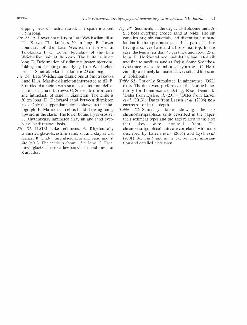
dipping beds of medium sand. The spade is about1.5 m long.
Fig. S5. A. Lower boundary of Late Weichselian till atUst Kanza. The knife is 20 cm long. B. Lowerboundary of the Late Weichselian horizon atTolokonka I. C. Lower boundary of the LateWeichselian unit at Bobrovo. The knife is 20 cmlong. D. Deformation of sediments (water injections,folding and bending) underlying Late Weichselianbeds at Smotrakovka. The knife is 20 cm long.
Fig. S6. Late Weichselian diamictons at SmotrakovkaI and II. A. Massive diamicton interpreted as till. B.Stratified diamicton with small-scale internal defor-mation structures (arrows). C. Sorted deformed sandand intraclasts of sand in diamicton. The knife is20 cm long. D. Deformed sand between diamictonbeds. Only the upper diamicton is shown in this pho-tograph. E. Matrix-rich debris band showing finingupward in the clasts. The lower boundary is erosive.F. Rhythmically laminated clay, silt and sand over-lying the diamicton beds.
Fig. S7. LLGM Lake sediments. A. Rhythmicallylaminated glaciolacustrine sand, silt and clay at UstKanza. B. Undulating glaciolacustrine sand and atsite 06013. The spade is about 1.5 m long. C. Frac-tured glaciolacustrine laminated silt and sand atKuryador.
Fig. S8. Sediments of the deglacial-Holocene unit. A.Silt beds overlying eroded sand at Nidz. The siltcontains organic materials and discontinuous sandlamina in the uppermost part. It is part of a lenshaving a convex base and a horizontal top. In thiscase, the lens is less than 40 cm thick and about 25 mlong. B. Horizontal and undulating laminated siltand fine to medium sand at Ozjag. Some Skolithos-type trace fossils are indicated by arrows. C. Hori-zontally and finely laminated clayey silt and fine sandat Tolokonka.
Table S1. Optically Stimulated Luminescence (OSL)dates. The dates were performed at the Nordic Labo-ratory for Luminescence Dating, Risø, Denmark.1Dates from Lyså et al. (2011); 2Dates from Larsenet al. (2013); 3Dates from Larsen et al. (2006) nowcorrected for burial depth.
Table S2. Summary table showing the sixchronostratigraphical units described in the paper,their sediment types and the ages related to the sitesthat they were retrieved from. Thechronostratigraphical units are correlated with unitsdescribed by Larsen et al. (2006) and Lyså et al.(2001). See Fig. 9 and main text for more informa-tion and detailed discussion.
Late Pleistocene stratigraphy and sedimentary environments, NW Russia 21BOREAS