Embed Size (px)
Citation preview
June 2015
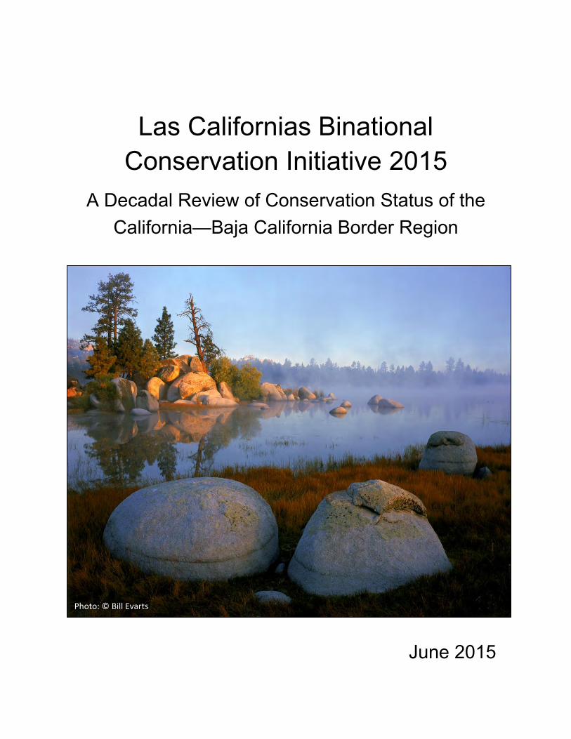
Las Californias Binational Conservation Initiative 2015
A Decadal Review of Conservation Status of the California—Baja California Border Region
A Decadal Review of Baja
Photo: © Bill Evarts
Las Californias Binational Conservation Initiative 2015:
A Decadal Review of Conservation Status of the California—Baja California Border Region
June 2015
Las Californias Binational Conservation Initiative 2015
ii June 2015
Recommended citation:
Stallcup, J.A., J.M. Randall, T. Smith, B.S. Cohen, C. Guerrero Avila, M.A. Vargas, and S.A. Morrison. 2015.
Las Californias Binational Conservation Initiative 2015: a decadal review of conservation status of
the California—Baja California border region. A report by the Conservation Biology Institute, Terra
Peninsular, Pronatura Noroeste, and The Nature Conservancy. 48 pp.
http://consbio.org/products/reports/las-californias-binational-conservation-initiative-2015
Previous report:
Conservation Biology Institute (CBI), Pronatura Noroeste, and The Nature Conservancy (TNC). 2004. Las
Californias Binational Conservation Initiative─a vision for habitat conservation in the border region
of California and Baja California. Prepared for The San Diego Foundation, Resources Legacy Fund
Foundation, and The International Community Foundation. 43 pp. + appendices
http://consbio.org/products/projects/conservation-from-california-to-baja
Las Californias Binational Conservation Initiative 2015
iii June 2015
Table of Contents List of Figures ................................................................................................................................................................................................... iv
List of Tables .................................................................................................................................................................................................... iv
Acknowledgments ...........................................................................................................................................................................................v
Executive Summary ....................................................................................................................................................................................... vi
1 Introduction ............................................................................................................................................................................................. 1
1.1 A Shared Ecosystem ................................................................................................................................................................. 1
1.2 A Shared Conservation Imperative .................................................................................................................................... 6
2 Review of Conservation Progress and Loss: 2004–2014 .................................................................................................... 9
2.1 Conservation Gains ................................................................................................................................................................... 9
2.2 Conservation Losses ............................................................................................................................................................... 11
2.3 Conservation Threats............................................................................................................................................................. 17
2.4 Conservation Opportunities ............................................................................................................................................... 17
3 Conservation Strategies 2015─2025 .......................................................................................................................................... 23
3.1 Conservation Strategies ........................................................................................................................................................ 23
3.1.1 Land protection strategies ............................................................................................................................................. 23
3.1.2 Land management strategies ........................................................................................................................................ 23
3.1.3 Policy strategies .................................................................................................................................................................. 24
3.1.4 Research strategies ........................................................................................................................................................... 25
3.1.5 Capacity-building strategies .......................................................................................................................................... 25
3.1.6 Communications strategies ........................................................................................................................................... 25
3.2 Example Strategies by Conservation Category ........................................................................................................... 25
3.2.1 Illustrative strategies for Category A and B lands and waters ....................................................................... 27
3.2.2 Illustrative strategies for Category C and D lands and waters ....................................................................... 34
3.3 Conclusions ................................................................................................................................................................................ 40
4 References .............................................................................................................................................................................................. 41
Appendices
A. List of Abbreviations
B. Data Sources and Limitations
Las Californias Binational Conservation Initiative 2015
iv June 2015
List of Figures
1. Study area 2
2. Elevation 3
3. Las Californias Binational Conservation Initiative 5
4. Disparity in conservation between California and Baja California 7
5. Conservation in San Diego County since 2004 10
6. Habitat loss 13
7. Maritime succulent scrub loss on Otay Mesa in San Diego County since 2004 15
8. Matorral rosetofilo costero loss in Baja California since 2004 16
9. Coastal sage scrub conversion to grassland due to fire on Rancho Jamul Ecological Reserve 18
10. Proposed renewable energy projects 20
11. Conservation strategies, examples 26
12. Parque-to-Park binational linkage 28
List of Tables
1. The four conservation categories with reserve functions, conservation goals, management strategies, land uses, and ecological integrity that characterize them 4
2. Examples of disparity in protected areas between the two Californias 8
3. Increase in conserved lands in San Diego County in 2014 compared to 2004, by management category and bioclimatic zone 9
4. Major changes in land use since 2004 relevant to conservation opportunities and threats 11
5. Increase in urban, agriculture, and rural residential development in 2014 compared to 2004, by management category 12
6. Habitat loss between 2004 and 2014, by bioclimatic zone and management category 12
7. Loss of selected rare vegetation communities between 2004 and 2014 14
8. Loss of Critical Habitat and modeled habitat for Peninsular bighorn sheep, and Recovery Habitat for Quino checkerspot butterfly in 2014 compared to 2004, by management category 14
9. Indirect impacts of population growth, development, habitat fragmentation, unnatural fire regimes, invasive species, climate change, and drought 19
10. Selected land use policies since 2004 relevant to potential conservation opportunities and threats 21
B-1. Digital data sources 48

Las Californias Binational Conservation Initiative 2015
v June 2015
Acknowledgments
Many thanks to my coauthors, John Randall, Trish Smith, and Scott Morrison of The Nature Conservancy,
Cesar Guerrero Avila of Terra Peninsular, and Miguel Angel Vargas of Pronatura Noroeste, and to Brian
Cohen of The Nature Conservancy for the spatial analyses and map figures.
We are all grateful to our colleagues listed below for data, discussions, and peer review that greatly
improved this document—and to all who work to advance the vision of a thriving and biodiverse Las
Californias region.
Alan Harper, Terra Peninsular
Alejandro Octavio Rodríguez Pereda, Asesoría Biológica y Ambiental
César Garcia Valderrama, California Native Plant Society, Baja chapter
Emily Perkins, San Diego Management and Monitoring Program
Gabriela Caloca Michel, Pronatura Noroeste
Geovanni Cordero-Herrera, Pronatura Noroeste
Héctor Ceballos Alcántara, Universidad Autónoma de Baja California, Ensenada
José Delgadillo Rodríguez, Universidad Autónoma de Baja California, Ensenada
Lisa Nordstrom, San Diego Zoo Global
Mathias Tobler, San Diego Zoo Global
Matt Guilliams, Santa Barbara Botanic Garden
Michael Wilken, California State University, San Marcos
Patricia Gordon-Reedy, Conservation Biology Institute
Richard Minnich, University of California, Riverside
Sula Vanderplank, Botanical Research Institute of Texas
Verónica Meza López, Terra Peninsular
– Jerre Ann Stallcup, lead author Conservation Biology Institute
Las Californias Binational Conservation Initiative 2015
vi June 2015
Executive Summary
The US-México border region is one of the most biodiverse landscapes in the world, where coastal,
inland valley, montane, and desert ecosystems converge, all within 60 mi (100 km) of the Pacific Ocean.
The region hosts a binational metropolis of more than four million people, whose well-being depends on
natural landscapes and their associated ecological processes. Natural landscapes sustain the economic
vitality of the region by protecting water supplies, maintaining air and water quality, preventing flooding
and excess erosion, and accommodating adaptation to a changing climate, as well as providing cultural,
recreational, energy, and educational resources for people.
The two countries who share this hotspot of biodiversity also share the responsibility to protect it. The
Las Californias Binational Conservation Initiative envisions a conservation landscape that integrates
across the region’s wildlands, agricultural areas, and urban centers—all have a role to play in sustaining
the region’s quality of life, plant and animal life, landscape beauty, its existing conservation investments,
and social, economic, and cultural values.
This document reviews the conservation gains and habitat losses over the last 10 years and underscores
the urgency to increase conservation investments in the region, especially in Baja California. With more
than 120,000 acres (48,000 hectares) lost to urbanization, agriculture, and rural residential development
in just the past 10 years, new conservation efforts are needed to:
Protect core areas of high biodiversity, which together represent the biological, topographic, geologic, and climatic diversity of the region.
Conserve north-south, east-west, and low elevation to high elevation linkages between these core areas and between lands that are already protected to allow biotic communities room to shift geographically in response to climate changes.
Establish a binational park system to connect Parque Nacional Constitución de 1857 in the Sierra Juárez in Baja California to the block of conservation lands formed by State Parks, National Forest lands, and Wilderness Areas in the Peninsular Ranges in San Diego and Imperial counties, California.
Secure water supplies, maintain air and water quality, and protect other ecological processes essential to a sustainable human environment.
Here, we outline the conservation vision presented in the first Las Californias report in 2004 and again
recommend that the work necessary to achieve it be undertaken. We outline recent policy changes
relevant to the achievement of the vision and propose new strategies for land protection, land
management, and conservation partnerships, and stress the need for public education and financial
incentives for landowners. We highlight specific examples of conservation priorities for the region that
illustrate the diversity of conservation management strategies needed to protect biodiversity,
ecosystem services, and ecological permeability across the spectrum of human land use intensities.
Finally, we issue a call to all sectors of government, business, non-governmental organizations, and
universities in both countries to rise to the challenge—and opportunity—of implementing a shared
binational conservation vision.

Las Californias Binational Conservation Initiative 2015
1 June 2015
1 Introduction
The Las Californias Binational Conservation Initiative (LCBCI) was conceived by a partnership among
conservation organizations and natural resource managers in California and Baja California to protect
the unique natural resources in the region bisected by the international border. In 2004, this partnership
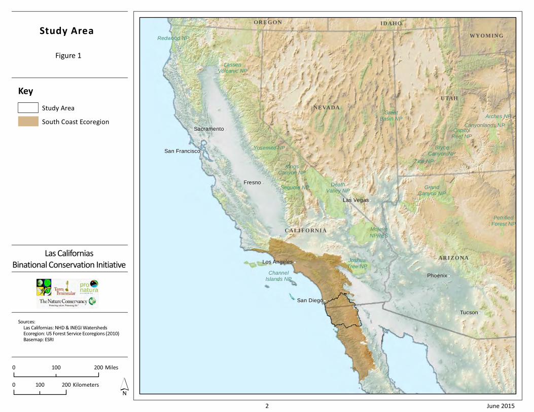
released a report that described the exceptional conservation importance of this area at the heart of the
California South Coast Ecoregion (Figure 1), which is threatened by rapidly growing human development
and climate change. The report identified the international border itself as a barrier to wildlife
movement and ecosystem processes, due to border security infrastructure (e.g., fences) and nearby
urban, residential, and industrial development. The LCBCI report presented a conservation vision for
binational collaboration that embraced the full spectrum of human land uses in the region, highlighting
conservation opportunities not only in the most intact wildlands, but also in agricultural and urban
centers. That vision galvanized conservation efforts in both the United States and México, ranging from
direct land protection to cross-border research collaboratives.
Here, 10 years later, we assess the conservation gains and habitat losses in the Las Californias region.
We also highlight new conservation opportunities and strategies and underscore the urgency for
conservation action──to protect the extraordinary biodiversity of the region and to secure the myriad
ecosystem services that natural landscapes provide to people on both sides of the border. An August
2014 meeting between President Nieto of México and Governor Brown of California, in which they
committed to more effective cross-border coordination in development, transportation, and the
environment, echoed this need. This document provides a blueprint for such binational cooperation in
conservation, with a special emphasis on the contribution of open space protection to enhance regional
conservation efforts and overall quality of life.
1.1 A Shared Ecosystem
The Las Californias region──defined by the Sweetwater, Otay, Tijuana, and Guadalupe River
watersheds──comprises one of the most biodiverse landscapes in the world, spanning coastal mesas,
fertile valleys, rolling foothills, rugged mountains, and desert canyons, all within 60 mi (100 km) of the
Pacific Ocean (Figure 2). Within this relatively short distance, coastal, inland, and montane ecosystems
come together, creating a matrix of tremendous natural diversity. This ecosystem gradient supports
>400 species that are endangered, threatened, or otherwise sensitive to human impacts, including many
that are found nowhere else in the world. The region also hosts a binational metropolis of over four
million people whose well-being depends on natural landscapes and associated ecological processes.
Natural landscapes sustain economic vitality by protecting water supplies, maintaining air and water
quality, preventing flooding and excess erosion, and accommodating adaptation to a changing climate,
as well as providing cultural, recreational, energy, and educational resources for people.
The international border poses a unique threat to existing conservation investments and the persistence
of many species. This barrier of security infrastructure and new development along both sides of the
Redwood NP
Yosemite NP
KingsCanyon NP
ChannelIslands NP
Sequoia NP
LassenVolcanic NP
DeathValley NP
Mojave
NPRES
JoshuaTree NP
Zion NP
GreatBasin NP
GrandCanyon NP
PetrifiedForest NP
CapitolReef NP
BryceCanyon NP
Canyonlands NP
Arches NP
IDAHOOREGON
NEVADA
CALIFORNIA
ARIZONA
WYOMING
UTAH
San FranciscoSan Francisco
SacramentoSacramento
FresnoFresno
Los AngelesLos Angeles
Las VegasLas Vegas
San DiegoSan Diego
PhoenixPhoenix
TucsonTucson
Study Area
Figure 1
Las Californias
Binational Conservation Initiative
Sources:
Las Californias: NHD & INEGI Watersheds
Ecoregion: US Forest Service Ecoregions (2010)
Basemap: ESRI
0 200100 Miles
0 200100 Kilometers
Key
Study Area
South Coast Ecoregion
2 June 2015
Elevation
Figure 2
Las Californias
Binational Conservation Initiative
Sources:
Las Californias: NHD & INEGI Watersheds
Elevation: USGS National Elevation Dataset
Sie
rr
aJ
uá
re
z
United StatesUnited States
MexicoMexico
Ensenada
Tijuana
San Diego
Tecate
Ja
cu
mb
aM
t ns
I n- K
o-P
ah
Mo
un
t ain
s
Valle Ojos Negros
SierraBlanca
Va
l le
Gu
adalupe
ValleLas Palmas
TecatePeak
C. Bola
OtayMountain
Ca mpo
Va
lle
y
TableMountainJacumba
Valley
L a g u na
Mo
un
t ai n
s
5
8
94
M3
M2
M1
0 2010 Miles
0 2010 Kilometers
Elevation Gradient (meters)
200 400 600 800 1,000 1,200 1,400 1,600 >1,6000
Key
Bioclimatic Zone Boundary
Study Area
3 June 2015
Las Californias Binational Conservation Initiative 2015
4 June 2015
border is especially problematic in the context of climate change, impeding species ability to track the
northward migration of suitable climates. Consequently, many conservation investments in San Diego
and Imperial counties will be jeopardized unless the natural biological communities to the south, and
the natural corridors needed to move northward, are also protected. Moreover, species and genotypes
present in Baja California may be more adapted to arid conditions, so their migration into California can
enhance overall viability in a climate-changed future. In the same way, conserving topographic
heterogeneity and a broad range of west-east elevational gradients is important to accommodating
species movement and protecting climate refugia in response to climate change.
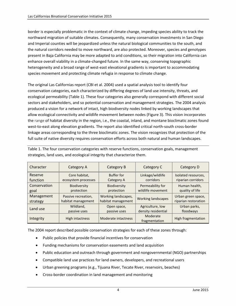
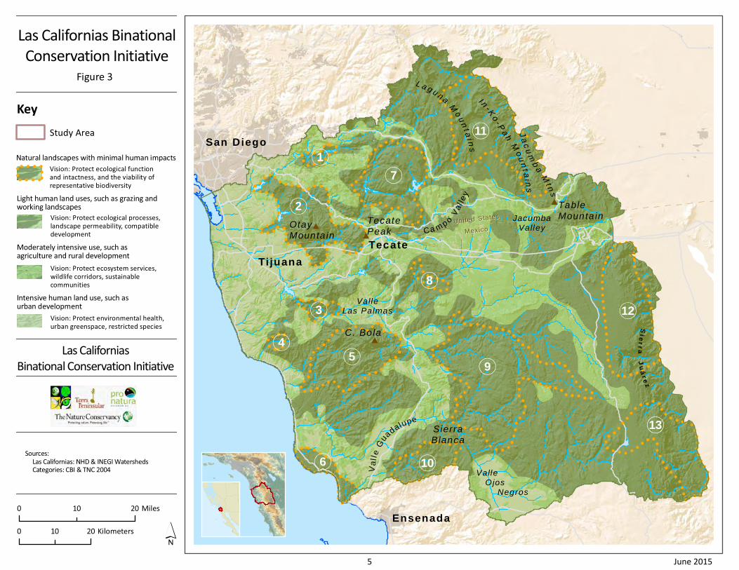
The original Las Californias report (CBI et al. 2004) used a spatial analysis tool to identify four
conservation categories, each characterized by differing degrees of land use intensity, threats, and
ecological permeability (Table 1). These four categories also generally correspond with different social
sectors and stakeholders, and so potential conservation and management strategies. The 2004 analysis
produced a vision for a network of intact, high biodiversity nodes linked by working landscapes that
allow ecological connectivity and wildlife movement between nodes (Figure 3). This vision incorporates
the range of habitat diversity in the region, i.e., the coastal, inland, and montane bioclimatic zones found
west-to-east along elevation gradients. The report also identified critical north-south cross-border
linkage areas corresponding to the three bioclimatic zones. The vision recognizes that protection of the
full suite of native diversity requires conservation efforts across both natural and human landscapes.
Table 1. The four conservation categories with reserve functions, conservation goals, management
strategies, land uses, and ecological integrity that characterize them.
Character Category A Category B Category C Category D
Reserve function
Core habitat, ecosystem processes
Buffer for Category A
Linkage/wildlife corridors
Isolated resources, riparian corridors
Conservation goal
Biodiversity protection
Biodiversity protection
Permeability for wildlife movement
Human health, quality of life
Management strategy
Passive recreation, habitat management
Working landscapes, habitat management
Working landscapes Urban green space, riparian restoration
Land use Wildland,
passive uses Open space, passive uses
Agriculture, low density residential
Urban parks, floodways
Integrity High intactness Moderate intactness Moderate
fragmentation High fragmentation
The 2004 report described possible conservation strategies for each of these zones through:
Public policies that provide financial incentives for conservation
Funding mechanisms for conservation easements and land acquisition
Public education and outreach through government and nongovernmental (NGO) partnerships
Compatible land use practices for land owners, developers, and recreational users
Urban greening programs (e.g., Tijuana River, Tecate River, reservoirs, beaches)
Cross-border coordination in land management and monitoring
Sie
rr
aJ
uá
re
z
United StatesUnited States
MexicoMexico
Ensenada
Tijuana
San Diego
Tecate
Ja
cu
mb
aM
tns
I n- K
o- P
ah
Mo
un
t ai n
s
Valle Ojos Negros
SierraBlanca
Va
lle
Gu
adalupe
ValleLas Palmas
TecatePeak
C. Bola
OtayMounta in
Ca m po
Va
l le
y
TableMounta inJacumba
Valley
L a g u n a
Mo
un
t ai n
s
9
8
7
6
5
4
3
2
1
13
12
10
11
Las Californias Binational
Conservation Initiative
Figure 3
Las Californias
Binational Conservation Initiative
Sources:
Las Californias: NHD & INEGI Watersheds
Categories: CBI & TNC 2004
Key
Study Area
0 2010 Kilometers
0 2010 Miles
Vision: Protect environmental health,
urban greenspace, restricted species
Intensive human land use, such asurban development
Vision: Protect ecosystem services,
wildlife corridors, sustainable
communities
Moderately intensive use, such asagriculture and rural development
Vision: Protect ecological processes,
landscape permeability, compatible
development
Light human land uses, such as grazing andworking landscapes
Vision: Protect ecological function
and intactness, and the viability of
representative biodiversity
Natural landscapes with minimal human impacts
5 June 2015
Las Californias Binational Conservation Initiative 2015
6 June 2015
1.2 A Shared Conservation Imperative
A central theme of the Las Californias Initiative is that the two countries that share this unique
ecosystem also share the responsibility to protect it. This 10-year status review of conservation gains
and habitat losses in the region since 2004 reemphasizes the urgency of acting to fulfill the Las
Californias vision.
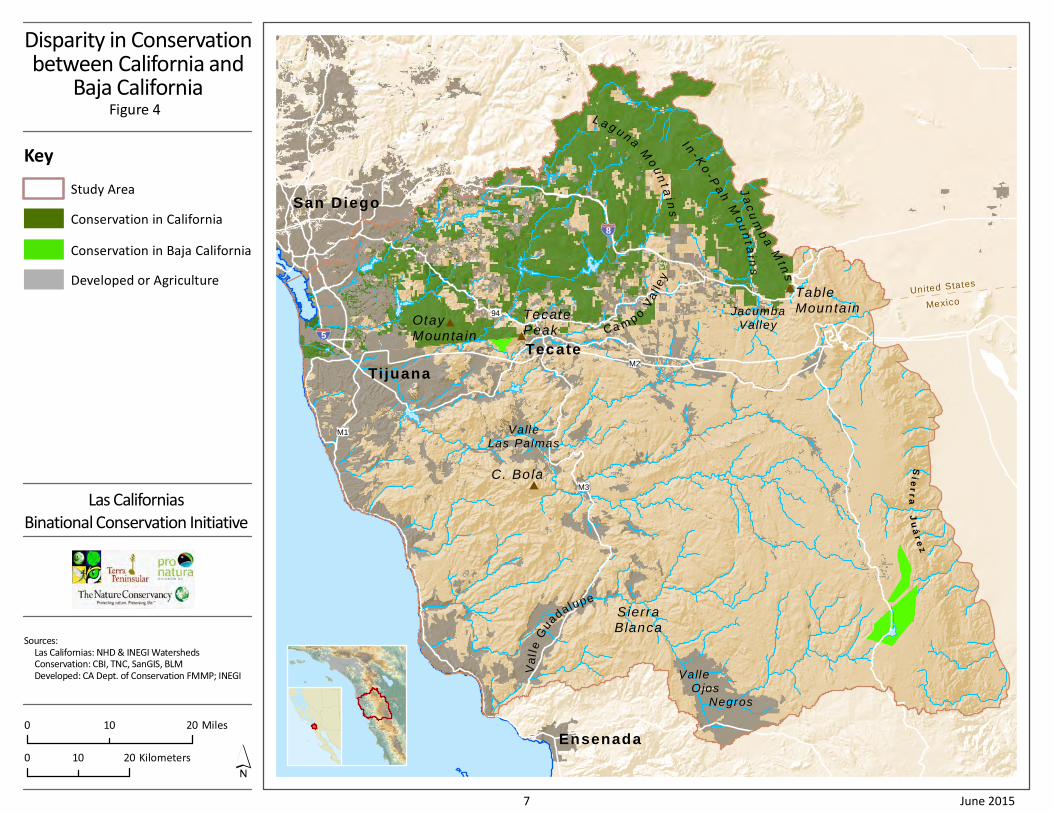
The different socio-economic and legal systems in the two countries challenge coordinated conservation
efforts. Insufficient financial resources for conservation have contributed to an extreme asymmetry in
conservation status across the border, with the result that the full range of the region’s biodiversity is
severely underrepresented in protected areas within Baja California. Figure 4 shows this disparity in
conservation between the north and south, as well as the lack of cross-border linkages and major gaps
in protection between public lands in San Diego County, particularly across bioclimatic zones. Table 2
contrasts the areal extent of some of the conserved lands north of the border with those south of the
border. This contrast especially highlights the need for accelerating conservation in Baja California so
that all vegetation communities and species are represented in a regional network of protected areas. In
their gap analysis, CONABIO et al. 2007 highlight the lack of representation of the full range of
biodiversity in conserved lands in Baja California, which they term the natural capital of the country.
The urgency to implement the LCBCI vision is mounting,
because conservation opportunities are fleeting. An
increase in border fence infrastructure and associated
development has further separated wildlife habitat in the
two Californias. The municipalities of Tijuana and Playas de
Rosarito have spread south along the coast and east
toward Tecate. Meanwhile, California’s Otay Mesa and Baja California’s Mesa de Otay have grown and
become almost a single community, with a new port of entry and a cross-border airport facility under
construction. Vineyards have consumed more of the inland valleys in Baja California, while population
growth, rural sprawl, renewable energy development, invasive species, altered fire regimes, recreational
activities, and a changing climate further threaten the conservation vision. Land managers on both sides
of the border must assess how to manage the cascading ecological consequences of this fragmentation,
so that these habitats are not further degraded.
Despite these setbacks, the LCBCI original broad-scale goals can still be achieved (Figure 3):
Protect core areas of high biodiversity, which together represent the biological, topographic, geologic, and climatic diversity of the region.
Conserve north-south and east-west linkages between these core areas and between lands that are already protected to allow biotic communities room to shift geographically in response to climate changes.
Establish a binational park system to connect Parque Nacional Constitución de 1857 in the Sierra Juárez in Baja California to the State Parks, National Forest lands, and Wilderness Areas in the Peninsular Ranges north of the border in California.
Conservation options are more limited now than they were 10 years ago. For example, some species populations were extirpated during this period, and the possibility of an intact coastal sage scrub linkage between the two Californias was lost.
Sie
rr
aJ
uá
re
z
United StatesUnited States
MexicoMexico
Ensenada
Tijuana
San Diego
Tecate
Ja
cu
mb
aM
tns
I n- K
o- P
ah
Mo
un
t ai n
s
Valle Ojos Negros
SierraBlanca
Va
lle
Gu
adalupe
ValleLas Palmas
TecatePeak
C. Bola
OtayMounta in
Ca m po
Va
l le
y
TableMounta inJacumba
Valley
L a g u n a
Mo
un
t ai n
s
5
M1
M3
M2
94
8
Disparity in Conservationbetween California and
Baja CaliforniaFigure 4
Las Californias
Binational Conservation Initiative
Sources:
Las Californias: NHD & INEGI Watersheds
Conservation: CBI, TNC, SanGIS, BLM
Developed: CA Dept. of Conservation FMMP; INEGI
Key
Study Area
0 2010 Kilometers
0 2010 Miles
Conservation in California
Conservation in Baja California
Developed or Agriculture
7 June 2015
Las Californias Binational Conservation Initiative 2015
8 June 2015
The Peninsular Ranges that span the Californias remain the inspirational backbone of the conservation
vision, supporting the most iconic species of this place──Peninsular bighorn sheep, mountain lions,
California condors, golden eagles, and plants like Cuyamaca cypress, Gander’s pitcher sage, and Dehesa
beargrass that grow nowhere else on Earth. Realizing the LCBCI vision──through land use policies, land
management, and land acquisition and easements──will require urgent action and renewed
commitment from all stakeholders. New opportunities and partnerships, innovative crossing structures
to reduce the barrier that roads pose to wildlife movement, and new perspectives and policies on
resource management all afford reasons for hope.
Table 2. Examples of disparity in protected areas between the two Californias. Areas noted in italicized
font represent potential additional regional, state, and national parks in Baja California based on areas
depicted in the Las Californias vision.
CALIFORNIA (examples; does not include all conserved lands) Acres Hectares
Cleveland National Forest1 138,884 56,204
BLM lands1—Otay Mountain, Otay Mesa, Cedar Creek, Sycamore Canyon, Tecate Peak 45,000 18,200
San Diego NWR acquisition boundary (70% of which is conserved) 43,860 17,750
Cuyamaca Rancho State Park 24,700 10,000
Anza-Borrego Desert State Park1 78,165 31,632
Otay Lakes County Park 78 32
Otay Valley Regional Park 200 81
Total examples in California study area 330,887 133,899
BAJA CALIFORNIA (examples; does not include all conserved lands) Acres Hectares
Parque Nacional Constitución de 1857 12,400 5,000
Rancho Rodeo del Rey (conservation easement) 4,450 1,800
Cerro Cuchumá (México only) 1,500 600
Total protected in Baja California study area 18,340 7,400
Parque Nacional Sierra de San Pedro Mártir (outside study area) 170,000 69,000
Proposed for conservation (examples) Acres Hectares
Northern Sierra Juárez APRN2 102,700 41,600
Southern Sierra Juárez APRN2 83,000 33,600
Sierra Blanca state or national park 33,000 13,400
El Pinal state or national park 177,000 71,600
Cerro Bola state park 78,300 31,700
San Miguel state park (part of Salsipuedes node) 143 58
Tijuana River state park 172 70
La Presa regional park, including reservoir 10,500 4,245
Mesa Redonda regional park 4,000 1,620
Total examples of proposed protection in Baja California study area 488,815 197,893 1
Includes only lands within the study area. 2
Includes national park; APRN = Área de Protección de Recursos Naturales (Terra Peninsular and TNC 2010).
Las Californias Binational Conservation Initiative 2015
9 June 2015
2 Review of Conservation Progress and Loss: 2004–2014
We reviewed conservation progress in the border region since 2004, as well as the extent, location, and
types of habitat loss in both Californias, by bioclimatic zone and by conservation management category.
Quantifying habitat loss was complicated by availability of data sources, data resolution, and the
different vegetation classification and mapping methods used in different portions of the study area
(Appendix B). This section summarizes the status of conservation in the study area, as well as new
threats and new conservation opportunities since 2004.
2.1 Conservation Gains
Additional habitat conservation, launch of new management and monitoring programs, and growth of
private land trusts and community outreach NGOs in both Californias have increased the public visibility
of the region’s conservation importance and the value of open space protection. Acquisition of private
land for conservation in furtherance of California’s Natural Community Conservation Planning (NCCP)
program increased by >13,000 acres (>5,260 hectares) in southern San Diego County between 2004 and
2014, creating a conservation core of almost 82,000 acres (33,185 hectares) south of Interstate-8.
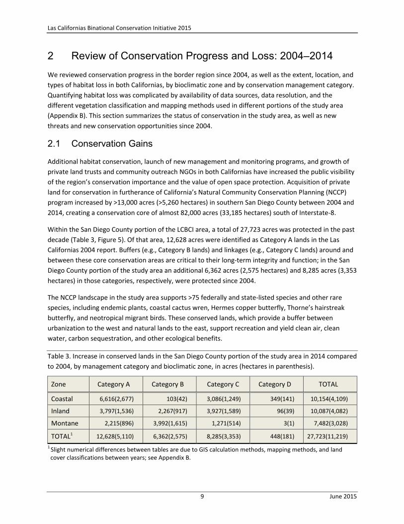
Within the San Diego County portion of the LCBCI area, a total of 27,723 acres was protected in the past
decade (Table 3, Figure 5). Of that area, 12,628 acres were identified as Category A lands in the Las
Californias 2004 report. Buffers (e.g., Category B lands) and linkages (e.g., Category C lands) around and
between these core conservation areas are critical to their long-term integrity and function; in the San
Diego County portion of the study area an additional 6,362 acres (2,575 hectares) and 8,285 acres (3,353
hectares) in those categories, respectively, were protected since 2004.
The NCCP landscape in the study area supports >75 federally and state-listed species and other rare
species, including endemic plants, coastal cactus wren, Hermes copper butterfly, Thorne’s hairstreak
butterfly, and neotropical migrant birds. These conserved lands, which provide a buffer between
urbanization to the west and natural lands to the east, support recreation and yield clean air, clean
water, carbon sequestration, and other ecological benefits.
Table 3. Increase in conserved lands in the San Diego County portion of the study area in 2014 compared
to 2004, by management category and bioclimatic zone, in acres (hectares in parenthesis).
Zone Category A Category B Category C Category D TOTAL
Coastal 6,616(2,677) 103(42) 3,086(1,249) 349(141) 10,154(4,109)
Inland 3,797(1,536) 2,267(917) 3,927(1,589) 96(39) 10,087(4,082)
Montane 2,215(896) 3,992(1,615) 1,271(514) 3(1) 7,482(3,028)
TOTAL1 12,628(5,110) 6,362(2,575) 8,285(3,353) 448(181) 27,723(11,219)
1 Slight numerical differences between tables are due to GIS calculation methods, mapping methods, and land cover classifications between years; see Appendix B.
Sie
rr
aJ
uá
re
z
United StatesUnited States
MexicoMexico
Ensenada
Tijuana
San Diego
Tecate
Ja
cu
mb
aM
tns
I n- K
o- P
ah
Mo
un
t ai n
s
Valle Ojos Negros
SierraBlanca
Va
lle
Gu
adalupe
ValleLas Palmas
TecatePeak
C. Bola
OtayMounta in
Ca m po
Va
l le
y
TableMounta inJacumba
Valley
L a g u n a
Mo
un
t ai n
s
5
M1
M3
M2
94
8
Conservation in San Diego County
since 2004Figure 5
Las Californias
Binational Conservation Initiative
Sources:
Las Californias: NHD & INEGI Watersheds
Conservation: CBI, TNC, SanGIS, BLM
Developed: CA Dept. of Conservation FMMP; INEGI
Key
Study Area
0 2010 Kilometers
0 2010 Miles
Conservation since 2004
Conservation as of 2004
Conservation in Mexico
San Diego National Wildlife Refuge
Developed or Agriculture
10 June 2015
Las Californias Binational Conservation Initiative 2015
11 June 2015
While conservation and management efforts in Baja California continue at a local scale, we did not find
documentation of any new conserved areas in the Las California study area. Habitat enhancement and
restoration (e.g., along the Tecate River/Arroyo Alamar by Pronatura Noroeste) and environmental
education (e.g., through Fundación la Puerta) are ongoing and critical to conservation success in Baja
California; therefore, building capacity for these efforts must be supported.
2.2 Conservation Losses
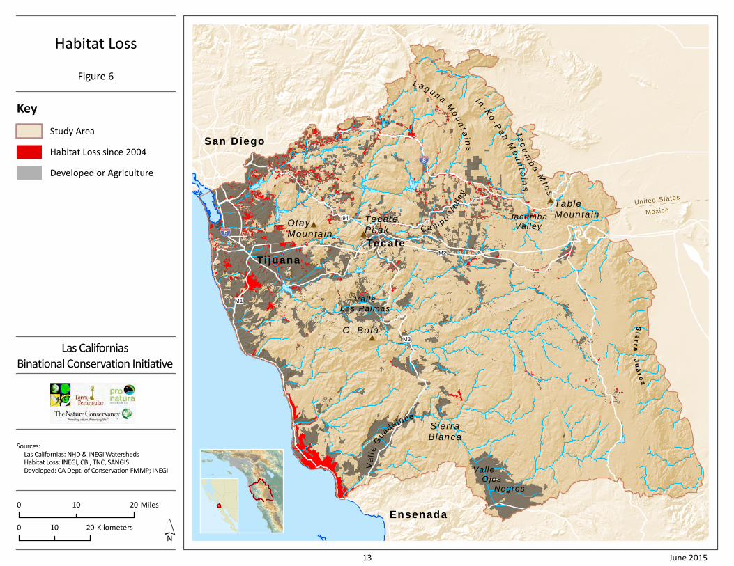
Tables 4, 5, and 6 show that more than 120,000 acres
(>48,000 hectares) have been converted to urban, rural
residential, and agricultural development in the last 10 years (Figure 6). Almost half of this lost habitat
comprised rare vegetation communities considered important by local, state, and federal resource
agencies (Tables 7 and 8); 70% of this loss was in Category C, where conservation objectives are to link
core habitat areas and maintain landscapes permeable to wildlife movement. These connectivity
objectives are at the heart of the Las Californias Initiative, both within and between the two Californias.
Table 4. Major changes in land use since 2004 relevant to conservation opportunities and threats.
Land Use Opportunity Threat
Renewable energy development Potential for conservation acquisition as offsite mitigation
Habitat loss & fragmentation, wildlife mortality, source of fire ignition
Recreation in the Peninsular Ranges
Greater public access to trails Habitat degradation due to public abuse & source of fire ignition
Urbanization along the coast Potential for decrease in urban sprawl & sources of fire ignition in eastern rural areas
Loss & fragmentation of coastal habitats, severed connectivity between California & Baja California, especially for coastal sage scrub species
Agricultural expansion (e.g., Valle de Guadalupe, Campo Valley)
Potential to provide permeable matrix habitat between core areas
Loss of habitat, air & water pollution, surface & groundwater depletion
Border infrastructure (triple fence, roads, new airport facility, new border crossing)
Conservation acquisitions & research funded as mitigation
Loss of connectivity between California & Baja California, habitat loss & degradation
Increased conservation & management in California
Potential for connecting conserved lands & managing threats
Insufficient funds for management & monitoring, potential for public abuse
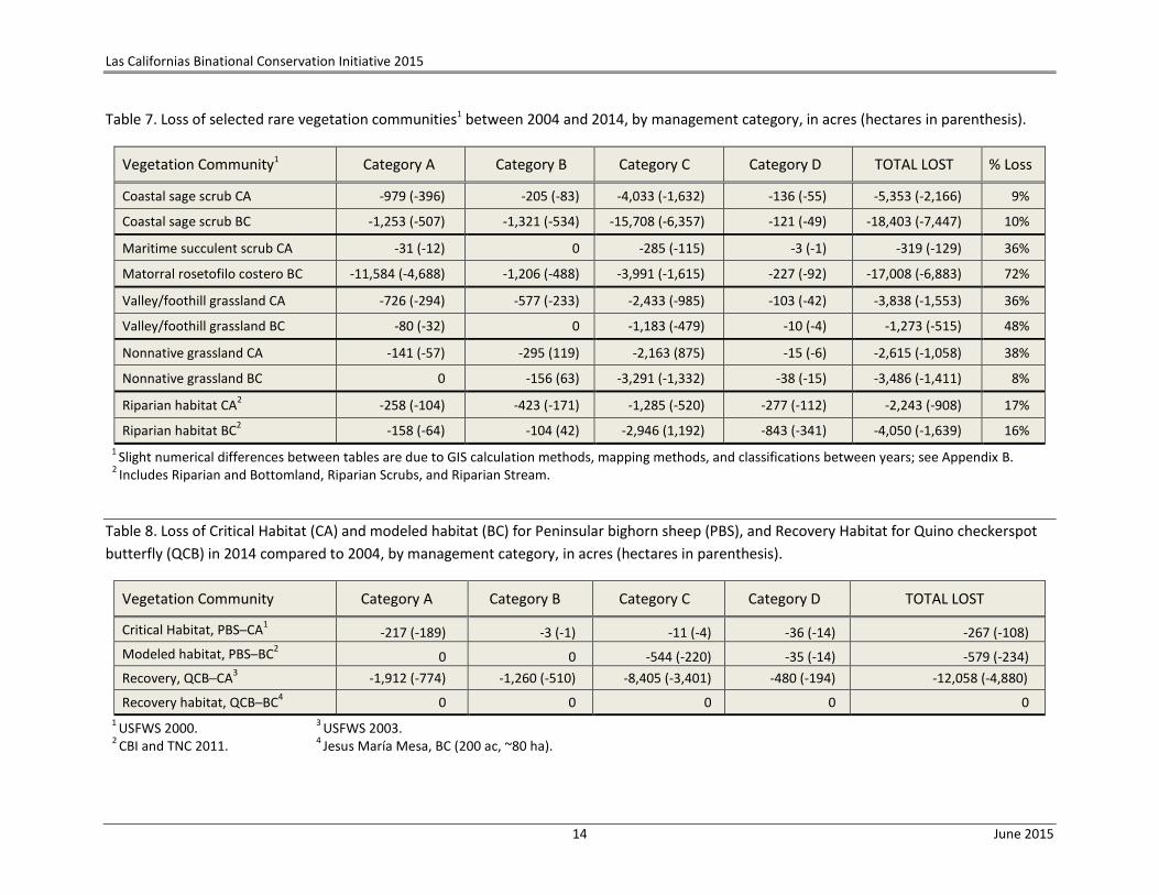
Maritime succulent scrub in the San Diego County portion of the study area decreased by 36%; the
majority of the remaining maritime succulent scrub on Otay Mesa in San Diego County has now been
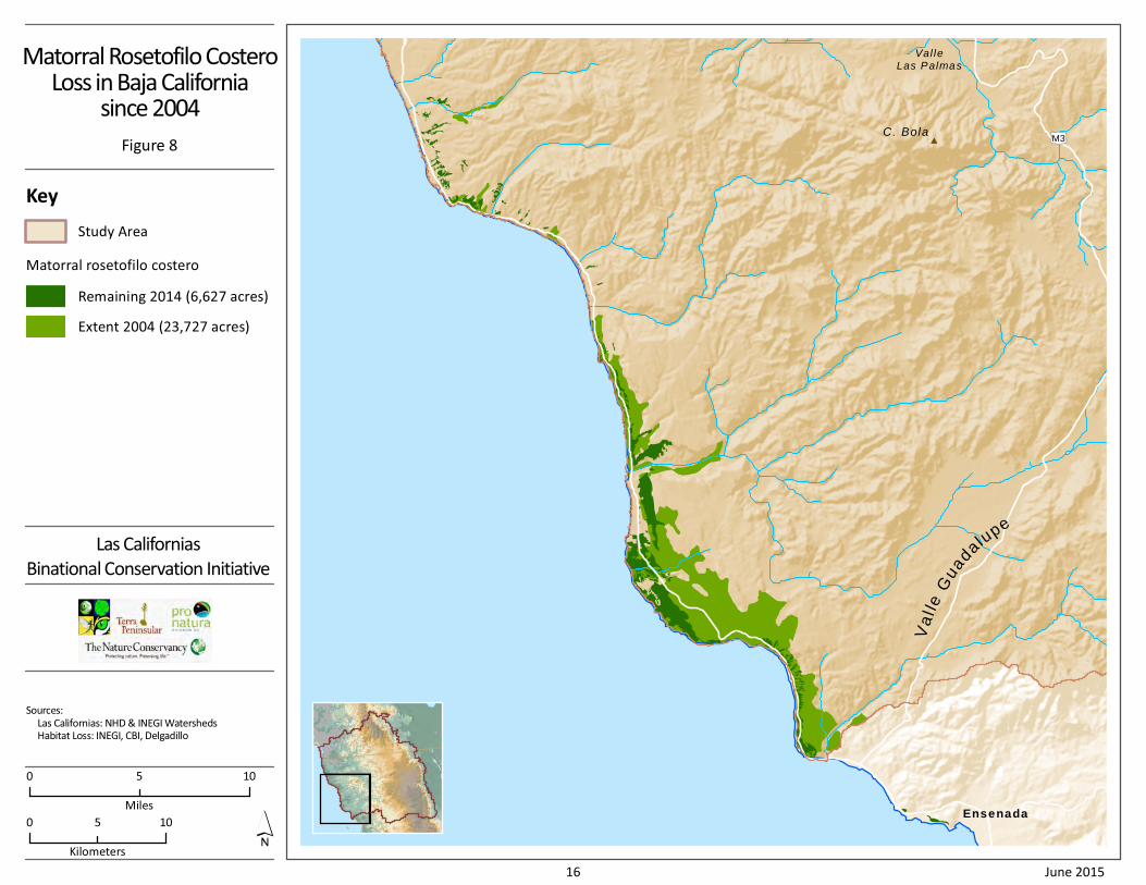
either developed or formally protected (see example, Figure 7). Along the coast of Baja California, 72%
of the matorral rosetofilo costero (the rough equivalent of areas identified as maritime succulent scrub
in California) present north of Ensenada in 2004 was lost to development and agriculture by 2014, based
on 2014 field surveys (Delgadillo and Ceballos Alcántara 2014) (Figure 8). While there has been <1% loss
of Tecate cypress forest to development across the study area, thousands of acres of Tecate cypress
forest were lost to repeated fires.
Over the past decade, more than 120,000 acres (48,000 ha) of natural habitats have been converted to human uses, mostly in the coastal and inland areas.

Las Californias Binational Conservation Initiative 2015
12 June 2015
Table 5. Increase in urban, agriculture, and rural residential development in 2014 compared to 2004, by management category, in acres
(hectares in parenthesis).
Land Use Category A Category B Category C Category D TOTAL INCREASE
Urban 2,660 (1,076) 4,331 (1,753) 24,496 (9,913) 2,189 (886) 33,676 (13,628)
Agriculture 13,527 (5,474) 5,514 (2,231) 37,536 (15,190) -531 (-215)3 56,046 (22,681)
Rural residential1,2 1,680 (680) 5,627 (2,277) 22,755 (9,209) 455 (184) 30,517 (12,350)
TOTAL INCREASE4 17,866 (7,230) 15,472 (6,261) 84,787 (34,312) 2,113 (855) 120,238 (48,658)
1 Spaced/Dispersed Residential; INEGI 1997 land use data; 2000 Tijuana River watershed data; 2003 SANDAG land use data.
2 Rural Residential (1 du/40, 80, 160, CA, SANDAG 2014) and Asentamientos Humanos (BC, INEGI 2006).
3 Agriculture actually decreased in Category D between 2004 and 2014.
4 Slight numerical differences between tables are due to GIS calculation methods, mapping methods, and land cover classifications between years; see Appendix B.
Table 6. Habitat loss between 2004 and 2014, by bioclimatic zone and management category, in acres, hectares, and % habitat lost between
2004 and 2014 for the specific zone/category.
Zone Category A Category B Category C Category D TOTAL LOSS
ac ha % ac ha % ac ha % ac ha % ac ha %
Coastal -14,607 -5,911 8 -2,221 -899 1 -38,222 -15,468 21 -150 -61 <1 -55,200 -22,339 7
Inland -2,847 -1,152 1 -11,516 -4,660 2 -40,491 -16,386 10 -1,491 -603 1 -56,345 -22,802 4
Mountain -413 -167 <1 -1,734 -702 <1 -6,074 -2,458 9 -472 -191 9 -8,694 -3,518 1
TOTAL LOSS1 -17,866 -7,230 2 -15,472 -6,621 2 -84,787 -34,312 13 -2,113 -855 1 -120,238 -48,658 4
1 Slight numerical differences between tables are due to GIS calculation methods, mapping methods, and land cover classifications between years; see Appendix B.
Sie
rr
aJ
uá
re
z
United StatesUnited States
MexicoMexico
Ensenada
Tijuana
San Diego
Tecate
Ja
cu
mb
aM
tns
I n- K
o- P
ah
Mo
un
t ai n
s
Valle Ojos Negros
SierraBlanca
Va
lle
Gu
adalupe
ValleLas Palmas
TecatePeak
C. Bola
OtayMounta in
Ca m po
Va
l le
y
TableMounta inJacumba
Valley
L a g u n a
Mo
un
t ai n
s
5
M1
M3
M2
94
8
Habitat Loss
Figure 6
Las Californias
Binational Conservation Initiative
Sources:
Las Californias: NHD & INEGI Watersheds
Habitat Loss: INEGI, CBI, TNC, SANGIS
Developed: CA Dept. of Conservation FMMP; INEGI
Key
Study Area
0 2010 Kilometers
0 2010 Miles
Habitat Loss since 2004
Developed or Agriculture
13 June 2015
Las Californias Binational Conservation Initiative 2015
14 June 2015
Table 7. Loss of selected rare vegetation communities1 between 2004 and 2014, by management category, in acres (hectares in parenthesis).
Vegetation Community1 Category A Category B Category C Category D TOTAL LOST % Loss
Coastal sage scrub CA -979 (-396) -205 (-83) -4,033 (-1,632) -136 (-55) -5,353 (-2,166) 9%
Coastal sage scrub BC -1,253 (-507) -1,321 (-534) -15,708 (-6,357) -121 (-49) -18,403 (-7,447) 10%
Maritime succulent scrub CA -31 (-12) 0 -285 (-115) -3 (-1) -319 (-129) 36%
Matorral rosetofilo costero BC -11,584 (-4,688) -1,206 (-488) -3,991 (-1,615) -227 (-92) -17,008 (-6,883) 72%
Valley/foothill grassland CA -726 (-294) -577 (-233) -2,433 (-985) -103 (-42) -3,838 (-1,553) 36%
Valley/foothill grassland BC -80 (-32) 0 -1,183 (-479) -10 (-4) -1,273 (-515) 48%
Nonnative grassland CA -141 (-57) -295 (119) -2,163 (875) -15 (-6) -2,615 (-1,058) 38%
Nonnative grassland BC 0 -156 (63) -3,291 (-1,332) -38 (-15) -3,486 (-1,411) 8%
Riparian habitat CA2 -258 (-104) -423 (-171) -1,285 (-520) -277 (-112) -2,243 (-908) 17%
Riparian habitat BC2 -158 (-64) -104 (42) -2,946 (1,192) -843 (-341) -4,050 (-1,639) 16%
1 Slight numerical differences between tables are due to GIS calculation methods, mapping methods, and classifications between years; see Appendix B.
2 Includes Riparian and Bottomland, Riparian Scrubs, and Riparian Stream.
Table 8. Loss of Critical Habitat (CA) and modeled habitat (BC) for Peninsular bighorn sheep (PBS), and Recovery Habitat for Quino checkerspot
butterfly (QCB) in 2014 compared to 2004, by management category, in acres (hectares in parenthesis).
Vegetation Community Category A Category B Category C Category D TOTAL LOST
Critical Habitat, PBS─CA1 -217 (-189) -3 (-1) -11 (-4) -36 (-14) -267 (-108)
Modeled habitat, PBS─BC2 0 0 -544 (-220) -35 (-14) -579 (-234)
Recovery, QCB─CA3 -1,912 (-774) -1,260 (-510) -8,405 (-3,401) -480 (-194) -12,058 (-4,880)
Recovery habitat, QCB─BC4 0 0 0 0 0
1 USFWS 2000.
3 USFWS 2003.
2 CBI and TNC 2011.
4 Jesus María Mesa, BC (200 ac, ~80 ha).
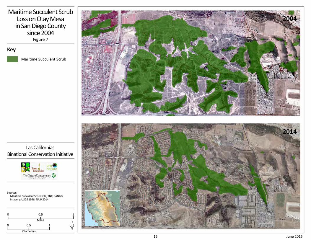
Maritime Succulent ScrubLoss on Otay Mesain San Diego County
since 2004Figure 7
Las Californias
Binational Conservation Initiative
Sources:
Maritime Succulent Scrub: CBI, TNC, SANGIS
Imagery: USGS 1996; NAIP 2014
Key
Maritime Succulent Scrub
0 10.5
Kilometers
0 10.5
Miles
2004
2014
15 June 2015
Ensenada
Va
l le
Guadalu
pe
Val leLas Palmas
C. BolaM3
Matorral Rosetofilo CosteroLoss in Baja California
since 2004
Figure 8
Las Californias
Binational Conservation Initiative
Sources:
Las Californias: NHD & INEGI Watersheds
Habitat Loss: INEGI, CBI, Delgadillo
Key
Study Area
Matorral rosetofilo costero
Remaining 2014 (6,627 acres)
Extent 2004 (23,727 acres)
0 105
Miles
0 105
Kilometers
16 June 2015
Las Californias Binational Conservation Initiative 2015
17 June 2015
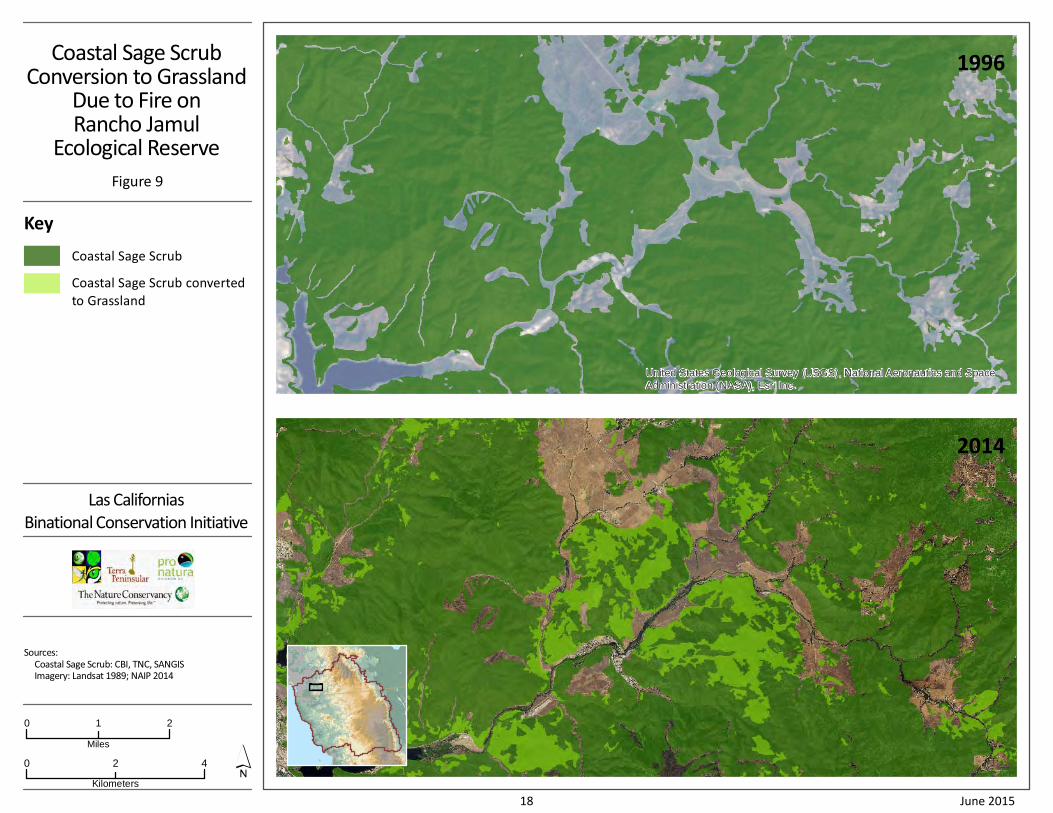
In addition to habitat lost to development, frequent fire, notably the 2003 and 2007 catastrophic
wildfires in San Diego County, resulted in habitat type conversion that is not accurately reflected in
vegetation community maps. For example, on the Rancho Jamul Ecological Reserve, in the center of the
largest conserved core habitat area in coastal San Diego County, repeated wildfires have type-converted
significant areas of coastal sage scrub to annual grasslands of invasive and highly flammable nonnative
species (Figure 9). These habitat losses have eliminated some historic populations of rare species, such
as the federally Endangered Quino checkerspot butterfly (QCB, Table 8). Thatch from invasive nonnative
grasses has prevented germination of some rare endemic plant species, such as the federally
Endangered San Diego thornmint, which occurs only in San Diego County and northern Baja California.
Populations of the federally Threatened California gnatcatcher, which formerly had core populations in
this area, have shifted elsewhere or been lost. While losses of Critical Habitat for the federally
endangered Peninsular bighorn sheep were not as great, the new habitat fragmentation by the Sunrise
Powerlink and ongoing border security activities, in addition to the habitat fragmentation caused earlier
by Interstate-8 (I-8) in California and Highway 2 (MX-2) in Baja California, likely altered population
dynamics, dispersal, and behavior of these animals (San Diego Zoo Global 2014, Buchalski et al. 2015).
2.3 Conservation Threats
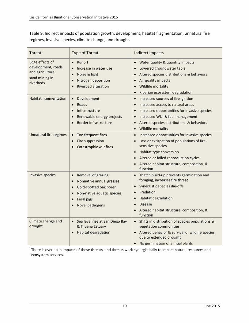
Much of the habitat loss is a result of urban development, road building, and sprawl. However, the
mapped data do not show habitat degradation and fragmentation caused by indirect impacts of
population growth and development, including the insidious edge effects of light and noise, invasions of
nonnative plant and animal species, increased recreational use of wildlands, unnatural fire regimes,
groundwater drawdown, and climate change (Table 9). These indirect impacts have profound
implications for the persistence of many native communities. Even natural resources within large blocks
of conserved lands are vulnerable to loss if those blocks are not appropriately connected, monitored,
and managed. Poor land use planning, resulting in fragmentation and siting of structures in areas of high
fire risk, has resulted in a larger wildlife-urban interface (WUI, Syphard et al. 2013); this in turn can lead
to significant additional habitat loss through clearing vegetation to create fire breaks. Impacts of
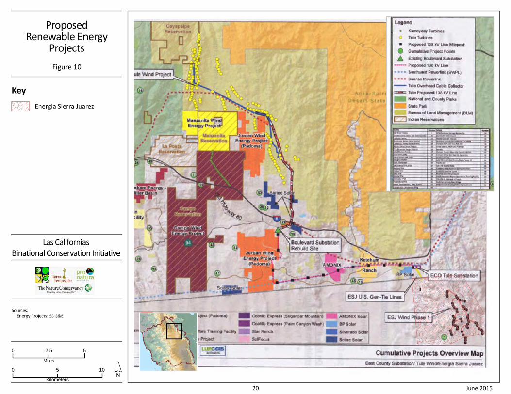
renewable energy projects (Figure 10) and border infrastructure and associated activities are only now
being realized. These threats synergistically impact natural resources in ways we don’t fully understand.
2.4 Conservation Opportunities
New conservation opportunities have presented themselves in both Californias over the past decade
(Table 10). In 2004, San Diego County voters approved the extension of the TransNet half-cent sales tax
to fund transportation improvements and associated environmental mitigation. The TransNet
Environmental Working Group, established as a result of this policy, administers conservation funding
for land acquisition, management, and monitoring. This measure also required a future funding
commitment for implementing habitat conservation plans in the San Diego region, once the current
sales tax expires. The deadline for meeting this commitment is November 2016; if a new measure is not
passed by that time, there will be no long-term funding for management and monitoring of NCCP
conserved lands in San Diego County.
United States Geological Survey (USGS), National Aeronautics and Space
Administration (NASA), Esri Inc.
Coastal Sage ScrubConversion to Grassland
Due to Fire onRancho Jamul
Ecological Reserve
Figure 9
Las Californias
Binational Conservation Initiative
Sources:
Coastal Sage Scrub: CBI, TNC, SANGIS
Imagery: Landsat 1989; NAIP 2014
Key
Coastal Sage Scrub
0 42
Kilometers
1996
2014
Coastal Sage Scrub converted
to Grassland
0 21
Miles
18 June 2015
Las Californias Binational Conservation Initiative 2015
19 June 2015
Table 9. Indirect impacts of population growth, development, habitat fragmentation, unnatural fire
regimes, invasive species, climate change, and drought.
Threat1 Type of Threat Indirect Impacts
Edge effects of development, roads, and agriculture;
sand mining in riverbeds
Runoff
Increase in water use
Noise & light
Nitrogen deposition
Riverbed alteration
Water quality & quantity impacts
Lowered groundwater table
Altered species distributions & behaviors
Air quality impacts
Wildlife mortality
Riparian ecosystem degradation
Habitat fragmentation Development
Roads
Infrastructure
Renewable energy projects
Border infrastructure
Increased sources of fire ignition
Increased access to natural areas
Increased opportunities for invasive species
Increased WUI & fuel management
Altered species distributions & behaviors
Wildlife mortality
Unnatural fire regimes Too frequent fires
Fire suppression
Catastrophic wildfires
Increased opportunities for invasive species
Loss or extirpation of populations of fire-sensitive species
Habitat type conversion
Altered or failed reproduction cycles
Altered habitat structure, composition, & function
Invasive species Removal of grazing
Nonnative annual grasses
Gold-spotted oak borer
Non-native aquatic species
Feral pigs
Novel pathogens
Thatch build-up prevents germination and foraging, increases fire threat
Synergistic species die-offs
Predation
Habitat degradation
Disease
Altered habitat structure, composition, & function
Climate change and drought
Sea level rise at San Diego Bay & Tijuana Estuary
Habitat degradation
Shifts in distribution of species populations & vegetation communities
Altered behavior & survival of wildlife species due to extended drought
No germination of annual plants 1
There is overlap in impacts of these threats, and threats work synergistically to impact natural resources and ecosystem services.
ProposedRenewable Energy
Projects
Figure 10
Las Californias
Binational Conservation Initiative
Sources:
Energy Projects: SDG&E
Key
Energia Sierra Juarez
0 105
Kilometers
0 52.5
Miles
20 June 2015
Las Californias Binational Conservation Initiative 2015
21 June 2015
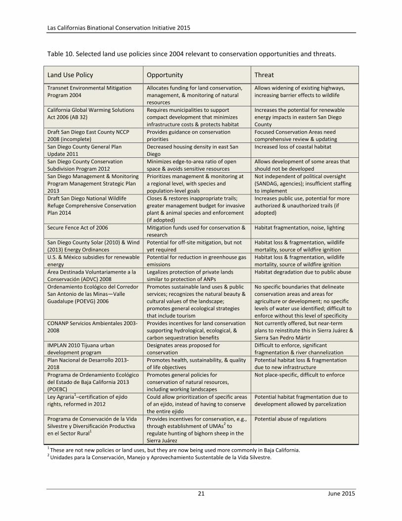
Table 10. Selected land use policies since 2004 relevant to conservation opportunities and threats.
Land Use Policy Opportunity Threat
Transnet Environmental Mitigation Program 2004
Allocates funding for land conservation, management, & monitoring of natural resources
Allows widening of existing highways, increasing barrier effects to wildlife
California Global Warming Solutions Act 2006 (AB 32)
Requires municipalities to support compact development that minimizes infrastructure costs & protects habitat
Increases the potential for renewable energy impacts in eastern San Diego County
Draft San Diego East County NCCP 2008 (incomplete)
Provides guidance on conservation priorities
Focused Conservation Areas need comprehensive review & updating
San Diego County General Plan Update 2011
Decreased housing density in east San Diego
Increased loss of coastal habitat
San Diego County Conservation Subdivision Program 2012
Minimizes edge-to-area ratio of open space & avoids sensitive resources
Allows development of some areas that should not be developed
San Diego Management & Monitoring Program Management Strategic Plan 2013
Prioritizes management & monitoring at a regional level, with species and population-level goals
Not independent of political oversight (SANDAG, agencies); insufficient staffing to implement
Draft San Diego National Wildlife Refuge Comprehensive Conservation Plan 2014
Closes & restores inappropriate trails; greater management budget for invasive plant & animal species and enforcement (if adopted)
Increases public use, potential for more authorized & unauthorized trails (if adopted)
Secure Fence Act of 2006 Mitigation funds used for conservation & research
Habitat fragmentation, noise, lighting
San Diego County Solar (2010) & Wind (2013) Energy Ordinances
Potential for off-site mitigation, but not yet required
Habitat loss & fragmentation, wildlife mortality, source of wildfire ignition
U.S. & México subsidies for renewable energy
Potential for reduction in greenhouse gas emissions
Habitat loss & fragmentation, wildlife mortality, source of wildfire ignition
Área Destinada Voluntariamente a la Conservación (ADVC) 2008
Legalizes protection of private lands similar to protection of ANPs
Habitat degradation due to public abuse
Ordenamiento Ecológico del Corredor San Antonio de las Minas—Valle Guadalupe (POEVG) 2006
Promotes sustainable land uses & public services; recognizes the natural beauty & cultural values of the landscape; promotes general ecological strategies that include tourism
No specific boundaries that delineate conservation areas and areas for agriculture or development; no specific levels of water use identified; difficult to enforce without this level of specificity
CONANP Servicios Ambientales 2003-2008
Provides incentives for land conservation supporting hydrological, ecological, & carbon sequestration benefits
Not currently offered, but near-term plans to reinstitute this in Sierra Juárez & Sierra San Pedro Mártir
IMPLAN 2010 Tijuana urban development program
Designates areas proposed for conservation
Difficult to enforce, significant fragmentation & river channelization
Plan Nacional de Desarrollo 2013-2018
Promotes health, sustainability, & quality of life objectives
Potential habitat loss & fragmentation due to new infrastructure
Programa de Ordenamiento Ecológico del Estado de Baja California 2013 (POEBC)
Promotes general policies for conservation of natural resources, including working landscapes
Not place-specific, difficult to enforce
Ley Agraria1─certification of ejido
rights, reformed in 2012 Could allow prioritization of specific areas of an ejido, instead of having to conserve the entire ejido
Potential habitat fragmentation due to development allowed by parcelization
Programa de Conservación de la Vida Silvestre y Diversificación Productiva en el Sector Rural
1
Provides incentives for conservation, e.g., through establishment of UMAs
2 to
regulate hunting of bighorn sheep in the Sierra Juárez
Potential abuse of regulations
1 These are not new policies or land uses, but they are now being used more commonly in Baja California.
2 Unidades para la Conservación, Manejo y Aprovechamiento Sustentable de la Vida Silvestre.
Las Californias Binational Conservation Initiative 2015
22 June 2015
The 2011 San Diego County General Plan, which replaced the 1978 General Plan, presents the greatest
opportunity for land conservation in central and eastern San Diego County. The new General Plan shifts
20% of future growth from eastern to more coastal urban communities, decreasing housing density in
the eastern county by adding infill development in the western part of the county. Hopefully, this
dramatic shift away from rural sprawl in some areas (e.g., Multiple Rural Use and Impact Sensitive: 1
dwelling unit per 4, 8, and 20 acres in 1978) toward lower densities (Rural Lands: 1 dwelling unit per 40,
60, 80 acres in 2011) will prevent dramatic reductions in permeability for wildlife movement, reduce
rates of new fragmentation, and facilitate conservation of larger properties. It should also slow growth
in sources of wildfire ignition, expenses for fire management, and loss of human life and property due to
wildfires.
In Baja California, a 2008 policy formally certifies voluntary conservation on private properties as Área
Destinada Voluntariamente a la Conservación (ADVC). NGOs such as Terra Peninsular and Pronatura
Noroeste have used this policy to provide legal certainty for conservation and associated management.
However, the economic benefits of, or incentives for, certification and the longevity of protection must
be clarified for conservation to be successful. In 2014, the Resources Legacy Foundation coordinated a
workshop in México City for NGOs, with the objective of influencing environmental legislation to provide
economic incentives for ADVCs and allocating funds for managing and monitoring these areas.
The Instituto Municipal de Planeación de Tijuana (IMPLAN 2010) designated conservation areas that
support ecosystem services, passive recreation and enhanced quality of life, listed and endemic species,
federal wetland zones, lands too steep for development or with geologic faults unsuitable for
development (e.g., Cerro San Ysidro), and areas to be conserved for agriculture (e.g., Valle de Las
Palmas). However, it is unclear what effect this may have on actual protection of these lands. In 2013,
the State of Baja California, together with SEMARNAT, prepared the POEBC (Programa de Ordenamiento
Ecológico of Baja California) to better enforce sustainable land use planning strategies, by area of the
state, that are compatible with environmental factors.
Perhaps the most significant negative policy impacts in the region resulted from the Secure Fence Act of
2006, which authorized construction of new border infrastructure without environmental review. The
triple fence and associated lighting, land clearing and filling, and habitat degradation resulting from
increased Border Patrol activity destroyed large areas of habitat and created a formidable barrier to
wildlife movement. This development has also altered many dynamic ecological processes—natural fire
and hydrologic regimes, levels of soil erosion and deposition, nutrient and energy flow through food
webs, as well as population dynamics, migration, gene flow, and species interactions such as predation,
dispersal, pollination, and competition. Nevertheless, opportunities remain to align border security goals
with regional conservation goals, in that both are advanced by open space protection along the border.
Open space──versus residential and industrial development──facilitates border enforcement and
minimizes risk of tunneling. Strategic conservation of open space buffers on both sides of the border is
also integral to securing critical east-west and north-south habitat connections for wildlife.
Las Californias Binational Conservation Initiative 2015
23 June 2015
3 Conservation Strategies 2015─2025
The Las Californias vision highlights a shared dependence on
natural resources and ecosystem services and thus a responsibility
for collaboration in cross-border conservation. The vision melds
efforts to protect biodiversity, open space, and watersheds, create
recreational and educational opportunities, cultivate tourism and
business investment, and preserve a rich agricultural and cultural
heritage. This complementarity of diverse interests can advance a
common vision to protect open space areas that represent the
region’s biodiversity and secure ecosystem services that natural
areas provide to the region’s economy, culture, and quality of life.
3.1 Conservation Strategies
This section describes some general strategies that can be applied across the study area, with specific
examples cited in Section 3.2. In México, Áreas Naturales Protegidas (ANP) have been the principal
strategy for promoting conservation of ecosystems and biodiversity. Originally ANPs were established
opportunistically for their scenic beauty, but more recently areas have been conserved strategically for
their biodiversity, endemic species, and unique vegetation communities (CONABIO et al. 2007).
In both countries, all strategies require collaboration among multiple stakeholders, especially
landowners. Government agencies at all levels, NGOs, scientists, and foundations must work together to
develop financial incentives for landowners and educate the public at large about the myriad cultural,
social, economic, and health benefits of open space protection and biodiversity conservation.
3.1.1 Land protection strategies
Protect high integrity lands via acquisition or conservation easement.
Protect key linkages by securing conservation easements or maintaining working landscapes to accommodate wildlife movement.
Acquire inholdings in National Forest lands in California, and legally enforce or expand forest protection in the Sierra Juárez (see Terra Peninsular and TNC 2010).
Restrict Border Patrol activities in areas with wildlife and plants sensitive to intrusion (e.g., bighorn sheep fawning and migration areas).
3.1.2 Land management strategies
Evaluate barriers, improve road-crossing infrastructure and fencing, and establish conservation easements under bridges to enhance connectivity and permeability to wildlife movement.
Use other means of securing the border than by fencing that is impermeable to wildlife movement, especially in critical areas needed to accommodate animal movement (e.g., border-crossing arroyos favored by many species. Alternatives are especially desirable in difficult terrain where fences and other rigid infrastructure are likely to wash out.
Successful conservation strategies can align biodiversity conservation goals with other societal goals, such as watershed protection or promoting ecotourism opportunities, across the spectrum of natural landscapes, agriculture, and other human uses. Indeed, conservation efforts should demonstrate the relevance of these values to human well-being, so as to develop the constituency needed to effect conservation outcomes (see Morrison 2014).
Las Californias Binational Conservation Initiative 2015
24 June 2015
Restore native plant cover around the fence and construction staging areas to minimize erosion.
Develop and implement regional control and eradication of invasive species, in particular feral pigs, American bullfrogs, sunfish, and high priority invasive plants (e.g., species rated high on the California Invasive Plant Council Inventory, and particularly those with an alert notation).
Restore habitat and manage recovery and viability of target species, including Tecate cypress, rare Dudleya species, manzanitas, and other endemic plant species, vernal pools, Quino checkerspot butterfly, Thorne’s hairstreak, Hermes copper butterfly, southwestern arroyo toad, coastal cactus wren, golden eagle, California condor, and Peninsular bighorn sheep.
Develop public access/recreation plans for natural open space lands, including regulations for hunting and off-road vehicle use, and fee structures that support associated management costs.
Develop a fire management strategy that prevents short fire-return intervals and controls sources of ignition (e.g., road hardening, managing flashy fuels, closing roads, access control during Santa Ana winds, fire watch programs).
Develop grazing management plans that control invasive nonnative plants, reduce fire threat, and enhance habitat for rare species.
Establish seed banks and nurseries for restoration.
3.1.3 Policy strategies
Implement, in place-specific ways, the policies in the Programa de Ordenamiento Ecológico del Estado de Baja California (POEBC, SEMARNAT 2013).
Generate new funding streams that can support conservation initiatives; direct conservation funds to high priority, multi-benefit projects.
Develop payment for ecosystem services programs, such as water funds, payments for carbon sequestration and avoided emissions, and other financial incentives for landowners.
Apply best practices in the mitigation hierarchy (avoid, minimize, mitigate) to renewable energy, transportation, and other infrastructure development projects (see Cameron et al. 2012); consider impacts to connectivity and the cascading, indirect effects of roads.
Explore conservation opportunities through the Department of Defense base buffering program (Readiness and Environmental Protection Integration) to protect open space beneficial to both border security and wildlife along the US-México border.
Make land use decisions that maintain intact vegetation communities, reduce coverage by roads (and thereby nitrogen deposition), and reduce potential ignition sources in high fire risk areas.
Establish watershed protection and enhancement policies around beaches, reservoirs, and riparian corridors that can also provide recreational and educational opportunities.
Approve initiatives that provide incentives to minimize or avoid development of private inholdings within protected lands.
Protect watersheds and enhance opportunities for tourism while also protecting community open space.
Las Californias Binational Conservation Initiative 2015
25 June 2015
3.1.4 Research strategies
Characterize and quantify the ecosystem services and other values of biodiversity and natural areas to people within the Las Californias region, e.g., for groundwater recharge, agricultural productivity, tourism economies, and public health.
Investigate large mammal movement in the region to prioritize properties for protection as wildlife corridors and to inform road and utility infrastructure planning and improvements (e.g., undercrossings, overcrossings, fencing) to enhance permeability.
Identify and protect additional corridors important for the movements of smaller animals, plants, and other organisms.
Develop a consistent, current, and accurate vegetation map for the whole region that can be regularly updated to set conservation priorities and track conservation progress.
Conduct surveys, implement genetic studies, and assess threats for target species populations in both countries to understand population structure and prioritize conservation actions.
Identify climate refugia that allow species opportunities for adaptation and persistence.
3.1.5 Capacity-building strategies
Build capacity in NGOs and land trusts in both Californias to provide community outreach and education programs as well as to conserve, manage, and steward lands.
Develop partnerships between NGOs and between sister agencies in the two countries.
3.1.6 Communications strategies
Tailor conservation messages to key audiences in the region to increase awareness of what resources and values have been protected, what resources still need to be protected, why they are important, and what we will lose if they are lost.
Develop educational outreach programs for ejidatarios, journalists, the hotel industry, ecotourism providers, academic researchers, agencies, NGOs, politicians and public officials, and potential conservation donors to foster their engagement in the initiative.
Encourage public figures and organizations to champion the conservation campaign.
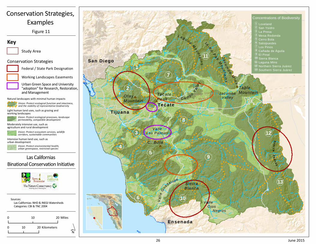
3.2 Example Strategies by Conservation Category
This section highlights potential conservation actions for selected places represented in the vision
(Figure 3), first describing those lands and strategies that pertain more to the natural landscapes (i.e.,
the Category A and B lands, and then to the more human-modified landscapes (i.e., the agricultural
lands of Category C and the urban landscapes of Category D). Figure 11 identifies some of these areas
(see also CBI et al. 2004 for more detailed maps).
Sie
rr
aJ
uá
re
z
United StatesUnited States
MexicoMexico
Ensenada
Tijuana
San Diego
Tecate
Ja
cu
mb
aM
tns
I n- K
o- P
ah
Mo
un
t ai n
s
Valle Ojos Negros
SierraBlanca
Va
lle
Gu
adalupe
ValleLas Palmas
TecatePeak
C. Bola
OtayMounta in
Ca m po
Va
l le
y
TableMounta inJacumba
Valley
L a g u n a
Mo
un
t ai n
s
9
8
7
6
5
4
3
2
1
13
12
10
11
Conservation Strategies,
Examples
Figure 11
Las Californias
Binational Conservation Initiative
Sources:
Las Californias: NHD & INEGI Watersheds
Categories: CBI & TNC 2004
Key
Study Area
0 2010 Kilometers
0 2010 Miles
Concentrations of Biodiversity
Loveland
San Ysidro
La Presa
Mesa Redonda
Cerro Bola
Salsipuedes
Los Pinos
Cañada de Águila
El Pinal
Sierra Blanca
Laguna Mtns
Northern Sierra Juárez
Southern Sierra Juárez
1
2
3
4
5
6
7
8
9
10
11
12
13
Vision: Protect ecological function and intactness,and the viability of representative biodiversity
Natural landscapes with minimal human impacts
Vision: Protect ecological processes, landscapepermeability, compatible development
Light human land uses, such as grazing andworking landscapes
Vision: Protect ecosystem services, wildlifecorridors, sustainable communities
Moderately intensive use, such asagriculture and rural development
Vision: Protect environmental health,urban greenspace, restricted species
Intensive human land use, such asurban development
Federal / State Park Designation
Conservation Strategies
Working Landscapes Easements
Urban Green Space and University"adoption" for Research, Restoration,and Management
26 June 2015
Las Californias Binational Conservation Initiative 2015
27 June 2015
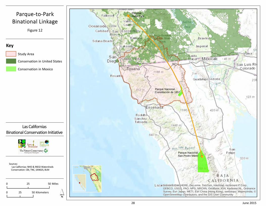
3.2.1 Illustrative strategies for Category A and B lands and waters
A. Parque-to-Park Binational Landscape (montane bioclimatic zone)
The Las Californias vision can promote binational unity, enhance ecotourism opportunities for rural
ejidos, support watersheds and ecosystem services, and maintain a landscape-scale habitat linkage by
designating and protecting a binational park along the Peninsular Ranges extending through California
and Baja California. This is consistent with CONABIO et al. (2007) recommendations for (1) connecting
protected areas as biological corridors and bosques certificados to maintain ecological processes and
(2) coordinate conservation efforts with other countries. The largely intact and rugged wilderness areas
of the Peninsular Ranges include Palomar State Park, Anza-Borrego Desert State Park, and the Jacumba
Wilderness in San Diego and Imperial counties, plus the Parque Nacional Constitución de 1857 and
Parque Nacional Sierra San Pedro Mártir in Baja California. The Las Californias Binational Conservation
Initiative identifies the Parque-to-Park Linkage (Figure 12) as a continental movement corridor essential
to maintaining ecosystem processes between the two Californias, while conserving high levels of
endemism and species diversity. This landscape of coniferous forest, chaparral, piñon pine-juniper, and
desert scrub, interspersed with granitic outcrops and boulder heaps, supports California condors,
mountain lions, golden eagles, Peninsular bighorn sheep, and American badgers. It is the most intact
and likely the most resilient portion of the study area, with granitic soils that may be more resistant to
invasive plants.
The Peninsular Ranges comprise the headwaters of watersheds that provide agriculture and municipal
water sources for large human populations on the Pacific Coast, and their forests sequester large
amounts of carbon. The north-south orientation and elevational gradients allow species and habitats the
opportunity to shift their ranges latitudinally and elevationally in response to changing climatic
conditions. While much of the California portion of this area is protected, some management changes
would enhance its conservation value, for example, restricting access to areas important for bighorn
sheep (Carrizo Gorge, In-ko-Pah Gorge, Myer Valley, Davies Valley, Pinto Canyon) and enhancing
connectivity across I-8.
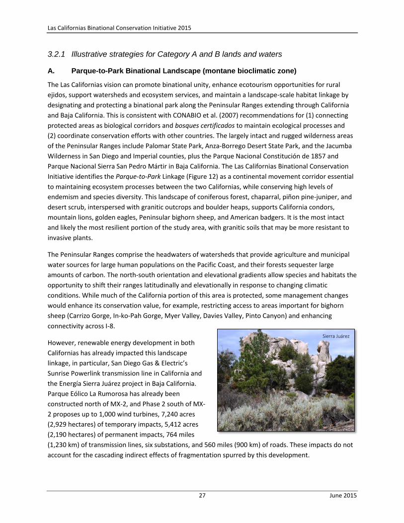
However, renewable energy development in both
Californias has already impacted this landscape
linkage, in particular, San Diego Gas & Electric’s
Sunrise Powerlink transmission line in California and
the Energía Sierra Juárez project in Baja California.
Parque Eólico La Rumorosa has already been
constructed north of MX-2, and Phase 2 south of MX-
2 proposes up to 1,000 wind turbines, 7,240 acres
(2,929 hectares) of temporary impacts, 5,412 acres
(2,190 hectares) of permanent impacts, 764 miles
(1,230 km) of transmission lines, six substations, and 560 miles (900 km) of roads. These impacts do not
account for the cascading indirect effects of fragmentation spurred by this development.
Sierra Juárez
PalomarState Park
Parque NacionalSan Pedro Mártir
Parque NacionalConstitución de 1857
Sources: Esri, HERE, DeLorme, TomTom, Intermap, increment P Corp.,
GEBCO, USGS, FAO, NPS, NRCAN, GeoBase, IGN, Kadaster NL, OrdnanceSurvey, Esri Japan, METI, Esri China (Hong Kong), swisstopo, MapmyIndia, ©OpenStreetMap contributors, and the GIS User Community
Parque-to-Park
Binational Linkage
Figure 12
Las Californias
Binational Conservation Initiative
Sources:
Las Californias: NHD & INEGI Watersheds
Conservation: CBI, TNC, SANGIS, BLM
0 5025 Miles
0 5025 Kilometers
Key
Study Area
Conservation in United States
Conservation in Mexico
28 June 2015
Las Californias Binational Conservation Initiative 2015
29 June 2015
Although the area of direct impact of this project is mostly in the Gustavo Aubanel, Cordillera Molina,
and Sierra de Juárez ejidos, most, if not all, of the energy generated by this system will be transported
across the border to California. This project will open the Sierra Juárez to greater human access and may
degrade its wilderness values. The potential environmental impacts have not been adequately assessed,
and there currently is no program proposed to monitor or mitigate the long-term effects of the
construction and operation on plants and wildlife.
Potential conservation strategies:
Land protection──
o Designate the Sierra Juárez as Área de Protección de Recursos Naturales, under the authorities of and in partnership with CONANP and CONAFOR and consistent with the Programa de Ordenamiento Ecológico del Estado de Baja California (SEMARNAT-POEBC 2013), which designates this area for low-density tourism and forestry.
o Adopt the new forest protection boundary proposed by Terra Peninsular and TNC.
o Establish servidumbres ecológicas (conservation easements), ADVCs, or other formal conservation agreements with landowners.
o Develop plans for protecting “working” conservation landscapes that include promoting best practices in managing livestock (e.g., using enclosures, managing access to sensitive areas like wetlands and riparian areas), conserving and managing patches of native habitat, reducing degradation due to unsustainable firewood harvest, and enhancing the servícios ambientales (environmental services) of the landscape.
o Work with renewable energy companies to site facilities on lands of lower ecological value, design road networks that minimize fragmentation, designate off-site conservation of land as mitigation for direct and indirect impacts of development, and establish conservation easements on the lands where facilities are sited.
o Work with the US Department of Homeland Security to enhance the conservation compatibility of border security programs, especially in areas that are most critical for wildlife movement and protection of rare species.
Land management──
o Establish regional resource management and monitoring guidelines for parks, landowners, hunters, and recreationalists, including establishing UMAs (Unidades para la Conservación, Manejo y Aprovechamiento Sustentable de la Vida Silvestre) such as for bighorn sheep, and fees and regulations for recreation such as for off-road vehicles.
o Foster and formalize binational collaboration and exchange, such as:
Sister park projects (e.g., Saguaro National Park in the US is a Sister Park to both national parks in Baja California (Parque Nacional Constitución de 1857 and Parque Nacional Sierra de San Pedro Mártir).
El Colegio de la Frontera Norte (COLEF) Tijuana River Watershed Project.
A border coalition among conservation practitioners, government agencies, scientists, and land trusts to strengthen conservation capacity and coordination.
Las Californias Binational Conservation Initiative 2015
30 June 2015
o Develop binational ecotourism projects.
o Control public access, domestic livestock, and development in major use areas for Peninsular bighorn sheep, including Davies Valley, Myer Valley, and Pinto Canyon in Imperial County and Cañada Los Alamos, Cañon de los Muertos, and Canon Tajo in Baja California.
Policy──
o Develop conservation incentives through North American Free Trade Agreement (NAFTA) programs.
o Establish a Transborder/International Peace Park along the Peninsular Ranges.
o Develop a Binational Integrated Watershed Management agreement for the Tijuana River.
o Incorporate the LCBCI as a priority for the Trilateral Committee for Wildlife and Ecosystem Conservation and Management.
o Work with the United Nations Educational, Scientific and Cultural Organization (UNESCO) to evaluate this binational area for Biosphere Reserve and World Heritage Site status.
o Establish policies for renewable energy companies to protect watershed lands with the objective of maintaining water quality and quantity for downstream users.
o Foster public and private investment in landowner incentives programs to protect ecosystem services (e.g., watershed protection, carbon sequestration) in landscapes of high conservation value (e.g., such as the program formerly instituted by CONANP—Programa de Pago de Servicios Ambientales in Áreas Naturales Protegidas).
o Explore conservation opportunities through the US Department of Defense base buffering program (Readiness and Environmental Protection Integration) to protect open space beneficial to both border security and wildlife along the US-México border.
o Establish regulations for off-highway vehicles to protect natural resources.
Research──Study movement of large mammals to identify crossing opportunities at major highways, especially I-8, MX-2, and MX-3.
Capacity building──Provide funding for Parque Nacional Constitución de 1857 and Memoranda of Understanding with the ejidos to manage land uses and resources within the Parque-to-Park landscape.
Communications—
o Ensure that key actors understand their role in securing a Parque-to-Park linkage, including the U.S. Border Patrol, California State Parks, CDFW, BLM, USFWS, CONANP, CONAFOR, and SEMARNAT.
o Develop a community education program for ejidatarios, ranchers, and other land owners so that they understand the conservation values where they live and work.
o Support the staffs of the Parque Nacional Constitución de 1857 and Parque Nacional Sierra de San Pedro Mártir to be champions for conservation throughout the Peninsular Ranges in Baja California.
Las Californias Binational Conservation Initiative 2015
31 June 2015
B. Sierra Blanca, Cañada de Águila, and El Pinal complex (inland bioclimatic zone)
This complex of mountains and intact expanses of coastal sage scrub provide an opportunity for large-
scale conservation surrounding the Valle de Guadalupe (historic village of Francisco Zarco) (Figure 11).
Comprising the western slope of the Sierra Juárez and ranging from 2,000 to >4,800 ft (610-1,460 m),
these mountains include the white granite peaks of Sierra Blanca (~4,400 ft, 1,340 m), Sierra de Ulloa,
Cerro Blanco, Cerro Venado Macho, and Cerro Apodaca. They support Diegan sage scrub, chamise and
mixed chaparral, oak woodlands, mountain meadows, and patches of Jeffrey pine forest. El Pinal
includes the largely intact hydrologic unit associated with Las Calabazas drainage in Cañada El Testerazo.
This area may well support the highest plant biodiversity in the State of Baja California (A. Rodriguez,
pers. comm.). Its Mediterranean climate and coastal fog support endemic species of manzanita, summer
holly, Tecate cypress, Cedros Island oak, Baja California bird bush, and wart-stemmed ceanothus. Relict
populations of Coulter pine and knobcone pine persist because of the relatively high winter rainfall. The
climate also supports small organic farms and wineries in Valle de Guadalupe. Conservation strategies
could be based on the extraordinary opportunity for cultural, culinary, and recreational tourism,
consistent with the ecosystem services described in the Programa de Ordenamiento Ecológico for Valle
de Guadalupe. The area has exceptional vistas and opportunities for rock climbing, hiking, skydiving,
horseback riding, and visits to historic ranchos. Conservation would help protect the watersheds critical
for local communities and the region’s agriculture- and tourism-based economies. Urban development
of this area is not suitable, considering the impacts on
water demand and solid waste disposal: “only
Mediterranean agriculture coupled with conservation
of the slopes and canyons can result in a harmonious
integrated landscape” (Espejel et al. 1999). Agriculture
and tourism are considered sustainable uses (Toledo
et al. 1989).
Potential conservation strategies:
Land protection──
o Establish a state or federal Área Natural Protegida or private Área Destinada Voluntariamente a la Conservación for this complex of lands between Tecate and Ensenada which could enhance opportunities for tourism, protect cultural history and ecosystem services, and provide community open space consistent with the POEBE (2013), which designates this area for agriculture and tourism.
o Tourist infrastructure could be based locally as well as in nearby Ensenada, Tecate, Playas de Rosarito, and Tijuana.
o Limit and mitigate impacts of sand extraction in the arroyos (Programa de Ordenamiento Ecológico del Valle de Guadalupe, SEMARNAT-POEVG 2006), and protect patches of native habitat within and around vineyards.
o Contain growth of the industrial corridor in El Sauzal, and mitigate its impacts through land protection (SEMARNAT-POEVG 2006).
Sierra Blanca
Las Californias Binational Conservation Initiative 2015
32 June 2015
Land management──
o Enforce measures to prevent illegal burning or clearing of understory vegetation for wildfire management and associated harvesting of firewood.
o Designate areas for public uses, and develop signage, picnic areas, and trails to ensure the conservation compatibility of public access, maintain good relations with neighboring land owners, and enhance visitor experience.
o Manage water use and drawdown of groundwater levels (SEMARNAT-POEVG 2006).
o Eradicate feral pigs.
o Develop fire management plans, especially for National Forest inholdings.
Policy──
o Formalize specific land protection and management actions by recording them in municipal (Tijuana, Tecate, Ensenada) and regional (Valle de Guadalupe) plans.
o Develop conservation actions and incentives programs for policies in the Ordenamiento Ecológico del Valle de Guadalupe, specifically to (a) protect water needs and proactively secure and enhance water sustainability, and (b) examine opportunities for enhancing nature-based tourism (also see SEMARNAT and Gobierno del Ejecutivo Estatal Secretaria de Protección al Ambiente 2013).
Research──
o Develop and fund a research program, e.g., at Universidad Autónoma de Baja California (UABC), that includes genetic comparison of endemic plant species in the region.
o Explore synergies between land use and biodiversity conservation (POEGV 2006).
Capacity building──Fund a local NGO or friends group to monitor land uses and help advance conservation efforts.
Communications—
o Outreach to landowners in Valle de Guadalupe in Baja California to manage land compatible with resource protection, including water.
o Develop communications materials for wineries and other tourist facilities in Baja California to foster their advocacy and promotion of protection of natural resources.
C. Sky Islands (coastal bioclimatic zone)
The “sky islands” of Otay Mountain, San Miguel Mountain, Sycuan Peak, McGinty Mountain, Cerro San
Ysidro, Cerro Bola/Cerro Gordo, and Tecate Peak (Cerro Cuchumá) hold some of the largest remaining
patches of Diegan coastal sage scrub, mafic chaparral, and gabbro and metavolcanic soils which support
numerous endemic plant species, including Bola ceanothus, Bola manzanita, Tecate cypress, and two
species of pitcher sage. Arroyos draining the eastern side of Cerro Bola (e.g., Cañada Las Palmas) support
the westernmost population of California fan palms. Cerro Cuchumá (>2,000 acres, 810 ha) represents
the only formally conserved land within the coastal zone of Baja California in the study area. Cerro San
Ysidro, Cerro Bola, and Cerro Gordo are not officially conserved, although IMPLAN (2008) shows that
Cerro San Ysidro is important for conservation and likely not feasible for development.

Las Californias Binational Conservation Initiative 2015
33 June 2015
Potential conservation strategies:
Land protection──
o Establish conservation easements on Cerro Bola and Cerro Gordo by working with landowners to ensure they continue to support compatible human uses (e.g., microwave towers on Cerro Bola) and function as part of the ecosystem.
o Establish conservation easements to maintain landscape connections between Cerros Bola and Gordo and between the vernal pools at Valle de Las Palmas.
Land management──Map and monitor the rare resources on these mountains to identify land use incompatibilities and threats.
Policy──Formalize land protection in municipal plans (Tijuana and Tecate).
Research──Develop and fund a research program, e.g., at UABC, that includes genetic analyses of endemic species.
Capacity building──Develop and fund local friends’ groups to monitor land uses and advance conservation efforts.
Communications—Develop an outreach program with land managers and researchers on Las Californias priorities.
D. San Diego National Wildlife Refuge Acquisition Area (coastal bioclimatic zone)
Lands within the San Diego National Wildlife Refuge acquisition boundary gained 7,800 acres (3,160
hectares) in conservation in this 10-year period, increasing the amount of land protected within the
acquisition boundary to 70% (30,794 acres, or 12,462 hectares). This wildland core represents hundreds
of millions of dollars of public conservation investments that are managed by an array of public and
private agencies and organizations. The habitat value of these lands relies on continued action to
minimize fragmentation of the areas around them and to effectively manage and enhance native species
populations and ecological processes.
Potential conservation strategies:
Land protection──Purchase key lands for conservation to minimize fragmentation and improve connectivity within the acquisition boundary.
Land management──
o Collaborate across jurisdictions and land holdings to maximize efficient management and monitoring across the greater refuge conservation area.
o Maintain refugia and a nursery stand for Tecate cypress, and store seed from different populations for use in restoration.
o Manage to prevent short fire-return intervals, including controlling ignitions (harden roads, manage fuels, control access during Santa Ana winds, eliminate target shooting).
Cerro Bola manzanitas, A. Rodriguez

Las Californias Binational Conservation Initiative 2015
34 June 2015
Policy──
o Close Proctor Valley Road to reduce fragmentation, and prohibit further development within the refuge boundary.
o Develop a collaborative program with Caltrans and land managers to enhance infrastructure for wildlife movement, including fencing to direct wildlife to designated crossings, including SR-94 and Otay Lakes Road.
Research──Conduct studies to prioritize areas for road infrastructure improvement to enhance wildlife movement (e.g., State Route 94, Otay Lakes Road).
Capacity building—Fund local NGOs to monitor land uses and advance conservation efforts, including Friends of San Diego Wildlife Refuges, Earth Discovery Institute, Chaparral Lands Conservancy, Friends of Otay Valley Regional Park, Endangered Habitats Conservancy, and others.
Communications—
o Identify County supervisors and NGOs as champions of the conservation campaign for Las Californias.
o Develop public outreach campaigns so that people understand the threats of nonnative plants and animals and know what they can do about them.
o Work with land use planners to ensure they understand the costs and liabilities of new development in fire-prone areas.
o Develop “Fire Watch” programs.
3.2.2 Illustrative strategies for Category C and D lands and waters
Category C lands, mostly in the inland section of the study area, can be protected as working landscapes
and thus maintain the rural ranching heritage in both countries. Category D lands──within urban
areas──provide open space that could improve quality of life, enhance recreational opportunities, and
create opportunities for “hands-on” environmental education.
A. East San Diego County Connectivity (inland bioclimatic zone)
Much of the inland zone is important for its connectivity, both between California and Baja California, as
well as between coastal and montane ecosystems. These valleys and foothills function as a transition
area of genetic divergence (Vandergast et al. 2008) that supports resources from all three of the region’s
climate zones. Some of these areas are well-suited for protection under conservation easements that
allow grazing, agriculture, or passive recreation (i.e., working landscapes). The US Navy SEAL facility in
Campo is a good example of a working landscape, where the military trains yet the habitat remains
intact, and private lands around the facility have been conserved as buffers. These lands comprise the La
Posta Linkage (CBI 2003) between US Forest Service lands north of I-8 and BLM lands on the border;
>2,100 acres (850 hectares) of this area have been protected since 2004.
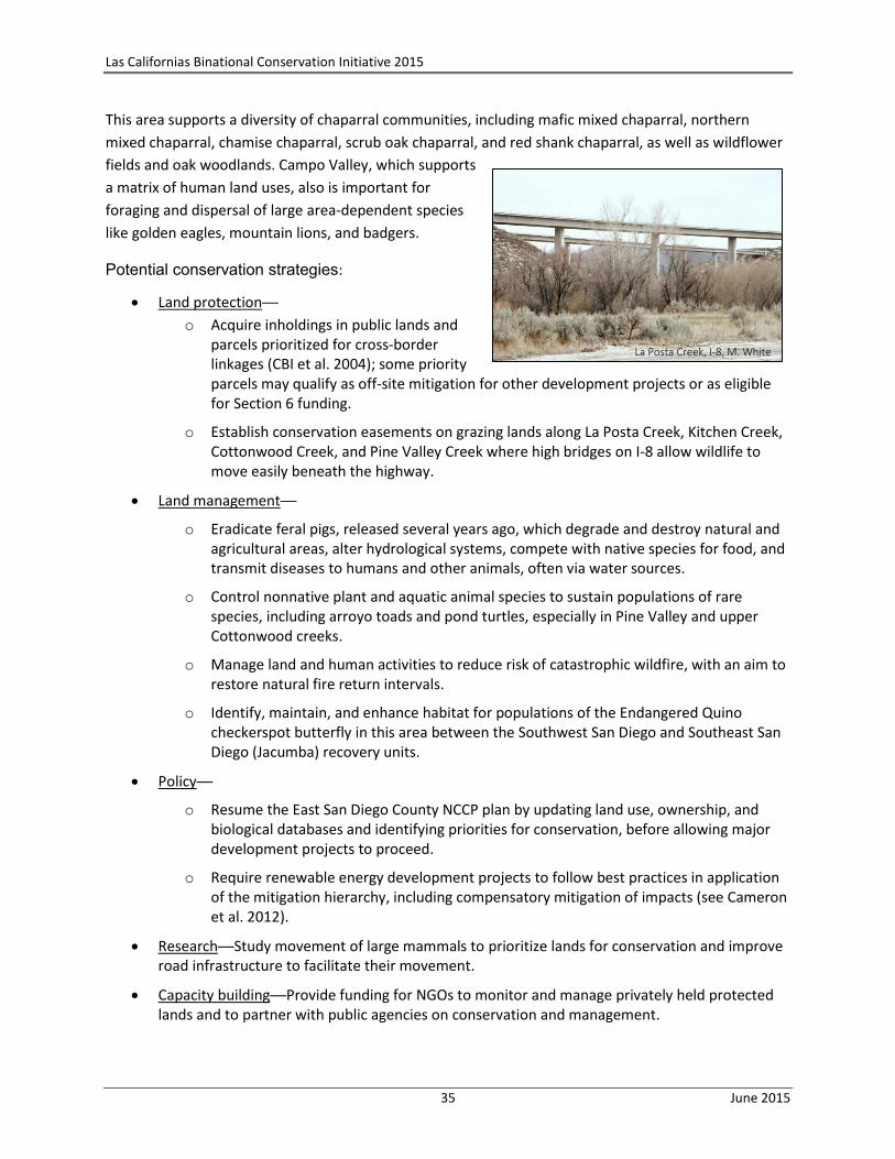
Las Californias Binational Conservation Initiative 2015
35 June 2015
This area supports a diversity of chaparral communities, including mafic mixed chaparral, northern
mixed chaparral, chamise chaparral, scrub oak chaparral, and red shank chaparral, as well as wildflower
fields and oak woodlands. Campo Valley, which supports
a matrix of human land uses, also is important for
foraging and dispersal of large area-dependent species
like golden eagles, mountain lions, and badgers.
Potential conservation strategies:
Land protection──
o Acquire inholdings in public lands and parcels prioritized for cross-border linkages (CBI et al. 2004); some priority parcels may qualify as off-site mitigation for other development projects or as eligible for Section 6 funding.
o Establish conservation easements on grazing lands along La Posta Creek, Kitchen Creek, Cottonwood Creek, and Pine Valley Creek where high bridges on I-8 allow wildlife to move easily beneath the highway.
Land management──
o Eradicate feral pigs, released several years ago, which degrade and destroy natural and agricultural areas, alter hydrological systems, compete with native species for food, and transmit diseases to humans and other animals, often via water sources.
o Control nonnative plant and aquatic animal species to sustain populations of rare species, including arroyo toads and pond turtles, especially in Pine Valley and upper Cottonwood creeks.
o Manage land and human activities to reduce risk of catastrophic wildfire, with an aim to restore natural fire return intervals.
o Identify, maintain, and enhance habitat for populations of the Endangered Quino checkerspot butterfly in this area between the Southwest San Diego and Southeast San Diego (Jacumba) recovery units.
Policy──
o Resume the East San Diego County NCCP plan by updating land use, ownership, and biological databases and identifying priorities for conservation, before allowing major development projects to proceed.
o Require renewable energy development projects to follow best practices in application of the mitigation hierarchy, including compensatory mitigation of impacts (see Cameron et al. 2012).
Research──Study movement of large mammals to prioritize lands for conservation and improve road infrastructure to facilitate their movement.
Capacity building──Provide funding for NGOs to monitor and manage privately held protected lands and to partner with public agencies on conservation and management.
La Posta Creek, I-8, M. White

Las Californias Binational Conservation Initiative 2015
36 June 2015
Communications—
o Outreach to landowners in Campo, Corte Madera, and Skye Valley to manage land compatible with resource protection.
o Work with public land owners to develop a communications program for recreationalists on public lands in California.
o Outreach to ranchers, community planning groups, and NGOs on the specific conservation priorities in this area.
o Develop environmental education workshops with CalFire and the Border Agency Fire Council on the regional conservation priorities.
o Encourage the CDFW, US Department of Agriculture, and SANDAG to increase the scale and pace of feral pig eradication in the border region.
B. Vernal Pools (coastal bioclimatic zone)
Vernal pools are ephemeral wetlands that occur on particular soil types and substrates; sometimes
these small pools fill for only a few weeks within a span of multiple years. In this region they harbor an
extraordinary diversity of endemic, rare, and imperiled species. The San Diego NWR lands protect the
last remaining vernal pools in southern San Diego County, while the mesas north and south of La Misión,
Jesús Maria Mesa, land around the Tijuana airport, and the river terraces southeast of Valle de Las
Palmas support the last remaining vernal pools in the border area of Baja California, although they are
threatened by development and agriculture (Figure 11). The area around La Misión supports a low
density of high quality pools (Guilliams et al. 2015); their currently undisturbed nature and proximity to
urban sprawl from Playas de Rosarito and Ensenada make them a priority for protection and
environmental education. The Universidad Autónoma de Baja California (UABC) at Ensenada and the
Baja chapter of the California Native Plant Society (CNPS) may be potential collaborators in their
research and ultimate protection. A few vernal pools still remain at Valle Redondo and Valle de
Guadalupe (M. Guilliams, Santa Barbara Botanic Garden, pers. comm.), but their persistence is
threatened by continued degradation and destruction associated with urbanization and agriculture.
Jesús Maria Mesa, on the slope of Cerro San Ysidro in Tijuana, supports a low density of pools with some
rare plants and a population of Quino checkerspot butterfly, a potential source population for this
federally Endangered butterfly in San Diego County; however, the habitat is threatened by urban
development. Because of its proximity to Tijuana, Jesús Maria Mesa could be a good location for open
space, research, and educational outreach.
The river terraces southeast of Valle de Las Palmas support biologically unique vernal pools (M.
Guillams, pers. comm.). They are mostly intact and surrounded by mesquite and other native species,
although they have been grazed and have subsided into the heavy clays. These pools support a
potentially undescribed species of mesa mint that may be endemic to the mesa (Bauder and McMillan
1998, Silveira and Simpson 2013). The pools are a priority for immediate protection (A. Rodriguez, pers.
comm.). UABC at Valle de Las Palmas, the Baja chapter of CNPS, and Santa Barbara Botanic Garden may
be potential collaborators in their research and ultimate protection; for example, a local university
campus could “adopt” a vernal pool complex and use the site as a field station and living laboratory for

Las Californias Binational Conservation Initiative 2015
37 June 2015
ecological education and skills training. Ecologically
linking this area to protected natural areas of Cerro Bola
would further enhance its persistence. Sustaining
“working landscapes” in this area will ensure protection
of biodiversity and rural heritage.
Potential conservation strategies:
Land protection──Establish working landscape conservation easements for vernal pools, their watersheds, and surrounding natural matrices.
Land management──
o Assess threats to vernal pools and their watersheds.
o Evaluate cattle grazing as a management tool, e.g., at Valle de Las Palmas.
o Maintain and enhance habitat for the Quino checkerspot butterfly.
Policy──Incorporate conservation easements and community education into planning documents of the municipalities of Tijuana, Tecate, and Ensenada.
Research──
o Establish a field station at UABC, Valle de Las Palmas.
o Expand genetics studies to compare among populations of vernal pool species in both countries, to understand degrees of endemism, biogeography, and ecological interconnectedness.
o Test and identify Best Management Practices for these habitats and species, especially vis-à-vis livestock grazing.
o Partner with land managers and NGOs to develop outreach and community education.
Capacity building──Provide funding for NGOs and land managers to protect these lands and for academic institutions to expand their research.
Communications—Outreach to land owners and researchers about collaborative opportunities for conservation and research.
C. Maritime Succulent Scrub (coastal bioclimatic zone)
Aside from vernal pools and other freshwater wetlands, the rarest vegetation communities in the study
area are dunes, salt marsh, and the succulent forms of Diegan coastal sage scrub, which include
maritime succulent scrub in the California portion of the study area and matorral rosetofilo costero in
Baja California (Figure 7). Only 580 acres (235 hectares) of maritime succulent scrub remain in the
California portion of the study area──a 36% decrease from 2004, all of it in one area of Otay Mesa; 78%
of this is conserved, and the remainder is highly fragmented by development and off-road vehicles.
Delgadillo and Ceballo Alcántara (2014) mapped 6,643 acres (2,688 hectares) of matorral rosetofilo
Institutional opportunity for a multi-disciplinary field station at UABC to explore the linkages between people and nature in the socio-ecological system of Valle de Las Palmas.
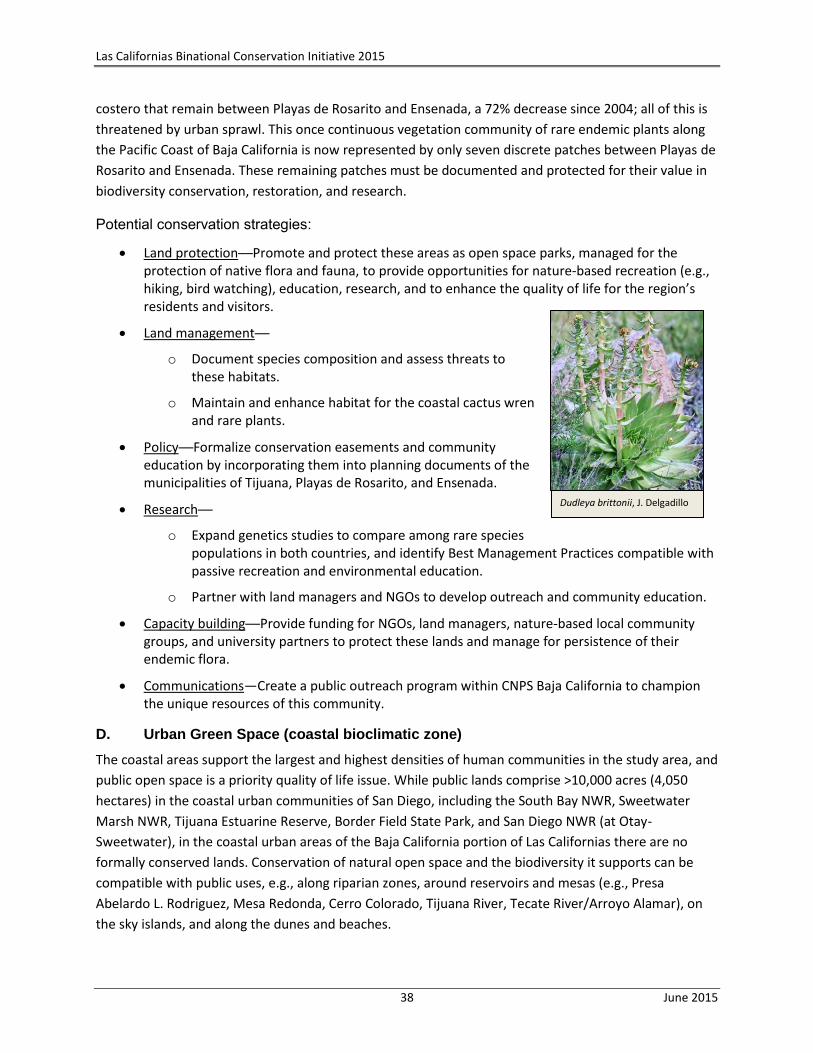
Las Californias Binational Conservation Initiative 2015
38 June 2015
costero that remain between Playas de Rosarito and Ensenada, a 72% decrease since 2004; all of this is
threatened by urban sprawl. This once continuous vegetation community of rare endemic plants along
the Pacific Coast of Baja California is now represented by only seven discrete patches between Playas de
Rosarito and Ensenada. These remaining patches must be documented and protected for their value in
biodiversity conservation, restoration, and research.
Potential conservation strategies:
Land protection──Promote and protect these areas as open space parks, managed for the protection of native flora and fauna, to provide opportunities for nature-based recreation (e.g., hiking, bird watching), education, research, and to enhance the quality of life for the region’s residents and visitors.
Land management──
o Document species composition and assess threats to these habitats.
o Maintain and enhance habitat for the coastal cactus wren and rare plants.
Policy──Formalize conservation easements and community education by incorporating them into planning documents of the municipalities of Tijuana, Playas de Rosarito, and Ensenada.
Research──
o Expand genetics studies to compare among rare species populations in both countries, and identify Best Management Practices compatible with passive recreation and environmental education.
o Partner with land managers and NGOs to develop outreach and community education.
Capacity building──Provide funding for NGOs, land managers, nature-based local community groups, and university partners to protect these lands and manage for persistence of their endemic flora.
Communications—Create a public outreach program within CNPS Baja California to champion the unique resources of this community.
D. Urban Green Space (coastal bioclimatic zone)
The coastal areas support the largest and highest densities of human communities in the study area, and
public open space is a priority quality of life issue. While public lands comprise >10,000 acres (4,050
hectares) in the coastal urban communities of San Diego, including the South Bay NWR, Sweetwater
Marsh NWR, Tijuana Estuarine Reserve, Border Field State Park, and San Diego NWR (at Otay-
Sweetwater), in the coastal urban areas of the Baja California portion of Las Californias there are no
formally conserved lands. Conservation of natural open space and the biodiversity it supports can be
compatible with public uses, e.g., along riparian zones, around reservoirs and mesas (e.g., Presa
Abelardo L. Rodriguez, Mesa Redonda, Cerro Colorado, Tijuana River, Tecate River/Arroyo Alamar), on
the sky islands, and along the dunes and beaches.
Dudleya brittonii, J. Delgadillo
Las Californias Binational Conservation Initiative 2015
39 June 2015
Pronatura Noroeste is working to promote a state park on the Tijuana River close to the Abelardo L.
Rodriguez Dam as well as a coastal state park at Arroyo San Miguel just north of Ensenada, where a local
group is restoring the area for public use in the San Antonio de Las Minas watershed (a critical riparian
ecosystem that contributes sand and cobblestones to form the well-known surfing spot at San Miguel).
This group and others are petitioning the Governor of Baja California to declare this ~140-acre (58-
hectare) area as the first State Park in Baja California, thus guaranteeing long-term protection of the
watershed and aquifer and providing greenspace for the community of Ensenada.
As part of its conservation mission, Fundación La Puerta in Tecate is providing environmental education
and community outreach programs along the Tecate River/Arroyo Alamar between Cerro San Ysidro and
Cerro Cuchumá, considered sacred by the indigenous Kumeyaay (often spelled Kumiai in Spanish).
Pronatura Noroeste is restoring wetlands along the Tecate River/Arroyo Alamar.
Potential conservation strategies:
Land protection──
o Secure conservation easements along the Tijuana, Tecate, Sweetwater, and Otay rivers as well as along beaches, reservoirs, and areas that could serve as outdoor learning centers (e.g., Cerro Cuchumá, Jesús Maria Mesa, Cerro Colorado, and Mesa Descanso).
o Designate a state park at Arroyo San Miguel.
Land management──
o Develop and implement plans to manage native diversity in the context of public access and urban edge effects.
o Clean up and restore river corridors, beaches, and borders of reservoirs as public open space parks.
o Restore river hydrology and habitat to manage flood flows and sediment transport.
Policy──
o Work with local and state governments to exclude urban development in priority habitat areas, and instead promote community parks and compatible recreation.
o Work with both countries to improve wastewater treatment.
o Enforce Tijuana plans to conserve 4,020 acres in Zona Federal de Arroyo and Conservation Agricola and other designated areas.
Research──Establish Memoranda of Understanding between academic institutions and municipalities to support conservation research on rare biological resources that are isolated by urban development.
Capacity building──Develop and support community outreach organizations and programs to promote local engagement and stewardship of native diversity in urban parks, perhaps as an integral part of a community pride campaign and initiatives to enhance quality of life and nature-based education in the urban landscape.
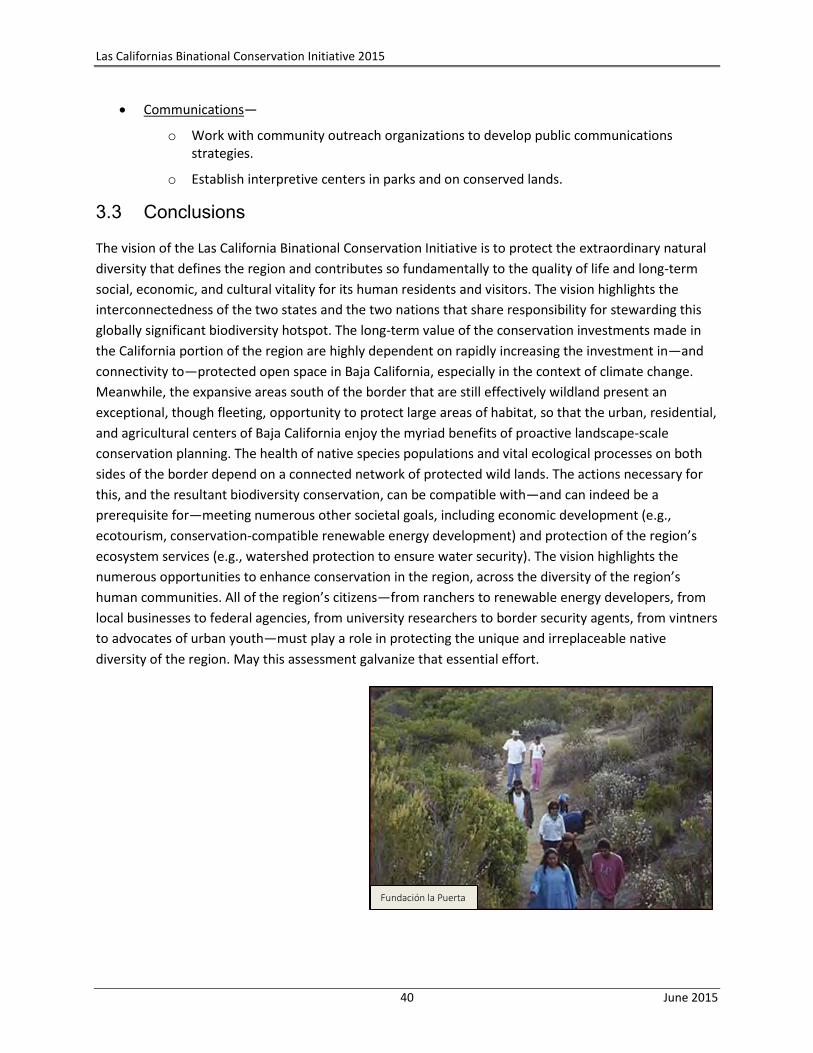
Las Californias Binational Conservation Initiative 2015
40 June 2015
Communications—
o Work with community outreach organizations to develop public communications strategies.
o Establish interpretive centers in parks and on conserved lands.
3.3 Conclusions
The vision of the Las California Binational Conservation Initiative is to protect the extraordinary natural
diversity that defines the region and contributes so fundamentally to the quality of life and long-term
social, economic, and cultural vitality for its human residents and visitors. The vision highlights the
interconnectedness of the two states and the two nations that share responsibility for stewarding this
globally significant biodiversity hotspot. The long-term value of the conservation investments made in
the California portion of the region are highly dependent on rapidly increasing the investment in—and
connectivity to—protected open space in Baja California, especially in the context of climate change.
Meanwhile, the expansive areas south of the border that are still effectively wildland present an
exceptional, though fleeting, opportunity to protect large areas of habitat, so that the urban, residential,
and agricultural centers of Baja California enjoy the myriad benefits of proactive landscape-scale
conservation planning. The health of native species populations and vital ecological processes on both
sides of the border depend on a connected network of protected wild lands. The actions necessary for
this, and the resultant biodiversity conservation, can be compatible with—and can indeed be a
prerequisite for—meeting numerous other societal goals, including economic development (e.g.,
ecotourism, conservation-compatible renewable energy development) and protection of the region’s
ecosystem services (e.g., watershed protection to ensure water security). The vision highlights the
numerous opportunities to enhance conservation in the region, across the diversity of the region’s
human communities. All of the region’s citizens—from ranchers to renewable energy developers, from
local businesses to federal agencies, from university researchers to border security agents, from vintners
to advocates of urban youth—must play a role in protecting the unique and irreplaceable native
diversity of the region. May this assessment galvanize that essential effort.
Fundación la Puerta
Las Californias Binational Conservation Initiative 2015
41 June 2015
4 References
AECOM. 2012. Western San Diego County vegetation map GIS shapefile. Prepared for the San Diego
Association of Governments.
Barr, K.R., A.G. Vandergast, and B.E. Kus. 2013. Genetic structure in the cactus wren in coastal southern
California. Prepared by US Geological Survey for California Department of Fish and Wildlife.
Bauder, E.T., and S. McMillan. 1998. Current distribution and historical extent of vernal pools in
southern California and northern Baja California, Mexico. Pp. 56-70 in Witham, C.W., E. Bauder, D.
Belk, W. Ferren, and R. Ornduff (eds.), Ecology, conservation, and management of vernal pool
ecosystems─proceedings from a 1996 conference. California Native Plant Society, Sacramento, CA.
Bezaury-Creel, J.E., J.F. Torres, N. Moreno, y M.L. Ochoa-Ochoa. 2007. Base de datos geográfica de Áreas
Naturales Protegidas estatales, del Distrito Federal y municipales de México para el análisis de
vacíos y omisiones en conservación. The Nature Conservancy—Pronatura—Comisión Nacional
para el Conocimiento y Uso de la Biodiversidad—Comisión Nacional de Áreas Naturales
Protegidas. 1 Capa ArcINFO + 1 Archivo de Metadatos Word.
Brown, C., S.A. Hathaway, and R.N. Fisher. 2012. Data summary for the TransNet Environmental
Mitigation Program grant agreement 5001140 regarding southwestern pond turtle restoration at
Sycuan Peak Ecological Reserve, March 2012. US Geological Survey data summary prepared for
the TransNet Environmental Mitigation Program, San Diego, CA. 20 pp.
Buchalski, M.R., A.Y. Navarro, W.M. Boyce, T.W. Vickers, M.W. Tobler, L.A. Nordstrom, J.A. Garcia, D.A.
Gille, M.C.T. Penedo, O.A. Ryder, and H.B. Ernest. 2015. Genetic population structure of Peninsular
bighorn sheep (Ovis canadensis nelsoni) indicates substantial gene flow across US-Mexico border.
Biological Conservation 184:218-228.
California Invasive Plant Council. www.Cal-IPC.org
Cameron, D.R., B.S. Cohen, and S.A. Morrison. 2012. An approach to enhance conservation-compatibility
of renewable energy development siting. PLoS ONE 7: e38437.
doi:10.1371/journal.pone.0038437
Committee on Binational Regional Opportunities (COBRO). 2007. Final Otay Mesa─Mesa de Otay
binational corridor strategic plan. San Diego Association of Governments, San Diego, CA. July.
Committee on Binational Regional Opportunities (COBRO). 2012. Tecate, Tijuana, and Playas de Rosarito
Metropolitan Strategic Plan 2034. San Diego Association of Governments, San Diego, CA.
Las Californias Binational Conservation Initiative 2015
42 June 2015
CONABIO-CONANP-TNC-Pronatura-FCF, UANL. 2007. Análisis de vacíos y omisiones en conservación de
la biodiversidad terrestre de México: espacios y especies. Comisión Nacional para el Conocimiento
y Uso de la Biodiversidad, Comisión Nacional de Áreas Naturales Protegidas, The Nature
Conservancy-Programa México, Pronatura Noroeste, A.C., Facultad de Ciencias Forestales,
Universidad Autónoma de Nuevo León, México. En seguimiento al programa de trabajo de Áreas
Protegidas, México, CDB-COP-7.
Conservation Biology Institute (CBI). 2003. La Posta linkage portfolio. Prepared for The San Diego
Community Foundation. Grant #C-2002-00340.
Conservation Biology Institute (CBI). 2009. An assessment of the known and potential impacts of feral
pigs (Sus scrofa) in and near San Diego County with management recommendations. Prepared for
The Nature Conservancy. October.
Conservation Biology Institute (CBI) and Terra Peninsular. 2010. Maintaining a landscape linkage for
Peninsular bighorn sheep. Prepared for The Nature Conservancy. April. 56 pp.
Conservation Biology Institute (CBI) and The Nature Conservancy (TNC). 2011. Potential bighorn sheep
habitat in Baja California (revised) in CBI and Terra Peninsular 2010, Maintaining a landscape
linkage for Peninsular bighorn sheep.
Conservation Biology Institute (CBI), The Nature Conservancy (TNC), and PRONATURA. 2004. Las
Californias Binational Conservation Initiative──a vision for habitat conservation in the border
region of California and Baja California. Prepared for The San Diego Foundation, Resources Legacy
Foundation, and The International Community Foundation. September.
Cordova, A., and C. de la Parra (eds.). 2007. A barrier to our shared environment──the border fence
between the United States and México. Secretariat of Environment and Natural Resources,
National Institute of Ecology, El Colegio de la Frontera Norte, and Southwest Consortium for
Environmental Research and Policy.
Cox, R.D., K.L. Preston, R.F. Johnson, R.A. Minnich, and E.B. Allen. 2014. Influence of landscape-scale
variables on vegetation conversion in Southern California, USA. Global Ecology and Conservation
2:190-203.
Delgadillo, J., and H. Ceballos Alcántara. 2014. Current status of “rosetofilo” coastal scrub (INEGI) and
diversity between Playas de Rosarito and Ensenada, Baja California, México. Report prepared for
The Nature Conservancy. December.
Espejel, I., D.W. Fischer, A. Hinojosa, C. García, and C. Leyva. 1999. Land-use for the Guadalupe Valley,
Baja California, México. Landscape and Urban Planning 45:219-232.
Flesch, A.D., C.W. Epps, J.W. Cain III, M. Clark, P.R. Krausman, and J.R. Morgart. 2010. Potential effects of
the United States-México border fence on wildlife. Conservation Biology 24(1):171-181.
Las Californias Binational Conservation Initiative 2015
43 June 2015
Forister, M., and A. Lucas. 2012. Thorne’s hairstreak (Callophrys [Mitoura] thornei) monitoring. Final
report. October.
Guilliams, C.M., K. Hasenstab-Lehman, J. Delgadillo, and B.G. Baldwin. 2015. Vernal pool landscapes of
Baja California México: an ongoing project to assess vernal pool loss and protect what remains. In
Schlising et al. (eds.), Vernal pools in changing landscapes, from Shasta to Baja. AquAlliance Vernal
Pools Conference, unpublished proceedings, Chico, CA. April.
Herzog, L.A. 2009. Global crossroads──planning and infrastructure for the California-Baja California
border region. University Readers, San Diego, CA.
Instituto Municipal de Planeación de Tijuana (IMPLAN). 2008. Programa parcial de desarrollo urbano de
Valle de Las Palmas en el centro de población de Tijuana.
Instituto Municipal de Planeación de Tijuana (IMPLAN). 2010. Actualización del Programa de Desarrollo
urbano del centro de población de Tijuana, BC. PDUCP T 2010-2030. El H. XIX Ayuntamiento de
Tijuana. http://www.implantijuana.org/planes-y-programas/ accessed Nov. 2, 2014.
International Council for Local Environmental Initiatives (ICLEI). 2012. Sea level rise adaptation strategy
for San Diego Bay. Prepared by ICLEI-Local Governments for Sustainability for the project’s Public
Agency Steering Committee, with the support of The San Diego Foundation.
Koleff, P., A. Lira-Noriega, T. Urquiza, and E. Morales. 2007. Priorities for biodiversity conservation in
Mexico’s northern border. Pp. 131-144 in Cordova, A., and C. de la Parra (eds.), A barrier to our
shared environment──the border fence between the United States and México. Secretariat of
Environment and Natural Resources, National Institute of Ecology, El Colegio de la Frontera Norte,
and Southwest Consortium for Environmental Research and Policy.
Lasky, J.R., W. Jetz, and T.H. Keitt. 2011. Conservation biogeography of the US-México border: a
transcontinental risk assessment of barriers to animal dispersal. Diversity and Distributions
17:673-687.
Madden-Smith, M., E.L. Ervin, K.P. Meyer, S.A. Hathaway, and R.N. Fisher. 2005. Distribution and status
of the arroyo toad (Bufo californicus) and western pond turtle (Emys marmorata) in the San Diego
MSCP and surrounding areas. Final report prepared by US Geological Survey for County of San
Diego and California Department of Fish and Game. October.
Minnich, R.A., and E. Franco-Vizcaíno. 1998. Land of chamise and pines: historical descriptions of
vegetation in northern Baja California. University of California Publications in Botany 80:1-166.
Morrison, S.A. 2014. A framework for conservation in a human-dominated world. Conservation Biology.
doi:10.1111/cobi.12432.
Las Californias Binational Conservation Initiative 2015
44 June 2015
Ojeda-Revah, L., G. Bocco, E. Ezcurra, and I. Espejel. 2008. Land-cover/use transitions in the binational
Tijuana River watershed during a period of rapid industrialization. Applied Vegetation Science
11:107-116.
ProNatura Noroeste. 2007. Tecate east unit and land tenure study, Las Californias Binational
Conservation Initiative. Prepared for The Nature Conservancy. April. 15 pp.
ProNatura Noroeste. 2007. San Ysidro unit, Las Californias Binational Conservation Initiative. Prepared
for The Nature Conservancy. May. 25 pp.
Riemann, H., and E. Ezcurra. 2005. Plant endemism and natural protected areas in the peninsula of Baja
California, Mexico. Biological Conservation 122:141-150.
San Diego Association of Governments (SANDAG) Service Bureau. 2008. California-Baja California border
master plan. Submitted to California Department of Transportation District 11, San Diego, CA.
San Diego Association of Governments (SANDAG) and Instituto Município de Planeación de Tijuana
(IMPLAN). 2014. San Diego─Baja California border region atlas. September.
San Diego Zoo Global──Institute for Conservation Research. 2014. Las Californias linkage for large
mammals──Peninsular bighorn sheep surveys in the Sierra Juárez, Baja California, México. Final
Report 2013-2014. Prepared for The Nature Conservancy. June. 32 pp.
Secretaria de Protección al Ambiente de Baja California. 2015. La Glosa del Primer Informe de la SPA
ante el Congreso del Estado. Revista Digital Trimestral. Ecología BC. Año 1 No. 3 febrero-marzo-
abril. https://www.youtube.com/watch?v=csrA5spKM_I
SEMARNAT. 2000. Programa Regional de Ordenamiento Ecológico del Municipio del Mexicali. Periódico
Oficial del Estado de Baja California No. 51.
SEMARNAT. 2006. Programa Regional de Ordenamiento Ecológico del Corredor San Antonio de las
Minas—Valle de Guadalupe (POEGV). Periódico Oficial del Estado de Baja California No. 8.
SEMARNAT and Gobierno del Ejecutivo Estatal Secretaria de Protección al Ambiente. 2013. Actualización
del Programa de Ordenamiento Ecológico del Estado de Baja California, México (POEBC). Mexicali,
BC. September.
Silveira, M.A., and M.G. Simpson. 2013. Phylogenetic systematics of the mesa mints: Pogogyne
(Lamiaceae). Systematic Botany 38.3:782-794.
Syphard, A.D., A.Bar Massada, V. Butsic, and J.E. Keeley. 2013. Land use planning and wildfire:
development policies influence future probability of housing loss. PLoS 8(8):e71708.
Doi:10.1371/hournal.pone.0071708.
Tecate, Ayuntamiento de. 2005-2007. Plan municipal de desarrollo.
Las Californias Binational Conservation Initiative 2015
45 June 2015
Terra Peninsular. 2005. Rancho Rodeo del Rey report. November.
Terra Peninsular and The Nature Conservancy. 2010. Estudio previo justificativo para la recategorización
de la “Reserva Forestal de Sierra de Juárez” como “Área de Protección de Recursos Naturales
Sierra de Juárez.” Prepared for CONANP. November. 140 pp.
Tijuana River Valley Recovery Team. 2012. Recovery strategy──living with the water. San Diego Regional
Water Quality Control Board, San Diego, CA.
Toledo, V., J. Carabias, C. Toledo, and C. González-Pacheco. 1989. La producción rural en México:
alternativas ecológicas. Fundación Universo 21(6):402.
US Department of Energy. 2012. Energía Sierra Juárez US transmission line project. Final Environmental
Impact Statement. Office of Electricity Delivery and Energy Reliability, Washington DC.
US Fish and Wildlife Service (USFWS). 2000. Recovery plan for bighorn sheep in the Peninsular Ranges,
California. Portland, OR. xv + 251 pp.
US Fish and Wildlife Service (USFWS). 2003. Recovery plan for the Quino checkerspot butterfly
(Euphydryas editha quino). Portland, OR. X + 179 pp.
US Fish and Wildlife Service (USFWS). 2009. Designation of Critical Habitat for Peninsular bighorn sheep
and determination of a Distinct Population Segment of desert bighorn sheep (Ovis canadensis
nelsoni). Federal Register 74, No. 70, pp. 17288-17365.
US Fish and Wildlife Service (USFWS). 2014. San Diego National Wildlife Refuge draft comprehensive
conservation plan/environmental assessment. Pacific Southwest Region, Sacramento, CA. June.
Vacariu, K., and J. Neeley. 2005. Outcomes and recommendations of the Border Ecological Symposium.
Tucson, AZ. March 9-10.
Vandergast, A.G., A.J. Bohonak, S.A. Hathaway, J. Boys, and R.N. Fisher. 2008. Are hotspots of
evolutionary potential adequately protected in southern California? Biological Conservation
141:1648-1664.
Vickers, T.W., J.N. Sanchez, C.K. Johnson, S.A. Morrison, R. Botta, T. Smith, B.S. Cohen, P.R. Huber, H.B.
Ernest, and W.M. Boyce. 2015. Survival and mortality of pumas (Puma concolor) in a fragmented,
urbanizing landscape. PLOS ONE | DOI:10.1371/journal.pone.0131490.
Watson, J.E.M., N. Dudley, D.B. Segan, and M. Hockings. 2014. The performance and potential of
protected areas. Nature 515:67-73.
White, M.D., J.A. Stallcup, K. Comer, M. Angel Vargas, J. Maria Beltrán Abaunza, F. Ochoa, and S.A.
Morrison. 2004. Designing and establishing conservation areas in the Baja California-Southern
California border region. SCERP Monograph Series 10, Border Institute, Rio Rico, AZ.
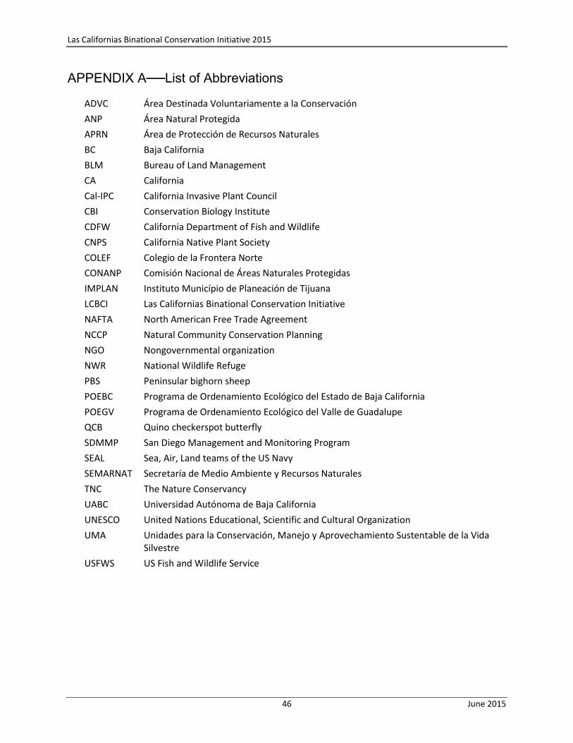
Las Californias Binational Conservation Initiative 2015
46 June 2015
APPENDIX A──List of Abbreviations
ADVC Área Destinada Voluntariamente a la Conservación
ANP Área Natural Protegida
APRN Área de Protección de Recursos Naturales
BC Baja California
BLM Bureau of Land Management
CA California
Cal-IPC California Invasive Plant Council
CBI Conservation Biology Institute
CDFW California Department of Fish and Wildlife
CNPS California Native Plant Society
COLEF Colegio de la Frontera Norte
CONANP Comisión Nacional de Áreas Naturales Protegidas
IMPLAN Instituto Município de Planeación de Tijuana
LCBCI Las Californias Binational Conservation Initiative
NAFTA North American Free Trade Agreement
NCCP Natural Community Conservation Planning
NGO Nongovernmental organization
NWR National Wildlife Refuge
PBS Peninsular bighorn sheep
POEBC Programa de Ordenamiento Ecológico del Estado de Baja California
POEGV Programa de Ordenamiento Ecológico del Valle de Guadalupe
QCB Quino checkerspot butterfly
SDMMP San Diego Management and Monitoring Program
SEAL Sea, Air, Land teams of the US Navy
SEMARNAT Secretaría de Medio Ambiente y Recursos Naturales
TNC The Nature Conservancy
UABC Universidad Autónoma de Baja California
UNESCO United Nations Educational, Scientific and Cultural Organization
UMA Unidades para la Conservación, Manejo y Aprovechamiento Sustentable de la Vida Silvestre
USFWS US Fish and Wildlife Service
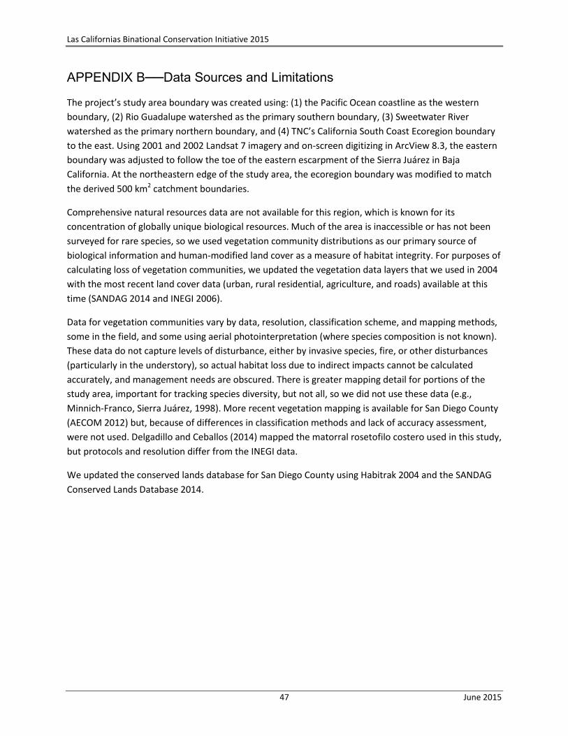
Las Californias Binational Conservation Initiative 2015
47 June 2015
APPENDIX B──Data Sources and Limitations
The project’s study area boundary was created using: (1) the Pacific Ocean coastline as the western
boundary, (2) Rio Guadalupe watershed as the primary southern boundary, (3) Sweetwater River
watershed as the primary northern boundary, and (4) TNC’s California South Coast Ecoregion boundary
to the east. Using 2001 and 2002 Landsat 7 imagery and on-screen digitizing in ArcView 8.3, the eastern
boundary was adjusted to follow the toe of the eastern escarpment of the Sierra Juárez in Baja
California. At the northeastern edge of the study area, the ecoregion boundary was modified to match
the derived 500 km2 catchment boundaries.
Comprehensive natural resources data are not available for this region, which is known for its
concentration of globally unique biological resources. Much of the area is inaccessible or has not been
surveyed for rare species, so we used vegetation community distributions as our primary source of
biological information and human-modified land cover as a measure of habitat integrity. For purposes of
calculating loss of vegetation communities, we updated the vegetation data layers that we used in 2004
with the most recent land cover data (urban, rural residential, agriculture, and roads) available at this
time (SANDAG 2014 and INEGI 2006).
Data for vegetation communities vary by data, resolution, classification scheme, and mapping methods,
some in the field, and some using aerial photointerpretation (where species composition is not known).
These data do not capture levels of disturbance, either by invasive species, fire, or other disturbances
(particularly in the understory), so actual habitat loss due to indirect impacts cannot be calculated
accurately, and management needs are obscured. There is greater mapping detail for portions of the
study area, important for tracking species diversity, but not all, so we did not use these data (e.g.,
Minnich-Franco, Sierra Juárez, 1998). More recent vegetation mapping is available for San Diego County
(AECOM 2012) but, because of differences in classification methods and lack of accuracy assessment,
were not used. Delgadillo and Ceballos (2014) mapped the matorral rosetofilo costero used in this study,
but protocols and resolution differ from the INEGI data.
We updated the conserved lands database for San Diego County using Habitrak 2004 and the SANDAG
Conserved Lands Database 2014.
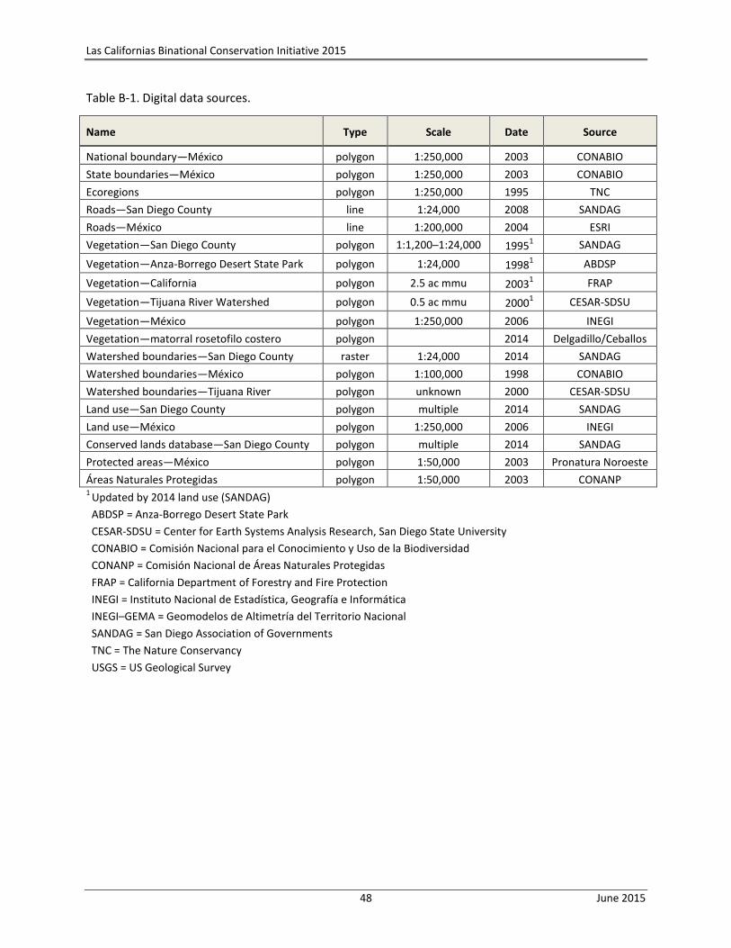
Las Californias Binational Conservation Initiative 2015
48 June 2015
Table B-1. Digital data sources.
Name Type Scale Date Source
National boundary—México polygon 1:250,000 2003 CONABIO
State boundaries—México polygon 1:250,000 2003 CONABIO
Ecoregions polygon 1:250,000 1995 TNC
Roads—San Diego County line 1:24,000 2008 SANDAG
Roads—México line 1:200,000 2004 ESRI
Vegetation—San Diego County polygon 1:1,200─1:24,000 19951 SANDAG
Vegetation—Anza-Borrego Desert State Park polygon 1:24,000 19981 ABDSP
Vegetation—California polygon 2.5 ac mmu 20031 FRAP
Vegetation—Tijuana River Watershed polygon 0.5 ac mmu 20001 CESAR-SDSU
Vegetation—México polygon 1:250,000 2006 INEGI
Vegetation—matorral rosetofilo costero polygon 2014 Delgadillo/Ceballos
Watershed boundaries—San Diego County raster 1:24,000 2014 SANDAG
Watershed boundaries—México polygon 1:100,000 1998 CONABIO
Watershed boundaries—Tijuana River polygon unknown 2000 CESAR-SDSU
Land use—San Diego County polygon multiple 2014 SANDAG
Land use—México polygon 1:250,000 2006 INEGI
Conserved lands database—San Diego County polygon multiple 2014 SANDAG
Protected areas—México polygon 1:50,000 2003 Pronatura Noroeste
Áreas Naturales Protegidas polygon 1:50,000 2003 CONANP 1
Updated by 2014 land use (SANDAG)
ABDSP = Anza-Borrego Desert State Park
CESAR-SDSU = Center for Earth Systems Analysis Research, San Diego State University
CONABIO = Comisión Nacional para el Conocimiento y Uso de la Biodiversidad
CONANP = Comisión Nacional de Áreas Naturales Protegidas
FRAP = California Department of Forestry and Fire Protection
INEGI = Instituto Nacional de Estadística, Geografía e Informática
INEGI–GEMA = Geomodelos de Altimetría del Territorio Nacional
SANDAG = San Diego Association of Governments
TNC = The Nature Conservancy
USGS = US Geological Survey