Embed Size (px)
Citation preview
LARGE IGNEOUS PROVINCES: CRUSTAL STRUCTURE,
DIMENSIONS, AND EXTERNAL CONSEQUENCES
Millard F. Coffin
Institute for Geophysics University of Texas Austin
Olav Eldholm
Department of Geology University of Oslo Oslo, Norway
Abstract. Large igneous provinces (LIPs) are a con- tinuum of voluminous iron and magnesium rich rock emplacements which include continental flood basalts and associated intrusive rocks, volcanic passive mar- gins, oceanic plateaus, submarine ridges, seamount groups, and ocean basin flood basalts. Such provinces do not originate at "normal" seafloor spreading cen- ters. We compile all known in situ LIPs younger than 250 Ma and analyze dimensions, crustal structures, ages, and emplacement rates of representatives of the three major LIP categories: Ontong Java and Ker- guelen-Broken Ridge oceanic plateaus, North Atlantic volcanic passive margins, and Deccan and Columbia River continental flood basalts. Crustal thicknesses
range from 20 to 40 km, and the lower crust is char- acterized by high (7.0-7.6 km s -•) compressional wave velocities. Volumes and emplacement rates de- rived for the two giant oceanic plateaus, Ontong Java and Kerguelen, reveal short-lived pulses of increased global production; Ontong Java's rate of emplacement may have exceeded the contemporaneous global pro-
duction rate of the entire mid-ocean ridge system. The major part of the North Atlantic volcanic province lies offshore and demonstrates that volcanic passive mar- gins belong in the global LIP inventory. Deep crustal intrusive companions to continental flood volcanism represent volumetrically significant contributions to the crust. We envision a complex mantle circulation which must account for a variety of LIP sizes, the largest originating in the lower mantle and smaller ones developing in the upper mantle. This circulation coexists with convection associated with plate tecton- ics, a complicated thermal structure, and at least four distinct geochemical/isotopic reservoirs. LIPs episod- ically alter ocean basin, continental margin, and con- tinental geometries and affect the chemistry and phys- ics of the oceans and atmosphere with enormous potential environmental impact. Despite the impor- tance of LIPs in studies of mantle dynamics and global environment, scarce age and deep crustal data neces- sitate intensified efforts in seismic imaging and scien- tific drilling in a range of such features.
1. INTRODUCTION
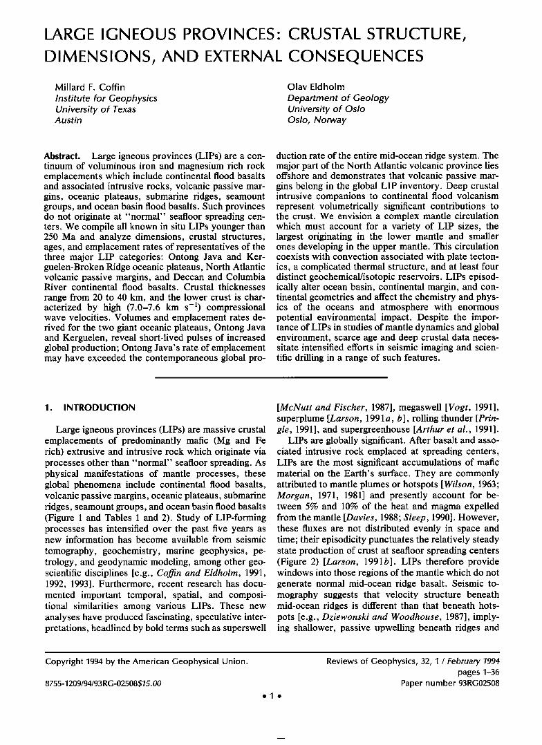
Large igneous provinces (LIPs) are massive crustal emplacements of predominantly mafic (Mg and Fe rich) extrusive and intrusive rock which originate via processes other than "normal" seafloor spreading. As physical manifestations of mantle processes, these global phenomena include continental flood basalts, volcanic passive margins, oceanic plateaus, submarine ridges, seamount groups, and ocean basin flood basalts (Figure 1 and Tables 1 and 2). Study of LIP-forming processes has intensified over the past five years as new information has become available from seismic
tomography, geochemistry, marine geophysics, pe- trology, and geodynamic modeling, among other geo- scientific disciplines [e.g., Coffin and Eldholm, 1991, 1992, 1993]. Furthermore, recent research has docu- mented important temporal, spatial, and composi- tional similarities among various LIPs. These new analyses have produced fascinating, speculative inter- pretations, headlined by bold terms such as superswell
[McNutt and Fischer, 1987], megaswell [Vogt, 1991], superplume [Larson, 1991 a, b], rolling thunder [Prin- gle, 1991], and supergreenhouse [Arthur et al., 1991].
LIPs are globally significant. After basalt and asso- ciated intrusive rock emplaced at spreading centers, LIPs are the most significant accumulations of mafic material on the Earth's surface. They are commonly attributed to mantle plumes or hotspots [Wilson, 1963; Morgan, 1971, 1981] and presently account for be- tween 5% and 10% of the heat and magma expelled from the mantle [Davies, 1988; Sleep, 1990]. However, these fluxes are not distributed evenly in space and time; their episodicity punctuates the relatively steady state production of crust at seafloor spreading centers (Figure 2) [Larson, 1991b]. LIPs therefore provide windows into those regions of the mantle which do not generate normal mid-ocean ridge basalt. Seismic to- mography suggests that velocity structure beneath mid-ocean ridges is different than that beneath hots- pots [e.g., Dziewonski and Woodhouse, 1987], imply- ing shallower, passive upwelling beneath ridges and
Copyright 1994 by the American Geophysical Union.
8755-1209/94/93 R G-02508515.00
ele
Reviews of Geophysics, 32, 1 / February 1994 pages 1-36
Paper number 93RG02508
2 ß Coffin and Eldholm- LARGE IGNEOUS PROVINCES 32, 1 / REVIEWS OF GEOPHYSICS
u.I
, LLJ
Z
t/
32, 1 / REVIEWS OF GEOPHYSICS Coffin and Eldholm: LARGE IGNEOUS PROVINCES ß 3
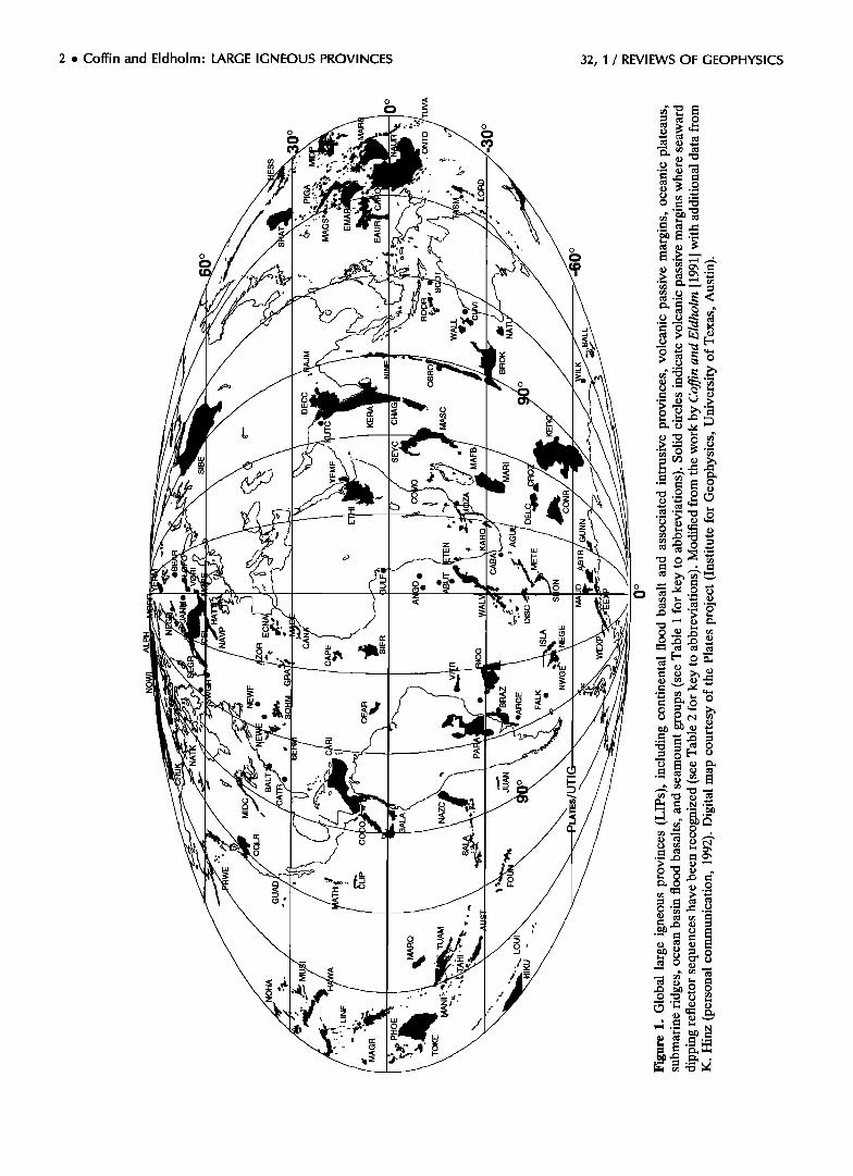
TABLE 1. Large Igneous Provinces, Excluding Volcanic Passive Margins
Abbreviations
LIP in Figure 1 Type Reference
Agulhas Ridge AGUL SR Alpha-Mendeleyev Ridge ALPH SR/OP* Angola Plain ANGO ASSC Austral seamounts AUST SMT Azores AZOR SMT
Balleny Islands BALL SMT Bermuda Rise BERM OP Broken Ridge BROK SR Canary Islands CANA SMT Cape Verde Rise CAPE OP Caribbean flood basalt CARI CFB/OBFB Caroline seamounts CARO SMT Ceara Rise CEAR OP
Chagos-Laccadive Ridge CHAG SR Chukchi Plateau CHUK OP
Clipperton seamounts CLIP SMT Cocos Ridge COCO SR Columbia River Basalt COLR CFB
Comores Archipelago COMO SMT Conrad Rise CONR OP Crozet Plateau CROZ OP Cuvier Plateau CUVI OP
Deccan traps DECC CFB Del Carlo Rise DELC OP
Discovery seamounts DISC SMT Eauripik Rise EAUR OP Eastern central North Atlantic ECNA ASSC East Mariana Basin EMAR OBFB Emeishan basalts? CFB Etendeka ETEN CFB
Ethiopian flood basalt ETHI CFB Foundation seamounts FOUN SMT
Galapagos/Carnegie Ridge GALA SMT/SR Great Meteor-Atlantis seamounts GRAT SMT
Guadelupe seamount chain GUAD SMT Hawaiian-Emperor seamounts HAWA SMT Hess Rise HESS OP
Hikurangi Plateau HIKU OP Iceland/Greenland-Scotland Ridge ICEL OP/SR Islas Orcadas Rise ISLA SR
Juan Fernandez Archipelago JUAN SMT Karoo KARO CFB
Kerguelen Plateau KERG OP Line Islands LINE SMT Lord Howe Rise seamounts LORD SMT
Louisville Ridge LOUI SMT Madagascar flood basalts MAFB CFB Madagascar Ridge MARI SR Madeira Rise MADE OP
Magellan Rise MAGR OP Magellan seamounts MAGS SMT Manihiki Plateau MANI OP
Marquesas Islands MARQ SMT Marshall Gilbert seamounts MARS SMT Mascarene Plateau MASC OP Mathematicians seamounts MATH SMT Maud Rise MAUD OP Meteor Rise METE SR
Midcontinent rift volcanics (Keweenawan) MIDC CFB Mid-Pacific Mountains MIDP SMT Musicians seamounts MUSI SMT Naturaliste Plateau NATU OP Natkusiak flood basalt NATK CFB Nauru Basin NAUR OBFB
IHO/IOC/CHS [1984] Weber and Sweeney [1990] Hinz and Block [1991] Crough [1978] G. R. Davies et al. [1989] Lanyon et al. [1993] Detrick et al. [1986] MacKenzie [1984] Schmincke [1982] Courtney and White [1986] Bowland and Rosencrantz [1988] Mattey [1982] Supko and Perch-Nielsen [1977] Duncan [1990] Hall [1990] Mammerickx [ 1989] Batiza [1989] Reidel and Hooper [ 1989] Emerick and Duncan [1982] Diament and Goslin [1986] Goslin and Diament [1987] Larson et al. [1979] Mahoney [1988] Goslin and Diament [1987] IHO/IOC/CHS [1984] Den et al. [1971] K. Hinz (personal communication, 1991) Abrams et al. [1993] Chung and Jahn [1993] Cox [1988] Mohr and Zanettin [1988] Mammerickx [ 1992] Christie et al. [1992] Tucholke and Smoot [1990] Batiza [1989] Clague and Dalrymple [1989] Vallier et al. [1983] Wood and Davey [1994] Vogt [1974] LaBrecque and Hayes [1979] IHO/IOC/CHS [1984] Cox [1988] Houtz et al. [1977] Sandwell and Renkin [1988] Wellman and McDougall [1974] Lonsdale [1988] Mahoney et al. [1991] Sinha et al. [ 1981] Peirce and Barton [1991] Winterer et al. [1973] IHO/IOC/CHS [1984] Winterer et al. [1974] Fischer et al. [1987] Schlanger et al. [1981] Duncan [1990] Mammerickx [1989] Barker et al. [1988] LaBrecque and Hayes [1979] Van Schmus [1992] Winterer and Metzler [1984] Batiza [1989] Coleman et al. [1982] Rainbird [1993] Shipley et al [1993]
4 ß Coffin and Eldholm: LARGE IGNEOUS PROVINCES 32, 1 / REVIEWS OF GEOPHYSICS
TABLE 1. (continued)
Abbreviations
LIP in Figure 1 Type Reference
Nazca Ridge NAZC SR New England seamounts NEWE SMT Ninetyeast Ridge NINE SR North Atlantic volcanic province NAVP CFB Northeast Georgia Rise NEGE OP Northwest Georgia Rise NWGE OP Northwest Hawaiian Ridge NOHA SR/SMT Northwind Ridge NOWI SR Ontong Java Plateau ONTO OP Osborn Knoll OSBO OP Paranti flood volcanism PARA CFB Phoenix seamounts PHOE SMT
Pigafetta Basin PIGA OBFB Pratt-Welker seamounts PRWE SMT
Rajmahal traps RAJM CFB Rio Grande Rise RIOG OP Roo Rise ROOR OP
Sala y Gomez Ridge SALA SR Shatsky Rise SHAT OP Shona Ridge SHON SR Siberian traps SIBE CFB Sierra Leone Rise SIER OP
Sohm Abyssal Plain SOHM ASSC Tahiti TAHI SMT Tasmantid seamounts TASM SMT Tokelau seamounts TOKE SMT
Tuamotu Archipelago TUAM SMT Tuvalu seamounts TUVA SMT
Vit6ria-Trindade Ridge VITR SR/SMT Wallaby Plateau WALL OP Walvis Ridge WALV SR Wrangellia? OP Yemen Plateau basalts YEME CFB
Pilger and Handschumacher [1981] Duncan [1984] Peirce et al. [1989] Upton [1988]; Dickin [1988] LaBrecque and Hayes [1979] Brenner and LaBrecque [1988] Mammerickx [1989] Hall [ 1990] Hussong et al. [1979] Sclater and Fisher [1974] Piccirillo et al. [1988] IHO/IOC/CHS [ 1984] Abrams et al. [1993] Batiza [1989] Mahoney et al. [1983] Gamboa and Rabinowitz [1984] IHO/IOC/CHS [ 1984] Pilger and Handschumacher [1981] Den et al. [1969] IHO/IOC/CHS [ 1984] Zolotukhin and Al'Mukhamedov [1988] Kumar [ 1979] Hinz and Popovici [1989] Duncan and McDougall [1976] McDougall and Duncan [1988] IHO/IOC/CHS [ 1984] Duncan and Clague [1985] IHO/IOC/CHS [ 1984] Francisconi and Kowsmann [1976] Symonds and Cameron [1977] Rabinowitz and LaBrecque [1979] Richards et al. [ 1991 ] Mohr and Zanettin [1988]
ASSC, anomalous seafloor spreading crust; CFB, continental flood basalt; OBFB, ocean basin flood basalt; OP, oceanic plateau; SMT, seamount; SR submarine ridge.
*Referred to in the literature as both a submarine ridge and an oceanic plateau. ?Not mapped in Figure 1.
deeper, dynamic upwelling beneath hotspots [Zhang sible environmental consequences. To do so, we use and Tanimoto, 1992]. Furthermore, thermal structure primarily geophysical and geological data and pub- of the upper mantle is heterogeneous, suggesting that lished results, focusing on five major mafic emplace- extensive magmatism requires a combination of hot ments: the Ontong Java and Kerguelen/Broken Ridge upper mantle and suitable lithospheric conditions oceanic plateaus, the North Atlantic volcanic passive [Anderson et al., 1992a, b]. Despite a wealth of data margins, and the Deccan and Columbia River conti- and results on hotspots and mantle plumes (for re- views and syntheses, see, for example, White and McKenzie [1989], Duncan and Richards [1991], Hill et al. [1992], and Sleep [1992]), not one of the available models satisfactorily explains the genesis of all LIPs or even individual categories of LIPs.
In this study we will describe and characterize tran- sient LIPs, that is, those LIPs which form by volumi- nous, but probably relatively short-lived, magmatic episodes and review their crustal structure. Because dimensions and emplacement rates for most LIPs are poorly known but are of fundamental importance both for internal processes and external implications, we calculate LIP dimensions and rates in order to evalu-
ate and summarize their genesis, evolution, and pos-
nental flood basalts, which represent the three main categories of transient LIPs. Of these, the two oceanic plateaus are the largest igneous provinces and may represent the highest rates of planetary crustal produc- tion on timescales of 106 years.
2. COMPOSITION, CATEGORIES, AND TECTONIC SETTING
LIPs are dominated by mafic rocks. Because con- tinental flood basalts are far more accessible to sam-
pling than submarine volcanic passive margin and oce- anic plateau igneous rocks, we know much more about the petrology and geochemistry of the former. The
32, I / REVIEWS OF GEOPHYSICS Coffin and Eldholm: LARGE IGNEOUS PROVINCES ß 5
TABLE 2. Volcanic Passive Margins, Including Marginal Plateaus
Continent
( S ub c o ntine nt/Mic roc o ntine nO Location Abbreviations
in Figure 1 Reference
Africa Abutment Plateau
Cape Basin Gulf of Guinea
Mozambique Basin Antarctica Astrid Ridge
Eastern Explora wedge Western Explora wedge Gunnerus Ridge Wilkes Land
Australia Cuvier Plateau Scott Plateau
Greenland Jan Mayen Ridge Morris Jesup Rise Northeast Greenland Southeast Greenland Southwest Greenland
India Kerala Basin Kutch Basin
North America Baltimore Canyon trough Carolina trough Newfoundland Ridge
Northwest Europe Bear Island margin Hatton Bank
Lofoten margin MOre margin V0ring margin Yermak Plateau
Seychelles Seychelles Bank South America Argentine margin
Brazilian margin Falkland Plateau
ABUT Hinz [1981] CABA Hinz [ 1981] GULF Rosendahl et al. [1991] MOZA DeBuyl and Flores [1986] ASTR Roeser et al. [1990] EEXP Hinz and Krause [1982] WEXP Kristoffersen and Hinz [1991] GUNN Roeser et al. [1990] WILK Eittrem et al. [1985] CUVI Hopper et al. [1992] SCOT Hinz [ 1981] JANM $kogseid and Eldholm [1987] MORR Feden et al. [1979] NEGR Hinz et al. [1987] SEGR Larsen and Jakobsdottir [1988] SWGR Chalmers [1991] KERA Hinz [ 1981] KUTC Hinz [ 1981 ] BALT Sheridan et al. [1993] CATR Austin et al. [1990] NEWF Grant [1977] BEAR Faleide et al. [1988] HATT Roberts et al. [1984] LOFO Eldholm et al. [1979] MORE Smythe [1983] VORI Hinz and Weber [1976]
YERM Feden et al. [1979] SEYC Devey and Stephens [1992] ARGE Hinz [ 1990] BRAZ Chang et al. [1992] FALK Lorenzo and Mutter [1988]
most abundant rock types are typically subhorizontal, subaerial basalt (mostly tholeiitic) flows, some of which extend for many hundred kilometers and have volumes as great as several thousand cubic kilometers [e.g., Tolan et al., 1989]. Felsic and intermediate rocks also occur as lavas and intrusives and are mostly associated with initial and late emplacement stages, while flood basalts largely uncontaminated by crustal components represent the most intense, transient eruption period. Relative to mid-ocean ridge basalt (MORB), major element compositions of continental flood basalts are much more diverse [Macdougall, 1988a]. Fractionated components are more common, and both alkalic and tholeiitic differentiates occur.
Petrologic and geochemical studies of rocks from LIP environments suggest lower to upper mantle sources for the magma. A consensus has developed on the basis of isotopic taxonomy that at least four dif- ferent source reservoirs persist in the mantle: depleted MORB mantle (DMM), high U/Pb ratio (HIMU) and enriched mantle 1 and 2 (EM1 and EM2) [Zindler and Hart, 1986; Hart et al., 1992]. In chemical and isotopic character, some continental flood basalts mimic in- traoceanic hotspot basalts along the same plume trace [Carlson, 1991]. Other continental flood basalts resem-
ble MORB lavas derived from depleted mantle. Many continental flood basalts have chemistries characteris-
tic of lithospheric fractionation and isotopic signatures more closely resembling those of continental crust than of convecting mantle. Differences among LIP chemistry and isotopes may be explained by varying degrees of crustal or lithospheric-mantle contamina- tion and different subcontinental lithospheric and as- thenospheric source compositions.
Intermediate and mafic sills are well developed in continental flood basalt provinces that overlie sedi- mentary sequences and along the offshore Norwegian and British volcanic margins and may contribute a significant fraction of the total igneous volume. Off Norway, flood basalts of a dipping reflector wedge are locally underlain by dacitic-andesitic lavas interpreted as having been emplaced during the late rift stage [Eldholm et al., 1989] by partial melting of a compo- nent of continental material in a shallow crustal
magma chamber [Parson et al., 1989]. Dacite also underlies basalt in the northern Rockall Trough off Great Britain [Morton et al., 1988]. Some provinces also contain significant amounts of rhyolite, probably erupted as high-temperature (--- 1100øC) lavas. Whether dacite and/or rhyolite is present in purely
6 ß Coffin and Eldholm' LARGE IGNEOUS PROVINCES 32, I / REVIEWS OF GEOPHYSICS
120
11o LIP/Mid-Ocean Ridge Emplacement Rate
ONTO LIP
lOO
7o
Early-Middle Eocene-
Miocene Oli8øcene Paleocene- • • Eocene ß
Maastrichtian- / Danian
DECC
Cenomanian- Turonian
Aptian- Albian
Berriasian-
Valanginian
30
2O
10
KERG LIP
0 ]COLR D o lO
I 20 30 40 50 60 70 80 90 100 110 120 130
Ma
140 150
Figure 2. LIPs as a percentage of mid-ocean ridge crustal production versus time. Thin line indicates curve derived from the work by Larson [1991 b]. Thick line depicts results of Coffin and Eldholm [1993]. The solid oceanic plateau (Kerguelen large igneous province (KERG LIP) and Ontong Java (ONTO) LIP) columns indicate off-ridge emplacement; solid and open parts depict on-ridge emplacement. Solid part of continental flood basalt DECC and COLR) columns indicates minimum rate; solid and open part indicates maximum rates. Maximum and minimum rates were calculated using 1.5- and 11.5-m.y. emplacement periods for Columbia River basalts (COLR) and 1.0 and 4.0 m.y. for Deccan traps (DECC). Compare with Figure 6. Solid horizontal bars indicate Cenozoic and Cretaceous mass extinctions [after Rampino and Stothers, 1988; Thomas, 1992]; note the correlation of COLR, DECC, and Kerguelen Plateau (KERG) LIP with extinctions. ONTO indicates Ontong Java Plateau only; ONTO LIP includes Ontong Java and Manihiki plateaus, and Mariana, Nauru, and Pigafetta basin flood basalts. KERG indicates Kerguelen Plateau only; KERG LIP includes Kerguelen Plateau, Elan Bank, and Broken Ridge.
mafic oceanic plateaus is uncertain. No intrusive rocks have been recovered from LIPs; these deeper rocks, presumably gabbros and ultramafics, are probably at least as voluminous as the extrusive components.
LIPs are distributed worldwide, occurring on both continental and oceanic crust in purely intraplate set- tings, on present and former plate boundaries, and along the edges of continents [Co•n and Eldholm, 1992] (Figure 1 and Tables 1 and 2). Continental flood basalts, the most intensively studied LIPs, are pre- dominantly tholeiitic magmas erupted on continental crust over timescales of 105-106 years. Generally be- lieved to be the product of fissure eruptions, they
consist primarily of horizontal and subhorizontal flows. Volcanic passive margins, situated on the trailing, rifted edges of continents, are characterized by excessive vol- canism and by uplift and/or lack of rapid initial subsid- ence during continental breakup [e.g., Roberts et al., 1984; Eldholm, 1991]. Margin formation is associated with both intrusive and extrusive activity [Larsen and Marcussen, 1992; Skogseid et al., 1992a]. The oldest oceanic crust is thicker than adjacent "normal" oceanic crust, and the lower crust beneath the extrusives is commonly characterized by bodies with high seismic velocities [e.g., Mutter and Zehnder, 1988; White and McKenzie, 1989; Eldholm and Grue, 1993].
32, 1 / REVIEWS OF GEOPHYSICS Coffin and Eldholm- LARGE IGNEOUS PROVINCES ß 7
In deep ocean basins, the largest LIPs are oceanic plateaus: broad, more or less flat-topped features which generally lie 2000 rn or more above the sur- rounding seafloor. They are formed by mafic volca- nism and associated intrusive activity; their extrusive cover may be emplaced either in subaerial (e.g., Ker- guelen Plateau) [Coffin, 1992] or submarine (e.g., On- tong Java Plateau) [Tarduno, 1992] environments. Oceanic plateaus are commonly isolated from major continents. Their crustal thickness is anomalously greater than that of adjacent oceanic crust, and their age may or may not be similar to that of adjacent crust. Another category of oceanic LIP is submarine ridges, which are elongated, steep-sided elevations of the sea- floor. They may be of continental or oceanic origin, and we only consider the latter herein. Submarine ridges are commonly characterized by varying topog- raphy, and those of basaltic nature may be created either on or off the axes of spreading centers. As with oceanic plateaus, their volcanic upper crust may be emplaced either subaerially or under water [Coffin, 1992]. Closely related to submarine ridges are sea- mounts, which are local elevations of the seafloor. Seamounts are flat-topped (guyot) or peaked mafic volcanoes whose last stages of construction were in a subaerial or a submarine environment, respectively. They may be discrete, arranged in a linear or random grouping, or connected at their bases and aligned along a ridge or rise. The least studied LIPs are ocean basin flood basalts, which are thick, extensive submarine flows and sills lying above and postdating oceanic igneous basement. Recently, K. Hinz (personal com- munication, 1992) has discovered thickened oceanic crust and dipping intrabasement reflectors in deep ocean basins with linear seafloor spreading-type mag- netic anomalies. We term this crustal type anomalous seafloor spreading crust.
Surface manifestations of the LIP types above record important spatial and temporal characteristics related to magma production. Many LIPs result from long-lived magmatic sources in the mantle, sources which initially transfer huge volumes of mafic rock into the crust over short intervals (• 1 m.y.) but which later transfer material at a far lesser rate, albeit over long intervals (10-100 m.y.).
Transient magmatism during LIP formation is most clearly documented for continental flood basalts and volcanic passive margins (Figure 1 and Tables 1 and 2). Numerous 4øAr-39Ar dates, for example, show that most basalts of the Deccan traps [e.g., Duncan and Richards, 1991] and Siberian traps [e.g., Campbell et al., 1992] were erupted during -1-m.y. periods indis- tinguishable from the Cretaceous-Tertiary and Per- mian-Triassic boundaries, respectively. Similarly, the North Atlantic volcanic province and other volcanic margins were emplaced during and immediately sub- sequent to continental breakup, but little or no volca- nism, aside from that associated with seafloor spread-
ing, persisted thereafter. Such transient events, which also include oceanic plateaus, have been commonly attributed to plume "heads" manifesting themselves in the crust after arriving from the lower mantle [e.g., Richards et al., 1989].
Persistent magmatism resulting in LIP formation is in most cases related to lithosphere moving over more or less steady state mantle plumes or plume "tails" in the terminology of Richards et al. [1989]. Through Early Cretaceous and younger plate reconstructions [e.g., Duncan and Richards, 1991], each of several mantle plume sources, or hotspots, can be tied to a group of LIPs, including (Figure 1) (1) the Iceland source (North Atlantic volcanic province including North Atlantic volcanic margins and the Greenland- Scotland ridge), (2) the Kerguelen source (Bunbury basalt (Australia), Naturaliste Plateau, Rajmahal traps, Kerguelen Plateau/Broken Ridge, Ninetyeast Ridge, and northernmost Kerguelen Plateau), (3) the R•union source (Deccan traps, western Indian volca- nic margins, Chagos-Laccadive Ridge, Mascarene Pla- teau, and Mauritius), and (4) the Tristan da Cunha source (Paranti and Etendeka basalts, South Atlantic volcanic margins, Rio Grande Rise, Walvis Ridge). The Iceland source has been active for at least 60 m.y. [e.g., Upton, 1988], the Kerguelen source for 135 m.y. [e.g., H. L. Davies et al., 1989], the R6union source for 65 m.y. [e.g., Courtillot et al., 1988], and the Tristan da Cunha source for 120 m.y. [e.g., O'Connor and le Roex, 1992]. Each of these hotspots was at some point during its evolution temporally and spa- tially associated with continental breakup.
Not all LIPs, however, have obvious connections to hotspots. In particular, some volcanic margins, for example, the U.S. East Coast [Sheridan et al., 1993] and northwest Australian Cuvier [Hopper et al., 1992] margins, appear to have formed away from known hotspots. These observations, together with well-doc- umented transient and persistent LIP-forming magma sources, suggest that more than one source model may be required to explain LIPs in general and volcanic margins in particular.
Mesozoic/Cenozoic LIP emplacement peaked near the middle of Cretaceous time (Figure 2) [e.g., Larson, 1991b]. To date, there has been no detailed explanation as to why this peak occurred, although recent specula- tion has centered on heightened activity at the core- mantle boundary (D" layer) preceding crustal emplace- ment of numerous LIPs in the Pacific Ocean [Larson, 1991a, b], including the largest known igneous province, the Ontong Java Plateau. Crustal production at mid- ocean ridges has varied far less than LIP crustal pro- duction over the past 150 m.y. [Larson, 1991b], sug- gesting that LIP production and seafloor spreading reflect fundamentally different mantle processes.
LIPs are found in a variety of tectonic settings, including the axes of seafloor spreading centers (e.g., Iceland), triple junctions (e.g., Shatsky Rise) [Nakan-
8 ß Coffin and Eldholm: LARGE IGNEOUS PROVINCES 32, 1 / REVIEWS OF GEOPHYSICS
ishi et al., 1989], old oceanic lithosphere (e.g., Ha- waii), passive margins (e.g., North and South Atlantic volcanic margins), and cratons (e.g., Siberian traps). Those situated at spreading centers, such as Iceland, Azores, and Galapagos, are readily distinguishable from "normal" oceanic crust by their anomalous vol- umes and geochemical signatures [e.g., Zindler and Hart, 1986; Hart et al., 1992]. Recent discussion has focused on whether mantle plumes and plate tectonics operate largely independently [e.g., Hill et al., 1992] or are intimately linked [e.g., Anderson et al., 1992a, b]; no consensus has been reached.
LIPs that are indisputably emplaced at plate bound- aries include those now observed to lie on active
spreading centers, those which are reliably dated to be the same age as adjacent "normal" oceanic crust, and volcanic passive margins. As higher-quality seismic reflection data become available on passive margins, an increasing number appear to be "volcanic" [Coffin and Eldholm, 1992]; thus massive volcanism may be quite common when continents separate.
Many LIPs, however, are difficult to associate with plate separation. Part of the reason is that most oce- anic crust is Cretaceous or younger; nearly all older oceanic crust with accompanying LIPs has been sub- ducted. This makes tying older LIPs to younger LIPs or to presently active hotspots difficult. The paucity of hotspot tracks on continents, however, could suggest that plate separations produce favorable conditions for thermally anomalous mantle to upwell. Alternatively, continental lithosphere might be robust enough to de- flect all but the most vigorous mantle upwellings to oceanic areas [Thompson and Gibson, 1991].
Given the potential characteristics required for a mantle upwelling to reach the surface and form a LIP (the size of the mantle upwelling, its temperature, and its temporal variability, as well as the heterogeneous vulnerability of the lithosphere), it is remarkable that hotspot trails are in some cases traceable for more than 100 m.y. It further implies that the long-lived tracks, including those emanating from Hawaii, Ker- guelen, R6union, Iceland, and Tristan da Cunha, are among the most stable and vigorous.
3. DIMENSIONS, CRUSTAL STRUCTURE, AGES, AND EMPLACEMENT: A STUDY OF FIVE LIPS
Evaluation of how LIP emplacements affect Earth history depends on key parameters, especially size, composition, emplacement rate, and emplacement en- vironment. Information on these parameters in differ- ent provinces is highly variable, and each LIP cate- gory offers particular advantages in understanding LIPs as a whole. Continental flood basalts provide by far the most data on composition and age. The areal extent of continental LIPs is easier to measure than
that of submarine LIPs, but subaerial erosion of basalt
is much more common than marine erosion. Thus
uncertainty in the areas originally covered by conti- nental flood basalts increases with increasing age of the province. The other two main categories of LIPs, volcanic passive margins and oceanic plateaus, suffer from severe undersampling of igneous basement and overlying sediment. For example, volcanic margins of the North Atlantic, the best studied of any worldwide, have been penetrated by fewer than ten drill holes of which only two have sampled more than 100 m of basement. Igneous basement of the two largest oce- anic plateaus, Ontong Java and Kerguelen, which to- gether cover an area nearly half the size of the conter- minous United States, has been sampled at only seven sites, of which only one was drilled more than 100 m. Yet seismic refraction, reflection, and gravity data, necessary for investigating crustal structure and hence volumes of LIPs, are easier to obtain and thus more prevalent from oceanic than from continental LIPs. Furthermore, the simpler lithospheric setting of oce- anic plateaus permits less ambiguous evaluation of crustal structure than of continental flood basalts or
volcanic passive margins. To study temporal and spa- tial aspects of LIP development, we examine charac- teristic examples which are among the best known LIPs (Figures 1 and 3): Ontong Java and Kerguelen- Broken Ridge oceanic plateaus, North Atlantic rifted volcanic margins, and Deccan and Columbia River continental flood basalts.
LIP Parameters: Methodology On the basis of existing data and new calculations
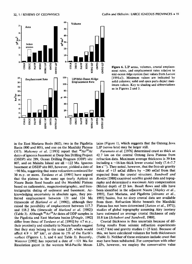
[Coffin and Eldholm, 1993] we determine the magni- tude and range of key LIP parameters. Seismic (e.g., Figure 4), outcrop, and borehole data from LIPs show that they are major constructions of extrusive igneous rock underlain by intrusive rock with crustal thickness ranging from 20 to 40 km. Despite scarce crustal data, an expanded crustal thickness and a lower crustal body characterized by high velocities (7.0-7.6 km s -1) appear typical for many LIPs (Figure 5). These fea- tures exist on Hawaii, the best known mid-oceanic LIP. Lower crustal bodies are believed to be added to
the crust as part of the magmatic event, which also results in massive extrusive activity [Watts and ten Brink, 1989; White and McKenzie, 1989].
Surface areas of the five LIPs examined are either
calculated or taken from published work (Figures 3 and 6 and Table 3). For the giant oceanic plateaus we determine LIP boundaries from bathymetry. For on- shore and offshore portions of the North Atlantic vol- canic province, we employ published values based on drilling results and seismic data. Areas of continental flood basalts are also taken from the literature. These
estimates do not take into account any rock that may have been eroded. We compile both present and preerosional estimates for the Deccan traps and present estimates for the Columbia River flood basalts.
32, 1 / REVIEWS OF GEOPHYSICS Coffin and Eldholm' LARGE IGNEOUS PROVINCES ß 9
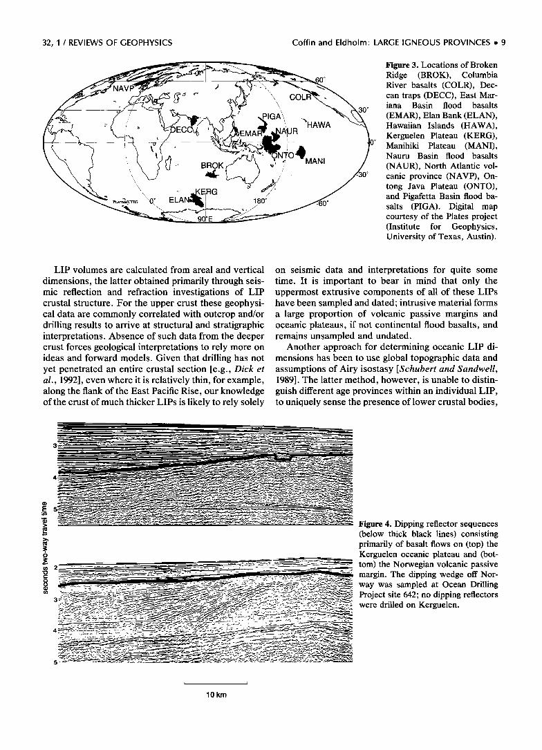
River basalts (COLR), Dec-
-. 'x,, x can traps (DECC), East Mar-
•0 o iana Basin flood basalts ; J ,• -'•••.; "•. (EMAR), Elan Bank (ELAN), Hawaiian Islands (HAWA),
'; •' //', Kerguelen Plateau (KERG),
_ 0 Manihiki Plateau (MANI), Nauru Basin flood basalts
(NAUR), North Atlantic vol- canic province (NAVP), On-
•"•. • '- _KE • tong Java Plateau (ONTO), • PI.AT•S/LrrIG '0 ø ELAN,,• •- and Pigafetta Basin flood ba- •__- •.•----•. , • -600 salts (PIGA). Digital map courtesy of the Plates project (Institute for Geophysics, University of Texas, Austin).
LIP volumes are calculated from areal and vertical
dimensions, the latter obtained primarily through seis- mic reflection and refraction investigations of LIP crustal structure. For the upper crust these geophysi- cal data are commonly correlated with outcrop and/or drilling results to arrive at structural and stratigraphic interpretations. Absence of such data from the deeper crust forces geological interpretations to rely more on ideas and forward models. Given that drilling has not yet penetrated an entire crustal section [e.g., Dick et al., 1992], even where it is relatively thin, for example, along the flank of the East Pacific Rise, our knowledge of the crust of much thicker LIPs is likely to rely solely
on seismic data and interpretations for quite some time. It is important to bear in mind that only the uppermost extrusive components of all of these LIPs have been sampled and dated; intrusive material forms a large proportion of volcanic passive margins and oceanic plateaus, if not continental flood basalts, and remains unsampled and undated.
Another approach for determining oceanic LIP di- mensions has been to use global topographic data and assumptions of Airy isostasy [Schubert and Sandwell, 1989]. The latter method, however, is unable to distin- guish different age provinces within an individual LIP, to uniquely sense the presence of lower crustal bodies,
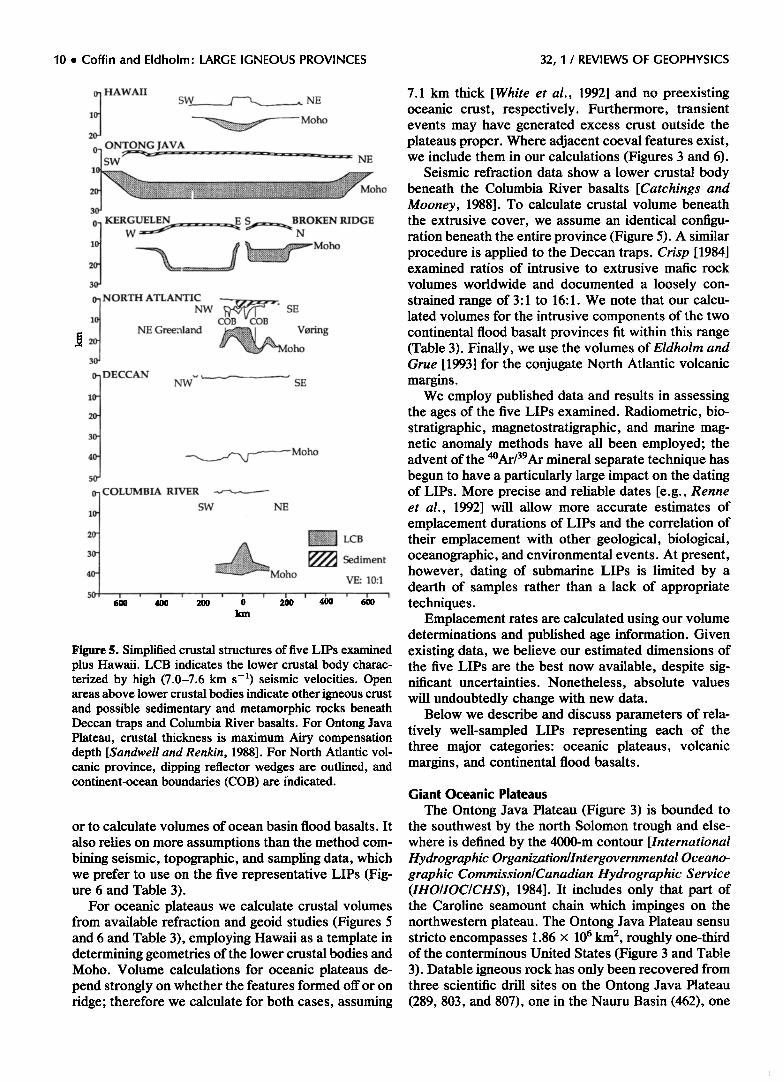
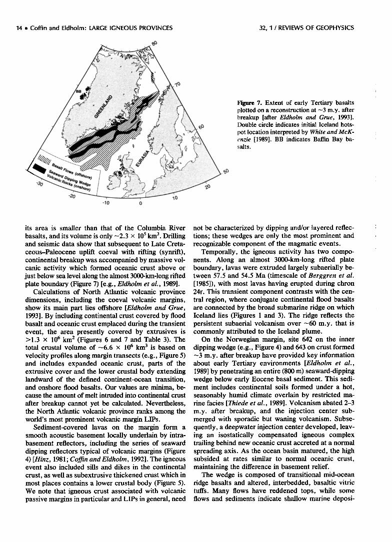
Figure 4. Dipping reflector sequences (below thick black lines) consisting primarily of basalt flows on (top) the Kerguelen oceanic plateau and (bat-
tom) the Norwegian volcanic passive margin. The dipping wedge aft Nor- way was sampled at Ocean Drilling Project site 642; na dipping reflectors were drilled an Kerguelen.
lO km
10 ß Coffin and Eldholm- LARGE IGNEOUS PROVINCES 32, I / REVIEWS OF GEOPHYSICS
• HAWAII S• NE 1 ß '..-.:..::::.::•::.....:....::............,,..,•..• Moho 2
0-' ONTONG JAVA '[SW --' ..... ---" NE
o KERGUELEN E S..-•.•_• BROKEN RIDGE
NORTH ATLANTIC
NW CO• SE 1
• NE Greenland •..• • V•ring ,-• o, '•::• •vioho
o- DECCAN
lO-
30-
40.
o- COLUMBIA RIVER
10.
2o-
3o-
SW NE
6•0 * 400
;':-• LCB
'•Moho • Sediment VE: 10:1
i i i I i i
•o o •o •o •o '
4O-
5O
Figure 5. Simplified crustal structures of five LIPs examined plus Hawaii. LCB indicates the lower crustal body charac- terized by high (7.0-7.6 km s -•) seismic velocities. Open areas above lower crustal bodies indicate other igneous crust and possible sedimentary and metamorphic rocks beneath Deccan traps and Columbia River basalts. For Ontong Java Plateau, crustal thickness is maximum Airy compensation depth [Sandwell and Renkin, 1988]. For North Atlantic vol- canic province, dipping reflector wedges are outlined, and continent-ocean boundaries (COB) are indicated.
or to calculate volumes of ocean basin flood basalts. It
also relies on more assumptions than the method com- bining seismic, topographic, and sampling data, which we prefer to use on the five representative LIPs (Fig- ure 6 and Table 3).
For oceanic plateaus we calculate crustal volumes from available refraction and geoid studies (Figures 5 and 6 and Table 3), employing Hawaii as a template in determining geometries of the lower crustal bodies and Moho. Volume calculations for oceanic plateaus de- pend strongly on whether the features formed off or on ridge; therefore we calculate for both cases, assuming
7.1 km thick [White et al., 1992] and no preexisting oceanic crust, respectively-. Furthermore, transient events may have generated excess crust outside the plateaus proper. Where adjacent coeval features exist, we include them in our calculations (Figures 3 and 6).
Seismic refraction data show a lower crustal body beneath the Columbia River basalts [Catchings and Mooney, 1988]. To calculate crustal volume beneath the extrusive cover, we assume an identical configu- ration beneath the entire province (Figure 5). A similar procedure is applied to the Deccan traps. Crisp [1984] examined ratios of intrusive to extrusive mafic rock
volumes worldwide and documented a loosely con- strained range of 3:1 to 16:1. We note that our calcu- lated volumes for the intrusive components of the two continental flood basalt provinces fit within this range (Table 3). Finally, we use the volumes of Eldholm and Grue [1993] for the conjugate North Atlantic volcanic margins.
We employ published data and results in assessing the ages of the five LIPs examined. Radiometric, bio- stratigraphic, magnetostratigraphic, and marine mag- netic anomaly methods have all been employed; the advent of the 4øAr/39Ar mineral separate technique has begun to have a particularly large impact on the dating of LIPs. More precise and reliable dates [e.g., Renne et al., 1992] will allow more accurate estimates of emplacement durations of LIPs and the correlation of their emplacement with other geological, biological, oceanographic, and environmental events. At present, however, dating of submarine LIPs is limited by a dearth of samples rather than a lack of appropriate techniques.
Emplacement rates are calculated using our volume determinations and published age information. Given existing data, we believe our estimated dimensions of the five LIPs are the best now available, despite sig- nificant uncertainties. Nonetheless, absolute values will undoubtedly change with new data.
Below we describe and discuss parameters of rela- tively well-sampled LIPs representing each of the three major categories: oceanic plateaus, volcanic margins, and continental flood basalts.
Giant Oceanic Plateaus
The Ontong Java Plateau (Figure 3) is bounded to the southwest by the north Solomon trough and else- where is defined by the 4000-m contour [International Hydrographic Organization/Intergovernmental Oceano- graphic Commission/Canadian Hydrographic Service (IHO/IOC/CHS), 1984]. It includes only that part of the Caroline seamount chain which impinges on the northwestern plateau. The Ontong Java Plateau sensu stricto encompasses 1.86 x 10 6 km 2, roughly one-third of the conterminous United States (Figure 3 and Table 3). Datable igneous rock has only been recovered from three scientific drill sites on the Ontong Java Plateau (289, 803, and 807), one in the Nauru Basin (462), one
32, 1 / REVIEWS OF GEOPHYSICS Coffin and Eldholm' LARGE IGNEOUS PROVINCES ß 11
4
.• 8
6
4
2
0
Area
before
erosion
Volume
Emplacement Rate LIP/Mid-Ocean Ridge Emplacement Rate
Figure 6. LIP areas, volumes, crustal emplace- ment rates, and emplacement rates relative to mid-ocean ridge system (last values from Larson [1991a]). Minimum values are indicated by solid columns; solid and open parts depict max- imum values. Key to shading and abbreviations as in Figures 2 and 3.
in the East Mariana Basin (802), two in the Pigafetta Basin (800 and 801), and one on the Manihiki Plateau (317). Mahoney et al. [1993] report that 4øAr/39Ar dates of igneous basement at Deep Sea Drilling Project (DSDP) site 289, Ocean Drilling Program (ODP) site 807, and on Malaita Island are all •122 Ma. Igneous basement at DSDP site 803, however, yielded a date of •90 Ma, suggesting that some volcanism continued for 30 m.y. or more. Tarduno et al. [1991] have argued that the plateau is the same age (early Aptian) as Nauru Basin flood basalts and the Manihiki Plateau
based on radiometric, magnetostratigraphic, and bios- tratigraphic dating of sediment and basement. Ac- knowledging uncertainty in absolute ages, they pre- ferred emplacement between 121 and 124 Ma (timescale of Harland et al. [1990]), although they raised the possibility of emplacement between 117.7 and 118.2 Ma (timescale of Harland et al. [1982]) (Table 3). Although 4øAr/39Ar dates of ODP samples in the Pigafetta and East Mariana basins [Pringle, 1992] differ from those of Tarduno et al. [1991] by <7 m.y., their proximity and similarity to Nauru basalts suggest that they may belong to the same LIP, which would affect 4.9 x 10 6 km 2, or close to 1% of the Earth's surface (Figures 1, 3, and 6 and Table 3). Recently, Winterer [1992] has reported a date of •121 Ma for Resolution guyot in the western Mid-Pacific Moun-
tains (Figure 1), which suggests that the Ontong Java LIP (sensu lato) may be larger still.
Furumoto et al. [1976] determined crust as thick as 42.7 km on the central Ontong Java Plateau from refraction data. Maximum average thickness is 39 km including a •16-km-thick lower crustal body (7.4-7.7 km s-•). They noted, however, that the free-air gravity value of + 15 mGal differs by •200 mGal from that expected from the crustal structure. Sandwell and Renkin [1988] examined satellite geoid data and topog- raphy and determined a maximum Airy compensation (Moho) depth of 25 km. Basalt flows and sills have been identified in the adjacent Nauru [Shipley et al., 1993], East Mariana, and Pigafetta [Abrams et al., 1993] basins, but no deep crustal data are available from them. Refraction Moho beneath the Manihiki
Plateau has not been determined [Sutton et al., 1971]; studies of global topography assuming Airy isostasy have estimated an average crustal thickness of only 10.8 km [Schubert and Sandwell, 1989].
Crustal thickness is thus uncertain because of dif-
fering results from seismic refraction experiments (<42.7 km) and gravity studies (•25 km). Because of this, we have calculated volumes for both thicknesses (Table 3). Neither of these estimates include crust that may have been subducted. For comparison with other LIPs, however, we employ the conservative value
12 ß Coffin and Eldholm- LARGE IGNEOUS PROVINCES 32, 1 / REVIEWS OF GEOPHYSICS
32, I / REVIEWS OF GEOPHYSICS Coffin and Eldholm: LARGE IGNEOUS PROVINCES ß 13
(Figure 6). For the Manihiki Plateau, the same age as Ontong Java [Tarduno et al., 1991], we assumed a maximum value of 25 km (Table 3), identical to the lower value for Ontong Java. Volume estimates of basalt flows and sills are available for the adjacent Naum [Shipley et al., 1993], Pigafetta, and East Mar- iana basins [Abrams et al., 1993], but it is not possible to estimate volumes of any deeper crustal compo- nents. For the entire Ontong Java LIP, calculated crustal accretion rates are 12.1 and 18.0 km 3 yr -• for off- and on-ridge emplacement, respectively (Figure 6 and Table 3). Using refraction, Moho for the Ontong Java Plateau would increase these rates by --•60 and •40%, respectively.
Three drill sites on the Ontong Java Plateau recov- ered tholeiitic basalt presumed to represent basement. The basalt appears to record high degrees of partial melting (--•30%), and isotopic signatures indicate a hotspot-like mantle source [Mahoney et al., 1993]. No shallow water sediment overlies basement at these
drill sites [Tarduno, 1992], and at each site, basalt apparently erupted in a submarine environment [Berger et al., 1992]. Seismic data do not indicate subaerial exposure and erosion of basement [Kroenke et al., 1991], but subsidence analysis indicates that at least part of the Ontong Java Plateau was emplaced near sea level [Tarduno, 1992].
Kerguelen Plateau and Broken Ridge are conjugate, Early Cretaceous LIPs in the Indian Ocean (Figures 1 and 3) which separated in Eocene time [Houtz et al., 1977; Mutter and Cande, 1983]. Cretaceous parts of the features are difficult to distinguish on the basis of bathymetry (Schlich et al. [1987] for Kerguelen and IHO/IOC/CHS [1984] for Broken Ridge) alone, be- cause they are continuous with younger parts. How- ever, using dates from rock samples (Table 3), plate reconstructions [e.g., Royer and Sandwell, 1989; Royer and Coffin, 1992], and changes in bathymetry, we interpreted the break between Mesozoic and Ce- nozoic parts to be just south of the Kerguelen Islands and between Broken and Ninetyeast ridges. Elan Bank, a distinct structural entity of unknown age ad- jacent to the southern Kerguelen Plateau [Coffin et al., 1986], was treated independently but assumed to be part of the Early Cretaceous Kerguelen Plateau. To- gether, the two conjugate Cretaceous features cover 2.3 x 10 6 km 2 (Figures 3 and 6 and Table 3).
Whitechurch et al. [1992] employed 4øAr?Ar tech- niques on whole rock ODP basement samples and obtained a wide variety of dates but concluded that the bulk of the plateau formed at --•110 Ma (Table 3). Their most reliable date, 109.5 Ma, and the 114-Ma K-Ar basement date of Leclaire et al. [1987] have been used to bracket the igneous event. Duncan [1991] deter- mined two 4øAr-39Ar age ranges for Broken Ridge dredge samples, 83-89 and 62-63 Ma, and proposed that the ridge formed during the older interval, while the younger dates mark early rifting between Broken
Ridge and Kerguelen Plateau. Turonian (88.5-91 Ma) sediment recovered from Broken Ridge [Peirce et al., 1989; Resiwati, 1991], however, implies older base- ment. Furthermore, Royer and Sandwell's [1989] plate model suggests that rifting between Broken Ridge and Kerguelen Plateau continued from Early Cretaceous to Eocene time; we conclude that both age intervals [Duncan, 1991] represent rifting events and that the basement age of Broken Ridge is similar to that of Kerguelen Plateau.
Seismic refraction experiments on the Cretaceous Kerguelen Plateau [Charyis and Operto, 1992] indicate 23- to 25-km-thick crust (Figure 5), including a variable thickness lower crustal body (7.3 km s-•). Refraction crustal thickness concurs with results of gravity mod- eling, which indicate 20- to 23-km-thick crust [Houtz et al., 1977]. We do not consider refraction results from the Kerguelen Islands, because Quaternary volcanism suggests a different thermal and, probably, a different seismic crustal structure. Refraction data from Broken
Ridge [Francis and Raitt, 1967] reveal a 20.5-km-thick crust, including a 5.9-km-thick lower crustal body (7.3 km s-•). The difference in our on-ridge volume (Figure 6) and the ---57 x 10 6 km 3 value of Schubert and Sandwell [1989] occurs mainly because we considered only the Cretaceous portions of the features. A 4.5- m.y. igneous event results in emplacement rates for the entire LIP of 3.4 and 5.4 km 3 yr -•, depending on whether it was constructed off- or on-ridge (Figure 6).
Four drill sites on the southern Kerguelen Plateau (738, 747, 749, and 750) recovered basalts, mostly tholeiites, interpreted as basement. A lava flow drilled at ODP site 748 is an alkali basalt. The rocks show
large geochemical and isotopic variations; however, with the exception of site 738 basalts they appear hotspot related [Storey et al., 1992]. Extreme isotopic compositions of a site 738 tholeiite may indicate sub- continental lithospheric contamination [Alibert, 1991]. Terrestrial, terrigenous, and/or shallow-water sedi- ment overlies basement at two of the drill sites (738 and 750), and at the other two sites (747 and 749) a significant hiatus separates basement and sediment [Barron et al., 1989; Schlich et al., 1989]. Weathering characteristics of the basalt at all four sites hnd sub-
sidence analysis suggest subaerial or shallow water emplacement [Coffin, 1992] in a near-tropical to tem- perate climate with high orographic rainfall [Holmes, 1992]. Angular unconformities observed on seismic reflection data (Figure 4) support subaerial exposure and erosion of basement [Coffin et al., 1990], which may have lasted as long as 50 m.y. following emplace- ment [Coffin, 1992].
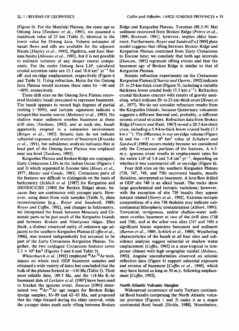
North Atlantic Volcanic Margins Widespread occurrence of early Tertiary continen-
tal flood basalts comprising the North Atlantic volca- nic province (Figures 1 and 3) ranks it as a major continental flood basalt [Dickin, 1988]. Nonetheless,
14 ß Coffin and Eldholm' LARGE IGNEOUS PROVINCES 32, 1 / REVIEWS OF GEOPHYSICS
-lO o
Figure 7. Extent of early Tertiary basalts plotted on a reconstruction at ---3 m.y. after breakup [after Eldholm and Grue, 1993]. Double circle indicates initial Iceland hots-
pot location interpreted by White and McK- enzie [1989]. BB indicates Baffin Bay ba- salts.
its area is smaller than that of the Columbia River
basalts, and its volume is only ---2.3 x 10⁵ km 3. Drilling and seismic data show that subsequent to Late Creta- ceous-Paleocene uplift coeval with rifting (synrift), continental breakup was accompanied by massive vol- canic activity which formed oceanic crust above or just below sea level along the almost 3000-km-long rifted plate boundary (Figure 7) [e.g., Eldholm et al., 1989].
Calculations of North Atlantic volcanic province dimensions, including the coeval volcanic margins, show its main part lies offshore [Eldholm and Grue, 1993]. By including continental crust covered by flood basalt and oceanic crust emplaced during the transient event, the area presently covered by extrusives is > 1.3 x 10 6 km 2 (Figures 6 and 7 and Table 3). The total crustal volume of---6.6 x 10 6 km 3 is based on velocity profiles along margin transects (e.g., Figure 5) and includes expanded oceanic crust, parts of the extrusive cover and the lower crustal body extending landward of the defined continent-ocean transition, and onshore flood basalts. Our values are minima, be- cause the amount of melt intruded into continental crust
after breakup cannot yet be calculated. Nevertheless, the North Atlantic volcanic province ranks among the world's most prominent volcanic margin LIPs.
Sediment-covered lavas on the margin form a smooth acoustic basement locally underlain by intra- basement reflectors, including the series of seaward dipping reflectors typical of volcanic margins (Figure 4) [Hinz, 1981; Coffin and Eldholm, 1992]. The igneous event also included sills and dikes in the continental
crust, as well as subextrusive thickened crust which in most places contains a lower crustal body (Figure 5). We note that igneous crust associated with volcanic passive margins in particular and LIPs in general, need
not be characterized by dipping and/or layered reflec- tions; these wedges are only the most prominent and recognizable component of the magmatic events.
Temporally, the igneous activity has two compo- nents. Along an almost 3000-km-long rifted plate boundary, lavas were extruded largely subaerially be- tween 57.5 and 54.5 Ma (timescale of Berggren et al. [1985]), with most lavas having erupted during chron 24r. This transient component contrasts with the cen- tral region, where conjugate continental flood basalts are connected by the broad submarine ridge on which Iceland lies (Figures 1 and 3). The ridge reflects the persistent subaerial volcanism over ---60 m.y. that is commonly attributed to the Iceland plume.
On the Norwegian margin, site 642 on the inner dipping wedge (e.g., Figure 4) and 643 on crust formed ---3 m.y. after breakup have provided key information about early Tertiary environments [Eldholm et al., 1989] by penetrating an entire (800 m) seaward-dipping wedge below early Eocene basal sediment. This sedi- ment includes continental soils formed under a hot, seasonably humid climate overlain by restricted ma- rine facies [Thiede et al., 1989]. Volcanism abated 2-3 m.y. after breakup, and the injection center sub- merged with sporadic but waning volcanism. Subse- quently, a deepwater injection center developed, leav- ing an isostatically compensated igneous complex trailing behind new oceanic crust accreted at a normal spreading axis. As the ocean basin matured, the high subsided at rates similar to normal oceanic crust,
maintaining the difference in basement relief. The wedge is composed of transitional mid-ocean
ridge basalts and altered, interbedded, basaltic vitric tuffs. Many flows have reddened tops, while some flows and sediments indicate shallow marine deposi-
32, 1 / REVIEWS OF GEOPHYSICS Coffin and Eldholm' LARGE IGNEOUS PROVINCES ß 15
tional environments. Subaerial and neritic environ-
ments are inferred during and subsequent to breakup when the wedge was constructed by an intense phase of explosive, subaerial volcanism. The basalt rests on dacitic lavas, emplaced by infrequent eruptions during the late rift stage, and interbedded sediments indicat- ing fluvial or shallow-water deposition.
Continental Flood Basalts
The Deccan traps, covering ---5 x 10⁵ km 2 in west- ern India (Figure 3), may have covered >1.5 x 10⁶ km 2 prior to erosion (Figure 6 and Table 3) [Mahoney, 1988]. These estimates do not include any offshore component of Deccan magmatism, which is suggested by seaward-dipping reflectors on the Indian margin [Hinz, 1981]. At the time of eruption, the Seychelles were attached to India; the coeval basalt there is esti- mated to cover 2.5 x 10⁵ km 2 [Devey and Stephens, 1992]. Apparently, the Deccan volcanic event covered a much larger area than reported in the literature, although a paucity of data offshore India and on the Mascarene Plateau preclude estimating both the area and volume of the total event.
The Deccan traps are predominantly tholeiitic basalts, although alkalic, felsic, and ultramafic intrusive suites form lithologically distinct but volumetrically negligible components [Mahoney, 1988]. Trace elements and iso- topic ratios vary considerably within the province, and bulk compositions change as well, but most evidence suggests that the depleted source of most tholelites is homogeneous, arguing that continental lithosphere is not the major basalt source. According to Biswas and Tho- mas [1992], most basalt erupted between 65 and 69 Ma, while Baksi [1990] and Vandamme et al. [1991] suggest a period of < 1 m.y. (Table 3). An 4øAr-39Ar date of 64 Ma has been reported from Mascarene Plateau basalts •500 km southwest of the Seychelles (Figure 1 and Table 1) [Duncan and Hargraves, 1990], implying that a signifi- cant portion of that feature may have been created by the transient Deccan event.
Verma and Banerjee [1992] have reviewed deep seismic reflection data and modeled gravity data across the Deccan traps. Interval velocities show lower crustal bodies (7.0-7.3 km s-I), but thicknesses are not well defined. Gravity modeling suggests an anomalously high density crustal body beneath the traps, but geometry is poorly constrained. We esti- mated a lower crustal body volume by applying the ratio of surface area to deep crustal volume for the Columbia River basalts to the original surface area of the Deccan flood basalts, excluding the Seychelles and the Mascarene Plateau (Figure 6). The total Deccan traps volume of 8.2 x 10 6 km 3 conservatively includes only extrusive rocks and lower crustal bodies. If the Deccan traps formed during 1- and 4-m.y. intervals, emplacement rates were 8.2 and 2.1 km 3 yr -• respec- tively (Figure 6 and Table 3).
Tolan et al. [1989] have calculated that the Colum-
bia River basalts (Figures 1 and 3) once covered 1.64 x 10⁵ km 2 (Figure 6 and Table 3) With an extrusive volume of 1.74 x 10⁵ km 3. A seismic refraction profile across the Columbia Plateau shows a lower crustal
body (7.5 km s -1) (Figure 5) interpreted as a "rift pil- low" [Catchings and Mooney, 1988]. To calculate crustal volume beneath the extrusive cover, we assumed an identical configuration beneath the entire province. The total LIP volume amounts to 1.3 x 10⁶ km 3.
The great majority of Columbia River basalts are tholeiites, although some flows are characterized by transitional to alkali basalt mineralogy [Hooper, 1988]. Variable isotopic values and trace element ratios re- quire a variable source, either in the form of a heter- ogeneous mantle or different degrees of crustal con- tamination or both. Basalts range in age from 6 to 17.5
ß
Ma, but most erupted between 15.7 and 17.2 Ma [Baksi, 1989]. Corresponding emplacement rates are 0.1-0.9 km 3 yr -• (Figure 6).
Discussion
Areas and volumes of transient LIPs (Figure 6), as well as previous estimates for other continental flood basalts [e.g., White and McKenzie, 1989], reveal vari- ations over ! to 2 orders of magnitude. Crustal struc- tures of the three main LIP types are similar, compris- ing an extrusive upper crest (Figure 4) and a lower crust (Figure 5) characterized by high seismic veloci- ties (7.0-7.6 km s-•), and differ from "normal" oce- anic or continental crust. Thus these LIPs may share a common genesis. Construction of the largest igneous provinces during transient magmatic episodes signifi- cantly increases global crustal production rates (Fig- ure 2). The North Atlantic volcanic province and re- cent studies of the U.S. East Coast continental margin [Holbrook and Kelemen, 1993] show that volcanic margins must be included in the LIP inventory.
Compressional wave velocities of 7.0-7.6 km s -• in lower crustal bodies are not those of normal oceanic or
continental crust, although they are found in some continental settings, mainly beneath rifts [e.g., Catch- ings and Mooney, 1988]. Composition of lower crustal bodies on volcanic margins is unknown; gabbroic, strongly mafic, and hot ultramafic rocks are possibili- ties [Meissner and K6pnick, 1988]. Some lower crustal bodies have been explained as magmatic underplating by accumulating mantle-derived material below the original crust [Large Aperture Seismic Experiments (LASE) Study Group, 1986; White et al., 1987]. Un- derplating suggests emplacement of mafic magma at the base of continental crust [Furlong and Fountain, 1986]. Density contrasts between the old crust and the melt determine whether melts are ponded below the crust or intruded into the crust [Herzberg et al., 1983]. For example, White and McKenzie [1989] suggested that decompressional melting of hot asthenospheric mantle would produce 7.1- to 7.2-km s -• velocities in ponded basaltic melt because of increased MgO con-
16 ß Coffin and Eldholm: LARGE IGNEOUS PROVINCES 32, 1 / REVIEWS OF GEOPHYSICS
tent. Thus underplating should only occur beneath continental crust, contradicting observed lower crustal body continuity into oceanic crest in the North Atlan- tic [Eldholm and Grue, 1993] and off the U.S. East Coast [LASE Study Group, 1986; Tr•hu et al., 1989].
The underplating hypothesis suggests that melts are trapped by a crustal density filter during rifting. Fol- lowing breakup, no such filter exists in oceanic crust, although similar anomalous velocity-density struc- tures are found beneath oceanic crust adjacent to vol- canic passive margins. Clearly, the underplating hy- pothesis does not adequately explain the occurrence of lower crustal bodies beneath oceanic crest. It is also
arguable whether magmatic underplating takes place when the crust is strongly attenuated, for example, during the late rift stage, because crustal strength rapidly becomes negligible when massive mafic up- welling reaches the brittle crust, causing the assump- tion of conductive heat transfer to break down [Dixon et al., 1989]. Although the lower crustal body is most likely emplaced during breakup, we consider the term "underplating" a misnomer.
Uncertainty in absolute dimensions, however, is dramatically illustrated by the biggest LIP, Ontong Java. We estimate a conservative volume based on
Airy isostasy, off-ridge emplacement, and a 3-m.y. magmatic event leading to an emplacement rate of 12.1 km 3 yr-• (Figure 6). On-ridge emplacement and refrac- tion Moho might increase the rate by a factor of 3 to --•36 km 3 yr -•. In addition, emplacement rate is par- ticularly sensitive to construction duration. For exam- ple, the alternate 0.5-m.y. duration considered by Tar- duno et al. [1991] results in an off-ridge emplacement rate of 72.8 km 3 yr -•. We stress, however, that well- dated basement at four sites over an area greater than half the size of the conterminous United States and
penetrating, at most, the upper --•0.5% of the total igneous section does not rule out a somewhat longer emplacement period, which would result in values resembling those of other LIPs.
Comparison of LIP crustal production with that of the global mid-ocean ridge system over the past 150 m.y. [Larson, 1991 a] (Figures 3 and 6) shows that the largest LIPs had the potential to significantly alter the hydrosphere and atmosphere through their mass, heat, chemical, fluid, and particulate fluxes during isolated time periods [e.g., Larson, 1991 a, b; Eldholm, 1990]. In this context, the extmsive crustal component is a key factor [e.g., Officer et al., 1987], and extrusive eruption rates for Deccan traps, North Atlantic volca- nic margins, and the two giant plateaus show less variability (0.3-2.6 km 3 yr -•) than do total crustal production rates [Eldholm and Grue, 1994]. This ob- servation, and the temporal correspondence of Deccan and North Atlantic eruptions with major environmen- tal change, may imply that LIPs smaller than Ontong Java have also contributed to these changes.
4. MANTLE DYNAMICS
LIPs are crustal manifestations of dynamic pro- cesses in the Earth's mantle; hence LIP parameters may be applied as boundary conditions to invert such processes. Presently, no consensus has developed concerning the nature and dimensions of mantle circu- lation required to emplace LIPs. In general, however, more effort has been devoted to development of man- tle models that may produce transient and/or persis- tent magmatism than to verification of such models through tests employing geological data. Despite the fragmented nature of the LIPs global database, data exist that directly or indirectly relate LIPs to mantle pro- cesses. Particularly relevant are (1) dimensions and em- placement rates (see section 3), (2) composition of the igneous complexes (see sections 2 and 3), (3) spatial location relative to known hotspots (see section 2), and (4) geological setting prior to and during emplacement (in particular, the relationship of LIPs to rifting and other types of lithospheric deformation) (see section 2).
Transient LIPs exist on many scales, reflecting a wide size range of mantle melt anomalies. Recognition of this dimensional variability is fundamental in eval- uating mantle processes leading to LIP emplacement. Volumetric variations among LIPs (Figure 6 and Table 3) are influenced by at least three factors: mantle source intensity, vulnerability of the lithosphere to asthenos- pheric penetration, and lithospheric plate speed over the source. Seismic tomography provides a broad, three-dimensional measure of source intensity, that is, volumes and relative magnitudes of asthenospheric ther- mal anomalies. The method outlines such features as
mid-ocean ridges, dead slabs, and cratons. Global stud- ies indicate that the upper mantle is dominated by sub- duction, whereas upwelling appears to dominate circu- lation in the lower mantle. It appears that the main mode of mantle convection is flow controlled and scaled by plates [e.g., Dziewonski and Woodhouse, 1987;Ander- son et al., 1992a; Davies and Richards, 1992].
Lithospheric vulnerability is somewhat difficult to assess; it was once thought that younger lithosphere should be more vulnerable than older lithosphere to asthenosphere-derived volcanism [Gass et al., 1978; Pollack et al., 1981; Vogt, 1981], but recent analyses of present-day heat flux from oceanic lithosphere sug- gest rather a correlation between plate speed and vul- nerability [Sleep, 1990; McNutt, 1990]. Absolute global plate motions in the hotspot reference frame are well constrained for the past --•90 m.y. [e.g., Miiller et al., 1993]; plate speed over the source does not appear to influence the volumes of transient features. How-
ever, lithospheric structures, for example, fracture zones and rifts, may act as preferential conduits for asthenospheric melts [Sykes, 1978; Okal and Batiza, 1987;McNutt et al., 1989]. In most intraplate settings, melting of the plume head is inhibited by the > 125- km-thick mechanical boundary layer. Therefore Kent
32, 1 / REVIEWS OF GEOPHYSICS Coffin and Eldholm: LARGE IGNEOUS PROVINCES ß 17
et al. [1992] proposed a plume incubation period to thin and partly remove the boundary layer prior to massive continental flood basalt production.
Mantle Convection and Plumes
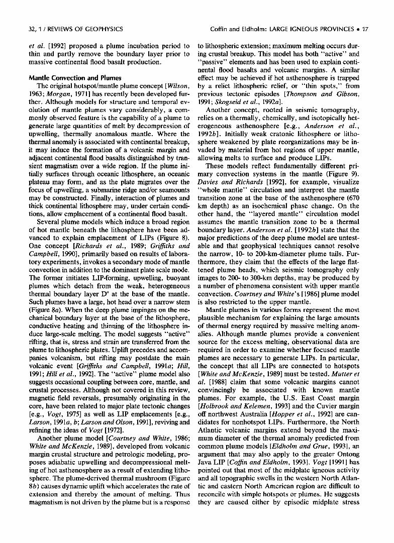
The original hotspot/mantle plume concept [Wilson, 1963; Morgan, 1971] has recently been developed fur- ther. Although models for structure and temporal ev- olution of mantle plumes vary considerably, a com- monly observed feature is the capability of a plume to generate large quantities of melt by decompression of upwelling, thermally anomalous mantle. Where the thermal anomaly is associated with continental breakup, it may induce the formation of a volcanic margin and adjacent continental flood basalts distinguished by tran- sient magmatism over a wide region. If the plume ini- tially surfaces through oceanic lithosphere, an oceanic plateau may form, and as the plate migrates over the focus of upwelling, a submarine ridge and/or seamounts may be constructed. Finally, interaction of plumes and thick continental lithosphere may, under certain condi- tions, allow emplacement of a continental flood basalt.
Several plume models which induce a broad region of hot mantle beneath the lithosphere have been ad- vanced to explain emplacement of LIPs (Figure 8). One concept [Richards et al., 1989; Griffiths and Campbell, 1990], primarily based on results of labora- tory experiments, invokes a secondary mode of mantle convection in addition to the dominant plate scale mode. The former initiates LIP-forming, upwelling, buoyant plumes which detach from the weak, heterogeneous thermal boundary layer D" at the base of the mantle. Such plumes have a large, hot head over a narrow stem (Figure 8a). When the deep plume impinges on the me- chanical boundary layer at the base of the lithosphere, conductive heating and thinning of the lithosphere in- duce large-scale melting. The model suggests "active" rifting, that is, stress and strain are transferred from the plume to lithospheric plates. Uplift precedes and accom- panies volcanism, but rifting may postdate the main volcanic event [Griffiths and Campbell, 1991a; Hill, 1991; Hill et al., 1992]. The "active" plume model also suggests occasional coupling between core, mantle, and crustal processes. Although not covered in this review, magnetic field reversals, presumably originating in the core, have been related to major plate tectonic changes [e.g., Vogt, 1975] as well as LIP emplacements [e.g., Larson, 1991a, b; Larson and Olson, 1991], reviving and refining the ideas of Vogt [1972].
Another plume model [Courthey and White, 1986; White and McKenzie, 1989], developed from volcanic margin crustal structure and petrologic modeling, pro- poses adiabatic upwelling and decompressional melt- ing of hot asthenosphere as a result of extending litho- sphere. The plume-derived thermal mushroom (Figure 8b) causes dynamic uplift which accelerates the rate of extension and thereby the amount of melting. Thus magmatism is not driven by the plume but is a response
to lithospheric extension; maximum melting occurs dur- ing crustal breakup. This model has both "active" and "passive" elements and has been used to explain conti- nental flood basalts and volcanic margins. A similar effect may be achieved if hot asthenosphere is trapped by a relict lithospheric relief, or "thin spots," from previous tectonic episodes [Thompson and Gibson, 1991; Skogseid et al., 1992a].
Another concept, rooted in seismic tomography, relies on a thermally, chemically, and isotopically het- erogeneous asthenosphere [e.g., Anderson et al., 1992b]. Initially weak cratonic lithosphere or litho- sphere weakened by plate reorganizations may be in- vaded by material from hot regions of upper mantle, allowing melts to surface and produce LIPs.
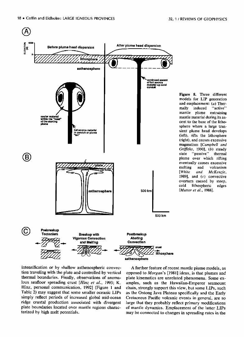
These models reflect fundamentally different pri- mary convection systems in the mantle (Figure 9). Davies and Richards [1992], for example, visualize "whole mantle" circulation and interpret the mantle transition zone at the base of the asthenosphere (670 km depth) as an isochemical phase change. On the other hand, the "layered mantle" circulation model assumes the mantle transition zone to be a thermal
boundary layer. Anderson et al. [ 1992b] state that the major predictions of the deep plume model are untest- able and that geophysical techniques cannot resolve the narrow, 10- to 200-km-diameter plume tails. Fur- thermore, they claim that the effects of the large flat- tened plume heads, which seismic tomography only images to 200- to 300-km depths, may be produced by a number of phenomena consistent with upper mantle convection. Courthey and White's [1986] plume model is also restricted to the upper mantle.
Mantle plumes in various forms represent the most plausible mechanism for explaining the large amounts of thermal energy required by massive melting anom- alies. Although mantle plumes provide a convenient source for the excess melting, observational data are required in order to examine whether focused mantle plumes are necessary to generate LIPs. In particular, the concept that all LIPs are connected to hotspots [White and McKenzie, 1989] must be tested. Mutter et al. [1988] claim that some volcanic margins cannot convincingly be associated with known mantle plumes. For example, the U.S. East Coast margin [Holbrook and Kelemen, 1993] and the Cuvier margin off northwest Australia [Hopper et al., 1992] are can- didates for nonhotspot LIPs. Furthermore, the North Atlantic volcanic margins extend beyond the maxi- mum diameter of the thermal anomaly predicted from common plume models [Eldholm and Grue, 1993], an argument that may also apply to the greater Ontong Java LIP [Coffin and Eldholm, 1993]. Vogt [1991] has pointed out that most of the midplate igneous activity and all topographic swells in the western North Atlan- tic and eastern North American region are difficult to reconcile with simple hotspots or plumes. He suggests they are caused either by episodic midplate stress
18 ß Coffin and Eldholm' LARGE IGNEOUS PROVINCES 32, 1 / REVIEWS OF GEOPHYSICS
Before plume head dispersion
lithosphere
asthenosphere
cooler material within the "head" of the starting plume
hot source material in conduit or plume "tall"
asthenosphere
After plume head dispersion
ascent o! hot source material up axial conduit
500 km
500 km
Figure 8. Three different models for LIP generation and emplacement: (a) Ther- mally induced "active" mantle plume entraining mantle material during its as- cent to the base of the litho-
sphere where a large tran- sient plume head develops (left), rifts the lithosphere (right), and causes excessive magmatism [Campbell and Grijfiths, 1990], (b) steady state "passive" thermal plume over which rifting eventually causes excessive melting and volcanism [White and McKenzie, 1989], and (c) convective overturn caused by steep, cold lithospheric edges [Mutter et al., 1988].
Prebreakup Tectonism Breakup with
Vigorous Convection and Melting
Postbreakup Abating
Convection
•• crust lithosphere
asthenosphere
intensification or by shallow asthenospheric convec- tion traveling with the plate and controlled by vertical thermal boundaries. Finally, observations of anoma- lous seafloor spreading crust [Hinz et al., 1993; K. Hinz, personal communication, 1992] (Figure 1 and Table 2) may suggest that some smaller oceanic LIPs simply reflect periods of increased global mid-ocean ridge crustal production associated with divergent plate boundaries located over mantle regions charac- terized by high melt potentials.
A further feature of recent mantle plume models, as opposed to Morgan's [1981] ideas, is that plumes and plate kinematics are unrelated phenomena. Some ex- amples, such as the Hawaiian-Emperor seamount chain, strongly support this view, but some LIPs, such as the Ontong Java Plateau specifically and the Early Cretaceous Pacific volcanic events in general, are so large that they probably reflect primary modifications of mantle dynamics. Emplacement of the latter LIPs may be connected to changes in spreading rates in the
32, I / REVIEWS OF GEOPHYSICS Coffin and Eldholm: LARGE IGNEOUS PROVINCES ß 19
I mid-ocean • Litho•sphere
Layered-mantle riag••__--• ups,
plume
Whole-mantle circulation
descending plate
Figure 9. Cartoons of (left) layered [e.g., Anderson et al., 1992a, b] and (fight) whole [e.g., Davies and Ri- chards, 1992] mantle circula- tion.
Early Cretaceous Pacific (W. J. Morgan, personal communication, 1990); one suggestion is that spread- ing rates increased during the Cretaceous magnetic quiet zone, because excessive plume melt lowered asthenospheric viscosity and hence resistance to plate motion (R. L. Larson, personal communication, 1993). Although some workers have proposed that plate re- adjustments may in places tap anomalously hot mantle and thus initiate a LIP [e.g., Anderson et al., t992a, b], such a model has yet to be rigorously tested. Other work has indicated that mantle plumes such as Hawaii must deflect in response to changes in direction of plate motion and that the shape of the bend in the surface track reflects this readjustment [Griffiths and Richards, 1989].
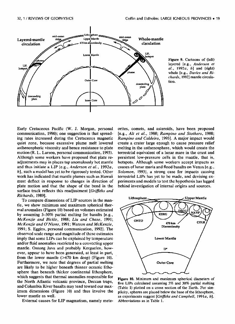
To compare dimensions of LIP sources in the man- tle, we show minimum and maximum spherical ther- mal anomalies (Figure t0) based on volumes estimated by assuming 5-30% partial melting for basalts [e.g., McKenzie and Bickle, 1988; Liu and Chase, 1991; McKenzie and O'Nions, 1991; Watson and McKenzie, 1991; S. Eggins, personal communication, 1992]. The observed scale range and magnitude of these estimates imply that some LIPs can be explained by temperature and/or fluid anomalies restricted to a convecting upper mantle. Ontong Java and probably Kerguelen, how- ever, appear to have been generated, at least in part, from the lower mantle (>670 km deep) (Figure t0). Furthermore, we note that degrees of partial melting are likely to be higher beneath thinner oceanic litho- sphere than beneath thicker continental lithosphere, which suggests that thermal anomalies responsible for the North Atlantic volcanic province, Deccan traps, and Columbia River basalts may tend toward our max- imum dimensions (Figure t0) and thus involve the lower mantle as well.
External causes for LIP magmatism, namely mete-
orites, comets, and asteroids, have been proposed [e.g., Altet al., 1988; Rampino and Stothers, 1988; Rampino and Caldeira, 1993]. A major impact would create a crater large e.nough to cause pressure relief melting in the asthenosphere, which would create the terrestrial equivalent of a lunar mare in the crust and persistent low-pressure cells in the mantle, that is, hotspots. Although some workers accept impacts as causes of lunar maria and flood basalts on Venus [e.g., Solomon, 1993], a strong case for impacts causing terrestrial LIPs has yet to be made, and devising ex- periments and models to test the hypothesis has lagged behind investigation of internal origins and sources.
Lithosphere Upper Mantle
ONTO 670 km
Discontinuity
COLR
Lower Mantle
Outer Core
Figure 10. Minimum and maximum spherical diameters of five LIPs calculated assuming 5% and 30% partial melting (Table 1) plotted on a cross section of the Earth. For sim- plicity, spheres are placed below the base of the lithosphere, as experiments suggest [Griffiths and Campbell, 1991a, b]. Abbreviations as in Table 1.
20 ß Coffin and Eldholm: LARGE IGNEOUS PROVINCES 32, 1 / REVIEWS OF GEOPHYSICS
Lithospheric Deformation: Uplift, Extension, Rifting, and Subsidence
Whether rifting precedes or accompanies emplace- ment of oceanic plateaus in intraplate settings is not possible to evaluate from available data. Where the mantle thermal anomaly is associated with continental breakup or located below thick continental crust, how- ever, the relationship between thermal plumes and rifting has been much debated [e.g., Duncan and Ri- chards, 1991; Hill, 1991; Hill et al., 1992]. We have previously shown that for LIPs erupted both in intra- plate and plate boundary settings, the tectonomag- matic history of LIP formation depends on interaction of the mantle asthenosphere anomaly, configuration and composition of mantle lithosphere and crust, and the amount of stress in the lithosphere. Nonetheless, one would expect volcanism and faulting to precede active rifting, while they would follow passive rifting [Dixon et al., 1989].
The main tholeiitic phases of many continental flood basalts, such as Columbia River [Hooper, 1990], Deccan [Hooper, 1990], and Siberian [Campbell et al., 1992], were erupted in what have been interpreted as largely nonextensional settings [Hill, 1991;Hill et al., 1992]. Other investigators connect continental flood basalts to rifting: examples are Paranti [Peate et al., 1990; Kazmin, 1991; Harry and Sawyer, 1992; Renne et al., 1992], Karoo [Kazmin, 1991], and Deccan [Ka- zmin, 1991; Biswas and Thomas, 1992]. Because many continental flood basalts show little evidence of litho-
spheric extension, Duncan and Richards [1991] con- clude that they result from melting events at the base of the lithosphere, whether or not such thermal events precipitate subsequent rifting. On the other hand, a nonextensional setting can probably only be expected if plume impingement at the base of the lithosphere and volcanism are nearly coeval events, whereas a more protracted deformation period, for example, the plume incubation model of Kent et al. [1992], would lead to regional uplift, extension, and intrusion of alkalic melts prior to volcanism. From field evidence in the Siberian, Karoo, Paranti, Rajmahal-Kerguelen, and Deccan-Seychelles-Mascarene Plateau continen- tal flood basalt provinces, Kent et al. [1992] conclude that the latter emplacement history is most appropriate for continental flood basalts.
Various plume and upwelling models may all be applied to asthenospheric behavior during formation of volcanic margins. However, Mutter et al. [1988] have proposed an alternative model depending on de- velopment of short-lived, small-scale convection close to the trailing edges of cold, thick continental litho- sphere (Figure 8c). Convection induces a pulse of excess magmatism during the onset of seafloor spread- ing. This entirely "passive" model, derived from data on the North Atlantic V0ring and northwest Australian margins [Hopper et al., 1992] and driven by plate separation, does not require increased mantle temper-
atures, although they would facilitate large melt vol- umes. Implicitly, it requires little lithospheric exten- sion prior to a relatively sudden breakup. However, recent work by Skogseid et al. [ 1992a] on the V0ring margin and its conjugate records a 16- to 18-m.y. rift phase prior to excess magmatism during and subse- quent to early Tertiary continental breakup. Further- more, they suggest that Late Cretaceous-Paleocene North Atlantic rifting affected a 300- to 350-km-wide crustal region. The rift zone is thus wider than the thickness of the lithosphere, and a wide region of asthenospheric upwelling has been predicted by El- dholm and Grue [1994], applying the concept of Keen [1987]. As the region of lithospheric extension nar- rowed and the deformation rate increased with time, melt production also increased, climaxing during breakup. Alkali basalts and gabbros, emplaced in con- tinental crust, were produced during early rifting and for low stretching factors; melts became tholeiitic when the lithosphere was extended further [McKenzie and Bickle, 1988]. Final crustal extension, or the late rift stage leading to breakup, occurred rapidly, and the main excess melts may have surfaced within ---1 m.y. [McKenzie, 1984].
Each mantle plume model should predict character- istic lithospheric uplift and subsidence histories asso- ciated with LIP emplacement and evolution. Experi- mental results of "active" plume modeling predict surface uplift on a wavelength comparable to the di- ameter of the plume, uplift which commences before extension and ---25 m.y. prior to maximum uplift (Fig- ure 11a) [e.g., Griffiths and Campbell, 1991a]. The uplift is controlled by the buoyancy of the hot plume material and lateral variation in lithospheric rheology and thickness. Maximum uplift can reach 1000 m in continental, and likely more in oceanic, lithosphere and precedes initiation of major basaltic volcanism by 3 to 30 m.y. [Hill et al., 1992]. Results of numerical "active" plume modeling demonstrate that a plethora of uplift and subsidence histories are possible, given various lithospheric ages, plate speeds, and many more loosely constrained model parameters [Mon- nereau et al., 1993].
Volcanism is a "passive" response to lithospheric thinning in White and McKenzie' s [1989] plume model; they predict that the bulk of LIP emplacement occurs contemporaneous with the main rifting. Uplift and subsidence are affected by lithospheric thinning, addi- tion to the crust of igneous material produced by adiabatic decompression, dynamic support of the man- tle plume, and reduction in density of residual mantle after removal of melt. Interaction of the various fac-
tors produces a variety of uplift and subsidence mod- els (Figure 11 b). Uplift and subsidence histories have not yet been predicted for the Mutter et al. [1988] and Anderson et al. [1992a, b] models.
Data with which to test the various models' uplift and subsidence histories are sparse. The geological
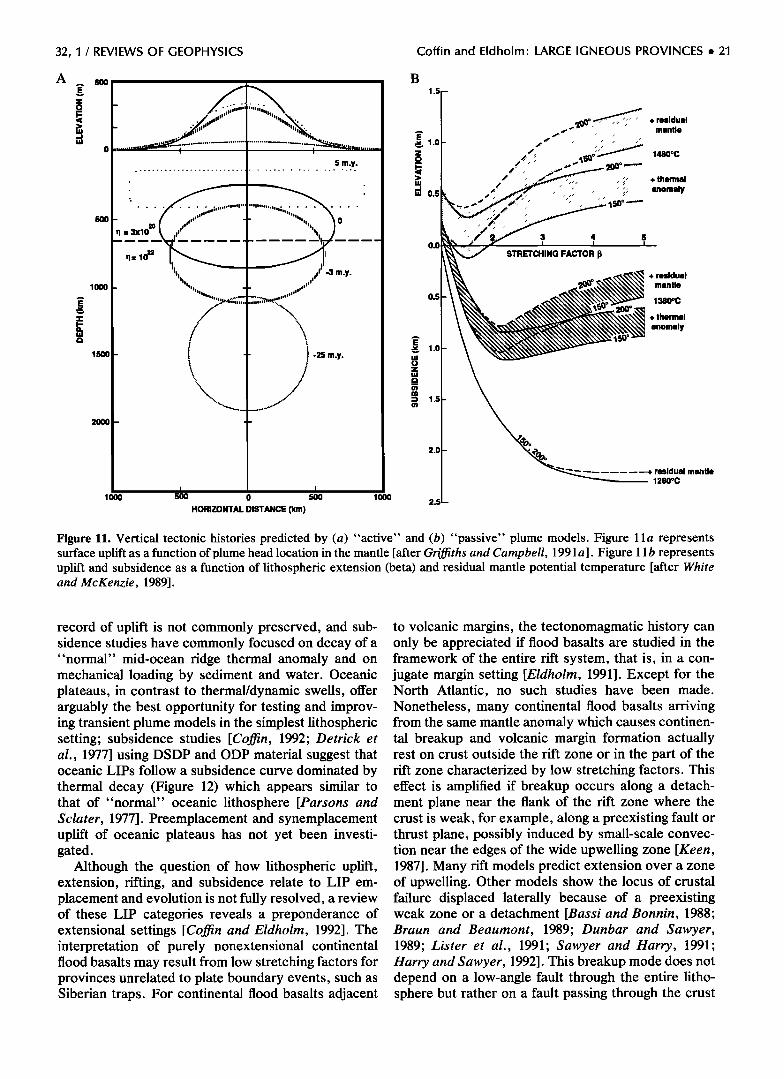
32, I / REVIEWS OF GEOPHYSICS Coffin and Eldholm' LARGE IGNEOUS PROVINCES ß 21
A
lOOO
15oo
2ooo
5 m.y.
ß
ß
..........
_ ill II
•1 = 3x10²ø •l=102•
. lilttill I . ............
/
- i '
? -3 m.y. -
\
I-:25 m.y. /
/
,.///
I I 1000 500 0 500 1000
HORIZONTAL DISTANCE (km)
B
0.0
0.5
2.0
2.5
================================================================================ =========================================================================================
:.:.:.:.:.:.:.:.: ./.-.'ii ......... :::::::::::::::::::::
....... :::::::::::::::::::::::::::::::::::::::::::::::::::::::::: + thermal .............
....................
3 4
STRETCHING FACTOR
+ residual mantle
1360øC
+ thermal
anomaly
residual mantle 1280oC
Figure 11. Vertical tectonic histories predicted by (a) "active" and (b) "passive" plume models. Figure 1 la represents surface uplift as a function of plume head location in the mantle [after Griffiths and Campbell, 1991 a]. Figure 11 b represents uplift and subsidence as a function of lithospheric extension (beta) and residual mantle potential temperature [after White and McKenzie, 1989].
record of uplift is not commonly preserved, and sub- sidence studies have commonly focused on decay of a "normal" mid-ocean ridge thermal anomaly and on mechanical loading by sediment and water. Oceanic plateaus, in contrast to thermal/dynamic swells, offer arguably the best opportunity for testing and improv- ing transient plume models in the simplest lithospheric setting; subsidence studies [Coffin, 1992; Derrick et al., 1977] using DSDP and ODP material suggest that oceanic LIPs follow a subsidence curve dominated by thermal decay (Figure 12) which appears similar to that of "normal" oceanic lithosphere [Parsons and Sclater, 1977]. Preemplacement and synemplacement uplift of oceanic plateaus has not yet been investi- gated.
Although the question of how lithospheric uplift, extension, rifting, and subsidence relate to LIP em- placement and evolution is not fully resolved, a review of these LIP categories reveals a preponderance of extensional settings [Coffin and Eldholm, 1992]. The interpretation of purely nonextensional continental flood basalts may result from low stretching factors for provinces unrelated to plate boundary events, such as Siberian traps. For continental flood basalts adjacent
to volcanic margins, the tectonomagmatic history can only be appreciated if flood basalts are studied in the framework of the entire rift system, that is, in a con- jugate margin setting [Eldholm, 1991]. Except for the North Atlantic, no such studies have been made. Nonetheless, many continental flood basalts arriving from the same mantle anomaly which causes continen- tal breakup and volcanic margin formation actually rest on crust outside the rift zone or in the part of the rift zone characterized by low stretching factors. This effect is amplified if breakup occurs along a detach- ment plane near the flank of the rift zone where the crust is weak, for example, along a preexisting fault or thrust plane, possibly induced by small-scale convec- tion near the edges of the wide upwelling zone [Keen, 1987]. Many rift models predict extension over a zone of upwelling. Other models show the locus of crustal failure displaced laterally because of a preexisting weak zone or a detachment [Bassi and Bonnin, 1988; Braun and Beattrnont, 1989; Dunbar and Sawyer, 1989; Lister et al., 1991; Sawyer and Harry, 1991; Harry and Sawyer, 1992]. This breakup mode does not depend on a low-angle fault through the entire litho- sphere but rather on a fault passing through the crust
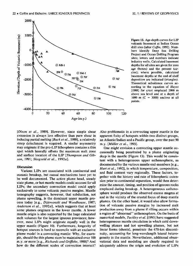
22 ß Coffin and Eldholm' LARGE IGNEOUS PROVINCES 32, I / REVIEWS OF GEOPHYSICS
-1 ©
•©
-40!
756 (•) SM-1
•> ©7o7 214
(•) 706 715
713
0 20 40 60 80
Age (m.y.)
(•) 216
(•> 758
749
© 747
(•> 750
lOO 12o
Figure 12. Age-depth curves for LIP volcanic basement at Indian Ocean
drill sites [after Coffin, 1992]. Num- bers identify Deep Sea Drilling Project and Ocean Drilling Program sites; letters and numbers indicate industry wells. Calculated basement depths for all sites are given for zero age (boxes) and the present (cir- cles); where possible, calculated basement depths at the end of shelf deposition are indicated (triangles). Theoretical subsidence curves ac-
cording to the equation of Hayes [1988] for crust emplaced 2000 m above sea level and at a depth of 1000 m (C = 3000) enclose at all points.
[Dixon et al., 1989]. However, since simple shear extension is always less effective than pure shear in inducing partial melting [Buck et al., 1988], a relatively steep detachment is required. A similar asymmetry may originate if the pre-LIP lithosphere contains a thin spot which laterally offsets the maximum melt zone and surface location of the LIP [Thompson and Gib- son, 1991; Skogseid et al., 1992a].
Discussion
Various LIPs are associated with continental and
oceanic breakup, but causal mechanisms have yet to be well documented. The active plume head, steady state plume, or hot mantle models could account for all LIPs; the secondary convection model could apply exclusively to some volcanic passive margins. Mantle tomography suggests, however, that subduction, not plume upwelling, is the dominant upper mantle pro- cess today [e.g., Dziewonski and Woodhouse, 1987; Anderson et al., 1992a], which suggests that at least some plumes originate in the lower mantle. A lower mantle origin is also supported by the huge calculated
Also problematic in a convecting upper mantle is the apparent fixity of hotspots within two distinct groups, an Atlantic/Indian and a Pacific group, over the past 90 m.y. [Mt;iller et al., 1993].
One might envision a convecting upper mantle oc- casionally being penetrated by a plume originating deep in the mantle (Figure 13). This would be consis- tent with a heterogeneous upper asthenosphere, as documented by the various mantle end-members [e.g., Hart et al., 1992], in which temperature, composition, and fluid content vary regionally. These factors, to- gether with the history and rate of lithospheric exten- sion prior to continental separation, would then deter- mine the amount, timing, and position of igneous rocks emplaced during breakup. A heterogeneous astheno- sphere would produce the observed excess magma at and in the vicinity of the crustal focus of deep mantle plumes. On the other hand, it would also allow forma- tion of volcanic passive margins by increased melt production away from a plume if rifting occurs within a region of " abnormal" asthenosphere. On the basis of
melt volumes for the largest igneous provinces; how- numerical models, Tackley et al• [1993] have suggested ever, most LIPs might originate equally well in the upper mantle (Figure 10). Furthermore, longevity of hotspot sources is hard to reconcile with an exclusive plume model in a convecting mantle: Why, for exam- ple, should the thin plume stem be maintained over 100 m.y. or more [e.g., Richards and Griffiths, 1988]? And how do the different scales of convection interact?
heterogeneous mantle circulation in which cold down- welling plumes and hot upwelling plumes, but not linear forms (sheets), penetrate the 670-km disconti- nuity, accounting for long-wavelength lateral hetero- geneity in the mantle. Nevertheless, additional obser- vational data and modeling are clearly required to adequately address the origin and evolution of LIPs
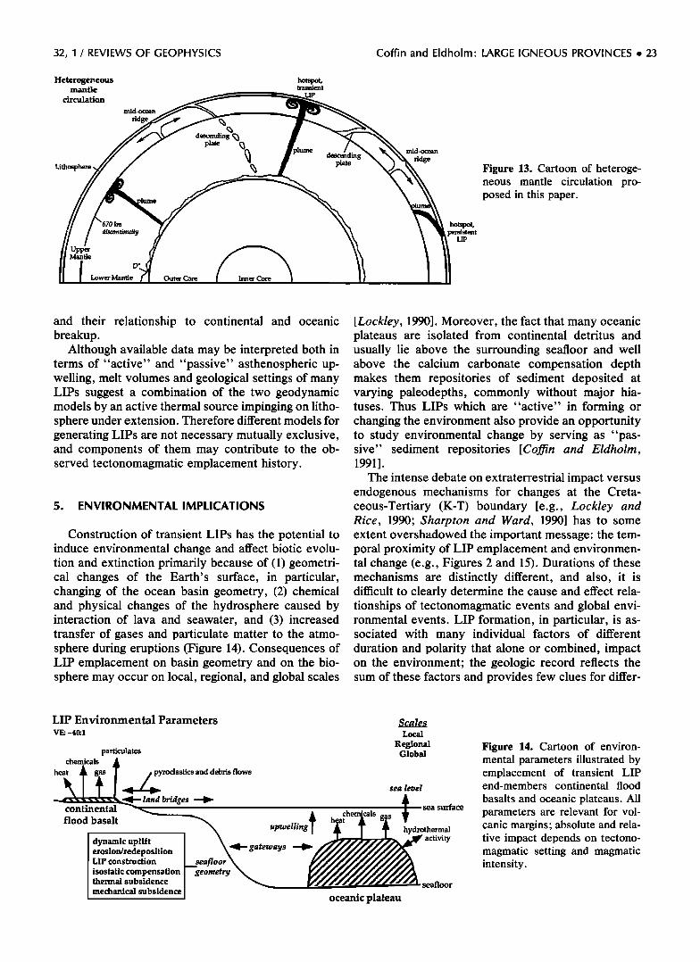
32, 1 / REVIEWS OF GEOPHYSICS Coffin and Eldholm- LARGE IGNEOUS PROVINCES ß 23
Heterogeneous mantle
circulation
Lithosphere
mid-ocean
ridge
descending
plate
hotspot, transient
LIP
Dlume
km
discontinuity
Upper lnn• Mantle
D'
Lower Mantle Outer Core
plate
mid-ocean
ridge
hotspot,
LIP
Figure 13. Cartoon of heteroge- neous mantle circulation pro- posed in this paper.
and their relationship to continental and oceanic breakup.
Although available data may be interpreted both in terms of "active" and "passive" asthenospheric up- welling, melt volumes and geological settings of many LIPs suggest a combination of the two geodynamic models by an active thermal source impinging on litho- sphere under extension. Therefore different models for generating LIPs are not necessary mutually exclusive, and components of them may contribute to the ob- served tectonomagmatic emplacement history.
5. ENVIRONMENTAL IMPLICATIONS
Construction of transient LIPs has the potential to induce environmental change and affect biotic evolu- tion and extinction primarily because of (1) geometri- cal changes of the Earth's surface, in particular, changing of the ocean basin geometry, (2) chemical and physical changes of the hydrosphere caused by interaction of lava and seawater, and (3) increased transfer of gases and particulate matter to the atmo- sphere during eruptions (Figure 14). Consequences of LIP emplacement on basin geometry and on the bio- sphere may occur on local, regional, and global scales
[Lockley, 1990]. Moreover, the fact that many oceanic plateaus are isolated from continental detritus and usually lie above the surrounding seafloor and well above the calcium carbonate compensation depth makes them repositories of sediment deposited at varying paleodepths, commonly without major hia- tuses. Thus LIPs which are "active" in forming or changing the environment also provide an opportunity to study environmental change by serving as "pas- sive" sediment repositories [Coffin and Eldholm, 1991].
The intense debate on extraterrestrial impact versus endogenous mechanisms for changes at the Creta- ceous-Tertiary (K-T) boundary [e.g., Lockley and Rice, 1990; Sharpton and Ward, 1990] has to some extent overshadowed the important message: the tem- poral proximity of LIP emplacement and environmen- tal change (e.g., Figures 2 and 15). Durations of these mechanisms are distinctly different, and also, it is difficult to clearly determine the cause and effect rela- tionships of tectonomagmatic events and global envi- ronmental events. LIP formation, in particular, is as- sociated with many individual factors of different duration and polarity that alone or combined, impact on the environment; the geologic record reflects the sum of these factors and provides few clues for differ-
LIP Environmental Parameters VE: -40:1
particulates chemicals
heat •yroclastics and debris flows land bridges •
continental
flood basalt
dynamic uplift erosion/redeposition LIP construction
isostatic compensation thermal subsidence
mechanical subsidence
upwelling• gateways
geometry
Scales Local
Regional Global
sea level
sea surface
hydrothermal activity
oceanic plateau
seafloor
Figure 14. Cartoon of environ- mental parameters illustrated by emplacement of transient LIP end-members continental flood
basalts and oceanic plateaus. All parameters are relevant for vol- canic margins; absolute and rela- tive impact depends on tectono- magmatic setting and magmatic intensity.
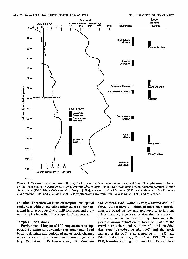
24 ß Coffin and Eldholm: LARGE IGNEOUS PROVINCES 32, I / REVIEWS OF GEOPHYSICS
Sea Level Large Atlantic 5]s0 (meters above present-day) Igneous
4 3 2 1 0 -1 0 50 100 150 200 250 Extinctions Provinces
o I ' i '-•'• '1' ''1 10 • Ead•;Middle ! Miocene 1 20 Columbia River
3O
• Eocene- I Oiigocene
4O
50
tlant•c • 60 •% Paleocene-Eocene-- ,
• aastrichtian-Danian 1 70 /
80"'1 Black Shales • Conlaoan • • ;oniacian •. Cenomanian-
90 1 -'• • Cenomanian- '• Turonian •
1 / Bae.,an- / / Ontong Java
30 1 / • Berriasian- I I I I '1 • Valanginian
,... Paleoternperature (øC, ice free) '•
150.-•
Figure 15. Cenozoic and Cretaceous climate, black shales, sea level, mass extinctions, and five LIP emplacements plotted on the timescale of Harland et al. [1990]. Atlantic •sO is after Raytoo and Ruddiman [1992], paleotemperature is after Arthur et al. [1985], black shales are after Jenkyns [1980], sea level is after Haq et al. [1987], extinctions are after Rampino and Stothers [1988] and Thomas [1992], LIP emplacements are from Coffin and Eldholm [1993] and this paper.
entiation. Therefore we focus on temporal and spatial similarities without excluding other causes either sep- arated in time or coeval with LIP formation and draw
on examples from the three major LIP categories.
Temporal Correlations Environmental impact of LIP emplacement is sup-
ported by temporal correlations of continental flood basalt volcanism and periods of major biotic changes or extinctions of terrestrial and marine organisms [e.g., Rich et al., 1986; Officer et al., 1987; Rampino
and Stothers, 1988; White, 1989a; Rampino and Cal- deira, 1993] (Figure 2). Although most such correla- tions are based on few and relatively uncertain age determinations, a general relationship is apparent. Three spectacular events are the synchronism of the greatest known extinction of biota on Earth at the Permian-Triassic boundary (•248 Ma) and the Sibe- rian traps [Campbell et al., 1992] and the biotic changes at the K-T [e.g., Officer et al., 1987] and Paleocene-Eocene [e.g., Rea et al., 1990; Thomas, 1990] transitions during eruptions of the Deccan flood
32, 1 / REVIEWS OF GEOPHYSICS Coffin and Eldholm: LARGE IGNEOUS PROVINCES ß 25
basalts and the North Atlantic volcanic province, re- spectively.
The geological record shows changes in populations of marine and terrestrial biota at or near the K-T
transition [e.g., Raup and Sepkoski, 1986]. Extinctions were particularly severe among calcareous planktonic organisms and among many species of reptiles. In contrast, some biotic groups show no significant changes, for example, benthic organisms. However, •10 m.y. later, within chron 24r, many benthic fora- minifera experienced global mass extinction [Kennett and Stott, 1991; Thomas, 1992]. In fact, there is a compelling temporal correspondence between em- placement of the North Atlantic volcanic province and major paleoceanographic changes comprising this "Paleocene-Eocene boundary event." Among the most significant events are massive extinctions of deep-sea organisms and land mammals, a large shift in oceanic carbon isotopes, greatly increased hydrother- mal activity, and reduced atmospheric circulation [Rea et al., 1990; Thomas, 1992]. Increased ocean temperature corresponds with Paleocene-Eocene warming (Figure 15) and with the early Eocene climate maximum which marks the warmest period on Earth during the last 70 m.y. [Owen and Rea, 1985]. As another example of temporal correspondence, the peak eruptive phase of the Columbia River basalts correlates with early and middle Miocene extinctions [Rampino and Stothers, 1988].
No similar temporal correlations have been well documented for emplacement periods of the giant oce- anic plateaus. Tarduno et al. [1991], in fact, note that the differences between biotic response to interpreted submarine Ontong Java Plateau volcanism and sub- aerial volcanism at the K-T transition are much greater than the similarities, suggesting that emplacement of the largest igneous provinces may occur without a major negative global impact on the marine ecosys- tem. Diversification of nannoplankton after emplace- ment of the Ontong Java Plateau may represent, in fact, a positive impact on the marine ecosystem [Erba and Larson, 1991]. The igneous event would cause atmospheric CO2 levels to rise, increasing the global mean temperature. Sea level would also rise, mobiliz- ing nutrients from the shelf. Both of these factors would promote biologic evolution. In contrast, Raup and Sepkoski [1986] report an extinction event in the Aptian which correlates with emplacement of the Ker- guelen Plateau and Broken Ridge.
tip Properties Great variability in LIP magnitude and emplace-
ment rates (Figures 2, 6, and 10 and Table 3) does not have to translate directly to a corresponding scale of environmental impact; such a direct correlation with size may, in fact, be misleading. Admittedly, the larg- est igneous province represents greatly increased crustal production (Figure 2) and associated uplift,
factors that influence basin geometry and eustatic sea level [Pitman, 1978]. However, other significant fac- tors or combinations of factors may not be directly related to LIP size [Self and Rampino, 1988]. For example, geological setting governs interaction be- tween lavas and the biosphere, as well as the impact of volcanism on atmospheric and oceanographic circula- tion patterns. For the latter, we consider continental flood basalts and intraplate oceanic plateaus to be end-members, while the impact of the intermediate volcanic margin members depends on the magnitude of the mantle thermal anomaly, mode of rifting, plate tectonic setting, and explosivity of the volcanism. In particular, subaerial flood basalt activity may have had a larger effect than submarine eruptions because of direct input of climatically important volatiles into the atmosphere instead of into the oceans.
Physical and chemical properties of the lava com- prise another key factor. Although the major propor- tion of extmsive lava at LIPs has a basaltic composi- tion, volumetrically smaller acidic and intermediate varieties contribute greater amounts of gases and par- ticles that affect biota, atmospheric chemistry, and insolation. On the other hand, lava composition also governs flow properties, and basalts in particular are able to flow for great distances. For example, flow lengths of >750 km have been reported from the Co- lumbia River province [Tolan et al., 1989], whereas acidic lavas are more viscous and remain closer to feeders.
Volume and rate of emplacement of extrusive cover may be equally as important in affecting the environ- ment as crustal volume and total crustal production rate. Eldholm and Grue [1993] have estimated extru- sive parameters for the North Atlantic volcanic prov- ince and noted that volumes and geometries of extru- sive cover on the two giant oceanic plateaus, Ontong Java and Kerguelen, remain virtually unknown. None- theless, by recognizing similarities in crustal velocity structure among volcanic margins and oceanic pla- teaus, they inferred that the upper crustal layer on
-1 these plateaus, with an average velocity of 5.5 km s [Hussong et al., 1979; Recq et al., 1990], roughly corresponds to flood basalts. Assuming average thick- nesses of 4.5 and 5.0 km for Ontong Java and Ker- guelen, respectively, they estimated extrusive vol- umes and eruption rates (Table 3). Although these values are still considered uncertain, eruption rates are of the same order of magnitude for the three types of LIPs studied and the giant oceanic plateaus are char- acterized by maximum average rates. We emphasize that the rates in Table 3 are averaged over large areas and time periods, whereas the actual eruption history probably consisted of many intense, voluminous, dis- crete events separated by quiet intervals [Eldholm et al., 1989; White, 1989b]. Regardless, these calcula- tions and the variable biotic response to LIP emplace-
26 ß Coffin and Eldholm: LARGE IGNEOUS PROVINCES 32, 1 / REVIEWS OF GEOPHYSICS
ment show that LIPs smaller than the giant oceanic plateaus must be considered.
Although possible effects on global environment may directly result from LIP "forcing," it is likely that the impact of individual LIP events is a function of the state of the global environment during emplacement. In periods of environmental stress close to ill-defined threshold levels, LIP genesis might trigger nonlinear responses and rapid global change.
Basin Geometry Rapid emplacement of offshore LIPs changes ocean
basin geometry by the morphology and location of the new constructional features, which in turn displaces seawater and thus modifies sea level. These changes can directly influence water mass formation and circu- lation, and erosion and sedimentation, influences that might reach far beyond the LIP proper.
Initial thermal and dynamic uplift and subsequent rapid build-up of the LIP above normal oceanic crustal depths result in a eustatic sea level rise. Such rises might be detected on continental margins. Rate and magnitude of the rise depends on the volume and rate of LIP emplacement and on isostatic and flexural re- sponses of the lithosphere. The volume of water-dis- placing igneous rock on the Ontong Java Plateau, for example, is •4 x 10⁶ km 3 [Schubert and Sandwell, 1989], which would elevate sea level by •10 m. If the entire Ontong Java LIP is included, this rise is larger. The magnitudes, however, are much smaller than those calculated by Haq et al. [1987] (lower Aptian black shale deposition, for example, corresponds to a short-term eustatic rise of--•75 m), but they are com- parable to those of Pitman and Golovchenko [1991]. Because fluctuations in global crustal accretion (sea- floor spreading) rates are more gradual (Figure 2) than LIP emplacement (Table 3), we consider the latter more likely to produce "events" in the stratigraphical record on continental margins. When the transient igneous episode ceases, LIP subsidence contributes to eustatic sea level fall. Thus the net effect of a LIP
emplacement would be a gentle eustatic sea level rise (lithospheric uplift) culminating with a rapid flooding event (LIP emplacement) and a subsequent gentle eustatic sea level fall (LIP subsidence).
Oceanic plateaus and volcanic margins affect water mass circulation by creating physical barriers. The barriers sometimes function as gatekeepers between major ocean basins which over short time intervals might inhibit existing or create new water mass routes. The significance of such gatekeepers, which signifi- cantly affect the global transport system of heat and moisture, depends on their location, areal extent, and depth profile. The marine environment responds rap- idly to physical oceanographic events of this kind, and establishment of gateways is well documented in the sedimentary record [Hay, 1988]. Previously, ocean basin evolution and fragmentation, and thereby gate-
way development, have been related to plate tectonic events and the subsidence history of persistent LIPs, or hotspot trails (e.g., the Greenland-Scotland ridge, Walvis Ridge-Rio Grande Rise). Formation of the North Atlantic volcanic province (Figure 7), however, introduced an additional component of basin fragmen- tation associated with synrift uplift and buildup of extrusive complexes which significantly influenced re- gional circulation and sedimentation and may have delayed opening of gateways as well as contributed to biotic endemism [Eldholm, 1990].
Compared with a "standard" plate tectonic model of ocean basin development characterized by initial subsidence and basin widening and deepening with time, oceanic LIP formation, either at plate bound- aries or intraplate, represents an additional event of basin deformation which might change water mass circulation patterns both on regional and global scales. Although LIP emplacement normally will affect both surface and deep waters, the impact on surface water is most significant during the constructional phase, while the impact on bottom-water circulation might last for longer periods. In addition, the surface waters above some LIPs may be affected by topographic upwelling which may enhance productivity.
Impact on the Biosphere Submarine volcanism might contribute to biotic
change, including mass extinction events, by addition of trace metals such as As, Sb, and Se, which are poisonous to marine life. Through heat output, under- sea volcanism also destabilizes the water column, in- ducing large-scale overturn affecting surface-dwelling organisms. Furthermore, release of volatiles such as CO2 and their redistribution through the ocean might lead to changes in the alkalinity of the ocean affecting climate and marine life. Increased CO2, in particular, may cause dissolution of carbonate. This would aug- ment high-productivity episodes recorded as black shales during oceanic anoxic events [Schlanger and Jenkyns, 1976]. Pacific Ocean sediment records inter- vals of major carbon burial at 91, 112, and 117.5 Ma, which correspond to patterns of biotic evolution [Sliter, 1992]. The two oldest events are approximately contemporaneous with formation of the Ontong Java and Kerguelen LIPs, respectively (Figures 2 and 15).
CO2 content in the oceans and atmosphere may change in response to seafloor hydrothermal activity [Berner et al., 1983] and volcanism [Arthur et al., 1985]. Noting that hydrothermal activity is most in- tense during continental rifting and oceanic plate boundary rearrangement, Owen and Rea [1985] and Rea et al. [1990] postulated that the geochemical im- pact of these tectonic events could affect the bio- sphere. Hydrothermal activity along the present mid- ocean ridge system accounts for -20% of the preindustrial atmospheric CO2 level, and enhanced hydrothermal activity might significantly raise global
32, 1 / REVIEWS OF GEOPHYSICS Coffin and Eldholm: LARGE IGNEOUS PROVINCES ß 27
CO2 levels, potentially inducing global warming [Owen and Rea, 1985]. On the other hand, Varekamp et al. [1992] infer that the combined effects of mid-ocean ridge volcanism, subduction magmatism, and slab al- teration have little impact on atmospheric CO2 content and climate, whereas intense flood basalt volcanism may influence climate on timescales in excess of 10 4 years. Thus transient volcanism may force rapid envi- ronmental change.
Continental flood basalts and the subaerial part of oceanic LIPs transfer CO2 directly to the atmosphere [McLean, 1985; Rampino, 1991]. For periods > 1 m.y., atmospheric CO2 levels are governed mainly by mag- matic sources and chemical weathering [Raymo and Ruddiman, 1992]. The Deccan traps, for example, could have transferred as much as 2 x 10¹⁷ mol of CO2 over a period of several hundred thousand years, a volume which has been estimated to create a global greenhouse effect of---2øC [CaMeira and Rampino, 1990]. Coeval volcanism along the conjugate passive margins of western India and the Seychelles-Mas- carene Plateau might have greatly enhanced this ef- fect. Furthermore, Eldholm and Thomas [1993] have suggested that CO2 output of North Atlantic volcanic province basalts could have triggered rapid environ- mental change through increased high-latitude surface temperatures, in turn changing deep-sea circulation and productivity. The Early Cretaceous superplume [Larson, 1991 b] provides another source of potential large-scale atmospheric impact. It may have led to CO2 levels from 3.7 to 14.7 times the modern prein- dustrial value, resulting in a global warming of 2.8 ø- 7.7øC with respect to the present global mean temper- ature. Including changes in paleogeography and higher sea level, the temperature range increases to 7.6 ø- 12.5øC [Caldeira and Rampino, 1991]. It is probably not coincidental that the Cretaceous greenhouse cul- minated from late Aptian through late Albian time [Arthur et al., 1991] following Ontong Java LIP for- mation and that the early Eocene greenhouse followed the North Atlantic volcanic margin LIP emplacement.
Volcanic eruptions also transfer other volcanic gases, aerosols, ash, and heat to the atmosphere [Sig- urdsson, 1990]. Aerosols are commonly generated from violent, explosive silicic eruptions which trans- port sulfuric volatiles to the stratosphere where they are converted to sulfuric acid aerosols [Rampino and Self, 1984; Self and Rampino, 1988]. Furthermore, widely dispersed early Tertiary tholeiitic tephras in the North Atlantic realm [Knox and Morton, 1988] imply that the North Atlantic volcanic province had at least a regionally significant environmental impact [Eldholm and Thomas, 1993]. In addition, basalts drilled at ODP site 642 reflect phreatomagmatic eruptions [Viereck et al., 1988] where local magma-water interaction ampli- fied the explosive nature. Sulfur contribution per unit volume from basaltic eruptions like those at LIPs is about 1 order of magnitude greater than that from
silicic magma [Devine et al., 1984]. Thus the gases and particles from both central vent and fissure eruptions might, if carried to the stratosphere, cause dramatic short-term effects such as acid rain, darkening, and climatic cooling spells [Officer et al., 1987]. Stothers et al. [1986] proposed that convective plumes over vents with very high eruption rates and associated large fire fountains provide the injection mechanism and calcu- lated that the larger Columbia River flow units were able to trigger environmental effects of this kind.
Synrift uplift at some volcanic margins and conti- nental flood basalts is another tectonic mechanism that
might influence environmental parameters by modify- ing atmospheric circulation [Ruddiman and Kutzbach, 1989] and by increasing chemical weathering, resulting in withdrawal of CO2 and global cooling [Raymo, 1991].
Resources
Relations between LIP emplacement and regional and global environmental events may have implica- tions for resource generation and accumulation [Keith, 1982]. Larson [1991a] pointed out the coincidence of Early Cretaceous superplume formation, global tem- perature increase, black shale deposition, eustatically transgressive sea level, and oil generation. The result- ing flooded continental platforms would promote ma- rine deposition of organic carbon (phytoplankton) that would later mature and form oil. He also explained the large Pennsylvanian-Permian coal deposits by a simi- lar superplume coinciding with sea level fall.
On volcanic margins, several factors may relate to hydrocarbon potential [Eldholm, 1991; Skogseid et al., 1992b]. First, LIP emplacement affects prerift sedi- mentary basins on the incipient margin by regional uplift, erosion, tectonism, and emplacement of intru- sive and extrusive rock complexes. Second, the ther- mal anomaly responsible for LIP formation might af- fect maturation. Third, regional synrift uplift provides an additional source area for synrift and postrift sedi- ment. If basin fragmentation during rifting and initial continental margin development forms restricted and poorly ventilated basins during hot and humid climates thereby enhancing biological productivity, local poten- tial lacustrine or marine source rocks may develop. This setting existed during breakup of the North At- lantic, and a similar setting should be considered for anoxic sequences along other passive continental mar- gins, such as the Early Cretaceous South Atlantic.
6. CONCLUSIONS
Evidence that LIPs both manifest a fundamental
mode of mantle circulation commonly distinct from that which characterizes plate tectonics and contribute episodically, sometimes catastrophically, to global en- vironmental change is accumulating rapidly. Dating of
28 ß Coffin and Eldholm: LARGE IGNEOUS PROVINCES 32, I / REVIEWS OF GEOPHYSICS
many continental flood basalts, from the Deccan traps in particular, have convincingly shown the geological suddenness of LIP emplacement. Geophysical and drilling data have demonstrated in one case, the North Atlantic volcanic province, that a large volumetric percentage of those continental flood basalts associ- ated with continental breakup lie offshore, that the uppermost extrusives were erupted subaerially, and that the intrusive component of LIPs is at least as voluminous as the extmsive component. Geophysical and drilling data from two oceanic plateaus, Ontong Java and Kerguelen-Broken Ridge, have illustrated that volumetrically these LIPs dwarf all others known, that much of Kerguelen's uppermost crest was erupted subaerially, and that extrusives of the Ontong Java LIP affected -1% of the Earth's surface. How-
ever, this study clearly documents that the database, particularly with respect to deep crustal structure and drillholes providing reliable age, compositional, di- mensional, and environmental data with which to for- mulate and constrain geological models, is signifi- cantly smaller than for most other comparable onshore and offshore features. It is important to recognize that to date, we have literally only scratched the surface of offshore LIPs. Nevertheless, we believe that the rela- tive scale of LIPs and the large dimensions of some LIPs are real, whereas absolute values will undoubt- edly change with new data.
Our dimensional analysis, combined with seismo- logical, geochronologic, geochemical, and isotopic data and results, leads us to favor a complex model of mantle circulation. Plumes responsible for the largest igneous provinces likely originate from the D" layer at the base of the mantle. Smaller plumes may well orig- inate in the transition zone between the lower and
upper mantle. How plumes at any scale interact with primary plate tectonic mantle convection and why some relatively weak plumes should persist for 100 m.y. or more remain very much open questions. The heterogeneous thermal character of the mantle, the presence of at least four distinct mantle reservoirs, and the two fundamental modes of mantle circulation sug- gest a complexity beneath our feet which will occupy geoscientists' attention well into the future.
Tectonic contributions to global change are increas- ingly being recognized. Although LIPs, except in the case of the Deccan traps, have largely escaped atten- tion until recently, we have attempted to explain var- ious ways in which LIPs would influence the environ- ment. Episodic geometrical, chemical, and physical changes accompanying LIP emplacement would po- tentially affect the hydrosphere and atmosphere; LIPs which form when the global environment is in or near a "threshold" condition, for example, the North At- lantic volcanic province near the Paleocene-Eocene boundary, can potentially push the planet over the threshold. In this context we view the mid-ocean ridge
system as more a "regulator" and LIPs as more "in- stigators" of global environment change.
ACKNOWLEDGMENTS. The senior author gratefully acknowledges the support of the Norwegian Research Coun- cil for Science and the Humanities and of the sponsors of the Plates global reconstruction project. We thank Roger Lar- son, Cliff Frohlich, John Ewing, Nathan Bangs, and an anonym for reviews. Comments from Bob White and John Tarduno were helpful, as were discussions with Shen-su Sun, Paul Mann, Greg Houseman, Steve Eggins, Bob Dun- can, Sherm Bloomer, John Bender, and Jamie Austin. Lisa Gahagan and Wayne Lloyd ably supplied technical services. This is the University of Texas at Austin Institute for Geo- physics contribution 986.
Alan Chave was the editor responsible for this manu- script. He thanks Roger Larson and John Ewing for their technical reviews and an anonymous associate editor for serving as a cross-disciplinary referee.
REFERENCES
Abrams, L. J., R. L. Larson, T. H. Shipley, and Y. Lance- lot, Cretaceous volcanic sequences and Jurassic oceanic crust in the East Mariana and Pigafetta basins of the western Pacific, in The Mesozoic Pacific, Geophys. Monogr. Ser., vol. 77, edited by M. S. Pringle et al., pp. 77-101, AGU, Washington, D.C., 1993.
Alibert, C., Mineralogy and geochemistry of a basalt from site 738: Implications for the tectonic history of the south- ernmost part of the Kerguelen Plateau, Proc. Ocean Drill. Program Sci. Results, 119, 293-298, 1991.
Alt, D., J. M. Sears, and D. W. Hyndman, Terrestrial mafia: The origins of large basalt plateaus, hotspot tracks, and spreading ridges, J. Geol., 96, 647-662, 1988.
Anderson, D. L., T. Tanimoto, and Y.-S. Zhang, Plate tectonics and hotspots: The third dimension, Science, 256, 1645-1651, 1992a.
Anderson, D. L., Y.-S. Zhang, and T. Tanimoto, Plume heads, continental lithosphere, flood basalts, and tomog- raphy, in Magmatism and the Causes of Continental Break-Up, edited by B. C. Storey, T. Alabaster, and R. J. Pankhurst, Geol. Soc. Spec. Publ. London, 68, 99-124, 1992b.
Arthur, M. A., W. A. Dean, and S. O. Schlanger, Variations in the global carbon cycle during the Cretaceous related to climate, volcanism, and changes in atmospheric CO2, in The Carbon Cycle and Atmospheric C02: Natural Variations Archean to Present, Geophys. Monogr. Ser., vol. 32, edited by E. T. Sundquist and W. S. Broecker, pp. 504-529, AGU, Washington, D.C., 1985.
Arthur, M. A., L. R. Kump, W. E. Dean, and R. L. Larson, Superplume, supergreenhouse? Eos Trans. AGU, 72(17), Spring Meeting suppl., 301, 1991.
Austin, J. A., Jr., P. L. Stoffa, J. D. Phillips, J. Oh, D. S. Sawyer, G. M. Purdy, E. Reiter, and J. Makris, Crustal structure of the southeast Georgia embayment-Carolina trough: Preliminary results of a composite seismic image of a continental suture(?) and a volcanic passive margin, Geology, 18, 1023-1027, 1990.
Baksi, A. K., Reevaluation of the timing and duration of extrusion of the Imnaha, Picture Gorge, and Grande Ronde basalts, Columbia River basalt group, in Volca- nism and Tectonism in the Columbia River Flood-Basalt
Province, edited by S. P. Reidel and P. R. Hooper, Spec. Pap. Geol. Soc. Am., 239, 105-111, 1989.
32, I / REVIEWS OF GEOPHYSICS Coffin and Eldholm: LARGE IGNEOUS PROVINCES ß 29
Baksi, A. K., Timing and duration of Mesozoic-Tertiary flood-basalt volcanism, Eos Trans. AGU, 71, 1835-1836, 1840, 1990.
Barker, P. F., et al., Proc. Ocean Drill. Program Sci. Re- sults, 113, 1-785, 1988.
Barron, J., et al., Proc. Ocean Drill. Program Initial Rep., 119, 1-942, 1989.
Bassi, G., and J. Bonnin, Rheological modeling and defor- mation instability of lithosphere under extension, Geo- phys. J., 93, 485-504, 1988.
Batiza, R., Seamounts and seamount chains of the eastern Pacific, in The Eastern Pacific, The Geology of North America, Decade of N. Am. Geol. Monogr. $er., vol. N, edited by E. L. Winterer, D. M. Hussong, and R. W. Decker, pp. 289-306, Geological Society of America, Boulder, Colo., 1989.
Berger, W. H., L. W. Kroenke, L. A. Mayer, J. Backman, T. R. Janacek, L. Krissek, M. Leckie, and M. Lyle, The record of Ontong Java Plateau: Main results of ODP leg 130, Geol. $oc. Am. Bull., 104, 954-972, 1992.
Berggren, W. A., D. V. Kent, J. J. Flynn, and J. A. Van Couvering, Cenozoic geochronology, Geol. $oc. Am. Bull., 96, 1407-1418, 1985.
Berner, R. A., A. C. Lasaga, and R. M. Garrels, The car- bonate-silicate geochemical cycle and its effect on atmo- spheric carbon dioxide over the past 100 million years, Am. J. $ci., 283, 641-683, 1983.
Biswas, S. K., and J. Thomas, The Deccan traps and Indian Ocean volcanism, in First Indian Ocean Petroleum Sem- inar, edited by P.S. Plummer, pp. 187-209, Department of Technical Co-operation for Development, United Na- tions, Seychelles, 1992.
Bowland, C. L., and E. Rosencrantz, Upper crustal struc- ture of the western Colombian Basin, Caribbean Sea, Geol. $oc. Am. Bull., 100, 534-546, 1988.
Braun, J., and C. Beaumont, Dynamical models of the role of crustal shear zones in asymmetric continental exten- sion, Earth Planet. $ci. Lett., 93,405-423, 1989.
Brenner, C., and J. LaBrecque, Bathymetry of the Georgia Basin and environs, Proc. Ocean Drill. Program Initial Rep., 114, 23-26, 1988.
Buck, W. R., F. Martinez, M. S. Steckler, and J. R. Co- chran, Thermal consequences of lithospheric extension: Pure and simple, Tectonics, 7, 213-234, 1988.
Caldeira, K., and M. R. Rampino, Deccan volcanism, green- house warming, and the Cretaceous/Tertiary boundary, in Global Catastrophes in Earth History, edited by V. L. Sharpton and P. D. Ward, Spec. Pap. Geol. $oc. Am., 247, 117-124, 1990.
Caldeira, K., and M. R. Rampino, The mid-Cretaceous su- per plume, carbon dioxide, and global warming, Geo- phys. Res. Lett., 18, 987-990, 1991.
Campbell, I. H., and R. W. Grififiths, Implications of mantle plume structure for the evolution of flood basalts, Earth Planet. $ci. Lett., 99, 79-93, 1990.
Campbell, I. H., G. K. Czamanske, V. A. Fedorenko, R. I. Hill, and V. Stepanov, Synchronism of the Siberian traps and the Permian-Triassic boundary, Science, 258, 1760- 1763, 1992.
Carlson, R. W., Physical and chemical evidence on the cause and source characteristics of flood basalt volca-
nism, Aust. J. Earth $ci., 38, 525-544, 1991. Catchings, R. D., and W. D. Mooney, Crustal structure of
the Columbia Plateau: Evidence for continental rifting, J. Geophys. Res., 92, 459-474, 1988.
Chalmers, J. A., New evidence on the structure of the Labrador Sea/Greenland continental margin, J. Geol. $oc. London, 148, 899-908, 1991.
Chang, H. K., R. O. Kowsmann, A.M. F. Figueiredo, and
A. A. Bender, Tectonics and stratigraphy of the east Brazil rift system: An overview, Tectonophysics, 213, 97-138, 1992.
Charvis, P., and S. Operto, Variations in the crustal struc- ture beneath the Kerguelen Plateau, Eos Trans. AGU, 73(43), Fall Meeting suppl., 532, 1992.
Christie, D. M., R. A. Duncan, A. R. McBirney, M. A. Richards, W. M. White, K. S. Harpp, and C. G. Fox, Drowned islands downstream from the Galapagos hots- pot imply extended speciation times, Nature, 355, 246- 248, 1992.
Chung, S.-L., and B. Jahn, The Permo-Triassic Emeishan flood basalts in SW China, Terra Nova, 5, abstr. suppl. 1, 424, 1993.
Clague, D. A., and G. B. Dalrymple, Tectonics, geochronol- ogy, and origin of the Hawaiian-Emperor Chain, in The Eastern Pacific, The Geology of North America, Decade of N. Am. Geol. Monogr. $er., vol. N, edited by E. L. Winterer, D. M. Hussong, and R. W. Decker, pp. 187- 217, Geological Society of America, Boulder, Colo., 1989.
Coilfin, M. F., Emplacement and subsidence of Indian Ocean plateaus and submarine ridges, in Synthesis of Results From Scientific Drilling in the Indian Ocean, Geophys. Monogr. $er., vol. 70, edited by R. A. Duncan, D. K. Rea, R. B. Kidd, U. von Rad, and J. K. Weissel, pp. 115-125, American Geophysical Union, Washington, D. C., 1992.
Coilfin, M. F., and O. Eldholm, Large igneous provinces: JOI/USSAC workshop report, Tech. Rep. 114, 79 pp., Inst. for Geophys., Univ. of Tex., Austin, 1991.
Coilfin, M. F., and O. Eldholm, Volcanism and continental break-up: A global compilation of large igneous prov- inces, in Magmatism and the Causes of Continental Break-Up, edited by B.C. Storey, T. Alabaster, and R. J. Pankhurst, Geol. $oc. Spec. Publ. London, 68, 21-34, 1992.
Coilfin, M. F., and O. Eldholm, Scratching the surface: Estimating dimensions of large igneous provinces, Geol- ogy, 21,515-518, 1993.
Coilfin, M. F., H. L. Davies, and W. F. Haxby, Structure of the Kerguelen Plateau province from SEASAT altimetry and seismic reflection data, Nature, 324, 134-136, 1986.
Coilfin, M. F., M. Munschy, J. B. Colwell, R. Schlich, H. L. Davies, and Z. G. Li, Seismic stratigraphy of the Raggatt Basin, southern Kerguelen Plateau: Tectonic and paleo- ceanographic implications, Geol. $oc. Am. Bull., 102, 563-579, 1990.
Coleman, P., P. Michael, and J. Mutter, The origin of the Naturaliste Plateau, SE Indian Ocean: Implications from dredged basalts, J. Geol. $oc. Aust., 29, 457-468, 1982.
Courtillot, V., G. F6raud, H. Maluski, D. Vandamme, M. G. Moreau, and J. Besse, Deccan flood basalts and the Cretaceous/Tertiary boundary, Nature, 333, 843-846, 1988.
Courtney, R. C., and R. S. White, Anomalous heat flow and geoid across the Cape Verde Rise: Evidence for dynamic support from a thermal plume in the mantle, Geophys. J. R. Astron. $oc., 87, 815-867, 1986.
Cox, K. G., The Karoo province, in Continental Flood Basalts, edited by J. D. Macdougall, pp. 239-271, Kluwer Academic, Norwell, Mass., 1988.
Crisp, J. A., Rates of magma emplacement and volcanic output, J. Volcanol. Geotherm. Res., 20, 177-211, 1984.
Crough, S. T., Thermal origin of mid-plate hot-spot swells, Geophys. J. R. Astron. $oc., 55, 4451-4469, 1978.
Davies, G., Ocean bathymetry and mantle convection, 1, Large-scale flow and hotspots, J. Geophys. Res., 93, 10,467-10,480, 1988.
30 ß Coffin and Eldholm: LARGE IGNEOUS PROVINCES 32, 1 / REVIEWS OF GEOPHYSICS
Davies, G. F., and M. A. Richards, Mantle convection, J. Geol., 100, 151-206, 1992.
Davies, G. R., M. J. Norry, D.C. Geralch, and R. A. Cliff, A combined chemical and Pb-Sr-Nd isotope study of the Azores and Cape Verde hotspots: The geodynamic impli- cations, in Magmatism in the Ocean Basins, edited by A. D. Saunders and M. J. Norry, Geol. Soc. Spec. Publ. London, 42,231-255, 1989.
Davies, H. L., S.-S. Sun, F. A. Frey, I. Gautier, M. T. McCulloch, R. C. Price, Y. Bassias, C. T. Klootwijk, and L. Leclaire, Basalt basement from the Kerguelen Plateau and the trail of a DUPAL plume, Contrib. Mineral. Petrol., 103, 457-469, 1989.
DeBuyl, M., and G. Flores, The southern Mozambique Basin: The most promising hydrocarbon province off- shore east Africa, in Future Petroleum Provinces of the World, edited by M. T. Halbouty, Mem. Am. Assoc. Pet. Geol., 40, 399-425, 1986.
Den, N., et al., Seismic refraction measurements in the northwest Pacific Basin, J. Geophys. Res., 74, 1421-1434, 1969.
Den, N., W. J. Ludwig, S. Muruachi, M. Ewing, H. Hotta, T. Asanuma, T. Yoshii, A. Kubotera, and K. Hagiwara, Sediments and structure of the Eauripik-New Guinea Rise, J. Geophys. Res., 76, 4711-4723, 1971.
Detrick, R. S., J. G. Sclater, and J. Thiede, The subsidence of aseismic ridges, Earth Planet. $ci. Lett., 34, 185-196, 1977.
Detrick, R. S., R. P. Von Herzen, B. Parsons, D. Sandwell, and M. Dougherty, Heat flow observations on the Ber- muda Rise and thermal models of midplate swells, J. Geophys. Res., 91, 3701-3723, 1986.
Devey, C. W., and W. E. Stephens, Tholeiitic dykes in the Seychelles and the original spatial extent of the Deccan, J. Geol. $oc. London, 148, 979-983, 1991.
Devey, C. W., and W. E. Stephens, Deccan-related magma- tism west of the Seychelles-India rift, in Magmatism and the Causes of Continental Break-Up, edited by B.C. Storey, T. Alabaster, and R. J. Pankhurst, Geol. Soc. Spec. Publ. London, 68, 271-291, 1992.
Devine, J. D., H. Sigurdsson, A. N. Davis, and S. Self, Estimates of sulphur and chlorine yield to the atmosphere from volcanic eruptions and potential climatic effects, J. Geophys. Res., 89, 6309-6325, 1984.
Diament, M., and J. Goslin, Emplacement of the Marion Dufresne, Lena, and Ob seamounts (south Indian Ocean) from a study of isostasy, Tectonophysics, 121, 253-262, 1986.
Dick, H. J. B., et al., Proc. Ocean Drill. Program Initial Rep., 140, 1-408, 1992.
Dickin, A. P., The North Atlantic Tertiary province, in Continental Flood Basalts, edited by J. D. Macdougall, pp. 111-149, Kluwer Academic, Norwell, Mass., 1988.
Dixon, T. H., E. R. Ivins, and B. J. Franklin, Topographic and volcanic asymmetry around the Red Sea: Constraints on rift models, Tectonics, 8, 1193-1216, 1989.
Dunbar, J. A., and D. S. Sawyer, How preexisting weak- nesses control the type of continental breakup, J. Geo- phys. Res., 94, 7278-7292, 1989.
Duncan, R. A., Age progressive volcanism in the New En- gland seamounts and the opening of the central Atlantic Ocean, J. Geophys. Res., 89, 9980-9990, 1984.
Duncan, R. A., The volcanic record of the Rrunion hotspot, Proc. Ocean Drill. Program Sci. Results, 3-10, 1990.
Duncan, R. A., Age distribution of volcanism along aseismic ridges in the eastern Indian Ocean, Proc. Ocean Drill. Program Sci. Results, 121,507-517, 1991.
Duncan, R. A., and D. A. Clague, Pacific plate motions recorded by linear volcanic chains, in The Ocean Basins
and Margins, vol. 7A, The Pacific Ocean, edited by A. E. M. Nairn, F. G. Stehli, and S. Uyeda, pp. 89-121, Plenum, New York, 1985.
Duncan, R. A., and R. B. Hargraves, 4øAr/39Ar geochronol- ogy of basement rocks from the Mascarene Plateau, the Chagos Bank, and the Maldives Ridge, Proc. Ocean Drill. Program Sci. Results, 115, 43-51, 1990.
Duncan, R. A., and I. McDougall, Linear volcanism in French Polynesia, J. Volcanol. Geotherm. Res., 1, 197- 227, 1976.
Duncan, R. A., and M. A. Richards, Hotspots, mantle plumes, flood basalts, and true polar wander, Rev. Geo- phys., 29, 31-50, 1991.
Dziewonski, A.M., and J. H. Woodhouse, Global images of the Earth's interior, Science, 236, 37-48, 1987.
Eittrem, S. L., M. A. Hampton, and J. R. Childs, Seismic- reflection signature of Cretaceous continental breakup on the Wilkes Land margin, Antarctica, Science, 229, 1082- 1084, 1985.
Eldholm, O., Paleogene North Atlantic magmatic-tectonic events: Paleoenvironmental implications, Mem. Geol. Ital., 44, 13-28, 1990.
Eldholm, O., Magmatic-tectonic evolution of a volcanic rifted margin, Mar. Geol., 102, 43-61, 1991.
Eldholm, O., and K. Grue, North Atlantic volcanic margins: Dimensions and production rates, J. Geophys. Res., in press, 1994.
Eldholm, O., and E. Thomas, Environmental impact of volcanic margin formation, Earth Planet. Sci. Lett., 117, 319-329, 1993.
Eldholm, O., E. Sundvor, and A. Myhre, Continental mar- gin off Lofoten-Vesterfilen, northern Norway, Mar. Geo- phys. Res., 4, 3-35, 1979.
Eldholm, O., J. Thiede, and E. Taylor, Evolution of the V0ring volcanic margin, Proc. Ocean Drill. Program $ci. Results, 104, 1033-1065, 1989.
Emerick, C. M., and R. A. Duncan, Age progressive volca- nism in the Comores Archipelago, western Indian Ocean and implications for Somali plate tectonics, Earth Planet. $ci. Lett., 60, 415-428, 1982.
Erba, E., and R. L. Larson, Nannofossils and superplumes, EO$ Trans. AGU, 72(17), Spring Meeting suppl., 301, 1991.
Faleide, J. I., A.M. Myhre, and O. Eldholm, Early Tertiary volcanism at the western Barents Sea margin, in Early Tertiary Volcanism and the Opening of the NE Atlantic, edited by A. C. Morton and L. C. Parson, Geol. $oc. Spec. Publ. London, 39, 135-146, 1988.
Feden, R. H., P. R. Vogt, and H. S. Fleming, Magnetic and bathymetric evidence for the "Yermak hot spot" north- west of Svalbard in the Arctic Basin, Earth Planet. Sci. Lett., 44, 18-38, 1979.
Fischer, K., M. McNutt, and L. Shure, Thermal and me- chanical constraints on the lithosphere beneath the Mar- quesas swell, Nature, 322,733-736, 1987.
Francis, T. J. G., and R. W. Raitt, Seismic refraction mea- surements in the southern Indian Ocean, J. Geophys. Res., 72, 3015-3041, 1967.
Francisconi, O., and R. O. Kowsmann, Preliminary struc- tural study of the south Brazilian continental margin: Continental margins of the Atlantic type, An. Acad. Bras. Cienc., 48, 89-100, 1976.
Furlong, K. P., and D. M. Fountain, Continental crustal underplating: Thermal considerations and seismic petro- logical consequences, J. Geophys. Res., 91, 8285-8294, 1986.
Furumoto, A. S., J.P. Webb, M. E. Odegard, and D. M. Hussong, Seismic studies on the Ontong Java Plateau, 1970, Tectonophysics, 34, 71-90, 1976.
32, 1 / REVIEWS OF GEOPHYSICS Coffin and Eldholm: LARGE IGNEOUS PROVINCES ß 31
Gamboa, L., and P. Rabinowitz, The evolution of the Rio Grande Rise in the southwest Atlantic Ocean, Mar. Geol., 58, 35-58, 1984.
Gass, I. G., D. S. Chapman, H. N. Pollack, and R. S. Thorpe, Geological and geophysical parameters of mid- plate volcanism, Philos. Trans. R. Soc. London, Ser. A, 288, 581-597, 1978.
Goslin, J., and M. Diament, Mechanical and thermal iso- static response of the Del Carlo Rise and Crozet Bank (southern Indian Ocean) from altimetry data, Earth Planet. Sci. Lett., 84, 285-294, 1987.
Grant, A. C., Multichannel seismic reflection profiles of the continental crust beneath the Newfoundland Ridge, Na- ture, 270, 22-25, 1977.
Griffiths, R. W., and I. H. Campbell, Stirring and structure in mantle starting plumes, Earth Planet. Sci. Lett., 99, 66-78, 1990.
Griffiths, R. W., and I. H. Campbell, Interaction of mantle plume heads with the Earth's surface and onset of small- scale convection, J. Geophys. Res., 96, 18,295-18,310, 1991a.
Griffiths, R. W., and I. H. Campbell, On the dynamics of long-lived plume conduits in the convecting mantle, Earth Planet. Sci. Lett., 103, 214-227, 1991b.
Griffiths, R. W., and M. A. Richards, The adjustment of mantle plumes to changes in plate motion, Geophys. Res. Lett., 16, 437-440, 1989.
Hall, J. K., Chukchi borderland, in The Arctic Ocean Re- gion, The Geology of North America, Decade of N. Am. Geol. Monogr. Ser., vol. L, edited by A. Grantz, L. Johnson, and J. F. Sweeney, pp. 337-350, Geological Society of America, Boulder, Colo., 1990.
Haq, B. U., J. Hardenbol, and P. R. Vail, Chronology of fluctuating sea levels since the Triassic, Science, 235, 1156-1167, 1987.
Harland, W. B., A. V. Cox, P. G. Llewellyn, C. A. G. Pickton, A. G. Smith, and R. Walters, A Geologic Time Scale, 122 pp., Cambridge University Press, New York, 1982.
Harland, W. B., R. L. Armstrong, A. V. Cox, L. E. Craig, A. G. Smith, and D. G. Smith, A Geologic Time Scale 1989, 263 pp., Cambridge University Press, New York, 1990.
Harry, D. L., and D. S. Sawyer, Basaltic volcanism, mantle plumes, and the mechanics of rifting: The Paranti flood basalt province of South America, Geology, 20, 207-210, 1992.
Hart, S. R., E. H. Hauri, L. A. Oschmann, and J. A. Whitehead, Mantle plumes and entrainment: Isotopic ev- idence, Science, 256, 517-520, 1992.
Hay, W. W., Paleoceanography: A review for the GSA centennial, Geol. Soc. Am. Bull., 100, 1934-1956, 1988.
Hayes, D. E., Age-depth relationships and depth anomalies in the southeast Indian Ocean and South Atlantic Ocean, J. Geophys. Res., 93, 2937-2954, 1988.
Herzberg, C. T., W. S. Fyfe, and M. J. Carr, Density constraints on the formation of the continental Moho and
crust, Contrib. Mineral. Petrol., 84, 1-5, 1983. Hill, R. I., Starting plumes and continental break-up, Earth
Planet. Sci. Lett., 104, 398-416, 1991. Hill, R. I., I. H. Campbell, G. F. Davies, and R. W. Griffiths,
Mantle plumes and continental tectonics, Science, 256, 186-193, 1992.
Hinz, K., A hypothesis on terrestrial catastrophes: Wedges of very thick oceanward dipping layers beneath passive margins--Their origin and paleoenvironment signifi- cance, Geol. Jahrb., E22, 345-363, 1981.
Hinz, K., The Argentine eastern continental margin: Struc-
ture and geological development, Am. Assoc. Pet. Geol. Bull., 74(5), 675-676, 1990.
Hinz, K., and M. Block, Deep seismic reflection studies in the Gambia Plain, in the eastern South Atlantic, and in the Angola Plain with M. V. Bin Hai 511, Rep. 109.045, 87 pp., Bundesanst. far Geowissenschaften und Rohstoffe, Hannover, Germany, 1991.
Hinz, K., and W. Krause, The continental margin of Queen Maud Land, Antarctica: Seismic sequences, structural elements, and geological development, Geol. Jahrb., E23, 17-41, 1982.
Hinz, K., and A. Popovici, Report on a multichannel seismic reconnaissance survey in the Newfoundland Basin and in the Sohm abyssal plain with S. V. Prospekta, Rep. 105.848, 79 pp., Bundesanst. far Geowissenschaften und Rohstoffe, Hannover, Germany, 1989.
Hinz, K., and J. Weber, Zum geologischen Aufbau des Norwegischen Kontinentalrandes und der Barents-See nach reflexionsseismischen Messungen, Erdoel Kohle Erdgas Petrochem., Compendium 75/76, 3-29, 1976.
Hinz, K., J. C. Mutter, C. M. Zehnder, and Norwegian- Greenland Transect Study Group, Symmetric conjuga- tion of continent-ocean boundary structures along the Norwegian and east Greenland margins, Mar. Pet. Geol., 3, 166-187, 1987.
Hinz, K., O. Eldholm, M. Block, and J. Skogseid, Evolution of N Atlantic volcanic continental margins, in Petroleum Geology of Northwest Europe: Proceedings of the Fourth Conference, edited by J. R. Parker, pp. 901-913, Geolog- ical Society of London, London, 1993.
Holbrook, W. S., and P. B. Kelemen, Large igneous prov- ince on the United States Atlantic margin and implica- tions for magmatism during continental breakup, Nature, 364, 433-436, 1993.
Holmes, M. A., Cretaceous subtropical weathering followed by cooling at 60øS latitude: The mineral composition of southern Kerguelen Plateau sediment, leg 120, Proc. Ocean Drill. Program Sci. Results, 120, 99-111, 1992.
Hooper, P. R., The Columbia River basalt, Continental Flood Basalts, edited by J. D. Macdougall, pp. 1-33, Kluwer Academic, Norwell, Mass., 1988.
Hooper, P. R., The timing of crustal extension and the eruption of continental flood basalts, Nature, 345, 246- 249, 1990.
Hopper, J. R., J. C. Mutter, R. L. Larson, C. Z. Mutter, and Northwest Australia Study Group, Magmatism and rift margin evolution: Evidence from northwest Australia, Geology, 20, 853-857, 1992.
Houtz, R. E., D. E. Hayes, and R. G. Markl, Kerguelen Plateau bathymetry, sediment distribution, and crustal structure, Mar. Geol., 25, 95-130, 1977.
Hussong, D. M., L. K. Wipperman, and L. W. Kroenke, The crustal structure of the Ontong Java and Manihiki plateaus, J. Geophys. Res., 84, 6003-6010, 1979.
International Hydrographic Organization/Intergovernmental Oceanographic Commission/Canadian Hydrographic Ser- vice, General Bathymetric Chart of the Oceans, 5th ed., 74 pp., Ottawa, Canada, 1984.
Jenkyns, H. C., Cretaceous anoxic events: From continents to oceans, J. Geol. Soc. London, 137, 171-188, 1980.
Kazmin, V. G., The position of continental flood basalts in rift zones and its bearing on models of rifting, Tectono- physics, 199, 375-387, 1991.
Keen, C. E., Some important consequences of lithospheric extension, in Continental Extensional Tectonics, edited by M.P. Coward et al., Spec. Publ. Geol. $oc. London, 28, 67-73, 1987.
Keith, M. L., Violent volcanism, stagnant oceans and some inferences regarding petroleum, strata-bound ores and
32 ß Coffin and Eldholm: LARGE IGNEOUS PROVINCES 32, 1 / REVIEWS OF GEOPHYSICS
mass extinctions, Geochim. Cosmochim. Acta, 46, 2621- 2637, 1982.
Kennett, J.P., and L. D. Stott, Abrupt deep-sea warming, paleoceanographic changes and benthic extinctions at the end of the Palaeocene, Nature, 353,225-228, 1991.
Kent, D. V., and F. M. Gradstein, A Cretaceous and Juras- sic geochronology, Geol. Soc. Am. Bull., 96, 1419-1427, 1985.
Kent, R. W., M. Storey, and A.D. Saunders, Large igneous provinces: Sites of plume impact or plume initiation, Geology, 20, 891-894, 1992.
Knox, R. W., O'B., and A. C. Morton, The record of early Tertiary N Atlantic volcanism in sediments of the North Sea Basin, in Early Tertiary Volcanism and the Opening of the NE Atlantic, edited by A. C. Morton and L. M. Parson, Geol. Soc. Spec. Pubh London, 39, 407-419, 1988.
Kristoffersen, Y., and K. Hinz, Evolution of the Gondwana plate boundary in the Weddell Sea area, in Geological Evolution of Antarctica, edited by M. R. A. Thomson, J. A. Crame and J. W. Thomson, pp. 225-230, Cambridge University Press, New York, 1991.
Kroenke, L. W., et al., Proc. Ocean Drill. Program Initial Rep., 130, 1-1240, 1991.
Kumar, N., Origin of "paired" aseismic ridges: Ceara and Sierra Leone rises in the equatorial and the Rio Grande Rise and Walvis Ridge in the South Atlantic, Mar. Geol., 30, 175-191, 1979.
LaBrecque, J. L., and D. E. Hayes, Seafloor spreading history of the Agulhas Basin, Earth Planet. Sci. Lett., 45, 411-428, 1979.
Lanyon, R., R. Varne, and A. J. Crawford, Tasmanian Tertiary basalts, the Balleny plume, and opening of the Tasman Sea (southwest Pacific Ocean), Geology, 21,555- 558, 1993.
Large Aperture Seismic Experiments, Study Group, Deep structure of the U.S. East Coast passive margin from large aperture seismic experiments (LASE), Mar. Pet. Geol., 3,234-242, 1986.
Larsen, H. C., and S. Jakobsdottir, Distribution, crustal properties, and significance of seaward-dipping sub-base- ment reflectors off E Greenland, in Early Tertiary Volca- nism and the Opening of the NE Atlantic, edited by A. C. Morton and L. M. Parson, Geol. $oc. Spec. Pubh Lon- don, 39, 95-114, 1988.
Larsen, H. C., and C. Marcussen, Sill intrusion, flood basalt emplacement, and deep crustal structure of the Scoresby Sund region, east Greenland, in Magmatism and the Causes of Continental Breakup, edited by B.C. Storey, T. Alabaster, and R. J. Pankhurst, Geol. $oc. Spec. Publ. London, 68, 365-386, 1992.
Larson, R. L., Geological consequences of superplumes, Geology, 19, 963-966, 1991a.
Larson, R. L., Latest pulse of Earth: Evidence for a mid- Cretaceous superplume, Geology, 19, 547-550, 1991b.
Larson, R. L., and P. Olson, Mantle plumes control mag- netic reversal frequency, Earth Planet. Sci. Lett., 107, 437-447, 1991.
Larson, R. L., J. C. Mutter, J. B. Diebold, G. B. Carpenter, and P. Symonds, Cuvier Basin: A product of ocean crust formation by Early Cretaceous rifting off western Austra- lia, Earth Planet. Sci. Lett., 45, 105-114, 1979.
Leclaire, L., et al., Lower Cretaceous basalt and sediments from the Kerguelen Plateau, Geo. Mar. Lett., 7, 169-176, 1987.
Lister, G. S., M. A. Etheridge, and P. A. Symonds, Detach- ment models for the formation of passive continental margins, Tectonics, 10, 1038-1064, 1991.
Liu, M., and C. G. Chase, Evolution of Hawaiian basalts: A
hotspot melting model, Earth Planet. Sci. Lett., 104, 151-165, 1991.
Lockley, M. G., How volcanism affects the biostratigraphic record, in Volcanism and Fossil Biotas, edited by M. G. Lockley and A. Rice, Spec. Pap. Geol. $oc. Am., 244, 1-12, 1990.
Lockley, M. G., and A. Rice (Ed.), Volcanism and Fossil Biotas, Spec. Pap. Geol. $oc. Am., 244, 1-125, 1990.
Lonsdale, P., Geography and history of the Louisville hots- pot chain in the southwest Pacific, J. Geophys. Res., 93, 3078-3104, 1988.
Lorenzo, J. M., and J. C. Mutter, Seismic stratigraphy and tectonic evolution of the Falkland/Malvinas Plateau, Rev. Bras. Geocienc., •8(2), 191-200, 1988.
Macdougall, J. D., Continental flood basalts and MORB: A brief discussion of similarities and differences in their
petrogenesis, in Continental Flood Basalts, edited by J. D. Macdougall, pp. 331-341, Kluwer Academic, Nor- well, Mass., 1988a.
Macdougall, J. D. (Ed.), Continental Flood Basalts, 341 pp., Kluwer Academic, Norwell, Mass., 1988b.
MacKenzie, K., Crustal structure and realistic seismic data, Ph.D. thesis, 121 pp., Univ. of Calif., San Diego, 1984.
Mahoney, J. J., Deccan traps, in Continental Flood Basalts, edited by J. D. Macdougall, pp. 151-194, Kluwer Aca- demic, Norwell, Mass., 1988.
Mahoney, J. J., J. D. Macdougall, G. W. Lugmair, and K. Gopalan, Kerguelen hot spot source for Rajmahal traps and Ninetyeast Ridge?, Nature, 303, 385-389, 1983.
Mahoney, J. J., C. Nicollet, and C. Dupuy, Madagascar flood basalts: Tracking oceanic and continental sources, Earth Planet. Sci. Lett., 104, 350-363, 1991.
Mahoney, J. J., M. Storey, R. A. Duncan, K. J. Spencer, and M. Pringle, Geochemistry and age of the Ontong Java Plateau, in The Mesozoic Pacific, Geophys. Monogr. $er., vol. 78, edited by M. S. Pringle and W. W. Sager, AGU, Washington, D.C., 1993.
Mammerickx, J., Large-scale undersea features of the north- east Pacific, in The Eastern Pacific, The Geology of North America, Decade of N. Am. Geol. Monogr. $er., vol. N, edited by E. L. Winterer, D. M. Hussong, and R. W. Decker, pp. 5-13, Geological Society of America, Boul- der, Colo., 1989.
Mammerickx, J., The Foundation seamounts: Tectonic set- ting of a newly discovered seamount chain in the South Pacific, Earth Planet. Sci. Lett., 113, 293-306, 1992.
Mattey, D., Minor and trace element geochemistry of vol- canic rocks from Truk, Ponape, and Kusaie, eastern Caroline Islands: Evolution of a young hot spot trace across old oceanic crust, Contrib. Mineral. Petrol., 80, 1-13, 1982.
McDougall, I., and R. A. Duncan, Age progressive volca- nism in the Tasmantid seamounts, Earth Planet. Sci. Lett., 89, 207-220, 1988.
McKenzie, D. P., The generation and compaction of par- tially molten rock, J. Petrol., 25,713-765, 1984.
McKenzie, D. P., and M. J. Bickle, The volume and com- position of melt generated by extension of the litho- sphere, J. Petrol., 29, 625-679, 1988.
McKenzie, D. P., and R. K. O'Nions, Partial melt distribu- tions from inversion of rare earth element concentrations, J. Petrol., 32, 1021-1091, 1991.
McLean, D. M., Deccan traps mantle degas sing in the ter- minal Cretaceous marine extinctions, Cretaceous Res., 6, 235-259, 1985.
McNutt, M., Deep causes ofhotspots, Nature, 346, 701-702, 1990.
McNutt, M. K., and K. M. Fischer, The South Pacific superswell, in Seamounts, Islands and Atolls, Geophys.
32, 1 / REVIEWS OF GEOPHYSICS Coffin and Eldholm: LARGE IGNEOUS PROVINCES ß 33
Monogr. Ser., vol. 43, edited by B. H. Keating et al., pp. 25-34, AGU, Washington, D.C., 1987.
McNutt, M., K. Fischer, S. Kruse, and J. Natland, The origin of the Marquesas fracture zone ridge and its impli- cations for the nature of hot spots, Earth Planet. Sci. Lett., 91,381-393, 1989.
Meissner, R., and M. K6pnick, Structure and evolution of passive margins: The plume model again, J. Geodynam- ics, 9, 1-13, 1988.
Mohr, P., and B. Zanettin, The Ethiopian flood basalt prov- ince, in Continental Flood Basalts, edited by J. D. Mac- dougall, pp. 63-110, Kluwer Academic, Norwell, Mass., 1988.
Monnereau, M., M. Rabinowicz, and E. Arquis, Mechanical erosion and reheating of the lithosphere: A numerical model for hotspot swells, J. Geophys. Res., 98, 809-823, 1993.
Morgan, W. J., Convection plumes in the lower mantle, Nature, 230, 42-43, 1971.
Morgan, W. J., Hotspot tracks and the opening of the At- lantic and Indian oceans, in The Sea, vol. 7, The Oceanic Lithosphere, edited by C. Emiliani, pp. 443-487, Wiley- Interscience, New York, 1981.
Morton, A. C., and L. M. Parson (Ed.), Early Tertiary Volcanism and the Opening of the NE Atlantic, Geol. Soc. Spec. Publ. London, 39, 1-477, 1988.
Morton, A. C., J. E. Dixon, J. G. Fitton, R. M. Macintyre, D. K. Smythe, and P. N. Taylor, Early Tertiary volcanic rocks in well 163/6-1A, Rockall Trough, in Early Tertiary Volcanism and the Opening of the NE Atlantic, edited by A. C. Morton and L. M. Parson, Spec. Publ. Geol. Soc. London, 39, 293-308, 1988.
M•iller, R. D., J.-Y. Royer, and L. A. Lawver, Revised plate motions relative to the hotspots from combined Atlantic and Indian Ocean hotspot tracks, Geology, 21,275-278, 1993.
Mutter, J. C., and S. C. Cande, The early opening between Broken Ridge and Kerguelen Plateau, Earth Planet. Sci. Lett., 65, 369-376, 1983.
Mutter, J. C., and C. M. Zehnder, Deep crustal structure and magmatic processes: The inception of seafloor spreading in the Norwegian-Greenland Sea, in Early Ter- tiary Volcanism and the Opening of the NE Atlantic, edited by A. C. Morton and L. M. Parson, Geol. Soc. Spec. Publ. London, 39, 35-48, 1988.
Mutter, J. C., W. R. Buck, and C. M. Zehnder, Convective partial melting, 1, A model for the formation of thick basaltic sequences during the initiation of spreading, J. Geophys. Res., 93, 1031-1048, 1988.
Nakanishi, M., K. Tamaki, and K. Kobayashi, Mesozoic magnetic anomaly lineations and seafloor spreading his- tory of the northwestern Pacific, J. Geophys. Res., 94, 15,437-15,462, 1989.
O'Connor, J. M., and A. P. le Roex, South Atlantic hot spot-plume systems, 1, Distribution of volcanism in time and space, Earth Planet. Sci. Lett., 113, 343-364, 1992.
Officer, C. B., A. Hallam, C. L. Drake, and J. D. Devine, Late Cretaceous and paroxysmal Cretaceous/Tertiary ex- tinctions, Nature, 326, 143-149, 1987.
Okal, E. A., and R. Batiza, Hotspots: The first 25 years, in Seamounts, Islands and Atolls, Geophys. Monogr. Ser., vol. 43, edited by B. H. Keating et al., pp. 1-11, AGU, Washington, D.C., 1987.
Owen, R. M., and D. K. Rea, Sea-floor hydrothermal activ- ity links to climate to tectonics: The Eocene carbon dioxide greenhouse, Science, 227, 166-169, 1985.
Parson, L., L. Viereck, D. Love, I. Gibson, A. Morton, and J. Hertogen, The petrology of the lower series volcanics,
ODP site 642, Proc. Ocean Drill. Program Sci. Results, 104, 419-428, 1989.
Parsons, B., and J. G. Sclater, An analysis of the variation of ocean floor bathymetry and heat flow with age, J. Geo- phys. Res., 82, 803-827, 1977.
Peate, D. W., C. J. Hawkesworth, M. S. M. Mantovani, and W. Shukowsky, Mantle plumes and flood-basalt stratig- raphy in the Paranti, South America, Geology, 18, 1223- 1226, 1990.
Peirce, C., and P. J. Barton, Crustal structure of the Madei- ra-Tore Rise, eastern North Atlantic--Results of a DOBS wide-angle and normal incidence seismic experiment in the Josephine seamount region, Geophys. J., 106, 357- 378, 1991.
Peirce, J. W., et al., Proc. Ocean Drill. Program Initial Rep., 121, 1-1000, 1989.
Piccirillo, E. M., A. J. Melfi, P. Comin-Chiaramonti, G. Bellieni, M. Ernesto, L. S. Margues, A. J. R. Nardy, I. G. Pacca, A. Roisenberg, and D. Stolfa, Continental flood volcanism from the Paranti Basin (Brazil), in Continental Flood Basalts, edited by J. D. Macdougall, pp. 195-238, Kluwer Academic, Norwell, Mass., 1988.
Pilger, R. H., Jr., and D. W. Handschumacher, The fixed- hotspot hypothesis and origin of the Easter-Salay Gomez- Nazca trace, Geol. Soc. Am. Bull., 92, 437-446, 1981.
Pitman, W. C., III, Relationship between eustacy and strati- graphic sequences of passive margins, Geol. Soc. Am. Bull., 89, 1389-1403, 1978.
Pitman, W. C., III, and X. Golovchenko, Modeling sedimen- tary sequences, in Controversies in Modern Geology, pp. 279-309, Academic, San Diego, Calif., 1991.
Pollack, H. N., I. G. Gass, R. S. Thorpe, and D. S. Chap- man, On the vulnerability of lithospheric plates to mid- plate volcanism: Reply to comments by P. R. Vogt, J. Geophys. Res., 86, 961-966, 1981.
Pringle, M. S., Rolling thunder of the Early Cretaceous: Plateau basalts, EMI from the lower mantle, and the origin of the DUPAL anomaly, Eos Trans. AGU, 72(17), Spring Meeting suppl., 300, 1991.
Pringle, M. S., Radiometric ages of basaltic basement recov- ered by ODP leg 129, Proc. Ocean Drill. Program Sci. Results, 129, 389-404, 1992.
Rabinowitz, P. D., and J. LaBrecque, The Mesozoic South Atlantic Ocean and evolution of its continental margins, J. Geophys. Res., 84, 5973-6001, 1979.
Rainbird, R. H., The sedimentary record of mantle plume uplift preceding eruption of the Neoproterozoic Natku- siak flood basalt, J. Geol., 101,305-318, 1993.
Rampino, M. R., Volcanism, climatic change, and the geo- logic record, in Sedimentation in Volcanic Settings, Spec. Publ. Soc. Econ. Paleontol. Mineral., 45, 9-18, 1991.
Rampino, M. R., and K. Caldeira, Major episodes of geo- logic change: Correlations, time structure and possible causes, Earth Planet. Sci. Lett., 114, 215-227, 1993.
Rampino, M. R., and S. Self, Sulfur-rich volcanic eruptions and stratospheric aerosols, Nature, 310, 677-679, 1984.
Rampino, M. R., and R. B. Stothers, Flood basalt volcanism during the past 250 million years, Science, 241,663-668, 1988.
Raup, D. M., and J. J. Sepkoski, Periodic extinction of families and genera, Science, 231,833-836, 1986.
Raymo, M. E., Geochemical evidence supporting T. C. Chamberlin's theory of glaciation, Geology, 19, 344-347, 1991.
Raymo, M. E., and W. F. Ruddiman, Tectonic forcing of late Cenozoic climate, Nature, 359, 117-122, 1992.
Rea, D. K., J. C. Zachos, R. M. Owen, and P. D. Gingerich, Global change at the Paleocene-Eocene boundary: Cli- matic and evolutionary consequences of tectonic events,
34 ß Coffin and Eldholm: LARGE IGNEOUS PROVINCES 32, 1 / REVIEWS OF GEOPHYSICS
Palaeogeogr. Palaeoclimatol. Palaeoecol., 79, 117-128, 1990.
Recq, M., D. Brefort, J. Malod, and J. Veinante, The Ker- guelen Isles (southern Indian .Ocean): New results on deep structure from refraction profiles, Tectonophysics, 182, 227-248, 1990.
Reidel, S. P., and P. R. Hooper (Ed.), Volcanism and Tec- tonism in the Columbia River Flood-Basalt Province, Spec. Pap. Geol. Soc. Am., 239, 1-386, 1989.
Renne, P. R., M. Ernesto, I. G. Pacca, R. S. Coe, J. M. Glen, M. Pr6vot, and M. Perrin, The age of Paranti flood volcanism, rifting of Gondwanaland, and the Jurassic- Cretaceous boundary, Science, 258, 975-979, 1992.
Resiwati, P., Upper Cretaceous calcareous nannofossils from Broken Ridge and Ninetyeast Ridge, Proc. Ocean Drill. Program Sci. Results, 121, 141-170, 1991.
Rich, J. E., G. L. Johnson, J. E. Jones, and J. Campsie, A significant correlation between fluctuations in seafloor spreading rates and evolutionary pulsations, Paleocean- ography, 1, 85-95, 1986.
Richards, M. A., and R. W. Griffiths, Deflection of plumes by mantle shear flow: Experimental results and a simple theory, Geophys. J. R. Astron. Soc., 94, 367-376, 1988.
Richards, M. A., R. A. Duncan, and V. E. Courtillot, Flood basalts and hot spot tracks: Plume heads and tails, Sci- ence, 246, 103-107, 1989.
Richards, M. A., D. L. Jones, R. A. Duncan, and D. J. DePaolo, A mantle plume initiation model for the Wrangellia flood basalt and other oceanic plateaus, Sci- ence, 254, 263-267, 1991.
Roberts, D. G., J. Backman, A. C. Morton, J. W. Murray, and J. B. Keene, Evolution of volcanic rifted margins: Synthesis of leg 81 results on the west margin of the Rockall Plateau, Initial Repts. Deep Sea Drill. Proj., 81, 883-911, 1984.
Roeser, H. A., H.-O. Bargelot, J. Fritsch, K. Hinz, P. Kewitsch, H. Meyer, and B. Schreckenberger, Geophys- ical investigations on the crustal structure off East Ant- arctica between longitudes 0 ø and 40øE: Final report on the PFS Polarstern cruise ANT VIII/6, Rep. 106.883, 96 pp., Bundesanst. far Geowissenschaften und Rohstoffe, Hannover, Germany, 1990.
Rosendahl, B. R., H. Groschel-Becker, J. Meyers, and K. Kaczmarick, Deep seismic reflection study of a passive margin, southeastern Gulf of Guinea, Geology, 19, 291- 295, 1991.
Royer, J.-Y., and M. F. Coffin, Jurassic to Eocene plate tectonic reconstructions in the Kerguelen Plateau region, Proc. Ocean Drill. Program Sci. Results, 120, 917-928, 1992.
Royer, J.-Y., and D. T. Sandwell, Evolution of the eastern Indian Ocean since the Late Cretaceous: Constraints
from Geosat altimetry, J. Geophys. Res., 94, 13,755- 13,782, 1989.
Ruddiman, W. F., and J. E. Kutzbach, Forcing of late Cenozoic northern hemisphere climate by plateau uplift in southern Asia and the American West, J. Geophys. Res., 94, 18,409-18,427, 1989.
Sandwell, D. T., and M. L. Renkin, Compensation of swells and plateaus in the North Pacific: No direct evidence for mantle convection, J. Geophys. Res., 93, 2775-2783, 1988.
Sawyer, D. S., and D. L. Harry, Dynamic modeling of divergent margin formation: Application to the U.S. At- lantic margin, Mar. Geol., 102, 29-42, 1991.
Schlanger, S. O., and H. C. Jenkyns, Cretaceous oceanic anoxic events: Causes and consequences, Geol. Mijn- bouw, 55, 179-184, 1976.
Schlanger, S. O., J. F. Campbell, J. A. Haggerty, and I.
Premoli-Silva, Cretaceous volcanism and Eocene failed atolls in the Radak Chain: Implications for the geological history of the Marshall Islands (abstract), Eos Trans. AGU, 62, 1075, 1981.
Schlich, R., M. F. Coffin, M. Munschy, H. M. J. Stagg, Z. G. Li, and K. Revill, Bathymetric Chart of the Ker- guelen Plateau, scale 1:5,000,000, Bureau of Mineral Re- sources, Geology and Geophysics, Canberra, Australia/ Institut de Physique du Globe, Strasbourg, France, 1987.
Schlich, R., et al., Proc. Ocean Drill. Program Initial Rep., 120, 1-648, 1989.
Schmincke, H., Volcanic and chemical evolution of the Canary Islands, in Geology of the Northwest African Continental Margin, edited by U. von Rad, K. Hinz, M. Sarnthein, and E. Seibold, pp. 273-308, Springer-Verlag, New York, 1982.
Schubert, G., and D. Sandwell, Crustal volumes of the continents and of oceanic and continental submarine pla- teaus, Earth Planet. Sci. Lett., 92, 234-246, 1989.
Sclater, J. G., and R. L. Fisher, Evolution of the east central Indian Ocean, with emphasis on the tectonic setting of the Ninetyeast Ridge, Geol. Soc. Am. Bull., 85, 683-702, 1974.
Self, S., and M. R. Rampino, The relationship between volcanic eruptions and climate change: Still a conun- drum?, Eos Trans. AGU, 69, 74-75, 85-86, 1988.
Sharpton, V. L., and P. D. Ward (Ed.), Global Catastrophes in Earth History, Spec. Pap. Geol. $oc. Am., 247, 1-631, 1990.
Sheridan, R. E., D. L. Musser, L. Glover III, M. Talwani, J. I. Ewing, W. S. Holbrook, G. M. Purdy, R. Hawman, and S. Smithson, Deep seismic reflection data of EDGE U.S. mid-Atlantic continental-margin experiment: Impli- cations for Appalachian sutures and Mesozoic rifting and magmatic underplating, Geology, 21,563-567, 1993.
Shipley, T. H., L. J. Abrams, Y. Lancelot, and R. L. Larson, Late Jurassic-Early Cretaceous oceanic crust, mid-Cretaceous volcanic sequences and seismic stratig- raphy of the Nauru Basin, western Pacific, The Mesozoic Pacific, Geophys. Monogr. $er., vol. 77, edited by M. S. Pringle et al., pp. 103-119, AGU, Washington, D.C., 1993.
Sigurdsson, H., Assessment of the atmospheric impact of volcanic eruptions, in Global Catastrophes in Earth His- tory, edited by V. L. Sharpton and P. D. Ward, Spec. Pap. Geol. Soc. Am., 247, 99-110, 1990.
Sinha, M., K. Louden, and B. Parsons, The crustal structure of the Madagascar Ridge, Geophys. J. R. Astron. Soc., 66, 351-377, 1981.
Skogseid, J., and O. Eldholm, Early Cenozoic crust at the Norwegian continental margin and the conjugate Jan Mayen Ridge, J. Geophys. Res., 92, 11,471-11,491, 1987.
Skogseid, J., T. Pedersen, O. Eldholm, and B. T. Larsen, Mantle plumes, lithospheric extension, and magmatism: Late Cretaceous-Early Tertiary rifting in the North At- lantic region, in Magmatism and the Causes of Continen- tal Break-Up, edited by B.C. Storey, T. Alabaster, and R. J. Pankhurst, Geol. Soc. Spec. Publ. London, 68, 305-320, 1992a.
Skogseid, J., T. Pedersen, and V. B. Larsen, VOring Basin: Subsidence and tectonic evolution, Spec. Publ. Norw. Petrol. Soc., 1, 55-82, 1992b.
Sleep, N.H., Hotspots and mantle plumes: Some phenom- enology, J. Geophys. Res., 95, 6715-6736, 1990.
Sleep, N.H., Hotspot volcanism and mantle plumes, Annu. Rev. Earth Planet. Sci., 20, 19-43, 1992.
Sliter, W. V., Cretaceous planktonic foraminiferal bios- tratigraphy and paleoceanographic events in the Pacific Ocean with emphasis on indurated sediments, in Cente-
32, 1 / REVIEWS OF GEOPHYSICS Coffin and Eldholm: LARGE IGNEOUS PROVINCES ß 35
nary of Japanese Micropaleontology, edited by K. Ish- izaki and T. Saito, pp. 281-299, Terra Scientific, Tokyo, 1992.
Smythe, D. K., Faeroe-Shetland escarpment and continental margin north of the Faeroes, in Structure and Develop- ment of the Greenland-Scotland Ridge---New Methods and Concepts, edited by M. H. P. Bott, S. Saxov, M. Talwani, and J. Thiede, pp. 109-119, Plenum, New York, 1983.
Solomon, S.C., Keeping that youthful look, Nature, 361, 114-115, 1993.
Storey, M., et al., Lower Cretaceous volcanic rocks on continental margins and their relationship to the Ker- guelen Plateau, Proc. Ocean Drill. Program Sci. Results, 120, 33-53, 1992.
Stothers, R. B., J. A. Wolff, S. Self, and M. R. Rampino, Basaltic fissure eruptions, plume heights, and atmo- spheric aerosols, Geophys. Res. Lett., 13,725-728, 1986.
Supko, P. R., and K. Perch-Nielsen, General synthesis of central and South Atlantic drilling results, leg 39, Deep Sea Drilling Project, Initial Rep. Deep Sea Drill. Proj., 39, 1099-1132, 1977.
Sutton, G. H., G. L. Maynard, and D. M. Hussong, Wide- spread occurrence of a high-velocity basal crustal layer in the Pacific crust found with repetitive sources and sonobuoys, in The Structure and Physical Properties of the Earth's Crust, Geophys. Monogr. Ser., vol. 14, edited by J. G. Heacock, pp. 193-209, AGU, Washington, D.C., 1971.
Sykes, L. R., Intraplate seismicity, reactivation of preexist- ing zones of weakness, alkaline magmatism, and other tectonism postdating continental fragmentation, Rev. Geophys., 16, 621-688, 1978.
Symonds, P. A., and P. J. Cameron, The structure and stratigraphy of the Canarvon Terrace and Wallaby Pla- teau, J. Aust. Petrol. Explor. Assoc., 17, 30-41, 1977.
Tackley, P. J., D. J. Stevenson, G. A. Glatzmaier, and G. Schubert, Effects of an endothermic phase transition at 670 km depth in a spherical model of convection in the Earth's mantle, Nature, 361,699-704, 1993.
Tarduno, J. A., Vertical and horizontal tectonics of the Cretaceous Ontong Java Plateau, Eos Trans. AGU, 72(43), Fall Meeting suppl., 532, 1992.
Tarduno, J. A., W. V. Sliter, L. Kroenke, M. Leckie, H. Mayer, J. J. Mahoney, R. Musgrave, M. Storey, and E. L. Winterer, Rapid formation of the Ontong Java Plateau by Aptian mantle plume volcanism, Science, 254, 399-403, 1991.
Thiede, J., O. Eldholm, and E. Taylor, Variability of Ceno- zoic Norwegian-Greenland Sea paleoceanography and northern hemisphere paleoclimate, Proc. Ocean Drill. Program Sci. Results, 104, 1067-1118, 1989.
Thomas, E., Late Cretaceous-Early Eocene mass extinc- tions in the deep sea, in Global Catastrophes in Earth History, edited by V. L. Sharpton and P.S. Ward, Spec. Pap. Geol. Soc. Am., 247, 481-495, 1990.
Thomas, E., Cenozoic deep-sea circulation: Evidence from deep-sea foraminifera, in The Antarctic Paleoenviron- ment: A Perspective on Global Change, Antarct. Res. Ser., vol. 56, edited by J.P. Kennett and D. Warnke, pp. 141-165, AGU, Washington, D.C., 1992.
Thompson, R. N., and S. A. Gibson, Subcontinental mantle plumes, hotspots and pre-existing thinspots, J. Geol. Soc. London, 148, 973-977, 1991.
Tolan, T. L., S. P. Reidel, M. H. Beeson, J. L. Anderson, K. R. Fecht, and D. A. Swanson, Revisions to the esti- mates of the areal extent and volume of the Columbia
River basalt group, in Volcanism and Tectonism in the Columbia River Flood-Basalt Province, edited by S. P.
Reidel and P. R. Hooper, Spec. Pap. Geol. Soc. Am., 239, 1-20, 1989.
Tr6hu, A.M., A. Ballard, L. M. Dorman, J. F. Gettrust, K. D. Klitgord, and A. Schreiner, Structure of the lower crust beneath the Caroline trough, U.S. Atlantic conti- nental margin, J. Geophys. Res., 94, 10,585-10,600, 1989.
Tucholke, B. E., and N. C. Smoot, Evidence for age and evolution of Corner seamounts and Great Meteor sea-
mount chain from multibeam bathymetry, J. Geophys. Res., 95, 17,555-17,569, 1990.
Upton, B. G. J., History of Tertiary igneous activity in the N Atlantic borderlands, in Early Tertiary Volcanism and the Opening of the NE Atlantic, edited by A. C. Morton and L. M. Parson, Geol. Soc. Spec. Pubh London, 39, 429- 453, 1988.
Vallier, T. L., W. E. Dean, D. K. Rea, and J. Thiede, Geologic evolution of Hess Rise, central North Pacific Ocean, Geol. Soc. Am. Bull., 94, 1289-1307, 1983.
Vandamme, D., V. Courtillot, J. Besse, and R. Montigny, Paleomagnetism and age determinations of the Deccan traps (India): Results of a Nagpur-Bombay traverse and review of earlier work, Rev. Geophys., 29, 159-190, 1991.
Van Schmus, W. R., Tectonic setting of the Midcontinent rift system, Tectonophysics, 213, 1-15, 1992.
Varekamp, J. C., R. Keulen, R. P. E. Porter, and M. J. Van Bergen, Carbon sources in arc volcanism, with implica- tions for the carbon cycle, Terra Nova, 4, 363-373, 1992.
Verma, R. K., and P. Banerjee, Nature of continental crust along the Narmada-Son Lineament inferred from gravity and deep seismic sounding data, Tectonophysics, 202, 375-397, 1992.
Viereck, L. G., P. N. Taylor, L. M. Parson, A. C. Morton, J. Hertogen, I. L. Gibson, and the ODP Leg 104 Scientific Party, Origin of the Paleogene VOring Plateau volcanic sequence, in Early Tertiary Volcanism and the Opening of the NE Atlantic, edited by A. C. Morton and L. M. Parson, Geol. Soc. Spec. Publ. London, 39, 69-83, 1988.
Vogt, P. R., Evidence for global synchronism in mantle plume convection and possible significance for geology, Nature, 240, 338-342, 1972.
Vogt, P. R., The Iceland phenomenon: Imprints of a hot spot on the ocean crust, and implications for flow below the plates, in Geodynamics of Iceland and the North Atlantic Area, edited by L. Kristjansson, pp. 105-126, D. Reidel, Norwell, Mass., 1974.
Vogt, P. R., Changes in geomagnetic reversal frequency at times of tectonic change: Evidence for coupling between core and upper mantle processes, Earth Planet. Sci. Lett., 25,313-321, 1975.
Vogt, P. R., On the applicability of thermal conduction models to mid-plate volcanism: Comments on a paper by Gass et al., J. Geophys. Res., 86, 950-960, 1981.
Vogt, P. R., Bermuda and Appalachian rises: Common non- hotspot processes, Geology, 19, 41-44, 1991.
Watson, S., and D. McKenzie, Melt generation by plumes: A study of Hawaiian volcanism, J. Petrol., 32,501-537, 1991.
Watts, A. B., and U.S. ten Brink, Crustal structure, flexure, and subsidence history of the Hawaiian Islands, J. Geo- phys. Res., 94, 10,473-10,500, 1989.
Weber, J. R., and J. F. Sweeney, Ridges and basins in the central Arctic Ocean, in The Arctic Ocean Region, The Geology of North America, Decade of N. Am. Geol. Monogr. Ser., vol. L, edited by A. Grantz, L. Johnson, and J. F. Sweeney, pp. 305-336, Geological Society of America, Boulder, Colo., 1990.
Wellman, P., and I. McDougall, Cainozoic igneous activity in eastern Australia, Tectonophysics, 23, 49-65, 1974.
36 ß Coffin and Eldholm: LARGE IGNEOUS PROVINCES 32, 1 / REVIEWS OF GEOPHYSICS
White, R. S., Igneous outbursts and mass extinctions, Eos Trans. AGU, 70, 1480, 1490, 1989a.
White, R. S., Initiation of the Iceland plume and opening of the North Atlantic, in Extensional Tectonics and Stratig- raphy of the North Atlantic Margins, edited by A. J. Tankard and H. R. Balkwill, Mere. Am. Assoc. Pet. Geol., 46, 149-154, 1989b.
White, R. S., and D. P. McKenzie, Magmatism at rift zones: The generation of volcanic continental margins and flood basalts, J. Geophys. Res., 94, 7685-7729, 1989.
White, R. S., G. D. Spence, S. R. Fowler, D. P. McKenzie, G. K. Westbrook, and A. N. Bowen, Magmatism at rifted continental margins, Nature, 330, 439-444, 1987.
White, R. S., D. McKenzie, and R. K. O'Nions, Oceanic crustal thickness from seismic measurements and rare
earth element inversions, J. Geophys. Res., 97, 19,683- 19,715, 1992.
Whitechurch, H., R. Montigny, J. Sevigny, M. Storey, and V. Salters, K-Ar and 4øAr-39Ar ages of central Kerguelen Plateau basalts, Proc. Ocean Drill. Program Sci. Results, 120, 71-77, 1992.
Wilson, J. T., A possible origin of the Hawaiian Islands, Can. J. Phys., 41,863-870, 1963.
Winterer, E. L., Results of ODP drilling in mid-Pacific mountains: Vertical tectonics and implications for Creta- ceous global sea level, Eos Trans. AGU, 73(43), Fall Meeting suppl., 587-588, 1992.
Winterer, E. L., and C. V. Metzler, Origin and subsidence of guyots in mid-Pacific mountains, J. Geophys. Res., 89, 9969-9979, 1984.
Winterer, E. L., et al., Initial Rep. Deep Sea Drill. Proj., 17, 1-931, 1973.
Winterer, E. L., P. Lonsdale, J. Matthews, and B. Rosen- dahl, Structure and acoustic stratigraphy of the Manihiki Plateau, Deep Sea Res., 21, 793-814, 1974.
Wood, R., and B. Davy, The Hikurangi Plateau, Mar. Geol., in press, 1994.
Zhang, Y.-S., and T. Tanimoto, Ridges, hotspots and their interaction as observed in seismic velocity maps, Nature, 355, 45-49, 1992.
Zindler, A., and S. Hart, Chemical geodynamics, Ann. Rev. Earth Planet. $ci., 14, 493-571, 1986.
Zolotukhin, V. V., and A. I. Al'Mukhamedov, Traps of the Siberian platform, in Continental Flood Basalts, edited by J. D. Macdougall, pp. 273-310, Kluwer Academic, Norwell, Mass., 1988.
M. F. Coffin, Institute for Geophysics, University of Texas, 8701 Mopac Boulevard, Austin, TX 78759-8397.
O. Eldholm, Department of Geology, University of Oslo, P.O. Box 1047, Blindern, N-0316 Oslo, Norway.


![Physical Volcanology of Continental Large Igneous ...espace.inrs.ca/1912/1/White-et-al-LIP-review2009[1].pdf · Large igneous provinces (LIPs) have been the subject of many previous](https://img.pdfslide.us/doc/110x75/5f0a5c897e708231d42b4431/physical-volcanology-of-continental-large-igneous-1pdf-large-igneous-provinces.jpg)