Embed Size (px)
Citation preview

Langton Matravers Parish Council Input to the Partial Review of Purbeck Local Plan Part 1(PLP1) Version 1.0 - As agreed by Parish Council on 12th December 2013.
PAGE � OF �1 10LANGTON MATRAVERS PC VERSION 1.0

Introduction Cari Wooldridge from the Purbeck District Council Planning Policy Dept. addressed
the Parish Council and local residents at the start of the October Parish Council Meeting concerning the Partial Review of the PDC Local Plan. The review is to explore the potential for higher housing growth as well as reviewing a number of other areas including settlement boundaries, employment sites, green belt land, open spaces and recreation sites. Plans of the purposed changes to the Langton Matravers settlement boundary were on display and these formed the basis for an interactive session that also included the use of Rural Exception Sites to provide affordable housing. As the PDC is asking all Parish Councils for their input into this review by the end of December 2013 it was decided that an "Open Walk-in event" be held in the village hall before the next Council meeting for any residents to come and 'have their say'.
This report reflects the views expressed at that event as well as the views of other residents and the Parish Council itself.
The Open Walk-in Event
The Open Walk-in event took place in the Village Hall between 1pm and 8pm on Wednesday 13th November 2013. It was hoped that the timing and nature of this event would attract not only the most number of residents but also a good cross section including young mothers going to or from the local primary school. In some respects the event was disappointing as very few younger members of the community came. However in total thirty four residents paid a visit with their arrivals well spread over the whole period which made it ideal to have good conversations with everybody. A number of Parish Councillors and the Parish Clerk were in attendance to discuss and answer questions on the purpose of the review. Two large maps of Langton Matravers were laid out, one showing the new proposed settlement boundary with the changes to the current boundary highlighted. Visitors were encouraged to talk about the boundary changes and areas that either needed special protection or were important to retain as open land. They were made aware of two parcels of land that had been put forward as potential exception sites for affordable housing and were asked for their views on these and to suggest other places where future development for affordable housing could take place.
PAGE � OF �2 10LANGTON MATRAVERS PC VERSION 1.0

Observations and Views Expressed
Settlement Boundary
There were no objections to the changes to the settlement boundary expressed at the Council meeting or the walk-in event. Some residents did query why Acton did not have a settlement boundary and what this meant in terms of any future development there.
Protected Open Spaces
There was unanimous support for making the St.Georges school playing field a 'Protected Open Space'. It has been the objective of the Parish Council that this playing field should always be available for the use of the residents of Langton Matravers when not being used by the school and must be afforded every protection from future development. There was also strong support for the playing areas of the Old Malthouse School to also be made 'Protected Open Space' although there was some disagreement as to whether this should extend to the other side of Malthouse Lane at the North and to the other side of Mount Pleasant Lane to the East.
Protected Open Spaces (POS) - St.Georges School Playing Field/Old Malthouse Playing Fields
PAGE � OF �3 10LANGTON MATRAVERS PC VERSION 1.0

Other Open Spaces (Important Gaps)
There was unanimous support for specifying and protecting from development a number of 'Important Gaps'. These gaps have always been present on previous Langton Matravers Appraisal Maps as they help define the historical character of this linear village as well as providing important views to landscapes of high value. The 'Important Gaps' identified are between The Gulley and Coombe, between Serrells Mead and the old Langton Manor Farm, the land running both North And South at Putlake and at Coles ground between Durnford Drove and Toms Field Road.
Important Gaps between The Gully and Coombe, Serrells Mead and Langton Manor Farm and land running both North and South at Putlake.
PAGE � OF �4 10LANGTON MATRAVERS PC VERSION 1.0

Important Gap between Toms Field Road and Durnford Drove
PAGE � OF �5 10LANGTON MATRAVERS PC VERSION 1.0

Housing Development
There is a strong feeling in the village that more affordable housing should be built if there is a proven need for local people. The Parish Plan of 2005 showed that 74% of respondents felt that a lack of affordable housing was a major concern. The Parish Plan update of 2011 showed that 95% of respondents felt that a lack of affordable housing was the main issue facing the village. Indications from the walk-in event were that people would support affordable housing for local people if a need was shown. Results of the latest housing needs survey for Langton Matravers should be available in January. If a case for more affordable housing for local people is shown then the Parish Council would support some development. The real problem, not surprisingly, will be where they should be built. There was no consensus at the walk-in event and it is likely that, whatever site or sites are chosen, there would be some opposition. Two possible sites that have been put forward for some affordable housing were highlighted at the event with the opportunity for people to suggest others. Site A. Spyway Orchard. – Access Durnford Drove Twenty-one comments received, with ten being positive and eleven negative. Of the objections a common theme was ‘would the development stop there’ or just keep spreading South and East. The new development at Steppes was mentioned as an example of what could happen, as the original exception site, built as a closed cul-de-sac, has now been expanded with another exception site against the wishes of the Parish Council and residents. How could the village be sure that an exception site at Spyway Orchard would not be expanded in the future? Site B. Parish Owned Land – Access Garfield Lane Fourteen comments received, with two being positive, eleven negative and one not sure about access and drainage. Although small in size this could be used with other small sites to create a integrated approach to affordable housing within the village. Two other sites were actually mentioned by people to the walk-in event. Site D was suggested by the owner. This was for an exception site down the edge of Crack Lane for two self build affordable homes mixed with the same number of market housing. The owner was in total agreement with the ‘important gap’ opposite Putlake, but felt this development would not impinge on it as it would be close to the road. This site was only really discussed with the owner so no views of other residents are known. This site could again be considered as part of the integrated approach, if a need was shown.
PAGE � OF �6 10LANGTON MATRAVERS PC VERSION 1.0
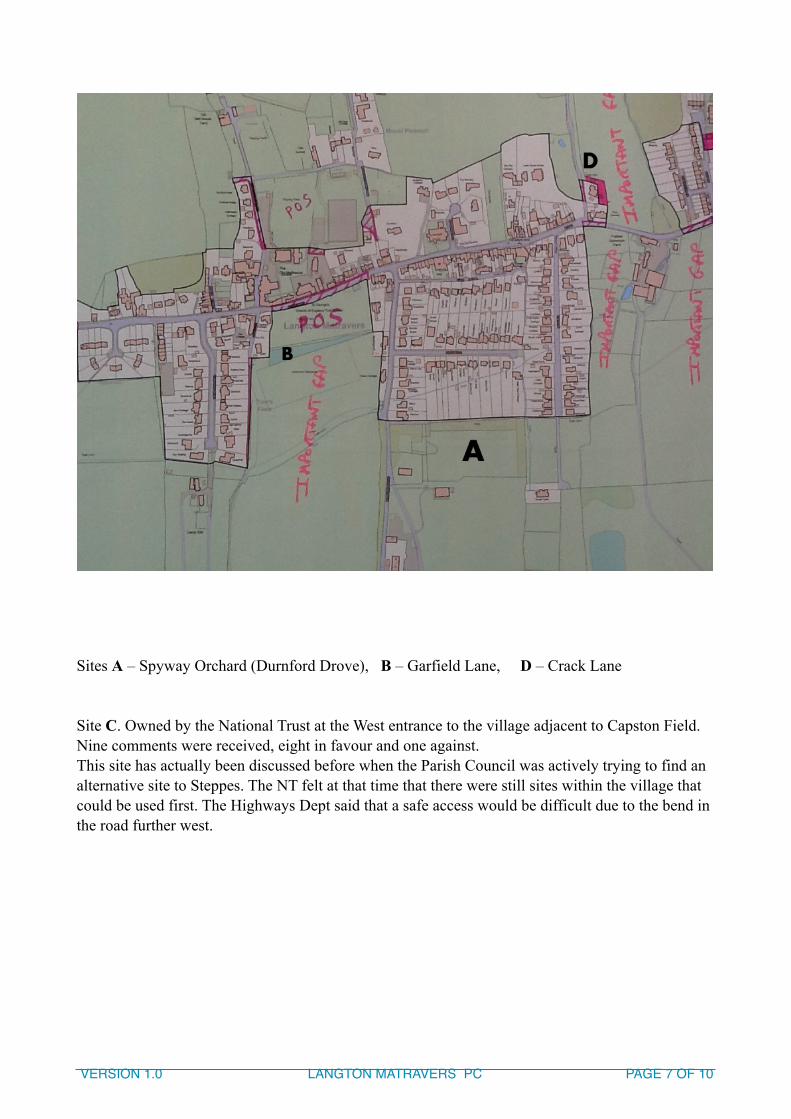
! Sites A – Spyway Orchard (Durnford Drove), B – Garfield Lane, D – Crack Lane Site C. Owned by the National Trust at the West entrance to the village adjacent to Capston Field. Nine comments were received, eight in favour and one against. This site has actually been discussed before when the Parish Council was actively trying to find an alternative site to Steppes. The NT felt at that time that there were still sites within the village that could be used first. The Highways Dept said that a safe access would be difficult due to the bend in the road further west.
PAGE � OF �7 10LANGTON MATRAVERS PC VERSION 1.0

! Site C - National Trust Land at Capstan Field – Off High Street
There was also a view that any affordable homes should be built in small clusters and scattered throughout the village. This echoes the recommendations of the Parish Plan update of 2011 on Affordable Housing that ‘The Council should continue to work with Purbeck District Council to provide small developments of affordable housing, which should be integrated throughout the village’. Various views were expressed on the type of affordable housing, self build, developer's discount, socially rented, part equity etc but it was appreciated that the type required would be dictated by the results of the 'Housing Needs Survey'. There were some comments that building of expensive market housing, would only attract second home owners which would not assist in the long term sustainability of the village and its facilities. There were also some views that to keep the cost of building affordable housing down, and therefore to help build more, different building materials and methods should be considered.
Business and Commercial Development
It was felt that it was important to provide more employment in the area for local people. Small business workshops should be provided, maybe as part of housing developments and there is the need for an imaginative campaign to bring higher value work to Purbeck.
PAGE � OF �8 10LANGTON MATRAVERS PC VERSION 1.0

Parish Council's Views and Recommendations • There is general agreement with the proposed new settlement boundary. • Protected Open Spaces should be established for St.Georges school playing field and the
play areas at the Old Malthouse school (see map above). • Important Gaps, as proposed above , should be preserved and protected against
development to keep the character and structure of the village. • The results of the newly completed Housing Needs Survey should be the driving factor
for any future housing developments which should be affordable and meet the needs of local people.
• Any future affordable housing must be integrated within the village and form part of mixed developments or small scattered clusters.
• The land at Crack Lane should be considered, with others identified so far, as possible exception sites, if a local housing need is determined.
• Every effort should be made to increase local employment within the Purbeck area, especially by providing small workshops and trying to encourage higher paid employment.
• Rural transport is a major concern and needs to be tailored to local needs. Bus services must be preserved, or supplemented with community transport as they are essential for workers and other residents to get to the major centres.
• Every effort must be made to create safe cycle ways for school children, workers and recreational users.
Parish Council's Outstanding Queries • Acton and a number of other inhabited areas are not included in any settlement
boundary. What does this mean in terms of any future development? • On the settlement boundary map supplied by PDC, property Island View, at the end of
Mount Pleasant Lane, is in land colour coded green, all other residential properties seem to be situated in land colour coded light yellow. Is there any significance to this?
PAGE � OF �9 10LANGTON MATRAVERS PC VERSION 1.0

New settlement boundary, Protected Open Spaces, Important Gaps and some possible affordable housing Exception Sites.
PAGE � OF �10 10LANGTON MATRAVERS PC VERSION 1.0