Embed Size (px)
Citation preview

Lane County Parks & Open Space Master Plan lab
LANE COUNTY PARKS & OPEN SPACE MASTER PLAN
Joint PAC/Task Force Meeting February 13, 2017
SEA TO SUMMIT: Creating the Future of Lane County Parks

Lane County Parks & Open Space Master Plan lab
Purpose of Meeting
• Describe the planning process• Discuss the County’s park and open space vision
• Introduce potential park investment “scenarios” based on key vision concepts
• Discuss and collect comments on these scenarios to determine what investment scenario to test with the public

Lane County Parks & Open Space Master Plan lab
Planning Process
Lane County Parks & Open Space Master Plan lab
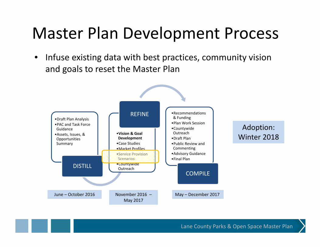
Master Plan Development Process
•Draft Plan Analysis•PAC and Task Force Guidance•Assets, Issues, & Opportunities Summary
DISTILL
•Vision & Goal Development•Case Studies•Market Profiles•Service Provision Scenarios•Countywide Outreach
REFINE •Recommendations & Funding•Plan Work Session•Countywide Outreach•Draft Plan•Public Review and Commenting•Advisory Guidance•Final Plan
COMPILE
June – October 2016 November 2016 –May 2017
May – December 2017
Adoption:Winter 2018
• Infuse existing data with best practices, community vision and goals to reset the Master Plan

Lane County Parks & Open Space Master Plan lab
Master Plan Development Process
•Vision & Goal Development•Case Studies•Market Profiles•Service Provision Scenarios•Countywide Outreach
REFINE •Recommendations & Funding•Plan Work Session•Countywide Outreach•Draft Plan•Public Review and Commenting•Advisory Guidance•Final Plan
COMPILE
Tentative Public Outreach Timeline:Service Alternatives questionnaire and workshops (March‐April)
Recommendations & tradeoffs activities (July/August)
Draft Plan online review (October), plus public Task Force, PAC and Board meetings (November)
• Strengthen countywide outreach to understand county vision/goals and gain support for right level of investment.

Lane County Parks & Open Space Master Plan lab
Master Plan Adoption Process
•Recommendations & Funding•Plan Work Session•Countywide Outreach•Draft Plan•Public Review and Commenting•Advisory Guidance•Final Plan•Adoption Hearings
COMPILE & ADOPT
• Take Master Plan through Lane County adoption process to discuss any proposed land use changes and ensure compliance with Statewide Planning goals
• To ensure adoption, develop plan in accordance with Statewide Planning goals, County land use goals, site deed restrictions, other applicable local, state and federal requirements.

Lane County Parks & Open Space Master Plan lab
Parks & Open Space Vision

Lane County Parks & Open Space Master Plan lab
Plan Framework Elements• Vision: aspirations for parks and open space in the future.
• Mission: the business or approach that staff will take in providing parks, recreation facilities, trails and open space.
• Goals: desired outcomes to be achieved by implementing the Parks & Open Space Master Plan.

Lane County Parks & Open Space Master Plan lab

Lane County Parks & Open Space Master Plan lab
PAC Plan/Vision Directions• Natural beauty • Trail‐related activities• Flexibility for new uses/changes• Cost‐neutral parks (not all focused on revenue‐
generation)• Public lands as asset• Balance of user needs, site uses, site qualities
(natural and cultural resources) and revenue needs• Inspirational vision – inspiring residents to support
higher level of investment

Lane County Parks & Open Space Master Plan lab
Task Force Vision DirectionsLane County Parks and Open Space:• Are democratic places • Have a positive economic impact • Preserve rivers, creeks and landscape• Support outdoor recreation experiences and adventure• Interpret/educate about the local environment• Are cared for through resource stewardship • Connect our communities, physically, environmentally and
socially• Involve collaboration and partnerships

Lane County Parks & Open Space Master Plan lab
Vision Concepts

Lane County Parks & Open Space Master Plan lab
Lane County Park Regions

ESRI Tapestry SegmentationESRI’s “tapestry segments” describe customers’ lifestyle choices, purchase options, and recreation based on demographic and socioeconomic characteristics.
Lane County Parks Service Provision Concepts

“The Great Outdoors”
“Silver & Gold”
“The Great Outdoors”
“The Great Outdoors”
“Middleburg”“In Style”
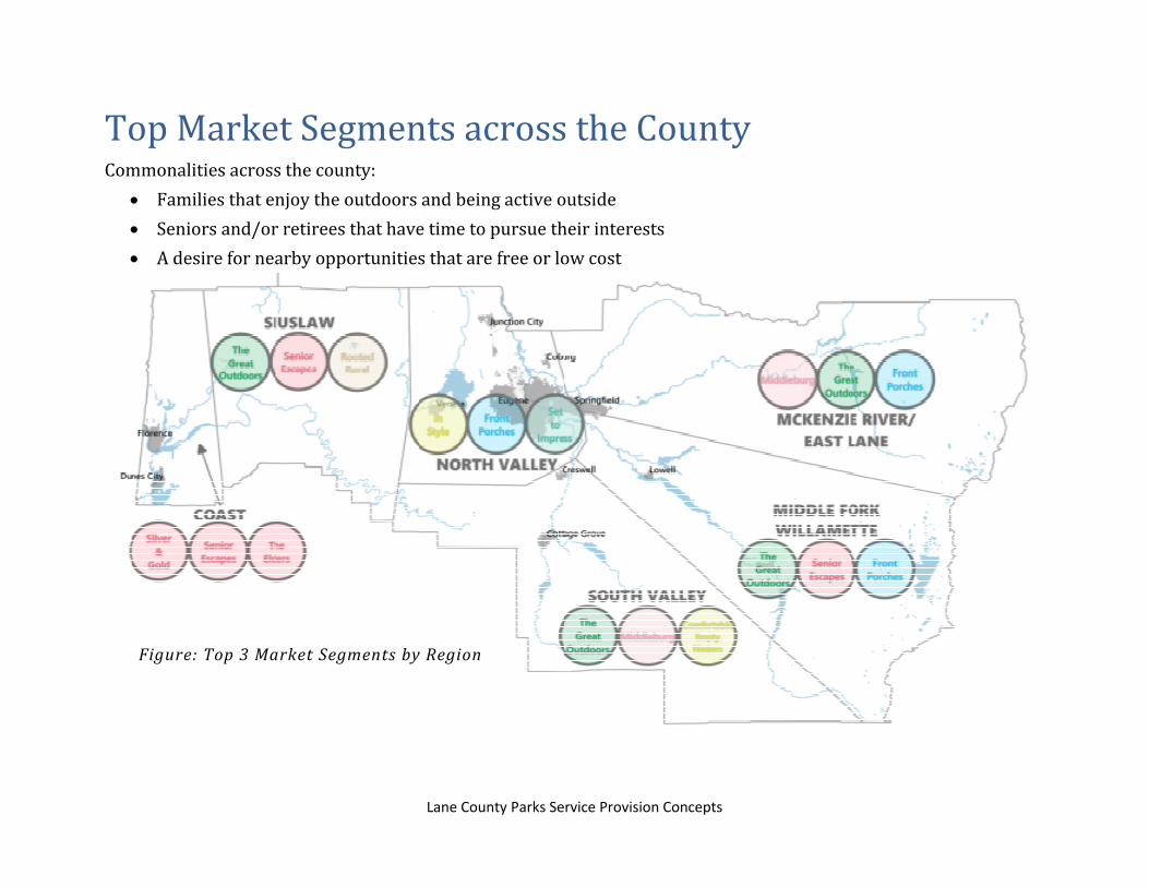
Top Tapestry Segments by Region
Lane County Parks Service Provision Concepts

Coastal Region: 9A “Silver & Gold”
• Active population,desire regularexercise regimen
• Pursue activesocial life, travel,hobbies, andsports
• High homeownership
• Low populationdensity
1/13/2017Lane County Parks Market Analysis
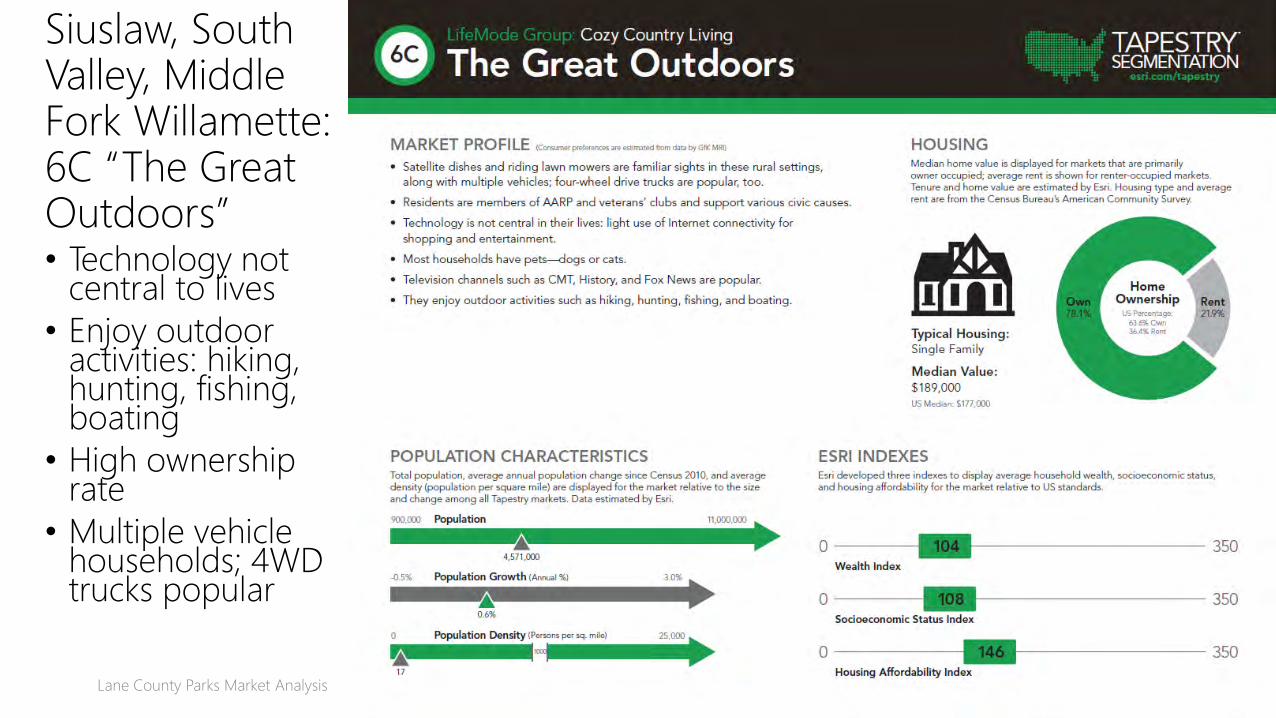
Siuslaw, South Valley, Middle Fork Willamette: 6C “The Great Outdoors”• Technology not
central to lives
• Enjoy outdoor activities: hiking, hunting, fishing, boating
• High ownership rate
• Multiple vehicle households; 4WD trucks popular
1/13/2017Lane County Parks Market Analysis Slide 28

North Valley: 5B “In Style”
• Partial to SUVs or trucks
• Actively support the arts
1/13/2017Lane County Parks Market Analysis Slide 30
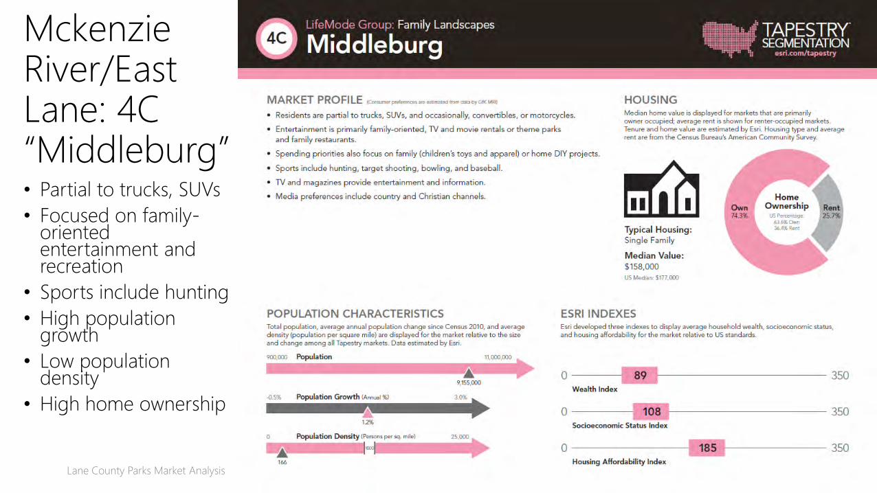
• Partial to trucks, SUVs
• Focused on family-oriented entertainment and recreation
• Sports include hunting
• High population growth
• Low population density
• High home ownership
1/13/2017Lane County Parks Market Analysis Slide 32
MckenzieRiver/East Lane: 4C “Middleburg”

Willamette Valley: 8E “Front Porches”
• Tech-savvy
• Enjoy variety of leisure activities
• Low population growth, high density
• Lower-than-average income
1/13/2017Lane County Parks Market Analysis Slide 34
Lane County Parks Service Provision Concepts
TopMarketSegmentsacrosstheCountyCommonalitiesacrossthecounty:
Familiesthatenjoytheoutdoorsandbeingactiveoutside Seniorsand/orretireesthathavetimetopursuetheirinterests Adesirefornearbyopportunitiesthatarefreeorlowcost
Figure: Top3Market SegmentsbyRegion

Lane County Parks & Open Space Master Plan lab
Potential Levels of Investment
• Level 0: Existing investment focused on smaller number of sites
• Level 1: Slightly higher level of investment• Level 2: Infusion of partnership funds, labor and resources
• Level 3: Higher level of investment through voter‐approved funding
0 1 2 . . . . . . . 2 3 . . . . .Current level of investment

Lane County Parks & Open Space Master Plan lab
Vision Concepts and Scenarios
• Disclaimer: These scenarios reflect conceptual ideas for discussion, not recommendations for development.
• How do we apply these concepts throughout the county? Do we favor one or try to meld all 3?
• Recognizing funding realities, what do we dial up? What do we dial down? How do we distribute resources and investments?
• Are these the right focus areas for activities?
Lane County Parks & Open Space Master Plan lab
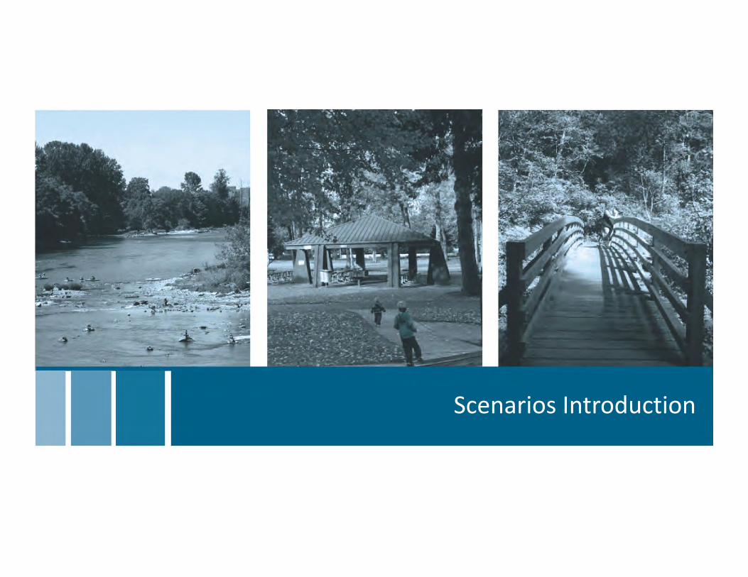
Scenarios Introduction

Scenarios Introduction CommentWorksheet
Concept 1: Accessible
Water‐Based System
Concept 2: Nature‐Based Recreation System
Concept 3: Connected Trail‐Based System
Other Notes
What do you like?
What do you like?
What do you like?
What don’t you like?
What don’t you like?
What don’t you like?
Questions/ comments
Questions/ comments
Questions/ comments

Lane County Parks Service Provision Concepts
RecreationConceptsOverviewLandCountyhasincrediblerecreationandnaturalresources.Therearethreeprimarydrivers(orconcepts)thattheCountycouldfocusontomakeitsparksystemevenbetter.
AnAccessibleWater‐BasedSystem:Rivers,streams,wetlands,estuaries,reservoirsandcoastlineareall
majorpublicresourcesandakeypartofLaneCounty’sidentity.Thesearesitesthateitherhaveaccesstowaterbodiescurrentlyorcanbeimprovedtocreateaccess.About54%ofcountyparksfitwithinthisconcept.
ANature‐BasedRecreationSystem:LaneCountyhasanincrediblydiverserangeofnaturalresourcesandrecreationopportunities,fromtheCascades,totheWillametteValleyandcoastrange,tothecoast.Thesetypicallyarelargesitesthatareundevelopedandnatural,protectedorhavenaturalresourcesasapredominantcharacteristic.Thereareabout15%ofcountyparksthatfitwithinthisconcept.
AConnected/Trail‐BasedSystem:LaneCountyhasanextensivesystemofparks,publiclandsandrecreationspacesprovidedbyothers.Severalsitescouldbeconnectedbylandorwatertrailstocreateamorecohesive,interconnectedrecreationsystem.Thereareabout31%ofcountyparksthatfitwithinthisconcept.
Water‐Based 54%
Nature‐Based 15%
Connected/Trails31%
Figure: DistributionofConceptsacrossCounty
Lane County Parks Service Provision Concepts
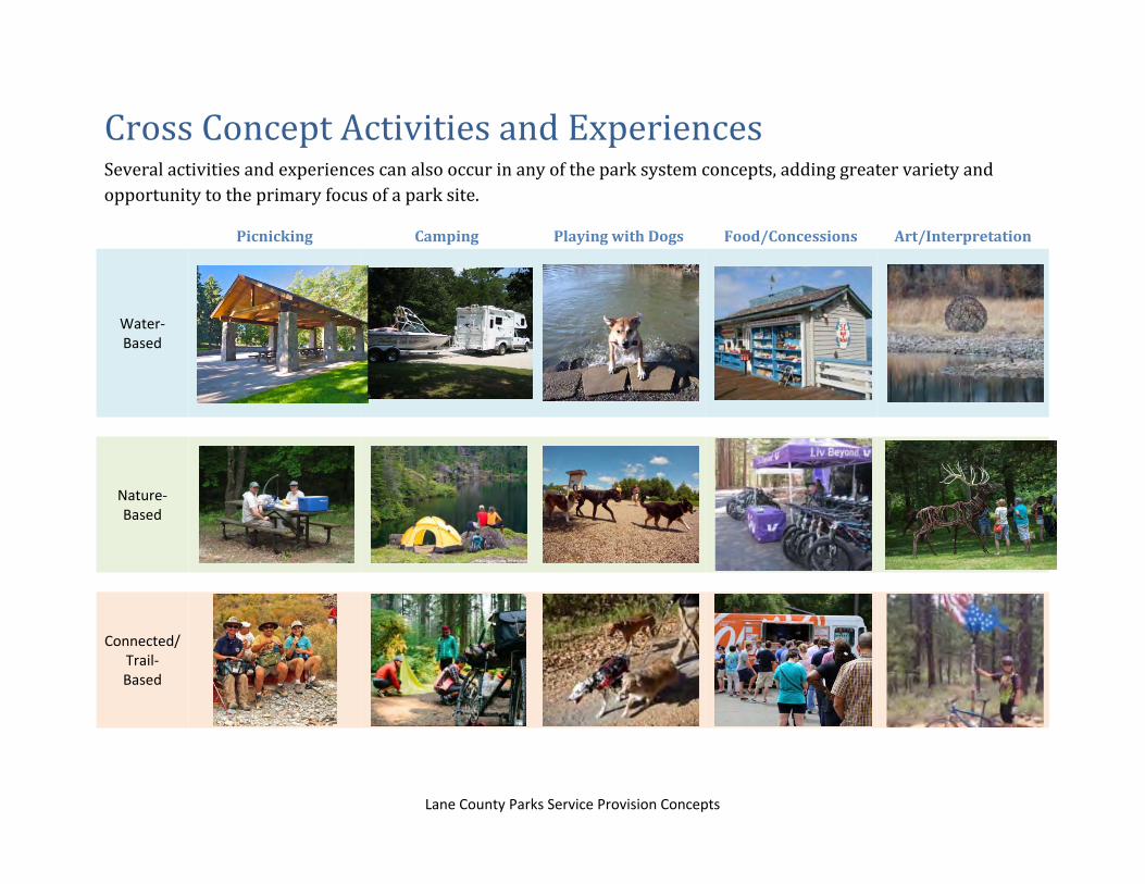
CrossConceptActivitiesandExperiencesSeveralactivitiesandexperiencescanalsooccurinanyoftheparksystemconcepts,addinggreatervarietyandopportunitytotheprimaryfocusofaparksite.
Picnicking Camping PlayingwithDogs Food/Concessions Art/Interpretation
Water‐Based
Nature‐Based
Connected/ Trail‐ Based

Lane County Parks Service Provision Concepts
AnAccessibleWater‐BasedSystem
Coast 16%
Siuslaw 18%
North Valley 16%
McKenzie River/East
Lane 38%
Middle Fork
Willamette2%
South Valley 10%
Figure: DistributionofConceptSitesacrossCounty

Lane County Parks Service Provision Concepts
Water‐BasedActivitiesandExperiences
Fishing Clamming Swimming Equipment Concessionaire
Non‐Motorized Boating Drift Boating Motorized Boating Guided Instruction/Tours
Picnic Areas Extended Vehicle Parking Marina Sand Play

0 10 205
Miles
Legend
Other Provider Sites
County Parks (Water Concept)Park Projects
State Highways
City Limits
National Forests
Rivers, Lakes & Waterbodies
BLM Lands
Other County Parks
N
WATER CONCEPT
Fall Creek
Orchard PointMckenzie River Water Trail
Baker Bay
Linslaw
Ada
Eugene
Springfield
Florence
Veneta
Dunes City
CottageGrove
JunctionCity
Oakridge
Creswell
Lowell
Coburg
Westfir
NORTH VALLEY
MCKENZIE RIVER / EAST LANE
SOUTH VALLEY
SIUSLAW
COAST
MIDDLE FORK WILLAMETTE

Lane County Parks Service Provision Concepts
Water‐BasedProjectsandPriorities
Coast
Ada Park
Improve lake access by adding boat ramp, courtesy dock, boat trailer parking, and marina (40‐75) slips. Develop day use area with large group picnic pavilion, small group picnic shelter(s) with fish clean station, and water‐theme playground. Restructure open space to accommodate large events, such as waterfront festivals.
Mckenzie River
McKenzie River Water Trail
Identify and improve boat put‐ins/take‐outs, boat drop‐off/parking and associated site improvements for non‐motorized boater access along water trail. Create marketing brochure mapping water trails, as well as amenities along the trail, designating short, medium and long trips. Consider food/concessions at key stopovers/end of trail.
Siuslaw
Linslaw Park
Maximize boat launch capacity by improving boat launch and increasing parking to accommodate 6‐8 additional cars and 2‐4 additional boat trailer parking spaces. Improve restroom and support amenities to support increased use.
Middle Fork Willamette
Fall Creek Park
Improve access to Fall Creek, add a water play area, meandering creekside disc golf course, and picnic tables and seating with water views.
North Valley
Orchard Point
Redesign and renovate marina. Construct/install new C‐Dock with 18‐32 new slips and new E‐Dock with 22‐36 slips. Replace courtesy dock, install all new pumpout station, and create new marina side social space/hub.
South Valley
Baker Bay Park
Create destination water play area in improved swimming area and beach. Renovate concession building with improved kitchen and larger, reservable water‐view seating porch/plaza, reservable shelter and water themed play area. Expand marina and add RV camping.

Lane County Parks Service Provision Concepts
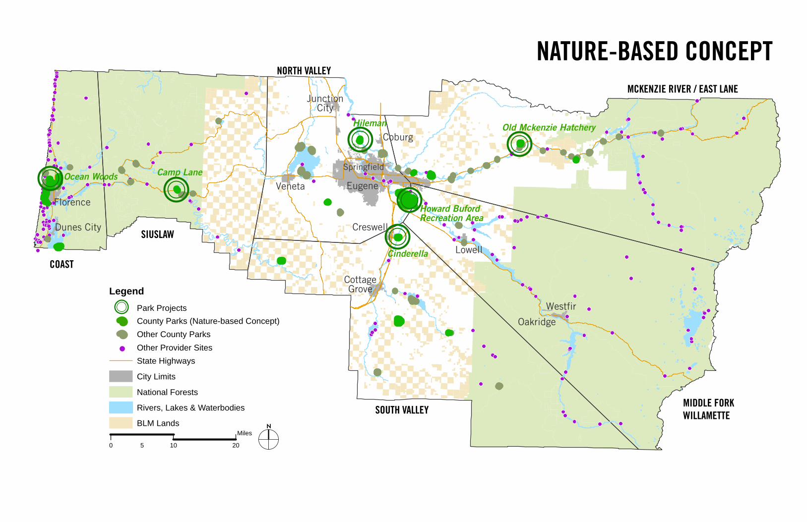
ANature‐BasedRecreationSystem
Coast28%
Siuslaw6%
North Valley 17%
McKenzie River/East Lane
28%
Middle Fork Willamette
0%
South Valley 22%
Figure: DistributionofConceptSitesacrossCounty

Lane County Parks Service Provision Concepts
Nature‐BasedActivitiesandExperiences
Wildlife Viewing Bird Blind Restoration/Stewardship Nature Play
Environmental Education Habitat Protection Community Gardening Adventure Activities
Interpretation and Interaction Amphitheater/Programming Reflection Area/View Point Nature Center
0 10 205
Miles
Legend
Other Provider Sites
County Parks (Nature-based Concept)Park Projects
State Highways
City Limits
National Forests
Rivers, Lakes & Waterbodies
BLM Lands
Other County Parks
N
NATURE-BASED CONCEPT
Cinderella
Camp Lane
Hileman
Howard Buford Recreation Area
Old Mckenzie Hatchery
Ocean WoodsEugene
Springfield
Florence
Veneta
Dunes City
CottageGrove
JunctionCity
Oakridge
Creswell
Lowell
Coburg
Westfir
NORTH VALLEY
MCKENZIE RIVER / EAST LANE
SOUTH VALLEY
SIUSLAW
COAST
MIDDLE FORK WILLAMETTE
Lane County Parks Service Provision Concepts
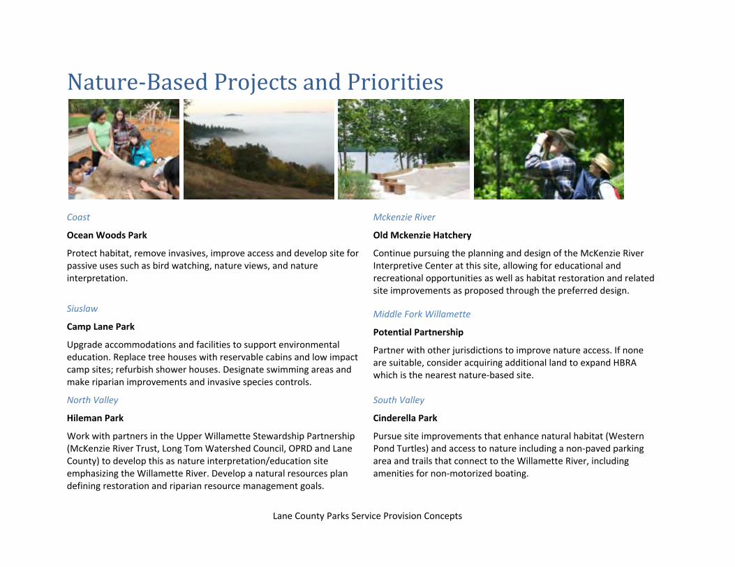
Nature‐BasedProjectsandPriorities
Coast
Ocean Woods Park
Protect habitat, remove invasives, improve access and develop site for passive uses such as bird watching, nature views, and nature interpretation.
Mckenzie River
Old Mckenzie Hatchery
Continue pursuing the planning and design of the McKenzie River Interpretive Center at this site, allowing for educational and recreational opportunities as well as habitat restoration and related site improvements as proposed through the preferred design.
Siuslaw
Camp Lane Park
Upgrade accommodations and facilities to support environmental education. Replace tree houses with reservable cabins and low impact camp sites; refurbish shower houses. Designate swimming areas and make riparian improvements and invasive species controls.
Middle Fork Willamette
Potential Partnership
Partner with other jurisdictions to improve nature access. If none are suitable, consider acquiring additional land to expand HBRA which is the nearest nature‐based site.
North Valley
Hileman Park
Work with partners in the Upper Willamette Stewardship Partnership (McKenzie River Trust, Long Tom Watershed Council, OPRD and Lane County) to develop this as nature interpretation/education site emphasizing the Willamette River. Develop a natural resources plan defining restoration and riparian resource management goals.
South Valley
Cinderella Park
Pursue site improvements that enhance natural habitat (Western Pond Turtles) and access to nature including a non‐paved parking area and trails that connect to the Willamette River, including amenities for non‐motorized boating.

Lane County Parks Service Provision Concepts
AConnectedTrail‐BasedSystem
Coast 10%
Siuslaw14%
North Valley 24%
McKenzie River/East Lane
31%
Middle Fork Willamette
3%
South Valley 17%
Figure: DistributionofConceptSitesacrossCounty

Lane County Parks Service Provision Concepts
ConnectedTrail‐BasedActivitiesandExperiences
Multi‐use/Accessible Activities Regional Trail Connections Mountain Biking on Single Track Horseback Riding
Bike Skills OHV/ATV Bike Touring Lookout/View Point
Trail Head/Staging Area Trail Head/Staging Area
(Primitive) Exploring Covered Bridges Interpretation/Education

CONNECTIVITY AND TRAILS CONCEPT
0 10 205
Miles
Legend
Other Provider Sites
County Parks (Trails Concept)Park Projects
Trail Connections to County ParksTrail Connections to Other Provider Sites
State Highways
City Limits
National Forests
Rivers, Lakes & Waterbodies
BLM Lands
Other County Parks
N
Blue Mountain
Camp Lane
Three Mile Priarie
Eagle Rock
Middle Fork Trail
Armitage
Eugene
Springfield
Florence
Veneta
Dunes City
CottageGrove
JunctionCity
Oakridge
CreswellLowell
Coburg
Westfir
NORTH VALLEY
MCKENZIE RIVER / EAST LANE
SOUTH VALLEY
SIUSLAW
COAST
MIDDLE FORK WILLAMETTE

Lane County Parks Service Provision Concepts
ConnectedTrail‐BasedProjectsandPriorities
Coast
Three Mile Prairie Park
Seek public access to encourage visitation and connections to nearby coastal destinations. Add gravel entrance and parking area, trails, low‐impact picnic areas and interpretive signage related to coastal/wetlands habitats. Conduct invasive vegetation removal projects with volunteers.
Mckenzie River
Eagle Rock Park
Improve site as a primary visitor destination to increase connections to nearby sites and National Forest. Pursue site improvements that will allow for a range of day‐use and overnight visitors, with well‐defined trails and information on surrounding recreational opportunities, including the McKenzie River Water Trail.
Siuslaw
Camp Lane
Improve main parking lot and upgrade buildings, restroom and showers to create trail hub for day use and overnight hiker/biker stay. Replace tree houses with reservable cabins and hiker/biker tent sites. Add food concessions. Link facilities throughout the park by pathway connected to regional trail system.
Middle Fork Willamette
Improve connection
Evaluate options to connect HBRA and Elijah Bristow State Park via bike routes and, if feasible an off‐street trail.
North Valley
Amitage Park
Work with the McKenzie Watershed Council to improve the Crilly Nature Trail; develop trails through campground and park and connect to regional trail system.
South Valley
Blue Mountain Park
Create master plan for site as trails hub and regional trailhead, balancing nature trails, multipurpose trails, and OHV/ATV trails and destination park.

Lane County Parks Service Provision Concepts
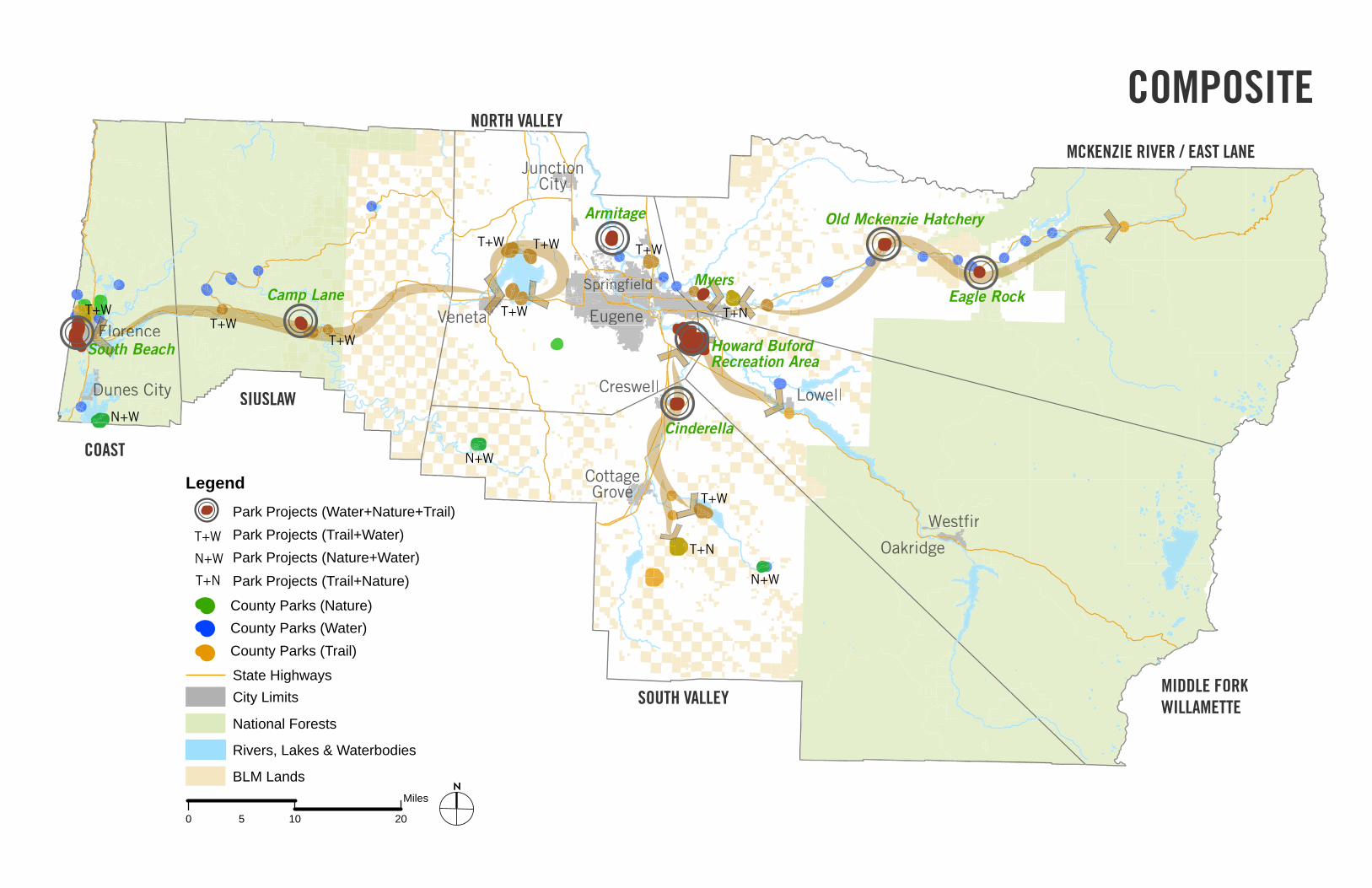
CompositeConceptWhenoverlayingallthreeconceptstogether,severalsitesarecriticaltoallthreeconcepts.IfeachoftheseelementsispartofLaneCounty’svision,theCountyshouldleverageresourcesandconcentrateinvestmentonsitesthatsupportthiscohesivevision.
Eagle Rock
Armitage
Myers
South Beach
N+W
N+W
N+W
T+W
T+N
T+N
T+W T+W
T+WT+W
T+W
T+W
T+W
T+W
N+W
T+N
0 10 205
Miles
Legend
County Parks (Trail)
County Parks (Nature)
Park Projects (Water+Nature+Trail)
State Highways
Park Projects (Trail+Water)Park Projects (Nature+Water)Park Projects (Trail+Nature)
City Limits
National Forests
Rivers, Lakes & Waterbodies
BLM Lands
County Parks (Water)
N
COMPOSITE
Cinderella
Howard BufordRecreation Area
Camp Lane
Old Mckenzie Hatchery
EEugene
prinpringfieldnnnn dSp dddddddddddddddddddddddlldldlpSSSSSS
rencencencnncreorenorenoorroroooroorerFloreFlFloolFFFFFlorererrrrrerVenetaVen taeVee
Dunes Cites CityDDuDunDDD
CottageCoC gGroverG ee
onoJunctioction ooooooooioCityty
OOakrikridgeOO
Creswelll LowellllLoweLoweL
WWestfirWestfiW
NORTH VALLEY
MCKENZIE RIVER / EAST LANE
SOUTH VALLEY
SIUSLAW
COAST
MIDDLE FORK WILLAMETTE

Lane County Parks & Open Space Master Plan lab
Large Group Discussion

Scenarios Discussion Preferred Concept Notes
Which level of investment do you think would be best to support Lane County Parks?
Level 0: Existing investment focused on smaller number of sites
Level 1: Slightly higher level of investment
Level 2: Infusion of partnership funds, labor and resources
Level 3: Higher level of investment through voter‐approved funding
Help us evaluate the level of service and investment that should be provided for each of the following concepts. Which should have investment levels that are higher, lower, or in the middle?
Park Concept Accessible Water‐Based System
↓ ⃝ ↑
Nature‐Based Recreation System
↓ ⃝ ↑
Connected Trail‐Based System ↓ ⃝ ↑
What does that mean for the level of investment in other parks (not targeted by the three concepts)? Which should have investment levels that are higher, lower, or in the middle?
Park Concept
Revenue‐generating land & facilities
↓ ⃝ ↑
Local parks ↓ ⃝ ↑
Waysides (supported through transportation funds)
↓ ⃝ ↑
Sites not supporting any of the 3 concepts
↓ ⃝ ↑
Sites supporting 1 of the 3 concepts
↓ ⃝ ↑

Lane County Parks & Open Space Master Plan lab
LANE COUNTY PARKS & OPEN SPACE MASTER PLAN
SEA TO SUMMIT: Creating the Future of Lane County Parks