Embed Size (px)
Citation preview
Landslides Triggered by Earthquakes in the Central Mississippi Valley, Tennessee and Kentucky
U.S. GEOLOGICAL SURVEY PROFESSIONAL PAPER 1336-C

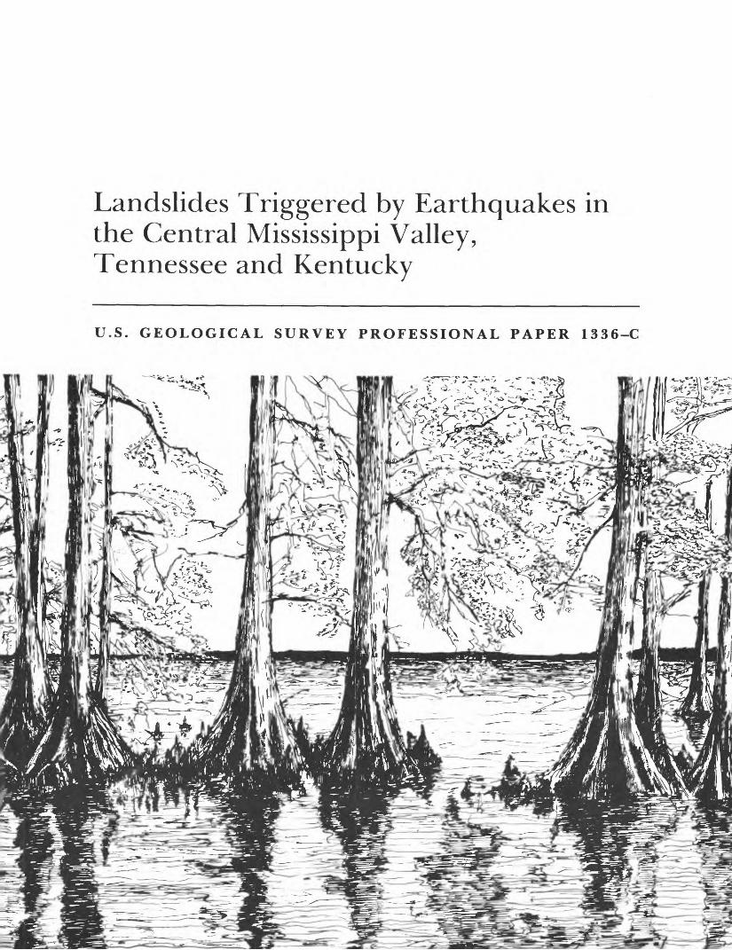
COVER: Cypress trees along the shore of Reelfoot Lake in northwestern Tennessee. Reelfoot
Lake, originally an oxbow lake in an abandoned Mississippi River meander, was substantially
enlarged during the major New Madrid earthquake of February 7, 1812. Pen and ink drawing
by Jeff Dietterle, 1987.
Landslides Triggered by Earthquakes in the Central Mississippi Valley, Tennessee and KentuckyBy RANDALL W. JIBSON and DAVID K. KEEPER
THE NEW MADRID, MISSOURI, EARTHQUAKE REGION- GEOLOGICAL, SEISMOLOGICAL, AND GEOTECHNICAL STUDIES
Edited by DAVID P. RUSS and ANTHONY J. CRONE
U.S. GEOLOGICAL SURVEY PROFESSIONAL PAPER 1336-C
A description and analysis of landslides and landslide-triggering mechanisms in a part of the central Mississippi Valley
UNITED STATES GOVERNMENT PRINTING OFFICE, WASHINGTON : 1988
DEPARTMENT OF THE INTERIOR
DONALD PAUL HODEL, Secretaiy
U.S. GEOLOGICAL SURVEY
Dallas L. Peck, Director
Library of Congress Cataloging in Publication Data
Jibson, Randall W.Landslides triggered by earthquakes in the central Mississippi Valley, Tennessee and Kentucky. (The New Madrid, Missouri, earthquake region geological, seismological, and geotechnical studies) (U.S. Geological Survey professional paper ; 1336-C) Bibliography: p.Supt. of Docs, no.: I 19.16:1336-C1. Landslides Tennessee, Western. 2. Landslides Kentucky. 3. Earthquakes Mississippi River Valley. 4. New Madrid
(Mo.) Earthquake, 1811. I. Keefer, David K. II. Title. III. Series. IV. Series: Geological Survey professional paper; 1336-C QE599.U5J53 1989 551.3'53 88-600059
For sale by the Books and Open-File Reports Section, U.S. Geological Survey, Federal Center, Box 25425, Denver, CO 80225
FOREWORD
The great New Madrid, Missouri, earthquakes of 1811-12 and the extended series of aftershocks that followed have focused considerable U.S. attention on the geologic stability of the interior of the North American crustal plate. These and subsequent earthquakes have shown clearly that the mid-continent is capable of generating devastating earthquake ground motions and that study of these earthquakes is essential to reducing their associated hazards. This Professional Paper presents significant new contributions to fundamental knowledge about the seismicity, tectonic framework, and earthquake hazards of the New Madrid seismic zone. Some of the chapters refine the conclusions of earlier work, further clarifying the understanding of the seismotectonics of the region.
As early as 1846, the eminent English geologist Sir Charles Lyell studied the effects of the earthquakes of 1811-12 and recognized the effects of recurrent earthquakes on the physiography and structure of the Mississippi Valley. The first comprehensive geologic investigation of the New Madrid earthquakes was made by Myron Fuller of the U.S. Geological Survey (USGS), who published his findings in 1912. Fuller described the distribution and character of surface deformation and liquefaction features and compiled a detailed list of aftershocks and their effects.
In 1974, the USGS began multidisciplinary studies to investigate the cause of the New Madrid earthquakes and to determine the hazards and risk associated with the continuing seismicity in the region. In the same year, the Department of Earth and Atmospheric Sciences of St. Louis University began installation of a 16-station microearthquake-detection network in the Mississippi embayment (later expanded to 32 stations plus 8 additional stations in the Wabash Valley of Illinois and Indiana). The studies and seismograph network were designed to determine the temporal and spatial distribution of seismicity in the New Madrid seismic zone, to delineate the structural framework of the earthquake source zone, and to determine the recurrence rate of damaging earthquakes in the New Madrid region by investigations of surficial sediments and structures.
In 1977, the U.S. Nuclear Regulatory Commission initiated a multi-institutional seismotectonic study of the area within a 200-mile radius of New Madrid. The study was conducted by scientists from midwestern universities and State geological surveys, in coordination with Federal agencies conducting investigations in the area. The purpose of the study was to define the structural and tectonic setting of the New Madrid seismic zone in order to evaluate earthquake risks in the siting of nuclear facilities. Geological, engineering, and seismological studies for assessing earthquake hazards and risk associated with the Mississippi River and related waterways and manmade structures have been conducted independently by scientists and engineers of the U.S. Army Corps of Engineers.
Results of many of the investigations completed in the first 8 years of study (1974-82) in the northern Mississippi embayment were presented in USGS Profes sional Paper 1236. These studies revealed that earthquakes in the New Madrid area occur in linear zones that are spatially associated with structures in a buried continental rift that formed in the Precambrian. Reactivation of faults along the axis and flanks of the rift in a compressive stress field has produced uplift and many of the region's earthquakes. The buried Paleozoic surface has only minor structural relief, however, indicating that Cenozoic fault activity has been only modest or that most of
IV FOREWORD
the fault offset has been strike-slip. Earthquakes large enough to cause tectonic surface deformation and liquefaction features occur on the average of every 600-700 years in the New Madrid seismic zone.
Geophysical, geological, and seismological investigations by scientists of the USGS, State geological surveys, academia, and the U.S. Army Corps of Engineers have continued in the New Madrid seismic zone since the publication of USGS Profes sional Paper 1236. Of particular importance have been seismic-refraction and seismic-reflection surveys; geomorphic analyses of river terraces and stream profiles in Tennessee, Kentucky, and Arkansas; and studies of earthquake-induced hazards such as liquefaction, landslides, and ground motion. Some of the new data and conclusions from these investigations are given in chapters published at irregular intervals as part of this Professional Paper 1336. These chapters provide a more complete understanding of the seismicity and tectonic evolution of the New Madrid region and the effects of hazards that the earthquakes produce; consequently, they will enhance the effort to implement loss-reduction measures in an economical and effective manner.
p.David P.Russ
Anthony J. Crone
Editors
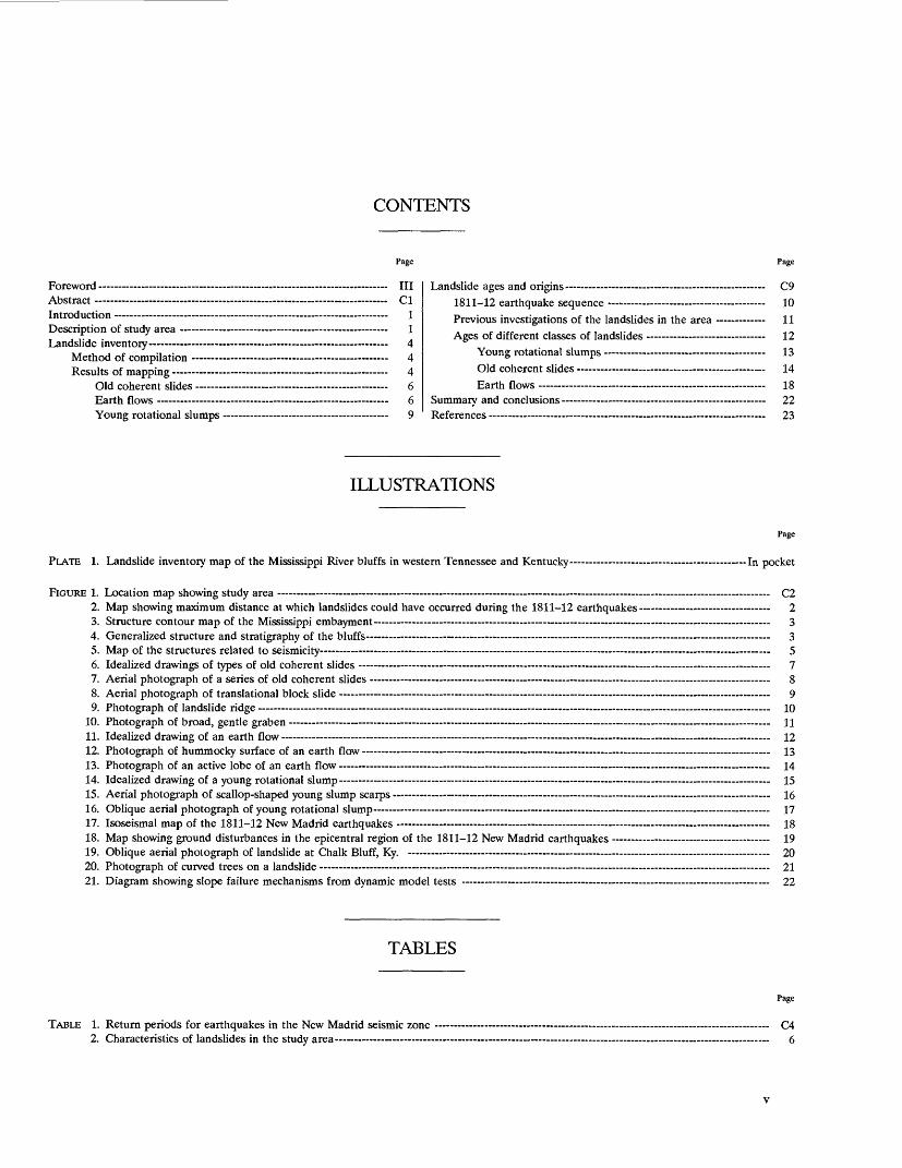
CONTENTS
Page
Foreword IIIAbstract ClIntroduction - 1Description of study area 1Landslide inventory 4
Method of compilation 4Results of mapping 4
Old coherent slides 6Earth flows 6Young rotational slumps 9
Page
Landslide ages and origins C91811-12 earthquake sequence - - - 10
Previous investigations of the landslides in the area 11Ages of different classes of landslides 12
Young rotational slumps 13Old coherent slides 14Earth flows 18
Summary and conclusions 22References- - - - ... 23
ILLUSTRATIONS
Page
PLATE 1. Landslide inventory map of the Mississippi River bluffs in western Tennessee and Kentucky - In pocket
FIGURE 1. Location map showing study area C22. Map showing maximum distance at which landslides could have occurred during the 1811-12 earthquakes 23. Structure contour map of the Mississippi embayment 34. Generalized structure and stratigraphy of the bluffs - 35. Map of the structures related to seismicity - 56. Idealized drawings of types of old coherent slides 77. Aerial photograph of a series of old coherent slides - 88. Aerial photograph of translational block slide - 99. Photograph of landslide ridge 10
10. Photograph of broad, gentle graben 1111. Idealized drawing of an earth flow 1212. Photograph of hummocky surface of an earth flow 1313. Photograph of an active lobe of an earth flow 1414. Idealized drawing of a young rotational slump 1515. Aerial photograph of scallop-shaped young slump scarps - 1616. Oblique aerial photograph of young rotational slump 1717. Isoseismal map of the 1811-12 New Madrid earthquakes 1818. Map showing ground disturbances in the epicentral region of the 1811-12 New Madrid earthquakes 1919. Oblique aerial photograph of landslide at Chalk Bluff, Ky. 2020. Photograph of curved trees on a landslide 2121. Diagram showing slope failure mechanisms from dynamic model tests 22
TABLES
TABLE 1. Return periods for earthquakes in the New Madrid seismic zone 2. Characteristics of landslides in the study area
Page
C46

THE NEW MADRID, MISSOURI, EARTHQUAKE REGION- GEOLOGICAL, SEISMOLOGICAL, AND GEOTECHNICAL STUDIES
LANDSLIDES TRIGGERED BY EARTHQUAKES IN THE CENTRAL MISSISSIPPI VALLEY, TENNESSEE AND KENTUCKY
By RANDALL W. JIBSON and DAVID K. KEEPER
ABSTRACT
We mapped 221 large (more than 200 ft across) landslides of three morphologically distinct types on the bluffs bordering the Mississippi alluvial plain in western Tennessee and Kentucky. Old coherent slides (146 landslides, or 66 percent of the total) include translational block slides and single- and multiple-block rotational slumps, all of which are covered by mature vegetation and have eroded features; no active analogs exist in the area. Earth flows (51 landslides, or 23 percent of the total) are also largely revegetated and eroded, though a few active earth flows are present on bluffs that have been cleared of vegetation. Young rotational slumps (24 landslides, or 11 percent of the total) form solely along actively eroding near-river bluffs and are the only active or recently active landslides in the area.
Two investigations conducted around 1900 indicate that the old coher ent slides, in at least part of the area, formed during the 1811-12 earthquakes. The present investigation uses dendrochronology, geomor- phology, historic topographic maps, local historical accounts, and compar isons with landslides triggered by other earthquakes to show that most or all of the old coherent slides and earth flows formed during the 1811-12 New Madrid earthquakes. Evidence clearly indicates that the only large, aseismic landslide activity in the area results from fluvial undercutting of near-river bluffs. This erosion of the base of the bluffs triggers slumps that are morphologically distinct from the old slumps on bluffs away from the river.
Our conclusions are consistent with the findings of other recent investigations of the same landslides that indicate extensive seismic triggering of coherent slides and earth flows during the 1811-12 New Madrid earthquakes.
INTRODUCTION
One of the most dramatic effects of the New Madrid earthquakes of 1811-12 was the formation of numerous landslides along the bluffs bordering the Mississippi alluvial
plain in western Tennessee and Kentucky. In his report of a field investigation of the New Madrid earthquakes con ducted in 1904, Fuller (1912, p. 59) stated, Probably no feature of the earthquake is more striking than the landslides developed in certain of the steeper bluffs * * *. From the vicinity of Hickman in southwestern Kentucky at least to the mouth of the Obion River, about halfway across the State of Tennessee * * * the landslides are a striking feature. Skirting the edge of the bluffs, in the vicinity of ReelfootLake, a characteristic landslide topography is almost constantly in sight * * *
Although'a few historical descriptions of the landslides from the 1811-12 earthquakes exist, no studies, either historical or contemporary, have adequately described the types and distribution of landslides present, the mechanisms of that landsliding, or the current landslide processes occur ring in the central Mississippi Valley. The present paper (1) describes and catalogs on an inventory map the landslides along the bluffs in the central Mississippi Valley and (2) presents field and historical evidence to establish the prob able ages and origins of the landslides in the area. Informa tion in this paper enhances our understanding of landslide processes in the central Mississippi Valley and hence improves our ability to assess landslide hazards there.
DESCRIPTION OF STUDY AREA
The study area lies in the central Mississippi Valley, primarily in Kentucky and Tennessee, and includes 192 mi of bluffs that form the eastern edge of the Mississippi alluvial plain from Barlow, Ky., 7 mi east of Cairo, 111., to Walls, Miss., 12 mi south of Memphis, Tenn. (fig. 1). The
ci
C2 THE NEW MADRID, MISSOURI, EARTHQUAKE REGION
36° -
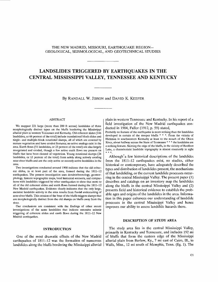
FIGURE 1. Study area (shaded) and estimated epicenters (diamonds), dates, and surface-wave magnitudes (M) of the three largest earth quakes in the 1811-12 sequence (Nuttli, 1973a; Nuttli and Herrmann, 1984).
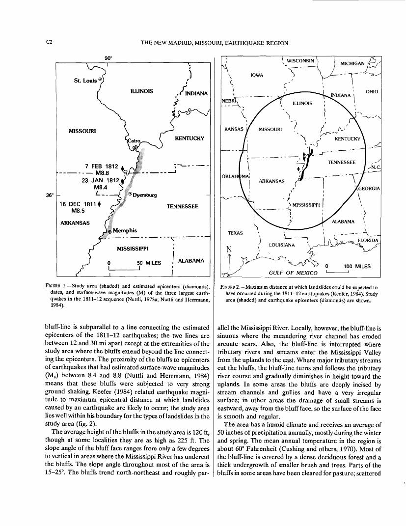
bluff-line is subparallel to a line connecting the estimated epicenters of the 1811-12 earthquakes; the two lines are between 12 and 30 mi apart except at the extremities of the study area where the bluffs extend beyond the line connect ing the epicenters. The proximity of the bluffs to epicenters of earthquakes that had estimated surface-wave magnitudes (Ms) between 8.4 and 8.8 (Nuttli and Herrmann, 1984) means that these bluffs were subjected to very strong ground shaking. Keefer (1984) related earthquake magni tude to maximum epicentral distance at which landslides caused by an earthquake are likely to occur; the study area lies well within his boundary for the types of landslides in the study area (fig. 2).
The average height of the bluffs in the study area is 120 ft, though at some localities they are as high as 225 ft. The slope angle of the bluff face ranges from only a few degrees to vertical in areas where the Mississippi River has undercut the bluffs. The slope angle throughout most of the area is 15-25°. The bluffs trend north-northeast and roughly par-
FIGURE 2. Maximum distance at which landslides could be expected to have occurred during the 1811-12 earthquakes (Keefer, 1984). Study area (shaded) and earthquake epicenters (diamonds) are shown.
allel the Mississippi River. Locally, however, the bluff-line is sinuous where the meandering river channel has eroded arcuate scars. Also, the bluff-line is interrupted where tributary rivers and streams enter the Mississippi Valley from the uplands to the east. Where major tributary streams cut the bluffs, the bluff-line turns and follows the tributary river course and gradually diminishes in height toward the uplands. In some areas the bluffs are deeply incised by stream channels and gullies and have a very irregular surface; in other areas the drainage of small streams is eastward, away from the bluff face, so the surface of the face is smooth and regular.
The area has a humid climate and receives an average of 50 inches of precipitation annually, mostly during the winter and spring. The mean annual temperature in the region is about 60° Fahrenheit (Gushing and others, 1970). Most of the bluff-line is covered by a dense deciduous forest and a thick undergrowth of smaller brush and trees. Parts of the bluffs in some areas have been cleared for pasture; scattered

LANDSLIDES TRIGGERED BY EARTHQUAKES IN THE CENTRAL MISSISSIPPI VALLEY, TENNESSEE AND KENTUCKY C3
90°
36° -
FIGURE 3. Structure contour map showing the elevation (in feet) of the Paleozoic-Cretaceous unconformity, which reflects the overall shape of the Mississippi embayment (adapted from Stearns and Marcher, 1962). Study area is shaded.
homes and farm buildings are also present in some cleared areas. At the time of the earthquakes, however, the bluffs were probably uninhabited and forested.
The study area lies in the northern Mississippi embay ment, a broad, south-southwest-plunging syncline whose axis roughly coincides with the Mississippi River (fig. 3). Beneath the embayment is an intracratonic rift that formed in Late Proterozoic time and that has been intermittently active since then (Braile and others, 1984). Since Late Cretaceous time the embayment has been subsiding and accumulating shallow marine and fluvial sediments. During Pleistocene time the gently rolling upland surface east of the Mississippi alluvial plain was blanketed with loess, which formed a wedge-shaped deposit that is more than 100 ft thick in places near the edge of the bluffs and that thins and pinches out 70-120 mi to the east (Krinitzsky and Turnbull, 1969).
The Eocene Jackson Formation (Conrad, 1856) forms the base of the bluffs throughout most of the study area (fig. 4). Exposures are as thick as 150 ft. Its composition is highly variable; it generally consists of discontinuous layers of shallow-marine embayment deposits of clay and silt, which range in thickness from a few inches to tens of feet. In some areas the Jackson Formation contains clean, uncemented sands as much as tens of feet thick interbedded with soft
Loess
Lafayette Formation (McGee, 1891)
Jackson Formation
FIGURE 4. Generalized structure and stratigraphy of bluffs in the studyarea.
clays. Some clay layers are saturated, others are desiccated and fissured. The clays are also subject to seasonal fluctu ation in ground-water level near the bluffs. The Jackson Formation is highly erodible, and few well-exposed outcrops are present. In the northern part of the area from Wickliffe to Barlow, Ky., the Eocene Claiborne Formation (Conrad, 1848) forms the base of the bluffs. It is similar to the Jackson Formation and consists of clays and silts in the study area. The Eocene beds generally dip a few degrees westward, out of the bluff face, but the amount and direc tion of the dip vary locally; the amount of dip rarely exceeds 20°. The unconformity on top of the Eocene section is highly irregular. In those areas where it has been mapped, this surface roughly parallels the present ground surface, which indicates that the present river channels in the area are in much the same locations as when that surface was formed (Schreurs and Marcher, 1959; Olive, 1967, 1974; Finch, 1971a,b; Lee, 1974).
Lying unconformably on the Jackson is as much as 65 ft of Pliocene terrace gravels and sands of the Lafayette Forma tion (McGee, 1891; Potter, 1955). The lenses of gravel and sand are uncemented in many areas but at a few localities contain concretionary beds as much as 6 ft thick. This unit is locally saturated where water tables are perched and is subject to large seasonal fluctuations in ground-water con ditions. The unit pinches out in some areas.
The bluffs are capped by 10-150 ft of Pleistocene loess, which lies unconformably on the Jackson and Lafayette Formations. The average thickness of the loess in the area is about 50 ft. Loess is a glacially derived, eolian silt that commonly forms vertical faces owing to the presence of vertical fractures. Vertical slopes can be supported because the loess in the study area has cohesion imparted by a clay binder or calcareous cementation or both (Krinitzsky and Turnbull, 1969).
The northern Mississippi embayment lies in the New Madrid seismic zone and is the most seismically active area

C4 THE NEW MADRID, MISSOURI, EARTHQUAKE REGION
in North America east of the Rocky Mountains. Continuing fault movement in the intracratonic rift is the most likely cause of the ongoing seismicity in the area (Braile and others, 1984). Shallower seismic activity may also result from sediment loading in the embayment or from shallow emplacement of igneous plutons (Mosaic, 1976).
The largest historical earthquakes in the New Madrid seismic zone were those that occurred during 1811-12. The three principal shocks (see fig. 1) had estimated body-wave magnitudes (mb ) between 7.1 and 7.4; corresponding surface-wave magnitudes (Ms ) are between 8.4 and 8.8 (Nuttli and Herrmann, 1984). In addition to these shocks, almost 2,000 earthquakes of lesser intensity were docu mented at Louisville, Ky., 235 mi from the epicentral area, between 16 December 1811 and 15 March 1812 (Penick, 1981). Since 1812 there have been at least 20 damaging earthquakes in the region having estimated body-wave magnitudes between 3.8 and 6.2 (Nuttli, 1982).
Ongoing studies of seismicity in the New Madrid seismic zone indicate no clear consensus on the return period for great (mb > 7.0) earthquakes in the area. Estimates range from 200 years (McClain and Myers, 1970) to almost 2,000 years (Johnston and Nava, 1984). Most estimates, however, are between 500 and 700 years (Hopper and others, 1983). Moderate earthquakes have occurred regularly and have much smaller return periods. Table 1 (from Johnston and Nava, 1984) shows estimated return periods for earth quakes of different magnitudes in the New Madrid seismic zone. Because of the low attenuation of seismic waves in the Central United States, the effects of an earthquake of any given magnitude will be felt over a much larger area there than would the effects of an earthquake of similar magni tude in the Western United States (Nuttli, 1973b; Nuttli and Zollweg, 1974).
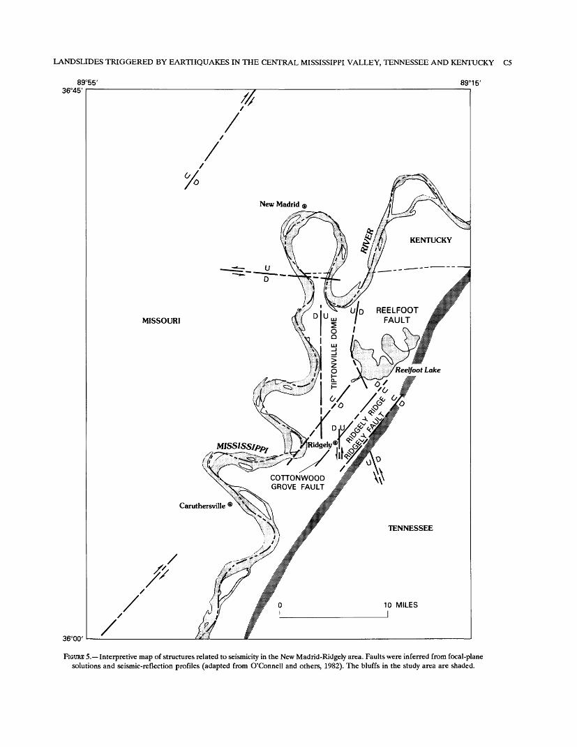
Figure 5 shows locations of subsurface faults in the study area inferred from seismological data and seismic reflection profiling. Several of these faults are adjacent to the bluffs in the study area. The foregoing information indicates that the bluffs being studied are in a seismically active area. The close proximity of earthquake sources means that damaging earthquakes in the area can affect slope stability along the bluffs.
LANDSLIDE INVENTORY
METHOD OF COMPILATION
A landslide inventory map of the bluffs in the study area was compiled on l:24,000-scale topographic base maps using black-and-white l:20,000-scale aerial photographs taken in 1970-71 by the U.S. Department of Agriculture, and, in some areas, color infrared photographs taken by
TABLE 1. Return periods for earthquakes in the New Madrid seismic zone (Johnston and Nava, 1984)
Body-wave magnitude (mb) Mean recurrence time (years)
3.0 4.0 5.0 6.0
0.32.3
18137
Westvaco Corporation. Landslides having minimum dimen sions of 200 ft were the smallest mappable features. Land slides were identified by the presence of arcuate scarps, disrupted or hummocky topography, and ponded drainage.
Landslides were classified according to their morphology and the level of confidence in identification. Three morpho logical classes were used (Varnes, 1978): (1) translational block slides and rotational slumps that have been revegeta- ted and eroded, together classified as old coherent slides (OC), (2) young rotational slumps (YS), which have fresh features, and (3) earth flows (EF), most of which are inactive but some of which have active portions. Three levels of confidence were used for all classes to indicate whether the identification is definite (D), probable (P), or questionable (Q). This procedure is similar to that recommended by Wieczorek (1984) for the compilation of landslide inventory maps. Each landslide feature was identified by a three-letter designation followed by an ordinal number. For example, EFP-14 signifies a probable landslide that is the 14th of the earth-flow type as counted from the north end of the study area.
After completion of the initial mapping from aerial photographs, reconnaissance of the entire study area by fixed-wing aircraft was conducted on two occasions. Also, more than 75 percent of the originally mapped landslide sites were examined on the ground. As a result of the aerial observation and ground investigations, approximately 20 percent of the landslides were upgraded in level of confi dence, and only 4 percent were downgraded or deleted.
The field reconnaissance allowed calibration of the accu racy of the mapping from aerial photographs. Taking the field observations into account, we reexamined the photo graphs, and the sites that were not visited were reviewed and reclassified where appropriate.
RESULTS OF MAPPING
Plate 1 is a strip map of the bluffs at scale 1:62,500 that shows the locations and letter designations of the 221 landslides mapped. The bluffs are divided into 2,500-ft-long segments for this study; every tenth segment is numbered on the map (pi. 1) for reference. The number and characteris tics of the landslides according to the present classification are recorded in table 2.
LANDSLIDES TRIGGERED BY EARTHQUAKES IN THE CENTRAL MISSISSIPPI VALLEY, TENNESSEE AND KENTUCKY C5
89°55' 89°15' 36°45
COTTONWOOD GROVE FAULT
36°00'
FIGCRB 5. Interpretive map of structures related to seismicity in the New Madrid-Ridgely area. Faults were inferred from focal-plane solutions and seismic-reflection profiles (adapted from O'Connell and others, 1982). The bluffs in the study area are shaded.
C6 THE NEW MADRID, MISSOURI, EARTHQUAKE REGION
TABLE 2. Characteristics of landslides in the study area [Length denotes distance, in the direction of landslide movement, from
the head to the toe of the landslide; width denotes distance, perpendic ular to the direction of landslide movement, between lateral margins of the landslide. Length, width, and slope height given in feet; slope angle given in degrees]
Old coherent slides
Young rotational slumps
Earth flows
Number:Definite Probable Questionable
TotalLength:
MinimumMedianMaximum
Width:MinimumMedianMaximum
Slope height:MinimumMedianMaximum
Slope angle:MinimumMedianMaximum
744329
146
200600
13,700
2501,3007,700
30115250
61831
1653
24
200500800
5501,6508,050
30130195
132334
26111451
300600
1,500
2501,200
11,600
50100250
61528
OLD COHERENT SLIDES
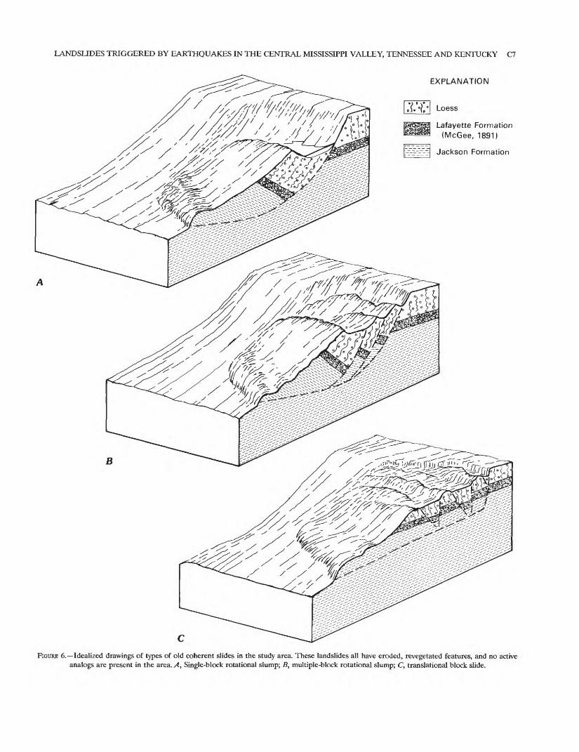
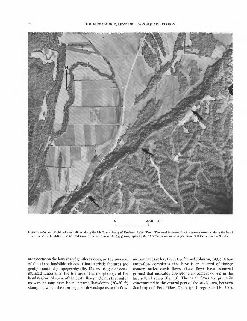
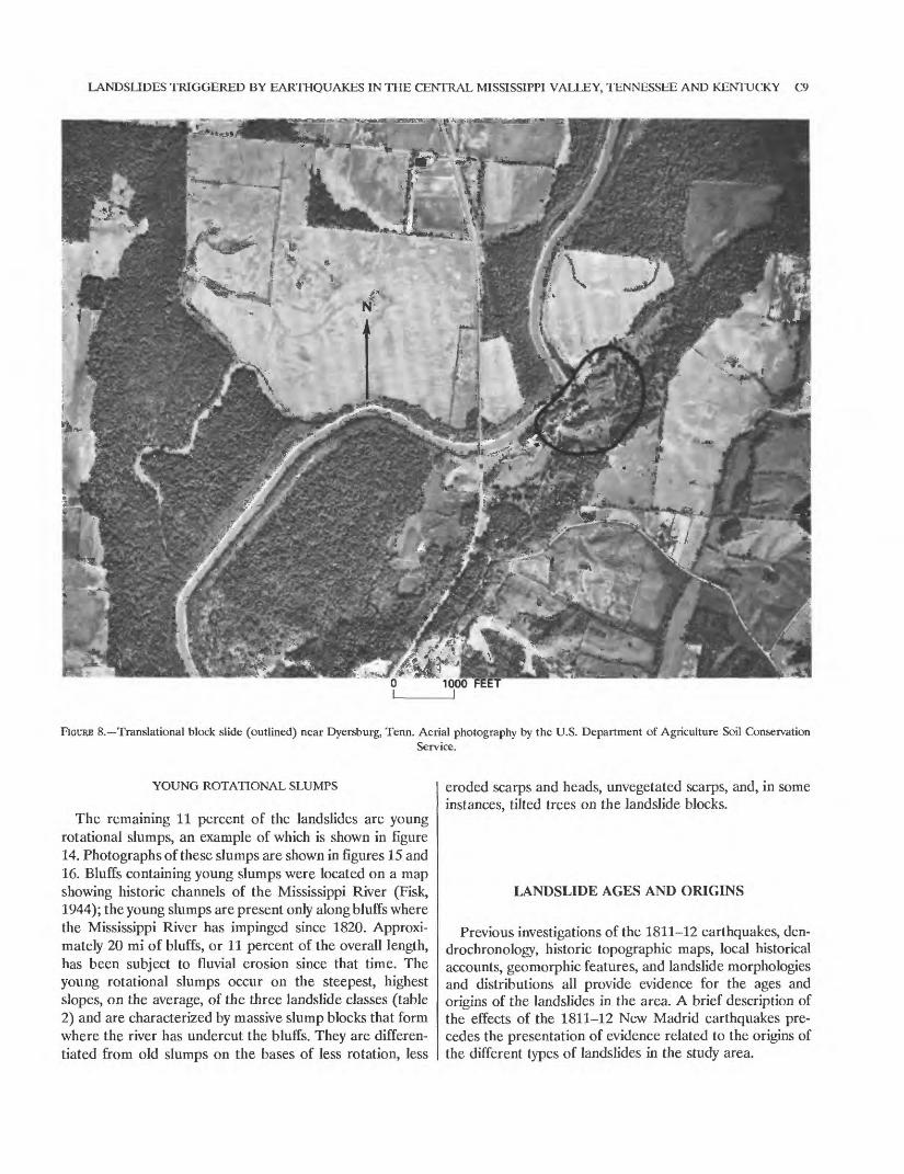
Old coherent slides constitute 65 percent of the land slides. Idealized drawings of this type of landslide are shown in figure 6, and aerial photographs of typical examples are shown in figures 7 and 8. Old translational and rotational landslides were grouped together because heavy tree cover and eroded features generally made it impossible to distin guish between them. In areas where a distinction could be made, nearly equal numbers of translational and rotational slides were present. Both types of landslides in this class are deep-seated (generally greater than 75 ft deep, as judged from landslide geometries and subsurface investigations) and have failure surfaces in the clayey Eocene materials that form the base of the bluffs. None of them have fresh features. Old coherent slides are present throughout the area except in localities where earth flows are concentrated, probably because local geologic conditions influence the type of landsliding.
The translational block slides are characterized by horst- and-graben topography consisting either of one or a few large horst blocks with broad intervening grabens or of several smaller horst-and-graben blocks arranged in stair step fashion. The toe areas commonly have pressure ridges where soil at the base of the slope presumably was com pressed and deformed as the landslide blocks moved down and out from the parent slope. These landslides have basal shear surfaces inclined 4-25° and have moved as much as 300 ft. The horst-and-graben topography is the subject of most of the historical descriptions of the landslides, the most complete being given by Fuller (1912, p. 60) as follows:
On climbing up the bluff the traveler sees increased confusion; sharp ridges of earth alternate with deep gashes, the whole surface locally being broken into a jumble of irregular ridges, mounds, and hummocks, interspersed with trench or basinlike hollows and other more irregular depressions, continuing with increased frequency to the top of the bluff, along the edge of which fault scarps and fissures are of frequent occurrence. Some of the depressions, those between parallel fissures, have [a] canal-like aspect * * *, one reported by Safford [1869] being as much as 100 feet wide. Speaking of Obion County, Tenn., Shaler [1869] says "depressions are even now visible 100 feet deep and varying from a few feet to 100 feet wide." * * *
Although landslides are most strongly developed on spurs, the general slopes of the bluffs are far from being free from them, and some of the resultant mounds and troughs are of considerable magnitude. * * * Water has collected in some of [the troughs], forming small ponds. The individual troughs are generally of considerable length, often several hundred feet. They begin as very slight depressions in the surface of the bluff, which, however, rapidly widen and deepen until strong trenches are produced. The troughs are usually not exactly parallel to the slope; the bottom descends slightly as the trough widens, and it usually has free drainage at the low end or that farthest from its point of beginning. The individual troughs and ridges are more or less curved or irregular. Many of them begin and end abruptly; others divide and subdivide, only to reunite again, forming a network of trenches.
Although the present features are not as fresh as Fuller described them, his description of these landslides corre sponds to what can be seen at present on many translational block slides in the old coherent class. The horst-and-graben topography on a few landslides is very steep (fig. 9); on others it is subdued and gentle (fig. 10), and a continuous variation between these two extremes is present on land slides in the area.
Rotational slumps in the old coherent class are charac terized by either single or multiple rotational blocks. The blocks in most cases appear to have rotated a large amount. Again we quote Fuller (1912, p. 60):The movement in many cases has been such as to cause a tilting of the disturbed masses, the inclination being usually toward the bluff. The steep alluvial and debris fans at the mouths of the gullies extending back into the bluffs also seem to have afforded very favorable conditions for slumping, and many of them, even at the present time [1904-05], exhibit corruga tions and low fault scarps due to the flowage and slumping of the material toward the lowlands.
Erosion and revegetation have subdued the features of both block slides and slumps in the old coherent class; locating the rare exposures that show the attitude of the bedding is generally the only means of distinguishing between them. A large majority of the translational block slides and old rotational slumps appear to be of similar age, on the basis of criteria that will be discussed in detail later (in the section on ages of the landslides). The degree of erosion of landslide ridges is similar for the two types, as is the apparent age and density of vegetation on scarps and disrupted areas. Scarp retreat and incision also appear similar.
EARTH FLOWS
Earth flows, schematically depicted in figure 11, consti tute 24 percent of the landslides. Earth flows in the study
LANDSLIDES TRIGGERED BY EARTHQUAKES IN THE CENTRAL MISSISSIPPI VALLEY, TENNESSEE AND KENTUCKY C7
EXPLANATION
Loess
Lafayette Formation (McGee, 1891)
Jackson Formation
B
FIGURE 6. Idealized drawings of types of old coherent slides in the study area. These landslides all have eroded, revegetated features, and no active analogs are present in the area. A, Single-block rotational slump; B, multiple-block rotational slump; C, translational block slide.
C8 THE NEW MADRID, MISSOURI, EARTHQUAKE REGION
2000 FEET
FIGURE 7. Series of old coherent slides along the bluffs northeast of Reelfoot Lake, Tenn. The road indicated by the arrows extends along the head scarps of the landslides, which slid toward the northwest. Aerial photography by the U.S. Department of Agriculture Soil Conservation Service.
area occur on the lowest and gentlest slopes, on the average, of the three landslide classes. Characteristic features are gently hummocky topography (fig. 12) and ridges of accu mulated material in the toe area. The morphology of the head regions of some of the earth flows indicates that initial movement may have been intermediate-depth (20-50 ft) slumping, which then propagated downslope as earth-flow
movement (Keefer, 1977; Keefer and Johnson, 1983). A few earth-flow complexes that have been cleared of timber contain active earth flows; these flows have fractured ground that indicates downslope movement of soil in the last several years (fig. 13). The earth flows are primarily concentrated in the central part of the study area, between Samburg and Fort Pillow, Tenn. (pi. 1, segments 120-240).
LANDSLIDES TRIGGERED BY EARTHQUAKES IN THE CENTRAL MISSISSIPPI VALLEY, TENNESSEE AND KENTUCKY C9
FIGURE 8. Translational block slide (outlined) near Dyersburg, Tenn. Aerial photography by the U.S. Department of Agriculture Soil ConservationService.
YOUNG ROTATIONAL SLUMPS
The remaining 11 percent of the landslides are young rotational slumps, an example of which is shown in figure 14. Photographs of these slumps are shown in figures 15 and 16. Bluffs containing young slumps were located on a map showing historic channels of the Mississippi River (Fisk, 1944); the young slumps are present only along bluffs where the Mississippi River has impinged since 1820. Approxi mately 20 mi of bluffs, or 11 percent of the overall length, has been subject to fluvial erosion since that time. The young rotational slumps occur on the steepest, highest slopes, on the average, of the three landslide classes (table 2) and are characterized by massive slump blocks that form where the river has undercut the bluffs. They are differen tiated from old slumps on the bases of less rotation, less
eroded scarps and heads, unvegetated scarps, and, in some instances, tilted trees on the landslide blocks.
LANDSLIDE AGES AND ORIGINS
Previous investigations of the 1811-12 earthquakes, den drochronology, historic topographic maps, local historical accounts, geomorphic features, and landslide morphologies and distributions all provide evidence for the ages and origins of the landslides in the area. A brief description of the effects of the 1811-12 New Madrid earthquakes pre cedes the presentation of evidence related to the origins of the different types of landslides in the study area.
CIO THE NEW MADRID, MISSOURI, EARTHQUAKE REGION
FIGURE 9. Steep horst-ridge on a landslide near Gratio, Tenn. Slopes on the ridge are 40-50°.
1811-12 EARTHQUAKE SEQUENCE
The earthquake sequence that began on 16 December 1811 and continued for several months is the most severe seismic event in historical times in the Central United States. The three major events had estimated body-wave magnitudes of 7.1, 7.2, and 7.4. Also, thousands of after shocks shook the area for many months, several of which were at least of moderate intensity (Nuttli, 1973a).
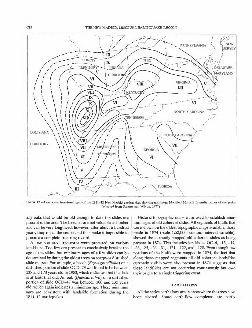
The effects of this earthquake sequence have been described by Fuller (1912), Nuttli (1973a), and Stearns and Wilson (1972); liquefaction effects were further docu mented by Saucier (1977) and Obermeier (in press). A composite isoseismal map of the sequence, based on the Modified Mercalli Intensity (MMI) scale, was compiled by Stearns and Wilson (1972) and is shown in figure 17. Immediately apparent is the large area affected by the earthquakes. Nuttli (1973a) estimated that 1 million sq mi was affected at MMI > V, the threshold of structural damage, and that 230,000 sq mi was affected at MMI > VII, the threshold of major damage. For comparison, 60,000 sq mi was affected at MMI > V and 12,000 sq mi at MMI > VII for the 1906 San Francisco earthquake. The
1811-12 earthquakes were felt as far away as Detroit (550 mi), Toronto (750 mi), New York City (900 mi), and Boston (1,050 mi); in all they were felt over more than 2 million sq mi (Stearns and Wilson, 1972). In Washington, D.C. (700 mi), people were awakened, dishes rattled, and suspended objects swung. Chimneys were damaged as far away as Richmond, Va. (700 mi), Savannah, Ga. (600 mi), and Cincinnati, Ohio (350 mi); plaster cracked and fell in Columbia, S.C. (550 mi); and many homes were badly damaged in St. Louis (150 mi), all as a result of these earthquakes (Nuttli, 1973a).
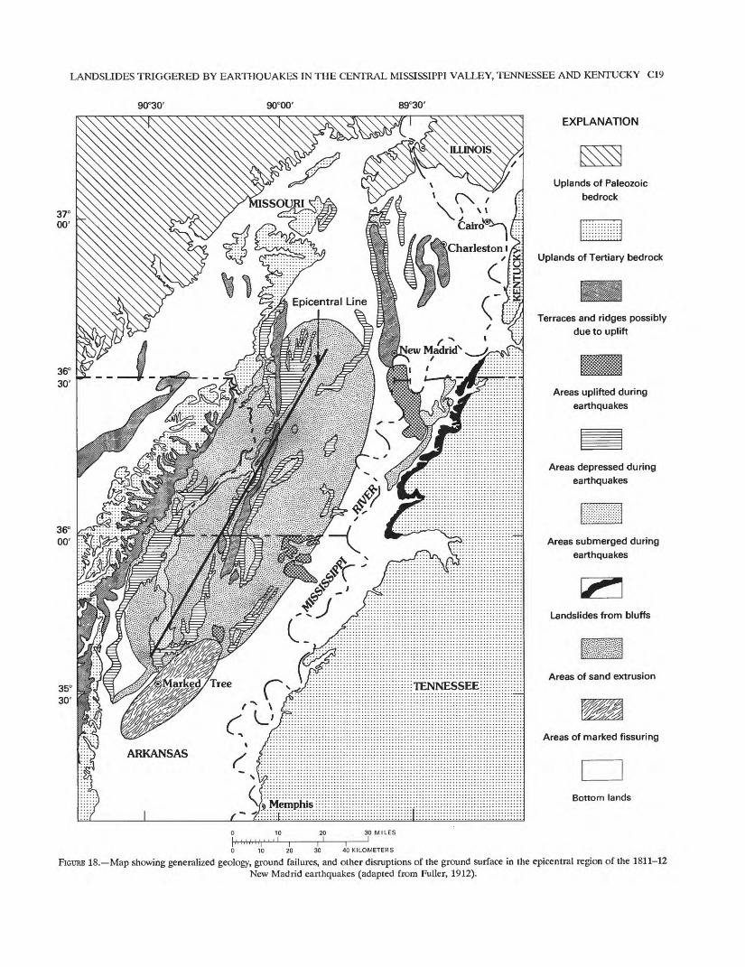
The epicentral area of greatest damage included approx imately 50,000 sq mi (Fuller, 1912). A map adapted from Fuller (1912) showing the epicentral region and the areas affected by various geologic phenomena is shown in figure 18. Within this region, uplift and subsidence on the order of a few feet occurred over hundreds of square miles (Fuller, 1912; Russ, 1982); the most notable area of subsidence was at Reelfoot Lake in northwestern Tennessee. Also, fissuring of the ground surface, caving of river banks, and venting of huge quantities of sand and water from the subsurface occurred. The latter effect was the result of liquefaction of sand layers, and it is estimated to have inundated approxi-
LANDSLIDES TRIGGERED BY EARTHQUAKES IN THE CENTRAL MISSISSIPPI VALLEY, TENNESSEE AND KENTUCKY Cll
i^S*v$U. ^"^i'^-.t.-AJB *?* ? ;'*/ '.fV*,'^it .-*£ *-J..
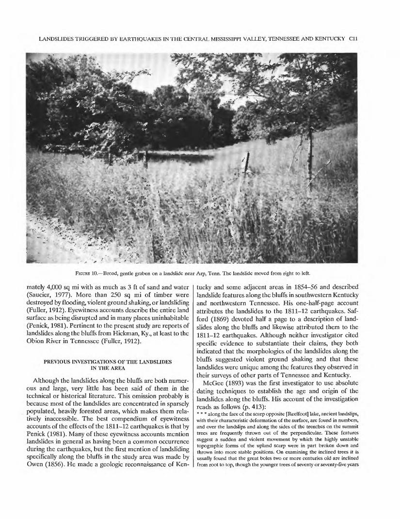
FIGURE 10. Broad, gentle graben on a landslide near Arp, Tenn. The landslide moved from right to left.
mately 4,000 sq mi with as much as 3 ft of sand and water (Saucier, 1977). More than 250 sq mi of timber were destroyed by flooding, violent ground shaking, or landsliding (Fuller, 1912). Eyewitness accounts describe the entire land surface as being disrupted and in many places uninhabitable (Penick, 1981). Pertinent to the present study are reports of landslides along the bluffs from Hickman, Ky., at least to the Obion River in Tennessee (Fuller, 1912).
PREVIOUS INVESTIGATIONS OF THE LANDSLIDES IN THE AREA
Although the landslides along the bluffs are both numer ous and large, very little has been said of them in the technical or historical literature. This omission probably is because most of the landslides are concentrated in sparsely populated, heavily forested areas, which makes them rela tively inaccessible. The best compendium of eyewitness accounts of the effects of the 1811-12 earthquakes is that by Penick (1981). Many of these eyewitness accounts mention landslides in general as having been a common occurrence during the earthquakes, but the first mention of landsliding specifically along the bluffs in the study area was made by Owen (1856). He made a geologic reconnaissance of Ken
tucky and some adjacent areas in 1854-56 and described landslide features along the bluffs in southwestern Kentucky and northwestern Tennessee. His one-half-page account attributes the landslides to the 1811-12 earthquakes. Saf- ford (1869) devoted half a page to a description of land slides along the bluffs and likewise attributed them to the 1811-12 earthquakes. Although neither investigator cited specific evidence to substantiate their claims, they both indicated that the morphologies of the landslides along the bluffs suggested violent ground shaking and that these landslides were unique among the features they observed in their surveys of other parts of Tennessee and Kentucky.
McGee (1893) was the first investigator to use absolute dating techniques to establish the age and origin of the landslides along the bluffs. His account of the investigation reads as follows (p. 413):* * * along the face of the scarp opposite [Reelfoot] lake, ancient landslips, with their characteristic deformation of the surface, are found in numbers, and over the landslips and along the sides of the trenches on the summit trees are frequently thrown out of the perpendicular. These features suggest a sudden and violent movement by which the highly unstable topographic forms of the upland scarp were in part broken down and thrown into more stable positions. On examining the inclined trees it is usually found that the great boles two or more centuries old are inclined from root to top, though the younger trees of seventy or seventy-five years

C12 THE NEW MADRID, MISSOURI, EARTHQUAKE REGION
EXPLANATION
Loess
riririr Jackson Formation
Lafayette Formation (McGee, 1891)
FIGURE 11. Idealized drawing of an earth flow in the study area. Earth flows form a subtle, hummocky topography and have eroded, revegetated features except in those few areas where active lobes are present resulting from the removal of vegetation.
usually stand upright, and that the trunks of a century to a century and a half in age are commonly inclined near the ground, but are vertical above. Thus the forest trees flanking the fissures and clothing the scarp give a trustworthy and fairly accurate date for the production of the minor topographic features a date determined by much counting of annual rings to lie between seventy-five and eighty-five or ninety years ago.
The preceding study was conducted in 1891, 80 years after the onset of the earthquake sequence. McGee's (1893) dendrochronology conclusively brackets the dates of the landslides to the years between 1801 or 1806 and 1816, which is strong evidence that they occurred at the time of the earthquakes. The area he examined is near Reelfoot Lake; he stated (p. 412) that the landslides are present "on approaching the Reelfoot country from the north or the south," so this area probably includes landslides from near Hickman, Ky., to the Obion River in Tennessee (pi. 1, increments 80-150).
The best known and most thorough investigation of the 1811-12 earthquakes is that of Fuller (1912). In three pages (p. 59-61) he described and gave locations of notable concentrations of landslides. Fuller (1912) also studied the ages of straight and tilted trees on landslides along the bluffs in 1904 and determined that "the greater part of the upright growth on the disturbed surfaces is fairly uniform and a little
less than 100 years of age, trees of greater age being in general tilted and partly overthrown." From this he con cluded that the major landslides in the area occurred at the time of the 1811-12 earthquakes. Although Fuller did not specify whether he counted tree rings or merely estimated the ages of the trees, his account corroborates McGee's dendrochronology.
Recent statistical analyses of the regional distribution of the landslides (Jibson and Keefer, in press) showed that the distribution of old coherent slides and earth flows in the study area is related to the estimated locations of the 1811-12 earthquake hypocenters: all other factors being equal, bluffs nearer to the 1811-12 hypocenters had more landslides than those more distant. These results suggest that these landslides were triggered by the 1811-12 earth quakes.
AGES OF DIFFERENT CLASSES OF LANDSLIDES
The preceding historical evidence for the ages of land slides in the study area probably pertains for the most part to old coherent slides, judging by the respective authors'
LANDSLIDES TRIGGERED BY EARTHQUAKES IN THE CENTRAL MISSISSIPPI VALLEY, TENNESSEE AND KENTUCKY C13
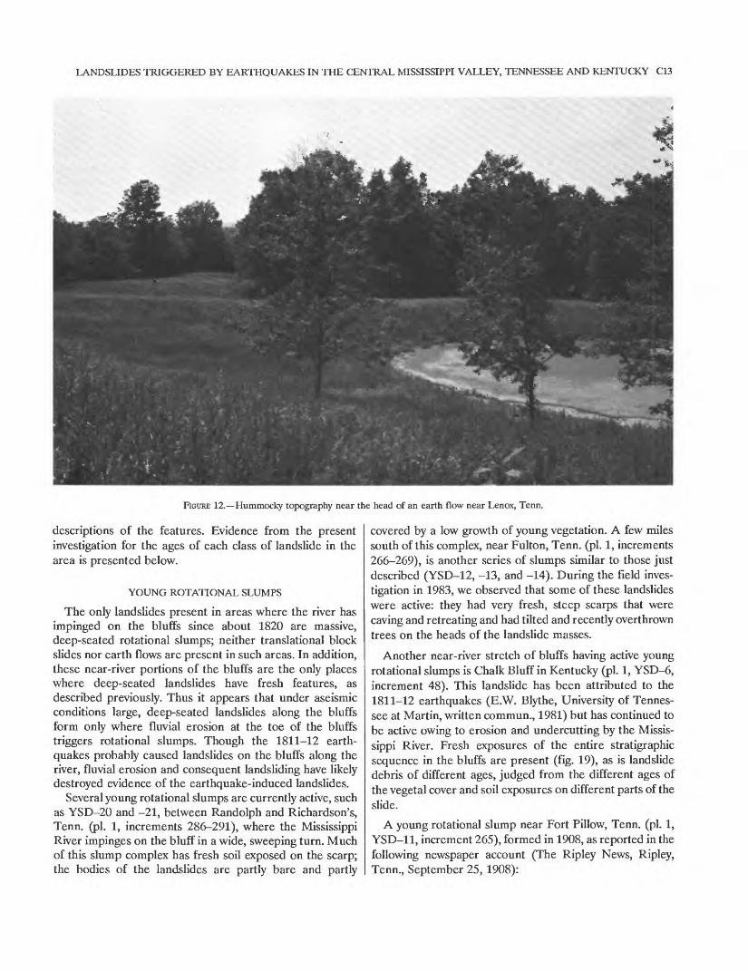
FIGURE 12. Hummocky topography near the head of an earth flow near Lenox, Tenn.
descriptions of the features. Evidence from the present investigation for the ages of each class of landslide in the area is presented below.
YOUNG ROTATIONAL SLUMPS
The only landslides present in areas where the river has impinged on the bluffs since about 1820 are massive, deep-seated rotational slumps; neither translational block slides nor earth flows are present in such areas. In addition, these near-river portions of the bluffs are the only places where deep-seated landslides have fresh features, as described previously. Thus it appears that under aseismic conditions large, deep-seated landslides along the bluffs form only where fluvial erosion at the toe of the bluffs triggers rotational slumps. Though the 1811-12 earth quakes probably caused landslides on the bluffs along the river, fluvial erosion and consequent landsliding have likely destroyed evidence of the earthquake-induced landslides.
Several young rotational slumps are currently active, such as YSD-20 and -21, between Randolph and Richardson's, Tenn. (pi. 1, increments 286-291), where the Mississippi River impinges on the bluff in a wide, sweeping turn. Much of this slump complex has fresh soil exposed on the scarp; the bodies of the landslides are partly bare and partly
covered by a low growth of young vegetation. A few miles south of this complex, near Fulton, Tenn. (pi. 1, increments 266-269), is another series of slumps similar to those just described (YSD-12, -13, and -14). During the field inves tigation in 1983, we observed that some of these landslides were active: they had very fresh, steep scarps that were caving and retreating and had tilted and recently overthrown trees on the heads of the landslide masses.
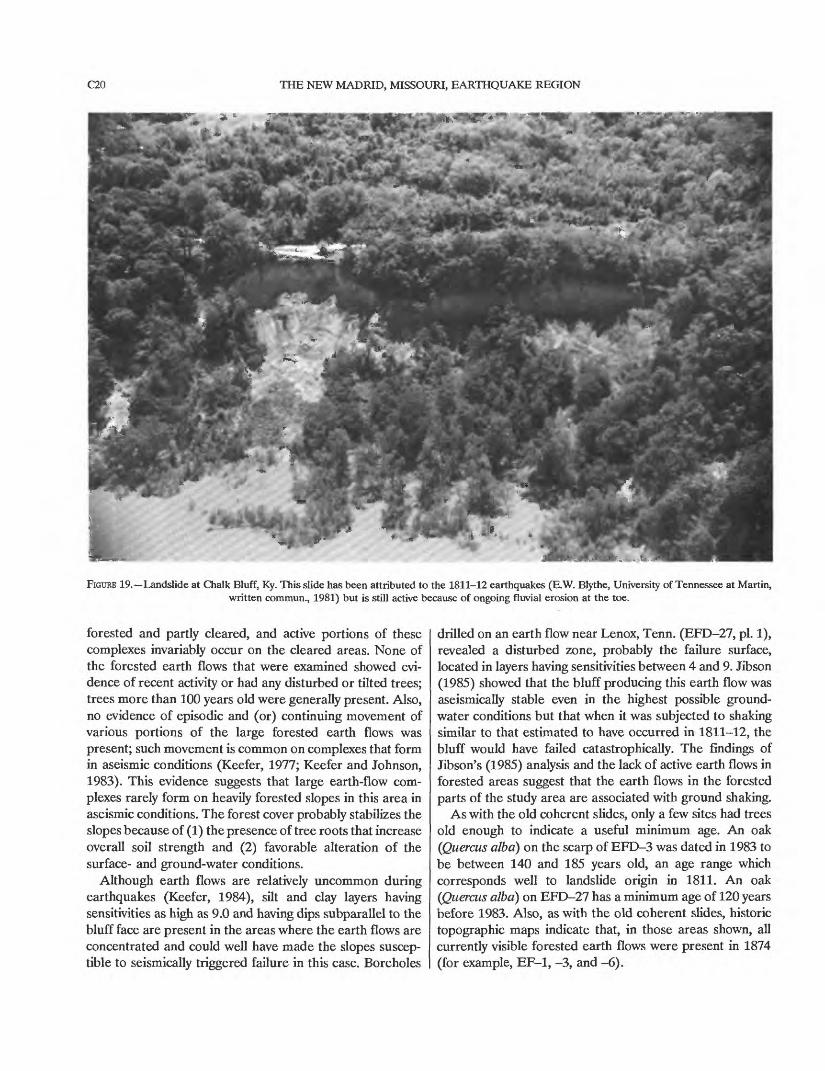
Another near-river stretch of bluffs having active young rotational slumps is Chalk Bluff in Kentucky (pi. 1, YSD-6, increment 48). This landslide has been attributed to the 1811-12 earthquakes (E.W. Blythe, University of Tennes see at Martin, written commun., 1981) but has continued to be active owing to erosion and undercutting by the Missis sippi River. Fresh exposures of the entire stratigraphic sequence in the bluffs are present (fig. 19), as is landslide debris of different ages, judged from the different ages of the vegetal cover and soil exposures on different parts of the slide.
A young rotational slump near Fort Pillow, Tenn. (pi. 1, YSD-11, increment 265), formed in 1908, as reported in the following newspaper account (The Ripley News, Ripley, Tenn., September 25, 1908):

C14 THE NEW MADRID, MISSOURI, EARTHQUAKE REGION
FIGURE 13. Active lobe of a large earth-flow complex near Lenox, Tenn. The active area has been cleared for pasture.
Without warning thirty acres of land, in one huge mass, caved into the capacious maw of the Mississippi River at the site of old Fort Pillow, fifty miles north of Memphis * * * Saturday [September 19, 1908].
The bluff where the slide took place is nearly two hundred feet high and the rending and groaning of the earth could be heard for miles around. The river had been very low and the current, taking a new direction, had evidently cut far back under the bank, causing the slide.
No one was hurt and damage was slight, though by the time the great mass of earth reached the river it was moving with considerable velocity and caused a great tidal wave, which swept across the river and tossed a lot of house boats, moored at Butler, Ark., topsy turvy into a dense growth of willows and inundated acres of cotton.This account indicates both the age of this young rotational slump and the mechanism of failure: rapid, catastrophic slumping of a large mass resulting from oversteepening by fluvial erosion.
Ages of some young rotational slumps were bracketed by comparing topographic maps and aerial photographs of different ages to see when the landslide was first visible. For example, topographic expression of landslide YSD-1 (pi. 1) was present on a 1911 topographic map (scale 1:62,500; contour interval 10-20 ft) but not on an 1874 map (scale
1:52,000; contour interval variable), which brackets the probable onset of landsliding between those dates. Simi larly, landslides YSP-23 and YSD-24 (pi. 1) appear in 1932 aerial photographs (scale 1:20,000) but not on the 1874 topographic map.
The preceding evidence indicates that landslides identi fied as young rotational slumps are related to fluvial bluff erosion and that they postdate the 1811-12 earthquakes.
OLD COHERENT SLIDES
If the old coherent slides in the study area were triggered by fluvial erosion and oversteepening of the bluffs, we would expect to see (1) a continuous variation in landslide ages corresponding to the length of time since the river impinged on different parts of the bluffs and (2) active analogs forming along bluffs currently being undercut by the Mis sissippi River. Neither situation occurs. Most old coherent slides, both rotational and translational, appear to be of similar age. And as stated in the preceding section, the only
LANDSLIDES TRIGGERED BY EARTHQUAKES IN THE CENTRAL MISSISSIPPI VALLEY, TENNESSEE AND KENTUCKY C15
EXPLANATION
Loess
Lafayette Formation (McGee, 1891)
^n^^ Jackson Formation
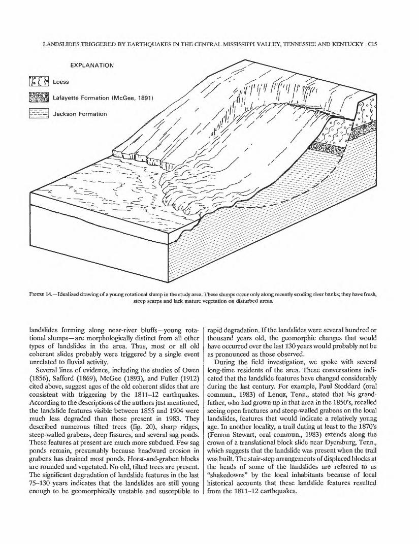
FIGURE 14. Idealized drawing of a young rotational slump in the study area. These slumps occur only along recently eroding river banks; they have fresh,steep scarps and lack mature vegetation on disturbed areas.
landslides forming along near-river bluffs young rota tional slumps are morphologically distinct from all other types of landslides in the area. Thus, most or all old coherent slides probably were triggered by a single event unrelated to fluvial activity.
Several lines of evidence, including the studies of Owen (1856), Safford (1869), McGee (1893), and Fuller (1912) cited above, suggest ages of the old coherent slides that are consistent with triggering by the 1811-12 earthquakes. According to the descriptions of the authors just mentioned, the landslide features visible between 1855 and 1904 were much less degraded than those present in 1983. They described numerous tilted trees (fig. 20), sharp ridges, steep-walled grabens, deep fissures, and several sag ponds. These features at present are much more subdued. Few sag ponds remain, presumably because headward erosion in grabens has drained most ponds. Horst-and-graben blocks are rounded and vegetated. No old, tilted trees are present. The significant degradation of landslide features in the last 75-130 years indicates that the landslides are still young enough to be geomorphically unstable and susceptible to
rapid degradation. If the landslides were several hundred or thousand years old, the geomorphic changes that would have occurred over the last 130 years would probably not be as pronounced as those observed.
During the field investigation, we spoke with several long-time residents of the area. These conversations indi cated that the landslide features have changed considerably during the last century. For example, Paul Stoddard (oral commun., 1983) of Lenox, Tenn., stated that his grand father, who had grown up in that area in the 1850's, recalled seeing open fractures and steep-walled grabens on the local landslides, features that would indicate a relatively young age. In another locality, a trail dating at least to the 1870's (Ferron Stewart, oral commun., 1983) extends along the crown of a translational block slide near Dyersburg, Tenn., which suggests that the landslide was present when the trail was built. The stair-step arrangements of displaced blocks at the heads of some of the landslides are referred to as "shakedowns" by the local inhabitants because of local historical accounts that these landslide features resulted from the 1811-12 earthquakes.
C16 THE NEW MADRID, MISSOURI, EARTHQUAKE REGION
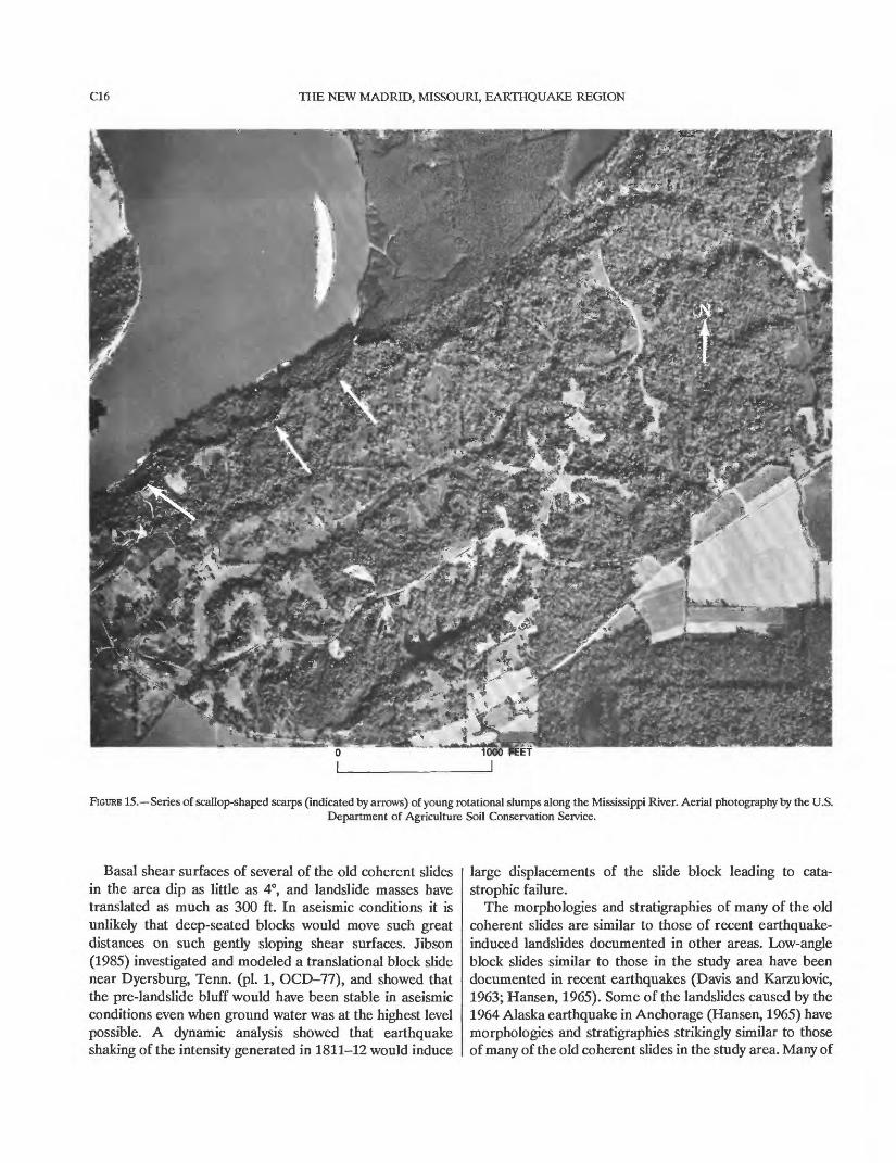
FIGURE 15. Series of scallop-shaped scarps (indicated by arrows) of young rotational slumps along the Mississippi River. Aerial photography by the U.S.Department of Agriculture Soil Conservation Service.
Basal shear surfaces of several of the old coherent slides in the area dip as little as 4°, and landslide masses have translated as much as 300 ft. In aseismic conditions it is unlikely that deep-seated blocks would move such great distances on such gently sloping shear surfaces. Jibson (1985) investigated and modeled a translational block slide near Dyersburg, Tenn. (pi. 1, OCD-77), and showed that the pre-landslide bluff would have been stable in aseismic conditions even when ground water was at the highest level possible. A dynamic analysis showed that earthquake shaking of the intensity generated in 1811-12 would induce
large displacements of the slide block leading to cata strophic failure.
The morphologies and stratigraphies of many of the old coherent slides are similar to those of recent earthquake- induced landslides documented in other areas. Low-angle block slides similar to those in the study area have been documented in recent earthquakes (Davis and Karzulovic, 1963; Hansen, 1965). Some of the landslides caused by the 1964 Alaska earthquake in Anchorage (Hansen, 1965) have morphologies and stratigraphies strikingly similar to those of many of the old coherent slides in the study area. Many of
LANDSLIDES TRIGGERED BY EARTHQUAKES IN THE CENTRAL MISSISSIPPI VALLEY, TENNESSEE AND KENTUCKY C17
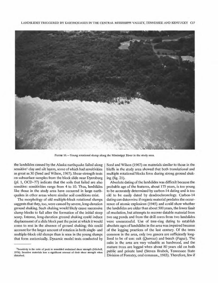
FIGURE 16. Young rotational slump along the Mississippi River in the study area.
the landslides caused by the Alaska earthquake failed along sensitive1 clay and silt layers, some of which had sensitivities as great as 30 (Seed and Wilson, 1967). Shear-strength tests on subsurface samples from the block slide near Dyersburg (pi. 1, OCD-77) indicate that the soils that failed are also sensitive: sensitivities range from 4 to 10. Thus, landslides like those in the study area have occurred in large earth quakes in other areas where similar soil conditions exist.
The morphology of old multiple-block rotational slumps suggests that they, too, were caused by severe, long-duration ground shaking. Such shaking would likely cause successive slump blocks to fail after the formation of the initial steep scarp. Intense, long-duration ground shaking could induce displacement of a slide block past the point at which it would come to rest in the absence of ground shaking; this could account for the larger amount of rotation in both single- and multiple-block old slumps than is seen in the young slumps that form aseismically. Dynamic model tests conducted by
Sensitivity is the ratio of peak to remolded undrained shear strength (Mitchell, 1976). Sensitive materials lose a significant amount of their shear strength when disturbed.
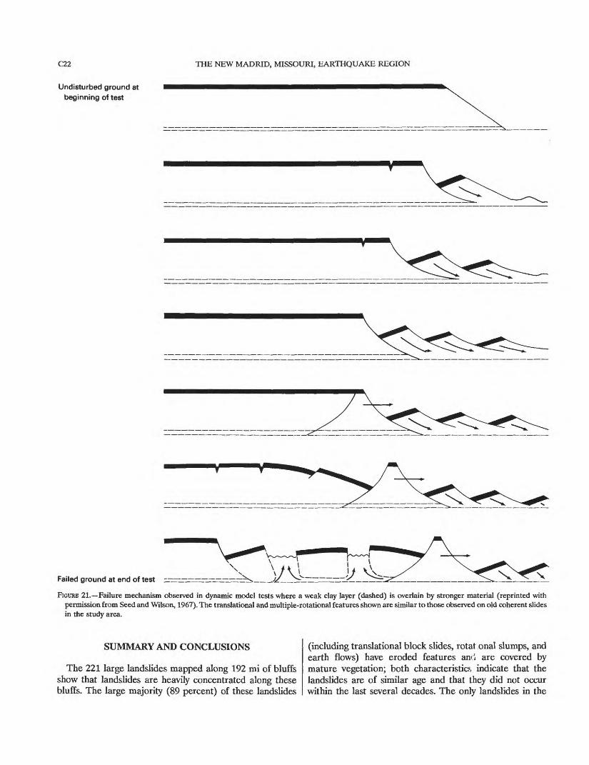
Seed and Wilson (1967) on materials similar to those in the bluffs in the study area showed that both translational and multiple rotational blocks form during strong ground shak ing (fig. 21).
Absolute dating of the landslides was difficult because the probable age of the features, about 175 years, is too young to be accurately determined by carbon-14 dating and is too old to be easily dated by dendrochronology. Carbon-14 dating can determine if organic material predates the occur rence of atomic explosions (1945) and could show whether the landslides are older than about 500 years, the lower limit of resolution, but attempts to recover datable material from two sag ponds and from the drill cores from two landslides were unsuccessful. Use of tree-ring dating to establish absolute ages of landslides in the area was impaired because of the logging practices of the last century. Of the trees common in the area, only two genera are sufficiently long- lived to be of use: oak (Quercus) and beech (Fagus). The oaks in the area are very valuable as hardwood, and the mature trees are logged when about 80 years old on both public and private land (Steven Brabek, Tennessee State Division of Forestry, oral commun., 1983). Therefore, few if
CIS THE NEW MADRID, MISSOURI, EARTHQUAKE REGION
\ \\ \ \ \ \ \\ \\ \ \\ \ \ \ \\ \ >^\\v\v?\\\\ wv ^
FIGURE 17. Composite isoseismal map of the 1811-12 New Madrid earthquakes showing maximum Modified Mercalli Intensity values of the series(adapted from Stearns and Wilson, 1972).
any oaks that would be old enough to date the slides are present in the area. The beeches are not valuable as lumber and can be very long-lived; however, after about a hundred years, they rot in the center and thus make it impossible to procure a complete tree-ring record.
A few scattered tree-cores were procured on various landslides. Too few are present to conclusively bracket the age of the slides, but minimum ages of a few slides can be determined by dating the oldest trees on scarps or disturbed slide masses. For example, a beech (Fflgws grandifolia) on a disturbed portion of slide OCD-73 was found to be between 138 and 173 years old in 1983, which indicates that the slide is at least that old. An oak (Quercus rubra) on a disturbed portion of slide OCD-47 was between 100 and 130 years old, which again indicates a minimum age. These minimum ages are consistent with landslide formation during the 1811-12 earthquakes.
Historic topographic maps were used to establish mini mum ages of old coherent slides. All segments of bluffs that were shown on the oldest topographic maps available, those made in 1874 (scale 1:52,000; contour interval variable), showed the currently mapped old coherent slides as being present in 1874. This includes landslides OC-4, -13, -14, -23, -25, -26, -31, -121, -122, and -128. Even though few portions of the bluffs were mapped in 1874, the fact that along those mapped segments all old coherent landslides currently visible were also present in 1874 suggests that these landslides are not occurring continuously but owe their origin to a single triggering event.
EARTH FLOWS
All the active earth flows are in areas where the trees have been cleared. Some earth-flow complexes are partly
LANDSLIDES TRIGGERED BY EARTHQUAKES IN THE CENTRAL MISSISSIPPI VALLEY, TENNESSEE AND KENTUCKY C19
90°30' 90°00' 89°30'
EXPLANATION
Uplands of Tertiary bedrock
Terraces and ridges possibly
Areas of marked fissurmg
Bottom lands
0 10 20 30 40 KILOMETERS
FIGURE 18. Map showing generalized geology, ground failures, and other disruptions of the ground surface in the epicentral region of the 1811-12New Madrid earthquakes (adapted from Fuller, 1912).
C20 THE NEW MADRID, MISSOURI, EARTHQUAKE REGION
FIGURE 19. Landslide at Chalk Bluff, Ky. This slide has been attributed to the 1811-12 earthquakes (E.W. Blythe, University of Tennessee at Martin, written commun., 1981) but is still active because of ongoing fluvial erosion at the toe.
forested and partly cleared, and active portions of these complexes invariably occur on the cleared areas. None of the forested earth flows that were examined showed evi dence of recent activity or had any disturbed or tilted trees; trees more than 100 years old were generally present. Also, no evidence of episodic and (or) continuing movement of various portions of the large forested earth flows was present; such movement is common on complexes that form in aseismic conditions (Keefer, 1977; Keefer and Johnson, 1983). This evidence suggests that large earth-flow com plexes rarely form on heavily forested slopes in this area in aseismic conditions. The forest cover probably stabilizes the slopes because of (1) the presence of tree roots that increase overall soil strength and (2) favorable alteration of the surface- and ground-water conditions.
Although earth flows are relatively uncommon during earthquakes (Keefer, 1984), silt and clay layers having sensitivities as high as 9.0 and having dips subparallel to the bluff face are present in the areas where the earth flows are concentrated and could well have made the slopes suscep tible to seismically triggered failure in this case. Boreholes
drilled on an earth flow near Lenox, Tenn. (EFD-27, pi. 1), revealed a disturbed zone, probably the failure surface, located in layers having sensitivities between 4 and 9. Jibson (1985) showed that the bluff producing this earth flow was aseismically stable even in the highest possible ground- water conditions but that when it was subjected to shaking similar to that estimated to have occurred in 1811-12, the bluff would have failed catastrophically. The findings of Jibson's (1985) analysis and the lack of active earth flows in forested areas suggest that the earth flows in the forested parts of the study area are associated with ground shaking.
As with the old coherent slides, only a few sites had trees old enough to indicate a useful minimum age. An oak (Quercus alba) on the scarp of EFD-3 was dated in 1983 to be between 140 and 185 years old, an age range which corresponds well to landslide origin in 1811. An oak (Quercus alba) on EFD-27 has a minimum age of 120 years before 1983. Also, as with the old coherent slides, historic topographic maps indicate that, in those areas shown, all currently visible forested earth flows were present in 1874 (for example, EF-1, -3, and -6).

LANDSLIDES TRIGGERED BY EARTHQUAKES IN THE CENTRAL MISSISSIPPI VALLEY, TENNESSEE AND KENTUCKY C21
FIGURE 20. Curved and bent trees in 1904 on landslide masses near Reelfoot Lake (photograph by M.L. Fuller).
C22 THE NEW MADRID, MISSOURI, EARTHQUAKE REGION
Undisturbed ground at beginning of test
Failed ground at end of test z
FIGURE 21. Failure mechanism observed in dynamic model tests where a weak clay layer (dashed) is overlain by stronger material (reprinted with permission from Seed and Wilson, 1967). The translational and multiple-rotational features shown are similar to those observed on old coherent slides in the study area.
SUMMARY AND CONCLUSIONS
The 221 large landslides mapped along 192 mi of bluffs show that landslides are heavily concentrated along these bluffs. The large majority (89 percent) of these landslides
(including translational block slides, rotat onal slumps, and earth flows) have eroded features anri are covered by mature vegetation; both characteristics indicate that the landslides are of similar age and that they did not occur within the last several decades. The only landslides in the

LANDSLIDES TRIGGERED BY EARTHQUAKES IN THE CENTRAL MISSISSIPPI VALLEY, TENNESSEE AND KENTUCKY C23
area having fresh features are rotational slumps that occur solely along near-river portions of the bluffs. These land slides are distinguished from the other, older landslides by their smaller amounts of rotation, fresher features, and recently tilted and disturbed vegetation.
Field and historical evidence indicates that the only large, deep-seated landslides forming along the bluffs in aseismic conditions are rotational slumps that occur where the Mississippi River erodes the base of the bluffs. Approxi mately 11 percent of the area is thus affected. Evidence presented concerning the old coherent slides and the for ested earth flows indicates that (1) most of these slides are about the same age, which suggests a single triggering event; (2) probable ages of these landslides are consistent with triggering by the 1811-12 earthquakes, on the basis of results of previous investigations and evidence presented from this study; and (3) morphologies and stratigraphies of these landslides are consistent with seismic triggering, on the basis of slope-stability analyses of representative land slides in the area, model tests, and reports of analogous landslides in other large earthquakes where bluffs com posed of similar materials were present.
REFERENCES
Braile, L.W., Hinze, W.J., Sexton, J.L., Keller, G.R., and Lidiak, E.G., 1984, Tectonic development of the New Madrid seismic zone, in Gori, P.L., and Hays, W.W., eds., Proceedings of the symposium on the New Madrid seismic zone: U.S. Geological Survey Open-File Report 84-770, p. 204-233.
Conrad, T.A., 1848, Observations on the Eocene formation and descrip tion of 105 new fossils of that period, from the vicinity of Vicksburg, Miss.: Philadelphia Academy of Natural Sciences, Proceedings, 1847, 1st ser., v. 3, p. 280-299.
1856, Observations on the Eocene deposit of Jackson, Miss., withdescriptions of 34 new species of shells and corals: PhiladelphiaAcademy of Natural Sciences, Proceedings, 1855, 1st ser., v. 7, p.257-258.
Gushing, E.M., Boswell, E.H., Speer, P.R., and Hosman, R.L., 1970,Availability of water in the Mississippi embayment: U.S. GeologicalSurvey Professional Paper 448-A, 13 p.
Davis, S.N., and Karzulovic, K.J., 1963, Landslides at Lage Rinihue, Chile:Seismological Society of America Bulletin, v. 53, no. 6, p. 1403-1414.
Finch, W.I., 1971a, Geologic map of part of the Hickman quadrangle,Fulton County, Kentucky and Mississippi County, Missouri: U.S.Geological Survey Geologic Quadrangle Map GQ-874, scale1:24,000.
1971b, Geologic map of part of the Bondurant quadrangle, Fulton County, Kentucky and New Madrid and Mississippi Counties, Mis souri: U.S. Geological Survey Geologic Quadrangle Map GQ-944, scale 1:24,000.
Fisk, H.N., 1944, Geological investigation of the alluvial valley of the lower Mississippi River: Vicksburg, Miss., U.S. Corps of Engineers Missis sippi River Commission, 78 p.
Fuller, M.L., 1912, The New Madrid earthquake: U.S. Geological Survey Bulletin 494, 119 p.
Hansen, W.R., 1965, Effects of the earthquake of March 27, 1964, at Anchorage, Alaska: U.S. Geological Survey Professional Paper 542-A, 68 p.
Hopper, M.G., Algermissen, S.T., and Dobrovolny, E.E., 1983, Estimation of earthquake effects associated with a great earthquake in the New Madrid seismic zone: U.S. Geological Survey Open-File Report 83-179, 94 p.
Jibson, R.W., 1985, Landslides caused by the 1811-12 New Madrid earthquakes: Stanford, Calif., Stanford University, Ph.D. dissertation, 232 p.
Jibson, R.W., and Keefer, O.K., 1984, Earthquake-induced landslides in the central Mississippi Valley, Tennessee and Kentucky, in Gori, P.L., and Hays, W.W., eds., Proceedings of the symposium on the New Madrid seismic zone: U.S. Geological Survey Open-File Report 84-770, p. 353-390.
in press, Statistical analysis of factors affecting landslide distribu tion in the New Madrid seismic zone, Tennessee and Kentucky: Engineering Geology.
Johnston, A.C., and Nava, S.J., 1984, Recurrence rates and probability estimates for the New Madrid seismic zone, in Gori, P.L., and Hays, W.W., eds., Proceedings of the symposium on the New Madrid seismic zone: U.S. Geological Survey Open-File Report 84-770, p. 279-329.
Keefer, D.K., 1977, Earthflow: Stanford, Calif., Stanford University, Ph.D. dissertation, 317 p.
1984, Landslides caused by earthquakes: Geological Society of America Bulletin, v. 95, p. 406-421.
Keefer, D.K., and Johnson, A.M., 1983, Earth flows: morphology, mobi lization, and movement: U.S. Geological Survey Professional Paper 1264, 56 p.
Krinitzsky, E.L., and Turnbull, W.J., 1969, Loess deposits of Mississippi: Geological Society of America Special Paper 94, 64 p.
Lee, K.Y., 1974, Geologic map of the Oakton quadrangle and part of the Wolf Island quadrangle, Hickman and Fulton Counties, Kentucky: U.S. Geological Survey Geologic Quadrangle Map GQ-1187, scale 1:24,000.
McClain, W.C., and Myers, O.H., 1970, Seismic history and seismicity of the southeastern region of the United States: U.S. Atomic Energy Commission, Oak Ridge National Laboratory, ORNL-4582, 41 p.
McGee, W.J., 1891, The Lafayette Formation: U.S. Geological Survey 12th Annual Report, pt. 1, p. 387-521.
1893, A fossil earthquake: Geological Society of America Bulletin,v. 4, p. 411^14.
Mitchell, J.K., 1976, Fundamentals of soil behavior: New York, John Wileyand Sons, 422 p.
Mosaic, 1976, Quakes in search of a theory: National Science Foundation,v. 7, no. 4, p. 2-11.
Nuttli, O.W., 1973a, The Mississippi Valley earthquakes of 1811 and 1812:intensities, ground motion, and magnitudes: Seismological Society ofAmerica Bulletin, v. 63, p. 227-248.
1973b, Seismic wave attenuation and magnitude relations for eastern North America: Journal of Geophysical Research, v. 78, no. 5, p. 876-885.
-1982, Damaging earthquakes of the central Mississippi valley, inMcKeown, F.A., and Pakiser, L.C., eds., Investigations of the New Madrid, Missouri, earthquake region: U.S. Geological Survey Profes sional Paper 1236, p. 15-20.
Nuttli, O.W., and Herrmann, R.B., 1984, Ground motion of Mississippi Valley earthquakes: American Society of Civil Engineers, Journal of Technical Topics in Civil Engineering, v. 110, no. 1, p. 54-69.
Nuttli, O.W., and Zollweg, J.E., 1974, The relation between felt area and magnitude for central United States earthquakes: Seismological Society of America Bulletin, v. 64, no. 1, p. 73-85.
Obermeier, S.F., in press, The New Madrid earthquakes: an engineering- geologic interpretation of relict liquefaction features: U.S. Geological Survey Professional Paper 1336-B.
C24 THE NEW MADRID, MISSOURI, EARTHQUAKE REGION
O'Connell, D.R., Bufe, C.G., and Zoback, M.D., 1982, Microearthquakes and faulting in the area of New Madrid, Missouri Reelfoot Lake, Tennessee, in McKeown, F.A., and Pakiser, L.C., eds., Investigations of the New Madrid, Missouri, earthquake region: U.S. Geological Survey Professional Paper 1236, p. 31-38.
Olive, W.W., 1967, Geologic map of part of the Cayce quadrangle, Hickman and Fulton Counties, Kentucky: U.S. Geological Survey Geologic Quadrangle Map GQ-601, scale 1:24,000.
1974, Geologic map of the Wickliffe quadrangle, Kentucky-Missouri, and the part of the Wyatt quadrangle in Ken tucky: U.S. Geological Survey Geologic Quadrangle Map GQ-1161, scale 1:24,000.
Owen, D.D., 1856, Report of the geological survey in Kentucky, made during the years 1854 and 1855: Frankfort, Ky., p. 117-119.
Penick, J.L., 1981, The New Madrid earthquakes (revised edition): Columbia, Mo., University of Missouri Press, 176 p.
Potter, P.E., 1955, The petrology and origin of the Lafayette Gravel, part II, geomorphic history: Journal of Geology, v. 63, no. 2, p. 115-132.
Russ, D.P., 1982, Style and significance of surface deformation in the vicinity of New Madrid, Missouri, in McKeown, F.A., and Pakiser, L.C., eds., Investigations of the New Madrid, Missouri, earthquake region: U.S. Geological Survey Professional Paper 1236, p. 95-114.
Safford, J.M., 1869, Geology of Tennessee: Nashville, Tenn., S.C. Mercer, 550 p.
Saucier, R.T., 1977, Effects of the New Madrid earthquake series in the
Mississippi alluvial valley: U.S. Army Engineers Waterways Experi ment Station Soils and Pavements Laboratory, Miscellaneous Paper S-77-5, 25 p.
Schreurs, R.L., and Marcher, M.V., 1959, Geology and ground-water resources of the Dyersburg quadrangle, Tennessee: Tennessee Divi sion of Geology Report of Investigations No. 7, 61 p.
Seed, H.B., and Wilson, S.D., 1967, The Turnagain Heights landslide, Anchorage, Alaska: American Society of Civil Engineers, Journal of the Soil Mechanics and Foundations Division, v. 93, no. SM4, p. 325-353.
Shaler, N.S., 1869, Earthquakes of the western United States: Atlantic Monthly, November 1869, p. 549-559.
Stearns, R.G., and Marcher, M.V., 1962, Late Cretaceous and subsequent structural development of the northern Mississippi embayment area: Tennessee Division of Geology Report of Investigations No. 18, 8 p.
Stearns, R.G., and Wilson, C.W., 1972, Relationship of earthquakes and geology in west Tennessee and adjacent areas: Nashville, Tenn., Vanderbilt University, unpublished report to Tennessee Valley Authority, 128 p.
Varnes, D.J., 1978, Slope movement types and processes, in Schuster, R.L., and Krizek, R.J., eds., Landslides: analysis and control: Trans portation Research Board, National Academy of Sciences, Washing ton, D.C., special report 176, p. 11-33.
Wieczorek, G.F., 1984, Preparing a detailed landslide-inventory map for hazard evaluation and reduction: Association of Engineering Geolo gists Bulletin, v. 21, no. 3, p. 337-342.
r US GOVERNMENT PBINTINQ OFFICE: 1988 - 201-933 - 226/80019

![Park Map of Natchez Trace Parkway National Scenic Trail [Mississippi, Alabama, and Tennessee]](https://img.pdfslide.us/doc/110x75/577ce6f11a28abf10393ff30/park-map-of-natchez-trace-parkway-national-scenic-trail-mississippi-alabama.jpg)