Embed Size (px)
Citation preview
LANDSLIDES ALONG THE SEA TO SKY CORRIDOR Andrée Blais-Stevens, Geological Survey of Canada, 601 Booth St., Ottawa, Ontario, Canada K1A 0E8 Dirk Septer, P.O. Box 1000, Whaletown, BC Canada V0P 1Z0BC ABSTRACT The Sea to Sky Highway (Hwy. 99) stretches 110 km through the southern Coast Mountains of British Columbia from West Vancouver to Pemberton. Although picturesque, the highway corridor is vulnerable to a variety of hazardous natural processes: landslides, earthquakes, floods, snow avalanches, and to some extent volcanism. The focus of our paper is on landslide hazard. More than 18 percent of Canada’s total landslide related deaths (>600) have occurred along the Sea to Sky corridor. Over the last 100 years, hundreds of landslide events have been reported. An inventory on landslides from available newspaper articles as well as geotechnical reports and scientific articles reveals a trend in landslide reporting frequency with a peak period during the 1980’s and 1990’s at approximately 40 events for each decade. We show the geographical distribution of landslides from the above-mentioned reports, classify the landslides
by type, and give examples of their impacts.
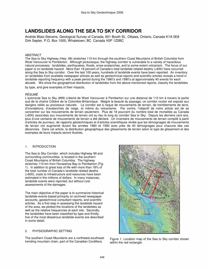
RÉSUMÉ L’autoroute Sea to Sky (#99) s’étend de West Vancouver à Pemberton sur une distance de 110 km à travers la partie sud de la chaîne Côtière de la Colombie-Britannique. Malgré la beauté du paysage, ce corridor routier est exposé aux dangers reliés au processus naturels. Le corridor est à risque de mouvements de terrain, de tremblements de terre, d’inondations, d’avalanches de neige, et même du volcanisme. Par contre, l’objectif de notre article est de se concentrer sur les mouvements de terrain seulement. Plus de 18 pourcent du nombre total de mortalités au Canada (>600) associées aux mouvements de terrain ont eu lieu le long du corridor Sea to Sky. Depuis les derniers cent ans, plus d’une centaine de mouvements de terrain a été déclaré. Un inventaire de mouvements de terrain compilé à partir d’articles de journaux, de rapports géotechniques et d’articles scientifiques révèle que les témoignages de mouvements de terrain ont augmenté durant les années 1980 et 1990 avec près de 40 témoignages pour chacune des ces décennies. Dans cet article, la distribution géographique des glissements de terrain selon le type de glissement et des exemples de leurs impacts seront illustrés. 1. INTRODUCTION The Sea to Sky Corridor, which includes Highway 99 and surrounding communities, is located in the southern Coast Mountains of British Columbia. The highway stretches 110 km from Horseshoe Bay to Pemberton (Fig. 1). In addition to great loss of life with more than 18% of the total number of Canada’s landslide related deaths (>600), costs to infrastructure and resources have been estimated in the millions of dollars. In many instances, landslide events were reported, but without cost assessments of the damages.
The main objective of the paper is to summarize historical landslide events based primarily on archived newspaper accounts, geotechnical consultant reports, and scientific articles. As a first step in assessing the landslide hazard of the area, we plotted the locations of the landslides as well as the relative frequencies at each site. Secondly, the landslides have been classified by type and thirdly, five of the most disastrous landslide events are described in some detail. 2. PHYSIOGRAPHIC SETTING The southern Coast Mountains are a northwest-southeast trending mountain chain, part of the Canadian Cordillera.
Figure 1. Location map of the Sea to Sky corridor shown within the red rectangle.
Sea to Sky Geotechnique 2006
448
In the south, the Coast Mountains range in age from Upper Triassic to Recent. They are composed of volcanic, volcaniclastic, sedimentary as well as plutonic rocks (i.e., Coast Plutonic Complex; Monger and Journeay, 1994). The area has experienced several glaciations and deglaciations over the last 2.5 million years. The most recent glaciation was the Fraser glaciation (ca. 25,000-10,000 years BP; Clague, 1989). Glaciers scoured rock slopes and deposited a variety of loose sediments ranging from large boulders to clay. Some of the more obvious features affected or created by glaciers are Howe Sound (fjord), cirques, hanging valleys, and arêtes. Peaks are high, reaching elevations of 2500-3000 m, and most are somewhat rounded from glacial erosion. Moist air masses generated over the North Pacific Ocean control climate in the corridor. This region receives up to 3000 mm of precipitation per year, making it one of the wettest parts of Canada. Thick snow packs accumulate during winter in mountains bordering the corridor. In summer, the coastal region comes under the influence of a large anticyclone, and there are spells of fair weather with infrequent convective storms. Air temperatures are moderated by maritime air masses and vary much less on the coast than farther inland. Mean January temperatures range from 1Ε-5ΕC. Topography produces strong local differences in climate. Precipitation increases and temperature decreases, with elevation (Hare and Hay, 1974; Ryder, 1989).
3. A BRIEF SURVEY OF LANDSLIDES Historical landslide events were compiled from newspaper articles, geotechnical reports, and scientific
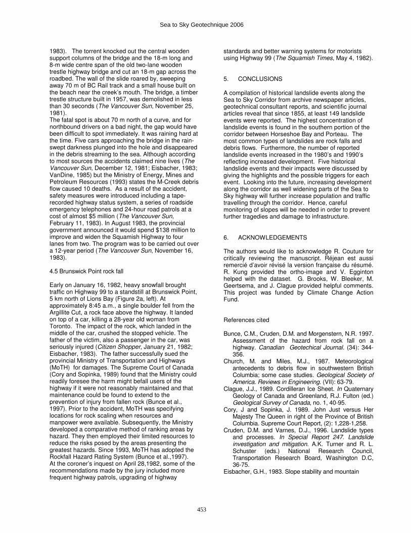
journal articles. A total of 149 events were reported. The authors plotted the distribution of landslides according to the landslide type (Figs. 2a, b, and c). Some assumptions were made when classifying the landslide types because, in some cases, few details were given and/or terms used were non-technical. The table associated with Figures 2a, b, and c listing all the reported landslide events and their characteristics will be shown on the poster at the conference. Landslide event distribution is more concentrated in the southern part of the Sea to Sky Corridor, especially from Horseshoe Bay to Porteau. Rock falls and debris flows are the most common types of landslide events. Rock falls occur more often as single isolated events as opposed to debris flows which demonstrate repeat occurrences. Rock slides are third in terms of frequency of events and occur usually as single events (Figs 2a, b, and c). In several of the accounts (roughly a third), the cause or trigger of the landslide event(s) is not reported. However, when the trigger is identified, the most common ones are climate-related. For instance, heavy rains, rain-on-snow and freeze-thaw conditions have been responsible for at least half of the reported landslide events along the corridor. A histogram showing the frequency of historical events per decade indicates that the number of events was higher in the 1980s (35 events) and 1990’s (43 events). This is most likely due to a greater increase in development of the corridor. Furthermore, most mitigation measures (e.g., such as shotcrete, channel stabilization, debris basins, rock bolting, etc.) to alleviate the impacts of such landslide events were emplaced only during or after the 1990’s.
Sea to Sky Geotechnique 2006
449
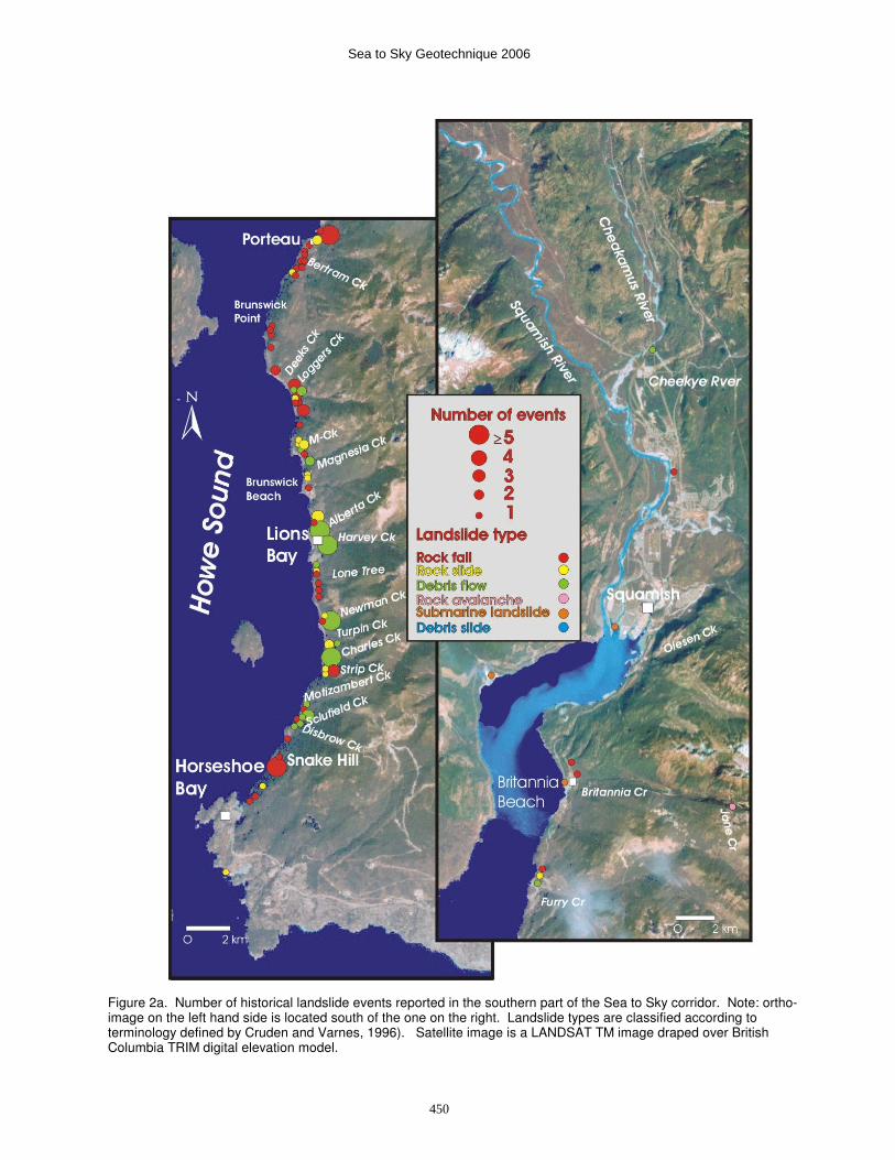
Figure 2a. Number of historical landslide events reported in the southern part of the Sea to Sky corridor. Note: ortho-image on the left hand side is located south of the one on the right. Landslide types are classified according to terminology defined by Cruden and Varnes, 1996). Satellite image is a LANDSAT TM image draped over British Columbia TRIM digital elevation model.
Sea to Sky Geotechnique 2006
450
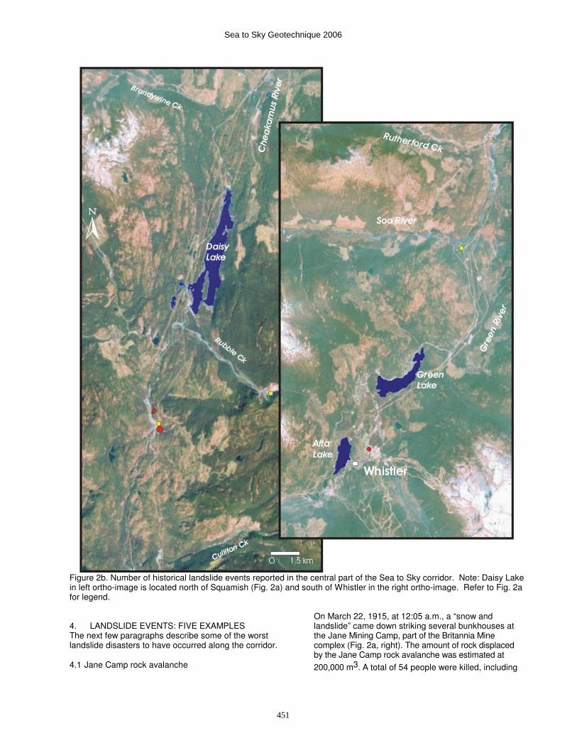
Figure 2b. Number of historical landslide events reported in the central part of the Sea to Sky corridor. Note: Daisy Lake in left ortho-image is located north of Squamish (Fig. 2a) and south of Whistler in the right ortho-image. Refer to Fig. 2a for legend. 4. LANDSLIDE EVENTS: FIVE EXAMPLES The next few paragraphs describe some of the worst landslide disasters to have occurred along the corridor.
4.1 Jane Camp rock avalanche
On March 22, 1915, at 12:05 a.m., a “snow and landslide” came down striking several bunkhouses at the Jane Mining Camp, part of the Britannia Mine complex (Fig. 2a, right). The amount of rock displaced by the Jane Camp rock avalanche was estimated at
200,000 m3. A total of 54 people were killed, including
Sea to Sky Geotechnique 2006
451
four women and six children. Several families were entirely wiped out (The British Columbian Newspaper, March 25, 1915). The slide was possibly caused by rapidly melting snow during the warm weather of the preceding 48 hours. Furthermore, it is thought that tunneling in fractured Mesozoic volcaniclastic rocks above Jane Camp in 1914 may have contributed to a progressive deterioration of an unstable bedrock ridge approximately 300 m above the camp. A near-vertical crack on the ridge crest above Jane Camp was observed and photographed before the disaster struck (Eisbacher, 1983; Evans and Gardner, 1989. This landslide event is coined Canada’s second worst landslide disaster after Frank slide, 1903, which killed 76 people.
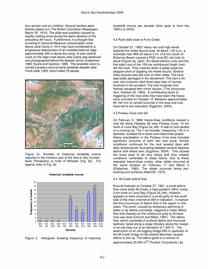
Figure 2c. Number of historical landslide events reported in the northern part of the Sea to Sky Corridor. Note: Pemberton is north of Whistler (Fig. 2b). For legend, refer to Fig. 2a.
Historical landslide events
1 1 1 1
30
1512
35
43
10
0
5
10
15
20
25
30
35
40
45
50
1850-1859
1910-1919
1920-1929
1930-1939
1940-1949
1950-1959
1960-1969
1970-1979
1980-1989
1990-1999
2000-2003
Decade
Fre
qu
en
cy o
f even
ts
Figure 3. Histogram showing frequency of historical
landslide events per decade (time span is from the 1850’s to 2003). 4.2 Rock slide close to Furry Creek
On October 21, 1963, heavy rain and high winds battered the Howe Sound area. At about 1:20 a.m., a rockslide near Mile 20 about 3 mi. (4.8 km) south of Britannia Beach caused a PGE (now BC rail) train to derail (Figure 2a, right). Six diesel-electric units and the first eight cars of the 109-car northbound freight train left the track. They crashed down a steep slope but stopped short of toppling into Howe Sound. Several other boxcars also fell over on their sides. The track was badly damaged in the derailment. The train’s 43-year old conductor died three days later of injuries received in the accident. The train engineer and fireman escaped with minor injuries. (The Vancouver Sun, October 25, 1963). A contributing factor to triggering of the rock slide may have been the heavy rains recorded on October 12. Between approximately 90-160 mm of rainfall occurred in the area and may have led to soil saturation (Egginton, 2004). 4.3 Porteau Cove rock fall On February 9, 1969, freeze-thaw conditions caused a rock fall along Highway 99 near Porteau Cove, 10 km north of Lions Bay (Figure 2a, left). A slab of rock landed on a moving car. The 1-ton boulder, measuring 1.35 m in diameter, tumbled 24 m down and killed three people. Heavy precipitation in the Porteau Cove area included significant amounts of both rain and snow. Similar conditions continued for the next several days with daily temperatures fluctuating between several degrees above and below zero (Egginton, 2004). This caused the snow pack to be very heavy and thus created conditions vulnerable to slope failure. Due to these repeated freeze-thaw cycles, other slides occurred at the same location on February 17 and March 4 (Eisbacher, 1983). The slides occurred along pre-existing joint surfaces (Nasmith, 1972). 4.4 M-Creek debris flow Around midnight on October 27, 1981, a small debris flow came down M-Creek, a high-gradient (48%) creek, 2 km north of Lions Bay (Figure 2a, left). Initiation appears to have occurred in a small gully on the south side of the main channel at 900 m elevation. It marked the first occurrence of debris flow in the region in nine years. The event, caused by temporary damming of water or by debris surcharge, triggered a major debris flow that cleared out the rockbound gully to its base near sea level (Church and Miles, 1987). The debris flow, which consisted of surficial debris and fractured bedrock, failed along a steep tributary along the margin of an old clear-cut at an elevation of 1,500 m. The destruction of an old logging bridge 650 m upstream of the M-Creek bridge on Brunswick Mountain caused debris to pile up. The debris grew to a volume of
approximately 20,000 m3 (Thurber Consultants Ltd,
Sea to Sky Geotechnique 2006
452
1983). The torrent knocked out the central wooden support columns of the bridge and the 18-m long and 8-m wide centre span of the old two-lane wooden trestle highway bridge and cut an 18-m gap across the roadbed. The wall of the slide roared by, sweeping away 70 m of BC Rail track and a small house built on the beach near the creek’s mouth. The bridge, a timber trestle structure built in 1957, was demolished in less than 30 seconds (The Vancouver Sun, November 25, 1981). The fatal spot is about 70 m north of a curve, and for northbound drivers on a bad night, the gap would have been difficult to spot immediately. It was raining hard at the time. Five cars approaching the bridge in the rain-swept darkness plunged into the hole and disappeared in the debris streaming to the sea. Although according to most sources the accidents claimed nine lives (The Vancouver Sun, December 12, 1981; Eisbacher, 1983; VanDine, 1985) but the Ministry of Energy, Mines and Petroleum Resources (1993) states the M-Creek debris flow caused 10 deaths. As a result of the accident, safety measures were introduced including a tape-recorded highway status system, a series of roadside emergency telephones and 24-hour road patrols at a cost of almost $5 million (The Vancouver Sun, February 11, 1983). In August 1983, the provincial government announced it would spend $138 million to improve and widen the Squamish Highway to four lanes from two. The program was to be carried out over a 12-year period (The Vancouver Sun, November 16, 1983). 4.5 Brunswick Point rock fall Early on January 16, 1982, heavy snowfall brought traffic on Highway 99 to a standstill at Brunswick Point, 5 km north of Lions Bay (Figure 2a, left). At approximately 8:45 a.m., a single boulder fell from the Argillite Cut, a rock face above the highway. It landed on top of a car, killing a 28-year old woman from Toronto. The impact of the rock, which landed in the middle of the car, crushed the stopped vehicle. The father of the victim, also a passenger in the car, was seriously injured (Citizen Shopper, January 21, 1982; Eisbacher, 1983). The father successfully sued the provincial Ministry of Transportation and Highways (MoTH) for damages. The Supreme Court of Canada (Cory and Sopinka, 1989) found that the Ministry could readily foresee the harm might befall users of the highway if it were not reasonably maintained and that maintenance could be found to extend to the prevention of injury from fallen rock (Bunce et al., 1997). Prior to the accident, MoTH was specifying locations for rock scaling when resources and manpower were available. Subsequently, the Ministry developed a comparative method of ranking areas by hazard. They then employed their limited resources to reduce the risks posed by the areas presenting the greatest hazards. Since 1993, MoTH has adopted the Rockfall Hazard Rating System (Bunce et al.,1997). At the coroner’s inquest on April 28,1982, some of the recommendations made by the jury included more frequent highway patrols, upgrading of highway
standards and better warning systems for motorists using Highway 99 (The Squamish Times, May 4, 1982).
5. CONCLUSIONS
A compilation of historical landslide events along the Sea to Sky Corridor from archive newspaper articles, geotechnical consultant reports, and scientific journal articles reveal that since 1855, at least 149 landslide events were reported. The highest concentration of landslide events is found in the southern portion of the corridor between Horseshoe Bay and Porteau. The most common types of landslides are rock falls and debris flows. Furthermore, the number of reported landslide events increased in the 1980’s and 1990’s reflecting increased development. Five historical landslide events and their impacts were discussed by giving the highlights and the possible triggers for each event. Looking into the future, increasing development along the corridor as well widening parts of the Sea to Sky highway will further increase population and traffic travelling through the corridor. Hence, careful monitoring of slopes will be needed in order to prevent further tragedies and damage to infrastructure.
6. ACKNOWLEDGEMENTS The authors would like to acknowledge R. Couture for critically reviewing the manuscript. Réjean est aussi remercié d’avoir révisé la version française du résumé. R. Kung provided the ortho-image and V. Egginton helped with the dataset. G. Brooks, W. Bleeker, M. Geertsema, and J. Clague provided helpful comments. This project was funded by Climate Change Action Fund. References cited Bunce, C.M., Cruden, D.M. and Morgenstern, N.R. 1997.
Assessment of the hazard from rock fall on a highway. Canadian Geotechical Journal. (34): 344-356.
Church, M. and Miles, M.J., 1987. Meteorological antecedents to debris flow in southwestern British Columbia; some case studies. Geological Society of America. Reviews in Engineering. (VII): 63-79.
Clague, J.J., 1989. Cordilleran Ice Sheet. In Quaternary Geology of Canada and Greenland, R.J. Fulton (ed.) Geological Survey of Canada, no. 1, 40-95.
Cory, J and Sopinka, J. 1989. John Just versus Her Majesty The Queen in right of the Province of British Columbia. Supreme Court Report, (2): 1,228-1,258.
Cruden, D.M. and Varnes, D.J., 1996. Landslide types and processes. In Special Report 247. Landslide investigation and mitigation. A.K. Turner and R. L. Schuster (eds.) National Research Council, Transportation Research Board, Washington D.C, 36-75.
Eisbacher, G.H., 1983. Slope stability and mountain
Sea to Sky Geotechnique 2006
453

torrents, Fraser Lowlands and southern Coast Mountains, British Columbia. Geological Association. of Canada. Annual Meeting. Fieldtrip Guidebook. No. 15. 46 p.
Egginton, V.,,2004. Compilation of Environment Canada climate data from weather stations in the Sea-to-Sky region, unpublished report, 20 p.
Evans, S.G. and Gardner, J.S., 1989. Geological hazards in the Canadian Cordillera. In Quaternary Geology of Canada and Greenland. (R. J. Fulton,ed.) Geological Survey of Canada, no 1, 702-713.
Hare, F.K. and Hay, J.E., 1974. The climate of Canada and Alaska, In Climates of North America, R.A. Bryson and F.K. Hay (eds.) Elsevier Scientific Publishing Company, Amsterdam, The Netherlands, 49-192.
British Columbia Ministry of Energy, Mines and Petroleum, 1993, Landslides, Information circular 1993-7.
Monger, J.W.H. and Journeay, J.M., 1994. Basement geology and tectonic evolution of the Vancouver region. Geological Survey of Canada Bulletin 481. J.W.H. Monger (ed.), 3-25.
Nasmith, H., 1972. Engineering geology of the southern Cordillera of British Columbia. 24
th International
Geological Congress, Montreal, Que. Excursion A08-C08. 34 p.
Ryder, J.M., 989. Climate (Canadian Cordillera). In Quaternary Geology of Canada and Greenland, R.J. Fulton (ed.) Geological Survey of Canada, no. 1, 26-31.
Thurber Consultants Ltd., 1983. Debris torrent and flooding hazards Highway 99, Howe Sound. Report to B.C. Ministry of Transportation and Highways. 25 p. (unpublished).
VanDine, D.F., 1985. Debris flows and debris torrents in the southern Canadian Cordillera. Canadian Geotechnical Journal. 22. (1): 44-68.
Additional references used in the compilation Chapman, A. 2003. River Forecast Centre post-event
review of the October 16-20 coastal flood event. 4 p.
Church, M. 1988. Floods in cold climates. Flood geomorphology. Edited by V.R. Baker, R.C. Kochel, and P.C. Patton. John Wiley & Sons, London. pp. 205-229.
Clague. J.J. and Evans, S.G. 1994. Formation and failure of natural dams in the Canadian cordillera. Geological Survey of Canada. Bulletin 464. 35 p.
Clague, J.J. and Souther, J.G. 1982. The Dusty Creek landslide on Mount Cayley, British Columbia. Canadian Journal of Earth Sciences (19): 524-539.
Cruden, D.M. and Lu, Z-y. 1989. The geomorphic impact of the catastrophic October 1984 flood on the planformn of the Squamish River, southwestern British Columbia: Discussion. Canadian Journal Earth Sciences (26): 336-337.
Eddy, F.W. 1979. Record-breaking rainstorm at Vancouver on Christmas Day 1972. Tec 872.
Environment Canada. Atmospheric Environment Service. Downsview, Ont.
Eisbacher, G.H. 1982. Howe Sound Debris Flows. Geoscience Canada. 9 (2): 132.
Eisbacher, G.H. and Clague, J.J., 1981. Urban landslides in the vicinity of Vancouver, British Columbia, with special reference to the December 1979 rainstorm. Canadian Geotechnical Journal. (18): 205-216.
Environment Canada. 1991. Historical streamflow summary British Columbia to 1990. Inland Waters Directorate, Water Resources Branch, Water Survey of Canada, Ottawa, Ont. 1116 p.
Evans, S.G. 1986. Landslide damming in the Cordillera of western Canada. Landslide Dams: Processes, Risk and Mitigation. (ed.) R.L. Schuster. American Society of Civil Engineers. Geotechnical Special Publication 3: 111-130.
Evans, S.G. 1992. High magnitude-low frequency catastrophic landslides in British Columbia. Geologic Hazards in British Columbia. Proceedings University of Victoria. B.C. Geological Survey Branch. Open File 1992-15: 71-98.
Evans, S.G. Damaging landslides and related processes in the Canadian Cordillera: impact and mitigation in the historical period 1855-1999. (unpublished data).
Hickin, E.J. and Sichingabula, H.M., 1988. The geomorphic impact of the catastrophic October 1984 flood on the planform of the Squamish River, southwestern British Columbia. Canadian Journal of Earth Sciences. (25): 1078-1087
Hickin, E.J. and Sichingabula, H.M., 1989. The geomorphic impact of the catastrophic October 1984 food on the planform of the Squamish River, southwestern British Columbia: Reply. Canadian Journal Earth Sciences. (26): 337.
Holland, S.S., 1964. Landforms of British Columbia, a physiographic outline. Bull. 48, Dept. of Mines and Petroleum Resources, Victoria, B.C. 138 p.
Hungr, O., Morgan, G.C. and Kellerhals, R., 1984. Quantitative analysis of debris torrent hazards for design of remedial measures. Can. Geotech. J. (21): 663-667.
Hungr, O., Morgan, G.C., VanDine, D.F. and Lister, D.R., 1987. Debris flow defences in British Columbia. In: Debris Flows/Avalanches: Process, Recognition, and Mitigation, ed. J.E. Costa and G.F. Wieczorek. Geological Society of America, Reviews in Engineering Geology, (VII): 201-222.
Jackson, L.E, Church, M., Clague, J.J. and Eisbacher, G.M., 1985. Slope hazards in the southern Coast Mountains. Geographical Society of America Cordilleran Section. Annual meeting. Vancouver, B.C. Guide Book. Field trip 4. 34 pp.
Jones, W.C., 1959. Cheekye River mudflows. Unpublished Report. British Columbia Department of Mines. 9 p.
Jones, D.P., Ricker, K.E., Deslosges, J.R. and Maxwell, M., 1985. Glacier Outburst Flood on Noeick River: The Draining of Ape Lake, British Columbia, October
Sea to Sky Geotechnique 2006
454
20, 1984. Open File Report 1139. Geological Survey of Canada. 81 p.
Jordan, P., 1987. Impacts of mass movement events on rivers in the southern Coast Mountains, British Columbia. Summary Report. Water Resources Branch, Inland Waters Directorate. Environment Canada. Report IWD-HQ-WRB-SS-87-3. 62 p.
Jordan P., 1994. Debris flows in the southern Coast Mountains, British Columbia: dynamic behaviour and physical properties. Ph.D. Thesis, Department of Geography, University of British Columbia. 260 p.
Lewis, C. J. and Moran, M.D., 1985. Severe storms of Canada’s west coast: a catalogue summary for the period 1957 to 1983. Canadian Climate Centre Report No. 85-7. Environment Canada. Atmospheric Environment Service. Downsview, Ont. 381 p.
Lister, D.R., Morgan, G.C., VanDine, D.F. and Kerr, J.W.G., 1984. Debris torrents along Howe Sound, British Columbia. IVth International Symposium on Landslides, Toronto, Ont. 7 p.
Lu, Z-y., 1988. Rock avalanche on Mount Caley, British Columbia. MSc Thesis. University of Alberta. Edmonton, Alta. 158 p.
MacFayden, B.E., 1981. Southwest British Columbia October 1981 flooding. Squamish to D’Arcy Area. Ministry of Environment. Rivers Subsection Engineering Division. Water Management Branch. 12 p.
McMullen, B.R.W., 1990. Southwestern B.C. Flooding November 9-10, 1990. Proposed Restoration Works under O.I.C. 1819. B.C. Environment Water Management Branch.
Melady, J., 1997. Heartbreak and heroism. Canadian Search and Rescue stories. Dundurn Press, Toronto. Ont. 217 p.
Melone, A.M., 1985. Flood producing mechanisms in coastal British Columbia. Canadian Water Resources Journal. (10): 46-64.
Pollock, D.M., 1975. An index to storm rainfall in Canada. CLI-1-75, Environment Canada. Atmospheric Environment Service. Downsview, Ont. 37 p.
Ramsey, B., 1962. PGE. Railway to the North. Mitchell Press, Vancouver, B.C. 264 p.
Ramsay, B., 1967. Britannia, the story of a mine. Britannia Beach Community Club. 177 p.
Reid, Collins and Associates Ltd., 1969. Report of investigation on the Harvey Creek flood of September 17-18, 1969. Lions Bay Improvement District Dawson Developments Limited. November 1969. Unpublished. Vancouver, B.C. 35 p.
Russell, S.O., 1972. Behaviour of steep creeks in a large flood. Mountain Geomorphology. O. Slaymaker and H.J. McPherson. (Eds.) B.C. Geographical Series. (14):223-227.
Rogers, A.C., 1992. More shipwrecks of British Columbia. Douglas & McIntyre. 242 p.
Schaefer, D.G. and Nikleva, S., 1973. Mean precipitation and snowfall maps for a mountainous area of
potential urban development. Proc. Western Snow Conf. Grand Junction, Colo. pp. 80-89.
Septer, D. and Schwab, J. W., 1995. Rainstorm and flood damage Northwest British Columbia 1891-1991. Province of British Columbia. Ministry of Forests Research Program. Land Management Handbook 31. 196 p.
Skermer, N. A., 1988. 28th of October. The BC Professional Engineer. 39(5): 21-23.
Smith, J., 1994. Lewis (Guardian ad litem of) versus British Columbia. British Columbia Law Reports, 2nd Series. (91):365-378.
Smith, A.G. and Vallières, G., 1986. Flood of October 8, 1984 on the Lillooet River, British Columbia. Internal Report. Planning and Studies Section. Water Resources Branch, Vancouver. December 1986. 83 p.
Talbot, R.J., 1986. Storm damage assessment October 8, 1984 flooding Pemberton, Whistler, Squamish areas. Rivers Section. Water Management Branch. O.I.C. 2012-84, File P84-6
Thurber Consultants Ltd., 1982. M-Creek mass movement. Report to British Columbia Ministry of Transportation and Highways, Victoria, B.C.
Thurber Engineering., 1984. Debris torrents, a review of mitigative measures. Report to British Columbia Ministry of Transportation and Communications. Victoria, B.C.
VanDine, D.F. and Lister, D.R., 1983. Debris torrents – A new natural hazard? The Professional Engineer. 34(12):9-11.
Ward, P.R.B. and Skermer, N.A., 1992. “The 50 -year Flood in Fitzsimmons Creek, Whistler, British Columbia.” 1st Canadian Symposium on Geotechnique and Natural Hazards, BiTech Publishers, Vancouver, 1992.
Wilson, Hugh and Wilson, A., 1998. Gaslights to gigawatts. A human history of BC Hydro and its predecessors by the BC Hydro Power pioneers. Hurricane Press. 236 p
Won, T.K., 1971. Meteorology in British Columbia: A Centennial Review. Canadian Meteorological Service, Pacific Region. Vancouver, B.C.
Sea to Sky Geotechnique 2006
455