Embed Size (px)
Citation preview

Himalafan Geology. Vo\. 20(2), 1999, pp. 31-44, Printed in India
Landslide Hazard Zonation in Kaliganga and Madhyamaheshwarvalleys of Garhwal Himalaya: A GIS based approach
PIYOOSH RAUTELA and V.C. THAKUR
Wadia Institute of Himalayan Geology, Dehra Dun-248 001, India
Abstract : Himalaya represents a fragile ecosystem and its fragility stems from geological history of its evolution and
structural set-up of the rocks. The fragility of the terrain is often manifested in the recurring natural hazards and washighlightedin August 1998when landslidestook regional proportionsand a large portion of Garhwal-Kumaunwas affected.Kaliganga and Madhyamaheshwar river valleys (tributaries of Mandakini river) of Garhwal Himalaya witnessed heavylosses and the death toll in these valleys crossed one hundred mark, Madhyamaheshwar river was dammed and vast tractsof hitherto fertile terraced land was rendered unsuitable for human interventions. Landslide hazard zonation (LHZ) andrisk assessment studies have been carried out in these valleys under Geographical Information System (GIS) environmentemploying statistical index method. Geology, structure, landuse, old slides, slope, shape of the slope, slope aspect, anddrainage are tbe different parameters affecting mass movement and bave been considered for LHZ exercise. For riskassessment population (1991 census) bas been considered the sole criteria as most infrastructure in tbe region is interwovenaround population centres. Tbis exercise bas brougbt out areas and population groups tbat are particularly vulnerable tolandslides.
IJ
Introduction
Himalayan ecosystem is fast approaching a stage ofdisequilibrium and there are clearly visible negative changesin the resources and the environment. Step by step, natureis being destroyed and human, terrestrial, and aquatic lifeare being shortened by the effects of development in theform of landslides, sedimentation, and eutrophication ofreservoirs, lakes and rivers, drying up of springs, and others(ESCAP Report 1989). Conventional development paradigmhas thus failed to take into account mountain specificitiessuch as inaccessibility, fragility, marginality, diversity orheterogeneity, niche or comparative advantage, and humanadaptation mechanisms. Of the specificities fragility (of theterrain) is of immediate concern and is expressed in recurringhazards that the region faces. These natural hazards are oftenaggravated by anthropogenic activities and take heavy tollof human lives, infrastructure and natural resources.
f
The fragility of the region stems mainly from theevolutionary history of the terrain. As the Tethys Seaintervening in-between Indian and Asian plates closed dueto the plate motion, mammoth blocks of rock masses movedsouthward for tens of kilometres. This movement of the earth
blocks initiated several weaknesses in the rocks of the region.From the Indus SutureZone (along which the two alien platesare welded) southward Tethyan Thrust (TT), Main CentralVaikrita Thrust (MCVT), Main Central Thrust (MCT), MainBoundary Thrust (MBT) and Himalayan Frontal Fault (HFF)form the major tectonic discontinuities along which majormovement has taken place. Besides these there are numerous
thrusts and faults intervening in-between. These haverendered the terrain highly folded, faulted, fractured andsheared; and thus fragile.
Fragility is thus associated with the terrain and theinhabitants have over generations adapted their lifestylesand have learnt to live and cope up with the specificities.Through experimentation and accumulated knowledge ofgenerations they evolved their own traditional ways ofovercoming the handicap imposed by the mountainspecificities. The people well understood the relationshipbetween the water entering the surface and recharge of theaquifers, as also the downslope mass movement. Therecharge zones of springs were protected at various locationsby invoking divine sanction and at the same time in order tosafeguard habitations at vulnerable locations people devisedways of diverting rainwater directly into the main streamthrough a network of channels. This helped in keeping thepore water pressure within the threshold limits and the massmovement was averted. Such drains, locally referred to asjungle guls (unlined canals) were observed at Ransi andKotma while those at Kalimath and Jagi- Bagwan have ceasedto exist. These were built and maintained by the communitywithout any support from the state and were regularlyrepaired and cleared before the onset of monsoon season.The traditional system however collapsed with the onslaughtof modem state oriented system. The traditional genius ofthe ancestors was lost into oblivion and these structures that
safeguarded the locality for generations died a natural deathin neglect and seclusion.
31
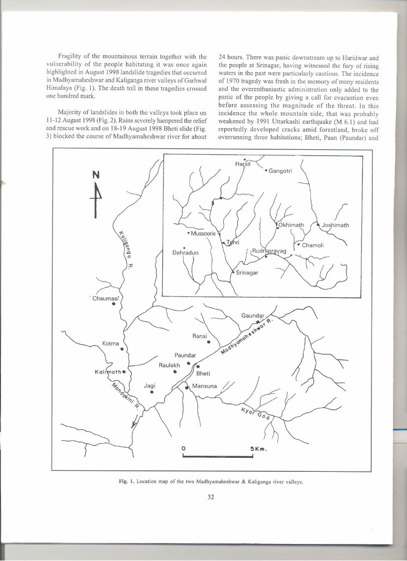
Fragility of the mountainous terrain together with thevulnerability of the people habitating it was once againhighlighted in August 1998landslide tragedies that occurredin Madhyamaheshwarand Kaligangariver valleys of GarhwalHimalaya (Fig. 1). The death toll in these tragedies crossedone hundred mark.
Majority of landslides in both the valleys took place on11-12August 1998(Fig. 2).Rains severelyhamperedthe reliefand rescue work and on 18-19 August 1998 Bheti slide (Fig.3) blocked the course of Madhyamaheshwar river for about
N
t
o
}
24 hours. There was panic downstream up to Haridwar andthe people at Srinagar, having witnessed the fury of risingwaters in the past were particularly cautious. The incidenceof 1970 tragedy was fresh in the memory of many residentsand the overenthusiastic administration only added to thepanic of the people by giving a call for evacuation evenbefore assessing the magnitude of the threat. In thisincidence the whole mountain side, that was probablyweakened by 1991 Uttarkashi earthquake (M 6.1) and hadreportedly developed cracks amid forestland, broke offoverrunning three habitations; Bheti, Paun (Paundar) and
~Km.
Fig. I. Location map of the two Madhyamaheshwar & Kaliganga river valleys.
32
j

Fig. 2. View of the landslides in Ma~oyamaheshwar river valley across Mansuna.
.
Fig. 3. View of the Bheti landslide of 18-19 August 1998 that blocked the course of the Madhyamaheshwar river for 24 hours.
33
..

.<
Sem. Rescue and relief work was at the same time delayedby incessant rains, wide sway of the slides and lack ofmanagement and co-ordination. Madhyamaheshwar river isreportedly blocked by landslides at the beginning of thecentury. River morphology supports past history ofblackadein the valley. The name Raulekh also suggests an erstwhilelake in the vicinity, as in local parlance Rau means whirlingwater pool.
"\.
Bheti landslide pushed the death toll over a hundred mark
and changed the geomorphic set up of the surrounding area;the agricultural lands and habitations being replaced withheaps of boulders and debris and the two streams that usedto meet Madhyamaheshwar river near Paundar lost theircoarse amid the debris.
As goes the saying Prevention is better than cure;mitigative planning is required for the entire region so as toensure that similar incidences are not repeated in future.Recorded history of landslides and landslide induced floodsin the region outvocally shows the importance of hazardidentification and management in reducing the loss of humanlives. In 1894 partial breach of the Gauna lake that wasforecast almost a year in advance by the British engineer Lt.Col. Pulford, though there was immense loss of property atSrinagar and downstream, the loss of life was reduced to oneby timely evacuation and warning.
First step in this direction is the demarcation of hazardprone zones in the region. There are many approaches forpreparing landslide hazard maps. In the present exercisestatistical approach is employed under GIS environment.
Geological set-up
In the valleys under consideration (Madhyamaheshwar andKaliganga) the rock types exposed mainly belong to CentralCrystallines. This region has been studied in detail by Bistand Sinha (1982). The Munsiari Formation overlying theBhatwari Unit along NE dipping Munsiari Thrust (MCT) isfollowed northwards by 10shimath Formation of VaikritaGroup (Fig. 4). This contact betweenMunsiari and 10shimathformations is designated Main Central Vaikrita Thrust(MCVT). Bhatwari Unit comprises of gneissose granites,augen gneisses, chlorite-sericite schists and amphibolites.10shimath Formation comprises of biotite-garnet-kyanite-sillimanite psammitic gneisses, schists and migmatites andis overlain by Pandukeshwar Formation over which isthrusted Pindari Formation along Pindari Thrust (Valdiya1998). Pandukeshwar Formation consists of quartzite,phyllonites and migmatites while the Pindari Formationconsists of calcsilicate rocks, gamet-chlorite-sericite schists.General dip of the foliation planes is towards NE and thereexists a strong NE trending stretching lineation. Close
proximity of the tectonic planes causes these rocks to behighly sheared and fractured. Munsiari Formation isparticularly sheared and fractured and there exist two setsof strong fracture planes dipping NW and SWat highangles. Besides these the presence of bedding joint is alsoobserved. These secondary weak planes render this rock unitparticularly susceptible to failure and therefore it is notsurprising to note that most of the mass movement in boththe valleys is confined to Munsiari Formation.
~Pindari Fm. r-,-,,"-""'IMunsiari Fm.
\>:::.-.:.1pandukeshwar Fm. t- =-~Bhatwari Unit
~Joshimath Fm
LFig. 4. Geological set-up of the area.
Landuse/Landcover
Being a direct expression of the terrain condition it givesimportant indication regarding the slope instability. Thelanduse in the Himalayan terrain has been influenced by thenature of terrain and the diversity of the climate. The vegetalcover has a considerable effect on erosion and weatheringintensities. Shallow landslides are generally associated withareas having very sparse vegetation (open scrub). There arenumerous examples where cutting down of the trees
34
l
triggered landslides. Removal of the vegetal cover leads toaccelerated erosion and shallow slides. Faster erosion andgreater instability of the slopes are found in barren rock orsoil surfaces as well as in the sparsely vegetated areas. Onthe other hand thickly vegetated areas are generally lessprone to mass wasting processes due to the well developedroot system that binds the soil particles, thus enhancing theshearing resistance of the slope material, except for the caseswhere deep seated failures take place. The anthropogenicactivities greatly enhances the chances of slope failure. Thecultivated land also behaves differently with different cropsplanted. The standing crops that require stagnant watersometimes result in increased pore water pressure in the soilmass underneath, resulting in mass movement. Prolongedrains that saturate the soils also cause similar effect.
The landuse features extracted from the SOl toposheetand updated with satellite data (IRD ID LISS III) show thatthe lower reaches of the valleys have most of the agriculturalland and its distribution varies with aspect. Differentialinsolation on different aspects account for vjlriations inlanduse with aspect. Westerly and southerly aspect (NW,W, SW, S & SE) account for most of the barren land; formerthree in Kaliganga valley and latter three inMadhyamaheshwar valley account for more than half thebarren land. Human interventions have left isolated forestpatches on all the aspects. Easterly and southeasterlyaspects show more land under cultivation.
These data indicate that the steep slopes with southerlyaspect have comparatively less vegetal cover. This is inconformation with the observations in other Himalayansectors and is attributed to the intense insolation on these
slopes.
Correlation of landuse pattern with the slope amountshow that gentle and moderate slopes have intensiveagricultural activity (70% of the agricultural land inMadhyamaheshwarvalley & 80% in Kaliganga valley) whilemost of the forests are confined to moderate and moderatelyhigh slopes (55% in Madhyamaheshwar valley & 60% inKaliganga valley). Presence of agriculture even on steepslope (>60°) indicates that the population pressure has forcedpeople to cultivate unconventional slopes. Terracing of thesteeper slopes requires higher embanking walls and theseare perpetually in a destabilised state. Moisture often addsto the instability.
Landslides
In the dark hours of 11-12 August 1998 lower reaches of bothMadhyamaheshwar and Kaliganga valleys were devastatedby landslides. The lush green valley was scarred deeply (Fig.2) and a large proportion of the agricultural land was lost
together with 62 human lives. Most of the slides initiated atthe steeper slopes of the valley and the rolling down debristook devastating proportions. Some of these slides were amidold slide zone. Large number of habitations in the hills aresituated on stabilised landslide debris where cultivable fieldsare easy to prepare. These sites however pose a naturaldanger of reactivation of the slide.
On 18-19August 1998the mountain slope oppositeBhetislided down, ravazing habitations on the opposite bank anddamming the river for 24 hours. The debris glided upslopeon the opposite bank burying alive the inhabitants withoutany trace. This slide shows distinct structural control withthree sets of penetrative joints observed in the rocks hostingthis slide and widening of the joints due to earlier tectonicdisturbances only increased the probability offailure. A widecrack was reportedly observed over the Bheti slide days inadvance by the villagers. The water percolating throughthese weak planes facilitated movement along one of thedominant and pre-existing weak plane. The Bheti slide tookplace with a thunderous sound of rolling boulders and therewas dust strom that covered a radius of more than twokilometers. The dust was not washed off and was observedover the vegetation days after the incidence.
AGRICULTURE
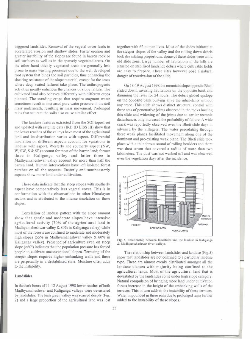
Fig. 5. Relationship between landslides and the landuse in Kaliganga& Madhyamaheshwar river valleys.
The relationship between landslides and landuse (Fig.5)show that landslides are not confined to a particular landusetype. These are almost evenly distributed amongst all thelanduse classes with majority being confined to theagricultural lands. Most of the agricultural land that isdevastated by the landslides come under high slope catagory.Natural compulsion of bringing more land under cultivationforces increase in the height of the embanking walls of theterraces. This in turn adds to the instability of these terraces.Water impounded in these soils due to prolongedrains furtheradded to the instability of these slopes.
-
35
1.6
:; 1.4:!!;;;...coS.....c:>
E.......!...!«

..
"\.
Madhyamaheshwar
Kaliganga
N
Fig. 6. Relationship between landslides and aspect of the slope in Kaliganga & Madhyamaheshwar river valleys.
The relationship between landslides and aspect of theslope (Fig. 6) show concentration of slides on easterly andsoutheasterly aspect (>50%). These are the slopes that havemaximumareaunder agriculture.Correlationoflandslides withthe slope amount shows that moderate slopes in Kaligangavalley (41%) and gentle slope in Madhyamaheshwar (31%)valley show predominance oflandslides (Fig. 7). In both thevalleys these slope classes have a large area undercultivation.
.~ --
,
LMadhya.maheshwar
Q)c.oiii.cCI
:i:
Q)c.oiiic.Q)Q)...If)
Fig. 7. Relationship between landslides and the slope class in Kaliganga& Madhyamaheshwar river valleys.
Straight slopes show shallow debris slides that initiateat higher topographic levels and take gigantic proportions
downslope. Some slides also initiate in the unstable convexslopes at higher elevations and take along material restingon straight slopes. All the slides on the concave slopes arereactivated old landslides.
Presence of agricultural terraces on unconventionalsteep slopes that have been adversely affected by slidessuggest violation of traditional farming dictums underpressure of increasing population and fragmentation of land.
Going through the landslide record one easily gathersthe fact that most of the slides take place during the rainyseason. It therefore becomes imperative to check in foranomalies in the rainfall record (Table 1).Analysis of rainfalldata in Garhwal-Kumaun Himalaya shows that the averageannual rainfall at different sites is about 1000mm to 2500mm
of which 50 to 80 percent comes down during the monsoonand occasionally very heavy rains can be expected. Once inevery 100years, 200 mm to 500 mm of rain can be expectedin one day. There are two zones of maximumprecipitation inHimalaya - one near the foot of the mountains and anotherat an elevation between 2000 to 2400 m (Dhar et al., 1986).Alarge portion of the area under present focus falls in the highrainfallzone.
I
L
The rainfall data shows that the rains were on the higherside during July-August 1998(1421 mm). The first fortnightof August 1998 recorded more than 300 mm of rains. Therewere incessant rains for weeks before the incidence and the
pore water pressure crossed the threshold. Water gushingout in the downslope regions was observed at many places
36
1.4
'"Q)
:!2(ij"tJc:.!!!
"tJc:::J
E0-
.!!!.roQ)
'" 1.2Q)
'""0c:'"- 0.8;;;"0c: 0.6"
E 0.4.><C"'"- 0.2'"
«
'C Q) Q)c: c. C.::J 0 00 iii iii...CI Q) .!!... ..ro c f!ii: Q) Q)
C) 'C0::E

Table I. Monthly rainfall details (in mm) over the years at Okhimath.
together with the seepage in the fault scarp of the Bheti slide.Water lubricated the weak planes and the load of the massresting on the steep slope increased beyond the thresholdlimits. Besides this the secondary structural weaknessespresent in the host rocks have also played a significant rolein mass movement.
Direct evidences of deforestation were not witnessed inboth the valleys and massive landslides were witnessed amidwell-forested areas. There is however no denying the factthat due to the growth of population masses have resortedto terrace cultivation in the steep slope. During 1998monsoon rains, that were concentrated within a short period,saturated the soil and it did not get enough time to escape.Increased weight of the saturated soil under its own loaddestabilised the terrace walls and the gushing water set thewhole process of devastation.
Bheti slide shows distinct structural control. Rain water
entering through the fracture zones enhanced the pore waterpressure and the whole mass moved downslope along apreexisting weak plane. The movement was so fast that thedownward moving mass acquired enough momentum tomove upslope (-200 m vertically) on the opposite bank wereit destroyed the habitations and caused immense loss ofhuman lives and property.
Landslide hazard zonation
Mass movements in mountainous terrain are natural
degradational and one of the most important landscapebuilding processes. Most of the terrain in mountainous areashas been subjected to slope failure at least once, under theinfluence of a variety of causal factors, and triggered byevents such as earthquakes and extreme rainfall (van Westen1994). Landslide is a natural process of mass wastage in
which downslope movement of the rock mass takes place.Though occurring naturally, anthropogenic influence oftenaccelerates this process. Mass movements become a problemwhen these interfare with the human activity and causelosses. In the areas under present focus landslides havecaused heavy loss of lives, property and natural resources.Mitigation of the landslides disasters can be successful onlywhen detailed knowledge is obtained about the expectedfrequency, character and magnitude of the mass movementin an area. The identification of landslide hazard musttherefore be the basis for any landslide mitigation project andshould supply planners and decision-makers with adequateand understandable information.
Based on the field studies and the remote sensing data(temporal multispectral and PAN digital data ofIRS 1DLISSIII) landslide distribution in Madhyamaheshwar andKaligangariver valleys is delineated(Fig. 8). 142active slidesand 11 old slides are considered for this exercise in the twovalleys. Lithology and structure play the major role indeciding the sites of ultimate failure. Besides these, landuse,drainage, slope and aspect are observed to influence theslides. These have therefore been considered while
undertaking hazard zonation.
Landslide hazard maps delineateareas withinwhich thereis finite probability of being affected by slope instability.Theapproach of landslide hazard zonation is based on theempirical relationship between landsliding and individualcausative factors. The comparison of the distribution ofdifferent factorsallows the identificationof areas with varyingpotential for landsliding. A landslide hazard zonation mapdepicts division of the land surface into zones of varyingdegree of stability based on the estimated significance ofcausative factors in inducing instability (Anbalgan 1992).Theevaluation of landslide hazard or risk is appropriate in all
-
37
1989 1990 1991 1992 1993 1994 1995 1996 1997 1998
January 282 15 14 117 96 II 68 35 42 0
February 34 170 53 106 101 2 90 105 28 63March 53 247 133 55 120 0 32 60 58 71
April 19 46 125 5 21 77 24 13 129 52
May 78 164 35 121 97 0 12 33 91 36June 253 166 90 76 242 200 136 505 250 85
July 563 524 414 523 352 534 616 535 597 796
August 931 784 537 904 336 452 489 479 383 625
September 242 203 175 411 361 141 230 109 191
October 17 2 2 7 5 0 27 46 77
November 38 24 8 5 0 0 0 0 50
December 61 96 29 I 0 II 5 0 48

II
I
for a parameter class is defined as the natural logarithm ofthe landslide density in the class divided by the landslide Idensity in the entire map (Van Westen 1997). The method isbased upon the following formula:
Fig. 8. Landslide distribution in Kaliganga & Madhyamaheshwar river valleys,
stages of the developmental activities from planning tomaintenance,
Despite thorough researches the causative factors thatshould be considered for landslide hazard zonation are not
all unanimously accepted. Different workers have come outwith their own schemes (Radbruch & Wentworth 1971,Brabbet ai" 1972, Stevenson 1977, Carrara et aI., 1977, 1978,Seshagiri et ai" 1982, Kawakami & Saito 1984, Choubey &Litoria 1990, Mehrotra et aI., 1991, Pachauri & Pant 1992).Analysis of landslide hazard is a complex task as manyfactors can playa role in the occurrence of mass movement.The analysis requires a large number of input parameters,and techniques of analysis may be very costly and timeconsuming. Computers have however created opportunitiesof detailed and rapid analysis of landslide hazard and its usedatesback to late 1970s(Burroughs 1986).Brabb (1984, 1995),Brabb and others (1989), Gupta and Joshi (1990),Pearson andothers (1991) and Naranjo and others (1994), havecontributed significantly to the field of landslide hazardzonation using computer based techniques.
In the present exercise statistical landslide index methodis used for hazard zonation. In this method the weight value
Densclas
Npix(Si)
Npix(Ni)
I Npix(Si)
I Npix(Ni)
Wi = In = InDensmap
Where,WiDensclas
DensmapNpix(Si)
Npix(Ni)
The weight given to a certain parameter classLandslide density within the parameter classLandslide density within the entire mapNumber of pixels, that contain landslides, ina certain parameter classtotal number of pixels in a certain parameterclass
...
The method is based on statistical correlation of a
landslidemap with different parameter maps. This correlationresults in cross tables that can be used to calculate the
density of the landslides per parameter class. Standardisation
38

.
of these density values is obtained by relating these to theoveralldensityof the entirearea.In the presentexercisethe '
following parameter maps have been used for landslidehazard zonation:
Geological mapTectonic mapLanduse mapOld slide zones
Slope mapShape of slopeAspect mapDrainage map
Using facilities available under GIS environment everymap was crossed with the landslide map prepared on thebasis of interpretation of the remote sensing data and thefield data. Weighted maps were prepared and the same wereintegrated to have the valuation of all the parametersconsidered. Both the zonation of landslide hazard and thebuffering along the linear features was undertaken with theaid of histograms.
Kaliganga valley
The area under present study is fmally divided into fivelandslide hazard zonation classes (Fig. 9). The landuse areafalling under different classes is given in Table 2.
Most agricultural land in both Madhyamaheshwar andKaliganga valleys falls under the highest hazard class andits proportion under other hazard classes is significantly low.It is a cause of concern as it is this land that houses most ofthe population and supports the economic activities of themasses.
Risk analysis
Vulnerability is defined as the degree of loss to a given setof elementsresulting from'the occurrence of the phenomenon.The elements at risk are the population, properties,infrastructure, economic activities and the others within agiven area. The hazard maps without vulnerability analysis
Madhyamaheshwar valley
III:Jo.D
Legend
Very low landslide hazard
Low landslide hazard
Moderate landslide hazard
High landslide hazard
Very high landslide hazard
o 10KIi1 ..
Fig. 9. Landslide hazard zonation map of Kaliganga & Madhyamaheshwar river valleys.
39

Table 2. Relationship between landslide hazard class and landuse.
are not meaningful for effective decision making. A smallhazard ill'a densely populated strategic location may causedisaster many times greater than that at a sparsely populatedarea. Vulnerabilitymaps are therefore prepared for Kaligangaand Madhyamaheshwar valleys using the population dataand correlating it with the hazard maps prepared. Populationis the sole criteria considered for this exercise because mostinfrastructure is interwoven around population centres. Thepopulation of these valleys (1991 census) has been classifiedinto four classes and landlside risk analysis is undertaken inaccordance with Table 3.
Risk map for Madhyamaheshwar and Kali river valleysis shown in Figure 10 while Table 4 shows the correlationbetween landuse and risk. The relationships between landuse
and risk (Fig. 11,12) show that most of the agricultural landfalls under high risk class.
Discussion
There exists a definite relationship between the distributionof slides and geological and tectonic set up of the area. Thisfact has been highlighted by the geologists in the past(Valdiya et al., 1984,Valdiya 1998)and requiresdue attentionon the wake of the present tragedies. Both in Kaliganga andMadhyamaheshwar valleys most slides are confined tosheared and fractured rocks ofMunsiari Formation. There isa marked positive correlation between the distribution oflandslides and landuse; in both the valleys most slides areconfined to agricultural lands. This very fact makes the
Table 3. Landslide risk classes based on landslide hazard zones and population distribution.
:=:...-
-
40
Landslide hazard Distribution in the two valleys
class Madhyamaheshwar Kaliganga
Area (sq km) % Area (sq km) %
Very high Forest 29.43 48.5 2.23 35.9
Very high Barren land 19.47 32.1 0.002 0.04
Very high Agriculture 11.84 19.5 3.99 64.1
High Forest 29.46 66.7 21.54 88.1
High Barren land 14.45 32.7 2.71 11.1
High Agriculture 0.25 0.6 0.22 0;9Moderate Forest 10.36 43.8 26.14 50.8Moderate Barren land 12.92 54.7 25.28 49.2Moderate Agriculture 0.35 1.5 0.0009 0.002Low Forest 59.91 56.0 13.75 18.9Low Barren land 47.01 43.9 57.31 78.8Low Agriculture 0.02 0.02 0 0
Very low Forest 3.11 34.4 0 0
Very low Barren land 1.57 17.4 0.01 0.1
Landslide Hazard Zone
Very low landslie Low landslide Moderate land- High landslide Very high landslidehazard hazard slide hazard hazard hazard
Sparsely Low landslide Low landslide Low landslide Moderate landslide Moderate landslide'" populated risk risk risk risk risk'"U
Low population Low landslide Low landslide Moderate Moderate High landslide=0 density risk risk landslide risk landslide risk risk...!!= Moderate Low landslide Low landslide Moderate High landslide High landslideCI.0 population risk risk landslide risk risk riski:I.
density
High population Low landslide Moderate High landslide High landslide High landslidedensity risk landslide risk risk risk risk

Kaliganga valley Madhyamaheshwar valley
Legend o 10KmLow landslide risk
Moderate landslide risk
High landslide risk
Fig. 10. Landslide risk map of Kaliganga & Madhyamaheshwar river valleys.
Table 4. Relationship between the landuse class and the landslide risk class.
41
Risk catagory Landuse Area (sq km) and percentage
Madhyamaheshwar Kaliganga
Area (sq km) % Area (sq km) %
Low risk Forest 67.12 51.2 16.14 15.5
Low risk Barren land 59.61 45.5 77.94 74.9
Low risk Agriculture 0.03\
0.05 0 0
Low risk Glaciers 4.35 3.3 10.33 9.9
Mode;-ate risk Forest 12.29 59.0 29.01 84.7
Moderate risk Barren land 7.45 35.7 4.92 14.4
Moderate risk Agriculture 1.1 5.3 0.31 0.9
High risk Forest 52.86 57.1 18.51 74.5
High risk Barren land 28.35 30.6 2.45 9.9
High risk Agriculture 11.32 12.2 3.89 15.7,

populace of these valleys particularly vulnerable to landslidesand requires detailed study of the changing landuse patternin the recent times. Presence of agriculture on steep slopesshow that the traditionallanduse dictums have been violatedunder the compulsions of reducing land per capita.Agriculture is the sole source of livelihood in Himalaya andunder compulsions of increasing population agriculture isoften resorted to on steeper slopes by clearing the forest.This trend seems to have gripped the entire Himalayan terrainand therefore there is an urgent need for promoting non-land
Highrisk
Fig. II. Relationship between landslide risk and landuse inMadhyamaheshwar river valley.
8070
_ 60
.! 50
! 40
e 3000( 20
10
o
Highrisk
Fig. 12. Relationship between landslide risk and landuse in Kaligangariver valley.
based economic activities in the region. Such an endeavouralone can relieve pressure upon land.
A combination of factors, both natural andanthropogenic, have contributed to the present tragedy.Mounting pressure of population has forced people topractice agricultural activities on adverse slopes in thegeologically and structurally fragile terrain of Madhya-maheshwar and Kaliganga valleys. The height of theembanking walls of the agricultural terraces has to beproportionately increased with increasing slope in order tobring equal area under cultivation. These terraces are in adestabilised position due to the mass of the soil andpersistent rains saturating the soils only add to this. It iseasy for the seasonal streams with high gradient to erodethese terraces and trigger downslope movement. Thisprocess of mass movement is observed between Bedula andRaulekh in Madhyamaheshwar valley and between Bedulaand Kalimath in Kaliganga valley. Traditional practice ofmaintaining jungle guls would have probably checked thelevel of saturation of the soils and the tragedy would nothave taken this dimension. Increased pore water conditionsare exhibited by the seepage and water emanating at manyplaces amid the agricultural lands. At many places in thehigher reaches of the valleys creep is also observed.
The Bheti slide that blocked the course of
Madhyamaheshwar river is typical of slope failures in theHimalaya. This landslide occured on a slope that was coveredwith moderetely good forest. According to the local peoplea fissure running parallel to the valley was seen above thevillage after Uttarkashi earthquake. A road was underconstruction in the vicinity and dynamites used in theconstruction might have further widened the fissures. Toeerosion by Madhyamaheshwar only destabilised the slopeand initiated movement along the pre-existing weak planes.Similar slides of smaller dimensions were also witnessed inthe vicinity ofRansi village in Madhyamaheshwar valley.
Field evidences (water upwelling amid low lying fieldsand seepage in the fault scarp) show that the increased porewater pressure has played a major role in mass movement.The correlation between the quantum of rains and crossingof the threshold limits however require detailed and longresearch. Unless these questions are addressed, it would notbe possible to constrain the timing and location of sliding.
Excessive water percolating underneath the ground hasthus played a major role in these mass movements and evenin the higher reaches of the watersheds where losses are notreported, active creeping is observed. At present manyagencies are supporting developmental activities in theHimalayan region based on the watershed approach thatseeks to maximise recharge of groundwater during rains so
42
70
60
50
E... 40IT.!!.co
30I!00(
20

as to be available for productive purposes during leanperiods, through a series of engineering, vegetative andallied activities in the watershed. Studies on Himalayanagriculture in Central Himalayan sector (Nepal) show that theterraces, especially on rainfed land, are often poorlyconstructed; these are outward rather than inward slopingand do not have a grassed bund on the edge. These areconstructed on upper, steeper slopes that are inacessible toirrigation systems and support traditional coarse cereals.These slope outward from the hillside so that the crops arenot damaged by water-logging. The hill farmers are awarethat increased accumulation of water on terraces (such aswould result from inward sloping forms) would greatlyaccelerate theproblem oflandsliding by increasing the degreeof soil saturation and adding weight of the ponded wateritself (Johnsonet ai.,1982,Gurung 1988).Furthennore annualrepair of the terraceswould require a much larger labour inputif these sloped inward. The monsoon rain is thus intendedto run off the outward sloping terraces. The farmerstraditionally do not engage in the bunding of hard to manage,far flung fields in the hilly terrain for the fear of downslopemovement due to the enhanced weight of the saturated soils.In the valleys under focus (Madhyamaheshawar andKaliganga) also rather than conserving the precipitationrecourse was traditionally taken to easy dispersal of theexcess precipitation through jungle guls. The strategy ofdevelopment in the hilly regions thus needs reorientation,and water management needs to be given top priority.Participation of the masses, and revival of the traditionalpractice of maintaining jungle guls needs promotion for it isthe most cost effective and time tested mitigative measure.
Though there exists no record of seismicity associatedwith present slides, the region lies in a seismically vulnerablezone (seismic gap). The region has been seismically activein the past (Fig. 13) and Madhyamaheshwar and Kaligangavalleys were visited by some shocks after the major landslideevents (in November 1998). These valleys also sufferedlosses during the 1991Uttarkashi earthquake (M 6.1) and theepicentre of 1999 Chamoli earthqake does not fall far awayfrom this region. Microseismicstudiesare therefore warrantedin the region.
Fieldwork, supplemented by the analysis of thesecondary and primary data under GIS environment (ILWIS2.1) has helped in preparing landslide hazard zonation mapsfor Kaliganga and Madhyamaheshwar valleys. Risk mapshave also been prepared for these valleys. For preparing therisk maps population has been considered as the sole criteriaas most of the infrastructure is closely interwoven aroundpopulation centres. These can be used for effective mitigativeplanning in the region.
Fig. 13. Epicentres of the past earthquakes around the study area(data USGS).
A comprehensive strategy for relief and rescue alsoneeds to be prepared keeping in view the fragility of theregion that often destroys the conventional infrastructure atthe time of the exigency and the bureaucracy should be wellversed with the relief and rescue operations that they haveto undertake.
Landslide hazard zonation needs to be undertaken in asystematic manner using the state of art technology so asto clearly demarcate high risk zones. The administration inthese zones should be specially trained and should beengaged in regular drills of rescue operations so as to ensurethat there is no mismanagement when the tragedy strikes.The opinion of the scientific community, as also thetraditional beliefs and practices of the locals needs to begiven due wieghtage while making various developmentalpolicies for the high hazard prone areas.
Acknowledgements: Support from Department of Science &Technology, Government of India (Grant No. HR/OY/A-23/96) andWadia Institute of Himalayan Geology, Dehradun is gratefullyacknowledged. Dean, Indian Institute of Remote Sensing, Dehradunis thanked for extending image processing and GIS facilities. Twoanonymous reviewers are thanked for their critical comments that
helped in improving the quality of the original manuscript.
References
ANBALGAN,R., 1992. Landhazard evaluation and zonation mapping inmountainous terrain. Engineering Geology. 32, 269-277.
SIST, K.S. & SINHA,AX., 1982. Some observations on the geologicaland structural setup of Okhimath area in Garhwal Himalaya: Apreliminary report. Him. Geol., 10, 467-475.
43
31.5... . .
31.0 . ..30.5 D . .
Q) Okhimath ."0
SG:'bYng
. .ro ....J 30.0 ..
29.5
29.0 I I I I I
77 78 79 80 81 82 83 84
Longitude

..
BRABB,E.E., 1984. Innovative approaches to landslide hazard andrisk mapping. Proceedings Fourth International Symposium onLandslides, Toronto, Canada, 1, 307-324.
, 1995. The San Mateo Couinty California GIS projectfor predicting the consequences of hazardous geological processesIn: Carrara A. & Guzzetti F. (eds), Geographical InformationSystems in Assessing Natural Hazards, Kluwer AcademicPublishers Netherland, 229-334.
, PAMPEYAN,E.H. & BONLlA,M.G., 1972. Landslidesusceptibility in San Mateo county, California, USGS Misc. Fieldstudies map.
....
, WADGE, G. & READING,A.J., 1989. Designing ageographical Information System for the prediction of landslidingpotential in the West indies. Proceedings Economic Geology &Geotechnics of Active Tectonic Regions, University CollegeLondon.
BURROUGHS,P.A., 1986. Principles of Geographical Information Systemfor land resources assessment, Clarendon Press, Oxford.
CARRARA,A.E., CATALONE.E.; SORRISOVOLVO,M.; REALL!,C. & OSSl,1.1978. Digital terrain analysis for land evaluation. GeologicalApplications Indogelogia, 13,69-127.
, PUGLIESE-CARRA TELL! & MERENDA, L., 1977. Computer based
data bank and statistical analysis of slope instabilityphenomenon. Zeilchrift fur Geomorphologie, 21, 187-222.
CHOUBEY,V.D. & LITORIA,P.K., 1990. Terrain classification and land
hazard mapping in Kalsi Chakrata area (Garhwal Himalaya), India.ITC Jour., 1, 68-65.
DHAR, O.N., KULKARNI,A.K. & RAKHECHA,P.R., 1986. Meterology ofheavy rainfall over Garhwal Kumaun regions of the Himalayas:A brief appraisal. Proceedings of Workshop on Flood Estimationin Himalayan Region, Central Board of Irrigation & Power, NewDelhi.
(ESCAP) Economic and Social commission for Asia and Pacific,1989. Environmental management of mountain ecosystems inAsia and the Pacific, Bangkok, Thailand: ESCAP.
GUPTA,R.P. & JOSHI,B.C., 1990. Landslide hazard zoning using Gisapproach-A case study from Ramganga catchment, Himalaya.Engineering Geol., 28, 119-131.
GURUNG,SUMITRAM., 1988. Beyond the myth of eco-crisis in Nepal:local response to pressure on land in the middle hills.Unpublished Ph.D. thesis, University of Hawaii, Honolulu.
JOHNSON, K., OLSON, E.A. & MANANDHAR, S., 1982. Environmental
knowledge and response to natural hazards in mountainousNepal. Mountain Research & Development, 2, 175-88.
KAWAKAMI,H. & SAITO, Y., 1984. Landslide risk mapping byquantification method. Proceedings of International Symposiumon Landslides, Toronto, 535-540.
MEHROTRA, G.S., SARKAR, S. & DHARMARAJU, R., 1991. Landslide hazard
assessment in Rishikesh - Tehri area, Garhwal Himalaya, India.Proceedings of the Sixth International Conference on Landslides,New Zealand.
NARANJO,J.L., VANWESTEN,C.J. & SOESTERS,R., 1994. Evaluating theuse of training areas in bivariate statistical landslide hazardanalysis- A case study in Colombia. ITC Jour.. 3, 292-299.
PACHAURl,A.K. & PANT, M., 1992. Landslide hazard mapping basedon geological attributes. Engineering Geol., 32, 81-100.
PEARSON,E., WADGE,G. & WISLOCKI,A.P., 1991. An integrated expertsystem/GIS approach to modelling and mapping natural hazards.Proceedings European Confernce on GIS (EGIS), 26, 763-771. .,
RADBRUCH, D.H. & WENTWORTH, C.M., 1971. Estimated relative
abundance of landslides in the San Francisco Bay region,California. US Department of the Interior, US Geological Survey.
JESHGlRl, D.N., LAKSHMI KANATHAN, C.B.; UPENDRAN, R. & SUBRAMANIAN,
K., 1982. Landslide zonation in Nilgiri Plateau, Tamilnadu,India. Proceedings of Fourth Congress of IAEG, New Delhi, 1,379-390.
STEVENSON,P.C., 1977. An empirical method for the evaluation ofrelative !andslide risk. International Association of EngineeringGeologists Bulletin, 16, 69-72.
VALDlYA,K.S., 1998. Catastrophic landslides in Uttaranchal, Central
Himalaya. Jour. Geol. Soc. India. 52, 483-486.
., VIRDl, N.S., MEHROTRA, G.S., BOSE, S. & KUMAR, G., 1984.
Aspects of landslides in UP hills: Remedial measures, publicpolicy and legislalive actions. Subcommittee Report submittedto the Hill Development Department of UP Government onJuly 14, 1984.
VAN WESTEN,C.J., 1994. Geographical Information Systems in landslide
hazard zonation: A review, with examples from the Andes of
Colombia, In: PRICEM.F. & HEYWOODD.I. (eds), GIS applicationsfor mountain areas, Taylor & Francis, U.K., 135-166.
, 1997. Statistical landslide hazard analysis, In: ILWIS 2.1for Windows Application Guide. ITC publication,Enschede.
44