Embed Size (px)
Citation preview
PAGE 12
SOLUTIONS
laNdSCoPE ENGiNEEriNGUSiNG tHE aUtoMaP SErviCE aNd orBit MoBilE MaPPiNG tECHNoloGy to MaP tHE tt aNd SoUtHErN 100 roUtES.
The Isle of Man Tourist Trophy, the annual motorcycle race, has certainly placed the Isle of Man firmly on the map offering one of the most challenging and exhila-rating events on the international racing calendar.
Therefore, when LandScope Engineering
was commissioned by the Isle of Man
Government to accurately map both the
TT and Southern 100 routes for the pur-
poses of highway asset inventory and vis-
ualisation and to meet future 3D gaming
and simulation requirements, a compel-
ling and innovative solution was required.
The autoMAP mobile mapping system
captures geo-referenced high density
LiDAR point cloud and high resolution
360° panoramic imagery both rapidly
and simultaneously from a vehicle trav-
elling at normal highway speed. Hence,
a single autoMAP data acquisition
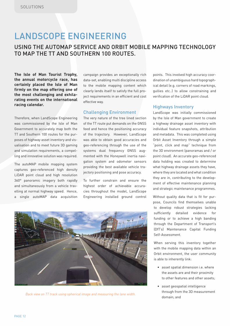
Back view on TT track using spherical image and measuring the lane width.
campaign provides an exceptionally rich
data-set, enabling multi discipline access
to the mobile mapping content which
clearly lends itself to satisfy the full pro-
ject requirements in an efficient and cost
effective way.
Challenging EnvironmentThe very nature of the tree lined section
of the TT route put demands on the GNSS
feed and hence the positioning accuracy
of the trajectory. However, LandScope
was able to obtain good accuracies and
geo-referencing through the use of the
systems dual frequency GNSS aug-
mented with the Honeywell inertia navi-
gation system and odometer sensors
providing the best available vehicle tra-
jectory positioning and pose accuracy.
To further constrain and ensure the
highest order of achievable accura-
cies throughout the model, LandScope
Engineering installed ground control
points. This involved high accuracy coor-
dination of unambiguous hard topograph-
ical detail (e.g. corners of road markings,
gullies etc..) to allow constraining and
verification of the LiDAR point cloud.
Highways inventoryLandScope was initially commissioned
by the Isle of Man government to create
a highway drainage asset inventory with
individual feature snapshots, attribution
and metadata. This was completed using
Orbit Asset Inventory through a simple
“point, click and map” technique from
the 3D environment (panoramas and / or
point cloud). An accurate geo-referenced
data holding was created to determine
what highway drainage assets they have,
where they are located and what condition
they are in, contributing to the develop-
ment of effective maintenance planning
and strategic maintenance programmes.
Without quality data that is fit for pur-
pose, Councils find themselves unable
to develop robust strategies lacking
sufficiently detailed evidence for
funding or to achieve a high banding
through the Department of Transport’s
(DfT’s) Maintenance Capital Funding
Self-Assessment.
When serving this inventory together
with the mobile mapping data within an
Orbit environment, the user community
is able to inherently link:
• asset spatial dimension i.e. where
the assets are and their proximity
to other features and other assets;
• asset geospatial intelligence
through from the 3D measurement
domain; and
PAGE 13
SOLUTIONS
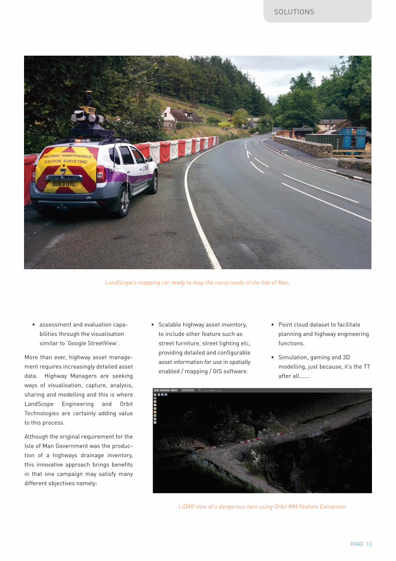
LandScope’s mapping car ready to map the curcy roads of the Isle of Man.
• assessment and evaluation capa-
bilities through the visualisation
similar to ‘Google StreetView’.
More than ever, highway asset manage-
ment requires increasingly detailed asset
data. Highway Managers are seeking
ways of visualisation, capture, analysis,
sharing and modelling and this is where
LandScope Engineering and Orbit
Technologies are certainly adding value
to this process.
Although the original requirement for the
Isle of Man Government was the produc-
tion of a highways drainage inventory,
this innovative approach brings benefits
in that one campaign may satisfy many
different objectives namely:
• Scalable highway asset inventory,
to include other feature such as
street furniture, street lighting etc,
providing detailed and configurable
asset information for use in spatially
enabled / mapping / GIS software.
• Point cloud dataset to facilitate
planning and highway engineering
functions.
• Simulation, gaming and 3D
modelling, just because, it’s the TT
after all…….
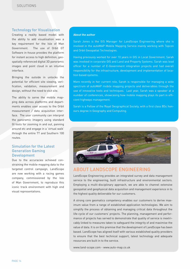
LiDAR view of a dangerous turn using Orbit MM Feature Extraction
PAGE 14
SOLUTIONS
technology for visualisationCreating a reality based model with
the ability to add visualisation was a
key requirement for the Isle of Man
Government. The use of Orbit GT
Software in-house provides the platform
for instant access to high definition, geo-
spatially referenced digital 3D panoramic
images and point cloud in an intuitive
interface.
Bringing the outside in unlocks the
potential for efficient site viewing, veri-
fication, validation, measurement and
design, without the need to visit site.
The ability to serve the mobile map-
ping data across platforms and depart-
ments enables user access to the Orbit
measurement / data acquisition inter-
face. The user community can interpret
the panoramic imagery using standard
GI tools for zooming in and out, panning
around etc and engage in a ‘virtual walk’
through the entire TT and Southern 100
routes.
Simulation for the latest Generation Gaming development Due to the accuracies achieved con-
straining the mobile mapping data to the
targeted control campaign, LandScope
are now working with a racing games
company, commissioned by the Isle
of Man Government, to reproduce this
iconic track environment with high end
visual representations.
About the author
Sarah Jones is the GIS Manager for LandScope Engineering where she is
involved in the autoMAP Mobile Mapping Service mainly working with Topcon
and Orbit Geospatial Technologies.
Having previously worked for over 10 years in GIS in Local Government, Sarah
was involved in corporate GIS and Land and Property Systems. Sarah was lead
officer for a number of E-Government integration projects and had overall
responsibility for the infrastructure, development and implementation of loca-
tion based systems.
More recently in her current role, Sarah is responsible for managing a wide
spectrum of autoMAP mobile mapping projects and deliverables through the
use of innovative tools and techniques. Last year, Sarah was a speaker at a
number of conferences, showcasing how mobile mapping plays its part in effi-
cient highways management.
Sarah is a Fellow of the Royal Geographical Society, with a first class BSc hon-
ours degree in Geography and Computing.
LandScope Engineering provides an integrated survey and data management
service to the engineering, built infrastructure and environmental sectors.
Employing a multi-disciplinary approach, we are able to channel extensive
geospatial and geophysical data acquisition and management experience in to
the highest quality deliverable for our customers.
A strong core geomatics competency enables our customers to derive max-
imum value from a range of established application technologies. We aim to
simplify the process of obtaining and managing critical data throughout the
life-cycle of our customers’ projects. The planning, management and perfor-
mance of projects has served to demonstrate that quality of service is inextri-
cably linked to measures taken to safeguard the integrity of and maximise the
value of data. It is on this premise that the development of LandScope has been
based. LandScope has aligned itself with various established quality providers
to ensure that the best technical support, latest technology and adequate
resources are built in to the service.
www.land-scope.com - www.auto-map.co.uk
aBoUt laNdSCoPE ENGiNEEriNG


![Undergraduate Writing Assignments in Mechanical Engineering...Mechanical Engineering, Electrical and Computer Engineering, Biosystems Engineering, Civil Engineering and Design Engineering]](https://img.pdfslide.us/doc/110x75/5ff7a06f83bfbd5c864bdc1a/undergraduate-writing-assignments-in-mechanical-engineering-mechanical-engineering.jpg)