Embed Size (px)
Citation preview
THOMAS H. McGOVERN, ORRI VESTEINSSON,ADOLF FRI -DRIKSSON, MIKE CHURCH, IAN LAWSON,
IAN A. SIMPSON, ARNI EINARSSON, ANDY DUGMORE,GORDON COOK, SOPHIA PERDIKARIS, KEVIN J . EDWARDS,
AMANDA M. THOMSON, W. PAUL ADDERLEY, ANTHONY NEWTON,GAVIN LUCAS, RAGNAR EDVARDSSON, OSCAR ALDRED,
AND ELAINE DUNBAR
Landscapes of Settlement in Northern Iceland:Historical Ecology of Human Impact and ClimateFluctuation on the Millennial Scale
ABSTRACT Early settlement in the North Atlantic produced complex interactions of culture and nature. A sustained program of
interdisciplinary collaboration focused on ninth- to 13th-century sites and landscapes in the highland interior lake basin of Myvatn in
Iceland and to contribute a long-term perspective to larger issues of sustainable resource use, soil erosion, and the historical ecology of
global change. [Keywords: Iceland, sustainability, historical ecology, paleoecology]
INTRODUCTION: NABO, GLOBAL CHANGE, ANDHISTORICAL ECOLOGY IN THE NORTH ATLANTIC
Near the close of the eighth century C.E., Nordic pi-rates, traders, and settlers began the expansion from theirScandinavian homelands that gave the Viking Age its nameand permanently changed the development and history ofEurope. In the North Atlantic, by circa C.E. 800–C.E. 850,settlers colonized the islands of the eastern North Atlantic(Shetland, Orkney, Hebrides, Man, Ireland, and Faroes). Ice-land was traditionally settled circa 874, Greenland circa985, and the short-lived Vinland colony survived for a fewyears around C.E. 1000 in Newfoundland–Gulf of St. Lau-rence region (Arneborg 2000; Wallace 2000). Around theyear C.E. 1000, Nordic language and culture extended fromthe coast of North America to the Baltic, and by C.E. 1014an Anglo-Scandinavian dynasty briefly united England,Denmark, and Norway. However, this first connection ofold and new worlds proved transient. By the mid–11th cen-tury the Vinland colony was abandoned, and by the mid–15th century the Greenlandic colony became completelyextinct. Iceland survived as the westernmost outpost of theViking Age North Atlantic expansion, and the first transat-lantic connection between the Old and New Worlds endedin failure. Changes in politics and market forces in Europeplayed a role in the unhappy end to the “Norse Atlantic
AMERICAN ANTHROPOLOGIST, Vol. 109, Issue 1, pp. 27–51, ISSN 0002-7294 online ISSN 1548-1433. C© 2007 by the American Anthropological Association.All rights reserved. Please direct all requests for permission to photocopy or reproduce article content through the University of California Press’s Rightsand Permissions website, http://www.ucpressjournals.com/reprintInfo.asp. DOI: 10.1525/AA.2007.109.1.27.
Saga” (Jones 1986), but climate change and human envi-ronmental affects on island ecosystems were also an impor-tant part of the story (Amorosi et al. 1997, 1998; Dugmoreet al. 2004; Ogilvie and McGovern 2000).
Prior to the 1970s, most scholars of the Viking periodwere philologists, medieval archaeologists, and documen-tary historians, and the uneven written record for Vikingdepredations in Europe and Iceland’s colorful and diversesaga literature tended to dominate discussion of the period(for research history see Fri riksson 1994). Since the mid–1970s research focus has shifted, as multiple projects com-bining archaeology, paleoecology, and history have beencarried out all across the region, producing a richer un-derstanding of the Norse migrations and placing themmore effectively in an environmental and economic con-text (Arneborg and Grønnow 2005; Bigelow 1991; Housleyand Coles 2004; McGovern 1990, 2004; Morris andRackham 1992; Ogilvie and McGovern 2000). The histor-ical ecology movement (Balee 1998; Crumley 1994, 1998,2001; Kirch and Hunt 1997) has come to provide the theo-retical underpinning of much North Atlantic archaeologicalresearch, a pattern shared by many other regions where ar-chaeology and paleoecology are attempting to connect thelong-term record of human–environment interaction withpresent issues of rapid environmental change and human
28 American Anthropologist • Vol. 109, No. 1 • March 2007
response (Hardesty and Fowler 2001). The movement at-tempts to combine the interdisciplinary environmental ori-entation of the best of the processual archaeology of the1980s with the concern for contextual history, factionalconflict, and politically loaded cultural landscape construc-tion stressed by some postprocessualists in the 1990s—witha clear agenda aimed at integrating archaeology and envi-ronmental history within global change research (Amorosiet al. 1996; Bawden and Reycraft 2001; Descola and Palsson1996; Kirch 1997; McGovern 1994; Redman 1999; Spriggs1997; Steadman 1995).
The dramatic value of the diverse cases provided by theNorse North Atlantic (initial spread of a homogeneous pop-ulation into different island ecosystems, subsequent eco-nomic and social diversification, and total extinction of theVinland and Greenland colonies) has increasingly featuredin works aimed at a broad audience interested in globalchange topics (Diamond 2005; McGovern and Perdikaris2000; Pringle 1997; Redman 1999). In the past decade,the North Atlantic has thus become an arena for just thesort of international, interdisciplinary research into long-term, human–environmental interactions that most fund-ing agencies identify as worthy of global change support.This development is itself in part an outcome of early globalchange funding to archaeology and paleoecology by theU.S. National Science Foundation’s Office of Polar Programs(NSF OPP).
The regional research cooperative North AtlanticBiocultural Organization ([NABO], see www.geo.ed.ac.uk/nabo) was formally set up at an NSF supported work-shop 1992, but it initially grew out of a meeting in 1988at Bowdoin College hosted by Gerry Bigelow and Su-san Kaplan of the Peary-Macmillan Arctic Center (Bigelow1991). Since 1993, NABO has provided support for fieldprojects in Iceland, Greenland, Northern Norway, Scot-land, and the Faroe Islands. The group has contributedto northern education by sponsoring doctoral, Master ofarts, and Master of science theses in anthropology, ge-ology, and geography in both the United States, UnitedKingdom, and Scandinavia, and since 1997 has cospon-sored (with City University of New York [CUNY], the Ice-landic Institute of Archaeology, University of Oslo, andUniversity of Glasgow) an international multidisciplinaryfield school in Iceland that has involved students from26 nations. Since 2000, a special NSF OPP Research Ex-perience for Undergraduates grant to Sophia Perdikaris ofBrooklyn College CUNY has integrated classroom, labora-tory, and real-time distance learning, with Icelandic field-work, dramatically changing the lives of highly motivatedinner-city undergrads and producing a series of student-authored papers and posters (Amundsen et al. 2005; Krivo-gorskaya et al. 2005). NABO has also provided practicallogistic support (three jointly purchased and maintainedLand Rovers, jointly purchased resistivity instruments, elec-tronic distance meters (EDMs) and GPS receivers, and prepo-sitioned stocks of basic field gear, tents, and provisions),has provided enhanced data comparability through com-
munity developed data management software (NABONE),and has held a suite of 22 workshops and conferencessince 1992 that have helped forge individual and institu-tional connections and produced major conference publica-tions (Arneborg and Grønnow 2005; Bigelow 1991; Housleyand Coles 2004; Morris and Rackham 1992; Ogilvie andJonsson 2001). NABO interdisciplinary efforts producedthe first use in archaeology and history of high-resolutionproxy climate data from the Greenland ice-core projects(Barlow et al. 1997; Buckland et al. 1996; Dugmore et al.forthcoming), and NABO meetings now regularly includerepresentatives of the hard sciences and environmentalplanners as well as the usual crowd of historians, archae-ologists, and paleoecologists. NABO teams have also beensuccessful in leveraging the initial NSF support to a cur-rent total of just over US$ 3.5 million in external fund-ing from North American, Scandinavian, and United King-dom sources. NABO participants have gotten by with helpfrom their friends and neighbors and have been able totake on projects and address problems beyond the capa-bility of any single scholar, university, or national researchprogram.
CASE STUDY: EARLY SETTLEMENT IN NORTH ICELAND
Although one objective of this article is to indicate thegeneral benefits (scholarly and financial) of sustained, ac-tive, and coordinated interdisciplinary international co-operation, the only real justification for involvement inthe acronym-rich world of Global Change research isthe improvement of our collective contribution throughcase-specific, problem-focused field and laboratory researchprojects. The remainder of this article turns to a presenta-tion of the results of one of the largest and longest-lastingcooperative NABO projects: the “Landscapes of Settlementin NE Iceland” project (1996 to present) in the inlandMyvatn district (Myvatnssveit).
Iceland is a volcanic island situated atop the NorthAtlantic ridge. It is subject to frequent volcanic erup-tions, many of which provide a widespread fallout of vol-canic ash (tephra). Where identified, these tephra layersdefine isochronous marker horizons that can be tracedthrough sediment, soil profiles, and archaeological deposits(Dugmore et al. 2004; Thorarinsson 1944, 1961, 1981).Southern Iceland is warmed by the North Atlantic driftand is classed as a boreal environment (with little persis-tent snow in lower elevations). Northern Iceland is signif-icantly colder (low arctic, substantial long-lasting wintersnow), and the interior highlands are today covered by largeglaciers and heavily eroded arctic deserts.
Accounts of early settlement by Celtic Christian monksare still unproven by archaeology (but see Ahronson 2000),and archaeological evidence strongly indicates the first ef-fective settlement of the island by humans occurred in thelate ninth century C.E. (conveniently associated with the“Landnam” tephra layer now dated C.E. 871 ±2 by cor-relation to the Greenland Ice Sheet; see Gronvold et al.
McGovern et al. • Landscapes of Settlement 29
1995). When Scandinavian settlers arrived, they encoun-tered a mid–Atlantic island with substantial arctic birch for-est in the lower elevations, coastal sea mammal (includ-ing walrus) and sea bird colonies, migratory nesting birds,and the green grass that could feed their imported do-mestic livestock. The economy of the Viking Age NorthAtlantic settlers was flexible but based around stock raisingsupplemented by limited barley growing and often exten-sive use of wild species (Dugmore et al. 2005; McGovernet al. 2001; McGovern et al. 2006; Simpson et al. 2002).Pasture was the ultimate source of wealth and power, andthe correlation of cattle, good grazing, and chieftainshipis clear in both the historical and archaeological record(McGovern 2000; Vesteinsson 1998). Between the initialsettlement (Landnam), traditionally dated circa C.E. 874,and political union with Norway in 1262, Icelandic societywas dominated by chieftains and great families but con-strained by codified laws and an elaborate system of tradi-tional justice (Sigur sson 1999; Vesteinsson 2000a, 2000b,2001). Although today Iceland is an independent, vibrant,rapidly urbanizing modern Scandinavian nation of around300,000, during the 15th–18th centuries Iceland was a rel-atively impoverished rural province in the kingdom ofNorway–Denmark with a population fluctuating around50,000.
Like many of the islands of Oceania and the Caribbean,Iceland thus represents an environment with a clear andrelatively recent prehuman–human baseline, but Icelandwould also become a fully literate island community whosenatives were to produce some of the most important histo-ries of early medieval Scandinavia and self-consciously anti-quarian records of pre-Christian pagan mythology. Icelandalso has a long modern tradition of scholarship in both thenatural and social sciences, particularly in history, anthro-pology, and the earth sciences. Icelandic medieval litera-ture (sagas, hagiographies, histories, annals, law codes, etc.)provides a rich record of later landholding patterns, legalpractice, stock raising, demography, conflict and competi-tion, and invaluable access to an internal world view andemic social and economic categories that have been heavilyexploited by anthropologists and social historians (Byock2001; Durrenberger 1989, 1992; Eggertsson 1998; Hastrup1985, 1990; Ingimundarson and Ogilvie 1998; Miller 1990;Ogilvie 1997; Vasey 1991, 1996; Vesteinsson 2000b). Partic-ularly useful for economic history and settlement patternanalysis is a comprehensive land and stock register com-piled in 1703–12 (Jar bok Arna Magnussonar 1990), whichstill exists for most of Iceland and has been recently con-verted to digital format (Edvardsson 2001). The Jar abokentries provide farm-by-farm details of early-18th-centurystock raising and wild resource use; furthermore, they re-tain some elements of medieval land valuation systems(Fri riksson 2004a). However, until the 12th century, noneof the medieval written sources are contemporary with theevents they describe, and they are problematic sources forthe reconstruction of economy and society at Landnam.The first two centuries of Icelandic archaeology are effec-
tively prehistoric and can only be directly investigated byarchaeology and paleoecology (Vesteinsson 1998, 2000a).
RESEARCH PROBLEM: UNINTENDED HUMAN IMPACTON ISLAND ECOSYSTEMS
Iceland has long been famous both for its rich medieval lit-erature and for an extreme human impact on vegetation,soils, and landscapes since its settlement in the ninth cen-tury C.E. While Icelanders were composing the prose andpoetry that still comprise major sources of the history ofthe North Atlantic in the Viking Age and a key elementin the literary heritage of medieval Europe, they were alsoparticipating in massive and often unanticipated alterationof their mid–Atlantic island. It is estimated that 90 per-cent of the forest and 40 percent of the soil present atthe ninth century Landnam has disappeared, and 73 per-cent of the modern land surface is currently affected bysoil erosion (Arnalds et al. 1997). Scores of deflated Viking-age farm ruins now stranded in gravel deserts devoid oftrees, grass, and soil bear witness to the complete destruc-tion of the presettlement environment in some parts ofthe country. The growth of the modern Icelandic economysince 1900 was based largely on fishing rather than agri-culture, and in many parts of Iceland today rural farmingsettlements continue to be endangered by soil erosion be-gun in the tenth century. The deliberate introduction ofthe northwestern European Iron age agricultural complexof domestic mammals and crops and the accidental in-troduction of a host of European insects and wild plants(Buckland et al. 1991a, 1991b) rapidly transformed plantcommunities never previously subjected to grazing pressureby mammals and creating what Paul Buckland has called an“ovigenic landscape” (Buckland 2000). Rapid deforestationoften closely followed first settlement (Caseldine et al. 2004;Hallsdottir 1987) and was, in turn, often followed by soilerosion beginning first at higher elevations and progress-ing downslope; as groundcover was breached over widerand wider areas, the highly friable Icelandic andisols (vol-canic soil type) were exposed to wind and water trans-port (Dugmore and Buckland 1991; Dugmore and Erskine1994).
The biogeography of the North Atlantic islands mayhave compounded the environmental assessment efforts offirst settlers: Essentially, northwestern European plant com-munities extend from Norway and the British Isles all theway to southern Greenland (Buckland 2000; Dugmore et al.2005). A ninth-century colonist coming from coastal Tromsdistrict in North Norway (north temperate climate despiteits location above the arctic circle) who came hundreds ofmiles south to settle in Iceland might be excused for failingto immediately recognize that pasture plant communitiesfamiliar from home were in fact much closer to their bio-logical range limits in Iceland and thus more vulnerable tograzing pressure. The volcanic andisols of Iceland are alsosubtly different from most soils of the settlers’ homelandsand are far more structurally vulnerable to wind and water

30 American Anthropologist • Vol. 109, No. 1 • March 2007
transport (Arnalds 1990) and less responsive to fertilization.An “overoptimistic pioneer fringe” of tenth-century settle-ment may have pushed into the interior highlands only tosee vegetation and soils destroyed by the grazing pressureof their imported animals (Sveinbjarnardottir 1992; but seealso Dugmore et al. 2006).
Local populations of walrus in southwest Iceland docu-mented by zooarchaeology also seem to have been killedoff in the first few generations of settlement, and wildbirds (described as initially “unwary” and easy to kill inlater accounts) made up a major portion of animal bonecollections (archaeofauna) in southern Iceland (McGovern1999; McGovern et al. 2001; Perdikaris and McGovern 2005;Vesteinsson et al. 2002). Analysis of a suite of eighth- to11th-century archaeofauna indicated that colonists wereimporting a very standardized mix of domestic stock, im-posing the same suite of cattle, pigs, goats, sheep, horses,dogs, and cats on every island settled (McGovern et al.2001). This attempt to transplant a familiar economy tounsuitable ecosystems resulted in the (brief) attempt at pigkeeping in Greenland in the 11th century, and substan-tial piggery lasted in Iceland throughout the tenth century(McGovern 1985; Olafsson et al. 2005). By the time Ice-land became a province of Norway in 1264 (following aprolonged civil war among its great magnate families), thecountry had become a very different place environmentallyas well as socially from the Landnam age.
If the marginalization and relative poverty of the latermedieval and early modern period had partly environ-mental roots, then it would appear that the early settlers’application of ultimately unsuitable models for land man-agement had effectively passed on a crushing bill to their de-scendants through their early land-use decisions (Amorosiet al. 1997). What happened in the undocumented first twocenturies of settlement in Iceland? Or perhaps more specif-ically, to what extent did the settlers adapt to their new en-vironment, creating a sustainable economy for themselves,and to what extent did they continue practices developedin a different environment, thus reducing their capacity toproduce riches and stability for their community?
“TRADITIONAL NARRATIVE” OF THE LANDNAMPERIOD (CA. 1990)
By the last decade of the 20th century, sustained multidis-ciplinary (but mainly single-site) investigations in Icelandhad produced what may be called a “traditional narrative,”describing the process of Landnam and its environmen-tal consequences (McGovern et al. 1988 is a representativeexample).� Settlement proceeded from coastal enclaves inland,
probably following major river valleys in gradual expan-sion (perhaps sometimes too far) into the interior high-lands as less wealthy or successful colonists were pushedout of the most desirable districts.
� First settlers had claimed vast tracts later subdividedamong followers, but the individual independent farmer
(bondi) and his farm household (so evident in the sagas)were the basic element of settlement and subsistence.
� Human impact on most wild resources was immediateand severe. “Natural capital” (in the sense of Cronon1991) accumulated since glacial times was rapidly drawndown and expended to finance the rapid expansion ofthe initially limited numbers of imported domestic stockduring the first years of Landnam.
� Deforestation was uniformly rapid; trees were clearedfrom all but a few belatedly protected areas.
� Almost all manufactured goods were imported, establish-ing a long-term dependency on continental Europe foriron and other critical materials.
� Cognitive maladies (“false analogy,” “insufficient detail,”“short observational series”) prevented effective adapta-tion of northwestern European economic expectationsto Icelandic realties.
� “Tragedy of the commons” (Feeny et al. 1990) had beenplayed out in the highland pastures, leading to erosionrolling downslope and eventually overwhelming infieldsand farms.
� Climate cooling in the later Middle Ages impacted a land-scape and society already riddled with self-created vul-nerabilities and substantially expended natural capitalreserves.
� Competition among elites interfered with effective en-vironmental management, pushing tenants into unsus-tainable practices and eventually destabilizing wholeregions.
This narrative certainly evokes parallels in many partsof the modern world, where overgrazing and land degrada-tion affects up to 40 percent of the earth’s vegetated landsurface (Brady and Weil 1999). The direct connection ofthese archaeologically visible processes to both modern Ice-landic and global erosion control efforts was used to justifyapplication for global change funding to supplement tradi-tional sources of support for archaeology. Just over a decadelater (thanks to this expanded funding), we now recognizethat many aspects of the traditional Icelandic environmen-tal Landnam narrative above are simply wrong, that oth-ers are clearly oversimplifications, and that the model as awhole needs revision if it is to provide an effective tool formodern landscape managers. These realizations are not theresult of gradual accumulation of facts derived from moresingle-site excavations but, rather, of a sustained programof cross-disciplinary, landscape-scaled investigation madepossible by the support of U.S., Icelandic, and U.K. global-change research funding to what became the “Landscapesof Settlement” project (see Figure 1).
LANDSCAPES OF SETTLEMENT IN NORTHERN ICELAND
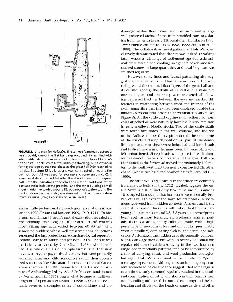
The Landscapes of Settlement project began as a single-siteinvestigation centered on the site of Hofsta ir near LakeMyvatn in north eastern Iceland (see Figure 2). Hofsta irwas identified as a potential pre-Christian “temple” sitein the 19th century; it was also the site of one of the
McGovern et al. • Landscapes of Settlement 31
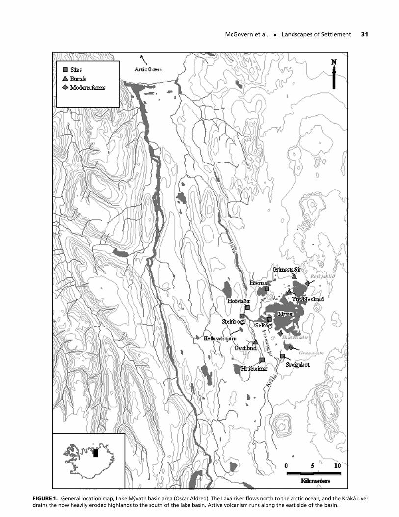
FIGURE 1. General location map, Lake Myvatn basin area (Oscar Aldred). The Laxa river flows north to the arctic ocean, and the Kraka riverdrains the now heavily eroded highlands to the south of the lake basin. Active volcanism runs along the east side of the basin.
32 American Anthropologist • Vol. 109, No. 1 • March 2007
FIGURE 2. Site plan for Hofsta ir. The sunken featured structure Gwas probably one of the first buildings occupied; it was filled withlater midden deposits, as were sunken feature structures A4 and A5to the east. The structure D was initially a dwelling, but it was usedfor hay storage by the final phase as the great hall (AB) reached itsfull size. Structure E2 is a large and well-constructed privy, and theoutshot room A2 was used for storage and some smithing. C2 isa medieval structured added after the abandonment of the greathall. Note the indications of benches and interior partitions left bypost and stake holes in the great hall and the other buildings. Smallsheet middens extended around E2, but most refuse (bone, ash, firecracked stones, artifacts, etc.) was dumped into the sunken featurestructure ruins. (Image courtesy of Gavin Lucas.)
earliest fully professional archaeological excavations in Ice-land in 1908 (Bruun and Jonsson 1909, 1910, 1911). DanielBruun and Finnur Jonsson’s partial excavation revealed anexceptionally large long hall (floor area 270 m2 whereasmost Viking Age halls varied between 60–90 m2) withassociated middens whose well-preserved bone collectionsgenerated the first professional zooarchaeological report forIceland (Winge in Bruun and Jonsson 1909). The site waspartially reexcavated by Olaf Olsen (1965), who identi-fied it as one of a class of “temple farms”: sites that mayhave seen regular pagan ritual activity but were primarilyworking farms and elite residences rather than special-ized structures like Christian churches or classical Greco-Roman temples. In 1991, teams from the Icelandic Insti-tute of Archaeology led by Adolf Fri riksson (and joinedby Vesteinsson in 1995) began what became a multiyearprogram of open-area excavation (1996–2002) that even-tually revealed a complex series of outbuildings and un-
damaged earlier floor layers and that recovered a largewell-preserved archaeofauna from stratified contexts, dat-ing from the tenth to early 11th centuries (Fri riksson 1993,1994; Fri riksson 2004c, Lucas 1998, 1999; Simpson et al.1999). The collaborative investigations at Hofsta ir con-clusively demonstrated that the site was indeed a workingfarm, where a full range of settlement-age domestic ani-mals were maintained, cooking fires generated ash- and fire-cracked stones in large quantities, and local bog iron wassmithed regularly.
However, some finds and faunal patterning also sug-gest regular ritual activity. During excavation of the wallcollapse and the terminal floor layers of the great hall andits outshot rooms, the skulls of 11 cattle, one male pig,one male goat, and one sheep were recovered, all show-ing depressed fractures between the eyes and marked dif-ferences in weathering between front and interior of theskull, suggesting that they had been displayed outside thebuilding for some time before their eventual deposition (seeFigure 3). All the cattle and caprine skulls either had horncores attached or were naturally hornless (a very rare traitin early medieval Nordic stock). Two of the cattle skullswere found face down in the wall collapse, and the restof the skulls were tossed in a pit in one of the side roomsof the structure during demolition. As part of the demo-lition process, two sheep were beheaded and both headsand bodies thrown into the same room but were otherwiseleft unbutchered. Sheep heads were placed in each door-way as demolition was completed and the great hall wasabandoned as the farmstead moved approximately 140 me-ters to the southwest, next to a newly constructed Christianchapel (whose two basal radiocarbon dates fall around C.E.1000).
The cattle skulls are unusual in that three are definitelyfrom mature bulls (in the 1712 Jar abok register the en-tire Myvatn district had only two immature bulls among18 occupied farms), and that horn cores were normally bro-ken off skulls to extract the horn for craft work in speci-mens recovered from midden contexts. Also unusual is theage distribution of the skulls with intact dentition: All areyoung adult animals around 2.5–3.5 years old (in the “primebeef” age). In most Icelandic archaeofauna from all peri-ods, there is a strong “dairy culling” profile, with a highpercentage of newborn calves and old adults (presumablyworn-out milkers) dominating skeletal and dental-age indi-cators. At Hofsta ir, the midden deposits generally conformto this dairy-age profile, but with an overlay of a small butregular addition of cattle also dying in the two–four-yearrange. Sheep mortality patterns tend to be complicated bya mix of dairying, meat, and wool production strategies,but again Hofsta ir is unusual in the number of “primemeat age” specimens. Although research is ongoing, cur-rent zooarchaeological evidence suggests that some regularevent (in the early summer) regularly resulted in the deathand consumption of cattle and sheep in their prime (thus,not the culling off-take of the normal economy) and the be-heading and display of the heads of some cattle and other

McGovern et al. • Landscapes of Settlement 33
FIGURE 3. Bull’s skull from wall demolition at Hofsta ir. Depressed fracture between the eyes is typical of these specimens, as is differentiallyheavy weathering on the outer surface and the intact horn cores. Fractured during 11th-century demolition of the great hall, this partialskull and set of horns seems to have been displayed for some time on the outside of the building. Radiocarbon dates on these skull fragmentsindicate that they were mounted gradually and not in the same event. (Image courtesy of Tom McGovern.)
domestic animals. These patterns are not typical of otherIcelandic archaeofauna and would tend to support Olsen’smodel for a “temple farm,” combining normal farming ac-tivity with recurring seasonal rituals involving the sacrifice,consumption, and display of major domestic animals whosedeath would have been expensive in terms of the normaleconomic cycle as we understand it.
While the excavation program at Hofsta ir progressed,survey teams documented early sites around the lake, even-tually documenting over 1,200 sites and structures in theMyvatn region (Myvatnssveit). As test pits and surfacecollections revealed excellent organic preservation at anincreasing number of sites datable to the ninth to 12thcenturies in Myvatnssveit, we somewhat belatedly realizedthat this inland region was particularly well suited to a sus-tained landscape-scale multidisciplinary investigation. Ma-jor excavations (see Figure 1) have taken place at Sveigakot(1999–2006), Hrısheimar (2001, 2003–06), Steinbogi (2002),and Selhagi (2001); mapping and small-scale excavation hasbeen carried out at abandoned farm sites at Oddasta ir,Brenna, and Stong (Edvardsson 2001; Edvardsson andMcGovern 2004; Vesteinsson 2000a, 2002, 2003).
Following a thorough revision of the entire Icelandiccorpus of grave goods (Eldjarn and Fri riksson 2000), theMyvatn pre-Christian burial sites as well as all (19) such sitesin northeastern Iceland have been revisited (Fri riksson2004b), offering new insights into the development ofthe Landnam society (Fri riksson 2003, 2004a; Fri rikssonet al. 2005a). New studies of burial topography have led tofresh burial finds at Hrısheimar (Fri riksson and McGovern2005), Da asta ir (Fri riksson et al. 2005b), Litlu-Nupar(Fri riksson et al. 2005c), and Saltvık (Fri riksson et al.2005c), from which both artifacts and human and animalbones have been recovered and are now being used to forma new basis for the chronology of the whole region.
Archaeological and paleoecological investigation inMyvatnssveit has been greatly aided by close cooperationwith the long-established Myvatn Research Station (af-filiated to the Icelandic Ministry for the Environment),which generously provided comparative zoological speci-mens, steadily expanding low-level air-photo coverage, anda trove of local environmental and cultural information andcontacts. Collaboration with geophysicists, geoarchaeolo-gists, and tephrochronologists from Iceland and the United
34 American Anthropologist • Vol. 109, No. 1 • March 2007
Kingdom also revealed a complex Holocene environmentalhistory of the region and the presence of a series of databletephra (notably the Landnam sequence of C.E. 871 ±2, atenth-century Vei ivotn layer, Hekla 1104 and 1300, Katla1262, Vei ivotn 1477 and 1717). Our research, combinedwith that of Gu run Larsen and colleagues (2002), has builtup an excellent tephrochronological framework that can beused to help answer chronological questions as well as ratesof environmental change.
MYVATNSSVEIT REGION
The Myvatn region (Myvatnssveit) straddles the mid–Atlantic rift and has been volcanically active for thousandsof years. The broad shallow lake is fed by underground chan-nels that drain a large area of basaltic lava fields and sanddeposits. The groundwater feeding the lake through a num-ber of springs gushing forth along its east shore is rich inphosphate and silica leading to a luxuriant growth of di-atoms and Cyanobacteria (blue–green algae) that supportthe populations of chironimid and simuliid flies that pro-vide its name (“Midge Lake”). The lake is renowned for richfishing—mainly of arctic charr (Salvelinus alpinus). Despiteits altitude of 250–300 meters above sea level (hereafter,asl) the Myvatn district supports rich hay fields around thelakeshore. Today, the highlands around the lake to both thenorth and south are heavily eroded deserts. Myvatnssveitrepresents the largest surviving inland farming communityin northern Iceland.
The major drainage is the Laxa river flowing north-ward to the sea approximately 60 kilometers away. The Laxa(“salmon river”) is a famous trout stream (Salmo trutta); inits lower reaches, it also receives migratory Atlantic salmon(Salmo salar), which do not reach the lake area. The Laxais joined by the Kraka River, which extends southward intothe interior highlands; today the region is largely strippedof vegetation and subject to ongoing soil erosion. Manysmaller but less fertile lakes surround Myvatn, also provid-ing habitat for charr and trout. Myvatn hosts vast num-bers of migratory waterfowl in spring and summer, withcurrently over 15,000 breeding pairs nesting around thelake. High-quality wet meadow was available around thelake, particularly around Reykjahlı in the northeast cor-ner of the lake (prior to an 18th-century lava flow) and ina broad periodically flooded marshland with small pondsand streams called Framengjar, a delta created by the Krakariver. Since at least the 18th century, the Kraka has beena destabilized, biologically impoverished, silt-laden, wan-dering stream, annually transporting tons of sand from therapidly eroding southern highlands and infilling much ofthe southern portion of the Framengjar.
When the ninth-century settlers arrived in this inte-rior highland lake basin, they found a somewhat differentenvironment. The hills around the lake were covered witha mixed vegetation of birch woods, heath, grassland, andwetlands. Stands of birch woods probably extended up toat least 400 meters, except for the wet meadows around the
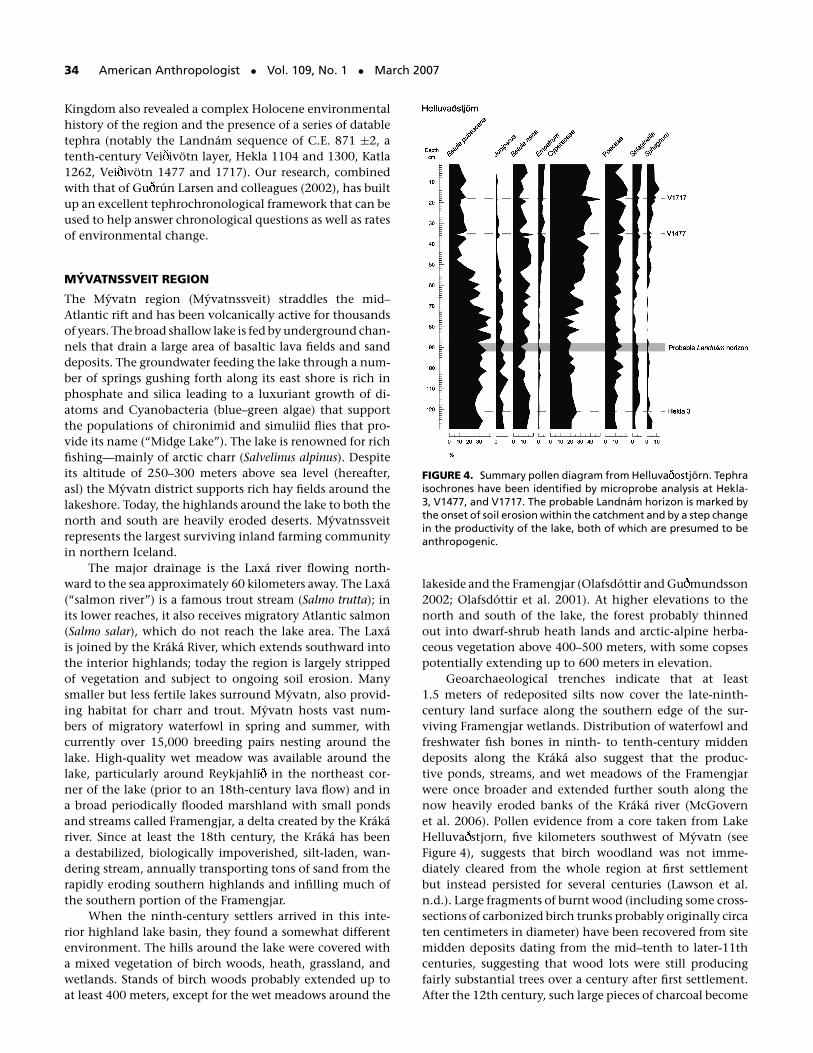
FIGURE 4. Summary pollen diagram from Helluva ostjorn. Tephraisochrones have been identified by microprobe analysis at Hekla-3, V1477, and V1717. The probable Landnam horizon is marked bythe onset of soil erosion within the catchment and by a step changein the productivity of the lake, both of which are presumed to beanthropogenic.
lakeside and the Framengjar (Olafsdottir and Gu mundsson2002; Olafsdottir et al. 2001). At higher elevations to thenorth and south of the lake, the forest probably thinnedout into dwarf-shrub heath lands and arctic-alpine herba-ceous vegetation above 400–500 meters, with some copsespotentially extending up to 600 meters in elevation.
Geoarchaeological trenches indicate that at least1.5 meters of redeposited silts now cover the late-ninth-century land surface along the southern edge of the sur-viving Framengjar wetlands. Distribution of waterfowl andfreshwater fish bones in ninth- to tenth-century middendeposits along the Kraka also suggest that the produc-tive ponds, streams, and wet meadows of the Framengjarwere once broader and extended further south along thenow heavily eroded banks of the Kraka river (McGovernet al. 2006). Pollen evidence from a core taken from LakeHelluva stjorn, five kilometers southwest of Myvatn (seeFigure 4), suggests that birch woodland was not imme-diately cleared from the whole region at first settlementbut instead persisted for several centuries (Lawson et al.n.d.). Large fragments of burnt wood (including some cross-sections of carbonized birch trunks probably originally circaten centimeters in diameter) have been recovered from sitemidden deposits dating from the mid–tenth to later-11thcenturies, suggesting that wood lots were still producingfairly substantial trees over a century after first settlement.After the 12th century, such large pieces of charcoal become
McGovern et al. • Landscapes of Settlement 35
rare. At the sites of Sveigakot (at 286 m asl) and Hrısheimar(at 316 m asl), a pattern of tree root casts appearing be-neath both the ninth-century Landnam tephra sequenceand a midden deposited directly on the Landnam tephraindicated the presence of a fairly dense wood, with trunkspacing about 50–75 centimeters apart. By the time a sec-ond tephra fell in the early- to mid–tenth century, the treeswere cleared from around the farm sites and the ash covereda leveled midden surface. Human impact had begun in theMyvatn lake basin.
CHRONOLOGY AND SETTLEMENT IN MYVATNSSVEIT
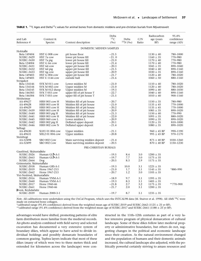
A growing suite of AMS radiocarbon dates (most on col-lagen from cattle or pig bones) provide a framework forphasing sites and contexts, especially where the localtephra sequence obviates some of the inherent problemsof the tenth-century radiocarbon calibration plateau (seeFigure 4). One immediate surprise was the early date for set-tlement in Myvatn. We have encountered definite middendeposits (including imported domesticates) in direct con-tact with the late-ninth-century Landnam tephra sequenceat Sveigakot, Hrısheimar, Selhagi, and probably Brenna(Vesteinsson 2002). Still further inland (100 km from thecoast and over 400 m asl), midden deposits at the aban-doned site of Undir Sandmula in Krokdalur have also beenfound in direct contact with the Landnam tephra. AvailableAMS radiocarbon dates confirm these surprisingly early in-dications of substantial human presence in the deep interiorbased on the tephra sequence.
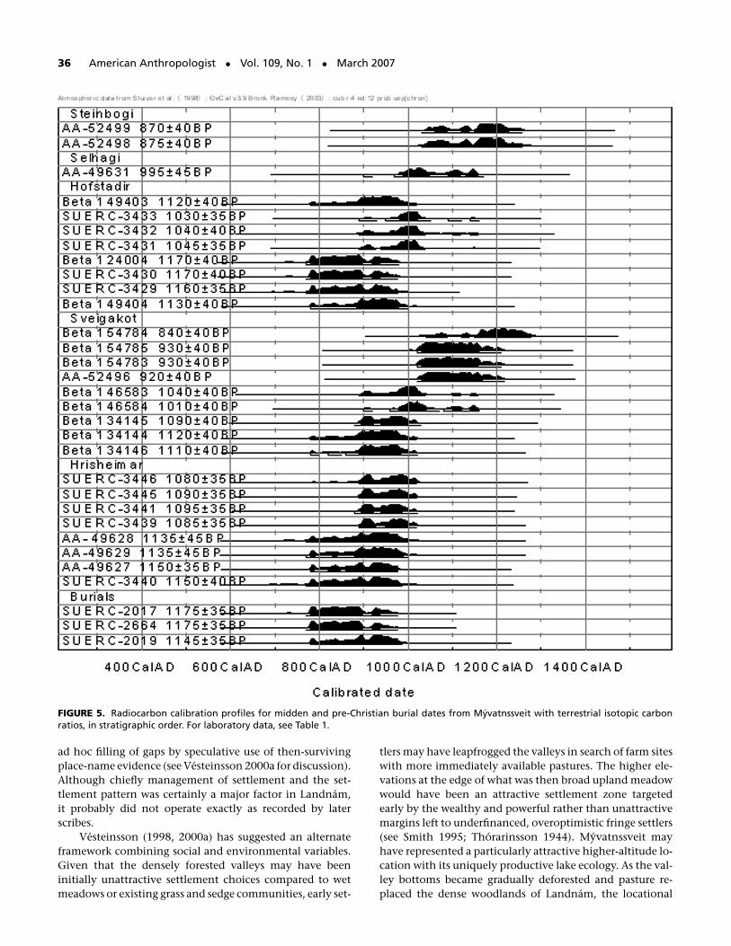
Part of the research program has been the radiocar-bon dating (and isotopic analysis) of previously excavatedpre-Christian burials in the region and the selective excava-tion of additional graves (Fri riksson 2000, 2004a, 2004b,2004c). As many pagan graves included horse and dog skele-tons, these domesticates can provide a chronological con-trol even when the human remains produce partly maritimecarbon isotope ratios likely to generate “old” dates (Ascoughet al. 2006). As Figure 5 and Table 1 illustrate, the horsebones that are associated with Myvatnssveit burials (whollyin the terrestrial food web) produce radiocarbon ages thatindicate human occupation of this inland zone in the ninthcentury. Our old model of a gradual penetration inland byindividual households from the coastal zone driven mainlyby population pressure now looks decidedly unlikely, andwe need to consider other approaches to understanding theIcelandic settlement process.
POLITICAL ECOLOGY AND SETTLEMENT PROCESS
Basal radiocarbon dates from the Greenlandic colony (set-tled from Iceland in the late tenth to early 11th centuries)also indicate surprisingly early occupation of what appear tohave always been small, marginal farms in highland valleysor on steep slopes with poor pasture (Arneborg 2000). As inIceland, the radiocarbon evidence does not support the ideaof a very gradual expansion from a few coastal centers but,rather, indicates instead a very swift dispersal within the first
generation of settlement. Orri Vesteinsson and colleagues(2002) discuss these two unexpected patterns for Landnam,suggesting that significant simple population pressure wasvery unlikely to have produced such early dispersal or suchstrong resource competition that independent settlers wereimmediately driven into marginal areas, given the smallinitial colonizing population. An alternate hypothesis canbe drawn from the Icelandic saga accounts of early settle-ment, particularly the often-cited passage from Egil’s Sagadescribing the establishment of the settlement of the chief-tain Skallagrim in Borgarfjorour in SW Iceland:
Skallagrim was an industrious man. He always kept manymen with him and gathered all the resources that wereavailable for subsistence, since at first they had little inthe way of livestock to support such a large number of peo-ple. Such livestock as there was grazed free in the woodlandall year round . . . there was no lack of driftwood west ofMyrar. He had a farmstead built on Alftanes and ran an-other farm there, and rowed out from it to catch fish andcull seals and gather eggs, all of which were there in greatabundance. There was plenty of driftwood to take back tohis farm. Whales beached there, too, in great numbers, andthere was wildlife there for the taking at this hunting post:the animals were not used to man and would never flee.He owned a third farm by the sea on the western part ofMyrar. . . . and he planted crops there and named it Akrar(Fields). . . . Skallagrim also sent his men upriver to catchsalmon. He put Odd the hermit by Gljufura to take careof the salmon fishery there . . . When Skallagrim’s livestockgrew in number, it was allowed to roam mountain pas-tures for the whole summer. Noticing how much betterand fatter the animals were that ranged on the heath, andalso that the sheep which could not be brought downfor winter survived in the mountain valleys, he had afarmstead built up on the mountain, and ran a farm therewhere his sheep were kept. . . . In this way, Skallagrim puthis livelihood on many footings.” [Egil’s Saga, ch. 29: seeHreinsson 1997, emphasis added]
This image of such a “Skallagrim effect” of chiefly firstsettlers claiming huge areas and “putting their livelihoodson many footings” by scattering retainers widely into dif-ferent resource zones recurs in other written accounts, in-cluding the apparently comprehensive Landnamabok (Bookof the Settlements; see Benediktsson 1968). Although suchaccounts provide a mechanism for the rapid, wide dispersalof small sites over a large area (perhaps initially occupiedseasonally or by a very few individuals), it does not ade-quately explain the pattern of early tephra and radiocar-bon dates for both farms and pre-Christian burials in theninth- to early-tenth-century Myvatnssveit. These are notthe isolated dwellings of salmon-fishing hermits but fullyestablished farms with resident lineages wealthy enough tofund elaborate burials of their ranking members. We nowneed to model a much more rapid and extensive first settle-ment, certainly involving interacting communities ratherthan individual pioneers. In addition, we have some rea-sons to distrust all the literary accounts of the Landnamperiod. They were all written down 250–300 years after theevents described, and modern source criticism has identifiedmany cases of both deliberate political manipulation and
36 American Anthropologist • Vol. 109, No. 1 • March 2007
FIGURE 5. Radiocarbon calibration profiles for midden and pre-Christian burial dates from Myvatnssveit with terrestrial isotopic carbonratios, in stratigraphic order. For laboratory data, see Table 1.
ad hoc filling of gaps by speculative use of then-survivingplace-name evidence (see Vesteinsson 2000a for discussion).Although chiefly management of settlement and the set-tlement pattern was certainly a major factor in Landnam,it probably did not operate exactly as recorded by laterscribes.
Vesteinsson (1998, 2000a) has suggested an alternateframework combining social and environmental variables.Given that the densely forested valleys may have beeninitially unattractive settlement choices compared to wetmeadows or existing grass and sedge communities, early set-
tlers may have leapfrogged the valleys in search of farm siteswith more immediately available pastures. The higher ele-vations at the edge of what was then broad upland meadowwould have been an attractive settlement zone targetedearly by the wealthy and powerful rather than unattractivemargins left to underfinanced, overoptimistic fringe settlers(see Smith 1995; Thorarinsson 1944). Myvatnssveit mayhave represented a particularly attractive higher-altitude lo-cation with its uniquely productive lake ecology. As the val-ley bottoms became gradually deforested and pasture re-placed the dense woodlands of Landnam, the locational
McGovern et al. • Landscapes of Settlement 37
TABLE 1. 14C Ages and Delta13c values for animal bones from domestic middens and pre-christian burials from Myvatnssveit
Delta Radiocarbon 95.4%and Lab Context & 13C Delta C/N age (years confidenceReference # Species Context description (‰) 15N (‰) Ratio BP) range (AD)
DOMESTIC MIDDEN SAMPLESHofsta ir
Beta 149404 HST G 008 cow pit house floor −21.5 1130 ± 40 780–1000SUERC-3429 HST 7a cow lower pit house fill −21. 0 1160 ± 35 770–980SUERC-3430 HST 7a pig lower pit house fill −21.0 1170 ± 40 770–980Beta 124004 HST G 6n cow lower pit house fill −21.4 1170 ± 40 770–980SUERC-3431 HST 6d cow upper pit house fill −20.3 1045 ± 35 890–1040SUERC-3432 HST 6d pig upper pit house fill −21.5 1040 ± 40 890–1160SUERC-3433 HST 6g cow upper pit house fill −20.9 1030 ± 35 890–1160Beta 149403 HST G 004 cow upper pit house fill −21.7 1120 ± 40 780–1020Beta 149405 HST E 1144 cow outside hall −21.6 1060 ± 50 880–1160
SveigakotBeta 134146 SVK M 011 cow Lower midden M −21.0 1110 ± 40 780–1020Beta 134144 SVK M 002 cow Upper midden M −21.0 1120 ± 40 780–1020Beta 134145 SVK M 012 sheep Upper midden M −19.3 1090 ± 40 880–1030Beta 146583 SVK T 055 cow upper fill of pit house T −22.7 1040 ± 40 890–1160Beta 146584 SVK T 055 cow upper fill of pit house T −21.5 1010 ± 40 900–1160
HrısheimarAA-49627 HRH 003 cow H Midden fill of pit house −20.7 1150 ± 35 780–980AA-49628 HRH 003 cow H Midden fill of pit house −21.0 1135 ± 45 770–1000AA-49629 HRH 003 cow H Midden fill of pit house −20.2 1135 ± 45 770–1000SUERC-3439 HRH 003 cow H Midden fill of pit house −20.9 1085 ± 35 890–1020SUERC-3440 HRH 003 pig H Midden fill of pit house −21.3 1150 ± 40 770–990SUERC-3441 HRH 003 cow H Midden fill of pit house −22.0 1095 ± 35 880–1020SUERC-3445 HRH 060 cow L Lower midden L −20.9 1090 ± 35 890–1020SUERC-3442 HRH 002 pig H Deflated upper deposit −20.1 1120 ± 35 810–1000SUERC-3446 HRH 002 cow N Deflated upper deposit −21.4 1080 ± 35 890–1020
SelhagiAA-49630 SLH1 01 004 cow Upper midden −21.1 960 ± 45 BP 990–1190AA-49631 SHL2 01 004 cow Upper midden −20.8 995 ± 45 BP 970–1170
SteinbogiAA-52498 SBO 002 Cow Main surviving midden deposit −21.4 875 ± 40 BP 1030–1260AA-52499 SBO 002 Cow Main surviving midden deposit −20.5 870 ± 40 BP 1150–1230
PRE-CHRISTIAN BURIALSGautlond, Skutusta ahr
SUERC-2026 Human GL -A-1 −19.5 8.4 3.0 1200 ± 35SUERC-2663 Human GL -A-1 −19.7 7.7 3.0 1175 ± 35SUERC-2664 Dog −20.5 8.3 2.9 1175 ± 35
Grımsstaoir, Skutusta ahrSUERC-2018 Human GRS-A-1 −19.3 10.0 3.1 1225 ± 35SUERC-2019 Horse 1967-213 −21.0 1.7 3.1 1145 ± 35 ∗880–990SUERC-2662 Horse 1967-213 −20.7 1.2 3.0 1105 ± 35
Ytri-Neslond, Skutusta ahrSUERC-2016 Human YNM-A-1 −18.9 9.7 3.1 1395 ± 35SUERC-2660 Human YNM-A-1 −19.3 8.3 3.1 1405 ± 35SUERC-2017 Horse 1960-46 −21.8 2.7 3.2 1175 ± 35 ∗∗770–900SUERC-2661 Horse 1960-46 −21.7 2.0 3.1 1200 ± 35
vera, ReykdælahrSUERC-2039 Human 2000-3-1 −19.7 8.7 3.1 1235 ± 35
Note. All calibrations were undertaken using the OxCal Program, which uses the INTCAL98 data (M. Stuiver et al. 1998). All AMS 14C weremade on extracted bone collagen.∗calibrated range (95.4% confidence) derived from the weighted mean age of SUERC-2019 and SUERC-2662 (1125 ± 25 yr BP).∗∗calibrated range (91.4% confidence) derived from the weighted mean age of SUERC-2017 and SUERC-2661 (1188 ± 25 yr BP).
advantages would have shifted, promoting patterns of elitefarm distribution more familiar from the medieval records.Air-photo analysis combined with field survey and selectedexcavation has documented a very extensive system ofboundary dikes, which appear to have acted to divide in-dividual holdings and possibly demarcate boundaries ofcommon grazing. Tephra layers indicate that most of thesedikes (many of which were two to three meters thick andextended for kilometers across the landscape) were con-
structed in the 11th–12th centuries as part of a very la-bor intensive program of physical demarcation of culturallandscape. Some of these dikes follow later medieval prop-erty or administrative boundaries, but others do not, sug-gesting changes in the political and economic landscapesince their creation. As the natural environment changedand the population of humans and their domestic animalsincreased, the cultural landscape also adjusted, with the po-litically powerful certainly striving to amass resources and
38 American Anthropologist • Vol. 109, No. 1 • March 2007
followers, but it is difficult to detect the presence of a singledominant chieftain of the Skallagrim sort.
In Myvatnssveit, the 18th-century Jar abok and ear-lier medieval documents indicate a more complex di-vision of power, with an early chieftain’s settlement atReykjahlı near the wet meadows of the northeast cornerof the lake, while two potential competitors at Grænavatnand Skutusta ir were spaced around the edges of the Fra-mengjar wetlands along the south shore.
A 13th-century saga partially set in Myvatnssveit re-counts multiple homicides and repeated, eventually suc-cessful attempts to assassinate “Killer Skuta” (the supposedfounder of Skutusta ir), but it is unclear how much of thetale relates to ninth- to tenth-century competition and howmuch to more contemporary later medieval power struggles(Hreinsson 1997). Hofsta ir would make sense as anotherearly chieftain’s farm, but tephra running beneath the wallsof the great hall make clear that this farm was in fact set-tled in the mid– to-late tenth century rather than in the firstwave of Landnam. The great hall was probably in use for lessthan a century before being demolished and abandoned inthe 11th century. The “temple farm” at Hofsta ir thus ap-pears to be an ultimately failed ploy by a second- or third-generation chieftain to set himself up in competition withthe existing power centers at Reykjahlı , Grænavatn, andSkutusta ir, all of which had access to better quality agri-cultural land. Well furnished pre-Christian burials (somewith associated weapons and other valuables) and scatteredfinds of Viking-age luxuries such as amber beads, a copperalloy sword chape (Hrısheimar), and ring-headed pin andsilver pendant (Hofsta ir) from floor and midden suggest acomfortable level of prosperity on many of the early settle-ment farms. When earlier patterns of chiefly competitionwere consolidated by the formation of the parish structurein the 12th century, both Reykjahlı and Skutusta ir sig-naled their triumph by erecting parish churches. However,the 12th-century parish boundaries were gerrymandered toplace both Hofsta ir and Graenavatn in the more distantparish of Reykjahlı instead of the far closer and more con-venient (but then bitterly rival) church farm at Skutusta ir(Vesteinsson 2000a).
Political power in Myvatnssveit seems to have beenfairly fragmented from first settlement, with no localparamount chieftain capable of dominating the entire basinemerging. It is difficult to model overcentralized or de-tached chiefly decision making as a cause for adverse earlyenvironmental impact. Current evidence instead suggestsat least two or three early chiefly aspirants, probably sur-rounded by lesser farmers initially capable of playing offcompeting chieftains against each other (Miller 1990). Bythe 13th century, Myvatnssveit had become a politicalbackwater marginal to the violent power struggles of thegreat magnate families based elsewhere. The 18th-centuryJar abok record shows far less concentration of wealth andstock on a few farms than is visible in nearby districts, andlittle apparent variation in household subsistence strategy.Although the district was later known as a refuge during
famines (because of its freshwater fishing), as well as a ma-jor source of mined sulfur (for gunpowder and medicinalproduction), it remained economically marginal until theexpansion of tourism and industry in the later 20th centurybrought a resurgence of prosperity probably not seen sincethe tenth century.
IRON PRODUCTION AND CHARCOAL MAKING
Air photos have revealed patterns of circular depressionsalong ridgelines in several parts of Myvatnssveit and the sur-rounding valleys. Excavation indicates that these are char-coal production pits similar to those documented in south-ern Iceland (Dugmore et al. 2006) and their density andextent suggests a fairly intensive production that could notbe sustained by the few modern stands of surviving birchwoods. Detailed archaeobotanical, radiocarbon, and tephraanalysis is ongoing from the excavated pits but preliminaryresults indicate that the charcoal largely consisted of locallygrown birch-branch wood cut in late spring to early sum-mer, which may indicate some form of deliberate manage-ment of the resource. All of the pits investigated were usedprior to the fall of the V1477 tephra that filled the pits.
Recent excavations at Hrısheimar have uncovered evi-dence of very large-scale iron smelting in the form of a groupof smelters and smithy structures clustered on a ridgelinejust above the farm ruin, and quantities of production slagand bloomery debris have been recovered from the erodedridgeline (Edvardsson 2001). The charcoal produced in thepits was very similar in form to the material recovered fromthe middens at Hrısheimar, suggesting the smelting at thesite used locally produced charcoal. It would appear thatthis now-abandoned Kraka valley farm was heavily involvedin iron production and was a major consumer of wood char-coal. Excavations continue at Hrısheimar, but it would ap-pear that one product of Landnam-era Myvatnssveit mayhave been smelted iron. Although the impact of charcoalmaking on the birch woods would have been significant, alocal iron production industry might also provide incentiveto efforts at woodland management, which, perhaps, was inturn reflected in the pollen profile of persisting birch woodson now-barren hillsides at Helluva stjorn. In any case, earlyIceland was clearly far less dependent on imported iron thanit was to become in early modern times, when virtually allmetal tools were imported.
PASTURES, SOIL, AND FARMING STRATEGIES
Analysis of regional Myvatnssveit Holocene geomorphol-ogy based on multiple soil cores tied together by tephraisochrones indicates that the highlands around the lakebasin have undergone repeated phases of vegetation andsoil loss and restabilization since deglaciation, suggest-ing the instability of the region over the long term(Olafsdottir and Gu mundsson 2002). Following periodsof increased sediment accumulation, circa 5,000 and circa2,500 years before present that Rannveig Olafsdottir andHjalti Gu mundsson (2002) relate to enhanced regional
McGovern et al. • Landscapes of Settlement 39
erosion Myvatnssveit seems to have entered a period ofstabilization prior to human settlement. It is possible thatin pre-Landnam times, the aeolian sediment accumulationforming the regions’ soil was significantly affected by ratesof tephra production. Volcanic ash is a major componentof the Icelandic andisols, and in prehistoric times whensediment accumulation rates were generally lower than inthe last 500 years, the proportion that was derived fromreworked tephra falling in the interior barren lands couldhave been significantly higher. It is notable that the basalages of soils in the Myvatnssveit region become youngerinto the interior, a pattern consistent with soil cover ex-tending inland as more and more tephra is deposited inthe highlands and reworked downslope to aid soil profileformation. Crucial changes occur with settlement. Gener-ally, across Iceland, aeolian sediment accumulation rates in-crease, a change that Sigurdur Thorarinsson (1961) convinc-ingly argued to be a result of soil erosion. Many studies havesince reinforced this picture (e.g., Dugmore et al. 2000), sug-gesting a widespread shift in environmental processes as aresult of human impacts, more sediment on the move as aresult of the widespread development of erosion patches invegetated areas, and as a result greater rates of accumula-tion in the reducing areas of surviving vegetation and soilcover.
In contrast to areas of southern Iceland (e.g.,Dugmore and Buckland 1991; Dugmore et al. 2000), ge-omorphological and tephrochronological studies in thevicinity of the archaeological sites along the Kraka(Sveigakot and Hrısheimar) indicate a comparatively lim-ited increase in aeolian sediment accumulation followingthe Norse settlement of the area. In general, there appears tobe a relatively slow increase in regional soil erosion throughthe Middle Ages, and, with the exception of some localizedepisodes of soil erosion prior to 1477, it seems that it was notuntil after the deposition of the Vei ivotn 1717 tephra layerthat key local thresholds were crossed. The 18th-centuryrecord is characterized by greatly increased accumulationrates (up to 20 times the 1477–1717 rate in some profiles)and the presence of repeated sand layers in the profiles, afeature not present in the older and pre-Landnam soils. Ingeneral, therefore, the soil profiles in the area do not suggestthat Landnam immediately triggered widespread erosionon the regional scale in Myvatnssveit, and that the catas-trophic levels of deflation and erosion visible in the mod-ern landscape postdate C.E. 1700 (see also Einarsson et al.1988).
Within this broad picture, there is much variability insoil erosion impact on the scale of the individual farm hold-ing, and investigations focused on this scale produce ev-idence of variability in land management between farms.Olafsdottir and Gu mundsson’s (2002) detailed investiga-tion of accumulation patterns in grazing estates associ-ated with the contrasting early settlements at Hofsta ir andSveigakot indicate marked differences in human impacts(Simpson et al. 2004). In both locations, there is evidenceof an acceleration of soil erosion with settlement through
to circa C.E. 1477. However, at Hofsta ir there was a subse-quent reduction in erosion rates to substantially below theregional average, whereas at Sveigakot the acceleration oferosion that began with settlement continued, leaving thearea as subarctic desert. Part of the explanation for these dif-ferences in settlement impacts is in inherent landscape sen-sitivities: Presettlement erosion patterns indicate a greaterrate of sediment movement at Sveigakot compared toHofsta ir, but positive land management strategies werealso of significance at Hofsta ir. Here, on a continuouslyoccupied farm site, the later reduction in land degrada-tion to substantially below the regional average indicatesa household community whose management of livestockinvolved grazing to minimize negative land degradation im-pacts (Thomson and Simpson 2006, in press).
Suggestions of early land management within theHofsta ir estate are not confined to grazing livestock; thereis also evidence of fuel resources regulation and man-agement (Simpson et al. 2003; Vesteinsson and Simpson2004). Micromorphological and image-based analyses offuel residues found in midden stratigraphies indicates thatfuel resources included peat, mineral-based turf, and birchwood but with temporal trends in utilization mix. Residuesfrom low temperature domestic combustion of mineral-based turf are evident throughout midden stratigraphies,although more concentrated in earlier phases. In contrast,peat utilization is almost entirely associated with high, “in-dustrial” temperature combustion and evident throughoutthe stratigraphy, whereas wood ash residues from low andhigh temperature combustion become more prevalent inlater phases of midden stratigraphies. This latter observa-tion hints that woodland management may have promoteddifferent age structures and densities of woodland, raisingproductivity for a time.
Although Hofsta ir and Sveigakot are less than 12 kilo-meters apart, their trajectories of human–stock–vegetation–soil interactions were critically different. The eventual out-comes for the farm households were also different. Hofsta iris still farmed and was continuously occupied, despite someshifts of the dwelling around its home field. Sveigakot wassettled earlier, initially by people living in a series of sunken-featured buildings, which were replaced by a small hallaround 60 square meters in floor area in the late tenth cen-tury. After some decades it was briefly abandoned, and whenreoccupied in the late 11th century, its hall floor area wasshortened to circa 35 square meters. In addition, the associ-ated archaeofauna shows changes (emphasizing wool pro-duction), which may be associated with declining status ortenantry. The site was completely abandoned by the early13th century and was only rediscovered by archaeologicalsurvey in 1998, as bone and charcoal eroded out of deflatingmiddens surrounded by a denuded rock field (Vesteinsson2000a). The continuity of farm-management strategy mayhave been an important factor in preserving the pro-ductivity of pasture communities around Hofsta ir, andthe changing economic and social fortunes of Sveigakot’shousehold certainly was a factor in the decline and eventual
40 American Anthropologist • Vol. 109, No. 1 • March 2007
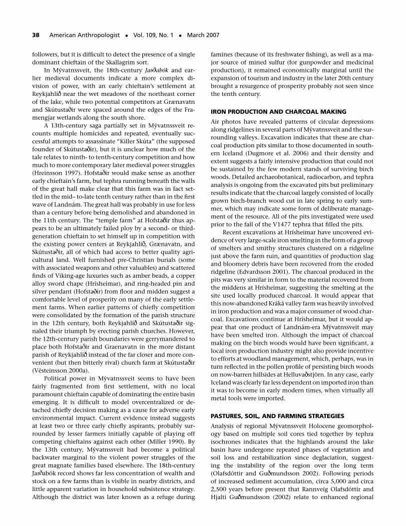
FIGURE 6. Changing relative proportions of domestic mammals from ninth to early 13th centuries for larger Myvatnssveit archaeofauna.Note the decline of pigs and cattle. In the same time period, “caprines” (both sheep and goats together) become nearly all sheep as goatsalso decline with time, and the farming strategy focuses increasingly on sheep and a limited number of cattle.
destruction of pastures and soil around the farm. In earlyIceland, as in so many areas today, human poverty and pow-erlessness are bad for pastures as well as people.
We now know that animal management strategy didnot remain static throughout the period of settlement.Archaeofauna from Hrısheimar, Sveigakot, Hofsta ir, andSelhagi clearly indicate that early settlers of Myvatnssveitdid indeed introduce the standard Landnam complex ofcattle, sheep, goats, horses, and pigs whose combined graz-ing, browsing, and rooting would certainly be effective indeforestation—and that, if unchecked, could lead to soilexposure and erosion. However, this initial mix of domes-ticates was altered during the tenth century, as goats be-came increasingly rare and pigs were progressively removedfrom the farmyard, eventually becoming extinct in Iceland(see Figure 6). As the early-13th-century archaeofauna fromSteinbogi indicates, there was also a shift away from cat-tle production toward the sheep-dominated pattern of the18th-century Jar abok farms (see Figure 7). Although theearly settlers certainly initially introduced a traditional mixof domestic stock familiar from their homelands, they wereby no means passive hyperconservative “prisoners of cul-ture” (Descola and Palsson 1996), incapable of altering their
farming strategy as they gained local experience and as localwoodlands (which made pig and goat keeping inexpensive)shrank.
Surviving law codes postdate the Landnam period bycenturies but contain a wealth of land-use and stocking leg-islation clearly shaped by practical experience and extensivecase-by-case litigation built up over years. Gragas (survivingin late-13th-century manuscripts; see Dennis et al. 1993)makes clear that pigs were by then viewed mainly as “prob-lem animals,” ones likely to generate disputes rather thaneconomic mainstays, and detailed land management pro-visions make equally clear that access and use of commonpasturage was by no means open or unregulated. As IanSimpson and colleagues note, “Regulatory mechanismswere in place to prevent overgrazing from at least the1200s AD, with sufficient biomass to support the num-bers of domestic livestock indicated from historic sources”(2001:176). Although some aspects of the surviving lawcodes penalize underuse of pasture vegetation, the overalleffect of the laws (if enforced) would be to closely regulategrazing pressure on common pool resource pastures.
Environmental simulation modeling predicting spatialand temporal patterns of vegetation biomass production
McGovern et al. • Landscapes of Settlement 41
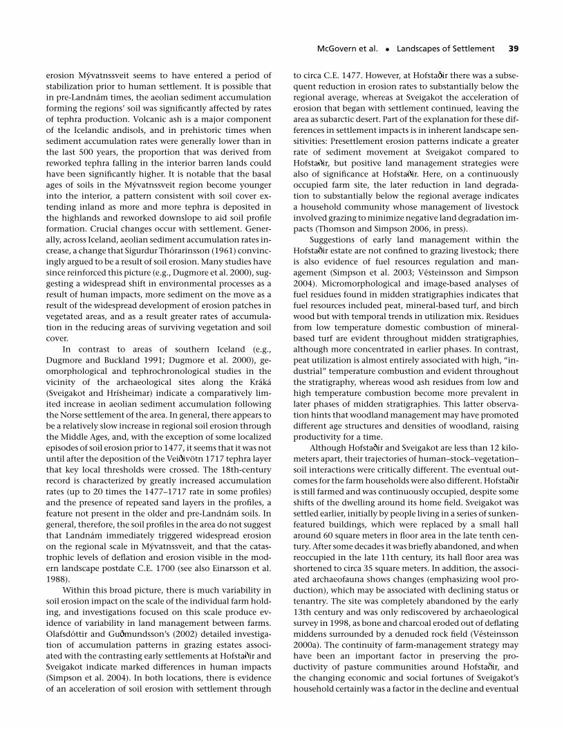
FIGURE 7. Changing ratios of caprine (sheep and goat) and cattle bones from larger archaeofauna spanning the ninth to 14th century inIceland. The earliest archaeofauna tend to have the highest ratio of cattle to caprine bones, but the pattern differs between regions. Higherstatus sites tend to have more cattle. The conversion to a largely sheep-based farming strategy appears to occur in the late 12th to early13th century.
and utilization (Bumodel; Thomson and Simpson 2006)has been used to compare landscapes of the Landnamand Jar abok periods (Simpson et al. 2001; Thomson andSimpson 2006, in press). Observations derived from this ap-proach suggest that there were spatial and temporal vari-ations in productivity within and between historic graz-ing areas and indicate that land degradation was not aninevitable consequence of the livestock introduced withsettlement. The model also clearly indicates that utiliz-able plant biomass productions in the winter and sum-mer grazing areas far exceeded potential grazing pressure,even when stock numbers were inflated beyond those in-dicated by archaeology or the Jar abok record. The crit-ical variable appears to be not total stock numbers, butthe timing of the annual removal of flocks in autumn.If animals are allowed to graze even a week beyond theend of grass growth, pasture degradation sets in, leadingeventually to breaching of the soil cover and rapid ero-sion. Correct assessment of the climatically driven on-set of winter in the highlands thus appears to have beenat least as important as management of total stockinglevels.
LONG-TERM SUSTAINABLE MANAGEMENT:WATERFOWL AND EGG COLLECTION
The Myvatn waterfowl nesting area is today a WorldHeritage site, protected by Icelandic law since 1974, butlocal residents are still permitted to continue their tradi-tional harvest of duck eggs. Duck-egg harvesting from thenesting grounds around Myvatn is first mentioned in the1712 Jar abok entry. The present rule to leave at least four–five eggs in the nest for the female to incubate is first men-tioned by a traveler in the area in 1862 (Shepherd 1867),but self-imposed restrictions to harvesting are mentionedsome 40 years earlier (Thienemann 1827). The four-to-fiveegg rule ensures a sustainable yield, as the ducks produceonly 0.3–2.8 young per female a year on the average andthe overall production of young is regulated by the avail-ability of food in the lake, mainly midges and their lar-vae and small crustaceans (Gardarsson and Einarsson 1997,2002, 2004). Today adult waterfowl are still not hunted, butthe lakeside farmers collect an average of 10,000 eggs eachspring. The zooarchaeological record for ninth- to 11th-century Myvatnssveit indicates that bird bones were a mi-nor element in the archaeofauna (see Figure 8), and what
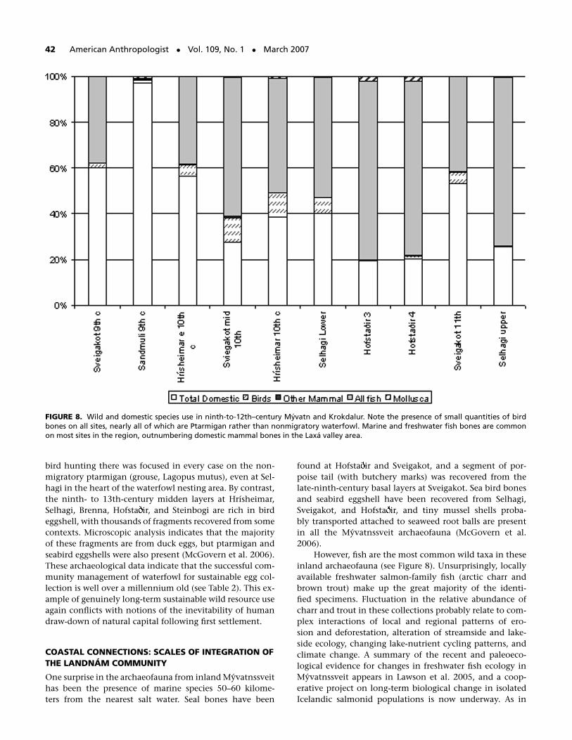
42 American Anthropologist • Vol. 109, No. 1 • March 2007
FIGURE 8. Wild and domestic species use in ninth-to-12th–century Myvatn and Krokdalur. Note the presence of small quantities of birdbones on all sites, nearly all of which are Ptarmigan rather than nonmigratory waterfowl. Marine and freshwater fish bones are commonon most sites in the region, outnumbering domestic mammal bones in the Laxa valley area.
bird hunting there was focused in every case on the non-migratory ptarmigan (grouse, Lagopus mutus), even at Sel-hagi in the heart of the waterfowl nesting area. By contrast,the ninth- to 13th-century midden layers at Hrısheimar,Selhagi, Brenna, Hofsta ir, and Steinbogi are rich in birdeggshell, with thousands of fragments recovered from somecontexts. Microscopic analysis indicates that the majorityof these fragments are from duck eggs, but ptarmigan andseabird eggshells were also present (McGovern et al. 2006).These archaeological data indicate that the successful com-munity management of waterfowl for sustainable egg col-lection is well over a millennium old (see Table 2). This ex-ample of genuinely long-term sustainable wild resource useagain conflicts with notions of the inevitability of humandraw-down of natural capital following first settlement.
COASTAL CONNECTIONS: SCALES OF INTEGRATION OFTHE LANDNAM COMMUNITY
One surprise in the archaeofauna from inland Myvatnssveithas been the presence of marine species 50–60 kilome-ters from the nearest salt water. Seal bones have been
found at Hofsta ir and Sveigakot, and a segment of por-poise tail (with butchery marks) was recovered from thelate-ninth-century basal layers at Sveigakot. Sea bird bonesand seabird eggshell have been recovered from Selhagi,Sveigakot, and Hofsta ir, and tiny mussel shells proba-bly transported attached to seaweed root balls are presentin all the Myvatnssveit archaeofauna (McGovern et al.2006).
However, fish are the most common wild taxa in theseinland archaeofauna (see Figure 8). Unsurprisingly, locallyavailable freshwater salmon-family fish (arctic charr andbrown trout) make up the great majority of the identi-fied specimens. Fluctuation in the relative abundance ofcharr and trout in these collections probably relate to com-plex interactions of local and regional patterns of ero-sion and deforestation, alteration of streamside and lake-side ecology, changing lake-nutrient cycling patterns, andclimate change. A summary of the recent and paleoeco-logical evidence for changes in freshwater fish ecology inMyvatnssveit appears in Lawson et al. 2005, and a coop-erative project on long-term biological change in isolatedIcelandic salmonid populations is now underway. As in
McGovern et al. • Landscapes of Settlement 43
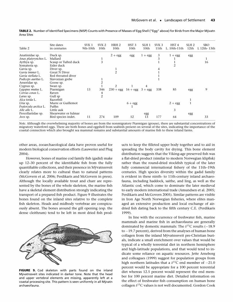
TABLE 2. Number of Identified Specimens (NISP) Counts with Presence of Masses of Egg Shell (“Egg” above) for Birds from the Major MyvatnArea Sites
Site dates SVK 1 SVK 2 HRH 2 HST 3 SLH 1 SVK 3 HST 4 SLH 2 SBOTable 2 in centuries 9th-10th 10th 10th 10th 10th 11th L. 10th-11th 12th L 12th- 13th
Anatinidae sp. Duck sp. 2 + egg egg 1 + egg 3 1 + egg eggAnas platyrynchos L. Mallard 1 3 1 1Aythya sp. Scaup or Tufted duck 3 1 1 16Somateria sp. Eider duck 2Gavia sp. Diver sp. 1 4Gavia immer L. Great N Diver 2 1Gavia stellata L. Red throated diver 1Podiceps auritus L. Slavonian grebe 1 1Anseridae sp. Goose sp. 2Cygnus sp. Swan sp. 1 2 1 4Lagopus mutus L. Ptarmigan 13 346 230 + egg 16 + egg 3 + egg 338 85 egg 9Corvus corax L. Raven 4Larus sp. Gull sp 2Alca torda L. Razorbill 1Uria sp. Murre or Guillemot 6 + egg 2 + egg 1Fratercula arctica L. Puffin 1Alle alle L. Little auk 3Procellariidae sp. Shearwater or fulmar egg eggAves sp. Bird species indet. 11 274 109 52 13 177 64 33
Note. Although the overwhelming majority of bones are from the nonmigratory Ptarmigan (grouse), there are substantial concentrations ofmigratory waterfowl eggs. There are both bones and eggshell from seabirds present on several of the sites, indicating the importance of thecoastal connection which also brought sea mammal remains and substantial amounts of marine fish to these inland farms.
other areas, zooarchaeological data have proven useful formodern biological conservation efforts (Lauwerier and Plug2004).
However, bones of marine cod family fish (gadid) makeup 12–30 percent of the identifiable fish from the fullyquantifiable collections, and their presence in Myvatnssveitclearly relates more to cultural than to natural patterns(McGovern et al. 2006; Perdikaris and McGovern in press).Although the locally available trout and charr are repre-sented by the bones of the whole skeleton, the marine fishhave a skeletal element distribution strongly indicating thetransport of a prepared fish product. Figure 9 illustrates thebones found on the inland sites relative to the completefish skeleton. Heads and midbody vertebrae are conspicu-ously absent. The bones around the gill opening (esp. thedense cleithrum) tend to be left in most dried fish prod-
FIGURE 9. Cod skeleton with parts found on the inlandMyvatnssveit sites indicated in darker tone. Note that the headand upper vertebral elements are missing, apparently left at acoastal processing site. This pattern is seen uniformly in all Myvatnarchaeofauna.
ucts to keep the filleted upper body together and to aid inspreading the body cavity for drying. This bone elementdistribution suggests that the Viking-age preserved fish wasa flat-dried product (similar to modern Norwegian klipfisk)rather than the round-dried stockfish typical of the laterfully commercial international fishery of the 11th–19thcenturies. High species diversity within the gadid familyis evident in these ninth- to 11th-century inland archaeo-fauna, including haddock, saithe, and ling, as well as theAtlantic cod, which come to dominate the later medievalto early modern international trade (Amundsen et al. 2005;Perdikaris and McGovern 2005). Similar patterns are visiblein Iron Age North Norwegian fisheries, where elites man-aged an extensive production and local exchange of air-dried fish dating back to the fifth century C.E. (Perdikaris1999).
In line with the occurrence of freshwater fish, marinemammals and marine fish in archaeofauna are generallydominated by domestic mammals: The δ13C results (−18.9to −19.7 percent), derived from the analyses of human bonecollagen from the inland Myvatnssveit pre-Christian buri-als, indicate a small enrichment over values that would betypical of a wholly terrestrial diet in northern hemisphereand high-latitude populations, and that would tend to in-dicate some reliance on aquatic resources. Jette Arneborgand colleagues (1999) suggest for population groups fromhigh northern latitudes that a δ13C end member of −21.0percent would be appropriate for a 100 percent terrestrialdiet whereas 12.5 percent would represent the end mem-ber for 100 percent marine diet. Detailed information onthe effect of freshwater fish consumption on human bonecollagen δ13C values is not well documented. Gordon Cook
44 American Anthropologist • Vol. 109, No. 1 • March 2007
and colleagues (2002) have demonstrated a similar rangeof δ13C values (−18.2 to −19.5 percent) for consumptionof significant freshwater resources at Schela Cladovei in theIron Gates Gorge of the River Danube during the Mesolithic.However, these small shifts in δ13C were accompanied bysignificantly greater shifts in δ15N (range = +13.2 to +15.3percent; cf. approximately +8 percent for a totally terres-trial diet). The Myvatnssveit δ15N values were lower in range(+7.7 to +10.0 percent); however, the shift would dependon the species consumed and its trophic level in the fresh-water food web.
Because of the mix of freshwater and marine aquaticresources at Myvatnssveit, it may not possible to adopt thestrategy of Arneborg et al. (1999) to determine the ma-rine 14C reservoir correction in individual humans, basedon the δ13C results. Furthermore, without evidence to thecontrary, we cannot rule out the possibility of a freshwaterreservoir effect (Cook et al. 2001). The age offset betweenthe humans and associated horse burials certainly indicatethat a reservoir effect does exist. More work is currently un-der way on the chronology and isotopic dietary reconstruc-tion of Icelandic pre-Christian burials, but at present thesedata appear to provide confirmation of the role of aquaticproducts in the diet of inland farmers during the settlementage.
Despite fully established farming and extensive use oflocal freshwater fish and well-managed egg collection, theeighth- to 11th-century settlers of Myvatnssveit felt theneed to regularly provision themselves with marine prod-ucts. This Viking-age inland distribution of marine prod-ucts (esp. dried fish) is best documented in Myvatnssveit,but marine fish and sea mammal bones have also been re-covered from early inland sites in eastern Iceland (A albol;McGovern n.d.), inland Eyjafjord (Granasta ir; Einarsson1994), and in western Iceland (Reykholt and Hals;McGovern 2004). The inland transfer of marine fish andother marine resources was definitely an established pat-tern in most parts of tenth-century Iceland. However, theacquisition of coastal resources was organized (chiefly sta-ple goods exchange, paired interhousehold transfers, laborservice), it appears that even in the earliest days of settle-ment neither the single farmstead nor even the local district(hreppur) was in fact the basic unit of economic survival. Weneed to consider the role and importance of trade and ex-change networks potentially connecting whole quarters ofIceland, and to take seriously the entrepreneurial role ofchieftains who were evidently not simply managers of theirown prosperous farms. New evidence of early specializedfishing settlements in northwest Iceland further suggest theexistence of an extensive distribution network that predatesthe historical international fisheries of the later Middle Ages(Amundsen et al. 2005; Edvardsson 2001, 2005; Edvardssonand McGovern 2005; Edvardsson et al. 2004; Krivogorskayaet al. 2005; McGovern et al. 2006). In light of these findings,the location of Hofsta ir at the juncture of the lake basinand the route along the Laxa valley to the sea may in itselfbe significant. Did an aspiring tenth-century chieftain lack-
ing high-quality pasture land attempt to control the flowof marine resources inland as well as playing the religioncard?
COMPLICATING CLIMATE INSTABILITY
Until recently, most paleoclimatic data sets had resolutionon the order of centuries or millennia, which led to simplis-tic or deterministic attempts to correlate climate and culture(Grove 1988; McGovern 1991). A major accomplishment ofmodern climatology has been the development of multipleclimatic proxy indicators whose resolution is on the “hu-man scale” of decades, years, or seasons (Jones and Mann2004; Meeker and Mayewski 2002). In the North Atlanticcontext, this most notably includes the Greenland Ice Sheetcores. The ice core data requires careful and informed inter-pretation, but it can be used to document proxy temper-atures on the seasonal scale, transforming the debate overclimate impact on the extinction of the Norse Greenlanders(Barlow et al. 1997; Buckland et al. 1996). The new high-resolution proxy indicators are not restricted to isotopictemperature reconstruction; they also provide geochemicalindicators of sea ice extent and storminess, which suggestthat the North Atlantic of the Viking Age was relatively calmand ice free compared to conditions after the 15th century(Dawson et al. 2003).
These multiple high-resolution indicators permit betterinvestigation of key questions as to which aspects of climatechange are potentially significant in terms of potential im-pacts on people. One view is that a year of extremely badweather (resulting in poor fodder crops or high neonatalfatalities in domesticated livestock) could create issues forsome (the poorest and most marginalized settlements), buta sequence of poor weather and repeated losses and pooryields is more likely to create significant problems for many,especially those in marginal environmental or cultural set-tings (e.g., Parry 1978). Simple economic response mod-els (Farmpact; see McGovern 1991; McGovern et al. 1988)developed for North Atlantic farming economies heavilydependent on stock herding and pasture productivity haveindicated that even very extreme events would have beenless systemically damaging than a closely spaced series ofless extreme, moderately poor growing seasons (Barlow et al.1997). Sequence and spacing of climate events thus prob-ably mattered more in terms of actual climate impact onNorth Atlantic medieval economies than did extreme coldspikes.
Perhaps an even more important factor in creating cli-matic economic impact could be predictability. Northernsocieties tend to be well buffered against a wide range ofclimate fluctuation, and demographic records for earlymodern Iceland reveal considerable resilience and successin containing human mortality, even in the face of com-bined cold weather and volcanic eruption (Vasey 1996). Ef-fective responses to bad seasons and even to strings of badseasons were certainly within the competence of the tra-ditional knowledge systems of the Viking Age Icelanders,
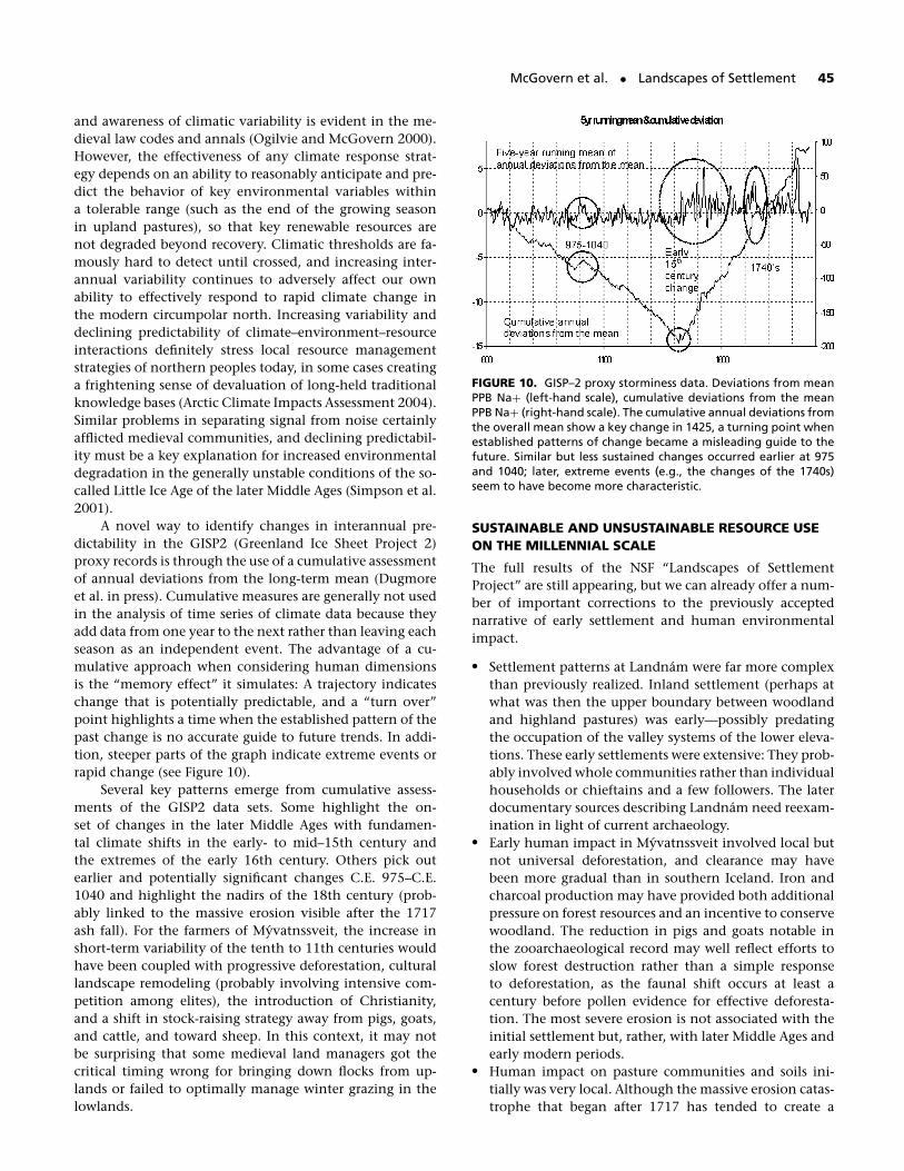
McGovern et al. • Landscapes of Settlement 45
and awareness of climatic variability is evident in the me-dieval law codes and annals (Ogilvie and McGovern 2000).However, the effectiveness of any climate response strat-egy depends on an ability to reasonably anticipate and pre-dict the behavior of key environmental variables withina tolerable range (such as the end of the growing seasonin upland pastures), so that key renewable resources arenot degraded beyond recovery. Climatic thresholds are fa-mously hard to detect until crossed, and increasing inter-annual variability continues to adversely affect our ownability to effectively respond to rapid climate change inthe modern circumpolar north. Increasing variability anddeclining predictability of climate–environment–resourceinteractions definitely stress local resource managementstrategies of northern peoples today, in some cases creatinga frightening sense of devaluation of long-held traditionalknowledge bases (Arctic Climate Impacts Assessment 2004).Similar problems in separating signal from noise certainlyafflicted medieval communities, and declining predictabil-ity must be a key explanation for increased environmentaldegradation in the generally unstable conditions of the so-called Little Ice Age of the later Middle Ages (Simpson et al.2001).
A novel way to identify changes in interannual pre-dictability in the GISP2 (Greenland Ice Sheet Project 2)proxy records is through the use of a cumulative assessmentof annual deviations from the long-term mean (Dugmoreet al. in press). Cumulative measures are generally not usedin the analysis of time series of climate data because theyadd data from one year to the next rather than leaving eachseason as an independent event. The advantage of a cu-mulative approach when considering human dimensionsis the “memory effect” it simulates: A trajectory indicateschange that is potentially predictable, and a “turn over”point highlights a time when the established pattern of thepast change is no accurate guide to future trends. In addi-tion, steeper parts of the graph indicate extreme events orrapid change (see Figure 10).
Several key patterns emerge from cumulative assess-ments of the GISP2 data sets. Some highlight the on-set of changes in the later Middle Ages with fundamen-tal climate shifts in the early- to mid–15th century andthe extremes of the early 16th century. Others pick outearlier and potentially significant changes C.E. 975–C.E.1040 and highlight the nadirs of the 18th century (prob-ably linked to the massive erosion visible after the 1717ash fall). For the farmers of Myvatnssveit, the increase inshort-term variability of the tenth to 11th centuries wouldhave been coupled with progressive deforestation, culturallandscape remodeling (probably involving intensive com-petition among elites), the introduction of Christianity,and a shift in stock-raising strategy away from pigs, goats,and cattle, and toward sheep. In this context, it may notbe surprising that some medieval land managers got thecritical timing wrong for bringing down flocks from up-lands or failed to optimally manage winter grazing in thelowlands.
FIGURE 10. GISP–2 proxy storminess data. Deviations from meanPPB Na+ (left-hand scale), cumulative deviations from the meanPPB Na+ (right-hand scale). The cumulative annual deviations fromthe overall mean show a key change in 1425, a turning point whenestablished patterns of change became a misleading guide to thefuture. Similar but less sustained changes occurred earlier at 975and 1040; later, extreme events (e.g., the changes of the 1740s)seem to have become more characteristic.
SUSTAINABLE AND UNSUSTAINABLE RESOURCE USEON THE MILLENNIAL SCALE
The full results of the NSF “Landscapes of SettlementProject” are still appearing, but we can already offer a num-ber of important corrections to the previously acceptednarrative of early settlement and human environmentalimpact.
� Settlement patterns at Landnam were far more complexthan previously realized. Inland settlement (perhaps atwhat was then the upper boundary between woodlandand highland pastures) was early—possibly predatingthe occupation of the valley systems of the lower eleva-tions. These early settlements were extensive: They prob-ably involved whole communities rather than individualhouseholds or chieftains and a few followers. The laterdocumentary sources describing Landnam need reexam-ination in light of current archaeology.
� Early human impact in Myvatnssveit involved local butnot universal deforestation, and clearance may havebeen more gradual than in southern Iceland. Iron andcharcoal production may have provided both additionalpressure on forest resources and an incentive to conservewoodland. The reduction in pigs and goats notable inthe zooarchaeological record may well reflect efforts toslow forest destruction rather than a simple responseto deforestation, as the faunal shift occurs at least acentury before pollen evidence for effective deforesta-tion. The most severe erosion is not associated with theinitial settlement but, rather, with later Middle Ages andearly modern periods.
� Human impact on pasture communities and soils ini-tially was very local. Although the massive erosion catas-trophe that began after 1717 has tended to create a
46 American Anthropologist • Vol. 109, No. 1 • March 2007
homogenized, deflated, gravel-field landscape in theworst impacted areas around the lake basin, site focusedintensive soil science investigations backed by impactmodeling reveal considerable differences between earlymanagement strategies and resulting human impacts inthe different farm catchments. It is possible to recon-struct household-level land management practices whileintegrating these findings with regional-scale indicators.
� Political competition in the first two centuries of set-tlement was complex, and appears to have involved arange of strategies including the control of pasture re-sources, the manipulation of regional staple goods ex-change, iron and charcoal production, and investmentin pre-Christian ritual and feasting. Following the adop-tion of Christianity, the clearance of the valley forestsfor settlement, and the depletion of at least some of thewoodlands of the upper elevations, the economic andritual landscape changed, affecting the political ecologyof power and probably permanently relegating uplandcommunities like Myvatnssveit to political and eco-nomic marginality. The collapse of the attempted “faith-based” chieftainship at Hofsta ir probably reflected fac-tors beyond the devaluation of an investment in a templefarm by change in cult, including changing patterns oftrade and new routes to the sea that bypassed Hofsta ir.
� Although information management maladies associatedwith colonization of deceptively familiar North Atlanticecosystems certainly provided unwelcome surprises toearly Icelandic settlers, the main cognitive challengesseem to have been associated with changes in cli-matic stability and predictability after the first centuryof Landnam. Patterns of land use, traditional herdingknowledge, and the critical timing for the end of up-land grazing would all be impacted by changes in whathad become a well-understood set of environmental pa-rameters. “Tragedy of the commons” is an unlikely ex-planation for the eventual failure of herding systems toprevent large-scale erosion. Inability to cope with radicalincreases in environmental variability is far more likelyto be the ultimate cause of eventual catastrophic soil loss.
� Not everything went wrong. The Myvatn record indi-cates significant human response to changing environ-ment, much probably aimed at resource management aswell as chiefly aggrandizement. The eventual failure toconserve soils and pasturelands over much of the regioncan be balanced against the impressive record of success-ful sustainable management of the migratory bird popu-lation of Myvatn. Some remedies were probably appliedtoo little and too late, others may have been frustratedby rapid and unpredictable climate change or by simpleinability to predict volcanic eruptions or external politi-cal changes. However, the pastures are still green aroundHofsta ir, and the waterfowl still come in their thousandseach spring to the lake shore. These features of the land-scape of Myvatnssveit are as much a result of a thousandyears of human environmental management as are theeroded hills beyond the lake.
HISTORICAL ECOLOGY AND MODERN GLOBALCHANGE
Anthropologists instinctively find attractive the notion thatsmall-scale, traditional societies are good stewards of landand resources. However, “sustainability” of resource useneeds to be assessed on the long-time scale of centuriesand millennia if we are to avoid simply confusing “serialunsustainability” (Kohler 2004) or cycles of “rape, ruin,and starve” (McGovern 1985) with the near-homeostasisenvisaged by modern resource planning. Although thereare clearly huge social and technological gaps between Ice-landic Viking Age farmers and modern resource mangersof global change impacts, some lessons of potentially wideapplication may be drawn from the Myvatn research:
� Long-term sustainability is possible. Millennial-scalesustainable use of waterfowl and their eggs can be docu-mented at Myvatn. This pattern seems to extend to firstsettlement and certainly provides a demonstration thatsmall-scale, nonstate societies can organize and enforcegenuinely sustainable resource use over a thousand yearsdespite climate fluctuation and severe economic hard-ship. The long-term record thus contains messages ofhope for the future as well as warnings.
� Continuity and security count. It is probably no ac-cident that the heavily eroded site of Sveigakot under-went cycles of abandonment and reoccupation at pro-gressively lower-status levels, whereas the still-occupiedsite of Hofsta ir is still richly vegetated. The geoarchae-ological evidence for successful long-term soil manage-ment at Hofsta ir certainly reflects in part the continuityof occupation by an upper-middle ranking household.Impoverished farmers with insecure land tenure manageresources differently from secure landowners expectingto pass on inheritance to kin.
� Predictability is critical. Successful local-level rangemanagement systems that have achieved broadly sus-tainable patterns of resource consumption for centuriesmay well be overwhelmed by the simultaneous rapidincreases in rate of change coupled with simultaneousdecrease in interseasonal predictability. This finding hasmajor implications for modern attempts to sustainablymanage agricultural systems in the face of rapid and in-creasingly unpredictable climate change. Planning foruncertainty is difficult, but this seems a critical needfor modern resource managers. Spending more resourceson updating older baselines and learning more aboutpast variability is indicated; complacency about “knownranges” of environmental change is not. Sustainable fu-tures are not built on ignorance.
SCIENCE MANAGEMENT LESSONS LEARNED
The experience of committing a decade of international,interdisciplinary effort to Myvatnssveit has provided somehumbling lessons. Some of the most difficult issues limitingeffective interdisciplinary cooperation (esp. between social
McGovern et al. • Landscapes of Settlement 47
and natural scientists) are the manifold problems of scalematching. Had the investigations been limited to a typi-cal archaeological project of two or three seasons of inten-sive excavation on a single site combined with a catchmentsurvey, we would have totally misunderstood the larger re-gional pattern and would have lacked the comparison ofnearby sites that provide some basis for sorting out vari-ability caused by time, place, environmental change, andchance. If a broad-brush regional scale approach had beenapplied, based on site survey backed by a few soil profiles orpollen cores, we would have also come to a largely false ap-preciation of the actual dynamics of human–environmentalinteractions in the study area. The marvelous isochronesprovided by the well-studied Icelandic tephra have been in-valuable, but the single greatest asset to effective integrationhas been prolonged field work involving sustained focus ona common set of problems within a common research area.
Persistence may matter more than project size: Small,well-integrated teams collecting data for multiple summers(and arguing over analytical patterns each winter) in thiscase accomplished more effective integration than a sin-gle, huge, multi-investigator project limited to a few sea-sons (the first of which tends to be inevitably spent in lo-gistic and coordination struggles). But however achieved,the size of the different disciplinary data sets does mattergreatly; multiple site collections, large ecofact counts, andhundreds of soil profiles all provide the solid basis for cross-disciplinary discussion and integration that is nearly impos-sible to achieve from a pastiche of small-scale, short-terminvestigations. If we are to successfully contribute to the ar-chaeology of global change, we need to develop structuresof funding and research support that will promote similarsustained, long-term cooperative investigations with a clearlandscape focus.
THOMAS H. MCGOVERN Department of Anthropology andNorthern Science and Education Center, Hunter College ofthe CUNY, New York, NY 10021ORRI VESTEINSSON Department of History, University ofIceland, Reykjavık 101 IcelandADOLF FRI-DRIKSSON Institute of Archaeology, Barugata 2,Reykjavik, 101, IcelandMIKE CHURCH Institute of Geography, University ofEdinburgh, ED2 6OH Scotland UKIAN LAWSON School of Geography, University of Leeds, LD67QC England, UKIAN A. SIMPSON School of Biological and Environmental Sci-ences, University of Stirling, ST1 8RW Scotland, UKARNI EINARSSON Myvatn Research Station, Skutusta ir, 404IcelandANDY DUGMORE Institute of Geography, University of Edin-burgh, ED2 6OH Scotland UKGORDON COOK Scottish Universities Environmental Re-search Centre, East Kilbride, EK5 6UO Scotland UKSOPHIA PERDIKARIS Department of Archaeology and Anthro-pology Brooklyn College of the CUNY and Northern Science
and Education Center, 2900 Bedford Avenue, Brooklyn NewYork 11210KEVIN J. EDWARDS Department of Geography and Environ-ment, University of Aberdeen, AB4 5ID Scotland UKAMANDA M. THOMSON School of Biological and Environ-mental Sciences, University of Stirling, ST1 8RW Scotland,UKW. PAUL ADDERLEY School of Biological and EnvironmentalSciences, University of Stirling, ST1 8RW Scotland, UKANTHONY NEWTON Institute of Geography, University of Ed-inburgh, ED2 6OH Scotland UKGAVIN LUCAS Institute of Archaeology, Barugata 2,Reykjavik, 101, Iceland, and Department of History, Uni-versity of Iceland 101, Reykjavik, IcelandRAGNAR EDVARDSSON Department of Anthropology andNorthern Science and Education Center, Hunter College ofthe CUNY, New York, NY 10021OSCAR ALDRED Institute of Archaeology, Barugata 2,Reykjavik, 101, IcelandELAINE DUNBAR Scottish Universities Environmental Re-search Centre, East Kilbride, EK5 6UO Scotland UK
NOTEAcknowledgments. We would like to thank the people ofMyvatnssveit and Husavık who have so kindly welcomed us andwho have so ably assisted the many seasons of investigation re-ported here. Warm thanks are also owed to the international fieldcrews (drawn from 26 nations in total), whose hard work and resis-tance to black flies made the fieldwork possible. The students of thespecial NSF Office of Polar Programs Research Experience for Under-graduates program run by Sophia Perdikaris from Brooklyn Collegedeserve special recognition for their hard work in both the field andlaboratory, and for their wonderful ability to adapt from inner-cityto subarctic conditions. We would also like to thank the staff ofthe SUERC Accelerator Mass Spectrometry Facility in East Kilbride,Scotland, for the many radiocarbon measurements. Funding sup-port has been generously provided by U.S., U.K., and Scandinaviansources: Vısindasjo ur, Rannsoknasjo ur RANNlS, NOS–H, the Lev-erhulme Trust (Landscapes circum Landnam project), the CarnegieTrust for the Universities of Scotland, the National Geographic So-ciety, the American–Scandinavian Foundation, Professional StaffCongress–CUNY grants program, the CUNY Northern Science andEducation Center, and the NSF (Archaeology program and ArcticSocial Sciences program). This article is a product of NABO. Wewould like to also thank the AA reviewers whose comments greatlyimproved this article.
REFERENCES CITEDAhronson, Kristjan
2000 Further Evidence for a Columban Iceland: PreliminaryResults of Recent Work. Norwegian Archaeological Review33:117–124.
Amorosi, Thomas, Paul C. Buckland, Andrew J. Dugmore, JonHaukur Ingimundarson, and Thomas H. McGovern
1997 Raiding the Landscape: Human Impact in the NorthAtlantic. Human Ecology 25:491–518.
Amorosi, Thomas, Paul C. Buckland, Kevin J. Edwards, Ingrid L.Mainland, Thomas H. McGovern, Jon P. Sadler, and PeterSkidmore
1998 They Did Not Live by Grass Alone: The Politics andPalaeoecology of Animal Fodder in the North Atlantic Region.Environmental Archaeology 1:41–54.
Amorosi, Thomas, James Woollett, Sophia Perdikaris, and ThomasH. McGovern
1996 Regional Zooarchaeology and Global Change: Problemsand Potentials. World Archaeology 28:126–157.
48 American Anthropologist • Vol. 109, No. 1 • March 2007
Amundsen, Colin, Sophia Perdikaris, Thomas H. McGovern,Yekaterina Krivogorskaya, Matthew Brown, Konrad Smi-arowski, Shaye Storm, Salena Modugno, Malgorzata Frik, andMonica Koczela
2005 Fishing Booths and Fishing Strategies in Medieval Iceland:An Archaeofauna from the of Akurvık, North-West Iceland. En-vironmental Archaeology 10(1):127–142.
Arctic Climate Impacts Assessment2004 Arctic Climate Impacts Assessment Report. Uni-
versity of Alaska–Fairbanks. Electronic document,http://www.acia.uaf.edu, accessed September 29, 2006.
Arnalds, Olafur1990 Characterization and Erosion of Andisols in Iceland. Ph.D.
dissertation, Department of Geography, Texas A&M University.Arnalds, Olafur, Elin F. Thorarinsdottir, Sigmar Metusalemsson, As-
geir Jonsson, Einar Gretarsson, and Arnor Arnason1997 Soil Erosion in Iceland. Reykjavik: Icelandic SCS and the
Agricultural Research Institute.Arneborg, Jette
2000 Introduction: From Vikings to Norsemen. In Vikings: TheNorth Atlantic Saga. William W. Fitzhugh and Elisabeth I.Ward, eds. Pp. 281–284. Washington, DC: Smithsonian Insti-tution Press.
Arneborg, Jette, and Bjarne Grønnow, eds.2005 Dynamics of Northern Societies: Proceedings of the
SILA/NABO Conference on Arctic and North Atlantic Archae-ology, Copenhagen, May 10–14, 2004, vol. 10. Copenhagen:Publications from the National Museum Studies in Archaeol-ogy and History.
Arneborg, Jette, Jan Heinemeier, Niels Lynnerup, Henrik L. Nielsen,Niels Rud, and Arny E. Sveinbjornsdottir
1999 Change of Diet of the Greenland Vikings Determined fromStable Carbon Isotope Analysis and 14C Dating of Their Bones.Radiocarbon 41:157–168.
Ascough, Phillipa L., G. T. Cook, M. J. Church, A. J. Dugmore, S. V.Arge, and T. H. McGovern
2006 Variability in North Atlantic Marine Radiocarbon Reser-voir Effects at c. A.D. 1000. The Holocene 16(1):131–136.
Balee, William H., ed.1998 Advances in Historical Ecology. New York: Columbia Uni-
versity Press.Barlow, Lisa K., Jon P. Sadler, Astrid E. J. Ogilvie, Paul C. Buckland,
Thomas Amorosi, Jon Haukur Ingimundarson, Peter Skidmore,Andrew J. Dugmore, and Thomas H. McGovern
1997 Interdisciplinary Investigations of the End of the NorseWestern Settlement in Greenland. The Holocene 7:489–499.
Bawden, Garth, and Richard M. Reycraft, eds.2001 Environmental Disaster and the Archaeology of Human
Response. Maxwell Museum of Anthropology, AnthropologyPapers, 7. Albuquerque: University of New Mexico Press.
Benediktsson, Jakob, ed.1968 Islenzk fornrit I. Islendingabok. Landnamabok, Hi
ıslenzka fornritafelag, Reykjavık. (Icelandic texts, book of theIcelanders and book of the settlements). Reykjavik: IcelandicHistory Publication Association.
Bigelow, Gerald F., ed.1991 The Norse of the North Atlantic. Special volume, Acta Ar-
chaeologica 61.Brady, Neil C., and Robert R. Weil
1999 The Nature and Properties of Soils. Princeton: PrenticeHall.
Bruun, Daniel, and Finnur Jonsson1909 Om hove og hovudgravninger paa Island (On temples and
temple excavation in Iceland). Aarbøger for nordisk oldkyn-dighed og historie (Yearbook for nordic antiquarianism andhistory):245–316.
1910 Undersøgelser og Udgravninger paa Island 1907–09(Research and excavation in Iceland 1907–09). GeografiskTidsskrift (Geographical journal) 20:302–315.
1911 Finds and Excavations of Heathen Temples in Iceland. SagaBook of the Viking Society 7:25–37.
Buckland, Paul C.2000 The North Atlantic Environment. In Vikings: The North
Atlantic Saga. William W. Fitzhugh and Elisabeth I. Ward,
eds. Pp. 164–153. Washington, DC: Smithsonian InstitutionPress.
Buckland, Paul C., T. Amorosi, L. K. Barlow, A. J. Dugmore, P. A.Mayewski, T. H. McGovern, A. E. J. Ogilvie, J. P. Sadler, and P.Skidmore
1996 Bioarchaeological and Climatological Evidence for theFate of the Norse Farmers in Medieval Greenland. Antiquity70(1):88–96.
Buckland, Paul C., Andrew J. Dugmore, David W. Perry, DianaSavory, and Gu run Sveinbjarnardottir
1991a Holt in Eyjafjallasveit, Iceland: A Palaeoecological Studyof the Impact of Landnam. Acta Archaeologica 61:252–271.
Buckland, Paul C., Andrew J. Dugmore, and Jon P. Sadler1991b Faunal Change or Taphonomic Problem? A Comparison
of Modern and Fossil Insect Faunas from South-East Iceland. InEnvironmental Change in Iceland Past and Present. Judith K.Maizels and Chris Caseldine, eds. Pp 127–146. Dordrecht, theNetherlands: Kluwer.
Byock, Jesse2001 Medieval Iceland: Society, Sagas, and Power. Berkeley: Uni-
versity of California Press.Caseldine, Christopher, Mark Dinnin, Dawn Hendon, and Pete
Langdon2004 The Holocene Development of the Icelandic Biota and Its
Paleoclimatic Significance. In Atlantic Connections and Adap-tations. Rupert Housely and Geraint Coles, eds. Pp. 28–48.Oxford: Oxbow Books.
Cook, Gordon T., Clive Bonsall, Robert E. M. Hedges, KathleenMcSweeney, Vasile Boroneant, Laszlo Bartosiewicz, and PaulB. Pettitt
2002 Problems of Dating Human Bones from the Iron Gates.Antiquity 76(1):77–85.
Cook, Gordon T., Clive Bonsall, Richard E. M. Hedges, KathleenMcSweeney, Vasile Boroneant, and Paul B. Pettitt
2001 A Freshwater Diet-Derived Reservoir Effect at the Stone AgeSites in the Iron Gates gorge. Radiocarbon 43:453–460.
Cronon, W.1991 Nature’s Metropolis: Chicago and the Great West. New
York: W. W. Norton.Crumley, L. Carole
1994 Historical Ecology: A Multidimensional Ecological Orien-tation. In Historical Ecology: Cultural Knowledge and Chang-ing Landscapes. Carole Crumley, ed. Pp. 1–16. Santa Fe: Schoolof American Research.
1998 Foreword. In Advances in Historical Ecology. WilliamH. Balee, ed. Pp. ix–xiv. New York: Columbia UniversityPress.
2001 New Directions in Anthropology and Environment: Inter-sections. Carole L. Crumley, ed. Pp. 12–22. Walnut Creek, CA:AltaMira Press.
Dawson, Alistair G., Lorne Elliott, Paul Mayewski, Peter Lockett,Sean Noone, Kieran Hickey, Tom Holt, Peter Wadhams, andIan Foster
2003 Late Holocene North Atlantic Climate “Seesaws,” Stormi-ness Changes and Greenland Ice Sheet (GISP2) Palaeoclimates.The Holocene 13:381–392.
Dennis, Andrew, Peter Foote, and Richard Perkins, trans.1993 Laws of Early Iceland, Gragas: The Codex Regius of Gragas
with Material from other Manuscripts, 2 vols. Winnipeg: Uni-versity of Manitoba Press.
Descola, Philippe, and Gısli Palsson, eds.1996 Nature and Society: Anthropological Perspectives. New
York: Routledge.Diamond, Jared
2005 Collapse: How Societies Choose to Fail or Succeed. NewYork: Viking.
Dugmore, Andrew J., and Paul C. Buckland1991 Tephrochronology and Late Holocene Soil Erosion in
South Iceland. In Environmental Change in Iceland Past andPresent. Judith K. Maizels and Christopher Caseldine, eds. Pp147–161. Dordrecht, the Netherlands: Kluwer.
Dugmore, Andrew J., Paul C. Buckland, Mike J. Church, AlisdairDawson, Kevin J. Edwards, Paul Mayewski, Thomas H.McGovern, Kerry-Anne Mairs, Ian A. Simpson, and Gu runSveinbjarnardottir
McGovern et al. • Landscapes of Settlement 49
In press Landscape and Settlement Change in the North AtlanticIslands and the Use of High-Resolution Proxy Climate Recordsfrom the Greenland Ice Sheet. Human Ecology.
Dugmore, Andrew J., Mike J. Church, Paul C. Buckland, KevinJ. Edwards, Ian T. Lawson, Thomas H. McGovern, Eva Pana-giotakopulu, Ian A. Simpson, Peter Skidmore, and Gu runSveinbjarnardottir
2005 The Norse Landnam on the North Atlantic Islands: An En-vironmental Impact Assessment. Polar Record 41:21–37.
Dugmore, Andrew J., Mike J. Church, Kerry-Anne Mairs, AnthonyJ. Newton, and Gu run Sveinbjarnardottir
2006 An Over-Optimistic Pioneer Fringe? Environmental Per-spectives on Medieval Settlement Abandonment in orsmork,South Iceland. In Dynamics of Northern Societies: Proceed-ings of the SILA/NABO Conference on Arctic and NorthAtlantic Archaeology, Copenhagen, May 10–14, 2004, vol.10. Jette Arneborg and Bjarne Grønnow, eds. Pp. 335–347.Copenhagen: Publications from the National Museum Studiesin Archaeology and History.
Dugmore, Andrew J., and Camilla C. Erskine1994 Local and Regional Patterns of Soil Erosion in Southern
Iceland. Munchener Geographische Abhandlungen 12:63–79.Dugmore, Andrew J., Gu run Larsen, and Anthony J. Newton
2004 Tephrochronology and Its Application to Late QuaternaryEnvironmental Reconstruction, with Special Reference to theNorth Atlantic Islands. In Tools for Constructing Chronolo-gies. Caitlin E. Buck and Andrew R. Millard, eds. Pp. 173–188.London: Springer-Verlag.
Dugmore, Andrew J., Anthony J. Newton, Gu run Larsen, andGordon T. Cook
2000 Tephrochronology, Environmental Change and the NorseColonisation of Iceland. Environmental Archaeology 5:21–34.
Durrenberger, Paul1989 Anthropological Perspective on the Commonwealth Pe-
riod. In The Anthropology of Iceland. E. Paul Durrenbergerand G. Palsson, eds. Pp. 228–246. Iowa City: University of IowaPress.
1992 The Dynamics of Medieval Iceland: Political Economy andLiterature. Iowa City: University of Iowa Press.
Edvardsson, Ragnar2001 Statistical Analysis of the 1703–1712 Land Register: Four
Districts in the North West of Iceland. Paper presented at theProceedings of the 21st Conference of Nordic Archaeologists,Akureyri Iceland, Reykjavık, September 6–9.
2005 Commercial and Subsistence Fishing in Vestfir ir: A Studyin the Role of Fishing in Medieval Icelandic Economy. Archae-ologica Islandica 4:121–144.
Edvardsson, Ragnar, and T. H. McGovern2004 Hrısheimar 2003. Interim Report FS 223–0322. Forn-
leifastofnun Islands, Reykjavik: Archaeological Institute Ice-land Report, Reykjavik.
2005 Archaeological Excavations at Vatnsfjor ur, 2003–04. Ar-chaeologica Islandica 4:145–163.
Edvardsson, Ragnar, Sophia Perdikaris, T. H. McGovern, N. Zagor,and M. Waxman
2004 Coping with Hard Times in North-West Iceland: Zooar-chaeology, History, and Landscape Archaeology at Finnbo-gastaoir in the 18th Century. Archaeologica Islandica 3:20–48.
Eggertsson, Thrainn1998 Sources of Risk, Institutions for Survival, and a Game
against Nature in Pre-Modern Iceland. Explorations in Eco-nomic History 35:1–30.
Einarsson, Arni, Hafli i Hafli ason, and Hlynur Oskarsson1988 Myvatn: Palaeolimnology and Tephrochronology of the
South Basin. Myvatn Research Station Report, 4. Reykjavik: Na-ture Conservation Council.
Einarsson, Bjarni F.1994 The Settlement of Iceland: A Critical Approach: Granas-
tadir and the Ecological Heritage. Series B Gothenburg Archae-ological Theses, 4. Gothenberg, Sweden: Gothenberg Univer-sity Press.
Eldjarn, Kristjan, and Adolf Fri riksson, eds.2000 Kuml og haugfe (Graves and grave finds). 2nd edition. Pp.
1–50. Reykjavık: Archaeological Institute Iceland.
Feeny, Daniel, and Fekret Berkes1990 The Tragedy of the Commons: Twenty Two Years Later.
Human Ecology 18(1):1–19.Fri riksson, Adolf
1993 Fornleifarannsoknir a Hofsto um ı Myvatnssveit 1991–1992 (Archaeological Research at Hofsta ir in Myvatn District1991–1992). Reykjavık: Archaeological Institute Iceland.
1994 Sagas and Popular Antiquarianism in Icelandic Archaeol-ogy. Aldershot, Avesbury: Samson Publishers.
2000 Viking Burial Practices in Iceland. In Kuml og haugfe(Graves and grave finds). 2nd edition. Kristjan Eldjarn andAdolf Fri riksson, eds. Pp. 549–610. Reykjavık: ArchaeologicalInstitute Iceland.
2004a Haugar og hei ni: Minjar un ıslenskt jarnaldarsamfelag(Temples and sacred places in the Icelandic Iron age). In Hlu-tavelta tımans (Past times). Pp. 56–63. Reykjavık: Bokasafn.
2004b The Topography of Iron-Age Burials in Iceland. In Cur-rent Issues in Nordic Archaeology: The Proceedings of the21st Conference of Nordic Archaeologists, 6–9 September 2001,Akureyri, Iceland. Gar ar Gu omundsson, ed. Pp. 15–16. Reyk-javık: Archaeological Institute Iceland.
Fri riksson, Adolf, ed.2003 Creating a Past: A Historiography of the Settlement of Ice-
land. In Contact, Continuity and Collapse: The Norse Col-onization of the North Atlantic. J. Barrett, ed. Pp 139–161.Turnhout, Belgium: Oxbow Books.
2004c Kuml og samfelag: Framvinduskyrsla 2003 (Graves andassociated finds: An overview 2003). Reykjavık: ArchaeologicalInstitute Iceland.
Fri riksson, Adolf, Hildur Gestsdottir, Thomas H. McGovern, andColleen A. Batey
2005a Kuml ı Saltvık ı Reykjahverfi, S- ingeyjarsyslu, (Gravefinds at Saltvık in the Reykja-locality, southern thingeyar dis-trict). Reykjavık: Archaeological Institute Iceland
Fri riksson, Adolf, Hildur Gestsdottir, Thomas H. McGovern,Colleen A. Batey, and Aaron Kendall
2005b Kuml a Da oasta aleiti, hja Lyngbrekku ı Reykjadal(Grave finds at Dadastadir near Lyngbrekka in Reykjadal). Reyk-javık: Archaeological Institute Iceland.
Fri riksson, Adolf, Hildur Gestsdottir, Thomas H. McGovern, JimWoollett, Colleen A. Batey, and Aaron Kendall
2005c Kumlin hja Litlu-Nupum ı A aldal. Fornleifarannsokn2004 (Graves near Litla Nupur in Adaldal. Archaeolog-ical research 2004). Reykjavık: Archaeological InstituteIceland.
Fri riksson, Adolf, and Thomas H. McGovern2005 Hrısheimahundurinn (The dog of Hrısheimar). Reykjavık:
Archaeological Institute Iceland.Gardarsson, Arnthor, and A. Einarsson
1997 Numbers and Production of Eurasian Wigeon in Relationto Conditions in a Breeding area, Lake Myvatn, Iceland. Journalof Animal Ecology 66:439–451.
2002 The Food Relations of the Waterbirds of Lake Myvatn, Ice-land. International Journal of Liminology 28:1–10.
2004 Resource Limitation of Ducks at Myvatn: Food Limits Pro-duction. Aquatic Ecology 38:285–295.
Gronvold, Karl, Nıels Oskarsson, Sigfus J. Johnsen, HenrikClausen, Claus U. Hammer, Gerard Bond, and EdouardBard
1995 Ash Layers from Iceland in the Greenland GRIP Ice CoreCorrelated with Oceanic and Ash Sediments. Earth and Plane-tary Science Letters 135:149–155.
Grove, Jean M.1988 The Little Ice Age. London: Methuen.
Hallsdottir, Margret1987 Pollen Analytical Studies of Human Influence on Vegeta-
tion in Relation to the Landnam Tephra Layer in SouthwestIceland. Lundqua Thesis 18, Department of Quaternary Geol-ogy, Lund University.
Hardesty, Donald L., and Don D. Fowler2001 Archaeology and Environmental Changes. In New Di-
rections in Anthropology and Environment. Carole L.Crumley, ed. Pp. 72–89. Walnut Creek, CA: AltaMiraPress.
50 American Anthropologist • Vol. 109, No. 1 • March 2007
Hastrup, K.1985 Culture and History in Medieval Iceland: An Anthropo-
logical Analysis of Structure and Change. Oxford: ClarendonPress.
1990 Island of Anthropology: Studies in Past and Present Ice-land. Odense: Odense University Press.
Housley, Rupert, and Geraint M. Coles, eds.2004 Atlantic Connections and Adaptations: Economies, En-
vironments and Subsistence in Lands Bordering the NorthAtlantic. Oxford: Oxbow.
Hreinsson, Sigurdur, ed.1997 The Complete Sagas of Icelanders: Including 49 Tales, vol.
1. Reykjavik: Arnemagnean Manuscript Institute.Ingimundarson, J. H., and A. E. J. Ogilvie
1998 Climatic Change, Socio-Economic Transformation, andEcological Succession, in the Late Twelfth to Fourteenth Cen-tury in Iceland. Paper presented at the 28th Arctic Workshop,Arctic and Alpine Environments, Past and Present Programwith Abstracts INSTAAR, Boulder, Colorado, March 12–14.
Jar abok Arna Magnussonar1990 Jar abok Arna Magnussonar og Pals Vidalın 1–11.
Copenhagen (1913–43):12–13.Jones, Gwyn
1986 The Norse Atlantic Saga: Being the Norse Voyages ofDiscovery and Settlement to Iceland, Greenland, and NorthAmerica. Oxford: Oxford University Press.
Jones, P. D., and M. E. Mann2004 Climate over the Millennia. Reviews of Geophysics
42:1120–1131.Kirch, Patrick V.
1997 Introduction: The Environmental History of Oceanic Is-lands. In Historical Ecology in the Pacific Islands: PrehistoricEnvironmental and Landscape Change. Patrick V. Kirch andTerry L. Hunt, eds. Pp. 1–22. New Haven, CT: Yale UniversityPress.
Kirch, Patrick V., and Terry L. Hunt, eds.1997 Historical Ecology in the Pacific Islands: Prehistoric Envi-
ronment and Landscape Change. New Haven, CT: Yale Univer-sity Press.
Kohler, Timothy A.2004 Pre-Hispanic Human Impact on Upland North American
Southwestern Environments: Evolutionary Ecological Perspec-tives. In The Archaeology of Global Change: The Impact of Hu-mans on Their Environment. Charles Redmand, Steven James,Paul Fish, and J. Daniel Rogers, eds. Pp. 224–243. Washington,DC: Smithsonian Institution.
Krivogorskaya, Yekaterina, Sophia Perdikaris, and Thomas H.McGovern
2005 Fish Bones and Fishermen: The Potential of Zooarchaeol-ogy in the Westfjords. Archaeologica Islandica 4:31–51.
Larsen, Gu run, Jon Eirıksson, Karen L. Knudsen, and JanHeinemeier
2002 Correlation of Late Holocene Terrestrial and MarineTephra Markers, North Iceland: Implications for Reservoir AgesChange. Polar Research 21:283–290.
Lauwerier, Roel, and Ina Plug, eds.2004 The Future from the Past: Archaeozoology in Wildlife Con-
servation and Heritage Management. Proceedings of 9th Inter-national Council for Archaeozoology. Durham: Oxbow Books.
Lawson, Ian T., Frederic J. Gathorne-Hardy, Mike J. Church, ArniEinarsson, Kevin J. Edwards, Paul Mayewski, Thomas H.McGovern, Colin Amundsen, and Gu run Sveinbjarnardottir
2005 Human Impact on Freshwater Environments in Norse andEarly Medieval Myvatnssveit, Iceland. In Dynamics of North-ern Societies: Proceedings of the SILA/NABO Conference onArctic and North Atlantic Archaeology, Copenhagen, May 10–14, 2004, vol. 10. Jette Arneborg and Bjarne Grønnow, eds.Pp. 375–383. Copenhagen: Publications from the National Mu-seum Studies in Archaeology and History.
Lucas, Gavin1998 Prehistory at Hofsta ir: An Introduction to the 1996–97
Excavations. Archaeologica Islandica 1:39–55.1999 Hofsta ir 1999. Interim report. Reykjavık: Archaeological
Institute Iceland.
McGovern, Thomas H.1985 Contributions to the Paleoeconomy of Norse Greenland.
Acta Archaeologica 54:73–122.1990 The Archaeology of the Norse North Atlantic. Annual Re-
view of Anthropology 19:331–351.1991 Climate, Correlation, and Causation in Norse Greenland.
Arctic Anthropology 28(2):77–100.1994 Management for Extinction in Norse Greenland. In His-
torical Ecology: Cultural Knowledge and Changing Land-scapes. Carole Crumley, ed. Pp. 127–154. Santa Fe: School ofAmerican Research.
1999 Preliminary Report of Animal Bones from Hofsta ir, andArea G Excavations 1996–97. Archaeologica Islandica 1:35–41.
2000 The Demise of Norse Greenland. In Vikings: The NorthAtlantic Saga. William W. Fitzhugh and Elisabeth I. Ward, eds.Pp. 327–339. Washington, DC: Smithsonian Institution Press.
2004 North Atlantic Biocultural Organization (NABO) 10 Yearson: Science, Education, and Community. In Atlantic Connec-tions and Adaptations: Economies, Environments and Subsis-tence in Lands Bordering the North Atlantic. Rupert Housleyand Geraint M. Coles, eds. Pp. 254–259. Oxford: Oxbow.
N.d. Animal Bones from A albol in Hrafnkelsdalur, E Iceland.Unpublished MS, Department of Archaeology, National Mu-seum of Iceland.
McGovern, Thomas H., Gerald F. Bigelow, Thomas Amorosi, andDaniel Russell
1988 Northern Islands, Human Error and Environmental Degra-dation: A View of Social and Ecological Change in the MedievalNorth Atlantic. Human Ecology 16:225–270.
McGovern, Thomas H., and Sophia P. Perdikaris2000 The Vikings’ Silent Saga: What Went Wrong with the
Scandinavian Westward Expansion? Natural History Magazine109:51–56.
McGovern, Thomas H., Sophia P. Perdikaris, Arni Einarsson, andJane Sidel
2006 Coastal Connections, Local Fishing, and Sustainable EggHarvesting: Patterns of Viking Age Inland Wild Resource Usein Myvatn District, Northern Iceland. Environmental Archae-ology 11.1:187–206.
McGovern, T. H., Sophia Perdikaris, and Clayton Tinsley2001 Economy of Landnam: The Evidence of Zooarchaeology.
In Approaches to Vinland. Sigurdur Nordal Institute Studies,4 A. Wawn and Thorunn Sigurdardottir, eds. Pp. 154–165.Reykjavik: Sigurdur Nordal Institute.
Meeker, Loren D., and Paul A. Mayewski2002 A 1400-Year-Long Record of Atmospheric Circulation over
the North Atlantic and Asia. The Holocene 12:257–266.Miller, William Ian
1990 Bloodtaking and Peacemaking: Feud, Law, and Society inSaga Iceland. Chicago: University of Chicago Press.
Morris, Christopher D., and D. James Rackham, eds.1992 Norse and Later Settlement and Subsistence in the North
Atlantic. Glasgow: Archetype Publications.Ogilvie, Astrid E. J.
1997 Fisheries, Climate and Sea Ice in Iceland: An HistoricalPerspective. In Marine Resources and Human Societies in theNorth Atlantic since 1500. D. Vickers, ed. Pp. 69–87. St. Johns,Canada: Institute of Social and Economic Research, MemorialUniversity of Newfoundland.
Ogilvie, Astrid E. J., and Trausti Jonsson2001 “Little Ice Age” Research: A Perspective from Iceland.
Climatic Change 48:9–52.Ogilvie, Astrid E. J., and Thomas H. McGovern
2000 Sagas and Science: Climate and Human Impacts inthe North Atlantic. In Vikings: The North Atlantic Saga.William W. Fitzhugh and Elisabeth I. Ward, eds. Pp. 385–393.Washington, DC: Smithsonian Institution Press.
Olafsdottir, Rannveig, and Hjalti Gu omundsson2002 Holocene Land Degradation and Climate Change in
Northeastern Iceland. The Holocene 12:159–167.Olafsdottir, Rannveig, Paul Schlyter, and Harald Haraldsson
2001 Simulating Icelandic Vegetation Cover during theHolocene: Implications for Long-Term Land Degradation, Ge-ografiska Annaler Series A: Physical Geography 83A:203–215.
McGovern et al. • Landscapes of Settlement 51
Olafsson, Gudmundur, Thomas H. McGovern, and Kevin Smith2005 The Outlaws of Surtshellir Cave: The Underground Econ-
omy of Viking Age Iceland. In Dynamics of Northern Soci-eties: Proceedings of the SILA/NABO Conference on Arctic andNorth Atlantic Archaeology Copenhagen May 10–14, 2004,vol. 10. Jette Arneborg and Bjarne Grønnow, eds. Pp. 395–407.Copenhagen: Publications from the National Museum Studiesin Archaeology and History.
Olsen, Olaf1965 Hørg, hov og kirke (Sacred place, temple, or church). Aar-
boger for Nordisk Oldkyndighed og Historie (Yearbook forNordic antiquarianism and history 1965:5–307.
Parry, Martin L.1978 Climate Change, Agriculture, and Settlement. Folkstone:
Dawson and Sons.Perdikaris, Sophia
1999 From Chiefly Provisioning to Commercial Fishery: Long-Term Economic Change in Arctic Norway. Peter RowleyConwy, ed. World Archaeology 30(3):388–402.
Perdikaris, Sophia, and Thomas H. McGovern2005 King Alfred, King Knut, and the Codfish: New Evidence
for the Beginning of North Atlantic Commercial Fisheries. Pa-per presented at the 2005 Society for American Archaeologymeetings, Salt Lake City, September 12–17.
In press Codfish and Kings, Seals and Subsistence: Norse Ma-rine Resource Use in the North Atlantic. In Human Impacts onMarine Environments. University of California Press HistoricalEcology Series. Torben Rick and Jon Erlandson, eds. Berkeley:University of California Press.
Pringle, Heather1997 Death in Norse Greenland. Science 275(6): 924–926.
Redman, Charles L.1999 Human Impact on Ancient Environments. Tucson: Uni-
versity of Arizona.Shepherd, C. W.
1867 The North-West Peninsula of Iceland: Being a Journal of aTour in Iceland in the Spring and Summer of 1862. London:Longmans, Green.
Sigur sson, Jon Vi ar1999 Chieftains and Power in the Icelandic Commonwealth.
Odense: Odense University Press.Simpson, Ian A., W. P. Adderley, G. Gu mundsson, M. Hallsdottir,
Magnus Sigurgeirsson, and M. Snæsdottir2002 Soil Limitations to Agrarian Land Production in Pre-
Modern Iceland. Human Ecology 30, 423–443.Simpson, Ian A., Andrew J. Dugmore, Amanda M. Thomson, and
Orri Vesteinsson2001 Crossing the Thresholds: Human Ecology and Historical
Patterns of Landscape Degradation. Catena 42:175–192.Simpson, Ian A., Gar ar Gu mundsson, Amanda M. Thomson, and
Jon Cluett2004 Assessing the Role of Winter Grazing in Historic Land
Degradation, Myvatnssveit, North-East Iceland. Geoarchaeol-ogy 19:471–503.
Simpson, Ian A., K. B. Milek, and G. Gu omundsson1999 A Reintepretation of the Great Pit at Hofsta ir, Iceland, Us-
ing Sediment Thin Section Micromorphology. Geoarchaeology14:511–530.
Simpson, Ian A., Orri Vesteinsson, W. Paul Adderley, and ThomasH. McGovern
2003 Fuel Resources in Landscapes of Settlement. Journal of Ar-chaeological Science 30:1401–1420.
Smith, Kevin P.1995 Landnam: The Settlement of Iceland in Archaeological and
Historical Perspective. World Archaeology 26:319–347.Spriggs, Matthew
1997 Landscape Catastrophe and Landscape Enhancement: AreEither or Both True in the Pacific? In Historical Ecology inthe Pacific Islands: Prehistoric Environmental and LandscapeChange. Patrick V. Kirch and Terry L. Hunt, eds. Pp. 80–104.New Haven, CT: Yale University Press.
Steadman, Richard1995 Prehistoric Extinction of South Pacific Birds: Biodiversity
Meets Zooarchaeology. Science 267(8): 1123–1131.
M. Stuiver, Paul J. Reimer, Everett Bard, John W. Beck, and George S.Burr
1998 INTCAL98 Radiocarbon Age Calibration. Radiocarbon40(3):1041–1083.
Sveinbjarnardottir, Gu run1992 Farm Abandonment in Medieval and Post-Medieval Ice-
land: An Interdisciplinary Study. Oxford: Oxbow Books.Thienemann, F. A. L.
1827 Reise im Norden Europas, vorzuglich in Island, in denJahren 1820 bis 1821 (Travels in northern Europe, especiallyin Iceland in the years 1820 to 1821). Leipzig: Carl HeinrichReclam.
Thomson, Amanda M., and Ian A. Simpson2006 A Grazing Model for Simulating the Impact of Historical
Land Management Decisions in Sensitive Landscapes: ModelDesign and Validation. Environmental Modelling and Software21:1096–1113.
In press Modeling Historic Rangeland Management andGrazing Pressures in Landscapes of Settlement. HumanEcology.
Thorarinsson, Sigurdur1944 Tefrokronologiska studier pa Island (Tephrachronology
studies in Iceland). Geografiska Annaler (Geographic Annals)26:1–217.
1961 Uppblastur a Islandi ı ljosi oskulagarannsokna (Winderosion in Iceland: A tephrochronological study). ArsritSkogræktarfelags Islands (Forestry Society of Iceland)1961:17–54.
1981 The Application of Tephrochronology in Iceland. InTephra Studies. Saida Self and Robert S. J. Sparks, eds. Pp. 109–134. Dordrecht, the Netherlands: Reidel.
Vasey, Daniel E.1991 Population, Agriculture, and Famine: Iceland, 1784–85.
Human Ecology 9(3):1–28.1996 Population Regulation, Ecology, and Political Economy
in Preindustrial Iceland. American Ethnologist 23(2):366–392.
Vesteinsson, Orri1998 Patterns of Settlement in Iceland. A Study in Pre-History.
Saga-Book of the Viking Society 25:1–29.2000a The Archaeology of Landnam Icelandic Early Settlement.
In Vikings: The North Atlantic Saga. W. W. Fitzhugh and E.Ward, eds. Pp. 164–174. Washington, DC: Smithsonian Insti-tution Press.
2000b The Christianization of Iceland: Priests, Power andSocial Change 1000–1300. Oxford: Oxford UniversityPress.
2001 Archaeological Investigations at Sveigakot, 1998–2000.Reykjavık: Forleifastofnuns Islands.
2004 Icelandic Farmhouse Excavations: Field Methods and SiteChoices. Archaeologia Islandica 3:71–100.
Vesteinsson, Orri, ed.2002 Archaeological Investigations at Sveigakot 2001, with
Reports on Preliminary Investigations at Hrısheimar,Selhagi and Ytri Tunga. Reykjavık: Archaeological InstituteIceland.
2003 Archaeological Investigations at Sveigakot 2002.Reykjavık: Archaeological Institute Iceland
Vesteinsson, Orri, T. H. McGovern, and Christian Keller2002 Enduring Impacts: Social and Environmental Aspects of
Viking Age Settlement in Iceland and Greenland. Archaeolog-ica Islandica 2:98–136.
Vesteinsson, Orri, and Ian A. Simpson2004 Fuel Utilization in Pre-Industrial Iceland: A Micro-
Morphological and Historical Analysis. In Current Issues inNordic Archaeology: Proceedings of the 21st Conference ofNordic Archaeologists, September 6–9, 2001. Gardar Gud-mundsson, ed. Pp. 181–187. Reykjavık: Archaeological Insti-tute Iceland.
Wallace, Birgitta2000 The Viking Settlement at L’Anse aux Meadows. In Vikings:
The North Atlantic Saga. William W. Fitzhugh and Elisabeth I.Ward, eds. Pp. 208– 216. Washington, DC: Smithsonian Insti-tution Press.