Embed Size (px)
Citation preview
Review of Historical Geography and Toponomastics, vol. VIII, no. 15-16, 2013, pp. 83-93
LANDMARKS OF HISTORICAL DEVELOPMENT IN DROBETA-TURNU SEVERIN
Mirabela PETCULESCU
PhD Student, Geography Doctoral Studies School, West University of Timişoara, Timiş County, e-mail: [email protected]
Abstract: Landmarks of Historical Development in Drobeta-Turnu Severin. Drobeta-Turnu Severin, also named the "bridge between Central Europe and the Near East, between Northern Europe and the Mediterranean World", is according to Mihai Butnariu in his Monograph Of Drobeta-Turnu Severin the "key to Europe and the Balkans" (1998:5). This metaphoric key opened here, at Drobeta Turnu-Severin, the "Iron Gates "for water and for the people, the gates which were opened during the Antiquity period for the Traian Emperor and the Roman culture, representing the beginning of the Romanian nation. Nature and history have bestowed to the Mehedinti county as a part of the Carpathian-danubian-pontic space certainfeatures which also can be registred across the whole territory of our homeland. Its geographical position has enabled the development of the city, by being a border point and a crossroads point even starting fromthe ancient times. The historical and the investigation conducted during this review are closely related to past research, the database was extended through the collection of information from locals, experts and decision makers, by confirming or disproving the previous assumptions. Rezumat: Repere ale evoluţiei istorice în Drobeta-Turnu Severin. Drobeta-Turnu Severin, botezat puntea de legătură între centrul European şi Orientul Apropiat, între nordul continentului şi lumea mediteraneană, deţine după cum spune Mihai Butnariu, în lucrarea Monografia Municipiului Drobeta-Turnu Severin, „cheia Europei şi a Balcanilor“ (1998, pag. 5). Această metaforică cheie a deschis, aici la Drobeta Turnu-Severin, „Porţile de Fier“, pentru ape şi pentru oameni, porţi care au fost deschise în perioada antichităţii pentru împăratul Traian şi cultura romană, constituind începutul neamului românesc. Natura şi istoria au conferit teritoriului judeţului Mehedinţi, parte a spaţiului carpatic-danubian-pontic, însuşiri care la rândul lor se înscriu pregnant în ansamblul întregului teritoriu al patriei noastre. Poziţia geografică a acestuia i-a favorizat dezvoltarea, fiind un punct vamal

Mirabela PETCULESCU
84
şi aflându-se la răscrucea de drumuri din cele mai vechi timpuri. Istoricul şi ancheta realizată în timpul analizei sunt strâns legate de cercetarea în trecut extinzându-se baza de date prin culegerea unor informaţii de la localnici, experţi şi factori de decizie, confirmând sau infirmând supoziţiile anterioare.
Key words: living history, historical evolution, Drobeta-Turnu Severin. Cuvinte cheie: istoricul locuirii, evoluţia istorică, Drobeta-Turnu Severin.
1. INTRODUCTION
Drobeta-Turnu Severin has a great historical value, given by the destiny of this city known from the old times, along with the wonderful lands bordering it. This is an european city with complex functions, which have bloomed since ancient times. The commercial function is the dominant feature in many cities of the world and it is compulsory in its definition.It has been identified since ancient times, Drobeta being recorded as a fair.
It is also a major industrial center, with industrial enterprises which have a diversified production, such as automobiles, ships, electronic appliances, optics, petrochemical, textile, furniture and luxury goods.
The city's transport function is the same as that identified in antiquity. The city grew due to the land and water transportation, considered to be a gate crossing from Western Europe to the Central-Eastern.
. 2. METHODOLOGY
Research methods represent "abstract guides of reasoning which lead to meeting
the norms required by the principles" (Petrea Dan, page 73). In carrying out this research I have used methods of investigation as well as analysis, synthesis method, historical and comparative survey method. The analysis method was used with accuracy in the analysis and interpretation of information in problem-solving and the development of the research project, as well as in the production of informations gathered on field (data, evidences etc.).
The comparative method is necessary both in the exploratory stage for comparison of the definitions and the preliminary formulation of views as well as in the analysis and interpretation of information by comparing the predicted results with those obtained after observation and analysis.
The historical and the investigation conducted during this review are closely related to past research, the database was extended through the collection of information from locals, experts and decision makers, by confirming or disproving the previous assumptions.With regard to the use of methods of systematizing knowledge,it can be mentioned the classification method, with a special role in organizing the information based on logical criteria, in a structured conceptual system which is compatible with the requirements of the investigative process. My attempt was preceded by many other works, among which I would like to mention:"The history of Severin", by V. Demetrescu, published in 1883, at the 50th anniversary of the founding of the place,"The History Drobeta Turnu-Severin" by C. Pajura and D.T. Giurăscu, printed on the occasion of the
Landmarks of Historical Development in Drobeta-Turnu Severin
85
centenary in 1993, and "The municipality of Drobeta Turnu-Severin"published in 1972 by A. Costea. D. Săvoiu, N. Ieva., O. Vişan and Eh. Nica and also "The Monograph of Drobeta Turnu-Severin" by Mihai Butnariu, 1998.
In parallel to numerous geological surveys that have summarized this geographical unit the are registered, very often, in 1902 and 1906, works of great geographical reference by the french geographer Emm. De Martonne-"La Valachie" and "Recherches sur Revolution morphologique des Alpes of Transylvania", contributing to more accurate and fundamental knowledge of morphological and human traits of these spaces of Mehedinti Plateau. There are also signed up with poignancy the important archaeological and historical research made by Dumitru Berciu and Dumitru Tudor historians (1934) and especially the historical geography and geographic delineation of Ion Conea (1931, 1939), who surprised the most interesting historical and geographical features of mountain regions and those adjacent to them.
Geographical classification is the method through which various geographical facts are grouped into categories or classes. Bringing them together is carried out according to affinities, which are more or less obvious. Although in the geographical area there can't be two absolutely identical facts, among different objects or phenomena, there can be determined degrees of similarity, by virtue of which they can be merged into categories of facts, each category corresponding to a strong type of objects, processes or phenomena, resulting from the combination and repetition of the same essential features.
During the preparation of this paper it has been used the cartographic method as the main method of representation-investigation. The main product that it generates is the map ("the second eye of the geographer" as it was plastically named by S. Mehedinţi). The map allows an easier identification of spacial research relationships, of links between different categories of phenomena and their dynamics, etc.
Sources of information. The collection of data and information has been made at the municipality of Drobeta Turnu Severin, Mehedinţi County. In order to obtain copies of the space presented, I have consulted the Statistics Direction of Mehedinti County and the General Urban Plan (PUG) was obtained from the Board of Directors of Drobeta Turnu Severin. Following the consultation with these source institutions, I have obtained the documents on the statistical situation of the population and on the activities developed in the studied area.
As for the documentation of the paper from a historical and ethnographic perspective, museums’role have been instrumental: The Iron Gates I Museum from Drobeta Turnu Severin and the Municipal Museum, but it were also consulted The Archives of the city of Drobeta Turnu Severin. In addition, I.G.Bibicescu Library as well as Mehedinti County Library were a very important source of information, from where there were picked up several papers about the municipality, but also about the County.
3. SHORT PRESENTATION OF THE STUDIED AREA
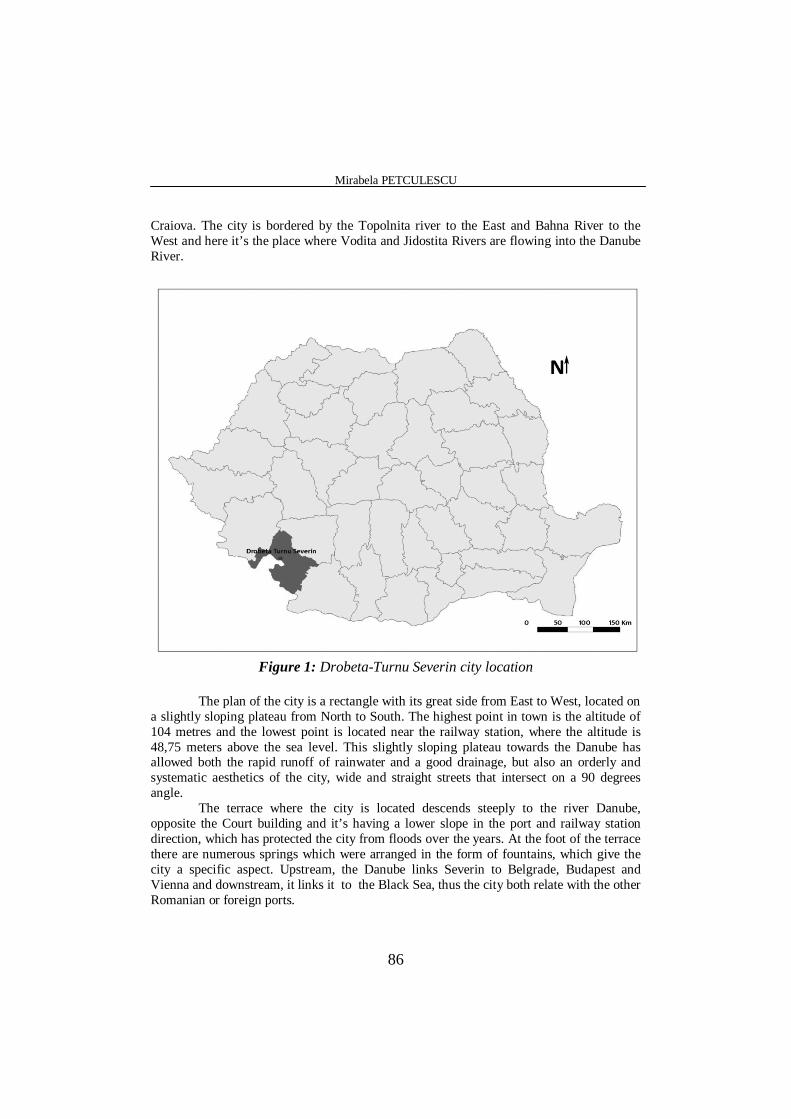
The city of Drobeta-Turnu Severin, the county seat of Mehedinti is located (Figure 1) in the most western part of Oltenia, with its center placed on the coordinates 22° 33' East longitude and 44° 38' North latitude. The city is located on the left side of the Danube River at the exit of the gorge, in the subcarphatian depression of Topolniţa, on the european road 70, at 353 km away from Bucharest, 210 km away from Timişoara and 113 km away from
Mirabela PETCULESCU
86
Craiova. The city is bordered by the Topolnita river to the East and Bahna River to the West and here it’s the place where Vodita and Jidostita Rivers are flowing into the Danube River.
Figure 1: Drobeta-Turnu Severin city location
The plan of the city is a rectangle with its great side from East to West, located on
a slightly sloping plateau from North to South. The highest point in town is the altitude of 104 metres and the lowest point is located near the railway station, where the altitude is 48,75 meters above the sea level. This slightly sloping plateau towards the Danube has allowed both the rapid runoff of rainwater and a good drainage, but also an orderly and systematic aesthetics of the city, wide and straight streets that intersect on a 90 degrees angle.
The terrace where the city is located descends steeply to the river Danube, opposite the Court building and it’s having a lower slope in the port and railway station direction, which has protected the city from floods over the years. At the foot of the terrace there are numerous springs which were arranged in the form of fountains, which give the city a specific aspect. Upstream, the Danube links Severin to Belgrade, Budapest and Vienna and downstream, it links it to the Black Sea, thus the city both relate with the other Romanian or foreign ports.
Landmarks of Historical Development in Drobeta-Turnu Severin
87
Between this city and the Danube River there was always a connection, because the old River gave its specifics and brought its economic prosperity. Simion Mehedinţi said that "who says Danube, must say at once The Black Sea. But not only that: we must add the Bosphorus (it's only an extension of the Danube), then the Dardanelles-a continuation of the Bosphorus ". On the left bank of this River lies the beautiful city of Drobeta Turnu-Severin, place where "God wanted to show to the people His generosity". (Mihai Butnariu, 1998, p. 6). The city is located between the Timiş-Cerna Passage, the Mehedinti Plateau, the Subcarpathian Depression of Oltenia and the Oltenia Plain. Here is the place where the Danube River falls into one of the largest meanderings that it meets on its route to the shedding. Severin is surrounded by a belt of hills: the Văranic Hill, to the Northwest, the Curile Hill, the Gîrdamul Hill and the Balota hill in the East. The latter, high of 368 metres, situated 18 km away from Severin, it dominates the depression of Topolniţa. To the South, the town is crossed by the Danube waters.
By being situated at the intersection of the communication paths of the continent, Severin was in permanent contact with the different cultures, civilizations and the most varied interests, which have influenced its development to the modern period. Very important is the tourist trail that connects Serbia and Banat to Bucharest and Romanian Black Sea coast. Severin's european destiny is a result of its geographical location, this space representing a real "bridge between Central Europe and the Near East, between the North of the continent and the Mediterranean World" (Mihai Butnariu, 1998, p. 5).
4. LANDMARKS OF HISTORICAL EVOLUTION
Drobeta-Turnu Severin is an old city, from the roman period. Viewed through a
flashback and based on archaeological and documentary evidence, we are be able to decipher the beginnings of human activity on this places and nearby. This land assured his people with the necessary living goods and the favorable conditions for the defense against enemies. The history keeps track, as evidence, of objects that were used as tools and weapons in the earliest epoch of human history – the Paleolithic. In the Middle Paleolithic there were further improved and refined the bifacial peaks. Such objects have been discovered at Cladova. (Pârvan, V.,1974, p.14) Numerous testimonies found here are quite specific to all cultures of the Neolithic, then there are those in the era of transition from Neolithic cultures to the Bronze age and even early Iron age. The second Iron age is represented in numerous human settlements on the Danube, across the plain, but also across the hills, plateaux and mountains. Are noted the fortifications at Bobaiţa, Schela Cladovei, Gura Văii, Dubova, Sviniţa, Ilovăţ, Hinova, Ostrovul Mare, Ostrovul imian, Opri or etc.
The beginning of the second millennium B.C., overlapping with the bronze age, testifies certain material cultures which are specific to the geto-Dacian ethnos. From this period as well as later, there are attested field works with wave of soil and defensive moats, placed after a relatively rigorous plan imposed by the defense or shelter needs. The most important were the fortifications situated in Bobaiţa, Ilovăţ, Grădeţ or on the Danube islands.
In such a settlement system, the Dacian centers such as Dierna and especially Drobeta are asserting itself. Drobeta will later become one of the most important cities placed in the contact area of the Roman Empire and Dacia. The Drobeta Roman
Mirabela PETCULESCU
88
experiences in its evolution three major periods: that of Antonins, of Constantine the Great and of Justinian’s (Davidescu, M.,1980)
The considerable material and spiritual culture specific to these settlements, which are located on the current territory of the Municipality of Dr. Tr. Severin are confirming the upper stage reached by the Geto-Dacian society and the favorable conditions that allowed Burebista to build the centralized and independent Dacian state (in the year 70 B.C. he united under the same authority the existing socio-political formations).
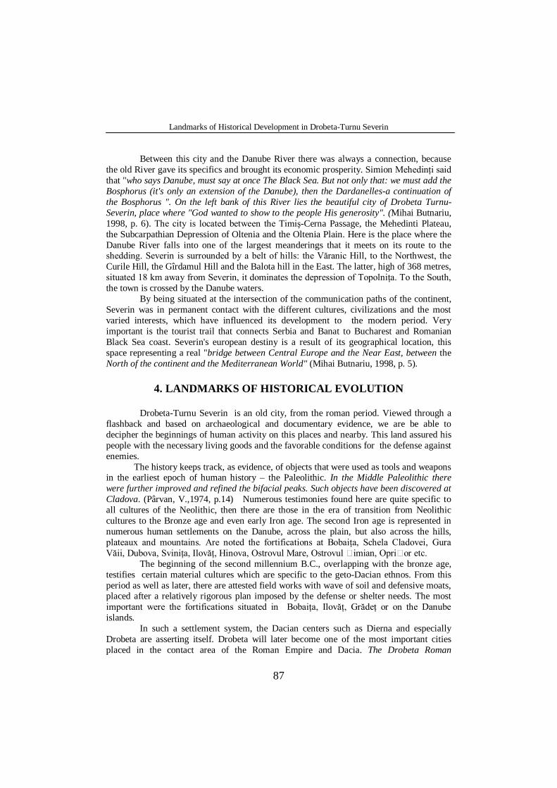
On these settlements’territory there are Roman civilisations testimonies which prove that the geto-Dacian population in this part of the country has entered early into contact with Roman culture and economic development. It is known that, after the conquest of the Balkan peninsula, the romans encountered here, on the Danube, the resistance of a powerful state. It was here where, after the first war between the Gauls and Romans (101-102), enormous material an human resources are concentrated and also starts the building of the majestic Danube River Bridge that once finished (105), turns Drobeta into a genuine military, economic and social center of convergence of the main roads built and refitted in Dacia. The construction of the bridge also was made because that there "was what he was missing, a bridge on Drobeta left bank, which of course was founded by the Romans in earlier times, probably under Flavi ( Iorga, N.,1985, p.37). During the reign of Septimius Severus Emperor, Drobeta is elevated and it is called a colony. The construction of the bridge took place between 103-105, and it was the longest stone bridge in the Roman Empire (Photo 1).
Photo 1: The root of the Traian’s bridge
(Petculescu Mirabela, 2012)
On the one hand, the Decebal and Traian monuments, which are installed nowadays in the centre of the city, signifies the heroism of the Dacians, led by King Decebalus, in their struggle to defend the territorial integrity and on the other hand, the obstinacy of an Emperor to subject his most feared adversary.
Landmarks of Historical Development in Drobeta-Turnu Severin
89
Drobeta retains its attributes as the Center with complex functions and, in particular, the defense function after the Aurelian withdrawal. It is remembered among the fortifications mastered by the Romans until the end of the 6th century, and it also was one of the centers of the defense in front of the migratory populations attacks.
The continuity and reactivation of the defence centres in this area are fully confirmed by the appearance of the Great wave of Defense, known as Novac’s Trace. This wave of Earth started from the edge of the Drobeta camp, from Topolnita and was extending beneath the hills on the contact line of the Romanian Plain, near Mizil.
On the current territory of the County, the archaeological diggings does not bring evidence of testimonies related to a migratory population. The rural areas stressed here and the material traces found in this place (the existence of manors and cabins located mainly on the Danube shedding and valley) reveals a stable civilisation, an evolving Romanian Dacian civilization supported by skilled agriculture, cattle breeders, fishermen and craftsmen. On this native background the Romanian feudal formations will be developed-the country of Severin, mentioned by the Ioanit Diploma as one of the oldest formations located between the Carpathian Mountains and the Danube River.
The confrontations between the Kings of Hungary and Bulgaria have favored the strengthening the Romanian organizations in this area and the recognition of Basarab I, as Great voivode of The Romanian Country. In 1366 Vladislav Vlaicu is acknowledged as "Banul Severinului" and in 1389 Mircea cel Bătrân is titled "al Banatului de Severin domn". The beginning of the modern era is marked by the revolution of 1821, this population playing an important role during that time, as well as it was during the 1848 national movement. The Union of the Romanian principalities from 1859 also had a strong echo in their lives, their adherence to this national act being stressed upon receiving in the County the ruler Al. I. Cuza on June, 25th 1859 and also Mihail Kogălniceanu in 1864. In 1867 King Charles, while visiting Oltenia reaches Severin and sees the construction of the hospital, started on which occasion Grecescu is introduced to him (Filetti,J.,1928, p. 25). The immediate period after the Union has been marked by a stage of development and modernization of Drobeta’s economic and social structures. At the beginning of the communism, the agriculture was heavily influenced by capitalism. Also, the industry an the commerce gradually evolved, thus creating a flourishing city by the time of the independence. The monument erected in Drobeta Turnu-Severin in the memory of the 12632 soldiers fallen on the battlefield, as well as dozens of smaller monuments raised in villages and townships of the County, are signs of gratitude of the next generations for their ancestors. Starting with 1888, the "Mine and forest society" and the "Mechanic workers society" appeared in Turnu Severin. In 1893, the first political party of the working class in Romania was created in this city-P.S.D.M.R. and this is where The Workers Club was first starting its activity in 1896. Through the establishment, in October 1907, of the Union workers in the Shipyard, the working class from Severin receives new impulses, standing at the forefront of the fight for an organisational and political union for the working class in Romania.
In 1913, the Turnu-Severin Department of P.S.D.R. founded the society called "People's House", a cradle for the Communist revolutionary movement. It was an important organization for leadershiping the working struggles for economic and political rights, in order to safeguard the independence and the completion of the national unity in Romania. It also worked against the capitalist exploitation and for the conquest of the political power.
Mirabela PETCULESCU
90
The magnitude of the actions and claims from the 1918-1920s also reflected the high degree of political maturity of the force labor. During this period, Turnu Severin was among the most important revolutionary centers of the country. According to one of the orders of the Legion of gendarmes in Mehedin i, Drobeta Turnu Severin was considered the most revolutionary centre in the county. In this order it is shown that in January, 1944 "The Communist Center is the city of Drobeta Turnu Severin, where, among C.F.R. Workshops workers and the Shipyard workers, there are elements which are described as communist" and there were taken measures in order to prevent demonstrations and also for control the people.
The rich history of these territories and the numerous archaeological discoveries made possible the existence of many museums, including some of the in the open air. Severin is mentioned for the first time in 1233 as the capital of a Hungarian Banat, whose purpose was to ensure the penetration of the hungarians, at the expense of their rivals, the bulgarians.
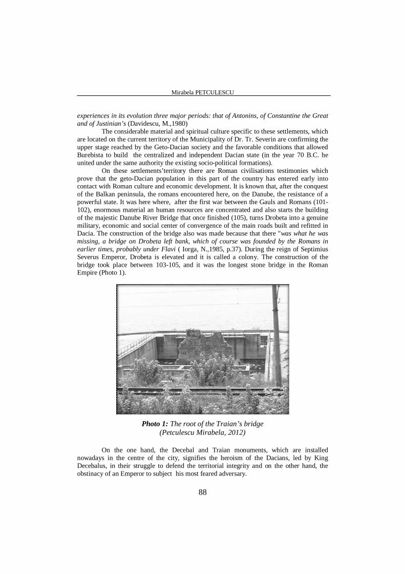
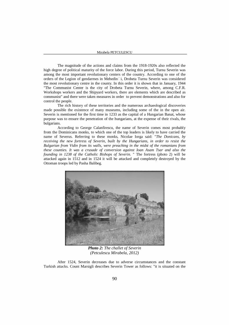
According to George Calanfirescu, the name of Severin comes most probably from the Dominicans monks, to which one of the top leaders is likely to have carried the name of Severus. Referring to these monks, Nicolae Iorga said: "The Donicans, by receiving the new fortress of Severin, built by the Hungarians, in order to resist the Bulgarian from Vidin from its walls, were preaching in the midst of the romanians from these counties. It was a crusade of conversion against Ioan Asam Tsar and also the founding in 1238 of the Catholic Bishops of Severin. " The fortress (photo 2) will be attacked again in 1512 and in 1524 it will be attacked and completely destroyed by the Ottoman troops led by Pasha Balibeg.
Photo 2: The challet of Severin
(Petculescu Mirabela, 2012)
After 1524, Severin decreases due to adverse circumstances and the constant Turkish attacks. Count Marsigli describes Severin Tower as follows: "it is situated on the
Landmarks of Historical Development in Drobeta-Turnu Severin
91
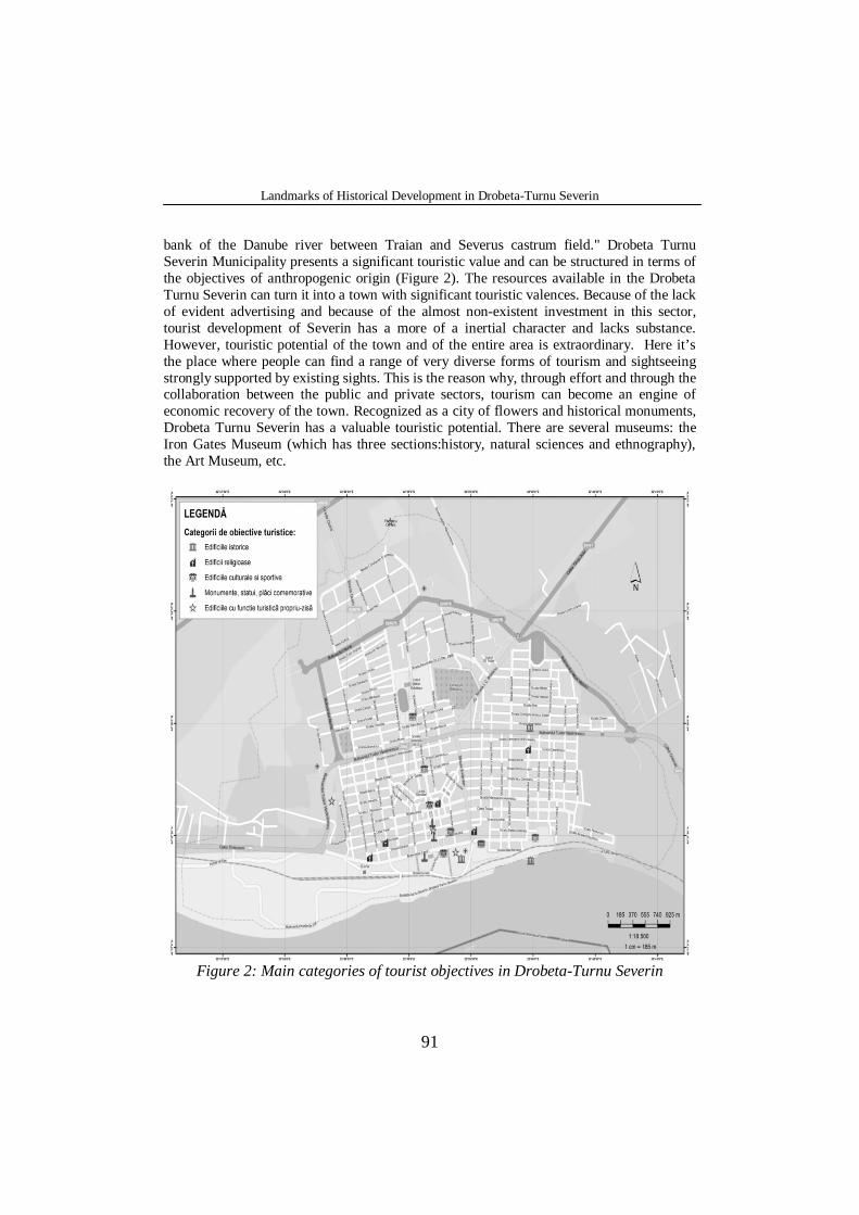
bank of the Danube river between Traian and Severus castrum field." Drobeta Turnu Severin Municipality presents a significant touristic value and can be structured in terms of the objectives of anthropogenic origin (Figure 2). The resources available in the Drobeta Turnu Severin can turn it into a town with significant touristic valences. Because of the lack of evident advertising and because of the almost non-existent investment in this sector, tourist development of Severin has a more of a inertial character and lacks substance. However, touristic potential of the town and of the entire area is extraordinary. Here it’s the place where people can find a range of very diverse forms of tourism and sightseeing strongly supported by existing sights. This is the reason why, through effort and through the collaboration between the public and private sectors, tourism can become an engine of economic recovery of the town. Recognized as a city of flowers and historical monuments, Drobeta Turnu Severin has a valuable touristic potential. There are several museums: the Iron Gates Museum (which has three sections:history, natural sciences and ethnography), the Art Museum, etc.
Figure 2: Main categories of tourist objectives in Drobeta-Turnu Severin
Mirabela PETCULESCU
92
In terms of settlement system, Drobeta Turnu Severin stands out because of its centrality and polarisation, it’s relative to rural towns in terms of spatial and functional organization of the system.
5. CONCLUSIONS
Situated at the intersection of the meaningful paths of communication on continent, Severin was in a permanent contact with the different cultures and has played a big role in local social relations since ancient times.
Drobeta camp was the first urban center that had military power, economic and religious importance from Oltenia, and the third urban centre in Dacia, after Sarmizegetusa and Apullum. The city of Drobeta has a very rich history which still preserves the material and immaterial testimonies of inestimable value. Most of them can be exploited from the touristic point of view, that's why they will be presented in what follows as are tourism resources. They are added to the natural sights.
Nowadays, Drobeta Turnu Severin constitutes an interesting territorial system based on the complexity of its natural and socio-economic components, but also based on the interrelations between these components.
REFERENCES
Albulescu I., (2000), Tourist area" Iron Gates", Drobeta Turnu-Severin. Beaujeu-Garnier, Jeacqueline, Chabot, G., (1971), Geografie Urbană, (Urban Geography), Ed.
Ştiinţifică, Bucureşti. Butnariu, M., (1998), Monografia Municipiului Dr. Tr. Severin,(The monograph of the Drobeta
Turnu-Severin Municipality), Ed. Albatros, Dr. Tr. Severin. Cândea, Melinda, Cimpoieru, Irina, Bran, Florina, (2006), Organizarea, amenajarea şi
dezvoltarea durabilă a spaţiului geografic, (Organization, planning and sustainable development of the geographical space), Ed. Universitară, Bucureşti.
Cizec, E. (1980), Age of Traian, Meridians House, Bucureşti. Constantiniu, B. (1997), A frank history of Romania, Encyclopedic Universe Publishing House,
Bucureşti. Costea, A., Săvoiu, D., Ieva, N., Vişan, O., Nica, Gh., (1972), Municipiul Dr. Tr. Severin,(Dr.
Tr.Severin Municipalily), Ed. Didactică şi Pedagogică, Bucureşti. Cucu, V., Popova-Cucu, Ana, (1980), Judeţul Mehedinţi,(Mehedinti County), Ed. Academiei
Republicii Socialiste România, Bucureşti. Davidescu, M. (1980), Drobeta in secolele I-VII (Drobeta in the 1st-7th centuries), Craiova. Davidescu, M., (1970), Cetatea Severinului, (The Severin Fortress), Ed. Scrisul Românesc, Craiova. Drǎgan, I. C. (1986), Dacia imperiului milenar ("Millennium imperial Dacia), Scientific and
Encyclopedic Publishing House, Bucureşti. Demetrescu, V., (1833), Istoria Oraşului Severin, (The history of Drobeta Turnu-Severin), Ed. Knoll,
Turnu Severin. Dumitru, T. (1980), Drobeta Gauls, in the Archives of Oltenia, no. 47-48. Erdeli, G., coord., (1999), Dicţionar de geografie umană, (Human Geography Dictionary), Ed.
Corint, Bucureşti. Faces, N., Măneanu, M. (1972), Catalog de documente cu istoria oraşului Turnu-Severin (Catalogue
of documents on the history of Turnu – Severin), Turnu Severin. Filetti, J. (1928), Marele filantrop Stoian Grecescu, in the Archives of Oltenia, nr 3, p.25-42.
Landmarks of Historical Development in Drobeta-Turnu Severin
93
Giurăscu, C., (1978), Istoria Românilor, (The Romanians’History) Ediţia a II-a, Ed. Albatros, Bucureşti.
Harp, O. J. (1985), History of Culture and Civilization, Scientific and Encyclopedic Publishing House, Bucureşti.
Iorga, N. (1985), Istoria românilor (History of the Romanian people), Scientific and Encyclopedic Publishing House, Bucureşti.
Pajură, C., Giurăscu, D. T., (1933), Istoricul oraşului Turnu Severin,(The Historic of the city Drobeta Turnu-Severin), Ed. Tiparul Românesc, Bucureşti.
Pârvan, V. (1974), Dacia. Civilizaţia anticǎ a statelor carpato-danubiene (Dacia. Ancient Civilizations of the Carpatho-Danubian Countries), Bucureşti.
Petrea, Dan, (2005), Obiect, metodă, şi cunoaştere geografică, (Object, Method and geographical knowledge), Ed. Universităţii din Oradea, Oradea.
Simionescu, I., (1983), Fauna României, Ed. Albatros, Bucureşti Spineanu, N.D., (1894), Dicţionar geografic al judeţului Mehedinţi (Geographical dictionary of the
Mehedinti County), Ed. Academiei, Bucureşti. Visan, I. N., Mehedinţi, O. (1992), Timp şi istorie (Time and history), Edit. Hermes, Drobeta Turnu
Severin

Mirabela PETCULESCU
94


![Problems Ted Eisenberg, Section Editor...5620: Proposed by Daniel Sitaru, National Economic College \Theodor Costescu" Drobeta Turnu-Severin, Mehedinti, Romania Prove: If a;b;2[0;1];](https://img.pdfslide.us/doc/110x75/60eb7a9fba425f16e9777ca1/problems-ted-eisenberg-section-editor-5620-proposed-by-daniel-sitaru-national.jpg)


![QUARTZ - cngt.ro · PDF file[Type text] COLEGIUL NAȚIONAL ,,GHEORGHE Ț IȚ EICA DROBETA TURNU SEVERIN QUARTZ - revistă școlară de fizică și viața-UUNNDDEEELLLEE](https://img.pdfslide.us/doc/110x75/5a798af57f8b9a197e8c9555/quartz-cngtro-type-text-colegiul-naional-gheorghe-i-eica-drobeta-turnu.jpg)