Embed Size (px)
Citation preview

LANDFORMS AND THEIR
EVOLUTION
C H A P T E R
A fter weathering processes have hadtheir actions on the earth materialsmaking up the surface of the earth, the
geomorphic agents like running water, groundwater, wind, glaciers, waves perform erosion.It is already known to you that erosion causeschanges on the surface of the earth. Depositionfollows erosion and because of deposition too,changes occur on the surface of the earth.
As this chapter deals with landforms andtheir evolution first start with the question,what is a landform? In simple words, small tomedium tracts or parcels of the earth’s surfaceare called landforms.
If landform is a small to medium sized partof the surface of the earth, what is a landscape?
Several related landforms together makeup landscapes, (large tracts of earth’s surface).Each landform has its own physical shape, size,materials and is a result of the action of certaingeomorphic processes and agent(s). Actionsof most of the geomorphic processes andagents are slow, and hence the results take along time to take shape. Every landform has abeginning. Landforms once formed maychange in their shape, size and nature slowlyor fast due to continued action of geomorphicprocesses and agents.
Due to changes in climatic conditions andvertical or horizontal movements of land-masses, either the intensity of processes or theprocesses themselves might change leading tonew modifications in the landforms. Evolutionhere implies stages of transformation of eithera part of the earth’s surface from one landforminto another or transformation of individuallandforms after they are once formed. That
means, each and every landform has a historyof development and changes through time. Alandmass passes through stages ofdevelopment somewhat comparable to thestages of life — youth, mature and old age.
What are the two important aspects ofthe evolution of landforms?
The evolutionary history of the continuallychanging surface of the earth is essential to beunderstood in order to use it effectively withoutdisturbing its balance and diminishing itspotential for the future. Geomorphology dealswith the reconstruction of the history of thesurface of the earth through a study of itsforms, the materials of which it is made up ofand the processes that shape it.
Changes on the surface of the earth owemostly to erosion by various geomorphicagents. Of course, the process of deposition too,by covering the land surfaces and filling thebasins, valleys or depressions, brings changesin the surface of the land. Deposition followserosion and the depositional surfaces too areultimately subjected to erosion. Running water,ground-water, glaciers, wind and waves arepowerful erosional and depositional agentsshaping and changing the surface of the earthaided by weathering and mass wastingprocesses. These geomorphic agents actingover long periods of time produce systematicchanges leading to sequential development oflandforms. Each geomorphic agent producesits own assemblage of landforms. Not only this,each geomorphic process and agent leave theirdistinct imprints on the landforms they

LANDFORMS AND THEIR EVOLUTION 59
produce. You know that most of thegeomorphic processes are imperceptiblefunctions and can only be seen and measuredthrough their results. What are the results?These results are nothing but landforms andtheir characteristics. Hence, a study oflandforms, will reveal to us the process andagent which has made or has been makingthose landforms.
Most of the geomorphic processes areimperceptible. Cite a few processes whichcan be seen and a few which can’t beseen.
As the geomorphic agents are capable oferosion and deposition, two sets — erosionalor destructional and depositional orconstructional — of landforms are producedby them. Many varieties of landforms developby the action of each of the geomorphic agentsdepending upon especially the type andstructure i.e. folds, faults, joints, fractures,hardness and softness, permeability andimpermeability, etc. come under structure ofrocks. There are some other independentcontrols like (i) stability of sea level; (ii) tectonicstability of landmasses; (iii) climate, whichinfluence the evolution of landforms. Anydisturbance in any of these three controllingfactors can upset the systematic andsequential stages in the development andevolution of landforms.
In the following pages, under each of thegeomorphic regimes i.e. running water;groundwater, glaciers, waves, and winds, firsta brief discussion is presented as to howlandmasses are reduced in their relief througherosion and then, development of some of theerosional and depositional landforms is dealtwith.
RUNNING WATER
In humid regions, which receive heavy rainfallrunning water is considered the mostimportant of the geomorphic agents inbringing about the degradation of the landsurface. There are two components of runningwater. One is overland flow on general landsurface as a sheet. Another is linear flow as
streams and rivers in valleys. Most of theerosional landforms made by running waterare associated with vigorous and youthfulrivers flowing along gradients. With time,stream channels over steep gradients turngentler due to continued erosion, and as aconsequence, lose their velocity, facilitatingactive deposition. There may be depositionalforms associated with streams flowing oversteep slopes. But these phenomena will be ona small scale compared to those associatedwith rivers flowing over medium to gentleslopes. The gentler the river channels ingradient or slope, the greater is the deposition.When the stream beds turn gentler due tocontinued erosion, downward cutting becomesless dominant and lateral erosion of banksincreases and as a consequence the hills andvalleys are reduced to plains.
Is complete reduction of relief of a highland mass possible?
Overland flow causes sheet erosion.Depending upon irregularities of the landsurface, the overland flow may concentrate intonarrow to wide paths. Because of the sheerfriction of the column of flowing water, minoror major quantities of materials from thesurface of the land are removed in the directionof flow and gradually small and narrow rillswill form. These rills will gradually develop intolong and wide gullies; the gullies will furtherdeepen, widen, lengthen and unite to give riseto a network of valleys. In the early stages,down-cutting dominates during whichirregularities such as waterfalls and cascadeswill be removed. In the middle stages, streamscut their beds slower, and lateral erosion ofvalley sides becomes severe. Gradually, thevalley sides are reduced to lower and lowerslopes. The divides between drainage basinsare likewise lowered until they are almostcompletely flattened leaving finally, a lowlandof faint relief with some low resistant remnantscalled monadnocks standing out here andthere. This type of plain forming as a result ofstream erosion is called a peneplain (an almostplain). The characteristics of each of the stagesof landscapes developing in running waterregimes may be summarised as follows:

FUNDAMENTALS OF PHYSICAL GEOGRAPHY60
Youth
Streams are few during this stage with poorintegration and flow over original slopesshowing shallow V-shaped valleys with nofloodplains or with very narrow floodplainsalong trunk streams. Streams divides are broadand flat with marshes, swamp and lakes.Meanders if present develop over these broadupland surfaces. These meanders mayeventually entrench themselves into theuplands. Waterfalls and rapids may exist wherelocal hard rock bodies are exposed.
Mature
During this stage streams are plenty with goodintegration. The valleys are still V-shaped butdeep; trunk streams are broad enough to havewider floodplains within which streams mayflow in meanders confined within the valley.The flat and broad inter stream areas andswamps and marshes of youth disappear andthe stream divides turn sharp. Waterfalls andrapids disappear.
Old
Smaller tributaries during old age are few withgentle gradients. Streams meander freely overvast floodplains showing natural levees, oxbowlakes, etc. Divides are broad and flat with lakes,swamps and marshes. Most of the landscapeis at or slightly above sea level.
EROSIONAL LANDFORMS
Valleys
Valleys start as small and narrow rills; the rillswill gradually develop into long and widegullies; the gullies will further deepen, widenand lengthen to give rise to valleys. Dependingupon dimensions and shape, many types ofvalleys like V-shaped valley, gorge, canyon,etc. can be recognised. A gorge is a deep valleywith very steep to straight sides (Figure 7.1) anda canyon is characterised by steep step-likeside slopes (Figure 7.2) and may be as deep asa gorge. A gorge is almost equal in width at itstop as well as its bottom. In contrast, a canyon
is wider at its top than at its bottom. In fact, acanyon is a variant of gorge. Valley types dependupon the type and structure of rocks in whichthey form. For example, canyons commonlyform in horizontal bedded sedimentary rocksand gorges form in hard rocks.
Figure 7.1 : The Valley of Kaveri river near Hogenekal,Dharmapuri district, Tamilnadu in the form of gorge
Figure 7.2 : An entrenched meander loop of river Coloradoin USA showing step-like side slopes of its valley
typical of a canyon
LANDFORMS AND THEIR EVOLUTION 61
Potholes and Plunge Pools
Over the rocky beds of hill-streams more or lesscircular depressions called potholes formbecause of stream erosion aided by the abrasionof rock fragments. Once a small and shallowdepression forms, pebbles and boulders getcollected in those depressions and get rotatedby flowing water and consequently thedepressions grow in dimensions. A series of suchdepressions eventually join and the streamvalley gets deepened. At the foot of waterfallsalso, large potholes, quite deep and wide, formbecause of the sheer impact of water androtation of boulders. Such large and deep holesat the base of waterfalls are called plunge pools.These pools also help in the deepening of valleys.Waterfalls are also transitory like any otherlandform and will recede gradually and bringthe floor of the valley above waterfalls to thelevel below.
INCISED OR ENTRENCHED MEANDERS
In streams that flow rapidly over steepgradients, normally erosion is concentrated onthe bottom of the stream channel. Also, in thecase of steep gradient streams, lateral erosionon the sides of the valleys is not much whencompared to the streams flowing on low andgentle slopes. Because of active lateral erosion,streams flowing over gentle slopes, developsinuous or meandering courses. It is commonto find meandering courses over floodplainsand delta plains where stream gradients arevery gentle. But very deep and wide meanderscan also be found cut in hard rocks. Suchmeanders are called incised or entrenchedmeanders (Figure 7.2). Meander loops developover original gentle surfaces in the initial stagesof development of streams and the same loopsget entrenched into the rocks normally due toerosion or slow, continued uplift of the landover which they start. They widen and deepenover time and can be found as deep gorges andcanyons in hard rock areas. They give anindication on the status of original landsurfaces over which streams have developed.
What are the differences between incisedmeanders and meanders over flood anddelta plains?
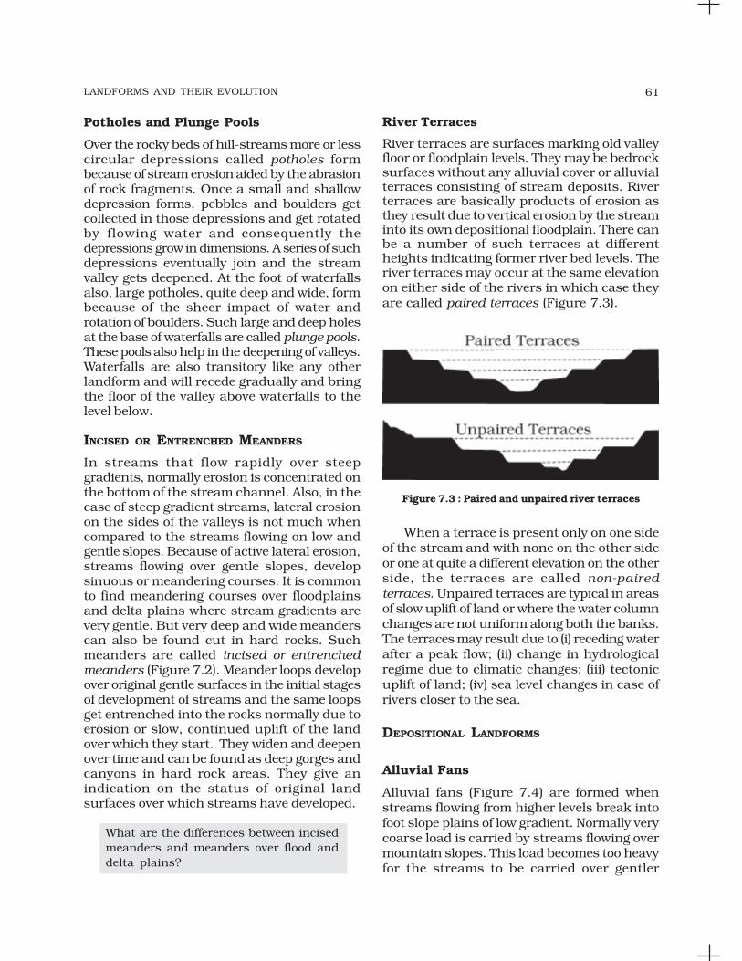
River Terraces
River terraces are surfaces marking old valleyfloor or floodplain levels. They may be bedrocksurfaces without any alluvial cover or alluvialterraces consisting of stream deposits. Riverterraces are basically products of erosion asthey result due to vertical erosion by the streaminto its own depositional floodplain. There canbe a number of such terraces at differentheights indicating former river bed levels. Theriver terraces may occur at the same elevationon either side of the rivers in which case theyare called paired terraces (Figure 7.3).
Figure 7.3 : Paired and unpaired river terraces
When a terrace is present only on one sideof the stream and with none on the other sideor one at quite a different elevation on the otherside, the terraces are called non-pairedterraces. Unpaired terraces are typical in areasof slow uplift of land or where the water columnchanges are not uniform along both the banks.The terraces may result due to (i) receding waterafter a peak flow; (ii) change in hydrologicalregime due to climatic changes; (iii) tectonicuplift of land; (iv) sea level changes in case ofrivers closer to the sea.
DEPOSITIONAL LANDFORMS
Alluvial Fans
Alluvial fans (Figure 7.4) are formed whenstreams flowing from higher levels break intofoot slope plains of low gradient. Normally verycoarse load is carried by streams flowing overmountain slopes. This load becomes too heavyfor the streams to be carried over gentler

FUNDAMENTALS OF PHYSICAL GEOGRAPHY62
gradients and gets dumped and spread as abroad low to high cone shaped deposit calledalluvial fan. Usually, the streams which flowover fans are not confined to their originalchannels for long and shift their position acrossthe fan forming many channels calleddistributaries. Alluvial fans in humid areasshow normally low cones with gentle slope from
as a low cone. Unlike in alluvial fans, thedeposits making up deltas are very well sortedwith clear stratification. The coarsest materialssettle out first and the finer fractions like siltsand clays are carried out into the sea. As thedelta grows, the river distributaries continueto increase in length (Figure 7.5) and deltacontinues to build up into the sea.
Floodplains, Natural Levees and Point Bars
Deposition develops a floodplain just aserosion makes valleys. Floodplain is a majorlandform of river deposition. Large sizedmaterials are deposited first when streamchannel breaks into a gentle slope. Thus,normally, fine sized materials like sand, silt andclay are carried by relatively slow movingwaters in gentler channels usually found in theplains and deposited over the bed and whenthe waters spill over the banks during floodingabove the bed. A river bed made of riverdeposits is the active floodplain. The floodplainabove the bank is inactive floodplain. Inactivefloodplain above the banks basically containtwo types of deposits — flood deposits andchannel deposits. In plains, channels shiftlaterally and change their courses occasionallyleaving cut-off courses which get filled upgradually. Such areas over flood plains builtup by abandoned or cut-off channels containcoarse deposits. The flood deposits of spilledwaters carry relatively finer materials like siltand clay. The flood plains in a delta are calleddelta plains.
Natural levees and point bars (Figure 7.6)are some of the important landforms foundassociated with floodplains. Natural levees arefound along the banks of large rivers. They arelow, linear and parallel ridges of coarse depositsalong the banks of rivers, quite often cut intoindividual mounds. During flooding as thewater spills over the bank, the velocity of thewater comes down and large sized and highspecific gravity materials get dumped in theimmediate vicinity of the bank as ridges. Theyare high nearer the banks and slope gentlyaway from the river. The levee deposits arecoarser than the deposits spread by floodwaters away from the river. When rivers shiftlaterally, a series of natural levees can form.
Figure 7.4 : An alluvial fan deposited by a hill streamon the way to Amarnath, Jammu and Kashmir
head to toe and they appear as high cones withsteep slope in arid and semi-arid climates.
Deltas
Deltas are like alluvial fans but develop at adifferent location. The load carried by the riversis dumped and spread into the sea. If this loadis not carried away far into the sea or distributedalong the coast, it spreads and accumulates
Figure 7.5 : A satellite view of part of Krishna riverdelta, Andhra Pradesh

LANDFORMS AND THEIR EVOLUTION 63
Point bars are also known as meander bars.They are found on the convex side of meandersof large rivers and are sediments deposited ina linear fashion by flowing waters along thebank. They are almost uniform in profile and inwidth and contain mixed sizes of sediments. Ifthere more than one ridge, narrow and elongateddepressions are found in between the point bars.Rivers build a series of them depending uponthe water flow and supply of sediment. As therivers build the point bars on the convex side,the bank on the concave side will erode actively.
In what way do natural levees differ frompoint bars?
Meanders
In large flood and delta plains, rivers rarely flowin straight courses. Loop-like channel patternscalled meanders develop over flood and deltaplains (Figure 7.7).
Figure 7.7 : A satellite scene showing meanderingBurhi Gandak river near Muzaffarpur, Bihar, showing
a number of oxbow lakes and cut-offs
Meander is not a landform but is only atype of channel pattern. This is because of(i) propensity of water flowing over very gentlegradients to work laterally on the banks;(ii) unconsolidated nature of alluvial depositsmaking up the banks with many irregularitieswhich can be used by water exerting pressurelaterally; (iii) coriolis force acting on the fluidwater deflecting it like it deflects the wind. Whenthe gradient of the channel becomes extremelylow, water flows leisurely and starts workinglaterally. Slight irregularities along the banksslowly get transformed into a small curvaturein the banks; the curvature deepens due todeposition on the inside of the curve anderosion along the bank on the outside. If thereis no deposition and no erosion or undercutting,the tendency to meander is reduced. Normally,in meanders of large rivers, there is activedeposition along the convex bank andundercutting along the concave bank.
Figure 7.8 : Meander growth and cut-off loops andslip-off and undercut banks
Figure 7.6 : Natural levee and point bars

FUNDAMENTALS OF PHYSICAL GEOGRAPHY64
The concave bank is known as cut-off bankwhich shows up as a steep scarp and theconvex bank presents a long, gentle profile andis known as slip-off bank (Figure 7.8). Asmeanders grow into deep loops, the same mayget cut-off due to erosion at the inflection pointsand are left as ox-bow lakes.
Braided Channels
When rivers carry coarse material, there can beselective deposition of coarser materials causingformation of a central bar which diverts the flowtowards the banks; and this flow increaseslateral erosion on the banks. As the valleywidens, the water column is reduced and moreand more materials get deposited as islandsand lateral bars developing a number ofseparate channels of water flow. Depositionand lateral erosion of banks are essential forthe formation of braided pattern. Or,alternatively, when discharge is less and load
is more in the valley, channel bars and islandsof sand, gravel and pebbles develop on the floorof the channel and the water flow is dividedinto multiple threads. These thread-like streamsof water rejoin and subdivide repeatedly to givea typical braided pattern (Figure 7.9).
Figure 7.9 : Satellite scenes showing braided channelsegments of Gandak (left) and Son (right) rivers
Arrows show the direction of flow
Figure 7.10 : Various karst features

LANDFORMS AND THEIR EVOLUTION 65
GROUNDWATER
Here the interest is not on groundwater as aresource. Our focus is on the work ofgroundwater in the erosion of landmasses andevolution of landforms. The surface waterpercolates well when the rocks are permeable,thinly bedded and highly jointed and cracked.After vertically going down to some depth, thewater under the ground flows horizontallythrough the bedding planes, joints or throughthe materials themselves. It is this downwardand horizontal movement of water whichcauses the rocks to erode. Physical ormechanical removal of materials by movinggroundwater is insignificant in developinglandforms. That is why, the results of the workof groundwater cannot be seen in all types ofrocks. But in rocks like limestones or dolomitesrich in calcium carbonate, the surface wateras well as groundwater through the chemicalprocess of solution and precipitationdeposition develop varieties of landforms. Thesetwo processes of solution and precipitation areactive in limestones or dolomites occurringeither exclusively or interbedded with otherrocks. Any limestone or dolomitic regionshowing typical landforms produced by theaction of groundwater through the processesof solution and deposition is called Karsttopography after the typical topographydeveloped in limestone rocks of Karst regionin the Balkans adjacent to Adriatic sea.
The karst topography is also characterisedby erosional and depositional landforms.
EROSIONAL LANDFORMS
Pools, Sinkholes, Lapies andLimestone Pavements
Small to medium sized round to sub-roundedshallow depressions called swallow holes formon the surface of limestones through solution.Sinkholes are very common in limestone/karstareas. A sinkhole is an opening more or lesscircular at the top and funnel-shapped towardsthe bottom with sizes varying in area from afew sq. m to a hectare and with depth from aless than half a metre to thirty metres or more.Some of these form solely through solutionaction (solution sinks) and others might start
as solution forms first and if the bottom of asinkhole forms the roof of a void or caveunderground, it might collapse leaving a largehole opening into a cave or a void below(collapse sinks). Quite often, sinkholes arecovered up with soil mantle and appear asshallow water pools. Anybody stepping oversuch pools would go down like it happens inquicksands in deserts. The term doline issometimes used to refer the collapse sinks.Solution sinks are more common than collapsesinks. Quite often the surface run-off simplygoes down swallow and sink holes and flow asunderground streams and re-emerge at adistance downstream through a cave opening.When sink holes and dolines join togetherbecause of slumping of materials along theirmargins or due to roof collapse of caves, long,narrow to wide trenches called valley sinks orUvalas form. Gradually, most of the surface ofthe limestone is eaten away by these pits andtrenches, leaving it extremely irregular with amaze of points, grooves and ridges or lapies.Especially, these ridges or lapies form due todifferential solution activity along parallel tosub-parallel joints. The lapie field mayeventually turn into somewhat smoothlimestone pavements.
Caves
In areas where there are alternating beds ofrocks (shales, sandstones, quartzites) withlimestones or dolomites in between or in areaswhere limestones are dense, massive andoccurring as thick beds, cave formation isprominent. Water percolates down eitherthrough the materials or through cracks andjoints and moves horizontally along beddingplanes. It is along these bedding planes thatthe limestone dissolves and long and narrowto wide gaps called caves result. There can bea maze of caves at different elevationsdepending upon the limestone beds andintervening rocks. Caves normally have anopening through which cave streams aredischarged. Caves having openings at both theends are called tunnels.
Depositional Landforms
Many depositional forms develop within thelimestone caves. The chief chemical in limestone

FUNDAMENTALS OF PHYSICAL GEOGRAPHY66
is calcium carbonate which is easily soluble incarbonated water (carbon dioxide absorbedrainwater). This calcium carbonate is depositedwhen the water carrying it in solutionevaporates or loses its carbon dioxide as ittrickles over rough rock surfaces.
Stalactites, Stalagmites and Pillars
Stalactites hang as icicles of differentdiameters. Normally they are broad at theirbases and taper towards the free ends showingup in a variety of forms. Stalagmites rise upfrom the floor of the caves. In fact, stalagmitesform due to dripping water from the surface orthrough the thin pipe, of the stalactite,immediately below it (Figure 7.11).
GLACIERS
Masses of ice moving as sheets over the land(continental glacier or pidmont glacier if a vastsheet of ice is spread over the plains at the footof mountains) or as linear flows down theslopes of mountains in broad trough-likevalleys (mountain and valley glaciers) are calledglaciers (Figure 7.12). The movement of glaciers
Figure 7.12 : A glacier in its valley
is slow unlike water flow. The movement couldbe a few centimetres to a few metres a day oreven less or more. Glaciers move basicallybecause of the force of gravity.
We have many glaciers in our countrymoving down the slopes and valleys inHimalayas. Higher reaches of Uttaranchal,Himachal Pradesh and Jammu andKashmir, are places to see some of them.Do you know where one can see riverBhagirathi is basically fed by meltwatersfrom under the snout (Gaumukh) of theGangotri glacier. In fact, Alkapuri glacierfeeds waters to Alakananda river. RiversAlkananda and Bhagirathi join to makeriver Ganga near Deoprayag.
Erosion by glaciers is tremendous becauseof friction caused by sheer weight of the ice.The material plucked from the land by glaciers(usually large-sized angular blocks andfragments) get dragged along the floors or sidesof the valleys and cause great damage throughabrasion and plucking. Glaciers can causesignificant damage to even un-weathered rocksand can reduce high mountains into low hillsand plains.
Figure 7.11 : Stalactites and stalagmites in a limestone cave
Stalagmites may take the shape of acolumn, a disc, with either a smooth, roundedbulging end or a miniature crater likedepression. The stalagmite and stalactiteseventually fuse to give rise to columns andpillars of different diameters.

LANDFORMS AND THEIR EVOLUTION 67
As glaciers continue to move, debris getsremoved, divides get lowered and eventuallythe slope is reduced to such an extent thatglaciers will stop moving leaving only a massof low hills and vast outwash plains along withother depositional features. Figures 7.13 and7.14 show various glacial erosional anddepositional forms described in the text.
EROSIONAL LANDFORMS
Cirque
Cirques are the most common of landforms inglaciated mountains. The cirques quite oftenare found at the heads of glacial valleys. Theaccumulated ice cuts these cirques whilemoving down the mountain tops. They aredeep, long and wide troughs or basins withvery steep concave to vertically dropping highwalls at its head as well as sides. A lake of watercan be seen quite often within the cirques after
the glacier disappears. Such lakes are calledcirque or tarn lakes. There can be two or morecirques one leading into another down belowin a stepped sequence.
Horns and Serrated Ridges
Horns form through head ward erosion of thecirque walls. If three or more radiating glacierscut headward until their cirques meet, high,sharp pointed and steep sided peaks calledhorns form. The divides between cirque sidewalls or head walls get narrow because ofprogressive erosion and turn into serrated orsaw-toothed ridges sometimes referred to asarêtes with very sharp crest and a zig-zagoutline.
The highest peak in the Alps, Matterhornand the highest peak in the Himalayas,Everest are in fact horns formed throughheadward erosion of radiating cirques.
Figure 7.13 : Some glacial erosional and depositional forms (adapted and modified from Spencer, 1962)

FUNDAMENTALS OF PHYSICAL GEOGRAPHY68
Glacial Valleys/Troughs
Glaciated valleys are trough-like and U-shapedwith broad floors and relatively smooth, andsteep sides. The valleys may contain littereddebris or debris shaped as moraines withswampy appearance. There may be lakesgouged out of rocky floor or formed by debriswithin the valleys. There can be hanging valleysat an elevation on one or both sides of the mainglacial valley. The faces of divides or spurs ofsuch hanging valleys opening into main glacialvalleys are quite often truncated to give theman appearance like triangular facets. Very deepglacial troughs filled with sea water andmaking up shorelines (in high latitudes) arecalled fjords/fiords.
What are the basic differences betweenglacial valleys and river valleys?
Depositional Landforms
The unassorted coarse and fine debris droppedby the melting glaciers is called glacial till. Mostof the rock fragments in till are angular to sub-angular in form. Streams form by melting iceat the bottom, sides or lower ends of glaciers.
Some amount of rock debris small enough tobe carried by such melt-water streams iswashed down and deposited. Such glacio-fluvial deposits are called outwash deposits.Unlike till deposits, the outwash deposits areroughly stratified and assorted. The rockfragments in outwash deposits are somewhatrounded at their edges. Figure 7.14 shows afew depositional landforms commonly foundin glaciated areas.
Moraines
They are long ridges of deposits of glacial till.Terminal moraines are long ridges of debrisdeposited at the end (toe) of the glaciers. Lateralmoraines form along the sides parallel to theglacial valleys. The lateral moraines may join aterminal moraine forming a horse-shoe shapedridge. There can be many lateral moraines oneither side in a glacial valley. These morainespartly or fully owe their origin to glacio-fluvialwaters pushing up materials to the sides ofglaciers. Many valley glaciers retreating rapidlyleave an irregular sheet of till over their valleyfloors. Such deposits varying greatly in thicknessand in surface topography are called groundmoraines. The moraine in the centre of the
Figure 7.14 : A panoramic diagram of glacial landscape with various depositional landforms(adapted and modified from Spencer, 1962)

LANDFORMS AND THEIR EVOLUTION 69
glacial valley flanked by lateral moraines iscalled medial moraine. They are imperfectlyformed as compared to lateral moraines.Sometimes medial moraines are indistinguishablefrom ground moraines.
Eskers
When glaciers melt in summer, the water flowson the surface of the ice or seeps down alongthe margins or even moves through holes inthe ice. These waters accumulate beneath theglacier and flow like streams in a channelbeneath the ice. Such streams flow over theground (not in a valley cut in the ground) withice forming its banks. Very coarse materials likeboulders and blocks along with some minorfractions of rock debris carried into this streamsettle in the valley of ice beneath the glacierand after the ice melts can be found as asinuous ridge called esker.
Outwash Plains
The plains at the foot of the glacial mountainsor beyond the limits of continental ice sheetsare covered with glacio-fluvial deposits in theform of broad flat alluvial fans which may jointo form outwash plains of gravel, silt, sand andclay.
Distinguish between river alluvial plainsand glacial outwash plains.
Drumlins
Drumlins are smooth oval shaped ridge-likefeatures composed mainly of glacial till withsome masses of gravel and sand. The long axesof drumlins are parallel to the direction of icemovement. They may measure up to 1 km inlength and 30 m or so in height. One end ofthe drumlins facing the glacier called the stossend is blunter and steeper than the other endcalled tail. The drumlins form due to dumpingof rock debris beneath heavily loaded icethrough fissures in the glacier. The stoss endgets blunted due to pushing by moving ice.Drumlins give an indication of direction ofglacier movement.
What is the difference between till andalluvium?
WAVES AND CURRENTS
Coastal processes are the most dynamic andhence most destructive. So, don’t you think itis important to know about the coastalprocesses and forms?
Some of the changes along the coasts takeplace very fast. At one place, there can beerosion in one season and deposition inanother. Most of the changes along the coastsare accomplished by waves. When waves break,the water is thrown with great force onto theshore, and simultaneously, there is a greatchurning of sediments on the sea bottom.Constant impact of breaking waves drasticallyaffects the coasts. Storm waves and tsunamiwaves can cause far-reaching changes in ashort period of time than normal breakingwaves. As wave environment changes, theintensity of the force of breaking waves changes.
Do you know about the generating forcesbehind waves and currents? If not, referto the chapter on movements in oceanwaters.
Other than the action of waves, the coastallandforms depend upon (i) the configurationof land and sea floor; (ii) whether the coast isadvancing (emerging) seaward or retreating(submerging) landward. Assuming sea level tobe constant, two types of coasts are consideredto explain the concept of evolution of coastallandforms: (i) high, rocky coasts (submergedcoasts); (ii) low, smooth and gently slopingsedimentary coasts (emerged coasts).
HIGH ROCKY COASTS
Along the high rocky coasts, the rivers appearto have been drowned with highly irregularcoastline. The coastline appears highlyindented with extension of water into the landwhere glacial valleys (fjords) are present. Thehill sides drop off sharply into the water. Shoresdo not show any depositional landformsinitially. Erosion features dominate.

FUNDAMENTALS OF PHYSICAL GEOGRAPHY70
Along high rocky coasts, waves break withgreat force against the land shaping the hillsides into cliffs. With constant pounding bywaves, the cliffs recede leaving a wave-cutplatform in front of the sea cliff. Wavesgradually minimise the irregularities along theshore.
The materials which fall off, and removedfrom the sea cliffs, gradually break into smallerfragments and roll to roundness, will getdeposited in the offshore. After a considerableperiod of cliff development and retreat whencoastline turns somewhat smooth, with theaddition of some more material to this depositin the offshore, a wave-built terrace woulddevelop in front of wave-cut terrace. As theerosion along the coast takes place a goodsupply material becomes available to longshorecurrents and waves to deposit them as beachesalong the shore and as bars (long ridges of sandand/or shingle parallel to the coast) in thenearshore zone. Bars are submerged featuresand when bars show up above water, they arecalled barrier bars. Barrier bar which get keyedup to the headland of a bay is called a spit.When barrier bars and spits form at the mouthof a bay and block it, a lagoon forms. Thelagoons would gradually get filled up bysediments from the land giving rise to a coastalplain.
LOW SEDIMENTARY COASTS
Along low sedimentary coasts the rivers appearto extend their length by building coastalplains and deltas. The coastline appearssmooth with occasional incursions of water inthe form of lagoons and tidal creeks. The landslopes gently into the water. Marshes andswamps may abound along the coasts.Depositional features dominate.
When waves break over a gently slopingsedimentary coast, the bottom sediments getchurned and move readily building bars,barrier bars, spits and lagoons. Lagoonswould eventually turn into a swamp whichwould subsequently turn into a coastal plain.The maintenance of these depositional featuresdepends upon the steady supply of materials.
Storm and tsunami waves cause drasticchanges irrespective of supply of sediments.Large rivers which bring lots of sediments builddeltas along low sedimentary coasts.
The west coast of our country is a highrocky retreating coast. Erosional formsdominate in the west coast. The eastcoast of India is a low sedimentary coast.Depositional forms dominate in the eastcoast.
What are the various differences betweena high rocky coast and a low sedimentarycoast in terms of processes andlandforms?
EROSIONAL LANDFORMS
Cliffs, Terraces, Caves and Stacks
Wave-cut cliffs and terraces are two formsusually found where erosion is the dominantshore process. Almost all sea cliffs are steepand may range from a few m to 30 m or evenmore. At the foot of such cliffs there may be aflat or gently sloping platform covered by rockdebris derived from the sea cliff behind. Suchplatforms occurring at elevations above theaverage height of waves is called a wave-cutterrace. The lashing of waves against the baseof the cliff and the rock debris that getssmashed against the cliff along with lashingwaves create hollows and these hollows getwidened and deepened to form sea caves. Theroofs of caves collapse and the sea cliffs recedefurther inland. Retreat of the cliff may leavesome remnants of rock standing isolated assmall islands just off the shore. Such resistantmasses of rock, originally parts of a cliff or hillare called sea stacks. Like all other features,sea stacks are also temporary and eventuallycoastal hills and cliffs will disappear becauseof wave erosion giving rise to narrow coastalplains, and with onrush of deposits from overthe land behind may get covered up byalluvium or may get covered up by shingle orsand to form a wide beach.

LANDFORMS AND THEIR EVOLUTION 71
DEPOSITIONAL LANDFORMS
Beaches and Dunes
Beaches are characteristic of shorelines that aredominated by deposition, but may occur aspatches along even the rugged shores. Most ofthe sediment making up the beaches comesfrom land carried by the streams and rivers orfrom wave erosion. Beaches are temporaryfeatures. The sandy beach which appears sopermanent may be reduced to a very narrowstrip of coarse pebbles in some other season.Most of the beaches are made up of sand sizedmaterials. Beaches called shingle beachescontain excessively small pebbles and evencobbles.
Just behind the beach, the sands lifted andwinnowed from over the beach surfaces will bedeposited as sand dunes. Sand dunes forminglong ridges parallel to the coastline are verycommon along low sedimentary coasts.
Bars, Barriers and Spits
A ridge of sand and shingle formed in the seain the off-shore zone (from the position of lowtide waterline to seaward) lying approximatelyparallel to the coast is called an off-shore bar.An off-shore bar which is exposed due tofurther addition of sand is termed a barrierbar. The off-shore bars and barriers commonlyform across the mouth of a river or at theentrance of a bay. Sometimes such barrier barsget keyed up to one end of the bay when theyare called spits (Figure 7.15). Spits may also
develop attached to headlands/hills. Thebarriers, bars and spits at the mouth of thebay gradually extend leaving only a smallopening of the bay into the sea and the baywill eventually develop into a lagoon. Thelagoons get filled up gradually by sedimentcoming from the land or from the beach itself(aided by wind) and a broad and wide coastalplain may develop replacing a lagoon.
Do you know, the coastal off-shore barsoffer the first buffer or defence againststorm or tsunami by absorbing most oftheir destructive force. Then come thebarriers, beaches, beach dunes andmangroves, if any, to absorb thedestructive force of storm and tsunamiwaves. So, if we do anything whichdisturbs the ‘sediment budget’ and themangroves along the coast, these coastalforms will get eroded away leaving humanhabitations to bear first strike of stormand tsunami waves.
WINDS
Wind is one of the two dominant agents in hotdeserts. The desert floors get heated up toomuch and too quickly because of being dryand barren. The heated floors heat up the airdirectly above them and result in upwardmovements in the hot lighter air withturbulence, and any obstructions in its pathsets up eddies, whirlwinds, updrafts anddowndrafts. Winds also move along the desertfloors with great speed and the obstructionsin their path create turbulence. Of course, thereare storm winds which are very destructive.Winds cause deflation, abrasion and impact.Deflation includes lifting and removal of dustand smaller particles from the surface of rocks.In the transportation process sand and silt actas effective tools to abrade the land surface.The impact is simply sheer force of momentumwhich occurs when sand is blown into oragainst a rock surface. It is similar to sand-blasting operation. The wind action creates anumber of interesting erosional anddepositional features in the deserts.
In fact, many features of deserts owe theirFigure 7.15 : A satellite picture of a part of Godavari
river delta showing a spit

FUNDAMENTALS OF PHYSICAL GEOGRAPHY72
formation to mass wasting and running wateras sheet floods. Though rain is scarce in deserts,it comes down torrentially in a short period oftime. The desert rocks devoid of vegetation,exposed to mechanical and chemicalweathering processes due to drastic diurnaltemperature changes, decay faster and thetorrential rains help in removing the weatheredmaterials easily. That means, the weathereddebris in deserts is moved by not only windbut also by rain/sheet wash. The wind movesfine materials and general mass erosion isaccomplished mainly through sheet floods orsheet wash. Stream channels in desert areasare broad, smooth and indefinite and flow fora brief time after rains.
EROSIONAL LANDFORMS
Pediments and Pediplains
Landscape evolution in deserts is primarilyconcerned with the formation and extension ofpediments. Gently inclined rocky floors closeto the mountains at their foot with or withouta thin cover of debris, are called pediments.Such rocky floors form through the erosion ofmountain front through a combination oflateral erosion by streams and sheet flooding.
Erosion starts along the steep margins ofthe landmass or the steep sides of thetectonically controlled steep incision featuresover the landmass. Once, pediments are formedwith a steep wash slope followed by cliff or freeface above it, the steep wash slope and free faceretreat backwards. This method of erosion istermed as parallel retreat of slopes throughbackwasting. So, through parallel retreat ofslopes, the pediments extend backwards at theexpense of mountain front, and gradually, themountain gets reduced leaving an inselbergwhich is a remnant of the mountain. That’s howthe high relief in desert areas is reduced to lowfeatureless plains called pediplains.
Playas
Plains are by far the most prominent landformsin the deserts. In basins with mountains andhills around and along, the drainage is towardsthe centre of the basin and due to gradual
deposition of sediment from basin margins, anearly level plain forms at the centre of thebasin. In times of sufficient water, this plain iscovered up by a shallow water body. Suchtypes of shallow lakes are called as playaswhere water is retained only for short durationdue to evaporation and quite often the playascontain good deposition of salts. The playaplain covered up by salts is called alkali flats.
Deflation Hollows and Caves
Weathered mantle from over the rocks or baresoil, gets blown out by persistent movementof wind currents in one direction. This processmay create shallow depressions calleddeflation hollows. Deflation also createsnumerous small pits or cavities over rocksurfaces. The rock faces suffer impact andabrasion of wind-borne sand and first shallowdepressions called blow outs are created, andsome of the blow outs become deeper andwider fit to be called caves.
Mushroom, Table and Pedestal Rocks
Many rock-outcrops in the deserts easilysusceptible to wind deflation and abrasion areworn out quickly leaving some remnants ofresistant rocks polished beautifully in theshape of mushroom with a slender stalk and abroad and rounded pear shaped cap above.Sometimes, the top surface is broad like a tabletop and quite often, the remnants stand outlike pedestals.
List the erosional features carved out bywind action and action of sheet floods.
Depositional Landforms
Wind is a good sorting agent. Depending uponthe velocity of wind, different sizes of grains aremoved along the floors by rolling or saltationand carried in suspension and in this processof transportation itself, the materials get sorted.When the wind slows or begins to die down,depending upon sizes of grains and theircritical velocities, the grains will begin to settle.So, in depositional landforms made by wind,good sorting of grains can be found. Since

LANDFORMS AND THEIR EVOLUTION 73
wind is there everywhere and wherever thereis good source of sand and with constant winddirections, depositional features in arid regionscan develop anywhere.
Sand Dunes
Dry hot deserts are good places for sand duneformation. Obstacles to initiate dune formation
are equally important. There can be a greatvariety of dune forms (Figure 7.16).
Barchans
Crescent shaped dunes called barchans withthe points or wings directed away from winddirection i.e., downwind, form where the winddirection is constant and moderate and wherethe original surface over which sand is movingis almost uniform. Parabolic dunes form whensandy surfaces are partially covered withvegetation. That means parabolic dunes arereversed barchans with wind direction beingthe same. Seif is similar to barchan with a smalldifference. Seif has only one wing or point. Thishappens when there is shift in wind conditions.The lone wings of seifs can grow very long andhigh. Longitudinal dunes form when supplyof sand is poor and wind direction is constant.They appear as long ridges of considerablelength but low in height. Transverse dunesare aligned perpendicular to wind direction.These dunes form when the wind direction isconstant and the source of sand is anelongated feature at right angles to the winddirection. They may be very long and low inheight. When sand is plenty, quite often, theregular shaped dunes coalesce and lose theirindividual characteristics. Most of the dunesin the deserts shift and a few of them will getstabilised especially near human habitations.
Figure 7.16 : Various types of sand dunesArrows indicate wind direction
EXERCISES
1. Multiple choice questions.
(i) In which of the following stages of landform development, downward cuttingis dominated?
(a) Youth stage (c) Early mature stage
(b) Late mature stage (d) Old stage
(ii) A deep valley characterised by steep step-like side slopes is known as
(a) U-shaped valley (c) Blind valley
(b) Gorge (d) Canyon
(iii) In which one of the following regions the chemical weathering process ismore dominant than the mechanical process?
(a) Humid region (c) Arid region(b) Limestone region (d) Glacier region

FUNDAMENTALS OF PHYSICAL GEOGRAPHY74
(iv) Which one of the following sentences best defines the term ‘Lapies’ ?
(a) A small to medium sized shallow depression
(b) A landform whose opening is more or less circular at the top andfunnel shaped towards bottom
(c) A landform forms due to dripping water from surface
(d) An irregular surface with sharp pinnacles, grooves and ridges
(v) A deep, long and wide trough or basin with very steep concave high wallsat its head as well as in sides is known as:
(a) Cirque (c) Lateral Moraine
(b) Glacial valley (d) Esker
2. Answer the following questions in about 30 words.
(i) What do incised meanders in rocks and meanders in plains of alluviumindicate?
(ii) Explain the evolution of valley sinks or uvalas.
(iii) Underground flow of water is more common than surface run-off inlimestone areas. Why?
(iv) Glacial valleys show up many linear depositional forms. Give theirlocations and names.
(v) How does wind perform its task in desert areas? Is it the only agentresponsible for the erosional features in the deserts?
3. Answer the following questions in about 150 words.
(i) Running water is by far the most dominating geomorphic agent in shapingthe earth’s surface in humid as well as in arid climates. Explain.
(ii) Limestones behave differently in humid and arid climates. Why? What isthe dominant and almost exclusive geomorphic process in limestone areasand what are its results?
(iii) How do glaciers accomplish the work of reducing high mountains into lowhills and plains?
Project Work
Identify the landforms, materials and processes around your area.


![Landforms Mady By Wind [Desert Landforms]](https://img.pdfslide.us/doc/110x75/56813971550346895da1066c/landforms-mady-by-wind-desert-landforms.jpg)