Embed Size (px)
Citation preview

Land_Cover_CCI – CMUG Co-location Meeting, Reading, March 2011
Land Cover_CCI
Pierre Defourny et al.Univ.cath. de Louvain

Land_Cover_CCI – CMUG Co-location Meeting, Reading, March 2011
Land Cover: 3 main uses in climate com.
Users requirements analysis considered the diversity of LC applications by climate modeling communities
1. As proxy for a suite of land surface parameters that are assigned based on PFTs
2. As proxy for human activities in terms natural versus anthropogenic, i.e. land use affecting land cover (land cover change as driver of climate change)
3. As datasets for validation of model outcomes (i.e. time series) or to study feedback effects (land cover change as consequence of climate change)

Land_Cover_CCI – CMUG Co-location Meeting, Reading, March 2011
Climate User Community
Broad assessment of ESA GLOBCOVER Users
4,6 % (372/8000) Associated user survey
17,6% (15/85)
Key user surveys: MPI-M,
LSCE, MOHC
Scientific literature review
Users Consultation Mechanisms
4 levels of users surveys
Global users distribution
Land Cover DataUser Community
Land_Cover_CCI – CMUG Co-location Meeting, Reading, March 2011
Output example :spatial resolution requirements
1
10
100
1000
10000
100000
key Users Associate users Broad users Key users Key users
Required for Modeling Required for parameter estimation
Required for land cover change detection
[m] (
log)
resolution used in current models resolution required to improve current models resolution required in new modeling approaches
1
10
100
1000
10000
key Users Associate users Broad users Key users Key users
Required for Modeling Required for parameter estimation
Required for land cover change detection
[m] (
log)
resolution used in current models resolution required to improve current models resolution required in new modeling approaches
Median
Minimum
1
10
100
1000
10000
key Users Associate users Broad users Key users Key users
Required for Modeling Required for parameter estimation
Required for land cover change detection
[m] (
log)
resolution used in current models resolution required to improve current models resolution required in new modeling approaches

Land_Cover_CCI – CMUG Co-location Meeting, Reading, March 2011
UR1 – Need for long term consistency of land cover and for a dynamic component
UR2 - Consistency among the different surface parameters of model is often more important than accuracy of individual datasets
UR3 - Providing information on natural versus anthropogenic vegetation and track land use and anthropogenic land cover change
UR4 - Land cover products should provide flexibility to serve different scales and purposes both in terms of spatial and temporal resolution;
UR5 - Variable importance of different LC class accuracies depending on relationship with the ‘climatically’ relevant surface parameters
UR6 - Further requirements for temporal resolution : monthly and inter-annual dynamic but also for periods beyond the remote sensing era
UR7 - UN LCCS classifiers suitable and compatible with PFT concepts
UR 8 - Quality of land cover products need to be transparent by using quality flags and controls
Users Requirements Survey findings

Land_Cover_CCI – CMUG Co-location Meeting, Reading, March 2011
Threshold requirement
Targetrequirement
Coverage and sampling
Geographic CoverageGlobal Global with regional and
local specific products
Temporal samplingBest/stable map and
regular updatesMonthly data on
vegetation dynamics and change
Temporal extent 1-2 years, most recent 1990 (or earlier)-present
ResolutionHorizontal Resolution 1000 m 30 m
Error/Uncertainty
Precision
Thematic land cover detail sufficient to meet current modelling user
needs
Thematic land cover detail sufficient to meet
future model needs
AccuracyHigher accuracy than
existing datasetsErrors of 5-10% either per class or as overall
accuracy
StabilityHigher stability than
existing datasetsErrors of 5-10% either per class or as overall
accuracy
Error Characteristics Independent one-time accuracy assessment
Operational and independent multi-date
validation

Land_Cover_CCI – CMUG Co-location Meeting, Reading, March 2011
Land Cover CCI : an opportunity to revisit the land cover concept
Rationale Land cover can not be the (observed) physical and biological cover on
the terrestrial surface (LCCS, 2005; GTOS ECV, 2009), ….and remains stable and consistent over time
(as requested
by users and by climate modellers)
LC is organized along a continuum of temporal and spatial scales.
A given LC is defined by a characteristic scale of observation and a time period of observation.
LC CCI relies on satellite remote sensing, the only data source regularly available providing global coverage
=> a set of ‘instantaneous’ EO are interpreted in ‘stable’ LC classes
Land_Cover_CCI – CMUG Co-location Meeting, Reading, March 2011
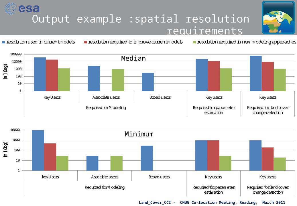
Land Cover CCI Product Specification
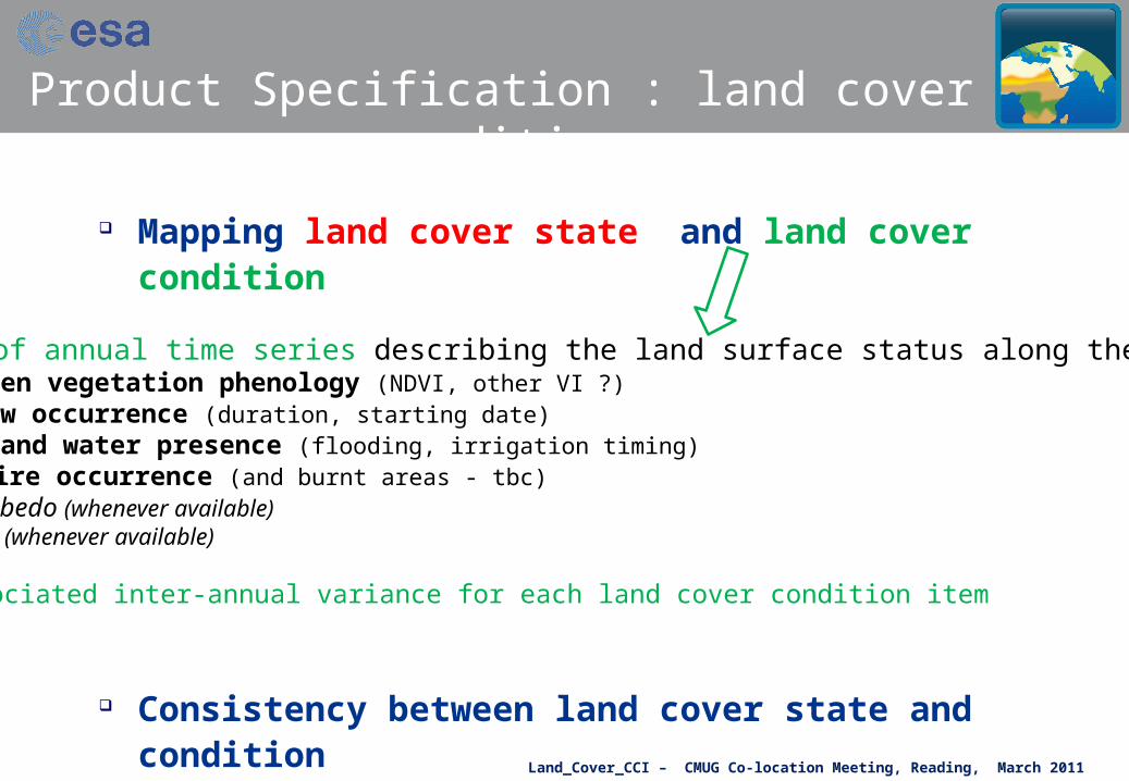
Mapping land cover state and land cover condition
through the use of land surface feature
The land cover change corresponds to a ‘permanent’ modification of the land cover state (not systematically mapped by CCI)
a stable ensemble of land surface features described by: - feature type (tree, shrub, water, built-up areas, permanent snow, etc.) - feature structure (veg. height, veg. density, building density, etc.)- feature homogeneity (mosaic/patterns of different features as urban fabric)- feature nature (level of artificiality, C3/C4 plant, etc).
Land_Cover_CCI – CMUG Co-location Meeting, Reading, March 2011
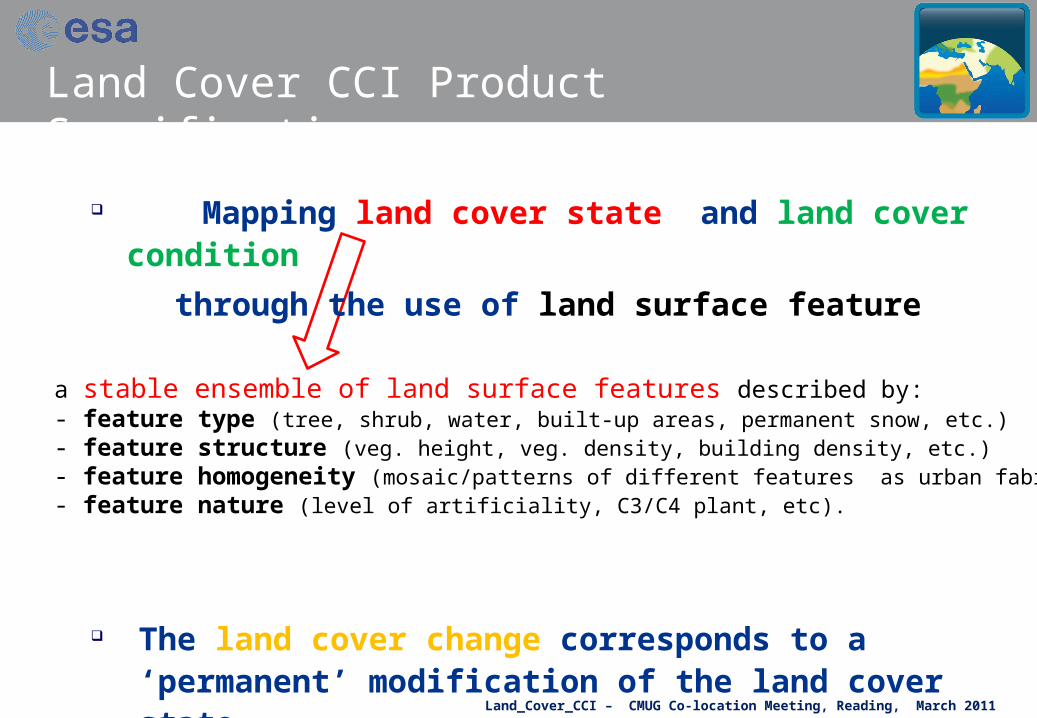
Product Specification : land cover state
Land cover state based on UN LCCS classifiers
Easy to translate in Plant Functional Types
Class PFT Description1 Broadleaved, evergreen2 Broadleaved, deciduous3 Needleleaved, evergreen4 Needleleaved, deciduous5 Shrubs6 Grassland7 Cropland, irrigated8 Cropland, non-irrigated9 Wetland10 Barren land or sparse vegetation11 Urban 12 Water13 Snow & Ice
Land_Cover_CCI – CMUG Co-location Meeting, Reading, March 2011
Mapping land cover state and land cover condition
Consistency between land cover state and condition
to be verified by cross-checking and with LST dataset
set of annual time series describing the land surface status along the year: - green vegetation phenology (NDVI, other VI ?) - snow occurrence (duration, starting date)- inland water presence (flooding, irrigation timing)- fire occurrence (and burnt areas - tbc)- albedo (whenever available)- LAI (whenever available)
+ associated inter-annual variance for each land cover condition item
Product Specification : land cover condition

Land_Cover_CCI – CMUG Co-location Meeting, Reading, March 2011
Land Cover State Land Cover Condition
• NDVI• Albedo• LAI
OccurrenceProbability
• Snow• Water• Active Fire• Burnt Areas
•
per pixel
per object
Detection algo or products
Map combiningthe classifiers (or feature charact.)in LC state class
annual
inter-annual
+ Uncertainty information at class level
Land Cover CCI Product Specification

Land_Cover_CCI – CMUG Co-location Meeting, Reading, March 2011
Matching the GCOS – CMUG – CCI requirements
Land Cover CCI product: consistent land cover on the long term withsome intra-annual dynamic information,
change only for major hot spot areas, and internal consistency focus in model surface parameters perspective
Best stable map
300m - 1km
80%
-
>85% 80%
- 85%
>90%
>95%
90% -
95 %
>95%
>85%
-
Land_Cover_CCI – CMUG Co-location Meeting, Reading, March 2011
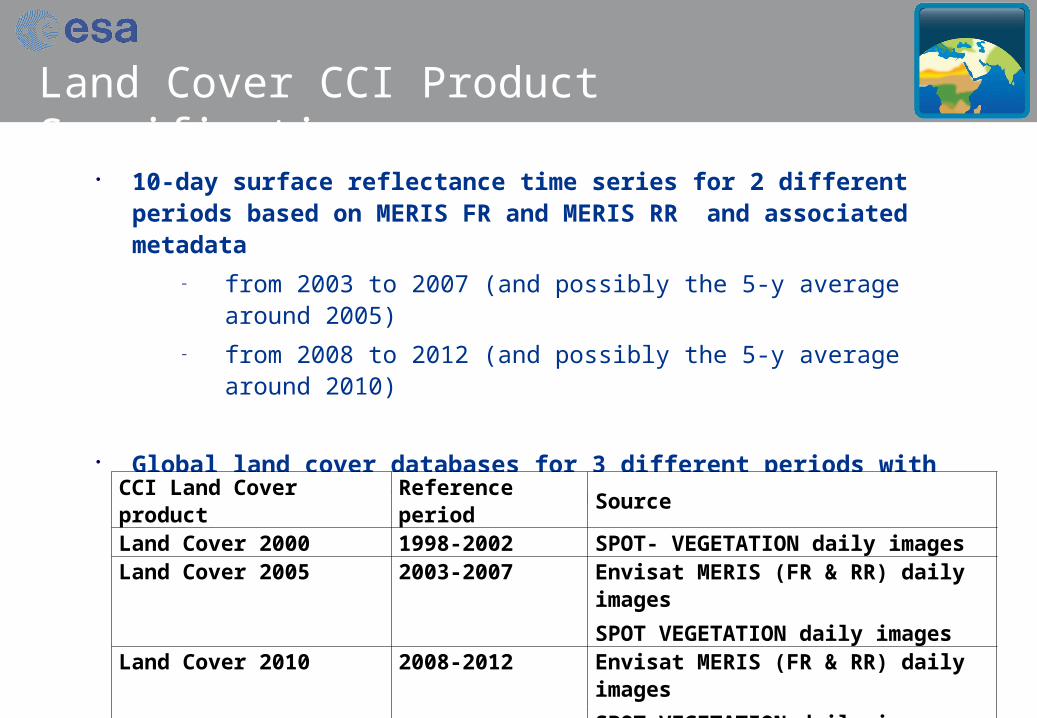
10-day surface reflectance time series for 2 different periods based on MERIS FR and MERIS RR and associated metadata
– from 2003 to 2007 (and possibly the 5-y average around 2005) – from 2008 to 2012 (and possibly the 5-y average around 2010)
Global land cover databases for 3 different periods with an overall accuracy > 80 % and a temporal stability of 80-85%
CCI Land Cover product Reference period Source Land Cover 2000 1998-2002 SPOT- VEGETATION daily imagesLand Cover 2005 2003-2007 Envisat MERIS (FR & RR) daily images
SPOT VEGETATION daily imagesLand Cover 2010 2008-2012 Envisat MERIS (FR & RR) daily images
SPOT VEGETATION daily images
Land Cover CCI Product Specification

Land_Cover_CCI – CMUG Co-location Meeting, Reading, March 2011
Satellite data Source Technical specifications
ENVISAT MERIS FRS_1P ESA 300-m resolution full swath 15 spectral bands in visible and near infrared Global coverage Output of 3rd re-processing required From 2003 on
ENVISAT MERIS RR_1P ESA 1.2-km resolution full swath 15 spectral bands in visible and near infrared Global coverage Output of 3rd re-processing required From 2001 on
SPOT-VGT (S1 or P products) CNES (VITO) 1-km spatial resolution 4 spectral bands (blue, red, NIR and SWIR) Daily synthesis (for S1 products) Global coverage 2nd re-processed version required (the VGT2 drift) From 1998 on
Envisat ASAR ASA_WSM_1P ESA 75-m spatial resolution Full swath products C band Global coverage From 2002 on
MODIS global surface reflectance daily products 250m
NASA Daily images 2 spectral bands (red, NIR) MOD09GQ for TERRA and MYD09GQ for AQUA Global coverage Collection 5 required
MODIS global surface reflectance daily products
500m and 1km
NASA Daily images 7 spectral bands (visible to SWIR) MOD09GA for TERRA and MYD09GA for AQUA Global coverage Collection 5 required
Product Specification : satellite data sources
Land_Cover_CCI – CMUG Co-location Meeting, Reading, March 2011
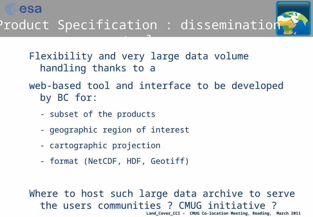
Flexibility and very large data volume handling thanks to a
web-based tool and interface to be developed by BC for:
- subset of the products
- geographic region of interest
- cartographic projection
- format (NetCDF, HDF, Geotiff)
Where to host such large data archive to serve the users communities ? CMUG initiative ?
Product Specification : dissemination tool
Land_Cover_CCI – CMUG Co-location Meeting, Reading, March 2011
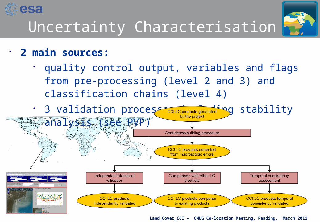
Uncertainty Characterisation 2 main sources:
quality control output, variables and flags from pre-processing (level 2 and 3) and classification chains (level 4)
3 validation processes including stability analysis (see PVP)

Land_Cover_CCI – CMUG Co-location Meeting, Reading, March 2011

Land_Cover_CCI – CMUG Co-location Meeting, Reading, March 2011
Uncertainty use Uncertainty information to be used in the classification
algorithms Uncertainty related to reference information taken into
account for the accuracy assessment Land cover error interpretation for PFT mapping
1 2 3 4 5 6 7 8 9 10 11 12
Generalized Land Cover Legend
Evergreen Needleleaf Trees
Evergreen Broadleaf Trees
Deciduous Needleleaf Trees
Deciduous Broadleaf Trees
Mixed / Other Trees
Shrubs
Herbaceous Vegetation
Cultivated and Managed Veg.
Urban / Built-up
Snow and Ice
Barren
Open Water
1 Evergreen Needleleaf Trees2 Evergreen Broadleaf Trees 87.13 Deciduous Needleleaf Trees 74.5 75.84 Deciduous Broadleaf Trees 67.6 78.0 85.45 Mixed / Other Trees 70.7 73.5 89.7 89.96 Shrubs 54.2 59.1 78.1 80.0 78.67 Herbaceous Vegetation 45.0 50.6 70.5 71.5 72.7 89.78 Cultivated and Managed Veg. 52.5 61.5 75.3 82.9 80.0 92.3 87.49 Urban / Built-up 34.2 33.2 53.1 48.3 55.3 58.9 65.9 55.410 Snow and Ice 21.7 15.6 39.4 32.4 42.1 50.6 58.2 45.6 69.111 Barren 36.6 30.5 54.3 47.3 57.0 65.5 73.1 60.5 78.5 85.112 Open Water 30.6 24.0 48.2 40.6 50.1 57.7 65.1 53.1 75.6 88.9 89.7
dissimilarity matrix for 9 model paramaters

Land_Cover_CCI – CMUG Co-location Meeting, Reading, March 2011
Integrated perspective of ECVs
• Partly embendded in the Land Cover product specification through the land cover condition
• Spatial consistency between Ocean/Land ECVs:
for a global land / sea mask
• Benefit from other ECVs:
AEROSOL : participation to progress meeting for info exchange
CLOUDS : in support of cloud screening at pixel level (level 2)
GLACIERS : still to be investigated – possible input for LC product
• Spatio-temporal consistency with FIRE ECV
Land_Cover_CCI – CMUG Co-location Meeting, Reading, March 2011
Need for ECMWF data
• Total Ozone Content for 1998 to 2012
for atmospheric correction to retrieve surface reflectance

Land_Cover_CCI – CMUG Co-location Meeting, Reading, March 2011
33rd ISRSE Symposium May 4-8, 2009 (Stresa – Italy)
21
Thank you for attention


![ESA [ECV] CCI Newsletter - Met Officeensembles-eu.metoffice.com/cmug/06_CMUG_web.pdf · 2016-01-26 · CMUG CCI Newsletter | Issue n. 6 | Jan 2016 The next cmug@metoffice.gov.uk Met](https://img.pdfslide.us/doc/110x75/5f3e774154e648248c07c6ad/esa-ecv-cci-newsletter-met-officeensembles-eu-2016-01-26-cmug-cci-newsletter.jpg)


![fire cci cmug reading [Modo de compatibilidad]ensembles-eu.metoffice.com/cmug/fire_cci cmug reading.pdf · Fire Disturbance CMUG Interaction meeting Emilio Chuvieco (fire_cci science](https://img.pdfslide.us/doc/110x75/5e7b9cf179cd5d350441cb41/fire-cci-cmug-reading-modo-de-compatibilidadensembles-eu-cmug-readingpdf-fire.jpg)