Embed Size (px)
Citation preview

LAND USE Testimony of Christina Snow
SUMMARY OF CONCLUSIONS
This section of the Final Staff Assessment (FSA) analyzes the potential effects on land use that would occur by construction and operation of the proposed Hidden Hills Solar Electric Generating System (HHSEGS). Energy Commission staff concludes the proposed project would not result in the conversion of any farmland (as classified by the Farmland Mapping and Monitoring Program) to non-agricultural use or conflict with existing agricultural zoning or Williamson Act contracts; would not disrupt or divide the physical arrangement of an established community; and would not conflict with any applicable habitat conservation plan, natural community conservation plan or biological opinion. However, staff has determined that the proposed project would not be consistent with applicable County of Inyo laws, ordinances, regulations, and standards (LORS) pertaining to land use planning. Staff has further determined that the proposed project’s conflict with such plans, policies and regulations of Inyo County would result in a significant impact under the California Environmental Quality Act (CEQA) Guidelines.
Socioeconomics Figure 1 and Socioeconomics Table 2 do not identify the presence of an environmental justice community. Therefore, the minority population in the six-mile buffer does not constitute an environmental justice population as defined by Environmental Justice: Guidance Under the National Environmental Policy Act and would not trigger further scrutiny for purposes of an environmental justice analysis.
INTRODUCTION
This land use analysis addresses project compatibility with existing or reasonably foreseeable1 land uses; consistency with County of Inyo applicable laws, ordinances, regulations, and standards (LORS); and potential project related direct, indirect, and cumulative environmental effects.
The HHSEGS solar fields and associated facilities are located on privately owned land that is adjacent to the Nevada border in unincorporated Inyo County, California. The electric transmission line and natural gas pipeline alignments begin on the project site and then exit the eastern border of the project site extending into Nevada. The project linears will be located primarily on federal land managed by the U.S. Bureau of Land Management (BLM). The California Energy Commission has jurisdiction over the portion of the proposed project that lies within California, which is subject to CEQA. Land use impacts associated with the portions of the project located in Nevada will be analyzed in a separate environmental analysis prepared by the Bureau of Land Management pursuant to the National Environmental Policy Act (NEPA) and are exempt from CEQA pursuant to Public Resources Code § 21080(b)(14).
1Whether a project is reasonably foreseeable (i.e., a "probable future project") for purposes of cumulative impact analysis depends on the nature of the resource in question, the location of the project, and the type of project. (14 California Code of Regulations, Section 15130(b)(2)).
December 2012 4.5-1 LAND USE
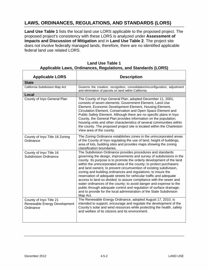
LAWS, ORDINANCES, REGULATIONS, AND STANDARDS (LORS)
Land Use Table 1 lists the local land use LORS applicable to the proposed project. The proposed project’s consistency with these LORS is analyzed under Assessment of Impacts and Discussion of Mitigation and in Land Use Table 2. The project site does not involve federally managed lands, therefore, there are no identified applicable federal land use related LORS.
Land Use Table 1 Applicable Laws, Ordinances, Regulations, and Standards (LORS)
Applicable LORS Description State California Subdivision Map Act Governs the creation, recognition, consolidation/reconfiguration, adjustment
and elimination of parcels on land within California. Local County of Inyo General Plan
The County of Inyo General Plan, adopted December 11, 2001, consists of seven elements: Government Element, Land Use Element, Economic Development Element, Housing Element, Circulation Element, Conservation and Open Space Element and Public Safety Element. Although there are no specific plans in Inyo County, the General Plan provides information on the population, housing units and other characteristics of several communities within the county. The proposed project site is located within the Charleston View area of the county.
County of Inyo Title 18 Zoning Ordinance
The Zoning Ordinance establishes zones in the unincorporated areas of the County of Inyo regulating the use of land, height of buildings, area of lots, building sites and provides maps showing the zoning classification boundaries.
County of Inyo Title 16 Subdivision Ordinance
The Subdivision Ordinance provides procedures and standards governing the design, improvements and survey of subdivisions in the county. Its purpose is to promote the orderly development of the land within the unincorporated area of the county; to protect purchasers and land owners; to prevent circumvention of existing subdivision, zoning and building ordinances and regulations; to insure the reservation of adequate streets for vehicular traffic and adequate access to land so divided; to assure compliance with the sewer and water ordinances of the county; to avoid danger and expense to the public through adequate control and regulation of surface drainage; and to provide for the local administration of the State Subdivision Map Act.
County of Inyo Title 21 Renewable Energy Development Ordinance
The Renewable Energy Ordinance, adopted August 17, 2010, is intended to support, encourage and regulate the development of the County’s solar and wind resources while protecting the health, safety and welfare of its citizens and its environment.
December 2012 4.5-2 LAND USE

SETTING
PROJECT SITE The project site is approximately eight miles2 directly south of Pahrump, Nevada and approximately 45 miles west of Las Vegas, Nevada. The city of Los Angeles is located approximately 180 miles southwest and Edwards Air Force Base is located approximately 130 miles west-southwest of the site. The unincorporated towns of Tecopa and Shoshone are the two closest California communities, located approximately 24 miles southwest and 36 miles west of the project site. Death Valley National Park is located approximately 20 miles west of the project site. The HHSEGS is proposed to be located on approximately 3,097 acres (5.12 square miles) of privately owned land in southeastern Inyo County, California immediately adjacent to the Nevada border. The project site is not developed, but contains unimproved dirt roads as a result of a previously approved development consisting of 170 parcels. Currently, there are no agricultural uses on the proposed HHSEGS site, although approximately 12 acres of land within the project boundary had previously been used as an orchard.
HHSEGS will consist of two solar fields and associated facilities that include a northern solar plant (Solar Plant 1) and a southern solar plant (Solar Plant 2). Solar Plant 1 consists of approximately 1,483 acres (2.3 square miles), and Solar Plant 2 will consist of approximately 1,510 acres (2.4 square miles). A common area encompassing 103 acres will be established on the southeastern corner of the site and will accommodate an administration, warehouse, switchyard and maintenance complex as well as an asphalt-paved visitor and employee parking area. The administration complex will occupy approximately 4.8 acres of the 103-acre common area (AFC, Figure 1.2-3).
The temporary construction laydown area, consisting of 180 acres (AFC, Figure 2.1-3), would be located immediately west of the Solar Plant 1 area. The project site and adjacent construction laydown area have not been developed except for the previously mentioned unimproved roads and trails throughout the site and the abandoned 12-acre orchard. Immediately south of the proposed project lies a sparsely populated residential area, Charleston View. Approved in the 1970s, Charleston View contains parcels ranging in size from two acres to 40 acres. The land use adjacent to the western and northern sides of the proposed project site is predominately undeveloped land with parcels ranging from 20 acres to larger tracts of land that are managed by BLM. Lands adjacent to the project on the eastern boundary within Nevada are also undeveloped with a large portion managed by the BLM and a privately owned smaller portion. Refer to Land Use Figure 2, which depicts the project site and surrounding designations.
The access to the HHSEGS site would be from the existing two-lane Old Spanish Trail Highway3 to the project entrance road on the east side of the project. Secondary access
2 28 miles is the driving distance from the proposed project to Pahrump, Nevada. Eight (8) miles is the direct distance from southern Pahrump to the proposed project’s northern boundary (Solar Field 1). 3 The road is referred to as Tecopa Road/Highway in Nevada, although Old Spanish Trail Highway and Tecopa Road have been used interchangeably.
December 2012 4.5-3 LAND USE

would be from Old Spanish Trail Highway along the west side of the site, then along a paved road between the two solar plants.
Transmission Lines
The HHSEGS project will interconnect to the Valley Electric Association (VEA) system4. The interconnection would require an approximately 10-mile-long generation tie-line (gen-tie line) from the HHSEGS project site to the proposed Crazy Eyes Tap Substation5, where the project would interconnect to the VEA electric grid. The gen-tie line would originate at the HHSEGS’s onsite switchyard, cross the state line, avoiding the mesquite vegetation to the south, and continue east for approximately 1.5 miles until reaching Tecopa Road. At Tecopa Road, the route would head northeast paralleling Old Spanish Trail Highway until it reaches the Crazy Eyes Tap Substation, which would be located immediately east of the Tecopa Road/SR 160 intersection. The Crazy Eyes Tap Substation would interconnect to the existing VEA Pahrump-Bob Tap 230-kV line.
Natural Gas Pipeline A 12-inch-diameter natural gas pipeline would be required for the project. Kern River Gas Transmission Company (KRGT) proposes to construct the pipeline from the HHSEGS meter station, to be located in the HHSEGS common area, extending 32.4 miles to KRGT’s existing mainline system just north of Goodsprings in Clark County, Nevada. (CH2 2012ee)
A meter station, approximately 300 by 300 feet, including the pig receiver facilities, would be constructed and would be surrounded by a 6-foot-tall chain-link fence with three strands of barbed wire (approximately 7 feet high total). The meter station would be shaded by a canopy to cover the meter runs and associated instrumentation and valving. A data acquisition and control (DAC) building would be located within the meter station. Data acquisition, control, uninterrupted power supply (UPS), and communication equipment would be installed inside the DAC building. Yard lights would be installed on the DAC building and meter building exterior. The light fixtures would be shielded or hooded and directed downward.
As indicated earlier, the natural gas pipeline would be located in Nevada, primarily on federal land managed by the BLM and will be analyzed in a separate environmental document prepared by BLM.
SURROUNDING AREA Inyo County has a total land area of approximately 6.5 million acres and is the second largest county in California. Although the county contains a large land area, only 1.9 percent of the land is held in private ownership. Federal agencies own 91.6 percent, the State of California owns 3.5 percent, the Los Angeles Department of Water and Power (LADWP) owns 2.7 percent, and Inyo County and other local agencies (including reservation lands) make up the remaining 0.3 percent. 4 In January 2013, VEA will become a participating transmission owner (PTO) and will turn operational control of its facilities over to the California Independent System Operator (CAISO). 5 In the HHSEGS Application for Certification (and in the Preliminary Staff Assessment, CEC 2012u), this substation was referred to as the Tap Substation.
December 2012 4.5-4 LAND USE

The project site is located on private land within a community identified in the General Plan as Charleston View. The Charleston View area contains various parcels of different sizes and is sparsely populated. The 2010 U.S. Census data6 indicates there are 68 residents living in California within six miles of the project site.
Existing land uses immediately adjacent to and nearby the proposed HHSEGS project site within Charleston View include:
• North: The area to the north of the project site consists of lands within California and Nevada. These areas contain undeveloped land owned and managed by the BLM.
• South: The area immediately adjacent to the project site consists of the Charleston View rural residential community that was approved in the 1960s that consists of several lots that are predominately 2.5 acres in size. The area is sparsely populated and consists of scattered residences, trailers and outbuildings.
• East: Consists of a large area of land within Nevada that is predominately undeveloped and is managed by BLM. There are also scattered private inholdings within these BLM lands. A 550-acre firearms training institute (Front Sight Firearms Training Institute) is located approximately two miles northeast of the project site in Nevada. A portion of the land to the east lies within California and is partially developed for residential use as part of the Charleston View area. In addition, the recently approved St. Therese Mission located slightly southeast of the project site is currently under construction.
• West: Larger undeveloped parcels in private ownership and undeveloped land owned and managed by BLM.
The project site and surrounding area do not contain land identified as Important Farmlands (California Department of Conservation, 2008).
A military airspace area, called R-2508 Special Use Airspace Complex, lies approximately 10 to 15 miles west of the project site. The R-2508 Complex provides the largest single area of overland Special Use Airspace (SUA) in the United States and is an important national military asset that provides an area for realistic military training. The airspace and associated land area consists of bombing ranges, supersonic flight corridors, low altitude high speed maneuver areas, radar testing areas, warfare training areas, and refueling training areas. The R-2508 Special Use Airspace Complex includes more than 20,000 square miles and consists of the overlying Restricted Area R-2508, five underlying restricted areas, and ten Military Operations Areas (MOA).
The Department of Defense administered a Joint Land Use Study (JLUS) that was coordinated by the Governor’s Office of Planning and Research. The JLUS was a collaborative effort between local communities, active military installations, and other stakeholders to encourage a collaborative planning process to ensure that land uses surrounding the SUAs are compatible and strategies are developed to reduce the impact of existing community and military activities on each other. Compatibility issues considered as part of this study include alternative energy development. The concern of alternative sources of energy projects include compatibility issues related to glare or 6 Source: U.S. Census Bureau, 2010 Census
December 2012 4.5-5 LAND USE

vertical obstruction or other interference with military operations.
GENERAL PLAN LAND USE
PROJECT SITE The 2001 Inyo County General Plan Update was approved by the Inyo County Board of Supervisors on December 11, 2001. The general plan identifies the project area as the Charleston View area. The general plan land use designation on the proposed site is Open Space and Recreation (OSR) and Resort/Recreational (REC) and the zoning is Open Space 40-acre minimum (OS-40).
The OSR general plan designation allows for existing and planned public parks, ball fields, horse stables, greenbelts, and similar compatible uses and typically has a minimum parcel size of 40 acres. The permitted uses for the Open Space zone includes single-family dwellings, farms and ranches for a variety of agricultural activities (including livestock), animal hospitals or kennels, wildlife refuges, and wilderness areas and uses. Additional accessory and conditional uses are allowed in the Open Space zone related to dwellings and signs as well as public, quasi public, agricultural and mining uses. As part of a statewide initiative to help identify the transmission projects needed to accommodate California’s renewable energy goals, called the Renewable Energy Transmission Initiative (RETI), the Energy Commission and stakeholders identified areas within California that could be developed for renewable energy (Competitive Renewable Energy Zones or CREZs). Recognizing that the county would potentially be subject to large renewable energy development, Inyo County requested to participate in the RETI Stakeholder Steering Committee (SSC) and identified areas within the county that could be potential CREZs. At that time, the Charleston View area was identified as a potential CREZ by the Inyo County Board of Supervisors and later, on August 17, 2010, the Inyo County Board of Supervisors adopted a Renewable Energy Ordinance, Title 21, to provide a framework for renewable energy projects and to ensure that potential adverse impacts from such development were addressed.
To further support potential renewable energy projects, Inyo County Board of Supervisors adopted a Solar and Wind Renewable Energy General Plan Amendment (REGPA) on April 26, 2011, which identified on a programmatic level, the Charleston View area as well as 14 other areas within the county for potential development of renewable energy. This REGPA was in place at the time the HHSEGS AFC was submitted to the Energy Commmission on August 5, 2011. On September 6, 2011, the Inyo County Board of Supervisors rescinded the County’s REGPA due to a legal challenge from the Sierra Club and the Center for Biological Diversity, which effectively eliminated the overlay zone that was discussed in the AFC. As a result of the revocation of the REGPA, the proposed project site is now subject to the original general plan designations of OSR and REC.
December 2012 4.5-6 LAND USE
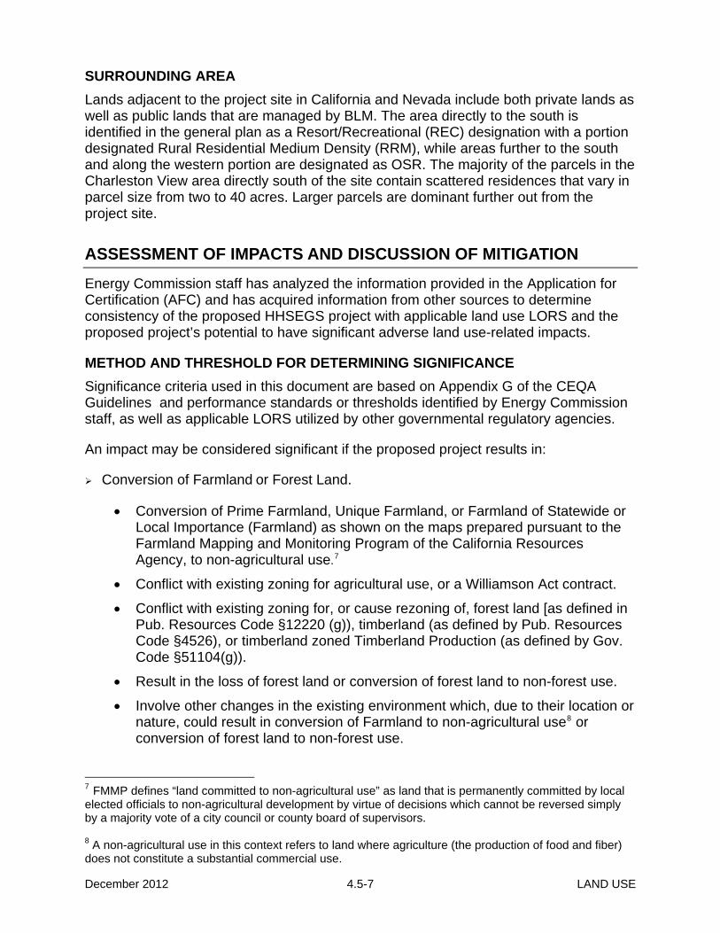
SURROUNDING AREA Lands adjacent to the project site in California and Nevada include both private lands as well as public lands that are managed by BLM. The area directly to the south is identified in the general plan as a Resort/Recreational (REC) designation with a portion designated Rural Residential Medium Density (RRM), while areas further to the south and along the western portion are designated as OSR. The majority of the parcels in the Charleston View area directly south of the site contain scattered residences that vary in parcel size from two to 40 acres. Larger parcels are dominant further out from the project site.
ASSESSMENT OF IMPACTS AND DISCUSSION OF MITIGATION
Energy Commission staff has analyzed the information provided in the Application for Certification (AFC) and has acquired information from other sources to determine consistency of the proposed HHSEGS project with applicable land use LORS and the proposed project’s potential to have significant adverse land use-related impacts.
METHOD AND THRESHOLD FOR DETERMINING SIGNIFICANCE Significance criteria used in this document are based on Appendix G of the CEQA Guidelines and performance standards or thresholds identified by Energy Commission staff, as well as applicable LORS utilized by other governmental regulatory agencies.
An impact may be considered significant if the proposed project results in:
Conversion of Farmland or Forest Land.
• Conversion of Prime Farmland, Unique Farmland, or Farmland of Statewide or Local Importance (Farmland) as shown on the maps prepared pursuant to the Farmland Mapping and Monitoring Program of the California Resources Agency, to non-agricultural use.7
• Conflict with existing zoning for agricultural use, or a Williamson Act contract.
• Conflict with existing zoning for, or cause rezoning of, forest land [as defined in Pub. Resources Code §12220 (g)), timberland (as defined by Pub. Resources Code §4526), or timberland zoned Timberland Production (as defined by Gov. Code §51104(g)).
• Result in the loss of forest land or conversion of forest land to non-forest use.
• Involve other changes in the existing environment which, due to their location or nature, could result in conversion of Farmland to non-agricultural use8 or conversion of forest land to non-forest use.
7 FMMP defines “land committed to non-agricultural use” as land that is permanently committed by local elected officials to non-agricultural development by virtue of decisions which cannot be reversed simply by a majority vote of a city council or county board of supervisors. 8 A non-agricultural use in this context refers to land where agriculture (the production of food and fiber) does not constitute a substantial commercial use.
December 2012 4.5-7 LAND USE

Physical disruption or division of an established community.
Conflict with any applicable habitat conservation plan, natural community conservation plan, or biological opinion.
Conflict with any applicable land use plan, policy, or regulation of an agency with jurisdiction, or that would normally have jurisdiction, over the project adopted for the purpose of avoiding or mitigating environmental effects. This includes, but is not limited to, a General Plan, redevelopment plan, or zoning ordinance.
Result in incremental impacts that, although individually limited, are cumulatively considerable when viewed in connection with other project-related effects or the effects of past projects, other current projects, and probable future projects.9
In general, a power plant and its related facilities may also be incompatible with existing or planned land uses, resulting in potentially significant impacts, if they create unmitigated noise, dust, or a public health or safety hazard or nuisance; result in adverse traffic or visual impacts; or preclude, interfere with, or unduly restrict existing or future uses. Refer to other sections of this document for a detailed discussion of any additional potential project-related impacts and recommended conditions of certification.
DIRECT/INDIRECT IMPACTS AND MITIGATION
This section discusses the applicable potential project impacts and associated methods and thresholds of significance referenced above. As part of this analysis, staff has also considered if there are any environmental justice populations in the vicinity of the project and whether land use impacts would occur as a result of the proposed HHSEGS project.
AGRICULTURE AND FOREST
Would the project convert Farmland to non-agricultural use? The Department of Conservation Farmland Mapping and Monitoring Program (FMMP) produces Important Farmland Maps and statistical data used for analyzing impacts on California’s agricultural resources. The FMMP is required to prepare, update, and maintain Important Farmland Series Maps and other soils and land capability information. The Important Farmland Maps depict categories of Prime Farmland, Farmland of Statewide Importance, Unique Farmland, Farmland of Local Importance, Grazing Land, Urban and Built-up Land, Other Land and Water. The FMMP designates the proposed HHSEGS project site and the construction laydown area as “Other Land” which is defined as land not included in any other mapping category (CDOC 2008).
The proposed HHSEGS project site does not contain, and would therefore not convert,
9 Cumulative impacts refer to two or more individual effects which, when considered together, are considerable or which compound or increase other environmental impacts. The individual effects may be changes resulting from a single project or a number of separate projects and can result from individually minor, but collectively significant actions taking place over a period of time (CEQA Guidelines §15355; 40 CFR 1508.7)
December 2012 4.5-8 LAND USE

any farmland with FMMP designations of Prime Farmland, Farmland of Statewide Importance, Unique Farmland, or Farmland of Local Importance to non-agricultural use. Therefore, the proposed HHSEGS project would have no impact with respect to farmland conversion.
Would the project conflict with existing zoning for agricultural use or a Williamson Act contract. The California Land Conservation Act, commonly referred to as the Williamson Act, enables local governments to enter into contracts with private landowners for the purpose of restricting specific parcels of land to agricultural or related open space uses. (Chapter 7, Agricultural Land, Gov. Code § 51200-51297.4) There are no existing agricultural uses present on the proposed project site or laydown area. The proposed HHSEGS project is not located on land that is under a Williamson Act contract and as a result would not conflict with any Williamson Act contracts.
Would the project conflict with existing zoning for, or cause rezoning of, forest land (as defined in Pub. Resources Code §12220(g)), timberland (as defined by Pub. Resources Code §4526), or timberland zoned Timberland Production (as defined by Gov. Code §51104(g)).
The proposed project site and laydown area are not zoned for forest land, timberland, or for timberland production. In addition, there is no land zoned for such purposes within one mile of the project site. Therefore, there would be no conflict with, or cause for, rezoning of forest land or timberland and as a result there would be no impact to forest land or timberland.
PHYSICAL DISRUPTION OR DIVISION OF AN ESTABLISHED COMMUNITY The proposed HHSEGS project and laydown area would be located in an area that is designated as open space in unincorporated Inyo County. The power plant and laydown area would be located entirely on leased private property, on a 3,097-acre site. The nearest residence to any of the power blocks is approximately 3,500 feet south of the Solar Plant 2 power block, and about 950 feet south of the project’s southern boundary. There are scattered dwellings and trailers located beyond these residents to the south and east of the project site.
There would not be a need to relocate any residences as a result of the HHSEGS project. The HHSEGS project would be located entirely within an area that does not contain any residential development. Therefore, the HHSEGS project would not physically divide or disrupt any community within the Charleston View area. In addition, the proposed project would not involve the displacement of any existing development or result in new development that would physically divide an existing community.
The project’s linear facilities would not present new physical barriers. The proposed transmission and gas lines would originate from the HHSEGS property in California and traverse the California-Nevada border before connecting to facilities within Nevada.
December 2012 4.5-9 LAND USE

CONFLICT WITH ANY APPLICABLE HABITAT OR NATURAL COMMUNITY CONSERVATION PLAN The HHSEGS project is not located within any Habitat Conservation Plan or Natural Community Conservation Plan and there will be no conflicts as a result of the proposed project.
CONFLICT WITH ANY APPLICABLE LAND USE PLAN, POLICY OR REGULATION Energy Commission staff evaluates (Cal. Code Regs. Tit. 20, § 1744) the information provided by the applicant in the AFC (and any amendments), project design, site location, and operational components to determine if elements of the proposed project would conflict with any applicable land use plan, policy, or regulation of an agency with jurisdiction over the project, or that would normally have jurisdiction over the project except for the Energy Commission’s exclusive authority. As part of the licensing process, the Energy Commission must determine whether a proposed facility complies with all applicable state, regional, and local LORS (Pub. Resources Code § 25523[d][1]). The Energy Commission must either find that a project conforms to all applicable LORS or make specific findings that a project’s approval is required for public convenience and necessity even where the project is not in conformity with all applicable LORS (Pub. Resources Code § 25525). When determining LORS compliance, staff is required to give “due deference” to a local agency’s assessment of whether a proposed project is consistent with that agency’s zoning and general plan (Cal. Code Regs. Tit. 20, § 1714.5). On past projects, staff has requested that the local agency provide a discussion of the findings and conditions that the agency would make when determining whether a proposed project would comply with the agency’s LORS, were they the permitting authority. Any conditions recommended by an agency are considered by Energy Commission staff for inclusion in the proposed conditions of certification for the project.
As part of staff’s analysis of local LORS compliance and to determine the county’s view of the project’s consistency with its general plan and zoning code, staff has reviewed Inyo County’s General Plan, Zoning Ordinance and Renewable Energy Ordinance with respect to the proposed project and has had personal communications with Inyo County staff regarding LORS compliance. As a follow-up, Inyo County submitted a letter, dated November 29, 2011 (INYO 2011a), to Energy Commission staff that stated the proposed HHSEGS project is inconsistent with the general plan designation and zoning on the project site and indicated that the project is inconsistent with the Renewable Energy Ordinance.
An additional letter submitted by Inyo County to BrightSource Energy, Inc (February 23, 2012, INYO 2012c), reconfirmed Inyo County’s determination that the project as proposed is not consistent with the general plan or zoning ordinance.
In addition to determining whether the project complies with local LORS, staff also makes a determination as to whether or not the project would create a significant impact. There may be instances where a project would conflict with LORS and not create a significant impact under CEQA.
Based on staff’s independent review and analysis of the AFC and the local land use
December 2012 4.5-10 LAND USE

LORS, staff concludes that the County of Inyo’s General Plan, Zoning Ordinance, Subidivion Ordinance and Renewable Energy Ordinance are applicable to the proposed HHSEGS project.
COMPLIANCE WITH LORS
The AFC identified several LORS (Table 5.6-2) and indicated that the proposed HHSEGS project was in compliance with all applicable local LORS. Since the time of the AFC submittal to the Energy Commission, most of the LORS identified in the AFC have been rescinded as part of the revocation of the Solar and Wind Renewable Energy General Plan Amendment (REGPA) on September 6, 2011.
Land Use Table 2 summarizes the HHSEGS project conformance with applicable LORS.
Land Use Table 2 Project Compliance with Adopted and Applicable LORS
Applicable LORS Description Consistency Determination
Basis for Consistency
State
California Subdivision Map Act Governs the creation, recognition, consolidation/reconfiguration, adjustment and elimination of parcels on land within California.
No The project site consists of 172 legally created parcels that will need to be combined to create one to three parcels.
Local
Inyo County General Plan
Provides comprehensive, long-range plans, policies, and goals to guide the physical development of the county.
No The project site is designated Open Space and Recreation (OSR) and Resort/Recreational (REC). Large renewable energy projects are not allowed in these land use designations.
Chapter 3 Government Element Goal Gov – 10: Energy Resources Policy Gov-10.1: Development
Encourages development of energy resources on both public and private lands consistent with policies and within the bounds of economic reason and sound environmental health.
Yes The project is a renewable energy project that is consistent with this general goal and policy.
Chapter 4 Land Use Element Commercial Goal LU-3: Provide commercial land uses that adequately serve the existing and anticipated future needs of the community and surrounding environs.
Policy LU-3.4: Resort/Recreational Designation (REC) This designation provides for a mixture of residential and recreational commercial uses, such as resorts, recreational facilities, motels, campgrounds, trailer parks, restaurants, general stores, service stations, and similar compatible uses. This designation is oriented toward tourist use, however, it also permits permanent residential use and public and quasi-public uses. The Floor Area Ratio (FAR) shall not exceed 0.40. The base residential density shall be 1 du/25 acres. Clustering of
No A portion of the project site is designated as REC and the project is not consistent with the intent of this policy. Inyo County has indicated that the tourist use is desired in this area. The intensity of the proposed project is not consistent with these goals and policies and a determination as to whether the project can incorporate elements that reduce this conflict has not been made by Inyo County.
December 2012 4.5-11 LAND USE

residential units is encouraged, with density of developed area allowed up to 24 du/net acre.
Chapter 4 Land Use Element Commercial Goal LU-5: Provide adequate public facilities and services for the existing and/or future needs of communities and their surrounding environs, and to conserve natural and managed resources.
Policy LU-5.1: Open Space and Recreation Designation This designation provides for existing and planned public parks, ball fields, horse stables, greenbelts, and similar compatible uses. The FAR shall not exceed 0.20. The minimum parcel size is generally 40 acres.
No The majority of the project site is designated as OSR. As indicated in the General Plan goals and policies, the project as proposed is inconsistent with those uses and there has been no review by Inyo County to determine appropriate measures to resolve this inconsistency.
Zoning Ordinance of the County of Inyo – Title 18
Provides a framework for development by indicating allowable uses and development standards that support the General Plan.
No The project site is zoned Open Space with a 40-acre Minimum (OS-40). Large renewable energy projects are not allowed in this zone district.
Inyo County Renewable Energy Ordinance – Title 21
Provides a mechanism for Inyo County to regulate the development of large scale renewable energy projects. Provides procedures outside of those that are within the Title 18 Zoning Ordinance.
No Renewable energy projects must be found to be consistent with the Inyo County General Plan prior to receiving a renewable energy impact determination or renewable energy permit or prior to entering into a renewable energy development agreement (Section 21.20.060 Consistency with the Inyo County General Plan)
Inyo County Subdivision Ordinance – Title 16
Provides a county process for implementing the California Subdivision Map Act.
No The project applicant has not submitted a Reversionary Map for county approval. The project applicant has not submitted a request for the abandonment of public road rights-of-way, as requested by Inyo County.
Inyo County General Plan State law requires each county and city to prepare and adopt a comprehensive and long-range general plan for its physical development (Government Code Section 65300). The general plan must include elements such as land use, circulation, housing, open-space, conservation, safety, and noise as identified in state law (Government Code Section 65302), to the extent that the topics are locally relevant. Once a general plan is adopted, its maps, diagrams, and development policies form the basis for a jurisdiction’s zoning, subdivision, and public works actions. Under California law, no specific plan, area plan/community plan, zoning, subdivision map, nor public works project may be approved unless the jurisdiction finds that it is consistent with the adopted general plan.
The Inyo County General Plan comprises several related documents, including the General Plan Summary, Goals and Policies Report, Background Report, Issues and Alternatives Report, and the Environmental Impact Report (EIR). The EIR prepared for the general plan was prepared in order to meet the requirements of CEQA. As part of that analysis, impacts were analyzed and mitigation measures were developed to reduce potential environmental impacts to less than significant levels where feasible. The Inyo County General Plan and EIR were approved on December 11, 2001.
December 2012 4.5-12 LAND USE

The land use element of the general plan designates the general distribution and intensity of land uses within the planning area while the open-space element describes measures for the preservation of open space for the protection of natural resources, the managed production of resources, and for public health and safety. The HHSEGS project site was identified in the general plan as Open Space and Recreation (OSR) and Resort/Recreational (REC).
As previously indicated, at the time the AFC was submitted to the Energy Commission (August 5, 2011), the County of Inyo had a Solar and Wind Renewable Energy General Plan Amendment (REGPA) in place that had been adopted by the Board of Supervisors on April 26, 2011. The REGPA was applicable to the Charleston View area, where the HHSEGS project site is located, as well as 14 other areas within the county.
The AFC Land Use Section 5.6 refers to this Inyo County General Plan REGPA as the primary planning document applicable to the project site. The REGPA provided the basis for approvals of solar or wind renewable energy facilities and established policies to encourage development of renewable energy in overlay zones in any zoning district under Title 18 of the Inyo County Code. The proposed project was identified by the REGPA as being within the Charleston View overlay zone. Projects that were within these overlay zones were subject to additional site-specific studies and appropriate environmental review according to Inyo County Code Title 21, Renewable Energy Development.
On September 6, 2011, the Inyo County Board of Supervisors rescinded the County’s REGPA due to a legal challenge from the Sierra Club and the Center for Biological Diversity, which effectively eliminated the overlay zone that was discussed in the AFC. As a result of the revocation of the REGPA, the proposed project is now subject to the original general plan designations of OSR and REC.
In Chapter 4 of Inyo County’s General Plan (Land Use Element), Land Use Policy 5.1 indicates that the OSR designation provides for existing and planned parks, ball fields, horse stables, greenbelts, and similar compatible uses. Although most of the project site is designated as OSR, there are some parcels in the southeastern portion of the site that are designated as REC. In addition, several parcels directly south of the project site are designated as REC, with some being designated as Rural Residential Medium Density (RRM).
The REC designation provides for a mixture of residential and recreational commercial uses, such as resorts, recreational facilities, motels, campgrounds, trailer parks, restaurants, general stores, service stations, and similar and compatible uses. The designation is oriented toward tourist use, but also permits permanent residential use; public and quasi-public uses.
A large solar electric generating system is not identified as an allowed use on lands designated as OSR or REC. The land uses identified as consistent with the project site would include uses that are generally open space uses that provide potential recreational opportunities. The proposed HHSEGS project is a large solar project that includes mirrors and solar power towers that would preclude open space uses on the project site. For these reasons, staff concludes that the proposed project is inconsistent
December 2012 4.5-13 LAND USE

with Inyo County’s General Plan and the corresponding analysis in the General Plan EIR.
As part of the responses to the PSA, the applicant contends that the proposed HHSEGS project is a public or quasi-public use and therefore, is allowed within the REC designation. The Inyo County General Plan, Chapter 8, Recreation Section 8.9, includes some discussion on examples of uses that are considered consistent with the REC designation. These include:
Active Recreation Area. Sites that have been modified with structures or facilities designed for their enjoyment, such as a playground or recreation center. Examples in the County would include Dehy County Park in Independence and the hot springs in Tecopa.
Open Space. A publicly owned or managed area that may be enjoyed for recreational activities even though its primary purpose may be some other activity (watershed protection, habitat protection, rangeland).
Passive Recreation Area. Areas used in their natural state with few structures or facilities other than parking and trails. Recreation Area. Any public or private space set aside or primarily oriented to recreational use.
Staff confirmed with Inyo County as to the allowed uses within a public or quasi-public area; uses that would potentially be allowed include, churches, communication facilities, public parks and neighborhood-serving utilities such as an electrical substation, a cable routing box, a telephone exchange and similar types of small utilities that serve a neighborhood. It is therefore staff’s determination that the HHSEGS project is inconsistent with the REC designation.
An additional response from the applicant indicated that the project as proposed is consistent due to the adoption of the General Plan Amendment 2004-06, which identifies all privately owned parcels with the Natural Resource and OSR designations to be designated as Rural Protection (RP). The significance being that the majority of the project site that is designated as OSR is now designated as RP. The applicant correctly identifies that the RP designation provides for the preservation of natural resources. The applicant further states that the General Plan Government Section indicates that renewable energy resources should be treated as natural resources and therefore, the HHSEGS project, as a natural resource, is allowed in the RP designation. Staff reviewed this resolution and determined that although the General Plan Amendment did re-designate parcels that were OSR to RP, it was applicable only to properties listed on the attachment to the resolution. The HHSEGS project site does not contain any of the attached listed parcels and the RP designation is not applicable to the project site. The intent of the RP designation is to apply to land or water areas that are essentially unimproved and planned to remain open in character, providing for the preservation of natural resources, the managed production of resources, low intensity agriculture including grazing, park and other low-intensity recreation, wildlife refuges,
December 2012 4.5-14 LAND USE
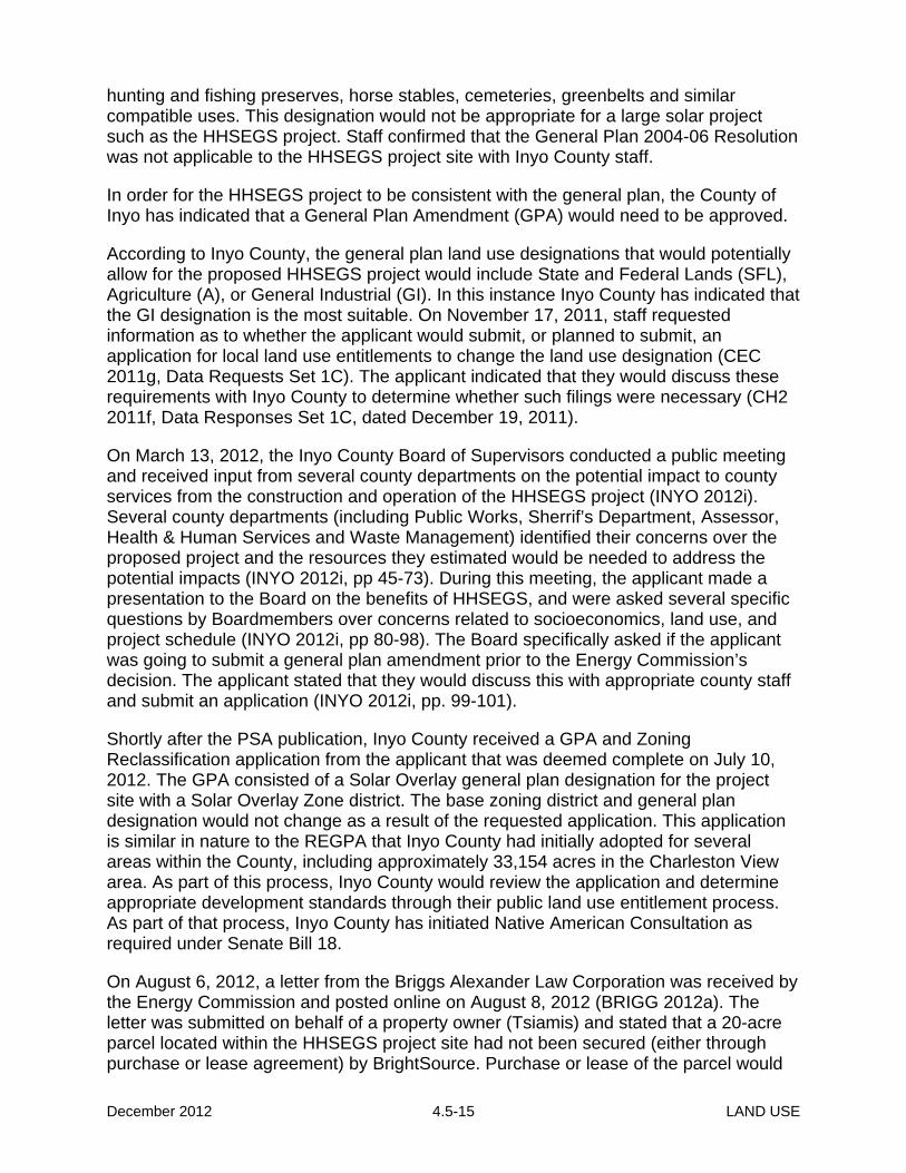
hunting and fishing preserves, horse stables, cemeteries, greenbelts and similar compatible uses. This designation would not be appropriate for a large solar project such as the HHSEGS project. Staff confirmed that the General Plan 2004-06 Resolution was not applicable to the HHSEGS project site with Inyo County staff.
In order for the HHSEGS project to be consistent with the general plan, the County of Inyo has indicated that a General Plan Amendment (GPA) would need to be approved.
According to Inyo County, the general plan land use designations that would potentially allow for the proposed HHSEGS project would include State and Federal Lands (SFL), Agriculture (A), or General Industrial (GI). In this instance Inyo County has indicated that the GI designation is the most suitable. On November 17, 2011, staff requested information as to whether the applicant would submit, or planned to submit, an application for local land use entitlements to change the land use designation (CEC 2011g, Data Requests Set 1C). The applicant indicated that they would discuss these requirements with Inyo County to determine whether such filings were necessary (CH2 2011f, Data Responses Set 1C, dated December 19, 2011).
On March 13, 2012, the Inyo County Board of Supervisors conducted a public meeting and received input from several county departments on the potential impact to county services from the construction and operation of the HHSEGS project (INYO 2012i). Several county departments (including Public Works, Sherrif’s Department, Assessor, Health & Human Services and Waste Management) identified their concerns over the proposed project and the resources they estimated would be needed to address the potential impacts (INYO 2012i, pp 45-73). During this meeting, the applicant made a presentation to the Board on the benefits of HHSEGS, and were asked several specific questions by Boardmembers over concerns related to socioeconomics, land use, and project schedule (INYO 2012i, pp 80-98). The Board specifically asked if the applicant was going to submit a general plan amendment prior to the Energy Commission’s decision. The applicant stated that they would discuss this with appropriate county staff and submit an application (INYO 2012i, pp. 99-101).
Shortly after the PSA publication, Inyo County received a GPA and Zoning Reclassification application from the applicant that was deemed complete on July 10, 2012. The GPA consisted of a Solar Overlay general plan designation for the project site with a Solar Overlay Zone district. The base zoning district and general plan designation would not change as a result of the requested application. This application is similar in nature to the REGPA that Inyo County had initially adopted for several areas within the County, including approximately 33,154 acres in the Charleston View area. As part of this process, Inyo County would review the application and determine appropriate development standards through their public land use entitlement process. As part of that process, Inyo County has initiated Native American Consultation as required under Senate Bill 18.
On August 6, 2012, a letter from the Briggs Alexander Law Corporation was received by the Energy Commission and posted online on August 8, 2012 (BRIGG 2012a). The letter was submitted on behalf of a property owner (Tsiamis) and stated that a 20-acre parcel located within the HHSEGS project site had not been secured (either through purchase or lease agreement) by BrightSource. Purchase or lease of the parcel would
December 2012 4.5-15 LAND USE

give BrightSource site control, and thus legal authority to seek a GPA and Zone Reclassification from Inyo County. The 20-acre Tsiamis parcel is located on the southeastern portion of the HHSEGS project site (See Land Use - Figure 3).
On August 10, 2012, Inyo County submitted a letter to Brightsource Energy, LLC stating that the GPA and Zoning Reclassification was incomplete since it was not signed by all the property owners, or by a designated representative of the owners. In a follow up email sent to a representative of BrightSource, Inyo County Counsel stated that they had not received three of the four property owners signatures located on the HHSEGS project site necessary to process the GPA and Zoning Reclassification (CEC 2012bb, tn 66647, August 13, 2012). Two of the three property owners who have not signed are related to the Wiley Trust, which has an existing lease agreement already in place with the applicant. Status of the remaining third property owner (Tsiamis parcel) remains in question, as the applicant continues to negotiate and finalize a settlement agreement.
On August 29, 2012, the Inyo County Planning Department conducted a public meeting at the Tecopa Senior Center to receive public input on the GPA and Zoning Reclassication for the HHSEGS project. Although, a representative of BrightSource indicated to Inyo County that they were moving forward with negotiations with the Tsiamis parcel, staff has not received official notice of site control. For further information on the issues associated with the Tsiamis parcel as it relates to site control, please see the Land Use Compatibility discussion of this Land Use section.
The applicant expects to obtain all the required signatures to process the GPA with the county. Once Inyo County receives a complete GPA application, the county will proceed with obtaining public input and continue to work closely with Energy Commission staff to incorporate appropriate anlalysis and development standards. Inyo County would use either the FSA or the Presiding Member’s Proposed Decision (PMPD) for their CEQA-level analysis and review of the GPA.
County Of Inyo Zoning Ordinance The County of Inyo Zoning Code does not specifically identify large solar projects as an allowed use in any one zoning district. However, a letter from the County of Inyo Board of Supervisors (INYO 2011a dated November 29, 2011), states that a large solar project would potentially be consistent with the General Industrial and Extractive zone district (M-1).
The General Industrial and Extractive zone allows for several types of uses including, but not limited to, agricultural, manufacturing, commercial, railroad yards, airports and landing fields and industrial uses. A conditional use permit (CUP) allows for other manufacturing and industrial uses and more intensive uses such as mining and processing of natural resources.
Currently, the project site is zoned Open Space with a 40-acre minimum lot size. The proposed HHSEGS project is not a permitted use within the OS-40 district. According to the Inyo County Zoning Ordinance, the Open Space zone is for areas designated as open space to encourage the protection of mountainous, hilly upland, valley, agricultural, potential agricultural, fragile desert areas, and other mandated lands from fire, erosion, soil destruction, pollution and other detrimental effects of intensive land
December 2012 4.5-16 LAND USE

use activities.
Permitted uses in the OS zone include single-family dwellings, farms and ranches for a variety of agricultural activities, livestock ranches, animal hospitals or kennels, wildlife refuges and hunting and fishing preserves, and wilderness areas and uses. Various accessory uses are also allowed in support of the permitted uses.
Uses such as public stables, public and quasi-public buildings, golf courses, farm labor, cemeteries, crematories, mausoleums and columbariums, airports, refuse disposal sites, and mining and processing of natural resources are also potentially allowed with a CUP. Renewable energy projects, such as HHSEGS, are not identified as an allowed use on the project site.
In order for the HHSEGS to be consistent with the zone district, a Zone Reclassification would need to be processed to change the OS-40 zone district to the General Industrial and Extractive district (M-1). As part of this process Inyo County would normally require a CUP to ensure applicable development standards were implemented for the proposed project. Because the HHSEGS is a renewable energy project, it is also subject to standards as determined under the county’s Title 21 code, Renewable Energy Ordinance process.
As indicated in the general plan discussion, the applicant submitted a GPA and Zoning Reclassification to Inyo County that was initially deemed complete and then determined to be incomplete due to the lack of the project site property owners signatures on the application. The applicant expects to obtain all the appropriate signatures for the GPA and Zone Reclassification, although a discussion of the potential ramifications of not obtaining the signatures is included in the “Land Use Compatibility” subsection in this FSA section.
The proposed Zoning Reclassification submitted to Inyo County requests a Solar Overlay zoning district. Inyo County has provided staff with appropriate development standards for the proposed HHSEGS project. Inyo County has determined that the applicable development standards for the proposed project are the development standards of the M-1 zone district. However, Inyo County’s Renewable Energy Ordinance (discussed below), allows the county flexibility with regard to development standards for renewable energy projects.
Although the M-1 zone height requirements for structures and buildings are limited to a maximum of forty (40) feet, the proposed HHSEGS project would exceed this limit by 710 feet with the two 750-foot solar power towers. If Inyo County were the permitting agency, they would require a variance for the exceedance of height restrictions. However, for those projects subject to Title 21 (see following section), the county may determine different development standards based upon the type of renewable project proposed. Other development standards include parking and setback requirements. The parking requirement in the M-1 zone is one parking space for each full-time employee, plus guest parking and loading space as deemed appropriate. The M-1 zone setbacks for the project site would be 25 feet for the front, 15 feet for the rear and 10 feet for the side. In the applicant’s data responses Set 2E received on May 4, 2012 (CH2 2012y), the applicant proposes a landscape area of 20 feet deep and a non-paved
December 2012 4.5-17 LAND USE

roadway setback of 12 feet deep behind the fencing along the project’s frontage with Old Spanish Trail Highway. However, a recent letter from Inyo County Department of Public Works has requested right-of-way for road improvements at a minimum of 24 feet wide along the project frontage. Inyo County has told staff that a setback of 25 feet, plus an additional 24-foot right-of-way (ROW) would be required for the proposed HHSEGS. The 24-foot right of way was requested from Inyo County Public Works for future improvements on Old Spanish Trail Highway (see Condition of Certification TRANS-2 in the Traffic and Transportation section of the FSA). Because the 24-foot right of way is for future road improvements, Inyo County has indicated that no trees or other large landscaping features should be placed within the ROW and that an additional setback of 25 feet should be required for landscaping/screening.
Inyo County Renewable Energy Ordinance The County of Inyo has adopted a Renewable Energy Ordinance (Title 21) to support, encourage and regulate the development of solar and wind resources. Proposed renewable energy projects submitted under the previously approved REGPA were also subject to Title 21. Title 21 remains in effect and states that any person proposing to construct a renewable energy facility within Inyo County must either obtain a Renewable Energy Permit, enter into a Renewable Energy Development Agreement with Inyo County or, if the project is under the jurisdiction of another agency, obtain a “renewable impact determination” from the planning commission. These options are in lieu of submitting a rezone to a zone designation that is identified as compatible in the zoning ordinance (Title 18).
Title 21 provides Inyo County options to implement necessary development standards and mitigation measures and also identifies a process where a renewable energy project can be consistent with applicable LORS regardless of the zone district under Title 18. Under Title 21 the project must also be consistent with the County General Plan before an applicant can either obtain a Renewable Energy Permit from, or enter into a Renewable Energy Development Agreement (Section 21.08.100) with, the county prior to commencing construction of the proposed project. For projects not subject to the permit, the Planning Commission issues a Renewable Energy Impact Determination and also determines whether or not the project is consistent with the general plan.
Inyo County can use Title 21 to implement the requirements of a development agreement, renewable energy permit or impact determination that could replace those of the Zoning Code in the following areas: (1) Permitted, conditional, and/or accessory uses related to a facility and its accessory uses and structures; (2) distance between buildings; (3) height, density and intensity; (4) light and glare; (5) noise; and (6) wireless communications facilities directly related to the facility (ICC 21.20.20).
Inyo County staff in their discussions with the applicant, have requested the applicant submit a GPA. In addition to the GPA, the county has requested the applicant to submit either a Zone Reclassification (Title 18), or alternatively under Title 21, enter into a Renewable Energy Development Agreement or apply for a Renewable Energy Permit or impact determination in lieu of a Zoning Reclassification.
To ensure that the proposed project complies with Title 21, the following development standards have been determined applicable to the HHSEGS site:
December 2012 4.5-18 LAND USE

Height: The height limit in the M-1 zone district is forty feet, although Title 21 can allow a different height depending upon the type of proposed renewable energy project. The solar power towers are 750-feet tall and are therefore, not consistent with the M-1 zoning height requirements. Although the height of the solar power towers is considerably over the height limits, Title 21 allows for the exceedance if the renewable energy project requires such a project feature to operate. The project as proposed does not comply with the height restrictions identified in Inyo County’s Zoning Ordinance and staff has determined that an exceedance to the height limits would be required for project operation in accordance with Title 21.
The proposed fencing along the perimeter of the project would consist of a galvanized eight-foot tall chain link security fence. The proposed fencing height is not in compliance with the Inyo County Zoning Ordinance’s height limit of six feet (Section 18.78.160 Fences, walls and hedges – Generally). However, Section 18.78.170, Fences, walls and hedges – Exceptions to height limitations, states that the height limitations shall not apply if a greater height is required by another ordinance, or is allowed by a variance specified in connection with the authorization of a conditional use.
Under Title 21, in lieu of the standards in Title 18 concerning permitted, conditional or accessory uses related to the facility and its structures, including setback requirements, other standards that are either necessary or appropriate may be adopted. Staff has determined that the eight foot tall fence would be required for security purposes.
Setbacks: As indicated in the previous Inyo County Zoning Ordinance discussion, Inyo County is requesting a 25-foot setback consistent with the M-1 zone. Staff is proposing Condition of Certification LAND-3 to ensure that the setback is consistent with the M-1 zone district and Title 21. This setback will be in addition to a 24-foot ROW requirement for Old Spanish Trail Highway (TRANS-2) and includes landscaping as required by the Condition of Certification VIS-2 in the Visual Resources section of the FSA. The applicant’s proposed 20-foot landscaping would be required to be within this 25-foot setback.
Lighting: The Visual Resources section is proposing Condition of Certification VIS-3 to address project lighting requirements.
Parking: Parking standards in the M-1 District require one parking space for each full-time employee, plus guest parking and loading space as deemed appropriate. However, Title 21 allows for flexibility in determining parking requirements. The applicant has proposed 62 parking spaces (58 for non-handicapped and four for handicapped) in the common area and 26 parking spaces at each power block (24 non-handicapped and four handicapped). The number of employees that will work at the HHSEGS site is 120, which would require an additional 32 parking spaces per county code. Because 40 employees will work during the day shift and 80 will work during the night shift, staff has determined that the proposed parking is adequate and consistent with the intention to provide adequate parking for employees as each shift will have adequate parking for every employee and additional parking for guests and loading.
Signage: Chapter 18.75 of the Zoning Ordinance identifies requirements for signage. The applicant has indicated that during construction, speed limit signs will be posted
December 2012 4.5-19 LAND USE

that will comply with the M-1District sign height limits of 25-feet and that any additional signs proposed will conform with the requirements of the Inyo County Code. Condition of Certification LAND-4 has been included to ensure compliance with Chapter 18.75.
Financial Assurances: As part of the Title 21 entitlements, the applicant is required to provide a reclamation/revegetation plan and financial assurances for implementation of this plan, should the applicant fail to implement the reclamation/revegetation plan. In support of this requirement, staff submitted Data Requests 2E (4/5/2012, Docket Log #64606), following receipt of an April 2, 2012 letter from Inyo County (INYO 2012), that asked the applicant how they intend to comply with the financial assurances requirement in Title 21. The applicant’s responses (CH2 2012y, dated May 4, 2012) stated that the Energy Commission has not required financial assurances as a condition of certification in the past, and that this requirement would create an undue burden on the applicant and would distinctly single out this facility.
It should be noted that in accordance with the Surface Mining and Reclamation Act of 1975, financial assurances have been used on large mining operations to protect state and local agencies from bearing the costs of reclamation. Should a large solar facility fail and be abandoned, or if a project owner is unable to perform appropriate reclamation/revegetation requirements then the local agencies may be burdened with the cost to remedy the situation. BLM also requires financial assurances on large solar projects to ensure compliance with the terms of their Right-of-Way (ROW) grant, including reclamation of the site upon completion of the term10. As a result, the Rice Solar Energy Project (09-AFC-10) and Ivanpah (09-AFC-5C) projects both required posting of a surety bond to ensure restoration of BLM’s ROW.
Large solar projects pose new challenges for local agencies. Many local jurisidictions are considering ordinances that would require financial assurances for large scale utility projects. In addition, in response to the increase in large solar projects proposed on both private and public land within California, the California County Planning Directors Assocation, in cooperation with several agencies (including the Energy Commission), published a “Solar Energy Facility Permit Streamlining Guide” (February 3, 2012). Although the focus was on large solar projects that are approved by local jurisdictions, the document provided guidance on developing local ordinances and policies that would alleviate several concerns including financial assurances.
Title 21 requires financial assurances that may be in the form of surety bonds, irrevocable letters of credit, trust funds or other mechanism to ensure that reclamation/revegetation plans will proceed and be accomplished in accordance with an approved reclamation plan. The County has expressed intent to require such security if the Energy Commission does not, although the type of financial assurances that it would require is not known at this time.
10 The BLM has issued policy guidance for determining bonding requirements (Instruction Memorandum (IM) 2009-
153, dated June 19, 2009) which provides detailed information about the process for determining the appropriate financial guarantees for intensive land uses on public lands.
December 2012 4.5-20 LAND USE
Other Considerations The project site consists of 170 undeveloped parcels with each parcel having property lines delineated on a recorded parcel map. There appears to be some easements for utilities and roadways associated with those parcels that were dedicated to Inyo County. A letter from County of Inyo to BrightSource Energy, Inc. (INYO 2012c, dated February 23, 2012) states that the applicant will need to rectify this by one or more of the following: (1) subdivision, (2) merger, or (3) reversion to acreage. Inyo County has adopted Title 16 Subdivisions Ordinance that provides the county with a process to implement the California Subdivision Map Act.
The applicant provided information in their Supplement Response to Data Adequacy Review (HHSG 2011b, posted September 9, 2011) that stated the parcels would be combined to create either one large single legal parcel or three or more parcels due to ownership interests. In this response, the applicant indicated that given the nature of the heliostats, it was not clear whether or not a merger or reversionary map would be required under Inyo County ordinances or the Subidivision Map Act.
According to Inyo County some of the unimproved road dedications on the project site have become public roads and these particular roads can only be eliminated through a discretionary decision by the Board of Supervisors. Staff reviewed the subdivision parcel maps that are applicable to the project site and the maps show private roadway easements along all of the parcels within the project site. The subdivision maps also contain wording indicating that the roadways were an offer of dedication. If these roadways are in fact public rights-of-way that were recorded as a result of the initial subdivision approval, the Inyo County Board of Supervisors may need to abandon those public rights-of-way prior to the HHSEGS construction. The applicant disputes Inyo County’s claims in their entirety.
The question of whether the roads are in fact public rights-of-way that Inyo County would require the land owner to abandon is a legal one whether common law or statutory law applies. Such a determination is beyond the scope of this analysis. The premise is that under common law, the intent of the owner to dedicate road easements and the use of the road easements by the public constitutes acceptance of the dedication and results in public rights-of-way. Under statutory law, pursuant to the California Subdivision Map Act, the road easement dedication must be formally accepted by the jurisidiction (the hearing body of Inyo County).
Inyo County contends that common law applies and has requested a Condition of Certification requiring the applicant to submit a formal request to abandon these public rights-of-way. The applicant contends that statutory law applies and because Inyo County has not formally accepted the road easements pursuant to the California Subdivision Map Act, the road easements are not public rights-of-way.
Because the road abandonment is a legal issue between the land owner and Inyo County, staff has not proposed a condition of certification requiring that roads on the HHSEGS site be abandoned.
December 2012 4.5-21 LAND USE

Compliance with the General Plan, Zoning Ordinance and Title 21 and Impact Determination When determining whether a project is consistent, the project is evaluated for consistency with detailed local standards and requirements as well as with the broader context of the general plan and its elements, environmental plans and policies, and regional environmental plans. The project elements that conflict with the plans or policies are evaluated and whether these conflict(s) would result in the project being inconsistent with the land use designation and/or environmental goals and policies of the county. Often in instances where the project is inconsistent, an applicant would also submit a proposed general plan (land use) amendment and/or zone change to the local jurisdiction. As part of this process, the local agency would determine whether all elements of the inconsistency have been addressed. These elements could include density, design, measures to reduce land use compatibility and other items as deemed appropriate by the local agency.
When a general plan and corresponding documents are adopted by a local agency, an environmental analysis identifies those areas that would have potential significant impacts and proposes mitigation measures to the extent feasible to decrease those impacts to a less than significant level. This analysis is considered and incorporated into the general plan through goals and policies and the zoning ordinance supports the land use patterns that were established by the general plan. When a project applicant proposes a land use that is not consistent with the general plan, the local agency requires a GPA and other required land use applications along with a corresponding environmental review to ensure that the project is analyzed through a local public process to determine the associated impacts and appropriate mitigation or project requirements that would decrease any land use impacts.
Inyo County staff have indicated that there are several ways in which the applicant can comply with LORS. In each case, a GPA would be required. Options include either a Zone Reclassification, or in compliance with Title 21, submit a Renewable Energy Permit, or enter into a Renewable Energy Development Agreement in lieu of a Zoning Reclassification. These entitlements would normally be required if the county were approving the project. In this instance, since the county is not the permitting agency, the applicant would be required to obtain a Renewable Energy Impact Determination from the Planning Commission in accordance with Title 21. This determination requires a general plan consistency determination and allows the county to also incorporate appropriate development standards and mitigation measures. Although the Energy Commission is the permitting agency staff considers county land use requirements in their analysis to determine consistency with LORS. Staff has worked with Inyo County to obtain as much information as possible with regard to what would be required if they were the permitting agency.
As indicated in the previous sections, the applicant has submitted a GPA and Zoning Reclassification for a solar overlay on the project site. However, this application has been determined to be incomplete due to the lack of a signature of one property owner (Tsiamis), whose parcel is located on the southeastern portion of the project site (see Land Use Figure 3). Currently, the applicant is working with the property owner, but at the time of publication of this FSA, applicant has not yet submitted evidence that
December 2012 4.5-22 LAND USE

Tsiamis’ parcel has been secured. Until the applicant has submitted the signatures of all the property owners, Inyo County cannot process the application for the GPA and Zoning Reclassification, and the proposed HHSEGS remains inconsistent with county LORS. Should the county receive a completed application, however, they would use one of the Energy Commission’s environmental documents as a basis for their CEQA review of the GPA and Zone Reclassification.
The project as proposed is inconsistent with County of Inyo’s LORS. In determining whether this inconsistency would be a significant impact with regard to Land Use, Appendix G of the CEQA Guidelines is considered as well as independent analysis of the county’s standards or thresholds. Specifically, the proposed HHSEGS project conflicts with an applicable land use plan, policy, or regulation of an agency with jurisdiction (in this case Inyo County), that was adopted for the purpose of avoiding or mitigating environmental effects.
The HHSEGS project would conflict with Inyo County’s General Plan, Zoning Ordinance and the Renewable Energy Ordinance and staff has determined that this is a significant impact. The HHSEGS project is an intensive land use and the project site does not allow such intensive land uses. The project site is zoned to allow for open area recreational uses that are tourist oriented. The land uses in the area surrounding the project are also not consistent with the proposed project.
Without appropriate Inyo County land use approvals described above, the project would be inconsistent with LORS, would have significant land use impacts under CEQA, and would require an override for approval and certification.
Transmission and Natural Gas Lines Although the HHSEGS project would be located on privately owned land in California, the transmission and natural gas lines, once they leave the eastern edge of the HHSEGS site along the California border, would be located on public land managed by the BLM Southern Nevada District Office. Therefore, the environmental impacts of the transmission and gas pipelines and associated facilities are being analyzed in a separate environmental process in accordance with NEPA, for which BLM will be the lead agency. The Valley Electric Assocation (VEA) project BLM is currently reviewing is called the “Hidden Hills Transmission Project”. A Notice of Intent (NOI) for this project was prepared and published by the BLM in the Federal Register on October 11, 2011, and three public scoping meetings were held on November 8, 9 and 10, 2011 in Pahrump, Jean and Boulder City, Nevada. The draft Environmental Impact Statement (EIS) is currently being prepared by BLM, and is expected to be released for public review by late December, 2012 or early January, 2013. The Hidden Hills Transmission Project would require a 10-mile-long generation tie-line (gen-tie line) from the HHSEGS site to the proposed Crazy Eyes Tap Station,11 where the project would interconnect to the VEA electric grid. The gen-tie line would originate at the HHSEGS’ onsite switchyard, cross the Nevada state line, and continue east for approximately 1.5 miles until reaching Tecopa Road. At Tecopa Road, the route would 11 In the HHSEGS AFC, and in the Preliminary Staff Assessment (CEC 2012u), this substation was referred to as the “Tap Substation.”
December 2012 4.5-23 LAND USE
head northeast paralleling Tecopa Road until it reaches the Crazy Eyes Tap Substation, which would be located immediately east of the Tecopa Road/SR 160 intersection. The Crazy Eyes Tap Substation would interconnect to the existing VEA Pahrump-Bob Tap 230-kV line.
The Hidden Hills Transmission Project also encompasses a 12-inch-diameter natural gas pipeline. The natural gas pipeline would enter the HHSEGS site in the common area where it would connect with an onsite gas metering station. It would exit the HHSEGS site at the California-Nevada border, and extend 32.4 miles to the Kern River Gas Transmission (KRGT) existing mainline system just north of Goodsprings in Clark County, Nevada.
Laydown Area The proposed construction laydown area is a permitted use under the County of Inyo Zoning Ordinance, Temporary Use Regulations (Section 18.78.190). The Section indicates that a temporary building or use necessary and incidental to the construction of a building or group of buildings, when located in the same or abutting property and only during the period of construction may be allowed. The laydown area consists of 180 acres located to the west of the site and would be used for equipment laydown, construction parking, construction trailer, a tire cleaning station, heliostat assembly buildings, and other construction support facilities. This area is also designated as OSR and zoned OS-40.
LAND USE COMPATIBILITY
When a jurisdictional authority, such as the County of Inyo, establishes zoning designations to implement its general plan, it is that agency’s responsibility to ensure the compatibility of adjacent zoning and permitted uses and incorporate conditions and restrictions that ensure those uses will not result in a significant adverse impact to surrounding properties. As noted in the discussion above under the section titled Physical Disruption or Division of an Established Community and in Land Use Table 2, development of the proposed project and its associated facilities would not divide an established community.
In general, a power plant and its related facilities may also be incompatible with existing or planned land uses, resulting in potentially significant impacts, if they create unmitigated noise, odor, public health or safety hazards, visual, adverse traffic, interfere with, or unduly restrict, existing or future land uses or cause other environmental impacts which conflict with surrounding land uses and the activities and conditions typically associated with those land uses.
As indicated in staff’s previous sections, the HHSEGS project is inconsistent with the general plan designation, zoning ordinance and renewable energy ordinance. Normally this land use inconsistency would be remedied through a general plan amendment and rezone. However, Inyo County’s renewable energy ordinance is applicable to the proposed project. As part of any land use entitlements, the county would also consider
December 2012 4.5-24 LAND USE

the surrounding land uses and make determinations or findings as part of their approvals.
At this time, Inyo County is considering BrightSource’s application for a GPA and Rezone to ensure that the project would be consistent with their General Plan and Zoning. Some of the findings that Inyo County would have to make for a GPA include whether or not the proposed project is consistent with the goals and policies of the Inyo County general plan and with the intent of the zoning ordinance. Should Inyo County deny or not act upon the proposed GPA or rezone, the proposed HHSEGS would continue to be inconsistent with Inyo County LORS.
In certain instances the county could determine that a project would create significant impacts with regard to surrounding land use conflicts and still approve a project and corresponding environmental document with overriding considerations. Inyo County has provided input to staff in order to implement appropriate development standards to the extent possible in lieu of their approval process, but the project remains inconsistent with the general plan designation and zone district.
Assessment of Surrounding Land Uses The nearest residence to the proposed HHSEGS project would be within approximately 300 feet east of the fence line, and the nearest residence to any power block equipment is approximately 3,500 feet south of the Solar Plant 2 power block and about 950 feet south of the project’s southern boundary. The St. Therese Mission, a commercial facility that recently broke ground, is located approximately 0.5 mile east from the HHSEGS boundary. The St. Therese Mission will consist of a chapel, columbarium, garden restaurant, visitor’s center, playground, restrooms, and an onsite caretaker home. The St. Therese Mission is in the process of constructing the various project buildings.
Please refer to the Air Quality, Hazardous Materials Management, Noise and Vibration, Public Health, and Transmission Line Safety and Nuisance sections of this FSA for detailed analyses of the air quality, dust, hazardous materials, noise, public health hazards and nuisance impacts on surrounding occupants.
Visual impacts of the project on surrounding land uses are also considered with regard to land use compatibility. The surrounding land uses include the unincorporated community of Charleston View, BLM land and wilderness areas, and the Old Spanish National Historic Trail. The area adjacent to the site in Nevada is largely BLM land with a smaller portion in private ownership. No development has occurred in Nevada close to the project site that would be subject to nuisance impacts.
The HHSEGS project is a large solar thermal power plant with two 750-foot power towers and related facilities. This use is an intensive land use that will be adjacent to land designated as OSR and zoned OS. In addition, the project is proposed near existing residences (nearest residence is approximately 300 feet east of the solar field with remaining Charleston View residences slightly further to the south) and would be visible from the surrounding BLM wilderness areas and the Old Spanish National Historic Trail. The Inyo County Zoning Ordinance requires a variance for structures over 30 feet in the OS zone and 40 feet in the M-1 zone. There are several other requirements related to visual resources in the Inyo County General Plan that are
December 2012 4.5-25 LAND USE

applicable to this project, discussed in further detail in the Visual Resources section of this FSA.
From a land use perspective, the proposed project could have a significant impact on surrounding land uses if it poses land use incompatabilities for surrounding parcels. Such land use incompatabilities could occur if there are uses that are inconsistent or would pose substantial changes that would impact surrounding land uses. The project proposes changes to the existing visual character of the area by the addition of 170,000 heliostats, each heliostat consisting of two mirrors approximately 12-feet high by 8.5-feet wide mounted on pylons (total area of 24-feet high by 17-feet wide), and two 750-foot tall solar power towers.
The project would pose a substantial change in the existing visual character and although not many residents surround the proposed project, the visual impacts represent a substantial change in the rural open space character of the area. The height of the power towers are substantially over the height limit in the OS and M-1 zone and cannot be screened from the adjacent residents or the public that use the various recreational and wilderness areas within California and Nevada.
In addition to the visual impacts on surrounding land uses, the applicant needs to demonstrate site control of the Tsiamis parcel, which would provide them with the legal right to seek a GPA and Zoning Reclassification from Inyo County. The applicant has not yet demonstrated that the parcel has been purchased or leased. Therefore, should the applicant fail to obtain the necessary approval to use the Tsiamis parcel, an additional land use incompatibility would exist, and Inyo County may not move forward with approval of the GPA and Zoning Reclassification. An approval of the HHSEGS project without the Tsiamis parcel would ultimately result in the Tsiamis parcel being surrounded on three sides by large heliostats. In addition, the only road providing access to the Tsiamis parcel is the eastern access road that leads into the project site and to the common area. The applicant would need to provide adequate access to the Tsiamis parcel, in compliance with the Subdvision Map Act and Inyo County requirements; it is not clear how that would occur. If the HHSEGS project were to be built around the Tsiamis parcel, it would result in a significant land use incompatibility.
Visual Resources staff has concluded that the project would have significant and unmitigable adverse direct and cumulative impacts. It is staff’s conclusion that the proposed project is not compatible with surrounding land uses, and would result in a significant and unmitigable impact that will have an impact on surrounding land uses.
Military Special Use Airspace A military airspace area, called R-2508 Special Use Airspace Complex, lies approximately 10 to 15 miles from the project site. The airspace and associated land area consists of bombing ranges, supersonic flight corridors, low altitude high speed maneuver areas, radar testing areas, warfare training areas, and refueling training areas.
An Obstacle Evaluation Study (August 16, 2010), was prepared for the HHSEGS project (AFC Appendix 5.12 Traffic and Transportation: Capitol Airspace Group, August 16, 2010) to identify obstacle clearance surfaces established by the Federal Aviation
December 2012 4.5-26 LAND USE
Administration (FAA) that would limit the height or location of proposed solar towers within the defined study area. As a part of this study Mr. Anthony Parisi, Head of the Sustainability Office for NAVAIR Ranges for the Department of Defense, was contacted to determine whether there would be an impact from the solar power tower development with regard to military mission operations. Mr. Parisi’s response indicated that although the initial review did not identify any conflicts with military training, a more formal review under the United States Code 49, Section 44718, may still result in objections from the Department of Defense (DOD).
A follow up email was sent by staff to Mr. Parisi and a confirmation of the assessment that no conflicts were identified was received from Mr. Parisi on February 27, 2012 (CEC 2012l). The Capitol Airspace Group Obstacle Evaluation Study stated that, “Over the past year, the DOD has been objecting to renewable energy projects via the environmental review and local permitting processes”. The study also encouraged the applicant to enter into discussions with the FAA and DOD as early as possible to identify and overcome potential objections from the military regarding impacts to long range radar systems and military operations. Mr. Parisi stated that although a more formal review may be conducted, the formal response would likely not be any different. Therefore, at this time, the HHSEGS project is not anticipated to create any land use compatibility impacts with regard to the surrounding airspace and military operations area.
CUMMULATIVE IMPACTS
A project may result in a significant adverse cumulative impact where its effects are cumulatively considerable. "Cumulatively considerable" means that the incremental effects of an individual project are significant when viewed in connection with the effects of past projects, the effects of other current projects, and the effects of probable future projects (Cal. Code Regs.§15065(a)(3).
The cumulative impact assessment identifies other known projects or land use changes proposed in the vicinity of the project that may either combine with the proposed project to create a land use incompatibility or nuisance impacts with the existing land uses.
The cumulative land use and planning analysis considers past, current and probable future projects that are relatively near the proposed project that would contribute to cumulative impacts by impacting agricultural or forest lands, disrupt or divide an established community, conflict with applicable land use plans, policy or regulation, or conflict with an applicable habitat conservation plan or natural community conservation plan. The geographic scope for the analysis of cumulative land use impacts related to this land use analysis includes the surrounding area in Inyo County and the lands near the California-Nevada state line that extend partially into the Pahrump and Sandy Valley area in Nevada. Staff reviewed known past, current, and probable future projects within California and near the project in Nevada that are in the vicinity of the proposed HHSEGS project that may either combine with the proposed project to create a land use incompatibility or nuisance impacts with the existing land uses.
Refer to the projects identified in Land Use Table 3, Cumulative Projects below and
December 2012 4.5-27 LAND USE

shown on Figure 5.6-3 in the AFC. (please also see Cumulative Effects Figure 1 and Figure 2 in the EXECUTIVE SUMMARY)
Land Use Table 3 Cumulative Projects
Jurisdiction
Project
Project Description
Location/ Distance from
Proposed HHSEGS Project
Site
Status of Project
County of Inyo
St. Therese Mission
A 17.5 acre environmental park development that includes a chapel, a meditation garden, a restaurant facility, a visitor’s center, an enclosed columbarium, an outdoor garden area, above-ground vaults and an on-site caretaker home.
881 E. Old Spanish Trail; approximately 0.5 mile southeast of project site
Approved The applicant has initiated rough grading and laying base work for facilities.
Nye County (Nevada)
Pahrump Airport
International Airport to supplement the McCarran International Airport in Las Vegas. 5,934 acre site adjacent to Pahrump, NV. 7,000 acre sphere of influence.
Approximately 12 miles NW of HHSEGS
Draft EIS was in progress, but suspended June 2010. New reports in June 2010 suggest project on hold.
Nye County (Nevada)
Element Power-Solar
100 MW Photovoltaic, 2,560 acres
6 ½ miles north of proposed HHSEGS in Nevada.
On hold
Nye and Clark County, (Nevada)
Hidden Hills Valley Electric Transmission Project (NVN089669)
A new substation located just east of HHSEGS in Nevada, 230 kV transmission line along Old Spanish Trail Highway to Highway 160. A new 10-acre substation at Highway 160 in Nevada.53.7 miles of new 500kV transmission lines to El Dorado substation in Nevada. A new 230 kV transmission line to Pahrump, Nevada. Introduction of significant industrial-scale electric facilities.
Less than one mile from HHSEGS, extending 9.7 miles to Highway 160, Nevada and beyond.
DEIS Pending (BLM lead)
Clark County (Nevada)
Sandy Valley (NVN090476)
Solar Power Tower Plant on BLM-managed land (750 MW).
8 miles east-southeast of HHSEGS near Highway 160.
Plan of Development
Source: Hidden Hills Solar Electric Generating System AFC Figure 5.6-3, Cumulative Projects; St. Therese Mission Notice of Determination (Filed on June 23, 2010), Inyo County Current List of Projects (http://inyoplanning.org/projects.htm). California Energy Commission list of cumulative projects (May 2012)
December 2012 4.5-28 LAND USE
The St. Therese Mission is the only current project that is being developed in California near the project site (approximately 0.5 miles southeast of HHSEGS). The St. Therese Mission is a 17.5 acre campus-style environmental park functioning primarily as a columbarium with garden niches and outdoor seating for reflection. It is a low-profile development with structure heights meeting the limitations of the Open Space designation and was found to be consistent with both the Inyo County General Plan and Zoning Ordinance12. It is slated to use desert plantings and colors in order to blend in with its environment. The County has reserved the right for additional 10 foot right-of-way along Old Spanish Trail Highway for turning lanes. Therefore it is assumed the project will be set back from the roadway. There are no other projects in California in the project area that are planned, proposed, or recently approved.
The Pahrump Valley General Aviation Airport is proposed to be located approximately 10 to 12 miles northwest of the HHSEGS site in Nye County, Nevada on BLM land. The Pahrump Valley Aviation Airport is currently going through environmental review. The EIS will analyze two 650-acre alternative airport sites, both located on BLM-administered federal public lands. Recent information on the status has revealed that BLM has had some concern over the land lease and the financial viability of the project and it may currently be placed on hold.
The Element Power Solar Project proponent filed a ROW application with the BLM Las Vegas Field Office on September 9, 2010 for the development of a solar photovoltaic project approximately seven miles north of HHSEGS. The ROW application covers approximately 2,560 acres of land in Nye County. According to the BLM solar project listing, the ROW application is on hold until 2013 and is not identified as a BLM priority project. Although the project may proceed forward, there is a possibility that the project may not be constructed due to issues identified in the BLM screening process.
BLM is currently preparing a Draft EIS for the Valley Electric Associatino (VEA) Hidden Hills Transmission Project. The transmission lines and associated facilities will be constructed on BLM-managed property in Nevada. The project includes new transmission lines/poles and upgrades to existing lines along with a new Tap (Gamebird) Substation, located at the intersection of Old Spanish Trail Highway (Tecopa) and Highway 160. The Hidden Hills Transmission Project would also include a new 12-inch diameter natural gas pipeline extending 32.4 miles from the HHSEGS site to the Kern River Gas Transmission (KRGT) existing mainline system just north of Goodsprings in Clark County, Nevada.
Another project under consideration is the proposed BrightSource Energy (BSE) Sandy Valley project. This project will use BSE’s proprietary “power tower” technology on BLM land in Nevada, approximately five miles east of the proposed HHSEGS site. BSE has submitted their ROW application to BLM and is currently awaiting approval.
CUMULATIVE IMPACTS ANALYSIS The following land use areas have been analyzed with regard to cumulative land use impacts. 12 Notice of Determination, Inyo County, Conditional Use Permit #2010-02//St.Therese Mission, June 23, 2010.
December 2012 4.5-29 LAND USE

Agriculture and Forest The project as proposed does not have any impacts to agricultural or forest lands or conflict with any land that is zoned for agricultural purposes and therefore, does not contribute to cumulative impacts related to this land use area.
Physical Disruption or Division of an Established Community Because the HHSEGS project does not directly physically divide an established community it would not contribute to a cumulative impact in this land use area.
Conflict with Any Applicable Habitat or Natural Community Conservation Plan The HHSEGS project does not conflict with any habitat or natural community conservation plans and will not contribute to any cumulative impacts in this land use area.
Conflict with Any Applicable Land Use Plan, Policy or Regulation The HHSEGS currently conflicts with Inyo County’s general plan, zoning and renewable energy ordinance. The nearest project to HHSEGS in California is the St. Therese Mission. No other projects have been approved or planned in the area. The St. Therese Mission is consistent with existing land uses and was found to have less than significant impacts with regard to land use.
In California, the proposed HHSEGS project will not contribute to significant cumulative impacts. Although the project is currently inconsistent with applicable land use plans and policies, there are no other projects that can be considered together with the HHSEGS project that would create cumulative impacts with regard to land use conflicts.
The other proposed projects identified for cumulative impact analysis include projects in Nevada: Pahrump Airport, Element Power Solar, VEA Hidden Hills Transmission Project, and the Sandy Valley solar power tower project. All of these projects are several miles away from the HHSEGS project site, although staff has noted that they are all on BLM designated lands.
BLM has designated areas that allow for solar development, while other areas provide limited potential for solar development. BLM is currently analyzing large solar utility projects throughout California and Nevada, as well as other western states, and is in the process of preparing a programmatic Solar Energy Development EIS (PEIS). The PEIS will consider, among other things, how the projects would interfere with existing land uses (grazing, wild horse and burro management, military uses, and minerals production). In addition, BLM will be considering how solar facilities could impact the use of nearby specially designated areas such as wilderness areas, areas of critical environmental concern (ACEC), or special recreation management areas. When the PEIS is completed, it will assist BLM in making landscape-based siting decisions that will help to avoid land disturbance and land use impacts. Currently, BLM is reviewing projects that submit ROW applications and performing environmental review for each of these projects on an individual basis.
The projects that are proposed in Nevada would have cumulative land use impacts if considered with the HHSEGS project, they conflicted with applicable Nye or Clark
December 2012 4.5-30 LAND USE

County general plans or policies, the Resource Management Plan prepared by BLM, or were close enough to the HHSEGS project site that they would contribute to impacts related to land use conflicts in the area surrounding the project site.
The area where the Nevada projects are proposed are within the 1998 Las Vegas Resource Management Plan (RMP), which is currently being updated. An RMP is a set of comprehensive, long-range decisions regarding the use and management of resources administered by BLM. In general, an RMP provides an overview of goals, objectives, and needs associated with public land management and establishes what land uses can occur on the public lands, where they can occur, and under what conditions.
RMPs include specific areas of critical environmental concern (ACEC) as well as recreational management areas and visual resource management areas. An area designated as an ACEC, Stump Springs, is approximately 2.3 miles east of the project site. Areas of ACEC are special management areas designated by BLM to protect significant historic, cultural, or scenic values, fish and wildlife resources, natural process or systems, and natural hazards. In southern Nevada, twelve ACECs protect and preserve irreplaceable significant cultural resource sites that include prehistoric rock art sites, prehistoric village and habitation sites, and historic mining, town, railroad, and trail sites.
The Stump Springs ACEC is identified as an area set aside for cultural purposes as it is believed to be located on a segment of the Old Spanish National Historical Trail and/or the Mormon Trail and was used previously by the Native Americans who lived in and around Pahrump Valley.
In addition, the area surrounding the project site in Nevada is designated as lying within a visual resource management area that is classified as a Class IV area. Class IV areas provide for management activities which require major modification of the existing character of the landscape and allows for a high level of of change to the landscape charachteristic.
The proposed projects in Nevada, when combined with the HHSEGS project, would not conflict with any of the RMP designations and the area adjacent and further out from the project site is in a visual resource area that BLM has designated as allowing for a high level of landscape change. It should be noted that the projects in Nevada are expected to go through environmental review and the impacts related to those projects have not yet been determined by BLM. The proposed VEA Hidden HillsTransmission Project EIS will also be considering impacts of the HHSEGS project as a connected action under NEPA.
Staff has determined that the HHSEGS project, when considered together with the surrounding projects in Nevada, would not contribute to a significant cumulative impact to land use inconsistencies within the area surrounding the project site.
December 2012 4.5-31 LAND USE

FACILITY CLOSURE
At some point in the future, the proposed power plant facility would permanently cease operation and close down. At that time, it would be necessary to ensure that closure is carried out in such a way that public health, safety and the environment are protected from adverse impacts.
The AFC states the planned lifetime of the plant is 25-30 years; however, if the plant is still economically viable, it can operate longer. It is also possible that the plant could become economically noncompetitive earlier than 25-30 years, and be permanently closed at that time. When the time comes to consider permanently closing the plant, a decommissioning process would commence, whereby a plan would be developed detailing the closure procedure to ensure that public health, safety and the environment are protected. At least 12 months prior to decommissioning, the applicant would prepare a Facility Closure Plan for Energy Commission review and approval. The review and approval process would be publicly noticed, and allow participation by interested parties and other regulatory agencies, including Inyo County. At the time of closure, all pertinent LORS would be identified, and the closure plan would discuss conformance of decommissioning, restoration, and remediation activities with these LORS. All of these activities would be under the authority of the Energy Commission. There are two other circumstances in which a facility closure can occur; unplanned temporary closure or unplanned permanent closure.
An unplanned temporary closure occurs when the facility is closed suddenly and/or unexpectedly, on a short-term basis, due to unforeseen circumstances such as a natural disaster or an emergency. An unplanned permanent closure occurs if the project owner closes the facility suddenly and/or unexpectedly, on a permanent basis. An on-site contingency plan will be required (see GENERAL CONDITIONS section of this FSA) to ensure that all necessary steps to mitigate public health and safety impacts and environmental impacts are taken in a timely manner for such unexpected events.
The County of Inyo’s Title 21, Renewable Energy Ordinance, states that a reclamation plan is required to ensure that after the project is decommissioned or otherwise ceases to be operational the county will have assurances that the area will be restored and revegetated. The Energy Commission requires these assurances as part of the licensing process and although the applicant has not initiated this process under Title 21, Inyo County will be able to provide input on the facility closure plan and on-site contingency plan when these plans are submitted. In addition, in order to ensure that the financial assurances aspect of Title 21 is resolved (as discussed in the Inyo County Renewable Energy Ordinance section in this analysis), staff is recommending Condition of Certification LAND-2 requiring establishment of appropriate financial assurances for site reclamation.
NOTEWORTHY PUBLIC BENEFITS
While the development of the proposed project is intended to address the requirements of federal and state mandates to develop renewable energy, it would not yield any noteworthy public benefits related to land use.
December 2012 4.5-32 LAND USE

RESPONSE TO PUBLIC AND AGENCY COMMENTS
Commission staff has received several letters from the County of Inyo. In a letter dated November 29, 2011, the County of Inyo requested participation in the Energy Commission process and provided information as it relates to land use and socioeconomics. The letter also provided information on the applicable Inyo County code that should be considered in staff’s analysis. Among other things, the County indicated that the project was subject to the Inyo County Renewable Energy Ordinance (Title 21), that the project conflicts with the general plan designation and the zoning for the site and the power towers would require a variance from height limitations. The letter also identified ways that the applicant could rectify the inconsistencies.
In a letter dated February 23, 2012 (INYO 2012c), the County of Inyo restated that the proposed project was inconsistent with the general plan and zoning ordinance. Additionally, the letter stated that the project site has easements over many of the 170 parcels on the site that would need to be extinguished through one or more of the following methods: subdivision, merger, or a reversion to acreage. The applicant has indicated in the AFC that they will be requesting a reversion to acreage from the County of Inyo after certification by the Energy Commission.
Inyo County submitted a letter (INYO 2012f, dated March 20, 2012) identifying visual elements such as landscaping, screening, entryways and setbacks. Open Space zoning requires a 50-foot setback, although if the zoning was changed to the county suggested zone of General Industrial and Extractive (M-1) zone district, the setbacks for the project site would be 25 feet for the front, 15 feet for the rear and 10 feet for the side. However, Inyo County indicated that additional setbacks may be necessary and that the 50-foot setback may be appropriate to buffer the project from nearby properties and Old Spanish Trail Highway. Since that time, staff has received additional input from the county and has included the requested development standards.
Several comments were received on the PSA during the public review period. Staff has reviewed these comments and has incorporated applicable edits and discussion into this FSA. To review staff’s responses, please refer to Appendix 1 at the end of this section (PSA Response to Comments).
CONCLUSIONS
The proposed HHSEGS would be located within the Charleston View area in unincorporated Inyo County.
Staff concludes the HHSEGS:
• Would not convert any Farmland (as classified by the Farmland Mapping and Monitoring Program) to non-agricultural use, conflict with existing agricultural zoning or Williamson Act contracts or convert forest land to non-forest use.
• Would not conflict with existing zoning for agricultural use or a Williamson Act contract.
December 2012 4.5-33 LAND USE
• Would not conflict with existing zoning for, or cause rezoning of, forest land, timberland, or timberland zoned Timberland Production.
• Would not result in the loss of forest land or conversion of forest land to non-forest use.
• Would not directly or indirectly divide an established community or disrupt an existing or recently approved land use.
• Would conflict with applicable land use plan, policy, or regulation of an agency with jurisdiction, or that would normally have jurisdiction, over the project, adopted for the purpose of avoiding or mitigating environmental effects.
• Would not conflict with any applicable habitat conservation plan or natural community conservation plan.
• Would not result in incremental impacts that, although individually limited, are cumulatively considerable when viewed in connection with other project-related effects or the effects of past projects, other current projects, and probable future projects.
• Would create a land use incompatibility due to significant and unavoidable visual impacts.
Staff concludes that the HHSEGS project would not be consistent with the County of Inyo General Plan, Zoning Ordinance and Renewable Energy Ordinance. The proposed project conflicts with all of the applicable land use plans. Staff has determined that the substantial size of the project, the degree of variance from local planning designations, and the presence of other potential impacts is a conflict with these LORS, and therefore causes a significant environmental impact under CEQA Guidelines Appendix G (Land Use and Planning).
BrightSource is currently in the process of obtaining the signatures of all the property owners on the project site so the county can process the GPA and Zone Reclassification. Should BrightSource resubmit a completed application and should it be approved by Inyo County, the project would be consistent with the County of Inyo General Plan and Zoning Ordinance. However, approval of the application will not resolve the issue of placing the project structures across lot lines or whether the abandonment of public rights-of-way on the project site is required.
PROPOSED FINDINGS OF FACT
Based on the evidence, staff makes the following findings:
1. The HHSEGS project site is designated "Open Space and Recreation" and “Recreation” under the Inyo County General Plan and “Open Space with a 40-acre Minimum” in the Inyo County Zoning Code.
2. A solar thermal power plant is not an allowed use in the "Open Space and Recreation" and “Recreation” general plan designations and the “Open Space” zone.
December 2012 4.5-34 LAND USE

3. The HHSEGS facility will not conform with applicable provisions of the Inyo County general plan, zoning code or renewable energy ordinance.
4. The HHSEGS project would not be consistent with the Inyo County Subdivision
ordinance or California statutes without the proposed conditions of certification. 5. The Inyo County Board of Supervisors holds exclusive authority to abandon public
roads and land use actions, such as merging lots or reverting acreage. 6. The HHSEGS would create a land use incompatibility due to significant and
unavoidable visual impacts.
PROPOSED CONDITIONS OF CERTIFICATION
LAND-1 The project owner shall comply with the Subdivision Map Act (Pub. Resources Code Section 66410-66499.58) by adhering to the provisions of Title 16, Subdivisions, Inyo County Code of Ordinances to ensure legality of parcels and site control. Verification: At least 30 days prior to construction of the HHSEGS project, the project owner shall submit evidence to the CPM, indicating approval of the reversionary map by Inyo County, or written approval of another process (i.e., to adjust lot lines) that is acceptable to the county. The submittal to the CPM shall include evidence of compliance with all conditions and requirements associated with the approval of the Reversionary Map or Certificate of Merger by the county. If all parcels or portions of parcels are not owned by the project owner at the time of the merger, a separate deed shall be executed and recorded with the county recorder. A copy of the recorded deed shall be submitted to the CPM, as part of the compliance package.
LAND-2 The project owner shall submit evidence of a financial assurance mechanism or agreement to the CPM and Inyo County for review (i.e. bond, letters of credit, trust funds, etc.) and comment to ensure sufficient financial assurances are in place to fully restore the project site to pre-project conditions. The CPM shall have final approval to ensure the agreement allows the Energy Commission to use the decommissioning fund to restore the property to pre-project conditions in the event that the project owner, or its successors or assigns, does not properly decommission the project or restore the property to pre-project conditions within a reasonable time following the cessation of business operations or the abandonment of the project or property for whatever reason.
The agreement shall provide that the amount of the decommissioning fund shall be calculated to fully implement the decommissioning activities as described in the preliminary and the final closure plan for the HHSEGS project and the property. The project owner shall pay for the county to retain a third party expert to review the final closure plan, and confirm the adequacy of the decommissioning fund. The decommissioning fund shall be adjusted for inflation (every three years) and for any updates to the final closure plan.
December 2012 4.5-35 LAND USE

With regard to the inflationary adjustment, the agreement shall specify either a process or the most appropriate inflationary index(es) to capture the actual costs to perform the necessary decommissioning work. The agreement also shall provide that, in the event that the decommissioning fund is inadequate to fully decommission the project or restore the property, the project owner, its successors or assigns, shall be liable for any amount expended by the county over the decommissioning fund balance and shall provide for termination of the decommissioning fund upon the completion of implementation of the final closure plan. The project owner shall maintain the approved financial assurance mechanism from a financial institution throughout the life of the proposed HHSEGS project and during closure activities. Verification: At least 30 days prior to site mobilization and prior to any notice to proceed with construction issued by the CPM, the project owner shall provide the CPM with documentation of an approved financial assurance or agreement satisfactory to Inyo County and CPM. The project owner shall also provide evidence to the CPM on an annual basis, documentation from a financial institution that a financial assurance has been maintained and is valid. LAND-3 The project owner shall provide a 25-foot wide setback -- in an addition to the 24-foot right-of-way (ROW) -- along the entire project frontage on Old Spanish Trail Highway (also known as “Tecopa Road”). Landscape screening shall only be planted within the 25-foot setback, with no trees or large landscaping features placed within the 24-foot ROW. Verification: At least thirty (30) days prior to construction of the HHSEGS project, the project owner shall submit a site plan to the CPM for review and approval that is to scale and shows the required setback and associated landscaping features. LAND-4 The project owner shall ensure that any proposed signs comply with the Chapter 18.75 Sign section of the Inyo County Zoning Ordinance. Verification: At least thirty (30) days prior to the installation of any sign(s), the project owner shall submit evidence to the CPM for review and approval that the proposed signs will conform to the guidelines. The submittal shall show the location of all proposed sign(s) and include evidence of review and comment by the County of Inyo.
December 2012 4.5-36 LAND USE
REFERENCES
BLM 2011 – Bureau of Land Management, 2011 Renewable Energy Priority Projects, website accessed on February 9, 2012: http://www.blm.gov/wo/st/en/prog/energy/renewable_energy/priority_projects.html
BLM 2012 – Bureau of Land Management, Hidden Hills Transmission Project Environmental Impact Statement Scoping Report, dated January 2012.
BRIGG 2012a -- Law Offices of Briggs & Alexander / L. Alexander (tn: 66487 ) Comment Letter from the Law Offices of Briggs and Alexander. 7/30/2012
BrightSource 2012 – BrightSource/C. Jensen (tn: 64139) BrightSource Letter to Inyo County. 03/02/2012
CEC 2011g – California Energy Commission/M. Monasmith (tn: 62911) Data Requests, Set 1C. 11/17/2011
CEC 2012l – California Energy Commission/M. Monasmith (tn: 63867) Report of Conversation w/ Anthony Parisi re: Military Operations. 2/27/2012
CEC 2012t – California Energy Commission/M. Monasmith (tn:65292) Report of Conversation w/Steven Kerr and Richard McCann regarding 5/9/12 Issues Resolution Workshop summary. 5/17/2012
CEC 2012u – California Energy Commission/M. Monasmith (tn: 65442 ) Preliminary Staff Assessment. 5/24/2012
CEC 2012y – California Energy Commission/M. Monasmith (tn: 66376) ROC Regarding Inyo County's Process for Issuing Building and Well Permits for Development of a Single Family Residence. 7/27/2012
CEC 2012bb – California Energy Commission/M. Monasmith (tn: 66647) ROC with Dana Drom, Inyo County Dpty Counsel. 8/13/2012
CCR 2011 – California Code of Regulations, Title 14, CEQA Guidelines.
CH2 2011f – CH2MHill/J. Carrier (tn: 63168) Applicant’s Data Responses, Set 1C. 12/19/2011
CH2 2012y – CH2MHill/J. Carrier (tn: 65092) Applicant's Data Response, Set 2E 5/04/2012
CH2 2012ee– CH2MHill/J. Carrier (tn: 66319) Applicant’s PSA Comments, Set 2. 7/23/2012
CDOC 2008 – California Department of Conservation, Farmland Mapping and Monitoring Program, website accessed on November 23, 2011: http://www.conservation.ca.gov/dlrp/FMMP/Pages/Index.aspx
December 2012 4.5-37 LAND USE

CH2 2011b – CH2MHill/J. Carrier (tn: 63056) Applicant’s Data Responses Set 1B. 12/05/2011
CH2 2011d – CH2MHill/J. Carrier (tn: 63168) Data Response, Set 1C. 12/19/2011
Clark County, Nevada, Land Use Planning 2008 – South County Land Use Plan, adopted on August 20, 2008, website accessed on February 15, 2012: http://www.clarkcountynv.gov/depts/comprehensive_planning/land_use/Pages/default.aspx
County of Inyo 2001 – General Plan Goals and Policies Report, Guide to Inyo County Communities, Chapter 2.
County of Inyo 2001 – General Plan Goals and Policies Report, Land Use Element, Chapter 4.
County of Inyo 2001 – General Plan Goals and Policies Report, Conservation/Open Space Element, Chapter 8.
County of Inyo 2012 – Title 18 Zoning Code. County of Inyo 2012 – Title 21, Renewable Energy Ordinance. County of Inyo 2012 – List of Current Projects, website accessed on February 7, 2012:
http://inyoplanning.org/projects.htm. County of Inyo 2010i – Notice of Determination and Draft Mitigated Negative
Declaration, Conditional Use Permit #2010-02 for St. Therese Mission, June 23, 2010.
HHSEGS 2010 – Hidden Hills Solar Electric Generating System Application for Certification Volume 1 & 2, dated August 2011. Submitted to CEC/Docket Unit on August 5, 2010, tn: 61756.
HHSG 2011a – BrightSource Energy/J. Woolard (tn: 61756) Application for Certification, Volume 1 & 2. 08/5/2011
HHSG 2011b – BrightSource Energy/C. Jensen (tn: 62125) Supplement to AFC for HHSEGS. 09/07/2011
INYO 2011a – Inyo County/J. Hart (tn: 63054) Request for Agency Participation.11/29/2011
INYO 2012b – Inyo County/K. Carunchio (tn: 63719) Letter from Inyo County regarding Preliminary Estimates for the Fiscal Impacts of the Constrution and Operation. 02/16/2012
INYO 2012c – Inyo County/J. Hart (tn: 63772) Inyo County letter to BrightSource re: General Plan Amendment. 02/23/2012
INYO 2012d – Inyo County/J. Hart (tn: 63869) Inyo County Letter Regarding Reclamation Plan. 2/27/2012
December 2012 4.5-38 LAND USE

December 2012 4.5-39 LAND USE
INYO 2012e – Inyo County/J. Hart (tn: 64136) Inyo County Letter to BrightSource Energy. 3/9/2012
INYO 2012f – Inyo County/J. Hart (tn: 64221) Inyo County Letter to CEC’s Melissa Mourkas Regarding Aesthetics and Visual Impacts. 3/20/2012
INYO 2012h – Inyo County/D. Wilson (tn: 65181) Inyo County Dept. of Public Works letter and exhibit re: setbacks and turn-lanes on Tecopa Road. 5/9/2012
INYO 2012i – Inyo County/D. Wilson (tn: 65282) Inyo County Board of Supervisors transcript from March 13, 2012 BrightSource presentation. 5/17/2012
INYO 2012j – Inyo County/M. Fortney (tn: 66310) Inyo County Comments on PSA. 7/17/2012
MAC 2012c -- Cindy MacDonald (tn: 66290) Cindy McDonald's PSA Comments. 07/23/2012
MAC 2012b -- Cindy MacDonald (tn: 66291) Cindy McDonald's Supplemental Comments and Analysis. 07/23/2012
Nye County, Nevada 2010 – Renewable Energy Resource Development, Pending Solar Rights-Of-Way Applications, November 5, 2010, website accessed on February 15, 2012: http://www.nye-renewables.com/solar.htm
Office of Energy Efficiency and Renewable Energy, Department of Energy, Bureau of Land Management and Department of the Interior 2010 – Programmatic Environmental Impact Statement and Supplement, website and documents accessed February 8, 2012: http://solareis.anl.gov/documents/index.cfm, dated December 2010 and October 2011.

Appendix 1 ‐‐ PSA Response to Comments ‐‐ Land Use
Page Page
1 2012
e n o f
e a e an n n
re l e
ty
LAND USE List of Comment Letters
Land Use Comments?1 Inyo County X2 Bureau of Land Management3 National Park Service4 The Nature Conservancy5 Amargosa Conservancy6 Basin & Range Watch7 Pahrump Paiute Tribe8 Richard Arnold, Pahrump Piahute Tribe
9 Big Pine Tribe of Owens Valley10 Intervenor Cindy MacDonald X11 Intervenor Center for Biological Diversity12 Intervenor, Old Spanish Trail Association13 Applicant, BrightSource Energy, Inc. X
Comment # DATE COMMENT TOPIC RESPONSE1 J l 17July 17, 2012 I C t Inyo County
1.7Requirements of Resolution 2012-29as it p rtai s t inancial assurancesreclamation/revegetation
and Title 21 for
Staff has proposed Condition of Certification LAND-2 to address the applicable Inyo County LORS regarding financial assurances.
1.28
Suggested revisions regarding the sapplicant's g neral plan mendm ntreclassificatio . Additio al la guage
lated to lot lines and pub ic roads osite.
tatus of the nd zoning requested n th project
Staff has revised the discussion accordingly and has provided more detail with regard to the lot lines and public roadways on the project site.
1.29
Suggested findings of fact regardingroadways, property lines, Inyo CounOrdinance and the exclusive authoriBoard of Supervisors to abandon pumerging or reverting acreage.
public ty Subdivision
of the blic roads and Partially revised as requested.
Appendix 1 ‐‐ PSA Response to Comments ‐‐ Land Use
e
a t e c
Page Page
1.3O
Suggested revisions to Condition of LAND-2
Certification Staff will revise some of the language in the Condition of Certification LAND-2. However, the final approval of any required submittals lie within the CPM's authority with input from Inyo County.
1.31Request for a new condition related abandonment of public roads on the
to the proj ct site. Revised as requested.
Comment # DATE COMMENT TOPIC RESPONSE
10 July 21, 2012
Intervenor Cindy MacDonald
10.1
Question as to whether the additionathe lease greement be w en the apland owner should be included in theanalysis.
l acreage in pli ant and CEQA
The proposed project is located on 3,096 total acres (plus a temporary construction laydown are of 180 acres). No additional acreage is proposed to be developed as part of this project and staff is not aware of any plans to develop additional acreage.
10.2
Who would have jurisdiction over adacreage in lease agreement?
ditional The Energy Commission does not have jurisdiction over any additional acreage that is "not a part of the project" and is agreed to between the lessee and lessor. If a future revision to the HHSEGS project included additional acreage, the Energy p j g , gyCommission would be required to analyze the impacts under CEQA at such time a license amendment was submitted. However, staff is not aware of any plans to develop additional acreage.
10.3
Can CEC assume jurisdiction on theacreage?
additional As indicated above, the Energy Commission cannot assume jurisdiction of any additional acreage "not a part of the project" that is agreed to in a lease. Staff is not aware of any plans to develop additional acreage for the HHSEGS project and to assume that the additional acreage will be developed is speculative and outside the scope of the CEQA analysis.

Appendix 1 ‐‐ PSA Response to Comments ‐‐ Land Use
a
a e
g a h u
Page Page
10 7
a end
10.4
Can the applicant or landowner deveadditional acre ge if the CEC has no
lop the jurisdiction?
As indicated above, if the applicant/landowner (or future project owner) were to revise the HHSEGS project they would be subject to the Energy Commission's license amendment process and CEQA review. If the Energy Commission does not have jurisdiction over development, then Inyo County, as lead agency would perform the CEQA review on all non-public lands in the county.
10.5Can CEC propose limits on water usadditional acreage?
e for the No. Please see prior answers. The additional acreage is not a part of the required HHSEGS CEQA analysis.
10.6
What are the reasonably forseeable the dditional acreage as a r sult ofproject?
impacts to the HHSEGS
Staff has analyzed the reasonably forseeable impacts of the proposed HHSEGS project, including the area surrounding the proposed project as it relates to housing, commercial and industrial development as well as growth inducement. The additional acreage is not proposed for development as part of the HHSEGS project.
10 7.
Who is legally responsible and has juevaluatin nd analyzing growt indin Nevada as a result of the HHSEG
risdiction for cing impacts
S project?
Energy Commission staff has analyzed growth inducing impacts along with other impacts that occur in Nevada as a result of HHSEGS -- Please see the Socioeconomics section of the FSA for more details.
10.8
Why didn't the CEC include a specifirecommendation for setting sid adprivate la in the Condition of the P
c ditional ermit?
The 6,800 acres that is referred to is the approximate acreage of compensatory mitigation that is required for the project impacts. The actual amount of acreage is 6,480 acres and was determined by staff in consultation with the California Department of Fish and Game (CDFG) and U.S. Fish and Wildlife Service (USFWS). This requirement is a Condition of Certification, BIO-12. Please see the Biological Resources section.

Appendix 1 ‐‐ PSA Response to Comments ‐‐ Land Use
co
e
o ee
Page Page
10 resources Please see the Biological Resources and other
10.9
Why would CEC staff assume that 6could be used for mtiigation when thd es not own lands for that purpose?
,800 acres e appli ant
All projects that are analyzed under CEQA that significantly impact biological resources require mitigation. The location of mitigation is determined by the type of biological resources that are being impacted. Lands may be purchased outside of Inyo County if they have been approved by CDFG and USFWS. Please see Condition of Certification BIO-12 in the Biological Resources section.
10.1O
If the 6,800 acres was set aside for mpurposes, it should be considered teWhat happens to the land wh n the terminated?
itigation mporary.project is
All lands set aside for mitigation purposes require some type of conservation easement or other legal instrument to ensure that the lands remain viable for the biological resources in perpetuity regardless of whether the project is terminated or abandoned. Please see Condition of Certification BIO-12.
10.11.11
How does it serve the public interestlands f r prot ction/preservation wheprotection can be imm diately withdrapplicant terminates the lease?
to use private n the awn once the
As indicated above, lands used for biological preservation due to a project's impacts, must remain viable to mitigate the project. Certain restrictions and requirements are legally binding based upon state and federal laws that protect such resources Please see the Biological Resources and other. pertinent sections relating to mitigation requirements.
10.12 through
10.16
Questions pertaining to temporary whousing.
orker The text "from temporary worker housing" was a typo in SOILS-8. Please refer to the Response to Comments table in the Soils and Surface Water section of this FSA.
10.17
Is the reference to a 3,900 acre projeaccurate?
ct a typo or The 3,900 acre reference is incorrect. The land use section identifies the project site acreage as 3,097 acres, with a temporary construction laydown area of 180 acres.
10.18If accurate, what other project elemethe 700 acres?
nts are within As indicated above, the 3,900 acreage reference is incorrect.
Appendix 1 ‐‐ PSA Response to Comments ‐‐ Land Use
Page Page
g p g
10.19What is the acreage of the switchyarmoved offsite?
d should it be The switchyard is proposed to be located on the project site, in the Common Area.
10.2O
Question pertaining to other design ewill be utilizing the additional 700 acr
lements that es.
As indicated in response 10.17 and 10.18, the reference of 3,900 acres is incorrect. The accurate project site acreage is 3,097 acres.
Comment # DATE COMMENT TOPIC RESPONSE
13 July 23, 2012 Applicant, BrightSource Energy, Inc. -- Land Use
13.6 p.217 Suggested change to PSA page 4.6-1 re: CEQA Revised as requested.
13.7 p.217Suggested change to PSA page 4.6-2 re: LORS Staff has identified the Subdivision Map Act as an appropriate
LORS.
13.8 p.217Suggested change to PSA page 4.6-2 recommunities
: designation of Revised as requested.
13.9 p.217Suggested change to PSA page 4.6-3 re: Tecopa Rd.
Revised as requested.
13.1O p.217 Suggested change to PSA page 4.6-3 re: orchard Revised as requested.
13 1113.11 217p.217Suggested change to PSA page 4.6-4 reggpipeline
: Natural Gas R i d t dRevised as requested.
13.12 p.217Suggested change to PSA page 4.6-4, dof 2nd paragraph, last sentence re: "use
eletion request " Revised as requested.
13.13 p.217Suggested change to PSA page 4.6-5, SArea, 3rd bullet -- insertion request re: B
urrounding LM lands Revised as requested.
13.14 p.218Suggested change to PSA page 4.6-5, SArea, 3rd bullet re: St. Therese Mission i
urrounding nclusion Revised as requested.
13.15 p.218
Suggested change to PSA page 4.6-5, GLand Use, 1st paragraph -- request to diCounty's Renewable Wind and Solar EnPlan Amendment + request to "revise" dinclude "Rural Protection" land use desig2004 amendment to Inyo County Genera
eneral Plan scuss Inyo ergy General iscussion to nation and l Plan
Staff has incorporated additional information on Charleston View and the Renewable Energy GPA. Staff has reveiwed Resolution No. 2004-61 and has determined that this is not applicable to the project site or surrounding area. Please see additional discussion in the Compliance With LORS (Inyo County General Plan) subsection.

Appendix 1 ‐‐ PSA Response to Comments ‐‐ Land Use
Page Page
y p
County s u ee
e S
13.16 p.218
Suggested change to PSA page 4.6-6, SArea, re: "Rural Protection" for surroundi
urrounding ng parcels
The area surrounding the project is not designated as Rural Protection. Staff has reviewed Resolution No. 2004-61 and has determined that it is not applicable to the project site or surrounding area.
13.17 p.218
Suggested change to PSA page 4.6-10, Table 2 -- LORS, deletion request re: CAMap Act
Land Use Subdivision
Staff has identified the California Subdivision Map Act as an applicable state LORS. Recent Energy Commission decisions, including Rice Solar, Abengoa and Ivanpah contain conditions of certification related to the Subdivision Map Act and the applicable local jurisdiction ordinances.
13.18 p.218suggested change to PSA page 4.6-10, 2 -- LORS, request for discussion on InyGeneral Plan
Land Use Table o County Comment noted.
13.19 p.218
Suggested change to PSA page 4.6-10, Table 2 -- LORS, Chapter 3 Gov't Eleme10: Energy Resoces Policy Gov-10.1: De
Land Use nt Goal Gov-velopment. Revised as requested.
13.2O p.218Suggested change to PSA page 4.6-10, Table 2 -- LORS, Chapter 3 Gov't Eleme10: Energy Resoces Policy Gov-10.1: Degy
Land Use nt Goal Gov-velopment.
Revised as requested.
13.21 p.218
Suggested change to PSA page 4.6-10, Table 2 -- LORS, Chapter 4 Land Use ECommerical, Goal LU-3.
Land Use lement
Staff has reviewed the Inyo County General Plan and has determined that public/quasi-public uses do not allow large renewable solar projects that are privately owned. Staff has also confirmed allowable public/quasi-public uses within the REC designation with Inyo County staff.
13.22 p.219
County has supported renewable enRe ol tion 2004-61 re-d sig
project sit from Open Space to RurAll r ferences to the O designationdeleted.
ergy and nated the al Protection. should be
Staff has reviewed Inyo County Resolution 2004-61 and has determined that it is not applicable to the proposed HHSEGS project site.

Appendix 1 ‐‐ PSA Response to Comments ‐‐ Land Use
n r o s
e
Page Page
219
e
hedesignation a
o
e e a o
e s
13.23 p.219
Page 4.6-11, Land Use Table 2 refer18 should recog ize that OS-40 distmining and pr cessing of natural resthe HHSEGS is consistent with this a
ence to Title ict allows forources, o llow d use.
The OS-40 district purpose is to designate those areas that are open space and to establish standards for preservation and protection. The OS-40 district does allow mining and processing as a conditional use for mining natural resources. However, in the General Plan Government Chapter 3, Mineral Resources and Energy Resources are identified as two separate Goals and include specific separate policies. The HHSEGS project is a renewable energy project and consists of an intensely developed area with heliostats and 750-foot solar towers. Inyo County has indicated that the M-1 district (General Industrial and Extractive) is the appropriate district for the proposed project structures. Staff has reveiwed the M-1 district and has determined that the M-1 district is the appropriate district for the HHSEGS project.
13.24 p.219Page 4.6-12, replace "OSR" with "RPProtection).
" (Rural The Rural Protection designation is not applicable to the proposed HHSEGS project site.
13.25219p.
Page 4.6-12, replace "OSR" with "RPProtection).
" (Rural The Rural Protection designation is not applicable to the proposed HHSEGS project site.
13.26 p.219
Page 4.6-13, 1st paragraph, 1st senApplicant disagrees with the PSA's characterization of whether renewabprojects are permitted us s in the gedesignation and contends that t R
llows for public/quasi-pwhich is applicable t the HHSEGS p
tence:
le energy neral plan EC land use ublic uses, roject.
Comment noted. Additional discussion addressing this topic is included in the Land Use section of FSA.
13.27
p.219
1) Request to insert the word expreslanguag on Pag 4.6-13 , County oOrdin nce. 2) Delete discussi n on srequirem nts for traffic/tran portationand glare.
sly in f Inyo Zoning etback due to glint
1) Comment noted. 2) Revised as requested.

Appendix 1 ‐‐ PSA Response to Comments ‐‐ Land Use
g e
t
t ea e c
Page Page
17 discuss th and sed htly it th
a o
t
u
13.28p.220
Page 4.6-15, 1st paragraph: Requesto discussion pertainin to Title 21 re
ted revision quir ments.
Comment noted.
13.29p.220
Delete 2nd paragraph, page 4.6-16. Staff has not identified this discussion as an applicable LORS.
13.3Op.220
Delete 3rd paragraph, page 4.6-16. Staff has not identified this discussion as an applicable LORS.
13.31p.220
Delete 4th paragraph, page 4.6-16.Comment noted.
13.32p.220
Page 4.6-16, Other Considerations, regarding condi ionally offered nonexeasements
add sentence clusive
Staff has reviewed the recorded parcel maps for the project site. Roadway easements have been recorded in the public record for access to parcels.
13.33
p.220
Page 4.16, Other Considerations, adindicating tha there is no evidence tCounty form lly accepted non x luseasements.
d a sentence hat th ive
Staff has reviewed the recorded parcel maps for the project site. Roadway easements have been recorded in the public record for access to parcels.
13.34
p.220
Request to delete 1st full paragraph 17 discussing the applicant's Supplemental, ing e applicant's SupplResponse to Data Adequacy.
on Page 4.6- Staff reveiwed the Supplemental Response to Data Adequacy and has revised slightly to ensure it uses the same languageemental has revi slig to ensure uses e same language that was contained in the Supplemental Response provided by the applicant.
13.35p.220
Page 4.6-17, 2nd full paragraph: Reqthe sentence that the applic nt dispuclaims in their entirety.
uest to add tes C unty's
Staff has added additional discussion in this section of the FSA, and also incorporated the applicant's requested revision accordingly.
13.36p.220
Page 4.6-20, 4th full paragraph: Thisshould be dele ed. The County has n
paragraph o jurisdiction. Revised discussion.
13.37p.220
Page 4.6-20, 5th full paragraph: Queregarding findings and that the Co nmade any findings.
stion ty has not Revised as requested.
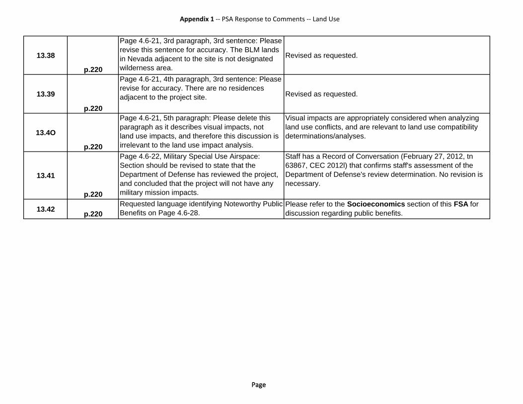
Appendix 1 ‐‐ PSA Response to Comments ‐‐ Land Use
a e s o
e
a
s
r ee e t
e h
Page Page
13.38
p.220
Page 4.6-21, 3rd paragraph, 3rd senrevise this sentence for ccuracy. Thin Nevada adjacent t the site is not wilderness area.
tence: Please BLM land
designated Revised as requested.
13.39
p.220
Page 4.6-21, 4th paragraph, 3rd senrevise for accuracy. There are no r sadjacent to the project site.
tence: Please idences
Revised as requested.
13.4O
p.220
Page 4.6-21, 5th paragraph: Please p ragraph as it describes visual impland use impacts, and therefore this irrelevant to the land use impact ana
delete this acts, not discussion is ly is.
Visual impacts are appropriately considered when analyzing land use conflicts, and are relevant to land use compatibility determinations/analyses.
13.41
p.220
Page 4.6-22, Military Special Use AiSection should be evised to stat thD partment of D fense has revieweand concluded that th project will nomilitary mission impacts.
rspace: at the d he project, t ave any
Staff has a Record of Conversation (February 27, 2012, tn 63867, CEC 2012l) that confirms staff's assessment of the Department of Defense's review determination. No revision is necessary.
13.42 p.220Requested language identifying NoteBenefits on Page 4.6-28.
worthy Public Please refer to the Socioeconomics section of this FSA for discussion regarding public benefits.

OSR
REC RMH
HHSEGS
CALIFORNIA
NEVADA
NYE
CO.
CLAR
K CO
.
INYO CO.
SFL
CALIFORNIA ENERGY COMMISSION, SITING, TRANSMISSION AND ENVIRONMENTAL PROTECTION DIVISION
LAND USE - FIGURE 1Hidden Hills Solar Electric Generating System (HHSEGS) - General Plan Designations
SOURCE: CH2MHILL, Inyo County Assessor and Planning
LAN
D U
SE
Hidden HillsSolar ElectricGenerating System
I0 0.5 10.25 Miles1:62,500
State Line
County Line
Roads
OSR, Open Space and Recreation
Private
Bureau of Land Management
General Plan Class
RMH, Residential Medium-High
SFL, State and Federal Lands
No Designation
REC, Resort/Recreational
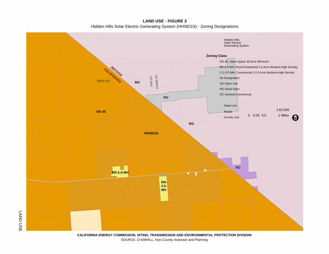
OU
RO
RO
GC
OS-40
RR-2.5-MH
RR-2.5-MH
HHSEGS
CALIFORNIA
NEVADA
NYE
CO.
CLAR
K CO
.
INYO CO.
CALIFORNIA ENERGY COMMISSION, SITING, TRANSMISSION AND ENVIRONMENTAL PROTECTION DIVISION
LAND USE - FIGURE 2Hidden Hills Solar Electric Generating System (HHSEGS) - Zoning Designations
SOURCE: CH2MHILL, Inyo County Assessor and Planning
LAN
D U
SE
State Line
County Line
Roads
I0 0.5 10.25 Miles
1:62,500
Hidden HillsSolar ElectricGenerating System
C-2-2.5-MH, Commercial 2-2.5 Acre Medium-High Density
OU Open Use
RO Rural Open
GC General Commercial
Zoning ClassOS-40, Open Space 40 Acre Minimum
RR-2.5-MH, Rural Residential 2.5 Acre Medium-High Density
No Designation

Mapped AreaInyo
San Bernardino
Nevada
LAND USE - FIGURE 3Hidden Hills Solar Electric Generating System (HHSEGS) - Parcel Ownership
CALIFORNIA ENERGY COMMISSION, SITING, TRANSMISSION AND ENVIRONMENTAL PROTECTION DIVISIONSOURCE: Inyo County Parcel Data 2011, CH2MHILL, Bing Aerial, and TeleAtlas Street Data 2010.
T:\Projects\CEC Projects\Hidden Hills\Land Use\Hidden Hills _LandUse_Fig 3_Parcel Map 3_Tabloid.mxd
LAN
D U
SE 0 1,000 2,000500 Meters1:22,000 O
0 2,500 5,0001,250 Feet
Note: All the data are projected to NAD 1983 California Teale Albers in meter. The acreage calculations represent parcel areas within the HHSEGS projectboundary (in red). The areas out of the HHSEGS project boundary for Section20 LLC are excluded in the acreage calculation. The acreage value for eachparcel ownership is calculated with Calculate Geometry Tool of ESRI ArcGISsoftware. Thus, these values are different from the rounded acreage values of the Inyo County Parcel Data.
Parcel Ownership
Road
HHSEGS Project Boundary
MCMONIGLE, MARY J C/O STEVEN R SCOW, ESQSECTION 20 LLC C/O STEVEN SCOWTSIAMIS, NICK & ARETIWILEY TRUST, MARY C/O STEVEN R SCOW ESQ
(712.39 acres)(465.91 acres)
(20 acres)(2,060.12 acres)
The Bureau of Land ManagementOther Ownership
"
•
•
,~ '" '",,.
'" ,..'" '" ... '" '" '" on,~ '"
,,, ,~ '" ,.. '" on
'" '" '" ,.. '" ,..'"
I~I~ 152 1:18 ,.. '" '" '" 182 ,.., ". ,~
'" 176 '" 'c 'M 186'(I '.7'"
'"
121
".
'"
, ,
=i~~-==i=::;:::1~age,',",,"i~"~eIS~O~flii~G~~sjl~m;;age cburtesy of the Nevada Stat Ma p:ing Advisory Committee © 2012
~
~
~ ,~
" ,~
" ".
" '",., 112
'" ,n
'" ".
'" '",~ '",.,
'"
"
"
..
..
..
..
..
..
"
"
"
"
..
'"
"
"
"
..
"
"
"
•
"
",
IL"""'~~~_---~:::;;-~-~------~~-:--::-:T---:-1T--:--t--:--t--:";---I-~.:,--:r=,,• 3