Embed Size (px)
Citation preview

LAND-USE REGIONS IN THE CENTRAL AND NORTHERN PORTIONS OF THE INCA EMPIRE
KENNETH KELLY Waterloo Lutheran University
ABSTRACT. The Central Andean civilization was developed within a fairly well-de- fined ecumene (oekumene), beyond which the possibilities for expansion were limited. With population increase each pattern of land use was extended into all physically suit- able areas. It is, therefore, possible to use interpolation to delimit and describe land-use regions within the Inca Empire, extending data pertaining to a specific location to all physically similar areas within the ecumene. Certain measures were taken to maintain productivity in these regions, but only servation employed.
UCH of the present agricultural geogra- M phy of such modern areas as Peru cannot be understood properly without a clear appre- ciation of the land-use pattern of the Inca Em- pire. In the Empire developed the most inti- mate adjustment of the native South American to his environment, and one of the most effec- tive developments of an environmental base. Moreover, all subsequent changes in the eco- nomic geography of the Central Andes have been wrought upon this pre-Columbian base. This base has everywhere been modified but, in places, not completely beyond recognition.
Current geographical works on the Central Andes recognize the importance of the pre- Columbian base. Thus James, writing on Peru, states that “the patterns developed by the Spaniards were superimposed upon those developed by the Indians, but with little real blending between the two,” and “to under- stand the way of living of more than half of the people one must go far back to a study of the Inca civilization in the pre-Columbian period.”l Moreover, the impact of the Euro- peans in the Central Andes is deemed a sub- ject worthy of geographical consideration.2
Available information on the Inca Empire is, however, of a nongeographical nature. The Inca Empire has been examined by sociolo- gists, anthropologists, archaeologists, and his- torians, never by geographers. Thus the avail- able material, with compilations rather than
Preston E. James, Latin America (New York: Odyssey Press, 1959), p. 161. Hereafter this source will be listed only as James, 1959, footnote 1, and a page reference.
Again see, for example, James, 1959, footnote 1, p. 166.
in the case of the irrigated land was true con-
chronicles being used as sources, is unsatisfac- tory from the geographer’s point of view. Again referring to James, a very general pic- ture of Inca society is presented as the basis for explanation and comparison, including data on marriage, pottery, and the accounting system. Consideration of the agricultural base of the Empire is limited to a very brief survey of a few crops and domesticated livestock.
This paper seeks to fill part of the gap in geographical work on the Inca Empire by de- limiting and describing the land-use regions of the central and northern portions of the Em- pire at about the time of the Spanish conquest. An attempt is made to explain the distribution of these regions. Finally, the measures taken to increase and perpetuate production from these regions are examined.3
THE BASIS FOR THE DELIMITATION AiVD DESCRIPTION OF THE REGIONS
The Central Andean civilizations were non- literate. The only record of land use comes from the chronicles of the conquerors and early settlers. These records are, however, fragmentary, and cannot provide the basis for a complete land-use survey. Nevertheless, cer- tain of the early chronicles have been the sources of the basic data for this paper. In order to use these data to build up a complete picture, even of the central and northern por-
the author’s knowledge, this is the first at- tempt, a t least in English, to produce a period picture of a single aspect of the economic geography of the Central Andes, using sixteenth-century chronicles and current archaeological work. It is somewhat specula- tive and the story needs verification and amplification by other studies.
327

328 KENNETH KELLY June
tions of the Empire, it has been necessary to interpolate. This has been done on the basis of what is known about physically similar lo- cations, but also on the assumption that each pattern of land use extended into all physi- cally suitable areas, within the effectively oc- cupied portion of the Empire.
This extension was, in tact, a reported policy of the Inca Imperial Government? If, during the course of a conquest, a district appearing to be suitable for cultivation was discovered to be empty, or only partially occupied, colonists “sufficient to populate it” were brought in and settled. When possible these were selected from an area of similar climate. The colonists were provided with flocks of llamas if they were moving into a stock-raising area and, universally, with rations to suffice until their own first harvests were gathered. Various in- centives, such as tax exemptions, were opera- tive for a number of years and, sometimes, even the luxury item coca was issued to the settlers “that they might with more goodwill be induced to establish themselves in their new homes.”5 Parts of the Apurimac Valley, for example, were brought into production by importing people from the Nasca Valley.6 Certain areas of the Montafia were colonized by highland Indians. A number of men and women were sent from each village of the Collao, and from other areas where maize could not be grown, into the Andean forest. The objective of this forced move was the ex- tension of the maize growing area. Surpluses of this crop were to be traded on the Altiplano. Collao Indians were also transferred to some of the coastal valleys, which had been emptied by a variety of forces7
* Throughout this paper, the administrative machine of the whole area under Inca rule iq referred to as the Inca Imperial Government.
5Pedro de Cieza de Leon, The Second Part of the Chronicle of Peru, translated and edited by C. R. Markham (London: printed for the Hakluyt Society, Series 1, No. 68, 1883), pp. 70-71. Hereafter this source will be noted only as de Leon, 1883, footnote 5, and a page reference.
Garcilasso de la Vega, Fir.* Part of the Royal Commentaries of the Yncas, Vol. I, translated and edited by C. R. Markham (London: printed for the Hakluyt Society, Series 1, No. 41, 1869), pp. 268-69. Hereafter this source will be noted only as de la Vega, 1869, footnote 6, and a page reference.
Report by Polo de Ondegardo in Narratives of the Rites and Laws of the Yncas, translated and edited by
The Inca Imperial Government introduced a wider range of food crops, such as sweet manioc, oca (Oxalis tuberosa, a tuber rather similar to the potato), sweet potato, and the peanut, into present-day Ecuador after their conquest, a t which time also llamas in great numbers were moved into the area.8
To increase the expanse of bottomland avail- able for cultivation, the courses of many high- land rivers had been straightened. Before the Inca rise to power, irrigation works character- ized most of the suitable terrain within the Central Andean ecumene ( oekumene, oikou- mene). It was left to the Incas to fill whatever small gaps existed in this system, and to undertake the construction of canals which would have defied the resources, in manpower and organization, of a smaller state. Water was led many miles to irrigate even small plots of land and the issue of irrigation water and the exact time of taking it were all carefully worked out and r e g ~ l a t e d . ~ The extension of irrigation works normally went hand in hand with terracing. Terracing was known in the pre-Inca period, but achieved its maximum distribution at the time of the Empire. The pre-Inca terrace was small and irregular, the product of the labor of an individual or a family, whereas the large-scale regular Inca terracing was developed by large labor gangs, the mit’a. Through terracing, all the land that was suitable for planting was used, and all irrigable sites were occupied. Soil was even transplanted from one site to another, and ter- races built which could only hold two or three rows of maize. Terracing was preeminently a feature of the upland valleys and basins. This type of expansion occurred within a fairly
C. R. Markham (London: printed for the Hakluyt Society, Series 1, No. 48, 1873), p. 164. Hereafter this source will be noted only as de Ondegardo, 1873, footnote 7, and a page reference.
* J. H. Steward, Ed., Handbook of South American Indians, Vol. 11, The Andean Civilizations (Washing- ton: Bureau of American Ethnology, Smithsonian In- stitution Bulletin 143, 1946), pp. 808-10. Hereafter this source will be listed only as Steward, 1946, foot- note 8, and a page reference. ’ Garcilasso de la Vega, First Part of the Royal Commentaries of the Yncas, Vol. 11, translated and edited by C. R. Markham (London: printed for the Hakluyt Society, Series 1, No. 45, 1871), p. 14. Hereafter this source will be noted only as de la Vega, 1871, footnote 9, and a page reference.

1965 INCA LAND USE 329
well-defined ecumene, beyond which the spread of the Central Andean peoples was limited.
The Boundaries of the Central Andean Ecumene
To the south, the real physical limit of the ecumene was the beginning of the mixed hygrophytic forest at the Rio Bio Bio, in pres- ent-day Chile, or the patchy gradation into it of the broadleaved evergreen hygrophytic forest about 60 miles to the north.1° The area of present-day central Chile was, however, separated by considerable distances of desert country from the main area of Central Andean civilization (Fig. 1). This belt of desiccation, the Atacama desert with its limited oases and the salt flats of the Altiplano, was not a com- plete barrier. Throughout, the characteristic economic structure of the Central Andes, in- tensive irrigation agriculture and stock raising, persisted. The arid belt was, nevertheless, a barrier to the extension of relatively high pop- ulation densities.ll The Central Andean econ- omy was unable to penetrate this zone suffi- ciently strongly to bloom again in the less harsh environment of the Vale of Chile. Moreover, the ferocity of the Araucanians made the spread of the Central Andean economy type by conquest, rather than by dispersion, diffi- cult if not impossible. Thus, although the Central Andean ecumene may be said to have extended as far south as the Bio Bio, there was, for a variety of reasons, an extensive transition belt with low-level occupance stretching southward from the northern mar- gins of the Atacama.
The eastern boundary of the ecumene was marked by the beginning of the mountain forest of low latitudes and the tropical rain forest. Several attempts were made at expan- sion into this area, for example the expedition to Moxos.12 Topa Inca twice attempted con- quest to the east. On the final occasion, “some
lo C. Lewis, Ed., The Oxford Atlas (London: 1954), pp. VIII-IX.
l1 J. H. Steward and L. C. Faron, Native Peoples of South America (New York: McGraw-Hill, 1959), p. 52. Hereafter this source will be listed only as Stew- ard and Faron, 1959, footnote 11, and a page refer- ence.
l2 de la Vega, 1871, footnote 9, p. 263.
tribes” were conquered and arrangements made for “large plantations of coca to be culti- vated.”13 Huayna Capac also attempted ex- pansion to the east but, like his predecessors, “returned flying before the fury of the men who dwell there.”14 To the southeast, the be- ginning of the Gran Chaco limited the ecu- mene. This area was, except for occasional Inca hunting expeditions, unused by the Cen- tral Andean peoples.
The northern boundary may be taken as the beginning of the belt of mountain forest of low latitudes.15 This boundary is not demonstrated on the population density map of Steward and Faron,lG but the map is very much gener- alized. The forest belt must, however, be con- sidered as a very significant barrier, since it is coincident with the limits of several very im- portant distributions ( see the earlier reference to the wider range of food crops carried north into present-day Ecuador by the Incas). Irri- gation in the area of present-day Ecuador is mentioned only in connection with the Caiiari prior to Inca conquest, and it may not have been practiced commonly elsewhere. It is re- corded that Inca canals considerably increased the cultivated area of present-day highland E~uad0r . l~
Within these boundaries, then, lay the Cen- tral Andean ecumene. Expansion beyond it was impossible, except in the appendages, in terms of occupance by highland farmers and stock raisers or by irrigation farmers. It is suggested that the ecumene was full or over- populated, in the sense of having a very con- siderable rural underemployment, at the in- ception of Inca imperialism. This underem- ployment is evidenced by the vast withdraw- als from the agricultural labor force, for con- struction work or military service, without any apparent drop in productivity. Thus, it can reasonably be argued that, within the ecu- mene, each type of land use was extended to its physical limits. There is local evidence of this extension. The writer suggests that this can be applied to the ecumene as a whole.
lJcle Leon, 1883, footnote 5, pp. 195-96. l4 de Leon, 1883, footnote 5 , p. 208.
IG Steward and Faron, 1959, footnote 11, p. 52. l7 Steward, 1946, footnote 8, pp. 808-10.
Lewis, 1954, pp. VIII-IX.

330 KENNETH KELLY
O C E A N
THE CENTRAL ANDEAN OEKUMENE
LEGEND
FO RE ST
CHACO
APPE NDA G E 5
TRANSITIONAL (
I I I
1 jf \ \
I HIGH LAND ECUADOR
VALE OFCHILE
TUCUMAN
SCALE c . I . I I . IMILES 100 0 100 200 300
MAUL€ R
FIGURE 1.
June
1965 INCA LAND USE 331
Agricultural Innovations and Population Growth
At this point, it is of some significance to examine the conclusions of Willey in his study of the VirG Valley.ls He noted that, with the introduction of maize, between 600 and 200 B.C., the population took a sudden climb. By about 800 A.D., full-scale coordinated irriga- tion was developed, and the population rose sharply to its prehistoric ceiling. The ceiling was set by the “maximum combination of amount and availability of water and the amount and relief of land.”lg The danger of forming a generalization on the strength of a single valley is realized but, nevertheless, it is suggested that a rapid explosion of popula- tion, following the perfection of a major tech- nique or the introduction of a new crop, was characteristic of all the oases of the Central Andes. Various dates have been assigned to the introduction of the basic productive tech- niques of agriculture and of the principal plant and animal domesticates into the area.2n Taking the most conservative of these esti- mates, it may be believed that the basic tech- nology was developed at least 600 years before the Inca rise to power. The later development of bronzez1 and its application to digging
between 1200 and 1400 A.D., and the probable invention of the foot plow at about the same time, did not open up new areas for settlement, although they may have reduced the labor of working the soil.
Steward and Faron believed that by 1000 A.D. and, probably on a local scale, some 500 years earlier, the whole Central Andean area had entered upon a course of cyclical imperial development, the mechanism of which was the pressure of population, plus the demands of the klite, upon food resources.23
l8 G. R. Willey, Prehistoric Settlement Patterns in the Virzi Valley, Peru (Washington: Bureau of Amer- ican Ethnology, Smithsonian Institution Bulletin 155, 1953), p. 391. Hereafter this source will be noted only as Willey, 1953, footnote 18, and a page refer- ence.
Willey, 1953, footnote 18, p. 391. 2o J. Alden Mason, The Ancient Civilisations of Peru
( Harmondsworth: Pelican Books, 1957) ; Steward, 1946, footnote 8; Steward and Faron, 1959, footnote 11; Willey, 1953, footnote 18.
21 Steward, 1946, footnote 8, p. 248. 22 Steward, 1946, footnote 8, p. 21. 23 Steward and Faron, 1959, footnote 11, p. 67.
THE LAND-USE REGIONS OF THE CENTRAL AND NORTHERN PORTIONS OF THE EMPIRE
Agricultural Regions One of the major characteristics of the Cen-
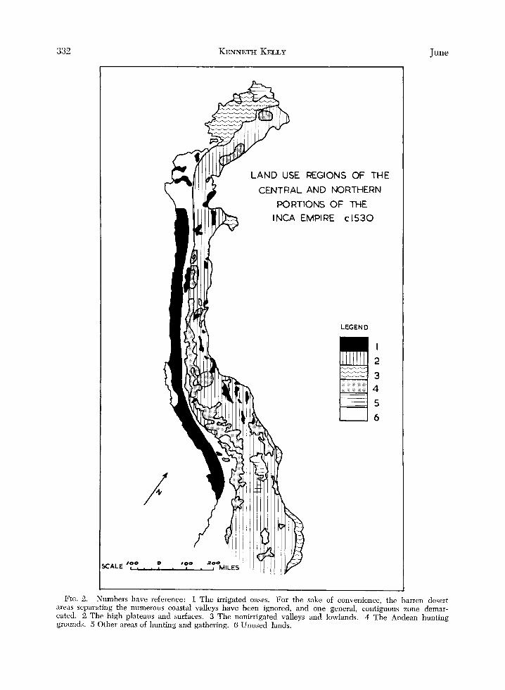
tral Andean civilization was the establishment of local self-sufficiency in foodstuffs wherever possible. Crop specialization was rarely to be found except in terms of climatically governed emphasis, based on one of the two major crop complexes, maize or potato-quinoa (qui- noa, Chenopodium quinoa, is an Andean plant of which the seeds, tender stems, and leaves can be consumed by humans). In general, wherever maize could be grown it was the dominant crop, although many other plants were grown in association with it. Where it was too cold for maize, the potato-quinoa sequence dominated, although fewer comple- mentary plants were grown than with maize. Beyond the limits of cultivation, stock rearing of domesticated animals or semirearing of wild animals was practiced. Specialization was, then, based upon environmental condi- tions rather than upon economic considera- tions. Present criteria employed in delimiting Inca agricultural regions are crop dominance, agricultural technology, and ancillary eco- nomic activities (Fig. 2 ) .
The Irrigated Oases It is suggested that the oases of the coastal
valleys, and the irrigated basins and valleys of the high-level surface constituted a single major agricultural region despite the fact that they are widely scattered. The key criterion of delimitation is the almost complete depen- dence upon irrigation for production. These were the great maize-producing areas of the Empire, areas of soils “irrigated and manured like a garden”24 that were devoted year after year to this crop. A great variety of other crops was also grown, but none challenged the primacy of maize. Stock raising was based, at least partially, in these areas, on the consump- tion of the wastes of cultivation.
The Coastal Valleys. No more land was under cultivation than could be irrigated,25 and the
24 de la Vega, 1871, footnote 9, p. 5. 25 Pedro de Cieza de Leon, The Travels of Pedro de
Cieza de Leon, Contained in the First Part of his Chronicle of Peru, translated and edited by C. R.
332 KENNETH KELLY
REGIONS OF THE
CENTRAL AND NORTHERN PORTIONS OF THE
INCA EMPIRE c I530
LEGEND
4 5 6
June
FIc. 2. Numbers have reference: 1 The irrigated oases. For the sake of convenience, the barren desert areas separating the numerous coastal valleys have been ignored, and one general, contiguous zone demar- cated. 2 The high plateaus and surfaces. 3 The nonirrigated valleys and lowlands. 4 The Andean hunting grounds. 5 Other areas of hunting and gathering. 6 Unused lands.

1965 INCA LAND USE 333
whole area was characterized by the broadest economic base in the Central Andean area. Maize was the chief crop, reaped twice a year and yielding abundantly.2G A number of other crops, temperate and subtropical, was also grown. In his list of crops characteristic of the coast, de Leon included yucas (Manihot utilissima, manioc), sweet potatoes, potatoes, beans, pepinos ( Solunum muricatum) , gauvas (Ysidium guujuva, a thin-skinned fruit), paltas ( Persea gratissima, avocado ), and caimito ( Chrysoplzyllum cairnito, star apple) T7 Cot- ton is mentioned as being grown in the valleys of Motupe and Tumbez but, since this was the chief clothing fiber of the lowlands and since specialization was not encouraged, its distribution must have been much wider, as is suggested by de Acosta.28
Hunting as a source of foodstuffs, even for the &te, cannot have been very important in the period of the Empire, since cover for game would have been very much limited by the appropriation of most of the available water for irrigation. A certain amount of scrub did occur, however, harboring several species of game birds, deer, and foxes.29 Nor did collect- ing play any important part in the local econ- omy, although algarrobas ( Prosopis iuZifEora )
Markham (London: printed for the Hakluyt Society, Series 1, No. 33, 1864), p. 215. Hereafter this source will be noted only as de Leon, 1864, footnote 25, and a page reference.
26 de Leon, 1864, footnote 25, p. 233. 27de Leon, 1864, footnote 25, p. 234. The prime
source for the botanical names of species is M. A. Towle, The Ethnobotany of Pre-Columbian Peru (New York: Viking Fund Publications in Anthro- pology, No. 30, Wenner-Gren Foundation, 1961 ). Carl Sauer’s 1950 article on the “Cultivated Plants of South and Central America,” in the Handbook of South American Indians is also useful; Vol. VI, pp. 487-543 of reference cited in footnote 8. The com- mon names used in the chronicles are retained, even when these are Arawakian rather than, for example, Quechua in origin. Towle gives a much fuller list of cultivated plants than any of the chronicles but the lists derived from the chronicles have not been added to. It is impossible to gauge how important in the local economy were some of the species mentioned by Towle.
2s Joseph de Acosta, A Natural and Moral History of the Indies, Vol. I, Natural History, translated by E. Grimston, edited by C. R. Markham (London: printed for the Hakluyt Society, Series 1, No. 60, 1880), p. 249. Hereafter this source will be noted only as de Acosta, 1880, footnote 28, and a page reference.
de Leon, 1864, footnote 25, p. 237.
grew in the thickets, and their beans were gathered for food.30 In this area many ducks were bred,31 but the domesticated animal most mentioned in the chronicles is the “sheep” or llama.32 The emphasis given to the llama, however, probably reflects its novelty rather than its importance. As stock raising is a less intensive land use than cultivation, it is un- likely that llamas occupied a prime place in the local economy. Neither could they graze throughout the year on the land adjacent to the cultivated areas, because of the seasonal appearance of browse. There is no mention of llama manure being used in the coastal valleys, suggesting either that there were not many llamas, that there was an antipathy towards its use in the area, or that they were present only at sporadic times. Three possible expla- nations of the presence of livestock present themselves.
1) Small numbers were permanently lo- cated in the oases, grazing on the sparse natural vegetation at the fringes, and having their diet supplemented by maize stalks and dry leaves.33 That would have meant that small-scale stock raising was partially integrated with the intensive cultivation to convert otherwise unus- able material into “wool,” protein, or muscle power.
2 ) There was a seasonal movement of live- stock down into the valleys to consume the waste of the harvest, or to graze on the lomns vegetation after the rains.34
3 ) The flocks were in reality pack trains, temporarily stationed in a particular valley.
Livestock raising in this region was a small- scale operation, essentially a minor adjunct to intensive cultivation.
The coastal valleys were further character- ized by fishing operations. Equipment was
30 de Leon, 1864, footnote 25, p. 234. 31 de Leon, 1864, footnote 25, p. 234; de la Vega,
1871, footnote 9, p. 388. 32 de Leon, 1864, footnote 25, p. 236; Report of
Francisco Xeres in Reports on the Discovery of Peru, translated and edited by C. R. Markham (London: printed for the Hakluyt Society, Series 1, No. 47, 1872), p. 20. Hereafter this source will be noted only as Xeres, 1872, footnote 32, and a page reference.
33de la Vega, 1871, footnote 9, p. 357. 34 James, 1959, footnote 1, p. 197.
334 KENNETH KELLY June
crude, however, the craft being reed balsas in most areas36 or, farther south, inflated seal skins.36 Upon these the fishermen went con- siderable distances out to sea, fishing with harpoons, hooks, and nets. The latter were “poor and wretched contrivance^."^^
In the coastal valleys, irrigation schemes made extremely efficient use of the surface waters, and in some areas there was an at- tempt to utilize the groundwater also. This was done by excavating “sunken fields” close to the seashore, the bottoms of which were moistened by flowing groundwater. This de- vice was adopted either where there was no permanent river, as at the hoyus of Chilca, Atico, Atequipa, Villa ccuri, and Mala,38 or where the irrigation system had broken down, as at Virh.
The CJpknd Valleys and Basins. Even though they lay in rain shadows, the oases of the up- lands were not so much islands in the desert as those of the coast. On the coast the transi- tion from intensively cultivated land through scrub to absolute desert was short and sharp. The upland oases were probably surrounded by vegetation, albeit not very luxurious, so that a slightly larger livestock base can be sug- gested for the upland than for the coast. In the upland oases quinoa was sown with maize on irrigated land.“9 In general, however, the land-use pattern was much the same as in the coastal valleys, although there was the possi- bility of raising some quick-growing crops on the more favored unirrigated slopes during the rainy season.40
The High Plateaus and Stwfuces
This high altitude, treeless surface41 was beyond the climatic limits of the characteris- tic subtropical crops of the oases, maize, yuca, m d aji (Capsicum nnnuuni, peppers.)42 Large areas were dominated by stipci ichzi, which
:35 de la Vega, 1869, footnote G , p. 261. de Acosta, 1880, footnote 28, p. 56.
:Ii de la Vega, 1869, footnote 6, p. 262. ,’” tle L,eon, 1864, footnote 25, p. 255; de la Vega,
i(” de la Vega, 1871, footnote 9, p. 5. 4o Steward, 1946, footnote 8, p. 211. .’lde Acosta, 1880, footnote 28, p. 166; de Leon,
1864, footnote 25, p. 360. 4? de Leon, 1864, footnote 25, p. 360; de Acosta,
1880, footnote 28, pp. 233, 239; de Ondegardo, 1873, footnote 7, p. 164.
1871, footnote 9, p. 12.
was “good pasturage for sheep.”43 This re- gion was characterized by the dominance of livestock raising. The livestock was, however, utilized almost exclusively for “wool” and transportation, rather than for meat, and milk was not taken. The livestock grazed entirely upon natural pasture, receiving no supplemen- tary feed.44 Provision was made to irrigate these pastures in the event of autumn drought, but this may not be regarded as any real mea- sure of range improvement.
Cultivation emphatically took second place to livestock raising. Potatoes, quinoa, and oca were the chief crops, but were grown in a fallowing system without irrigation. The yield was extremely unreliable and the area under cultivation fluctuated widely. Thus no sepa- rate potato-quinoa area can be delimited. It was the usual thing in the Collao for three out of five years to be without harvest,45 in which case the livestock may have consumed what was left of the dried-out leaves and stalks.4f; Crop failure was caused primarily by
At such times, the people were dependent for survival on their stores of dried potatoes and upon the Inca famine relief sys- tem, part of which involved permission for these people to engage in trading, normally a state monopoly. The occupance of this region was subsidized by the Inca surplus and the Inca colonizing machine, in order to secure the production of livestock for “wool” and for transportation purposes. It may be argued that this subsidy was made necessary, to a certain degree, by the discouragement or even prohibition of the slaughter of livestock for food.
Three subregions can be recognized: 1) the present Ecuadorian area, where crop
yields were more certain; 2 ) the Collao, in which the tribesmen them-
selves owned many animals;48 and 3 ) the intermediate area, in which crop
yields were uncertain and where live-
43 de la Vega, 1869, footnote 6, p. 254; de la Vega,
44de Acosta, 1880, footnote 28, p. 289. 45 de Ondegardo, 1873, footnote 7, p. 159. 4F Although, presumably, at such times, the human
population would be more dependent upon quinoa leaves and stalks also.
1871, footnote 9, p. 17.
47 de Leon, 1864, footnote 25, p. 361. 4s de la Vega, 1871, footnote 9, p. 118.

1965 INCA LAND USE 335
stock was owned almost exclusively by state organizations.
There is only one specific mention of what appears to be transhumance. There were pas- tures in the Marcara area to which, at certain times of the year, flocks were brought to graze, “as they do in Castille and Estrema- d ~ r a . ” ~ ~
The Nonirrigated Valleys and Lowlands Production here was not based upon irriga-
tion, but upon natural precipitation. The crops grown included yucas, aji, potatoes, and numerous “fruits and roots,” but maize ap- pears to have dominated. Hunting and gath- ering also figured in the economy. The key criterion of differentiation from the oases is lack of irrigation, but it is also worth remem- bering that this economy was pursued in the less tamed environment of forest clearings. I t is probable, moreover, that some of the culti- vation was on a shifting basis.
The Andean Valleys. This area was pene- trated by the Collao mit imes , or colonists. It produced a wide variety of crops, some of which often were sent to the colonists’ home villages to alleviate the food shortage there. Some gathering also took place, especially for honey.jO The distinguishing feature of this subregion was, however, coca production. Under the Incas, coca production did not reach the volume it achieved under the Span- iards,jl since consumption was, in general, limited to the ruling group.52 Thus, the total production, except for that of a few small patches granted to chiefs and officials, was dispatched as tribute to the central govern- ment. Coca was a crop of special significance, a luxury item, and it can be said that it was grown to pay taxes. Its production constituted a certain type of specialization and, as such, merits attention. Climatically, the crop is limited to hot, wet valleys and there is no reason why it could not be grown in the coastal Ecuador subregion. However, it was not grown there. Since consumption was, to a
49 Xeres, 1872, footnote 32, p. 79. 50de Leon, 1864, footnote 25, p. 362. “ d e Ondegardo, 1873, footnote 7 , p. 158. “Not
62 de Acosta, 1880, footnote 28, p. 246; de Onde- (by ) one fiftieth part.”
gardo, 1873, footnote 7 , p. 158.
large extent, centralized and limited, it was probably considered most efficient to grow it it in the empty Andean valleys closest to the capital. Great care was required in the produc- tion of the crop, so that it was probably grown in plantation^.^^ Rowe mentioned exile to the coca plantations as a p u n i ~ h m e n t . ~ ~
The Coastal Lowlands of Present-Day Ecuu- dor. The crops grown in this subregion in- cluded maize, yucas, aji, potatoes, guavas, melons, peas, and beans. Cultivation was practiced in forest clearings and in man-made savanna. Honey was also collected and, at least in Manta country, peccaries were hunted.55 All along the coast, fishing was im- portant. Some livestock raising was reported in Manta territory,j6 but this was of very re- cent introduction, probably not antedating the Inca conquest of the area. Apparently no livestock had been introduced to Puna Island.
Hunting and Gathering Regions
The Andean Hunting Grounds This region is differentiated from those to
follow on the basis of superior organization of hunting, of rotation of areas to be hunted, and of protection extended to game during the closed season. Such techniques will be dis- cussed in the following section.
The Lake Titicaca Islands and the Desagmdero Swamps
This region was occupied by the Uru, who found in the tortma reed “all they require,”57 this material being used primarily for their boats and dwellings. They may, to a very limited extent, have engaged in some cultiva- tion and kept a very few llamas, but basically they depended upon fishing and the hunting of waterfowl. They were strictly noncontrib- utors to the Inca economic system.
The Northern Comtal Lowlands of Present-Day Ecuador
The Esmeraldas were portrayed by de la Vega as nonagriculturalists, dependent solely upon the gathering of roots and fishing.
53 de Acosta, 1880, footnote 28, p. 245, 54 Steward, 1946, footnote 8, p. 271. 55 de Leon, 1864, footnote 25, p. 174. 56 de Leon, 1864, footnote 25, p. 199. 57 de Acosta, 1880, footnote 28, p. 83.
336 KENNETH KELLY June
Doubtless, fishing was important in their econ- omy but it is difficult to imagine a group in this area not practicing cultivation to any ex- tent. Murr@ found these people very rich for simple hunters and gatherers.
MEASURES TAKEN TO PERPETUATE AND INCREASE PRODUCTION
Certain basic principles of conservation were enforced, or were in common practice throughout the Empire. Measures for the con- servation of arable land, manuring or fallow- ing, had probably long been known.59 Even in a small state, such measures would have been both necessary and possible. It is un- likely that any innovation in this field was de- veloped during the Inca period, although the areal range of certain practices may have been extended.
The use of manure was widespread and, in this regard may be regionalized as follows:
1) Guano was used in many of the coastal valleys.G0 Each province utilizing this manure had an island, or portion of an island, allotted to it as a source of sup- ply. Each provincial area was broken up into village allotments. If we follow de la Vega, there was further division into individual allotments.G1 Allotments were settled "in accordance with the require- ments of" the land. The guano was shipped to the mainland in balsas. The birds themselves received total protec- tion. No one, on pain of death, was permitted to land on the islands during the breeding season, nor was it per- mitted to kill these birds at any time or in any place.62 Human or llama dung may have been used as a secondary fer- tilizer, but there is no mention of this,
2 ) Also on the coast, there is a record of fish heads being used as a manure. In the sunken fields already referred to, two sardine heads were put in with each grain of maize planted.63
"Steward, 1946, footnote 8, p. 803. Steward, 1946, footnote 8, p. 21.
Go de Acosta, 1880, footnote 28, p. 281; de la Vega, 1871, footnote 9, p. 11; de Leon, 1864, footnote 25, p. 267.
de la Vega, 1871, footnote 9, p. 11. G 2 de la Vega, 1871, footnote 9, p. 12. G3de Leon, 1864, footnote 25, p. 255.
3 ) In the upland valleys and basins, human manure was applied to the maize fields. It was applied at the time of sowing, after having first been dried and pulver- ized.64
4) On the areas of the high plateaus and surfaces, where attempts were made to raise crops, some llama dung was applied to the fields.
Wherever maize was grown it was manured, usually copiously, and watered and, therefore, no crop rotation was p r a ~ t i c e d . ~ ~ Indeed, there is little evidence of crop rotation within the Empire, the system on the unirrigated fields being one of fallowing after only one or two years of cultivation. It must be noted that a great deal of llama dung was used as a fuel, rather than being applied to the land.
Strict regulations governed livestock raising within the Empire, and this may have been an innovation of the Incas. The pastures of the domesticated stock were demarcated, basi- cally to facilitate counting and control, but this may also have, to some extent, regulated graz- ing at the same time.6G The Inca Imperial Government sought to make constant, or near constant, the annual carrying capacity of the pastureland. In their unmodified state, there was a tendency for the pastures, in some years, to dry out in the autumn. This made necessary the understocking of the range at other times, the transfer of stock seasonally, or the semi- starvation of stock if the autumn rains did not fall. Many irrigation canals were constructed to serve the pastures. Irrigation through these was not year round, merely taking place in the autumn of certain years. It is possible that some of the pre-Inca states practiced this sys- tem on a small scale, but the really compre- hensive works had to await the conditions of stability, ready labor supply, and high level of organization which only an Empire could bring.6i Several large schemes are mentioned by de la Vega, the main feeder of one of which was more than twelve. feet deep and wide and ran for more than 150 leagues.'j8
'j4de la Vega, 1871, footnote 9, p. 11. 62 de la Vega, 1871, footnote 9, p. 5. ' jG de Acosta, 1880, foonote 28, p. 420; dc Onde-
'ji It is realized that the Incas were not the first
6s de la Vega, 1871, footnote 9, p. 77.
gardo, 1873, footnote 7 , p. 158.
people to develop an empire on the Altiplano.

1965 INCA LAND USE 337
Despite the foregoing, the basic livestock regulations were designed to increase the numbers of stock, rather than to conserve the status of the pastures themselves. It was for- bidden to kill female livestock, even for sacri- fice, so that the flocks increased enormously.69
The only force effective in reducing the numbers of livestock was the scab-like disease, carache. This was highly contagious, and no cure was attempted. The infected beast was destroyed immediately and buried deeply.70 After the fall of the Empire, many beasts were lost to this disease, possibly because of the re- luctance of individual herdsmen to destroy an animal after Inca control had disappeared.
It was reported that, prior to the arrival of the Spaniards, there was “scarcely sufficient pasture for the This may be merely descriptive exaggeration, but it is not difficult to imagine overstocking and degeneration of pasture under this kind of livestock-raising mentality. Xeres stated that many of the “sheep had gone wild, because the Incas could not maintain all that they breed.”72
In the case of wild game, the same princi- ple of not killing females was adhered except in the case of those beyond the repro- ductive age.74 It also appears that some kind of selective breeding was attempted, at least among deer, “the best and finest” males being released after the hunt as progenitors of the next generation, whereas the remainder were killed. All predators encountered were slaugh- tered. Strict regulations were in force to pro- tect the game. It was prohibited for the com- mon man to hunt at all, except for the licensed hunting of small birds for the table of gover- nors and c ~ r a c a s . ~ ~ For larger game, a closed season was strictly observed, and this conser- vation policy was so successful that game in- creased much more rapidly than it was killed
Apparently, it was felt that conservation measures were especially necessary in the case
6Q de Acosta, 1880, footnote 28, p. 420; de Onde- gardo, 1873, footnote 7, p. 160; de Leon, 1883, foot- note 5, p. 45.
70de Acosta, 1880, footnote 28, p. 291, 420; de Ondegardo, 1873, footnote 7, p. 160.
71de la Vega, 1871, footnote 9, p. 26. 72Xeres, 1872, footnote 32, p. 63. 73 de Acosta, 1880, footnote 28, p. 287. i4de Acosta, 1880, footnote 28, p. 420. 7 5 de la Vega, 1871, footnote 9, p. 115. i F de Ondegardo, 1873, footnote 7, pp. 164-65.
of the vicuiia, as these were found not to in- crease very rapidly.77
The organizational unit for hunting was the province. Its hunting area was divided into three or four parts, and each was hunted at not less than three-year intervals. This was primarily to allow the vicufia fleeces to grow to their full length again, since to s h e d 8 them before this would constitute a waste. This minimum interval also permitted the game to recover numerically from the last hunt. More- over, under this arrangement, the beasts were not so wild as they would become if hunted more frequentlyY9 a not unimportant consid- eration since many of the animals were taken by hand. Apart from amusement, wild game provided a substantial part of the meat supply of the population and all of the fine vicuiia ‘‘wool.’’
Regulations were in force governing the use of the timber resources of the Empire. Tim- ber-producing areas, largely located in the areas designated as nonirrigated valleys and lowlands, were assigned for the use of prov- inces in which there was a fuel shortage, as well as for local use. These forests were known as moyas. The regulation was that timber should be cut according to require- ments for actual use.*O The measure, then, appears to have been one of apportionment, rather than conservation, of the forest. There is no mention of any replanting program. There is no means of telling how well the system worked or whether, in view of the problems of transporting timber, it was in fact widely adhered to. If taken seriously, how- ever, this regulation would have retarded the expansion of cultivation in the forested valleys by precluding the rapid removal of the trees.
CONCLUSION
It has been demonstrated that the Central Andean ecumene was probably full at the in- ception of Inca conquest. It is not suggested that this condition was new to the area which, it is believed, was in a continuing state of chronic overpopulation. On the basis of this fullness, the product of the economic history
77 de Acosta, 1880, footnote 28, p. 287. 78 The vicufia were hunted down, captured by hand
so as not to injure them, sheared, and then released. 79 de la Vega, 1871, footnote 9, p. 117.
Ondegardo, 1873, footnote 7, p. 165.

338 KENNETH KELLY June
of the area and of the mass transfers of people, the assumption can be made of the optimum use of the nonforested portions of the Empire. \Vherever it could be grown, maize was the chief crop, whereas beyond its limits potato- quinoa came into dominance. Acting upon this assumption, it has proved possible to in- terpolate between areas and land uses specif- ically mentioned in the chronicles, and thus to build up a rough map of the land-use regions of the Empire.
Within each of these regions, attempts were made to increase or perpetuate yields, but only in the case of some of the arable land did this amount to true conservation. Livestock- raising policies, although remarkable in the case of game, were shortsighted. In the pas- toral sector of their economy, the Incas were
little different from the less sophisticated con- temporary pastoral societies of Asia or Africa.
Attempts were made to increase the resource base of the Empire by heavy labor investment in the creation of terraces and large irrigation works, but the most effective way was by con- quest of new areas. Local population pressure was relieved in two ways. Foodstuffs were collected at central points and dispatched to areas of shortage, and people were transferred to less densely populated sections of the Em- pire. So great was this movement that “there were very few cultivable lands that remained desert in the time of the Incas, but all were well peopled, as is well known to the first Christians who entered the country.”s1
81de Leon, 1883, footnote 5, p. 71.


![Mathematics of the Inca Empire - [email protected] Home](https://img.pdfslide.us/doc/110x75/613d6f91736caf36b75d4dab/mathematics-of-the-inca-empire-emailprotected-home.jpg)