Embed Size (px)
Citation preview

Land Use Planning and Land Management
Policies, Instruments and Techniques
Claudio Acioly Jr.
www.ihs.nl
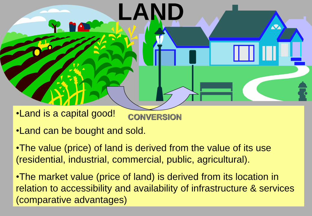
•Land is a capital good!
•Land can be bought and sold.
•The value (price) of land is derived from the value of its use
(residential, industrial, commercial, public, agricultural).
•The market value (price of land) is derived from its location in
relation to accessibility and availability of infrastructure & services
(comparative advantages)
LAND
CONVERSION

Some generally accepted views and postulations 1:
1.Rising demand Conversion rural-urban
2.Expansion of
total area
Higher economic values
in central city
3.Higher values of
land
Increases pressure for
economy in land use
Increasing densities in
central areas

Some generally accepted views and postulations 2:
4.Lengthy procedures for land
transfer and cumbersome
process for approving land
development
5.Inadequate institutional and
legal frameworks
6.Cumbersome institutional,
legal and political contexts
Higher premium/land rent to be
paid by users and benefiting
owners
Increases demand that pushes
market values of land upwards
Scarcity of serviced land
Excessive land pricesInvasion of land, illegal
subdivisions, pirate
developments

Different forms of Land Tenure affecting urban
growth patterns!
Exclusive rights of use
and disposition of land
Roman law
No well-defined rights
Tribal customs Customary
practices Squatters
Public
ownership
Islamic Waqf
non-alienation limited use
Legal forms: freehold ________________ leasehold
Security of Tenure

Variety of Objectives
of LAND POLICIES
Equity Efficiency
•Appropriate supply
•Harmony of urban spatial structures
•Equity
•Distribution of population
•Distribution of activities
•Environmental control
The question is how to reconcile these objectives
and the instruments of land management ?
The Need for Government Intervention

OBJECTIVES
URBAN LAND POLICY: Government objectives
Policy Tools Institutions
Master plans
Land use zoning ordinances
Land parcelling regulations
Building codes
Land management tools: land sharing; land banking; land readjustment; TDR-transfer of development rights; land registration.Sites & Services;
Land Development Agencies
Land Registration Offices
Land Cadastre
Land Banking Units
Land Management & Control Agency
Urban Land Operations Units
To protect the urban & natural environment
To gear infrastructure investments with development
To maintain and enhance property values
To provide poor families with access to land and neutralise land speculation

LAND: input to housing & urban development
Essential for human
activities
Supply is fixed, inelastic but land-use expandable
Total supply is fixed then increasing demand increases prices. This may produce inflationary pressure on prices.
Land is immobile and inflexible: each parcel is unique.
Increasing prices not leading to increased supply due to common market speculation for high profits resulting in vacancy
Rights attached to land is called “TENURE” that expresses ownership, control and use
TENURE forms directly affect the urban economy via mortgages, tax revenue, market transactions
Social, economic and political values affect TENURE systems.

HOUSING
LAND
INFRASTRUCTURE
LOCATION
LOCATION
VALUE
ACCESSIBILITY
LEGAL STATUS
WATER, ELECTRICITY,
SEWERAGE, DRAINAGE, ROADS
COMMUNITY SERVICES,
TRANSPORTATION
EMPLOYMENT OPPORTUNITIES
INCOME OPPORTUNITIES,
COMMERCIAL
INCOME GENERATION
The cross-sector character of Housing
Housing involves social welfare and reflects rise in the social & economic status.

ACTORS AND MOTIVATIONS TOWARDS LAND
INDIVIDUAL: asset,
privacy, security, base
for production &
activities
ENGINEERS:
structural qualities
(stability, erosion,
permeability...
PLANNERS: mosaic requiring conformity to norms and development control
POLITICIANS: platform of social justice versus maintenance of pillar a society based on individual & private property
ARCHITECTS: landscape qualities of sites
LAWYERS: physical dimension to which individual and collective rights are attached
ECONOMIST: a factor of production whose price is defined by supply/demand
AGRICULTURALIST: assesses land on basis of soil suitability, water resources and location for productivity
DEVELOPERS: objects of investment to create new values through activities and use of land
EnvironmentalistLand conversion and loss of green fields, factor of sustainable development
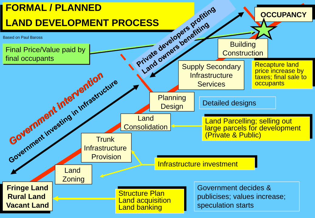
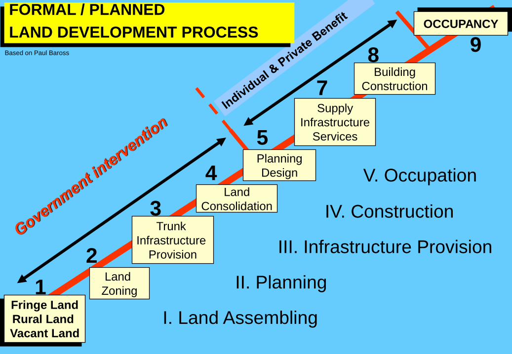
FORMAL / PLANNED
LAND DEVELOPMENT PROCESS
Final Price/Value paid by
final occupants
Fringe Land
Rural Land
Vacant Land
Land
Zoning
Trunk
Infrastructure
Provision
Land
Consolidation
Planning
Design
Supply Secondary
Infrastructure
Services
Building
Construction
OCCUPANCY
Government decides &
publicises; values increase;
speculation starts
Structure Plan Land acquisition Land banking
Infrastructure investment
Land Parcelling; selling out large parcels for development (Private & Public)
Detailed designs
Recapture land price increase by taxes; final sale to occupants
Based on Paul Baross
Fringe Land
Rural Land
Vacant Land
Land
Zoning
Trunk
Infrastructure
Provision
Land
Consolidation
Planning
Design
Supply
Infrastructure
Services
Building
Construction
OCCUPANCYFORMAL / PLANNED
LAND DEVELOPMENT PROCESS
1
2
3
4
5
7
89
I. Land Assembling
II. Planning
III. Infrastructure Provision
IV. Construction
V. Occupation
Based on Paul Baross
INFORMAL / UNPLANNED
LAND DEVELOPMENT PROCESS
VACANT
LAND
Commercial
Land Subdivision
or Land Invasion
Trunk
Infrastructure
Provision
Building
Temporary
Occupancy
Planning
Design
On-site
Infrastructure
Supply
Regularisation
Legalisation
Densification
OBIP
People starts building,
pressure, mobilisation,
recognition, services
Individual
connections
Autonomous development
Based on Paul Baross

INFORMAL / UNPLANNED
LAND DEVELOPMENT PROCESS
VACANT
LAND
Commercial
Land Subdivision
or Land Invasion
Trunk
Infrastructure
Provision
Building
Temporary
Occupancy
Planning
Design
On-site
Infrastructure
Supply
Regularisation
Legalisation
Autonomous development
1
2
3
4
5
6
I. Land Invasion/land holding
II. Building & Densification
III. Infrastructure Provision
IV. Planning
V. Legalisation
Based on Paul Baross

1. Land Assembling
2. Planning
3. Infrastructure Provision
4. Construction
5. Occupation
1. Land Invasion / land holding /
Parcelling
2. Building & Densification
3. Infrastructure Provision
4. Planning
5. Legalisation & Regularisation
FORMAL LAND DEVELOPMENT INFORMAL LAND DEVELOPMENT
Formal x Informal


FAVELAS:
•Squatter settlements and most common feature in all
Brazilian Cities.
•Gradual or eruptive process of land invasion.
•On derelict land.
•Public land (but also private land).
•Land not appropriate for human settlement: hills,
flood prone sites,
•Poor infrastructure and public services.


Illegal subdivision
in Campo Grande
•Bairro Aurora - 448
plots - 2240
inhabitants

Illegal subdivision in Guaratiba called Jardim Maravilha -
11,754 plots (1720 are occupied ) - 5527 inhabitants

Land Use Planning InstrumentsZoning Ordinances: . Municipal decrees, laws, norms.
Land Use Norms: . Linked to master plans;
Planning Guidelines: . Linked to City Planning Ordinances
Land Parcelling Norms: . Linked to National norms
Building Permits: . Applied city-wide by municipalities
Development Applications: . Requests by individuals/firms/developers
Development Permits: . Approvals/concessions by municipalities

Land Management InstrumentsADMINISTRATION
Land expropriation
Pre-emption right
Compulsory Replotting
Cadastre
Land Information System-LIS
MANAGEMENT
Land Bank
Land Pooling
Land Readjustment
Land lease
TRD-Transfer Develop.Rights
TAXATION
Real estate property taxes
Land transfer duties
Development charges
Betterment & servicing charges
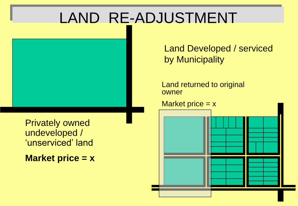
LAND RE-ADJUSTMENT
Privately owned undeveloped / ‘unserviced’ land
Market price = x
Land Developed / serviced
by Municipality
Land returned to original owner
Market price = x

LAND RE-ADJUSTMENTA municipal government or other public agency declares privately
owned land that is about to be developed as a land readjustment
project!
1.
Municipality prepares site plan (in co-operation with owner)
2.
Municipality assesses market value of raw land
3.
Municipality calculates the percentage of land required for physical services: roads, infrastructure, water, sewerage, etc.
4.
Municipality deducts from total parcel a percentage of land with sufficient improvement value to recover costs of the services;
5.
Municipality returns the remainder of land to original owner.
6.
Owner’s land has increased in value because of infrastructure investments
7.
Municipality sell its share of the improved land to recover costs of service provision