Embed Size (px)
Citation preview
Land use land cover changes in the Uttarakhand Himalaya: assessment and mappingHimalaya: assessment and mapping
Dr Vishwambhar Prasad SatiDr. Vishwambhar Prasad SatiPG Department of GeographyGovt. Post Graduate CollegeShivpuri, Madhya Pradesh,Shivpuri, Madhya Pradesh,
IndiaEmail: [email protected]
Bishkek Presentation 10/09/2009 1

Introduction to the Area
1. Total Area: 51125 sq km
2. Of its total geographicalgeographical area, about 92.6% is covered by mountains, which is thewhich is the mainland of Uttarakhand
3. 7.4% is Taraiplains
The Pindar River
plains. 4. The total snow
covered area of its mountainous region is 16.1% with an elevation of over 4000 m.
Bishkek Presentation 10/09/2009 2

Kedarnath Group of Peaks
Kedar Nath Temple
Mandakini River
Bishkek Presentation 10/09/2009 3
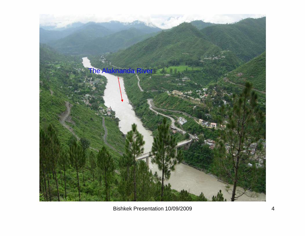
The Alaknanda River
Bishkek Presentation 10/09/2009 4
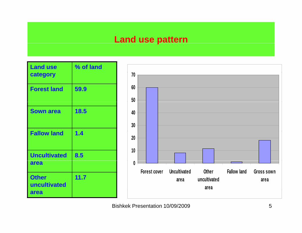
Land use patternp
Land use t
% of land0category
Forest land 59.9
50
60
70
Sown area 18.5
F ll l d 1 430
40
50
Fallow land 1.4
Uncultivated 8.510
20
area
Other uncultivated
11.7
0Forest cover Uncultivated
areaOther
uncultivatedarea
Fallow land Gross sownarea
Bishkek Presentation 10/09/2009 5
area

Land use pattern Dense oak forest, terraced agricultural fields and settlementsfields and settlements
Extensive pine forest in the Upper
Bishkek Presentation 10/09/2009 6
p ppPindar River Watershed

The Great Himalayan Ranges
Bishkek Presentation 10/09/2009 7
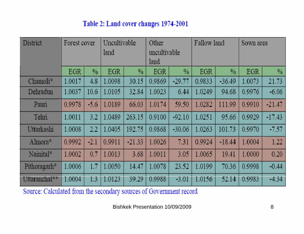
Bishkek Presentation 10/09/2009 8
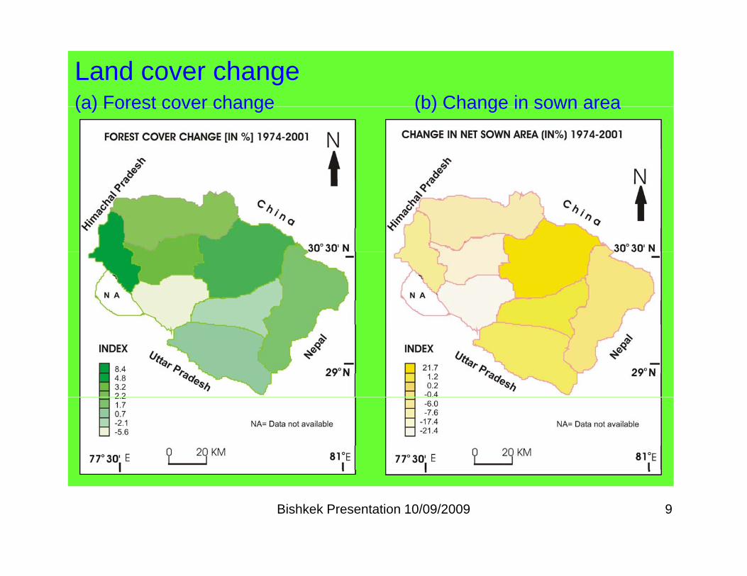
Land cover change(a) Forest cover change (b) Change in sown area(a) Forest cover change (b) Change in sown area
Bishkek Presentation 10/09/2009 9

Land cover change(c) Fallow land (d) Uncultivated land( ) ( )
Bishkek Presentation 10/09/2009 10

Forest cover and sown area change in Dehradun
Forest Cover Change in Dehradun District
6 8
% f F t C
Change in Sown Area in Dehradun District
17
58
6 0
6 2
6 4
6 6
ores
t Cov
er
% of Forest Cover
15 5
16
16.5
nge
in %
50
52
54
56
58
19 74 - 79 19 79 - 8 4 19 8 4 - 8 9 19 8 9 - 9 4 19 9 4 - 0 1
% o
f Fo
14.5
15
15.5
1974-79 1979-84 1984-89 1989-94 1994-01C
ha
Bishkek Presentation 10/09/2009 11

Rajaji National Park in Surrounding of Dehradun City
Basmati Rice Fields are now Converting into SettlementConverting into Settlement
Bishkek Presentation 10/09/2009 12

Forest cover and sown area change in Chamoli
Change in Sown Area in Chamoli District
9
Forest Cover Change in Chamoli District
63
456789
ge in
%
585960616263
ores
t Cov
er
01234
1974-79 1979-84 1984-89 1989-94 1994-01C
han
5455565758
1974-79 1979-84 1984-89 1989-94 1994-01
% o
f Fo
Bishkek Presentation 10/09/2009 13

Change in agricultural land use
Subsistence crops Cultivation of paddy
Cash generating crops
Bishkek Presentation 10/09/2009 14

Bishkek Presentation 10/09/2009 15

Pine forest invading the regime of temperate oak forest
Pine forest
Temperate oak forest
Bishkek Presentation 10/09/2009 16

Bishkek Presentation 10/09/2009 17