Embed Size (px)
Citation preview
Land use in karst terrain: reviewof impacts of primary activitieson temperate karst ecosystems
SCIENCE FOR CONSERVATION 198
Peter B. Urich
Published by
Department of Conservation
P.O. Box 10-420
Wellington, New Zealand

Science for Conservation is a scientific monograph series presenting research funded by New Zealand
Department of Conservation (DOC). Manuscripts are internally and externally peer-reviewed; resulting
publications are considered part of the formal international scientific literature.
Titles are listed in the DOC Science Publishing catalogue on the departmental website http://
www.doc.govt.nz and printed copies can be purchased from [email protected]
© Copyright June 2002, New Zealand Department of Conservation
ISSN 1173–2946
ISBN 0–478–22262–9
This report was prepared for publication by DOC Science Publishing, Science & Research Unit; editing
by Michael Ashdown and layout by Ruth Munro. Publication was approved by the Manager, Science &
Research Unit, Science Technology and Information Services, Department of Conservation, Wellington.

CONTENTS
Abstract 5
1. Introduction 6
1.1 Rationale 6
1.2 Categories 7
1.3 Methodology 8
1.4 Overview 9
2. Impact of primary activities 11
2.1 Forestry 11
2.2 Forest recovery 13
2.3 Agriculture and cropping systems 15
2.4 Impacts of soil erosion on karst 19
2.5 Agricultural chemicals 20
2.5.1 Monitoring and assessment of pollution pathways 23
2.6 Percolating water 23
2.7 Quarries, landfills and mining 26
2.7.1 Quarrying 26
2.7.2 Anthropogenic landforms 27
2.7.3 Reclamation 28
2.7.4 Landfilling 27
2.7.5 Restoration and closing of quarries and landfills 29
2.8 Urban development (USA) 31
2.8.1 Sinkhole flooding 31
2.8.2 Groundwater withdrawal 32
2.9 Dams 33
2.9.1 Remedial measures when damming 33
3. Best management practices (BMPs)—current knowledge 35
3.1 Examples of BMP and cave protection 36
4. Specific processes and features of karst-based activities and impacts 38
4.1 Doline management 38
4.2 Cave fauna 40
4.3 Speleothems 42
4.3.1 Methods and monitoring 43
4.3.2 The entrance environment at Kartchner Caverns 43
4.4 Epikarst processes 45
5. Legislating for karst management 47
6. Conclusion 49
7. Acknowledgements 50
8. References 51
9. Glossary 58

4 Urich—Land use in karst terrain
5Science for Conservation 198
© June 2002, Department of Conservation. This paper may be cited as:
Urich, P.B. 2002: Land use in karst terrain: review of impacts of primary activities on temperate karst
ecosystems. Science for Conservation 198. 60 p.
Land use in karst terrain:review of impacts of primaryactivities on temperate karstecosystems
Peter B. Urich
The International Global Change Institute, The University of Waikato,
Hamilton, New Zealand
A B S T R A C T
There is an acknowledged lack of information available to managers of New
Zealand’s karst estate on the impacts of primary activities on these sensitive
environments. A review of the international literature was undertaken to begin
to address the issue. Subjects of particular interest were identified by
Department of Conservation staff and included, in order of priority: forestry,
agriculture and quarrying, followed by a second range of activities including
landfilling, groundwater chemistry changes, urbanisation, cave climate and
near-entrance vegetation change, and also conservation legislation. While there
is a volume of literature on karst, it is largely devoted to the science of karst
processes rather than the impacts of primary activities. In many cases the
science is robust and the likely impacts of primary activity can be adequately
assessed. In the future, improved communication by karst managers and
researchers and the people living on, and in contact with karst landscapes on a
daily basis will lead to better informed and directed research on the impacts of
human occupancy on karst ecosystems.
Keywords: temperate karst, primary industry, management, impacts, protection,
conservation, legislation
6 Urich—Land use in karst terrain
1. Introduction
1 . 1 R A T I O N A L E
Much of the karst1 scientific literature is relatively inaccessible to managers of karst
environments both within and outside New Zealand. Yet much of this literature is
potentially applicable and useful in management. Over time, little consultation has
occurred between karst scientists and potential end users of the research product,
i.e. land/conservation managers. Certain notable examples of more applied
research do exist (Kiernan 1998, 1989a) and much of this has been undertaken in
New Zealand and Australia (Williams 1975, 1980; Gunn 1978; Wilde 1985; Bunting
1998). However, the prevailing situation is mainly for research to be driven by the
scientific community rather than the management community. This project is a first
attempt at bridging the gap between the science of karst and the practice of karst
management. The project draws from a very rich and diverse literature to begin to
answer some important questions being raised by the managers of karst
environments. The overall rationale therefore is to deduce from the scientific
literature the potential impacts of primary activities (defined below) on the short-
and long-term sustainability of karst environments. Imbedded within this
overarching rationale is an attempt to provide an avenue whereby accessible
knowledge of particular, science-based studies can influence and support policy
formulation for the preservation, conservation or sustainable use of New Zealand’s
karst heritage.
This research project was initiated in discussion with Dave Smith (Department
of Conservation, Maniapoto Office, Te Kuiti) concerning issues faced by
managers of New Zealand’s karst estate. We attempted to discern the particular
needs of New Zealand’s karst managers when confronting various legislative
polices. We wished to link these issues with current environmental thinking,
both theoretical and applied. We grouped the original set of issues under
headings representing ‘activities of concern’, ‘management’ and ‘processes and
features’, then ranked the issues according to ‘level of concern’. This provided a
focus to review the literature comprising close to 5000 potentially relevant
works.
Further input on these categories was sought by email from DOC staff involved
in the management of karst terrain in New Zealand, but none was forthcoming.
1 . 2 C A T E G O R I E S
The following categories were derived, in part, from a brief assessment of works
by particular karst scientists. The matrix devised by Williams (1993) was
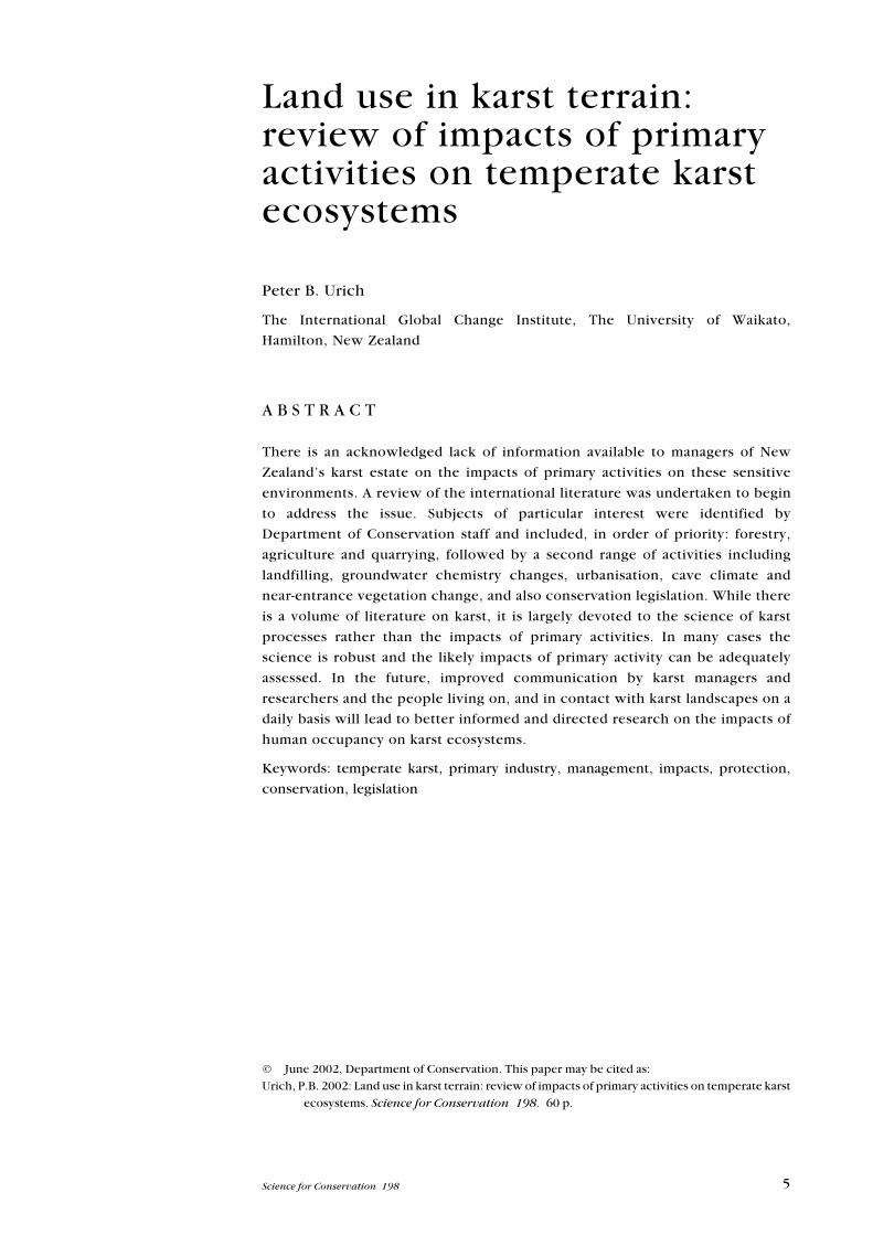
particularly helpful (Fig. 1).
1 Karst refers to landscapes formed through the solution of rock, most commonly ‘limestone and its close
relatives’ (Gillieson 1986). Common elements of karst environments include macro features such as
cave systems, lack of surface water, pinnacles, closed depressions and limestone-derived soils.
7Science for Conservation 198
For the present literature review, a more refined matrix was devised in order to
address the needs of karst managers in New Zealand. The categories for
consideration were grouped under three headings:
Activities of general concern in New Zealand:
• Pastoral farming: conversion, species and stocking rates, soil chemistry,
percolating water chemistry, soil erosion, agrochemicals and sedimentation
rates.
• Forestry: species and stocking rates, clear felling, selective logging, soil
chemistry, percolating water chemistry, leaf litter, soil biology, harvesting,
soil erosion, and sedimentation rates , effects of ‘rotating’ of impacts.
• Cropping systems (maize, viticulture, etc.): groundwater contamination, soil
compaction, soil erosion, irrigation.
• Quarries and landfills: groundwater contamination, sediment movement,
groundwater pumping.
• Urban development: subdivision, storm water management, contaminants,
surges.
• Dams: hazards, effects of water level control (dams above karst).
Figure 1. Matrix of anthropogenic activities, effects and impacts on karst terrain. (Source:
Williams 1993. Reproduced with permission.)
�������������
����� �� �������������
�������������
�����������
�� ������������!���!����"
#����"������!�$�����
������$���!�����������
�������"�����%�����
&������'(���������
)�!�$��*�(�����$+
)������!,�����(�$(���
)�!�$��*!�,������$+
�$(�%����-�!�������"
�����!����!��������!��������
��!�$��������������%��
&�����.�����"�!������������
���!���$�!����������
����������(��
�(�����!����������
����,��������������
���,��!�/������"���$�
�������������� ��������
��� ��������
�� � �������������
0������� ����
��!���!��%�(������(�������
��������!����������!��������
��������!���!�$����!���-����
���!�����
&�����,�����!���-����
���/���!�$���������$�%��
�-�$�����,�����
&������!�����
��!���!��������������-����
&������� �����,�����
����!�����
8 Urich—Land use in karst terrain
Management of karst terrains—current knowledge:
• Measurement and management: anything pertaining to temperate karst.
• Remedial measures: strategies, outcomes and impacts.
Specific processes and features of karst-based activities and impacts:
• Percolation water: effects of vegetation type.
• Doline management: erosion control, gallery vegetation.
• Cave entrance flora: vegetation (microclimate, light/temperature pene-
tration and airflow with change in vegetation cover) change in flows of energy
(organics), air, water through vertical entrances.
• Cave fauna: sensitivity of stygobites to water quality, epigean aquatics (solids
and contaminants), organic content of allogenic streams and changes to cave
riparian communities.
• Speleothems: effects of change in water quantity and quality.
• Epikarst processes: effects of erosion and change in water quantity and quality.
• Flooding: quantity and quality of floodwater and effects on speleogenesis.
While all the above issues were perceived to be important, the available
literature did not support such a detailed analysis. A second framework was
therefore devised for the purposes of this review, with forestry and agricultural
activities carrying the most weight.
1 . 3 M E T H O D O L O G Y
Examined literature sources included professional journals, conference proceed-
ings, books and government reports.
The University of Waikato library and the Internet provided electronic access to
Firstsearch’s GEOBASE and GEOREF.
GEOBASE covers worldwide literature on ecology, geography, geology, human
geography, international development and related disciplines. Over 2000
journals are covered fully, and 3000 selectively in addition to coverage of more
than 2000 books, monographs, conference proceedings and reports. GEOBASE
contains more than 600 000 records with abstracts maintained from 1980 on.
The GEOREF database is the most comprehensive geosciences database,
providing access to over 2.2 million references related to geoscience journal
articles, books, maps, conference papers, reports and theses.
These two major databases were supplemented by a search of the UNCOVER
REVEAL online database. UNCOVER is a database containing current article
information from well over 18 000 multidisciplinary journals. UNCOVER also
contains brief descriptive information for over 8 800 000 articles which have
appeared since late 1988.
Search terms were uniformly applied to all databases. These terms included
‘karst’ and ‘limestone’ in combination with the following descriptors: environ-
ment, development, epikarst, formations, stalactite, stalagmite, sediments,
quarry, aquifer, pollution, agriculture, impact, fauna and flora. The search was
conducted for keywords and abstracts in order to search as widely as possible to
9Science for Conservation 198
capture references electronically using the Endnote Version 3.0 computer
program. A total of 4762 references were placed in a searchable file in Endnote.
The references were then sorted off-line. Titles and available abstracts were
assessed with respect to their applicability in addressing the questions posed in
the objectives noted above. Papers with potential to address the questions
raised in the objectives were placed in a second database and sought through
libraries. Personal contacts or the American Geographical Society collection at
the University of Wisconsin-Milwaukee, where I was based for one month,
provided additional works. A total of 142 referenced research works were
obtained and form the basis for this literature review.
1 . 4 O V E R V I E W
Karst environmental change occurs both on the surface and underground. The
activities that alter karst environments may be direct or indirect in nature, and
may occur within the karst environment or beyond its boundaries, entering and
impacting upon it. There is an urgent need for a better understanding of the
linkages between primary activities such as agriculture, mining and forestry
(amongst others), and both the short and long-term impact these activities can
and do have on New Zealand’s karst heritage.
Environmental damage in karst landscapes is carried through the karst system
either rapidly with great impact, or sometimes slowly with little readily
apparent impact (Fig. 2). The slow accumulation of change in the karst
environmental system is important. By definition, karst systems are typically
ancient, defined and moulded by eons of entrophic change (‘natural’ environ-
mental processes). Hence, slight changes in groundwater chemistry, while not
immediately and dramatically evident, may become so over a longer time frame.
Many karst scientists argue that this time frame needs to be considered in all
assessments of primary activity impacts in a karst environment system.
Most karst studies have been focused on the engine of karst development—
water; scientific studies have generally focused on the issue of water and its
chemistry, role in karst development, flow patterns (traces) and water quantity
and quality in an anthropogenic sense. Hardwick & Gunn (1990) comment ‘the
impacts on limestone cave geoecosystems of surface change resulting from
human activity have not been well documented’. Therefore, this literature
review tried initially to capture a large volume of literature that might broadly
relate to topics of interest to those managing New Zealand’s karst. Although not
directly comparable, international knowledge of karst environmental processes
is broadly applicable to New Zealand conditions on a case-by-case basis.
This literature review has been arranged as ‘blocks of knowledge’. Where an article
touches on issues that are relevant to different parts of this review, I have dealt with
each part separately, rather than through the single review of a referenced work.
For example, it is common for a researcher to address sampling methods, findings
and management outcomes, perhaps in terms of legislative requirements, in one
paper. I have distributed these ideas into the relevant subsections of this review,
with a comprehensive bibliography at the end. A glossary of technical terms is
appended. The use of technical terms has been minimised.
10
Urich
—La
nd
use in
ka
rst terrain
Figure 2. A model karst system. (Source: Gillieson 1996. Reproduced with permission.)
�������������
����������� ������������������������������������������ ������� �������
��������������
������������������������������������� �������������
����� ��������� �������
�����������������
�����������
��� ������������ ���� �
���!����
������"�����
�������#����
"����
�� ����������$���
���� �� ���
$�����$����������
������������%!��� ����&
���������
�������������!�'
����������������������� ���!�"��������� �����������������
������������������������������������� �����������
��������������������� �������
��������������������� ����#���$%&'������� ���"()���*"+��
��(� ��)������
��*� + ��(�����
���)����,����
���������
�-��������$��� � ��!����
�
� � �
� � �
� � �
� �
� �
�
�
�
�
�
�
�

11Science for Conservation 198
2. Impact of primary activities
2 . 1 F O R E S T R Y
Felling of trees in experimental catchments has repeatedly shown that runoff
increases by an amount equivalent to previous losses by evapotranspiration
from the forest stand. In temperate rainforest, such as that occurring on the
Waitomo karst in New Zealand, which receives an annual rainfall of about 1800
mm, annual runoff can increase by up to 700 mm (over 35%). This represents a
very large increase in kinetic energy available for erosion and transportation of
soil and debris. Such increases result in downslope movement of soil, especially
where the protective ground cover is disturbed by burning or machines. At
Waitomo (Central North Island, New Zealand), the bottoms of cleared solution
dolines became the repositories of forest debris and soil, which occurred
despite the fact that increased runoff impeded transmission of flow to springs
(Gunn 1978). In the lower Waitomo valley, floodplain sedimentation of 2.1–4.3
m has occurred since forest clearance for agriculture commenced about a
century ago (Williams 1980). This is 40 to 80 times the average Holocene
sedimentation rate in that valley. The local soils are principally derived from a
thick blanket of volcanic ash. Hence, the karst still remains largely soil-covered.
This contrasts markedly with regions that are dependent only on karst-derived
soils. In the latter case, forest clearance can lead to the complete stripping of
the thin soil that may have existed.
There is some confusion regarding the impact of forest clearance on
speleothem development. There is little doubt that groundwater recharge is a
major control on speleothem growth and development processes; calcite
cannot be deposited in absence of recharge. However, Kiernan (1988) has
presented two interesting cases from Tasmania, Australia. A decrease in
recharge following a change of vegetation cover from pasture to pine forest was
associated with subsequent desiccation and ‘fossilisation’ of speleothems in
underlying caves; yet in another cave in Tasmania, forest clearance above
resulted in renewed calcite deposition. If forest cover was the natural
ecosystem in these areas of karst development, then forest cover appears to
mitigate speleothem development; advocating the regeneration of forest to
preserve the underlying karst ecosystem may be remiss. Important research
remains to be done on the impact of the composition of forest species and
complexity of the forest cover and litter and karst processes. In the Tasmanian
case noted above, monocropping of Pinus radiata appeared to be detrimental
to the karst; however the condition of the cave prior to the development of the
plantation forest was not discussed.
Any change in the volume and chemical or physical state of flowing water or air
may also have a profound effect upon cave decoration (Kiernan 1988). Kiernan
further notes that any disturbance of the soil mantle can lead to dehydration and
a change in the continuity of formation development. There have been cases in
Tasmania where sealing roads and carparks at tourist cave locations has actually
led to the degradation of the spelothems that attracted tourists in the first place
(Skinner 1972 in Kiernan 1988). It is becoming more evident that local
12 Urich—Land use in karst terrain
hydrology must be taken into account during all phases of development in karst
areas, and that this must occur at a variety of scales in order to recognise
interconnectivity of systems. As will be discussed later, both the cave and
entrance area atmosphere conditions must also be considered. As Kiernan
(1988, 1989b) noted, this issue can have important implications for manage-
ment. For example, the removal of forest cover can raise soil temperatures and
subsequently alter soil CO2 levels, and ultimately lead to the development of
more acidic and hence aggressive seepage water entering the cave
environment, which could corrode decorations. Kiernan also details a case
where the opposite may occur, when salts are released in regeneration burning
which causes the opposite trend but notes that hard data to prove this is
lacking.
Unfortunately, these claims are largely anecdotal since no data are available.
One study of the impacts of forest clearance on these parameters is underway in
Tasmania, Australia, but results cannot be expected in the short term (Kiernan,
pers. comm.).
Evidence from Norway is also inconclusive with respect to the role of forest cover
in its influence on water chemistry, i.e. carbon dioxide levels in the epikarst zone.
In the Norwegian example, there was a difference in carbon dioxide levels in water
debouching above and below the tree line. A definitive correlation between forest
cover and CO2 was not possible, owing to intervening factors such as flood pulses
and reduced sampling levels (Bakalowicz 1984). As discussed elsewhere in this
report (cf. percolation waters), the sampling methods used in assessing the
aggressiveness or depositional capacity of karst waters are hotly debated.
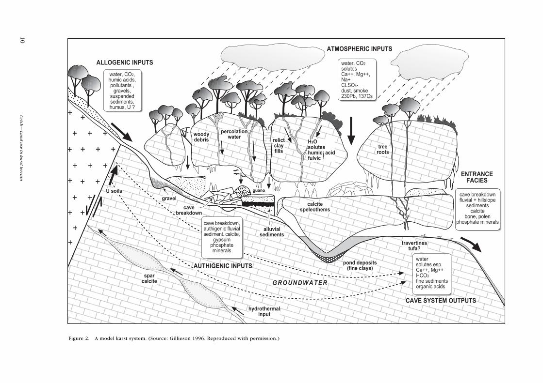
The northern half of Vancouver Island, Canada, features steep limestone slopes
that were still glaciated up to 12 000 years ago. Following deglaciation,
coniferous forest grew upon the veneers of the outwash laid down upon the ice-
scoured rocks. The dominant species were western hemlock (Tsuga
heterophylla), silver fir (Abies amabilis) and western red cedar (Thuja
plicata). Clear-cutting involving the removal of all trees and burning of the
slash and dead wood began around 1900, but increased in intensity with
mechanisation in 1960. Land that was cleared was left to re-seed naturally.
Harding & Ford (1991) established that ‘clear cutting led to significant soil
losses on both limestone and volcanic rock slopes but that losses were much
greater on the limestone’. In the limestone area, there was a mean reduction in
soil depth of 25% five years after logging. This increased to 60% after ten years.
The mean percentages of bare limestone also increased, with virtually none
under virgin forest. Bareness increased from between 10 and 20% after five
years to between 20 and 30% after ten years. Soil losses on limestone were
significantly greater where deliberate burning of slash and dead wood followed
cutting. Burning was not as significant on the volcanic rocks. Eroded soil on the
limestone bedrock was deposited in the epikarst and in shallow micro-caves.
Regrowth was very limited. Evidence to date shows that there will be no growth
of large trees on the longer, bare limestone slopes. For example, even in the site
clear-cut in 1911, which was much flatter than more recently logged areas and
thus retained more soil, the area had regained only about 17% of the original
volume of timber (Harding & Ford 1991).
13Science for Conservation 198
2 . 2 F O R E S T R E C O V E R Y
Discussion in the forestry literature related to karst is dominated by the
negative effects of deforestation on the karst ecosystem and the subsequent
impact on the sustainability of economic activities (Urich 1996). Researchers
and managers of the karst estate are also concerned with rehabilitation of
endemic forest cover when and where possible, in order to preserve karst
systems. Several studies have explored the underlying conditions necessary for,
and constraints on the rehabilitation of forest cover (Rivera & Aide 1998; Urich
& Reeder 1999).
The study by Rivera & Aide (1998) was conducted in Puerto Rico where karst
covers 20% of the island. At the peak of deforestation just after WWII, native
forest covered only 6% of the island. Other studies of forest recovery rates had
been conducted in non-karst environments. Rivera & Aide’s study was the first to
explore the issue in karst terrain. The researchers sought to answer two questions:
• How do the different types of land use affect forest regeneration in terms of
basal area, density and species diversity?
• How does the composition of seedling regeneration compare with the
composition of adult trees in abandoned pastures and coffee plantations?
These authors predicted that species diversity and stem density would recover
faster in pasture, and that basal area would be greater in abandoned coffee
plantations. Historically, coffee was planted below shade trees. Recovery in an
area with a close canopy should restrict the establishment and growth of shade-
intolerant species. On the other hand, pasture sites may be colonised by species
with a wide range of light requirements.
They found that densities were higher in abandoned pastures than in coffee
plantation sites, but there was no difference between the two land uses in basal
area. The major differences between these land uses were the vegetation
structure at the time of abandonment, age since abandonment, valley width and
light environment. The coffee plantation sites were all abandoned around 35
years ago. The pasture sites were younger and were abandoned at different
times (range 15–35 years ago). It appears that coffee plantation sites reached a
stable phase in terms of density and basal area, while the pastures were still in
the thinning (density) and increment (basal area) phases. Valley width was
significantly higher in abandoned pastures than in abandoned coffee plantation
sites. The wider valleys received more light, while the light environment in the
abandoned pastures would have been much greater at the time of abandonment.
The coffee plantations were all planted under shade trees where light levels in
the understory were relatively low.
Rivera & Aide compared the findings of their study with those of researchers
working in other geologic settings in Puerto Rice. They found that secondary
forests in the karst region recover faster than secondary forest in other
geological/soil formations. In the karst region, the mean basal area in the
abandoned pastures (age 15–35 years) was nearly double the mean basal area in
pastures of similar age (15–37 years) in eastern Puerto Rico. Another study
reported a similar mean basal area in pastures that were at least twice the age
(60 years) of those in the karst region. Abandoned coffee plantations in the karst
region’s subtropical moist forest also recovered faster. In Rivera & Aide’s study,
14 Urich—Land use in karst terrain
basal areas in 35-year-old abandoned coffee plantations were again nearly
double those of similar plantations in other geologies, namely volcanic areas.
The differences in the recovery rate in these abandoned coffee plantations
could have been due to different climates, but the authors believed that the
topography of the karst region may also have contributed to the recovery.
The unique topography of karst landscapes may be the most important factor
contributing to the rapid recovery of secondary forest. Karst topography often
consists of long narrow valleys surrounded by hills with steep slopes. This
topography protects the valleys from strong winds. In addition, the accumulation of
soil and organic matter in the valley bottoms creates better conditions for plant
growth. The long narrow valleys protected the soil from direct sunlight
(maintaining high humidity) and soil erosion (high nutrient inputs occur from
runoff from the surrounding hills) in contrast with other non-karst soils.
The encouraging findings of Rivera & Aide in relation with the ability of
limestone environments to recover secondary forest cover are echoed in the
findings of Urich & Reeder (1999) in the Philippines. They found that micro-
geomorphic factors appear to influence both tree survival and growth rates.
Each hill they studied had micro-geomorphic features that included slope angle,
slope length, breaks in slope, and the size and distribution of talus, which
influenced the rates of erosion and deposition. In their case study, trees were
planted on a preset grid, and hence in a wide range of micro-geomorphologic
environments with no apparent regard for micro-topography. Soils were both
deeper and moister toward the toeslope of the mogotes. This is to be expected,
since overland flow transports eroded soil to the toeslope and, combined with
lateral unsaturated flow, keep this soil moist. For these reasons, generally
higher survival rates and more vigorous growth can be expected to occur at the
toeslope rather than at the mid-slope or on summits. These analyses indictate that
there is a fairly strong relationship between tree growth and landscape position.
Additionally, and in support of the work of Rivera & Aide (1998), Urich &
Reeder (1999) found that previous land-use history plus length and intensity of
land cultivation following the clearance of primary forest were critical to the
survival rate and vigour of secondary forest growth.
Unfortunately, similar studies to those above have not been conducted in
temperate karst environments such as New Zealand. Particularly useful in the
context of this review is the evidence that karst environments can, in some
instances, support the growth of secondary forest cover. Secondly, karst
environment appears to support more rapid secondary forest growth than other
environments of different geology, topography and soil types as noted by the
work of Rivera & Aide. Similar constraints on rates and success of secondary
forest recover such as history of deforestation and subsequent land use should
apply in New Zealand’s karst environments.
15Science for Conservation 198
2 . 3 A G R I C U L T U R E A N D C R O P P I N G S Y S T E M S
As in the case of forestry, the primary impact on the karst environmental system
from the conversion of natural land cover, be it forest, grassland or any other
biome, is the resultant change to the characteristics of the water entering the
karst system either allogenically or autogenically.
Williams (1993) addressed this in a general way. Water supplies in karst areas
are very susceptible to degradation by both point source and diffuse or non-
point source pollutants and, consequently, their ecosystems are correspond-
ingly susceptible to irreparable damage. This is largely due to the nature of karst
hydrologic systems. Natural treatment of water-borne contaminants is often
relatively ineffective in these systems. Ford & Williams (1989) identify five
reasons for this:
• The surface area available for colonisation by natural micro-organisms, and for
adsorption and ion exchange, is much less in dense, fractured karst rocks with
shallow soil than in porous elastic sediments with deep soil covers. Conse-
quently, percolating water that diffusely recharges karst has relatively little
opportunity for self-purification.
• Rapid infiltration into karst also reduces the opportunity for evaporation, a
process that is particularly important for the removal of volatile substances
such as solvents and pesticides.
• The transmission of particulate contaminants right through the karst systems
to springs is assisted by the turbulent flow regime that is characteristic of well-
developed karst aquifers. Point recharge occurs via stream-sinks (ponors) and
dolines. Sinking rivers penetrate rapidly and deeply into the karst. Drainage
from the bottom of individual dolines is on a smaller scale, but their frequent
use as rubbish pits permits rapid transport of debris and leachate down
opened joints into groundwater systems. A similar but larger-scale problem
arises when abandoned limestone quarries are used as landfill sites.
• Physical filtration is relatively ineffective through rocks with highly developed
secondary porosity and patchy, shallow soils.
• Flow velocities are very high and flow-through times correspondingly short
compared with most other groundwater systems. Consequently, pollution
elimination processes that are time-dependent are less effective. There is
usually insufficient time, for example, to permit the die-off of pathogenic
organisms, which may therefore emerge at karst springs.
Soil erosion is often intensified when soils are disturbed for agriculture and other
primary land uses such as highly mechanised forestry. Increased sediment loads
impact on speleothems, speleogens and clastic sedimentary deposits. This may
result in sediment accretion and either total or partial infilling of cave passages, and
possibly the burial of in situ speleothems, speleogens and clastic sediments.
Hardwick & Gunn (1990) conducted a review of the impacts of soil erosion on
cavernous limestone catchments (Fig. 3). They soon noted that reports on soil
erosion in limestone catchments are obscure and require careful scrutiny. They
found this unfortunate, since the formulation of land use strategies for karst
terrain should require consideration of soil erosion and its environmental
impact on cave systems and limestone aquifers. Hardwick & Gunn’s analysis is
divided into two components: soil erosion on limestones overlying caves and
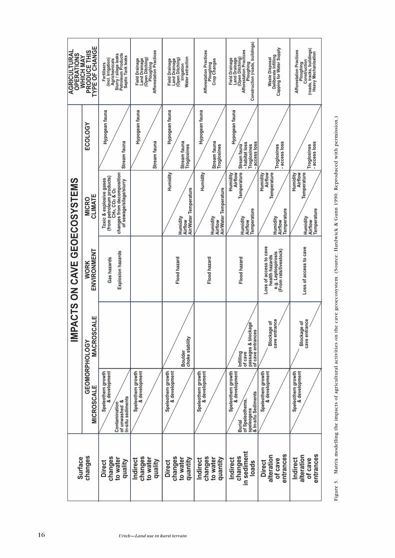
16 Urich—Land use in karst terrain
Fig
ure
3.
Mat
rix
mo
de
llin
g t
he
im
pac
ts o
f ag
ric
ult
ura
l ac
tivi
tie
s o
n t
he
cav
e g
eo
ec
osy
ste
m.
(So
urc
e:
Har
dw
ick
& G
un
n 1
99
0.
Re
pro
du
ce
d w
ith
pe
rmis
sio
n.)
���
����
��
����
��
����
�
���
����
��
����
��
����
�
����
���
��
���
��
��
��
��
��
���
��
���
����
����
�
� �
��
����
���
�!
� ��
"���
#
��$
���
����
���
�!
� ��
"���
#
� �
��
����
���
�!
� ��
"���
#
��$
���
����
���
�!
� ��
"���
#
��$
���
����
���
��
�$ %
��
���$
�
� �
��
�� �
�� �
��
���
���
���
���
��$
���
�� �
�� �
��
���
���
���
���
&�
'(
��
��'
��
��
��
���
'�
��
�)�
��
�'
��
��
)��
��'
��
)��
���
��
�)�
��
��
��
�'
�*
�)�
��
�+��
�� �
�%�
��!
�,
$��
���+
%��
���
�%
��
��
��
�!��
��$
,��
-� �
��$
%��
�
���
��
��
+���
� ��
%�.
�+��
����
��,
��-�
��
�$ %
�� �
�� �
� ��
��
���
+���
����
,/
����
���
��
���
�� �
����
�
���
�$��
����
��
�/ �
#
���
��0
��$�
�1+
���
���
�0��
$�
2���
$��
0��$
2���
$��
0��$
2���
$��
0��$
)���
��
����
� �
���
���
�� �
��0
��$�
�3�3
)�+
��+
���
�42
��%
��
�5� �
�� �
��6
)���
��
����
� �
���
�
��1
�,
�1+
���
���
����
4��%
+�
����
�%+
��$�
� �6
�*
7.�
�8,
�8
����
���
��%
$��
�%+�
� �
��
��!
���5
� ��
��5�
����
#
*�%
$ #
*�%
$ #
*�%
$ #
� �
��!
��%
+���
���
*�%
$ #
� �
��!
��%
+���
���
*�%
$ #
� �
��!
��%
+���
���
*�%
$ #
� �
��!
��%
+���
���
*�%
$ #
� �
��!
��%
+���
���
*�%
$ #
� �
��!
��%
+���
���
*�%
$ #
� �
��!
� �
5&�
���
�%+�
�� �
��
*�%
$ #
� �
��!
� �
5&�
���
�%+�
�� �
��
����
��1
���
-���
���
����
����
��1
���
-���
���
����
� ��
�%�
���
-��/
� �
���
����
��1
���
-���
���
����
� ��
�%�
���
����
��1
���
� ��
�%�
���
����
��1
���
� ��
�%�
���
� ��
�%�
���*#+
����
��
���
*#+
����
��
���
*#+
����
��
���
*#+
����
��
���
*#+
����
��
���
��
'��
9)�
9'
�)
��
�'
����
��
&*
��*
���
�'
��
9�
��
*��
���
��
2�
*�
��
�2�
� �
����
4 ���
3���
��
��6
���
���
% �
���
���
��#
5� ��
����
���
��
����
�%�
��$�
� �
��+
��
���
����
�
2 ��
$�
�� �
���
)��$
���
���
�4�
+��
� �
� ��
6�
����
� ��
��
���
� �
��
���
���
2 ��
$�
�� �
���
)��$
���
���
�4�
+��
� �
� ��
6��
� ��
��
&�
���
1 ��
� �
�
��
���
� �
��
���
���
���
���
���
��+
���
����
2 ��
$�
�� �
���
)��$
���
���
�4�
+��
� �
� ��
6�
���
� �
��
���
� �
���
����
� ��
���
� ��
� �
�4�
��$�
./�
�$ �
��6
&��
��
�+�
���
���
/��
� �
�� �
� ��
��+
+ ��
��
&�
���
�++�
#
��
���
� �
��
���
���
���
���
���
���
���
��
4���
$�.
����
�./
� �$
���
6*
���#
���
���
�� �
�
�+��
�� �
�%�
��!
�,
$��
���+
%��
�+��
�� �
�%�
��!
�,
$��
���+
%��
�+��
�� �
�%�
��!
�,
$��
���+
%��
�+��
�� �
�%�
��!
�,
$��
���+
%��
�+��
�� �
�%�
��!
�,
$��
���+
%��
�+��
�� �
�%�
��!
�,
$��
���+
%��
17Science for Conservation 198
the transport of derived sediments underground by autogenic water on one
hand, and inputs of sediments to caves from the catchments of allogenic feeder
streams on the other.
In many areas, superficial deposits of allogenic origin, on which mineral soils
have developed, overlay limestones. There are also extensive areas of bare
limestone where intervening fissures and underlying caves frequently contain
substantial amounts of sediment (eroded in previous phases of land use
change). For example, the bare appearance of much of the Mediterranean
karstlands, including the ‘classic’ karst of Yugoslavia, is believed to be a result of
human-induced deforestation and subsequent soil erosion. In England, early
agriculture in the northern Pennines may have provoked large-scale soil loss,
hence leaving bare limestones in that area. The shallow soils, patchy vegetation
and large areas of bare rock of the Burren karst plateau of Ireland have been
ascribed to glacial erosion. However, Drew (1983) argued that the area was
once well populated and forested, with an extensive cover of mineral soil which
was removed by erosion as a result of forest clearance in the late Bronze Age.
There is also evidence from areas where modern intensive agriculture is
practised. Lewis (1981), in a study of CO2 levels in Coldwater Cave, Iowa, USA,
noted that large amounts of mud and fine organic debris were washed into the
cave from the overlying farmland during storm events. Similarly, Weirsma et al.
(1986), in their study of Wisconsin’s Door County karst, noted the impact on
groundwater quality of soil loss into dolines. Moreover, agricultural produc-
tivity was reduced by a loss of tillable area.
In many cases, the ultimate destination of eroded material must be the
underlying cave and conduit systems. The speed and mode of transmission are
poorly understood. Hardwick & Gunn (1990) identify three points on the basis
of physical size of conduits: shaft flow with thin films of water flowing down
the walls of openings more than 1 m in diameter; vadose flow with meteoric
water mostly flowing solutionally enlarged fissures and joints 0.01–1.00 m in
diameter; and vadose seepage of water percolating through tight fissures and
fractures, or moving as intergranular flow. Shaft flow and most vadose flows are
turbulent, and capable of transporting soil and rock particles underground.
Once boulders, rocks, pebbles and sediment reach the larger cave conduits, the
process of their movement is very similar to that of surface fluvial systems
(Gillieson 1996). The primary difference is that the sediments are confined to a
conduit. Gillieson (1996) commented that this resulted in the following effects:
• There can be rapid changes in water level from flooding or the morphology of
the cave passage and this results in steep gradients and the rapid change in the
energy available for reworking sediments along the cave passage. This can
lead to a greater diversity in sediment textures per unit length than in surface
systems.
• There can also be the complete reworking of sediments whereby previous
deposited sediments may be completely removed with a subsequent high-
intensity event (flood). Thus the life history of a parcel of cave sediment is one
of periodic reworking until its identity is lost, its volume become negligible or
it is placed in a very low-energy environment.
18 Urich—Land use in karst terrain
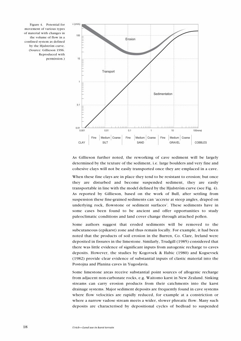
As Gillieson further noted, the reworking of cave sediment will be largely
determined by the texture of the sediment, i.e. large boulders and very fine and
cohesive clays will not be easily transported once they are emplaced in a cave.
When these fine clays are in place they tend to be resistant to erosion; but once
they are disturbed and become suspended sediment, they are easily
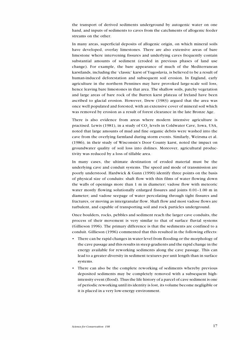
transportable in line with the model defined by the Hjulström curve (see Fig. 4).
As reported by Gillieson, based on the work of Bull, after settling from
suspension these fine-grained sediments can ‘accrete at steep angles, draped on
underlying rock, flowstone or sediment surfaces’. These sediments have in
some cases been found to be ancient and offer opportunities to study
paleoclimatic conditions and land cover change through attached pollen.
Some authors suggest that eroded sediments will be removed to the
subcutaneous (epikarst) zone and thus remain locally. For example, it had been
noted that the products of soil erosion in the Burren, Co. Clare, Ireland were
deposited in fissures in the limestone. Similarly, Trudgill (1985) considered that
there was little evidence of significant inputs from autogenic recharge to caves
deposits. However, the studies by Kogovsek & Habic (1980) and Kogsevsek
(1982) provide clear evidence of substantial inputs of clastic material into the
Postojna and Planina caves in Yugoslavia.
Some limestone areas receive substantial point sources of allogenic recharge
from adjacent non-carbonate rocks, e.g. Waitomo karst in New Zealand. Sinking
streams can carry erosion products from their catchments into the karst
drainage systems. Major sediment deposits are frequently found in cave systems
where flow velocities are rapidly reduced, for example at a constriction or
where a narrow vadose stream meets a wider, slower phreatic flow. Many such
deposits are characterised by depositional cycles of bedload to suspended
Figure 4. Potential formovement of various types
of material with changes inthe volume of flow in a
confined system as definedby the Hjulström curve.
(Source: Gillieson 1996.Reproduced with
permission.)
�������
��
�� ����������
���
��
�
���
����
��������
������ ����� ���� �� ��� ������
����
��� ����� � !!���
"� �#� ������ ���� "� �#� ������ ���� "� �#� ������
�$�%
%����&���
19Science for Conservation 198
sediment. Gillieson (1986) studied allogenic slopewash sediments from lime-
stone rock shelters in the Papua New Guinea highlands. These suggested that
late Pleistocene erosion rates under stable primary forest were minimal but
erosion increased significantly from 6000 B.P. on, and especially from
300–400 B.P. owing to horticultural intensification.
In temperate regions, Tucker (1982) noted continuing accretion of up to
several metres of agriculturally derived sediment in Kentucky caves. Several
authors (e.g. Williams 1975; Hawke 1982) have documented rapidly increasing
sediment levels in cave systems that are due to anthropogenic activities in the
catchments of allogenic streams in New Zealand. Public road maintenance and
deforestation activities in surface catchments are just two possible reasons for
the artificial raising of stream levels downstream, which can reduce the
hydraulic gradient of the system, leading to further depositions of sediment. In
some cases blockage and disruption of underground drainage routes can also
create problems, particularly flooding, within their surface catchments
(Dougherty 1983).
2 . 4 I M P A C T S O F S O I L E R O S I O N O N K A R S T
The impacts of soil erosion in karst catchments can be severe. Soil erosion can
result in the partial or complete infilling of cave passages and the burial of older
clastic deposits, some of which may be of scientific importance. With the
choking of passages, backflooding may result and access to caves or parts of
cave systems may be permanently lost. However, the rehabilitation of an
allogenic catchment to natural or semi-natural vegetation may have unforeseen
consequences, with downcutting of cave sediment infills resulting from
increased stream competence (Kranjc 1979; Dougherty 1983). Sediment infill
may also lead to long-term changes on cave passage morphology.
Adverse impact of soil materials transported by autogenic recharge on
speleothem growth and development has been demonstrated by Jakucs (1977).
He found that speleothems beneath barren and deforested karst were inactive
and usually yellowy, brown or ochre in colour. When surface vegetation died off
or was removed, there was a marked change in colour of speleothem growth
layers, usually towards red, and this was attributed to the inwashing of terra
rossa soils and deposition of clay minerals on the speleothem surface. If
afforestation recommenced, speleothems grew lighter with fresh deposition of
white or translucent calcite.
Anthropogenically induced allogenic sedimentation may also impact on cave
ecosystems. For example, silting of Mammoth Cave, Kentucky, USA is known to
have affected the geographical distribution of hypogean Asselidae communities
(Lewis 1981), since pool and riffle sequences, plus gravel areas that were lost,
were essential for the species’ reproduction and survival. Similarly, sediment-
ation is known to have reduced the breeding sites of a species of glow worm at
the Waitomo glow-worm grotto, in New Zealand (Pugsley 1981). There is also
the case of the impact of differential deposition of clay minerals on the
hypogean fauna in Belgium (Tercafs 1988). Thus, localised movement of soils
may have a profound impact on hypogean communities.
20 Urich—Land use in karst terrain
In the conclusion of their review, Hardwick & Gunn (1990) noted that modern
agricultural practices may increase the material taken underground by allogenic
streams, and may also increase the rate of this material further removal by
autogenic recharge. A continued dependence on agrochemicals to maintain soil
fertility may promote long-term soil degradation owing to the loss of organic
material from soil matrices (Luoma 1989). The presence of underlying joints
and fissures is likely to facilitate the evacuation of soils from the surface. This
can be exacerbated by soil disturbance and compaction during soil cultivation.
The application of liquid sewage sludge as fertilisers using irrigation techniques
may accelerate soil erosion, owing to rapid subsurface runoff via the
subcutaneous zone.
Since catchment disturbance is likely to lead to increased sediment loads in
insurgent streams, consideration needs to be given to agricultural activities in
allogenic catchments. This raises a further problem with the present system for
the designation of Cave Sites of Special Scientific Interest in Britain under the
1981 Wildlife and Countryside Act, since ‘only land overlying known or
hypothesized caves, not the allogenic catchment, is included in the site’
(Hardwick & Gunn 1990).
2 . 5 A G R I C U L T U R A L C H E M I C A L S
Berryhill (1989) provided a general overview of the potential impact that
changing agricultural practices might have on the karst environment. His focus
was on particular nutrients and their movement and impact. He considered one
of the critical issues to be that of plant nutrients such as nitrogen. Sources of
contamination include fertilisers and manure applied to fields for crop
production, as well as manure storage facilities, feedlots, dairy parlours, poultry
and hog houses. Activities that may exacerbate nutrient losses include excess
fertiliser and manure application, improper timing of application, poor manure
storage management and failure to supervise areas where livestock may
concentrate. Other activities include inappropriate tillage practices such as up-
and-down-hill ploughing just before heavy rainfall, and allowing livestock
access to sinking streams, cave entrances and sinkholes.
Conservation practices may also increase nutrient loss. Reduced tillage
techniques, which leave a crop residue cover on the soil surface, can increase
infiltration and cause loss of soluble nutrients to groundwater. Level terraces
can more than double groundwater nitrate loading compared with contour
farming (Johnson et al. 1982).
Nitrate is recognised as a major karst groundwater pollutant, owing to its adverse
health effects. In infants, nitrate can be reduced to nitrite, causing methemoglo-
binemia, the ‘blue-baby’ syndrome (Grow 1986). Levels of nitrate above the United
States Environmental Protection Agency drinking water standard of 10 mg/L have
been documented in karst groundwater in Minnesota (Grow 1986; Smolen et al.
1989), Pennsylvania (Kastrinos & White 1987) and Iowa (Mitchem et al. 1988).
Kastrinos & White (1987) showed a linear relationship between mean nitrate
concentration in karst spring water and agricultural land use coverage. In their
study of the Conestoga Headwaters RCWP project area (about a third of which is
21Science for Conservation 198
underlain by carbonate rocks) wells in the carbonate-rock portion showed higher
nitrate levels than non-carbonate wells.
Phosphorus is not considered a groundwater pollutant, since it has no adverse
health effects and does not migrate far into soils before it is immobilised (White
1988). However, if excessive loadings of phosphourous (usually from manure)
exceed the adsorptive capacity of a soil, leaching to ground water is possible
(Johnson et al. 1982) and direct entry and passage of phosphorus through
conduit drainage to resurgences may occur. The major adverse environmental
effect of high phosphorus levels is the eutrophication of surface waters
(Johnson et al. 1982).
The link between changing agricultural land use and impacts on the underlying
karst have been most thoroughly studied in the context of human effluent and
manure lagoons and silage storage. Alexander & Book (1984) examined the
notorious case of the Altura Minnesota lagoon collapse in 1976, studying the
massive failure of a series of effluent and aeration ponds holding concentrated
human waste. The lack of understanding of the number and extent of sinkholes
underlying the lagoon area was implicated as the cause for the disaster.
Moreover, the presence of a thin, poorly indurated and jointed sandstone layer
overlaying a thick carbonate unit was not discovered in pre-construction
surveys. The problem arose when sandstone collected solutionally aggressive
vadose water and concentrated it on the underlying bedrock exposures. The
aggressive, differential solution of the underlying carbonate produced enlarged
voids in which the overlaying materials collapsed. The stored effluent then
drained into the underlying carbonate karst aquifer.
Drew (1996), working in the Burren country of western Ireland, investigated
the threat of farm-related effluents on the underlying karst groundwater system.
It was discovered that a large proportion of silage piles produced a potent form
of effluent that greatly exceeds the other more commonly examined types of
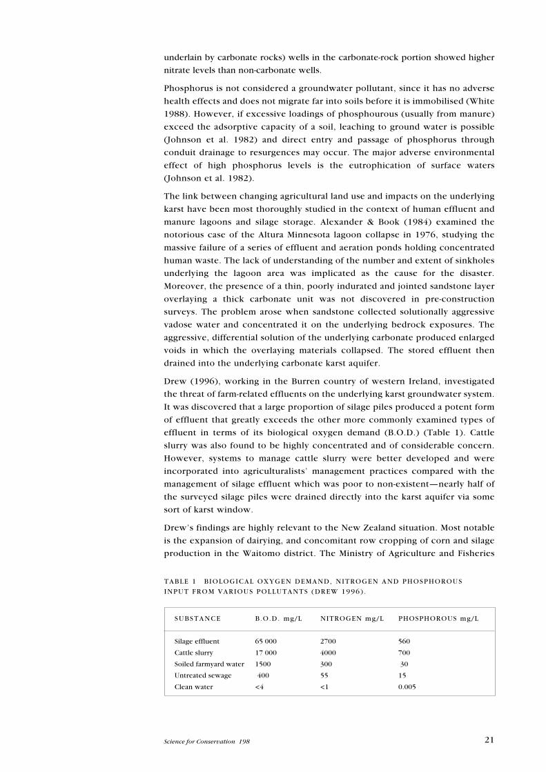
effluent in terms of its biological oxygen demand (B.O.D.) (Table 1). Cattle
slurry was also found to be highly concentrated and of considerable concern.
However, systems to manage cattle slurry were better developed and were
incorporated into agriculturalists’ management practices compared with the
management of silage effluent which was poor to non-existent—nearly half of
the surveyed silage piles were drained directly into the karst aquifer via some
sort of karst window.
Drew’s findings are highly relevant to the New Zealand situation. Most notable
is the expansion of dairying, and concomitant row cropping of corn and silage
production in the Waitomo district. The Ministry of Agriculture and Fisheries
TABLE 1 BIOLOGICAL OXYGEN DEMAND, NITROGEN AND PHOSPHOROUS
INPUT FROM VARIOUS POLLUTANTS (DREW 1996) .
SUBSTANCE B.O.D. mg/L NITROGEN mg/L PHOSPHOROUS mg/L
Silage effluent 65 000 2700 560
Cattle slurry 17 000 4000 700
Soiled farmyard water 1500 300 30
Untreated sewage 400 55 15
Clean water <4 <1 0.005
22 Urich—Land use in karst terrain
(Hamilton) reported an increase in dairy operations from 44 to 51 in the
Waitomo district between 1991 and 1992 (Begg 2002). Since 1992, the trend
toward increased dairy cow numbers per unit area and the number of new
operations has increased rather than diminished.
Related to the increase in row cropping of corn with the expansion of dairying
is the risk of contamination of karst groundwater owing to the use of
agricultural chemicals. Most modern herbicides move in the dissolved phase. In
Iowa karst, of the atrazine found in groundwater, 55 to 85% arrived there via
infiltration through the soil (Mitchem et al. 1988). Maas et al. (1984) and other
authors including Boyer & Pasquarell (1996, 1999) and Pasquarell & Boyer
(1996) identified the following primary routes of bacteria and/or pesticide
transport to karst aquatic systems: by direct application to water surface; in
runoff: either dissolved, granulated or adsorbed on to soil particles; aerial drift;
volatilisation and subsequent atmospheric deposition; and through uptake by
biota and subsequent movement through the food web. Sources of pesticide
contamination in karst include excessive or improper application, poor timing
of application, incorrect choice of chemicals, and improper cleanup and
disposal practices. Pesticides in groundwater not only affect drinking water
wells and springs adjacent to the point of use, but also may kill fish and other
aquatic life (Maas et al. 1984) and affect municipal water supplies and surface
water bodies downstream. Hallberg et al. (1985) reported year-round
concentrations of atrazine in Iowa karst ground water of 0.2 to 0.5 µg/L. The
levels of atrazine reached a maximum in 1984–85 but dropped after cleanup
efforts (Klein 1989 quoted in Berryhill 1989).
Quinlan & Alexander (1987) conducted a comprehensive survey of atrazine flow
through a karst environment. Their study addressed the unique hydrodynamics of
recharge storage, and also discharge in a karst aquifer and its influence on the
distribution of pollutant maxima during various water input scenarios (both
meteoric and snow melt). The study challenged the applicability of sampling
methods for monitoring groundwater quality that were designed to satisfy
regulatory requirements. Such methods, he discovered, commonly assume that
there are no significant short-term changes, and he concurred with Bender (1986)
that very few publications address water-sampling strategy and related problems of
sampling frequency.
Quinlan & Alexander found that nitrate may reach a maximum or minimum
which neatly coincides with the hydrographic peak, but this depends upon the
season and whether a significant amount of recharge infiltrates through the soil.
The lag between the hydrograph maximum and the atrazine maximum is a
consequence of the rise in stage which is caused by groundwater being pushed
out of the cave by ‘piston-flow’ of storm water behind it. The hydrographic
peak in the nitrate has a similar origin. It is water which was stored in joints and
fissures, but which is also being pushed out before the storm water runoff
attunes at the monitoring site.
Importantly, the time span for pollutant variability ranges from months to years,
and is a response to the frequency and duration of wet periods versus dry
periods. During dry periods, the pollutants accumulate in the soil and epikarst
zone (Williams 1985; Hobbs & Smart 1986; Smart & Friederich 1986). Hence,
pollutant concentration detected in springs and relevant wells in the active
23Science for Conservation 198
flow zone decreases. Since flow is also less during dry periods, the total amount
of pollutants moving through the system decreases too. In wet periods,
however, more pollutants are washed through the soil and epikarst zone and
are detected at springs and monitoring wells which intercept conduits flowing
to them. Therefore, the total amount of pollutants, as well as their
concentrations reaching these monitoring points, is much higher during wet
periods. Short-term, event-related fluctuations of pollutant concentration are
superimposed on these long-term fluctuations.
2.5.1 Monitoring and assessment of pollution pathways
Adequate monitoring of a pollutant source in a karst characterised by conduit-
flow and concentrated recharge requires both frequent sampling (in some
settings) as often as hourly during a storm or other precipitation event as well
as long-term sampling (regularly, over a period of years). Adequate monitoring
also requires continuous recording, inspection and interpretation of stage data
and also adjustment of sampling frequency, so that it is possible to know the
approximate times of parameter maxima during a storm event. Additionally, it
must be possible to know and interpret antecedent soil-moisture conditions,
since they strongly influence the hydrograph response.
Different sampling problems are encountered in karst aquifers dominated by
diffuse-flow through fractures. Quinlan & Alexander (1987) demonstrated that
daily sampling of numerous springs and wells was necessary to detect one-way
‘pulses’ of dye that randomly appeared one week to even months after injection
at a proposed landfill on a ridgetop. It must be noted that this was a case where
a precise throughput time was required rather than simply proving a hydrologic
connection.
As alluded to in Quinlan & Alexander’s work, soil type, depth and
characteristics of the soil profile bear heavily on the movement of water, and
hence pesticides, into the epikarst zone. Veni (1999) discussed in some detail
the role played by soil when conducting environmental impact assessments in
karst areas. Veni asserts that surface karst features containing no sediment or
soil, or only A horizon-type soils, are far more likely to transmit contaminants
rapidly into aquifers than features containing soils of the B and C horizons. In
karst areas however, the thickness and permeability of sediments and soils can
vary dramatically over short distances. Conditions assessed in one feature
should not be generalised to other features and locations.
2 . 6 P E R C O L A T I N G W A T E R
Landscapes and their vegetation type can have important implications for the
formation of particular biokarst features. Hence, attention must be given to
alterations in the vegetation cover in areas where biokarst features occur. The
main biokarst features that have been researched in the context of changing
vegetation cover are tufa dams and micro-pits (Jie at al. 1997). Two areas of
interest are commonly referred to in the discussion of the role of biokarst in
karst landscape development. One area applies to erosional elements such as
lichen and mosses, which in effect play a catalytic role in eroding limestone.
24 Urich—Land use in karst terrain
Small, micro-scale features ‘etched’ into exposed limestone are the result. These
are considered to be minor factors in the meso- and macro-scale formation of
karst landscapes. Local exceptions must of course be considered, e.g. karstic
coral islands, as important examples of the potential of this type of activity.
Identified as more important are the depositional biokarst processes. These are
represented by the deposition of calcite on the surface in the form of tufas.
Considerable debate surrounds the process of tufa accumulation. Jie et al.
(1997) proposed a model based on research conducted in Sichuan Province,
China. They discovered that the role of algae and mosses in karst deposition has,
in turn, an important role in tufa formation. The management implication of this
study is that site-specific bacteria, algae and mosses prevalent in the wider karst
area or hydrological catchment must be identified and protected if the natural
process of karst deposition on the surface as tufa deposits is to continue. This
research also supports arguments made elsewhere on the role of bio-agents in
the epikarst zone and karst erosion and deposition.
A two-year study of a karst spring in the peri-Mediterranean karst system in
southeast France yielded some interesting results that are relevant for karst area
managers. Lastennet & Mudry (1997) attempted, through longer–term study, to
determine the nature of the variability in karst water chemistry debouched by
one spring. By studying the area for two years, the effects of drought and flood
could be assessed. The authors discovered considerable variability in the
chemical composition of the water debouched from the system, especially as
related to ‘discrete’ and ‘unusual’ climatic events. One of the important findings
was that small events in the catchment appeared to have little or no impact on
the entire karst hydrological system (or the effects were so small that they were
undetectable). Major events, however, such as large floods, had great and
potentially lasting impacts on the system. These lasting impacts usually resulted
because of the gross change effected on the composition of the autogenic input
sites in the karst basin by substantial movement of regolith either into the
system or the entrances of caves. Similarly, the blocking of exit points by debris
and sediment had the potential to force a longer-term change in the flow regime
of the hydrological system, and thus alter the chemical makeup of the water.
A second and equally important finding was the variability discovered in water
chemistry in relation to storm events. Special emphasis was placed on
chemicals recognised as influential in the karstification process. These were
total dissolved solids, i.e. bicarbonates; chloride and nitrate (tracers of shallow
water systems); and silica and magnesium (tracers of water from the saturated
zone). Concentrations of these compounds were highly variable in relation to
storm events. Consequently, the authors emphasised the importance of a
rigourous water sampling methodology in most studies of karst groundwater.
This is highly relevant to managers of karst environments in New Zealand,
where climatic variability across time and space is significant. When water
chemistry data form a vital input into the database on which management
decisions are to be made, it must be ensured that these data are rigorous and
appropriate for the type of karst being considered.
As an example, Quinlan & Alexander (1987) devised a set of parameters to
determine the frequency at which water samples should be taken when
assessing the impact of pollutants from agricultural, waste disposal and spill
sites in karst terrain. The authors implore agencies to consider these
25Science for Conservation 198
recommendations in order to have accurate information ‘to defend against their
[environmental zealots] frequently unjustified attacks’. Quinlan & Alexander
state that ‘the conventional practice of using four conveniently located
monitoring wells (one up-gradient and three down-gradient), as commonly
required by regulatory agencies (in the United States) for granular aquifers, but
honorably, naively, and erroneously also required for karst terraces, is likely to
be a waste of time and money’. Moreover, the sampling of water collected
quarterly, semi-annually and annually is also invalid in karst terrain. The authors
advocate much more frequent monitoring. It is argued that the distinctive
characteristics of the karst aquifer under investigation must be considered on a
case-by-case basis. The unique hydrodynamics of recharge, storage, and
discharge and their influence on the distribution of various pollutants must
account for variability in climatic events. The requirements in place in the
United States for monitoring groundwater are simple and straightforward, but
do not account for the variability that can occur in karst aquifers. The
assumption in the USA regulations is that there will be little short-term change in an
aquifer and that testing for any short-term change will not be cost-effective.
The importance of frequent sampling was reinforced by the results of Quinlan
& Alexander (1987) study of Moth Spring in Minnesota, USA. In the conduit
flow-type situation they studied, concentrations of pollutants can range from
100 to 10 000 times higher than antecedent levels within a few hours or days.
Admittedly, this is in a conduit-flow situation (more rapid and hence more likely
to have concentrated pulses of contaminants), which the authors recognise as
one end of the continuum of karst aquifer development, with diffuse-flow and
dispersed recharge aquifers at the other end. In essence, pulses driven by
precipitation or runoff events account for one set of effects. The maxima for
different contaminants can be out of phase with each other and the hydrograph
peak. For example, with non-point sources of pollution such as herbicides that
may be carried by surface runoff, this component may reach a maximum early in
the hydrograph peak at the spring discharge. However, nitrate is often carried
by the diffuse component of recharge. Nitrate may reach its peak or trough
along with the hydrograph peak, depending on the intensity of a given rainfall
event, soil moisture conditions and seasonality. In some cases, the maximum
contamination can occur before the peak hydrograph as contaminants stored in
joints and fissures are ‘pushed out’ by the rising pulse of the storm surge.
The second scale of analysis determined by Quinlan & Alexander is over a
longer time frame. This correlated with either wet and dry periods or longer
duration over months and years. Since flow during extended dry periods is less,
the amount of contaminant discharged in such periods also decreases.
Conversely, at the end of a dry period and with the onset of a wetter period, the
amount of water and contaminants debouched from a spring will rise. The
variability of the aforementioned short-term events is superimposed on these
wet and dry period fluctuations.
In summary, Quinlan & Alexander suggest that for adequate pollutant monitoring in
a karst area characterised by a conduit-flow system and concentrated recharge,
sampling should occur hourly during storm or other significant precipitation
events, and also longer term over several years. In conjunction with water
chemistry, attention must be given to regular collection of reliable stage data so
that researchers can characterise an aquifer and predict the impact of individual
26 Urich—Land use in karst terrain
rainfall events with reasonable certainty. Accuracy of predictions is also enhanced
by the collection and interpretation of soil-moisture conditions, since these
strongly influence hydrograph behaviour.
The monitoring of karst groundwater is critical for assessment of risk associated
with the use of karst landscapes for primary production. Problems do arise
however, when data attained in the comprehensive study of a karst aquifer are
released to the public. A commonly asked question, one posed by Quinlan &
Alexander is: ‘Is a temporary high concentration of parameter “X” during a
storm a real problem as contrasted with merely a theoretical one? . . . does such
an event constitute a significant risk to the health and welfare of people, cave
fauna, or other life?’ What if, for example, it were possible to avoid the use of
the contaminated groundwater debouched during a storm event that is likely to
have a high concentration of contaminant(s)? Risk analysis cannot, by itself,
provide a panacea for unequivocally determining issues of public safety and
health (or of the impact on the flora and fauna of the karst environment). At
best, as Quinlan & Alexander note, risk assessment offers some guidance for
policy decision, as does common sense.
2 . 7 Q U A R R I E S , L A N D F I L L S A N D M I N I N G
Two significant forms of point pollution in karst areas are sinkhole dumping
and the act of quarrying and subsequently employing disused quarries as sites
for solid waste disposal. In this section, the focus is on the issue of quarrying
and use of disused quarries for waste management, or in limited cases as sites
for landscape rejuvenation.
2.7.1 Quarrying
In aesthetic terms, limestone quarrying is the most ‘obvious and, in both
process and landform terms, the most dramatic anthropogenic impact on karst
terrain’ (Gunn & Bailey 1991, 1993). The quarrying of limestone has both
geomorphological and ecological impacts. The work of Gunn & Bailey (1991,
1993), Gunn & Hobbs (1999) and Hess & Slattery (1999) detailed these impacts
in a British context. However, many of their findings are applicable to quarrying
in any environment.
In essence, quarrying represents an intensification of the erosion process. In
the case of Britain, the volume of material excavated would have taken up to
10 000 years to erode naturally. It is the rate of change that has dramatic and
equally rapid impacts on hydrology and karst ecology. One of the more
common impacts of quarrying is the drawdown of water in the subcutaneous
zone surrounding the quarry. In some cases, this has led to doline formation. In
other cases, the entire subcutaneous zone may be removed by quarrying
activities and in such cases the impacts on local water resources and karst
processes can be profound. When groundwater pumping is required to
maintain a quarrying operation, the impacts typically affect a greater area than
when pumping is not required. Groundwater drawdown can influence
groundwater discharge from springs in the region of the quarrying operation, in
terms of both quantity (seasonality) and quality of debouched water.
27Science for Conservation 198
The stripping of forest cover and soil for quarry development destroys the karst
ecology of the area earmarked for quarry development. Deposition of the spoils
from these activities can also influence karst processes. The size and depth of
the quarry has implications for the subsequent recolonisation of the environ-
ment by surrounding vegetation. With an increase in depth, it is correspond-
ingly likelier that a different limestone composition will be exposed. Upon
abandonment, the soil formed from this parent material could be significantly
different from the surrounding environment, obviating the development of a
complementary plant assemblage (Ruthrof 1997).
Gunn & Bailey (1991) assert that the size of a quarry is of less impact than its
situation. They describe three possible locations for quarry development: on flat
ground, along or into the side of a valley, or into a hill. Quarries developed in
flat areas have less impact and this is restricted to the destruction of local karst
features. Valleyside and hillside quarries are, however, favoured for their
economy; it is easier and cheaper to work material laterally rather than
vertically. Generally, hillside quarries have a greater geomorphological impact
than valleyside operations. Cases of complete hill removal through quarrying
have been documented (Stanton 1990; Urich et al. 2001).
2.7.2 Anthropogenic landforms
Gunn & Bailey (1991) describe three anthropogenic features that may result
when quarrying ceases.
• Enclosed or semi-enclosed rock basins have formed when quarrying occurred
in a generally flat landscapes in morphometric terms, they are comparable to
very steep-sided collapsed dolines.
• Valleys with both sides modified by quarrying result in a steepening of the
valley sides and a widening of the valley floor. Resulting valleys have a shape
usually found after glacial sculpting.
• Artificial dry valleys can result when quarrying activities work in, rather than
along a slope.
The landforms described above can, and should be considered ‘permanent’ in
that it will take considerable geologic time for the modified landscape and the
surrounding environment to evolve to become a unified system. The return to a
more ‘natural’ geomorphological condition can be hastened by the importation
of foreign material (land fill), with its own set of ecological ramifications.
2.7.3 Reclamation
Given that the evolution of quarried landscapes to a more natural condition may
take hundreds of thousands of years, there has been a movement to hasten the
process through the use of rehabilitative techniques. In Britain, it is now mandatory
that a reclamation plan be included with any application for a quarrying permit.
2.7.4 Landfilling
Bodhankar & Chatterjee (1994) examined an interesting case of land filling in a
disused quarry in Madya Pradesh, India. They considered a water-quality prob-
lem in their study. The problem was first discovered when a variation in the
colour of the groundwater was noticed, owing to the presence of suspended
28 Urich—Land use in karst terrain
sediments. The water had been supplied by tube wells in a residential locality
near an abandoned limestone quarry. This abandoned quarry was used as an
urban waste disposal site. The problem only occurred during the rainy season,
when the quarry filled with precipitation and surface runoff water. This
phenomenon was overlooked and the people continued using water. After
some time, many nearby residents had to be hospitalised owing to waterborne
diseases such as cholera, dysentery and gastroenteritis. Jaundice, malaria and
typhoid were also on the rise.
A study showed that groundwater from the wells and water within the now
garbage-filled quarry were linked. Four other sources of contamination were also
identified:
• Domestic waste disposal: the prevailing practice was the direct disposal of
domestic waste into surface sewers, which flow into the natural drainage system
within the watershed area. Sewage was also dumped in sinkholes within the
highly porous and permeable soil capping the limestone. Unregulated waste
disposal in slums and newly urbanized areas without a planned sewage disposal
system led to the formation of cess pools, which were potential sources of
contamination.
• Water conservation structures: there were approximately 35 water conser-
vation structures in and around Raipur City. These were in the form of natural
lakes and ponds, and artificially constructed stop dams, and acted as
groundwater recharge sites. The inflow into these reservoirs included
precipitation and surface runoff water. Most hazardous was the surface runoff
water that carried dissolved and suspended solids such as food wastes, animal
faeces, fertilisers, pesticides, grease and oil.
• Landfills: there were more than 25 active or abandoned urban waste disposal
sites in Raipur City. Dumped waste consisted of garbage, and at some landfills
there was also incineration of combustible refuse in abandoned limestone
quarries. Landfill material included paper products, food wastes, construction
debris, septic tank sludge, plastic, glass and chemicals.
• Water wells: domestic dug wells were of small capacity and tapped the shallow
water. Many of these shallow wells had dried owing to lowering of the
groundwater level. These dried dug wells were in places used as community
dump sites. Deeper tube wells for private and municipal water distribution were
of a higher capacity and tap deep-seated aquifers. Surface and groundwater
percolation from outside the casing may also have occurred, leading to
contamination.
The case of quarry use for landfill, and its consequences, were graphic in Raipur
City. Similar cases and impacts are also common in so-called developed areas. In
some cases in the United States, it is not the solid wastes that are of the greatest
concern. Liquids, mainly in the form of industrial chemicals, have been dumped
in disused quarries and other landfills developed in karst areas. Contamination
of the groundwater supply is common, with potentially disastrous conse-
quences for public health and aquifer integrity. See the works of Hoenstine et
al. (1987); Edwards & Smart (1989); Slifer & Erchul (1989); Hall et al. (1995);
Davis (1997) for details that parallel those of the Raipur City case study.
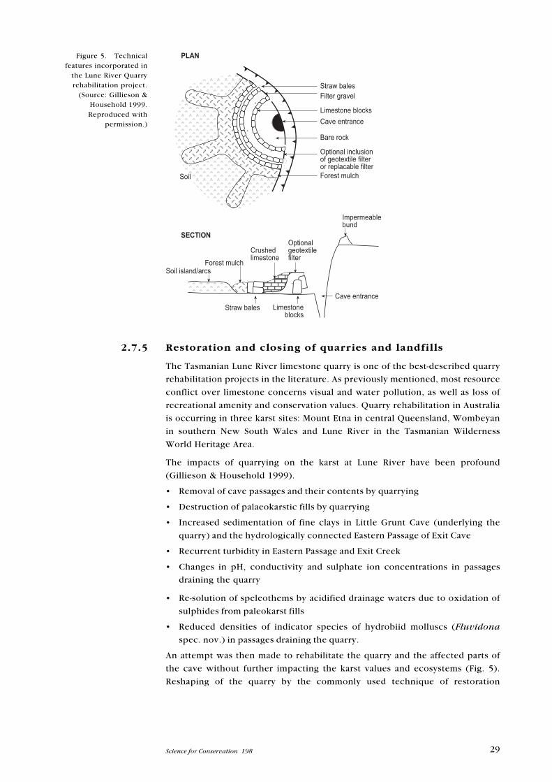
29Science for Conservation 198
2.7.5 Restoration and closing of quarries and landfills
The Tasmanian Lune River limestone quarry is one of the best-described quarry
rehabilitation projects in the literature. As previously mentioned, most resource
conflict over limestone concerns visual and water pollution, as well as loss of
recreational amenity and conservation values. Quarry rehabilitation in Australia
is occurring in three karst sites: Mount Etna in central Queensland, Wombeyan
in southern New South Wales and Lune River in the Tasmanian Wilderness
World Heritage Area.
The impacts of quarrying on the karst at Lune River have been profound
(Gillieson & Household 1999).
• Removal of cave passages and their contents by quarrying
• Destruction of palaeokarstic fills by quarrying
• Increased sedimentation of fine clays in Little Grunt Cave (underlying the
quarry) and the hydrologically connected Eastern Passage of Exit Cave
• Recurrent turbidity in Eastern Passage and Exit Creek
• Changes in pH, conductivity and sulphate ion concentrations in passages
draining the quarry
• Re-solution of speleothems by acidified drainage waters due to oxidation of
sulphides from paleokarst fills
• Reduced densities of indicator species of hydrobiid molluscs (Fluvidona
spec. nov.) in passages draining the quarry.
An attempt was then made to rehabilitate the quarry and the affected parts of
the cave without further impacting the karst values and ecosystems (Fig. 5).
Reshaping of the quarry by the commonly used technique of restoration
Figure 5. Technicalfeatures incorporated in
the Lune River Quarryrehabilitation project.
(Source: Gillieson &Household 1999.
Reproduced withpermission.)
30 Urich—Land use in karst terrain
blasting was rejected, owing to the sensitivity of both the geomorphology and
biology of the cave (Gagen & Gunn 1987).
The World Heritage values of the Exit Cave system was identified as a primary
objective. It was then deemed necessary to return the ecosystem processes
within the quarry area to as close as possible to their original state. In terms of
rehabilitation, the integrity of the underground drainage was set as the main
priority, followed by water quality and finally the cave invertebrate popu-
lations. A secondary objective was also identified: the project proponents
wished to re-establish a high degree of interconnected secondary porosity in the
quarry so as to effectuate appropriate recharge and to simulate as much as
possible the original polygonal karst drainage and forest cover.
The detailed objectives were as follows (Gillieson & Household 1999):
• Restore the hydrology of the site by simulating as much as possible the
drainage characteristics of the unimpacted karst.
• Reduce peak runoff by the creation of small internal drainage basins which
simulate dolines in polygonal karst as an effective way of restoring near-
natural infiltration rates and their spatially diverse patterning to allow soil and
subcutaneous zone recharge.
• Control sediment movement at source by the use of control structures and
filters, and construct adequate filters at stream sinks to prevent entry of
sediment into the karst hydrological system.
• Control active soil erosion and sediment entry to the karst system by
stabilising the soil surface (using hydromulching on steep areas) at the
sediment sources and encouraging cryptogam growth, which is the soil’s first
defence against erosion.
• Establish a stable vegetation cover, preferably of perennial plants. A diverse
vegetative cover with viable seed and the right structure to maintain
geomorphic and biotic processes is not only aesthetically pleasing, but also
will effectively moderate karst processes in the long term. The quality of
substrates used in rehabilitation is critical.
• Reactivate the soil biology. Allowing colonisation of the site by soil biota,
especially the colonial insects necessary for litter breakdown, will enhance
the recovery of nutrient cycling and produce a good soil structure for plant
seedling establishment and water infiltration.
• Monitor progress above and below ground. The success or failure of the
rehabilitation can only be assessed with meaningful data, preferably collected
on an event basis in order to allow calculation of loads of solutes and sediments
entering the karst drainage system.
• The complex nature of drainage and filter structures means that daily supervision
is mandatory during machine work phases. Plant operators may be unfamiliar
with karst rehabilitation principles, and environmentally costly mistakes may be
made inadvertently.
A monitoring system was established at Exit Cave to quantify the effects of the
quarry rehabilitation strategy. To date, the researchers have found that hydro-
graph peaks and the transfer of solutes and fine sediments have declined. A
more controlled and diffuse infiltration of surface water is occurring, which has
led to a decrease in the introduction of sulphite-rich clays to the subterranean
31Science for Conservation 198
environment. It is still too early to assess the impact the changes have had on
the cave fauna.
A model of sorts for designing, implementing and monitoring the closing of a
quarry landfill comes from Missouri in the United States (Hall et al. 1995). The
landfill in question was situated within a mature dolomite karst system, which
included numerous sinkholes, springs, cave systems, and streams which lost
flow to the bed through fissures in the underlying limestone bedrock or gained
flow from water seeping up through the bed. The investigation and closure of
this site was conducted utilising a set of innovative techniques including
fracture trace analysis, natural-potential and resistivity surveys, regional potentio-
metric data analysis, structural information, stream/spring gauging, monitoring
well installations and dye-tracing studies. It was determined that well-connected
karst conduits were the structural features that control the movement of
groundwater in the vicinity of the landfill. Final landfill closure included the use of
such methods as seep remediation and a landfill cap to limit through-flow of
meteoric water, plus the sealing of an on-site sinkhole. Groundwater monitoring
continues to assess the success of the project.
2 . 8 U R B A N D E V E L O P M E N T ( U S A )
A considerable amount of research has been conducted on the impact of urban
development on underlying karst aquifers. The greater part of this research has
been conducted in the United States, where large urban agglomerations are
sited atop important karst aquifers.
2.8.1 Sinkhole flooding
Nicholas Crawford, who heads the Karst Waters Research Unit at Western
Kentucky University, studied the impact of sinkhole flooding and surface water
contamination on the karst underlying the urban area of Bowling Green,
Kentucky (Crawford 1984). The city of Bowling Green is located entirely upon a
sinkhole plain, with underground streams flowing through solutionally
enlarged caves within the shallow carbonate aquifer. The landscape resembles
large funnels (sinkholes) that direct storm water runoff into the underlying
caves. Flooding of sinkholes in this karst region is a part of the natural
hydrologic system.
The urban storm water runoff flowing into By-Pass Cave exceeded the surface
water criteria for public water supplies for faecal coliform, oil and grease,
chromium, lead and iron. Grab samples revealed that levels of ammonia, 5-day
Biological Oxygen Demand (BOD5) and total dissolved solids were also high
enough to be considered pollutants or indictors of pollution during the first
flush of storm water into the cave. In addition, suspended solids (e.g. plastic
bags) were a significant pollutant; the refuse had a high potential for clogging
cave passages and exacerbating flooding.
Crawford concluded that any attempt to keep urban storm water runoff out of
caves under Bowling Green was impractical or impossible, even though it
carries pollutants into the underground streams.
32 Urich—Land use in karst terrain
In one part of the city, a watershed systems approach had been made to solve a
particular sinkhole flooding problems. This problem resulted from increased
storm water runoff associated with primarily residential developments. Sinkholes
were filled by developers and homeowners, and runoff was directed into
adjacent sinks which were unable to handle the increased discharge. Over-
flowing sinkholes during storms produced an unchanneled surface-flowing
stream that wound its way through residential property for about 2.5 km before
sinking completely. The watershed approach with a thorough mapping of cave
conduits and capacities was deemed a success and reduced local flooding. In the
future, developers need to be made aware of the nature of the underlying
geology and be restricted in their practice of infilling sinkholes (which block
underground flow). Avoiding the movement of surface water in this urban
development into the karst aquifer is impractical, but can be better managed.
2.8.2 Groundwater withdrawal
A similar case of urban development in a fragile karst with a risk to its
groundwater and surface collapse was studied in the northwestern part of
Augusta County in Virginia. The area is flanked by the Blue Ridge Mountains of
the Ridge and Valley Physiographic Province. Groundwater resources are
plentiful in Augusta County, particularly along the toe of the Blue Ridge in what
is known as the Lyndhurst-Grottoes alluvial corridor, immediately adjacent to
the study area. To meet future water-use demand in the county, a groundwater
supply well was developed and a 48-hour pump test conducted at 11 356 litres
per minute. Although groundwater reserves proved plentiful, a 45-cm-deep
sinkhole developed about 198 m from the well, farm ponds 457 m away receded
and residential wells 244–610 m away incurred reduced water levels. Residents
feared a risk of damage to homes, loss of their water supply and degradation of
drinking water quality (Destephen & Benson 1993). Groundwater and surface
water testing included inorganic water-quality also and microbiological parameters.
The latter included particulate analyses and the presence of protozoan parasite
Giardia lamblia and coliforms, which were used to evaluate the connection
between groundwater and local surface water bodies. Although results of the
study indicated a low potential for structural damage, owing to future sinkhole
activity, it showed that the water quality of some residential wells might be
degraded.
Since particulate analyses confirmed that groundwater feeding into the supply
well is under the direct influence of surface water, it was recommended that
certain residents be placed on an alternative water supply prior to production
pumping, and that filtration be provided for the well in accordance with the
Surface Water Treatment Rule. A mitigation plan was implemented, which
included crack surveys. The more comprehensive plan included a long-term
settlement station monitoring programme, and limitation of the groundwater
withdrawal rate to 3.78 million litres per day (mgd) and a maximum production
rate of 5670 litres per minute. The residents who could have been adversely
impacted by groundwater resource exploitation were satisfied by the outcome
of this investigation and the subsequent management plan. In this case, a
thorough study of the impacts of groundwater extraction averted human
suffering and the associated high mitigation costs.
33Science for Conservation 198
2 . 9 D A M S
The impacts of large dams in karst areas are well established (Herak et al. 1970;
Nicod 1991; Breznik 1998).
Karst terrain presents several risks related to development of not only dams, but
also other large structures such as buildings and landfills (Destephen & Wargo
1992). The risks include: highly variable rock surface with pinnacles and slots;
‘enhanced weathered zones’; and solution voids and cavities. The first can cause
differential settlement and unanticipated construction costs and delays. The
others can result in either sudden or ongoing subsidence. When designing
foundations in karst (for buildings or dams), the risks of potential future
subsidence must be defined for potential owners so that they can make rational
decisions about the amount of risk they are willing to accept.
Seismic instability may also be more likely in karst areas where dams and large
reservoirs are created. In China, 19 cases of reservoir-induced seismicity have
been acknowledged and 15 of these are associated with karst (Chen & Talwani
1998). For example, the Wujiangdu dam, with a height of 165 m is the highest
built dam in a karst area of China. A temporary seismic network was set up
40 km upstream from the dam. The results indicate that epicentres were
distributed along the immediate banks, composed of karstified carbonate, and
focal depths were only several hundred metres. Most of the focal mechanisms
were of thrust and normal faulting. Chen & Talwani suggested that karst may be
an important factor in induced seismicity, since karst landscapes provide the
hydraulic connection to change the saturation and pressure that can lead to
weak planes, and hence dislocation and induced seismicity. In effect, dams raise
water levels, which increases the water pressure and forces water into bedding
planes of limestone—thus lubricating and expanding joints leading to earthquakes.
In south-east Andalusia, Spain, the Guadalfeo and Adra Rivers drain the crystalline
massif of the Sierra Nevada and, before reaching the sea, cross a mountainous
region occupied by permeable Triassic carbonate materials. The Beninar Reservoir
is situated in this karst area on the Adra River. The reservoir is less efficient in part
owing to considerable seepage through a series of sinkholes in the carbonate
outcrops (Benavente et al. 1993). A new reservoir, on the Guadalfeo River, is
planned in a similar, but more complex hydrogeological context. The study of the
area by Benavente et al. (1993) suggested that the permeability of the proposed
dam site obviated the rationale for dam development.
In one case, the flooding of downstream springs resulted when a dam was
constructed further upstream. The construction of a reservoir on the Neretva
River in Yugoslavia influenced the flow regime of three springs 1 km
downstream from the dam (Bonacci & Jelin 1988).
2.9.1 Remedial measures when damming
The potential for leaks to develop in reservoirs created by damming rivers in
karst terrain is widely understood. Technologies have been used to mitigate
such risks, although not always with great success, as the following examples
describe.
34 Urich—Land use in karst terrain
The first evidence of possible foundation problems at Wolf Creek Dam on the
Cumberland River of Kentucky, USA were noted in 1962, when a cluster of wet
areas appeared on the downstream toe of the embankment. In 1968, sinkholes
began to develop and muddy flows could be seen in the tailrace. A series of
studies was initiated to determine the cause and investigate the need for
remedial treatment. The investigations indicated that the sinkholes and muddy
flows were the result of piping that moved through an extensive network of
solution channels in the dam foundation. It was found that serious defects
existed in the foundation of the dam, and that grouting (then the common cure)
could not be relied upon for long-term protection. Instead a concrete
diaphragm wall was constructed along the upstream crest of the embankment,
for a distance of about 683 m. The method was deemed successful (albeit
costly) for rehabilitating the Wolf Creek Dam (Hejazi 1987).
The Logan Martin Dam is a hydroelectric project on the Coosa River in Alabama,
USA. As in the previous case, the project was initiated in the early 1960s. Seepage
beneath the dam required several remedial measures to be implemented. The dam
was underlain by highly fractured and solutioned dolomite and limestone (Williams
& Robinson 1993). Subsequent hydrogeological investigations identified key
leakage zones and indicate that the original (1960s) and the remedial (1970s) grout
curtains did not extend deeply enough to intercept the predominate seepage paths.
The grouting was extended to a depth of nearly 122 m to seal the entire known
permeable zone underneath the dam (Williams & Robinson 1993).
35Science for Conservation 198
3. Best management practices(BMPs)—current knowledge
Although carbonate rock-derived soils in karst areas are rich (White 1988) and
in relatively flat topographical settings such as parts of the North American Mid-
west make excellent cropland, in other areas soils are shallow and rocky, and
fields are small and steep. Small farms raising livestock and poultry are more
prevalent in the mountainous karst area of the eastern United States.
Discussions follow of some ‘Best Management Practices’ (BMPs) that may be
helpful on cropland, and for livestock and poultry operations. Many of the
conservation practices developed in recent years are applicable in karst regions,
especially those for management of fertiliser, pesticides, animal wastes and
erosion. Those which increase infiltration are contraindicated if they also
increase groundwater loading of nutrients and pesticides.
Two BMPs that especially apply to karst include Planned Grazing Systems and
Livestock Exclusion (Soil Conservation Service 1987). Planned Grazing refers to
rotation of pastures with rest periods to allow ground cover to regenerate. The
efficacy of planned grazing with respect to improvement of groundwater
quality was demonstrated by Van Keuren et al. (1979) who compared the
effects of rotational summer grazing and continuous winter grazing by a herd of
beef cattle in a two-year study. There was no measurable soil loss from the three
summer pastures, although round 1600 kg/ha per year was eroded from the one
winter grazing and feeding area. Average annual surface runoff from the
summer areas (13.2 mm) was reduced by 85% from the winter value (90.4 mm).
Infiltration was slightly greater in summer under the rotational-grazed system
(407 mm compared with 388 mm), as was subsurface transport of nitrogen and
soluble salts. This study was made in a non-karst region. More research is
needed on the effects of different grazing systems on karst soils and waters.
Livestock exclusion is one practice of keeping animals away from water bodies
and areas subject to erosion. In karst, sinkholes and cave entrances should be
declared off-limits (Berryhill 1989). Laurel Creek Cave in Monroe County, West
Virginia, USA was an obvious case where livestock exclusion was not practised.
Several years ago, the low, wide entrance of a cave was a favorite resting area
for cattle. During storms, however, the cave took large volumes of water, as
evidenced by a highway bridge that had been washed deep inside the cave. The
potential for pollution from cattle effluent of the aquifer recharged by this cave
entrance could have been greatly reduced by a few feet of fencing.
Other suggestions for livestock are paved animal living spaces, means for
flushing or scraping daily buildup of manure in stock holding areas, leak-proof
feed and manure storage facilities, and unitary means to dispose of dead
animals. They also include runoff control structures and vegetative filter strips
for erosion and nutrient control. In the Garvin Brook, Minnesota, USA, these
measures were used to keep feedlot runoff from entering sinkholes (Barryhill
1989). Some cattle operations in the upper Mid-west of the USA rely on unlined
lagoons and pits for manure storage. These should not be considered BMP in
karst, unless local soils and underlying bedrock have been tested and found to
36 Urich—Land use in karst terrain
be acceptably impermeable. The worst possible case would be a swine waste
lagoon over cavernous limestone in an area of active sinkhole collapse.
3 . 1 E X A M P L E S O F B M P A N D C A V E P R O T E C T I O N
Cave protection has been addressed more widely in the literature. The most
comprehensive karst assessment process to date is that of Doerfliger & Zwahlen
(1995), who proposed identifying hydrologically vulnerable areas in karst
spring drainage basins through the use of air photo interpretation, tracer tests,
geophysical data and geomorphological mapping. Their EPIK system uses the
resulting data to define an area’s ‘Epikarst’ (surface karst features), ‘Protective’
cover (soil), ‘Infiltration’ conditions and ‘Karst’ drainage degree of solutional
conduit development. The characteristics of an assessed karst watershed area
are matched to a category under each EPIK factor. Categories have numerical
values, which are multiplied by a constant for the EPIK factor, and the results
are summed to identify the area’s degree of sensitivity, primarily with respect to
groundwater contamination. This vulnerability mapping method has a broad
application and should be conducted whenever possible. However, its reliance
on tracer testing and hydrologic data invalidates it as a strictly geomorpho-
logical Environmental Impact Assessment (EIA) methodology. Moreover, it
assumes uniform geomorphological interpretations when no standard methods
have been proposed.
Many of the methods described above are widely used, and all are based on the
accepted theories of cave, karst and speleothem development presented by
White (1988) and Ford & Williams (1989). However, the primary goal of Veni
(1999) was to offer a standard, yet flexible approach to developing karst EIAs
and to show how geomorphological methods can be used to develop more
comprehensive and quantifiable EIAs in karst areas. Veni tests this method in a
detailed study of over 700 caves and 650 karst features along the south-eastern
margin of the Edwards Plateau, Texas, USA.
Veni (1999) advocated particular methods for EIA development in karst terrain,
both in terms of data collection and analytical phases of data assessment. Two
particular features of his method are extensive use of excavation of fractures to
check karst permeability, and assessments using several lines of evidence of
epikarst development. The study area in the case of this paper was a subdued
semi-arid karst, where many features are subtle or cryptic, and the caves had
small surface catchments, with epikarst and fractures providing significant
recharge. While the data gathered primarily concerned geology/geomorphology
and hydrology, they were supplemented with biological and archaeological
information. On the basis of this data, development/exclusion zones were
proposed around specific caves and fractures, including the assessed surface
and epikarst catchment areas, and a buffer zone beyond these. This model for
cave protection was based on concentric rings of ‘exclusion’ defined through
the application of environmental impact assessment guidelines.
These concentric zones protected rare cave fauna and other features, as well as
preventing contamination of the main site of recharge. This was deemed critical
as the aquifer fed by the study area supplied water to over one million people.

37Science for Conservation 198
Veni (1999) accepts a maximum figure of 15% for impervious cover (buildings,
roads, paved areas etc.) within karst areas. When impervious cover exceeds this
figure, there is a significant adverse effect on karst water quality.
While the Veni example represents, to a large degree, isolated cave and epikarst
environments (boundaries relatively easily identified), these situations are not
common in New Zealand (where karst tends to be more integrated with lateral
cave conduits linking to larger systems). Yet the general thrust of his argument
is applicable to karst EIA planning in New Zealand. The basic emphasis on
epikarst assessment applies to extensive cave systems as well; however, in the
New Zealand context this could be controversial as it could result in pressure
being placed on private landholders to alter landuse practices owing to the
presence of cave passages on their land (perhaps with little or no evidence of
their presence) and outside the currently DOC-managed estate.
38 Urich—Land use in karst terrain
4. Specific processes andfeatures of karst-basedactivities and impacts
4 . 1 D O L I N E M A N A G E M E N T
Specific literature assessing the impact of changed vegetation on the epikarst
zone and, in many cases, caves associated with dolines is non-existent. Yet
much of the other literature reviewed and discussed elsewhere points to the
strong relationship between entrance ways, climate and air movement and
impacts on the near-entrance cave environment. Hence changes in the
vegetation in dolines or sinkholes (tomo) that often form around the entrances
to caves should be carefully considered when management concerns the
underlying karst formations. With the lack of specific studies of landuse change
and its impacts on issues such as sediment movement into caves from the
typically steep and erosive doline surfaces, I attempted to adapt other studies
(primarily riparian vegetation strip management) to the task. Ultimately,
specific studies of individual dolines should be conducted, however the
methodological considerations in devising a research strategy would be daunting
(finding controls, altering doline vegetation, finding comparable examples etc.).
Widespread interest in improving the quality of surface waters has led to an
emphasis on best management practices for controlling agricultural non-point
source pollution. Physical reasoning coupled with limited data has led to the
conclusion that non-point source pollution is best controlled on-site, where
flows are not concentrated into channels. Thus, control of sediment and
chemicals is best accomplished while the flow is still classed as shallow
overland flow, i.e. in the soil and regolith of dolines.
To augment information from previous studies, the objective of research by
Barfield et al. (1998) was to develop a database focused on the trapping of
sediment and chemicals in natural grass riparian vegetation where inflows and
outflows were carefully measured. In addition, these authors estimated the
partitioning of trapped chemicals from those adsorbed and those sediments and
chemicals infiltrated. Studies were conducted in an area of karst geology with
very high infiltration rates.
When tested to the point where water would flow through all the grass strips to
the outlet, infiltration rates were still extremely high, as evidenced by a high
fraction of runoff which infiltrated in the grass strip. The trapping efficiency
increased dramatically as the percentage of runoff that infiltrated, increased as
it moved downslope. One would anticipate that much of the trapping was a
result of infiltration into the soil matrix. The improvement in trapping
efficiency is not significant when filter length was increased from 4.57 to
9.14 m. However, the better performance of the 13.72 m filters over 9.14 m
filters was found in this study. The increase in trapping efficiency with filter
length is due to an increased opportunity for runoff infiltration and chemical
39Science for Conservation 198
adsorption. The length of plot upslope from the filter strips also had a strong
effect on trapping efficiency.
An important evaluation is the impact of riparian vegetative filter strips on peak
concentration of contaminants in runoff across the filter strips. A decrease in
peak concentration would result in a lower peak discharge in the receiving
stream (the stream in the case of this review representing a cave receiving
runoff from a doline slope) and, possibly, a lower impact. An example of the
impact of the riparian grass vegetation on the concentrations of atrazine for the
4.56 m filter strips in the Barfield et al. was provided. The results show a greatly
reduced peak discharge concentration. The ratio of peak outflow to peak inflow
concentration was evaluated for all tests in the study. Based on peak concen-
trations only, it is obvious that the filter strips had a significant impact on water
quality for all chemicals except phosphorus. The 4.57 m plots had higher ratios
than the two longer plots, except for phosphorus which had similar ratio
regardless of the plot size.
Erosion plots were treated with atrazine, nitrogen and phosphorus. Simulated
rainfall was applied to the plots. Runoff from the erosion plots was directed on
to the vegetative filter strips and measurements were made of flow into and off
the individual strips. The results showed that the filters trapped over 90% of
sediment and chemicals. Trapping efficiency is generally improved when the
length of the filter strips is increased. Estimates were made of distribution of
trapping between infiltration mass and storage, and adsorption on the soil
surface layer. It was determined that the major trapping mechanism was by
infiltration, followed by adsorption in the surface layer.
This testing site bears resemblance to a doline’s slopes and thus is, given the
paucity of other sources, one of the few examples of the importance of
vegetative cover in sloping limestone areas that may direct water into the cave
environment. The relevance is particularly great where the doline vegetation
has been cleared and cultivation with application of fertilizers and herbicides
may be occurring. The presence of longer vegetative sequences greatly
increases the chances for dangerous chemicals to be trapped and volatised
before entering a cave or karst groundwater system. The situation in forest-
covered karst and doline environments is less clear. Disturbed forest would
certainly lead to a disruption of the doline environment and would logically
lead to at least an initial burst of soil movement downslope and possibly into the
cave. Numerous examples of sediment-choked dolines and cave’s passages have
been noted in the literature. Clearly, the natural forest cover in limestone areas
should be preserved if managers wish to limit any possible degradation to the
doline and underlying cave and karst environment. There is an intimate
relationship between the near-surface vegetation and the micro-climate of the
cave entrance and the fauna supported by the light, moisture and other organic
material washed into the cave through natural processes. Any disruption in this
natural system would have an impact on the cave environment and should be
avoided if at all possible.
40 Urich—Land use in karst terrain
4 . 2 C A V E F A U N A
Many types of activity threaten cave fauna. Gillieson (1996) reviewed the range
of impacts:
• Caves are used for legal and illegal dumping of refuse
• Although relatively few animals can survive in refuse or garbage, cave faunas
are especially sensitive. Increased resource levels may allow non-cave
dwelling species to thrive and outcompete the obligate cave species
• Inadequate sewage treatment may pollute groundwater sediments, leading to
local extinction and/or replacement of cave species by surface species
• Cave entrances are vulnerable to closure on account of landfills, housing
developments or road construction
• Deforestation or land-use change may affect water flow and sedimentation rates
• Pesticides and herbicides in agricultural area may impact both cave vertebrate
and invertebrate populations
• Mining and quarrying remove cave habitats
• Human visitors impact the cave fauna in many ways.
Many caves have only limited numbers of individual endemic species, which
often occupy a very narrow range and are intolerant of change. Therefore, they
can be very susceptible to the impacts of pollution entering that environment.
There have been several studies of specific primary activities and their impact
on groundwater resources (Quinlan & Ewers 1985; Wheeler et al. 1989;
Waterhouse 1984) but only a handful have linked this and other types of human
activity with cave faunal declines (Sket 1997). Hamilton-Smith (1970) discussed
the linkages between the extinction of cave fauna with trampling, water
pollution and shifts in cave micro-climates. Pride et al. (1989) studied the
relationship between urban runoff and cave invertebrates in three springs in
Tennessee, USA. All sites had a history of contamination but the more heavily
polluted sites had increases in some species that were markers for higher
pollution levels; ‘cleaner’ caves fed by more diffuse recharge had higher
biodiversity and contained species eliminated from other caves and recognised
as sensitive to higher levels of pollution. Sket’s study (1997) was more regional
in nature and incorporated an historical approach to landuse change and
legislation in the famous Dinaric Karst of Slovenia. Such a long-term approach
throws up some interesting contradictions in terms of soil protection and
biodiversity. Sket found that as landuse in the Dinaric Karst changed from rather
species-poor forest cover to species-rich human modified landscapes, the faunal
resources in the karst also diversified. With the introduction of monocropping,
particularly Pinus radiata plantings, the diversity is being lost both in flora and
fauna. Sket has advocated the protection of traditional landuses in order to
‘protect the high diversity of the man-made landscape’.
Tercafs (1988) stated that there was very little research on changes in faunal
populations in cave environments and the underlying implications for their
conservation. Within this narrow definition of his interests Tercafs was correct.
Few studies have comprehensively quantified the decline in species numbers
and linked this with particular activities and their intensity. To remedy this,
Tercafs studied widely-visited caves in Belgium.
41Science for Conservation 198
Tercafs notes that existing biomass in any given cave is limited. Almost all available
energy is contributed by one of two functions: the vegetative matter and small
organisms carried into the cave environment by water (both via percolation and
free flowing); and the regular visits of non-consumer active organisms
(trogloxenes) which come and go in the subterranean environment. Cave fauna
should be a high priority for preservation because of their unique characteristics of
diversity and ability to coexist in an environment poor in energy resources.
Tercafs (1988) defines three types of cave fauna. The trogloxenes inhabit
caves on a temporary basis for particular physiological needs, often linked to
seasonal variations with prolonged periods of inactivity, such as hibernation,
aestivation (slowing of activity in summer owing to heat and dryness, often
associated with snails) or diapause. The use of the subterranean environment is
in no way obligatory for these species, since similar and appropriate epigeous
(above-ground) niches exist. Importantly, no morphological differences are
noted between trogloxenes and other above-ground individuals. Troglophiles
are elective subterranean guests, but display no typical morphological
modifications. They are apt to live in underground environments because these
suit their behaviours and they may have a physiological predisposition to caves;
principally, this is linked to diet. Their entire life cycle takes place
underground. Troglobites are permanent, obligatory occupants of the
subterranean environment and cannot live outside of it. These species typically
display some types of regression characteristics such as the absence or major
reduction of the eye and cutaneous pigments, and also a slowing of growth and
development.
Tercafs states that the biology of the underground environment ‘is, as yet, only
partially known and necessitates special measures in conservation’.
Subterranean environments have suffered from voluntary and involuntary
destruction owing to quarrying, water pollution, damage caused by
speleologists’ visits and, in some cases, vandalism. To assist in determining the
conservation value of particular cave fauna, Tercafs developed a complex
methodological framework consisting of faunal and ecological factors denoting
some values for these through various sections of a cave system with more than
200 000 visits per year by tourists.
The key points of the methodology that need to be considered were an
abundant cave fauna, an extended and diverse cave and karst network
(extensive cave system) and heavy recreational use. It must be noted that only
anecdotal evidence is provided to explain why the census of cave fauna
changed over a period of round 50 years. Other variables in the model included
faunal and ecological factors and the recreational use factor, the latter
consisting of the length of the route taking by visitors through the cave, the
aesthetic value of different formations and lookout points and the accessibility
of various ecological zones through the cave. A coefficient of biological value
was placed on the 17 trogloxenes, 91 troglophiles and 6 troglobites occurring
in the cave. A weighted value was made for each species based on its ecological
status. An ecological fragility coefficient was expressed as a function of the
tourist activity and associated infrastructure (lighting, cement paths etc.).
Species were then classified as non-sensitive, slightly sensitive, sensitive, very
sensitive and organisms that could not stand the slightest disturbance.
42 Urich—Land use in karst terrain
Changes in cave fauna were found to have occurred over the 50 years from the
original comprehensive survey of cave fauna. Many of the changes were related
to differences in survey method, including non-systematic sampling in the
original survey conducted in 1939. Tercafs noted the impact of cave visitations
on clay deposits and the negative impact this had on three species that are
linked to clay deposits in their life cycle. However, he added a caveat that this
conclusion was tentative and may be linked to other phenomena. The strength
of Tercaf’s article was its comprehensive and well-explained methodology, and
the emphasis in the conclusion on the importance of troglobites and their
apparent decline in the Belgian case. The susceptibility of troglobites to
disturbance of their environment is highlighted by their occupation of a
relatively narrow tension-zone and even a slight modification of that
environment can have a detrimental effect. Troglobites have only underground
populations (they cannot be augmented by the introduction of individuals from
outside the cave, such as with trogloxenes and troglophiles), and they also have
low reproductive capacities. This further limits their ability to recover from an
ecological shock and reduction in their population.
The management outcomes of the research by Tercafs are clear. Specific routes
through the tourism cave were classified by seasonal variations in the presence
of species, the aesthetic value and, above all, the great susceptibility of the cave
fauna to disturbance. Behaviour could then be modified so that the impact on
species diversity could be greatly reduced, if not eliminated. In Belgium, the
visits by sport cavers to unregulated (i.e. unmanaged) cave environments led to
a ‘profound deterioration of the subterranean heritage’ (Tercafs 1988); the
chances of preserving cave species were much improved in the managed cave
environment, which accommodated many visitors.
4 . 3 S P E L E O T H E M S
Much of the work on speleothem development has concentrated on the
possible developmental changes that can occur owing to changes in the relative
humidity of the cave environment. Two studies from the Southwestern United
States have explored the issue of relative humidity using very accurate methods.
Their findings are very important for managers interested in the impact of cave
entrances on cave air and also that of vegetation composition near entrances to
caves. As will be discussed below, the relative humidity of the cave environ-
ment determines to a large degree (along with air movement) the rate of
calcium carbonate deposition within caves that result in cave formations
(stalactites and stalagmites etc.).
An excellent study of microclimate was conducted at Kartchner Caverns in
Arizona, USA (Buecher 1999). The study of microclimate was conducted to
assess the potential impact of opening Kartchner Caverns to the public. The
researchers discovered that development of the cave for public viewing would
greatly increase evaporation owing to multiple entrances, induced airflow and
increased heat from visitors’ lights. Drying of the cave could result in
permanent damage to many of the features that make Kartchner Caverns so
attractive. This process had already been observed in many other show caves; in
Kartchner, however, the arid Arizona climate aggravated the problem.
43Science for Conservation 198
4.3.1 Methods and monitoring
Surface climate monitoring provided a record of external variations that frequently
drive micro-environmental changes within a cave (Buecher 1999). The following
study was conducted in an ice cave at Kartchner Caverns, Arizona.
A surface weather station which included a thermograph, hydrograph and
microbarograph, was placed in a standard instrument shelter on the south side
of Gaidani Wash, 165 m south-east of the natural entrance. A recording rain
gauge was also installed near the Breather station. Surface climate data was
collected continuously from June 1989 to June 1991.
A lower limit on the amount of moisture reaching this particular ice cave was
determined by surveying the whole cave for active drips. In each room, the
researchers listened and counted the number of drips in a fixed length of time.
This single ‘whole cave’ drip rate was adjusted to the average annual drip rate
by using the eight monitored drips as an index of conditions at the time of the
‘whole cave’ survey. Using the average drip volume, an over-influx of drip water
was determined to be equivalent to an accumulated depth of 4.3 mm/yr. This
method was reinforced by the use of pans and measuring the amount of water
collected after correcting for evaporation losses. This method yielded drip
water input of 6.9 mm/yr. The third and final method to triangulate the study
was an evaluation of evaporation rates in the driest portions of the cave.
From these three approaches the amount of water reaching the cave in the form
of drip water was estimated at 4.3 mm/yr, 6.9 mm/yr and 12.4 mm/yr
respectively. The mean of these figures, 7.9 mm/yr, was used as a reasonable
estimate for input from drips. Therefore, of an annual precipitation of 448 mm,
less than 2% reached the cave.
Relative humidity (RH) has a profound impact on moisture conditions within
the cave, since it largely determines the rate of evaporation. Higher humidity
results in lower evaporation. For example, if the relative humidity falls from
99.5% to 99.0%, the evaporation rate will double.
A total of 318 measurements were taken throughout the cave, using a dewpoint
meter. The recorded RH varied from 96.32% to 100.00%, averaging 99.42%. The
distribution was highly skewed toward relative humidities approaching 100%.
A high RH also means that only a small drop in air temperature is necessary for
water to condense from the air. For the majority of conditions observed within
the cave, a temperature of <0.1°C will bring the air to saturation point, and any
additional cooling of the air will cause condensation to occur.
4.3.2 The entrance environment and cave climate
The existing natural entrance to Kartchner Caverns was the only known
connection to the surface. Early observations indicated that the natural
entrance had a profound influence on conditions throughout the cave. This
prompted an intensive data gathering exercise to deduce the probable impact
of either changes to the entrance or the possible development of a second
entrance for tourism purposes. Seven dry-and-wet bulb temperature probe
stations were connected to a computer data logging system and temperatures
were recorded each hour from March 1989 to June 1990.
44 Urich—Land use in karst terrain
It was believed that airflow from the entrance into the cave was strongly related
to other processes within the cave, since the exchange of air altered the
concentrations of carbon dioxide and radon gas. It was discovered that the
management of carbon dioxide and radon levels in the cave might contradict
the most effective means of controlling cave moisture. Increasing air exchange
rates would lower gas concentrations, but would also increase evaporation, and
thus dry out the cave, potentially leading to damage.
A second detailed cave air study was recently conducted at Torgac Cave, New
Mexico, USA (Forbes 1998). Dried conditions were encountered close to the
entrance, where old, dense winter air sank into the main entrance, drying the
cave passages below as the air warmed. Forbes discovered that the cave
generally became progressively drier throughout the winter months, then
became warmer during the summer. This was in response to inflow of surface
water from summer thunderstorms and the stable thermal stratification of the
cave atmosphere during the warmer months, which restricted the density-
driven influx of outside air.
Torgac Cave has two known entrances, including a large main (west) entrance
and a smaller east entrance. Since the large sinkhole surrounding the main
entrance acts as a cold trap for outside winter air, the air temperature in the
cave is noticeably colder than in other caves in the vicinity. Cavers noted that
some areas of the cave were much colder than others. Minimum temperatures
occur at about 8:00 a.m., and maxima at about 2:00 p.m.; cave air temperature
fluctuations appeared to correlate with external temperature cycles, the coldest
cave temperatures occurring near dawn at the end of a cold night. The room
where these measurements were taken is located approximately 75 m from the
main entrance. Pulses of outside air are able to penetrate to this distance.
The findings of both these studies confirm that ‘the climate in caves is often
described as being constant, in reality this is found only in deep interiors where
there is a minimal interaction between the cave and the outside environment’
(Tarhule-Lips & Ford 1998). While these ice cave environments have few
corresponding examples in New Zealand, it was the quality of the research on
moisture, temperature and air movements that is of relevance. A solid and well
implemented research methodology provided important insights into the
fragility of cave environments to changes in the cave atmosphere.
It is therefore, possible to infer from these studies that the surface morphology
and orientation of individual caves (horizontal v. vertical) and their entrance
and near-entrance environments can have a profound effect on temperature,
airflow patterns and relative humidity over time. Any changes to the number of
entrances and/or size of an entrance for tourism or other development
purposes could affect the entire cave (e.g. the Waitomo Glow Worm cave
experience in New Zealand). Similarly, changes to the soil and vegetation of the
entrance environment could be significant, since only very slight changes in the
cave atmosphere, and the temperature and moisture of air flowing into the cave
on a seasonal basis, can disrupt the cave’s equilibrium and alter the rate of cave
formation.
45Science for Conservation 198
4 . 4 E P I K A R S T P R O C E S S E S
Epikarst hydrology is a relatively new field of study that is often overlooked in
karst assessments. Veni (1999) noted that, in most areas, the only published
data relating to epikarst are regional soil surveys. In the context of environ-
mental impact assessments, it is argued that the thickness and permeability of
local soils can be mitigating factors in environmental impact by their retention
or delay in transmission of contaminants to an aquifer. In areas with thick soil
mantles, it is suggested that road cuts and quarries be examined for cross-
sectional views of the soil-bedrock interface. The common situation in karst of
irregular or pinnacled surfaces suggests relatively rapid recharge through the
soil.
Veni noted other indicators of the role of soil in the epikarst. For example,
sinkhole ponds should not be regarded as signs of possible poor permeability
throughout the karst, although they usually account for just a small percentage
of the total number of sinkholes. However, floors of sinkholes have often been
rendered less permeable by the input of colluvium by forest clearance, for
example Waitomo karst of New Zealand (Williams 1980), and/or by livestock
trampling and soil compaction.
Solutional features within caves may be used to estimate epikarst extent and
permeability. Active recharge into caves through a permeable epikarst is
demonstrated by caves with micro-conduit networks such as honeycombed
solutioned beds; anastomosed and solutionally widened bedding planes and
fractures; passage features such as drip-pitted walls and floors; vertically fluted
veils; and water-cut channels in passage floors. The micro-conduits and features
of lesser permeability are what White (1969) described as the diffuse flow
component of karst aquifers. In the vadose zone, its most intensive develop-
ment occurs adjacent to horizontally extensive caves, and where cavernous
limestone crops out at the surface. Micro-conduits and epikarst permeability are
laterally extensive near caves, since caves are sites of flow-path convergence
and chemically aggressive clay can be injected into cave walls during floods. In
the phreatic zone, such solutionally enlarged features often serve as the
extensive and permeable diffuse flow system that supplies most groundwater to
wells.
A rapid and nearly unimpeded recharge of deeper groundwater aquifers in karst
areas that occurs along fractures in the limestone bedrock can infer that an area
has underdeveloped epikarstic groundwater storage. In such cases, most vadose
water is stored well below the epikarst within and along fractures, bedding
plane partings, other minor voids from the top of the water table or major
groundwater perching horizon. This water usually appears in caves as seeps,
drips, or moisture on cave walls. This moisture may provide the baseflows of
some cave streams.
Hardwick & Gunn (1993) have produced a comprehensive overview of the
interrelationships between landscape change and impacts on the underlying
karst features, since changes in water quality are likely to affect calcite
deposition and hence speleothem growth and development. This is because
calcite deposition is dependent on the presence of either saturated or
supersaturated hydrogen carbonate (HCO3) ions in recharge waters. This issue
46 Urich—Land use in karst terrain
has been little studied, although Kevin Kiernan is currently overseeing an on-
going study of this relationship in the context of the anthropogenically induced
forest cover change in Tasmania, Australia. Hardwick & Gunn suggest that
‘geochemical process studies carried out on surface water systems and in
laboratory experiments suggest that calcite deposition may be influenced by the
presence of other ions’. Notably, ions of phosphate, fulvic acids and humic
acids have been implicated as influential in crystal growth (Reddy 1977; Morse
1983; Lorah & Herman 1988). Latham (1981) has also suggested that organic
matter and other debris washed into caves can influence crystal forms and to a
lesser degree perhaps the shape (‘gross morphology’) of speleothems.
Reference is made to speleothem colour variation within caves as direct
evidence of the presence of various ions, acids or organic matter.
The impact of global change on epikarst processes must not be discounted (Assaad
& Jordan 1994). Under normal conditions, rain has a pH of 5.5–6.0, as measured in
Greenland ice from the time before the Industrial Revolution. Since then the
concentration of hydrogen ions has increased owing to the combustion of
hydrocarbon fuels and/or exhalation of aerosols, which are carried upward,
incorporated into the air moisture and precipitated into soils and groundwater.
The acidified rain leads to acid deposition. Aerobic decay of organic matter in
the soil, together with the metabolic processes of the soil micro-organisms
produce carbonic acids together with other acids that corrode limestone, all of
which affect karstification (Jakucs 1977).
Limestone has a natural alkalinity, but this may be neutralised by the acidic
infiltrates through corrosion. The quantification of limestone corrosion carried
by acid precipitation is dependent on many complicated factors, namely the
level of precipitation and its pH value, temperature, global radiation, effective
catalysts, buffer capacity of the soil, soil moisture and geological features of the
saturated zone. The problem of the greenhouse effect may intensify
karstification. On the other hand, the depletion of the ozone layer and the
increase of CO2 (25% during the last 50 years), together with CH
4 (nearly 1% per
year) and NOx (nearly 0.2% per year) may lead to a warmer climate and shift the
warm climate zone to the Northern Hemisphere rather than the Southern
Hemisphere. Hence this may intensify the process of karstification more in the
Northern than in the Southern Hemisphere (Assaad & Jordan 1994).
Of course, one of the main problems encountered when trying to ascertain the
environmental impact of human activities on the karst natural system is the
difficulty of distinguishing changes caused by ongoing natural processes,
including global warming, from those induced by human activities. This is
possible only if the workings of the natural system and its robustness or
vulnerability are well understood. Naturally occurring and human-induced
environmental changes in karst are more easily ascertained in certain cases, and
these tend to be the larger-magnitude, short-duration-type events such as water-
table lowering with deforestation or sediment inflows from watershed forest
clearance. The often more subtle chemical changes are less apparent and it is
more difficult to ascribe causes to them.
47Science for Conservation 198
5. Legislating for karstmanagement
Local government units, regional political bodies and in some cases nation
states are increasingly adopting laws to address the issues highlighted in this
literature review. The comprehensiveness of the legislation is patchy at best. In
many cases, karst terrain is not singled out as the target of the legislation, but
rather is subsumed within a larger ‘blanket’ policy to cover, for example,
‘protected areas’ and ‘groundwater resources’. When legislation is of this
‘macro’ variety, the inherent distinctiveness of limestone environments tends to
be overlooked and the legislative thrust can have little or no impact on such
areas (LaMoreaux et al. 1997). The USA has had the greatest experience in the
area of local government lawmaking with reference to karst terrain (Bade &
Moss 1997; LaMoreaux et al. 1997). The presence of the relatively large array of
local government ordinances in the United States is a response to the
decentralised type of government. Much of the experience has to do with
landfills (Davis 1997) and groundwater issues (Bowles & Arsuffi 1993) rather
than the more recent trend to protect distinctive karst environments for their
aesthetic and tourism potential (Day 1996).
Some initiatives are truly local in nature (Devilbiss 1995). For example, in
Carroll County, Maryland, community groups are actively involved in sinkhole
monitoring, mapping and repair, as well as new construction evaluation and
mitigation. The programme is implemented with a non-regulatory approach.
However, based on the groups’ experience, more formal, regulatory functions
are being considered.
In one case, the cost of disregarding the potential risks of construction in karst
areas motivated researchers to design a model karst ordinance for uptake by
local government units (Dougherty 1989). Karst subsidence was identified as a
growing problem in the Lehigh Valley, the portion of the Great Valley of the
Appalachians that cuts diagonally from north-east to south-west across
Pennsylvania. More than US$1 million in damage had occurred each year. In
addition, groundwater pollution endangered the productive aquifers of the
area. Dougherty’s paper was based on the premise that the best way to prevent
the occurrence of subsidence and groundwater problems was to have
safeguards in place in local zoning ordinances, comprehensive plans and
subdivision ordinances. It was discovered that few municipalities had zoning
ordinances with karst precautions. In order to overcome the lack of
information, a model ordinance was created for one township in the hope that
other local government units would adopt it.
In Clinton, New Jersey, a lay, legal and technical group prepared a geotech-
nically oriented ordinance which mandated consideration of the problem of
karst in a multi-disciplined, multi-phased investigation (Fischer & Lechner
1989). The Township Planning Board and an experienced geotechnical
consultant reviewed the results of a developer’s investigation. To date, the
ordinance appears to function as intended, has been well received by the
township officials and is generally accepted by the developers (Fischer 1997).

48 Urich—Land use in karst terrain
In the United Kingdom, specific karst features have been protected. The
Wildlife and Countryside Act 1981 was passed to provide strengthened such
environmental features and threatened wildlife. Limestone pavements
(exposed, extensive areas of limestone bedrock) were included specifically in
Section 34 of this Act because their unique features were being damaged or
destroyed through various causes. Limestone Pavement Orders (LPOs) are made
under this act (Goldie 1993).
49Science for Conservation 198
6. Conclusion
This literature review has raised several important issues and provides the
evidence from scientific literature on which to base management decisions or
direct future research projects. There are some clear and readily assessed
dangers to karst viability from activities in primary industry. In addition, a multi-
tude of less subtle and, I would argue, no less important issues exist that still
await the development of adequate methodologies for assessment.
It is clear that environmental damage in karst terrain is transmitted through the
karst, in many cases to a point far from the area of initial impact. This is a
distinctive characteristic of the karst environment, with its hydrological
processes that operate underground and, unfortunately, out of sight of many
policy makers. The result, as this literature review has repeatedly shown, is that
serious environmental damage has been detected too late, when the damage
was already well advanced or, in some cases, catastrophic. As Williams (1993)
noted, it is often difficult to predict the pathways that pollution will follow,
given the complexity and variability of karst hydrologic systems. These systems
are arguably the most complex of any known geologic structure, because they
combine laminar and turbulent regimes and are dynamic in nature.
Related to the above point is the need when managing the country’s landscapes
to recognise the interconnectedness of systems. In New Zealand, karst
landscapes frequently occupy just one or more parts of larger watersheds.
Therefore the activities outside of the limestone environment but within the
watershed may have important impacts when the water derived from the other
geologies enters the limestone zones. The impact of the water can sometimes
be easily seen, such as bedload and suspended sediments, but it may also and
more critically involve dissolved materials that can affect the rate of limestone
dissolution, or disrupt important bacteria and algae communities distinctive to
the particular karst environment.
Within karst landscapes there is clear evidence that alteration of vegetative
communities of any sort can lead to substantial and potentially irreversible
impacts on the karst processes operating in that area. This is most clearly
manifest with changes in vegetation near the entrances to caves which may
alter the cave’s climate, and the large-scale conversion of native forest to other
uses: be it plantation forestry with exotic species or agricultural activities and
associated changes to soil chemistry and subsequently groundwater chemistry.
On a more optimistic note, the literature does provide examples of the
resilience of karst landscapes. The type of disturbance, its scale and duration
and the subsequent form of intervention to rehabilitate the disrupted karst
landscape all interact to influence the pace and success of karst landscape and
karst process rejuvenation. More work is being carried out in this important
area with some solid evidence emerging of the ability for some karst systems to
be successfully rehabilitated in a relatively short period of time.
Nevertheless the specific literature that is available to shed light on the issues
defined by the managers of New Zealand’s karst estate is scant. While much
50 Urich—Land use in karst terrain
research has been done on aspects of karst processes, very little of this can be
directly applied to karst management.
The review is taking a highly anthropocentric position, because humans are
impacting the environment even when claiming to be ‘saving’ it. Our actions, for
example to attain ‘sustainability’, are just another form of intervention. In the case
of management of karst landscapes, given their complexity, our interventions will
have to be ‘best guesses’ at this point rather than plans devised with a clear and
incontestable scientific grounding. This discussion is not intended to denigrate the
work of scientists working in karst environments, nor the interventions proposed
by those entrusted with their management. It is from their work that important
management decisions will have to be devised, implemented and monitored, since
this is the best information available at this time.
The process of moving from the literature to planning is a more overt political
process. While the literature is patchy, it can assist in many of the important
decisions that must be made when individuals, communities and societies
decide to engage in the management of karst terrains.
7. Acknowledgements
This report originated from work carried out under Department of
Conservation research investigation 3294. I wish to thank Dave Smith of the
Department of Conservation in Te Kuiti for his valuable input into the design of
the project. John Ash of the Waitomo community and Peter Dimond of the
Waitomo Museum of Caves have been very helpful over the years in assisting
with karst-related research in New Zealand. Professors Paul Williams at the
University of Auckland, Dave Gillieson at the University of Queensland and John
Gunn of the University of Huddersfield provided text to include in the review
and gave permission to use figures from their publications. Kevin Kiernan from
Tasmania and Boris Sket of Slovenia also provided me with publications and
updates on current, much needed research. I also thank Professor Michael Day
of the University of Wisconsin who hosted me at his institution for part of this
research and provided me with access to the University of Wisconsin’s library
holdings. Finally, I thank Max Oulton for his cartographic skills, the anonymous
reviewers for their guidance, Michael Ashdown and Jaap Jasperse for their
detailed editorial work and Ruth Munro for production.
51Science for Conservation 198
8. References
Alexander, E.C.; Book, P.R. 1984: Altura Minnesota lagoon collapses. Pp. 311–318 in Beck, B.F. (Ed.)
Sinkholes: their geology, engineering, and environmental impact: Proceedings of the first
multidisciplinary conference on sinkholes, Orlando, Florida, 15–17 October 1984. A.A.
Balkema, Rotterdam and Boston.
Assaad, F.A.; Jordan, H. 1994: Karst terranes and environmental aspects. Environmental Geology
23: 228–237.
Bade, J.; Moss, P. 1997: Studies and regulations in the Southwestern Illinois karst. Pp. 439–442 in
Beck, B.F.; Stephenson, J.B. (Eds) The Engineering Geology and Hydrogeology of Karst
Terranes: Proceedings of the sixth multidisciplinary conference on sinkholes and the
engineering and environmental impacts of karst, Springfield, Missouri, 6–9 April 1997. A.A.
Balkema, Rotterdam.
Bakalowicz, M. 1984: Water chemistry of some karst environments in Norway. Norsk Geografisk
Tidsskrift 15(3–4): 208–214.
Barfield, B.J.; Blevins, R.L; Evangelou, V.P. 1998: Water quality impacts of natural filter strips in karst
areas. Transactions of the American Society of Agricultural Engineers 41(2): 371–381.
Begg, M. 2002: Dairy farm women in the Waikato. Unpubl. DPhil. Thesis, Department of Geography,
University of Waikato.
Benavente, J.; Cardenal, J.; Cruz-Sanjulian, J.; Garcia-Lopez, S.; Nevot, A. 1993: Karstic
hydrogeological investigations for the construction of the Rules Reservoir (Granada, Spain).
Pp. 25–31 in Gunay, G.; Johnson, A.I.; Back, W. (Eds) International Association of
Hydrological Sciences; Publication, 207: Hydrogeological Processes in Karst Terranes.
Wallingford, Oxfordshire, Reino Unido.
Bender, S.S. 1986: Effluent sampling for biological effects testing. Pp. 81–91 in Bergman, H.L.;
Kimerle, R.H.; Maki, A.W. (Eds) Environmental Hazard Assessment of Effluents. Pergamon
Press, New York.
Berryhill, W.S. 1989: The impact of agricultural practices on water quality in karst regions. Pp. 159–
164 in Beck, B.F. (Ed.) Engineering and Environmental Impacts of Sinkholes and Karst:
Proceedings of the third multidisciplinary conference on sinkholes and the engineering and
environmental impacts of karst, St. Petersburg Beach, Florida, 2–4 October 1989. A.A.
Balkema, St. Petersburg Beach.
Bodhankar, N.; Chatterjee, B. 1994: Pollution of limestone aquifer due to urban waste disposal
around Raipur, Madhya Pradesh, India. Environmental Geology 23: 209–213.
Bonacci, O.; Jelin, J. 1988: Identification of a karst hydrological system in the Dinaric karst
(Yugoslavia). Hydrological Sciences Journal/Journal des Sciences Hydrologiques 33(5):
483–497.
Bowles, D.E.; Arsuffi T.L. 1993: Karst aquatic ecosystems of the Edwards Plateau region of central
Texas, USA: a consideration of their importance, threats to their existence, and efforts for
their conservation. Aquatic Conservation: Marine and Freshwater Ecosystems 3: 317–329.
Boyer, D.G.; Pasquarell G.C. 1996: Agricultural land use effects on nitrate concentrations in a mature
karst aquifer. Water Resources Bulletin 32(3): 565–573.
Boyer, D.G.; Pasquarell, G.C. 1999: Agricultural land use impacts on bacterial water quality in a karst
groundwater aquifer. Journal of the American Water Resources Association 35(2): 291–300.
Breznik, M. 1998: Storage reservoirs and deep wells in karst regions. A.A. Balkema, Rotterdam;
Brookfield, VT. P. 251.
Buecher, R.H. 1999: Microclimate study of Kartchner Caverns, Arizona. Journal of Caves and Karst
Studies 61(2): 108–119.
Bunting, B. 1998: The impacts of recreational caving on the physical environment of wild caves.
Unpubl. MSc thesis, University of Waikato. 171p.
52 Urich—Land use in karst terrain
Chen, L.; Talwani, P. 1998: Reservoir-induced Seismicity in China. Pure and Applied Geophysics
153 (1): 133–149.
Crawford, N.C. 1984: Sinkhole flooding associated with urban development upon karst terrain:
Bowling Green, Kentucky. Pp. 283–292 in Beck, B.F. (Ed.) Sinkholes: Their Geology,
Engineering, and Environmental Impact: Proceedings of the first multidisciplinary
conference on sinkholes, Orlando, Florida, 15-17 October 1984. A.A. Balkema, Rotterdam
and Boston.
Davis, S.B. 1997: Interstate assessment of governmental regulations on landfills in karst areas. Pp.
433–438 in Beck, B.F.; Stephenson, J.B. (Eds) The Engineering Geology and Hydrogeology of
Karst Terranes: Proceedings of the sixth multidisciplinary conference on sinkholes and the
engineering and environmental impacts of karst, Springfield, Missouri, 6–9 April 1997. A.A.
Balkema, Rotterdam.
Day, M. 1996: Conservation of karst in Belize. Journal of Cave and Karst Studies 58(2): 139–144.
Destephen, R.A.; Benson C.P. 1993: Assessment of ground water withdrawal impacts in a karst area.
Applied karst geology. Pp. 157–165 in Beck, B.F. (Ed.) Proceedings of the 4th conference on
sinkholes and the engineering and environmental impacts of karst. A.A. Balkema, Panama City.
Destephen, R.A.; Wargo R.H. 1992: Foundation design in karst terrain. Bulletin—Association of
Engineering Geologists 29: 165–173.
Devilbiss, T.S. 1995: A local government approach to mitigating impacts of karst. In Beck, B.F.(Ed.)
Karst GeoHazards: Engineering and Environmental Problems in Karst Terranes. Proceedings
of the Fifth Multidisciplinary Conference on Sinkholesand the Engineering and
Environmental Impacts of Karst. A.A. Balkema, Rotterdam.
Doerfliger, N.; Zwahlen, F. 1995: EPIK: a new method for outlining of protection areas in karst
environment. Pp. 117–123 in Gunay, G.; Johnson, I. (Eds) Proceedings of the 5th
International symposium field seminar on karst waters and environmental impacts. Antalya,
September 1995. A.A. Balkema, Rotterdam.
Dougherty, P.H. 1983: Valley tides—land-use response floods in a Kentucky karst region. Pp. 3–15 in
Dougherty, P.H. (Ed.) Environmental Karst. Geospeleo Publications, Cincinnati Ohio.
Dougherty, P.H. 1989: Land use regulations in the Lehigh Valley: zoning and subdivision ordinances
in an environmentally sensitive karst region. Pp. 341–348 in Beck, B.F. (Ed.) Engineering and
Environmental Impacts of Sinkholes and Karst: Proceedings of the third multidisciplinary
conference on sinkholes and the engineering and environmental impacts of karst, St.
Petersburg Beach, Florida, 2–4 October 1989. A.A. Balkema, St. Petersburg Beach.
Drew, D.P. 1983: Accelerated soil erosion in a karst area: the Burren, western Ireland. Journal of
Hydrology 61: 113–124.
Drew, D. 1996: Agriculturally induced environmental changes in the Burren Karst, western Ireland.
Environmental Geology 28: 137–144.
Edwards, A.J.; Smart, P.L. 1989: Waste disposal on karstified carboniferous limestone aquifers of
England and Wales. Pp. 165–182 in Beck, B.F. (Ed.) Engineering and Environmental Impacts
of Sinkholes and Karst: Proceedings of the third multidisciplinary conference on sinkholes
and the engineering and environmental impacts of karst, St. Petersburg Beach, Florida, 2–4
October 1989. A.A. Balkema, St. Petersburg Beach.
Fischer, J.A. 1997: Limestone ordinances of New Jersey and Pennsylvania: A practitioner’s
experiences. Pp. 463–466 in Beck, B.F.; Stephenson, J.B. (Eds) The Engineering Geology and
Hydrogeology of Karst Terranes: proceedings of the sixth multidisciplinary conference on
sinkholes and the engineering and environmental impacts of karst, Springfield, Missouri, 6–
9 April 1997. A.A. Balkema, Rotterdam.
Fischer, J.A.; Lechner, H. 1989: A karst ordinance—Clinton Township, New Jersey. Pp. 357–361 in
Beck, B.F. (Ed.) Engineering and Environmental Impacts of Sinkholes and Karst: Proceedings
of the third multidisciplinary conference on sinkholes and the engineering and
environmental impacts of karst, St. Petersburg Beach, Florida, 2–4 October 1989. A.A.
Balkema, St. Petersburg Beach.
53Science for Conservation 198
Forbes, J. 1988: Air temperature and relative humidity study: Torgac Cave, New Mexico. Journal of
caves and karst studies. 60(1): 27–32.
Ford, D.; Williams, P. 1989: Karst Geomorphology and Hydrology. Unwin Hyman, London. P. 601.
Gagen, P.; Gunn, J. 1987: A geomorphological approach to restoration blasting in limestone
quarries. Pp. 457–461 in Beck, B.F.; Wilson, W.L. (Eds) Karst Hydrogeology: Engineering and
Environmental Applications: proceedings of the second multidsciplinary conference on
sinkholes and the environmental impacts of karst, Orlando, Florida, 9–11 February 1987.
A.A. Balkema, Rotterdam and Boston.
Gillieson, D.S., 1986: Cave Sedimentation in the New Highlands. Earth Surface Processes and
Landforms 11: 533–543.
Gillieson, D. 1996: Caves: processes, development and management. Blackwell, Oxford, UK. 324 p.
Gillieson, D.; Household, I. 1999: Rehabilitation of the Lune River Quarry, Tasmanian Wilderness
World Heritage Area, Australia. Pp. 201–205 in Drew, D.; Hotzel, H. (Eds) Karst
hydrogeology and human activities: impacts, consequences and implications. A.A. Balkema,
Rotterdam.
Goldie, H.S. 1993: The legal protection of limestone pavements in Great Britain. Environmental
Geology 21(3): 160–165.
Grow, S.R. 1986: Water quality in the Forestville Creek karst basin of southeastern Minnesota. MSc
Thesis (Geology), University of Minnesota, Minneapolis. 219 p.
Gunn, J. 1978: Karst Hydrology and Solution in the Waitomo District, New Zealand. Unpubl. PhD
Thesis, University of Auckland, Auckland.
Gunn, J.; Bailey, D. 1991: Limestone quarrying and limestone quarry reclamation in Britain. Pp. 69–
76 in Sauro, U; Bondesan, A; Meneghel, M. (Eds) Proceedings of the International
Conference on Environmental Changes in Karst Areas—I.G.U.—U.I.S., Universita di Padova,
Italy, Quaderni del Dipartimento di Geografia 13.
Gunn, J.; Bailey, D. 1993: Limestone Quarrying and Quarry Reclamation in Britain. Environmental
Geology 21: 167–172.
Gunn, J.; Hobbs, S. 1999: Limestone quarrying: hydrogeological impacts, consequences,
implication. Pp. 192–201 in Drew, D.; Hotzel, H. (Eds) Karst hydrogeology and human
activities: impacts, consequences and implications. A.A. Balkema, Rotterdam.
Hallberg, G.R.; Libra, R.D.; Hoyer, B.E. 1985: Nonpoint source contamination of ground water in karst-
carbonate aquifers in Iowa. Pp. 109–114 in Perspectives on Nonpoint Source Pollution
Proceedings. Kansas City, MO. 19–22 May 1985. Epic 42UJ/5-85-001. United States
Environmental Protection Agency, Office of Water Regulations and Standards. Washington, DC.
Hall, P.J.; McCusker, A.J.;Bingham, C.T. 1995: Site investigation, monitoring, and successful landfill
closure within a karst terrain. B.F. Beck, Balkema.
Hamilton-Smith, E. 1970: Biological aspects of cave conservation. Journal of the Sydney
Speleological. Society 14 (7): 157–164.
Harding, K.; Ford, D. 1991: A study of the impact of primary deforestation upon limestone slopes in
Northern Vancouver Island, Canada and of natural rates of forest regrowth. Pp.411 in Sauro,
U.; Bondesan, A.; Meneghel, M. (Eds) Proceedings of the International Conference on
Environmental Changes in Karst Areas—I.G.U.—U.I.S., Universita di Padova, Italy, Quaderni
del Dipartimento di Geografia 13.
Hardwick, P.; Gunn, J. 1990: Soil erosion in cavernous limestone catchments. Pp. 301–310 in
Borqadman, J.; Forester, D.L.; Dearing, J.A. (Eds) Soil erosion on agricultural land. John Wiley
and Sons Ltd, London.
Hardwick, P.; Gunn, J. 1993: The impact of agriculture on limestone caves. Pp. 235–249 in Williams,
P.W. (Ed.) Karst Terrains, environmental changes, human impact. Catena Supplement 25.
Hawke, D.V. 1982: Fluvial Processes of the Upper Waitomo Catchment. Unpubl. PhD Thesis,
University of Auckland.
54 Urich—Land use in karst terrain
Hejazi, H.A. 1987: Use of a concrete diaphragm wall to prevent cavernous underflow at a dam. Pp.
463–469 in Beck, B.F.; Wilson, W.L. (Eds) Karst Hydrogeology: Engineering and
Environmental Applications: Proceedings of the second multidsciplinary conference on
sinkholes and the environmental impacts of karst, Orlando, Florida, 9–11 February 1987.
A.A. Balkema, Rotterdam and Boston.
Herak, M. 1970: Problems relative to the construction of dams and reservoirs in karst areas. Pp. 899–
908. General paper no. 10. Paris, Yugoslavia. National Committee on Large Dams.
Hess, J.W; Slattery, L.D. 1999: Extractive industries impact. Pp. 187–192 in Drew, D.; Hotzel, H. (Eds)
Karst hydrogeology and human activities: impacts, consequences and implications. A.A.
Balkema, Rotterdam.
Hobbs, S.L.; Smart, P.L., 1988: Heterogeneity in Carbonate aquifers—A case study from Mendip Hills,
England. Pp. 734–730. Proceedings of the 21st Congress, Karst Hydrogeology and Karst
Environment Protection, Geological Publishing House, Beijing, China.
Hoenstine, R.W.; Lane, E.; Spencer, S.M.; O’Carroll, T. 1987: A landfill site in a karst environment,
Madison County, Florida—A case study. Pp. 253–258 in Beck, B. F.; Wilson, W. L. (Eds) Karst
Hydrogeology: Engineering and Environmental Applications: proceedings of the second
multidsciplinary conference on sinkholes and the environmental impacts of karst, Orlando,
Florida, 9–11 February 1987. AA Balkema, Rotterdam and Boston.
Jakucs, L.Q 1977: Morphogenetics of Karst Regions. Adam Hilger, Bristol. 283 p.
Jennings, P. 1968: Cave and Karst Terminology. http://www.wasg.iinet.net.au/terminol.html.
Additions by Rauleigh Webb 1995,1996 As published in Australian Karst Index 1985. First
published in ASF Newsletter 83 (1979). Replaces list in Speleo Handbook (1968).
Jie, Z.; Shenfeng, L.; Yinkang, Z. 1997: On bio-effects on karst landscape in Jiuzhaigou conservation,
Sichuan Province, China. The Journal of Chinese Geography 7(3): 1–13.
Johnson, D.D.; Kreglow, J. M.; Dressing, S.A.; Maas, R.P.; Koehler, F.A.; Humenik, F.J.; Snyder, S.K.;
Christensen, L. 1982: Best Management: Practices for Agricultural Nonpoint Source
Control. I. Commercial Fertiliser. North Carolina Agricultural Extension Service, and
Agricultural Engineering Department, N.C. Stand University, Raleigh, N.C.
Kastrinos, J.R.; White, W.B. 1987: Seasonal, hydrogeologic, and land-use controls on nitrate
contamination of carbonate ground waters. Proceedings, Environmental Problems in Karst
Terranes and Their Solution, Bowling Green, Ky., 1986. National Water Well Association,
Dublin, Ohio.
Kiernan, K. 1988: The management of soluble rock landscapes: an Australian perspective. Sydney,
The Speleological Research Council Ltd. 61 p.
Kiernan, K. 1989a: Karst, caves and management at Mole Creek, Tasmania. Department of Parks,
Wildlife and Heritage. Occasional Paper No. 22. 130 p.
Kiernan, K. 1989b: Human impacts and management responses in the karsts of Tasmania. Pp. 69–92
in Gillieson, D.; Smith, D.I. (Eds) Resource Management in Limestone Landscapes:
International Perspectives, University College, Australian Defence Force Academy,
Department of Geography and Oceanography.
Kogovsek, J. 1982: Vertical percolation in the Planina Cave. Acta Carsologica Krasoslovni Zbornik
10: 107–125.
Kogovsek, J.; Habic, P. 1980: Study of vertical water percolation in the case of Planina and Postojna
Caves. Acta Carsologica Krasoslovni Zbornik 9: 133–148.
Kranjc, A. 1979: The influence of man on cave sedimentation, Actes du symposium international sur
l’erosion karstique. International Union of Speleology, Aix en Provence-Marseilles-Nimes,
117–123.
LaMoreaux, P.E.; Powell, W.J.; LeGrand, H.E. 1997: Environmental and legal aspects of karst areas.
Environmental Geology 29(1/2): 23–36.
Lastennet, R.; Mudry, J. 1997: Role of karstification and rainfall in the behavior of a heterogeneous
karst system. Environmental Geology 32(2): 114–123.
55Science for Conservation 198
Latham, A.G. 1981: Muck spreading on speleothems. Pp. 356–357 in Proceedings of the 8th
International Speleological Congress, Kentucky, 1981.
Lewis, W.C. 1981: Carbon dioxide in Coldwater Cave. Pp. 91–92 in Proceeding of the 8th
International Speleological Congress, Kentucky.
Luoma, J.R. 1989: Soil is not a factory. Audubon 91(6): 61–63.
Lorah, M.M.; Herman, J.S. 1988: The chemical evolution of a travertine depositing stream: geochemical
processes and mass transfer reactions. Water Resources Research 24(9): 1541–1552.
Maas, R.P.; Kessling, S.A.; Spooner, J.; Smolen, M.D.; Humenik, E.J. 1984: Best Management
Practices for Agricultural Nonpoint Source Control. IV. Pesticides. North Carolina
apicultural Extension Service, Biological and Agricultural Bngineering Department, N.C.
State University, Raleigh, N.C.
Mitchem, P.S.; Hallberg, G.R.; Hoyer, B.E.; Libra, R.D. 1988: Ground-Water Contamination and Land
Management in the Karst Area of Northeastern Iowa. Pp. 442–458 in Collins, A.G.; Johnson,
A.I. (Eds) Ground-Water Contamination: Field Methods, ASTM STP 963 American Society
for Testing and Materials, Philadelphia.
Morse, J.W. 1983: The kinetics of calcium carbonate dissolution and precipitation. In Reeder, R.J.
(Ed.) Mineralogy and Chemistry: Reviews in Mineralogy 11. Mineralogical Society of
America.
Nicod, J. 1991: Natural hazards and engineering impacts in the karsts of Mediterranean France.
Proceedings of the International Conference on Environmental Changes in Karst Areas—
I.G.U.—U.I.S., Universita di Padova, Italy, Quaderni del Dipartimento di Geografia. Pp. 9–16.
Pasquarell, G.C.; Boyer, D.G. 1996: Herbicides in karst groundwater in Southeast West Virginia.
Journal of environmental quality 25(4): 755–765.
Pride, T.E.; Ogden A.E.; Harvey M.J. 1989: Biology and water quality of caves receiving urban runoff
in Cookville, Tennessee, USA. Pp. 27–29 in Proceedings of the 9th International
Speleological Congress, Budapest.
Pugsley, C. 1981: Management of a biological resource—Waitomo Glowworm cave, New Zealand.
Pp. 489–492. Proceedings of the 8th International Speleological Congress, Bowling Green,
Kentucky.
Quinlan, F.; Ewers, R.O. 1985: Ground water flow in limestone terranes: strategy, rationale and
procedure for reliable, efficient monitoring of ground water quality in karst areas. Pp. 197–
234. National symposium and exposition on aquifer restoration and ground water
monitoring, proceedings. Worthington, OH: National Water Well Association.
Quinlan, J.F.; Alexander, E.C. 1987: How often should samples be taken at relevant locations for
reliable monitoring of pollutants from an agricultural, waste disposal, or spill site in a karst
terrane? A first approximation. Pp. 277–286 in Beck, B.F.; Wilson, W.L. (Eds) Karst
Hydrogeology: Engineering and Environmental Applications: proceedings of the second
multidsciplinary conference on sinkholes and the environmental impacts of karst, Orlando,
Florida, 9–11 February 1987. A.A. Balkema, Rotterdam and Boston.
Reddy, M.M. 1977: Crystallisation of Calcium Carbonate in the presence of trace concentrations of
phosphorous containing ions. 1. Inhibition of phosphate and glycerophosphate ions at pH
8.8 and 25 degrees Celsius. Journal of Crystal Growth 41: 287–295.
Rivera, L.W.; Aide, T.M. 1998: Forest recovery in the karst region of Puerto Rico. Forest ecology and
management 108(1/2): 63–75.
Ruthrof, K.X. 1997: Improving the success of limestone quarry revegetation. Cave and Karst
Science 24(3): 117–125.
Sket, B. 1997: Biotic diversity of the dinaric karst, particularly in Slovenia: History of its richness,
destruction, and protection. Pp. 84–98 in Sasowsky, I.D.; Fong, D.W.; White, E.L. (Eds)
Conservation and protection of the biota of karst. Karst Waters Institute Special Publication 3.
Soil Conservation Service. 1987: National Handbook of Conservation Practices. U.S. Department
of Agriculture, Soil Conservation Service. Washington, D.C.
56 Urich—Land use in karst terrain
Slifer, D.W.; Erchul, R.A. 1989: Sinkhole dumps and the risk to ground water in Virginia’s karst areas.
Engineering and Environmental Impacts of Sinkholes and Karst: Proceedings of the third
multidisciplinary conference on sinkholes and the engineering and environmental impacts
of karst, St. Petersburg Beach, Florida, 2–4 October 1989. B.F. Beck, St. Petersburg Beach,
A.A. Balkema: 207–212.
Smart, P.L.; Friederich, H. 1986: Water movement and storage in the unsaturated zone a maturely
karstified Carbonate aquifer Mendip Hills, England. Proceedings of the Environmental
Problems in Karst Terranes and Their Solutions Conference, October 28–30, Bowling Green,
Kentucky. Pp. 59–87.
Smolen, M.D.; Humenik, F.D.; Brichford, S.L.; Spooner, J.; Bennett, T.B.; Lanier, A.L.; Coffey, S.W.;
Adler, K.J. 1989: Annual Report: Status of Agricultural Nonpoint Source Projects.
Biological and Agricultural Engineering Department, N.C. Agricultural Extension Service
N.C. State University, Raleigh, N.C. 122 p.
Stanton, W.S. 1990: Hard limestone: too valuable to quarry. Minerals Planning 43: 3–9.
Tarhule-Lips, R.F.A.; Ford, D.C. 1998: Condensation corrosion in caves on Cayman Brac and Isla de
Mona. Journal of caves and karst studies 60(2): 84.
Tercafs, R. 1988: Optimal management of karst sites with cave fauna protection. Environmental
Conservation 15(2): 149–166.
Trudgill, S.T. 1985: Limestone Geomorphology. Longman, London. 196 p.
Tucker. N.L. 1982: Nonpoint Agricultural Pollution in a Karst Aquifer: Lost River Groundwater
Drainage Basin, Warren County, Kentucky, Unpubl. MSc Thesis, Western Kentucky
University, Bowling Green, Kentucky.
Urich, P.B. 1996: Deforestation and declining irrigation in Southeast Asia: A Philippine case.
International Journal of Water Resources Development 12(1): 49–63.
Urich, P.B.; Day, M.; Lynagh, F. 2001: Policy and practice in karst landscape protection: Bohol, the
Philippines. Geographical Journal 167(4): 305–323.
Urich, P.B.; Reeder, P. 1999: Plantation forestry in tropical limestone uplands: environmental
constraints and opportunities. Professional Geographer 51(4): 493–506.
Van Keuren, R.W.; McGuinness, J.L.; Chichester, F.W. 1979: Hydrology and Chemical Quality Flow from
Small Pastured Watersheds; I. Hydrology. Journal of Environmental Quality 812: 162–166.
Veni, G. 1999: A geomorphological strategy for conducting environmental impact assessments in
karst areas. Geomorphology 31: 151–180.
Waterhouse, J.D. 1984: Groundwater in the Mount Gambier area. Department of Mines and Energy,
Adelaide. 12 p.
Weirsma. J.H.; Steiglitz, R.D.; Devayne, L.C.; Metzer, G.M. 1986: Characterisation of the shallow
groundwater system in as area with thin soils and sinkholes. Environment Geology Water
Sciences 8(1–2): 99–104.
Wheeler, B.J.; Alexander, E.C.; Adams, R.S.; Huppert, G.N. 1989: Agricultural land use and
groundwater quality in the Coldwater Cave groundwater basin, upper Iowa River karst
region, USA. Pp. 249–60 in Gillieson, D.; Smith, D.I. (Eds) Resource Management in
Limestone Landscapes: International Perspectives Special Publication no. 2, Department
Geography & Oceanography University Colleges Australian Defence Force Academy.
White, W.B. 1969: Conceptual models for carbonate aquifers. Ground Water 7(3): 15–21.
White, W.B., 1988: Geomorphology and Hydrology of Karst Terrains. Oxford University Press,
New York. 464 p.
Wilde, K.A. 1985: An historical review of cave and karst management in New Zealand 1889–1985.
Pp. 163–206. Proceedings of the Sixth Australasian Conference on Cave Tourism and
Management.
Williams, B.E.; Robinson R. 1993: Grouting beneath an existing dam founded on karst terrane. Pp. 255–
258 in Beck, B.F. (Ed.) Applied karst geology. Proceedings of the 4th conference on sinkholes and
the engineering and environmental impacts of karst. AA Balkema, Panama City.

57Science for Conservation 198
Williams, P.W. 1975: Report on the conservation of Waitomo Caves. New Zealand Speleological
Bulletin 5(93): 373–396.
Williams, P.W. 1980: From Forest to suburb: the hydrological impact of Man in New Zealand. Pp.
103–124 in Anderson, A.G. (Ed.) The Land Our Future. Auckland. Longman Paul. Chapter 7.
Williams, P.W. 1983: The role of subcutaneous zone in karst hydrology. Journal of Hydrology 61:
45–67.
Williams, P.W. 1985: Subcutaneous hydrology and the development of doline and cockpit karst.
Zeitschrift fuer Geomorphologie 29(4): 463–482.
Williams, P.W. 1993: Environmental change and human impact on karst terrains: an introduction. In
Williams, P.W. (Ed.) Karst Terrains, environmental changes, human impact. Catena
Supplement 25: 1–19.
58 Urich—Land use in karst terrain
9. Glossary
Active cave A cave which has a stream flowing in it.
Allogenic Allogenic water enters the karstic system through the capture of
streams that form on insoluble rocks at higher elevations.
Arthropods The most common group of animals inhabiting caves, including
insects, crustaceans, spiders, millipedes etc. They have jointed limbs and
external skeletons.
Autogenic Ground water is derived from within a catchment that is all
carbonate rock.
Bare karst Karst with much exposed bedrock.
Bedding-grike A narrow, rectilinear slot in a karst rock outcrop owing to
solution along a bedding-plane.
Bedding-plane A surface separating two beds, usually planar.
Calcite The commonest calcium carbonate (CaCO3) mineral and the main
constituent of limestone.
Cave A natural cavity in rock large enough for human entry. It may be water-
filled. If it becomes full of ice or sediment and is impenetrable, the term still
applies but needs qualification.
Cave breathing (1) Movement of air in and out of a cave entrance at
intervals. (2) The associated air currents within the cave.
Cave ecology The study of the interaction between cave organisms and their
environment, e.g. energy input from surface, climatic influences.
Cave fill Transported materials such as silt, clay, sand and gravel which cover
the bedrock floor or partially or wholly block some part of a cave.
Cave system A collection of caves interconnected by passages that can be
entered or linked hydrologically, or a cave with an extensive complex of
chambers and passages.
Cenote A partly water-filled, wall-sided doline.
Clasitic sediments Fragments of rock derived through physical or chemical
weathering processes.
Cockpit karst Conekarst in which the residual hills are chiefly
hemispheroidal and the closed depressions often lobate.
Colluvium Rock detritus and soil accumulated at the foot of a slope.
Conduit flow Water flowing through an underground stream course
completely filled with water and under hydrostatic pressure.
Conekarst Karst, usually tropical, dominated by its projecting residual relief
rather than by its closed depressions.
Corrasion The wearing away of bedrock or loose sediment by mechanical
action of moving agents, especially water, i.e. Corrosion and abrasion.
Corrosion Synonym for solution.
59Science for Conservation 198
Dead cave A cave without streams or drips of water.
Doline A closed depression draining underground in karst, of simple but
variable form, e.g. cylindrical, conical, bowl- or dish-shaped. From a few to
many hundreds of metres in dimension. Also known as sinkholes.
Doline karst Karst dominated by closed depressions, chiefly dolines, perforating
a simple surface.
Dolomite A mineral consisting of the double carbonate of magnesium and
calcium, CaMg(CO3)2 or a rock made chiefly of dolomite mineral.
Dry cave A cave without a running stream. Cf. dead cave.
Epikarst The upper/outer layer of karstified carbonate rock in the
unsaturated zone, immediately below the soil layer.
Epiphreatic Referring to water moving with some speed in the top of the
phreatic zone or in the zone liable to be temporarily in flood, thus becoming
part of the phreatic zone.
Erosion The wearing away of bedrock or sediment by mechanical and
chemical actions of all moving agents such as rivers, wind and glaciers at the
surface, or in caves.
Grike A deep, narrow, vertical or steeply inclined, rectilinear slot in a rock
outcrop owing to solution along a joint.
Groundwater Synonym for phreatic water.
Karren The minor forms of karst owing to solution of rock on the surface or
underground.
Karst Terrain with special landforms and drainage characteristics owing to
greater solubility of certain rocks in natural waters than is normally common.
Derived from the geographical name of part of Slovenia.
Laminar flow Streamline flow of ground water whereby it moves in layers
without fluctuations or turbulence so that successive water molecules passing
the same point have the same velocity.
Limestone A sedimentary rock consisting mainly of calcium carbonate, CaCO3.
Mogote An isolated, steep-sided, commonly asymmetrical hill or ridge
composed of limestone.
Percolation water Water moving mainly downwards through pores, cracks
and tight fissures in the vadose zone.
Permeability The property of rock or soil permitting water to pass through
it. Primary permeability depends on interconnecting pores between the grains
of the material. Secondary permeability depends on solutional widening of
joints and bedding planes and on other solution cavities in the rock.
Phreatic water Water below the level at which all voids in the rock are
completely filled with water.
Phreatic zone Zone where voids in the rock are completely filled with water.
Planar flow A shallow lense of water flowing over the land surface during
heavy rainfall events.
Porosity The property of rock or soil of having small voids between the
constituent particles. The voids mayor may not interconnect.
60 Urich—Land use in karst terrain
Sediment Material recently deposited by water, ice or wind, or precipitated
from water.
Sink hole A closed depression draining underground in karst, of simple but
variable form, e.g. cylindrical, conical, bowl- or dish-shaped. From a few to
many hundreds of metres in dimension. Also known as dolines.
Solution In karst study, the change of bedrock from the solid to the liquid
state by combination with water. In physical solution, the ions of the rock go
directly into solution without transformation. In chemical solution, acids take
part, especially the weak acid formed by carbon dioxide (CO2).
Speleogens Cave features formed erosionally or by weathering during cave
enlargement such as scallops, rock pendants or canyons.
Speleology The exploration, description and scientific study of caves and
related phenomena.
Speleothem A secondary mineral deposit formed in caves, most commonly
calcite.
Stalactite A speleothem hanging downwards from a roof or wall, of cylin-
drical or conical form, usually with a central hollow tube.
Stalagmite A speleothem projecting vertically upwards from a cave floor and
formed by precipitation from drips.
Subcutaneous zone The uppermost layers of rock below the soil on a karst. The
zone is distinguished from lower zones by a higher porosity and storage capacity
for water as a result of the presence of many solutionally enlarged fissures.
Tomo A hole or shaft.
Towerkarst Conekarst in which the residual hills have very steep to
overhanging lower slopes. There may be alluvial plains between the towers and
flat-floored depressions within them.
Troglobite A cavernicole unable to live outside the cave environment.
Troglophilic Animals characterised by their ability to complete their entire
life cycles within a cave, but that may also be found in cool, moist habitats
outside of caves.
Trogloxene A cavernicole which spends only part of its life cycle in caves
and returns periodically to the epigean domain for food.
Tufa Spongy or vesicular calcium carbonate deposited from spring, river or
lake waters.
Vadose flow Water flowing in free-surface streams in caves.
Vadose water Water in the vadose zone.
Vadose zone The zone where voids in the rock are partly filled with air and
through which water descends under gravity.
Water table The surface between phreatic water which completely fills voids
in the rock, and ground air, which partially fills higher voids.
Source: Cave and karst terminology (Jennings, http://www.wasg.iinet.net.au/
terminol.html)