Embed Size (px)
Citation preview
CIRCULATION ELEMENT
TABLE OF CONTENTS
I. INTRODUCTION ..........................................................................1
Policy Document ..............................................................................1 Background Report...........................................................................2
II. POLICY DOCUMENT ..................................................................3
A. County Plans and Programs ........................................................3 B. Roadways ....................................................................................4 C. Transit Improvements .............................................................. 12 D. Bicycle, Pedestrian, and Multi-Purpose Trails ........................ 13
III. BACKGROUND REPORT ........................................................ 27
A. Roadway System ...................................................................... 27 B. Transit ....................................................................................... 39 C. Bicycle, Pedestrian and Alternative Circulation Facilities ...... 51
IV. SUB-ELEMENT – UTILITIES AND SERVICES .................. 59
LIST OF TABLES
Table C-II- 1: Daily Traffic Capacities by Roadway Type ........................8 Table C-II- 2: Descriptions for Roadway Levels of Service ......................8 Table C-III-1: Existing Conditions – Daily Traffic Volumes ................. 33 Table C-III-2: MPAH Roadway Capacities ............................................ 34 Table C-III-3: Volume/Capacity & Ratios and Level of Service ............ 34 Table C-III-4: Number of Intersections at each Level of Service ........... 37 Table C-III-5: OCTA Fixed Routes Serving City of Laguna Woods ..... 41 Table C-III-6: Leisure World Transportation Services Destinations ...... 43 Table C-III-7: Transit Services By Function ........................................... 47
City of Laguna Woods General Plan C-i
CIRCULATION ELEMENT
LIST OF EXHIBITS
Exhibit C-II- 1: Roadway Cross-Sections ......................................................... 5 Exhibit C-II- 2: Roadway Plan ........................................................................... 11 Exhibit C-II- 3: Bicycle Plan .............................................................................. 15 Exhibit C-II- 4: Multi-Purpose Trails Plan ..................................................... 18 Exhibit C-III- 1: Existing Roadway Characteristics .................................... 28 Exhibit C-III- 2: Existing Daily Traffic Volumes ........................................ 32 Exhibit C-III- 3: Existing Intersection Level of Service ............................. 36 Exhibit C-III- 4: Existing and Proposed Bicycle Trails .............................. 53 Exhibit C-III- 5: Existing Horse Trails ............................................................ 56
City of Laguna Woods C-ii General Plan
CIRCULATION ELEMENT
I. INTRODUCTION The Circulation Element, one of the seven elements of the City of Laguna Woods General Plan, guides development of the transportation system to support existing development and planned growth in the City. The Circulation Element is required by California Law (Government Code Section 65302) and must include the general location and extent of existing and proposed thoroughfares, transportation routes and terminals, all correlated with the Land Use Element of the General Plan. State law also requires that the Circulation Element address public utilities. The City of Laguna Woods General Plan contains a Circulation Sub-element that discusses utilities. The Circulation Element serves as a guide to community leaders for future development of improvements to the transportation system in response to community needs and future growth in the City. The Circulation Element is organized into two sections:
Policy Document The Policy Document defines the Circulation Plan for future development in the City of Laguna Woods. The plan includes policies and plans for streets and highways, for transit, and for bicycle, pedestrian, and multi-purpose trails.
The Policy Document is based on a series of qualitative statements reflecting community values. These statements, or Objectives, are the starting point and guide to formulating the Circulation Plan. The Objectives reflect input from those who live and work in the City of Laguna Woods about the kinds of improvements to the transportation system that will be accepted as positive change. Policies in the General Plan direct future courses of action for achieving Objectives. Policies are sufficiently flexible to allow for alternate courses of action. This is particularly important as circumstances may change during the estimated fifteen-year lifespan of the General Plan.
City of Laguna Woods General Plan
C-1
CIRCULATION ELEMENT Implementation Measures are specific actions to be taken toward achieving the Circulation Plan. Implementation Measures establish the work program for meeting Objectives of the General Plan. Capital improvements and municipal services decisions will be the principal means available to the City as Implementation Measures for the Circulation Element.
Background Report The Background Report provides information about the City of Laguna Woods at the time the General Plan was prepared. Quantitative data about existing transportation facilities and operating conditions reflect research by professional planners responsible for preparing the General Plan. Planners conducted public workshops using results of their research to inform and elicit responses from community members about the future of the City of Laguna Woods and the General Plan. The Background Report is the product of analysis and interpretation of technical data and public input by the planners and provides the foundation for the Circulation Element. The Background Report identifies the existing characteristics of the different components of the transportation system, as well as identifying key transportation issues.
City of Laguna Woods General Plan
C-2
CIRCULATION ELEMENT
II. POLICY DOCUMENT The Circulation Element identifies objectives, policies and implementation measures which affect the transportation system and provide guidance for future transportation improvements within the City. The Circulation Element contains three components: • Roadway Plan • Transit Plan • Bicycle, Pedestrian, and Alternative Circulation Plan. Together, these three components provide a balanced, multi-modal transportation system to maintain and improve safe and convenient mobility within the City.
A. County Plans and Programs
County of Orange Master Plan of Arterial Highways (MPAH) The MPAH defines the arterial system in the Circulation Element of the Orange County General Plan. This system, which is the planned future roadway system in the County, incorporates several specific arterial roadway classifications. The Circulation Elements of cities within the County are expected to be consistent with the MPAH in order to be eligible for funding improvements on MPAH roadways. County of Orange Measure M Growth Management Program Measure M, approved in 1990 by the voters in the County, authorized the collection of a one-half percent sales tax to fund needed transportation improvements in the County. In order to be eligible to receive funds, cities must satisfy a number of requirements, including adopting a Circulation Element that is consistent with the County’s MPAH, adopting a Growth Management Plan, and adopting a seven-year capital improvement program to include transportation projects funded by Measure M.
City of Laguna Woods General Plan
C-3
CIRCULATION ELEMENT County of Orange Congestion Management Plan (CMP) Proposition 111, approved by voters in the State of California in 1990, requires urbanized areas such as Orange County to adopt and implement a Congestion Management Plan (CMP). The intent of the CMP is to reduce traffic congestion and provide for coordination between land use development and transportation improvements. In Orange County, the Orange County Transportation Authority (OCTA) administers the CMP, which was last updated in 1999.
B. Roadways 1. Classifications Like the City’s built environment, the road system is virtually built out. A hierarchy of roadway types that are differentiated by function, size, and capacity defines the surface roadway system in City of Laguna Woods. The following roadway classifications are defined in the Roadway Plan: Major Arterial A major arterial highway is a six-lane divided roadway, with a typical right-of-way width of 120 feet, and a roadway width from curb-to-curb, including a 14-foot median, of 102 feet (Exhibit C-II-1) with no on-street parking allowed. A major arterial is designed to accommodate up to 56,300 vehicle trips per day. Major arterials typically carry a heavy volume of traffic, a significant portion of which may be regional in nature. Primary Arterial A primary arterial highway is a four-lane divided roadway, with a typical right-of-way width of 100 feet and a roadway width from curb to curb, including a 14-foot median, of 84 feet (Exhibit C-II-1). A primary arterial is designed to accommodate approximately 37,500 vehicles per day. The level of regional traffic will typically be less than that for a six-lane arterial, but primary arterials still form a component of the regional roadway network.
City of Laguna Woods General Plan
C-4
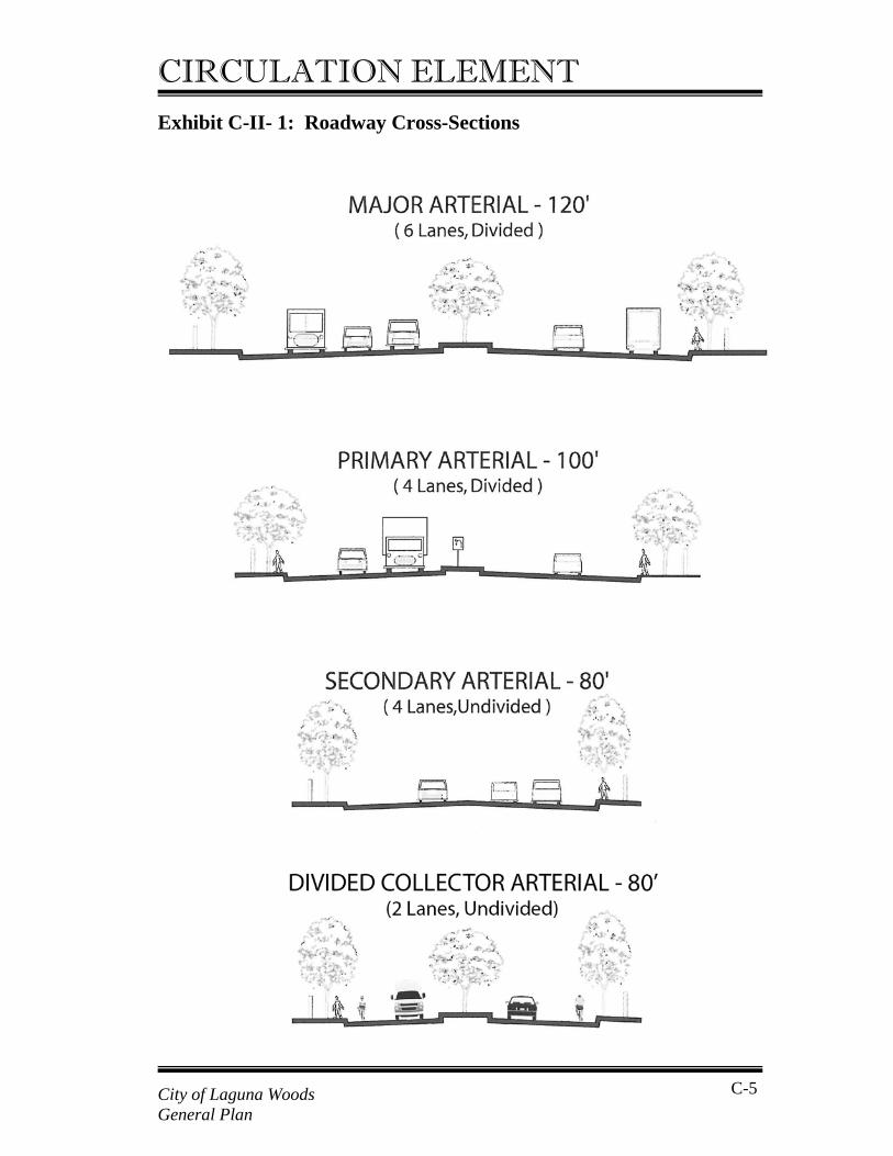
CIRCULATION ELEMENT Exhibit C-II- 1: Roadway Cross-Sections
City of Laguna Woods General Plan
C-5
CIRCULATION ELEMENT Secondary Arterial A secondary arterial highway is a four-lane undivided (no median) roadway, with a typical right-of-way width of 80 feet, and a roadway width from curb to curb of 64 feet (Exhibit C-II-1). A secondary arterial is designed to accommodate approximately 25,000 vehicles per day. A secondary arterial serves as a collector, distributing traffic between local streets and principal and major arterials. Although some secondary arterials serve as through routes, most provide more direct access to surrounding land uses than major or primary arterials. Divided Collector Arterial A divided collector arterial highway is a four-lane divided roadway with a reallocation of pavement width to emphasize bicycle and pedestrian. It provides one through vehicle lane per direction, one bicycle lane per direction, two-way left turn lanes and an optional right-turn lane. It is designed to accommodate 22,000 vehicles per day. Smartstreet Arterial In addition to the arterial classifications, the Circulation Plan recognizes Smartstreet arterials with an enhanced traffic-carrying capacity. The augmentation in capacity may be achieved by a variety of measures: • Addition of through or turn lanes at intersections; • Preferential traffic signal timing and synchronization; • Removal of on-street parking; • Intersection grade separations; • Grade separated turning movements; • Access limitation – right turns only or no access (streets and/or
driveways); • Access consolidation; • Frontage roads; • Pedestrian grade separations; and • Other elements that may be found useful.
The intent of these measures is to minimize conflicts with cross traffic. These measures improve traffic carrying capacity and facilitate improved traffic flow along an arterial. Hence, the terms “High Flow Arterial” or “Continuous Flow Boulevard” can also be used to describe a
City of Laguna Woods General Plan
C-6
CIRCULATION ELEMENT “Smartstreet.” This designation represents a roadway of a major or a principal arterial classification. Exhibit C-II-1 shows schematic cross sections of each arterial roadway category. These represent desirable standards, although some variation in right-of-way width and specific roadway widths may occur in certain cases due to physical constraints, right-of-way limitations, or where preservation of community character dictates special treatment. These roadway designations and standards are consistent with those found in the County’s Master Plan of Arterial Highways (MPAH). However, the goals of the MPAH are not necessarily consistent with some of the mobility goals of the City of Laguna Woods, given the special needs of the Leisure World Community. For example, the MPAH Smartstreet designation for Moulton Parkway focuses on maximizing traffic flow and capacity. This is not consistent with the mobility needs and characteristics of residents of Leisure World and, in particular, elderly pedestrians needing to cross Moulton Parkway.
2. Performance Standards In order to gauge the operation of the roadway system, performance criteria must be defined. The most common method is to compare roadway traffic volumes to roadway capacity to develop volume/capacity (V/C) ratios, which are then expressed as levels of service. The technical V/C ratios are calculated using existing or future average daily traffic (ADT) volumes and daily arterial capacities. The daily capacities of each roadway type are summarized in Table C-II-1 below.
City of Laguna Woods General Plan
C-7
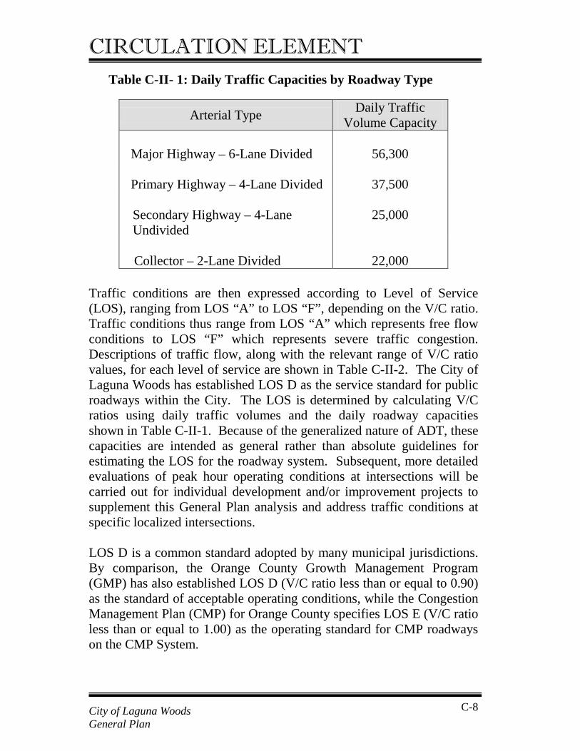
CIRCULATION ELEMENT Table C-II- 1: Daily Traffic Capacities by Roadway Type Traffic conditions are then expressed according to Level of Service (LOS), ranging from LOS “A” to LOS “F”, depending on the V/C ratio. Traffic conditions thus range from LOS “A” which represents free flow conditions to LOS “F” which represents severe traffic congestion. Descriptions of traffic flow, along with the relevant range of V/C ratio values, for each level of service are shown in Table C-II-2. The City of Laguna Woods has established LOS D as the service standard for public roadways within the City. The LOS is determined by calculating V/C ratios using daily traffic volumes and the daily roadway capacities shown in Table C-II-1. Because of the generalized nature of ADT, these capacities are intended as general rather than absolute guidelines for estimating the LOS for the roadway system. Subsequent, more detailed evaluations of peak hour operating conditions at intersections will be carried out for individual development and/or improvement projects to supplement this General Plan analysis and address traffic conditions at specific localized intersections. LOS D is a common standard adopted by many municipal jurisdictions. By comparison, the Orange County Growth Management Program (GMP) has also established LOS D (V/C ratio less than or equal to 0.90) as the standard of acceptable operating conditions, while the Congestion Management Plan (CMP) for Orange County specifies LOS E (V/C ratio less than or equal to 1.00) as the operating standard for CMP roadways on the CMP System.
Arterial Type Daily Traffic Volume Capacity
Major Highway – 6-Lane Divided
56,300
Primary Highway – 4-Lane Divided
37,500
Secondary Highway – 4-Lane Undivided
25,000
Collector – 2-Lane Divided
22,000
City of Laguna Woods General Plan
C-8
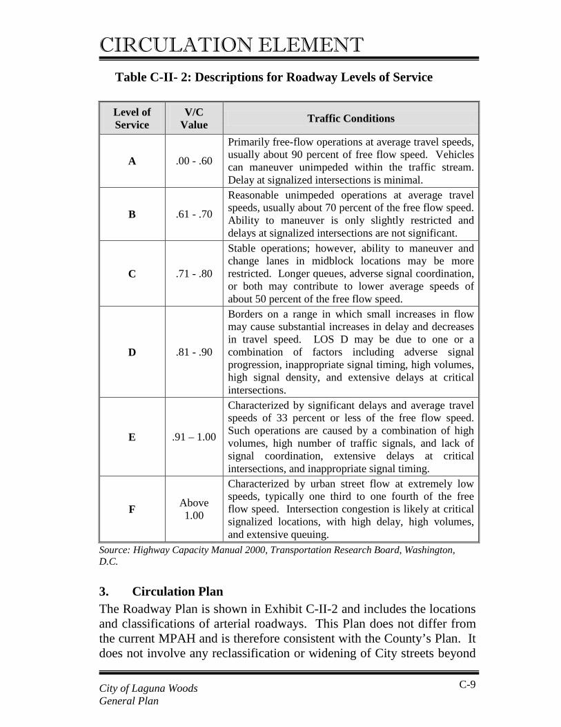
CIRCULATION ELEMENT Table C-II- 2: Descriptions for Roadway Levels of Service
Level of Service
V/C Value Traffic Conditions
A .00 - .60
Primarily free-flow operations at average travel speeds, usually about 90 percent of free flow speed. Vehicles can maneuver unimpeded within the traffic stream. Delay at signalized intersections is minimal.
B .61 - .70
Reasonable unimpeded operations at average travel speeds, usually about 70 percent of the free flow speed. Ability to maneuver is only slightly restricted and delays at signalized intersections are not significant.
C .71 - .80
Stable operations; however, ability to maneuver and change lanes in midblock locations may be more restricted. Longer queues, adverse signal coordination, or both may contribute to lower average speeds of about 50 percent of the free flow speed.
D .81 - .90
Borders on a range in which small increases in flow may cause substantial increases in delay and decreases in travel speed. LOS D may be due to one or a combination of factors including adverse signal progression, inappropriate signal timing, high volumes, high signal density, and extensive delays at critical intersections.
E .91 – 1.00
Characterized by significant delays and average travel speeds of 33 percent or less of the free flow speed. Such operations are caused by a combination of high volumes, high number of traffic signals, and lack of signal coordination, extensive delays at critical intersections, and inappropriate signal timing.
F Above 1.00
Characterized by urban street flow at extremely low speeds, typically one third to one fourth of the free flow speed. Intersection congestion is likely at critical signalized locations, with high delay, high volumes, and extensive queuing.
Source: Highway Capacity Manual 2000, Transportation Research Board, Washington, D.C.
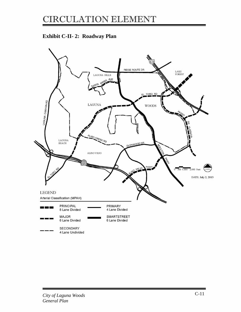
3. Circulation Plan The Roadway Plan is shown in Exhibit C-II-2 and includes the locations and classifications of arterial roadways. This Plan does not differ from the current MPAH and is therefore consistent with the County’s Plan. It does not involve any reclassification or widening of City streets beyond
City of Laguna Woods General Plan
C-9
CIRCULATION ELEMENT levels already identified in the County MPAH. Changes anticipated in the Roadway Plan consistent with the MPAH include:
• Improvement of Moulton Parkway to Smartstreet Arterial;
• El Toro Road, between Calle Corta and Aliso Creek Road – restripe southbound directions from two lanes to three lanes;
• El Toro Road, between Calle Corta and Calle Sonora – install
raised median;
• Ridge Route Drive, between Moulton Parkway and Avenida de la Carlota – build additional two lanes and raised median.
In addition, there are two roadway improvement projects outside but immediately adjacent to the City that will affect circulation within the City of Laguna Woods. These are:
• The MPAH, the City of Lake Forest General Plan, and the City of Laguna Hills General Plan call for a new I-5 overcrossing to connect Ridge Route Drive west of I-5 (in the Cities of Laguna Woods/Laguna Hills) to Ridge Route Drive east of I-5 (in Lake Forest);
• The City of Laguna Hills will improve southbound Paseo de
Valencia from Calle de la Plata to Laguna Hills Drive from two lanes to three lanes to match the northbound three lanes and meet the County MPAH requirements.
City of Laguna Woods General Plan
C-10
CIRCULATION ELEMENT
Exhibit C-II- 2: Roadway Plan
City of Laguna Woods General Plan
C-11
CIRCULATION ELEMENT With the exception of these improvements, the City’s street system is complete, with little if any ability to provide additional capacity. Future growth in traffic volumes on the City’s arterial roadways will be very largely due to growth in other cities and throughout the region. With the exception of certain intersection improvements, building new roads or expanding existing roads is not feasible. Alternative regional policies, such as the greater use of transit and other non-auto alternatives will thus have to be aggressively explored and pursued.
C. Transit Improvements Transit will continue to play a key role in the City. Future enhancements and improvements to transit service will require efforts by the Orange County Transportation Authority as the regional service provider, by Leisure World as the provider of service for its residents, and by the City as a coordinator and facilitator between service providers. A variety of transit improvements will be considered to meet the needs of residents of the City of Laguna Woods, including the following: Improving service to key destinations not currently
served by transit, such as major arts, shopping, movie theatre, and restaurant destinations outside of the City of Laguna Woods
Improving coordination between the different transit
services to provide more transfer points as well as more frequent and better timed connections between services
Providing an on-call, door-to-door service for people
calling ahead to arrange a trip (demand response) Making transit more accessible and convenient for City
of Laguna Woods residents through improved transit information (better, clearer and easy-to-understand maps, guides and related information) and through personal guidance for trip making and travel planning
Developing a Travel Training Program providing hands-
City of Laguna Woods General Plan
C-12
CIRCULATION ELEMENT
on assistance and instruction to City of Laguna Woods residents on the use of fixed route buses and rail transportation
Developing a Rider Information Hotline and Referral
System for City of Laguna Woods transportation services that centralizes information and offers step-by-step instructions in the use of fixed route bus, train, demand response and other transit services.
Given that transit service is provided primarily by two non-City organizations, OCTA and Leisure World, the City of Laguna Woods will play a leadership role in coordinating the needs of residents and the service supplied by operators. The City will continue to develop a strong working relationship with OCTA staff and management, and through increased oversight and involvement in fixed route bus and paratransit services, to make the needs of City of Laguna Woods seniors known and to enhance and improve coordination of services. The City will need to coordinate with Leisure World and other local service providers, including South County Senior Services, to determine and allocate responsibilities for transit services, facilities, and information, as some may best be handled by the service provider, while others may best be handled by the City.
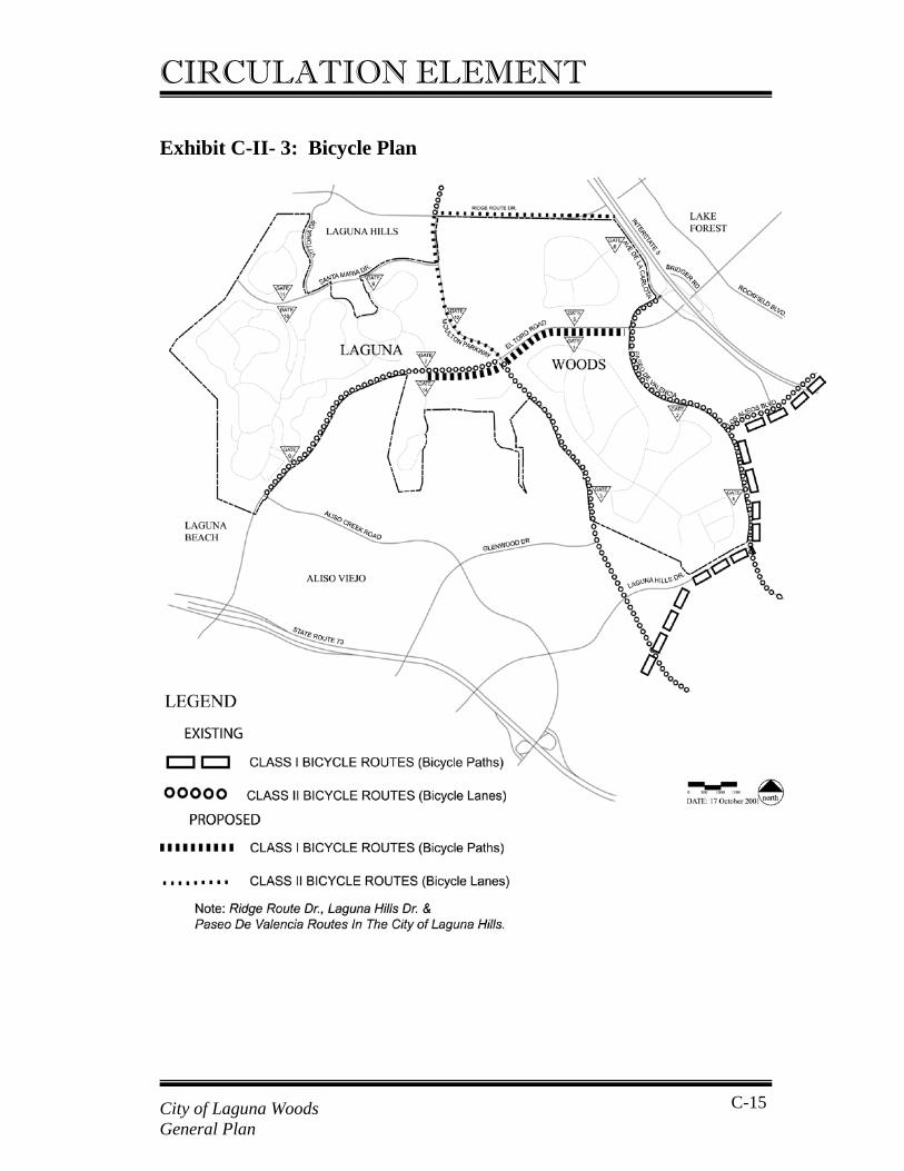
D. Bicycle, Pedestrian, and Multi-Purpose Trails A key component of the Circulation Plan is the provision of facilities for alternative transportation modes to the automobile, such as motorized scooters, electric wheelchairs, bicycles, and walking. These facilities provide the opportunity to travel within the City without using a car, thereby reducing traffic volumes. This component of the Circulation Element addresses provisions for bicycles, pedestrians, equestrians, and alternative vehicles by way of multi-purpose trails. 1. Bicycle Plan The bicycle plan identifies a system of bicycle facilities that meet local needs, connect with facilities in adjacent cities, and are consistent with
City of Laguna Woods General Plan
C-13
CIRCULATION ELEMENT the County’s Commuter Bikeways Strategic Plan, adopted in August 2001. Two types of bicycle facilities are identified in the Bicycle Plan:
Class I Bikeway (Bicycle Path) A Class I bicycle path is a paved facility that is physically separated from a roadway and designated for the use of bicyclists and pedestrians. Bicycle paths typically serve corridors not served by roadways, or where sufficient right-of-way exists parallel to a roadway. Class II Bikeway (Bicycle Lane) A Class II bicycle lane is a striped lane on a roadway designated for use by bicycles. It is located along the edge of the paved roadway adjacent to the curb and outside of the vehicle travel lanes. Bicycle lanes should be a minimum of five feet wide and may typically be up to eight feet wide.
The Bicycle Plan, shown in Exhibit C-II-3, is based largely on Class II bicycle lanes on arterial roadways, many of which exist today. Class II bicycle lanes are proposed on Moulton Parkway between El Toro Road and Ridge Route Drive. An off-street multi-purpose trail is being considered along the south side of El Toro Road between Calle Sonora and Paseo De Valencia (see discussion below on multi-purpose trails). An existing Class I bicycle path adjacent to the City of Laguna Woods in the City of Laguna Hills is part of a regional “mountains-to-sea” bikeway which, when completed, will allow travel from the Cleveland National Forest to the ocean.
City of Laguna Woods General Plan
C-14
CIRCULATION ELEMENT Exhibit C-II- 3: Bicycle Plan
City of Laguna Woods General Plan
C-15
CIRCULATION ELEMENT 2. Pedestrian Plan Walking is an important transportation mode in the City, particularly for residents of Leisure World who prefer not to drive, or cannot drive. The highest demand for walking occurs along El Toro Road between Gates 1 and 5, and the various churches, commercial and other uses between Moulton Parkway and Paseo De Valencia. Pedestrian access to similar uses is also important along Moulton Parkway between Gate 3 and El Toro Road. The Pedestrian Plan will enhance and maintain pedestrian facilities to provide for walking as a safe and convenient mode of transportation. Most streets already have sidewalks. The Pedestrian Plan provides for improvements to sidewalks at two general locations such that they are wide enough for pedestrians to pass safely, and for pedestrians with mobility aids (walkers, wheelchairs) to use safely. Specifically, the Pedestrian Plan calls for the improvement of the sidewalk on the east side of Moulton Parkway between Gate 3 and El Toro Road, and improvement of the sidewalk on the south side of El Toro Road between Moulton Parkway and Paseo de Valencia, possibly as part of a multi-purpose trail. Other measures to enhance pedestrian facilities in the City will include ensuring pedestrians are able to safely cross-city streets at signalized intersections/crosswalks (through appropriate signal timing and signal equipment). It is also proposed that pedestrian access points be installed between Leisure World and the Willow Tree Shopping Center and between Leisure World and the churches along Moulton Parkway and the land uses along El Toro Road east of the Willow Tree Shopping Center. These will provide more direct and convenient access to these uses and allow pedestrians to avoid having to take circuitous routes via public streets.
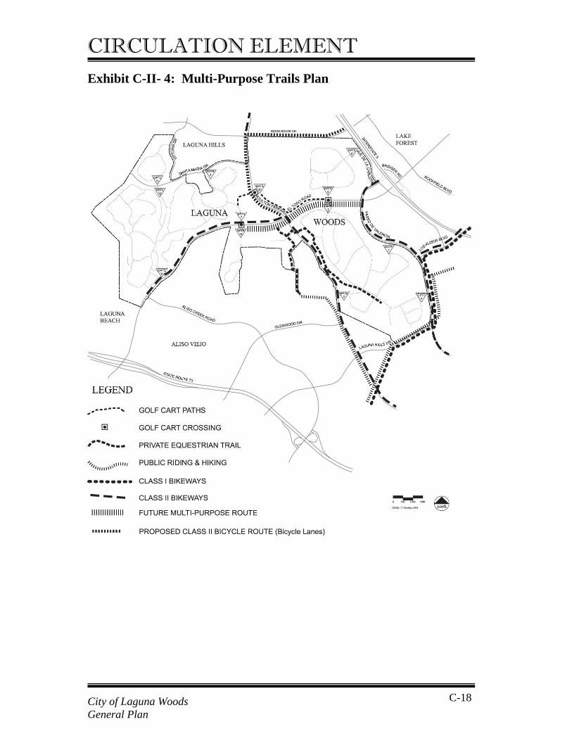
3. Multi-Purpose Trails Plan Multi-purpose trails are off-street routes that may provide for some combination of pedestrians, bicycles, horses and/or alternative vehicles including motorized scooters, electric wheelchairs, and golf carts. Horse trails are typically unpaved while trails for pedestrians, bicycles, golf carts, and other alternative vehicles are typically paved. The Multi-Purpose Trails Plan shown in Exhibit C-II-4 identifies the planned trails
City of Laguna Woods General Plan
C-16
CIRCULATION ELEMENT in the City that will accommodate some combination of various modes of travel and recreational use. The horse trail system as shown currently exists and no changes are planned. The key focus of this component of the plan is to facilitate the use of alternative vehicles as a means of travel within the City, although not on public roadways. Currently there is one short golf-cart path and a number of signed golf-cart crossings of arterial roadways in the City. The intent of the Multi-Purpose Trails Plan is that a backbone network of (off-street) alternative vehicle paths be developed. The majority of alternative vehicle usage will continue to occur on the private streets within Leisure World. A key component will be a potential off-street multi-purpose trail along the south side of El Toro Road between Calle Sonora and Paseo de Valencia that will provide for alternative vehicles, bicycles and pedestrians. This will connect Gate 7, Gate 1 and Gate 5 to the numerous commercial and institutional uses along El Toro Road, thereby providing a key spine route for alternative vehicle circulation. Alternative vehicles should also be allowed to use the proposed pedestrian access point between Leisure World and the Willow Tree Shopping Center and adjacent uses.
City of Laguna Woods General Plan
C-17
CIRCULATION ELEMENT Exhibit C-II- 4: Multi-Purpose Trails Plan
City of Laguna Woods General Plan
C-18
CIRCULATION ELEMENT
E. Objectives, Policies, and Implementation Measures Policies in this section suggest courses of action for seizing opportunities that will move the City toward achieving Objectives set forth in the Circulation Element consistent with the overall development scenario of the General Plan. Implementation Measures are specific actions to be taken to achieve Objectives. They are specific, discreet steps that may be included in the City’s work programs consistent with adoption of annual municipal budgets. Implementation Measures typically involve capital improvement and public services programs. Objective I: Improve and expand transportation options within the
City and to destinations outside the City. Policy I.A: Maintain and enhance an integrated vehicular
circulation network to accommodate local needs and land uses.
Implementation Measure: I.A.1 Monitor arterial roadways and intersections within
the City with the goal of maintaining Level of Service (LOS) D on roadway segments and at intersections.
I.A.2 The City shall develop a Traffic Impact Analysis Procedures Manual to guide the conduct of traffic studies. The Manual shall define procedures for analyzing proposed development traffic impacts on roadways both within and outside the City, for determining appropriate and effective mitigation measures, and for establishing procedures ensuring that new development pays at least its fair and proportionate share of required mitigation measures. The Manual shall identify the types and sizes of
City of Laguna Woods General Plan
C-19
CIRCULATION ELEMENT
projects requiring a traffic impact analysis, and a process for preparing the analysis, including analysis methodologies, and development of significance criteria consistent with level of service performance criteria identified in the Circulation Element. The Manual shall also identify procedures for analyzing land development within the Urban Activities Center to ensure that overall trip generation totals identified in the General Plan are not exceeded, and that General Plan roadway standards continue to be met. The Manual shall include methods to ensure consistency with the requirements of the County of Orange Congestion Management Plan and the Growth Management Plan.
I.A.3 Define on-site and off-site circulation infrastructure improvements necessary to mitigate impacts of new development.
I.A.4 Work with the Orange County Transportation Authority and the County of Orange in phased implementation of Master Plan of Arterial Highways to meet the particular needs of the City.
Policy I.B: Develop strong working relationships with
management and staff of the Orange County Transportation Authority (OCTA), Leisure World Transportation, South County Senior Services, and other appropriate agencies to highlight the transit needs of City of Laguna Woods residents, including the special needs of seniors, and to enhance and coordinate transit services in the City.
Implementation Measure: I.B.1 Support the provision of safe and efficient intercity
and intracity public transportation for residents and workers in the City of Laguna Woods.
I.B.2 Encourage the use of public transportation. I.B.3 Explore funding sources for the operation,
City of Laguna Woods General Plan
C-20
CIRCULATION ELEMENT
maintenance and improvement of local transit services, including bus shelter and transfer point amenities.
I.B.4 Increase staff involvement in oversight of fixed route bus and paratransit services.
I.B.5 Work with the Orange County Transportation Authority (OCTA) and Leisure World Transportation to coordinate bus service schedules to minimize wait time for fixed route service.
I.B.6 Promote future service extensions to popular destinations outside the City.
I.B.7 Promote driver sensitivity training that extends to operation of wheelchair lifts and tiedowns, bus stop announcements, and understanding the needs of individuals with mobility impairments.
I.B.8 Provide fixed route bus information in a format easily readable by seniors.
I.B.9 Arrange training programs to provide on-site assistance to City of Laguna Woods residents to familiarize them with OCTA and Leisure World ridership options and traveling tips.
I.B.10 Require the dedication and improvement of rights-of-way for bus turnouts as a condition of development approval, when appropriate.
I.B.11 Encourage maintenance of deep discounts for seniors using OCTA bus services and adoption of other inducements to use fixed route services, such as restaurant and merchant coupons.
I.B.12 Continually review the network of transit services to determine and encourage adoption of methods to increase ridership and respond to changing demands of the community.
I.B.13 Support the efforts of appropriate agencies to provide additional local and express bus services to the City of Laguna Woods, such as intercity rail station feeder service.
City of Laguna Woods General Plan
C-21
CIRCULATION ELEMENT I.B.14 Provide opportunities for residents to give input on
current and future fixed route and paratransit services.
Policy I.C: Coordinate the efforts of all transit service providers
to plan for and implement a package of improved services for residents and workers.
Implementation Measure: I.C.1 Coordinate with and support transit service providers
as appropriate in developing and implementing plans for improving transportation services, coordination, and marketing.
I.C.2 Provide input for development of service schedules that minimizes wait time for transfers between Leisure World Transportation and OCTA fixed route bus services.
I.C.3 Continue to implement a bus shelter program with comfortable and convenient amenities.
Policy I.D: Explore opportunities to contract for new transit
services based upon the needs of the community. Implementation Measure: I.D.1 Update the transit service needs of City of Laguna
Woods residents on a regular basis to determine new destinations and changes in service demands.
I.D.2 Devise transit services to meet changing community service needs.
I.D.3 Implement new services, as appropriate, based upon budget and operation considerations.
City of Laguna Woods General Plan
C-22
CIRCULATION ELEMENT Objective II: Provide innovative alternatives for maintaining
independence and mobility of residents. Policy II.A: Consider implementation of local demand response
and shuttle service. Implementation Measure: II.A.1 Implement a demand responsive taxi voucher service
to serve all residents. II.A.2 Explore the feasibility of establishing a City operated
or contracted shuttle service using rotating destinations and routes.
II.A.3 Accommodate and support innovative vehicles and services that meet the transit needs of the community while reducing air pollution and fossil fuel energy consumption as practicable.
Policy II.B: Help residents understand transit services and
options. Implementation Measure: II.B.1 Work with transportation service providers to
develop clear, readable transit maps and guides. II.B.2 Publish improved transit rider information maps and
guides. II.B.3 Post City transit maps at bus stops and transfer points
throughout the City to help people travel throughout the County.
II.B.4 Distribute transit maps and guides throughout the City.
II.B.5 Develop a Travel Training Program providing orientation on available transportation services and options.
II.B.6 Develop a Rider Information Hotline and Referral
City of Laguna Woods General Plan
C-23
CIRCULATION ELEMENT
System that provides personalized, step-by-step instructions in the use of fixed route bus, train, demand response and other transportation services.
Objective III: Maintain and improve existing circulation
infrastructure. Policy III.A: Provide and maintain a bicycle circulation system
that connects to adjacent jurisdictions consistent with the regional bicycle network.
Implementation Measure: III.A.1 Provide Class II on-street bicycle lanes on arterial
roadways consistent with the County of Orange Commuter Bicycle Plan.
III.A.2 Investigate the feasibility of including a Class I bicycle path as part of a multi-purpose trail along the south side of El Toro Road between Calle Sonora and Paseo de Valencia.
Policy III.B: Accommodate the unique needs of residents in the
design and construction of pedestrian facilities. Implementation Measure: III.B.1 Construct sidewalks of adequate width along El Toro
Road between Moulton Parkway and Paseo de Valencia, possibly as part of a multi-purpose trail, and along Moulton Parkway between El Toro Road and Calle Aragon.
III.B.2 Determine the feasibility of providing secured, direct pedestrian and alternative vehicle access between residential communities and commercial and institutional uses.
City of Laguna Woods General Plan
C-24
CIRCULATION ELEMENT III.B.3 Maintain adequate time intervals for the pedestrian
crosswalk phase at signalized street intersections. III.B.4 Consider enhancements for crosswalks such as easy
to operate crosswalk buttons, audio warning indicators, and curb cuts at key signalized street intersections near commercial areas and Leisure World gates.
Policy III.C: Maintain and enhance infrastructure to promote
alternative vehicle access where feasible. Implementation Measure: III.C.1 Determine the feasibility of including alternative
vehicle access to a multi-purpose trail along the south side of El Toro Road between Calle Sonora and Paseo de Valencia.
III.C.2 Investigate the feasibility of developing secure, direct access points for alternative vehicles between residential communities and commercial and institutional uses.
III.C.3 Work with the City of Laguna Hills to determine the feasibility of providing off-street alternative vehicles connections to the Laguna Hills Mall and Saddleback Medical Center.
III.C.4 Provide alternative vehicles parking areas at key commercial locations, churches, and main transit stops, where feasible.
III.C.5 Consider adopting zoning and subdivision requirements for connecting alternative vehicle trails between new and existing commercial, institutional, and residential destinations.
III.C.6 Consider adopting zoning ordinance standards for accommodating alternative vehicles in commercial, institutional, and multiple family residential developments.
City of Laguna Woods General Plan
C-25
CIRCULATION ELEMENT Objective IV: Identify potential impacts on the City of Laguna
Woods of land use and transportation decisions of other governmental entities.
Policy IV.A: Coordinate with neighboring jurisdictions and with
agencies responsible for projects affecting the City of Laguna Woods.
Implementation Measure: IV.A.1 Participate with the County of Orange, the Orange
County Transportation Authority, Transportation Corridor Agencies, and the Southern California Association of Governments to represent the City’s position and to facilitate implementation of an integrated circulation system that meets the needs of the City of Laguna Woods.
IV.A.2 Monitor local development activity and transportation improvements in adjacent jurisdictions as well as regional transportation projects to determine benefits and impacts to the City.
IV.A.3 Continue working with the El Toro Reuse Planning Authority in supporting development of the former Marine Corps Air Station that is compatible with the land use objectives of the City.
City of Laguna Woods General Plan
C-26
CIRCULATION ELEMENT
III. BACKGROUND REPORT This report provides background studies to support the preparation of the Circulation Element for the City of Laguna Woods General Plan. It addresses transportation conditions and issues for both the existing environment in the year 2001, as well as future projected transportation conditions.
A. Roadway System
1. City Roadways Because the City of Laguna Woods has only recently incorporated, the City has not developed its own roadway classification system. The roadways within the City are classified according to the County’s Master Plan of Arterial Highways (MPAH) and are identified below and in Exhibit C-III-1. Moulton Parkway This roadway is classified in the MPAH as a 6-lane divided Smartstreet Arterial. It is currently built as a 6-lane divided roadway for its entire length running north to south through the City. To the south, it connects to Aliso Viejo, Laguna Hills, Laguna Niguel and Dana Point. To the north, Moulton Parkway connects to Laguna Hills and Irvine. El Toro Road This road is classified in the MPAH as a 6-lane divided Major Arterial. It is also County Road S18. El Toro Road runs east to west through the City, and is currently a 6-lane divided road for most of its length except for two short locations. Between Calle Sonora and Calle Corta, the roadway is undivided with a painted central left turn lane. West of Calle Corta, the roadway is three lanes eastbound and two lanes westbound with a median divider. El Toro Road continues west to connect to Laguna Canyon Road, and extends east to Laguna Hills, an interchange with the I-5 Freeway, and into Lake Forest.
City of Laguna Woods General Plan
C-27
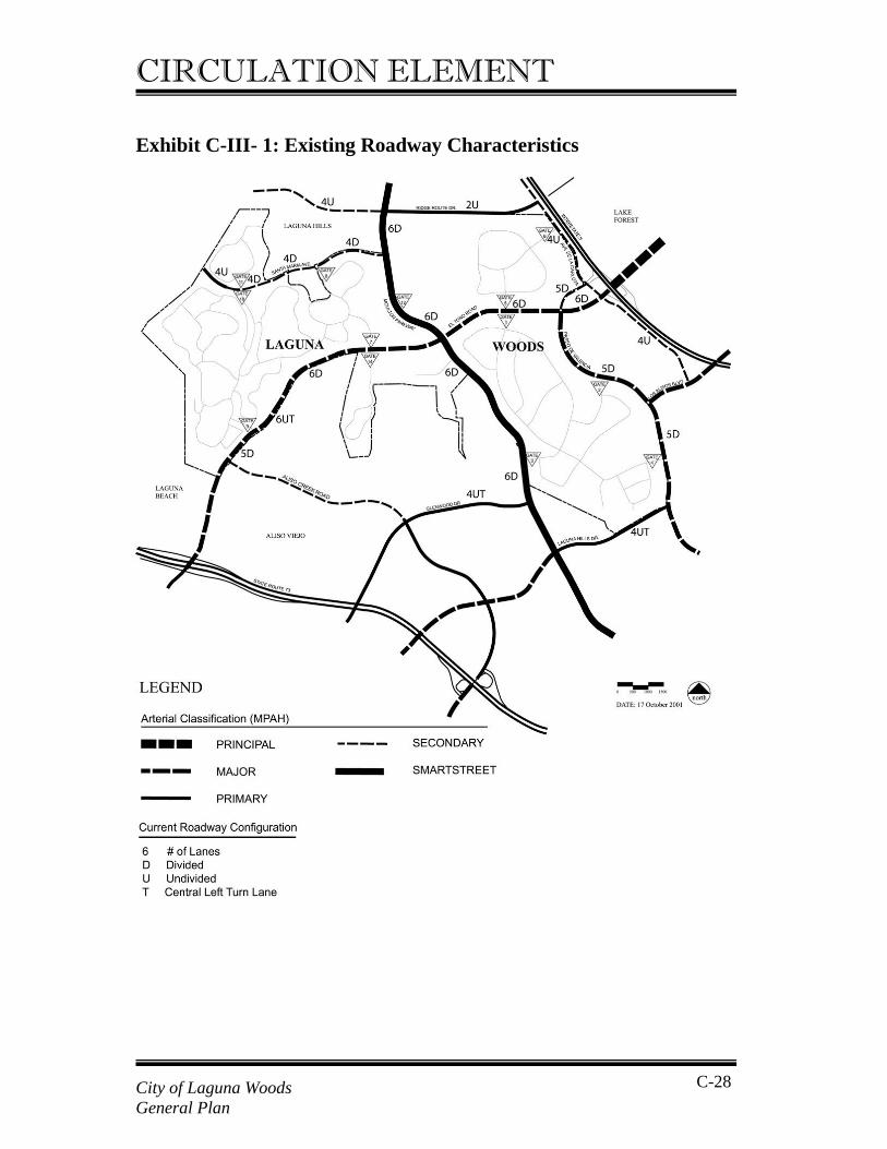
CIRCULATION ELEMENT Exhibit C-III- 1: Existing Roadway Characteristics
City of Laguna Woods General Plan
C-28
CIRCULATION ELEMENT Santa Maria Avenue This roadway is classified as a 4-lane undivided Secondary Arterial in the MPAH. It extends from Moulton Parkway west to the City Limit and is currently a 4-lane undivided street. A short section west of Via Vista is located in the City of Laguna Hills. Ridge Route Drive This road runs between Moulton Parkway and Avenida De La Carlota (Carlota). The south half of the right-of-way is in the City of Laguna Woods and the north half is in the City of Laguna Hills. This roadway is classified in the MPAH as a 4-lane divided Primary Arterial. It is currently an undivided 2-lane road, the paved surface being located in the City of Laguna Hills. That portion of the right of way in the City of Laguna Woods is currently unimproved. Ridge Route terminates at Carlota and currently does not extend over the I-5 freeway. This road extends west of Moulton Parkway to the Laguna Hills City limit. The remaining streets in the City of Laguna Woods are private streets in the Leisure World community. Access from these private streets to the public roadway system is provided via a series of Leisure World gates, as also shown on Exhibit C-III-1. Access to Renaissance at the Regency and Alterra Wynwood facilities is via private streets outside of the Leisure World gates.
2. Roadways Adjacent to the City There are a number of roadways immediately adjacent to the City of Laguna Woods but entirely within the jurisdictions of other cities. However, these roads provide access to parts of the City of Laguna Woods and traffic conditions on these roads affect traffic circulation within the City of Laguna Woods. These streets are included for consideration in the following: Avenida De La Carlota (Carlota) This street runs north to south immediately west of I-5 and immediately adjacent to the City of Laguna Woods between Ridge Route Drive and Paseo De Valencia (Valencia).
City of Laguna Woods General Plan
C-29
CIRCULATION ELEMENT This roadway is classified in the MPAH as a 4-lane undivided Secondary Arterial. It is currently built to four-lane undivided roadway standards. Paseo De Valencia (Valencia) This roadway runs from the intersection with Carlota and the I-5 southbound ramps south along the eastern edge of the City of Laguna Woods, past El Toro Road, Laguna Hills Mall and Saddleback Medical Center to Laguna Hills Drive and beyond. It is classified in the MPAH as a 6-lane divided Major Arterial and is currently built as a 5-lane divided road with three lanes northbound and two lanes southbound. Laguna Hills Drive This road runs west from Valencia along the south limit of the City of Laguna Woods to Moulton Parkway and then west through Aliso Viejo. It is classified in the MPAH as a 4-lane divided Primary Arterial and is currently built as a 4-lane undivided highway with a painted central left turn lane. Exhibit C-III-1 shows these roadways, their classifications according to the County MPAH, and the number of lanes.
3. Regional/Freeway Access Regional access to the City of Laguna Woods is provided by the I-5 San Diego Freeway and the SR-73 San Joaquin Hills Toll Road. Primary access is provided by an interchange with I-5 at El Toro Road, which provides a southbound on-ramp, and two northbound on-ramps one each from eastbound and westbound El Toro Road. This interchange is located in the cities of Laguna Hills and Lake Forest. Southbound off and on ramps are also provided at the intersection of Carlota and Valencia, north of El Toro Road in the City of Laguna Hills. Access to SR-73 is provided at an interchange with El Toro Road to the south of the City of Laguna Woods.
4. Roadway System Performance Table C-III-1 shows key roadway segments in and adjacent to the City of Laguna Woods. For each segment, the table indicates the jurisdiction,
City of Laguna Woods General Plan
C-30
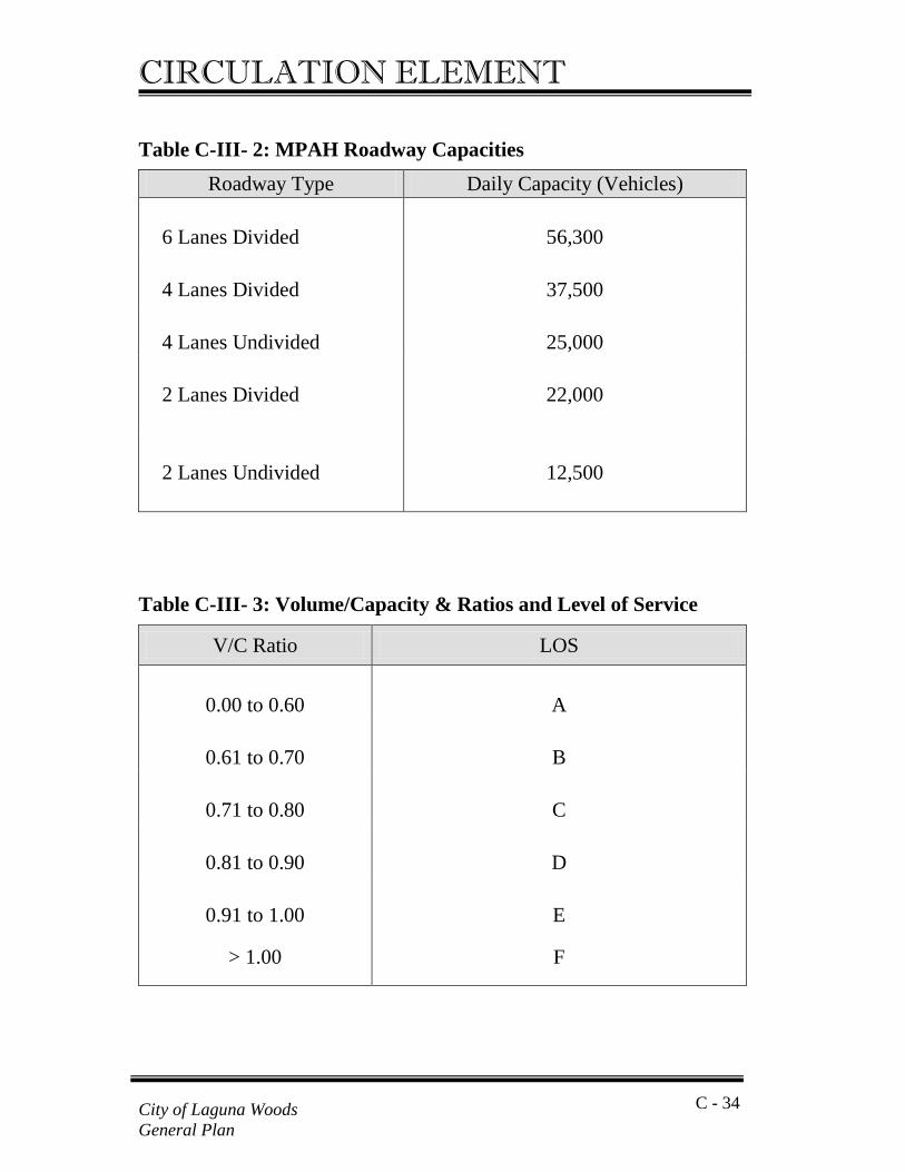
CIRCULATION ELEMENT the MPAH classification, the number of lanes and the current daily volume. Daily traffic volumes on these roadways are shown in Exhibit C-III-2. These data were collected in May of 2001. Traffic volumes are expressed as average daily traffic (ADT) that is the total number of vehicles traveling in both directions on a street over a 24-hour period. The highest traffic volumes occur on Moulton Parkway that carries between 39,400 and 45,800 ADT. Traffic volumes on El Toro Road are in the range of 20,700 to 24,200 ADT west of Calle Sonora, and between 34,400 and 35,900 ADT between Calle Sonora and Paseo De Valencia. Within the City of Laguna Woods, Santa Maria Avenue carries approximately 5,800 ADT, while Ridge Route Drive carries approximately 7,400 ADT. Adjacent to the City of Laguna Woods, traffic volumes on Carlota are 15,900 ADT. Volumes on Valencia range from 21,900 and 24,100 ADT between El Toro and Los Alisos to approximately 34,100 south of Los Alisos Boulevard. Table C-III-1 includes current roadway capacities based on specifications in the County MPAH for each roadway type and number of lanes as described in Table C- III-2. Traffic conditions on roadways are described by comparing the daily volume to daily capacity to obtain a volume to capacity (V/C) ratio and a corresponding level of service. Table C-III-3 shows the V/C ratio ranges that correspond to the different levels of service. Current traffic volumes in and adjacent to the City are such that on a daily basis, most roadways in the City operate at LOS C or better with many roadway segments operating at LOS A or LOS B. Only one roadway segment, Moulton Parkway between El Toro Road and Calle Cortez, operates at LOS D. There are currently no roadway segments within the City operating at LOS E or LOS F.
City of Laguna Woods General Plan
C-31
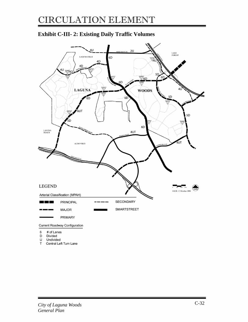
CIRCULATION ELEMENT Exhibit C-III- 2: Existing Daily Traffic Volumes
City of Laguna Woods General Plan
C-32
CIRCULATION ELEMENT Table C-III- 1: Existing Conditions – Daily Traffic Volumes
1. D = Divided, U = Undivided, UT = Undivided Central Turn Median 2. Capacities based on MPAH designations and current number of lanes.
Daily No. of Daily2 Link No. Arterial Location Jurisdiction MPAH Designation Volume Lanes 1 Capacity V/C LOS
1 Moulton Pkwy Ridge Route Dr - Santa Maria Ave LH Smartstreet 6 Lane Divided 39,400 6 D 56,300 0.700 B 2 Moulton Pkwy Gate 12 - El Toro Rd LW Smartstreet 6 Lane Divided 44,300 6 D 56,300 0.787 C 3 Moulton Pkwy El Toro Rd - Calle Cortez LW Smartstreet 6 Lane Divided 45,800 6 D 56,300 0.813 D 4 Moulton Pkwy Via Iglesia - City Limits LW Smartstreet 6 Lane Divided 42,500 6 D 56,300 0.755 C 5 El Toro Rd Aliso Creek Rd - Calle Corta LW Major 6 Lane Divided 20,700 5 D 46,900 0.441 A 6 El Toro Rd Calle Corta - Calle Sonora LW Major 6 Lane Divided 24,200 6 UT 56,300 0.430 A 7 El Toro Rd Calle Sonora - Moulton Pkwy LW Major 6 Lane Divided 35,900 6 D 56,300 0.638 B 8 El Toro Rd Moulton Pkwy - Avd Sevilla LW Major 6 Lane Divided 34,400 6 D 56,300 0.611 B 9 El Toro Rd Avd Sevilla - Paseo De Valencia LW Major 6 Lane Divided 35,200 6 D 56,300 0.625 B
10 El Toro Rd Paseo De Valencia - Avd De La Carlota LH Major 6 Lane Divided 29,300 6 D 56,300 0.520 A 11 Ridge Route Dr Santa Vittoria - Moulton Pkwy LH Secondary 4 Lane Undivided 10,300 4 U 25,000 0.412 A 12 Ridge Route Dr Moulton Pkwy - Avd De La Carlota LW/LH Primary 4 Lane Divided 7,400 2 U 12,500 0.592 A 13 Santa Maria Ave Avd Sosiega - Santa Vittoria LW Secondary 4 Lane Undivided 5,800 4 U 25,000 0.232 A 14 Santa Maria Ave San Remo Dr - Moulton Pkwy LH Secondary 4 Lane Undivided 10,000 4 D 37,500 0.267 A 15 Glenwood Dr Cedarbrook - Moulton Pkwy AV Primary 4 Lane Divided 11,800 4 UT 25,000 0.472 A 16 Laguna Hills Dr Aspen Creek Ln - Paseo De Valencia LH Primary 4 Lane Divided 21,400 4 UT 25,000 0.856 D 17 Avd De La Carlota Via Puerta - Paseo De Valencia LH Secondary 4 Lane Undivided 15,900 4 U 25,000 0.636 B 18 Paseo De Valencia El Toro Rd - Calle De La Plata LH Major 6 Lane Divided 24,100 5 D 46,900 0.514 A 19 Paseo De Valencia Calle De La Magdalena - Health Center LH Major 6 Lane Divided 21,900 5 D 46,900 0.467 A 20 Paseo De Valencia Health Center Dr - Los Alisos Blvd LH Major 6 Lane Divided 22,400 5 D 46,900 0.478 A 21 Paseo De Valencia Beckenham St - Laguna Hills Dr LH Major 6 Lane Divided 34,100 5 D 46,900 0.727 C
C - 33 City of Laguna Woods General Plan
CIRCULATION ELEMENT
Table C-III- 2: MPAH Roadway Capacities
Table C-III- 3: Volume/Capacity & Ratios and Level of Service
Roadway Type Daily Capacity (Vehicles) 6 Lanes Divided
56,300
4 Lanes Divided
37,500
4 Lanes Undivided
25,000
2 Lanes Divided
22,000
2 Lanes Undivided
12,500
V/C Ratio LOS
0.00 to 0.60
A
0.61 to 0.70
B
0.71 to 0.80
C
0.81 to 0.90
D
0.91 to 1.00
E
> 1.00 F
C - 34 City of Laguna Woods General Plan
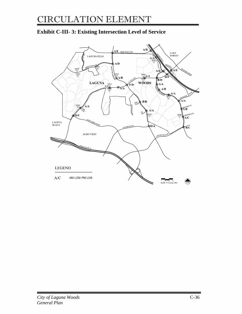
CIRCULATION ELEMENT Roadways adjacent to the city are also operating for the most part at LOS C or better with many roadways operating at LOS A or LOS B. On roadways adjacent to the City, only one roadway link, Laguna Hills Drive west of Valencia, currently operates at LOS D. No roadways adjacent to the city currently operate worse than LOS D. Traffic data was also collected for intersection turn movements for both the AM and PM peak periods enabling the calculation of levels of service at key intersections within and adjacent to the City (Exhibit C-III-3). This data indicates that the morning peak hour occurs between 7:30 and 8:30 AM and the afternoon peak hour occurs between 4:45 and 5:45 PM. Intersection level of service was calculated using the Intersection Capacity Utilization (ICU) methodology specified by the Orange County Transportation Authority (OCTA) for the Congestion Management Plan planning process. Traffic conditions at intersections are evaluated by comparing the volume of traffic passing through the intersection on conflicting (critical) movements to the capacity in order to obtain a volume/capacity (V/C) ratio and a corresponding level of service (see Table C-III-3) The General Plan sets LOS D as the minimum acceptable traffic condition for the City of Laguna Woods. Table C-III-4 shows the calculated intersection level of service for existing conditions in the City of Laguna Woods and adjacent roadways. The number of intersections operating at each level of service in the AM and PM peak hours are summarized below. As can be seen from these tables the vast majority of intersections in and around the City of Laguna Woods are operating at satisfactory conditions (LOS D or better) with many operating at LOS A or LOS B. This indicates that, in general, traffic conditions are currently good within the city. In the AM peak period, two intersections operate at worse than LOS D. One of these is the intersection of Moulton Parkway and El Toro Road in the City of Laguna Woods that operates at LOS F (V/C of 1.051). The other intersection, in Laguna Hills, is the intersection of El Toro Road and Avenida De La Carlota, which operates at LOS E (V/C ratio of 0.937).
City of Laguna Woods General Plan
C-35
CIRCULATION ELEMENT Exhibit C-III- 3: Existing Intersection Level of Service
City of Laguna Woods General Plan
C-36
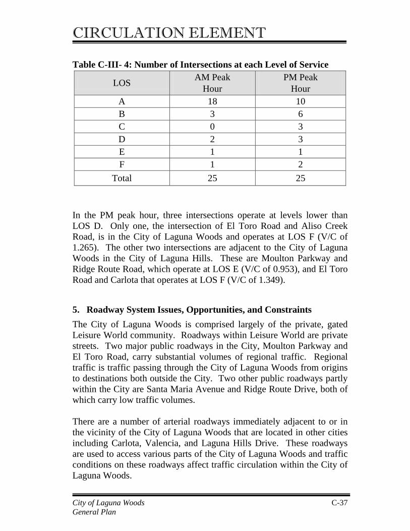
CIRCULATION ELEMENT Table C-III- 4: Number of Intersections at each Level of Service
In the PM peak hour, three intersections operate at levels lower than LOS D. Only one, the intersection of El Toro Road and Aliso Creek Road, is in the City of Laguna Woods and operates at LOS F (V/C of 1.265). The other two intersections are adjacent to the City of Laguna Woods in the City of Laguna Hills. These are Moulton Parkway and Ridge Route Road, which operate at LOS E (V/C of 0.953), and El Toro Road and Carlota that operates at LOS F (V/C of 1.349).
5. Roadway System Issues, Opportunities, and Constraints The City of Laguna Woods is comprised largely of the private, gated Leisure World community. Roadways within Leisure World are private streets. Two major public roadways in the City, Moulton Parkway and El Toro Road, carry substantial volumes of regional traffic. Regional traffic is traffic passing through the City of Laguna Woods from origins to destinations both outside the City. Two other public roadways partly within the City are Santa Maria Avenue and Ridge Route Drive, both of which carry low traffic volumes. There are a number of arterial roadways immediately adjacent to or in the vicinity of the City of Laguna Woods that are located in other cities including Carlota, Valencia, and Laguna Hills Drive. These roadways are used to access various parts of the City of Laguna Woods and traffic conditions on these roadways affect traffic circulation within the City of Laguna Woods.
LOS AM Peak Hour
PM Peak Hour
A 18 10 B 3 6 C 0 3 D 2 3 E 1 1 F 1 2
Total 25 25
City of Laguna Woods General Plan
C-37
CIRCULATION ELEMENT All roadways in and adjacent to the city are currently operating at satisfactory levels of service within the standard daily highway capacities for Level of Service D, set forth in the General Plan and in the County Growth Management Element. Two intersections within the City and two intersections adjacent to the City, however, currently operate at unsatisfactory levels of service i.e. LOS E or LOS F, during either the AM or the PM peak hour. Most streets within and adjacent to the City are built to City General Plan and County MPAH standards in terms of number of lanes and street widths. As the City is largely built out, there is little opportunity to widen or improve these streets without acquiring additional rights-of-way. Short sections of public roadways, however, do not currently meet MPAH standards within the City of Laguna Woods. These are the segment of El Toro Road between Calle Corta and Aliso Creek Road, which is currently five lanes rather than the six lanes called for in the MPAH, and the segment of El Toro Road between Calle Corta and Calle Sonora, which is currently undivided rather than divided as indicated in the MPAH. Ridge Route Drive between Moulton Parkway and Carlota is currently not improved on the City of Laguna Woods’ side of the right-of-way. Outside but adjacent to the City, Paseo de Valencia does not meet MPAH standards as it is currently only five lanes between De la Plata and Laguna Hills Drive rather than the six lanes called for in the MPAH. Planned roadway improvements include the installation by the City of two new traffic signals, at the following locations: • Moulton Parkway and Via Campo Verde; • El Toro Road and St. Nicholas Church. The County is currently preparing plans for widening Moulton Parkway between Via Campo Verde and Santa Maria Avenue, as part of the Measure M Smartstreet improvements. The street will remain a 6-lane roadway but will include bike lanes and sidewalks on each side of the street. Improvements at the intersection of Moulton Parkway and El Toro Road will add turn lanes such that each approach includes two left turn lanes and one right turn lane in addition to three through travel lanes.
City of Laguna Woods General Plan
C-38
CIRCULATION ELEMENT B. Transit This section presents information on transit services operating in and around the City of Laguna Woods. The information in this section was taken from the City of Laguna Woods Transit Needs Assessment, Draft Final Report, March 2001. There are four types of transit service providers in the city:
• General Public Transportation • Leisure World Residents’ Transportation • Specialized Transportation • Other Transportation Providers
Transit service providers in each of these categories are summarized below.
1. General Public Transportation Orange County Transportation Authority (OCTA) is the transportation provider for the general public. OCTA provides fixed route and paratransit throughout the County including the City of Laguna Woods, and into parts of Los Angeles County. Table C-III-5 provides a summary of OCTA operating routes, major destinations and cities served by the OCTA routes, and service spans and frequencies. OCTA operates a Transportation Center in the City of Laguna Hills, located at the intersection of Paseo De Valencia and Calle Los Caballeros just south of the Laguna Hills Mall. This facility provides a total of twelve bus bays and is served by nine OCTA bus routes. The Leisure World bus service also serves the Transportation Center enabling transfers between Leisure World and OCTA buses. The center also includes a park-and-ride lot. The following sections provide descriptions of the fixed route and paratransit services offered to the general public in the City of Laguna Woods.
City of Laguna Woods General Plan
C-39
CIRCULATION ELEMENT OCTA Fixed Route Buses There are nine routes that travel through or are immediately adjacent to the City of Laguna Woods. Most of these routes provide direct service to many popular destinations with no transferring required; however, only three of these routes operate throughout the day and into the evening. Of the others, service is available only during rush hours (5:25 – 8:30 AM, 3:00 – 5:30 PM) or at times that are very early or late. An example is the express service to the Irvine Business Complex and South Coast Plaza that operates from the Laguna Hills Transportation Center on Paseo de Valencia just south of the Laguna Hills Mall. It is difficult for those without autos to use this express service since Leisure World bus service does not operate before 8:00 AM. Orange County Transportation Authority (OCTA) Paratransit OCTA paratransit provides five different types of paratransit services countywide:
• ACCESS ADA Service is the complementary paratransit service for OCTA fixed routes. Passengers are certified as eligible under criteria set forth by the Americans with Disabilities Act (ADA). Service is available on a subscription and advanced reservation basis;
• Group Service is an advanced reservation service for groups of eight or more people going to a common destination not served by the special agency services or Orange County Area Agency on Aging (AAA) senior nutrition program;
• Medical Back-up Service provides service to ADA-certified individuals for unplanned medical trips that could not be booked in advance on OCTA ACCESS service. This service is provided at a premium fare on a same-day reservation basis;
• Special Agency Services are provided under agreement with the Regional Center of Orange County (RCOC) to provide transportation services for school or program related trips.
City of Laguna Woods General Plan
C-40
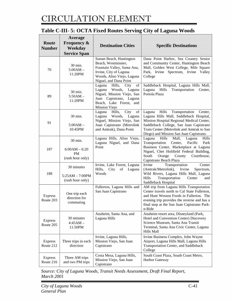
CIRCULATION ELEMENT Table C-III- 5: OCTA Fixed Routes Serving City of Laguna Woods
Source: City of Laguna Woods, Transit Needs Assessment, Draft Final Report, March 2001
Route Number
Average Frequency &
Weekday Service Span
Destination Cities Specific Destinations
70 30 min.
5:00AM – 11:20PM
Sunset Beach, Huntington Beach, Westminster, Fountain Valley, Santa Ana, Irvine, City of Laguna Woods, Aliso Viejo, Laguna Niguel, and Dana Point
Dana Point Harbor, Sea Country Senior and Community Center, Huntington Beach Mall, Golden West College, Mile Square Park, Irvine Spectrum, Irvine Valley College
89 30 min.
5:50AM – 11:20PM
Laguna Hills, City of Laguna Woods, Laguna Niguel, Mission Viejo, San Juan Capistrano, Laguna Beach, Lake Forest, and Mission Viejo
Saddleback Hospital, Laguna Hills Mall, Laguna Hills Transportation Center, Portola Plaza
91
30 min.
5:00AM – 10:45PM
Laguna Hills, City of Laguna Woods, Laguna Niguel, Mission Viejo, San Juan Capistrano (Metrolink and Amtrak), Dana Point
Laguna Hills Transportation Center, Laguna Hills Mall, Saddleback Hospital, Mission Hospital Regional Medical Center, Saddleback College, San Juan Capistrano Train Center (Metrolink and Amtrak to San Diego) and Mission San Juan Capistrano.
187
30 min.
6:00AM – 6:20 PM
(rush hour only)
Laguna Hills, Aliso Viejo, Laguna Niguel, and Dana Point
Laguna Hills Mall, Laguna Hills Transportation Center, Pacific Park Business Center, Marketplace at Laguna Niguel, Chet Holifield Federal Building, South Orange County Courthouse, Capistrano Beach Plaza
188
30 minutes
5:25AM – 7:00PM (rush hour only)
Irvine, Lake Forest, Laguna Hills, City of Laguna Woods
Irvine Transportation Center (Amtrak/Metrolink), Irvine Spectrum, Wild Rivers, Laguna Hills Mall, Laguna Hills Transportation Center and Saddleback Hospital
Express Route 203
One trip each direction for commuting
Fullerton, Laguna Hills and San Juan Capistrano
AM trip from Laguna Hills Transportation Center travels north to Cal State Fullerton, and Hunt Wesson Foods in Fullerton. The evening trip provides the reverse and has a final stop at the San Juan Capistrano Park-n-Ride
Express Route 205
30 minutes 4:45AM – 11:50PM
Anaheim, Santa Ana, and Laguna Hills
Anaheim resort area, Disneyland (Park, Hotel and Convention Center) Discovery Science Museum, Santa Ana Transit Terminal, Santa Ana Civic Center, Laguna Hills Mall
Express Route 212
Three trips in each direction
Irvine, Laguna Hills, Mission Viejo, San Juan Capistrano
Irvine Business Complex, John Wayne Airport, Laguna Hills Mall, Laguna Hills Transportation Center, and Saddleback College
Express Route 216
Three AM trips and two PM trips
Costa Mesa, Laguna Hills, Mission Viejo, San Juan Capistrano
South Coast Plaza, South Coast Metro, Harbor Gateway
City of Laguna Woods General Plan
C-41
CIRCULATION ELEMENT OCTA also provides Senior Nutrition Transportation services funded through a contract with the Orange County AAA in support of senior congregate meal programs based at seniors’ centers. In some areas, private and municipally run transportation programs provide this service such as that offered by South County Senior Services for trips to the Florence Sylvester Senior Center in Laguna Hills.
2. Leisure World Transportation Leisure World is a private, gated community in the City of Laguna Woods. Leisure World provides three types of transportation services to its residents and their guests. Services are funded through the monthly maintenance assessments paid by Leisure World residents and no fares are collected. Leisure World Fixed Route Service There are currently 11 fixed routes providing hourly service to City residents from 8:00 AM to 6:00 PM Monday through Saturday. On Sundays, the hours of service are generally the same as during the week, although some routes are combined. The fixed route service is being restructured so the information presented herein focuses on major destinations served by routes rather than on specific route configurations, which are subject to change. Leisure World has recently replaced 13 of its older not-accessible buses with new low-floor, air-conditioned buses. These new buses allow passengers to walk right onto the bus without the barrier of high steps. Those who use wheelchairs and other mobility devices can now use the fixed route service. The Leisure World fixed route bus system is available to all residents and their guests, and serves all clubhouses within Leisure World and many destinations outside of Leisure World, including shopping and commercial centers within or just outside the City of Laguna Woods. Table C-III-6 summarizes these outside destinations. Leisure World “B” Bus The “B” Bus is a demand responsive shuttle that provides service to residents and their guests Monday through Saturday from 6:00 PM to 10:45 PM. Reservations can be made from 8:00 AM to 3:30 PM the day that service is requested. Residents may request any pick-up or drop-off
City of Laguna Woods General Plan
C-42
CIRCULATION ELEMENT point served by the fixed route system that is “safe for the bus and its riders.” Lift Bus There are two shuttle-type buses equipped with lifts for residents who cannot use the regular fixed route buses due to a disability. Passengers can make reservations up to three days in advance with service available seven days a week from 8:00 AM – 10:45 PM.
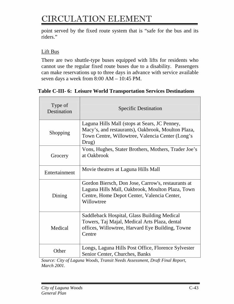
Table C-III- 6: Leisure World Transportation Services Destinations
Source: City of Laguna Woods, Transit Needs Assessment, Draft Final Report, March 2001.
Type of Destination Specific Destination
Shopping
Laguna Hills Mall (stops at Sears, JC Penney, Macy’s, and restaurants), Oakbrook, Moulton Plaza, Town Centre, Willowtree, Valencia Center (Long’s Drug)
Grocery Vons, Hughes, Stater Brothers, Mothers, Trader Joe’s at Oakbrook
Entertainment Movie theatres at Laguna Hills Mall
Dining
Gordon Biersch, Don Jose, Carrow's, restaurants at Laguna Hills Mall, Oakbrook, Moulton Plaza, Town Centre, Home Depot Center, Valencia Center, Willowtree
Medical
Saddleback Hospital, Glass Building Medical Towers, Taj Majal, Medical Arts Plaza, dental offices, Willowtree, Harvard Eye Building, Towne Centre
Other Longs, Laguna Hills Post Office, Florence Sylvester Senior Center, Churches, Banks
City of Laguna Woods General Plan
C-43
CIRCULATION ELEMENT 3. Specialized Transportation There are specialized transportation services available for clients of social service agencies and medical services providers. Specialized transportation services are also provided to customers of select commercial establishments. These services are generally provided as an “added benefit” for the convenience of a client or customer. Specialized transportation services have specific eligibility criteria and consequently are not available to the general public. South County Senior Services South County Senior Services is a not-for-profit organization that provides a full range of social services to seniors in south Orange County. The agency has a fleet of shuttle buses that are operated under contract to medical providers and social service groups for transporting:
• Adult Day Health Care participants (Calle Sonora & El Toro Road);
• Alzheimer’s Day Care participants (Calle Sonora & El Toro Road);
• Senior Center participants (Florence Sylvester Senior Center); • Patients of Mission Medical Center (Medical Center Road,
Mission Viejo). There is no fare charged to passengers although donations are accepted. Renaissance at the Regency/Alterra Wynwood at Palm Terrace In addition to Leisure World, residential facilities within the City of Laguna Woods also provide shuttle service to their residents. These include the independent living and assisted care facilities of Renaissance at the Regency and Alterra Wynwood at Palm Terrace. Service is typically demand responsive and no fare is charged. Saddleback Hospital Saddleback Hospital provides transportation through home caregivers and a variety of therapy departments. Patients are driven in the caregiver’s personal car and are charged $0.40 per mile.
City of Laguna Woods General Plan
C-44
CIRCULATION ELEMENT South Coast Medical Center South Coast Medical Center in Laguna Beach provides free shuttle services for its patients to and from doctor’s appointments. Vons Grocery Shuttle Vons grocery store contracts with Super Shuttle to provide free trips home for its customers who live in the immediately surrounding area. This service provides a faster trip home than most of the fixed route services, a desirable feature when transporting fresh groceries.
4. Other Transportation Providers Other transportation services are available to the general public in the City of Laguna Woods and the surrounding area. Metrolink This commuter rail service stops at the Irvine Transportation Center in the Irvine Spectrum, and provides direct service to Oceanside, Anaheim, Fullerton, and Los Angeles. Passengers can also transfer to the six Metrolink lines to travel to destinations in the counties of San Bernardino, Riverside, Los Angeles and Ventura. Fares are based upon a zone system. Amtrak This national and regional rail service stops at the Irvine Transportation Center and provides direct service to San Diego and Los Angeles. Private Taxis There are about 10 private taxi providers in the City of Laguna Woods area. Taxis are regulated by the OCTA. Many taxi companies offer discounts to seniors of 10% to 15%. “Ghost Taxis” Individuals, usually City of Laguna Woods residents, provide an informal service to other residents. These “ghost taxis” are not licensed taxi providers, but advertise in the local newspapers and use their personal vehicles. Ghost taxis usually charge about $10 an hour. Information suggests that ghost taxis play an important role in the City of Laguna Woods transportation network. The City of Laguna Woods
City of Laguna Woods General Plan
C-45
CIRCULATION ELEMENT Transportation Survey 2000 indicated that eight percent of respondents prefer to pay others to drive as an alternative to driving alone. Airport Shuttle Super Shuttle and a number of other carriers provide shuttle service to John Wayne Airport, Los Angeles International Airport, and Ontario Airport. Home Care Providers Several agencies providing home care offer a variety of services to their clients, including transportation. Caregivers are hired to assist people in their homes and often provide transportation in personal vehicles as part of their service.
5. Summary of Transit Services Table C-III-7 lists all of the previously mentioned transportation services by function. Seven different service functions have been identified. They are:
• Intercity Fixed Route Service; • Taxi Services; • ADA Eligible; • Private Community Services (i.e. Leisure World); • Social Service; • Medical Services; • Specialized.
The first two types are available to the general public, whereas the next five are restricted to residents or users of a specialized service. For example, services categorized as social service transportation are provided by the OCTA and South County Senior services. These services are limited to persons affiliated with a social service agency traveling to/from an agency site. Overall a significant amount of transit service is provided to the residents of the City of Laguna Woods by a variety of operators servicing a wide range of destinations. OCTA and Leisure World Transportation Services offer the most extensive services and carry the most passengers of all transportation service providers in the City of Laguna Woods, and serve a wide variety of key destinations. City of Laguna Woods General Plan
C-46
CIRCULATION ELEMENT Table C-III- 7: Transit Services By Function
Intercity Fixed Route
Taxi Services
ADA Eligible
Private Community
Services
Social Service Transportation
Medical Services Specialized
OCTA Fixed Routes Regular X Express X
OCTA Paratransit Access ADA X Senior Nutrition Program
X
Group Service X Medical Backup
X
Special Agency Services
X
Leisure World Fixed Route X “B” Bus X Lift Bus X
C - 47 City of Laguna Woods General Plan
CIRCULATION ELEMENT
Intercity Fixed Route
Taxi Services
ADA Eligible
Private Community
Services
Social Service Transportation
Medical Services
Specialized
Specialized Transportation South Corridor Senior Services
X
Renaissance at the Regency & Alterra Wynwood
X
Saddleback Hospital
X
South Coast Medical Center
X
Vons Grocery X Other Transportation
Metrolink X Amtrak X Private Taxi X “Ghost” Taxi X Airport Shuttle X Homecare Provider
X
City of Laguna Woods General Plan
C-48
CIRCULATION ELEMENT 6. Transit Issues, Opportunities and Constraints While the majority of City of Laguna Woods residents (82%) are currently licensed to drive and 71% have vehicles in their households, only 54% of respondents expect to be licensed drivers in fifteen years. Eighteen percent (18%) of respondents do not have a current driver’s license. These numbers indicate a significant increase in future transit demand if residents want to maintain their current mobility patterns. Approximately 25% of City of Laguna Woods residents currently use available fixed route and Dial-a-Ride buses. These residents tend to be approximately 83 years of age, older than the average resident age of 77.5 years and are predominantly female. Surveys indicate that City of Laguna Woods residents perceive that they are not well served by local OCTA fixed bus routes or that schedules do not meet residents’ needs. Seniors are interested in riding OCTA (or Leisure World) fixed route buses. There appears to be a demand for bus services closer to where seniors live compared to bus services that operate primarily on the main arterials. The City of Laguna Woods household survey revealed that 45% would use Leisure World buses as an alternative to driving alone. City of Laguna Woods residents who attended public forums complained about the level of service provided by OCTA ACCESS ADA, identifying limited availability, reservations far in advance (i.e. one week) of scheduled service, long wait times, and the lack of assurance of return trips as major problems. Many seniors indicate an interest in using the fixed route buses but identified obstacles that prevented their use including bus information that is inaccessible or difficult to understand, lack of familiarity with OCTA routes and services, and feeling vulnerable riding fixed route buses. Many residents seem confused about existing services or are unaware of how to access them. This suggests a need for local transportation information catering to City of Laguna Woods residents.
City of Laguna Woods General Plan
C - 49
CIRCULATION ELEMENT Ideally, information about transportation services would take many forms, including personal guidance for trip making and travel training. Residents identified improvements they would like to see including more frequent service, more direct routes, more door-to-door service, and expanded evening service, particularly for those uncomfortable driving in the dark. The most requested type of destination is for major shopping areas not easily accessible by OCTA fixed routes such as South Coast Plaza, The Shops at Mission Viejo, Fashion Island, shops on Ridge Route Drive, and specific stores such as Super K-Mart, Walgreen’s, etc.
Some of these shopping areas are directly accessible using OCTA fixed routes with no transferring required. However, residents still have to get to the OCTA bus stops, and many are unaware of the services that are available to them or are reluctant to try them for the first time. Getting to the grocery stores in the City of Laguna Woods area and back to residents’ homes can be difficult without a car. Using public or private transit can take up to 60 minutes. Transporting heavy groceries is also cited as a concern when residents have to walk more than a block or two. Residents have identified the need for more direct service to medical providers, noting that they are required to transfer buses when traveling to medical appointments. Sometimes these transfers involve considerable wait time, resulting in very long travel times. While some medical facilities provide transportation services for their patients, not all can or do. The following medical facilities have been identified as not having their own transportation or direct fixed route services: Kaiser Permanente facilities (Anaheim, Mission Viejo, and Irvine) and Saddleback Dentistry. Some residents who live in the private community of Leisure World have expressed dissatisfaction with both the time and distance in getting from their homes to OCTA bus stops. This is a common dilemma for anyone living in a private, gated community, which has many cul-de-sacs.
City of Laguna Woods General Plan
C-50
CIRCULATION ELEMENT Leisure World transportation provides very few connections to OCTA fixed routes because of OCTA bus stop limitations for other providers. Residents mentioned a need for a higher level of amenities that will encourage and allow them to use transit more conveniently. Some of these requests pertain to facilities in the private gated community of Leisure World, over which the City of Laguna Woods has no jurisdiction. The types of amenities mentioned include:
• Bus stop shelters to provide protection from the sun, wind and rain (new shelters have been installed at all locations able to accommodate them and meet ADA and OCTA requirements);
• More benches to provide “rest stops” between residences and bus stops (specific locations being identified);
• Increased lighting for nighttime use of transit; • Leisure World needs curb cuts so that people using mobility
devices can access transportation services and commercial areas.
7. Planned Transit Improvements South County Senior Services is planning a new dial-a-ride service that is intended to serve as an affordable alternative to driving a car. Passengers will be charged a flat local rate for this dial-a-ride service based upon “zones.” For passengers traveling outside the local zone there will be additional charges, although the actual amounts have not yet been determined. A six to twelve month pilot program is being proposed for the local City of Laguna Woods area, where South County Senior Services is headquartered. The program will be expanded if the pilot is successful.
C. Bicycle, Pedestrian and Alternative Circulation Facilities Facilities are currently provided for a number of other transportation modes within the City of Laguna Woods. These modes provide alternatives to the automobile, and along with transit play a significant role given the unique transportation needs of the City of Laguna Woods community. These other transportation modes are described in the following sections.
City of Laguna Woods General Plan
C-51
CIRCULATION ELEMENT 1. Bicycle Facilities a. Existing Bicycle System Characteristics Existing bicycle routes within the City of Laguna Woods are shown in Exhibit C-III-4. These facilities are striped bike lanes on public streets. Within the City of Laguna Woods bike lanes are currently provided on Moulton Parkway between El Toro Road and the southern city limits, and on El Toro Road between Aliso Creek Road and Moulton Parkway. On roadways adjacent to the City, bike lanes are currently provided on Moulton Parkway north of Ridge Route Drive, and south of the southerly city limit. They are also provided on Paseo de Valencia from Carlota to south of Laguna Hills Drive, on Laguna Hills Drive between Valencia and Moulton Parkway, and on Los Alisos Boulevard east of Valencia. b. Bicycle Issues, Opportunities and Constraints The bicycle routes network is currently discontinuous in the City of Laguna Woods with bike lanes being provided on some street segments but not on others. For example, bike lanes are currently not provided on Moulton Parkway between El Toro Road and Ridge Route Drive, or on El Toro Road between Moulton Parkway and Valencia. Bicycling is not a common mode of transportation for City of Laguna Woods residents. The Transit Needs Assessment Study identified only 3% of trips being made by bicycle, on foot, and by golf cart in total. Bike lane facilities in the City seem to be oriented more to trips passing through the City to connect to bike lanes in other cities as part of the regional/countywide network. The plans for widening Moulton Parkway between Via Campo Verde and Santa Maria Avenue include bike lanes in both directions. In addition, the City of Laguna Woods is currently studying El Toro Road between Calle Sonora and Valencia and exploring the feasibility of providing a bicycle path as part of a multi-purpose trail, particularly between Moulton Parkway and Valencia.
City of Laguna Woods General Plan
C-52
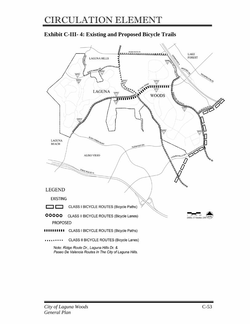
CIRCULATION ELEMENT Exhibit C-III- 4: Existing and Proposed Bicycle Trails
City of Laguna Woods General Plan
C-53
CIRCULATION ELEMENT 2. Pedestrian Facilities a. Existing Sidewalk Characteristics The provision of sidewalks on major arterials in the City of Laguna Woods is currently somewhat sporadic and inconsistent. While sidewalks are currently provided at many locations, there are other locations where sidewalks are either sub-standard (less than 9 feet wide) or do not exist at all. The following are such key locations within the city:
• No sidewalk on the north side of the street on El Toro Road
between St. Nicholas Church and Valencia; • The sidewalk is often less than 9 feet and in some locations is
particularly narrow on El Toro Road between St. Nicholas Church and Valencia on the south side;
• No sidewalk on Moulton Parkway between El Toro Road and Ridge Route Drive on the east side;
• The sidewalk is often less than 9 feet and on the east side is less than 5 feet in some locations on Moulton Parkway between El Toro Road and the southerly City limit, on both the west and east sides.
Adjacent to the city, on Valencia between Calle de la Plata and Laguna Hills Drive, there is currently no sidewalk on the west side of the street adjacent to the Leisure World communities. b. Pedestrian Issues, Opportunities, and Constraints The relatively narrow sidewalks marked by poor placement of street furniture and utility poles are often virtually impassable. Because Leisure World is a gated community and there are no direct pedestrian connections from the various neighborhoods into the adjacent commercial areas (except for the pedestrian gate near the Administration Building) Leisure World residents have to use the public roadway system to walk to principal destinations within the city. The lack of, or substandard nature, of sidewalks makes walking to many destinations a difficult proposition. This is particularly the case on El Toro Road between Moulton Parkway and Valencia where Leisure World residents from Gate 1 and Gate 5 need to access church, City of Laguna Woods General Plan
C-54
CIRCULATION ELEMENT institutional, recreational, and major shopping/commercial destinations along this stretch of El Toro Road. The poor pedestrian environment along this stretch of El Toro Road is exacerbated by the narrow sidewalks being located immediately adjacent to fast moving traffic on a major arterial highway, particularly problematical given the average older age of City of Laguna Woods residents. Residents also have expressed difficulty crossing this stretch of El Toro Road Those seniors who live close enough and prefer to walk to destinations would walk more if they felt safer and if basic amenities like sidewalks were more available. This was confirmed in the City of Laguna Woods household survey, with 15% of respondents stating they would walk if they were unable to drive.
The widening of Moulton Parkway between Via Campo Verde and Santa Maria Avenue will include installation of sidewalks on both sides of the street, thereby improving pedestrian facilities on this roadway. The City also is exploring ways of improving pedestrian conditions and facilities along El Toro Road between Moulton Parkway and Valencia.
3. Horse Trails Within the City of Laguna Woods there are two principal horse trails as shown in Exhibit C-III-5. From the Leisure World Equestrian Center on the southwest corner of Moulton Parkway and El Toro Road, a horse trail extends southward and then splits into two trails. The first heads east under Moulton Parkway, then behind the Methodist Church, and then south, continuing into Leisure World on the east side of Moulton Parkway and to the area of Gate 3 at Calle Aragon. The second trail continues south adjacent to the Aliso Viejo Golf course before heading east to Moulton Parkway near the southerly City limit. This trail then continues south of the City along the west side of Moulton Parkway to join the Aliso Creek trail. This trail extends south along Aliso Creek and east along the north side of Laguna Hills Drive, north on the east side of Paseo de Valencia, and then northerly along Aliso Creek.
City of Laguna Woods General Plan
C-55
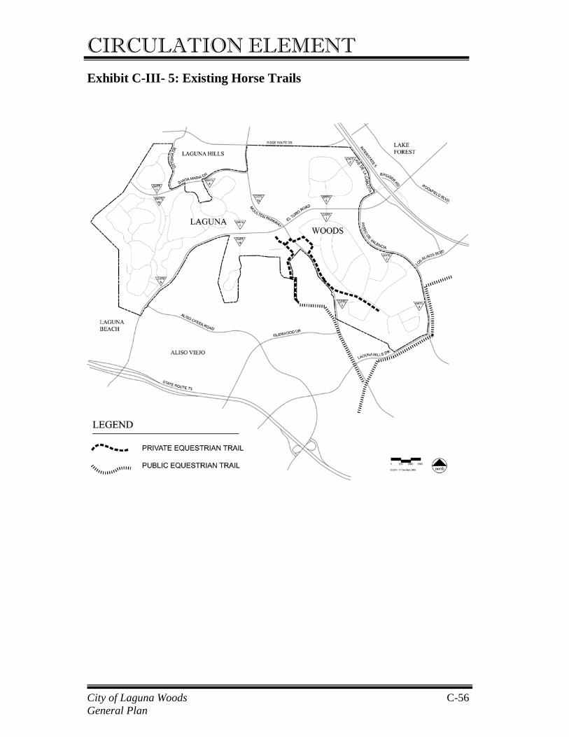
CIRCULATION ELEMENT Exhibit C-III- 5: Existing Horse Trails
City of Laguna Woods General Plan
C-56
CIRCULATION ELEMENT 4. Multi-Purpose Trails a. Existing Golf Cart Paths A number of Leisure World residents own golf carts used primarily for recreational golf purposes. There are currently three signed golf cart crossings of public roadways at the following locations:
• Across El Toro Road at Calle Sonora (Gates 7 and 14); • Across El Toro Road at Avenida Sevilla (Gates 1 and 5); • Across Moulton Parkway at Gate 12 (golf course entrance).
There is also a short golf cart path running directly from Gate 7 at Calle Sonora down the hill to the golf driving range on the west side of Moulton Parkway and continuing to the intersection of Moulton Parkway at Gate 12. This golf cart path is part of the Leisure World Community, although located outside the walls. b. Multi-purpose trails and Alternative Vehicles Issues,
Opportunities and Constraints There is a desire from the public to be able to use golf carts and alternative vehicles more easily throughout the City of Laguna Woods. Some residents would like to directly access commercial areas on foot or on golf carts and alternative vehicles. Others would like to use alternative vehicles to access available transportation services from their homes. Other requests include:
• Additional multi-purpose trail and alternative vehicle crossings on the main arterial streets of El Toro and Moulton Parkway;
• Additional alternative vehicle park-n-ride lots at main transit stops;
• Alternative vehicles lanes, especially to Vons and Longs shopping centers, Home Depot, Laguna Hills Mall, and local facilities.
There is also an identified need for special areas for alternative vehicles parking, particularly at shopping destinations but also including churches and other facilities. Additionally, there are concerns that the park and ride facilities at the Laguna Hills Transportation Center are not secure for alternative vehicles.
City of Laguna Woods General Plan
C-57
CIRCULATION ELEMENT The El Toro Road study currently being conducted by the City of Laguna Woods includes a feasibility study for a multi-purpose trail along El Toro Road between Calle Sonora and Paseo de Valencia that could include provisions for alternative vehicles and providing access to various destinations along this stretch of El Toro Road.
City of Laguna Woods General Plan
C-58
CIRCULATION ELEMENT
IV. SUB-ELEMENT – Utilities and Services A. Storm Drains Stormwater run-off is carried in a stormdrain system within the rights-of-way of public streets in the City. The City of Laguna Woods is responsible for maintenance of the system. The public storm drain system includes a catch basin at the southeastern corner of Moulton Parkway and El Toro Road which channels water into a 42-inch reinforced concrete pipe. The 42-inch drain runs east on El Toro Road and connects with a larger 72-inch reinforced concrete pipe west of Sevilla Avenue. The 72-inch storm drain travels north to Ridge Route Drive, crosses under Ridge Route Drive and outlets into Veeh reservoir in Laguna Hills, within the San Diego Creek watershed. Parcels indicated for future development in the Land Use Element of the General Plan ultimately drain northwesterly, toward San Diego Creek, through a street/gutter system and the local storm drain facilities. Parcel 1 drains east through an existing culvert where it then connects to a storm drain in Ridge Route Drive and outlets into Veeh Reservoir to the northwest in the City of Laguna Hills. Parcels 2, 3, and 9 drain through a culvert under Moulton Parkway and across the Leisure World Golf Course to Ridge Route Drive where water enters an existing storm drain that empties into Veeh Reservoir in Laguna Hills. Storm water from Parcels 4, 5, 6, 7, and 8 drains east via a culvert under Moulton Parkway which connects to a storm drain in Avenue Carmel, then travels north and connects to the drain in El Toro Road that ultimately drains into the Veeh reservoir. Due to the capacity problems in the existing stormdrain system in El Toro Road and the storm drain system that leads to Veeh reservoir, Parcel 5 serves as a retention basin for adjacent parcels to the west. This allows for water to be retained until such time as the capacity of the storm drain allows water to flow into the reservoir.
City of Laguna Woods General Plan
C-59
CIRCULATION ELEMENT B. Water The El Toro Water District provides the consumers of the City of Laguna Woods with domestic water supply in conformance with all State and federal regulatory requirements. As a constituent member of the Municipal Water District of Orange County (MWDOC), the El Toro Water District receives water from the Metropolitan Water District of Southern California (MWDSC) that imports water from both the Colorado River and northern California. Imported water is transported by pipeline from a MWDSC Treatment Plan located in Yorba Linda directly into the El Toro Water District Transmission System for delivery to the consumer and/or into the El Toro Reservoir in the City of Mission Viejo where the water is used for daily operating and emergency storage purposes. Commercial users in the City of Laguna Woods consume 387,770 gallons of water per day, an average of 0.46 gallons per square foot of building area. Residential users in the City of Laguna Woods consume 3,260,000 gallons per day, an average of 246 gallons per day per dwelling. C. Sanitary Sewers The El Toro Water District owns and operates sanitary sewer lines serving the City of Laguna Woods. The District operates a treatment plant in the City that recycles ten percent (10%) of all wastewater for beneficial reuse. The effluent from the balance of the wastewater is discharged, after treatment, into the Pacific Ocean through an outfall pipe 7,900 feet offshore and southwest of the mouth of Aliso Creek. The biosolids from El Toro Water District sewers in the City of Laguna Woods are transported by truck to the Laguna Niguel Joint Regional Treatment Coastal Treatment Plant of the South Orange County Wastewater Authority (SOCWA). The ETWD estimates that sewage generation from residential uses is equal to 75% of residential water consumption, and sewage from commercial uses equal to 90% of commercial water consumption. Based on water consumption numbers (Section B, above), it can be estimated that commercial users generate 348,993 gallons of sewage per day, an average of 0.42 gallons per square foot of building area.
City of Laguna Woods General Plan
C-60
CIRCULATION ELEMENT Residential users generate approximately 2,445,000 gallons per day, an average of 184 gallons per day per dwelling. D. Natural Gas The Southern California Gas Company provides natural gas service to the City of Laguna Woods via existing 4” gas mains in Ridge Route Drive, Moulton Parkway, and El Toro Road. The Gas Company indicates that future development in the City will be served through existing, or the extension of existing, gas mains and/or service lines. Estimated consumption rates for natural gas are based on average figures provided by the South Coast Air Quality Management District1 (SCAQMD). Residential consumption is broken down into single and multi-family units. Single-family units consume, on average, 6,665 cubic feet of natural gas per unit per month while multi-family units consume 4,011.5 cubic feet per unit per month. Commercial/office consumption rates average 24 cubic feet per square foot per year and retail consumption rates average 34.8 cubic feet per square foot per year. E. Electricity Southern California Edison provides electricity to the City of Laguna Woods. The City is served by electrical substations near the intersection of El Toro and Aliso Creek Roads in Laguna Beach, and at 24731 Bridger Drive in Lake Forest. Both stations step down from 66 kilovolts to 12 kilovolts for local service. Based on average consumption by building type provided by the SCAQMD2, a total of 74,562,378 kWh per year (5,626.5 kWh/unit) are consumed in the 13,252 residential units in the City. Office users consume an average 12.95 kWh per square foot per year, a total of 4,922,955 kWh per year. Retail uses consume 13.55 kWh per square foot, for a total of 6,295,737 kWh per year. Total consumption in the City for all types of land use is estimated to be 85,781,070 kWh per year.
1 Table A9-12-A, Appendix 9, SCAQMD CEQA Air Quality Handbook, adopted April 1993. Consumption averages are based on The Gas Company’s average usage rates. 2 Table A9-11-A, Appendix 9, SCAQMD CEQA Air Quality Handbook, adopted April 1993. Consumption averages are based on SCE and Los Angeles Department of Water and Power usage rates.
City of Laguna Woods General Plan
C-61
CIRCULATION ELEMENT F. Television Cable Rossmoor Electric provides television cable services within the Leisure World community. Alterra Wynwood, Renaissance at the Regency, and The Fountains residential communities are served by Cox Communications based in Rancho Santa Margarita. G. Telephone Pacific Bell Telephone Company provides the telephone service throughout the City of Laguna Woods. H. Solid Waste Solid waste collection service in the City of Laguna Woods is provided by Waste Management of Orange County and the Solag/C&N Disposal, Inc. Waste is transported to the Frank R. Bowerman Landfill, located approximately four miles north of Interstate 5 in Irvine. Green waste is transported to the Sunset Environmental site in Irvine.
The 725-acre Frank R. Bowerman Landfill opened in 1990 with 326 acres permitted for refuse disposal and is scheduled to close in approximately 2024. The Integrated Waste Management Department, however, is conducting a study that may extend the life and disposal capacity of the landfill. A public park is the planned end use of the site. The landfill is open Monday through Saturday for commercial customers only. The landfill has capacity to accept up to 8,500 tons of waste on a given day; however, pursuant to a settlement agreement with the City of Irvine, the maximum that may be accepted annually is based on 7,519 tons per day beginning in 2002, and increasing each year until 2009 when the maximum will be based on an a average of 8,640 tons per day. In 2000, solid waste (disposal) generated in the City totaled 10,526.44 tons. Of this, 9,414.64 tons were generated from residences and the remaining 1,111.80 tons were commercially generated. Recyclable waste (diversion) totaled 12,212.32 tons that included 12,106.41 tons of residential recyclable waste and 1,057.36 tons of commercial recyclable waste. It is estimated that residents in the City of Laguna Woods produce an average of 0.57 tons of waste per year per resident.
City of Laguna Woods General Plan
C-62
CIRCULATION ELEMENT Commercial waste in the City of Laguna Woods is generated at an averaged rate of 0.46 tons of waste per acre annually.
I. Educational Facilities The City of Laguna Woods is located within two school districts: the Saddleback Valley Unified School District (SVUSD) and the Laguna Beach Unified School District (LBUSD). The majority of the City is served by the Saddleback Unified School District that has an enrollment of approximately 35,000 students throughout their elementary, intermediate, and senior high schools. However, because of seniors-only age-restrictions applicable to most existing residences in City, the existing population does not include children of elementary, intermediate, or high school ages. J. Library Services Presently, residents of the City of Laguna Woods may utilize all branch libraries operated by the Orange County Public Library. A mini-branch library is located within the City of Laguna Woods City Hall. The nearest branches to the City of Laguna Hills are the El Toro branch in Lake Forest, and the Aliso Viejo branch. Residents can also utilize the Mission Viejo branch, which is owned and operated by the City of Mission Viejo.
City of Laguna Woods General Plan
C-63