Embed Size (px)
Citation preview
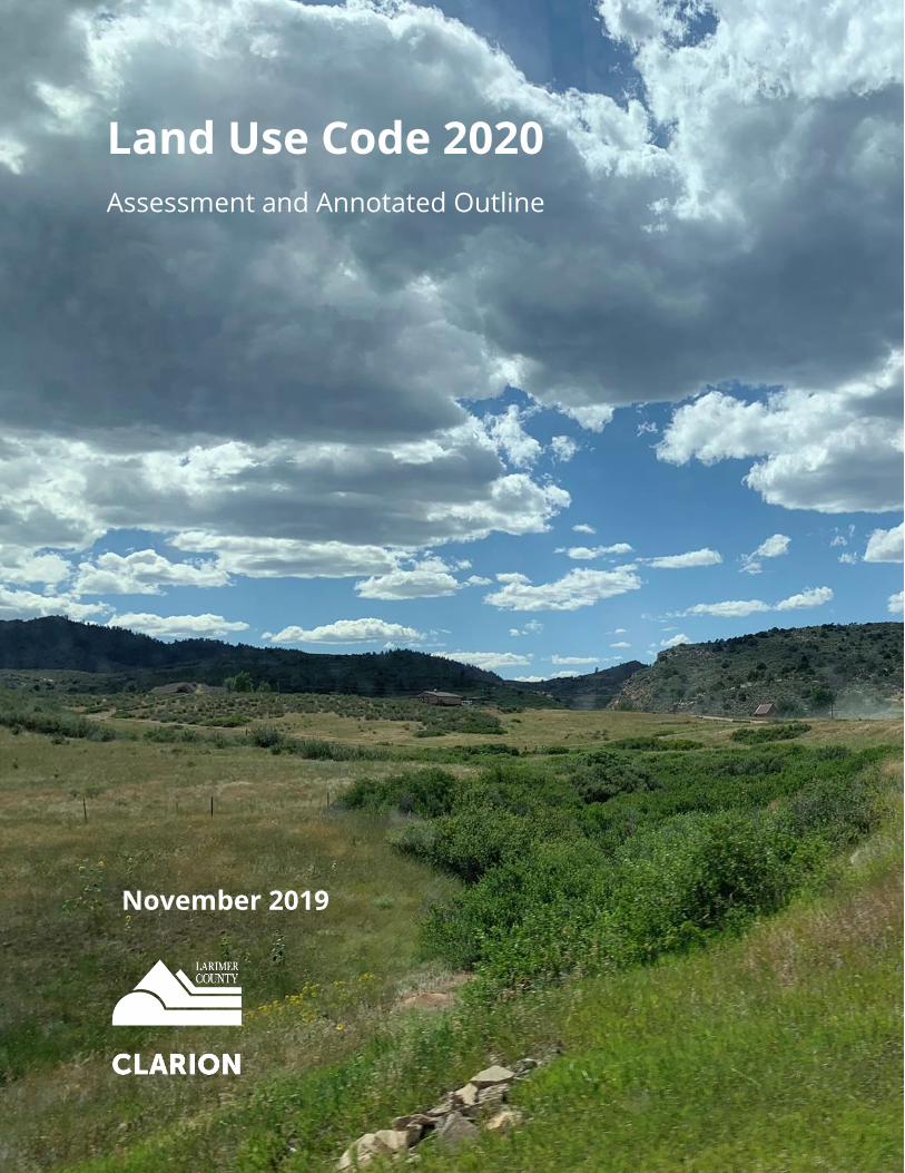
Land Use Code 2020
Assessment and Annotated Outline
November 2019

LUC 2020 – Code Assessment and Annotated Outline Page | i
LUC 2020 – Code Assessment and Annotated Outline Page | ii
Table of Contents Project Overview and Summary.............................................................................. 1
Background .......................................................................................................................... 1
LUC 2020 Overview ............................................................................................................. 1
Drafting a New LUC – The Process ........................................................................................................ 2
What is Included in the LUC Update? ................................................................................................... 2
Summary of Feedback Received ........................................................................................................... 3
Integrating Context ............................................................................................................................... 3
Report Organization ........................................................................................................... 4
Next Steps ............................................................................................................................ 5
We Want Your Input! ............................................................................................................................ 5
Summary of Recommendations .............................................................................. 5
Key Areas to Improve the LUC ............................................................................... 11
Revise and Modernize the Zoning Districts ................................................................... 11
Review of Current Zoning Districts ..................................................................................................... 11
Ensure Zoning Districts Implement Larimer County’s Adopted Plans ................................................ 13
Establish New Zoning Districts ............................................................................................................ 19
Refine the Overlay Districts ................................................................................................................ 24
Summary Table of Proposed Zoning Districts ..................................................................................... 25
Clean Up the Planned Development Standards .................................................................................. 27
Mapping the New Districts ................................................................................................................. 29
Enhance the Use Regulations .......................................................................................... 31
Revisit Use Permissions ....................................................................................................................... 31
Enhance Standards for Accessory Uses and Structures ...................................................................... 32
Expand Housing Options ..................................................................................................................... 33
Consider New Use Types ..................................................................................................................... 34
Update Use-Specific Standards ........................................................................................................... 35
Revise the Table of Allowed Uses ....................................................................................................... 37
Revise Use Definitions ......................................................................................................................... 38
Improve the Development Standards ............................................................................ 40
General Considerations for All Development Standards .................................................................... 40
LUC 2020 – Code Assessment and Annotated Outline Page | iii
Enhance Hazard Mitigation throughout the LUC ................................................................................ 43
Revisit Parking Requirements ............................................................................................................. 45
Update the Sign Regulations ............................................................................................................... 46
Address Installation and Maintenance ............................................................................................... 46
Coordinate Land Use and Engineering Standards ............................................................................... 47
Rewrite and Simplify the Review Procedures ............................................................... 49
Overview of Current Review Procedures ............................................................................................ 49
Improve the Organization and Clarity of the Review Procedures ...................................................... 51
Restructure and Simplify the Site Plan Procedures ............................................................................ 53
Improve and Clarify the Subdivision Procedures ................................................................................ 54
Refine the General Development Plan (GDP) Process ........................................................................ 57
Rewrite the Administrative Variance Procedure ................................................................................ 58
Create an Administrative Manual ....................................................................................................... 59
Rethink the Definitions and Standards for Agriculture ............................................... 60
Establish a Dedicated Agriculture Zoning District ............................................................................... 60
Redefine and Broaden the Agricultural Land Uses ............................................................................. 63
Expand the Definition of “Farm” ......................................................................................................... 64
Restructure the Rural Land Use Process ............................................................................................. 65
Simplify Livestock Classifications ........................................................................................................ 67
Strengthen References to the Right to Farm and Ranch Policy .......................................................... 67
Create a User-Friendly Land Use Code ........................................................................... 68
Reorganize the LUC ............................................................................................................................. 68
Include More Graphics and Tables ..................................................................................................... 68
Clarify Language .................................................................................................................................. 69
Ensure Compliance with Applicable Laws ........................................................................................... 70
Annotated Outline for a New LUC ........................................................................ 71
Summary of Proposed Organization .............................................................................. 71
Chapter 1.0 – General Provisions .................................................................................... 72
Incorporating Current Sections of the LUC ......................................................................................... 73
Chapter 2.0 – Zoning Districts .......................................................................................... 73
Incorporating Current Sections of the LUC ......................................................................................... 74
Chapter 3.0 – Use Regulations ......................................................................................... 75
LUC 2020 – Code Assessment and Annotated Outline Page | iv
Chapter 4.0 – Development Standards ........................................................................... 77
Incorporating Current Sections of the LUC ......................................................................................... 78
Chapter 5.0 – Subdivision Standards .............................................................................. 79
Incorporating Current Sections of the LUC ......................................................................................... 79
Chapter 6.0 – Review Procedures .................................................................................... 79
Incorporating Current Sections of the LUC ......................................................................................... 80
Chapter 7.0 – Signs ............................................................................................................ 81
Incorporating Current Sections of the LUC ......................................................................................... 81
Chapter 8.0 – Wireless Communication Facilities ......................................................... 82
Incorporating Current Sections of the LUC ......................................................................................... 82
Chapter 9.0 – Rules of Interpretation and Definitions ................................................. 82
Incorporating Current Sections of the LUC ......................................................................................... 82
Detailed Review of the Current LUC ..................................................................... 83
Detailed Review of the Current Zoning Districts ................................................. 93
Project Overview and Summary Background
LUC 2020 – Code Assessment and Annotated Outline Page | 1
Project Overview and Summary
Background
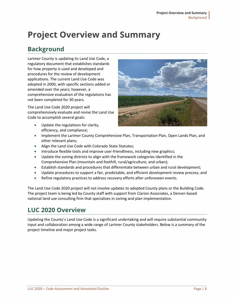
Larimer County is updating its Land Use Code, a regulatory document that establishes standards for how property is used and developed and procedures for the review of development applications. The current Land Use Code was adopted in 2000, with specific sections added or amended over the years; however, a comprehensive evaluation of the regulations has not been completed for 30 years.
The Land Use Code 2020 project will comprehensively evaluate and revise the Land Use Code to accomplish several goals:
• Update the regulations for clarity, efficiency, and compliance;
• Implement the Larimer County Comprehensive Plan, Transportation Plan, Open Lands Plan, and other relevant plans;
• Align the Land Use Code with Colorado State Statutes;
• Introduce flexible tools and improve user-friendliness, including new graphics;
• Update the zoning districts to align with the framework categories identified in the Comprehensive Plan (mountain and foothill, rural/agriculture, and urban);
• Establish standards and procedures that differentiate between urban and rural development;
• Update procedures to support a fair, predictable, and efficient development review process; and
• Refine regulatory practices to address recovery efforts after unforeseen events.
The Land Use Code 2020 project will not involve updates to adopted County plans or the Building Code. The project team is being led by County staff with support from Clarion Associates, a Denver-based national land use consulting firm that specializes in zoning and plan implementation.
LUC 2020 Overview
Updating the County’s Land Use Code is a significant undertaking and will require substantial community input and collaboration among a wide range of Larimer County stakeholders. Below is a summary of the project timeline and major project tasks.
Project Overview and Summary LUC 2020 Overview
LUC 2020 – Code Assessment and Annotated Outline Page | 2
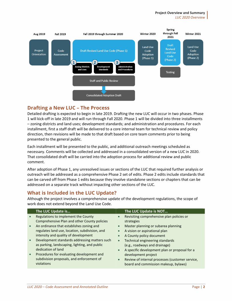
Drafting a New LUC – The Process Detailed drafting is expected to begin in late 2019. Drafting the new LUC will occur in two phases. Phase 1 will kick-off in late 2019 and will run through Fall 2020. Phase 1 will be divided into three installments – zoning districts and land uses; development standards; and administration and procedures. For each installment, first a staff draft will be delivered to a core internal team for technical review and policy direction, then revisions will be made to that draft based on core team comments prior to being presented to the general public.
Each installment will be presented to the public, and additional outreach meetings scheduled as necessary. Comments will be collected and addressed in a consolidated version of a new LUC in 2020. That consolidated draft will be carried into the adoption process for additional review and public comment.
After adoption of Phase 1, any unresolved issues or sections of the LUC that required further analysis or outreach will be addressed as a comprehensive Phase 2 set of edits. Phase 2 edits include standards that can be carved off from Phase 1 edits because they involve standalone sections or chapters that can be addressed on a separate track without impacting other sections of the LUC.
What is Included in the LUC Update? Although the project involves a comprehensive update of the development regulations, the scope of work does not extend beyond the Land Use Code.
The LUC Update is… The LUC Update is NOT… • Regulations to implement the County
Comprehensive Plan and other County policies
• An ordinance that establishes zoning and regulates land use, location, subdivision, and intensity and quality of development
• Development standards addressing matters such as parking, landscaping, lighting, and public dedication of land
• Procedures for evaluating development and subdivision proposals, and enforcement of violations
• Revisiting comprehensive plan policies or strategies
• Master planning or subarea planning
• A vision or aspirational plan
• A County policy document
• Technical engineering standards (e.g., roadways and drainage)
• A specific development plan or proposal for a development project
• Review of internal processes (customer service, board and commission makeup, bylaws)
Project Overview and Summary LUC 2020 Overview
LUC 2020 – Code Assessment and Annotated Outline Page | 3
Summary of Feedback Received
Project Kick-Off The project team kicked off in mid-August 2019 with a series of internal staff meetings, interviews, meetings with various stakeholder groups, and a public meeting held jointly with the Board of County Commissioners and the Planning Commission. Collectively, the project team met with the following stakeholders:
• Board of County Commissioners
• Planning Commission
• Technical Advisory Committee (comprised of County staff from various departments)
• Rural Land Use Board members
• Agricultural Advisory Board members
• Planning staff
• Representatives from other County departments (Engineering, Building, Natural Resources, Health, Web Development, and Code Compliance)
• Local developers
• Local business owners
• Local architects and design professionals
• Residents
Public Survey The project team also prepared an online survey that was widely distributed to stakeholders throughout the County. More than 50 people completed the survey. While that is not necessarily a fully representative cross-section of the county, nevertheless the responses were informative and some highlights are summarized below.
• Who completed the survey? Nearly 75 percent were residents or property owners, with the next-highest group being business owners at 21 percent.
• What procedures could be improved to be more fair, predictable, and timely? Nearly 60 percent of the respondents said neighborhood meetings, and one-third of respondents said the rural land use process.
• How are the dimensional standards (height, setbacks, lots) working in urban areas? More than 40 percent responded “poorly” or “very poorly.”
Additional feedback from the surveys is woven throughout this report in the green shaded “survey responses” boxes.
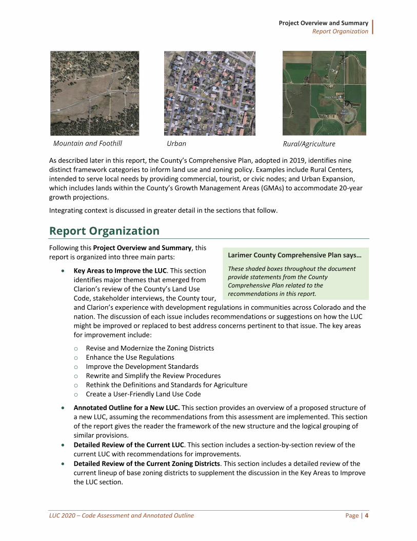
Integrating Context One of the most important themes carried throughout this document is the need to recognize the various contexts within Larimer County. Because of a varied landscape with varied development patterns, one-size-fits-all approaches in the Land Use Code will not effectively help the County achieve its goals for growth and development, redevelopment, and preservation.
Generally, the County recognizes three major distinct contexts: Mountain and foothill; rural and agriculture; and urban. Each context should be treated differently in terms of the zoning applied, the uses allowed, and how strict or flexible development quality standards are applied and enforced.
Survey Responses
These shaded boxes throughout the document provide additional feedback from the survey.
Project Overview and Summary Report Organization
LUC 2020 – Code Assessment and Annotated Outline Page | 4
As described later in this report, the County’s Comprehensive Plan, adopted in 2019, identifies nine distinct framework categories to inform land use and zoning policy. Examples include Rural Centers, intended to serve local needs by providing commercial, tourist, or civic nodes; and Urban Expansion, which includes lands within the County’s Growth Management Areas (GMAs) to accommodate 20-year growth projections.
Integrating context is discussed in greater detail in the sections that follow.
Report Organization
Following this Project Overview and Summary, this report is organized into three main parts:
• Key Areas to Improve the LUC. This section identifies major themes that emerged from Clarion’s review of the County’s Land Use Code, stakeholder interviews, the County tour, and Clarion’s experience with development regulations in communities across Colorado and the nation. The discussion of each issue includes recommendations or suggestions on how the LUC might be improved or replaced to best address concerns pertinent to that issue. The key areas for improvement include:
o Revise and Modernize the Zoning Districts o Enhance the Use Regulations o Improve the Development Standards o Rewrite and Simplify the Review Procedures o Rethink the Definitions and Standards for Agriculture o Create a User-Friendly Land Use Code
• Annotated Outline for a New LUC. This section provides an overview of a proposed structure of a new LUC, assuming the recommendations from this assessment are implemented. This section of the report gives the reader the framework of the new structure and the logical grouping of similar provisions.
• Detailed Review of the Current LUC. This section includes a section-by-section review of the current LUC with recommendations for improvements.
• Detailed Review of the Current Zoning Districts. This section includes a detailed review of the current lineup of base zoning districts to supplement the discussion in the Key Areas to Improve the LUC section.
Larimer County Comprehensive Plan says…
These shaded boxes throughout the document provide statements from the County Comprehensive Plan related to the recommendations in this report.
Summary of Recommendations Next Steps
LUC 2020 – Code Assessment and Annotated Outline Page | 5
Next Steps
We Want Your Input! The County has established a project website that will serve as the online home base for the project and will host project materials and drafts for review and download, surveys for public feedback, and up-to-date project schedules. Please visit: https://www.larimer.org/planning/luc2020
The County will collect feedback on this document and discuss potential solutions to issues raised during the drafting process. Feedback collected prior to this assessment report as part of the initial online survey, and any additional feedback collected after public release of this report will be provided as an addendum. Additional in-person public meetings may be scheduled as necessary to focus on broad Land Use Code issues or specific topics based on initial feedback.
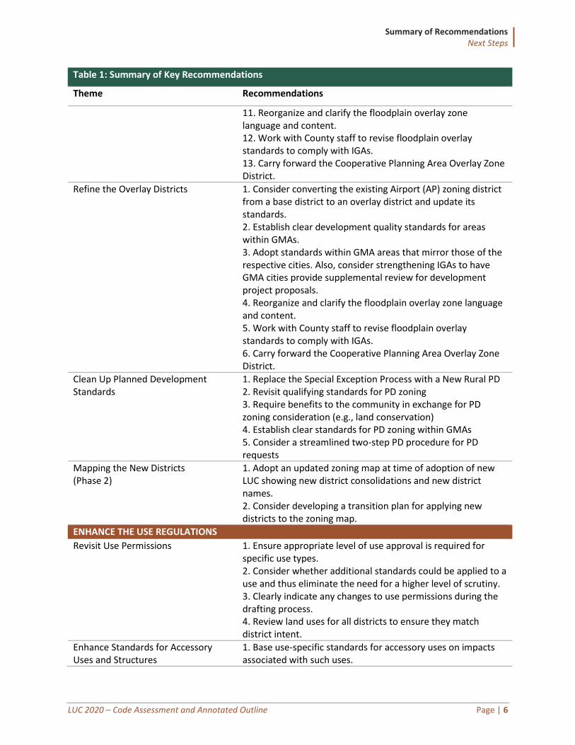
Summary of Recommendations The following table summarizes the recommendations included in the Key Areas to Improve the LUC section of this report. All recommendations are considered Phase 1 except for those with “(Phase 2)” indicated.
Table 1: Summary of Key Recommendations
Theme Recommendations
REVISE AND MODERNIZE THE ZONING DISTRICTS
Ensure Zoning Districts Implement Larimer County’s Adopted Plans
1. Update district names to reflect district intent (e.g., rename Forestry (FO) to Residential Rural (RR)). 2. Clarify district purpose statements to accurately describe the district’s intent and character. 3. Update use schedules to better align with the district intent. 4. Consolidate zoning districts with similar purposes, dimensional standards, or other key characteristics.
Establish New Zoning Districts 1. Establish new mixed-use districts: Rural Center, Mixed-Use Neighborhood, Mixed-Use Commercial. 2. Establish one or more new Agriculture districts. 3. Establish RR-1 - Residential Rural district. 4. Establish CR - Commercial Rural district. 5. Establish NR - Natural Resource district. 6. Establish CF - Community Facilities district. 7. Simplify the Open district. 8. Consider converting the existing Airport (AP) zoning district from a base district to an overlay district and update its standards. 9. Establish clear development quality standards for areas within GMAs. 10. Adopt standards within GMA areas that mirror those of the respective cities. Also, consider strengthening IGAs to have GMA cities provide supplemental review for development project proposals.
Summary of Recommendations Next Steps
LUC 2020 – Code Assessment and Annotated Outline Page | 6
Table 1: Summary of Key Recommendations
Theme Recommendations
11. Reorganize and clarify the floodplain overlay zone language and content. 12. Work with County staff to revise floodplain overlay standards to comply with IGAs. 13. Carry forward the Cooperative Planning Area Overlay Zone District.
Refine the Overlay Districts 1. Consider converting the existing Airport (AP) zoning district from a base district to an overlay district and update its standards. 2. Establish clear development quality standards for areas within GMAs. 3. Adopt standards within GMA areas that mirror those of the respective cities. Also, consider strengthening IGAs to have GMA cities provide supplemental review for development project proposals. 4. Reorganize and clarify the floodplain overlay zone language and content. 5. Work with County staff to revise floodplain overlay standards to comply with IGAs. 6. Carry forward the Cooperative Planning Area Overlay Zone District.
Clean Up Planned Development Standards
1. Replace the Special Exception Process with a New Rural PD 2. Revisit qualifying standards for PD zoning 3. Require benefits to the community in exchange for PD zoning consideration (e.g., land conservation) 4. Establish clear standards for PD zoning within GMAs 5. Consider a streamlined two-step PD procedure for PD requests
Mapping the New Districts (Phase 2)
1. Adopt an updated zoning map at time of adoption of new LUC showing new district consolidations and new district names. 2. Consider developing a transition plan for applying new districts to the zoning map.
ENHANCE THE USE REGULATIONS
Revisit Use Permissions 1. Ensure appropriate level of use approval is required for specific use types. 2. Consider whether additional standards could be applied to a use and thus eliminate the need for a higher level of scrutiny. 3. Clearly indicate any changes to use permissions during the drafting process. 4. Review land uses for all districts to ensure they match district intent.
Enhance Standards for Accessory Uses and Structures
1. Base use-specific standards for accessory uses on impacts associated with such uses.
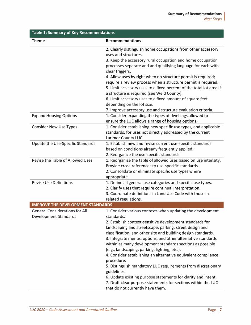
Summary of Recommendations Next Steps
LUC 2020 – Code Assessment and Annotated Outline Page | 7
Table 1: Summary of Key Recommendations
Theme Recommendations
2. Clearly distinguish home occupations from other accessory uses and structures. 3. Keep the accessory rural occupation and home occupation processes separate and add qualifying language for each with clear triggers. 4. Allow uses by right when no structure permit is required; require a review process when a structure permit is required. 5. Limit accessory uses to a fixed percent of the total lot area if a structure is required (see Weld County). 6. Limit accessory uses to a fixed amount of square feet depending on the lot size. 7. Improve accessory use and structure evaluation criteria.
Expand Housing Options 1. Consider expanding the types of dwellings allowed to ensure the LUC allows a range of housing options.
Consider New Use Types 1. Consider establishing new specific use types, and applicable standards, for uses not directly addressed by the current Larimer County LUC.
Update the Use-Specific Standards 1. Establish new and revise current use-specific standards based on conditions already frequently applied. 2. Reorganize the use-specific standards.
Revise the Table of Allowed Uses 1. Reorganize the table of allowed uses based on use intensity. Provide cross-references to use-specific standards. 2. Consolidate or eliminate specific use types where appropriate.
Revise Use Definitions 1. Define all general use categories and specific use types. 2. Clarify uses that require continual interpretation. 3. Coordinate definitions in Land Use Code with those in related regulations.
IMPROVE THE DEVELOPMENT STANDARDS
General Considerations for All Development Standards
1. Consider various contexts when updating the development standards. 2. Establish context-sensitive development standards for landscaping and streetscape, parking, street design and classification, and other site and building design standards. 3. Integrate menus, options, and other alternative standards within as many development standards sections as possible (e.g., landscaping, parking, lighting, etc.). 4. Consider establishing an alternative equivalent compliance procedure. 5. Distinguish mandatory LUC requirements from discretionary guidelines. 6. Update existing purpose statements for clarity and intent. 7. Draft clear purpose statements for sections within the LUC that do not currently have them.
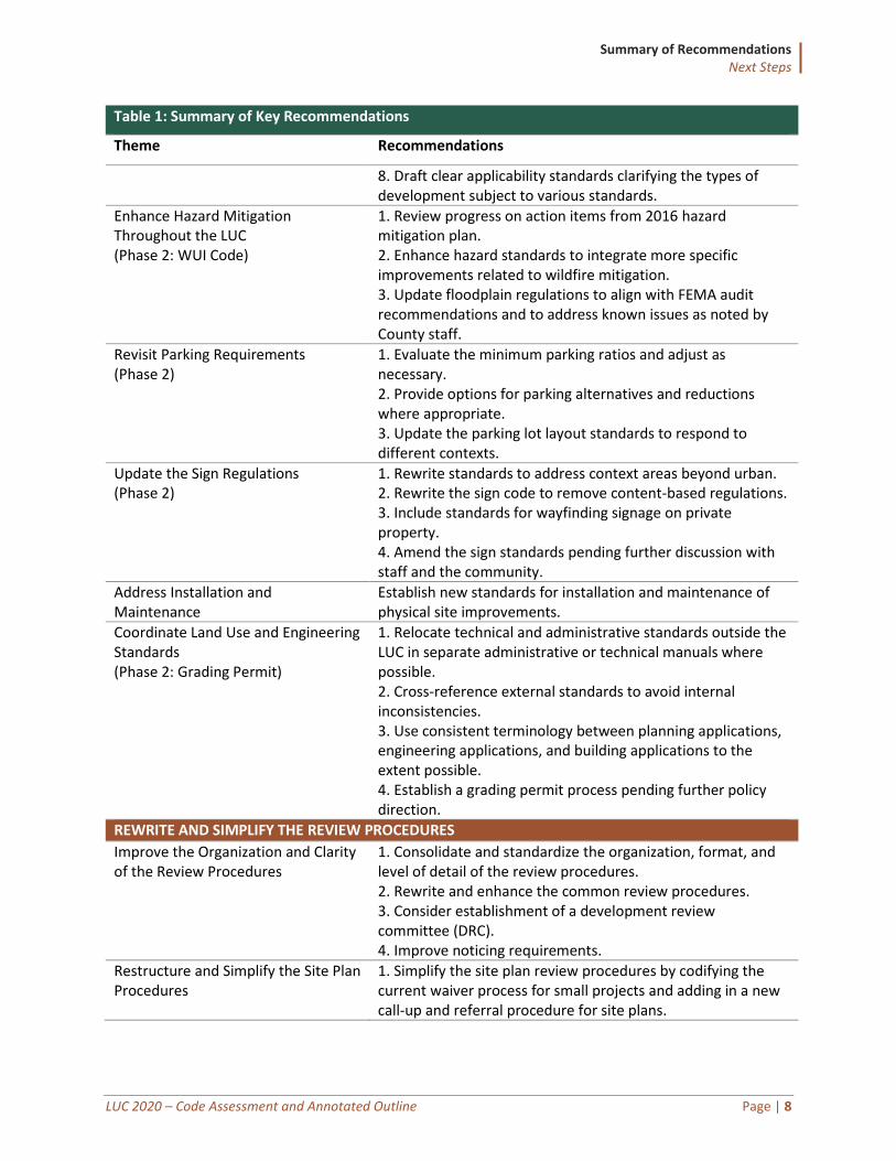
Summary of Recommendations Next Steps
LUC 2020 – Code Assessment and Annotated Outline Page | 8
Table 1: Summary of Key Recommendations
Theme Recommendations
8. Draft clear applicability standards clarifying the types of development subject to various standards.
Enhance Hazard Mitigation Throughout the LUC (Phase 2: WUI Code)
1. Review progress on action items from 2016 hazard mitigation plan. 2. Enhance hazard standards to integrate more specific improvements related to wildfire mitigation. 3. Update floodplain regulations to align with FEMA audit recommendations and to address known issues as noted by County staff.
Revisit Parking Requirements (Phase 2)
1. Evaluate the minimum parking ratios and adjust as necessary. 2. Provide options for parking alternatives and reductions where appropriate. 3. Update the parking lot layout standards to respond to different contexts.
Update the Sign Regulations (Phase 2)
1. Rewrite standards to address context areas beyond urban. 2. Rewrite the sign code to remove content-based regulations. 3. Include standards for wayfinding signage on private property. 4. Amend the sign standards pending further discussion with staff and the community.
Address Installation and Maintenance
Establish new standards for installation and maintenance of physical site improvements.
Coordinate Land Use and Engineering Standards (Phase 2: Grading Permit)
1. Relocate technical and administrative standards outside the LUC in separate administrative or technical manuals where possible. 2. Cross-reference external standards to avoid internal inconsistencies. 3. Use consistent terminology between planning applications, engineering applications, and building applications to the extent possible. 4. Establish a grading permit process pending further policy direction.
REWRITE AND SIMPLIFY THE REVIEW PROCEDURES
Improve the Organization and Clarity of the Review Procedures
1. Consolidate and standardize the organization, format, and level of detail of the review procedures. 2. Rewrite and enhance the common review procedures. 3. Consider establishment of a development review committee (DRC). 4. Improve noticing requirements.
Restructure and Simplify the Site Plan Procedures
1. Simplify the site plan review procedures by codifying the current waiver process for small projects and adding in a new call-up and referral procedure for site plans.
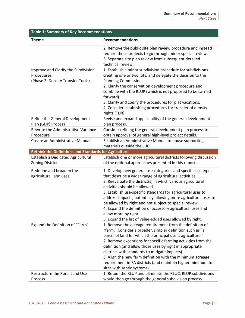
Summary of Recommendations Next Steps
LUC 2020 – Code Assessment and Annotated Outline Page | 9
Table 1: Summary of Key Recommendations
Theme Recommendations
2. Remove the public site plan review procedure and instead require those projects to go through minor special review. 3. Separate site plan review from subsequent detailed technical review.
Improve and Clarify the Subdivision Procedures (Phase 2: Density Transfer Tools)
1. Establish a minor subdivision procedure for subdivisions creating one or two lots, and delegate the decision to the Planning Commission. 2. Clarify the conservation development procedure and combine with the RLUP (which is not proposed to be carried forward). 3. Clarify and codify the procedures for plat vacations. 4. Consider establishing procedures for transfer of density rights (TDR).
Refine the General Development Plan (GDP) Process
Revise and expand applicability of the general development plan process.
Rewrite the Administrative Variance Procedure
Consider refining the general development plan process to obtain approval of general high-level project details.
Create an Administrative Manual Establish an Administrative Manual to house supporting materials outside the LUC.
Rethink the Definitions and Standards for Agriculture
Establish a Dedicated Agricultural Zoning District
Establish one or more agricultural districts following discussion of the optional approaches presented in this report.
Redefine and broaden the agricultural land uses
1. Develop new general use categories and specific use types that describe a wider range of agricultural activities. 2. Reevaluate the district(s) in which various agricultural activities should be allowed. 3. Establish use-specific standards for agricultural uses to address impacts, potentially allowing more agricultural uses to be allowed by right and not subject to special review. 4. Expand the definition of accessory agricultural uses and allow more by right. 5. Expand the list of value-added uses allowed by right.
Expand the Definition of “Farm” 1. Remove the acreage requirement from the definition of “farm.” Consider a broader, simpler definition such as “a parcel of land for which the principal use is agriculture.” 2. Remove exceptions for specific farming activities from the definition (and allow those uses by right in appropriate districts with standards to mitigate impacts). 3. Align the new farm definition with the minimum acreage requirement in FA districts (and maintain higher minimum for sites with septic systems).
Restructure the Rural Land Use Process
1. Retool the RLUP and eliminate the RLUC, RLUP subdivisions would then go through the general subdivision process.
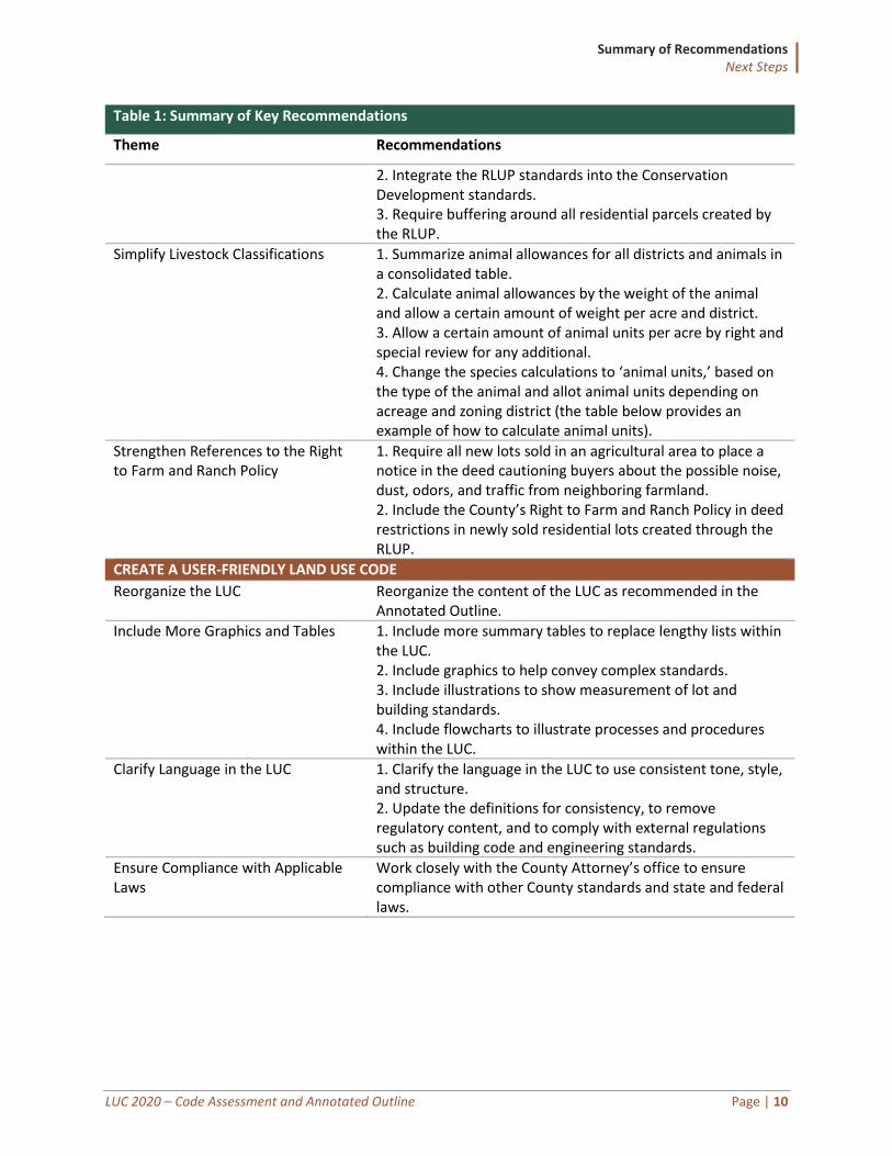
Summary of Recommendations Next Steps
LUC 2020 – Code Assessment and Annotated Outline Page | 10
Table 1: Summary of Key Recommendations
Theme Recommendations
2. Integrate the RLUP standards into the Conservation Development standards. 3. Require buffering around all residential parcels created by the RLUP.
Simplify Livestock Classifications 1. Summarize animal allowances for all districts and animals in a consolidated table. 2. Calculate animal allowances by the weight of the animal and allow a certain amount of weight per acre and district. 3. Allow a certain amount of animal units per acre by right and special review for any additional. 4. Change the species calculations to ‘animal units,’ based on the type of the animal and allot animal units depending on acreage and zoning district (the table below provides an example of how to calculate animal units).
Strengthen References to the Right to Farm and Ranch Policy
1. Require all new lots sold in an agricultural area to place a notice in the deed cautioning buyers about the possible noise, dust, odors, and traffic from neighboring farmland. 2. Include the County’s Right to Farm and Ranch Policy in deed restrictions in newly sold residential lots created through the RLUP.
CREATE A USER-FRIENDLY LAND USE CODE
Reorganize the LUC Reorganize the content of the LUC as recommended in the Annotated Outline.
Include More Graphics and Tables 1. Include more summary tables to replace lengthy lists within the LUC. 2. Include graphics to help convey complex standards. 3. Include illustrations to show measurement of lot and building standards. 4. Include flowcharts to illustrate processes and procedures within the LUC.
Clarify Language in the LUC 1. Clarify the language in the LUC to use consistent tone, style, and structure. 2. Update the definitions for consistency, to remove regulatory content, and to comply with external regulations such as building code and engineering standards.
Ensure Compliance with Applicable Laws
Work closely with the County Attorney’s office to ensure compliance with other County standards and state and federal laws.
Key Areas to Improve the LUC Revise and Modernize the Zoning Districts
LUC 2020 – Code Assessment and Annotated Outline Page | 11
Key Areas to Improve the LUC There are six key areas for improving the County’s LUC based on feedback received during the project orientation and Clarion’s internal review of the County’s Land Use Code. Those key areas, listed below, provide an organizational framework for building on the strengths and addressing weaknesses of the current LUC.
• Revise and Modernize the Zoning Districts
• Enhance the Use Regulations
• Improve the Development Standards
• Rewrite and Simplify the Review Procedures
• Rethink the Definitions and Standards for Agriculture
• Create a User-Friendly Land Use Code
Each of the key areas are discussed in further detail in this section of the report. More detailed comments appear in the section-by-section analysis beginning on page 83.
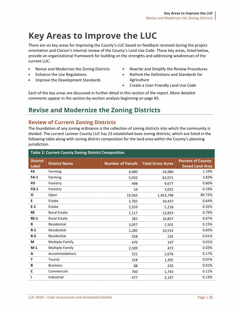
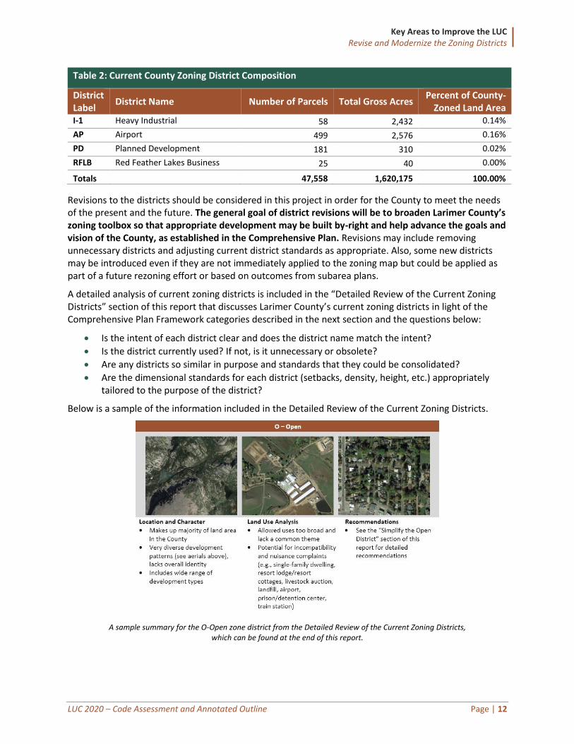
Revise and Modernize the Zoning Districts
Review of Current Zoning Districts The foundation of any zoning ordinance is the collection of zoning districts into which the community is divided. The current Larimer County LUC has 23 established base zoning districts, which are listed in the following table along with zoning district composition for the land area within the County’s planning jurisdiction.
Table 2: Current County Zoning District Composition
District Label
District Name Number of Parcels Total Gross Acres Percent of County-
Zoned Land Area FA Farming 4,080 24,980 1.54%
FA-1 Farming 5,932 62,071 3.83%
FO Forestry 498 9,677 0.60%
FO-1 Forestry 54 3,025 0.19%
O Open 19,565 1,453,798 89.73%
E Estate 2,765 10,437 0.64%
E-1 Estate 2,559 5,218 0.32%
RE Rural Estate 1,117 12,833 0.79%
RE-1 Rural Estate 382 10,857 0.67%
R Residential 3,057 2,501 0.15%
R-1 Residential 1,285 10,533 0.65%
R-2 Residential 558 226 0.01%
M Multiple-Family 470 147 0.01%
M-1 Multiple-Family 2,509 473 0.03%
A Accommodations 321 2,676 0.17%
T Tourist 318 1,205 0.07%
B Business 88 220 0.01%
C Commercial 760 1,743 0.11%
I Industrial 477 2,197 0.13%
Key Areas to Improve the LUC Revise and Modernize the Zoning Districts
LUC 2020 – Code Assessment and Annotated Outline Page | 12
Table 2: Current County Zoning District Composition
District Label
District Name Number of Parcels Total Gross Acres Percent of County-
Zoned Land Area I-1 Heavy Industrial 58 2,432 0.14%
AP Airport 499 2,576 0.16%
PD Planned Development 181 310 0.02%
RFLB Red Feather Lakes Business 25 40 0.00%
Totals 47,558 1,620,175 100.00%
Revisions to the districts should be considered in this project in order for the County to meet the needs of the present and the future. The general goal of district revisions will be to broaden Larimer County’s zoning toolbox so that appropriate development may be built by-right and help advance the goals and vision of the County, as established in the Comprehensive Plan. Revisions may include removing unnecessary districts and adjusting current district standards as appropriate. Also, some new districts may be introduced even if they are not immediately applied to the zoning map but could be applied as part of a future rezoning effort or based on outcomes from subarea plans.
A detailed analysis of current zoning districts is included in the “Detailed Review of the Current Zoning Districts” section of this report that discusses Larimer County’s current zoning districts in light of the Comprehensive Plan Framework categories described in the next section and the questions below:
• Is the intent of each district clear and does the district name match the intent?
• Is the district currently used? If not, is it unnecessary or obsolete?
• Are any districts so similar in purpose and standards that they could be consolidated?
• Are the dimensional standards for each district (setbacks, density, height, etc.) appropriately tailored to the purpose of the district?
Below is a sample of the information included in the Detailed Review of the Current Zoning Districts.
A sample summary for the O-Open zone district from the Detailed Review of the Current Zoning Districts, which can be found at the end of this report.
Key Areas to Improve the LUC Revise and Modernize the Zoning Districts
LUC 2020 – Code Assessment and Annotated Outline Page | 13
Ensure Zoning Districts Implement Larimer County’s Adopted Plans
Comprehensive Plan The Larimer County Comprehensive Plan, adopted in 2019, represents the community’s overall vision of where and how it wants to grow and develop in the coming decades. The LUC is one of the primary tools for implementing that vision and should reflect the plan’s goals, policies, and strategies concerning the physical growth and development of the County.
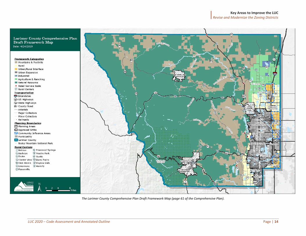
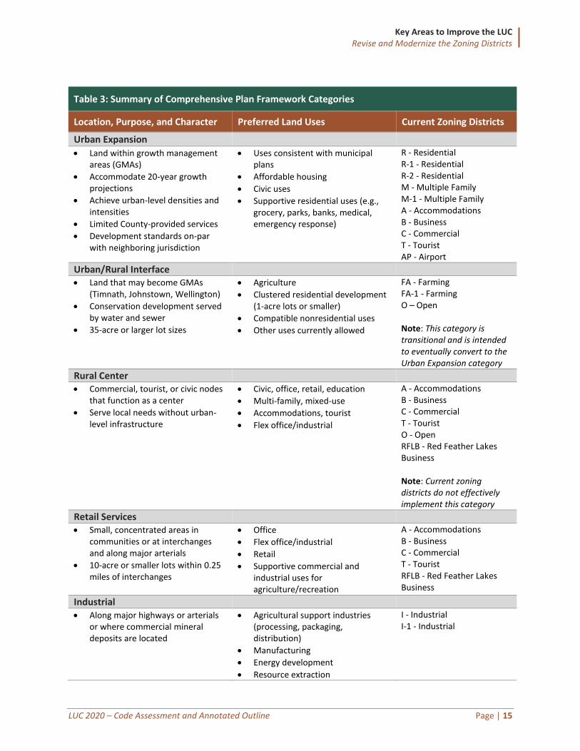
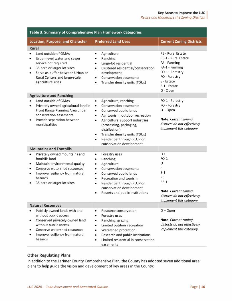
The Comprehensive Plan identifies nine distinct framework categories (listed below) to help inform future land use and zoning policy, providing a foundation for considering updates to the menu of zoning districts available in the new LUC. The framework categories help convey the County’s desired development patterns and priorities for economic development and community character, the locations of neighborhoods and industries, and preservation of natural, agriculture, and rural landscapes. The Comprehensive Plan includes a Framework Map (shown on the following page) that spatially represents the collective vision for Larimer County by identifying areas where the framework categories are appropriate.
• Mountains and Foothills
• Rural
• Urban/Rural Interface
• Urban Expansion
• Industrial
• Agriculture & Ranching
• Natural Resource
• Retail Service Node
• Rural Centers
The table following the map summarizes general information for the Framework Categories and suggests how those categories generally translate to the existing base zoning districts. This is Clarion’s analysis, in consultation with staff; the plan does not explicitly link the Framework Categories to the districts.
The zoning district(s) listed under the “Current Zoning Districts” are those that most closely align with the purpose each Framework Category and do not necessarily imply that those districts alone achieve the true intent of the Framework Category. Where more than one zoning district is listed it is usually an indicator that one or more specific elements from each zoning district, when combined, would help achieve the vision of that specific Framework Category.
In some cases, there are no existing zoning districts that obviously fit the Framework Categories envisioned in the plan. For instance, there are no districts that clearly achieve the intent of the “Natural Resources” category. Additionally, one of the preferred land uses in the “Rural Center” category is mixed-use. While mixed-use development could theoretically be achieved using the existing commercial districts by locating residential districts next to nonresidential uses to create horizontal mixed-use, the lack of specific mixed-use districts would not allow any by-right vertical mixed-use projects (building that include both residential and nonresidential uses) under the current zoning lineup.
Key Areas to Improve the LUC Revise and Modernize the Zoning Districts
LUC 2020 – Code Assessment and Annotated Outline Page | 14
The Larimer County Comprehensive Plan Draft Framework Map (page 61 of the Comprehensive Plan).
Key Areas to Improve the LUC Revise and Modernize the Zoning Districts
LUC 2020 – Code Assessment and Annotated Outline Page | 15
Table 3: Summary of Comprehensive Plan Framework Categories
Location, Purpose, and Character Preferred Land Uses Current Zoning Districts
Urban Expansion
• Land within growth management areas (GMAs)
• Accommodate 20-year growth projections
• Achieve urban-level densities and intensities
• Limited County-provided services
• Development standards on-par with neighboring jurisdiction
• Uses consistent with municipal plans
• Affordable housing
• Civic uses
• Supportive residential uses (e.g., grocery, parks, banks, medical, emergency response)
R - Residential R-1 - Residential R-2 - Residential M - Multiple Family M-1 - Multiple Family A - Accommodations B - Business C - Commercial T - Tourist AP - Airport
Urban/Rural Interface
• Land that may become GMAs (Timnath, Johnstown, Wellington)
• Conservation development served by water and sewer
• 35-acre or larger lot sizes
• Agriculture
• Clustered residential development (1-acre lots or smaller)
• Compatible nonresidential uses
• Other uses currently allowed
FA - Farming FA-1 - Farming O – Open Note: This category is transitional and is intended to eventually convert to the Urban Expansion category
Rural Center • Commercial, tourist, or civic nodes
that function as a center
• Serve local needs without urban-level infrastructure
• Civic, office, retail, education
• Multi-family, mixed-use
• Accommodations, tourist
• Flex office/industrial
A - Accommodations B - Business C - Commercial T - Tourist O - Open RFLB - Red Feather Lakes Business Note: Current zoning districts do not effectively implement this category
Retail Services • Small, concentrated areas in
communities or at interchanges and along major arterials
• 10-acre or smaller lots within 0.25 miles of interchanges
• Office
• Flex office/industrial
• Retail
• Supportive commercial and industrial uses for agriculture/recreation
A - Accommodations B - Business C - Commercial T - Tourist RFLB - Red Feather Lakes Business
Industrial • Along major highways or arterials
or where commercial mineral deposits are located
• Agricultural support industries (processing, packaging, distribution)
• Manufacturing
• Energy development
• Resource extraction
I - Industrial I-1 - Industrial
Key Areas to Improve the LUC Revise and Modernize the Zoning Districts
LUC 2020 – Code Assessment and Annotated Outline Page | 16
Table 3: Summary of Comprehensive Plan Framework Categories
Location, Purpose, and Character Preferred Land Uses Current Zoning Districts
Rural • Land outside of GMAs
• Urban-level water and sewer service not required
• 35-acre or larger lot sizes
• Serve as buffer between Urban or Rural Centers and large-scale agricultural uses
• Agriculture
• Ranching
• Large-lot residential
• Clustered residential/conservation development
• Conservation easements
• Transfer density units (TDUs)
RE - Rural Estate RE-1 - Rural Estate FA - Farming FA-1 - Farming FO-1 - Forestry FO - Forestry E - Estate E-1 - Estate O - Open
Agriculture and Ranching • Land outside of GMAs
• Privately owned agricultural land in Front Range Planning Area under conservation easements
• Provide separation between municipalities
• Agriculture, ranching
• Conservation easements
• Conserved public lands
• Agritourism, outdoor recreation
• Agricultural support industries (processing, packaging, distribution)
• Transfer density units (TDUs)
• Residential through RLUP or conservation development
FO-1 - Forestry FO - Forestry O – Open Note: Current zoning districts do not effectively implement this category
Mountains and Foothills • Privately owned mountains and
foothills land
• Maintain environmental quality
• Conserve watershed resources
• Improve resiliency from natural hazards
• 35-acre or larger lot sizes
• Forestry uses
• Ranching
• Agriculture
• Conservation easements
• Conserved public lands
• Recreation and tourism
• Residential through RLUP or conservation development
• Resorts and public institutions
FO FO-1 O E E-1 RE RE-1 Note: Current zoning districts do not effectively implement this category
Natural Resources • Publicly owned lands with and
without public access
• Conserved privately-owned land without public access
• Conserve watershed resources
• Improve resiliency from natural hazards
• Resource conservation
• Forestry uses
• Ranching, grazing
• Limited outdoor recreation
• Watershed protection
• Research and public institutions
• Limited residential in conservation easements
O – Open Note: Current zoning districts do not effectively implement this category
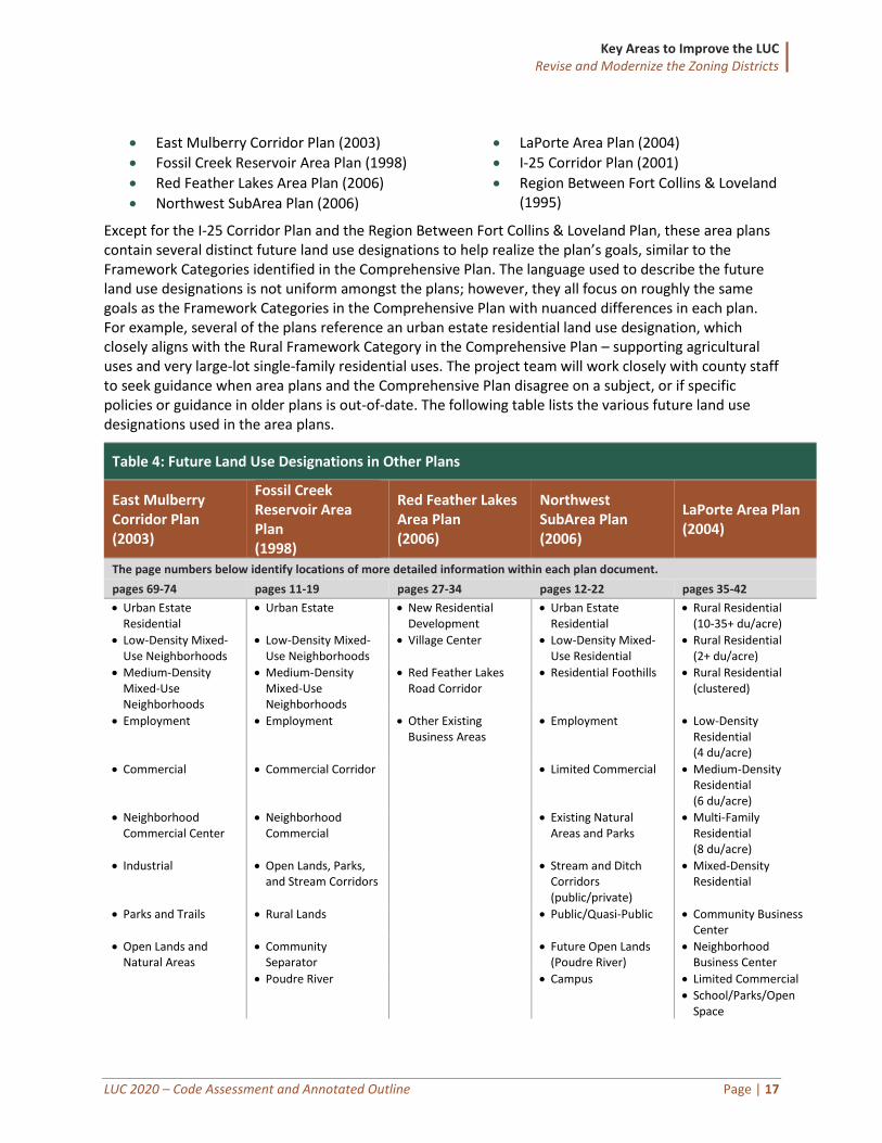
Other Regulating Plans In addition to the Larimer County Comprehensive Plan, the County has adopted seven additional area plans to help guide the vision and development of key areas in the County:
Key Areas to Improve the LUC Revise and Modernize the Zoning Districts
LUC 2020 – Code Assessment and Annotated Outline Page | 17
• East Mulberry Corridor Plan (2003)
• Fossil Creek Reservoir Area Plan (1998)
• Red Feather Lakes Area Plan (2006)
• Northwest SubArea Plan (2006)
• LaPorte Area Plan (2004)
• I-25 Corridor Plan (2001)
• Region Between Fort Collins & Loveland (1995)
Except for the I-25 Corridor Plan and the Region Between Fort Collins & Loveland Plan, these area plans contain several distinct future land use designations to help realize the plan’s goals, similar to the Framework Categories identified in the Comprehensive Plan. The language used to describe the future land use designations is not uniform amongst the plans; however, they all focus on roughly the same goals as the Framework Categories in the Comprehensive Plan with nuanced differences in each plan. For example, several of the plans reference an urban estate residential land use designation, which closely aligns with the Rural Framework Category in the Comprehensive Plan – supporting agricultural uses and very large-lot single-family residential uses. The project team will work closely with county staff to seek guidance when area plans and the Comprehensive Plan disagree on a subject, or if specific policies or guidance in older plans is out-of-date. The following table lists the various future land use designations used in the area plans.
Table 4: Future Land Use Designations in Other Plans
East Mulberry Corridor Plan (2003)
Fossil Creek Reservoir Area Plan (1998)
Red Feather Lakes Area Plan (2006)
Northwest SubArea Plan (2006)
LaPorte Area Plan (2004)
The page numbers below identify locations of more detailed information within each plan document.
pages 69-74 pages 11-19 pages 27-34 pages 12-22 pages 35-42
• Urban Estate Residential
• Urban Estate • New Residential Development
• Urban Estate Residential
• Rural Residential (10-35+ du/acre)
• Low-Density Mixed-Use Neighborhoods
• Low-Density Mixed-Use Neighborhoods
• Village Center • Low-Density Mixed-Use Residential
• Rural Residential (2+ du/acre)
• Medium-Density Mixed-Use Neighborhoods
• Medium-Density Mixed-Use Neighborhoods
• Red Feather Lakes Road Corridor
• Residential Foothills • Rural Residential (clustered)
• Employment • Employment • Other Existing Business Areas
• Employment • Low-Density Residential (4 du/acre)
• Commercial • Commercial Corridor • Limited Commercial • Medium-Density Residential (6 du/acre)
• Neighborhood Commercial Center
• Neighborhood Commercial
• Existing Natural Areas and Parks
• Multi-Family Residential (8 du/acre)
• Industrial • Open Lands, Parks, and Stream Corridors
• Stream and Ditch Corridors (public/private)
• Mixed-Density Residential
• Parks and Trails • Rural Lands • Public/Quasi-Public • Community Business Center
• Open Lands and Natural Areas
• Community Separator
• Future Open Lands (Poudre River)
• Neighborhood Business Center
• Poudre River • Campus • Limited Commercial • School/Parks/Open
Space
Key Areas to Improve the LUC Revise and Modernize the Zoning Districts
LUC 2020 – Code Assessment and Annotated Outline Page | 18
Based on this review, the County should explore modifications to the district lineup to ensure it has a complete toolbox available to implement the adopted plans. While a perfect alignment between the plans and zoning districts is unlikely, Larimer County would benefit from improved linkages between its plans and the LUC to help further the achievement of the plan goals.
The process of bringing districts into better alignment with local plans is often incremental and evolves over time. A range of strategies should be considered, including:
Update District Names Several district names do not accurately reflect the intended character or built conditions of the district. For example, the FO and FO-1 districts are named “Forestry” and the FA and FA-1 districts are named “Farming.” While forestry and farming are existing practices in those districts, the lists of allowed land uses and the built environment may communicate a different purpose. Similarly, several stakeholders and County staff mentioned the confusion surrounding the Open district (O) name. Some interpret that to mean the district is “open” to do whatever is desired, while others interpret it to mean it is reserved for “open space.” In reality, the Open district allows a broad range of land uses that make it difficult to distinguish its true intent.
Clarify District Purposes The current LUC does not include district purpose statements, making it difficult to understand the intent of each district. District purpose statements should be drafted to succinctly describe the intended character. Purpose statements provide the framework for future land use decisions and a basis to determine whether uses allowed in the district are appropriate. New purpose statements also allow the County to reflect policies found in the Comprehensive Plan and area plans.
Update Use Schedules The land uses allowed in the existing districts should be updated to better fit the district intent and the Framework Category descriptions in the Comprehensive Plan. Several districts allow a wide range of land uses that lack a common theme and make it challenging for decision-makers to establish and enforce an effective set of standards to accommodate a wide range of activities. Specific recommendations for updating use schedules is discussed in the “Enhance the Use Regulations” section of this report.
Consolidate Similar Districts Larimer County has several zoning districts with very similar permitted use lists, lot standards, and density requirements. We recommend the County consider consolidating zoning districts in those cases. For example, the FA and FA-1 zoning district dimensional standards are nearly identical, except that the FA-1 district does not allow the creation of half-acre lots when public water and sewer service are provided. The land uses allowed in the FA-1 district are identical to those allowed in the FA district, except that membership club/clubhouse, shooting range, and cabin are allowed in the FA-1 but not in the FA district. The density limit for the FA district is calculated by dividing the developable area by the lot size, while the FA-1 district limits density by calculating the developable area by 100,000 square feet; however, both allow increased densities through approval of a Rural Land Use Plan. Table 6 summarizes where we think districts could be consolidated to help advance the County’s goals and policies.
Applying all these types of changes would result in an improved set of districts for Larimer County. More detail related to proposed district changes is included in the Detailed Review of the Current LUC section at the end of this report.
Key Areas to Improve the LUC Revise and Modernize the Zoning Districts
LUC 2020 – Code Assessment and Annotated Outline Page | 19
Recommendations to Ensure Zoning Districts Implement Larimer County’s Adopted Plans
1. Update district names to reflect district intent (e.g., rename Forestry (FO) to Residential Rural (RR)). 2. Clarify district purpose statements to accurately describe the district’s intent and character. 3. Update use schedules to better align with the district intent. 4. Consolidate zoning districts with similar purposes, dimensional standards, or other key characteristics.
Establish New Zoning Districts Some new zoning districts are necessary to fill in the gaps in the current district lineup and provide opportunities that may not be possible even with modifications to existing districts. New districts to consider in Larimer County for certain locations such as rural centers or potentially to implement subarea plans are summarized below.
New Mixed-Use Districts Mixed-use development can be defined in a variety of ways, including:
• The vertical mix of uses within a single building (typically retail businesses on the first floor with residential units or offices above); or
• The horizontal mix of residential and nonresidential uses in separate buildings within the same planned development center; or
• A mix of uses in a predominantly single-use area – such as a corner store in a single-family dwelling neighborhood, or apartment buildings in predominantly commercial areas.
Mixed-use development is designed to allow residential and nonresidential uses to develop intentionally as part of the same project or site. The combination provides residents the opportunity to live, work, and shop in the same location without requiring a car trip for each activity, thus helping to lower vehicle miles traveled and reducing overall traffic congestion and air pollution. It can be a key tool for promoting sustainability, concentrating development in strategic locations where it can be serviced most efficiently, and providing a variety of housing and business opportunities.
In the past, typical zoning ordinances like Larimer County’s LUC segregated uses by district, and so developers have had to jump through multiple hoops to gain approval to mix uses within a single project, such as obtaining variances, waivers, and/or PUD approval. Today, however, communities often establish one or more zoning districts that allow mixed-use development by right, rather than discouraging it through cumbersome procedures.
The Comprehensive Plan calls generally for mixed-use development within the Rural Centers framework category and where infrastructure is available and can reasonably be obtained. The LaPorte Area Plan also mentions the potential for mixed-use development within the Entryway Transition Area and the Fossil Creek Reservoir Area Plan includes three different mixed-use land classifications. The current LUC would require rezoning to a Planned Development (PD) district to accommodate mixed-use projects.
While mixed-use development is not appropriate everywhere, it could help further redevelopment in some locations to be consistent with the plans. For example, mixed-use zones may be appropriate to encourage the adaptive reuse of underused vacant commercial and industrial structures within the Urban Expansion Framework where adjacent municipalities would like to see more intense development.
The current Larimer County LUC does not include any mixed-use districts by name. There are several key issues to consider when establishing new mixed-use districts.
• Location, applicability, and compatibility. Mixed-use districts could be limited to areas around
Key Areas to Improve the LUC Revise and Modernize the Zoning Districts
LUC 2020 – Code Assessment and Annotated Outline Page | 20
the incorporated municipalities, and/or specific centers or nodes identified in area plans. Or, they could be allowed anywhere they meet specified locational criteria, which might include access to utilities and infrastructure, population served, service radius, minimum separation from other mixed-use districts, and location with respect to arterial and secondary roadways. These limitations can help ensure that mixed-use districts are permitted in areas of the County where they will be compatible with existing development and neighborhoods.
• Use mix. While all mixed-use districts generally include a mix of residential, commercial, institutional, and/or office uses, the combinations of uses will vary by district; for example, the amount of residential along primary corridors like Mulberry Street may be lower than in neighborhood centers. A community has options for choosing how prescriptive to be: prescribe a minimum mix of uses at set percentages (e.g., at least 40 percent residential, at least 30 percent retail, at least 20 percent office, etc.); require a mix of uses but not mandate a set percentage; or encourage, but not require, a mix of uses through incentives. As a general rule, we recommend incentivizing mixed-use development (but not requiring it), which is both easier to enforce and also creates more opportunity for flexible market response.
• Density and intensity. Traditionally, zoning ordinances set maximum density requirements to ensure that areas do not become overcrowded. In urban mixed-use areas, however, communities often set minimum density requirements to ensure the necessary number of rooftops and activity is present to support thriving centers or nodes. For residential development, minimum densities could be required for larger centers, to ensure such areas do not become exclusively office and retail developments. For commercial development, options include setting minimum FAR standards and setting minimum height standards to target intensity at key locations (e.g., along arterial streets).
We recommend new mixed-use districts appropriate for areas of varied scale and intensity be established in the new LUC. Adding mixed-use zoning districts will help to diversify the housing stock in and introduce more creative and innovative developments. By providing a common “toolbox” for mixed-use development, future specific area plans, as well as individual new developments, will be able to address mixed-use concepts in a more consistent manner. For discussion purposes, we propose three new districts:
• Rural Center. This would include a mix of low- to medium-intensity residential uses (if served by water and sewer) with small- to medium-scale civic, commercial, retail, educational, accommodations, and tourist uses. This district would enable the basic needs of rural communities to be met without urban-scale development, especially within areas designated as Rural Centers in the Comprehensive Plan.
• Mixed-Use Neighborhood. This would be primarily residential in character but allow a wide range of housing types. Neighborhood-serving, small-scale commercial and retail uses would also be allowed by right. The district would be intended for smaller areas within and adjacent to residential neighborhoods.
• Mixed-Use Commercial. This would be primarily commercial with some moderate-density residential allowed. Use lists and intensity/dimensional standards should be tailored to accommodate moderate-intensity development called for in plan policies like the activity centers in the I-25 Corridor Plan.
Larimer County Comprehensive Plan says…
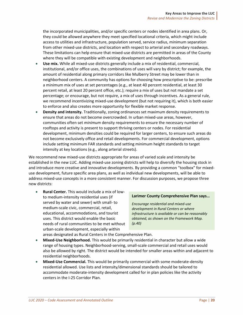
Encourage residential and mixed-use development in Rural Centers or where infrastructure is available or can be reasonably obtained, as shown on the Framework Map. (p.40)
Key Areas to Improve the LUC Revise and Modernize the Zoning Districts
LUC 2020 – Code Assessment and Annotated Outline Page | 21
All mixed-use districts should be designed to emphasize pedestrian-scale development and the relationship of buildings to the streetscape, and to minimize pedestrian and vehicle conflicts. Transitional standards that limit development at the district’s edges can help provide an appropriate transition to adjacent development. Mixed-use districts may emphasize form and design more than other base zoning districts. Illustrations and graphics can help convey the intended character of the districts.
Agricultural District(s) Several options for new agricultural districts are proposed for consideration and discussed in the “Rethink the Definitions and Standards for Agriculture” section of this report.
Other New Districts In addition to the mixed-use and agricultural districts, we recommend introducing four additional districts to address gaps between the Comprehensive Plan and the existing line-up of districts:
• CR - Commercial Rural. This district would be intended to capture the commercial and industrial agricultural support uses referred to in the Rural framework category if those uses are limited or removed from the current FO, FO-1, and RE districts. It is proposed those districts transition to a more residential focus, allowing this new district to fill that nonresidential need. Depending on the County’s preferred approach for establishing new agricultural districts, the purpose and intent of this district may be accomplished by one of the options presented in Table 9, rendering this new district unnecessary.
• NR - Natural Resource. This district would directly respond to the purpose and character of the Natural Resource framework category. The County does not currently have a district specifically for publicly owned lands or private lands under conservation easements (those with very limited or no development potential). The uses in this district would be limited to maintain the undisturbed nature of protected lands.
• CF - Community Facilities. This district is intended to accommodate civic and public uses (e.g., libraries, churches, schools, utility facilities, community parks, government buildings). Communities often find it helpful to have a distinct zone district designed for those use types to prevent unintended consequences of a rezone to accommodate such a use. For example, if a pump station or other high-intensity utility land use was needed near a residential neighborhood, it would be unlikely that residents would support a rezoning to a commercial or industrial district because there are several other use types allowed that are associated with those districts. Conversely, neighborhoods often support the rezoning of a community park to the CF district because it ensures the property will not undergo a drastic redevelopment without a rezoning and proper public notice.
• R-PD - Rural Planned Development. This district would allow for planned development outside of the LaPorte Planned Area and established GMAs. Please see the Clean Up the Planned Development Standards section of this report for details regarding this new district.
Simplify the Open District The majority of land area in Larimer County (approximately 90 percent) is in the O zoning district. As a result, this district encompasses several of the framework categories identified in the Comprehensive Plan, including “Rural,” “Agriculture/Ranching,” “Mountains and Foothills,” and “Natural Resource.” The O district currently allows a wide range of land uses, including several that have the potential for creating issues with land use incompatibility (e.g., alfalfa dehydrator, livestock auction, landfill, prison/detention center, single-family dwelling, rafting business academy, airport, park and ride, train station, resort lodge/resort cottages, and child/elderly care center). Allowing such a broad range of
Key Areas to Improve the LUC Revise and Modernize the Zoning Districts
LUC 2020 – Code Assessment and Annotated Outline Page | 22
residential and nonresidential uses in a single zoning district makes it difficult to decipher the district’s true intent.
There are currently two sets of setback standards that sometimes differ by 20 feet. There is a discrete set of standards for lots established prior to November 29, 1973, and additional standards for lots established after that date. Additionally, structures over 120 square feet established prior to January 22, 2007, have their own setback standards. These varying setback standards further contributes to the diverse development patterns that exist in the O district and results in a lack of district identity. We recommend moving to a simplified and uniform approach for setbacks in this district.
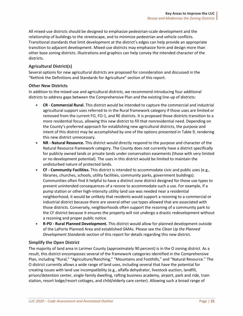
The O district’s lack of identity and “one-size-fits-all” nature has made it challenging for staff and decision-makers to establish and enforce an effective set of standards that accommodate the range of activities currently allowed. The aerial images below demonstrate the diversity of development patterns that exist today.
These images demonstrate the land use diversity that exist in the current O zoning district. Rocky Mountain National Park (top left), Livermore commercial node (top right), Noosa Yoghurt operation (bottom left), and LaPorte neighborhood (bottom right).
The following table presents a preferred approach and two additional options for how Larimer County could address the challenges associated with the O district and summarizes the advantages and disadvantages of each approach.
Table 5: Proposed Options for Open District
Summary Advantages Disadvantages
Preferred Approach: Refine to Establish Clear Intent Carry forward and refine the O district to have a clear residential focus, while still allowing other rural uses. This would require substantial updates to district
• Addresses the current “catch-all” approach and establish a clear district intent
• Eliminates the variety of land uses currently allowed
• Creates nonconformities, unless properties at risk are
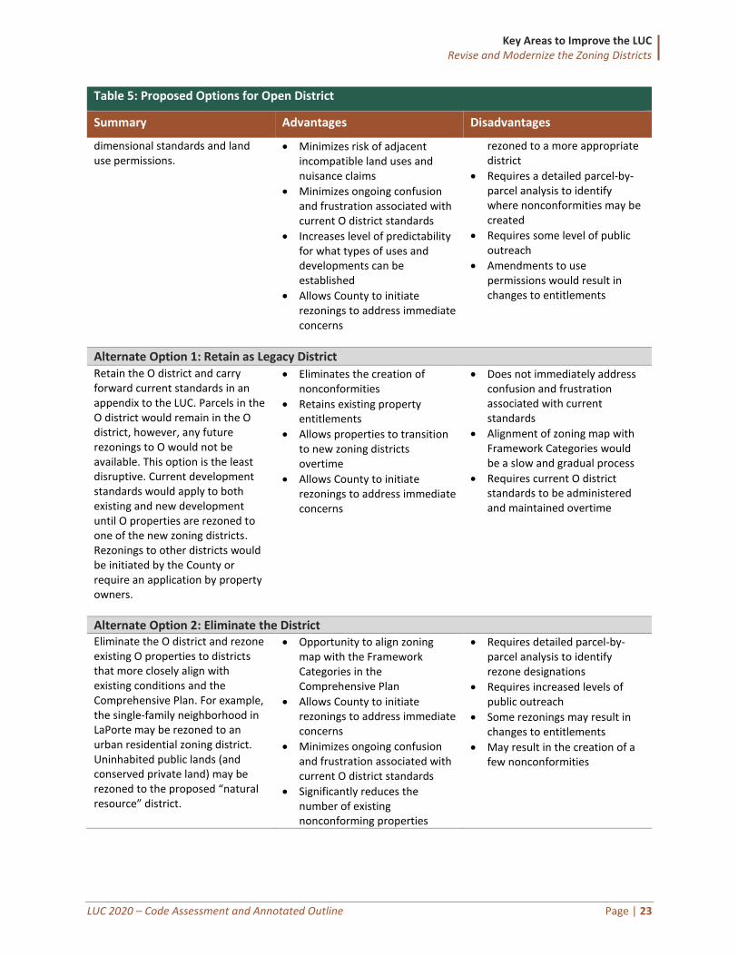
Key Areas to Improve the LUC Revise and Modernize the Zoning Districts
LUC 2020 – Code Assessment and Annotated Outline Page | 23
Table 5: Proposed Options for Open District
Summary Advantages Disadvantages
dimensional standards and land use permissions.
• Minimizes risk of adjacent incompatible land uses and nuisance claims
• Minimizes ongoing confusion and frustration associated with current O district standards
• Increases level of predictability for what types of uses and developments can be established
• Allows County to initiate rezonings to address immediate concerns
rezoned to a more appropriate district
• Requires a detailed parcel-by-parcel analysis to identify where nonconformities may be created
• Requires some level of public outreach
• Amendments to use permissions would result in changes to entitlements
Alternate Option 1: Retain as Legacy District Retain the O district and carry forward current standards in an appendix to the LUC. Parcels in the O district would remain in the O district, however, any future rezonings to O would not be available. This option is the least disruptive. Current development standards would apply to both existing and new development until O properties are rezoned to one of the new zoning districts. Rezonings to other districts would be initiated by the County or require an application by property owners.
• Eliminates the creation of nonconformities
• Retains existing property entitlements
• Allows properties to transition to new zoning districts overtime
• Allows County to initiate rezonings to address immediate concerns
• Does not immediately address confusion and frustration associated with current standards
• Alignment of zoning map with Framework Categories would be a slow and gradual process
• Requires current O district standards to be administered and maintained overtime
Alternate Option 2: Eliminate the District Eliminate the O district and rezone existing O properties to districts that more closely align with existing conditions and the Comprehensive Plan. For example, the single-family neighborhood in LaPorte may be rezoned to an urban residential zoning district. Uninhabited public lands (and conserved private land) may be rezoned to the proposed “natural resource” district.
• Opportunity to align zoning map with the Framework Categories in the Comprehensive Plan
• Allows County to initiate rezonings to address immediate concerns
• Minimizes ongoing confusion and frustration associated with current O district standards
• Significantly reduces the number of existing nonconforming properties
• Requires detailed parcel-by-parcel analysis to identify rezone designations
• Requires increased levels of public outreach
• Some rezonings may result in changes to entitlements
• May result in the creation of a few nonconformities
Key Areas to Improve the LUC Revise and Modernize the Zoning Districts
LUC 2020 – Code Assessment and Annotated Outline Page | 24
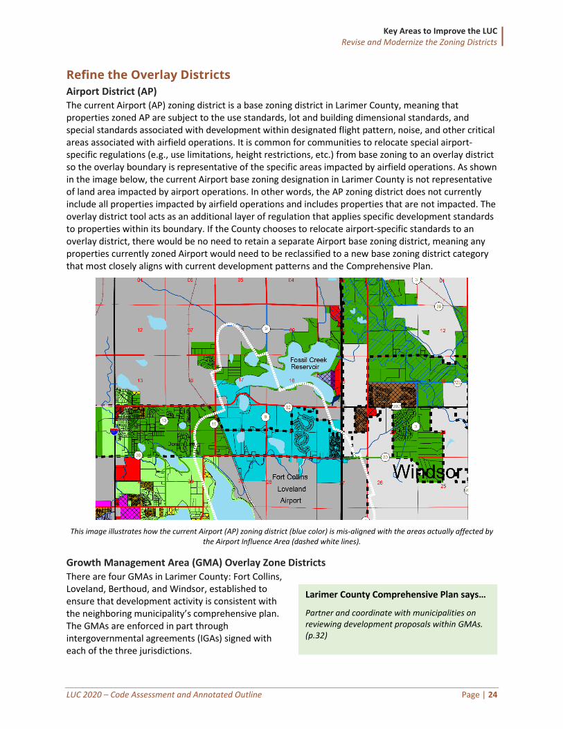
Refine the Overlay Districts
Airport District (AP) The current Airport (AP) zoning district is a base zoning district in Larimer County, meaning that properties zoned AP are subject to the use standards, lot and building dimensional standards, and special standards associated with development within designated flight pattern, noise, and other critical areas associated with airfield operations. It is common for communities to relocate special airport-specific regulations (e.g., use limitations, height restrictions, etc.) from base zoning to an overlay district so the overlay boundary is representative of the specific areas impacted by airfield operations. As shown in the image below, the current Airport base zoning designation in Larimer County is not representative of land area impacted by airport operations. In other words, the AP zoning district does not currently include all properties impacted by airfield operations and includes properties that are not impacted. The overlay district tool acts as an additional layer of regulation that applies specific development standards to properties within its boundary. If the County chooses to relocate airport-specific standards to an overlay district, there would be no need to retain a separate Airport base zoning district, meaning any properties currently zoned Airport would need to be reclassified to a new base zoning district category that most closely aligns with current development patterns and the Comprehensive Plan.
This image illustrates how the current Airport (AP) zoning district (blue color) is mis-aligned with the areas actually affected by the Airport Influence Area (dashed white lines).
Growth Management Area (GMA) Overlay Zone Districts There are four GMAs in Larimer County: Fort Collins, Loveland, Berthoud, and Windsor, established to ensure that development activity is consistent with the neighboring municipality’s comprehensive plan. The GMAs are enforced in part through intergovernmental agreements (IGAs) signed with each of the three jurisdictions.
Larimer County Comprehensive Plan says…
Partner and coordinate with municipalities on reviewing development proposals within GMAs. (p.32)
Key Areas to Improve the LUC Revise and Modernize the Zoning Districts
LUC 2020 – Code Assessment and Annotated Outline Page | 25
The current LUC requires properties within GMAs to either develop under the County’s current zoning, rezone to a PD district, or seek annexation by the adjacent municipality. Those who opt to rezone to a PD typically incorporate the neighboring municipality’s zoning standards into the PD to help minimize the creation of nonconformities if that property is annexed. We heard that cities have expressed some frustration when properties are developed under County zoning since the County does not have the same level of standards to address setbacks, building design, parking, and other development- quality standards .
Moving forward, this project provides an opportunity to establish clearer standards for development within GMAs and would help ensure high-quality development and a smooth transition to municipal zoning if an annexation were to occur. One approach to accomplish this would be to integrate additional standards within GMA areas that mirror those of the respective cities. Longer term, the County may consider strengthening Intergovernmental Agreements (IGAs) to have cities provide supplemental review for development projects to ensure they meet city expectations. For example, County staff is currently working with the City of Fort Collins to explore ways in which the development quality standards and development review procedures could be enhanced within the Fort Collins GMA to help further the goals of both Larimer County and the City of Fort Collins.
Floodplain Overlay The floodplain overlay district is intended to provide additional standards for areas that are at risk of periodic flooding and generally apply to all Federal Emergency Management Agency (FEMA) and local 100-year special flood hazard areas. We do not propose a major rethink of the County’s current floodplain overlay zones, but recommend its content be reorganized and clarified to improve user-friendliness. Any content related to decision-making bodies and review and approval procedures may be relocated to the corresponding sections in the LUC that address those topics.
We also recommend that the current floodplain overlay regulations be revised to comply with any corresponding Intergovernmental Agreements (IGAs). Given the technical nature of this work, we will work closely with subject matter experts from the County during the drafting process to identify specific areas in need of revision to ensure compliance with state and federal law.
Recommendations for Refining the Overlay Districts
1. Consider converting the existing Airport (AP) zoning district from a base district to an overlay district and update its standards.
2. Establish clear development quality standards for areas within GMAs. 3. Adopt standards within GMA areas that mirror those of the respective cities. Also, consider strengthening
IGAs to have GMA cities provide supplemental review for development project proposals. 4. Reorganize and clarify the floodplain overlay zone language and content. 5. Work with County staff to revise floodplain overlay standards to comply with IGAs. 6. Carry forward the Cooperative Planning Area Overlay Zone District.
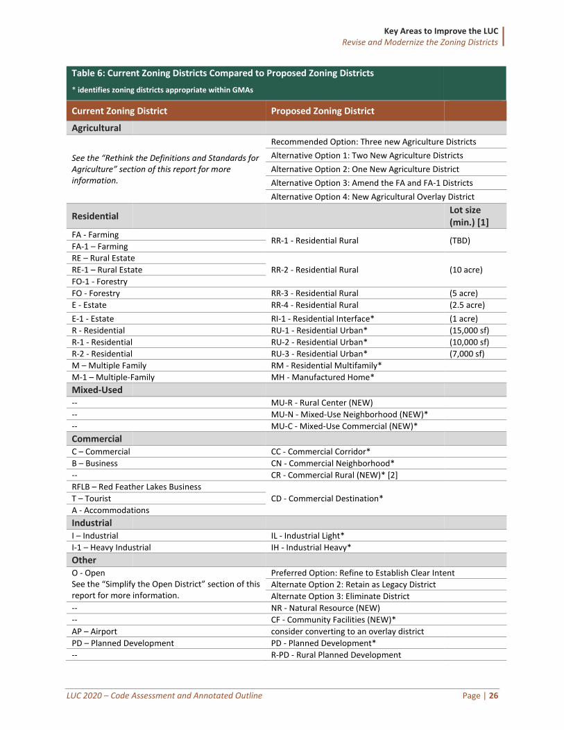
Summary Table of Proposed Zoning Districts The following table shows how each of the current zoning districts would translate to the new lineup of base zoning districts following the recommendations of this report. The first column shows the current zoning districts in Larimer County. The second column shows the proposed zoning districts through the LUC update project. Where existing zoning districts are recommended to be carried forward, the substance of those district standards would still be reviewed and updated as needed during the LDC update project.
Key Areas to Improve the LUC Revise and Modernize the Zoning Districts
LUC 2020 – Code Assessment and Annotated Outline Page | 26
Table 6: Current Zoning Districts Compared to Proposed Zoning Districts
* identifies zoning districts appropriate within GMAs
Current Zoning District Proposed Zoning District
Agricultural
See the “Rethink the Definitions and Standards for Agriculture” section of this report for more information.
Recommended Option: Three new Agriculture Districts
Alternative Option 1: Two New Agriculture Districts
Alternative Option 2: One New Agriculture District
Alternative Option 3: Amend the FA and FA-1 Districts
Alternative Option 4: New Agricultural Overlay District
Residential Lot size (min.) [1]
FA - Farming RR-1 - Residential Rural (TBD)
FA-1 – Farming
RE – Rural Estate
RR-2 - Residential Rural (10 acre) RE-1 – Rural Estate
FO-1 - Forestry
FO - Forestry RR-3 - Residential Rural (5 acre)
E - Estate RR-4 - Residential Rural (2.5 acre)
E-1 - Estate RI-1 - Residential Interface* (1 acre)
R - Residential RU-1 - Residential Urban* (15,000 sf)
R-1 - Residential RU-2 - Residential Urban* (10,000 sf)
R-2 - Residential RU-3 - Residential Urban* (7,000 sf)
M – Multiple Family RM - Residential Multifamily*
M-1 – Multiple-Family MH - Manufactured Home*
Mixed-Used -- MU-R - Rural Center (NEW)
-- MU-N - Mixed-Use Neighborhood (NEW)*
-- MU-C - Mixed-Use Commercial (NEW)*
Commercial C – Commercial CC - Commercial Corridor*
B – Business CN - Commercial Neighborhood*
-- CR - Commercial Rural (NEW)* [2]
RFLB – Red Feather Lakes Business
CD - Commercial Destination* T – Tourist
A - Accommodations
Industrial I – Industrial IL - Industrial Light*
I-1 – Heavy Industrial IH - Industrial Heavy*
Other O - Open See the “Simplify the Open District” section of this report for more information.
Preferred Option: Refine to Establish Clear Intent
Alternate Option 2: Retain as Legacy District
Alternate Option 3: Eliminate District
-- NR - Natural Resource (NEW)
-- CF - Community Facilities (NEW)*
AP – Airport consider converting to an overlay district
PD – Planned Development PD - Planned Development*
-- R-PD - Rural Planned Development
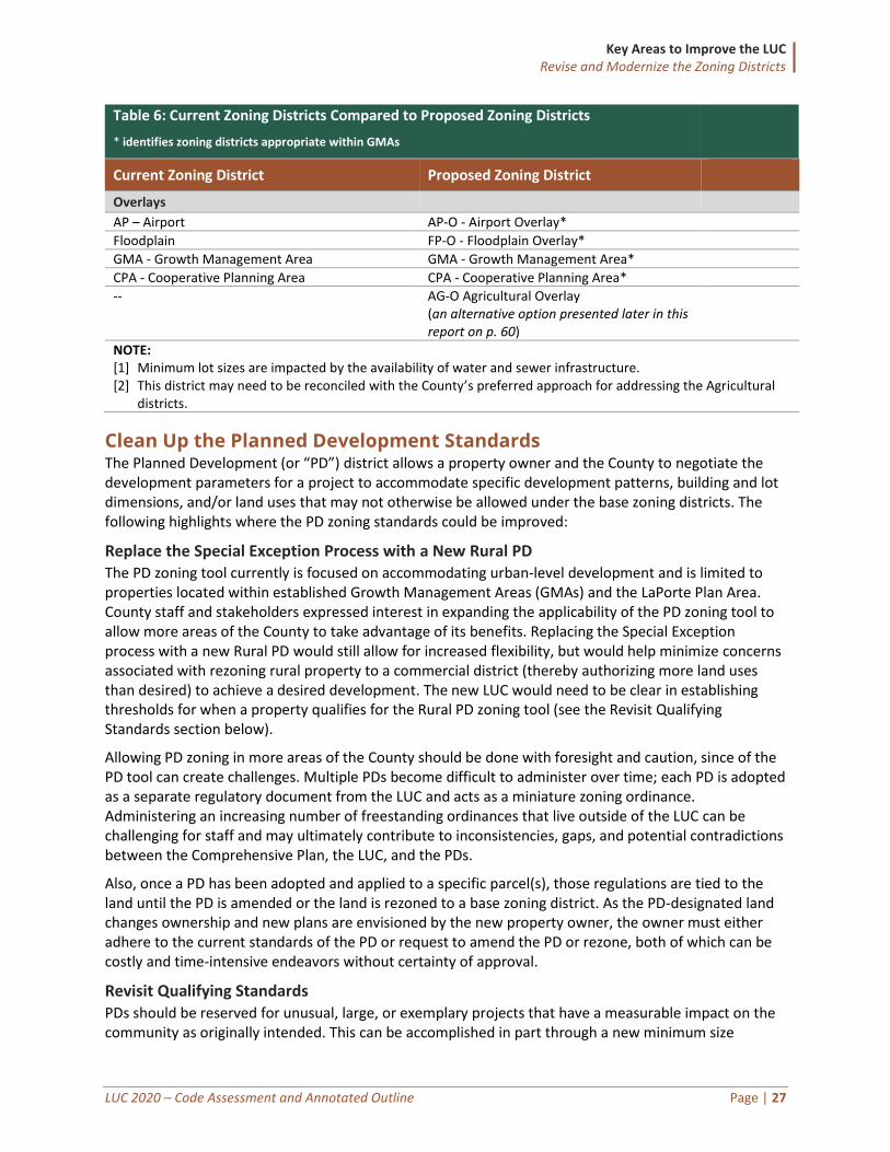
Key Areas to Improve the LUC Revise and Modernize the Zoning Districts
LUC 2020 – Code Assessment and Annotated Outline Page | 27
Table 6: Current Zoning Districts Compared to Proposed Zoning Districts
* identifies zoning districts appropriate within GMAs
Current Zoning District Proposed Zoning District
Overlays
AP – Airport AP-O - Airport Overlay*
Floodplain FP-O - Floodplain Overlay*
GMA - Growth Management Area GMA - Growth Management Area*
CPA - Cooperative Planning Area CPA - Cooperative Planning Area*
-- AG-O Agricultural Overlay (an alternative option presented later in this report on p. 60)
NOTE: [1] Minimum lot sizes are impacted by the availability of water and sewer infrastructure. [2] This district may need to be reconciled with the County’s preferred approach for addressing the Agricultural
districts.
Clean Up the Planned Development Standards The Planned Development (or “PD”) district allows a property owner and the County to negotiate the development parameters for a project to accommodate specific development patterns, building and lot dimensions, and/or land uses that may not otherwise be allowed under the base zoning districts. The following highlights where the PD zoning standards could be improved:
Replace the Special Exception Process with a New Rural PD The PD zoning tool currently is focused on accommodating urban-level development and is limited to properties located within established Growth Management Areas (GMAs) and the LaPorte Plan Area. County staff and stakeholders expressed interest in expanding the applicability of the PD zoning tool to allow more areas of the County to take advantage of its benefits. Replacing the Special Exception process with a new Rural PD would still allow for increased flexibility, but would help minimize concerns associated with rezoning rural property to a commercial district (thereby authorizing more land uses than desired) to achieve a desired development. The new LUC would need to be clear in establishing thresholds for when a property qualifies for the Rural PD zoning tool (see the Revisit Qualifying Standards section below).
Allowing PD zoning in more areas of the County should be done with foresight and caution, since of the PD tool can create challenges. Multiple PDs become difficult to administer over time; each PD is adopted as a separate regulatory document from the LUC and acts as a miniature zoning ordinance. Administering an increasing number of freestanding ordinances that live outside of the LUC can be challenging for staff and may ultimately contribute to inconsistencies, gaps, and potential contradictions between the Comprehensive Plan, the LUC, and the PDs.
Also, once a PD has been adopted and applied to a specific parcel(s), those regulations are tied to the land until the PD is amended or the land is rezoned to a base zoning district. As the PD-designated land changes ownership and new plans are envisioned by the new property owner, the owner must either adhere to the current standards of the PD or request to amend the PD or rezone, both of which can be costly and time-intensive endeavors without certainty of approval.
Revisit Qualifying Standards PDs should be reserved for unusual, large, or exemplary projects that have a measurable impact on the community as originally intended. This can be accomplished in part through a new minimum size
Key Areas to Improve the LUC Revise and Modernize the Zoning Districts
LUC 2020 – Code Assessment and Annotated Outline Page | 28
requirement, by establishing geographic locations for where the PD tool is or is not available, or by specifying which types of projects qualify for PD approval (e.g., affordable housing, clustered residential development). The qualifying standards should also prohibit the use of PD zoning when the variance or minor modification procedures could address the situation.
Require Public Benefits in Exchange for Flexibility The code should explicitly state that PDs and PD amendments shall provide benefits to the community, in exchange for the opportunity of gaining approval outside of the base zoning districts and procedures. Desired benefits do not need to be specified with mathematical precision, but they should be described with as much specificity as possible and should be required for major changes. Also, stronger enforcement and tracking of public benefits is necessary. Benefits such as preserved open space should be legally identified and protected through easements.
Establish Clear Standards for PDs The PD approval process is described in Section 4.1.22 of the LUC. The description is brief, and the details are unclear. County staff expressed interest in clarifying the PD approval process to help the review be more predictable, efficient, and effective. A PD approval is a specialized type of rezoning, with unique submittal requirements and approval criteria. Communities vary in their approach to PD processes; some establish a two-step process (preliminary and final approval) while others have a three-step process (conceptual, preliminary, and final approval). For discussion, a two-step process is proposed below (however, the optional concept plan proposed later in this report also could be integrated into this procedure).
Preliminary PD Plan
The preliminary plan provides a basis for evaluation of basic concepts, including whether the proposed development is in “substantial conformance” with the comprehensive plan and other adopted plans and policies. In addition, the preliminary plan provides an opportunity to reach general agreement on uses, number of units, general access alignments, and other factors. The stated outcome of the preliminary plan process is an identification of issues and concerns the applicant must address to ultimately receive final plan approval. Often, the preliminary plan is reviewed by both the Planning Commission and the BCC.
It is important to ensure that the preliminary plan process not require too much detail too early in the process. All communities struggle with where best to draw the line between early and later versions of a complex development application. It is not uncommon to see thresholds change over time as local officials and planners learn lessons and adapt. County officials and staff should discuss and identify the essential project attributes that are key to understanding a project’s overall impacts. As a starting point, we recommend the following:
• What currently exists on the site?
• What land uses are proposed? Where would they be located, and how big would they be?
• Why could this project not be built using the base zoning districts? What additional flexibility is needed?
• What public benefits will be provided? (Open space, street improvements, trails, etc.)
• How will people access and move around the site—by car, by bicycle, and on foot?
• How will water, sewer, and other utilities be provided?
• What is the timing of the development, and will it occur in stages?
• Does this project comply with the Comprehensive Plan and any applicable area plan?
After the criteria are established for preliminary plan review, the application requirements should be
Key Areas to Improve the LUC Revise and Modernize the Zoning Districts
LUC 2020 – Code Assessment and Annotated Outline Page | 29
revised to reflect those criteria. Any items not essential to understanding these key project attributes should be deferred to the site plan review stage. The following is an example of what the preliminary plan submittals list might look like this:
• Existing conditions map (existing vegetation, natural watercourses, natural features, etc.).
• Proposed land uses (including residential densities and nonresidential intensities).
• Proposed building locations, building heights, and vehicular use areas.
• Conceptual access and circulation plan (vehicular, pedestrian, trails).
• Conceptual phasing plan.
• Conceptual utility plan.
• Public benefits to be provided, including any open space to be protected.
• Statement of plan conformance.
These would be prepared at a “bubble plan” level of illustration. The actual application submittal list would not be in the LUC but in a separate administrative manual, along with specific technical specifications for each submittal (e.g., the requirement for drawings to be to scale). Ultimately, all submittal requirements for the preliminary plan and final stages should be located in a separate administrative manual. Doing so will allow the submittal requirements to be refined over time by simply updating the manual, not by making formal changes to the LUC.
Final PD Plan Approval
After the preliminary plan is reviewed and approved, the next step is having the applicant revise the plan to reflect comments and conditions for consideration by the Board of County Commissioners. At the final review stage, the Board of County Commissioners considers the final PD plan/plat together with the proposed development standards package (zone text amendment) and the zone map amendment. The Board of County Commissioners would be the final decision-making body.
Recommendations for Cleaning Up the Planned Development Standards
1. Replace the Special Exception Process with a New Rural PD 2. Revisit qualifying standards for PD zoning 3. Require benefits to the community in exchange for PD zoning consideration (e.g., land conservation) 4. Establish clear standards for PD zoning within GMAs 5. Consider a streamlined two-step PD procedure for PD requests
Mapping the New Districts Ultimately, a new lineup of zoning districts in Larimer County will require a revised zoning map that reflects any updates to district names or consolidation of districts. For those changes, and for any districts that are carried forward, the new zoning map simply should reflect the updated designations. In most cases, individual parcels will require only a simple “one-to-one” conversion (e.g., properties currently zoned “R-1” are re-labeled “RU-2” to reflect the new naming convention). In some cases, however, County staff may need to conduct additional research to verify the appropriate conversion based on existing land uses or other factors.
Key Areas to Improve the LUC Revise and Modernize the Zoning Districts
LUC 2020 – Code Assessment and Annotated Outline Page | 30
Any new districts established would likely not be introduced immediately at the time of adoption of new LUC but would be available for future rezonings. To apply a new district and any associated standards, a rezoning of an existing property would have to be approved by the BCC. Local governments often wait until after a zoning code is adopted to consider either legislative rezoning (large areas of the jurisdiction at one time) or rezoning of individual properties. The following are a few options the County may consider regarding zoning map updates:
• Option 1 – Landholder opt-in. The County could distribute an announcement to property owners and invite them to discuss potential rezoning. This option is staff-intensive and would require several individual meetings and negotiations. Under this option, the County could sweeten the pot by offering incentives such as reduced or waived fees, or expedited review and approval.
• Option 2 – Legislative rezoning. The County can rezone properties as part of a legislative rezoning process that would collectively focus on the entire County (or large portions of it) rather than individual site-specific rezoning applications. Through this option, a wholesale revision to the zoning framework in Larimer County would be achieved immediately; however, this can be a challenging option and would require extensive public outreach.
• Option 3 (staff preferred approach) – Legislative rezoning with “opt-outs.” The legislative rezoning (Option 2) could be combined with an “opt-out” option by which property owners could: A) Negotiate a different base zoning district designation; or B) Opt out entirely from the legislative rezoning and retain existing zoning and entitlements.
Incentives can be a powerful tool to help put the updated and new districts into practice through future rezonings. Preferred development that is compatible with plan goals should be encouraged and incentivized where appropriate.
Recommendations for Mapping the New Districts (Phase 2)
1. Adopt an updated zoning map at time of adoption of new LUC showing new district consolidations and new district names.
2. Consider developing a transition plan for applying new districts to the zoning map.
Larimer County Comprehensive Plan says…
In the past, much of the problem regarding certainty and consistency of land use decisions has come from basic inconsistencies between the adopted Plan and the land use regulations—particularly the zoning map. (p.72)
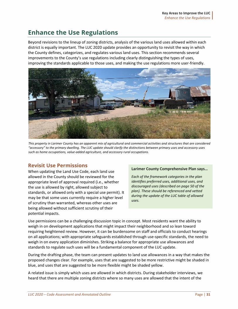
Key Areas to Improve the LUC Enhance the Use Regulations
LUC 2020 – Code Assessment and Annotated Outline Page | 31
Enhance the Use Regulations
Beyond revisions to the lineup of zoning districts, analysis of the various land uses allowed within each district is equally important. The LUC 2020 update provides an opportunity to revisit the way in which the County defines, categorizes, and regulates various land uses. This section recommends several improvements to the County’s use regulations including clearly distinguishing the types of uses, improving the standards applicable to those uses, and making the use regulations more user-friendly.
This property in Larimer County has an apparent mix of agricultural and commercial activities and structures that are considered “accessory” to the primary dwelling. The LUC update should clarify the distinctions between primary uses and accessory uses such as home occupations, value-added agriculture, and accessory rural occupations.
Revisit Use Permissions When updating the Land Use Code, each land use allowed in the County should be reviewed for the appropriate level of approval required (i.e., whether the use is allowed by right, allowed subject to standards, or allowed only with a special use permit). It may be that some uses currently require a higher level of scrutiny than warranted, whereas other uses are being allowed without sufficient scrutiny of their potential impacts.
Use permissions can be a challenging discussion topic in concept. Most residents want the ability to weigh in on development applications that might impact their neighborhood and so lean toward requiring heightened review. However, it can be burdensome on staff and officials to conduct hearings on all applications; with appropriate safeguards established through use-specific standards, the need to weigh in on every application diminishes. Striking a balance for appropriate use allowances and standards to regulate such uses will be a fundamental component of the LUC update.
During the drafting phase, the team can present updates to land use allowances in a way that makes the proposed changes clear. For example, uses that are suggested to be more restrictive might be shaded in blue, and uses that are suggested to be more flexible might be shaded yellow.
A related issue is simply which uses are allowed in which districts. During stakeholder interviews, we heard that there are multiple zoning districts where so many uses are allowed that the intent of the
Larimer County Comprehensive Plan says…
Each of the framework categories in the plan identifies preferred uses, additional uses, and discouraged uses (described on page 50 of the plan). These should be referenced and vetted during the update of the LUC table of allowed uses.
Key Areas to Improve the LUC Enhance the Use Regulations
LUC 2020 – Code Assessment and Annotated Outline Page | 32
district is not achieved. We will review land uses allowed in all districts (existing, revised, or new) to ensure the menu of land uses allow matches the district intent.
Recommendations: Revisit Use Permissions
1. Ensure appropriate level of use approval is required for specific use types. 2. Consider whether additional standards could be applied to a use and thus eliminate the need for a higher
level of scrutiny. 3. Clearly indicate any changes to use permissions during the drafting process. 4. Review land uses for all districts to ensure they match district intent.
Enhance Standards for Accessory Uses and Structures The current Section 4.3.10 addresses accessory uses and structures. We generally heard that these standards are functioning well, but that certain uses need clarification. Initial feedback indicated that one of the biggest challenges is the unclear lines between residential, agricultural, commercial, and accessory uses. For example, the vague nature of “accessory agricultural uses” makes it sometimes challenging to determine whether an activity is considered an accessory use versus another principal use of the property.
The following should be considered for improving accessory uses and structure standards:
• Base use standards on impacts. Standards applicable to accessory uses should clearly be based on their potential land-use impacts (e.g., traffic, number of people, customer base, and public access). For example, value-added agricultural processing is currently permitted by right only if 100 percent of the raw materials are raised or grown on the site but requires a minor special review approval if the amount raised or grown is anywhere between 50 and 100 percent. These standards were likely intended to address delivery truck traffic, but the standard does not clearly indicate that.
• Distinguish home occupations from other accessory uses. The new LUC should also clearly distinguish between home-based accessory uses (home occupations), rural occupations, and other accessory uses. We heard from stakeholders that the lines are blurred for when a home occupation is accessory to a primary residential use and when such use or structure becomes the primary use of the property. For instance, the accessory rural occupation process does not have a clear trigger, making it unclear when that process applies, rather than the typical home occupation process.
• Clarify size restrictions for accessory structures. The LUC states that accessory uses may not exceed 50 percent of the square footage of the dwelling (except for accessory rural occupations on at least two-acre lots where the use may not exceed 10,000 square feet). This standard creates the adverse incentive of expanding one’s dwelling in order to have more accessory uses. Size limitations should be clarified to indicate specific restrictions either based on percentage of lot area or a maximum number of square feet.
• Improve accessory use and structure evaluation criteria. The problem of accessory uses dominating principal uses is likely partially related to the criteria for accessory uses, home occupations, and accessory rural occupations. The criteria for each are different and the thresholds for when each set of criteria applies is not clear. For example, currently the criteria
Survey Response
“I would like the County to refine the standard to eliminate the ambiguities around running a construction business as a rural occupation.”
Key Areas to Improve the LUC Enhance the Use Regulations
LUC 2020 – Code Assessment and Annotated Outline Page | 33
do not effectively limit the size of the accessory uses because they rely on more subjective standards, like accessory uses must be “clearly secondary and incidental to the principal use of the property.”
Recommendations: Enhance Standards for Accessory Uses and Structures
1. Base use-specific standards for accessory uses on impacts associated with such uses. 2. Clearly distinguish home occupations from other accessory uses and structures. 3. Keep the accessory rural occupation and home occupation processes separate and add qualifying
language for each with clear triggers. 4. Allow uses by right when no structure permit is required; require a review process when a structure permit
is required. 5. Limit accessory uses to a fixed percent of the total lot area if a structure is required (see Weld County). 6. Limit accessory uses to a fixed amount of square feet depending on the lot size. 7. Improve accessory use and structure evaluation criteria.
Expand Housing Options Diversifying housing requires thinking outside the traditional single-family neighborhood box. The need for a greater variety of housing options is identified in the comprehensive plan and was also a common theme from the initial stakeholder outreach efforts. Expanding housing options is an important consideration not just to satisfy varied personal preferences, but also to improve the County’s attainable and affordable housing stock.
The County should consider expanding the types of dwellings allowed by the table of allowed uses to address use types in between single-family detached housing and dense apartments (i.e., the “missing middle”). For example:
• Accessory dwelling units (ADUs) play a role in many communities for expanding housing options. ADUs should be evaluated as part of the LUC update, and specifically the topic of whether ADUs should be available for long-term rent within the County, or limited by geographic area, district, or other ownership restrictions.
• Co-housing (and cottage housing) are options that include single-family detached living experience with shared amenities such as courtyards, community gardens, and community kitchens. This type of housing is ideal for smaller units on either single small lots or in a condominium arrangement.
• Live-work units where the owner of a business also resides in a separate space within the same building or unit.
• Single-family attached products beyond duplexes, to include various condominium and townhouse options such as tri- and four-plexes that are different than traditional apartment buildings.
Larimer County Comprehensive Plan says…
“Larimer County encourages a diversity of housing types necessary to meet the need for identified housing choices.” (p. 39)
Survey Responses
“[Allowing ADUs as rentals] could help decrease the housing crisis burden and make more options readily available.”
“We need to up the attainability of housing in Larimer County, especially for young people, for those who have lost homes due to fires and floods, for retirees needing on site care, and for farmers needing workers throughout the County.”
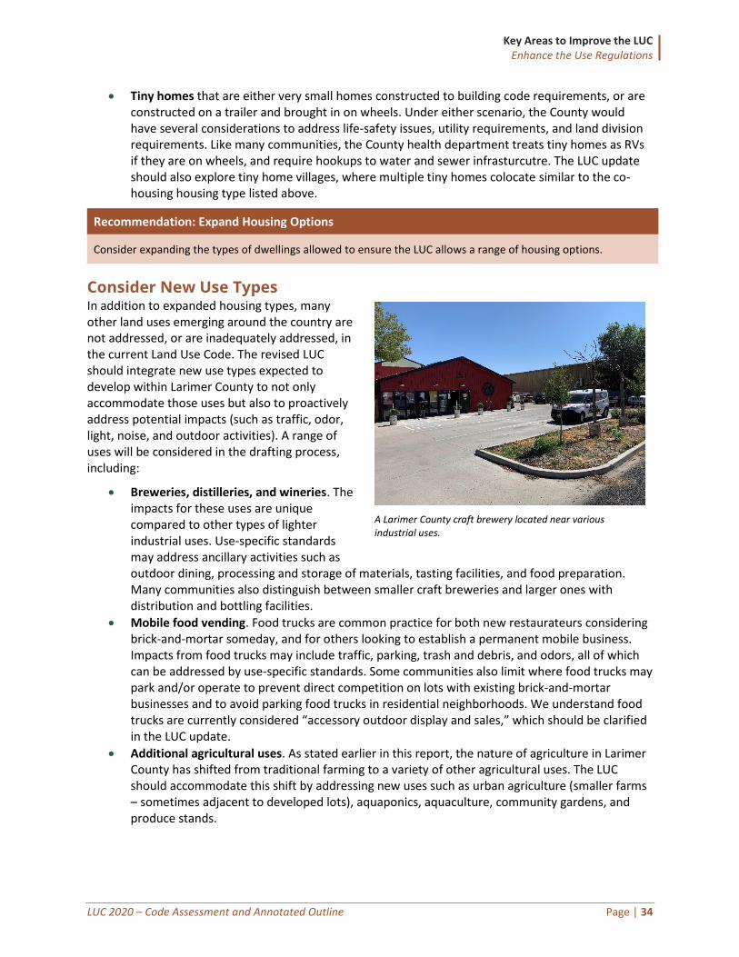
Key Areas to Improve the LUC Enhance the Use Regulations
LUC 2020 – Code Assessment and Annotated Outline Page | 34
• Tiny homes that are either very small homes constructed to building code requirements, or are constructed on a trailer and brought in on wheels. Under either scenario, the County would have several considerations to address life-safety issues, utility requirements, and land division requirements. Like many communities, the County health department treats tiny homes as RVs if they are on wheels, and require hookups to water and sewer infrasturcutre. The LUC update should also explore tiny home villages, where multiple tiny homes colocate similar to the co-housing housing type listed above.
Recommendation: Expand Housing Options
Consider expanding the types of dwellings allowed to ensure the LUC allows a range of housing options.
Consider New Use Types In addition to expanded housing types, many other land uses emerging around the country are not addressed, or are inadequately addressed, in the current Land Use Code. The revised LUC should integrate new use types expected to develop within Larimer County to not only accommodate those uses but also to proactively address potential impacts (such as traffic, odor, light, noise, and outdoor activities). A range of uses will be considered in the drafting process, including:
• Breweries, distilleries, and wineries. The impacts for these uses are unique compared to other types of lighter industrial uses. Use-specific standards may address ancillary activities such as outdoor dining, processing and storage of materials, tasting facilities, and food preparation. Many communities also distinguish between smaller craft breweries and larger ones with distribution and bottling facilities.
• Mobile food vending. Food trucks are common practice for both new restaurateurs considering brick-and-mortar someday, and for others looking to establish a permanent mobile business. Impacts from food trucks may include traffic, parking, trash and debris, and odors, all of which can be addressed by use-specific standards. Some communities also limit where food trucks may park and/or operate to prevent direct competition on lots with existing brick-and-mortar businesses and to avoid parking food trucks in residential neighborhoods. We understand food trucks are currently considered “accessory outdoor display and sales,” which should be clarified in the LUC update.
• Additional agricultural uses. As stated earlier in this report, the nature of agriculture in Larimer County has shifted from traditional farming to a variety of other agricultural uses. The LUC should accommodate this shift by addressing new uses such as urban agriculture (smaller farms – sometimes adjacent to developed lots), aquaponics, aquaculture, community gardens, and produce stands.
A Larimer County craft brewery located near various industrial uses.
Key Areas to Improve the LUC Enhance the Use Regulations
LUC 2020 – Code Assessment and Annotated Outline Page | 35
Recommendation: Consider New Use Types
Consider establishing new specific use types, and applicable standards, for uses not directly addressed by the current Larimer County LUC.
Update Use-Specific Standards Use-specific standards address the impacts associated with particular land uses. They may be tailored based on specific location (zoning district or another context). They typically address issues such as distance requirements from lower-intensity uses, and size limitations of the structures or use.
Use-specific standards differ from the “special review” and “minor special review” procedures, which require BOCC approval of conditions to uses following a public hearing. Instead, use-specific standards apply to the use type regardless of the required approval (by-right vs. special review). The approval of a use by-right subject to standards is typically faster and involves less public notice and comment than approval of special review use.
Generally, for each use in the table of allowed uses, the County should evaluate whether the use could be permitted “by right” if certain standards were in place, or whether certain standards should be in place regardless of the process for approval. The County may establish both quantitative and qualitative thresholds in determining whether a use may be allowed by right (subject to standards) or whether special review and a hearing should be required.
Additional recommendations for improving Larimer County’s use-specific standards include:
Establish New and Revise Current Use-Specific Standards Larimer County should consider new use-specific standards that are not currently addressed by the LUC, or that are addressed but require strengthening. Use-specific standards would be drafted as automatic conditions placed on a particular use type. A good first step is to review recent applications of development proposals for uses where conditions were established during the approval process and determine which common conditions would benefit from broadly applied use-specific standards.
Some example uses the County may consider establishing new or revised standards for include:
• Community halls. The term “community hall” is broadly applied to various uses, but most visibly wedding venues. The impacts of wedding venues on neighboring properties should be adequately addressed in the new LUC, beyond square footage thresholds for special review procedural requirements. The current standards rely largely on a subjective determination of compatibility, or perceived compatibility. Also, the current use-specific standards for community halls are related to the scenarios that trigger a special review but do not directly address the impacts or evaluate whether the use is compatible. The standards could be made more objective in part by requiring parking plans, distance requirements, and limiting hours of operation. It also may be appropriate to change the name of this use to “event center.”
• Kennels (currently “pet animal facility”). The current code identifies when a special review or minor special review is required but does not place specific land use restrictions on kennels. The standards should be revised to be aligned with state requirements and to distinguish between commercial kennels and casual or “hobby” breeder accessory uses. Many communities adopt distance standards from existing or future residential for outdoor dog runs or other boarding standards to avoid nuisance issues.
• Self-storage. Self-storage, or “mini-warehousing” uses are in high demand across the country. Many communities allow them where appropriate (typically in more intense commercial and
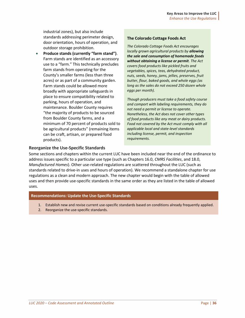
Key Areas to Improve the LUC Enhance the Use Regulations
LUC 2020 – Code Assessment and Annotated Outline Page | 36
industrial zones), but also include standards addressing perimeter design, door orientation, hours of operation, and outdoor storage prohibition.
• Produce stands (currently “farm stand”). Farm stands are identified as an accessory use to a “farm.” This technically precludes farm stands from operating for the County’s smaller farms (less than three acres) or as part of a community garden. Farm stands could be allowed more broadly with appropriate safeguards in place to ensure compatibility related to parking, hours of operation, and maintenance. Boulder County requires “the majority of products to be sourced from Boulder County farms, and a minimum of 70 percent of products sold to be agricultural products” (remaining items can be craft, artisan, or prepared food products).
Reorganize the Use-Specific Standards Some sections and chapters within the current LUC have been included near the end of the ordinance to address issues specific to a particular use type (such as Chapters 16.0, CMRS Facilities, and 18.0, Manufactured Homes). Other use-related regulations are scattered throughout the LUC (such as standards related to drive-in uses and hours of operation). We recommend a standalone chapter for use regulations as a clean and modern approach. The new chapter would begin with the table of allowed uses and then provide use-specific standards in the same order as they are listed in the table of allowed uses.
Recommendations: Update the Use-Specific Standards
1. Establish new and revise current use-specific standards based on conditions already frequently applied. 2. Reorganize the use-specific standards.
The Colorado Cottage Foods Act
The Colorado Cottage Foods Act encourages locally grown agricultural products by allowing the sale and consumption of homemade foods without obtaining a license or permit. The Act covers food products like pickled fruits and vegetables, spices, teas, dehydrated product, nuts, seeds, honey, jams, jellies, preserves, fruit butter, flour, baked goods, and whole eggs (as long as the sales do not exceed 250 dozen whole eggs per month).
Though producers must take a food safety course and comport with labeling requirements, they do not need a permit or license to operate. Nonetheless, the Act does not cover other types of food products like any meat or dairy products. Food not covered by the Act must comply with all applicable local and state-level standards including license, permit, and inspection requirements.
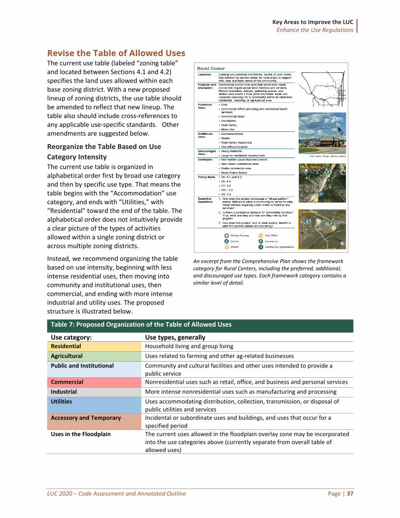
Key Areas to Improve the LUC Enhance the Use Regulations
LUC 2020 – Code Assessment and Annotated Outline Page | 37
Revise the Table of Allowed Uses The current use table (labeled “zoning table” and located between Sections 4.1 and 4.2) specifies the land uses allowed within each base zoning district. With a new proposed lineup of zoning districts, the use table should be amended to reflect that new lineup. The table also should include cross-references to any applicable use-specific standards. Other amendments are suggested below.
Reorganize the Table Based on Use
Category Intensity The current use table is organized in alphabetical order first by broad use category and then by specific use type. That means the table begins with the “Accommodation” use category, and ends with “Utilities,” with “Residential” toward the end of the table. The alphabetical order does not intuitively provide a clear picture of the types of activities allowed within a single zoning district or across multiple zoning districts.
Instead, we recommend organizing the table based on use intensity, beginning with less intense residential uses, then moving into community and institutional uses, then commercial, and ending with more intense industrial and utility uses. The proposed structure is illustrated below.
Table 7: Proposed Organization of the Table of Allowed Uses
Use category: Use types, generally Residential Household living and group living
Agricultural Uses related to farming and other ag-related businesses
Public and Institutional Community and cultural facilities and other uses intended to provide a public service
Commercial Nonresidential uses such as retail, office, and business and personal services
Industrial More intense nonresidential uses such as manufacturing and processing
Utilities Uses accommodating distribution, collection, transmission, or disposal of public utilities and services
Accessory and Temporary Incidental or subordinate uses and buildings, and uses that occur for a specified period
Uses in the Floodplain The current uses allowed in the floodplain overlay zone may be incorporated into the use categories above (currently separate from overall table of allowed uses)
An excerpt from the Comprehensive Plan shows the framework category for Rural Centers, including the preferred, additional, and discouraged use types. Each framework category contains a similar level of detail.
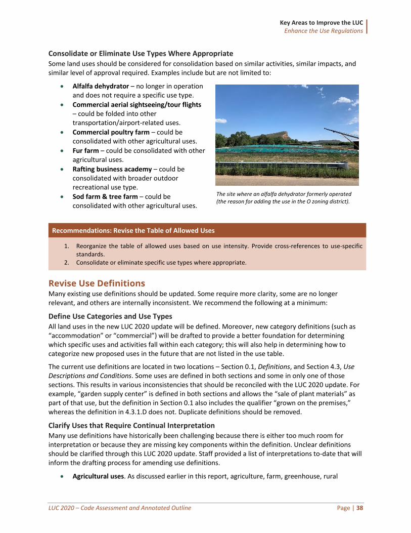
Key Areas to Improve the LUC Enhance the Use Regulations
LUC 2020 – Code Assessment and Annotated Outline Page | 38
Consolidate or Eliminate Use Types Where Appropriate Some land uses should be considered for consolidation based on similar activities, similar impacts, and similar level of approval required. Examples include but are not limited to:
• Alfalfa dehydrator – no longer in operation and does not require a specific use type.
• Commercial aerial sightseeing/tour flights – could be folded into other transportation/airport-related uses.
• Commercial poultry farm – could be consolidated with other agricultural uses.
• Fur farm – could be consolidated with other agricultural uses.
• Rafting business academy – could be consolidated with broader outdoor recreational use type.
• Sod farm & tree farm – could be consolidated with other agricultural uses.
Recommendations: Revise the Table of Allowed Uses
1. Reorganize the table of allowed uses based on use intensity. Provide cross-references to use-specific standards.
2. Consolidate or eliminate specific use types where appropriate.
Revise Use Definitions Many existing use definitions should be updated. Some require more clarity, some are no longer relevant, and others are internally inconsistent. We recommend the following at a minimum:
Define Use Categories and Use Types All land uses in the new LUC 2020 update will be defined. Moreover, new category definitions (such as “accommodation” or “commercial”) will be drafted to provide a better foundation for determining which specific uses and activities fall within each category; this will also help in determining how to categorize new proposed uses in the future that are not listed in the use table.
The current use definitions are located in two locations – Section 0.1, Definitions, and Section 4.3, Use Descriptions and Conditions. Some uses are defined in both sections and some in only one of those sections. This results in various inconsistencies that should be reconciled with the LUC 2020 update. For example, “garden supply center” is defined in both sections and allows the “sale of plant materials” as part of that use, but the definition in Section 0.1 also includes the qualifier “grown on the premises,” whereas the definition in 4.3.1.D does not. Duplicate definitions should be removed.
Clarify Uses that Require Continual Interpretation Many use definitions have historically been challenging because there is either too much room for interpretation or because they are missing key components within the definition. Unclear definitions should be clarified through this LUC 2020 update. Staff provided a list of interpretations to-date that will inform the drafting process for amending use definitions.
• Agricultural uses. As discussed earlier in this report, agriculture, farm, greenhouse, rural
The site where an alfalfa dehydrator formerly operated (the reason for adding the use in the O zoning district).
Key Areas to Improve the LUC Enhance the Use Regulations
LUC 2020 – Code Assessment and Annotated Outline Page | 39
occupation, value-added agriculture, and other agricultural-related use definitions should be revisited as part of the overall package of updates intended to improve and retain the County’s agricultural sector. For example, some landowners that are using their land for farming activities do not meet the definition of “farm” due to the three-acre requirement, whereas others that may fall within that definition of farm are not actually farming on the property. There is currently not a clear line drawn for when agricultural uses become commercial or industrial uses.
• Community hall. Partially due to increasing demand for rural wedding venues, and partially due to the need to diversify agriculture business ventures, the number of wedding venue operations has increased in the last several years. The County accommodates these uses under the “community hall” use, but the broad definition has resulted in compatibility issues with neighboring properties.
• Home occupation. The definition should be amended to clearly distinguish the use from accessory rural occupations and to reflect historical staff interpretations.
Coordinate Definitions Related to Other Regulations The LUC update should update definitions to be more consistent with building code, engineering documents, and fire and public health regulations. For example, we heard from multiple internal stakeholders that the nuances of how planning defines specific uses is different from the building department.
• Habitable space. The current definition of “habitable space” creates issues with accessory dwelling units, and inconsistent interpretations. Also, consider a category for detached accessory spaces that are not considered a “dwelling unit.”
• Intended activities in commercial structures. There is an issue with building being constructed and used for activities that were not initially intended for that use type, which may have triggered fees and building code compliance had those activities been identified by planners earlier in the process. For example, large commercial buildings may be allowed under “art studio” or “boat house” and thus bypassing some building code standards.
• Reconcile other planning and building code terms. Some definitions require coordination with building code terms, including “residential,” “commercial,” and “structure.”
Recommendations: Revise Use Definitions
1. Define all general use categories and specific use types. 2. Clarify uses that require continual interpretation. 3. Coordinate definitions in Land Use Code with those in related regulations.
Key Areas to Improve the LUC Improve the Development Standards
LUC 2020 – Code Assessment and Annotated Outline Page | 40
Improve the Development Standards
The term “development standards” refers to the various regulations adopted by Larimer County that affect the quality of development – from protection of sensitive and natural areas (e.g., floodplain regulations); to design of the site (e.g., how much parking and landscaping are required); to building design and site features (e.g., signs, lighting). Over many years, County officials have established a range of development standards that are important for protecting Larimer County’s unique sense of place and character.
However, a common theme from the initial outreach is that the current development quality standards are applied as one-size-fits-all and do not reflect the vast diversity of Larimer County. For example, the same parking and landscaping standards apply in both urbanizing areas and mountain communities.
The sections below first introduce some general considerations that should apply to the update of all types of development standards. Subsequent sections address specific issues, like parking, in more detail.
General Considerations for All Development Standards
Establish Context-Based Standards The LUC 2020 rewrite should move away from a uniform approach to regulating developing quality towards one that is more tailored based on land use context. The various contexts established in the comprehensive plan are one foundation for tailoring development standards. But there are several possible contexts the County could consider as a basis for tailoring development standards:
• Designated framework categories as described in the comprehensive plan (such as mountains and foothill areas, retail service nodes, or rural centers)
• Zoning districts
• Growth Management Areas (GMAs)
• Infill and redevelopment areas (versus raw-land or greenfield development)
• Other mapped areas (such as hazard areas or sub-area planning areas)
Different contexts may be appropriate for different standards – in other words, some standards may be calibrated by district, while others are distinguished by plan place type. Appropriate contexts for different standards will proposed for discussion during the drafting process.
The following development standards could be improved to be more context-sensitive:
• Landscaping. Landscaping requirements could differ depending on whether the development is on previously undeveloped property versus expansions, renovations, or redevelopment of existing development, or whether it is located within an urbanized context where traditional landscaping would be less desirable than an urban streetscape with tree wells, plaza areas,
Larimer County Comprehensive Plan says…
The Framework map and categories answer the following essential questions:
• Where should we live, work, play, and grow food?
• Where should we invest in infrastructure?
• Where and how should we protect and conserve watersheds, wildlife habitat, viewsheds, hazardous areas, and other resources?
• What type of County do we want to become?
Larimer County Comprehensive Plan says…
“Use annexations and development approvals within GMAs to accomplish the residential densities, non-residential intensities and street patterns contained in the municipality’s comprehensive plan.” (p. 32)
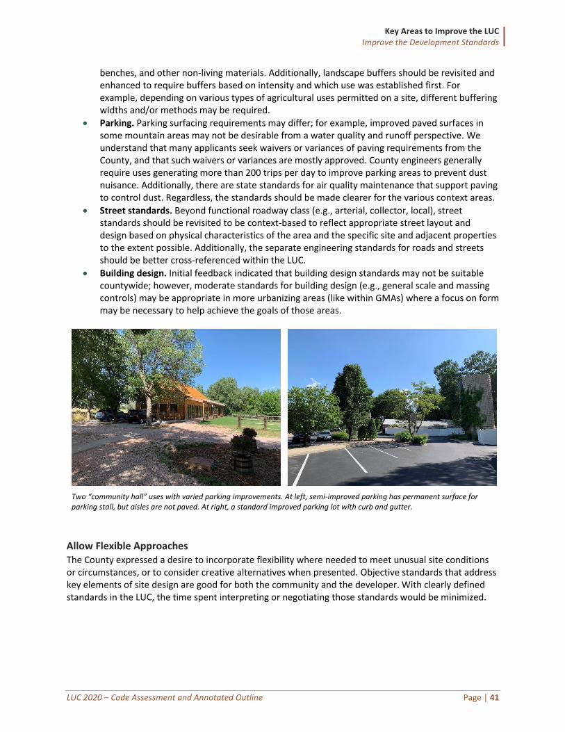
Key Areas to Improve the LUC Improve the Development Standards
LUC 2020 – Code Assessment and Annotated Outline Page | 41
benches, and other non-living materials. Additionally, landscape buffers should be revisited and enhanced to require buffers based on intensity and which use was established first. For example, depending on various types of agricultural uses permitted on a site, different buffering widths and/or methods may be required.
• Parking. Parking surfacing requirements may differ; for example, improved paved surfaces in some mountain areas may not be desirable from a water quality and runoff perspective. We understand that many applicants seek waivers or variances of paving requirements from the County, and that such waivers or variances are mostly approved. County engineers generally require uses generating more than 200 trips per day to improve parking areas to prevent dust nuisance. Additionally, there are state standards for air quality maintenance that support paving to control dust. Regardless, the standards should be made clearer for the various context areas.
• Street standards. Beyond functional roadway class (e.g., arterial, collector, local), street standards should be revisited to be context-based to reflect appropriate street layout and design based on physical characteristics of the area and the specific site and adjacent properties to the extent possible. Additionally, the separate engineering standards for roads and streets should be better cross-referenced within the LUC.
• Building design. Initial feedback indicated that building design standards may not be suitable countywide; however, moderate standards for building design (e.g., general scale and massing controls) may be appropriate in more urbanizing areas (like within GMAs) where a focus on form may be necessary to help achieve the goals of those areas.
Two “community hall” uses with varied parking improvements. At left, semi-improved parking has permanent surface for parking stall, but aisles are not paved. At right, a standard improved parking lot with curb and gutter.
Allow Flexible Approaches The County expressed a desire to incorporate flexibility where needed to meet unusual site conditions or circumstances, or to consider creative alternatives when presented. Objective standards that address key elements of site design are good for both the community and the developer. With clearly defined standards in the LUC, the time spent interpreting or negotiating those standards would be minimized.
Key Areas to Improve the LUC Improve the Development Standards
LUC 2020 – Code Assessment and Annotated Outline Page | 42
• Integrate menus, options, and other types of alternative development standards. Menus and optional approaches throughout the development standards (e.g., “pick three of these five approaches”) will allow the County and applicants meet the intent of the code yet adapt each project to unique situations—say redevelopment, infill, changes of use, challenging site conditions, or for concepts not anticipated by the community. Alternatives could be drafted within each applicable development standards section (e.g., landscaping, parking, lighting, etc.) where alternatives would be necessary to achieve the desired quality. Generally, a cautious approach to alternatives should be considered for the County, recognizing that such alternatives may or may not be appropriate depending on the specific context.
• Consider Alternative Equivalent Compliance. Many communities allow for “alternative equivalent compliance” for development proposals that meet the intent of the standards but for one reason or another cannot meet the strict letter of the law. These are not variances or waivers from standards, but rather alternatives approaches deemed acceptable by the County because they offer greater benefit in exchange for accommodating unusual circumstances. If a proposed concept meets the intent and results in a similar level of community benefit, then allowing alternatives to the standards administratively is a flexible approach to being business-friendly without compromising character. Such a procedure may require a separate meeting and should include additional criteria to ensure the development achieves the County’s goals to the same or better degree with the alternatives.
Clarify Mandatory versus Optional Standards One example of improving objectivity is to change current non-mandatory discretionary guidelines such as “should” and either revise the guideline to “shall” or remove the guideline from the LUC. For example, within the conservation development regulations, Section 5.3.5 describes specific standards for attached single-family dwellings near detached single-family dwellings and states that they “should be constructed to look like single-family dwellings” and that rural features “should be preserved.” There are 95 instances of “should” within the current LUC that “should” be reviewed for strengthening during the LUC update. Clarifying the distinction between requirements and advisory text is a powerful tool to help achieve the levels of quality that the County wants. Our general approach is to review each standard and determine:
• Is it written as a discretionary guideline or a mandatory standard?
• If it is a guideline, should it be applied more strictly as a standard?
• If it is a standard, should it be applied more broadly throughout the County, or by context?
• If it is a standard, should it be loosened to apply only as a guideline and potentially relocated outside the LUC?
Include Clear Statements of Purpose and Applicability Throughout the development standards, the new LUC should establish clear purpose and applicability statements that indicate both the intent of the standards and the types of development and redevelopment scenarios to which the standards apply. These are fundamental to modern defensible
Larimer County Comprehensive Plan says…
The plan describes the relationship between the plan and the Land Use Code and includes various principles of carrying forward a fair process, including: “A fair process…has consistent requirements that contain flexibility within the written criteria.” (p. 5)
“Larimer County balances growth and preservation of community character outside GMAs through flexible and predictable land use strategies, processes, and development standards in unincorporated areas.” (p. 33)
Key Areas to Improve the LUC Improve the Development Standards
LUC 2020 – Code Assessment and Annotated Outline Page | 43
codes. Purpose statements are also an excellent way to educate the community on how particular standards are relevant to the County and how they will help the County achieve its goals. The current code does have some purpose statements and some applicability standards, but they are addressed inconsistently across development standards and should be improved. For example, purpose statements are provided for landscaping and drainage standards, but not for parking standards. Without purpose statements, the County is beholden to interpreting the LUC on its face, without direct justification or reasoning based on a stated intent that answers the question “why is the County regulating ____________?”
Beyond the content of the standards themselves, County staff and officials can rely on well-written purpose statements to provide overall direction and justification for decision-making. Applicability statements improve transparency of the development process by indicating specific thresholds for when certain development standards apply and whether there are any exemptions. This relatively simple drafting exercise results in a more user-friendly document.
Recommendations: General Considerations for All Development Standards
1. Consider various contexts when updating the development standards. 2. Establish context-sensitive development standards for landscaping and streetscape, parking, street design
and classification, and other site and building design standards. 3. Integrate menus, options, and other alternative standards within as many development standards
sections as possible (e.g., landscaping, parking, lighting, etc.). 4. Consider establishing an alternative equivalent compliance procedure. 5. Distinguish mandatory LUC requirements from discretionary guidelines. 6. Update existing purpose statements for clarity and intent. 7. Draft clear purpose statements for sections within the LUC that do not currently have them. 8. Draft clear applicability standards clarifying the types of development subject to various standards.
Enhance Hazard Mitigation throughout the LUC Like many other Colorado counties, Larimer County has seen unprecedented natural hazards historically and in recent years. The County is challenged with droughts, flooding, geologic hazards, and wildfire on a consistent basis, in addition to other hazards less predictable in terms of geographic location such as tornados, hazmat event, and severe winter weather. Clarion has worked with the Colorado Department of Local Affairs and with several Colorado communities to implement hazard mitigation into land use codes, including both zoning and subdivision tools. The County should consider further implementation measures that address risk reduction, with the expectation that the trend for more frequent and more severe hazards will continue.
Evaluate Actions from the Hazard Mitigation
Plan The Larimer County 2016 Multi-Jurisdictional Hazard Mitigation Plan provides a profile on each of the hazard threats within the County and identifies a plan of action for priority mitigation projects. The actions range from physical mitigation improvements such as bridge improvements, to mapping updates to reflect current FEMA floodplain delineations, to code changes to both the LUC and the building code.
Mountain Resilience Plan says…
“Secondary egress, or additional access points into neighborhoods and communities, prevent a population from being isolated from outside support in the event of a natural disaster.” (p.76)
“A wildfire home mitigation program supporting home and property owners through technical expertise, home wildfire vulnerability assessments and recommended actions can increase the likelihood of effective mitigation and lower insurance rates.” (p. 77)
“Although fire codes, no matter how stringent, cannot eliminate the risk of wildfire to life and property, they can reduce the risk.” (p. 81)
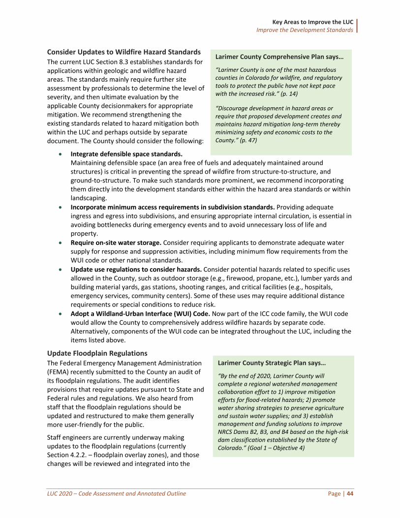
Key Areas to Improve the LUC Improve the Development Standards
LUC 2020 – Code Assessment and Annotated Outline Page | 44
Consider Updates to Wildfire Hazard Standards The current LUC Section 8.3 establishes standards for applications within geologic and wildfire hazard areas. The standards mainly require further site assessment by professionals to determine the level of severity, and then ultimate evaluation by the applicable County decisionmakers for appropriate mitigation. We recommend strengthening the existing standards related to hazard mitigation both within the LUC and perhaps outside by separate document. The County should consider the following:
• Integrate defensible space standards. Maintaining defensible space (an area free of fuels and adequately maintained around structures) is critical in preventing the spread of wildfire from structure-to-structure, and ground-to-structure. To make such standards more prominent, we recommend incorporating them directly into the development standards either within the hazard area standards or within landscaping.
• Incorporate minimum access requirements in subdivision standards. Providing adequate ingress and egress into subdivisions, and ensuring appropriate internal circulation, is essential in avoiding bottlenecks during emergency events and to avoid unnecessary loss of life and property.
• Require on-site water storage. Consider requiring applicants to demonstrate adequate water supply for response and suppression activities, including minimum flow requirements from the WUI code or other national standards.
• Update use regulations to consider hazards. Consider potential hazards related to specific uses allowed in the County, such as outdoor storage (e.g., firewood, propane, etc.), lumber yards and building material yards, gas stations, shooting ranges, and critical facilities (e.g., hospitals, emergency services, community centers). Some of these uses may require additional distance requirements or special conditions to reduce risk.
• Adopt a Wildland-Urban Interface (WUI) Code. Now part of the ICC code family, the WUI code would allow the County to comprehensively address wildfire hazards by separate code. Alternatively, components of the WUI code can be integrated throughout the LUC, including the items listed above.
Update Floodplain Regulations The Federal Emergency Management Administration (FEMA) recently submitted to the County an audit of its floodplain regulations. The audit identifies provisions that require updates pursuant to State and Federal rules and regulations. We also heard from staff that the floodplain regulations should be updated and restructured to make them generally more user-friendly for the public.
Staff engineers are currently underway making updates to the floodplain regulations (currently Section 4.2.2. – floodplain overlay zones), and those changes will be reviewed and integrated into the
Larimer County Comprehensive Plan says…
“Larimer County is one of the most hazardous counties in Colorado for wildfire, and regulatory tools to protect the public have not kept pace with the increased risk.” (p. 14)
“Discourage development in hazard areas or require that proposed development creates and maintains hazard mitigation long-term thereby minimizing safety and economic costs to the County.” (p. 47)
Larimer County Strategic Plan says…
“By the end of 2020, Larimer County will complete a regional watershed management collaboration effort to 1) improve mitigation efforts for flood-related hazards; 2) promote water sharing strategies to preserve agriculture and sustain water supplies; and 3) establish management and funding solutions to improve NRCS Dams B2, B3, and B4 based on the high-risk dam classification established by the State of Colorado.” (Goal 1 – Objective 4)
Key Areas to Improve the LUC Improve the Development Standards
LUC 2020 – Code Assessment and Annotated Outline Page | 45
larger LUC update as appropriate. Although generally separate bodies of regulations, any updates to the floodplain regulations should also be coordinated with related stormwater regulations if needed.
Recommendations: Enhance Hazard Mitigation Throughout the LUC
1. Review progress on action items from 2016 hazard mitigation plan. 2. Enhance hazard standards to integrate more specific improvements related to wildfire mitigation. (WUI
code: Phase 2) 3. Update floodplain regulations to align with FEMA audit recommendations and to address known issues as
noted by County staff.
Revisit Parking Requirements The current parking standards are established in Section 8.6, Private Local Access Road and Parking Standards. Specific parking stall requirements are identified, but not for all uses allowed in Larimer County. For development proposals without specified parking requirements, the engineering department must determine off-street parking and loading space estimates. Several online survey respondents commented on issues with parking, as noted in the box on the following page.
The following changes should be considered during the LUC Update:
• Evaluate minimum parking ratios. The project team should consider the parking standards of surrounding jurisdictions and national best practices and propose adjustments where necessary. For example, the current office and retail parking requirements at one per 200 square feet may be relatively strict (requires more parking than necessary) as compared to other communities. Establishing appropriate parking ratios is not necessarily scientific but should be locally tailored while considering other communities and referring to published standards such as the International Transportation Engineers “Parking Generation Manual.”
• Provide alternatives for parking standards. Many communities offer options for parking reductions for parking in mixed-use centers, parking near transit services, and for shared parking arrangements. Larimer County may consider additional options for flexibility in required parking.
• Update the parking lot layout standards. The County’s current parking lot layout standards are likely not addressing parking issues in the more urbanized areas of the County. For example, the current limitation that not more than 50 percent of the parking area can be located between the front façade of the principal building and the abutting street may not adequately address site layout for mixed-use areas that are intended to be more pedestrian-friendly. Conversely, that requirement may be overly prescriptive for industrial areas and rural and agricultural areas.
Survey Responses
More than 40 percent of the respondents said that the County has regulated parking “poorly” or “very poorly,” whereas only nine percent responded favorably to the parking regulations.
“I feel like there is not enough parking and you are not doing anything to fix it.”
“Parking and fencing need to be something that can work with agricultural operations.”
“Cars are currently parked all over the roads to the reservoir in spots marked no parking. People walking in the road is a hazard.”
Key Areas to Improve the LUC Improve the Development Standards
LUC 2020 – Code Assessment and Annotated Outline Page | 46
Recommendations: Revisit Parking Requirements (Phase 2)
1. Evaluate the minimum parking ratios and adjust as necessary. 2. Provide options for parking alternatives and reductions where appropriate. 3. Update the parking lot layout standards to respond to different contexts.
Update the Sign Regulations The sign regulations (currently Chapter 10.0) should be rewritten as part of the LUC update to ensure they are meeting the County’s policy goals, are user-friendly, and are enforceable. The current sign regulations were established largely based on urban standards, thus not adequately addressing other context areas. Further, the sign regulations need to remove content-based provisions to the extent possible to comply with the court rulings under Reed v. Gilbert. For example, Section 10.6 identifies several types of signs that do not require a sign permit such as “agricultural product signs,” “crop signs,” and “election signs” which all arguably regulate signage based on the content of the sign. We did not hear much direct feedback related to the sign code during initial stakeholder outreach, and therefore further discussion is required to indicate how well the sign measurement calculations and allowable sign standards (size, number, and location) are working for Larimer County. Also, the standards for wayfinding signage need to be expanded for private property wayfinding (wayfinding signage on public property currently managed by Engineering).
The sign regulations rewrite generally is proposed as a Phase 2 task. However, targeted updates may be considered as part of Phase 1 to identify and remove any content-based regulations.
Recommendations: Update the Sign Regulations (Phase 2)
1. Rewrite standards to address context areas beyond urban. 2. Rewrite the sign code to remove content-based regulations. 3. Include standards for wayfinding signage on private property. 4. Amend the sign standards pending further discussion with staff and the community.
Address Installation and Maintenance One common issue for community development departments around the nation is that, once a development is approved, and a certificate of occupancy issued, it becomes increasingly difficult to manage the improvements over time. For example, what happens when the parking area is damaged, or the landscaping dies? The County should clarify the installation and maintenance standards for physical improvements such as landscaping, fencing, parking areas, outdoor lighting, and signage. Installation requirements may address the process for how particular landscaping should be installed (including detailed technical standards that could live outside
Historic pole sign in Livermore, Colorado.
Survey Responses
“There are lighting regulations in our area but there doesn’t seem to be much enforcement.”
“Regulations should be about safety not maintaining property values or enforcing collective will.”
Key Areas to Improve the LUC Improve the Development Standards
LUC 2020 – Code Assessment and Annotated Outline Page | 47
the LUC – such as irrigation specifications), and may address operational standards related to nuisance prevention such as noise, odor, vibrations, radiation, and the like.
Some communities include a standalone section for installation, operation, and maintenance standards that apply to all physical improvements, and others opt to include individual standards within each applicable development standard section. Regardless of the approach, establishing such regulations will help improve enforcement mechanisms when necessary. Enforcement of the LUC regulations is currently conducted mostly on a complaint basis; any additional standards related to maintenance would not change the County’s policy on enforcement.
Recommendations: Address Installation and Maintenance
Establish new standards for installation and maintenance of physical site improvements.
Coordinate Land Use and Engineering Standards Initial stakeholder feedback indicated the need to reconcile the building and engineering standards and practices with the Land Use Code requirements. This is important because the administrators of the building and engineering standards are not always the administrators of the Land Use Code, and vice versa. When there are conflicts between the standards, the applicants are at the losing end because they are often referred to other departments or are given conflicting advice or requirements.
Relocating Engineering Standards to Technical Manuals Where Possible Most modern zoning codes eliminate technical and administrative standards from the code to the extent practicable and relocate them to a separate administrative or technical manual. When such manuals already exist, it is essential that the code requirements be aligned. For example, Section 5.8, Rural Land Use Process, includes road cross-sections and certification templates within subsection 5.8.6.D that apply to roads within those subdivisions. When cross-sections are updated in external engineering design manuals, they may or may not reflect those included in the Land Use Code. Additionally, the supplementary regulations in Chapter 15.0 contain various engineering regulations and cross-references to engineering standards; however, the accuracy of those standards compared to separate engineering design manuals is unclear. Because the Larimer County Urban Area and Rural Area Road Standards are not being updated at this time, it is important to identify areas for future coordination when the timing allows. When drafting updates to the LUC, the following manuals should be reviewed for consistency and referenced where appropriate:
• Rural Area Road Standards
• Urban Area Street Standards
• Stormwater Design Standards
• Sign Standards (roads, memorial signs, tourist-oriented destination, private signs)
Cross-Reference External Standards Where the engineering or other agency requirements may differ from Land Use Code requirements, those external standards should be provided as a cross-reference instead of repeating those standards or providing potentially conflicting standards. A simple cross-reference in the LUC alerts the applicant that additional standards may apply and avoids overlap and inconsistency. As an example, Fire District standards for access are typically not as strict as those required in the LUC, which sometimes requires an appeal from the BCC to get the access standards reverted to the level that the Fire District would approve. A summary of the procedures for application types in the County should also include engineering permits to alert applicants that a separate approval process may be required. That type of information should also be a fundamental component of the pre-application conferences.
Key Areas to Improve the LUC Improve the Development Standards
LUC 2020 – Code Assessment and Annotated Outline Page | 48
Use Consistent Terminology where Possible Inconsistent definitions between building code standards and the LUC has resulted in some confusion with some development applications. For example, the building department and the community development department measure building height differently. This can result in plan amendments after approval and applicant frustration with the process. The LUC can clarify the differences and can also make clearer the scenarios that may require a building permit even where a specific LUC evaluation process may not be required. Another example is that the LUC and planning staff may treat a proposed land use as a “residential use” but the building department may treat the structure for that use as a “commercial building” meaning it would be subject to the commercial building code. Commercial code requirements often require more stringent life-safety elements that add costs to the structure. We heard in initial feedback that some projects receive entitlement approvals prior to realizing that the commercial building code renders the project financially infeasible. This has especially been problematic for value-added agricultural uses. Improved and more frequent coordination may prevent such discrepancies.
Establish a Grading Permit Process The County is considering establishing a grading permit process with additional standards. Should the County proceed in that direction, the standards in the LUC should be consistent with the engineering standards for grading, erosion, and sediment control. Additional policy direction on this topic is expected by midyear 2020. (Phase 2 update)
Recommendations: Coordinate Land Use and Engineering Standards
1. Relocate technical and administrative standards outside the LUC in separate administrative or technical manuals where possible.
2. Cross-reference external standards to avoid internal inconsistencies. 3. Establish a grading permit process pending further policy direction. (Phase 2) 4. Use consistent terminology between planning applications, engineering applications, and building
applications to the extent possible.
Key Areas to Improve the LUC Rewrite and Simplify the Review Procedures
LUC 2020 – Code Assessment and Annotated Outline Page | 49
Rewrite and Simplify the Review Procedures
Land use regulations should clearly describe the procedures by which applications for development projects are accepted, considered, and acted upon by local officials. Well-written regulations make it easy for staff, the development community, and elected officials to know exactly what is required for approval of applications and help ensure consistent administration over time.
We heard a variety of feedback about the development review procedures in Larimer County during the stakeholder interview process. Some of the comments included:
• In terms of the procedures generally:
o A high level of detail is required in early submissions for many projects, resulting in applicants having to spend time and money early to prepare technical plans and studies to support applications for which they have little certainty will be approved. Examples include requiring detailed construction drawings early in the application process.
o There needs to be a way to get concept approval major projects prior to spending too much time and money on the details.
o Some relatively small projects require public hearings and approval by either the Planning Commission and/or Board of County Commissioners, which creates additional expense and uncertainty. Consider more delegation of minor approvals to staff.
o The customer service from the County is great but can be unpredictable. o There often is not a clear understanding of what procedures may be required for a
particular project. o The procedures generally can be unpredictable. o Timelines for review applications are not consistent.
• In terms of application processing and staff comments:
o Applicants claim that there can be a variety of staff members among various departments working on the same application; would be helpful to have more uniform assistance throughout the project.
o Staff comments are sporadic and inconsistent (especially between departments). o Applicants often must call the individual departments to see if they have
redlines/comments. Interdepartmental coordination of comments could be improved. o Need to simplify and minimize the paper submittal process. Allow more electronic plan
review.
Many of these concerns can be addressed in a code rewrite. This section of the report first provides an overview of the current development review process, and then suggests strategies to address the concerns above and streamline the system.
Overview of Current Review Procedures The table below summarizes the types of development applications within Larimer County and indicates the various levels of review and approval required for each.
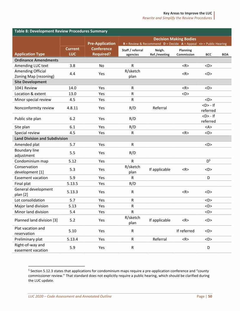
Key Areas to Improve the LUC Rewrite and Simplify the Review Procedures
LUC 2020 – Code Assessment and Annotated Outline Page | 50
Table 8: Development Review Procedures Summary
Application Type
Pre-Application
Conference Required?
Decision Making Bodies R = Review & Recommend D = Decide A = Appeal <> = Public Hearing
Current LUC
Staff / referral agencies
Neigh. Ref./meeting
Planning Commission BCC BOA
Ordinance Amendments
Amending LUC text 3.8 No R <R> <D>
Amending Official Zoning Map (rezoning)
4.4 Yes R/sketch
plan <R> <D>
Site Development
1041 Review 14.0 Yes R <R> <D>
Location & extent 13.0 Yes R <D>
Minor special review 4.5 Yes R <D>
Nonconformity review 4.8.11 Yes R/D Referral <D> - If
referred
Public site plan 6.2 Yes R/D <D> - If
referred
Site plan 6.1 Yes R/D <A>
Special review 4.5 Yes R <R> <D>
Land Division and Subdivision
Amended plat 5.7 Yes R <D>
Boundary line adjustment
5.5 Yes R/D
Condominium map 5.12 Yes R D5
Conservation development [1]
5.3 Yes R/sketch
plan If applicable <R> <D>
Easement vacation 5.9 Yes R D
Final plat 5.13.5 Yes R/D
General development plan [2]
5.13.3 Yes R <R> <D>
Lot consolidation 5.7 Yes R <D>
Major land division 5.13 Yes R <D>
Minor land division 5.4 Yes R <D>
Planned land division [3] 5.2 Yes R/sketch
plan If applicable <R> <D>
Plat vacation and reservation
5.10 Yes R If referred <D>
Preliminary plat 5.13.4 Yes R Referral <R> <D>
Right-of-way and easement vacation
5.9 Yes R D
5 Section 5.12.3 states that applications for condominium maps require a pre-application conference and “county commissioner review.” That standard does not explicitly require a public hearing, which should be clarified during the LUC update.
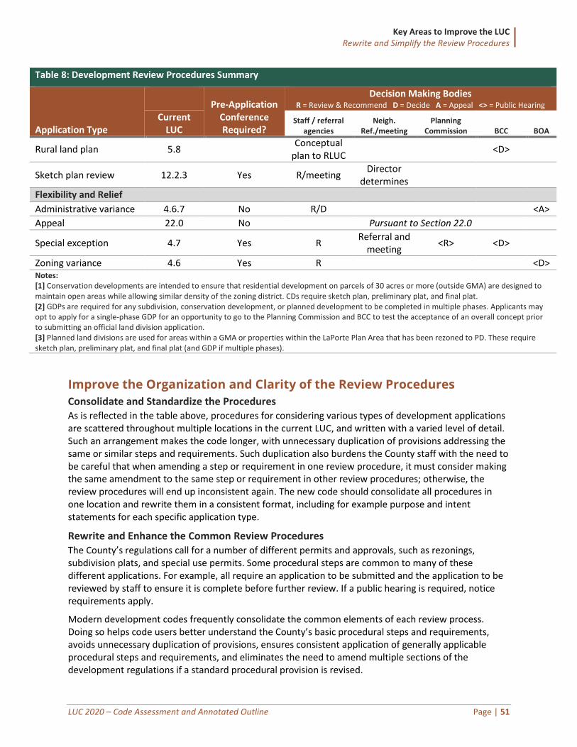
Key Areas to Improve the LUC Rewrite and Simplify the Review Procedures
LUC 2020 – Code Assessment and Annotated Outline Page | 51
Table 8: Development Review Procedures Summary
Application Type
Pre-Application
Conference Required?
Decision Making Bodies R = Review & Recommend D = Decide A = Appeal <> = Public Hearing
Current LUC
Staff / referral agencies
Neigh. Ref./meeting
Planning Commission BCC BOA
Rural land plan 5.8 Conceptual
plan to RLUC <D>
Sketch plan review 12.2.3 Yes R/meeting Director
determines
Flexibility and Relief
Administrative variance 4.6.7 No R/D <A>
Appeal 22.0 No Pursuant to Section 22.0
Special exception 4.7 Yes R Referral and
meeting <R> <D>
Zoning variance 4.6 Yes R <D> Notes: [1] Conservation developments are intended to ensure that residential development on parcels of 30 acres or more (outside GMA) are designed to maintain open areas while allowing similar density of the zoning district. CDs require sketch plan, preliminary plat, and final plat. [2] GDPs are required for any subdivision, conservation development, or planned development to be completed in multiple phases. Applicants may opt to apply for a single-phase GDP for an opportunity to go to the Planning Commission and BCC to test the acceptance of an overall concept prior to submitting an official land division application. [3] Planned land divisions are used for areas within a GMA or properties within the LaPorte Plan Area that has been rezoned to PD. These require sketch plan, preliminary plat, and final plat (and GDP if multiple phases).
Improve the Organization and Clarity of the Review Procedures
Consolidate and Standardize the Procedures As is reflected in the table above, procedures for considering various types of development applications are scattered throughout multiple locations in the current LUC, and written with a varied level of detail. Such an arrangement makes the code longer, with unnecessary duplication of provisions addressing the same or similar steps and requirements. Such duplication also burdens the County staff with the need to be careful that when amending a step or requirement in one review procedure, it must consider making the same amendment to the same step or requirement in other review procedures; otherwise, the review procedures will end up inconsistent again. The new code should consolidate all procedures in one location and rewrite them in a consistent format, including for example purpose and intent statements for each specific application type.
Rewrite and Enhance the Common Review Procedures The County’s regulations call for a number of different permits and approvals, such as rezonings, subdivision plats, and special use permits. Some procedural steps are common to many of these different applications. For example, all require an application to be submitted and the application to be reviewed by staff to ensure it is complete before further review. If a public hearing is required, notice requirements apply.
Modern development codes frequently consolidate the common elements of each review process. Doing so helps code users better understand the County’s basic procedural steps and requirements, avoids unnecessary duplication of provisions, ensures consistent application of generally applicable procedural steps and requirements, and eliminates the need to amend multiple sections of the development regulations if a standard procedural provision is revised.
Key Areas to Improve the LUC Rewrite and Simplify the Review Procedures
LUC 2020 – Code Assessment and Annotated Outline Page | 52
The County has begun implementing this approach primarily in Section 12.0, “Common Procedures for Development Review.” However, though these standard procedures are mostly consolidated, the level of detail for each process is inconsistent and many key details are left unanswered. Also, the subsections in this part of the LUC could be better organized.
We recommend building on this organization and enhancing it with a more complete set of rewritten common procedures. We recommend the new LUC address the following procedural elements at a minimum:
• Pre-application consultation. Designate appropriate staff for each type of application.
• Neighborhood meetings. Identify what types of applications require neighborhood meetings and at what stage of the review process.
• Application submittal and acceptance. Establish procedure for reviewing and accepting applications.
• Staff review and action. Identify the procedures for reviewing applications, provide for interdepartmental coordination, commenting on applications, and preparing recommendations and investigative reports when applicable.
• Public hearing scheduling and notice. Identify the types of public hearings and the noticing requirements (e.g., published vs. posted vs. mailed vs. website).
• Decision-making review and action. Establish the general procedures for public hearings on development decisions, including public hearings.
• Post-decision actions and limitations. Describe how decisions are posted or presented to applicants and the public, and whether or not decisions expire. Should also include details on extending expirations.
During the drafting phase, the common review procedures may be expanded on depending on how much related information is presented with each application type.
We also heard comments on specific aspects of these common procedures that could be considered for improvement during the drafting process:
• Consider formally establishing the development review team (DRT) process. The County currently uses the DRT process for various application types, but it is not codified. This would involve a more formal opportunity for representatives from various county departments to weigh in earlier in the process, especially on complex applications. Departments to consider might include health, building, engineering, water, fire, sewer, irrigation, and even representatives from adjacent municipalities. Not all departments might be necessary for each application; the directory could have authority and discretion to identify appropriate referrals. This forum also could provide an opportunity for identification and reconciliation of competing departmental comments. The timing of DRC meetings varies by jurisdiction; meetings could be at the pre-application stage and/or following submission of the application. The details of membership and meetings do not have to be in the LUC itself, but rather could be part of operating procedures outside the code.
• Improve noticing requirements. The County currently requires noticing for various application types, but not all. For those applications that do not require notice (administrative applications), the final decision and the opportunity to appeal that decision is not readily available to the public. Additionally, the County currently provides notice generally within 500 feet of a subject property, but sometimes go beyond that distance for certain applications. Those scenarios could be specified in the LUC, and the signage for public noticing could be improved.
Key Areas to Improve the LUC Rewrite and Simplify the Review Procedures
LUC 2020 – Code Assessment and Annotated Outline Page | 53
Recommendations: Improve the Organization and Clarity of the Review Procedures
1. Consolidate and standardize the organization, format, and level of detail of the review procedures. 2. Rewrite and enhance the common review procedures. 3. Consider establishment of a development review committee (DRC). 4. Improve noticing requirements.
Restructure and Simplify the Site Plan Procedures The site plan procedure is the County’s standard tool used to evaluate compliance of a proposed project with the LUC’s site development standards. There are two versions of the procedure:
• The general site plan procedure (Section 6.1) applies principally to multi-family and nonresidential projects and requires a pre-application conference, referral to applicable review agencies, and then a written determination by the planning director of approval, approval with conditions, or denial. The director may require modifications prior to approval. The director may authorize the project to go directly to the building permit review process. The director’s decision may be appealed to the BOCC.
• The public site plan procedure (Section 6.2) is almost identical to the general site plan procedure in terms of process and review criteria; however, it requires property owner notification and comment prior to the director’s determination. If any property owner has comments, the code allows for an “opportunity to agree on a solution,” which may be communicated to the director prior to the determination. The director may require a public hearing before the BOCC if there are unresolved neighbor/comments/concerns. The criteria to approve a public site plan by the BOCC are that the use will be “compatible” with existing and proposed uses, “in harmony” with the neighborhood, and “will not result in a substantial adverse impact” on nearby property. In practice, the bulk of these projects are approved administratively, with only a fraction being sent up for BOCC review.
Whether a project is subject to a general site plan or a public site plan is called out in the use table for each individual use type.
We heard a variety of concerns about the site plan tools, with some stakeholders suggesting only minor tweaks are needed, while others claimed the system is “completely broken.” There is a general sentiment that small projects take too long to get through the site plan process. (Reportedly the timeframe is four to six months for most projects that demonstrate code compliance quickly). We heard that the general process is considered so onerous for small projects that it is often avoided by property owners, who may simply opt to seek for forgiveness for unapproved work rather than take the time to navigate the site plan procedure.
We also note that the current site plan structure is somewhat confusing in that the applicable process is based on the use table, rather than the scale of the proposed project. The special review process located elsewhere in the LUC is the tool typically used by most communities to determine the appropriateness of a land use at a particular location. In contrast, the site plan tool is usually the tool for evaluating compliance with development standards like parking, landscaping, and setbacks.
Simplify the Site Plan Procedure Moving forward, we recommend the County restructure and simplify the site plan procedure in the following ways:
• Keep the general site plan procedure as the principal mechanism for determining whether a project complies with the code’s development and design requirements. If possible, the
Key Areas to Improve the LUC Rewrite and Simplify the Review Procedures
LUC 2020 – Code Assessment and Annotated Outline Page | 54
procedure should be simplified, with streamlined submittal requirements and a shorter expected timeline.
• Codify the current waiver process that exempts small projects from having to go through site plan review. This would formalize an abbreviated review procedure that already exists in Larimer County for very small projects (e.g., under 200 square foot addition to an existing building).
• Introduce a new referral and call-up procedure, by which site plan applications may be either called up by the BCC or referred up to the BCC by the Director.
• Require projects that currently are designated as requiring a public site plan to instead go through minor special review. That is the appropriate process to evaluate the appropriateness of the proposed at use the proposed location.
Collectively, these changes will allow for a more tailored approach based on the scale of the project, with bigger projects requiring more review and smaller projects being approved faster and more efficiently. The special review procedure will continue to be a BOCC decision, with a public hearing, focusing on the compatibility of a particular use; while the site plan procedure will continue to be a staff-decision, focusing on the project’s compliance with site and building design standards.
Additionally, submittal requirements for site plans should be calibrated. Less information should be required for smaller projects with fewer impacts, and more information required for more significant applications. Examples of submittals that might be unnecessary for smaller projects are traffic impact analyses and detailed architectural elevations. The submittals could either be waived at the discretion of the Director (as is done in Garfield County), or an initial determination could simply be made that certain materials are not necessary for smaller projects.
Finally, the new site plan procedures should include more specific and objective review criteria than found in the current LUC, which rely on ambiguous, undefined terms like “harmony” and “compatibility.”
Separate Site Plan Review from Technical Review In addition to calibrating the submittal requirements for site plans (located outside the LUC) and requiring less information for smaller projects, there also is an opportunity to separate out the more detailed construction plans and engineering specifications that can be expensive to prepare into a subsequent process. This is a common approach around the country.
On a related note, the submittal requirements for greenfield development, change of use, and redevelopment plans are currently folded into site plan review. We heard they should be considered separately.
Recommendations: Restructure and Simplify the Site Plan Procedures
1. Simplify the site plan review procedures by codifying the current waiver process for small projects and adding in a new call-up and referral procedure for site plans.
2. Remove the public site plan review procedure and instead require those projects to go through minor special review.
3. Separate site plan review from subsequent detailed technical review.
Improve and Clarify the Subdivision Procedures Many of the comments received related to procedures involved applications for subdivision. Subdivision procedures are located in Chapter 5.0 of the LUC, Land Division. The standard subdivision process includes a pre-application conference, sketch plan review, neighbor referral, preliminary plat review,
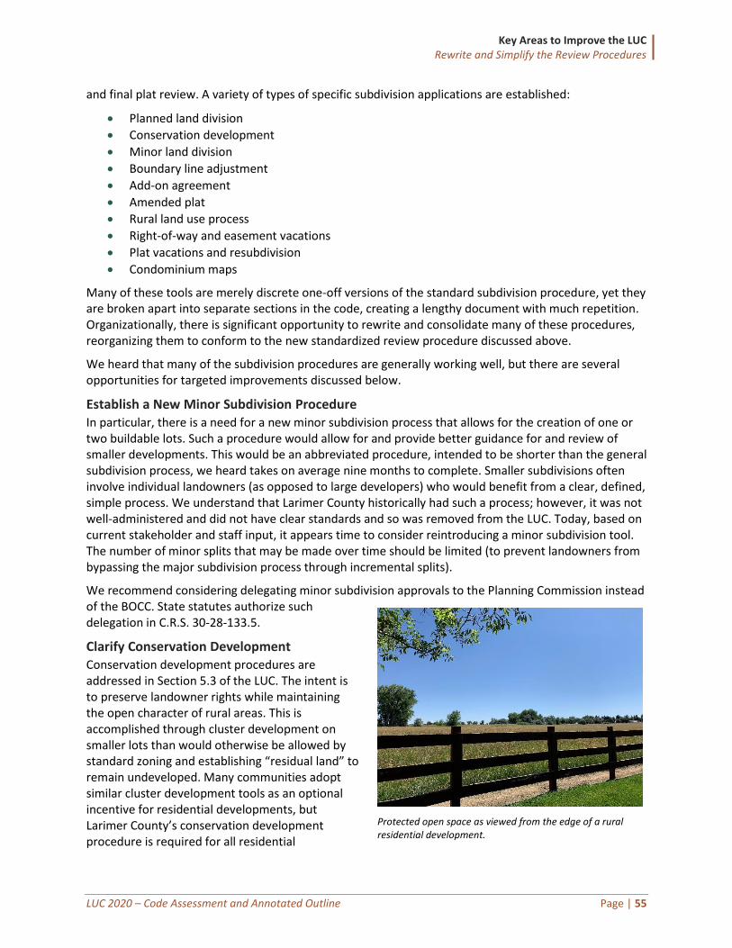
Key Areas to Improve the LUC Rewrite and Simplify the Review Procedures
LUC 2020 – Code Assessment and Annotated Outline Page | 55
and final plat review. A variety of types of specific subdivision applications are established:
• Planned land division
• Conservation development
• Minor land division
• Boundary line adjustment
• Add-on agreement
• Amended plat
• Rural land use process
• Right-of-way and easement vacations
• Plat vacations and resubdivision
• Condominium maps
Many of these tools are merely discrete one-off versions of the standard subdivision procedure, yet they are broken apart into separate sections in the code, creating a lengthy document with much repetition. Organizationally, there is significant opportunity to rewrite and consolidate many of these procedures, reorganizing them to conform to the new standardized review procedure discussed above.
We heard that many of the subdivision procedures are generally working well, but there are several opportunities for targeted improvements discussed below.
Establish a New Minor Subdivision Procedure In particular, there is a need for a new minor subdivision process that allows for the creation of one or two buildable lots. Such a procedure would allow for and provide better guidance for and review of smaller developments. This would be an abbreviated procedure, intended to be shorter than the general subdivision process, we heard takes on average nine months to complete. Smaller subdivisions often involve individual landowners (as opposed to large developers) who would benefit from a clear, defined, simple process. We understand that Larimer County historically had such a process; however, it was not well-administered and did not have clear standards and so was removed from the LUC. Today, based on current stakeholder and staff input, it appears time to consider reintroducing a minor subdivision tool. The number of minor splits that may be made over time should be limited (to prevent landowners from bypassing the major subdivision process through incremental splits).
We recommend considering delegating minor subdivision approvals to the Planning Commission instead of the BOCC. State statutes authorize such delegation in C.R.S. 30-28-133.5.
Clarify Conservation Development Conservation development procedures are addressed in Section 5.3 of the LUC. The intent is to preserve landowner rights while maintaining the open character of rural areas. This is accomplished through cluster development on smaller lots than would otherwise be allowed by standard zoning and establishing “residual land” to remain undeveloped. Many communities adopt similar cluster development tools as an optional incentive for residential developments, but Larimer County’s conservation development procedure is required for all residential
Protected open space as viewed from the edge of a rural residential development.
Key Areas to Improve the LUC Rewrite and Simplify the Review Procedures
LUC 2020 – Code Assessment and Annotated Outline Page | 56
development applications on parcels 30 acres or larger and located outside GMAs.
There are exceptions, including rural land use process (RLUP) applications, lots with public water and sewer in residential zones, subdivisions into lots 35 acres and larger, and other exceptions when warranted by the BCC under the criteria in 5.3.2.H for unusual site characteristics, or potential of causing more harm to agricultural or sensitive areas than through the standard subdivision process.
We heard from several stakeholders that the conservation development procedures are too strict as compared to the RLUP, and that a more flexible list of allowed uses within conservation developments would help landowners respond to market conditions.
As mentioned in the agriculture section earlier in this report, we recommend integrating the conservation development procedure with the RLUP, because that process has evolved and is therefore not necessary to carry forward as a separate procedure. Instead, the intent of the RLUP – including the protection of agricultural uses, rural areas, and open space – could be integrated into the clarified conservation development procedure. The detailed mechanics of knitting together these two procedures requires further discussion, but the intent would be to respect the historical values communicated through these procedures while streamlining and clarifying the procedures for applicants and staff.
Codify Vacation Plat Procedures Although there is a section dedicated to Plat Vacations and Resubdivision (Section 5.10), the procedure for evaluating and approving such vacations is not codified beyond requiring that the BOCC review and approves the plat vacation according to the criteria listed in 5.10.3. It is unclear what types of meetings are required (pre-submittal, public hearing, neighborhood) or whether staff is expected to prepare a recommendation to the Planning Commission prior to a decision by the BOCC. In the absence of clear procedures, staff is burdened with administering a process without guidance from the LUC, which has the potential for inconsistency over time. The new LUC should incorporate clear standards that make the process predictable and administrable.
Consider Appropriate Mechanism for Density Transfers The Comprehensive Plan mentions the concept of transferable density units throughout the document, mostly as a tool to cluster development and protect rural areas and other sensitive areas. The idea is that areas intended to be preserved (rural areas, natural resources, sensitive environmental areas) would be awarded some sort of density value, either through specific development units or land area, that could be “transferred” to “receiving” areas where the County is expecting and encouraging growth (e.g., within GMAs, designated centers). These systems are commonly referred to as transfer of development rights (TDR) programs.
Managing density transfers can vary widely in terms of complexity and administration, with varied levels of care and feeding required. For example, some of the more complex TDR programs establish land banks where density units can be purchased. Those units are assigned monetary values that are continually monitored for market reality. Simpler systems allow the transfer of development rights through additional dwelling units and/or additional height in specified areas in exchange for protecting sensitive areas.
Larimer County Comprehensive Plan says…
Encourage a variety of land use planning tools, such as the rural land use process, conservation development process, transferable density units, public/private partnerships and other innovative planning tools to protect and conserve important natural and fiscal resources. (p.30)

Key Areas to Improve the LUC Rewrite and Simplify the Review Procedures
LUC 2020 – Code Assessment and Annotated Outline Page | 57
The County has experience administering density transfers through the Fossil Creek Reservoir Area Transferable Density Units Overlay Zone, which was recently repealed (previously Section 4.2.3). That program established eligibility requirements for sending and receiving areas and detailed the procedures for monitoring and administering the program. Further policy discussion with the BOCC, the Planning Commission, and staff is required for whether that system could be replicated to apply more broadly throughout specified areas within the County, or if certain aspects of that system should be revised if applied elsewhere.
This density transfer topic will be discussed with the BOCC upon presentation of this report for further policy guidance. Crafting of any new density transfer tools would be a Phase 2 task.
Recommendations: Improve and Clarify the Subdivision Procedures
1. Establish a minor subdivision procedure for subdivisions creating one or two lots, and delegate the decision to the Planning Commission.
2. Clarify the conservation development procedure and combine with the RLUP (which is not proposed to be carried forward).
3. Clarify and codify the procedures for plat vacations. 4. Consider establishing procedures for transfer of density rights (TDR). (Phase 2)
Refine the General Development Plan (GDP) Process Generally, stakeholders believe too much detail is required for development applications too early in the process, requiring applicants to spend relatively large amounts of time and money on initial submittals without having any sense of the County’s reaction to the larger contours of the project. The code update project provides an opportunity to establish new tools and update existing tools that would be more proportional, with the level of upfront effort and commitment scaled to both the size of the project and the amount of early assurance given by the County. One such tool is the new proposed distinction of major versus minor plans, discussed above.
Larimer County has an existing general development plan process (Section 5.13.3) that allows an applicant to go to the Planning Commission and Board of County Commissioners to test concepts. The general development plan shows the overall physical character of a proposed large development, including major circulation systems, major open spaces, and the allocation of major land uses and development intensities among various segments and/or phases of the development. (It is similar to a PUD, but is intended to work within code requirements, rather than proposing substantial deviations from the code as is done with a PUD). We propose revising and expanding the applicability of the existing process to provide an opportunity for the developer of a large project to submit and obtain approval of a high-level concept plan before committing the time and money needed to develop specific plans, even for projects not associated with land division.
Approval of the general development plan should not authorize any actual development, but rather give the developer a limited time period (perhaps five years) in which to obtain final approvals of detailed plans for the development shown on the development plan (generally phase by phase). During that time period, the developer could be authorized to pursue final approvals of the proposed development administratively, in accordance with the general parameters set by the approved general development plan and otherwise in accordance with the standards applicable at the time of the final approvals. This
Key Areas to Improve the LUC Rewrite and Simplify the Review Procedures
LUC 2020 – Code Assessment and Annotated Outline Page | 58
would give the developer the assurance needed to commit time and money towards completion of the development and thus encourage the advanced planning of large integrated developments and construction of approved site improvements that might not be otherwise proposed.
For discussion, we recommend that the new LUC provide developers the option of seeking general development plan approval before submitting applications for both site plan approval or preliminary subdivision plat approval for larger sites. The actual minimum threshold would require further discussion—for example, five acres or more, or 100,000 square feet of commercial floor area or more.
Recommendation: Refine the General Development Plan Process
Revise and expand applicability of the general development plan process.
Rewrite the Administrative Variance Procedure We heard it is common in Larimer County for development review applications to be accompanied by at least one administrative variance or waiver request, most of which are usually approved. The LUC authorizes an “administrative variance” (Section 4.6.7) as well as the general “zoning variance” (Section 4.6). The administrative variance is available only for specific situations: setbacks from streams, creeks, and rivers; road setbacks; and corner lot setbacks. In addition, some individual sections allow waivers or some or all standards with administrative discretion, such as the landscaping waiver provision in Section 8.5.2.D (allows Director to waive Landscaping section in whole or in part as part of administrative review process).
In part, a high number of variance and waiver requests is a result of inflexible development standards, which are addressed elsewhere in this report. From a procedural perspective, the high number of variances results from not having any tools that allow staff the authority to grant limited relief in targeted circumstances.
Many communities allow such modifications more broadly than the administrative variance tool in place in Larimer. The intent is to authorize staff to approve minor deviations from a range of dimensional or development standards based on specific criteria. The procedure is intended to provide relief where strict application of the standards would otherwise create unnecessary difficulties.
We recommend restructuring the administrative variance procedure in Larimer into a broader “minor modification.” Such a procedure could specifically identify a broader range of standards that are commonly adjusted. The extent of the deviation is typically limited to five or 10 percent; however, greater percentages could be considered for areas where redevelopment is encouraged or additional flexibility is desired. Alternatively, the County could establish a more tailored approach by which greater deviations may be allowed for some requirements over others. Applications seeking flexibility beyond those allowed by this administrative process would require a variance (due to hardship) or a rezoning.
The rewritten procedure should specify criteria (not present in the current LUC) that the deviation not undermine the intent of the underlying regulation, and that the deviation would not impose greater impacts on adjacent properties than would be imposed through strict compliance. For example, clear criteria should be established for when an adjustment to a stream setback is allowed under a minor modification versus requiring a hardship variance approval. Examples of standards that are more frequently subject to administrative adjustments (beyond the minimum setbacks included in the current code) include:
• Minimum lot width and minimum lot coverage
• Maximum building, lighting, fence, or screening height
Key Areas to Improve the LUC Rewrite and Simplify the Review Procedures
LUC 2020 – Code Assessment and Annotated Outline Page | 59
• Minimum required number of parking spaces
• Minimum perimeter landscaping area width
• Maximum lighting levels
Many Colorado communities have adopted a broader version of this tool. Mesa County, for example, authorizes adjustments to any numeric dimensional or development standard in its code, except those related to building height, residential density, and non-residential intensity.
Recommendations: Rewrite the Administrative Variance Procedure
Change the current administrative variance procedure into a more expansive minor modification tool.
Create an Administrative Manual The current LUC contains information that is either technical in nature or otherwise not necessary to carry forward into the updated LUC. Examples include application submittal requirements and plan content requirements. This information should live outside the LUC in some sort of an administrative manual, guidebook, or dedicated webpage on the County’s website. In fact, the County’s existing planning website, especially as it relates to development processes, functions much like an administrative manual. During the drafting process, Clarion will maintain a separate document including content from the current LUC that should be considered for relocation. This will make the LUC shorter and more user-friendly, while also allowing staff to update the technical and administrative content over time without requiring a formal code amendment by the Board of County Commissioners. Other information typically considered for relocation to an administrative manual includes:
• Required fees and/or fees-in-lieu
• Typical timelines for application processing
• Lists of acceptable and prohibited landscaping species
• Technical engineering standards (e.g., best management practices for erosion control, or asphalt thickness standards) (though these may instead be in a separate public works design criteria manual)
Recommendations: Create an Administrative Manual
Establish an Administrative Manual to house supporting materials outside the LUC.
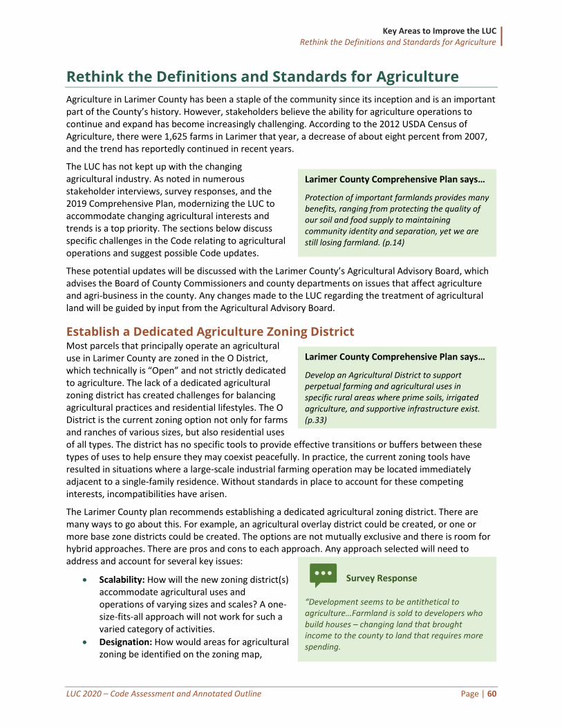
Key Areas to Improve the LUC Rethink the Definitions and Standards for Agriculture
LUC 2020 – Code Assessment and Annotated Outline Page | 60
Rethink the Definitions and Standards for Agriculture
Agriculture in Larimer County has been a staple of the community since its inception and is an important part of the County’s history. However, stakeholders believe the ability for agriculture operations to continue and expand has become increasingly challenging. According to the 2012 USDA Census of Agriculture, there were 1,625 farms in Larimer that year, a decrease of about eight percent from 2007, and the trend has reportedly continued in recent years.
The LUC has not kept up with the changing agricultural industry. As noted in numerous stakeholder interviews, survey responses, and the 2019 Comprehensive Plan, modernizing the LUC to accommodate changing agricultural interests and trends is a top priority. The sections below discuss specific challenges in the Code relating to agricultural operations and suggest possible Code updates.
These potential updates will be discussed with the Larimer County’s Agricultural Advisory Board, which advises the Board of County Commissioners and county departments on issues that affect agriculture and agri-business in the county. Any changes made to the LUC regarding the treatment of agricultural land will be guided by input from the Agricultural Advisory Board.
Establish a Dedicated Agriculture Zoning District Most parcels that principally operate an agricultural use in Larimer County are zoned in the O District, which technically is “Open” and not strictly dedicated to agriculture. The lack of a dedicated agricultural zoning district has created challenges for balancing agricultural practices and residential lifestyles. The O District is the current zoning option not only for farms and ranches of various sizes, but also residential uses of all types. The district has no specific tools to provide effective transitions or buffers between these types of uses to help ensure they may coexist peacefully. In practice, the current zoning tools have resulted in situations where a large-scale industrial farming operation may be located immediately adjacent to a single-family residence. Without standards in place to account for these competing interests, incompatibilities have arisen.
The Larimer County plan recommends establishing a dedicated agricultural zoning district. There are many ways to go about this. For example, an agricultural overlay district could be created, or one or more base zone districts could be created. The options are not mutually exclusive and there is room for hybrid approaches. There are pros and cons to each approach. Any approach selected will need to address and account for several key issues:
• Scalability: How will the new zoning district(s) accommodate agricultural uses and operations of varying sizes and scales? A one-size-fits-all approach will not work for such a varied category of activities.
• Designation: How would areas for agricultural zoning be identified on the zoning map,
Larimer County Comprehensive Plan says…
Develop an Agricultural District to support perpetual farming and agricultural uses in specific rural areas where prime soils, irrigated agriculture, and supportive infrastructure exist. (p.33)
Larimer County Comprehensive Plan says…
Protection of important farmlands provides many benefits, ranging from protecting the quality of our soil and food supply to maintaining community identity and separation, yet we are still losing farmland. (p.14)
Survey Response
“Development seems to be antithetical to agriculture…Farmland is sold to developers who build houses – changing land that brought income to the county to land that requires more spending.
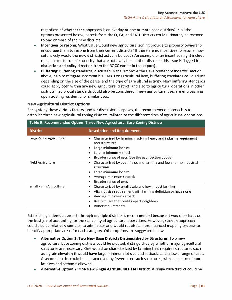
Key Areas to Improve the LUC Rethink the Definitions and Standards for Agriculture
LUC 2020 – Code Assessment and Annotated Outline Page | 61
regardless of whether the approach is an overlay or one or more base districts? In all the options presented below, parcels from the O, FA, and FA-1 Districts could ultimately be rezoned to one or more of the new districts.
• Incentives to rezone: What value would new agricultural zoning provide to property owners to encourage them to rezone from their current districts? If there are no incentives to rezone, how extensively would the new district(s) actually be used? An example of an incentive might include mechanisms to transfer density that are not available in other districts (this issue is flagged for discussion and policy direction from the BOCC earlier in this report).
• Buffering: Buffering standards, discussed in the “Improve the Development Standards” section above, help to mitigate incompatible uses. For agricultural land, buffering standards could adjust depending on the size of the parcel and the type of agricultural activity. New buffering standards could apply both within any new agricultural district, and also to agricultural operations in other districts. Reciprocal standards could also be considered if new agricultural uses are encroaching upon existing residential or similar uses.
New Agricultural District Options Recognizing these various factors, and for discussion purposes, the recommended approach is to establish three new agricultural zoning districts, tailored to the different sizes of agricultural operations.
Table 9: Recommended Option: Three New Agricultural Base Zoning Districts
District Description and Requirements
Large-Scale Agriculture • Characterized by farming involving heavy and industrial equipment and structures
• Large minimum lot size
• Large minimum setbacks
• Broader range of uses (see the uses section above)
Field Agriculture • Characterized by open fields and farming and fewer or no industrial structures
• Large minimum lot size
• Average minimum setback
• Broader range of uses
Small Farm Agriculture • Characterized by small-scale and low impact farming
• Align lot size requirement with farming definition or have none
• Average minimum setback
• Restrict uses that could impact neighbors
• Buffer requirements
Establishing a tiered approach through multiple districts is recommended because it would perhaps do the best job of accounting for the scalability of agricultural operations. However, such an approach could also be relatively complex to administer and would require a more nuanced mapping process to identify appropriate areas for each category. Other options are suggested below.
• Alternative Option 1: Two New Base Districts Distinguished by Structures. Two new agricultural base zoning districts could be created, distinguished by whether major agricultural structures are necessary. One would be characterized by farming that requires structures such as a grain elevator; it would have large minimum lot size and setbacks and allow a range of uses. A second district could be characterized by fewer or no such structures, with smaller minimum lot sizes and setbacks allowed.
• Alternative Option 2: One New Single Agricultural Base District. A single base district could be
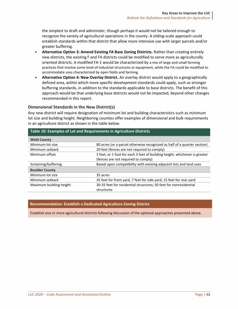
Key Areas to Improve the LUC Rethink the Definitions and Standards for Agriculture
LUC 2020 – Code Assessment and Annotated Outline Page | 62
the simplest to draft and administer, though perhaps it would not be tailored enough to recognize the variety of agricultural operations in the county. A sliding-scale approach could establish standards within that district that allow more intensive use with larger parcels and/or greater buffering.
• Alternative Option 3: Amend Existing FA Base Zoning Districts. Rather than creating entirely new districts, the existing F and FA districts could be modified to serve more as agriculturally oriented districts. A modified FA-1 would be characterized by a mix of large and small farming
practices that involve some level of industrial structures or equipment, while the FA could be modified to accommodate uses characterized by open fields and farming.
• Alternative Option 4: New Overlay District. An overlay district would apply to a geographically defined area, within which more specific development standards could apply, such as stronger buffering standards, in addition to the standards applicable to base districts. The benefit of this approach would be that underlying base districts would not be impacted, beyond other changes recommended in this report.
Dimensional Standards in the New District(s) Any new district will require designation of minimum lot and building characteristics such as minimum lot size and building height. Neighboring counties offer examples of dimensional and bulk requirements in an agriculture district as shown in the table below.
Table 10: Examples of Lot and Requirements in Agriculture Districts
Weld County
Minimum lot size 80 acres (or a parcel otherwise recognized as half of a quarter section)
Minimum setback 20 feet (fences are not required to comply)
Minimum offset 3 feet, or 1 foot for each 3 feet of building height, whichever is greater (fences are not required to comply)
Screening/buffering Based upon compatibility with existing adjacent lots and land uses
Boulder County
Minimum lot size 35 acres
Minimum setback 35 feet for front yard, 7 feet for side yard, 15 feet for rear yard
Maximum building height 30-35 feet for residential structures; 50 feet for nonresidential structures
Recommendation: Establish a Dedicated Agriculture Zoning District
Establish one or more agricultural districts following discussion of the optional approaches presented above.
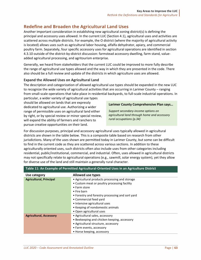
Key Areas to Improve the LUC Rethink the Definitions and Standards for Agriculture
LUC 2020 – Code Assessment and Annotated Outline Page | 63
Redefine and Broaden the Agricultural Land Uses Another important consideration in establishing new agricultural zoning district(s) is defining the principal and accessory uses allowed. In the current LUC (Section 4.1), agricultural uses and activities are scattered across multiple districts. For example, the O district (where the majority of agricultural activity is located) allows uses such as agricultural labor housing, alfalfa dehydrator, apiary, and commercial poultry farm. Separately, four specific accessory uses for agricultural operations are identified in section 4.3.10 outside of the district-by-district discussion: farmstead accessory dwelling, farm stand, value-added agricultural processing, and agritourism enterprise.
Generally, we heard from stakeholders that the current LUC could be improved to more fully describe the range of agricultural use types allowed and the way in which they are presented in the code. There also should be a full review and update of the districts in which agriculture uses are allowed.
Expand the Allowed Uses on Agricultural Land The description and categorization of allowed agricultural use types should be expanded in the new LUC to recognize the wide variety of agricultural activities that are occurring in Larimer County – ranging from small-scale operations that take place in residential backyards, to full-scale industrial operations. In particular, a wider variety of agricultural use types should be allowed on lands that are expressly dedicated to agricultural use. Authorizing a wider range of permissible uses on agricultural land either by right, or by special review or minor special review, will expand the ability of farmers and ranchers to pursue creative opportunities on their land.
For discussion purposes, principal and accessory agricultural uses typically allowed in agricultural districts are shown in the table below. This is a composite table based on research from other jurisdictions. Many of the uses shown are permitted today in Larimer County, but some can be difficult to find in the current code as they are scattered across various sections. In addition to these agriculturally oriented uses, such districts often also include uses from other categories including residential, public/institutional, commercial, and industrial. Often, uses allowed in agricultural districts may not specifically relate to agricultural operations (e.g., sawmill, solar energy system), yet they allow for diverse use of the land and still maintain a generally rural character.
Table 11: An Example of Permitted Agricultural-Oriented Uses in an Agriculture District
Use category Allowed use types Agricultural, Principal • Agricultural products processing and storage
• Custom meat or poultry processing facility • Farm store • Fire barn • Forestry and forestry processing and sort yard • Commercial feed yard • Intensive agricultural uses • Keeping of nondomestic animals • Open agricultural uses
Agricultural, Accessory • Agricultural sales, accessory • Beekeeping and chicken keeping, accessory • Agricultural structure, accessory • Farm events, accessory • Horse keeping, accessory
Larimer County Comprehensive Plan says…
Support secondary-income options on agricultural land through home and accessory rural occupations (p.34)
Key Areas to Improve the LUC Rethink the Definitions and Standards for Agriculture
LUC 2020 – Code Assessment and Annotated Outline Page | 64
Accessory Agricultural Uses Accessory uses on agricultural land allow landowners to increase and diversify their income. While some agricultural uses do not require additional approvals under the current LUC, like a farmstead accessory dwelling, other such uses are required to go through special approval procedures. For instance, value-added agricultural processing must meet 10 general criteria along with one of three use review procedures depending on the type of use. Moving forward, the new code can establish a more expansive definition of accessory agricultural uses that offers farmers and ranchers more by-right flexibility in maintaining and expanding their operations, while establishing standards to control potential impacts of such uses.
Clarify Value-Added Agriculture Processing Value-added agriculture processing is the process of changing the state or form of a product to enhance its value. Examples vary widely, from turning llama fur into blankets to turning grapes into wine. Value-added agriculture processing is identified in the current LUC as an accessory use on agricultural land. Site plan review and approval to determine compliance with the code’s development standards is required prior to all value-added processing unless waived by the planning director. Further, a review of the use itself is required, which varies in scope for the type of parcel and use involved. Depending on what criteria aligns with the use, the use might be allowed by right, require a minor special review, or require a special review. The perceived complexity of the review procedures for value-added agriculture has created unpredictability and increased the possibility of inconsistent decisions over time. The new code should look for opportunities to allow certain types of value-added processing by right.
Recommendations: Redefine and Broaden the Agricultural Land Uses
1. Develop new general use categories and specific use types that describe a wider range of agricultural activities.
2. Reevaluate the district(s) in which various agricultural activities should be allowed. 3. Establish use-specific standards for agricultural uses to address impacts, potentially allowing more
agricultural uses to be allowed by right and not subject to special review. 4. Expand the definition of accessory agricultural uses and allow more by right. 5. Expand the list of value-added uses allowed by right.
Expand the Definition of “Farm” The Code currently defines a farm as:
Any parcel of land containing at least three acres used primarily for the commercial, soil dependent cultivation of an agricultural crop, the facilities and storage necessary for the management of a commercial custom farming operation or the hauling of farm products, the raising of fish, bees, plants or animals or the raising of livestock, including horse breeding farms. This does not include feed yards, poultry farms, exotic animal farms or fur farms.
Key Areas to Improve the LUC Rethink the Definitions and Standards for Agriculture
LUC 2020 – Code Assessment and Annotated Outline Page | 65
The definition of “farm” is limiting in that it excludes the wide variety of small farming operations that exist in and could be developed in the County. The minimum acreage requirement makes smaller farms nonconforming or requires them to be designated as accessory uses for zoning purposes. Separately, the FA and FA-1 Districts only have a 2.3 minimum acre requirement (or larger if a septic system is required), so land technically could be in a farming district while still not considered a “farm” under the Code. The definition also specifically excludes certain types of farms, like poultry farm, making that type of activity in the County more difficult.
Moving forward, a new, more expansive definition of “farm” could be drafted that removes the acreage requirement and the limitations on specific types of farming. New use-specific standards may be drafted for certain activities as necessary (e.g., for poultry farms) to help control impacts of those uses while not fully excluding them from the definition of “farm.”
Recommendations: Expand the Definition of “Farm”
1. Remove the acreage requirement from the definition of “farm.” Consider a broader, simpler definition such as “a parcel of land for which the principal use is agriculture.”
2. Remove exceptions for specific farming activities from the definition (and allow those uses by right in appropriate districts with standards to mitigate impacts).
3. Align the new farm definition with the minimum acreage requirement in FA districts (and maintain higher minimum for sites with septic systems).
Restructure the Rural Land Use Process The Rural Land Use Process (RLUP) is unique to Larimer County and was established to offer rural landowners a streamlined subdivision process, with a goal of strong protection of rural character, open space, and agricultural uses. The RLUP applies to parcels with at least 70 acres. At the time the RLUP was adopted, 4,633 parcels qualified for the process. Today 4,308 parcels qualify, including a mix of working farms and other rural land.
The RLUP was designed to be as informal as possible. The LUC identifies the Rural Land Use Center (RLUC) as the administrator of the process. By code, the RLUC is comprised of the Rural Land Use Advisory Board (RLUAB), the RLUC director, and a group of neighborhood volunteers. The criteria for approving a subdivision through the RLUP is a negotiated process that results in the creation of a preliminary rural land plan. When the RLUC and landowner “are satisfied” with the preliminary rural land plan, the RLUC director then prepares a memorandum including the plan and other relevant details. After the landowner’s review, the memorandum goes through several referrals and a public meeting is held. The County Commissioners then vote on approving the subdivision and are to keep in mind “the negotiated, voluntary and cooperative nature of the process.”
Survey Response
“The development in the foothills that have agricultural land and now are being sold and developed [should be addressed in the Code]. It seems that residential is going anywhere and everywhere without regard to infrastructure or traffic needs.”
Survey Response
“The arbitrary three-acre limit should be removed. If you are zoned Agriculture, FA, or FA-1, the lot size shouldn't matter. You can grow a lot of food on a half-acre, or even less. This is an arbitrary limit on farming and removes Right to Farm protection for properties that are zoned FA-1 but are otherwise too small.”
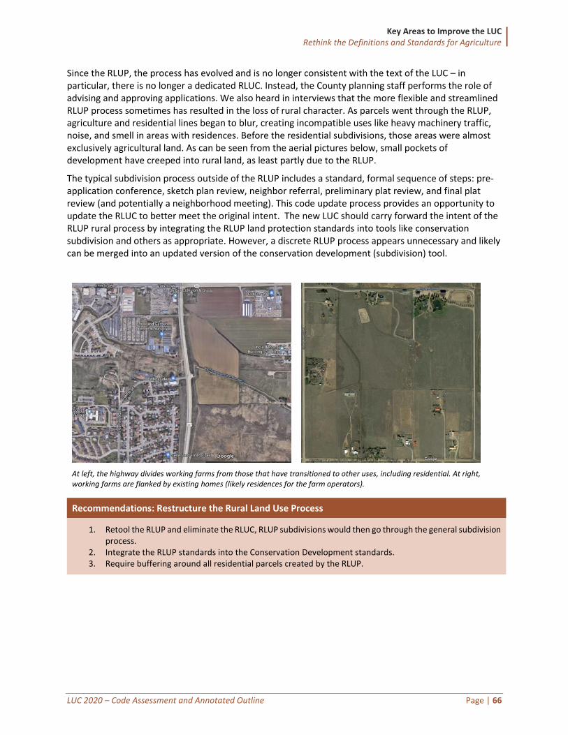
Key Areas to Improve the LUC Rethink the Definitions and Standards for Agriculture
LUC 2020 – Code Assessment and Annotated Outline Page | 66
Since the RLUP, the process has evolved and is no longer consistent with the text of the LUC – in particular, there is no longer a dedicated RLUC. Instead, the County planning staff performs the role of advising and approving applications. We also heard in interviews that the more flexible and streamlined RLUP process sometimes has resulted in the loss of rural character. As parcels went through the RLUP, agriculture and residential lines began to blur, creating incompatible uses like heavy machinery traffic, noise, and smell in areas with residences. Before the residential subdivisions, those areas were almost exclusively agricultural land. As can be seen from the aerial pictures below, small pockets of development have creeped into rural land, as least partly due to the RLUP.
The typical subdivision process outside of the RLUP includes a standard, formal sequence of steps: pre-application conference, sketch plan review, neighbor referral, preliminary plat review, and final plat review (and potentially a neighborhood meeting). This code update process provides an opportunity to update the RLUC to better meet the original intent. The new LUC should carry forward the intent of the RLUP rural process by integrating the RLUP land protection standards into tools like conservation subdivision and others as appropriate. However, a discrete RLUP process appears unnecessary and likely can be merged into an updated version of the conservation development (subdivision) tool.
At left, the highway divides working farms from those that have transitioned to other uses, including residential. At right, working farms are flanked by existing homes (likely residences for the farm operators).
Recommendations: Restructure the Rural Land Use Process
1. Retool the RLUP and eliminate the RLUC, RLUP subdivisions would then go through the general subdivision process.
2. Integrate the RLUP standards into the Conservation Development standards. 3. Require buffering around all residential parcels created by the RLUP.
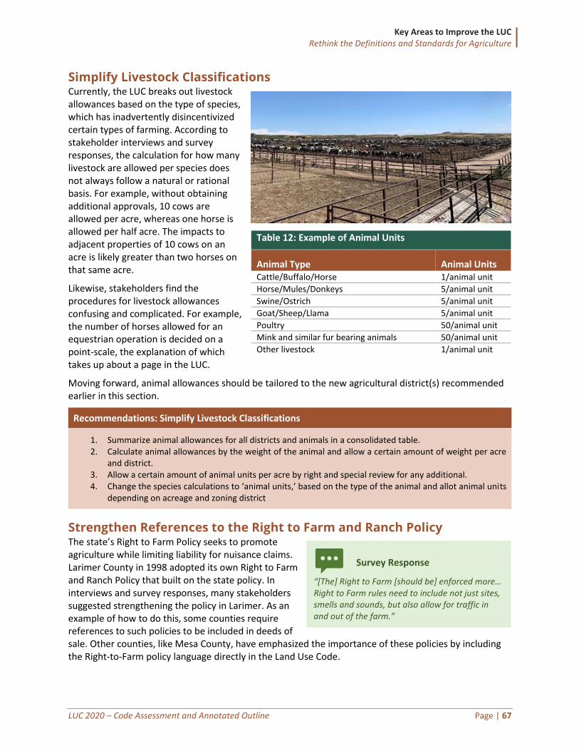
Key Areas to Improve the LUC Rethink the Definitions and Standards for Agriculture
LUC 2020 – Code Assessment and Annotated Outline Page | 67
Simplify Livestock Classifications Currently, the LUC breaks out livestock allowances based on the type of species, which has inadvertently disincentivized certain types of farming. According to stakeholder interviews and survey responses, the calculation for how many livestock are allowed per species does not always follow a natural or rational basis. For example, without obtaining additional approvals, 10 cows are allowed per acre, whereas one horse is allowed per half acre. The impacts to adjacent properties of 10 cows on an acre is likely greater than two horses on that same acre.
Likewise, stakeholders find the procedures for livestock allowances confusing and complicated. For example, the number of horses allowed for an equestrian operation is decided on a point-scale, the explanation of which takes up about a page in the LUC.
Moving forward, animal allowances should be tailored to the new agricultural district(s) recommended earlier in this section.
Recommendations: Simplify Livestock Classifications
1. Summarize animal allowances for all districts and animals in a consolidated table. 2. Calculate animal allowances by the weight of the animal and allow a certain amount of weight per acre
and district. 3. Allow a certain amount of animal units per acre by right and special review for any additional. 4. Change the species calculations to ‘animal units,’ based on the type of the animal and allot animal units
depending on acreage and zoning district
Strengthen References to the Right to Farm and Ranch Policy The state’s Right to Farm Policy seeks to promote agriculture while limiting liability for nuisance claims. Larimer County in 1998 adopted its own Right to Farm and Ranch Policy that built on the state policy. In interviews and survey responses, many stakeholders suggested strengthening the policy in Larimer. As an example of how to do this, some counties require references to such policies to be included in deeds of sale. Other counties, like Mesa County, have emphasized the importance of these policies by including the Right-to-Farm policy language directly in the Land Use Code.
Table 12: Example of Animal Units
Animal Type Animal Units Cattle/Buffalo/Horse 1/animal unit
Horse/Mules/Donkeys 5/animal unit
Swine/Ostrich 5/animal unit
Goat/Sheep/Llama 5/animal unit
Poultry 50/animal unit
Mink and similar fur bearing animals 50/animal unit
Other livestock 1/animal unit
Survey Response
“[The] Right to Farm [should be] enforced more… Right to Farm rules need to include not just sites, smells and sounds, but also allow for traffic in and out of the farm.”
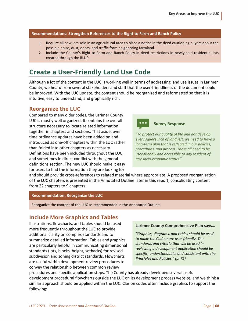
Key Areas to Improve the LUC
LUC 2020 – Code Assessment and Annotated Outline Page | 68
Recommendations: Strengthen References to the Right to Farm and Ranch Policy
1. Require all new lots sold in an agricultural area to place a notice in the deed cautioning buyers about the possible noise, dust, odors, and traffic from neighboring farmland.
2. Include the County’s Right to Farm and Ranch Policy in deed restrictions in newly sold residential lots created through the RLUP.
Create a User-Friendly Land Use Code
Although a lot of the content in the LUC is working well in terms of addressing land use issues in Larimer County, we heard from several stakeholders and staff that the user-friendliness of the document could be improved. With the LUC update, the content should be reorganized and reformatted so that it is intuitive, easy to understand, and graphically rich.
Reorganize the LUC Compared to many older codes, the Larimer County LUC is mostly well organized. It contains the overall structure necessary to locate related information together in chapters and sections. That aside, over time ordinance updates have been added on and introduced as one-off chapters within the LUC rather than folded into other chapters as necessary. Definitions have been included throughout the LUC, and sometimes in direct conflict with the general definitions section. The new LUC should make it easy for users to find the information they are looking for and should provide cross-references to related material where appropriate. A proposed reorganization of the LUC chapters is presented in the Annotated Outline later in this report, consolidating content from 22 chapters to 9 chapters.
Recommendation: Reorganize the LUC
Reorganize the content of the LUC as recommended in the Annotated Outline.
Include More Graphics and Tables Illustrations, flowcharts, and tables should be used more frequently throughout the LUC to provide additional clarity on complex standards and to summarize detailed information. Tables and graphics are particularly helpful in communicating dimensional standards (lots, blocks, height, setbacks) for revised subdivision and zoning district standards. Flowcharts are useful within development review procedures to convey the relationship between common review procedures and specific application steps. The County has already developed several useful development procedural flowcharts outside the LUC on its development process website, and we think a similar approach should be applied within the LUC. Clarion codes often include graphics to support the following:
Larimer County Comprehensive Plan says…
“Graphics, diagrams, and tables should be used to make the Code more user-friendly. The standards and criteria that will be used in reviewing a development application should be specific, understandable, and consistent with the Principles and Policies.” (p. 72)
Survey Response
“To protect our quality of life and not develop every square inch of land left, we need to have a long-term plan that is reflected in our policies, procedures, and process. These all need to be user-friendly and accessible to any resident of any socio-economic status.”
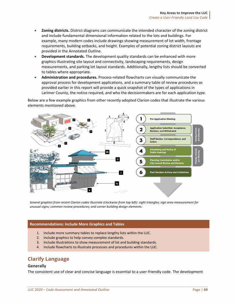
Key Areas to Improve the LUC Create a User-Friendly Land Use Code
LUC 2020 – Code Assessment and Annotated Outline Page | 69
• Zoning districts. District diagrams can communicate the intended character of the zoning district and include fundamental dimensional information related to the lots and buildings. For example, many modern codes include drawings showing measurement of lot width, frontage requirements, building setbacks, and height. Examples of potential zoning district layouts are provided in the Annotated Outline.
• Development standards. The development quality standards can be enhanced with more graphics illustrating site layout and connectivity, landscaping requirements, design measurements, and parking lot layout standards. Additionally, lengthy lists should be converted to tables where appropriate.
• Administration and procedures. Process-related flowcharts can visually communicate the approval process for development applications, and a summary table of review procedures as provided earlier in this report will provide a quick snapshot of the types of applications in Larimer County, the notice required, and who the decisionmakers are for each application type.
Below are a few example graphics from other recently adopted Clarion codes that illustrate the various elements mentioned above.
Several graphics from recent Clarion codes illustrate (clockwise from top left): sight triangles; sign area measurement for unusual signs; common review procedures; and corner building design elements.
Recommendations: Include More Graphics and Tables
1. Include more summary tables to replace lengthy lists within the LUC. 2. Include graphics to help convey complex standards. 3. Include illustrations to show measurement of lot and building standards. 4. Include flowcharts to illustrate processes and procedures within the LUC.
Clarify Language
Generally The consistent use of clear and concise language is essential to a user-friendly code. The development
Key Areas to Improve the LUC Create a User-Friendly Land Use Code
LUC 2020 – Code Assessment and Annotated Outline Page | 70
regulations should use a consistent style and voice throughout and should use parallel construction for provisions within a defined hierarchy. For example, some of the procedures follow a similar structure including a purpose statement, applicability, review criteria, and process (e.g., minor land divisions and site plans); whereas other procedures (e.g., condominium maps and preliminary plats) include the process prior to the review criteria. Additionally, the formatting of the hierarchy is inconsistent throughout the LUC. Some headings are included as part of a list, and are not bolded, where others are separated by bold headings with a new numbering system.
Improve Definitions Definitions should be written clearly, should not include substantive regulations, and should include supplemental graphics to illustrate especially complex terms, such as the measurement of building height. For example, the definition of “farm” should remove regulatory language related to the minimum three-acre size requirement because that is a fundamental component of regulating Larimer County farms but is arguably hidden by including it within the definition.
The definitions should also be internally consistent within the LUC, and with external documents such as the engineering standards and the building codes, where possible. For example, the terms “bed and breakfast facility” and “cabin” are defined differently in the Building Code than within the LUC (See Sec. 10-2, Amendments, in the County Code). We also understand that the way building officials measure height is different than the defined measurement in the LUC. Missing definitions should be drafted, and outdated definitions replaced, based on best practices such as consultant repositories or American Planning Association publications where appropriate.
Recommendations: Clarify Language
1. Clarify the language in the LUC to use consistent tone, style, and structure. 2. Update the definitions for consistency, to remove regulatory content, and to comply with external
regulations such as building code and engineering standards.
Ensure Compliance with Applicable Laws As part of the LUC update, the County should review existing and newly drafted provisions to ensure compliance with state and federal regulations. Staff and Clarion should work closely with the County Attorney’s office to address any potential conflicts. The updated LUC should also reflect other applicable County standards throughout the County Code (outside the LUC) and provide cross-references to related provisions where appropriate.
Recommendation: Ensure Compliance with Applicable Laws
Work closely with the County Attorney’s office to ensure compliance with other County standards and state and federal laws.
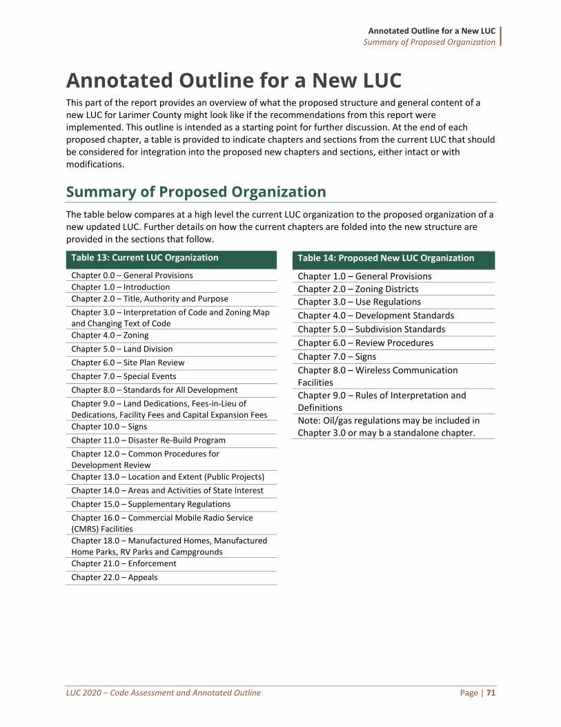
Annotated Outline for a New LUC Summary of Proposed Organization
LUC 2020 – Code Assessment and Annotated Outline Page | 71
Annotated Outline for a New LUC This part of the report provides an overview of what the proposed structure and general content of a new LUC for Larimer County might look like if the recommendations from this report were implemented. This outline is intended as a starting point for further discussion. At the end of each proposed chapter, a table is provided to indicate chapters and sections from the current LUC that should be considered for integration into the proposed new chapters and sections, either intact or with modifications.
Summary of Proposed Organization
The table below compares at a high level the current LUC organization to the proposed organization of a new updated LUC. Further details on how the current chapters are folded into the new structure are provided in the sections that follow.
Table 13: Current LUC Organization
Chapter 0.0 – General Provisions
Chapter 1.0 – Introduction
Chapter 2.0 – Title, Authority and Purpose
Chapter 3.0 – Interpretation of Code and Zoning Map and Changing Text of Code
Chapter 4.0 – Zoning
Chapter 5.0 – Land Division
Chapter 6.0 – Site Plan Review
Chapter 7.0 – Special Events
Chapter 8.0 – Standards for All Development
Chapter 9.0 – Land Dedications, Fees-in-Lieu of Dedications, Facility Fees and Capital Expansion Fees
Chapter 10.0 – Signs
Chapter 11.0 – Disaster Re-Build Program
Chapter 12.0 – Common Procedures for Development Review
Chapter 13.0 – Location and Extent (Public Projects)
Chapter 14.0 – Areas and Activities of State Interest
Chapter 15.0 – Supplementary Regulations
Chapter 16.0 – Commercial Mobile Radio Service (CMRS) Facilities
Chapter 18.0 – Manufactured Homes, Manufactured Home Parks, RV Parks and Campgrounds
Chapter 21.0 – Enforcement
Chapter 22.0 – Appeals
Table 14: Proposed New LUC Organization
Chapter 1.0 – General Provisions
Chapter 2.0 – Zoning Districts
Chapter 3.0 – Use Regulations
Chapter 4.0 – Development Standards
Chapter 5.0 – Subdivision Standards
Chapter 6.0 – Review Procedures
Chapter 7.0 – Signs
Chapter 8.0 – Wireless Communication Facilities
Chapter 9.0 – Rules of Interpretation and Definitions
Note: Oil/gas regulations may be included in Chapter 3.0 or may b a standalone chapter.
Annotated Outline for a New LUC
LUC 2020 – Code Assessment and Annotated Outline Page | 72
Chapter 1.0 – General Provisions
This chapter will consolidate materials related to the legal authority, purpose, and applicability of the various sections of the LUC.
Title This section integrates the materials from the current Section 2.1 describing the name of and references to the LUC.
Authority This section includes the materials from the current Section 2.2 citing applicable sections of Colorado law granting the County the authority to regulate the use, division, and development of land.
Purpose This section will integrate material from the current Section 2.3 describing the intent of the LUC and liking to important policy direction and planning documents (such as the Comprehensive Plan).
Applicability This section will integrate material from the current Section 2.4 clarifying that all development and redevelopment in the County (but for Estes Valley, which is subject to separate standards) must comply with the LUC unless explicitly exempted elsewhere in the LUC or by state or federal law.
Relationship to Other Regulations This new section will clarify that in the case of a conflict between the LUC and other County regulations, or conflicts internally within the LUC, the strictest of the provisions shall govern, with potential exceptions to that rule such as overlay districts.
Relationship to Private Covenants and Conditions This new section will clarify that in the case of a conflict between the LUC and the provisions of a private restrictive covenant, the provisions of the LUC shall apply. It will also clarify that the County has no obligations to enforce private restrictive covenants.
Transition from Previous Ordinances This section will explain how the County will transition from the provisions of the current LUC and to this new LUC. More specifically, it will state that any complete application filed before the date of the new LUC shall be governed by the provisions of the previous ordinances. Incomplete applications pending on the effective date, and applications filed after the effective date, will be governed by the new LUC. This section will also clarify that violations of the previous LUC will continue unless the structure or activity that gave rise to the violation is legal under the new LUC.
NOTE: The transition language can alternatively be included in the adoption resolution, rather than the ordinance itself.
Severability This section will incorporate the provisions of the current Section 3.7, clarifying that if any portion of the LUC is declared invalid by the courts, the remainder shall remain valid and in effect.
Nonconformities This section should address nonconforming situations including nonconforming lots, uses, structures, signs, and site features (landscaping, parking, lighting). Site features are not currently addressed by the LUC, and the nonconforming site features should be drafted in concert with the applicability thresholds
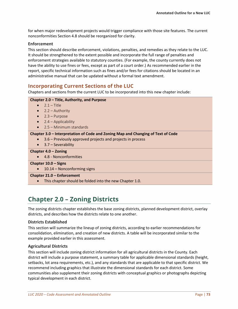
Annotated Outline for a New LUC
LUC 2020 – Code Assessment and Annotated Outline Page | 73
for when major redevelopment projects would trigger compliance with those site features. The current nonconformities Section 4.8 should be reorganized for clarity.
Enforcement This section should describe enforcement, violations, penalties, and remedies as they relate to the LUC. It should be strengthened to the extent possible and incorporate the full range of penalties and enforcement strategies available to statutory counties. (For example, the county currently does not have the ability to use fines or fees, except as part of a court order.) As recommended earlier in the report, specific technical information such as fines and/or fees for citations should be located in an administrative manual that can be updated without a formal text amendment.
Incorporating Current Sections of the LUC Chapters and sections from the current LUC to be incorporated into this new chapter include:
Chapter 2.0 – Title, Authority, and Purpose
• 2.1 – Title
• 2.2 – Authority
• 2.3 – Purpose
• 2.4 – Applicability
• 2.5 – Minimum standards
Chapter 3.0 – Interpretation of Code and Zoning Map and Changing of Text of Code
• 3.6 – Previously approved projects and projects in process
• 3.7 – Severability
Chapter 4.0 – Zoning
• 4.8 - Nonconformities
Chapter 10.0 – Signs
• 10.14 – Nonconforming signs
Chapter 21.0 – Enforcement
• This chapter should be folded into the new Chapter 1.0.
Chapter 2.0 – Zoning Districts
The zoning districts chapter establishes the base zoning districts, planned development district, overlay districts, and describes how the districts relate to one another.
Districts Established This section will summarize the lineup of zoning districts, according to earlier recommendations for consolidation, elimination, and creation of new districts. A table will be incorporated similar to the example provided earlier in this assessment.
Agricultural Districts This section will include zoning district information for all agricultural districts in the County. Each district will include a purpose statement, a summary table for applicable dimensional standards (height, setbacks, lot area requirements, etc.), and any standards that are applicable to that specific district. We recommend including graphics that illustrate the dimensional standards for each district. Some communities also supplement their zoning districts with conceptual graphics or photographs depicting typical development in each district.
Annotated Outline for a New LUC
LUC 2020 – Code Assessment and Annotated Outline Page | 74
Residential Districts This section will include zoning district information for all residential districts. The components included in agricultural districts will also be included for all other districts in the code (purpose, summary of dimensions, district-specific standards, graphics, and references to design standards).
Mixed-Use Districts This section will include zoning district information for all mixed-use districts. The components included in agricultural districts will also be included for all other districts in the code (purpose, summary of dimensions, district-specific standards, graphics, and references to design standards).
Commercial Districts This section will include zoning district information for all commercial districts. The components
included in agricultural districts will also be included for all other districts in the code (purpose,
summary of dimensions, district-specific standards, graphics, and references to design standards).
Industrial Districts This section will include zoning district information for all industrial districts. The components included
in agricultural districts will also be included for all other districts in the code (purpose, summary of
dimensions, district-specific standards, graphics, and references to design standards).
Special Purpose Districts This section will include zoning information for all special purpose districts, such the planned development, natural resource, and community facilities districts.
Overlay Districts This section will describe the purpose and applicability of overlay districts and summarize how they are administered.
Dimensional Standards and Exceptions This section will summarize the dimensional standards for all zoning districts. This will include summary tables with dimensional standards for the following:
• Lot standards (e.g., minimum lot area, maximum impervious coverage)
• Setbacks (e.g., minimum yard requirements, build-to requirements)
• Building standards (e.g., minimum and maximum height)
A summary of the key dimensional standards will be included in a short summary table for each zoning district. Following the dimensional standards tables, a list of exceptions and encroachments will be included, as well as references to the residential design standards. This will describe what types of structures, building elements, or site features are either exceptions from dimensional standards (such as uncovered porches), or may encroach into required areas (such as spires, chimneys, and bay windows).
Incorporating Current Sections of the LUC Chapters and sections from the current LUC to be incorporated into this new chapter include:
Chapter 4.0 – ZONING
• 4.1 Zoning districts. Use permissions will be relocated to a consolidated table in Chapter 3.0 Use Regulations. Lot, building, and structure requirements for each district will be carried forward in a table and accompanied by an illustrative graphic.
• 4.2.1 Growth management area overlay zone.
Annotated Outline for a New LUC
LUC 2020 – Code Assessment and Annotated Outline Page | 75
• 4.2.2 Floodplain overlay zones. Subsections G, H, I, and J will be relocated to Chapter 8.0 Review Procedures. Subsection K will be relocated to Chapter 9.0 Rules of Construction and Definitions. Application submittal requirements may be relocated to an Administrative Manual outside of the LUC.
• 4.2.3 Fossil Creek Reservoir area transferable density units overlay zone. This content has been repealed and will be not be included in the draft.
• 4.2.4 Cooperative planning area overlay zone district.
• 4.9 Setbacks, lot requirements, and structure height.
Chapter 3.0 – Use Regulations
The use regulations include the Table of Allowed Uses, indicating which land uses are allowed in each zoning district, and the level of permission required for each. Following the Table of Allowed Uses, this Chapter will include the use-specific standards applicable to some use types.
Table of Allowed Uses All uses in Larimer County’s base zoning districts will be organized into a single Table of Allowed Uses. The table will be reorganized by use categories as suggested earlier (beginning with residential uses through industrial/utility uses, followed by accessory and temporary uses). For each specific use type, the cells for each zoning district will be populated by some version of the following abbreviations:
• Blank cell – use is not permitted in that zoning district.
• P – use is permitted by right in that zoning district.
• S – use is allowed only with approval of a special review.
• MS – use is allowed only with approval of a minor special review.
• A – use is allowed as an accessory use incidental to a primary use.
• T – use is allowed with approval of a temporary use permit.
The current distinction between uses by right and uses that require site plan or public site plan approvals are not recommended to be carried forward; see the discussion of this issue earlier in this report under “Restructure and Simplify the Site Plan Procedure.” The applicability of site plan requirements can be specified in the procedures rather than within the Table of Allowed Uses. The right-hand column of the table will include cross-references to any applicable use-specific standards for that use type. A portion of a use table from another community is shown below for reference.
As the team reviews the current use table and use-specific standards, we may propose changes to the use permissions. For example, where the impacts of a current special or minor special review use on surrounding properties can be mitigated through use-specific, or is a use suggested by the comprehensive plan, that use may be recommended as a use by right.
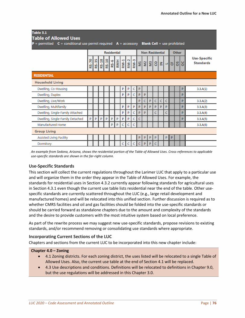
Annotated Outline for a New LUC
LUC 2020 – Code Assessment and Annotated Outline Page | 76
An example from Sedona, Arizona, shows the residential portion of the Table of Allowed Uses. Cross-references to applicable use-specific standards are shown in the far-right column.
Use-Specific Standards This section will collect the current regulations throughout the Larimer LUC that apply to a particular use and will organize them in the order they appear in the Table of Allowed Uses. For example, the standards for residential uses in Section 4.3.2 currently appear following standards for agricultural uses in Section 4.3.1 even though the current use table lists residential near the end of the table. Other use-specific standards are currently scattered throughout the LUC (e.g., large retail development and manufactured homes) and will be relocated into this unified section. Further discussion is required as to whether CMRS facilities and oil and gas facilities should be folded into the use-specific standards or should be carried forward as standalone chapters due to the amount and complexity of the standards and the desire to provide customers with the most intuitive system based on local preference.
As part of the rewrite process we may suggest new use-specific standards, propose revisions to existing standards, and/or recommend removing or consolidating use standards where appropriate.
Incorporating Current Sections of the LUC Chapters and sections from the current LUC to be incorporated into this new chapter include:
Chapter 4.0 – Zoning
• 4.1 Zoning districts. For each zoning district, the uses listed will be relocated to a single Table of Allowed Uses. Also, the current use table at the end of Section 4.1 will be replaced.
• 4.3 Use descriptions and conditions. Definitions will be relocated to definitions in Chapter 9.0, but the use regulations will be addressed in this Chapter 3.0.
Annotated Outline for a New LUC
LUC 2020 – Code Assessment and Annotated Outline Page | 77
Chapter 7.0 – Special Events10
• 7.7 Performance standards
• 7.8 Compliance with other regulations
• 7.9 Site cleanup and restoration
Chapter 8.0 – Standards for All Development
• 8.18 Large retail development
Chapter 15.0 – Supplementary Regulations
• 15.2.2 Supplementary regulations for GMAs. The use-related standards in the GMAs will be relocated to this new Chapter 3.0.
Chapter 18.0 – Manufactured Homes, Manufactured Home Parks, Recreational Vehicle Parks and Campgrounds
• Entire chapter to be relocated to new Chapter 3.0
Chapter 4.0 – Development Standards
The development standards chapter will address the development quality standards for Larimer County, organized generally from the “ground up.” The chapter will start with those standards related to preparing the site for development (e.g., grading and drainage), followed by standards for improving the site (e.g., access and circulation and landscaping), followed by building standards (e.g., design standards), and ending with site operations and maintenance standards (e.g., outdoor lighting and maintenance).
Grading and Drainage This section includes the requirements for grading and drainage improvements to a development site. Many of these standards are technical in nature and may warrant relocation outside the LUC in a separate engineering manual. As the County considers developing a grading permit procedure, those standards will also be referenced in this section.
Sensitive Area Protection These standards will integrate the various sections that address sensitive areas, such as wetlands, floodplains, hazard areas, and wildlife habitat.
Access, Connectivity, and Circulation This will be a new section to include standards for internal circulation within a site, connections between development sites, and multiple modes of mobility to and throughout the site. This section will also include provisions for when and where sidewalks are required, and standards for private access and driveways. Streets and other right-of-way provisions will be addressed in the subdivision standards and cross-referenced in this section as appropriate. This section will carry forward some of the existing access standards currently located within Section 8.14.
Off-Street Parking and Loading This section will consolidate the off-street parking and loading requirements from the current Section 8.6. Most of the information in this section will be consolidated into a parking requirements table (either stand-alone or as integrated into the overall table of allowed uses). The current LUC addresses parking
10 Further discussion needed during the drafting process. This topic may be better located in a separate section on its own.
Annotated Outline for a New LUC
LUC 2020 – Code Assessment and Annotated Outline Page | 78
lot landscaping within the landscaping regulations (subsection 8.5.8). Many communities opt to incorporate parking lot landscaping requirements into the parking section of the code. There are advantages and disadvantages to both approaches and requires further discussion with staff.
Landscaping, Buffering, and Screening This section will include the standards for landscaping on a development site, required landscape buffers, and screening and fencing requirements. The fence standards in Section 8.16 will be consolidated with the current subsection 8.5.13 and relocated to this new section.
Building Design This new section will include any building design standards addressing architectural character or building form if such standards are necessary in certain contexts or zoning districts.
Outdoor Lighting This section will address the standards for exterior lighting, expanding and improving the current Section 8.15. Standards will include the types of lighting allowed, the appropriate lighting levels, and standards for administering and enforcing the lighting standards. Modern lighting ordinances place an emphasis on consistent measurement of lighting levels and inclusion of newer technologies such as LED lighting where appropriate.
Incorporating Current Sections of the LUC Chapters and sections from the current LUC to be incorporated into this new chapter include:
Chapter 8.0 – Standards for all Development
• 8.1 Adequate public facilities (those that would apply to redevelopment, otherwise will be relocated to the subdivision standards in Chapter 7.0)
• 8.2 Wetland areas
• 8.3 Hazard areas
• 8.4 Wildlife
• 8.5 Landscaping
• 8.6 Private local access road and parking standards. Some road and technical parking standards may be relocated outside the code or within subdivision regulations.
• 8.7 Road surfacing requirements
• 8.8 Irrigation facilities
• 8.11 Air quality standards
• 8.12 Water quality management standards
• 8.13 Commercial mineral deposits
• 8.14 Development design for land division. Standards and procedures related to subdivision design will be included in Chapters 7.0 and 8.0 respectively.
• 8.15 Lighting
• 8.16 Fences
• 8.17 Hazardous waste treatment and disposal
Chapter 15.0 – Supplementary Regulations
• 15.2.2 – Supplementary Regulations for GMAs. The standards applicable to development standards should be relocated to this new Chapter 4.0.
Annotated Outline for a New LUC
LUC 2020 – Code Assessment and Annotated Outline Page | 79
Chapter 5.0 – Subdivision Standards
This chapter will include the standards related to land divisions and land dedication within the County, including the current standards in Section 8.14, Development Design for Land Division. The procedures for land division and subdivision approvals will be relocated to the consolidated review procedures in Chapter 8.
Lot and Block Layout This section will prescribe the location and arrangement of lots and blocks for new subdivisions, expanding on the current standards in 8.14 and the design standards for conservation and rural land divisions. These standards will be coordinated with revisions to the existing dimensional standards for base zoning districts.
Street Standards This section will describe the design requirements for streets and rights-of-way in Larimer County, mostly by providing a cross-reference to external manuals. This section will address how private streets are regulated, pulling from the standards in Section 8.6. (The regulatory approach to private streets will be discussed during the drafting process; typically, but not always, private streets are subject to the same standards as public streets.)
Dedication of Land This section will address the requirements for public dedication of land or fees-in-lieu of dedication for new subdivisions and land divisions. Some of the information may apply to redevelopment and would therefore be relocated to the development standards in Chapter 4.0.
Public Improvements This section will describe the types of public improvements required for new subdivisions and developments, and then specify the timing and agreements required for providing such improvements. Much of this information is currently located in Section 8.1, Adequate Public Faculties.
Incorporating Current Sections of the LUC Chapters and sections from the current LUC to be incorporated into this new chapter include:
Chapter 8.0 – Standards for All Development
• 8.1 Adequate public facilities (standards that apply to redevelopment will be located in development standards in Chapter 4.0)
• 8.6 Private local access road and parking standards
• 8.14 Development design for land division
Chapter 9.0 – Land Dedications, Fees-in-Lieu, Facility Fees, and Capital Expansion Fees
• Some of the standards in this chapter will be located in the subdivision chapter; however, many of the requirements may make more sense to include them in the procedures.
Chapter 6.0 – Review Procedures
This chapter should describe the review and approval procedures for all development applications. The procedures should be drafted to reflect the changes proposed earlier in this report. The new procedures will be clarified to include more clear criteria, to be more user-friendly, and to result in a more predictable process.
Annotated Outline for a New LUC
LUC 2020 – Code Assessment and Annotated Outline Page | 80
Review and Decision-Making Bodies This section should describe, carry forward, and update the portions of Section 12.2 that describes each of the decision-making and review bodies in the County, their powers and duties, their membership, and any other requirements not covered by their bylaws.
Summary Table of Review Procedures This section would include a new summary table of review procedures similar to the one provided earlier in this report. This approach provides the community (and staff) with a snapshot of the overall procedures in the County.
Common Review Procedures This section should build on and improve the current Chapter 12.0. The County has already started thinking about common review procedures, and this revised section will identify and describe the procedures that apply to most development applications in Larimer County. As recommended earlier in the report, common review procedures establish the procedures that apply to all (or most) development applications and thus avoid duplication and potential for inconsistencies as the LUC is updated.
Land Use Code Amendments This section should describe the types of development applications that amend the LUC, policy documents, or the zoning map (such as rezonings, text amendments, or comp plan updates). These procedures should refer back to applicable steps from the common review procedures and describe any modifications or additions to those procedures.
Development Permits and Approvals This section should describe the types of applications associated with development in Larimer County (such as site plans, special review, or special permits). These procedures should refer back to applicable steps from the common review procedures and describe any modifications or additions to those procedures.
Subdivision Approvals This section should describe the types of development applications associated with subdivisions, land divisions, or condominiumization. These procedures should refer back to applicable steps from the common review procedures and describe any modifications or additions to those procedures.
Flexibility and Relief Procedures This section should describe the types of development applications associated with adjustments or otherwise providing relief from development standards in Larimer County. This would include the recommended minor modification procedure, variances, and appeals. These procedures should refer back to applicable steps from the common review procedures and describe any modifications or additions to those procedures.
Incorporating Current Sections of the LUC Chapters and sections from the current LUC to be incorporated into this new chapter include:
Chapter 3.0 – Interpretation of Code and Zoning Map and Changing Text of Code
• 3.8 – Amending the code text
Chapter 4.0 – Zoning
• 4.2.2 – Floodplain (administration sections only G-J)
• 4.4 – Amending the official zoning map (rezoning)
• 4.5 – Special review and minor special review
Annotated Outline for a New LUC
LUC 2020 – Code Assessment and Annotated Outline Page | 81
• 4.6 – Zoning variances
• 4.7 – Zoning special exceptions
Chapter 5.0 – Land Division
• 5.1 – Subdivision
• 5.2 – Planned land division
• 5.3 – Conservation development
• 5.4 – Minor land division
• 5.5 – Boundary line adjustment
• 5.6 – Add-on agreement
• 5.7 – Amended plat
• 5.8 – Rural land use process
• 5.9 – Right-of-way and easement vacations
• 5.10 – Plat vacations and resubdivision
• 5.12 – Condominium maps
• 5.13 – Land division process
Chapter 6.0 – Site Plan Review
• 6.1 – Site plan review
• 6.2 – Public site plan review
Chapter 7.0 – Special Events11
• Provisions related to the process and permit requirements will be located in this section
Chapter 12.0 – Common Procedures for Development Review
• This entire chapter will be evaluated and carried forward into the new Chapter 8.0
Chapter 13.0 – Location and Extent (Public Project Review)
• This entire chapter will be carried forward as a development procedure
Chapter 14.0 – Areas and Activities of State Interest
• These 1041 regulations will be carried forward into the new Chapter 8.0
Chapter 22.0 – Appeals
• This entire chapter will be carried forward into the flexibility and relief procedures
Chapter 7.0 – Signs
The current sign regulations need to be updated to remove content-based regulations and to make other improvements as stated earlier in this report. Although we indicate here that the sign regulations remain in a standalone chapter, some communities opt to integrate them into the development standards chapter. Further discussion is required on the preferred approach.
Incorporating Current Sections of the LUC Chapters and sections from the current LUC to be incorporated into this new chapter include:
Chapter 10 – Signs
• This chapter should be relocated as amended to the new Chapter 7.0.
11 Further discussion needed during the drafting process. This topic may be better located in a separate section on its own.
Annotated Outline for a New LUC
LUC 2020 – Code Assessment and Annotated Outline Page | 82
Chapter 8.0 – Wireless Communication Facilities
This chapter will include the new Wireless Communication Facilities standards from Chapter 16.0.
Incorporating Current Sections of the LUC Chapters and sections from the current LUC to be incorporated into this new chapter include:
Chapter 16.0 – Wireless Communication Facilities
• This chapter will be carried forward as amended into the new Chapter 8.0.
Chapter 9.0 – Rules of Interpretation and Definitions
The definitions chapter is drafted in pieces, growing longer with each installment of the draft LUC. For the first installment, we will include only the definitions used in and relevant to that installment. With the second installment, we will include the definitions from the first installment, and then add new definitions pertinent to the second installment, and so forth until a consolidated set of definitions is provided with the consolidated draft. This chapter will also include the basic rules of construction establishing the parameter for certain terms used throughout the LUC such as “he” or “she” and what is meant by the term “includes.” Also included is the basic rules for the computation of time and how to interpret conjunctions.
Incorporating Current Sections of the LUC Chapters and sections from the current LUC to be incorporated into this new chapter include:
Chapter 0.0 – General Provisions
• 0.1 Definitions
Chapter 4.0 – Zoning
• 4.2.2 Floodplain overlay zones. Subsections K includes definitions related to floodplains.
• 4.3 Use descriptions and conditions. The definitions for uses will be reconciled with the definitions in Section 0.1.
Chapter 8.0 – Standards for all Development
• 8.5.14 Landscaping definitions
Chapter 9.0 – Land Dedications, Fees-in-Lieu, Facility Fees, and Capital Expansion Fees
• 9.3.6 Community park dedication definitions
• 9.4.6 Regional park dedication definitions
• 9.5.5 Non-regional road capital expansion fee definitions
• 9.6.6 Regional road capital expansion fee definitions
Chapter 10.0 – Signs
• 10.15 Definitions
Chapter 16.0 – Commercial Mobile Radio Service (CMRS) Facilities
• 16.1.7 Definitions
LUC 2020 – Code Assessment and Annotated Outline Page | 83
Detailed Review of the Current LUC The following table provides section-by-section detailed comments on the current Land Use Code. Many of the more substantive comments are addressed earlier in this report, whereas other comments are technical in nature and do not require in-depth narrative. Not every section includes comments; however, the absence of comments in this table does not preclude amendments to those provisions during the drafting process.
Table 15: Detailed Review of the Current LUC
Section/subsection Comments and recommendations
Chapter 0.0 General Provisions
General • Move any adjective modifiers to end of definition. Example: for “commercial poultry farm,” change to “poultry farm, commercial”
• Lots of agriculture-related definitions need cleaning up and modernizing.
• Missing definitions: “farm/rural occupation”
0.1 Definitions • Move all definitions found throughout the Code to this section.
• Break out the definition of “community hall” into various definitions (e.g. wedding venue).
• See agricultural section for suggested changes to “farm.”
• Add a hyphen for “value-added agricultural processing.” Make that change throughout.
• Remove definitions that are not used in the Code: bird hobby breeder facility, canine hobby breeder facility, specified sexual activity.
Chapter 1.0 Introduction
1.1 Background and Context • Delete. Not necessary to carry forward this background context.
Chapter 2.0 Title, Authority and Purpose
2.3 Purpose • Update in accordance with new Comprehensive plan.
Chapter 3.0 Interpretation of Code and Zoning Map and Changing of Text of Code
General • Unless otherwise noted below, relocate all this material to the new consolidated procedures chapter.
3.7 Severability • Move to new general procedures chapter.
• Add ‘unlawful’ after ‘unconstitutional.’
3.8 Amending the Code Text • This procedure needs to be rewritten and expanded to clarify the steps in the process and mirror the new standard format for all procedures recommended in this report.
Chapter 4.0 Zoning
General
4.1 Zoning Districts Generally:
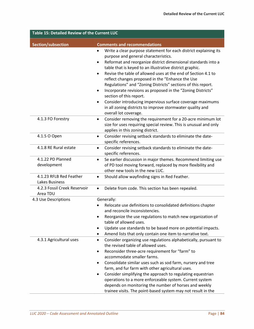
Detailed Review of the Current LUC
LUC 2020 – Code Assessment and Annotated Outline Page | 84
Table 15: Detailed Review of the Current LUC
Section/subsection Comments and recommendations
• Write a clear purpose statement for each district explaining its purpose and general characteristics.
• Reformat and reorganize district dimensional standards into a table that is keyed to an illustrative district graphic.
• Revise the table of allowed uses at the end of Section 4.1 to reflect changes proposed in the “Enhance the Use Regulations” and “Zoning Districts” sections of this report.
• Incorporate revisions as proposed in the “Zoning Districts” section of this report.
• Consider introducing impervious surface coverage maximums in all zoning districts to improve stormwater quality and overall lot coverage.
4.1.3 FO Forestry • Consider removing the requirement for a 20-acre minimum lot size for uses requiring special review. This is unusual and only applies in this zoning district.
4.1.5 O Open • Consider revising setback standards to eliminate the date-specific references.
4.1.8 RE Rural estate • Consider revising setback standards to eliminate the date-specific references.
4.1.22 PD Planned development
• Se earlier discussion in major themes. Recommend limiting use of PD tool moving forward, replaced by more flexibility and other new tools in the new LUC.
4.1.23 RFLB Red Feather Lakes Business
• Should allow wayfinding signs in Red Feather.
4.2.3 Fossil Creek Reservoir Area TDU
• Delete from code. This section has been repealed.
4.3 Use Descriptions Generally:
• Relocate use definitions to consolidated definitions chapter and reconcile inconsistencies.
• Reorganize the use regulations to match new organization of table of allowed uses.
• Update use standards to be based more on potential impacts.
• Amend lists that only contain one item to narrative text.
4.3.1 Agricultural uses • Consider organizing use regulations alphabetically, pursuant to the revised table of allowed uses.
• Reconsider three-acre requirement for “farm” to accommodate smaller farms.
• Consolidate similar uses such as sod farm, nursery and tree farm, and fur farm with other agricultural uses.
• Consider simplifying the approach to regulating equestrian operations to a more enforceable system. Current system depends on monitoring the number of horses and weekly trainee visits. The point-based system may not result in the
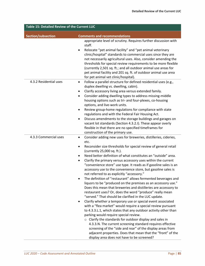
Detailed Review of the Current LUC
LUC 2020 – Code Assessment and Annotated Outline Page | 85
Table 15: Detailed Review of the Current LUC
Section/subsection Comments and recommendations
appropriate level of scrutiny. Requires further discussion with staff.
• Relocate “pet animal facility” and “pet animal veterinary clinic/hospital” standards to commercial uses since they are not necessarily agricultural uses. Also, consider amending the thresholds for special review requirements to be more flexible (currently 2,501 sq. ft.; and all outdoor animal use areas for pet animal facility and 201 sq. ft. of outdoor animal use area for pet animal vet clinic/hospital).
4.3.2 Residential uses • Follow a parallel structure for defined residential uses (e.g., duplex dwelling vs. dwelling, cabin).
• Clarify accessory living area versus extended family.
• Consider adding dwelling types to address missing-middle housing options such as tri- and four-plexes, co-housing options, and live-work units.
• Review group-home regulations for compliance with state regulations and with the Federal Fair Housing Act.
• Discuss amendments to the storage buildings and garages on vacant lot standards (Section 4.3.2.I). These appear overly flexible in that there are no specified timeframes for construction of the primary use.
4.3.3 Commercial uses • Consider adding new uses for breweries, distilleries, cideries, etc.
• Reconsider size thresholds for special review of general retail (currently 25,000 sq. ft.).
• Need better definition of what constitutes an “outside” area.
• Clarify the primary versus accessory uses within the current “convenience store” use type. It reads as if gasoline sales is an accessory use to the convenience store, but gasoline sales is not referred to as explicitly “accessory.”
• The definition of “restaurant” allows fermented beverages and liquors to be “produced on the premises as an accessory use.” Does this mean that breweries and distilleries are accessory to restaurant uses? Or, does the word “produce” really mean “served.” That should be clarified in the LUC update.
• Clarify whether a temporary use or special event associated with a “flea market” would require a special review pursuant to 4.3.3.L.1, which states that any outdoor activity other than parking would require special review. o Clarify the standards for outdoor display and sales in
4.3.3.N. The current screening standard requires effective screening of the “side and rear” of the display areas from adjacent properties. Does that mean that the “front” of the display area does not have to be screened?
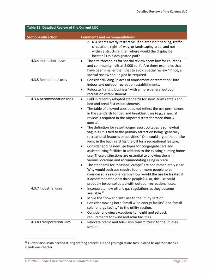
Detailed Review of the Current LUC
LUC 2020 – Code Assessment and Annotated Outline Page | 86
Table 15: Detailed Review of the Current LUC
Section/subsection Comments and recommendations
o N.4 seems overly restrictive. If an area isn’t parking, traffic circulation, right-of-way, or landscaping area, and not within a structure, then where would the display be located? On a designated pad?
4.3.4 Institutional uses • The size thresholds for special review seem low for churches and community halls at 2,000 sq. ft. Are there examples that have been smaller than that to avoid special review? If not, a special review should just be required.
4.3.5 Recreational uses • Consider dividing “places of amusement or recreation” into indoor and outdoor recreation establishments.
• Relocate “rafting business” with a more general outdoor recreation establishment.
4.3.6 Accommodation uses • Fold in recently adopted standards for short-term rentals and bed and breakfast establishments.
• The table of allowed uses does not reflect the use permissions in the standards for bed and breakfast uses (e.g., a special review is required in the Airport district for more than 6 guests).
• The definition for resort lodge/resort cottages is somewhat vague as it is tied to the primary attraction being “generally recreational features or activities.” One could argue that a bike jump in the back yard fits the bill for a recreational feature.
• Consider adding new use types for congregate care and assisted living facilities in addition to the existing nursing home use. These distinctions are essential to allowing them in various locations and accommodating aging in place.
• The standards for “seasonal camps” are not immediately clear. Why would such use require four or more people to be considered a seasonal camp? How would the use be treated if it accommodated only three people? Also, this use could probably be consolidated with outdoor recreational uses.
4.3.7 Industrial uses • Incorporate new oil and gas regulations as they become available.12
• Move the “power plant” use to the utility section.
• Consider moving both “small wind energy facility” and “small solar energy facility” to the utility section.
• Consider allowing exceptions to height and setback requirements for wind and solar facilities.
4.3.8 Transportation uses • Relocate “radio and television transmitters” to the utilities section.
12 Further discussion needed during drafting process. Oil and gas regulations may instead be appropriate as a standalone chapter.
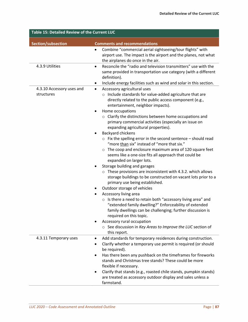
Detailed Review of the Current LUC
LUC 2020 – Code Assessment and Annotated Outline Page | 87
Table 15: Detailed Review of the Current LUC
Section/subsection Comments and recommendations
• Combine “commercial aerial sightseeing/tour flights” with airport use. The impact is the airport and the planes, not what the airplanes do once in the air.
4.3.9 Utilities • Reconcile the “radio and television transmitters” use with the same provided in transportation use category (with a different definition).
• Include energy facilities such as wind and solar in this section.
4.3.10 Accessory uses and structures
• Accessory agricultural uses o Include standards for value-added agriculture that are
directly related to the public access component (e.g., entertainment, neighbor impacts).
• Home occupations o Clarify the distinctions between home occupations and
primary commercial activities (especially an issue on expanding agricultural properties).
• Backyard chickens o Fix the spelling error in the second sentence – should read
“more than six” instead of “more that six.” o The coop and enclosure maximum area of 120 square feet
seems like a one-size fits all approach that could be expanded on larger lots.
• Storage building and garages o These provisions are inconsistent with 4.3.2. which allows
storage buildings to be constructed on vacant lots prior to a primary use being established.
• Outdoor storage of vehicles
• Accessory living area o Is there a need to retain both “accessory living area” and
“extended family dwelling?” Enforceability of extended family dwellings can be challenging; further discussion is required on this topic.
• Accessory rural occupation o See discussion in Key Areas to Improve the LUC section of
this report.
4.3.11 Temporary uses • Add standards for temporary residences during construction.
• Clarify whether a temporary use permit is required (or should be required).
• Has there been any pushback on the timeframes for fireworks stands and Christmas tree stands? These could be more flexible if necessary.
• Clarify that stands (e.g., roasted chile stands, pumpkin stands) are treated as accessory outdoor display and sales unless a farmstand.
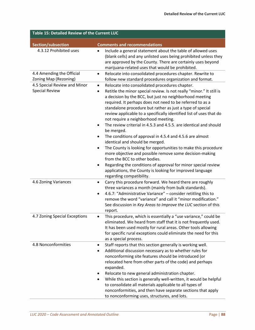
Detailed Review of the Current LUC
LUC 2020 – Code Assessment and Annotated Outline Page | 88
Table 15: Detailed Review of the Current LUC
Section/subsection Comments and recommendations
4.3.12 Prohibited uses • Include a general statement about the table of allowed uses (blank cells) and any unlisted uses being prohibited unless they are approved by the County. There are certainly uses beyond marijuana-related uses that would be prohibited.
4.4 Amending the Official Zoning Map (Rezoning)
• Relocate into consolidated procedures chapter. Rewrite to follow new standard procedures organization and format.
4.5 Special Review and Minor Special Review
• Relocate into consolidated procedures chapter.
• Retitle the minor special review. Is not really “minor.” It still is a decision by the BCC, but just no neighborhood meeting required. It perhaps does not need to be referred to as a standalone procedure but rather as just a type of special review applicable to a specifically identified list of uses that do not require a neighborhood meeting.
• The review criterial in 4.5.3 and 4.5.5. are identical and should be merged.
• The conditions of approval in 4.5.4 and 4.5.6 are almost identical and should be merged.
• The County is looking for opportunities to make this procedure more objective and possible remove some decision-making from the BCC to other bodies.
• Regarding the conditions of approval for minor special review applications, the County is looking for improved language regarding compatibility.
4.6 Zoning Variances • Carry this procedure forward. We heard there are roughly three variances a month (mainly from bulk standards).
• 4.6.7: “Administrative Variance” – consider retitling this to remove the word “variance” and call it “minor modification.” See discussion in Key Areas to Improve the LUC section of this report.
4.7 Zoning Special Exceptions • This procedure, which is essentially a “use variance,” could be eliminated. We heard from staff that it is not frequently used. It has been used mostly for rural areas. Other tools allowing for specific rural exceptions could eliminate the need for this as a special process.
4.8 Nonconformities • Staff reports that this section generally is working well.
• Additional discussion necessary as to whether rules for nonconforming site features should be introduced (or relocated here from other parts of the code) and perhaps expanded.
• Relocate to new general administration chapter.
• While this section is generally well-written, it would be helpful to consolidate all materials applicable to all types of nonconformities, and then have separate sections that apply to nonconforming uses, structures, and lots.
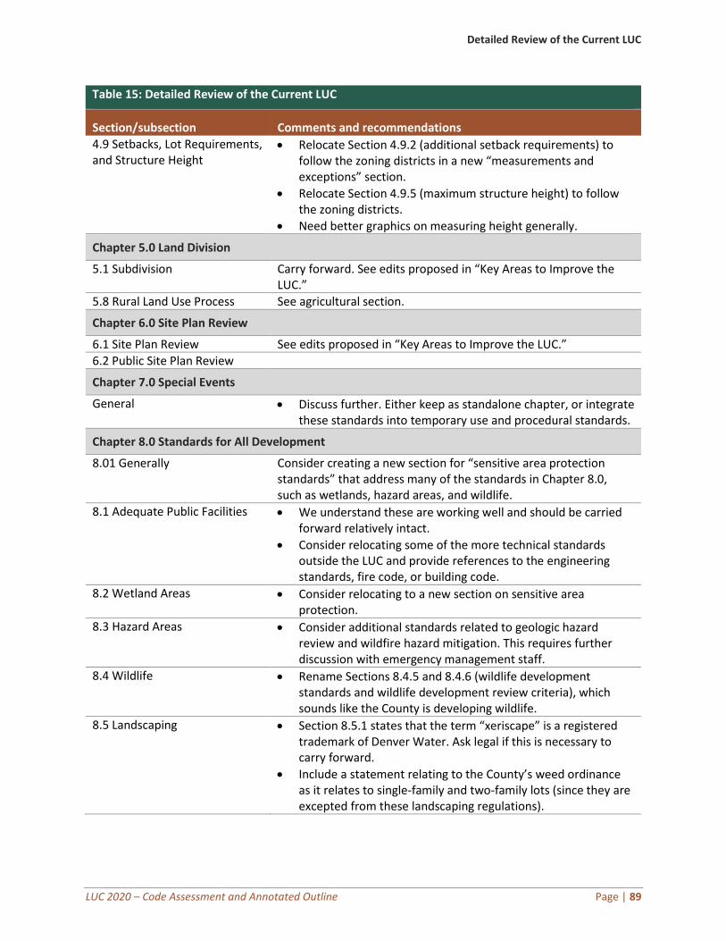
Detailed Review of the Current LUC
LUC 2020 – Code Assessment and Annotated Outline Page | 89
Table 15: Detailed Review of the Current LUC
Section/subsection Comments and recommendations
4.9 Setbacks, Lot Requirements, and Structure Height
• Relocate Section 4.9.2 (additional setback requirements) to follow the zoning districts in a new “measurements and exceptions” section.
• Relocate Section 4.9.5 (maximum structure height) to follow the zoning districts.
• Need better graphics on measuring height generally.
Chapter 5.0 Land Division
5.1 Subdivision Carry forward. See edits proposed in “Key Areas to Improve the LUC.”
5.8 Rural Land Use Process See agricultural section.
Chapter 6.0 Site Plan Review
6.1 Site Plan Review See edits proposed in “Key Areas to Improve the LUC.”
6.2 Public Site Plan Review
Chapter 7.0 Special Events
General • Discuss further. Either keep as standalone chapter, or integrate these standards into temporary use and procedural standards.
Chapter 8.0 Standards for All Development
8.01 Generally Consider creating a new section for “sensitive area protection standards” that address many of the standards in Chapter 8.0, such as wetlands, hazard areas, and wildlife.
8.1 Adequate Public Facilities • We understand these are working well and should be carried forward relatively intact.
• Consider relocating some of the more technical standards outside the LUC and provide references to the engineering standards, fire code, or building code.
8.2 Wetland Areas • Consider relocating to a new section on sensitive area protection.
8.3 Hazard Areas • Consider additional standards related to geologic hazard review and wildfire hazard mitigation. This requires further discussion with emergency management staff.
8.4 Wildlife • Rename Sections 8.4.5 and 8.4.6 (wildlife development standards and wildlife development review criteria), which sounds like the County is developing wildlife.
8.5 Landscaping • Section 8.5.1 states that the term “xeriscape” is a registered trademark of Denver Water. Ask legal if this is necessary to carry forward.
• Include a statement relating to the County’s weed ordinance as it relates to single-family and two-family lots (since they are excepted from these landscaping regulations).
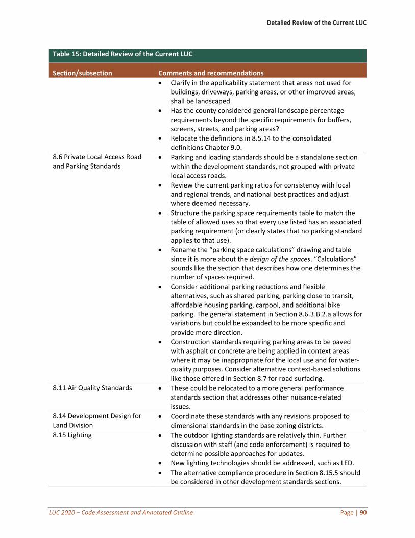
Detailed Review of the Current LUC
LUC 2020 – Code Assessment and Annotated Outline Page | 90
Table 15: Detailed Review of the Current LUC
Section/subsection Comments and recommendations
• Clarify in the applicability statement that areas not used for buildings, driveways, parking areas, or other improved areas, shall be landscaped.
• Has the county considered general landscape percentage requirements beyond the specific requirements for buffers, screens, streets, and parking areas?
• Relocate the definitions in 8.5.14 to the consolidated definitions Chapter 9.0.
8.6 Private Local Access Road and Parking Standards
• Parking and loading standards should be a standalone section within the development standards, not grouped with private local access roads.
• Review the current parking ratios for consistency with local and regional trends, and national best practices and adjust where deemed necessary.
• Structure the parking space requirements table to match the table of allowed uses so that every use listed has an associated parking requirement (or clearly states that no parking standard applies to that use).
• Rename the “parking space calculations” drawing and table since it is more about the design of the spaces. “Calculations” sounds like the section that describes how one determines the number of spaces required.
• Consider additional parking reductions and flexible alternatives, such as shared parking, parking close to transit, affordable housing parking, carpool, and additional bike parking. The general statement in Section 8.6.3.B.2.a allows for variations but could be expanded to be more specific and provide more direction.
• Construction standards requiring parking areas to be paved with asphalt or concrete are being applied in context areas where it may be inappropriate for the local use and for water-quality purposes. Consider alternative context-based solutions like those offered in Section 8.7 for road surfacing.
8.11 Air Quality Standards • These could be relocated to a more general performance standards section that addresses other nuisance-related issues.
8.14 Development Design for Land Division
• Coordinate these standards with any revisions proposed to dimensional standards in the base zoning districts.
8.15 Lighting • The outdoor lighting standards are relatively thin. Further discussion with staff (and code enforcement) is required to determine possible approaches for updates.
• New lighting technologies should be addressed, such as LED.
• The alternative compliance procedure in Section 8.15.5 should be considered in other development standards sections.
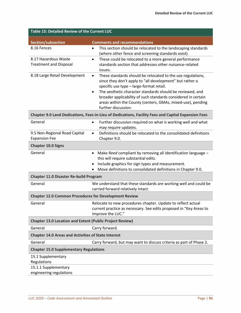
Detailed Review of the Current LUC
LUC 2020 – Code Assessment and Annotated Outline Page | 91
Table 15: Detailed Review of the Current LUC
Section/subsection Comments and recommendations
8.16 Fences • This section should be relocated to the landscaping standards (where other fence and screening standards exist).
8.17 Hazardous Waste Treatment and Disposal
• These could be relocated to a more general performance standards section that addresses other nuisance-related issues.
8.18 Large Retail Development • These standards should be relocated to the use regulations, since they don’t apply to “all development” but rather a specific use type – large-format retail.
• The aesthetic character standards should be reviewed, and broader applicability of such standards considered in certain areas within the County (centers, GMAs, mixed-use), pending further discussion.
Chapter 9.0 Land Dedications, Fees-in-Lieu of Dedications, Facility Fees and Capital Expansion Fees
General • Further discussion required on what is working well and what may require updates.
9.5 Non-Regional Road Capital Expansion Fee
• Definitions should be relocated to the consolidated definitions Chapter 9.0.
Chapter 10.0 Signs
General • Make Reed compliant by removing all identification language – this will require substantial edits.
• Include graphics for sign types and measurement.
• Move definitions to consolidated definitions in Chapter 9.0.
Chapter 11.0 Disaster Re-build Program
General We understand that these standards are working well and could be carried forward relatively intact.
Chapter 12.0 Common Procedures for Development Review
General Relocate to new procedures chapter. Update to reflect actual current practice as necessary. See edits proposed in “Key Areas to Improve the LUC.”
Chapter 13.0 Location and Extent (Public Project Review)
General Carry forward.
Chapter 14.0 Areas and Activities of State Interest
General Carry forward, but may want to discuss criteria as part of Phase 2.
Chapter 15.0 Supplementary Regulations
15.1 Supplementary Regulations
15.1.1 Supplementary engineering regulations
Detailed Review of the Current LUC
LUC 2020 – Code Assessment and Annotated Outline Page | 92
Table 15: Detailed Review of the Current LUC
Section/subsection Comments and recommendations
15.1.2 Supplementary regulations for growth management areas
15.3 Reserved
Chapter 16.0 Commercial Mobile Radio Service (CMRS) Facilities
General • Pending updates will be incorporated into the LUC as they become available.
Chapter 18.0 Manufactured Homes, Manufactured Home Parks, Recreational Vehicle Parks and Campgrounds
General • Staff notes that a complete rewrite of these standards is necessary. These standards as updated should be relocated to use regulations. Policy discussions related to mobile homes may be relevant to this rewrite.
18.4 Campgrounds • These standards should be reconciled with “seasonal campground” use. Evaluate whether two types of campgrounds are necessary, since most applications all have an RV component.
Chapter 21.0 Enforcement
General • These standards should be located with the general provisions of the LUC as proposed in the Annotated Outline.
• Rewrite to include the full range of enforcement penalties and tools available to Colorado statutory counties.
Chapter 22.0 Appeals
22.1 Purpose Carry forward in procedures. Consider a narrower scope of the right to appeal during the drafting process.
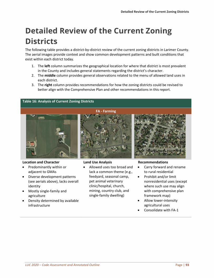
Detailed Review of the Current Zoning Districts
LUC 2020 – Code Assessment and Annotated Outline Page | 93
Detailed Review of the Current Zoning
Districts The following table provides a district-by-district review of the current zoning districts in Larimer County. The aerial images provide context and show common development patterns and built conditions that exist within each district today.
1. The left column summarizes the geographical location for where that district is most prevalent in the County and includes general statements regarding the district’s character.
2. The middle column provides general observations related to the menu of allowed land uses in each district.
3. The right column provides recommendations for how the zoning districts could be revised to better align with the Comprehensive Plan and other recommendations in this report.
Table 16: Analysis of Current Zoning Districts
FA - Farming
Location and Character
• Predominantly within or adjacent to GMAs
• Diverse development patterns (see aerials above), lacks overall identity
• Mostly single-family and agriculture
• Density determined by available infrastructure
Land Use Analysis
• Allowed uses too broad and lack a common theme (e.g., feedyard, seasonal camp, pet animal veterinary clinic/hospital, church, mining, country club, and single-family dwelling)
Recommendations
• Carry forward and rename to rural residential
• Prohibit and/or limit nonresidential uses (except where such use may align with comprehensive plan framework map)
• Allow lower-intensity agricultural uses
• Consolidate with FA-1
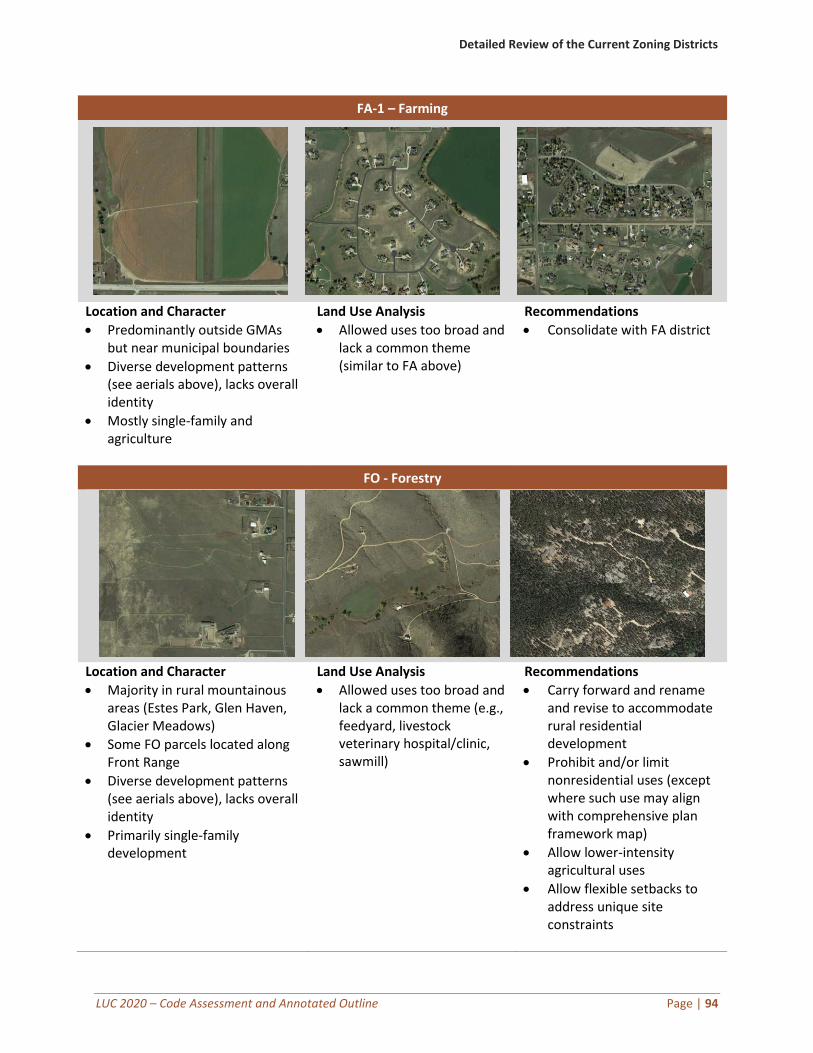
Detailed Review of the Current Zoning Districts
LUC 2020 – Code Assessment and Annotated Outline Page | 94
FA-1 – Farming
Location and Character
• Predominantly outside GMAs but near municipal boundaries
• Diverse development patterns (see aerials above), lacks overall identity
• Mostly single-family and agriculture
Land Use Analysis
• Allowed uses too broad and lack a common theme (similar to FA above)
Recommendations
• Consolidate with FA district
FO - Forestry
Location and Character
• Majority in rural mountainous areas (Estes Park, Glen Haven, Glacier Meadows)
• Some FO parcels located along Front Range
• Diverse development patterns (see aerials above), lacks overall identity
• Primarily single-family development
Land Use Analysis
• Allowed uses too broad and lack a common theme (e.g., feedyard, livestock veterinary hospital/clinic, sawmill)
Recommendations
• Carry forward and rename and revise to accommodate rural residential development
• Prohibit and/or limit nonresidential uses (except where such use may align with comprehensive plan framework map)
• Allow lower-intensity agricultural uses
• Allow flexible setbacks to address unique site constraints
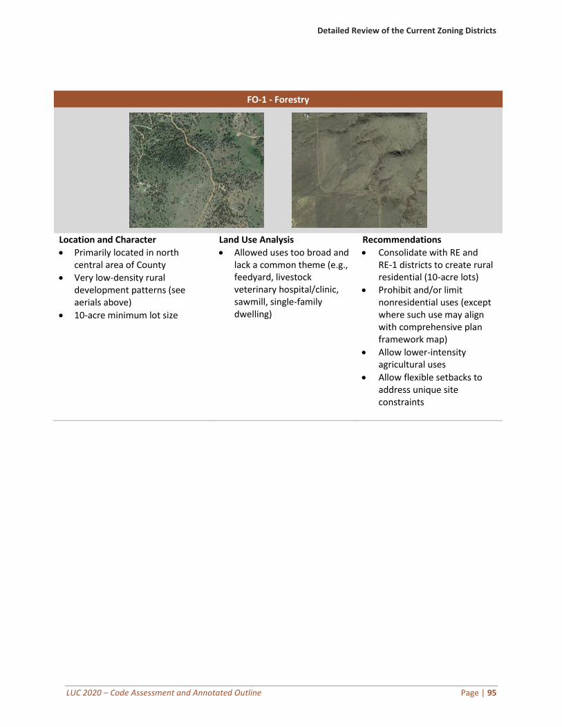
Detailed Review of the Current Zoning Districts
LUC 2020 – Code Assessment and Annotated Outline Page | 95
FO-1 - Forestry
Location and Character
• Primarily located in north central area of County
• Very low-density rural development patterns (see aerials above)
• 10-acre minimum lot size
Land Use Analysis
• Allowed uses too broad and lack a common theme (e.g., feedyard, livestock veterinary hospital/clinic, sawmill, single-family dwelling)
Recommendations
• Consolidate with RE and RE-1 districts to create rural residential (10-acre lots)
• Prohibit and/or limit nonresidential uses (except where such use may align with comprehensive plan framework map)
• Allow lower-intensity agricultural uses
• Allow flexible setbacks to address unique site constraints
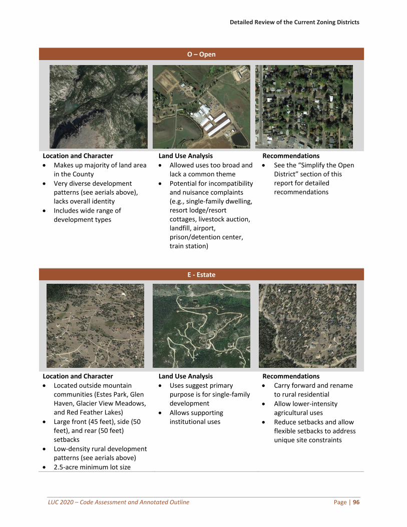
Detailed Review of the Current Zoning Districts
LUC 2020 – Code Assessment and Annotated Outline Page | 96
O – Open
Location and Character
• Makes up majority of land area in the County
• Very diverse development patterns (see aerials above), lacks overall identity
• Includes wide range of development types
Land Use Analysis
• Allowed uses too broad and lack a common theme
• Potential for incompatibility and nuisance complaints (e.g., single-family dwelling, resort lodge/resort cottages, livestock auction, landfill, airport, prison/detention center, train station)
Recommendations
• See the “Simplify the Open District” section of this report for detailed recommendations
E - Estate
Location and Character
• Located outside mountain communities (Estes Park, Glen Haven, Glacier View Meadows, and Red Feather Lakes)
• Large front (45 feet), side (50 feet), and rear (50 feet) setbacks
• Low-density rural development patterns (see aerials above)
• 2.5-acre minimum lot size
Land Use Analysis
• Uses suggest primary purpose is for single-family development
• Allows supporting institutional uses
Recommendations
• Carry forward and rename to rural residential
• Allow lower-intensity agricultural uses
• Reduce setbacks and allow flexible setbacks to address unique site constraints
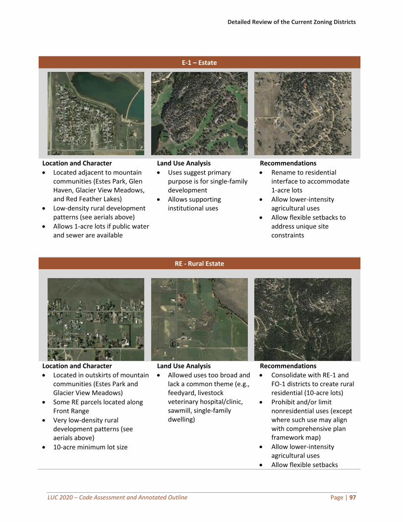
Detailed Review of the Current Zoning Districts
LUC 2020 – Code Assessment and Annotated Outline Page | 97
E-1 – Estate
Location and Character
• Located adjacent to mountain communities (Estes Park, Glen Haven, Glacier View Meadows, and Red Feather Lakes)
• Low-density rural development patterns (see aerials above)
• Allows 1-acre lots if public water and sewer are available
Land Use Analysis
• Uses suggest primary purpose is for single-family development
• Allows supporting institutional uses
Recommendations
• Rename to residential interface to accommodate 1-acre lots
• Allow lower-intensity agricultural uses
• Allow flexible setbacks to address unique site constraints
RE - Rural Estate
Location and Character
• Located in outskirts of mountain communities (Estes Park and Glacier View Meadows)
• Some RE parcels located along Front Range
• Very low-density rural development patterns (see aerials above)
• 10-acre minimum lot size
Land Use Analysis
• Allowed uses too broad and lack a common theme (e.g., feedyard, livestock veterinary hospital/clinic, sawmill, single-family dwelling)
Recommendations
• Consolidate with RE-1 and FO-1 districts to create rural residential (10-acre lots)
• Prohibit and/or limit nonresidential uses (except where such use may align with comprehensive plan framework map)
• Allow lower-intensity agricultural uses
• Allow flexible setbacks

Detailed Review of the Current Zoning Districts
LUC 2020 – Code Assessment and Annotated Outline Page | 98
RE-1 - Rural Estate
Location and Character
• Primarily located outside of Estes Park
• Very low-density rural development patterns (see aerials above)
• 10-acre minimum lot size
Land Use Analysis
• Uses suggest primary purpose is for single-family development
• Allows supporting institutional uses
Recommendations
• Consolidate with RE and FO-1 districts to create rural residential (10-acre lots)
• Allow lower-intensity agricultural uses
• Allow flexible setbacks to address unique site constraints
R - Residential
Location and Character
• Predominately within GMAs
• Traditional suburban-style residential development patterns
• Density determined by available infrastructure (15,000 square feet for water and sewer-served site)
Land Use Analysis
• Mostly residential, except that hospitals and some supporting institutional uses are allowed
Recommendations
• Carry forward and rename to urban residential
• Consider allowing lower-intensity accessory agricultural uses
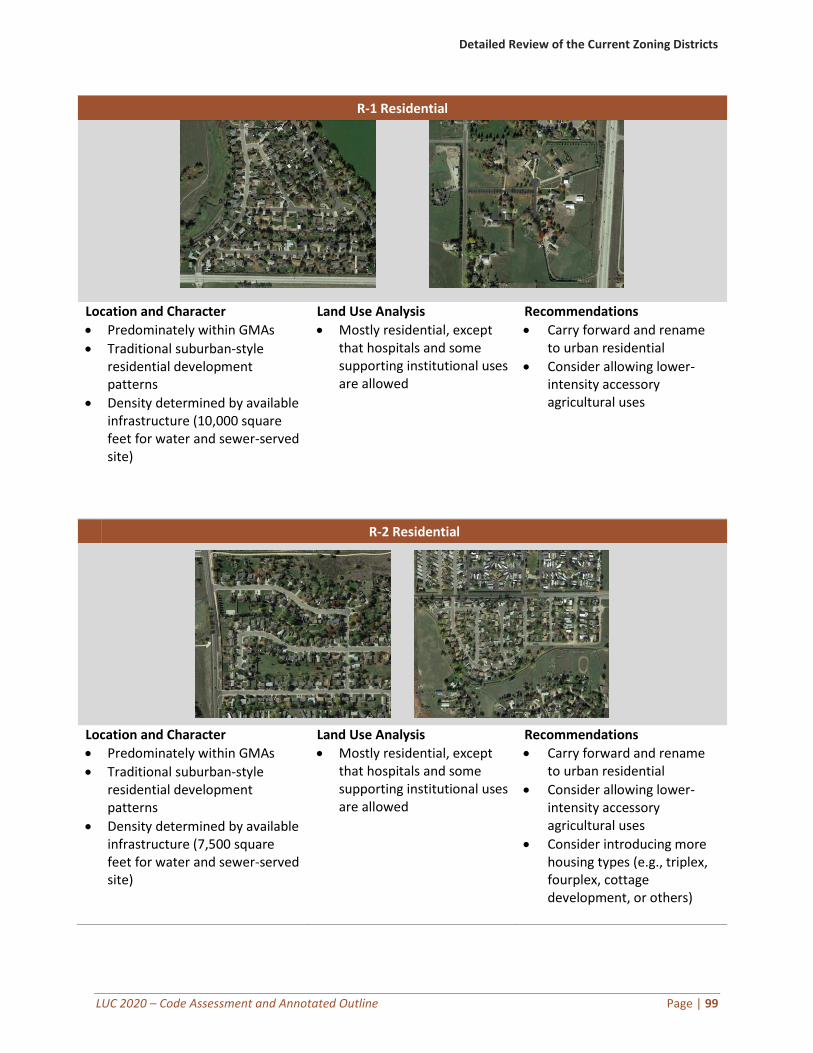
Detailed Review of the Current Zoning Districts
LUC 2020 – Code Assessment and Annotated Outline Page | 99
R-1 Residential
Location and Character
• Predominately within GMAs
• Traditional suburban-style residential development patterns
• Density determined by available infrastructure (10,000 square feet for water and sewer-served site)
Land Use Analysis
• Mostly residential, except that hospitals and some supporting institutional uses are allowed
Recommendations
• Carry forward and rename to urban residential
• Consider allowing lower-intensity accessory agricultural uses
R-2 Residential
Location and Character
• Predominately within GMAs
• Traditional suburban-style residential development patterns
• Density determined by available infrastructure (7,500 square feet for water and sewer-served site)
Land Use Analysis
• Mostly residential, except that hospitals and some supporting institutional uses are allowed
Recommendations
• Carry forward and rename to urban residential
• Consider allowing lower-intensity accessory agricultural uses
• Consider introducing more housing types (e.g., triplex, fourplex, cottage development, or others)
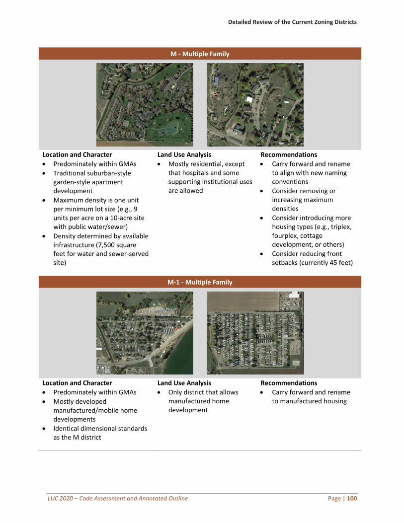
Detailed Review of the Current Zoning Districts
LUC 2020 – Code Assessment and Annotated Outline Page | 100
M - Multiple Family
Location and Character
• Predominately within GMAs
• Traditional suburban-style garden-style apartment development
• Maximum density is one unit per minimum lot size (e.g., 9 units per acre on a 10-acre site with public water/sewer)
• Density determined by available infrastructure (7,500 square feet for water and sewer-served site)
Land Use Analysis
• Mostly residential, except that hospitals and some supporting institutional uses are allowed
Recommendations
• Carry forward and rename to align with new naming conventions
• Consider removing or increasing maximum densities
• Consider introducing more housing types (e.g., triplex, fourplex, cottage development, or others)
• Consider reducing front setbacks (currently 45 feet)
M-1 - Multiple Family
Location and Character
• Predominately within GMAs
• Mostly developed manufactured/mobile home developments
• Identical dimensional standards as the M district
Land Use Analysis
• Only district that allows manufactured home development
Recommendations
• Carry forward and rename to manufactured housing
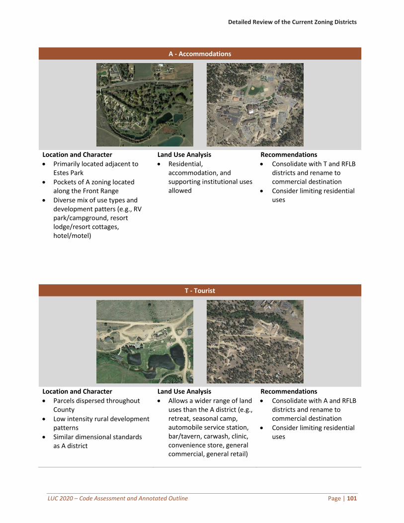
Detailed Review of the Current Zoning Districts
LUC 2020 – Code Assessment and Annotated Outline Page | 101
A - Accommodations
Location and Character
• Primarily located adjacent to Estes Park
• Pockets of A zoning located along the Front Range
• Diverse mix of use types and development patters (e.g., RV park/campground, resort lodge/resort cottages, hotel/motel)
Land Use Analysis
• Residential, accommodation, and supporting institutional uses allowed
Recommendations
• Consolidate with T and RFLB districts and rename to commercial destination
• Consider limiting residential uses
T - Tourist
Location and Character
• Parcels dispersed throughout County
• Low intensity rural development patterns
• Similar dimensional standards as A district
Land Use Analysis
• Allows a wider range of land uses than the A district (e.g., retreat, seasonal camp, automobile service station, bar/tavern, carwash, clinic, convenience store, general commercial, general retail)
Recommendations
• Consolidate with A and RFLB districts and rename to commercial destination
• Consider limiting residential uses
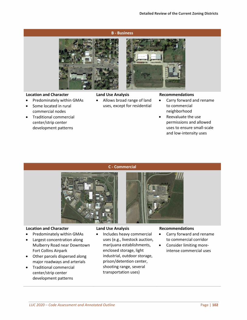
Detailed Review of the Current Zoning Districts
LUC 2020 – Code Assessment and Annotated Outline Page | 102
B - Business
Location and Character
• Predominately within GMAs
• Some located in rural commercial nodes
• Traditional commercial center/strip center development patterns
Land Use Analysis
• Allows broad range of land uses, except for residential
Recommendations
• Carry forward and rename to commercial neighborhood
• Reevaluate the use permissions and allowed uses to ensure small-scale and low-intensity uses
C - Commercial
Location and Character
• Predominately within GMAs
• Largest concentration along Mulberry Road near Downtown Fort Collins Airpark
• Other parcels dispersed along major roadways and arterials
• Traditional commercial center/strip center development patterns
Land Use Analysis
• Includes heavy commercial uses (e.g., livestock auction, marijuana establishments, enclosed storage, light industrial, outdoor storage, prison/detention center, shooting range, several transportation uses)
Recommendations
• Carry forward and rename to commercial corridor
• Consider limiting more-intense commercial uses
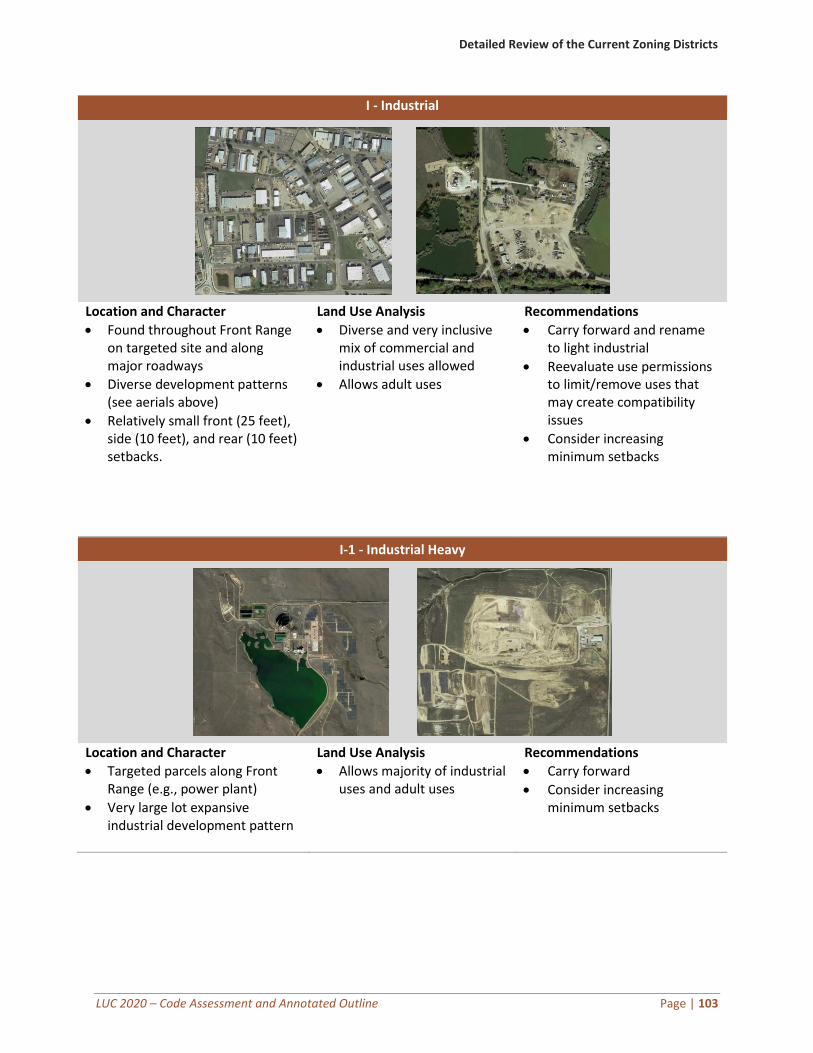
Detailed Review of the Current Zoning Districts
LUC 2020 – Code Assessment and Annotated Outline Page | 103
I - Industrial
Location and Character
• Found throughout Front Range on targeted site and along major roadways
• Diverse development patterns (see aerials above)
• Relatively small front (25 feet), side (10 feet), and rear (10 feet) setbacks.
Land Use Analysis
• Diverse and very inclusive mix of commercial and industrial uses allowed
• Allows adult uses
Recommendations
• Carry forward and rename to light industrial
• Reevaluate use permissions to limit/remove uses that may create compatibility issues
• Consider increasing minimum setbacks
I-1 - Industrial Heavy
Location and Character
• Targeted parcels along Front Range (e.g., power plant)
• Very large lot expansive industrial development pattern
Land Use Analysis
• Allows majority of industrial uses and adult uses
Recommendations
• Carry forward
• Consider increasing minimum setbacks
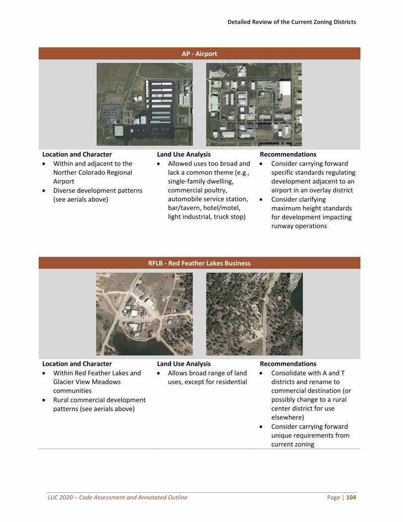
Detailed Review of the Current Zoning Districts
LUC 2020 – Code Assessment and Annotated Outline Page | 104
AP - Airport
Location and Character
• Within and adjacent to the Norther Colorado Regional Airport
• Diverse development patterns (see aerials above)
Land Use Analysis
• Allowed uses too broad and lack a common theme (e.g., single-family dwelling, commercial poultry, automobile service station, bar/tavern, hotel/motel, light industrial, truck stop)
Recommendations
• Consider carrying forward specific standards regulating development adjacent to an airport in an overlay district
• Consider clarifying maximum height standards for development impacting runway operations
RFLB - Red Feather Lakes Business
Location and Character
• Within Red Feather Lakes and Glacier View Meadows communities
• Rural commercial development patterns (see aerials above)
Land Use Analysis
• Allows broad range of land uses, except for residential
Recommendations
• Consolidate with A and T districts and rename to commercial destination (or possibly change to a rural center district for use elsewhere)
• Consider carrying forward unique requirements from current zoning