Embed Size (px)
Citation preview
LUCID’s Land Use Change Analysis as an Approach
for Investigating Biodiversity Loss and Land Degradation Project
Land Use Change Analysis as an Approach for Investigating Biodiversity Loss and Land Degradation:
A Targeted Research Project Proposal to UNEP-GEF
LUCID Project Working Paper 13
By
Jennifer M. Olson, Francois Bart, David J. Campbell, Helen Gichohi, Joseph M. Maitima, Milline Mbonile, Salome Misana, Samuel Mugisha, Joy Tukahirwa and Robin S. Reid
September 2000
Internation
Address Correspondence to:LUCID Project
al Livestock Research InstituteP.O. Box 30709Nairobi, Kenya
E-mail: [email protected]. +254-20-4223000Fax. +254-20-4223001

Land Use Change Analysis as an Approach for Investigating Biodiversity Loss and Land Degradation:
A Targeted Research Project Proposal to UNEP-GEF
The Land Use Change, Impacts and Dynamics Project
Working Paper Number 13
By
Jennifer M. Olson, Francois Bart, David J. Campbell, Helen Gichohi, Joseph M. Maitima, Milline Mbonile, Salome Misana, Samuel Mugisha, Joy Tukahirwa and Robin S. Reid
September 2000
Address Correspondence to:LUCID Project
International Livestock Research InstituteP.O. Box 30709Nairobi, Kenya
E-mail: [email protected]. +254-20-4223000Fax. +254-20-4223001
Copyright © 2000 by the: Michigan State University Board of Trustees, The University of Dar es Salaam, Makerere University, International Livestock Research Institute, and United Nations Environment Programme/Division of Global Environment Facility Coordination. All rights reserved. Reproduction of LUCID Working Papers for non-commercial purposes is encouraged. Working papers may be quoted or reproduced free of charge provided the source is acknowledged and cited. Cite working paper as follows: Author. Year. Title. Land Use Change Impacts and Dynamics (LUCID) Project Working Paper #. Nairobi, Kenya: International Livestock Research Institute. Working papers are available on www.lucideastafrica.org or by emailing [email protected].
LUCID Working Paper 13 ii
TABLE OF CONTENTS 1. INTRODUCTION............................................................................................................... 1 II. PROJECT RATIONALE AND OBJECTIVES.................................................................. 1 III. A REVIEW OF RELEVANT RESEARCH....................................................................... 5 IV. CURRENT SITUATION IN EAST AFRICA .................................................................. 8 V. RESEARCH HYPOTHESIS TO BE TESTED IN THE PROJECT............................... 10 VI. ACTIVITIES................................................................................................................... 11 A. Introduction .............................................................................................................. 11 B. Site level data............................................................................................................ 15 C. National level data .................................................................................................... 16 D. Integrative Themes ................................................................................................... 16 VII. CONCLUSION............................................................................................................... 17 REFERENCES....................................................................................................................... 18
TABLES 1. Site Descriptions.................................................................................................................. 3
2. Site Research Methods ...................................................................................................... 12
LUCID Working Paper 13 iii
I. INTRODUCTION The "Land Use Change Analysis as an Approach for Investigating Biodiversity Loss and Land Degradation" is a medium sized targeted research project funded by United Nations Environment Programme-Global Environment Facility (UNEP-GEF) and other donors. The project provides an umbrella for coordinated research activities occurring in sites across East Africa, and at the East Africa regional level. The project’s goal is to contribute to the conservation of biodiversity and prevention of land degradation by providing useful instruments, or methodological guides, to identify and monitor changes in the landscape associated with biodiversity loss and land degradation, and to identify the root causes of those changes. The main approach has been to examine the linkages between the processes of change in biodiversity, land degradation and land use in East Africa in order to derive information and experience upon which to base the design of the guides for detecting such trends. Various ecological, socioeconomic and land use change theories and conceptual frameworks have informed the research and the guides. The project is being conducted by the LUCID (Land Use Change, Impacts, and Dynamics) team. LUCID is a partnership of scientists at national and international institutions who have been studying land use change in East Africa and its implications for land degradation, biodiversity, and climate change for over twenty years. LUCID developed a formal research programme for UNEP-GEF to consolidate the findings from long term research sites concerning the causes and consequences of land use change, land degradation and change in biodiversity. This LUCID Working Paper is drawn from the proposal submitted to UNEP-GEF in 2000 (GEF 2000). It provides a description of the objectives of the project, the research and environmental situation in East Africa, summarizes current research on this topic, and outlines the hypotheses and methodology for the new cross-site data collection and analysis.1 II. PROJECT RATIONALE AND OBJECTIVES The project will provide critical tools derived from land use change analysis for use by GEF, subsequent GEF projects, decision makers and NGOs in meeting GEF operational goals in biodiversity conservation, and prevention and mitigation of land degradation. Development of these tools emanates from the need to identify the linkages between land degradation and the GEF focal areas (GEF 1999). The information developed by the project on the linkages between biodiversity and land degradation will assist in the design of GEF projects on land degradation with multi-focal area benefits. The complexity of interactions between ecological and societal processes over time and space has challenged attempts to understand the linkages between change in biodiversity and land degradation. Land use change analyses provide an entry into understanding these linkages and associated processes. As discussed in the report of the STAP (1999) expert group workshop on land degradation, land use change analysis is a particularly useful tool because it a) provides information on the wide societal forces leading to environmental change, b) is a cause in and of itself of land degradation and loss of biodiversity, and c) provides information on the type and extent of environmental change. The land use change analysis approach will be developed and tested in a region of high risk to biodiversity and land degradation, East Africa. This is an area rich with existing research that the project can draw upon. It is also an area with a history of varied environmental management regimes and programs that provide many lessons.
1 The actual activities conducted by the project somewhat differ from what was proposed. For example, two sites in Uganda were added, and a variety of specific studies not mentioned in the proposal were completed. A full set of these papers are available on the internet at www.lucideastafrica.org.
LUCID Working Paper 13 1
The project falls under the GEF Operational Programme number one on Arid and Semi-Arid Ecosystems. The tool will be developed and tested in the semi-arid region of East Africa, a region with abundant biodiversity and of high risk to biodiversity loss and land degradation. This is an area rich with existing research that the project can draw upon. It is also an area with a history of varied environmental management regimes and programs that provide many lessons (Tengberg et al. 1998). The project will build upon a foundation of long term detailed landscape scale site studies of environmental change and resource management in three East African countries (Kenya, Tanzania and Uganda). The four sites are representative of highland to lowland ecological gradients in East Africa, and the semi-arid plains in the lowlands contain biodiversity and land degradation characteristics and problems representative of those ecosystems within the wider region. The sites have comparable physical environments in terms of the range of rainfall and temperature across their ecological gradients, with corresponding agroecological zones which range from cool highland agricultural systems growing tea and/or coffee, to hot, semi-arid areas formerly dominated by nomadic herding and wildlife. The lowland areas, as in many semi-arid areas of Africa and indeed elsewhere, are currently experiencing broad socioeconomic processes that are profoundly influencing land use, including an economy shifting in favour of crops, in-migration by cultivators, local human population growth, and a transformation of the land tenure system towards privatisation. These environmental and socioeconomic similarities will encourage comparability and permit the development of generalisations, including cross-site statistical analyses and modelling exercises. Despite their similarities in environment and current socioeconomic processes, however, the four sites are each unique due to their varied political, cultural and economic histories (Table 1). Past and current land use reflects these differences, as do the current state of biodiversity and land degradation. The two sites on the slopes of Mt. Kilimanjaro, for example, straddle the national boundary between Kenya and Tanzania and, despite similar ecosystems and a comparable ethnic composition, the land reflects different national socio-political histories. Indeed, the difference is visible from the air; the border between the two countries can be traced on satellite imagery and aerial photographs. The Tanzanian side is intensely cultivated with a high density of planted trees and bananas, whereas the Kenyan side is less intensely cultivated. The agricultural production on Tanzanian side of the mountain has been central to its national economy, whereas the Kenya side of the mountain has only recently attracted important national economic policy and infrastructure attention with a spreading of commercial crop production in particular places. The wildlife resources shared across the border have also been differently managed, with resultant contrasting community/ wildlife relationships. In many respects, the site in Embu and Mbeere Districts on the eastern slopes of Mt. Kenya resembles the Tanzanian side of Mt. Kilimanjaro more closely than the site on the Kenyan side of the mountain. Similarities include a history of intensely cultivated highlands, important downslope migration into the agro-pastoral area, and land management being influenced by strong ties to the urban sector and to the national and international market. The site in southwest Uganda also has a history of intensely cultivated highlands, though until recently without the strong ties to the national and international market and without the soil management practices found in Embu and the Tanzania site. For a variety of cultural and political reasons, the adjacent semi-arid areas have only recently started to experience in-migration by cultivators coming from the humid region.
LUCID Working Paper 13 2
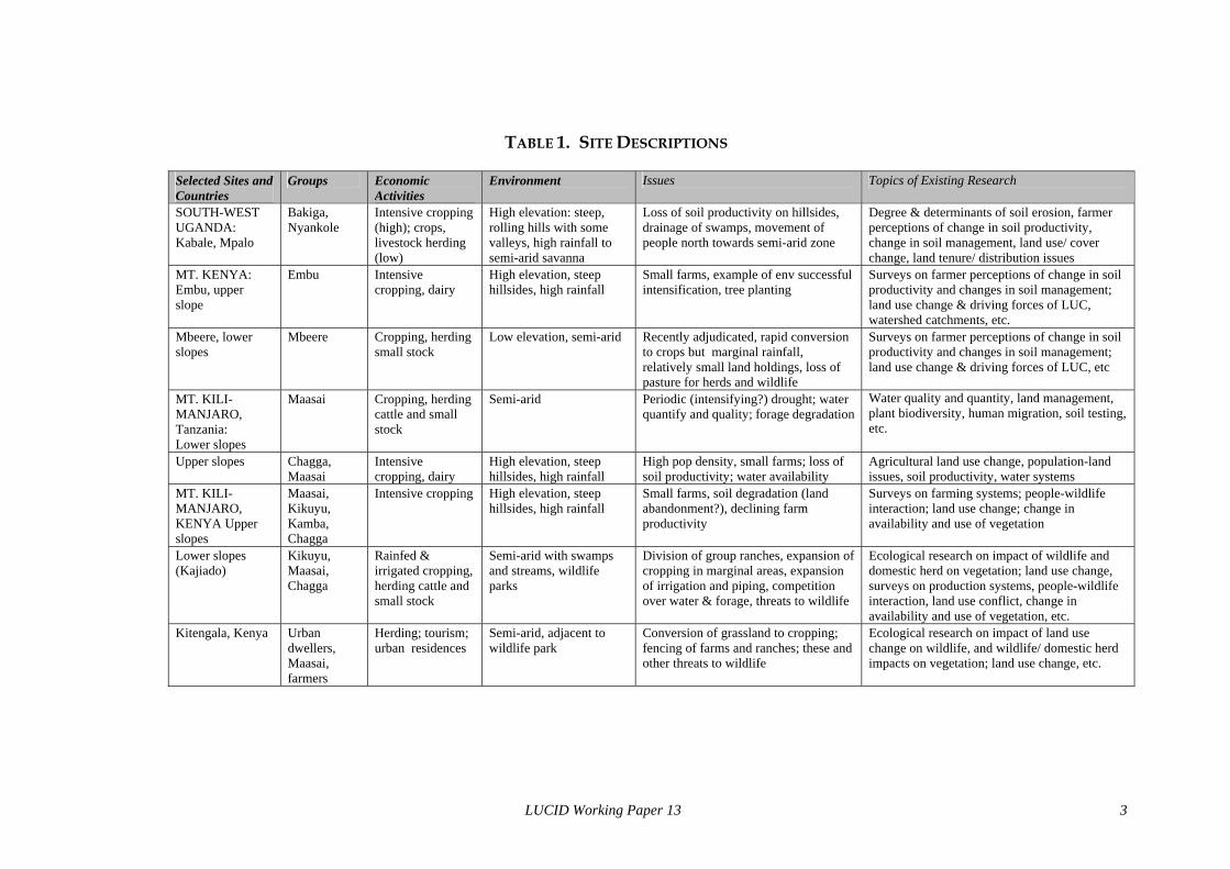
TABLE 1. SITE DESCRIPTIONS
Selected Sites and Countries
Groups
Economic Activities
Environment
Issues
Topics of Existing Research
SOUTH-WEST UGANDA: Kabale, Mpalo
Bakiga, Nyankole
Intensive cropping (high); crops, livestock herding (low)
High elevation: steep, rolling hills with some valleys, high rainfall to semi-arid savanna
Loss of soil productivity on hillsides, drainage of swamps, movement of people north towards semi-arid zone
Degree & determinants of soil erosion, farmer perceptions of change in soil productivity, change in soil management, land use/ cover change, land tenure/ distribution issues
MT. KENYA: Embu, upper slope
Embu
Intensive cropping, dairy
High elevation, steep hillsides, high rainfall
Small farms, example of env successful intensification, tree planting
Surveys on farmer perceptions of change in soil productivity and changes in soil management; land use change & driving forces of LUC, watershed catchments, etc.
Mbeere, lower slopes
Mbeere
Cropping, herding small stock
Low elevation, semi-arid
Recently adjudicated, rapid conversion to crops but marginal rainfall, relatively small land holdings, loss of pasture for herds and wildlife
Surveys on farmer perceptions of change in soil productivity and changes in soil management; land use change & driving forces of LUC, etc
MT. KILI-MANJARO, Tanzania: Lower slopes
Maasai
Cropping, herding cattle and small stock
Semi-arid
Periodic (intensifying?) drought; water quantify and quality; forage degradation
Water quality and quantity, land management, plant biodiversity, human migration, soil testing, etc.
Upper slopes
Chagga, Maasai
Intensive cropping, dairy
High elevation, steep hillsides, high rainfall
High pop density, small farms; loss of soil productivity; water availability
Agricultural land use change, population-land issues, soil productivity, water systems
MT. KILI-MANJARO, KENYA Upper slopes
Maasai, Kikuyu, Kamba, Chagga
Intensive cropping
High elevation, steep hillsides, high rainfall
Small farms, soil degradation (land abandonment?), declining farm productivity
Surveys on farming systems; people-wildlife interaction; land use change; change in availability and use of vegetation
Lower slopes (Kajiado)
Kikuyu, Maasai, Chagga
Rainfed & irrigated cropping, herding cattle and small stock
Semi-arid with swamps and streams, wildlife parks
Division of group ranches, expansion of cropping in marginal areas, expansion of irrigation and piping, competition over water & forage, threats to wildlife
Ecological research on impact of wildlife and domestic herd on vegetation; land use change, surveys on production systems, people-wildlife interaction, land use conflict, change in availability and use of vegetation, etc.
Kitengala, Kenya Urban dwellers, Maasai, farmers
Herding; tourism; urban residences
Semi-arid, adjacent to wildlife park
Conversion of grassland to cropping; fencing of farms and ranches; these and other threats to wildlife
Ecological research on impact of land use change on wildlife, and wildlife/ domestic herd impacts on vegetation; land use change, etc.
LUCID Working Paper 13 3
These similarities and idiosyncrasies of the four sites are typical of any sites that could be chosen. They will be important in evaluating the relative importance of the various external and local factors influencing land use change, and its impacts on biodiversity and land degradation. Due to having four comparable sites with comparable information, the team will be able to develop generalisations of the root causes of land use change and synthesize data on the linkages between land use change, biodiversity and land degradation. The four case studies are being conducted within a similar framework that examines the impact of land use change on environmental conditions including land degradation, biodiversity, hydrology and deforestation. This project would support additional data collection and analysis to provide data complementarity between sites, allowing cross-site comparison of the team’s research findings for the first time, and the development of the guide to land use change analysis and a replicable framework to identify root causes. It will thus provide global environmental change researchers and policy makers critical insights into the linkages between land degradation and biodiversity, and tested approaches for such analyses. It will provide the communities and countries vital information necessary for effective land use and other policy addressing these serious environmental challenges. The scientific information base will contribute to policy formation to improve peoples’ livelihoods and promote ecological integrity. It will complement existing projects and research by illustrating how current approaches and findings might more effectively meet ecological and socioeconomic objectives through an integrated assessment of issues and alternatives. It will contribute to activities that assist East African governments to fulfil their commitment to their NEAPs and NAPs through policies that reduce environmental degradation, foster biodiversity conservation, and promote rural development and natural resources management. The project will contribute to current inquiries concerning environmental change in the social and biophysical sciences, and especially in the integration of the two. It will do this through a deliberate design of research questions that require consideration of the impact of the social system on environmental variables and vice versa, and through the choice of methods that permit joint collection of socioeconomic and ecological data (for example, transects and surveys). The integrative questions and research methods are described in the section following, Activities and Financial Inputs Needed. The project team is composed of ecological and social scientists, who will work together to collect and analyze information drawing upon their individual disciplinary expertise. Land use itself is the reflection of biophysical and socioeconomic factors on the landscape, and the analysis of land use change forces consideration of the interaction of one set of factors upon the other. Many of the previous studies of land use change in tropical areas have focused on humid forest ecosystems due to concerns of rapid loss of forest biodiversity and carbon sequestration capacity. Land use change in other systems, especially in semi-arid ecosystems and in agricultural landscapes, has been less studied and few models of land use change have been developed. This project will contribute to that analysis, particularly in understanding the trends, causes and environmental impacts of the land use transition from herding to cropping. In addition to the loss of biodiversity inherent in this transition, the movement towards intensified cropping and herding threatens accelerated soil degradation in the fragile soils and variable rainfall regimes of semi-arid areas, placing the human population at greater risk. At this time, our understanding of the interactions among land use, land degradation and biodiversity globally is rudimentary. Particularly in the tropics, scientists know very little about these relationships. This project will pull together the first synthesis of these relationships of its kind. Existing biodiversity research in East Africa has been conducted typically on a particular wildlife species. There has been much less research on questions of broader society/ ecological interaction, for example the research that this project will conduct
LUCID Working Paper 13 4
on the trends of land use change across wide areas and their impact on types of biodiversity. Similarly, most past research on land degradation has been confined to the local scale. The contribution this project will make is in linking integrated findings from the local level to those from the meso or higher levels. In summary, the ultimate goal of the project is to contribute to the conservation of biodiversity and prevention of land degradation by providing useful instruments to identify and monitor changes in the landscape associated with biodiversity loss and land degradation, and to identify the root causes of those changes. The three intermediate objectives are as follows:
1. Analyze new and existing data concerning the linkages between the processes of change in biodiversity, land degradation and land use in order to design a guide on how to use land use change analysis to identify spatial and temporal trends, and linkages, of change in biodiversity and land degradation.
2. Integrate ecological, socioeconomic and land use data and theory to develop a replicable analytical framework to identify the root causes of land use change leading to changes in biodiversity and land degradation.
3. Provide integrated data and information on the patterns and trends in land use, biodiversity and land degradation in East Africa that will provide a basis for more effective local, national and regional programs.
III. A REVIEW OF RELEVANT RESEARCH Following is a summary description of research addressing the linkage between biodiversity and land degradation, and the root causes of land use change, constituting the “baseline” of current research. Also mentioned are gaps in current knowledge that will be addressed by this project. The project sites are important both ecologically and economically for the nations. Highland agriculture on the slopes, and the rich wildlife and herding areas with related tourism in the semi-arid areas, generate crucial sources of food and income for the population and the national economies. The ecological and economic importance places the sites at the core of national economic policy, yet much of their productive potential depends on lands undergoing rapid land use change, making them susceptible to land degradation and biodiversity loss. Reduction and fragmentation of habitat, conversion of land from pasture or natural riverain vegetation to crops, clearance of woodlands, fencing, and reduction of fallow length in cultivated areas are all examples of threats to biodiversity and causes of degradation associated with land use change. The current situation is characterized by partial, but continuing degradation of vegetative cover and soil productivity, reduced access to water and other key resources by wildlife and pastoralists, and declining wildlife numbers. It is a condition of a socioeconomic system that is experiencing rapid changes itself, in economics, the political and social context, and demographics. Land use change trends are both extremely rapid, and in flux. These trends need to be identified, and their impact on land degradation and biodiversity be understood, before remedial policies and programmes can be effective in the long term across wide areas. The baseline research situation in the region, however, is of a patchwork of studies being conducted usually in relatively small areas and often focussing on one wildlife species or one other aspect of the ecological or social system. Lacking thus far has been a wider analysis of the societal and ecological trends across space, especially of several areas in different countries of East Africa that would allow a generalisation of patterns and processes to be made, and general lessons to be learned. Approaching this type of analysis requires studying the patterns and root causes of land use change, and the impact of land use change on the environment. This project is particularly
LUCID Working Paper 13 5
interested in the ecological and processual linkages between change in biodiversity and land degradation. The root causes of land use change and the environment impacts of these changes are typically studied separately, and each topic has its own theories, methods and models. By approaching the analysis through integrated questions, methods and analytical techniques, this project hopes to go beyond this separation to understand the interlinkages and feedbacks. The land use change literature has evolved out of efforts to understand, predict and manage ecologically damaging land use changes such as deforestation. It provides landscape or higher level information on biophysical changes in the landscape, such as changes in the extent, location and fragmentation of habitats, degradation of forest canopies, the spreading or shrinking of ecosystems, and changes in biomass production or in vegetative species. It also provides a wealth of socioeconomic information critical in the identification of the driving forces of those changes. Interest in land use change analysis has grown due to improved availability of remotely sensed data, especially multi-spectral satellite imagery, and facilitated interpretation with geographic information systems (GIS). The combination of increased interest in large scale environmental changes and improved data and interpretation methodologies is leading to an increasing number of studies and projects using land use change analysis. Indeed, the international global environmental change research community has chosen land use/ cover change as a major area of research because it provides broad scale data on changing carbon storage and sequestration by terrestrial plants, and because it provides an entry into understanding the human dimensions of environmental change (Lambin et al. 1999; Turner et al. 1995). Most previous studies of land use change in tropical areas have focused on humid forest ecosystems, such as in Amazonia, the Congo Basin or Asia, due to concerns of loss of forest biodiversity and carbon sequestration capacity. Recent efforts to model land use change have therefore been directed at deforestation in humid areas (Lambin 1997). Land use change in other tropical systems, especially in semi-arid ecosystems and in agricultural landscapes, has been less studied, particularly the trends, causes and environmental impacts of the land use transition from herding to cropping that is occurring in many semi-arid regions of the globe. In addition to the loss of biodiversity inherent in this transition, the movement towards intensified cropping threatens accelerated soil degradation in the fragile soils and variable rainfall regimes of semi-arid areas, placing the human population at greater risk. By widening the analysis to include the adjacent humid ecosystem, the biophysical and societal interactions between the ecosystem gradients that are critical to the functioning of the semi-arid ecosystem will also be better understood. Alterations in these interactions are a prime reason behind current rapid land use change and threats to environmental sustainability occurring in the semi-arid zone of East Africa (Bart 1999). This theme, interaction between ecosystems, is an example of examining the interface between the social and ecological systems, across space and time. Land use change provides useful starting point for analyzing such interlinkages because it is a physical imprint of society/ environment interaction. Analysis of land use change processes requires a three level approach: determination of the spatial and temporal pattern of change, site studies to understand the driving forces and dynamics, and comparative analyses and modelling to identify the broad factors affecting land use change. Defining and analyzing the causes at different sites, and cross-site comparisons, permits a generalized understanding of the drivers of land use change that can be linked to patterns of change at the regional scale. The root causes of the land use conversions in any one site are associated with events in other areas, competition between land users, the national and international economic and policy context, and local socioeconomic and biophysical
LUCID Working Paper 13 6
processes. Land managers’ decisions are shaped by their access to resources, their social and economic status, and the opportunities and constraints defined by the institutional and policy context. Political ecology, an approach that structures this analysis by defining major processes at different scales that contribute to land use patterns, will inform the underlying research questions and analysis (Blaikie and Brookfield 1987; Campbell 1998; Olson 1998; Peet and Watts 1996). Recent directions in political ecology are moving towards incorporation of concepts of non-equilibrium dynamics and stochastic models from contemporary ecology to support conservation efforts that extend beyond protected areas (Zimmerer 2000). In this project, interpretation of root causes and trend analysis will be structured within a land use change conceptual framework that combines phases derived from intensification theory with contextual factors illuminated by political ecology (Olson 1998). Political ecology and, increasingly, other approaches to land use change analysis are realizing the importance of incorporating information on field-level and household level decision making in land use change analyses. Quantitative analyses of these human dimensions, including differentiation between households and income diversification factors, can reveal properties of the land use system and lead to better prediction and improved models. Nevertheless, this relationship between household structure and landscape pattern has thus far remained implicit (Skole et al. 2000). This project will analyze findings from extensive existing field-level and household surveys conducted by team members, and complement this with additional data collection, to allow cross-site comparisons of these influences. The effect of household variations in resources, for example, will help inform land use interpretation and illuminate the poverty/ land degradation relationship through multivariate statistical modelling. Macro-scale spatial models such as those derived from von Thunen are being developed to integrate these elements of the social structure with those of the economy (e.g., commodity prices, transport costs) to predict conversions of land use (Chomitz and Gray 1996; Walker 1997). This bid-rent approach has been applied to deforestation, but not yet to the herding/ cropping transition to be examined in this study. It is hoped that analyzing the influence of changing relative economic return of land uses, within the context of other socioeconomic and biophysical parameters, will illuminate proximate factors affecting land use conversion on the agricultural frontier. The results of spatial analyses (that address where changes occur) with other information and models (that address why and the type of change) will be combined in a spatially nested approach to develop logical assumptions of future land use changes. Scenario analyses will test the impact of alternative policy choices and other interventions on the type and location of change. Currently, land use and other society/ environmental issues in the East Africa savanna region are being examined in a multitude of research and development projects usually covering one area and/or focussed on a particular issue. Much existing research on biodiversity in East Africa has been conducted in terms of particular wildlife species, for example the elephant population in Amboseli is the best studied in the world. There has been much less research on questions of broader society/ ecological interaction, for example the trends of land use change across wide areas and their impact on plant and other forms of biodiversity. Similarly, most past research on land degradation has been confined to the local scale, and usually at the plot level examining soil parameters at agricultural research stations or on particular farms. It is recognized that land degradation in semi-arid areas is probably widespread and the most important change in the ecosystem brought about by human activity. Systematic measurements of degradation, and especially identifying the links between degradation to changes in land use and in biodiversity, are, however, rare. The degradation processes involved that ultimately results in the loss of biodiversity richness are often complex and not obvious (Ezcurra and Oba 1999). In long-standing pastoral systems, for example, the existing biome is the result of regular disturbances in the form of fire, livestock grazing and other
LUCID Working Paper 13 7
management practices. Indeed, on-going research by team members and others have identified positive impacts of the Maasai management system, such as the rotation of bomas, on maintaining ecosystem variability (Muchiru 1992; Reid and Ellis 1995; Stelfox 1986; Young 1995). This and other ecological research is calling into question the need to restrict all community/ wildlife land sharing (Homewood and Brockington 1991). The outcome of any human induced changes to these systems depends on the nature of the system and the intensity of the perturbation. Intense livestock grazing pressure may lead to the dominance of certain plant species, for example, and may increase risks of soil compaction and erosion causing severe land degradation and biodiversity loss (Du Toit and Cumming 1999). Research is showing that human induced disturbance leads to unexpected changes in biodiversity, but some patterns are now becoming known. In the transition from herding to farming, an intensification of land use occurs. In this process, phases of intensification are associated with different land use strategies and land cover patterns. The project will provide cross-site comparability to identify the flora and fauna of intensification phases and how they are affected by the transition. Intensification leads to changes in the relative value of land, labour and capital, increasing the relative value of land and eventually to greater investments in soil management. The project will examine this intensification/ land management relationship to understand the impact of intensification on the use of key resources, on land degradation, and on ecosystem fragmentation. This intensification/ environment relationship is an area where relatively little previous research has been done, but that would have broad implications for other regions (Maitima 1998; Olson 1998; Reid et al. 1997). In sum, current understanding of the interactions among land use, land degradation and biodiversity globally is rudimentary. Particularly in the tropics, scientists know little about these relationships. This project will pull together the first synthesis of these relationships. The synthesis will be particularly valuable because it will focus on land use change initiated principally by smallholder farmers and herders in the tropics. IV. CURRENT SITUATION IN EAST AFRICA The project sites encompass highland to lowland ecological gradients in four areas in East Africa. Human and wildlife land use systems of the semi-arid savanna in East Africa evolved to take advantage of the diversity of natural resources across the gradient. Herders and wildlife of the savanna depend on the water and vegetative resources of higher elevations and on the permanent water sources in the lowlands to survive prolonged dry seasons and recurrent drought (Gichohi, Mangui, and Gakuhu 1996; Kisanga 1999). However, these same water and vegetative resources in the higher areas and wetter margins of the savannas have been the focus of expanding agricultural settlement. This change in land use has altered the resource base available to herders and to some the richest remaining wildlife biodiversity in the world. The biodiversity of the East African savanna and adjacent wetlands and woodlands is famous and unparalleled in the world. Herds of large herbivores, such as the zebra, wildebeest, gazelles and giraffe are joined by the more threatened lesser kudu and eland. Other large mammals relying on large expanses of habitat include the elephant and black rhinoceros. Carnivores preying on these and other animals include the endangered wild dog and cheetah. Equally important in the functioning of the ecosystem, and extremely diverse in numbers of species and individuals, are the smaller animals and the region’s plants. Co-existing for centuries with the wildlife in this rich and complex ecosystem are the cattle, sheep and goats of herders. On-going research by project members and others is illuminating how the management system of Maasai herders promoted the grassland and woodland mix sustaining wildlife biodiversity (Muchiru 1992; Reid and Ellis 1995; Stelfox 1986; Young 1995), and how livestock / wildlife coexistence is not necessarily destructive to wildlife
LUCID Working Paper 13 8
(Homewood and Brockington 1991). Nevertheless, structural changes in land tenure systems are raising questions of the economic feasibility of wildlife conservation outside of protected areas (Norton-Griffiths and Southey 1995). These and other new understandings of the wildlife/ society relationship have implications for wildlife management, and in land use management and policy. Research into habitat requirements of savanna animals has shown the necessity for the maintenance of large expanses of grasslands, a mosaic of ecosystem types (often provided by altitudinal gradients), grazing and water sources during the dry seasons and droughts, and unobstructed migration corridors. Similarly, woodland species including primates, rodents, elephants and birds all depend upon maintenance of sufficiently sized tracts (Debinski and Holt 2000; Western and Gichohi 1993). Loss of these required habitats and fragmentation over the past 30 years has been the most important threat to the region’s biodiversity. The loss in habitat has been through direct mechanisms, for example, deforestation or conversion of grasslands to cropping, and through incremental degradation of soils and vegetation. The expansion of cultivation is resulting in clearance and fragmentation of wildlife habitats, disruption of access to water by fencing, and water pollution by agricultural chemicals. Clearance of riparian and grassland vegetation in the lowlands, and encroachment on remaining upland forests entails the loss of significant biodiversity. The degree of agricultural biodiversity that replaces these remains to be fully documented. Further, on the upper slopes and in irrigated areas, team members are examining changes in established cropping systems that contribute to deforestation, affect agricultural biodiversity, and influence land degradation (Blot 1999; Misana 1999; Pomel 1999). These areas continue to be visited by wildlife, though fencing restricts access by larger animals and smaller species now dominate. Recurrent damage by elephants and small species (e.g. porcupine) causes considerable losses to farmers. The economic threat to agriculture is increasing as farmers plant higher value crops (e.g. horticulture and coffee), and the political costs are high as damage results in reduced local support for wildlife management programs. Meanwhile, the expansion of cropping and the intensification of herding in semi-arid areas is leading to increased pressure on fragile soils and creating economic systems highly vulnerable to rainfall fluctuations. Team members and collaborating institutions are examining the relationship between these processes—land use change, loss of biodiversity and land degradation. The current approach will be strengthened to permit cross-site comparison and regional generalization in order to provide information on the physical and temporal linkages between the processes. Land in the savannas of East Africa is thus the key to survival of wildlife, and to the economy of the human population. During the past 30 years, competition between land users—between groups of people, and between people and wildlife—has intensified and led to widespread conversions of land use (Campbell and Migot-Adholla 1981). The conversions have been driven by new land use and tenure policies, by an evolution of the rural economy favoring farming over herding or wildlife, and by human population growth including in-migration from highland areas (Kimani and Pickard 1998; Mbonile 1999). The root causes of the land use conversions are thus associated with events in other areas, the national and international economic and policy context, and local socioeconomic and environmental processes. Defining and analyzing these causes at different sites, and cross-site comparisons, will permit the development of a conceptual model of the driving forces of land use change that lead to biodiversity loss and to land degradation. Comparisons of the root causes at each of the study sites of the project, and of other sites studied by team members, will permit a generalized understanding of the drivers of land use change that can be linked to patterns of change at the regional scale. Political ecology, an approach that structures the analysis by defining major processes at different scales that contribute to land use patterns, will inform the underlying research questions and analysis (Blaikie and Brookfield 1987; Campbell 1998; Olson 1998).
LUCID Working Paper 13 9
The development of the generic root causes framework, and of the guide to land use change analysis, is thus based on the coordination of the existing site studies. In short, project collaborating institutions and others are involved in a multitude of research and development activities, usually covering a small area and usually focussed on a particular issue. This project adds to these findings by conducting additional data collection and analysis permitting cross-border, cross-site comparability, and conducting synthetic analyses focusing on the links in the East African savannas between land use change, biodiversity change and land degradation. It will use those results as a base for the development of the generic framework and guide to be of use globally, to GEF and other environmental agencies. V. RESEARCH HYPOTHESES TO BE TESTED IN THE PROJECT It is thus hypothesized that rapid land use change in semi-arid ecosystems is leading to accelerated land degradation and loss of biodiversity, and that land degradation and change in biodiversity are linked. There is an urgent need to identify the root causes of the land use change and to develop an analytical tool to predict the impact of land use change on these ecosystems. The hypothesis above will be tested by an analysis of the following themes. 1. Identification of land use / cover change spatial patterns and trends. 2. Identification of the driving forces of land use change at the community, national and international levels: causes, trends, trajectories
a. changing rural economies (e.g., within pastoralism, from pastoralism to mixed agriculture, economic links with urban centers)
b. demographic trends: density, distribution, migration, urbanization c. infrastructure development: roads, education and health facilities, markets, etc. d. policies and programs concerning land distribution, land tenure and land use;
also, policies affecting the economy, markets, demography, tourism and other relevant sectors
e. social factors: distribution of land and other resources between groups and generations, resource use competition, the decision making process, land tenure
f. climatic /hydrological factors: drought frequency and duration; access to ground and surface water
g. biological factors: incidence of human and livestock disease h. natural resource factors: effects of negative feedbacks on land-use caused by
over-use of natural resources 3.Impacts of the changes in land use/ land management on biodiversity and land degradation
a. identification of important types of change in land use and land management (fires, deforestation, ploughing, riparian irrigation, planting of crops, frequency of cultivation, erosion control, biological and chemical fertilizers, pesticides etc.)
b. impacts on ecosystem fragmentation and diversity, c. impacts on vegetative cover and structure and plant biodiversity d. impacts on soil characteristics and erosion e. impacts on water quality f. impacts on wildlife biodiversity: migration corridors, habitat, breeding areas,
seasonal and drought refuges 4. Integrative questions: relationship between changes in land use, biodiversity and land degradation
a. Land use transition from herding to cropping: driving forces, spatial patterns & trends, impact on biodiversity and land degradation.
b. Agricultural intensification/ change in biodiversity relationship. c. Ecological interactions and feedbacks between land degradation and changes in
biodiversity
LUCID Working Paper 13 10
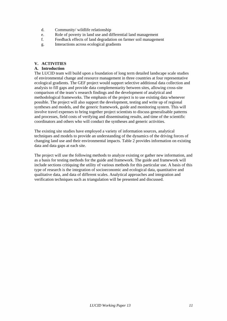
d. Community/ wildlife relationship e. Role of poverty in land use and differential land management f. Feedback effects of land degradation on farmer soil management g. Interactions across ecological gradients
V. ACTIVITIES A. Introduction The LUCID team will build upon a foundation of long term detailed landscape scale studies of environmental change and resource management in three countries at four representative ecological gradients. The GEF project would support selective additional data collection and analysis to fill gaps and provide data complementarity between sites, allowing cross-site comparison of the team’s research findings and the development of analytical and methodological frameworks. The emphasis of the project is to use existing data whenever possible. The project will also support the development, testing and write up of regional syntheses and models, and the generic framework, guide and monitoring system. This will involve travel expenses to bring together project scientists to discuss generalisable patterns and processes, field costs of verifying and disseminating results, and time of the scientific coordinators and others who will conduct the syntheses and generic activities. The existing site studies have employed a variety of information sources, analytical techniques and models to provide an understanding of the dynamics of the driving forces of changing land use and their environmental impacts. Table 2 provides information on existing data and data gaps at each site. The project will use the following methods to analyze existing or gather new information, and as a basis for testing methods for the guide and framework. The guide and framework will include sections critiquing the utility of various methods for this particular use. A basis of this type of research is the integration of socioeconomic and ecological data, quantitative and qualitative data, and data of different scales. Analytical approaches and integration and verification techniques such as triangulation will be presented and discussed.
LUCID Working Paper 13 11
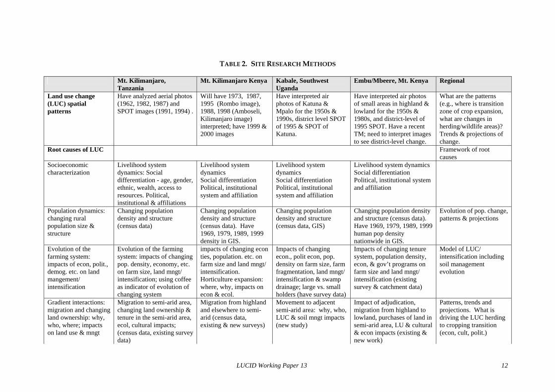
TABLE 2. SITE RESEARCH METHODS Mt. Kilimanjaro,
Tanzania Mt. Kilimanjaro Kenya Kabale, Southwest
Uganda Embu/Mbeere, Mt. Kenya Regional
Land use change (LUC) spatial patterns
Have analyzed aerial photos (1962, 1982, 1987) and SPOT images (1991, 1994) .
Will have 1973, 1987, 1995 (Rombo image), 1988, 1998 (Amboseli, Kilimanjaro image) interpreted; have 1999 & 2000 images
Have interpreted air photos of Katuna & Mpalo for the 1950s & 1990s, district level SPOT of 1995 & SPOT of Katuna.
Have interpreted air photos of small areas in highland & lowland for the 1950s & 1980s, and district-level of 1995 SPOT. Have a recent TM; need to interpret images to see district-level change.
What are the patterns (e.g., where is transition zone of crop expansion, what are changes in herding/wildlife areas)? Trends & projections of change.
Root causes of LUC Framework of root causes
Socioeconomic characterization
Livelihood system dynamics: Social differentiation - age, gender, ethnic, wealth, access to resources. Political, institutional & affiliations
Livelihood system dynamics Social differentiation Political, institutional system and affiliation
Livelihood system dynamics Social differentiation Political, institutional system and affiliation
Livelihood system dynamics Social differentiation Political, institutional system and affiliation
Population dynamics: changing rural population size & structure
Changing population density and structure (census data)
Changing population density and structure (census data). Have 1969, 1979, 1989, 1999 density in GIS.
Changing population density and structure (census data, GIS)
Changing population density and structure (census data). Have 1969, 1979, 1989, 1999 human pop density nationwide in GIS.
Evolution of pop. change, patterns & projections
Evolution of the farming system: impacts of econ, polit., demog. etc. on land mangement/ intensification
Evolution of the farming system: impacts of changing pop. density, economy, etc. on farm size, land mngt/ intensification; using coffee as indicator of evolution of changing system
impacts of changing econ ties, population. etc. on farm size and land mngt/ intensification. Horticulture expansion: where, why, impacts on econ & ecol.
Impacts of changing econ., polit econ, pop. density on farm size, farm fragmentation, land mngt/ intensification & swamp drainage; large vs. small holders (have survey data)
Impacts of changing tenure system, population density, econ, & gov’t programs on farm size and land mngt/ intensification (existing survey & catchment data)
Model of LUC/ intensification including soil management evolution
Gradient interactions: migration and changing land ownership: why, who, where; impacts on land use & mngt
Migration to semi-arid area, changing land ownership & tenure in the semi-arid area, ecol, cultural impacts; (census data, existing survey data)
Migration from highland and elsewhere to semi-arid (census data, existing & new surveys)
Movement to adjacent semi-arid area: why, who, LUC & soil mngt impacts (new study)
Impact of adjudication, migration from highland to lowland, purchases of land in semi-arid area, LU & cultural & econ impacts (existing & new work)
Patterns, trends and projections. What is driving the LUC herding to cropping transition (econ, cult, polit.)
LUCID Working Paper 13 12
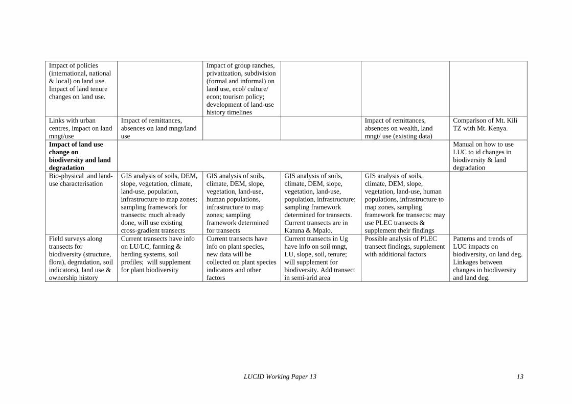
Impact of policies (international, national & local) on land use. Impact of land tenure changes on land use.
Impact of group ranches, privatization, subdivision (formal and informal) on land use, ecol/ culture/ econ; tourism policy; development of land-use history timelines
Links with urban centres, impact on land mngt/use
Impact of remittances, absences on land mngt/land use
Impact of remittances, absences on wealth, land mngt/ use (existing data)
Comparison of Mt. Kili TZ with Mt. Kenya.
Impact of land use change on biodiversity and land degradation
Manual on how to use LUC to id changes in biodiversity & land degradation
Bio-physical and land-use characterisation
GIS analysis of soils, DEM, slope, vegetation, climate, land-use, population, infrastructure to map zones; sampling framework for transects: much already done, will use existing cross-gradient transects
GIS analysis of soils, climate, DEM, slope, vegetation, land-use, human populations, infrastructure to map zones; sampling framework determined for transects
GIS analysis of soils, climate, DEM, slope, vegetation, land-use, population, infrastructure; sampling framework determined for transects. Current transects are in Katuna & Mpalo.
GIS analysis of soils, climate, DEM, slope, vegetation, land-use, human populations, infrastructure to map zones, sampling framework for transects: may use PLEC transects & supplement their findings
Field surveys along transects for biodiversity (structure, flora), degradation, soil indicators), land use & ownership history
Current transects have info on LU/LC, farming & herding systems, soil profiles; will supplement for plant biodiversity
Current transects have info on plant species, new data will be collected on plant species indicators and other factors
Current transects in Ug have info on soil mngt, LU, slope, soil, tenure; will supplement for biodiversity. Add transect in semi-arid area
Possible analysis of PLEC transect findings, supplement with additional factors
Patterns and trends of LUC impacts on biodiversity, on land deg. Linkages between changes in biodiversity and land deg.
LUCID Working Paper 13 13
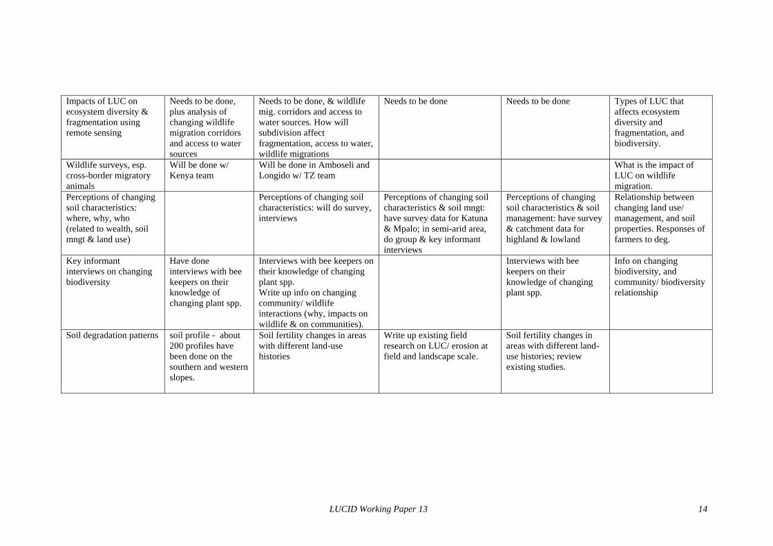
Impacts of LUC on ecosystem diversity & fragmentation using remote sensing
Needs to be done, plus analysis of changing wildlife migration corridors and access to water sources
Needs to be done, & wildlife mig. corridors and access to water sources. How will subdivision affect fragmentation, access to water, wildlife migrations
Needs to be done Needs to be done Types of LUC that affects ecosystem diversity and fragmentation, and biodiversity.
Wildlife surveys, esp. cross-border migratory animals
Will be done w/ Kenya team
Will be done in Amboseli and Longido w/ TZ team
What is the impact of LUC on wildlife migration.
Perceptions of changing soil characteristics: where, why, who (related to wealth, soil mngt & land use)
Perceptions of changing soil characteristics: will do survey, interviews
Perceptions of changing soil characteristics & soil mngt: have survey data for Katuna & Mpalo; in semi-arid area, do group & key informant interviews
Perceptions of changing soil characteristics & soil management: have survey & catchment data for highland & lowland
Relationship between changing land use/ management, and soil properties. Responses of farmers to deg.
Key informant interviews on changing biodiversity
Have done interviews with bee keepers on their knowledge of changing plant spp.
Interviews with bee keepers on their knowledge of changing plant spp. Write up info on changing community/ wildlife interactions (why, impacts on wildlife & on communities).
Interviews with bee keepers on their knowledge of changing plant spp.
Info on changing biodiversity, and community/ biodiversity relationship
Soil degradation patterns soil profile - about 200 profiles have been done on the southern and western slopes.
Soil fertility changes in areas with different land-use histories
Write up existing field research on LUC/ erosion at field and landscape scale.
Soil fertility changes in areas with different land-use histories; review existing studies.
LUCID Working Paper 13 14
B. Site level data: 1. Ethnography: key informant interviews and focus groups to obtain data on economic
activities, resource conflicts, perceptions of change in soil characteristics and biodiversity, the impact of policies at the local level, and causes and trends of migration.
2. Surveys: household and field level surveys of farmers and herders on changing land use and land management techniques; perceptions of changes in environmental variables including soil, plant and wildlife species; migratory history, household characteristics and economic activities including ties to the urban and non-farm sector.
3. Feedback seminars during which community members, decision makers and others to verify data interpretation and to explain the context of survey findings, e.g. the impact of land use change on the soil, plant and animal biodiversity, or the history of land tenure and its impact on land use.
4. Remote sensing and GIS. Land use change for 2-3 periods. Project members have conducted GIS analyses of land use/ cover change using satellite images from the 1970s to present, and aerial photographs from the 1950s to the 1980s. The team will further examine the interactions among land use change and wildlife distributions and habitat, soil characteristics, ecosystem fragmentation, human migration, etc.. Analyses will identify the hotspots of LUC and impact of LUC on key resources and on wildlife migration corridors. The root causes analysis will relate LUC to other data and information using methods such as spatial regression and scenario analysis.
5. Ecological field surveys. Synthesis of existing, and collection of new data on selected indicators of the effects of land use/ cover change (land clearing, grazing intensity) on land degradation (e.g., soil fertility, vegetative cover and structure) and biodiversity (plant and wildlife species diversity).
An approach being developed by the PLEC project will be used and expanded to provide an overview of land degradation and biodiversity across the sites. It is based on 1) developing a biophysical characterization of the area using climate and soils data in a GIS, and 2) field surveys along transects that cross ecological gradients and represent the spectrum of land use types. This project will broaden this characterization to include social variables in the GIS (land use, tenure, human population density, infrastructure) to develop an initial description of each site.
Along each transect, the project will assess the impact of land-use change and land degradation on selected ecological variables. Sampling will be conducted along the transects for areas of high and low land-use intensity. Information on vegetative structure and the abundance of key indicator plant species will be collected to provide indices of plant diversity, soil fertility (productivity) and soil degradation. We will use species area curve analysis to determine the probable total biodiversity for each site and land-use type. We will also collect soil samples for analysis to show ranges in soil fertility measures (indices). Analyses will include comparing results of areas with different land use histories and intensities, and comparing data obtained from the transect study with that obtained from the land use/ cover change analysis.
6. Wildlife surveys: Wildlife surveys will assess the impacts of different types of land-
use on wildlife populations. This will be done by conducting fine-resolution ground counts of the spatial interactions between people, land-use, livestock and wildlife, using a new technique developed by one of the team members. This information will be supplemented by information on the impacts of land-use on wildlife population structures and behavior.
LUCID Working Paper 13 15
C. National level data The following macro-level analyses will contextualize site level information within national, regional, and international frameworks.
1. Population census and other socioeconomic data: demographic patterns and processes, including migration, and other data (e.g., agricultural production, income, land tenure) will be analyzed and integrated into the project database
2. Economic and policy analysis: Economic trends and policies that affect the sites will be incorporated into the framework of this project. These include protected areas, land tenure, economic restructuring, and international economic and environmental agreements.
3. Ecological data synthesis: Synthesis of a variety of site-level studies (most in the grey literature) of the impacts of human activities on wildlife populations in Uganda, Kenya and Tanzania.
Cross-Site Comparisons and Regional Analysis
h. Coordination of the socioeconomic, land use change and ecological research a. communication and travel by regional coordinators to ensure cross-site
comparability of data collection and analysis b. analysis of regional-level land use change root causes and other GIS
analyses c. literature searches and contacts with land use and other communities d. review and comment on project papers
i. Develop and maintain project database j. Prepare a CD-ROM (decision making tool), build and maintain project web site k. Prepare annual project reports and conduct internal project evaluation l. Organize regional workshops and meetings m. Design, format and disseminate project “working paper” series
D. Integrative Themes The themes being addressed require an approach that relates changes occurring in the social system with those occurring in the biophysical system, and interactions between aspects of the biophysical system. The complexity of the question requires a focus on critical relations and processes. The following integrative questions will frame the research.
• Intensification/ biodiversity relationship. In the transition from herding to farming, an intensification of land use occurs. In this process, phases of intensification are associated with different land use strategies and land cover patterns. What are the associated flora and fauna of these phases, and how are they affected by the transition? What is the impact on key resources, land degradation, ecosystem fragmentation? This is an area where relatively little previous research has been done (Maitima 1998; Olson 1998; Reid et al. 1997).
• Poverty/ land degradation relationship. How does poverty and the socioeconomic status of households affects land use choices, soil management, and the soil. This is an area where previous research has elucidated major parameters (Biot et al. 1995; Campbell 1999; Olson 1994; Scherr and Yadav 1996; Tengberg et al. 1998). This project will test those parameters in a semi-arid environment, and provide a framework to examine the issue for developing programmatic responses.
• Wildlife / community interaction: impact of changes in the agro-pastoral system (land management, nomadism) on wildlife habitat and on wildlife. This is an area of recent inquiry, for example the positive role of old pastoral settlements in enhancing the structure and function of ecosystems (Reid and Ellis 1995). These interactions can also be negative; the expansion of cultivation precipitated strong declines in wildlife populations in the Mara in the last two decades (Ottichilo et al. in press). When are wildlife/community interactions positive and when are they negative? What determines the outcome of these interactions? This project will also examine the
LUCID Working Paper 13 16
impact of tourism, and government and NGO programs on the community/wildlife relationship. Increasingly, communities are demanding that wildlife contribute to the local economies, otherwise land will continue to be converted for more profitable uses. A great deal of effort is thus being made to improve the socioeconomic well being of communities living with wildlife by helping them derive benefits from wildlife and by involving them more in wildlife management. Activities that will be examined include the creation of community wildlife sanctuaries, linking communities in wildlife rich areas with the private sector for tourism and nature based enterprise development, and especially ways to reduce conflicts between human activity and wildlife to rationalize land use to permit biodiversity conservation.
• Societal and ecological interactions across ecological or altitudinal gradients: what are the interactions, how have the interactions evolved, what is impact of changes on society, wildlife, land degradation (Bernard, Campbell, and Thom 1989).
• Ecological interactions and feedbacks between land degradation and changes in biodiversity: As land begins to degrade, some work shows that, initially, biodiversity can increase (Reid et al. 1997; Wilson et al. 1997). How do land degradation and biodiversity interact? When does land degradation lead to biodiversity loss and when does it not? When there is loss, is it a gradual, linear loss or are there thresholds and surprises in this relationship? If land degradation is defined as biodiversity loss, how can they be separated conceptually?
VII. CONCLUSION The LUCID team will conduct research in four case study sites to examine the root causes of land use change and its impact on environmental conditions including land degradation and biodiversity. The research will be conducted within a common analytical and methodological framework to produce data complementarity between sites, allowing cross-site comparison of the research findings. The site and regional research findings will be disseminated in the form of working papers, on the project’s internet site, on a project CD-ROM, and in policy workshops. The results will form the basis of the development of guides to using land use change analysis for identifying and monitoring change in biodiversity and land degradation, and a replicable framework to explain the root causes of land use change. The results will provide researchers and policy makers critical insights into the linkages between land degradation and biodiversity, and tested approaches for such analyses. It will also provide the communities and countries vital information necessary for effective land use and other policy addressing these serious environmental challenges.
LUCID Working Paper 13 17
REFERENCES Bart, Francois. 1999. Up and Down the Mountain: The Altitudinal Zonation of Mt.
Kilimanjaro Farming System. Paper read at Mount Kilimanjaro: Land Use and Environmental Management, July, at Arusha, Tanzania.
Bernard, Frank E., David J. Campbell, and Derrick J. Thom. 1989. Carrying Capacity of the Eastern Ecological Gradient of Kenya. National Geographic Research 5 (4):399-421.
Biot, Yvan, Piers M. Blaikie, Cecile Jackson, and Richard Palmer-Jones. 1995. Rethinking Research on Land Degradation in Developing Countries. Washington, D.C.: World Bank.
Blaikie, Piers, and Harold Brookfield. 1987. Land Degradation and Society. London: Methuen & Co., Ltd.
Blot, Jacques. 1999. Ecology, Dynamics and Evolution of Vegetation in Kilimanjaro. Paper read at Mount Kilimanjaro: Land Use and Environmental Management, July, at Arusha.
Campbell, David J. 1987. Participation of a Community in Social Science Research: a Case Study from Kenya Maasailand. Human Organization 46 (2):160-167.
Campbell, David J. 1998. Towards an Analytical Framework for Land Use Change. In Carbon and Nutrient Dynamics in Tropical Agro-Ecosystems, edited by Bergstrom and Kirschmann. Wallingford, UK: CAB International.
Campbell, David J. 1999. Response to Drought among Farmers and Herders in Southern Kajiado District, Kenya: A Comparison of 1972-1976 and 1994-1996. Human Ecology 27 (3):377-416.
Campbell, David J., and Shem E. Migot-Adholla. 1981. The Development of Kenya's Semi Arid Lands. Nairobi: Institute for Development Studies, University of Nairobi.
Chomitz, K.M., and D.A. Gray. 1996. Roads, Land Use and Deforestation: A Spatial Model Applied to Belize. The World Bank Economic Review 10 (3):487-512.
Debinski, D.M., and R.D. Holt. 2000. A Survey and Overview of Habitat Fragmentation Experiments. Conservation Biology 14 (2):342-355.
Du Toit, J.T., and D.H.M. Cumming. 1999. Functional Significance of Ungulate Diversity in African Savannas and the Ecological Implications of the Spread of Pastoralism. Biodiversity and Conservation 8 (12):1643-1661.
Ezcurra, E., and G. Oba. 1999. Interlinkages Between Land Degradation and Biodiversity. Paper read at The Global Environment Facility Scientific Technical Advisory Panel Workshop, at Bologna, Italy.
Fairhead, James and Melissa Leach. 1996. Misreading the African Landscape: Society and Ecology in a Forest-Savanna Mosaic. Cambridge: Cambridge University Press.
GEF (Global Environment Facility). 1999. Clarifying Linkages Between Land Degradation and the GEF Focal Areas: An Action Plan for Enhancing GEF Support. Washington, D.C.: Global Environment Facility Council.
GEF (Global Environment Facility). 2000. Land Use Change Analysis as an Approach for Investigating Biodiversity Loss and Land Degradation. Available on the internet: www.gefweb.org/Documents/Medium-Sized_Project_Proposals/ MSP_Proposals/Reg_Kenya_Tanzania_Uganda.pdf.
Gichohi, H., E. Mangui, and C. Gakuhu. 1996. Savanna Ecosystems. In East African Ecosystems and Their Conservation, edited by T. R. McClanahan and T. P. Young. New York: Oxford University Press.
LUCID Working Paper 13 18
Homewood, K., and D. Brockington. 1991. Biodiversity, Conservation and Development in Mkomazi Game Reserve, Tanzania. Global Ecology and Biogeography 8 (3-4):301-313.
Kenya. 1979. Arid and Semi Arid Lands: The Framework for Implementation, Programme Planning and Evaluation. Nairobi: Government Printer.
Kenya. 1994. The Kenya National Environment Action Plan (NEAP) Report. Nairobi: Ministry of Environment and Natural Resources.
Kenya. 1999. National Action Programme (NAP) to Combat Desertification. Nairobi: National Environment Secretariat, Ministry of Environmental Conservation.
Kimani, K., and J. Pickard. 1998. Recent Trends and Implications of Group Ranch Subdivision and Fragmentation in Kajiado District, Kenya. Geographical Journal 164 (July):202-213.
Kisanga, Danielson, R. 1999. The Impact of Some Tree Species on Soil and Water Management on the Slopes of Mount Kilimanjaro. Les Cahiers de l’IFRA 16 (March/April):41-47.
Lambin, Eric F. 1997. Modelling and Monitoring Land-Cover Change Processes in Tropical Regions. Progress in Physical Geography 21 (3):375-393.
Lambin, E.F., X. Baulies, N. Bocksteil, G. Fischer, T. Krug, R. Leemans, E.R. Moran, R.R. Rinkfuss, Y. Santo, D. Skole, B.L. Turner II, and C. Vogel. 1999. Land-Use and Land-Cover Change (LUCC) Implementation Strategy. Bonn, Germany: International Geosphere-Biosphere Programme and the International Human Dimensions Programme on Global Environmental Change.
Maitima, J.M. 1998. Changes in Vegetation Structure and Species Diversity in Lambwe Valley: A Study of Tsetse Control Impacts on Land Use: IFAD, Integrated Approach to the Assessment of Trypanosomiasis Control Technologies and their Impacts on Agricultural Production, Human Welfare and Natural Resources in Tsetse-Affected Areas of Africa.
Mbonile, Milline. 1999. Population Dynamics on the Slopes of Mount Kilimanjaro. Cahiers de l’IFRA 16 (March-April):18-23.
Misana, Salome, B. 1999. Community Utilization and Management of Forest on Mount Kilimanjaro. Les Cahiers de l’IFRA 16 (March/April):48-58.
Muchiru, A.N. 1992. The Ecological Impact of Abandoned Maasai Settlements on Savanna Vegetation and its Herbivores in the Amboseli Ecosystem. MSc. Thesis, University of Nairobi, Nairobi, Kenya.
Norton-Griffiths, M., and C. Southey. 1995. The Opportunity Costs of Biodiversity Conservation in Kenya. Ecological Economics 12:125-139.
Olson, Jennifer M. 1994. Farmer Responses to Land Degradation in Gikongoro, Rwanda. Ph.D., Geography Department, Michigan State University, East Lansing.
Olson, Jennifer M. 1998. A Conceptual Framework of Land Use Change in the East African Highlands. Paper read at Earth's Changing Land: Joint Global Change and Terrestrial Ecosystems and Land Use and Land Cover Change Open Science Conference on Global Change, at Barcelona, Spain.
Ottichilo, W.K., J. de Leeuw, A.K. Skidmore, H.T. Prins, and M. Y. Said. in press. Population Trends of Large Non-Migratory Wildlife Herbivores and Livestock in Masai Mara Ecosystem, Kenya: 1977 - 1997. African Journal of Ecology.
Peet, R., and M. Watts. 1996. Liberation Ecologies: Environment, Development, Social Movements. New York: Routledge.
LUCID Working Paper 13 19
Pomel, Simon. 1999. Soils as Indicators of Anthropic Actions on Kilimanjaro. Paper read at Mount Kilimanjaro: Land Use and Environmental Management, July, at Arusha.
Reid, R.S., and J.E. Ellis. 1995. Livestock-Mediated Tree Regeneration: Impacts of Pastoralists on Dry Tropical Woodlands. Ecological Applications 5 (4):978-992.
Reid, R.S., C.J. Wilson, R.L. Kruska, and W. Mulatu. 1997. Impacts of Tsetse Control and Land Use on Vegetation Structure and Tree Species Composition in Southwestern Ethiopia. Journal of Applied Ecology 34 (3):731-747.
Scherr, Sara J., and Satya Yadav. 1996. Land Degradation in the Developing World: Implications for Food, Agriculture and the Environment to 2020. Washington, D.C.: International Food Policy Research Institute.
Skole, D. L., R. T. Walker, W. A. Salas, and C. H. Wood. 2000. Pattern to Process in Amazônia: Measurement and Modeling of the Inter-Annual Dynamics of Deforestation and Regrowth. East Lansing: Department of Geography, Michigan State University.
STAP. 1999. Report of the STAP Expert Group Workshop on Land Degradation (Prepared by the Scientific and Technical Advisory Panel). Washington, D.C.: Global Environment Facility.
Stelfox, B.J. 1986. Effects of Livestock Enclosures (Bomas) on the Vegetation of the Athi Plains, Kenya. African Journal of Ecology 24:41-45.
Tengberg, Anna, Jim Ellis-Jones, Romano Kiome, and Michael Stocking. 1998. Applying the Concept of Agrodiversity to Indigenous Soil and Water Conservation Practices in Eastern Kenya. Agriculture, Ecosystems and Environment 70:259-272.
Tiffen, M., Mortimore, M. and Gichuki, F. 1994. More People, Less Erosion: Environmental Recovery in Kenya. Chichester: John Wiley.
Turner, B.L. II, David Skole, Steven Sanderson, Gunther Fischer, Louise Fresco, and Rik Leemans. 1995. Land-Use and Land-Cover Change Science/Research Plan: International Geosphere-Biosphere Programme.
Uganda. 1993. The Republic of Uganda National Environment Action Plan (NEAP). Kampala: NEAP Secretariat, Ministry of Natural Resources.
Uganda. 1999. Framework for the National Action Programme to Combat Desertification and Drought in Uganda: The Way Forward in Implementing the United Nations Convention to Combat Desertification. Entebbe: Ministry of Agriculture, Animal Industry and Fisheries.
Walker, R.T. 1997. Land Use Transition and Deforestation in Developing Countries. Geographical Analysis 19:18-30.
Western, David, and Helen Gichohi. 1993. Segregation Effects and the Impoverishment of Savannah Parks. The case for ecosystem viability analysis. African Journal of Ecology 31:268-271.
Wilson, C.J., R.S. Reid, N.L. Stanton, and B.D. Perry. 1997. Ecological Consequences of Controlling the Tsetse Fly in Southwestern Ethiopia: Effects of Land-Use on Bird Species Diversity. Conservation Biology 11:435-447.
Young, T.P. 1995. Long-Term Glades in Acacia Bushland and their Edge Effects in Laikipia, Kenya. Ecological Applications 5:97-108.
Zimmerer, K. S. 2000. The Reworking of Conservation Geographies: Nonequilibrium Landscapes and Nature-Society Hybrids. Annals of the Association of American Geographers 90 (2):356-369.
LUCID Working Paper 13 20