Embed Size (px)
Citation preview
v r
At e
....a
144
.1 -r 0 -
;4>4 Uv F k1
Frontcover photo: Threshing millet.
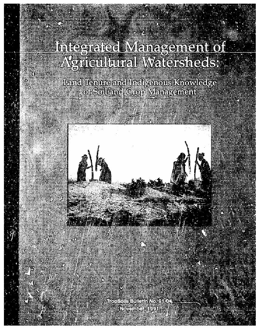
Back cover photo: "The land is old and tired" said a Zarma farmer.
Photo credits: A. S. R. Juo; A. Manu; R. Puentes; T. L. Thurow; and L. P. Wilding.
Printed by The FullerCorporation,2023 Texas Avenue, Bryan, Texas 77802
INTEGRATED MANAGEMENT OF AGRICULTURAL WATERSHEDS:
LAND TENURE AND INDIGENOUS KNOWLEDGE OF SOIL AND CROP MANAGEMENT
Ellen Taylor-Powell
in collaboration with
Andrew Manu Stepnen C. GeigerMamadou Ouattara Anthony S. R. Juo
Tropoils Bulletin 91-04. Published by Soil Management Collaborative Research Support Program, Box 7113, North Carolina State University, Raleigh, N.C., USA 27695; Department of Soil & Crop Sciences, Texas A&M University, College Station, Texas, USA; National Institute for Agronomic Research, Niamey, Niger; and United States Agency for International Development -Mission in Niamey, Niger.
November, 1991
Printedon recycled paper
Foreword
Texas A&M University (TAMU), Soil Management Collaborative Research Program (T-,opSoils) in collaboration with Niger National Institute for Agronomic Research (INRAN) plamed a joint project on Integrated Management of Agricultural Watersheds in Niger (IMAW). A major goal of the project is to improve agricultural productivity and enhance natural resource base through integrating indigenous knowledge with improved technologies for soil, crop, livestock and vegetation management within a well-defined watershed. In 1989, a proposal was submitted to he Agency for International Development Mission in Niamey for support and funding.
This report contains the findings of the on-farm survey on land tenure and land management. The complete report of the findings of soil, vegetation, hydrology and indigenous farming systems was published in a separate volume (TropSoils Bulletin No. 91-03, 1991).
The effort of many were required to complete the study. Dr. Ellen Taylor-Powell conducted the survey in 1989. Dr. A.S.R. Juo, Dr. R. Puentes, and Dr. A. Manu contributed to the planning, design and implementation )f the project. Dr. S.C. Geiger and Mr. F. Adamou conducted the soil erosion assessment in the farmer's fields. Dr. Manadou Ouattara whose earlier work in the watershed coutributed much to the study. Ms. Ann Pfordresher helped with the base maps. Mr. Hama Yaye assisted with field interviews. Ms. Kati Ferrari and Ms. Peggy King assisted wit the editing and formatting of this report.
The continued support, interest and encouragement from the Office of the Director-General of INRAN, and from the administrative and technical officers of the USAID Mission in Niamey, Mr. George Eaton, Director; Mr. John Mitchell, ADO; Mr. George Taylor, ADO; Mr. Ernest Gibson, former ADO, and Mr. Flynn Fuller, former ADO, are gratefully acknowledged.
The siudy was supported in part by USAID/Niger (USAID/REDSO/TAMU No. 693-0261-A-00-9042-00) and Soil Management CRSP (USAID Grant No. DAN-1311-G-SS-6018-00).
Roger G. Hanson, Director Soil Management CRSP November 30, 1991.
i
EXECUTIVE SUMMARY
Less vegetative cover, declinirg soil fertility, increased erosion,and shorter fallows are consequences of the climatic changes and demographic pressures affecting the Sahel.
Past programs in the region have focused mostly on increasing food production through commodi~y improvements. The Integrated Managerment of Agricultural Watersheds (IMAW) project is a joint undertaking of the institut National de Recherche Agronomique du Niger (INRAN), Texas A&M University, and the U.S. Agency for International Development/Niger. It seeks to pustain the productivity of land management units as opposed to merely increasing crop production. Small watersheds form the land use area within which sustainable management strategies can be established.
The project proposal called for a baseline assessment of social and cultural factors influencing lauid use, with a particular focus on indigenous knowledge related to soil management. To provide this infGrmation, a study was undertaken in a 500 ha pilot watershed cast of the village of lamdallaye, 30 km northeast of the national
capital, Niamey, during October-December 1989.
The terms of reference included documentation of land history, assessment of land tenure, indigenous knowledge of soil and crop management, farmer perceptions of agricultural problems and solutions, and the historical and demographic description of the region. In-depth interviews were conducted with 42 farmers, plus village elders and chiefs having administrative responsibility over the territory. Major findings include tle following:
1. Originally settld by Zarma farmers, land in the watershed is currently
claimed by 41 families and is farmed by 56 different persons. Land holdings per household average 10.3 ha, ranging from 0.7 to 41.5 ha. Cultivated areas average 5.2 ha and fallow areas average 5 1 ha. Approximately half the watershed was in fallow during the 1989 farming season.
2. Nearly half of the cuftivators are farming on borrowed land. Land tenure security appears to exist through established relationships and customary rules that allow borrowed land to pass to sucessive generations. Formal ieases are being encouraged to guard against land claims by borrowing families. Women do not control land. They are allotted small plots on a temporary basis for cultivating peanuts and household gardens.
3. Of the 42 farmers interviewed, 32 are Zarma, 6 are Hausa, and 4 are Peul. Millet/cowpea intercrop dominates the cropping pattern. Improved varieties have oeen available since the early 1980s, but local varieties are preferred. Forty percent of the farmers reported never using fertilizer.
4. Nearly three-fourths of the households own livestock, principally mixes of goats, sheep, and cattle. Animals are an important source of investment for both women and men, and provide manure, pack/transport, and food. Zarma-owned cattle usually are entrusted to Fulani herders to spend the cultivation season outside the watershed, returning for crop residue grazing. Animals are kept from cultivated areas during the growing season on orders of the chef de canton. After harvesting, animals have free access to arable land. Plant'-d cowpea forage and two native species, Ipomoea involucrataand Merremia tridentala,are cut and stored for dry season feeding or sold. The two native species offer multi-purpose possibilities.
ii
5. Heads of households have a strong sense of land ownership, though land belongs to the i-neage and is not to be sold. Management decisions and use of the land's production, including crop residue and other valuable plants, such as grasses and forage, fall to the field's cultivator,
6. Various tenures exist depending on use of the land and the user. Cultivators have exclusive use of cropped fields. Grazing land on the plateau is communal as is arable land after harvest, Tenure rules related to fallow land vary, depending on the season and whether the user is the lando wner or borrower. Tenure rules apply to all permanent land improvements. Leasehol ' 'rs are barred from digging weils or planting trees of economic value, such as citrus, mango, and baobab.
7. Fallow periods have reportedly shorteied from 10 years to 3 to 5 years on family land and 2 to 3 years on borrowed land. The shortened fallow periods are blamed on population pressures, cultivation of larger areas to make up for decreased land productivity, seeding all land to minimize risk of a crop failure and to demonstrate use of land to keep others from using it, pressures to loan !and with its being brought back into cultivation prematurely, and breaking up of family holdings resulting in greater farming inter.sification.
8. Farmers see their land base as degrading as a result of climatic changes and vegetation loss. Problems and concerns about poorer land productivity are most often tied to declining soil fertility. Wind that carries away topsoil and wind-blown soil that buries millet seedlings is considered more of a problem than water erosion. Sand deposits from water runoff that limit the cultivable area and bury the crop are considered more widespread and harmful than guily erosi n. Farmers' perspectives and knowledge aie empirically based. They plan for the short term and are concerned with minimizing risks in order to meet the food need!s cf the household.
9. Use of animal manure is seen as the primary method for sustaining production. The supply of manure, however, is limited by fewer head of permanent and migrating animals in the region since the droughts of the past two deces and by reduced vegetation to attract grazing animals. It is stated that few Fulani now own cattle so farmers must own animals to make manuring of fields possible.
10. Management of crop residues has reportedly changed over the past decade due to increased wind erosion. Some millet stalks are removed following harvest for construction, but most millet residue : left standing on the field to "hold the soil." After crop residue grazing, the stalks are uprooted and laid on the field, sometimes straiegically on severely eroded areas.
11. Farmers in the watershed are attempting to lessen the risk of crop deficits by experimenting with various strategies such as multiple planting ddtes; mixing seed varieties; strategic farming in favorable microenvironments, priority weeding; and soil restoration techniques and wind erosion controls using crop residues and native woody species Piliostigma rcliculatum, Combretum glutinosum, and Guiera senegalensis. Farmers have years of experience in adapting to an unpredictable environment. The existing wealth of indigenous technical knowledge when integrated with modern technologies should result in sustainable agricultural systems.
iii1
TABLE OF CONTENTS
FOREWORD ...............................................................
EXECUTIVE SUMMARY ................................................... ii
INTRODUCTION .......................................................... iii
TABLE OF CONTENTS ..................................................... iv
GENER AL SETTING AND DESCRIPTION OF PROJECT WATERSHED ................ 2
N iger Context .............................................................. 2 IMA W Watershed ............................................................ 2 Village Territories ........................................................... 4 Village H istories ............................................................ 4 Characteristics of Farmers ..................................................... 4 The Farming System ......................................................... 5
Cropping Pattern ...................................................... 5 Field Sizes ........................................................... 7 Cropping Calendar ..................................................... 7 Labor ............................................................... 8
LAND TENURE
Customary Land Rights ...................................................... 10 Land Agreem ents ........................................................... I Land A vailability ........................................................... I I Use of Land Resource Base ................................................... 12 Summary and Conclusions: Implications on Land Use and Management .................. 12
INDIGENOUS KNOWLEDGE AND CLASSIFICATIONS ............................ 14
Land Types ............................................................... 14 Field Classification Systern .................................................... 14 Soil Classifications .......................................................... 14 Classification of Vegetation ................................................... 16
Plants ....................................... ....... ....... ......... 16 Trees .......................................................... .... 16 Livestock ........................................................... 17
SOIL AND WATER CONSERVATION PRACTICES ................................ 17
Farmer Perceptions of Factors Determining Crop Production .......................... 17 Rainfall/fertility interaction ............................................. 17 Changes in Farn.ing Practices ............................................ 17 Perceived Agricultural Problems .......................................... 19
iv
Soil Management Practices .................................................... 19 Fallowing ........................................................... 19 Full-field fallow ..................................................... 21 With-in field fallow ................................................... 22 Emergency fallow .................................................... 22 Use of Animal M anure ................................................. 22 Use of Fertilizer .................................................... 23 Use of Compound and Refuse Accumulation Sites ............................ 23 Crop Residue Management .............................................. 24 Mulching ....................................................... 25 Other Soil Management Practices ......................................... 25
Extent and Control of Erosion .............................................. 25 Farmer Practices to Control Erosion ....................................... 26
Summary and Conclusions .................................................. 27
SUMMARY COMMENTS AND IMPLICATIONS .................................. 29
REFERENCES ............................................................ 30
List of Tables
Table I Land area in each village territory ....................................... 4 Table 2 Crop pattern in lamdallaye watershed, 1989 (n - 46 fields) .................... 5 Table 3 Millet and cowpea varieties used in Hamdallaye watershed, 1989(n - 42 farmers) ... 7
......................... Table 5 Livestock held by watershed cultivators (n = 41 farmers) ...................... 8 Table 4 Size of total area and cultivated area household, 1989 8
Table 6 Number of family land holdings and cultivators by village territory in the watershed 10 Table 7 Farmer listing of beneficial plants and trees in. the watershed .................. 18 Table 8 Summary of rainfall data in the Hamdallaye Watershed for 1989 and 1990 ........ 21 Table 9 Fallow practices on fields currently under cultivation (n = 40 farmers) ........... 21 Table 10 Methods of manure application for 11 farmers, 1989 ........................ 23 Table I I Fertilizer use among 39 farmers, 1989 ................................... 24 Table 12 Fertilizer use by 12 farmers, 1989 ...................................... 24 Table 13 Frequency and standard deviations of surfaces within the watershed (n = 25 fields) . 27 fable ,4 Native plants used for erosion control (n = 25 farmers) ...................... 27 Table 15 Different methods of erosion control practiced by local farmers (n = 25 farmers) ... 27
List of Figures
Figure 1 Map of Western Niger showing Watershed Location .......................... 3 Figure 2 Administrative Boundaries, IMAW Hamdallaye ............................. 6 Figure 3 Landuse Map ...................................................... 20
V
INTRODUCTION
Soil degradation and the consequent loss of crop production potential is a widespread concern across the Sahel. Infertile sandy soils common to the region are susceptible to wind and water erosion particularly when the vegetation cover has been depleted. Population pressures and competing uses for land are resulting in reduced fallow periods and expansion of farming on marginal land.
Past activities in the region1 focused primarily on cropping system components with the objective of increasing production. The Integrated Management of Agricultural Watersheds (IMAW) project pinpoints the sustained productivity of land management units. Small watersheds with c'itchment areas of 2 to 6 km make up the land use area within which sustainable management strategies can be established,
The ways used by local farmers in conserving resources must be understood and integrated with modern technologies to bring about sustainable agricultural systems. An initial objective of the project was to conduct research on land tenure and indigenous knowledge related to land and soil management in order to get farmers' perspectives and document existing land tenure and conservation practices.
The terms of reference for this research called for three related activities to be conducted from October to December 1989:
+ Conduct interviews with village chiefs and elders to provide historical and demographic descriptions of the zone;
+ Identify all farmers within the watershed and document the land history of cultivated and fallew areas, and
+ Conduct individual farmer interviews to provide a general assessment of land tenure, indigenous knowledge of soil and crop management, and farmers' perceptions of problems and solutions.
Methods
The watershed selected for the IMAW project is 500 ha near the village of Hamdallaye, 30 km east northeast of Niamey, the capital of Niger. To identify persons farming or owning land, the researcher walked the watershed with knowledgeable farmers obtaining names associated with each cultivated and fallow field. Maps prepared from aerial photographs were used as the base of reference and served to stimulate a dynamic conversation with these nonliterate farmers. Of the 56 farmers identified, interviews were conducted with 42, a 75% sample. Several group interviews were held with village elders, and individual interviews weie conducted with each of the three village chiefs having administrative responsibility over land in the watershed. A subsequent survey was conducted to determine the extent of wind and water erosion within 25 fields.
The exploratory nature of the research called for a naturalistic approach to data collection. Ethnographic techniques of informal interviewing and observation provided an opportunity to discover the variety in, and reasons underlying, farming practices. During the interview process the researcher walked with farmers over their fields asking for comments and seeking explanations related to soil management. Content analysis was conducted to categorize the field data into meaningful themes and patterns.
2
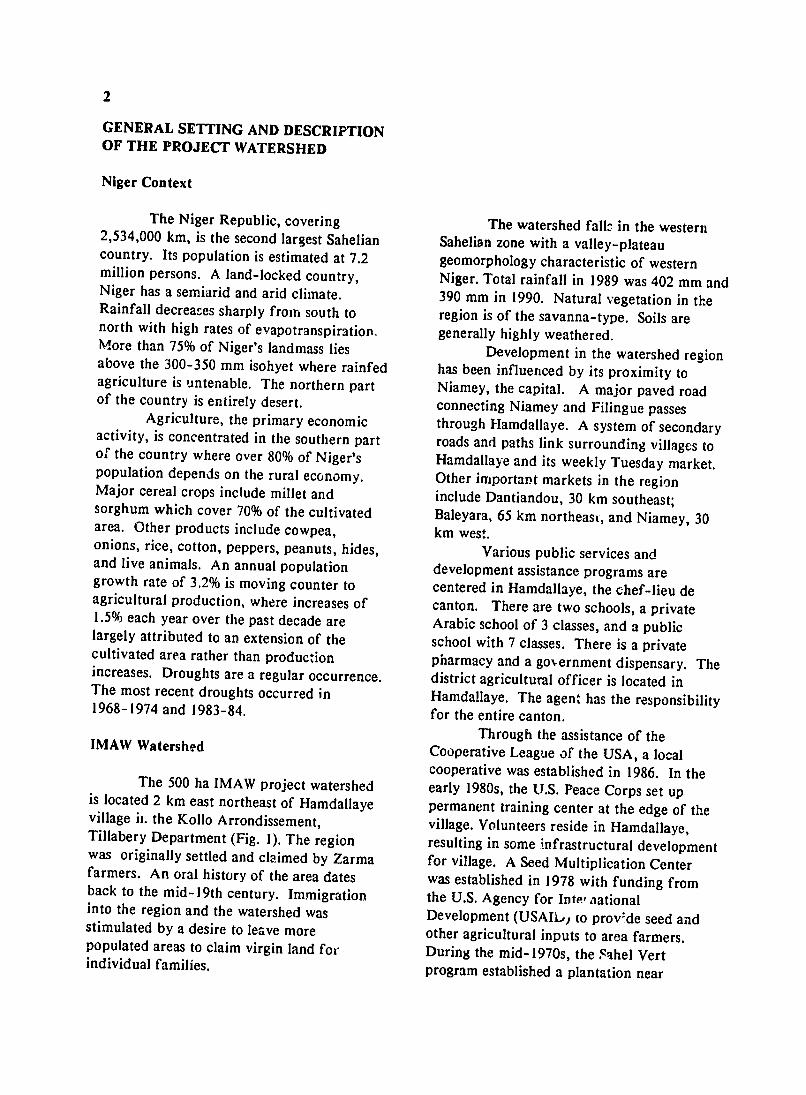
GENERAL SETTING AND DESCRIPTION OF THE PROJECT WATERSHED
Niger Context
The Niger Republic, covering 2,534,000 km, is the second largest Sahelian country. Its population is estimated at 7.2 million persons. A land-locked country, Niger has a semiarid and arid climate. Rainfall decreases sharply from south to north with high rates of evapotranspiratiop. More than 75% of Niger's landmass lies above the 300-350 mm isohyet where rainfed agriculture is untenable. The northern part of the country is entirely desert.
Agriculture, the primary economic activity, is concentrated in the southern part of the country where over 80% of Niger's population depends on the rural economy. Major cereal crops include millet and sorghum which cover 70% of the cultivated area. Other products include cowpea,onions, rice, cotton, peppers, peanuts, hides, and live animals. An annual population growth rate of 3.2% is moving counter to agricultural production, where increases of 1.5% each year over the past decade are largely attributed to an extension of the cultivated area rather than production increases. Droughts are a regular occurrence, The most recent droughts occurred in 1968-1974 and 1983-84.
IMAW Watershed
The 500 ha IMAW project watershed is located 2 km east northeast of Hamdallaye village ii. the Kollo Arrondissement, Tillabery Department (Fig. 1). The region was originally settled and claimed by Zarma farmers. An oral history of the area dates back to the mid-19th century. Immigrationinto the region and the watershed was stimulated by a desire to leave more populated areas to claim virgin land for individual families.
The watershed falls in the western Sahelian zone with a valley-plateau geomorphology characteristic of western Niger. Total rainfall in 1989 was 402 mm and 390 mm in 1990. Natural vegetation in the region is of the savanna-type. Soils are generally highly weathered.
Development in the watershed region has been influenced by its proximity to Niamey, the capital. A major paved road connecting Niamey and Filingue passes through Hamdallaye. A system of secondary roads and paths link surrounding villages to Hamdallaye and its weekly Tuesday market. Other important markets in the region include Dantiandou, 30 km southeast; Baleyara, 65 km northeast, and Niamey, 30 km west.
Various public services and development assistance programs are centered in Hamdallaye, the chef-lieu de canton. There are two schools, a private Arabic school of 3 classes, and a public school with 7 classes. There is a private pharmacy and a go,,ernment dispensary. The district agricultural officer is located in Hamdallaye. The agent has the responsibility for the entire canton.
Through the assistance of the Cooperative League of the USA, a local cooperative was established in 1986. In theearly 1980s, the U.S. Peace Corps set up permanent training center at the edge of the village. Volunteers reside in Hamdallaye, resulting in some infrastructural development for village. A Seed Multiplication Center was established in 1978 with funding from the U.S. Agency for Int., national Development (USAIL.,, to prov.de seed and other agricultural inputs to area farmers. During the mid- 1970s, the Sahel Vert program established a plantation near
Figure 1
MAP OF WESTERN NIGER SHOWING WATERSHED LOCATION
AlIgeri e
*Hamdallaye
63mmm
100 km
4
Hamdallaye which reportedly provided villagers with trees to plant,
Village Territories
Four villages have administrative territory within the watershed (Fig. 2). Approximately 13% of the land falls within the territory of Hamdallaye.
The village of Iokotchili Kaina, 4 km east of Hamdallaye by sand track, is outside the project boundaries but 56% of the watershed land area lies within its territory.
Falanke Kaina, a hamlet entirely located within the watershed boundaries, is about 6 kra east of Hamdaliaye. A quarter of the land within the watershed comes under the administration of the Family head of Falanke Kaina.
Outside the project area on the easternmost corner lies Falanke Beri whose administrative district covers about 6% of the watershed land. Land area falling within each village territory is reported in Table 1.
Table 1. Land area in each village territory
Village territory Land area
Hamdallaye 71.6 ha Bokotchili Kaina 308.7 ha Falanke Kaina 137.8 ha Falanke Beri 30.6 ha
TOTAL 548.7 ha
Village Histories
Hamdallaye. Two Zarma families are said to have been the first settlers in Hamdallaye. Originating from near Baleyara in the canton of Tagazar, they settled in N'Dounga before finally establishing themselves in Hamdallaye about 1854. The
current chief, installed in 1988, is fifth in the patrilineal descent. The current population of Hamdallaye is about 1,200 households, predominantly Zarma. Some Hausa, Tuareg, and Arabs have settled in Hamdallaye. A settlement of Fulani, "Hamdallaye Fulani," is found on the southwest side of the village.
Bokotchili Kaina. The founder of Bokotchili Kaina originated from Bokotchili Beri in the canton of Koure. After settling and claiming land in Bokotchili Kaina, he moved on to settle the village area of Binni Bokotchili. Today, descendants from the same lineage claim land in all three villages. The current population of Bokotchili Kaina is about 800 Zarma in 88 households. Reportedly, the village population has decreased since the droughts of 1968-1974 and 1982-1984. Bokotchili Kaina has no governmental services or market.
Falanke Kaina. The history of Falanke Kaina dates back five generations, when a Zarma pioneer came from Allahoni to cultivate and claim surrounding virgin land. The hamlet consists of about 100 persons in 11 :milies. All are descendants of the original pioneer except one Fulani family who established herding relationshipswith the cattle-owning Zarma has settled permanently.
Characteristics of Farmers
Of the 42 farmers interviewed, 32 are Zarma (76%), 6 are Hausa (14%), and 4 are Fulani (10%). All are men except 2, one Hausa and one Fulani, who in the absence of' husbands are de facto heads of households.' Age of the head of the household ranges from 22 to 70 years with an average of 42
Household" is defined primarily as a production unit: persons who work a common field(s) and share the produce. A household is a subgroup of a concession (residential dwelling unit composed of one or more conjugal units) which ioa subgroup of a lineage.
5
years. Over half of the household heads are within a field -- are cultivated to sorghum between 22 and 40 years with 12% over 61. (Sorghum bicolor), maize (Zea mays), sorrel, Household sizes for the 42 farmers average 9 and okra (Hibiscus esculentus). Women persons ranging from 2 to 20. cultivate small plots of peanuts (Arachis
Traditionally, Zarma are hypogaea) and tend rainy season gardens agriculturalists with a production goal of next to the household compound. Reportedly meeting household cereal requirements and there is little dry season gardening due to the selling surplus grain to meet cash needs. depth of the water table. A few manioc Given recent droughts and unfavorable gardens are found in low-lying areas. rainfall, producers have increasingly turned to off-farm work, particularly seasonal Table 2. Crop pattern in Hamdallaye migration to coastal countries as unskilled watershed, 1989 (n = 46 fields) laborers. Other activities include jobs in transportation (donkey and ox cart), petty Crop No. % commerce, crafts, tailoring, butchering, brickmaking, barbering, and herding (Fulani). Two of the 42 farmers have Millet/cowpea 30 65.2 salaried employment. Other sources of Sole millet 7 i5.2 household income include remittances from Sole millet; millet/cowpea 4 8.7 nonresident household members. Sole millet; sole cowpea 2 4.3 Availability and allocation of capital and Millet/cowpea; sole cowpea 2 4.3 labor by households was not documented but Millet/cowpea/sorghum 1 2.1 is clearly diverse.
TOTAL 46 99.8 The Farming System
A millet-based mixed farming system Besides plantred millet, two other characterizes the watershed's agricultural types of millet are important in the system. Demarcated land holdings fall under production system. Diaraou,volunteer millet the control of household heads, but (mil savage in French), competes with households vary in the way collective planted millet but ripens first and is decisions are made about land management. therefore important in providing food during Besides family fields, unmarried household the "hungry gap." Diaraou residue is used in men and women often cultivate individual construction and fed to animals. fields, thereby establishing independent Sunne (chibras in Hausa) is subeconomies within the household. undeveloped grain heads produced by local
varieties. It is harvested, often by women, Cropping Pattern. prior to the regular harvest and is also useful
during the hungry season. Sunne not Millet (Pennisetum spp.) dominates forming grain heads is weeded since it
the cropping pattern, generally as an competes with planted millet. intercrop with cowpea (Vigna unguiculata) Improved millet (HKP) and cowpea (Table 2). Sorrel (Hibiscussabedarifa) is (TN578) varieties have been availablie in the often intercropped with millet and region through the Seed Multiplication millet/cowpea combinations. More favorable Center since 1982-83. Local varieties, microenvironments -- areas of however, dominate (TabJe 3). Two local favorable moisture and nutrient conditions millet varieties, tchumo (dark colored millet)
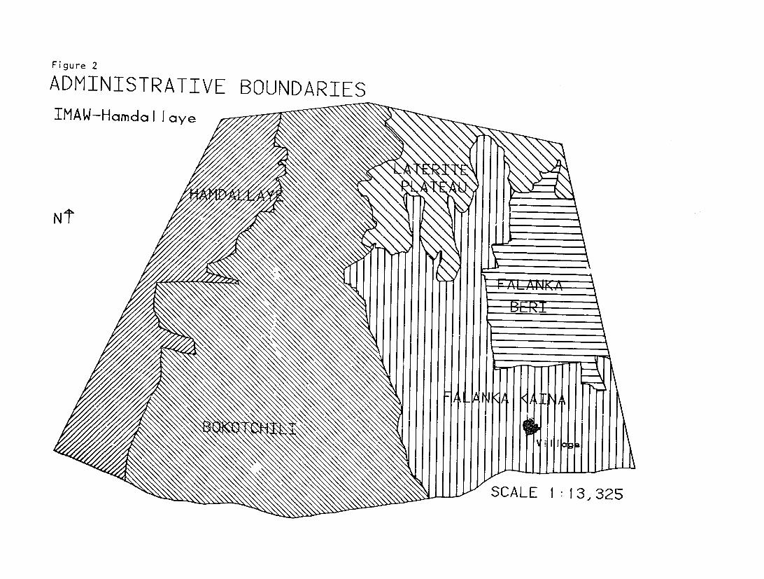
Figure 2
ADMINISTRATIVE BOUNDARIES IMAW-Hamda Illaye
N'T
S
7
and drankoba(light colored millet), are a poor yield was expected due to lack of ra'n typically sown together and may be mixed and his inability to reimburse costs. with HKP to diversify and minimize risk.
Field Sizes.2
Table 3. Millet and cowpea varieties used in Hamdallaye watershed, 1989 (n = 42 Field sizes in the watershed were farmers) calculated by the TropSoils staff using an
electronic planimeter to measure fields Variety No. of % identified on aerial photographs (1:5200) and
Farmers* verified on the ground. Fallow and cultivated fields averaged 10.3 ha per
Local millets 35 83.3 household, ranging from .7 to 41.5 ha.3 The Improved millet (HKP) 13 30.9 average cultivated area was 5.2 ha, with a Local cowpea 39 92.8 range of 0.7 - 16.4 ha per household. The Improved cowpea (TN578) 3 7.1 average fallow field was 5.1 ha, with a range
of 0.2-41.5 ha. Of the households with land * Totals may exceed 100% since farmers may in the watershed in 1989, 62% had land in mix local and improved varieties fallow and 83% were cultivating fields. A
further breakdown of land areas by There are varying opinions about the household is reported in Table 4.
productivity of improved versus local millet varieties. There are three main Cropping Calendar. disadvantages with the improved variety, according to farmers: Farmers in the watershed either dry
1. Susceptibility to bird and insect seed or seed with tl.e first sufficient rains in attack due to its early maturity mid to late June. Reseeding is often
2. Competition with other labor necessary due to early season drought or the needs since it needs weeding sooner after burial of seedlings by wind-blown sand. planting because of its fast growth Planting can continue through July in some
3. Productivity depends on full use years. Two weedings are customary though of recommended inputs. Prior to 1989, dependent on the amount of labor available farmers reimbursed the Seed Multiplication and an assessment of the potential crop yield. Center with millet and cowpea grain at the The first weeding of the millet crop occurs rate of 2.5 kg for every 10 kg of seed 10 days aftcr planting. Harvesting is usually obtained. Triple superphosphate and urea done in mid to late October. In 1989, were available at a cost of 3,750 CFA and harvesting began in the watershed during the 3,250 CFA per 50 kg, respectively, or week of October 16, 1989. The cropping farmers could repay fertilizer in grain calendar varies by year depending on the equivalents at the fair market price. Cowpea rainfall pattern. insecticide was free of charge.
Farmers' decisions in use of crop 2Field is defined as contiguous land une r varieties and fertilizers were linked to a household's control.
variety of variables: climate, availability of 3These field sizes should not be equated with resources and inputs, and expected returns. total farm size since some households have land outside
the watershed which was no. measured. Average farmFor example, one farmer used a fast-growing sizes for two slightly more northern Zarma villages in improved millet variety when the rains were 1982-1985 were found to be 10.1 and 15.3 ha (McIntire,
late. Another put off using fertilizer because Hopkins, Lamers, Fussel, 1989).
8
Table 4. Size of total area and cultivated area household, 1989
Total area Cultivated area Fallow area (n=53 hshld) (n=44 hshld) (n=33 hshld*)
Size of area No. % No. % No. %
Less than I ha 1 1.9 1 2.3 3 9.1 1 - 3.99 ha 9 17.0 13 1429.5 42.4 4 - 6.99 ha 16 30.2 15 34.1 7 21.2 7 - 9.99 ha 10 18.9 8 18.2 0 0 Over 10 ha i7 32.1 7 15.9 9 27.3
TOTALS 53 100.0 44 100.0 33 100.0
* represents only households with cultivated/fallow land in 1989
Table 5. Livestock held by watershed cultivators
(n = 41 farmers)
No. %
Households with no animals 11 26.8 Households with animals 30 73.2 Type of specie owned Cattle 15 36.6 Sheep 21 51.2 Goat 25 60.9 Donkey 9 21.9 Camel 1 2.4 Horse 2 4.9
Labor.
Hand cultivation using a long-handled hoe (hilaire)features surface rather than deep cultivation. The division of They may cultivate small personal peanutlabor by gender is apparent. Field labor is plots and gardens near the compound;typically done by the males of the hourehold. interplant sorrel into the main crop, and Work is done first in family fields. harvest sunne (undeveloped grain heads) andHousehold members then work in individual various native plants for home consumptionfields. Zarma women in the region mostly and sale. assist in planting and harvesting on common Only one farmer had used animal household fields as well as postharvest work. traction but reportedly uses the oxen more
9
for transport. Two have used tractors - one material such as mats, granaries, and gardens to open new lateritic land near the plateau, from scavenging livestock. another from Niamey who also used hired Fulani farmers who maintain herds labor. 4 These two cultivators have the largest on their farms (two of ihe four resident cropped areas in the watershed, 16.4 and 15.1 Fulani in tile watershed) profit from manure ha, respectively. during the growing season but must balance
By household, field labor ranged labor between cropping and livestock, For from 1 to 7 persons, averaging 2.5 persons, these two Fulani, th- cropped area is During weeding and harvesting, households relatively small, 2.7 and 3.8 ha, respectively, may participate in reciprocal labor parties, but land productivity is relatively high. bougou. Food and drink are provided by All farmers interviewed report fewer women. Paid labor is rare. Only three livestock in the region since the drought farmers reported hiring labor in 1989. The ending in 1984, though numbers are said now minimum daily payment is 750 CFA per day, to be increasing. Freviously. the watershed or by the job. During the 1989 har 'est, was used by "etranger" Fulani herders both laborers received 50 CFA per botte, a bundle passing through during the seasonal of tied millet heads. movement of cattle and while setting up
Livestock. Nearly three-fourths of seasonal re-idences. Today few use the the households own livestock, principally watershed. mixes of goats, sheep, and cattle (Table 5). Of the 30 households with animals, 60% own one or two species, 33% own three or four types of animals, and 6% own five or six species. Women own small stock as a more secure investment than having land allotted for their temporary use by men. 5
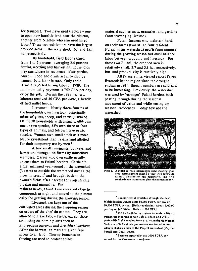
A few small ruminants, donkeys, and horses are managed on farms by household members. Zarma who own cattle usually entrust them to Fulani herders. Cattle are either managed year-round in the watershed (3 cases) or outside the watershed during the Plate 1. A millet-cowpea intercropped field showing good
6 crop establishment during a year with favorablegrowing season and brought back to the rainfall distribution and reliability. The field owner's fields after harvest for crop residue received some manure and phosphate amendments.
grazing and manuring. For resident herds, animals are corralled close to compounds at night and moved to the plateau daily for grazing during the growing season. 4Tractor rental available through the Seed
Livestock are kept out of the Multiplication Center costs $0,000 FCFA per day or
season 10,000 FCFA per ha. [Dollar equivalent: about $160.00cultivated areas during the cropping per day or $40.00/ha. Dollar = 250 CFA]on orders of the chef du canton. They are 5In two neighboring regions in western Niger,
allowed to graze fallow fields, except those women are reported to won 74% of sheep and 77% of
producing economic plants such as goats with flocks ranging form 1-41 animals; an averageAndropogon gayanus and Aristida sieberiana. flock size of 5.6 animals per woman was found in twoAfdrooge haeanls avillages slightly north of the Project watershed (Taylor-After the harvest, animals are given free Powell and Okali, 1990).
access to all land. Thorny branches or 6 Farmers reportedly pay 1000 FCFA per
fencing are used to protect edible animal for the three-month sorjourn.
10
LAND TENURE
a husband or son. The laad tenure system in the IMAW Today all land in the watershed is
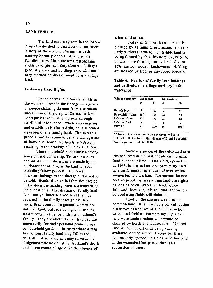
project watershed is based on the settlement claimed by 41 families originating from the history of the region. During the 19th early settlers (Table 6). Cultivable land is century Zarma pioneers, usually single being farmed by 56 cultivators, 32, or 57%,families, moved into the area establishing of whom are farming family land. Six, or rights to virgin land they cleared. Villages 15%, are nonresident landowners. Holdingsgradually grew and holdings expanded until are marked by trees or unweeded borders. they reached borders of neighboring village land. Table 6. Number of family land holdings
and cultivators by village territory In the Customary Land Rights watershed
Under Zarma la,..d enure, rights in Village territory Claimants Cultivators the watershed rest in the lineage -- a group # % # % of people claiming descent from a common Hamdallaye 7 17 9 16 ancestor -- of the original Zarma settlers. Bokotchili Yaina 18* 44 23 41 Land passes from father to sons through Falanke K&,na 13 32 21 38 patrilineal inheritance. When a son marries Falanke Beri 3 7 3 5 and establishes his household, he is allocated TOTAL 41 100 56 100
a portion of the family land. Through this * Three of these claimants do not actually live in process land has come under the management Bokotchili K-,ina but in tha villages of Binni Bokotchili, of individual household heads (windi koy) Fandougou and Bokotchili Beri. resulting in the breakup of the original tract.
These household heads have a strong Some expansion of the cultivated area sense of land ownership. Tenure is secure has occurred in the past decade on marginaland management decisions are made by the land near the plateau. One field, opened upcultivator for as long as the land is used, in 1988, is situated on land previously used including fallow periods. The tract, as a cattle marketing route and over which however, belongs to the lineage and is not to ownership is uncertain. The current farmer be sold. Heads of extended families preside sees no problems in retaining land use rightsin the decision-making processes concerning as long as he cultivates the land. Once the allocation and arbitration of family land. fallowed, however, it is felt that landowners Land not yet inherited and land that has of bordering fields will claim it. reverted to the family througii disuse is Land on the plateau is said to be under their control. In general women do common land. It is unsuitable for cultivation not hold land, but receive rights to use the but serves as a source of fuel, construction land through residence with their husband's wood, and fodder. Farmers say if plateau family. They are allotted small tracts to use land were made productive it would be temporarily for their personal peanut crops claimed by bordering landowners. Unused or household gardens. In cases 'ihere a man land is not thought of as being vacant, has no sons, family land may fall to the available, or unclaimed. Except for these daughter. Also, a woman may serve as the two recently opened-up fields, all other land designated title holder at her husband's death in the watershed has passed through a until a son comes of age or in the absence of succession of users.
11
Land Agreements areas, however, land sales are reported. The use of borrowed land passes in
Besides inheritance, the principal way patrilineal succession to the borrower's sons, to acquire land is by lozn. Forty-three allowing use of loaned land to pass through percent of watershed farmers crop on multiple generations. This provides tenure borrowed land. Of these 24 farmers, 15 are security to nonlandowners. It also results in landless, having moved into the area without major land disputes since succeeding users original family claims. Nine have family develop a false sense of ownership. To land in the area but have sought a borrowed prevent such misunderstandings, formal field in the watershed because of leases obtained through the chef de canton "insufficient family." "Insufficient" can are being encouraged. If a land dispute refer to the quantity of the family land is occurs that the chef de village cannot settle, insufficient to meet their production needs. the chef de caiiton convokes knowledgeable
A borrower and a land proprietor elders to clarify the original settlement usually reach a verbal agreement providing history. access to the land. There are no time periods. The undersianding is that the Land Availability borrower will use the land until the "field becomes too old and difficult to cultivate," at Actual land availability in the projectwhich point land is fallowed and the watershed is unknown. Surplus family land ownership reverts to the lending family. The appears to exist in Falanka Kaina, but the borrower may then acquire another field elders of Bokotchili claim that village land is from the same family, negotiate with another limited. Farmers contend land is available family, or subdivide the field into a rotation for anyone who wants to cultivate it. For fallow system. Borrowing land entitles the example, "All the good, strong workers have cultivator to the field's harvest, including left. They've gone elsewhere. They don't crop residues. But it does not ensure want to farm. They want to find work in the longterm rights. Thus, a borrower Nould not cities. All who are left are the old men. So, invest in long-term improvements such as there is land here for anyone who wants to digging a well or planting economic trees. work." Such perceptions may b3 typical of
Few instances were reported where a the deep-seated belief over much of Africa landowner reclaimed land from a borrower. that land is to be shared (de Wilde, 1967) or Tenure security of borrowed land appears to be subject to government policies that have exist through established lender-borrower encouraged the use of land by anyone willing relationships. Several farmers were found to farm.1
acting as subleasers, allowing a third party to Land availability is not synonymous use parcels of their borrowed laud. with accessibility or quality of land. Much
For usi of land, the farmer typically of the land in the watershed is distant from gives the lending household head a the village centers of lamdallaye and proportion of the harvest -- reportedly 10% Bokotchili Kaina. Farmers living in of the yield -- though the amount varies Hamdallaye travel 4 to 6 km to their fields. according to their relationship and the crop's Women are granted small temporary parcels yield. No money is paid for land use. Land is not sold. A typical remark is that if Report from Zinder suggest that this one "sells land, the money will soon be gone government Intervention has resulted inthe disruption of whereas land lasts forever." In neighboring the fallow system and promotion of land degradation
(Arnould, 1982).
12
and observations indicate that recent new residents are farming very marginal land.
Access to land is a function of the reputations of the lender and the borrower. Heads of families are known according to their temperament and generosity and are chosen for land negotiations accordingly. Borrowers are expected to be "serious farmers." It is said that land is only loaned to those who "want to work."
Use of Land Resource Base
The watershed serves various users both seasonally and yearly for multiple purposes. One person may own the land and another may farm it and have rights to the crop. Other persons may depend on the same piece of ground for dry season feed or as a seasonal residence.
Nineteen families live in the watershed using land as their residence including huts, gardens, livestock tethering sites, and granaries. A network of paths is used for transporting wood and to get to outlying areas. A livestock route dissects the watershed providing an important avenue for moving livestock to grazing during the cropping season. While actual monitoring of the watershed by its users was beyond the scope of this study, it is clear that land cannot be viewed from a single perspecdve.
Summary and Conclusions: Implications on Land Use and Management
Forty-one families claim ownership rights to the 500 ha comprising the watershed. Of the 56 farmers, 57% are using family land and 43% are farming on borrowed land. Under customary Zarma land tenure, land is inherited through the patrilineage and comes under the control of modern heads of nuclear households within the lineage. Household heads have a strong
sense of land ownership, though the land belongs to the lineage and may not be sold. Women reportedly own no land.
Land holdings are identified with the head of the household using the land. However, nearly two-thirds of the fields are worked by more than one person. Often household members have individual parcels. Access to and tenure over individual plots within the household's holdings need further clarification. The person who cultivates the land is entitled to the harvest, including cropresidue and valuable plants. A leaseholder is not permitted to dig a well or invest in improvements that hinge on long-term land rights.
Land must be used in order for the household to maintain possession and the right to transmit it to successive generations -- whether family land or borrowed. When the land becomes exhausted and uneconomic to cultivate, it is fallowed until the same or another cultivator needs it. Through this process most of the land has passed through a succession of different users. Many more farmers have various types of user rights to land and its resources than originally thought. Who uses the land and how and when become important factors in designing a watershed management strategy. Seasonal uses of the land, microenvironmental situations, and multiple users need to be considered.
Animals are typically blamed for promoting land degradation. Yet animals play an important role in the farming system as a source of investment, food, transportand pack, and manure. Monitoring animal use of the watershed during both wet and dry seasons would seem necessary.
Lack of land security is often cited as a major drawback to long-term investments in land improvement. Tenure security appears to exist for borrowers of land through established relationships and long-term leases that allow borrowed land to
13
pass to successive generations. Falloux and Mukendi (1988) contend individual land ownership is an unnecessary prerequisite for encouraging land investmenos. Depending on the type of land investment, individual leaseholder arrangements and rights to crops may be sufficient. Willingness to invest in land improvements certainly depends on the nature and costs of the particular intervention.
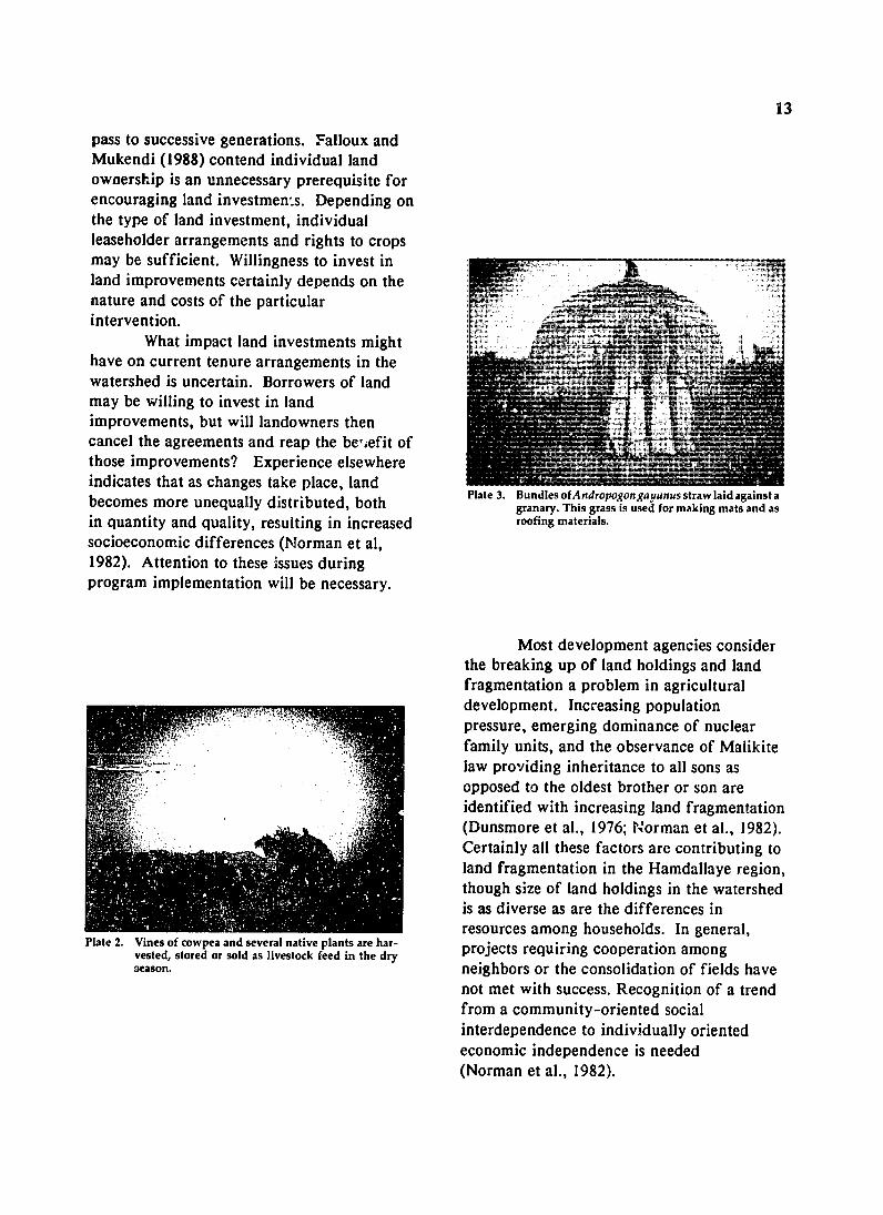
What impact land investments might have on current tenure arrangements in the watershed is uncertain. Borrowers of land may be willing to invest in land improvements, but will landowners then cancel the agreements and reap the bensefit of those improvements? Experience elsewhere indicates that as changes take place, land becomes more unequally distributed, both Plate 3. BundlesofAndropogongayanus straw laid against a
granary. This grass is used for making mats and as in quantity and quality, resulting in increased roofing materials. socioeconomic differences (Norman et al, 1982). Attention to these issues during program implementation will be necessary.
Most development agencies consider the breaking up of land holdings and land fragmentation a problem in agricultural development. Increasing population pressure, emerging dominance of nuclear family units, and the observance of Malikite law providing inheritance to all sons as opposed to the oldest brother or son are identified with increasing land fragmentation
" (Dunsmore et al., 1976; Norman et al., 1982). Certainly all these factors are contributing to land fragmentation in the Hamdallaye region, though size of land holdings in the watershed is as diverse as are the differences in resources among households. In general,
Plate 2. Vines of cowpea and several native plants are har- projects requiring cooperation amongvested, stored or sold as livestock feed in the dryGeason. neighbors or the consolidation of fields have
not met with success. Recognition of a trend from a community-oriented social interdependence to individually oriented economic independence is needed (Norman et al., 1982).
14
INDIGENOUS KNOWLEDGE AND CLASSIFICATIONS
Research on indigenous knowledge in the IMAW project watershed centered on farmers' understanding and experience about soil management. Interviews clarified local classifications of soils and landscapes and farmer perceptions of problems in order to incorporate and build upon this technical knowledge in designing appropriate soil conservation measures.
Land Types
By their position in the landscape, farmers characterize three major land types:
+ Gorou means valley floor or gully, but has various applications. It is also used to refer to gully erosion. Gorou also stands as a general designation for any low-lying land. it can mean the whole drainage basin, the lower portion of a field, or microdepression sites within a field.
+ Fondu refers to an upland area. Besides describing the entire region between a valley and a plateau, fondu is used to refer to elevated areas within a field, such as raised mounds of deposited soil or the upslope portion of a field.
+ Tondo boz refers to a plateau. In general, a plateau is viewed as nonarable and a communal grazing reserve. Tondo kakasia refers to land just below the plateau which is stoney and unproductive. Farmers state that tondo kakasia can be made productive through tractor cultivation,
General land quality is associated with these major topographical divisions, Typically, farmers classify higher elevations as less fertile because of water and nutrient runoff. Land closest to the plateau is considered the poorest in terms of soil structure. Farmers recognize, however, that management practices affect land productivity and they distinguish attributes of particular soils within a topographical
sequence. Consequently, farmers tend to associate land quality more with cultivation and fallow practices than by topography. For example, recently cultivated marginal land near the plateau is considered more productive than downslope but older fields.
Field Classification System
The field classification system reflects the importance attributed to cultivation history by farmers:
+ Sacara - Land just returned to cultivation after a I-year fallow
+ Lalibanda - First year of cultivation after sacara
+ Kwarkwari - Land under cultivation for 3 to 4 years
+ Blanga - Land under cultivation for 5 years or more
+ Farezenou - Land in fallow
Fields often include parcels of various fallow lengths. Within a single field, a farmer may distinguish a portion as sacara, another portion as lalibanda, and another portinn as blanga. Productivity levels are equated with each.
Soil Classifications
Farmers distinguish three dominant soil types by color: labu biri as black soil; labu kware as white soil, and labu kirey as red soil.
Soil color is related to the presence or absence of organic matter, the process of soil erosion, and subsoil character. Black soil contains more organic materials and is considered more fertile. Through cultivation and erosion, valuable nutrients are depleted, leaving less productive white soil. Further degradation results in red soil. Within a class, farmers distinguish gradations in fertility. For example, a soil may be typified as a mixture of black and white.
The second major classification
15
system for soils is related to texture in three soils. In a few cases, farmers described a major types: lassi, sandy soils; botogo, soils hardpan layer that restricted the infiltration with some clay content; and gangani, of water and plant roots. crusted, compacted soils. Farmers use sight and touch to
Properties used to describe tassi soils determine the physical properties of soil,include light weight, sandy texture, soft, paying close attention to the top layer -- the porous, and dry. The botogo soils, in rooting zone for millet and cowpea propertiescontrast, are said to be darker in color, that farmers distinguish are color, organicheavier and retain water. They are described matter, texture, drainage condition, and as being strong, more difficult to cultivate, depth. Chemical properties seem not to but more fertile. Weeds grow faster in feature in their classifications. botogo soils, which also influences crop In evaluating soil fertility farmers choice and its management. Because weeds commonly use the phrases labu zenou or labu inhibit growth, millet grown in botogo soils farga, meaning the soil is tired. These soils must be weeded more carefully than have been cultivated too long, their fertilitysorEhum. Thus, extra labor is required. depleted. To restore productivity, farmers Also, botogo soils are particularly difficult to typically fallow or apply animal manure if cultivate when dry, leading, at times, to an possible.undesirable decision of delayed weeding. Another phrase used to describe less Small depressions within a field of botogo common soils is labu sida bani, meaning the soils are often planted in sorghum or maize, soil is not fertile. Farmers translate this to
Within class distinctions are made mean the soil is sick. They observe this relative to whether the soil contains some condition by looking at millet roots soon clay, sand, or laterite. Better quality land after planting. If the new roots do not form contains some clay. Soil that is too sandy is and existing roots are dry and black, the soil considered too light and more susceptible is sick. Farmers say they are powerlessness to wind erosion. By contrast, soils with some to change this condition. clay content are heavier and can trap and In general, soil types are classified hold plant debris, leading to buildup in according to topographical location. organic matter. Low-lying land typically features loamy to
Ganganirefers to denuded ground. clayey soils. Higher land is characterized byFarmers typically listed gangani as land sandy soils. However, variability exists where plants do not grow. Gangani may be within fields. Different intercrop patterns found over large areas or as isolated patches maximize these microenvironments. For of bare earth within a field. Most farmers instance, sorghum, sorrel, okra, and maize regenerate small patches of gangani found may be grown in small water catchments within fields. Over large areas, animal with heavier textured soils. Sites with highertraction or tractor cultivation, along with productivity potential -- areas where animals additions of organic matter such as manure, have been kept and at bonfire and grainchaff, and crop residue, are considered pounding sites where litter has accumulated necessary to restore productivity. -- are similarly used.
The water retention capacity of soil is Wind-blown soil forms a natural linked to length of cultivation as well as to mound-gully cultivation system. Soil is clay content. Rainfall amounts are not deposited around plants, debris, and stumps.considered critical to yields if fields are Also, wind may move soil from one of the newly cultivated. Rain is not considered as field to another, resulting in highmuch a problem on clayey soils as on sandy productivity on the lee side.
16
Higher productivity sites within a field are associated with ant (n'kondo) and termite (tcharra)colonies. Termite casts are considered rich in clay and plant nutrients, while tunnels loosen and mix the soil. During the dry season termites attack cropresidues, resulting in decomposition and organic matter enrichment,
Classification of Vegetation
Various indigenous species are valued in the production system. Listed in order of priority in Table 7 are the principal plantsand trees and their uses as identified by local farmers.
Plants.
Andropogon gayanus is widely found throughout the watershed. It is used for construction, principally in weaving large mats used in house construction, but an excess in fields lowers millet yields. Farmers contend hardier andropogonroots compete with millet, that morning dew on andropogen is too humid for millet, and that large plants shade the millet. Surplus andropogon is sold, but its income does not exceed that of millet,
Animals are kept from grazing fallow fields producing Andropogon gayanus and Aristida sieberiana,signifying their importance in the production system. Besides Aristida sieberiana, farmers use two other similar grasses in thatching roofs. Bata-kirey(Heteropogon contortus) is found on the plateau and bata kwarey (Ctenium elegans) is found in fields.
Trees.
Of the woody species found in the watershed, kosey (Piliostigmareticulatum) is given primary importance. Its impact on productivity oc'curs because its leaves containnutrients that increase soil fertility and wnnd-blown soil colleats aroundethelbaseaofwind-blown soil collects around the base of
the plant. The most productive millet occurs on mounds of raised earth at the site of kosey shrubs. Kosey rejuvenates land similarly to fallowing, farmers said. Kokorbey(Combretum glulinosum) has a similar effect on soil fertility.
Sabara(Guierasenegalensis)1 is another very common woody specie found on cultivated fields. it grows on the harder,hotter, more lateritic soils closer to the plateau. Different parts of kosey and sabara are eaten by animals. Guierasenegalensis and Combretum nigricansi are considered good fuel.
On cultivated fields, shrubs are cut twice a year. This practice provides mulch to boost soil fertility and inhibit wideerosion, reduces shade which retards millet growth, and takes advantage of the highnutrient content of young foliage as animal fodder.
Few large trees are found in the watershed. Fruit trees around household compound and villages are few. Lack of water and roaming animals that eat seedlings discourage tree planting. Trees, however, serve to mark field boundaries. Farmers attribute the main benefit of tree, to the shade they provide during fieldwork rest periods. The leaves and fruit of some trees are eaten. Higher soil fertility around the zamturi (Prosopis africana) is associated with leaf and bark decomposition and manure deposited by animals seeking shade. Nigerien law prohibits cutting trees.
Farmers indicate a preference for gao (Acacia albida) and garbey (Balanites aegyptica). Gao enhances soil fertility. It is used in traditional medicines, and the fruitand leaves are fed to animals. However, gao needs water and is found near waterways but not on upland cultivated land (fakara). Garbey also is linked to enhanced soil
1Guiera aengalenhis, Combretum rcn and Combretum micranthum are the three principal firewoodspecies sold in Niamey (Heermans, 1986).
17
fertility. Its fruit and leaves are used as Farmer Perceptions of Factors Determining livestock feed, food for the household, and Crop Production sale.
Attitudes toward large trees are Farmers consider rainfall the positive, but there is no custom of planting principal factor determining crop production. trees. Misgivings were expressed about small Low yields in 1989 were linked to late start trees in fields because their shade hinders of the rains, a drought period after planting, millet growth. A Zarma phrase indicates the and too many rains in late July and early importance of clean fields, "Da turi kaina go August, impeding grain .velopment. faro ra haino si kasu gumo," meaning, "If Early season rains are particularly there are small trees in the field the millet critical because a rainfall of greater than 20 will not grow large." The established mm is considered necessary to established a practice is to cut bushes to make space for successful crop (Sivakumar et al., 1981). For millet. In farmers' words, "Millet needs air the Hamdallaye watershed, the first rain fell and sun to grow." on Juno 25, but it was not until July 11 that a
single rainfall of over 20 mm was recorded Livestock feed. (Table 8). The amount of rainfall was
adequate in 1989 but the overall distribution Several plants are harvested and was a problem.
stored for animal feed in the dry season. Two are considered to be equal in nutritive Rainfall/fertility Interaction. value to the cowpea: fugutu (Ipomoea involucrate) and kongo zara (Merremia Farmers consider rainfall the tridentata). Fugutu is found in fertile soils, principal factor determining crop production. whereas kongo zara grows on less productive In good rainfall years production levels are soils. Only the farmer has the right to sufficient regardless of land quality. But harvest these plants, indicating their under increasingly drier and erratic weather importance in the production system. They conditions, farmers stressed the combination are stored for dry season or sold. A third of poor rainfall and soil fertility for reduced specie, kullum (Eragrostis tremula), does not production. Rainfall patterns were have the same feeding value, and anyone considered a particular problem because the may cut and use it. Branches of two large "land is old and tired." Soils, they said, were trees, zamturi and farka hanga (Terminalia cultivated too long, the soil structure is weak, avicenioides), are often cut and fed to and rainfall infiltration is low. While animals in the dry season. farmers consider the start and pattern of
rainfall of foremost importance, they SOIL AND WATER CONSERVATION appeared increasingly concerned about soil PRACTICES fertility.
In an uncertain environment where Changes in Farming Practices. annual crop yields vary greatly, the objective is to secure a reliable food supply. Rather Agricultural practices have changed than speaking of changes or yield decreases, in response to the environmental farmers view each year as different and circumstances affecting the region. Farmers unique. spoke of a seven to eight-month dry season
18
Table 7. Farmer listing of beneficial plants and trees in the watershed.
Zarma name
Subu nya
Bata
Borboto
Gandabani
Haramdam
Tutu Fugutu Kongo zara Kullum
Kosey
Korkobey Darey
Zamturi
Sabara
Deli-nya Gao
Garbey
Farkahanga
Scientific name
PLANTS
Andropogon gayanus
Aristida sieberiana
Pennisetumpedicellatum
Cassiamimosoides
Diheteropogonhagerupii
Setariapallide-Fusca Ipomeoa ivolucrate Merremia tridentala Eragrostistremula
TREES
Piliostigmareticulatum
Combretum glutinosum Ziziphus mauritiana
Prosopisafricana
Guierasenegalensis
Combretum nigricans Acacia albida
Balanites aegyptiaca
Terminaliaavicenioides
Use
mats; roofing; leaf sheath fed to animals mats; roofing as underneath layer to Andropogon animal feed; can replace Aristida in roofing soil fertility; mats; can replace
Aristida in roofinganimal feed; roofing as underneath layer to Aristida animal feed animal feed animal feed animal feed
bark used for cord; soil fertility; fruit, and new leaf growth as animal fruit
medicine; soil fertility fruit; leaves as animal feed;
thorny branches used to protect mats and granaries from animals construction; soil fertility; cut branches for animal feed in late d. y season; wood for mortar, daba, etc. medicine; leaves as sheep feed; firewood firewood; consume and sell fruit enhance soil fertility; traditional medicine; fruit and leaves as animal feed enhance soil fertility; fruit and leaves as animal feed and human nutrition animal feed
19
only three months of good rain. Most have and costs appeared to limit its usage.in the past when they could count on for Farmer Perceptions of Land Degradationmonths of rain. Today they can depend Farmers refer to land degradation as onabandoned samno, late season millet, the decreased production potential of the because of the shortened rainy season and land. Most commonly, dogradation was insufficient soil fertility. Many farmers attributed to a loss of vegetation and an plant dry, mix varieties and follow varying increase in wind. Declining land management strategies to minimize risks, productivity was viewed as a self-
Fallowing practices have changed perpetuating phenomenon over which because of uncertain yields and increasing farmers expressed little control. Decreased pressure on the land. Farmers say fields vegetation resulted in the loss of fertile cannot be left to regenerate while another topsoil and its capacity to support vegetation.field is cultivated. Farmers also noted Farmers attributed loss of vegetation to increased wind erosion of valuable topsoil -- general climatic changes, the severe droughtcausing a change in crop residue that ended in 1974, increased cultivation management. where more land is under the hoe, and
Farmers spoke about increased risks shorter fallow periods. They also spoke of in agriculture. In the past they were assured changes in the composition of plant an adequate harvest if a crop was planted, species.Today, even producing a crop is uncertain. Farmers note an increase in the In this setting, farmers were more concerned frequency and velocity of the dry season with minimizing risks, than with maximizing wind. These winds carry away topsoil,production. leaving unproductive gangani, literally
meaning bare earth. Farmers furtherPerceived Agricultural Problems. complained of millet damage when wind-blown soil buries seedlings. Farmers
Principal production problems plant seeds amid millet residue to protectexpressed by farmers are related to the germinating seedlings.geo.cological changes affecting the region: Water erosion was seldom mentionedinadequate and irregular rainfall, low soil as a problem by farmers. Wind erosion fertility, lack of animal manure, limited emerged as a larger concern !-ecause all access to and money to purchase chemical farmers fear its potential damaging effects. fertilizer, labor shortages due to young men Water erosion, in contrast, depends on theleaving home and the expense of hired labor, location and slope of fields and is considered wind erosion. less severe. A representative comment:
Insect and pest damage were seldom "Even with water on the field you can still mentioned in discussions of agricultural get some harvest, but with wind problems. This may be due to the variability damage you won't get anything." There in pest populations related to rainfall appear to be differences in the ability to conditions. When inspecting fields, farmers combat wind and water erosion. Morequickly pointed to insect damage. In this techniques are used to control wind erosion. context, farmers attributed 1989 yield losses In contrast, farmers expressed an inability to to mice, a nocturnal millet beetle, combat water erosion. grasshoppers, and various millet-eating worms. Soil Management Practices
Animal manure and chemical fertilizer were considered the primary means Fallowing. for improving productivity. In general,farmers reported shortages and higher costs Fallowing continues to be the of animal manure due to fewer numbers of principal management practice. to restore soil permanent and nomadic cattle in the region. productivity.Changes during 1989 in fertilizer availability About half of the watershed was in
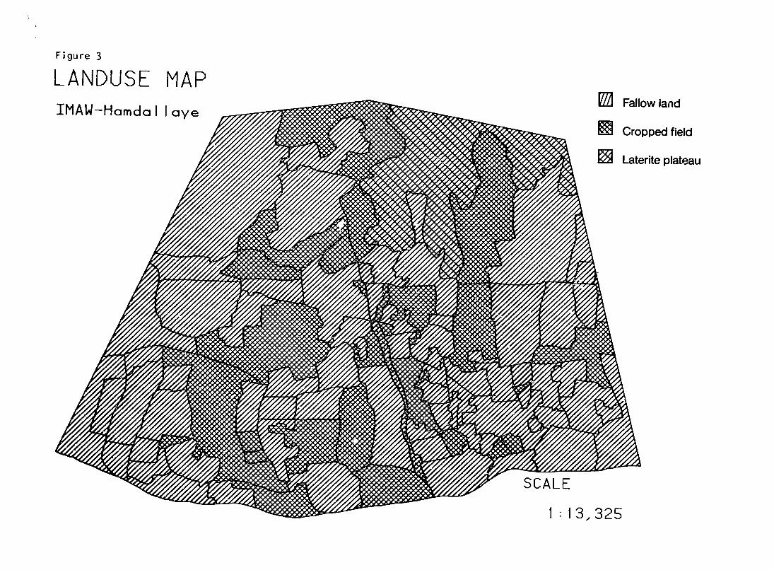
Figure 3
LANDUSE MAP IMAW-HomdalI ye
I Wl Cropped field
Laterite plateau
SCALE
1:13,325
21
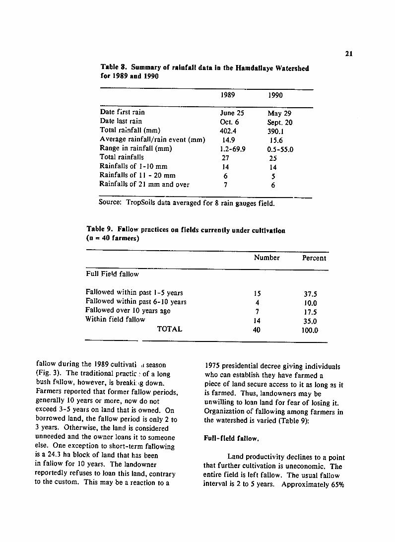
Table 8. Summary of rainfall data in the Hamdallaye Watershed for 1989 and 1990
1989 1990
Date first rain June 25 May 29 Date last rain Oct. 6 Sept. 20 Total rainfall (mm) 402.4 390.1 Average rainfall/rain event (mm) 14.9 15.6 Range in rainfall (mm) 1.2-69.9 0.5-55.0 Total rainfalls 27 25 Rainfalls of 1-10 mm 14 14 Rainfalls of 11 - 20 mm 6 5 Rainfalls of 21 mm and over 7 6
Source: TropSoils data averaged for 8 rain gauges field.
Table 9. Fallow practices on fields currently under cultivation (n = 40 farmers)
Number Percent
Full Field fallow
Fallowed within past 1-5 years 15 37.5 Fallowed within past 6-10 years 4 10.0 Fallowed over 10 years ago 7 17.5 Within field fallow 14 35.0
TOTAL 40 100.0
fallow during the 1989 cultivati a season 1975 presidential decree giving individuals (Fig. 3). The traditional practic.' of a long who can establish they have farmed a bush fallow, however, is breaki: tg down. piece of land secure access to it as long as it Farmers reported that former fallow periods, is farmed. Thus, landowners may be generally 10 years or more, now do not unwilling to loan land for fear of losing it. exceed 3-5 years on land that is owned. On Organization of fallowing among farmers in borrowed land, the fallow period is only 2 to the watershed is varied (Table 9): 3 years. Otherwise, the land is considered unneeded and the owner loans it to someone Full-field fallow. else. One exception to short-term fallowingis a 24.3 ha block of land that has been Land productivity declines to a pointin fallow for 10 years. The landowner that further cultivation is uneconomic. The reportedly refuses to loan this land, contrary entire field is left fallow. The usual fallow to the custom. This may be a reaction to a interval is 2 to 5 years. Approximately 65%
22
oi the interviewed farmers indicated that entire fields had been left in fallow. Leaving a whole field in fallow implies having access to another field to crop during the period, Fifty-seven percent of the farmers had more than one.
With-in field fallow.
Least productive areas within a field are fallowed. The remaining land is cultivated. With-in field fallowing implies having sixfficient contiguous land to move cultivated areas around within the field. In this manner, a field can be composed of several parcels of varying fallow lengths. Usually the fallow interval is 2 to 3 years. Thirty-five percent of the farmers practice with-in field fallowing.
Emergency fallow.
A field or portion of a field may also be fallowed due to the illness of the farmers, lack of labor, or other circumstances that delay planting. Two farmers reported unintentional fallows in 1989 due to lack of labor.
Seven farmers reported no fallow practice. Cultivation periods ranged from 10 to 50 years with an average of 23 years. It is assumed some form of land regeneration management is practiced to sustain productivity. Three farmers, for example, use substantial amounts of manure, If the field or parts of it are uneconomic, it is left fallow. Faimers said that due to overall soil degradation, land takes longer to regenerate. They contend that the second year after a fallow is the most productive,
A commnn practice among Bokotchili farmers is a 3-year fallow followed by a 7-year cropping period. Farmers consistently said that a minimum 3-year fallow is necessary to regeperate soil productivity, but this may be shortened depending on how the rainy season unfolds,
Late rains in 1989 brought fields back into cultivation prematurely. Soil characteristics, state of the land when fallowed, rainfall, family needs, and resource availability interact in determining actual crop and fallow intervals.
Another fairly common practice is to seed all land. Fields or portions of fields may be later abandoned if labor is unavailable to weed or if the chance of obtaining a harvest becomes low due to poor rainfall. Also, seeding all land is a way to spread out risks. Farmers evaluate fields and concentrate labor where it is likely to be most cost effective. Another reason for planting all land is to show use to preclude others from using it. Pressures exist to loan fallow land to family or outsiders. Land must be used in order to maintain land rights. At least 25% of the farmers in the watershed seeded entire fields but did not weed all or portions of those fields. Such land is called a "disguised fallow" (Mclntire, et al., 1989) and does not benefit from being used.
Use of Animal Manure.
Farmers believe -- that if they have animals then crop production can be sustained. One Fulani, verbalized the importance of livestock to farming by saying, "Bankan gonda kurgne in gandaban kan sinda kurgne manta a fo," meaning that the womai who has a husband and she who does not are not the same.
Animal manure is preferred to chemical fertilizer because it is said to last from 5 to 10 years, depending on the amount and type applied (goat, sheep, cattle jr donkey), soil type, method of application (kraaling or hauling manure from the compound to field), and whether it is the rainy or the dry season. Eleven of 39 (28%) farmers with cropped fields reported applying animal manure during 1989, principally by kraaling animals on crop
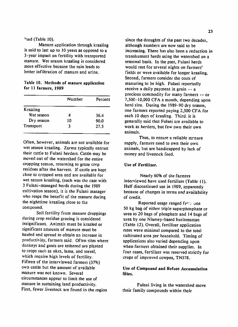
23 1%nd(Table 10). since the droughts of the past two decades,
Manure application through kraaling although numbers are now said to be is said to last up to 10 years as opposed to a increasing. There has also been a reduction in 3-year impact on fertility with transported transhumant herds using the watershed on a manure. Wet season kraaling is considered seasonal basis. In the past, Fulani herds more effective because the rain leads to would rest for several nights on farmers' better infiltration of manure and urine, fields or were available for longer kraaling.
Second, farmers consider the costs ofTable 10. Methods of manure application manuring to be high. Fulani reportedly for 11 farmers, 1989 receive a daily payment in grain -- a
precious commodity for many farmers -- or Number Percent 7,500-10,000 CFA a month, depending upon
herd size. During the 1989-90 dry season, Kraaling one farmers reported paying 2,500 CFA for
Wet season 4 36.4 each 10 days of kraaling. Third. it is Dry season 10 90.0 generally said that Fulani are available to
Transport 3 27.3 work as herders, but few own their own animals.
Thus, to ensure a reliable mrnure Often, however, animals are not available for supply, farmers need to own their own wet season kraaling. Zarma typically entrust animals, but are handicapped by lack of their cattle to Fulani herders. Cattle may be money and livestock feed. moved out of the watershed for the entire cropping season, returning to graze crop Use of Fertilizer. residues after the harvest. If cattle are kept close to cropped area and are available for Nearly 60% of t0e farmers wet season kraaling, (such was the case with interviewed have used fertilizer (Table 11).3 Fulani-managed herds during the 1989 Half discontinued in 1999, apparentlyuse cultivation season), it is the Fulani manager because of changes in terms and availability who reaps the benefit of the manure during of credit. the nighttime kraaling close to the Reported usage ranged fr,' . one compound. or50 kg bag of either triple superphosphate
Soil fertility from manure droppings urea to 20 bags of phosphate and 14 bags of during crop residue grazing is considered urea by one Niamey-based businessman insignificant. Animals must be kraaled or (Table 12). Overall, fertilizer application significant amounts of manure must be rates were minimal compared to the total hauled and spread to obtain an increase in cultivated area per household. Timing of productivity, farmers said. Often sites where applications also varied depending upondonkeys and goats are tethered are planted when farmers obtained their supplies. In to crops such as okra, lama, and sorrel, four cases, fertilizer was reserved strictly for which require high levels of fertility, crops of improved cowpea, TN578. Fifteen of the interviewed farmers (37%) own cattle but the amount of available Use of Compound and Refuse Accumulation manure was not known. Several Sites. circumstances appear to limit the use of manure in sustaining land productivity. Fulani living in the watershed move First, fewer livestock are found in the region their family compounds within their
24
designated land areas up to three times a year to take advantage of accumulated household
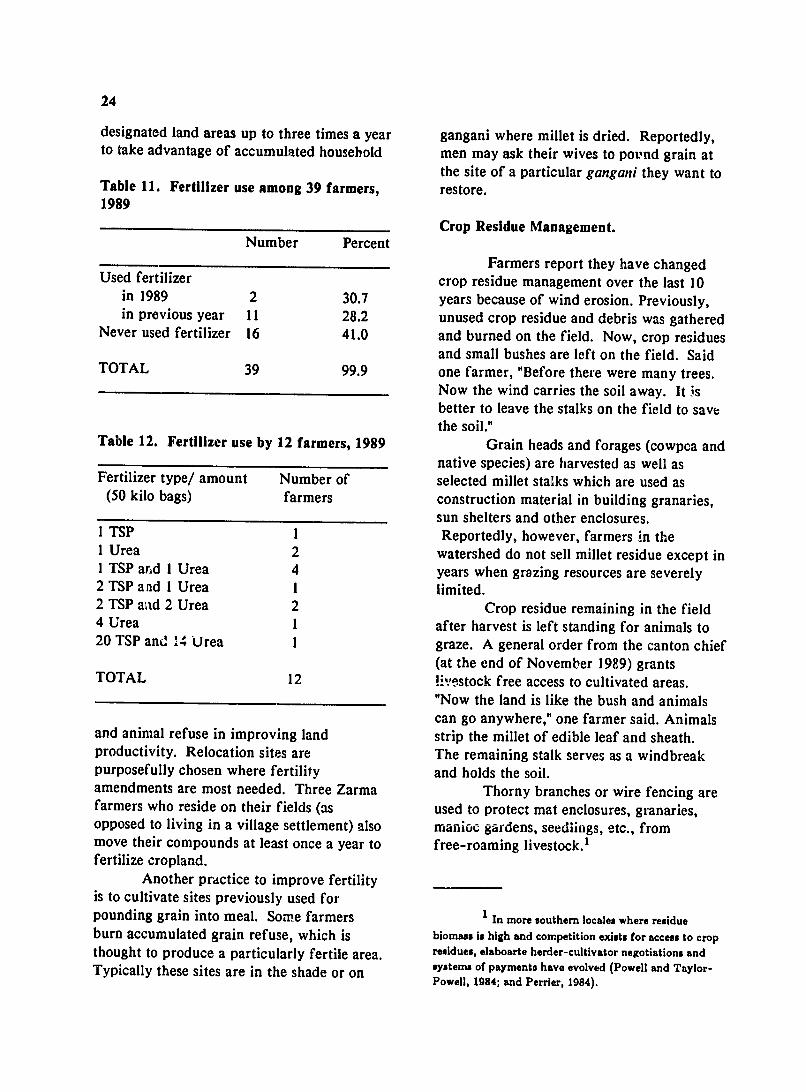
Table 11. Fertilizer use among 39 farmers, 1989
Number Percent
Used fertilizer in 1989 2 30.7 in previous year 11 28.2
Never used fertilizer 16 41.0
TOTAL 39 99.9
Table 12. Fertilizer use by 12 farmers, 1989
Fertilizer type/ amount Number of (50 kilo bags) farmers
I TSP 1 1 Urea 2 1 TSP and I Urea 4 2 TSP and I Urea I 2 TSP and 2 Urea 2 4 Urea 1 20 TSP and 14 Urea 1
TOTAL 12
and animal refuse in improving land productivity. Relocation sites are purposefully chosen where fertility amendments are most needed. Three Zarma farmers who reside on their fields (as opposed to living in a village settlement) also move their compounds at least once a year to fertilize cropland.
Another practice to improve fertility is to cultivate sites previously used for pounding grain into meal. Some farmers burn accumulated grain refuse, which is thought to produce a particularly fertile area. Typically these sites are in the shade or on
gangani where millet is dried. Reportedly, men may ask their wives to pound grain at the site of a particular gangani they want to restore.
Crop Residue Management.
Farmers report they have changed crop residue management over the last 10 years because of wind erosion. Previously, unused crop residue and debris was gathered and burned on the field. Now, crop residues
and small bushes are left on the field. Said one farmer, "Before there were many trees.
Now the wind carries the soil away. It is better to leave the stalks on the field to save the soil."
Grain heads and forages (cowpca and native species) are harvested as well as selected millet stalks which are used as construction material in building granaries,
sun shelters and other enclosures. Reportedly, however, farmers in the
watershed do not sell millet residue except in years when grazing resources are severely limited.
Crop residue remaining in the field after harvest is left standing for animals to graze. A general order from the canton chief (at the end of November 1989) grants!-estock free access to cultivated areas. "Now the land is like the bush and animals can go anywhere," one farmer said. Animals strip the millet of edible leaf and sheath. The remaining stalk serves as a windbreak and holds the soil.
Thorny branches or wire fencing are used to protect mat enclosures, granaries, manioc gardens, seedlit-gs, etc., from free-roaming livestock. 1
In more southern locales where residue biomass is high and competition exists for access to crop residues, elaboarte herder-cultivator negotiations and systems of payments have evolved (Powell and Taylor-Powell, 1984; and Perrier, 1984).
25
Crop residue is returned to the fields windward side of a field to cut down on in late December through January after crop wind erosion. residue grazing or in April during land preparation. This latter practice involves Other Soil Management Practices. uprooting dead millet plants using a long-handled tool, called a some. The stalks Other soil conservation measures are are laid on the field, sometimes on gangani, practiced on a more limited scale. For to rebuild eroded soil. example, weeding operations may be
Whether farmers uproot millet during suspended on unproductive areas to establish the December-January period or later in plant cover and trap wind- blown soil. April depends on their willingness to Women may break up crusted patches of continue field work after the harvest and wind-eroded land, which, with additions ofwhether labor is available during the dry millet mulch and manure, can be made season. Uprooting millet after grazing is productive within one year.onsidered beneficial because the stalks Fewer practices exist to preventattract termites, decompose over the dry water erosion. This is due to the difficulty season, and trap wind-blown soil. In addition in making improvements. Grass waterwaysto soil enrichment, uprooting millet prevents were seen, but, in general, farmers said thereinjury during weeding when the hoe could was greater need to clear and cultivate all catch embedded roots. It also destroys land for maximum production. A fewinsects that otherwise might live through the farmers experimented with blockades made dry season in roots under the ground. of branches or stones to combat gully
erosion, or to keep water from gushing ontoMulching. cropped area. Success in halting gully
erosion is limited because of the high forceMulching is practiced principally to of the water in comparison to the strength of build up eroded soils and to cut down on the blockade. Contour plowing with a wind erosion. Various crop, plant, and tractor is viewed as a way to slow deposits of household residues are used as mulch, sand and sheet erosion, but few farmers have including branches of native shrubs, kosey, resources to hire a tractor. Farmers korkobey, and sabara; millet stalks; refuse mentioned dam construction as the only wayfrom old granaries; roof thatching from of combating severe gulley erosion found on dismantled homes; fallen tree limbs, and cut the eastern side of the watershed - an grasses. alternative not within local farmers' means.
Typically, native shrubs are trimmed twice a year and used as mulch between Extent and ContuG! of Erosion December (after harvest) and April (beforeplanting) and at the time of the second millet A survey was conducted to measure weeding. The last trimming provides space the extent of wind and water erosional and sunlight for the millet, surfaces in 25 fields selected at differing
Mulching materials may be toposequence positions and to ascertain distributed over fields or placed on severely farmer attempts to control the erosion. eroded areas to trap wind-blown soil. This Water erosion is associated with runpractice provides an adequate soil depth for off from the laterite plateau and lateritic plant growth without having to break up the outcrops and from large areas of exposed Bt lateritic crust. Mulch also is placed on the horizons with surface crusts. Gullies are also
26
common, but do not appear to cover a large part of the land surface. Farmers say they are relatively powerless to control water erosion, as runoff from the plateau and adjacent talus slopes will involve erosion control work away from fields and, therefore, is of little interest.
Wind erosion is seen by the giadual loss of the Al horizon. In extreme cases, it leaves an exposed Bt horizon that is prone to surface crusting, which in turn can form a water erosive surface.
Five types of erosion were distinguished and are referred to by their Zarma names:
1. Tassi gande: Surface deposits of alluvial sand fans resulting from a decrease in slope at the end of a gully or rill. There is no growth due to high speed water flow during intense rains, which tends to uproot seedlings or cover them with sand. Generally there is good water balance for crop growth but the soil is sometimes depleted of nutrients and organic matter, depending on the force of flowing water. Farmers state that once millet is established, it grows well in these areas.
2. Gorou gande: A surface created by sheet erosion, as evidenced by stratification of the Al horizon,
3. Gorou: The name for gully which results from the concentration of water from crusted or impermeable surfaces, such as those found on the laterite plateau and outcrops. Gorou areas are found only in areas with high slopes, and the walls of the valley bottom. As the slope decreases gorou become tassigande.
4. Ganganikware: White gangani,a denuded soil resulting from wind erosion, where part of the surface soil is removed exposing the lower A horizon and sometimes the upper Bt horizon.
5. Ganganikirey: Red gangani,a denuded soil resulting from water and possibly wind erosion where the surface horizon is completely removed and the Bt horizon is exposed. This is generally crusted
and is more difficult to regenerate than gangani kware. These areas may represent sites of o!d trmite mounds, etc.
Of these types of water erosion, tassi gande was cited most frequently as a drawback to production because more fields are subject to sand deposits. Also, deep sand on fields is seen as an immediate problem because it limits the cultivated area and buries the crop. In contrast, gully erosion was seen as a long-term problem where "the water eats the field away little by little," thereby reducing the area available for future cultivation.
Results of an aerial survey, however, show that gangani kirey comprises the largest erosional surface within the watershed, followed by tassi gande (Table 13). However, less than 2% of farmers' fields are affected by ganganikirey. About 3.7% of farmers' fields was affected by one of the five types of erosion. Distribution of erosional surfaces was not uniform, as evidenced by the large standard deviations for each type of surface.
Erosion was most prevalent close to the laterite plateau at the upper part of the toposequence and in the valley bottom. However, gangani kirey was also associated with shallow soils at the second and third laterite outcrops. Farmers associated gangani kware with wind eroded surfaces. However, this surface is not very widely distributed in the watershed (Table 13). Ganganikirey may also result in part from wind erosion, so that the combination of the two ganganisurfaces could indicate that both wind and water erosion contribute to the problems.
Farmer Practices to Control Erosion.
Several native plant species are used by farmers to control wind erosion, primarily on ganganikware areas (Table 14). Branches are generally cut twice a year and spread on the eroded surfaces to trap wind-born soil and build up the surface horizon.
27
Table 13. Frequency and standard Table 15. Different methods of erosion deviations of surfaces within the watershed control practiced by local farmers (n=25 fields) (n=25 farmers)
Erosion type %of field Method %fieldsStd Dev. # fields
Tassi gande 30.73 2.07 Millet surface mulch: Gorou gande 0.50 1.48 stover 4 16 Gorou 0.25 0.58 chaff 1 4 Gangani kware 0.23 0.46 Animal manure 2 8 Gangani kirey 1.98 2.73 Animal traction 1 4
MEAN 3.69 Two farmers used animal manure
exclusively to combat erosion by spreading it on gangani Kirey soils to build up the surface. The manures were generally appliedisthedomiantto
shrub of the semiarid savannah lands of West animal traction to break up the surface crust
Africa, and it is not surprising that it is most and loosen gangani kirey soil, applying
Both G. anr open t the som reforing
Guiea snegaenss the gangani kirey soils. ONe farmer used
used by farmers to control erosion. nd Pliotigm reicultummanruesenealenis to prevent the crust from reforming.senegalensis and Piliostigmareticulaturm
grow throughout the watershed, primarily Summary and Conclusions due to their unpalatability to browsing livestock. Farmers in the watershed view their
land as degrading as a result of climatic changes and loss of vegetation. Problems and concerns are most often related to lower soilTable 14. Native plants used for erosion fertility. Additions of manure and fertilizer
control (n=25 farmers) are seen as solutions to stabilizing
Scientific name # fields used %fields production. Wind erosion causing ti-e used loss of topsoil and burial of millet seedlings
is considered more of a problem than water Guierasenegalensis 12 48 erosion. Water erosion that deposits sand on Piliostigmareticulatum 10 40 cropping areas and buries the crop is Combretum glutinosum 6 24 considered more widespread and harmful Cassiamimosoides 1 4 than gully erosion. Combretum micranthum 1 4 Traditional practices to sustain
productivity -- fallowing and manuring -are breaking down. Fallow periods reportedly have shortened; 3- to 5-year
Several other practices are used to fallows on family land and 2- to 3-year control erosion (Table 15). Millet stalks on fallows on borrowed land as opposed to 10 fields during the dry season are cut and laid years previously. Numerous reasons are on soil surfaces to act as mulches. They trap believed responsible: (1) cultivation of larger wind-blown materials. One farmer used areas to compensate for decreasing land millet chaff for this purpose, productivity; (2) seeding all land to cut risk
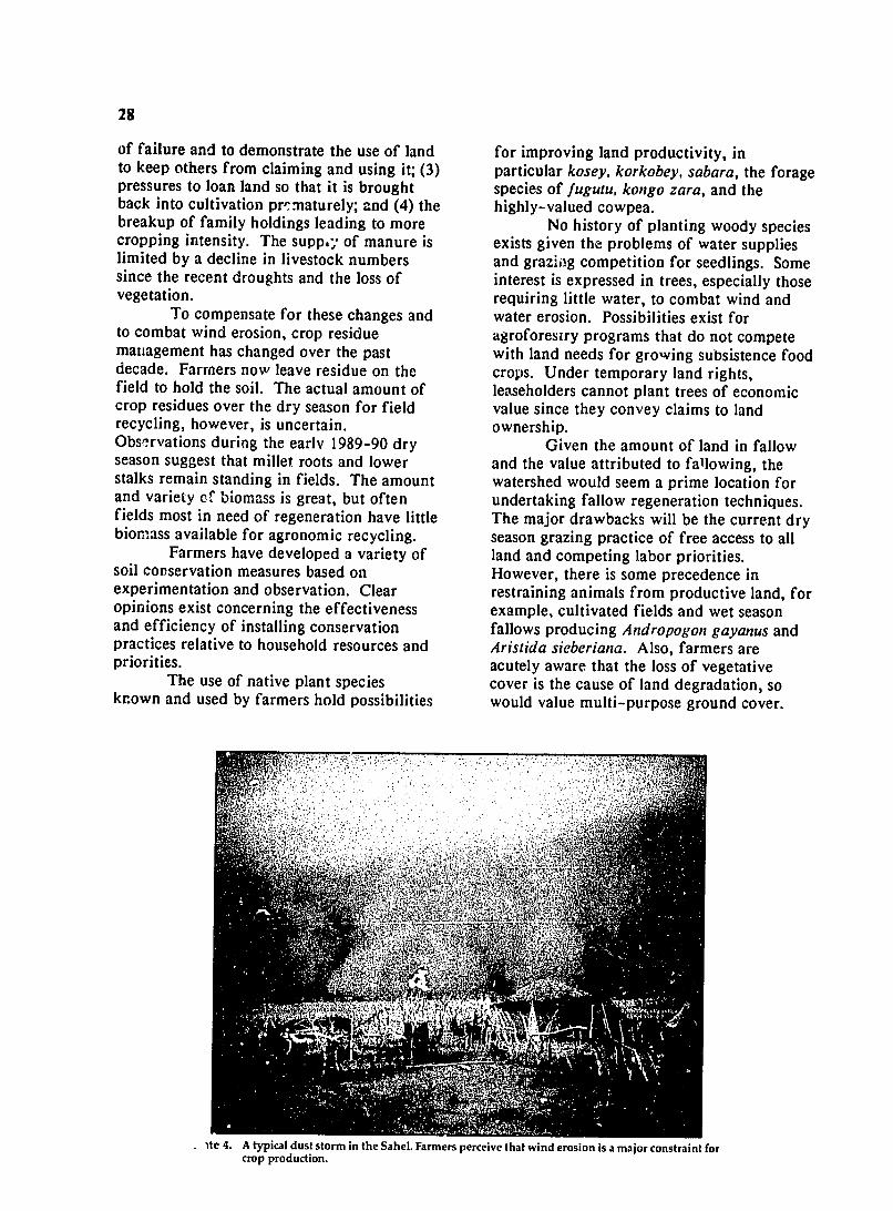
28
of failure and to demonstrate the use of land to keep others from claiming and using it; (3) pressures to loan land so that it is brought back into cultivation pr,:naturely; and (4) the breakup of family holdings leading to more cropping intensity. The suppay of manure is limited by a decline in livestock numbers since the recent droughts and the loss of vegetation.
To compensate for these changes and to combat wind erosion, crop residue management has changed over the past decade. Farmers now leave residue on the field to hold the soil. The actual amount of crop residues over the dry season for field recycling, however, is uncertain, Obse-rvations during the early 1989-90 dry season suggest that millet roots and lower stalks remain standing in fields. The amount and variety cf biomass is great, but often fields most in need of regeneration have little biomass available for agronomic recycling,
Farmers have developed a variety of soil conservation measures based on experimentation and observation. Clear opinions exist concerning the effectiveness and efficiency of installing conservation practices relative to household resources and priorities.
The use of native plant species known and used by farmers hold possibilities
for improving land productivity, in particular kosey, korkobey, sabara,the forage species of fugutu, kongo zara,and the highly-valued cowpea.
No history of planting woody species exists given the problems of water supplies and graziog competition for seedlings. Some interest is expressed in trees, especially those requiring little water, to combat wind and water erosion. Possibilities exist for agroforesiry programs that do not compete with land needs for growing subsistence food crops. Under temporary land rights, leaseholders cannot plant trees of economic value since they convey claims to land ownership.
Given the amount of land in fallow and the value attributed to fallowing, the watershed would seem a prime location for undertaking fallow regeneration techniques. The major drawbacks will be the current dry season grazing practice of free access to all land and competing labor priorities. However, there is some precedence in restraining animals from productive land, for example, cultivated fields and wet season fallows producing Andropogon gayanus and Aristida sieberiana. Also, farmers are acutely aware that the loss of vegetative cover is the cause of land degradation, so would value multi-purpose ground cover.
. ite 4. A typical dust storm in the Sahel. Farmers perceive that wind erosion is a major constraint for crop production.
29 SUMMARY COMMENTS AND crop residues. Grazing land on the plateauIMPLICATIONS is considered communal, as is arable
land within the watershed after harvest.Farmers in the watershed are resilient Tenure rules related to fallow land vary,and adaptable in responding to agroecological depending on the season and whether thechanges. They experiment in various ways to user is the landowner or borrower. Theselessen the risk of crop failure by using multiple tenure arrangements need to bemultiple planting dates, mixing seed considered in watershed project design andvarieties, using favorable implementation. Likewise, it will bemicroenvironments, priority weeding, using important to recognize that land in thesoil restoration techniques, and controlling watershed falls under the jurisdiction of fourwind erosion by mulching with crop residues villages which certainly will add complexityand native woody species, to issues of resource management and
Unfavorable rainfall patterns and cooperation.declining soil fertility are considered the Subsistence economy households haveprimary drawbacks to crop production, short time views. Water erosion is not seenFarmers typically describe their land as "old by farmers to be a major problem. A far and tired." Fallowing and use of manure more widespread concern is the loss ofcontinue to be the principal means of topsoil by wind erosion. Farmers seesustaining land productivity. However, problems in terms of individual bousehold;fallow periods have gone from 10 years down and threats to their subsistence as opposedto 2- to 5-year periods, depending on tenure to community concerns or the long-termsecurity. Pressure to use land to maintain consequences of land degradation. They willland rights discourages fallowing. Manure participate in land conservation work when it availability is limited because of a decline in is profitable from a labor standpoint andlivestock numbers and less fodder because of does not compete with subsistence food grainreccnt droughts. Animals are important in needs. The size of the land holdin-s and its the production system -- for manure, quality vary greatly in the watershed, as doestransportation, and food -- so improvements the ability of households to acquire and in forage to provide a soil cover and as allocate other resources. animal feed hold possibilities. Native plant This research does not fully capturespecies currently valued include cowpea, the diversity and complexity of these ruralfugutu, and kongo zara. households. Information being collected in
Nearly half of the farmers are the region by the International Food Policycropping on borrowed land. A certain Research Institute of Washington, D.C., anddegree of tenure security appears to exist the International Crops Research Institute forthrough established lender-borrower the Semi-Arid Tropics near Hyderabad,relationships, and the custom of passing India, will contibute to the current borrowed land to sons. As land becomes understanding of Nigerien peasant economies scarcer and values increase, however, it is and the effect household and productionlikely these customary laws will change. economies have on farmer decision making.Encouragement to obtain formal leases indicates change underway. Currently, leaseholders do not invest in improvements that rely on longterm land rights.
The watershed operates on a land system where a mixture of tenures exists, 'd pending on the use of the land (cropping, fallow, or grazing) and the user (household, individual farmers - men or women). Farmers have exclusive use of their cropped fields, including various native species and
30
REFERENCES
Arnould, Eric J. 1982. Regional Market System Development and Changes in Relations of Production in Three Communities in Zinder Province, Niger Republic. Ph.D. Dissertation, Department of Anthropology, University of Arizona.
de Wilde, John C. 1967. Experiences with agricultural development in Tropical Africa. Vol. 1. Baltimore: Johns Hopkins Press.
Dunsmoie, J.R., A.B. Rains, G.D. Lowe, D.J. Moffatt, I.P. Anderson, and J.B. Williams, 1976. The Agricultural Development of the Gambia: An Agricultural, Environmental and 2ocio-Economic Analysis. Land Resource Study, No. 22, Ministry of Overseas Development, Eng~lnd.
Failoux, Francois and Aleki Mukendi (eds). 1988. Desertification Control and Renewable Resource Management in the Sahelian and Sudanian Zones of West Africa. World Bank Technical Paper No. 70. World Bank, Washington, D.C.
Heermans, John G. 1986. The Guesselbodi Experiment: Bushland Management in Niger. Rural Africana, 23-24, Fall-Winter, 1986, pp. 67-77.
Mclntire, John, Jane Hopkins, John Lamars, L.K. Fussell, 1989. The Millet System of Western Niger. ILCA, Addis Ababa, Ethiopia.
Norman, David, Emmy Simmons, Henry Hays. 1982. Farming Systems in the Nigerian Savanna: Research and Strategies for Development. Boulder, CO: Westview Press.
Perrier, G.K. 1984. The Grazing Management Strategy and Practices of Settled Fulani Livestock Producers near Zaria, northern Nigeria. Report to NAPRI, Samaru, Nigeria.
Powell, J.M. and Ellen Taylor-Powell. 1984. Cropping by Fulani Agropastoralists in centra Nigeria. ILCA Bulletin, No. 19, Addis Ababa, Ethiopia.
Sivakumar, M.V.K, S.M. Virmani, and S.J. Reddy. 1981. Rainfall Climatology of West Africa: Niger. ICRISAT Information Bulletin No. 5. Patancheru,India.
Taylor-Powell, E. and C. Okali. 1990. Rapid rural appraisal techniques: Women's small ruminant production in Niger. Working document submitted to Ministry of Agriculture and Livestock and National Institute for Agronomic Research, Niamey, Niger.