Embed Size (px)
Citation preview
5/29/2016
1
Masyhur Irsyam
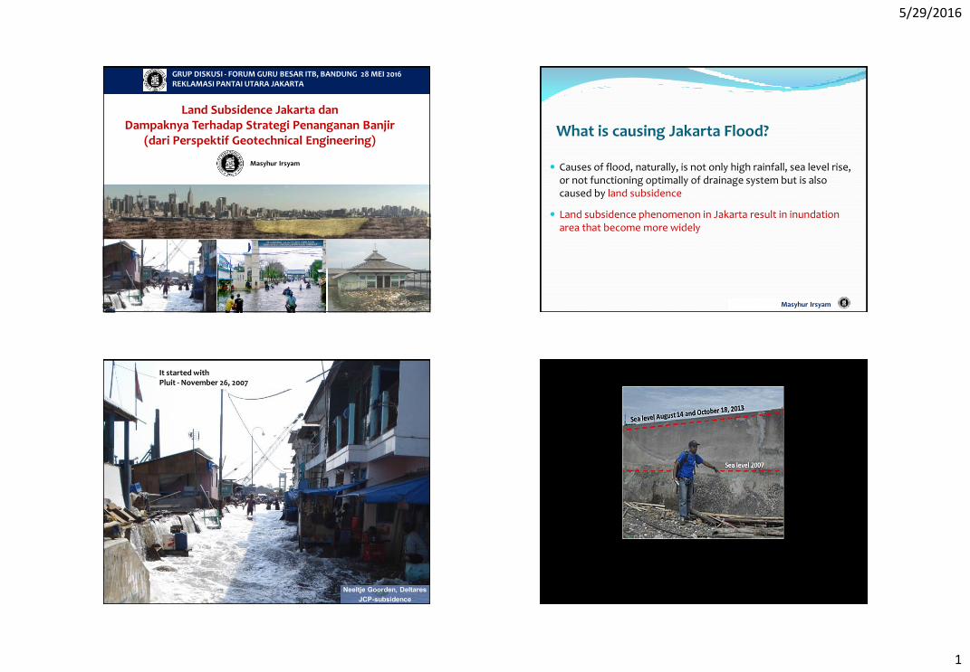
Land Subsidence Jakarta dan Dampaknya Terhadap Strategi Penanganan Banjir
(dari Perspektif Geotechnical Engineering)
GRUP DISKUSI - FORUM GURU BESAR ITB, BANDUNG 28 MEI 2016 REKLAMASI PANTAI UTARA JAKARTA
What is causing Jakarta Flood?
Causes of flood, naturally, is not only high rainfall, sea level rise, or not functioning optimally of drainage system but is also caused by land subsidence
Land subsidence phenomenon in Jakarta result in inundation area that become more widely
Masyhur Irsyam
It started with Pluit - November 26, 2007
5/29/2016
2
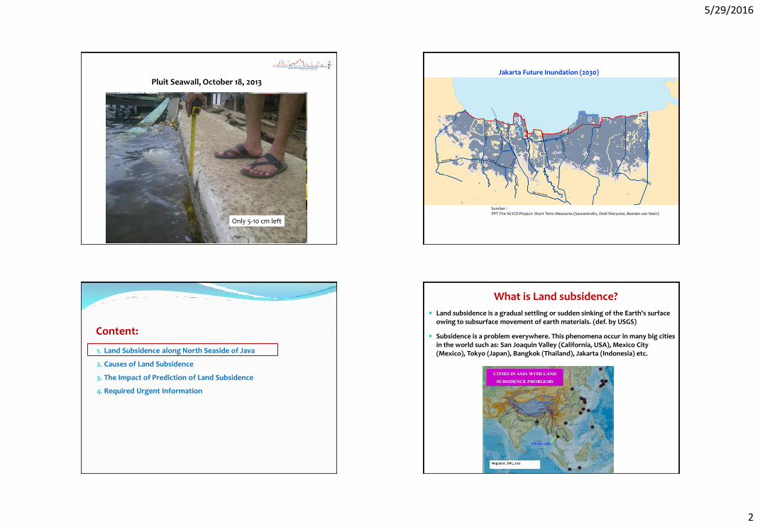
Pluit Seawall, October 18, 2013
Only 5-10 cm left
Jakarta Future Inundation (2030)
Sumber : PPT The NCICD Project: Short Term Measures (Sawarendro, Dedi Waryono, Bastien van Veen)
Content:
1. Land Subsidence along North Seaside of Java
2. Causes of Land Subsidence
3. The Impact of Prediction of Land Subsidence
4. Required Urgent Information
What is Land subsidence?
Land subsidence is a gradual settling or sudden sinking of the Earth's surface owing to subsurface movement of earth materials. (def. by USGS)
Subsidence is a problem everywhere. This phenomena occur in many big cities in the world such as: San Joaquin Valley (California, USA), Mexico City (Mexico), Tokyo (Japan), Bangkok (Thailand), Jakarta (Indonesia) etc.
5/29/2016
3
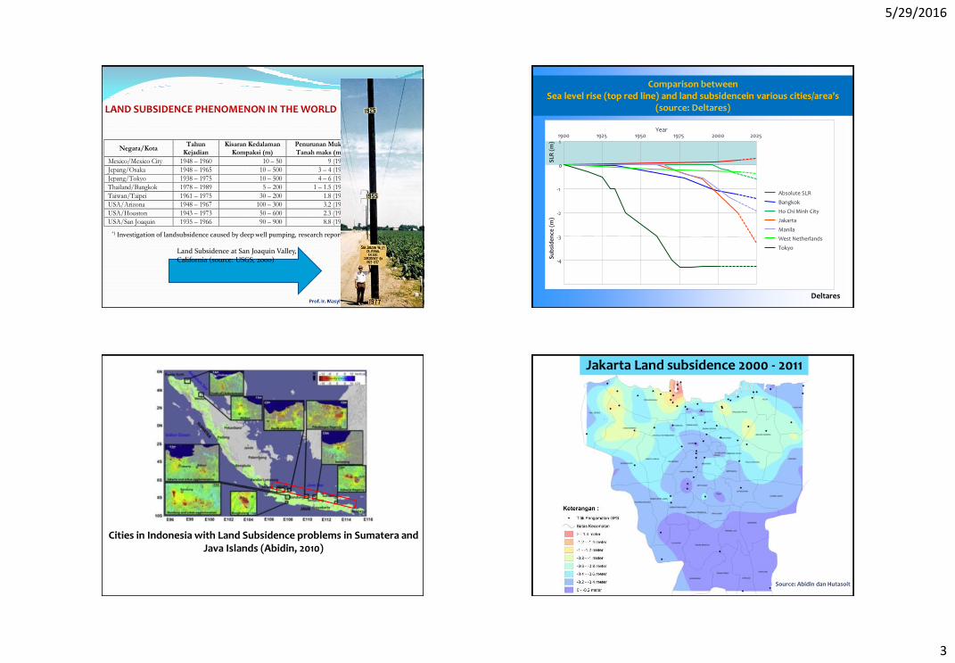
LAND SUBSIDENCE PHENOMENON IN THE WORLD
Negara/Kota Tahun
Kejadian Kisaran Kedalaman
Kompaksi (m) Penurunan Muka Tanah maks (m)
Luas Penurunan Muka Tanah (km2)
Mexico/Mexico City 1948 – 1960 10 – 50 9 (1973) 25 (1973)
Jepang/Osaka 1948 – 1965 10 – 500 3 – 4 (1965) 120 (1960)
Jepang/Tokyo 1938 – 1975 10 – 500 4 – 6 (1975) 230 (1974)
Thailand/Bangkok 1978 – 1989 5 – 200 1 – 1.5 (1989) 40 (1989)
Taiwan/Taipei 1961 – 1975 30 – 200 1.8 (1975) 100 (1975)
USA/Arizona 1948 – 1967 100 – 300 3.2 (1975) 925 (1967)
USA/Houston 1943 – 1973 50 – 600 2.3 (1973) 6475 (1973)
USA/San Joaquin 1935 – 1966 90 – 900 8.8 (1976) 13500 (1976)
*) Investigation of landsubsidence caused by deep well pumping, research report no.91, AIT, Bangkok, 1981
Land Subsidence at San Joaquin Valley, California (source: USGS, 2000)
1900 1
0
-1
-2
-3
-4
1925 1950 1975 2000 2025
SLR
(m
) S
ub
sid
en
ce (
m)
Year
Absolute SLR
Bangkok
Ho Chi Minh City
Jakarta
Manila
West Netherlands
Tokyo
Deltares
Comparison between Sea level rise (top red line) and land subsidencein various cities/area's
(source: Deltares)
Cities in Indonesia with Land Subsidence problems in Sumatera and Java Islands (Abidin, 2010)
Jakarta Land subsidence 2000 - 2011
Source: Abidin dan Hutasoit
5/29/2016
4
Land Subsidence of Jakarta
Abidin, 2010
Abidin, 2010
Peta Geologi Umum Daerah semarang
Holocene
Pleistocene
Pliocene
Shore lineSemarang City
HILL
PLAIN
Damar Formation
Pleistocene
Holocene
TIPIKAL PROFIL LAPISAN TANAH SEPANJANG PANTAI UTARA JAWA (Semarang)
DL -0.65GW-6
DL +0.25G-6
CROSS SECTION A-A
DL +0.40
G-1 GW-3
DL -3.70
WB-2DL -2.35
Soft clay with trace shell (greenish grey)
Very soft clay with silty sand (brownish grey)
Stiff clay with sand (blackish grey)
shell, organic(greenish grey)
Very soft sandy silt
Existing Break WaterDL 0.00DGSC-4DGSC-3
DL 0.00
Compact sand (blackish grey)
pumice (grey and yellowish brown)
Stiff clay - silty clay with sand, vulcanic ash,
Medium clay with sandy silt,
Soft Clay
DL -0.65GW-6
DL +0.25G-6
CROSS SECTION A-A
DL +0.40
G-1 GW-3
DL -3.70
WB-2DL -2.35
Soft clay with trace shell (greenish grey)
Very soft clay with silty sand (brownish grey)
Stiff clay with sand (blackish grey)
shell, organic(greenish grey)
Very soft sandy silt
Existing Break WaterDL 0.00DGSC-4DGSC-3
DL 0.00
Compact sand (blackish grey)
pumice (grey and yellowish brown)
Stiff clay - silty clay with sand, vulcanic ash,
Medium clay with sandy silt,
5/29/2016
5
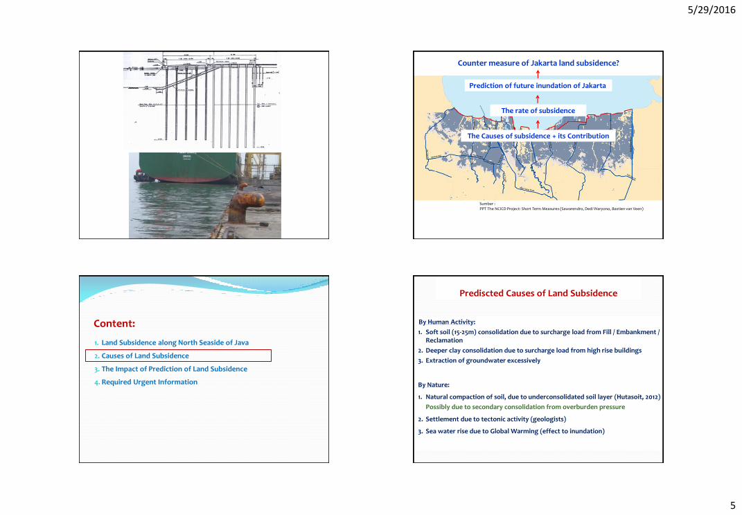
Prediction of future inundation of Jakarta
Sumber : PPT The NCICD Project: Short Term Measures (Sawarendro, Dedi Waryono, Bastien van Veen)
The rate of subsidence
The Causes of subsidence + its Contribution
Counter measure of Jakarta land subsidence?
Content:
1. Land Subsidence along North Seaside of Java
2. Causes of Land Subsidence
3. The Impact of Prediction of Land Subsidence
4. Required Urgent Information
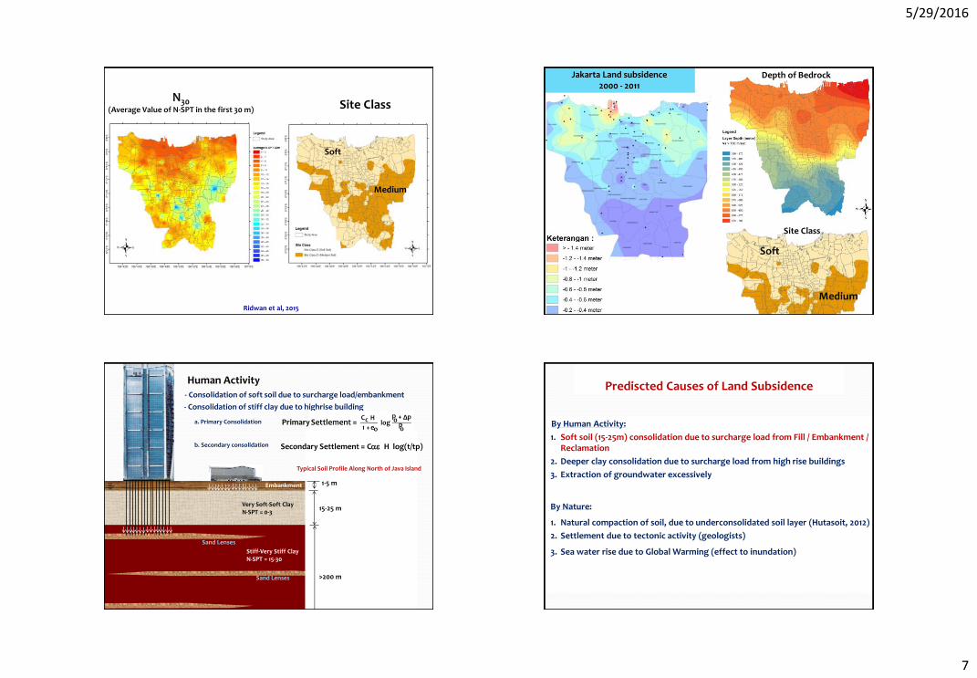
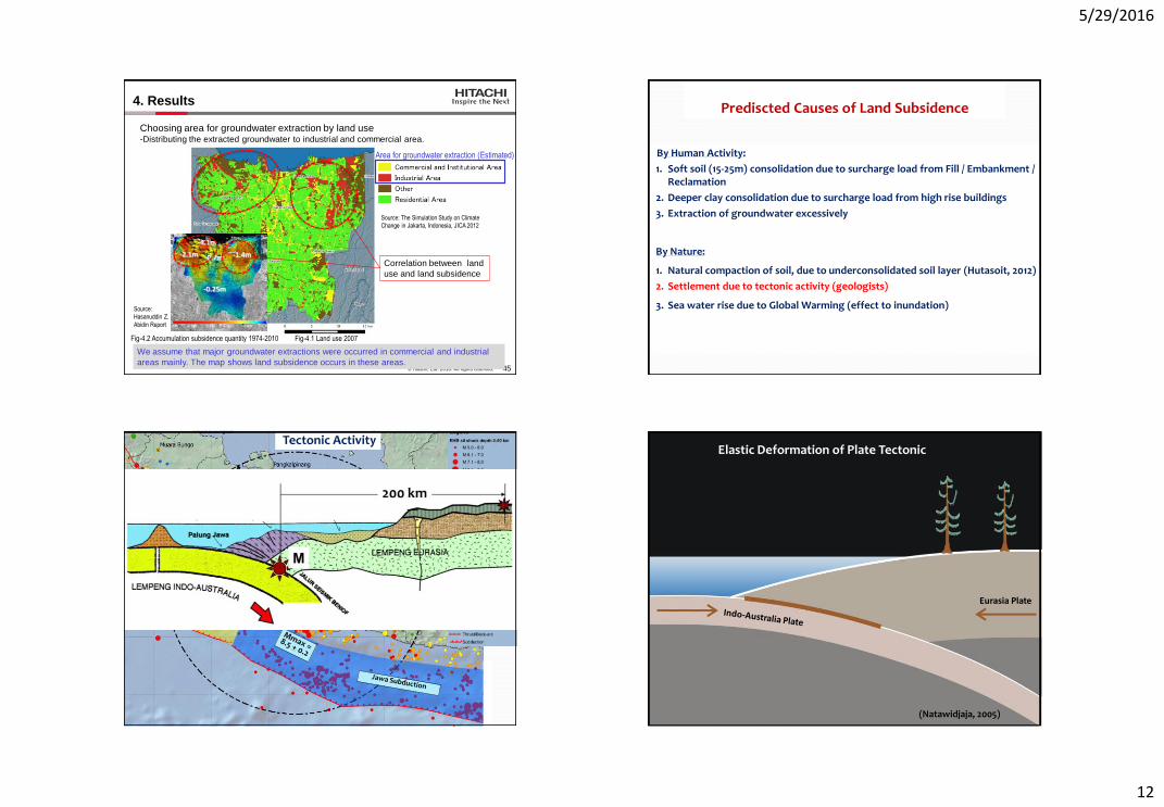
By Human Activity:
1. Soft soil (15-25m) consolidation due to surcharge load from Fill / Embankment / Reclamation
2. Deeper clay consolidation due to surcharge load from high rise buildings
3. Extraction of groundwater excessively
By Nature:
1. Natural compaction of soil, due to underconsolidated soil layer (Hutasoit, 2012)
Possibly due to secondary consolidation from overburden pressure
2. Settlement due to tectonic activity (geologists)
3. Sea water rise due to Global Warming (effect to inundation)
Prediscted Causes of Land Subsidence
5/29/2016
6
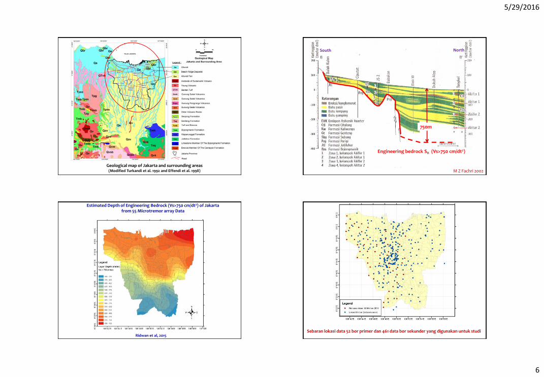
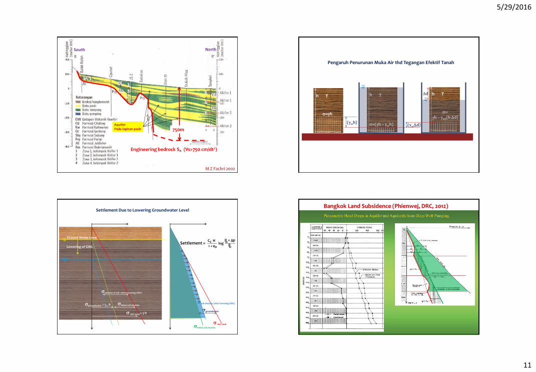
Geological map of Jakarta and surrounding areas (Modified Turkandi et al. 1992 and Effendi et al. 1998) M Z Fachri 2002
Engineering bedrock SB (Vs>750 cm/dt2)
South North
750m
Estimated Depth of Engineering Bedrock (Vs>750 cm/dt2) of Jakarta from 55 Microtremor array Data
Ridwan et al, 2015 Sebaran lokasi data 52 bor primer dan 461 data bor sekunder yang digunakan untuk studi
5/29/2016
7
Site Class
Ridwan et al, 2015
N30 (Average Value of N-SPT in the first 30 m)
Soft
Medium
Jakarta Land subsidence 2000 - 2011
Depth of Bedrock
Site Class
Stiff-Very Stiff Clay N-SPT = 15-30
Sand Lenses
Sand Lenses
Lensa Pasir
Very Soft-Soft Clay N-SPT = 0-3
Embankment
15-25 m
>200 m
1-5 m
o
o
o
c p
p Δ p log
e 1
H C +
+ Settlement =
Typical Soil Profile Along North of Java Island
- Consolidation of soft soil due to surcharge load/embankment
- Consolidation of stiff clay due to highrise building
a. Primary Consolidation b. Secondary consolidation
Primary
Secondary Settlement = Cae H log(t/tp)
Human Activity
By Human Activity:
1. Soft soil (15-25m) consolidation due to surcharge load from Fill / Embankment / Reclamation
2. Deeper clay consolidation due to surcharge load from high rise buildings
3. Extraction of groundwater excessively
By Nature:
1. Natural compaction of soil, due to underconsolidated soil layer (Hutasoit, 2012)
2. Settlement due to tectonic activity (geologists)
3. Sea water rise due to Global Warming (effect to inundation)
Prediscted Causes of Land Subsidence
5/29/2016
8
Pengaruh Beban Sendiri dari Reklamasi? B-34 B-137B-100 B-168 B-142B-137B-100 B-168 B-142B-38B-166 B-52
Very soft soi 15-25m
Fill Layer
B-34 B-100 B-137 B-52 B-112 B-107 B-36 B-103 B-170
Soft soil
Cv based on
laboratory
test
Fill Layer 2-3m
15 m
Sand Layer
Settlement the 1st 5 years = 50% After 5 years= (30 – 50)/20 = 1.5 – 2.5 cm
Settlement for 3m ExistingFill = 60 - 100 cm
By Human Activity:
1. Soft soil (15-25m) consolidation due to surcharge load from Fill / Embankment / Reclamation
2. Deeper clay consolidation due to surcharge load from high rise buildings
3. Extraction of groundwater excessively
By Nature:
1. Natural compaction of soil, due to underconsolidated soil layer (Hutasoit, 2012)
2. Settlement due to tectonic activity (geologists)
3. Sea water rise due to Global Warming (effect to inundation)
Prediscted Causes of Land Subsidence
5/29/2016
9
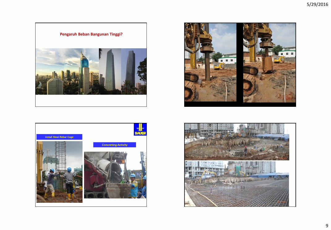
Pengaruh Beban Bangunan Tinggi?
Install Steel Rebar Cage
Concreting Activity
5/29/2016
10
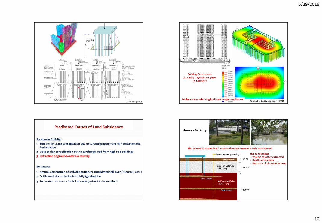
Simatupang, 2014 Rahardjo, 2014, Laporan TPKB
Building Settlement: D usually < 25cm in +15 years
(< 2.0cm/yr)
Settlement due to building load is not a major contribution
By Human Activity:
1. Soft soil (15-25m) consolidation due to surcharge load from Fill / Embankment / Reclamation
2. Deeper clay consolidation due to surcharge load from high rise buildings
3. Extraction of groundwater excessively
By Nature:
1. Natural compaction of soil, due to underconsolidated soil layer (Hutasoit, 2012)
2. Settlement due to tectonic activity (geologists)
3. Sea water rise due to Global Warming (effect to inundation)
Prediscted Causes of Land Subsidence
Stiff-Very Stiff Clay N-SPT = 15-30
Sand Lenses
Sand Lenses
Lensa Pasir
Very Soft-Soft Clay N-SPT = 0-3
Embankment
15-25 m
>200 m
3-5 m
Groundwater pumping
The volume of water that is reported to Government is only less than 10%
Has to estimate: - Volume of water extracted - Depths of aquifers - Decrease of piezometer head
Human Activity
5/29/2016
11
M Z Fachri 2002
Engineering bedrock SB (Vs>750 cm/dt2)
South North
750m Aquifer Pada lapisan pasir
h g
s=gh
h g
s=(gh – gwh)
(gwh)
h g
s=
gh – gw((h-Dd)
Dd
(gwDd)
Pengaruh Penurunan Muka Air thd Tegangan Efektif Tanah
Ground Water Level
s Soil total = g h
sgroundwater = gw h sinitial soil efective
Lowering of GWL
sefective of soil (after lowering GWL)
s Soil total
sgroundwater
sinitial soil efective
ssoil efective (after lowering GWL)
Settlement Due to Lowering Groundwater Level Bangkok Land Subsidence (Phienwej, DRC, 2012)
5/29/2016
12
© Hitachi, Ltd. 2016. All rights reserved. 45
Fig-4.1 Land use 2007
We assume that major groundwater extractions were occurred in commercial and industrial
areas mainly. The map shows land subsidence occurs in these areas.
Choosing area for groundwater extraction by land use -Distributing the extracted groundwater to industrial and commercial area.
Source: The Simulation Study on Climate
Change in Jakarta, Indonesia, JICA 2012
Area for groundwater extraction (Estimated)
4. Results
Fig-4.2 Accumulation subsidence quantity 1974-2010
Source:
Hasanuddin Z.
Abidin Report
Correlation between land
use and land subsidence
By Human Activity:
1. Soft soil (15-25m) consolidation due to surcharge load from Fill / Embankment / Reclamation
2. Deeper clay consolidation due to surcharge load from high rise buildings
3. Extraction of groundwater excessively
By Nature:
1. Natural compaction of soil, due to underconsolidated soil layer (Hutasoit, 2012)
2. Settlement due to tectonic activity (geologists)
3. Sea water rise due to Global Warming (effect to inundation)
Prediscted Causes of Land Subsidence
Semangko Mmax = 7.6
Sunda Mmax = 7.2
Cimandiri 7.6
Baribis
Lembang 6.5
Bumiayu
Tectonic Activity
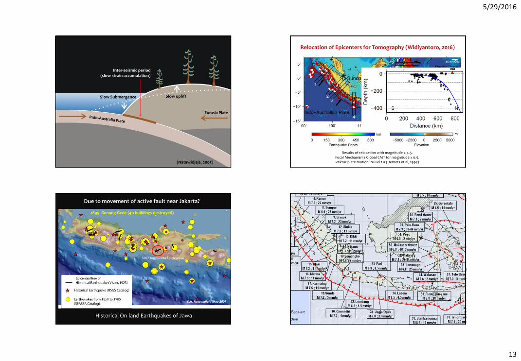
(Natawidjaja, 2005)
Eurasia Plate
Elastic Deformation of Plate Tectonic
5/29/2016
13
Inter-seismic period (slow strain accumulation)
Slow uplift Slow Submergence
Eurasia Plate
(Natawidjaja, 2005)
Relocation of Epicenters for Tomography (Widiyantoro, 2016)
Results of relocation with magnitude ≥ 4.5. Focal Mechanisms Global CMT for magnitude ≥ 6.5. Vektor plate motion: Nuvel 1.a (Demets et al, 1994)
Historical On-land Earthquakes of Jawa
D.H. Natawidjaja May 2007
1699 Gunung Gede (40 buildings destroyed)
Due to movement of active fault near Jakarta?
PARAMETER SUMBER GENPA SESAR
5/29/2016
14
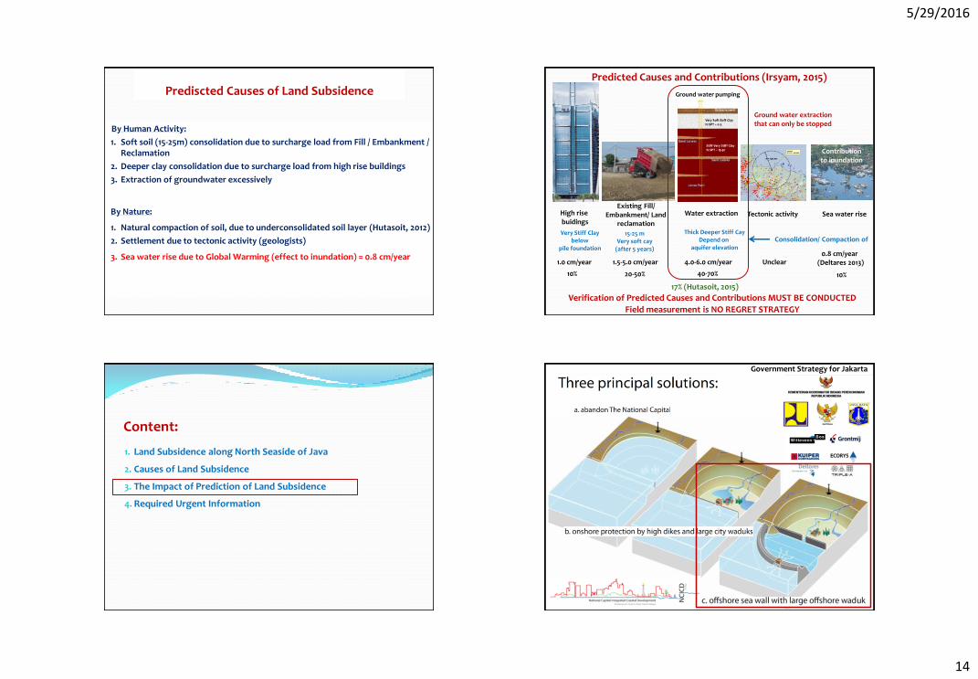
By Human Activity:
1. Soft soil (15-25m) consolidation due to surcharge load from Fill / Embankment / Reclamation
2. Deeper clay consolidation due to surcharge load from high rise buildings
3. Extraction of groundwater excessively
By Nature:
1. Natural compaction of soil, due to underconsolidated soil layer (Hutasoit, 2012)
2. Settlement due to tectonic activity (geologists)
3. Sea water rise due to Global Warming (effect to inundation) = 0.8 cm/year
Prediscted Causes of Land Subsidence
High rise buidings
Existing Fill/ Embankment/ Land
reclamation
Water extraction Tectonic activity
1.0 cm/year 1.5-5.0 cm/year 4.0-6.0 cm/year Unclear
10% 20-50% 40-70%
Predicted Causes and Contributions (Irsyam, 2015)
Verification of Predicted Causes and Contributions MUST BE CONDUCTED
Field measurement is NO REGRET STRATEGY
Ground water pumping
Sea water rise
Very Stiff Clay below
pile foundation
15-25 m Very soft cay
(after 5 years)
Thick Deeper Stiff Cay Depend on
aquifer elevation 0.8 cm/year
(Deltares 2013)
10%
Consolidation/ Compaction of
Ground water extraction that can only be stopped
Contribution to inundation
17% (Hutasoit, 2015)
Content:
1. Land Subsidence along North Seaside of Java
2. Causes of Land Subsidence
3. The Impact of Prediction of Land Subsidence
4. Required Urgent Information
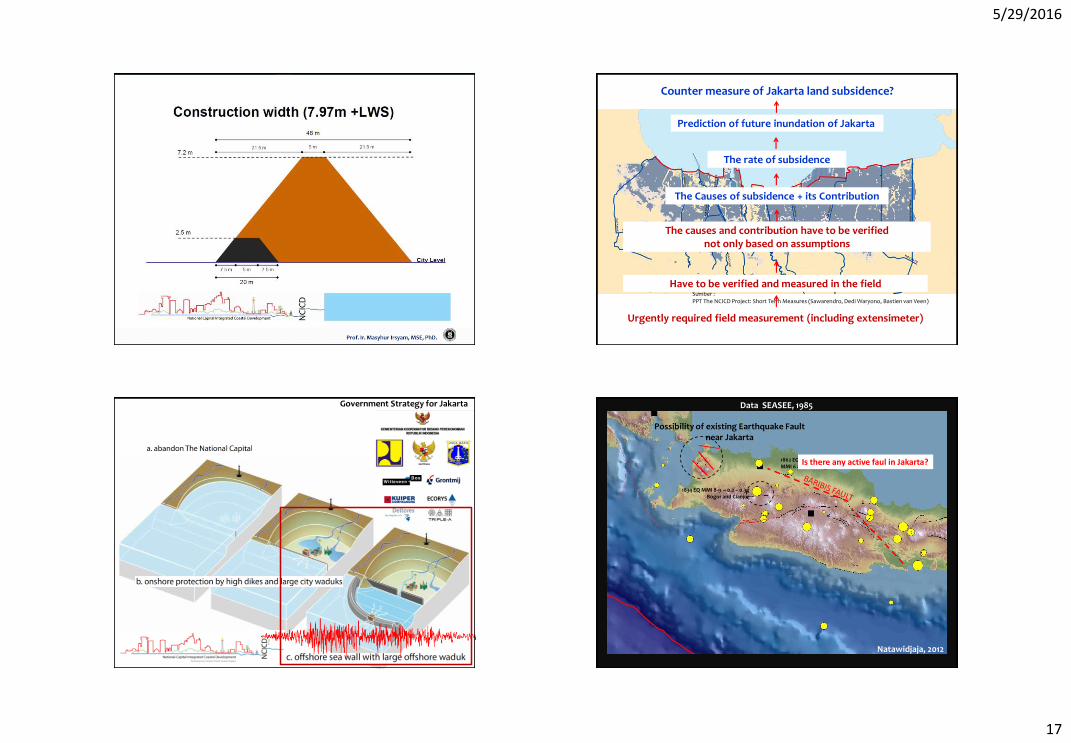
Government Strategy for Jakarta
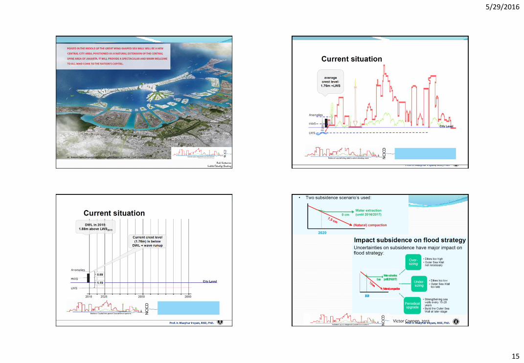
5/29/2016
15
Andi Kartawiria
Institut Teknologi Bandung
Victor Coenen, 2013
5/29/2016
16
5/29/2016
17
Prediction of future inundation of Jakarta
Sumber : PPT The NCICD Project: Short Term Measures (Sawarendro, Dedi Waryono, Bastien van Veen)
The rate of subsidence
The Causes of subsidence + its Contribution
Counter measure of Jakarta land subsidence?
The causes and contribution have to be verified not only based on assumptions
Have to be verified and measured in the field
Urgently required field measurement (including extensimeter)
Government Strategy for Jakarta
1862 EQ MMI 6 at Karawang
Data SEASEE, 1985
Possibility of existing Earthquake Fault near Jakarta
Natawidjaja, 2012
Is there any active faul in Jakarta?
1834 EQ MMI 8-9 ~ 0.2 – 0.3g Bogor and Cianjur
5/29/2016
18
Content:
1. Land Subsidence along North Seaside of Java
2. Causes of Land Subsidence
3. The Impact of Prediction of Land Subsidence
4. Required Urgent Information
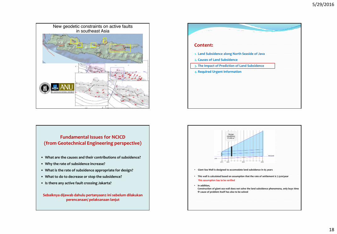
Fundamental Issues for NCICD (from Geotechnical Engineering perspective)
• What are the causes and their contributions of subsidence?
• Why the rate of subsidence increase?
• What is the rate of subsidence appropriate for design?
• What to do to decrease or stop the subsidence?
• Is there any active fault crossing Jakarta?
Sebaiknya dijawab dahulu pertanyaan2 ini sebelum dilakukan perencanaan/ pelaksanaan lanjut
• Giant Sea Wall is designed to accomodate land subsidence in 65 years
• This wall is calculated based on assumption that the rate of settlement is 7.5cm/year
This assumption has to be verified
• In addition, Construction of giant sea wall does not solve the land subsidence phenomena, only buys time cause of problem itself has also to be solved
5/29/2016
19
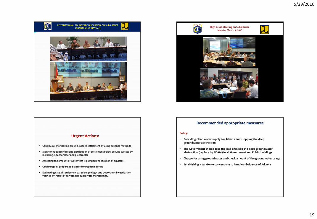
INTERNATIONAL ROUNDTABE DISCUSSION ON SUBSIDENCE JAKARTA 25-26 MAY 2015
High Level Meeting on Subsidence Jakarta, March 3, 2016
• Continuous monitoring ground surface settlement by using advance methods
• Monitoring subsurface and distribution of settlement below ground surface by installing extensometer and piezometer
• Assessing the amount of water that is pumped and location of aquifers
• Obtaining soil properties by performing deep boring
• Estimating rate of settlement based on geologic and geotechnic investigation verified by result of surface and subsurface monitorings.
Urgent Actions:
Recommended appropriate measures
Policy:
• Providing clean water supply for Jakarta and stopping the deep groundwater abstraction
• The Government should take the lead and stop the deep groundwater abstraction (replace by PDAM) in all Government and Public buildings.
• Charge for using groundwater and check amount of the groundwater usage
• Establishing a taskforce concentrate to handle subsidence of Jakarta