Embed Size (px)
Citation preview
1
Land Ownership in the Haldimand Tract: A Historical Perspective From
1638 to 2020 With a Focus on Lot 3 Range West of the Caledonia to Townsend
(McKenzie) Road, Oneida Township
Purpose of the Present Study: Over the years some Six Nations members have asserted that
their ancestors did in fact NOT surrender various parcels of land outside the present boundaries
of IR 40, the Six Nations of the Grand River Reserve. Some of the most contentious claims
include the Burtch Tract and the Eagle’s Nest Tract in Brant County, and parts of Oneida
Township south of Caledonia, in Haldimand County. The goal here is to explore the evidence
relating to land ownership in the area that is today Brant County and Haldimand County,
Ontario, Canada with a view towards determining legal ownership of a parcel of land (Lot 3
Range West of the Caledonia to Townsend (McKenzie) Road) in Haldimand County.
In the spring of 2020 construction had begun on a housing development situated on Lot 3, but in
July 2020 work was brought to a halt when Six Nations members and their supporters occupied
the land, naming it “1492 Land Back Lane”. At the time of writing, the land is still occupied by
this group. The lands known as McKenzie Meadows had been sold to a buyer (now Foxgate
Developments) who can trace ownership of the property back to a Crown Patent in the 1850s.
The question to be answered is, “Considering the Crown Patent, what is the basis of the claim of
these protesters that the land was NOT surrendered (ceded) to the Crown by the Six Nations
Chiefs in Council when the present Reserve was created in the years leading up to 1850?” If the
documentary sources from the years prior to 1850 indicate that the land was in fact surrendered
voluntarily by the then Six Nations Council, then the present legal owner’s title, rooted in a
Crown Patent, is valid. The legal situation is closely tied to another property, the 40 acre
Douglas Creek Estates (Block C, Oneida Township), south of Caledonia, and naming it
“Kanonstaton” (Mohawk for The Protected Place). In 2006 Six Nations activists claimed that it
was unceded land, which apparently justified their violent take-over, and their continued
occupation of this Crown Patented property to this day.
**While it was deemed necessary to provide extensive information on the general history of land
ownership in the Grand River Valley, those whose sole focus is on the present disputed land at
McKenzie Meadows can turn to “Legal Questions and Answers” on page 11 of this manuscript,
and read from there.
Note as to Sources: While the present author has read all of the key sources in their
original form (e.g., Surrenders, historical and archaeological references), many are found in
difficult to access archives. Thus, here we will use selected secondary sources for less critical
material. The author knows all the individuals whose publications are referenced herein, and can
attest to the fact that each (e.g., Charles M. Johnston) is a highly respected academic. Any minor
fact not specifically sourced is from the author’s research of 45 years in the original records
2
pertaining to the Six Nations. For the period after 1840, when the disputed surrenders begin, it is
important to provide original sources for each and every fact.
Background to Land Ownership in the Haldimand Tract:
1492 to 1782: The history of human settlement in what is today Southwestern Ontario
(SWO) can be traced in the archaeological record back to the Early Archaic Period circa 7,500
years B.C. The presence of Iroquoian peoples in SWO can be detected from about 900 A.D. as
far north as the Severn River (juncture with the Canadian Shield). The climate and soil
conditions of the area from what is today Orillia southwards permitted the growing of “The
Three Sisters” (corn, beans and squash), food staples for Iroquoian peoples down through
historic times. Neighbours to the north and west appear to have been the ancestors of the
Anishinabe (Ojibway, Mississauga, Ottawa) peoples of historic times. In the years prior to 1638
there is little evidence of conflict between these two linguistic – cultural groups, and
considerable evidence, via the archaeological record, and the Jesuit Relations documents, of a
long-standing trading relationship where Iroquoian peoples traded corn for beaver pelts. Conflict
came from the south, from other Iroquoian speaking peoples.
The French and Dutch (as well as English after 1664) had an insatiable desire for beaver pelts –
used in Europe for fashionable beaver felt hats. Much of this market was supplied by the Five
Nations Confederacy. This Confederacy included, from east to west, the Mohawk, Oneida,
Onondaga, Cayuga and Seneca peoples. The territory of the Five Nations extended from what is
today Albany westward to just east of the Niagara River in what is today New York State. By
1630, in the territory of the Five Nations, the beaver populations plummeted and left the people
with few options for obtaining essential European trade goods such as guns and copper pots. To
the north lay the Huron / Wendat and Petun; and to the west were the Wenro, and groups such as
the Erie; while to the south were the Susquehanna – all Iroquoian speaking. The area of the
Niagara Penninsula, the location of the Grand River, and where the Haldimand Tract would later
be located, was occupied by the Attiwandaronk / Neutral peoples, also Iroquoian speaking.
With an inability to engage in competitive trade, the Five Nations, bolstered by a strong
Confederacy, and well-armed thanks to Dutch traders, chose to raid their neighbours in all
directions to secure territory in which to hunt, and to completely destroy the competition. At this
time epidemics were sweeping across what is today Upstate New York and SWO. These had
impacted all peoples in the region to the point where population numbers dropped by more than
half in most villages. Hence between 1638 and 1656 the better armed Five Nations had managed
to completely decimate all of the above - named peoples – committing acts of genocide, torture,
and cannibalism in the process. Due to the epidemics, population replacement was one of the
goals of these “Beaver Wars”, and so some non-combatants, largely women and children, were
spared to be adopted into the families of the Five Nations – primarily the Seneca and the
Mohawk. Some few also escaped west to the territory of their allies among the Anishinabe (e.g.,
near what is today Anderdon), Ontario; and some few Huron found their way to Ancienne
3
Lorette (Wendake) near Quebec City where their descendants live today. Most survivors simply
disappeared and are lost to history. Key sources include Dean R. Snow, “The Iroquois”,
Blackwell, Cambridge MA, 1996; and Marit K. Munson and Susan M. Jamieson (Eds.), “Before
Ontario: The Archaeology of a Province”, McGill-Queens University Press, Montreal and
Kingston, 2013.
What is crystal clear is that as a result of the “no holds barred” genocidal wars perpetrated by the
Five Nations (who became the Six Nations with the addition of the Tuscarora from North
Carolina circa 1714), SWO was completely void of a human presence for a number of years.
Beginning in the 1660s, the Five Nations attempted to secure and possess the territory north of
Lake Ontario by establishing 8 villages. For example, “La Salle set westward in 1669 and met
Jolliet at an Iroquois village west of Lake Ontario, somewhere near the present City of
Brantford” (Ontarioarchaeology.org, Ontario Archaeological Society, 2020 for this reference
and also the above). Perhaps this is, “Tinaouatoua, located in the heart of the former Neutral
homeland between the head of Lake Ontario and the Grand River” (Neal Ferris, “The
Archaeology of Native-Lived Colonialism: Challenging History in the Great Lakes”, The
University of Arizona Press, Tucson, 2009, p.118). However, due to the raids by the “Five Fires
Confederacy” involving the Mississauga, Ottawa, Ojibway, Pottawatomi and other Anishinabe, it
became clear that retaining possession of these villages by the Five Nations was not sustainable.
Over the years all of these villages were destroyed, and the occupants removed back to what is
today Upstate New York. Thus, “By 1696 the Mississauga were in possession of the village sites
on the north shore of Lake Ontario” (Snow, p.119).
According to the “Indian Claims Commission of 2003 – Mississauga of New Credit First Nations
Inquiry – Toronto Purchase Claim”, p.9: “By 1700, the Mississaugas had succeeded in expelling
the Iroquois and taken control of the north shore of Lake Ontario. In that year, representatives of
the Mississaugas and other Ojibwa groups travelled to Onondaga, the capital of the Iroquois
Confederacy, with an offer of peace. In exchange for the Confederacy’s recognition of the
Mississaugas’ territorial control, and an agreement to allow them direct access to English fur
traders, the Mississaugas offered to cease hostilities. The offer of peace was accepted in June
1700, and as a result, the Mississaugas secured their control of the territory between Lake
Huron and Lake Ontario. They would occupy these lands until the land cessions of the late 18th
and early 19th centuries confined them to a very small proportion of their former territory.” See
here.
Since that time the British and Six Nations accepted the Mississauga as the legal “owners” of the
land in Southwestern Ontario. However, in 1701 a group of 20 Five Nations Chiefs tried to at
least salvage beaver hunting rights. By a deed of that year they, “surrender, deliver up and
forever quit claim”, lands in SWO (to which they had no legal claim) by petitioning “our great
Lord and Master the King of England”. This document has come to be known as the “Nanfan
Treaty of 1701” (named after the New York Governor of that time). This was not a treaty, it was
an attempt to forge rights to hunt beaver, on land that neither Six Nations nor the British had
legal rights. An examination of the front and back (page 2) via a photograph of the original,
shows that this did not even include the Colonial seal, let alone the Crown seal – both needed if
this was a “treaty”. In fact it is a trading document of historic interest only – despite recent
4
claims of Six Nations asserting that it gives them land and hunting rights throughout all of SWO
(see here). An extremely well researched document on this and all of Six Nations history from
1660 to today is, Garry Horsnell, “A Short History of the Six Nations of the Grand River”, 6th
Edition, 2011. This important study can be found here.
1783 to 1840: As the American Revolution drew to a close, it became clear that the Six
Nations lands were not included in the Treaty of Paris. Therefore, the British Colonial
authorities, including Governor Sir Frederick Haldimand, offered lands in Canada (still under
Crown control) to those Six Nations who wished to settle there. The Lower (Ft. Hunter)
Mohawks under Chief John Odeserontyon chose to settle at the Bay of Quinte. Chief Joseph
Brant Thayendanagea head of the Upper (Canajoharie) Mohawks wished to have lands closer to
the Senecas, most of whom had chosen to stay in their ancestral villages in what is today Upstate
New York. See Johnston (Charles M. Johnston, “The Valley of the Six Nations: A Collection of
Documents on the Indian Lands of the Grand River”, The Champlain Society, Toronto, 1964) as
an excellent source for this period – transcripts of the referenced documents are included in this
source.
In the years leading up to 1783, some Delawares had moved to the Grand River forming
scattered settlements “Below the Rapids” south of what is today Cayuga, Haldimand County.
Governor Sir Frederick Haldimand sent an officer in the Six Nations Indian Department, Lt. John
Young, to the region to report back events of concern in the area (such as a murder of a party of
traders headed to Detroit, on the shore of Lake Erie) – see here. Knowing that the War was over,
and seeing a potential to obtain a farm similar to what he owned along the Mohawk River,
Young purchased a one mile by one-mile tract of land near Cayuga from the Mississauga Chiefs.
The latter signed the deed on 20 January 1784 (LAC, RG10, Vol. 894, Claims of the
Descendants of Adam Young, p.8x). Almost a year later, Governor Haldimand issued an
unofficial (no Great Seal of the Province of Quebec was affixed) “proclamation” (in this case a
license of occupation), dated 25 October 1784 (see Horsnell, pp.6-8 for an extensive discussion
of the differences between the various deeds, patents and other Crown documents and their
meaning). This document stated that the Crown recognized that “the Mohawk Indians” had lost
their land in the former Colony of New York, and so “purchased a Tract of Land” (from the
Mississauga) and offered the “Mohawk Nation, and such other of the Six Nations Indians as wish
to settle in that Quarter to take Possession of, & Settle upon the Banks of …… the Grand River
……… Six Miles deep from each side of the River beginning at Lake Erie, & extending in that
Proportion to the Head of the said River, which them & their Posterity are to enjoy for ever.”
(Johnston, pp.50-51).
We must pause here to make it perfectly clear that the Six Nations and allies who moved to the
Grand River Tract after 1784 are NOT aboriginal to the land. The Mississauga obtained the land
in the Niagara Peninsula (where the Haldimand Grant is located) by right of conquest in 1696,
and that right was not questioned. The only “land rights” that the Six Nations possess are
historical, stemming from a “grant of usage” of the lands comprising the Grand River Tract by
5
the Crown. The Crown retained ownership rights whereby all sales had to be approved by
representatives of the Crown. That did not stop individual Six Nations Indians from selling what
were communal lands (belonging to all Six Nations) to individual White purchasers. This is a
key historical fact, profoundly affecting the ethnographic composition of the Grand River lands,
and having a significant effect on land surrenders. This matter will be explored in detail later.
The Six Nations who were then settled at Buffalo Creek, and the Niagara region, began to move
to the Grand River in the Spring of 1785, and a census of that year showed a total of “Six
Nations” to include 1843 individuals. However, many of these were Anishinabe Six Nations
allies, the Delawares being most numerous, but also included Upper and Lower Tootalies,
Nanticokes and others (Johnston, p.52). Noticeably underrepresented were the Seneca, the most
numerous of the Six Nations before the Council fire at Onondaga (near Syracuse, New York)
was extinguished in 1777, since the majority chose to remain in their old villages. Thus, there
were many Seneca chiefships that were vacant, a problem that extended from then to today
(finding legitimate lineal descendants of the original families to fill vacancies). The situation
was similar for the Oneida since most supported the American cause and remained in their
homes near Lake Oneida. The Oneidas who came to the Grand River were Auquagas, Oneidas
who migrated south of the Mohawk River, settling along the Susquehanna River – but most of
the chiefships remained in the new United States. Only the Mohawk had a full complement of
Hereditary Chiefs (9) when settling on the Grand River.
Importantly, at Six Nations chiefships needed to be allotted to the non - Six Nations allies
residing there, so for example four were assigned to the Delaware, prior to the 1840s, and a full
Council would require a very heterogeneous and ever shifting assortment of individuals. There
was considerable migration to Six Nations from settlements in the USA such as the Mohawk and
Onondaga of St. Regis (Akwesasne), and the Seneca of Cattaraugus, New York plus sundry
refugees from groups such as the Cherokee and Shawnee. Therefore, at Six Nations the
“Council of Chiefs” never recapitulated the 50 Six Nations Confederacy Chiefs dictated by “The
Great Law” governing the Six Nations in the years before 1777. However even here it was not
the Hereditary Chiefs who wielded the power, and who signed land deeds to White purchasers –
it was the Village Chiefs and Pine Tree Chiefs (see Snow). The same was largely true at Six
Nations, where Chief Joseph Brant, a Pine Tree Chief (War Chief) who was not a Hereditary
Chief, was the leader from the first days of settlement in 1785 to his death in 1807. While
Brant’s brother-in-law Henry Tekarihogen was the head of the Mohawk Hereditary Chiefs, it
was Brant who had the final say in dealing with the Colonial authorities.
The Grand River Tract was surveyed by Augustus Jones in 1790 (Johnston, p.56), however
before that date the Six Nations began to issue what are known today as “Brant Leases”. Chief
Joseph Brant had never known a homeland without German, Dutch, and English neighbours.
Hence for him (and the Mohawks in general) it was natural to wish to have old friends settled
near them. So, in 1780s and 1790s, since the grant of Crown land was not in fee simple, the Six
Nations issued leases to select White men.

6
One of the first leases, known as the “Mohawk Deed” of 26 February 1787, was actually a gift
(999 year lease for the annual rent of one peppercorn) to friends and relatives as follows: Capt.
John Dochstader of the Six Nations Indian Department; Henry and John Huff of Brant’s
Rangers; Adam Young and his three sons (including Lt. John Young of the Six Nations Indian
Department who had already purchased part of the land from the Mississauga 3 years before) of
Butler’s Rangers, as well as Capt. Hendrick William Nelles of the Six Nations Indian
Department and two of his sons (LAC, RG10, Vol. 894, Claims of the Descendants of Adam
Young, pp.6-13).
This leasing arrangement was extended to others such as John Smith of Cainsville who built the
Mohawk Chapel in 1786 and to others within Brant’s circle, which caused rifts among the Six
Nations and even within Mohawk families. For example, Aaron Hill and his cousin Isaac Hill
left to settle with the Tyendinaga Bay of Quinte Mohawks, while Aaron’s brother David Hill
settled in what is today Brantford on lands beside those of his good friend Joseph Brant.
The survey map generated by Augustus Jones in 1791 (as well as his survey notes) showed
where each White resident’s home was located, and where each settlement of Six Nations and
allied peoples was situated. Many other maps of later dates occur from 1794 onwards showing
who was settled where. The author has a file folder about ¾ inches thick filled with these maps –
many of which show precisely where each Indian’s “improvements” were in relation to others in
each township.
After a great deal of lobbying by Joseph Brant, the Haldimand Tract was “formalized” via a deed
known as the “Simcoe Patent” dated 14 January 1793. This document corrected Haldimand’s
error of having granted lands to the headwaters of the Grand River near Dundalk, Ontario – this
area had not been purchased of the Mississauga. Thus, the tract extended for 6 miles on each
side of the Grand River from the mouth of the Grand to what is today Elora, Ontario. The
document made it absolutely clear that the land was for Six Nations people only, and that if they
wished to part with any of it then the transaction must be via a lease or sale to the Crown. The
document was not accepted by Six Nations (Joseph Brant), who wanted more control over their
lands. Later events (individual Indians selling their improvements to White purchasers) teaches
us that had they succeeded in obtaining title in fee simple, then over the years all the land would
have been sold until there was nothing left and the remaining Six Nations would have been
forced to move westward to most likely the Ohio Country and ultimately ended up in Oklahoma,
merging with the Seneca there – and largely disappeared to history. The cold fact is that they
were saved from a very uncertain future by the Colonial authorities (the Crown’s inflexibility on
this issue of land ownership) – who ironically are frequently blamed for many of the perceived
ills experienced by Six Nations.
On 2 November 1796, Joseph Brant was given “power of attorney” to sell parts of the grant not
needed, such that the money arising from the sales could be invested for the future. He was
given the authority, to act, in our names and in behalf of our said several Nations to Surrender,
7
Relinquish and for ever quit Claim to His Majesty ……. all their rights, claims etc. lying on the
Grand River (Johnston, pp. 79-81). The document was signed by 35 Chiefs.
It is at this point that the Land Surrender process began. The land was not theirs in fee simple,
but had to be sold / surrendered only to the Crown (a thorny topic at this time). So for example,
between 15 January and 6 February 1798, Brant surrendered present day Dumfries, Waterloo,
Woolwich and Nichol Townships downwards on both sides of the River from the Northern most
part. Furthermore, a surrender of most of Canboro and Moulton Townships was undertaken.
There was something of a pause in the surrenders until the 1830s, although in the background, as
we shall see later, individual members of the Six Nations were selling lands they personally
claimed (although the practice was actively discouraged by both the Chiefs and more so the
Government officials).
Chief Joseph Brant died on 24 November 1807, and thus the responsibility of land sales and
surrenders again fell on the shoulders of the Chiefs in Council.
These grants / leases / surrenders began to expand “out of control” throughout the years when
Joseph Brant was alive, and when he was given “power of attorney”. It came to the point where
at a Council Meeting of 1 March 1809 at Onondaga, the Chiefs were compelled to discuss each
parcel of land from just north of Brantford to the mouth of the Grand River.
As noted above, but it bears repeating, the matter became further complicated by the fact that
individual Indians were selling their “improvements” to incoming White people, often from
Britain and Ireland. The Chiefs, apparently, were not duly upset about the matter (perhaps
because many were engaged in the same practice as there were only so many ways to obtain
funds). However, this practice of treating the land as if it was owned in fee simple, had drastic
consequences in the Haldimand Tract. It became a patchwork of scattered individual Indian
farms, settlements (e.g., Mohawk Village; Davisville) as well as the farms of the ever-expanding
number of White people moving to the Haldimand Tract. The Government was concerned that
this practice of selling individual parcels of land would eventually mean that there would be no
land left, and the Six Nations would end up scattering to Manitoulin Island or to the Ohio
country as many had already done (particularly to the latter location). It became a difficult
matter too in that it brought up the issue of individual versus communal rights of Six Nations
peoples – and there was no easy answer. White people were given deeds to their property (often
already surveyed) signed by the individual Indian who claimed the property. Other White people
simply “squatted” on unoccupied land. Matters reached crisis proportions when there were
2,000 or so Six Nations Indians, and 2,000 or so White settlers and “squatters”.
Here follows an example of such a deed, one which relates to the land that is now the north side
of Caledonia, Haldimand County. The author will quote from his book, David K. Faux,
“Understanding Ontario First Nations Genealogical Records: Sources and Case Studies”, The
Ontario Genealogical Society, Toronto, 2002).

8
“In the extensive collection of papers that relate to the sale by William Crawford during the
1830s and 1840s of his land holdings in the village of Caledonia in Seneca Township, there
exists a detailed surveyor’s description of the property. These records indicate that Crawford
was an Onondaga chief whose property, known as “the Crawford Tract”, abutted that of John
Buck, alias Clearsky, another Onondaga chief. The parcel was 400 acres in size, and had been
occupied by William Crawford for about twenty years. The deed turning over the land to Jacob
Turner, a White man, was signed by – William (X) Crawford, John (X) Crawford, Mary (X)
Crawford and Abraham Crawford (who is noted in the documents as being a son of the said
William)” (p.45).
These land records occur for each parcel of land sold by a Six Nations individual to a non-Indian
person (or non-enrolled individual) – usually a White male from Great Britain. The deeds are
scattered around the RG10 Papers, but are concentrated in Volumes 103-113, 119-121, 151 and
803.
Faced with the chaotic land possession situation, and the prospect of the Six Nations people
migrating en masse west to the Ohio country (the American “Northwest”), both the Government
representatives and the Chiefs recognized that only by consolidating the lands would the people
be able to remain in the Haldimand Tract. So, the challenge was to determine how much (how
many acres) and where (which Townships) were to remain with them (reserved for the Six
Nations) and which sold off. The remaining parcels of land not reserved by the Chiefs would be
surrendered to the Crown and each parcel sold and the money placed in trust. The White people
who had deeds but were residing on land within the area the Chiefs wished to reserve had to be
evicted (an unpleasant task) and even those without deeds were given compensation for the
improvements they had made to the property. Some of this appears to have been given out of the
trust funds – one wonders about the process, and how well this money was managed.
The Land Surrender process was not entirely smooth – which is entirely understandable
considering what was at stake. An example of some of the principal early surrenders is included
in Johnston (p.120).
19 April 1830 – Surrender of the Site of the Town of Brantford – 807 acres.
19 April 1831 – Surrender of the Northern Part of the Township of Cayuga – 20,670 acres.
8 February 1834 – The Residue of Cayuga, Township of Dunn, Part of Canboro and Moulton –
50,212 acres.
26 March 1835 – Confirmation of all the preceding Surrenders.
1841 to 2020: A unique source for this specific period in time is Joan Holmes &
Associates, “Reports of Joan Holmes (Filed on the City of Brantford’s Injunction Motion,
2009)”. This report, submitted to Justice Harrison Arrell of the Superior Court in Brantford,
9
includes transcripts of all relevant “land claims” data from 1841 to 1848. The substance of this
report, available here, was such that it allowed Justice Arrell to state that should a land claims
matter come before him, clearly the Six Nations would have a very “weak case” in maintaining
that there were any unsurrendered lands in the Haldimand Tract.
There are two key documents of this period which underpin all that follows. These are the Land
Surrenders of 1841 and 1844.
** 18 January 1841 – Surrender of the residue of the land with a reservation of 20,000
Acres. See Johnston, pp.191-192, or “Canada. Indian Treaties and Surrenders”, Vol. 1, Queen’s
Printer, Ottawa, pp.119-123 for a full transcript on this key Surrender (Number 50), as well as
the preceding correspondence between the Government officials and the Chiefs of the Six
Nations recommending that they reserve 20,000 acres that they could “occupy as a concentrated
body”, with the remainder of the land being either leased or sold for their benefit. Deputies from
each of the Six Nations signed this document.
A very informative and sympathetic view of the “Condition of the Six Nations” as of 1842,
based on highly supportive (pro – Six Nations) individuals such as Rev. Abraham Nelles, Major
James Winnett, Rev. Adam Elliott and Rev. W. H. Landon can be found in Johnston, pp.305-
311. Here is data that is relevant for a consideration of how well the interest money from the
sale of lands was invested and spent – clearly incompetence and / or corruption were in the
picture.
After the above 1841 Surrender, between 1841 and 1843, some of the Chiefs occasionally
questioned whether it was in their best interest to sell this or that parcel, including for example
the Eagle’s Nest Tract, and the Oxbow. The documents with full Library and Archives Canada
reference information, as well as a transcription, can be found in the above Joan Holmes Report.
** 18 December 1844 – On this date a final Surrender / Confirmation was issued via the
signatures of 45 Chiefs in Council at Onondaga where they unanimously agreed to accept the
Reserve south of Brantford as described in numerous previous documents, and that the Crown
would sell the lands not reserved. In addition to Tuscarora Township, 200 acres in Brantford
Township, and a block to the north in Onondaga Township, the Chiefs wished to reserve lands,
“Lying on the South side of the Grand River, West from the tier of Lots adjoining the Plank
Road, in the township of Oneida ….” These lands (tier of lots) butted up against a more
regularly laid out area of the Township which were an extension of those in adjacent Tuscarora
Township. It was only this land in Oneida that the Chiefs wished to reserve.
Understandably this was a big decision and there was some “sellers regret”. In the years 1845,
1846, and 1848 after discussions in Council, the Chiefs acknowledged that they agreed to not
reserve the Oxbow, Eagles Nest, Johnson Settlement, Martin Settlement and the Burtch Tract –
the latter being the greatest stumbling block.
10
None the less, a notice posted in June 1846 warning squatters to remove themselves from the
lands that were to comprise the reserved lands, described these lands clearly – and none other. It
bears quoting in full as this is the full extent of the Reserve – then and now. The lands the Chiefs
wished to reserve were, “In the Township of Oneida, from the Tier of Lots on the West Side of the
Plank Road to the boundary line of the Township of Tuscarora, and the whole of the Township of
Tuscarora, and a parcel of 200 Acres lying adjacent to the Mohawk Institute, in the Township of
Brantford, and on the North side of the Grand River, in the Township of Onondaga, a tier of
River Lots, from No. 61 to 45, both inclusive ….” (LAC, RG10, Vol. 458, p.97).
Previous to the year 1847 the reserved lands in Tuscarora Township, part of Brantford, Oneida
and Onondaga Townships, had been surveyed and began to be settled by Six Nations people who
wished to remove to the assigned lots within what eventually expanded from the initial 20,000
acres to the larger acreage (see below) that is the present day Six Nations of the Grand River
Reserve. The 200 acres proximal to the Mohawk Institute in Brantford Township was to be used
for training Six Nations boys in the techniques of agriculture. No one was required to remove,
and some stayed on the lots they were residing on, at least for a time. For example, they can be
found scattered throughout the Grand River Valley townships in the 1851-52 Census of Upper
Canada (see Faux, pp.38-40). However, most removed to the Reserve lands eventually since
residence on Reserve lands was a requirement in order to be registered on the Band List and
entitled to share in the interest monies (known as “Presents” in the early days).
A more detailed consideration of the Land Surrenders of 1841 and 1844 will be included in the
discussion of Lot 3 Range West of the Caledonia to Townsend Road in Oneida Township,
Haldimand County, below.
The final document of interest in relation to the Surrenders is the report of Lord Elgin.
In 1850 Lord Elgin (James Bruce), who was the Governor General of Canada, proclaimed the
“Indian Protection Act”. For our purposes, it is important to note that he included among the
attachments to the Act the boundaries of all Reserves in Canada, including the Grand River lands
as agreed upon throughout the negotiations of the 1840s. There are herein noted no other lands
than those included in the present-day IR 40 Six Nations of the Grand River Reserve. The exact
number of acres reserved by Six Nations is detailed in the Special Commissioner’s Report of
1858. Of the original acreage in the Haldimand grant, 694,910 acres, the final number of acres
that were selected to be reserved amounted to 52,133.25 acres, considerably more than the
originally agreed upon figure of 20,000 acres (See Joan Holmes Report, p.25).
Based on the above data, Holmes concluded that, The Elgin Proclamation of 1850 appears to
accurately describe the lands that the Six Nations in Council had resolved to reserve for their
exclusive use as of 1850. The lands not intended for reservation were to be sold (ibid.).
After this date there was no organized attempt to amend or alter the surrenders of land that
occurred during the 1840s, until 1995. Here, what is today the Lands and Resources Office of

11
the Six Nations Band Council, initiated a series of 29 land claims – which were largely focused
on the lack of proper accounting of the interest payments, and the irresponsible actions of those
entrusted with the management of their affairs. For example, the White investors in the
disastrous Grand River Navigation Company venture were able to cash out without any great
loss. However, it is clear to anyone who has examined the documents that the Six Nations
investors were left holding the bag. So, there is room for negotiations around the subject of
interest payments, but not land surrenders – the latter was a done deal, no wiggle room, 176
years ago.
Legal Questions and Answers:
1) An article entitled, “Feds say that Six Nations land claim is invalid”, in the 27 January
2007 edition of “CTV News” (Toronto), reported on circumstances concerning Douglas
Creek Estates. According to this article, “Land claims made by the Six Nations
Confederacy near Caledonia, Ont. will not hold up in court, the federal government has
said. A Department of Justice report presented to the Six Nations Confederacy earlier
this week made the statement”. Furthermore, “Federal negotiator Barbara McDougall
said … “the government says Six Nations does not have "a legitimate claim to that
particular property"”.
2) Also, according to fellow researcher Garry Horsnell, “In a letter dated January 9, 2009,
Chuck Strahl, the federal Minister of Indian and Northern Affairs Canada said, ‘the
Government of Canada’s position is that the surrender of 1844 is valid’”.
3) Furthermore, in November 2010 Justice Harrison Arrell of the Superior Court of Ontario
in Brantford made a ruling in a Brant County case that has clear parallels to both the
Douglas Creek Estates take over, and the current Foxgate occupation, both in Caledonia,
Ontario (and part of old Oneida Township in Haldimand County).
The late Christie Blatchford wrote a summary of the Court findings in “The Globe and
Mail”, 22 November 2010, in an article entitled, “Judge finds Six Nations’ land claim
‘exceedingly weak’”. Specifically, Blatchford reported that, “The HDI and Confederacy
claim all lands within that tract, which runs six miles on either side of the Grand River
and includes Brantford and, interestingly, Douglas Creek Estates in the nearby small
town of Caledonia, Ont., site of the area's most notorious occupation.
The lands in question, the judge found in accepting the expert report of Joan Holmes,
were in fact "properly surrendered" for sale by Six Nations chiefs in 1844 when they
created the boundaries of the reserve, which basically sits between the two
municipalities.
Judge Arrell said he found comfort that Ms. Holmes' opinion is correct in the fact that Six
Nations, "despite 25-30 years of archival research on their own", have never filed legal
proceedings for return or title of the land. A lawsuit filed in 1995 and now dormant seeks
only financial compensation.
12
The judge was required to make only a preliminary assessment of the strength of the Six
Nations' claim, but pronounced it "exceedingly weak" at one point in his decision and a
"very weak case" at another”.
Hence the Joan Holmes Report was sufficient for the Judge to declare that there is little if
any basis for any land claim beyond the boundaries of the current Six Nations of the
Grand River Reserve.
4) The 29 Six Nations Land Claims can be found here. Claim Number 16 is for Oneida
Township, all of which is claimed as unceded – however they only note the content of the
Council Minutes of 1843 and completely ignore the key Surrender of 18 December 1844
and subsequent Council meetings where the dimensions of what the Chiefs wished to
reserve in Oneida Township is discussed on multiple occasions. See here for details of
the Six Nations Oneida Township claim. A recent newspaper article shows that the Six
Nations researchers have likely modified their position. It is entitled, “Six Nations people
shut down Caledonia construction” in “Turtle Island News”, 22 July 2020, which spoke
specifically about the McKenzie Meadows Development in Oneida Township. They
reported that, “Lonny Bomberry, Director of Six Nations Land and Resources, has said
that there is no traditional land claim associated with the occupied development, since it
has been under third-party ownership for at least 150 years, and while the entirety of the
Haldimand Tract is subject to a land claim, that claim is not against third-party
developers”. The Hereditary Council does not have a research organization of any
description attached to it. Nor does it have, to the best of this author’s knowledge, any
research collection beyond that found in the Elected Council’s Land and Resources
Office.
Lot 3 Range West of the Caledonia to Townsend (McKenzie) Road: This parcel of land is
part of the general Surrenders of 1841 and 1844 so there is no need to discuss the matter further
except for the fact that there are now individuals occupying the land claiming that it was not
surrendered. That claim is without merit, as can be seen in the above information, however it
would be helpful to view Lot 3 in historical context outside the Surrender.
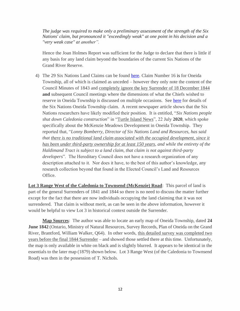
Map Sources: The author was able to locate an early map of Oneida Township, dated 24
June 1842 (Ontario, Ministry of Natural Resources, Survey Records, Plan of Oneida on the Grand
River, Brantford, William Walker, Q64). In other words, this detailed survey was completed two
years before the final 1844 Surrender – and showed those settled there at this time. Unfortunately,
the map is only available in white on black and is slightly blurred. It appears to be identical in the
essentials to the later map (1879) shown below. Lot 3 Range West (of the Caledonia to Townsend
Road) was then in the possession of T. Nichols.
13
1842 Survey Map of Part of Oneida Township
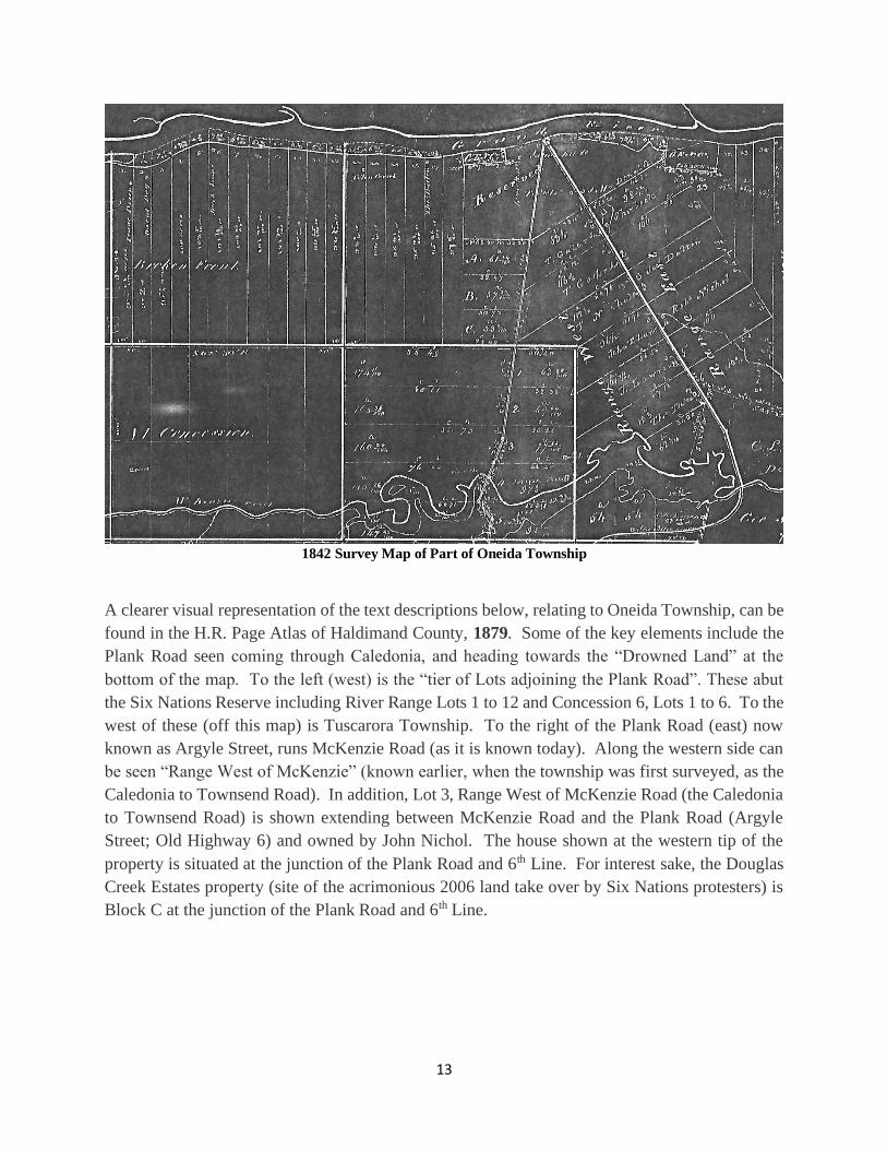
A clearer visual representation of the text descriptions below, relating to Oneida Township, can be
found in the H.R. Page Atlas of Haldimand County, 1879. Some of the key elements include the
Plank Road seen coming through Caledonia, and heading towards the “Drowned Land” at the
bottom of the map. To the left (west) is the “tier of Lots adjoining the Plank Road”. These abut
the Six Nations Reserve including River Range Lots 1 to 12 and Concession 6, Lots 1 to 6. To the
west of these (off this map) is Tuscarora Township. To the right of the Plank Road (east) now
known as Argyle Street, runs McKenzie Road (as it is known today). Along the western side can
be seen “Range West of McKenzie” (known earlier, when the township was first surveyed, as the
Caledonia to Townsend Road). In addition, Lot 3, Range West of McKenzie Road (the Caledonia
to Townsend Road) is shown extending between McKenzie Road and the Plank Road (Argyle
Street; Old Highway 6) and owned by John Nichol. The house shown at the western tip of the
property is situated at the junction of the Plank Road and 6th Line. For interest sake, the Douglas
Creek Estates property (site of the acrimonious 2006 land take over by Six Nations protesters) is
Block C at the junction of the Plank Road and 6th Line.
14
Part of Oneida Township, Haldimand County Atlas, 1879
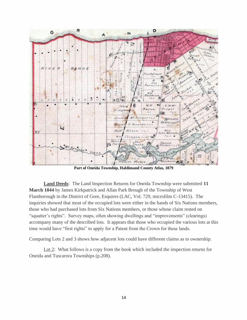
Land Deeds: The Land Inspection Returns for Oneida Township were submitted 11
March 1844 by James Kirkpatrick and Allan Park Brough of the Township of West
Flamborough in the District of Gore, Esquires (LAC, Vol. 729, microfilm C-13415). The
inquiries showed that most of the occupied lots were either in the hands of Six Nations members,
those who had purchased lots from Six Nations members, or those whose claim rested on
“squatter’s rights”. Survey maps, often showing dwellings and “improvements” (clearings)
accompany many of the described lots. It appears that those who occupied the various lots at this
time would have “first rights” to apply for a Patent from the Crown for these lands.
Comparing Lots 2 and 3 shows how adjacent lots could have different claims as to ownership.
Lot 2: What follows is a copy from the book which included the inspection returns for
Oneida and Tuscarora Townships (p.208).
15
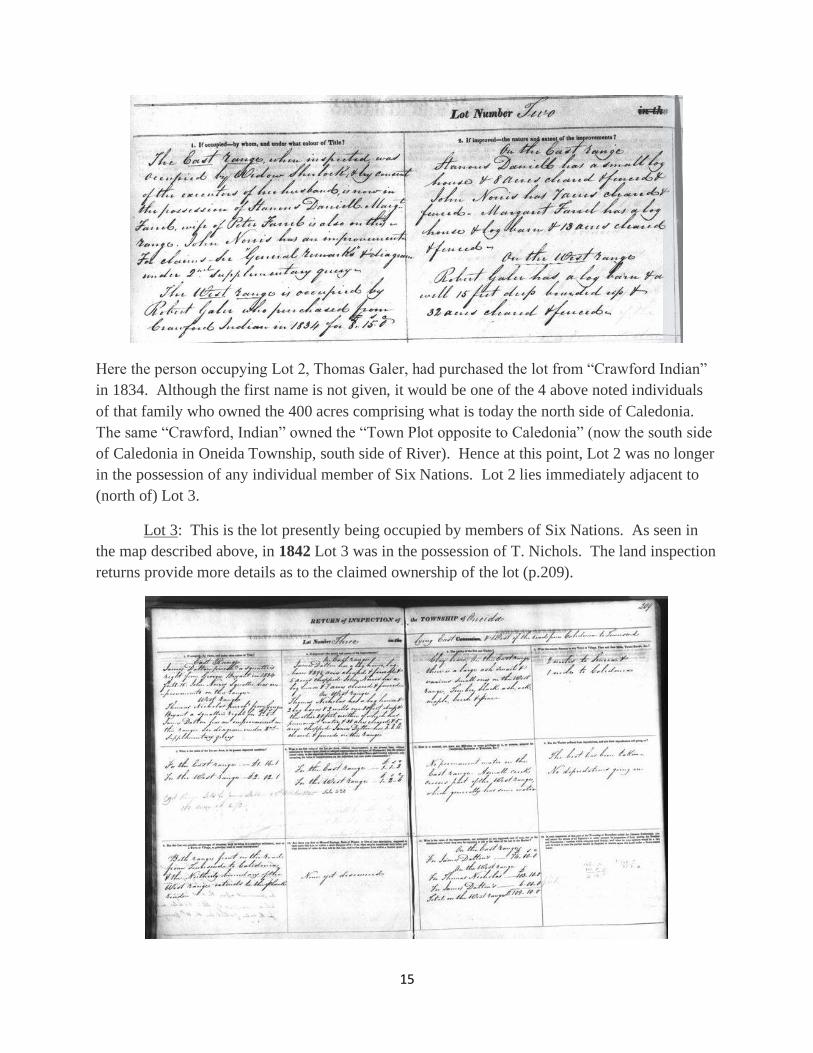
Here the person occupying Lot 2, Thomas Galer, had purchased the lot from “Crawford Indian”
in 1834. Although the first name is not given, it would be one of the 4 above noted individuals
of that family who owned the 400 acres comprising what is today the north side of Caledonia.
The same “Crawford, Indian” owned the “Town Plot opposite to Caledonia” (now the south side
of Caledonia in Oneida Township, south side of River). Hence at this point, Lot 2 was no longer
in the possession of any individual member of Six Nations. Lot 2 lies immediately adjacent to
(north of) Lot 3.
Lot 3: This is the lot presently being occupied by members of Six Nations. As seen in
the map described above, in 1842 Lot 3 was in the possession of T. Nichols. The land inspection
returns provide more details as to the claimed ownership of the lot (p.209).
16
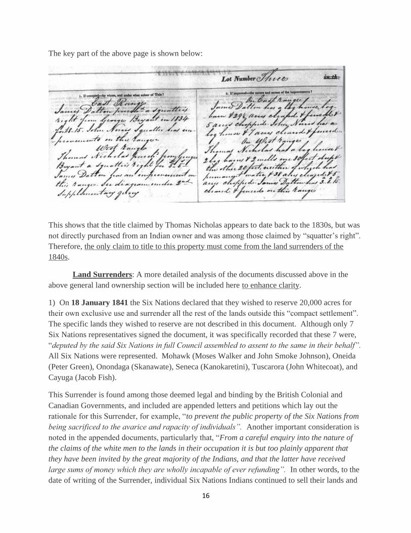
The key part of the above page is shown below:
This shows that the title claimed by Thomas Nicholas appears to date back to the 1830s, but was
not directly purchased from an Indian owner and was among those claimed by “squatter’s right”.
Therefore, the only claim to title to this property must come from the land surrenders of the
1840s.
Land Surrenders: A more detailed analysis of the documents discussed above in the
above general land ownership section will be included here to enhance clarity.
1) On 18 January 1841 the Six Nations declared that they wished to reserve 20,000 acres for
their own exclusive use and surrender all the rest of the lands outside this “compact settlement”.
The specific lands they wished to reserve are not described in this document. Although only 7
Six Nations representatives signed the document, it was specifically recorded that these 7 were,
“deputed by the said Six Nations in full Council assembled to assent to the same in their behalf”.
All Six Nations were represented. Mohawk (Moses Walker and John Smoke Johnson), Oneida
(Peter Green), Onondaga (Skanawate), Seneca (Kanokaretini), Tuscarora (John Whitecoat), and
Cayuga (Jacob Fish).
This Surrender is found among those deemed legal and binding by the British Colonial and
Canadian Governments, and included are appended letters and petitions which lay out the
rationale for this Surrender, for example, “to prevent the public property of the Six Nations from
being sacrificed to the avarice and rapacity of individuals”. Another important consideration is
noted in the appended documents, particularly that, “From a careful enquiry into the nature of
the claims of the white men to the lands in their occupation it is but too plainly apparent that
they have been invited by the great majority of the Indians, and that the latter have received
large sums of money which they are wholly incapable of ever refunding”. In other words, to the
date of writing of the Surrender, individual Six Nations Indians continued to sell their lands and
17
improvements to White men who offered them sizeable amounts of money for these individual
holdings. The problem was so acute that there were upwards of 2,000 white men and their
families, many of whom possessed deeds from individual Six Nations Indians, residing within
the Haldimand Tract. To remove all of them and their families was not practical, particularly
since individual Six Nations Indians continued to engage in this practice of selling their
improvements to White purchasers. There did not appear to be a clear and effective way to stop
this practice, and so the only solution appeared to be to create a consolidated community on
lands that could not and would not be sold (in fee simple) to the White purchaser who offered the
largest sum of money.
The document is registered as Surrender 50, and found on pages 119 to 123 of the Government
publication, Canada. Indian Treaties and Surrenders from 1680 to 1890, Volume 1, Ottawa,
Queen’s Printer, 1891.
**While the above Surrender is legal and binding, it does not include a description of the lands
that the Chiefs in Council had decided to reserve for the settlement of their people. There was
some pushback from individual Six Nations members to the effect that not enough time was
given for the Chiefs to deliberate. The latter insisted that this was not true, that in fact they had
ample time to consult about the issue. Hence, we must turn to a “finalized surrender”, issued
after much discussion of the matter between 1841 and 1844 in Council.
2) On 18 December 1844, at the Onondaga Council House, 45 Chiefs in full Council
unanimously agreed that the only parts of the Haldimand Tract that they wished to reserve were
south of Brantford, including all of Tuscarora Township, 200 acres in Brantford Township near
the Mohawk Institute, and specified parts of Onondaga Township (3,600 acres), as well as a
segment of Oneida Township in Haldimand County adjoining Tuscarora Township. This area to
this day can be seen on any detailed map and recognized as the Six Nations of the Grand River,
IR40, Reserve as it is presently constituted. The original document is found at Library and
Archives Canada, RG10, Indian Affairs Papers, Volume 44, pages 83269 to 83279 (see Joan
Holmes Report). The heterogeneous composition of the Six Nations of the Grand River at this
time is reflected in the accounting of who was present, as seen below:
Upper and Lower Mohawks = 13; Cayugas = 9; Tuscaroras = 7; Onondagas = 6; Oneidas = 4;
Delawares = 4; Senecas = 2; Nanticokes = 2; Total = 47. The discrepancy between this
enumeration versus the 45 actual signatures likely reflects the reality of any meeting, especially
in winter, that some may have needed to leave for any of a variety of reasons (weather, illness,
distance from their homes located between Cayuga and Paris, Ontario).
The signatures of the Chiefs are included below:

18

19
Since the most contentious part of this surrender in 2020 is in Oneida Township, it is important
to quote what the Chiefs agreed to in full. They wished to reserve lands on the south side of the
River from, “that which is deeded at Burtch’s Landing [all of Tuscarora Township] down to the
west side of the Plank Road [Argyle Street, old Highway 6, in Caledonia and south to
Hagersville] except the tier of lots adjoining the said Road”. The author has bold printed the
key part. The Douglas Creek Estates (Block C) is among the “tier of lots” that the Chiefs chose
NOT to reserve. Anything east of the Plank Road, which includes Lot 3 West of the Caledonia
to Townsend Road (McKenzie Road) was surrendered, and never in question (by the Chiefs).
As noted above, it is this Surrender as well as the previous one of 1841 that are currently
recognized as legal and binding by the Federal Government of Canada. None the less, due to the
20
acrimony and continued insistence, by the “land defenders”, that the land was never ceded back
to the Crown, it may be useful to follow excerpts from the Minutes of Council from 1845 to Lord
Elgin’s Proclamation in 1850 as they relate to the Township of Oneida.
3) Minutes of Council, 17 and 18 September 1845. David Thorburn, Indian Superintendent,
Onondaga Council House (LAC, RG10, Vol. 152, pp. 87852-87854):
Sixty-six chiefs were in attendance on September 17. The following was recorded,
“... After much time spent in discussion, [illegible word] the submission it was finally resolved
[illegible word or words] reserves should consist of the lands adjoining, the tier of Lots on the
west side of the Plank road in the township of Oneida and the whole of. the Township of
Tuscarora ..........”
In order to alert squatters, including those with deeds from individual Indians, a public notice
was issued describing the reserved lands:
“Lying on the South side of the Grand River, West from the tier of Lots adjoining the Plank
Road, in the Township of Oneida, including the Township of Tuscarora ........” (LAC, “Notice”
[prior to 1 January 1846], RG10, Vol. 458, p.78 – the document is damaged and the date cannot
be discerned as noted by Joan Holmes).
4) *** It is important to note that some of the Six Nations who lived in the surrendered part of
Oneida Township chose to purchase their lots rather than move to the consolidated Reserve.
This indicates that individual Indians accepted the Surrender, and the fact that they had a choice
of moving to the reserved land, or remaining on their own land. For example, focusing on
Oneida Township, the example of Chief George Styres, a Lower Cayuga of Six Nations (Faux,
p.49), illustrates the fact that the Surrenders of the 1840s were accepted / not contested by the
individual members of Six Nations. The signers of the above Surrender of 1841 were very clear
that they were given “power of attorney” to represent the wishes of their people. Clearly all Six
Nations saw the writing on the wall. The choice was to retreat to the new reserve or stay on their
individual plots of land scattered throughout the Lower Grand River Valley. On 13 July 1842
George Styers asked Indian Department officials how he should proceed in order to obtain title
to his land in Oneida Township (LAC, RG10, Vol. 457, p.80824). Styers was then settled on
Lot 68, Oneida Township, near Mount Healey. The Land Inspection Returns for Oneida record
that, “George Styres (Chief) Bought this Lot on 7th April 1846” - 158 ½ acres from the Crown
(LAC, RG10, Vol. 729, Land Inspection Returns for Oneida Township, p.199), as seen below.
21
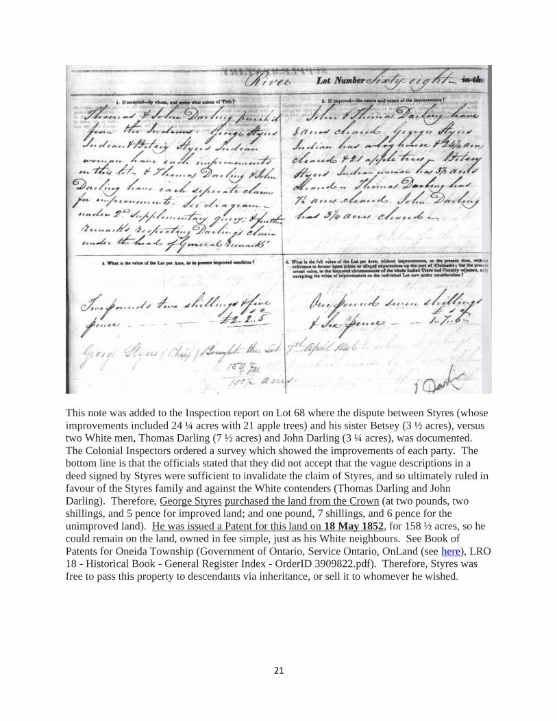
This note was added to the Inspection report on Lot 68 where the dispute between Styres (whose
improvements included 24 ¼ acres with 21 apple trees) and his sister Betsey (3 ½ acres), versus
two White men, Thomas Darling (7 ½ acres) and John Darling (3 ¼ acres), was documented.
The Colonial Inspectors ordered a survey which showed the improvements of each party. The
bottom line is that the officials stated that they did not accept that the vague descriptions in a
deed signed by Styres were sufficient to invalidate the claim of Styres, and so ultimately ruled in
favour of the Styres family and against the White contenders (Thomas Darling and John
Darling). Therefore, George Styres purchased the land from the Crown (at two pounds, two
shillings, and 5 pence for improved land; and one pound, 7 shillings, and 6 pence for the
unimproved land). He was issued a Patent for this land on 18 May 1852, for 158 ½ acres, so he
could remain on the land, owned in fee simple, just as his White neighbours. See Book of
Patents for Oneida Township (Government of Ontario, Service Ontario, OnLand (see here), LRO
18 - Historical Book - General Register Index - OrderID 3909822.pdf). Therefore, Styres was
free to pass this property to descendants via inheritance, or sell it to whomever he wished.
22
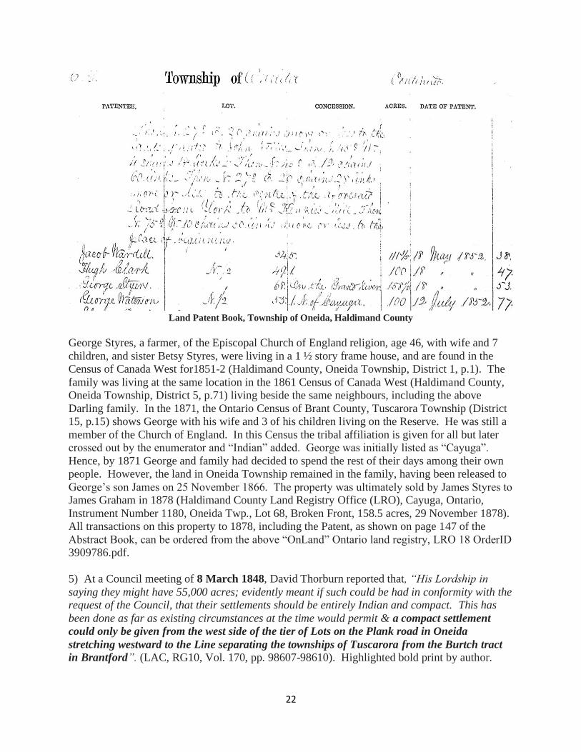
Land Patent Book, Township of Oneida, Haldimand County
George Styres, a farmer, of the Episcopal Church of England religion, age 46, with wife and 7
children, and sister Betsy Styres, were living in a 1 ½ story frame house, and are found in the
Census of Canada West for1851-2 (Haldimand County, Oneida Township, District 1, p.1). The
family was living at the same location in the 1861 Census of Canada West (Haldimand County,
Oneida Township, District 5, p.71) living beside the same neighbours, including the above
Darling family. In the 1871, the Ontario Census of Brant County, Tuscarora Township (District
15, p.15) shows George with his wife and 3 of his children living on the Reserve. He was still a
member of the Church of England. In this Census the tribal affiliation is given for all but later
crossed out by the enumerator and “Indian” added. George was initially listed as “Cayuga”.
Hence, by 1871 George and family had decided to spend the rest of their days among their own
people. However, the land in Oneida Township remained in the family, having been released to
George’s son James on 25 November 1866. The property was ultimately sold by James Styres to
James Graham in 1878 (Haldimand County Land Registry Office (LRO), Cayuga, Ontario,
Instrument Number 1180, Oneida Twp., Lot 68, Broken Front, 158.5 acres, 29 November 1878).
All transactions on this property to 1878, including the Patent, as shown on page 147 of the
Abstract Book, can be ordered from the above “OnLand” Ontario land registry, LRO 18 OrderID
3909786.pdf.
5) At a Council meeting of 8 March 1848, David Thorburn reported that, “His Lordship in
saying they might have 55,000 acres; evidently meant if such could be had in conformity with the
request of the Council, that their settlements should be entirely Indian and compact. This has
been done as far as existing circumstances at the time would permit & a compact settlement
could only be given from the west side of the tier of Lots on the Plank road in Oneida
stretching westward to the Line separating the townships of Tuscarora from the Burtch tract
in Brantford”. (LAC, RG10, Vol. 170, pp. 98607-98610). Highlighted bold print by author.
23
6) Finally, on 8 November 1850 Lord Elgin’s Proclamation provides precise survey
information as to the lands that the Chiefs wished to reserve, all others being surrendered to the
Crown. As per the Holmes Report, these included, the following lands in the Haldimand Tract:
“... certain tract or parcel of land, situate in the Township of ONEIDA in the County of
Haldimand ... comprising lots numbers one, two, three, four, five and six in the first, second,
third, fourth,' fifth and sixth concessions respectively of Oneida .. and also, River lots numbers
one, two, three, four, five, six, seven, eight, nine, ten, eleven and twelve in the same Township”.
From a “Proclamation extending the provisions of 13 and 14 Vict. Ch. 74 to certain lands in
several townships in U.C. in the occupation or enjoyment of various tribes of Indians”. All lands
not mentioned in the above description were surrendered to the Crown. (INAC Indian Lands
Registration No. 8740-292). The above lands described as being in the Township of Oneida are
those included in the present consolidated Six Nations of the Grand River Reserve IR 40 – and,
importantly, identical to the description in the “Notice” of June 1846 above.
So, time and time again the Chiefs in Council heard the boundaries discussed, and the Chiefs
laid no further claim to them, or any lands in the Township of Oneida outside the formal
description of the lands there that they wished to reserve, after the surrender of 1844
during the 19th and (most of the) 20th centuries. It was a done deal, and accepted as legal and
binding.
Land Patent: After the Surrenders the unreserved lands were returned to the Crown, the
Crown in turn sold each property and issued Patents for each lot in each concession in each
Township in Brant and Haldimand Counties – to White and Six Nations people. All Crown
Patents for Haldimand County are found in the Haldimand County Land Registry Office in
Cayuga, and summarized in very large index books showing the date of the Patent, to whom it
was issued, and then a summary of all subsequent sales, mortgages, liens etc. registered in
relation to the property until the present day. Copies of each of these deeds are found using the
code numbers from the index books. Today these records are obtained from Service Ontario’s
OnLand system (noted above).
Concerning Lot 3 Range West of the Caledonia to Townsend Road, reference to the documents
found in the Land Registry Office show that a Crown Patent for this property was issued on
21 November 1853, and by Instrument Number 5246 was registered on 20 March 1857 to
Thomas Nicholas, who had occupied the land since the 1830s (although the surname also
appears as Nichol and Nichols in various documents). A Crown Patent could not have been
issued if the land had not been surrendered by the Six Nations Chiefs. As seen in the above
“Land Inspection Returns” for Oneida Township, the Government was very careful to document
the ownership of each parcel of land, ensuring that there were no irregularities, before any
Crown Patent could be issued.
Subsequent Land Transactions: All further transactions relating to this property to 17
October 1861 are recorded in Index Book 1 for the Township of Oneida, and from then in
comparable books. If there were no unresolved irregularities registered on title for this property
since the Patent date, then the lawyer for the present owner would have been able to demonstrate
24
a clear legal title to the property. If there was any irregularity, the permits for development from
the County of Haldimand would not have been issued.
Conclusion: There are a number of important “takeaways” from the content of this report.
1) The Aboriginal People of the Haldimand Tract: The Six Nations are not aboriginal to the
Haldimand Tract. Their status is similar to the Loyalist refugees who accompanied them.
Since 1696 the Mississauga have been the recognized (by the Six Nations and the Crown)
as the owners by right of conquest of most of Southern Ontario, including the Grand
River Valley. It is they who in 1784 sold the land which became the Haldimand Tract to
the Crown, who in turn granted only a right of occupancy to the Six Nations. The land
remained Crown land through the surrenders of the 1840s.
2) The Hereditary Council: The present body known as the Hereditary Confederacy Chiefs
Council is supporting the actions of the protesters at McKenzie Meadows. They are not
legally recognized by the Government of Canada as being representatives of the Six
Nations, and also do not reflect the composition of the Chiefs throughout the history of
the Six Nations of the Grand River. Due to the influx of many non – Six Nations people,
and the fact that many hereditary chiefships remained in the United States, the concept of
“Chief” was unique to the Six Nations of the Grand River and included many non –
hereditary and non – Six Nations members.
3) The Rationale for Surrendering Land in 1844: During and after the 1830s individual Six
Nations members defied the communal occupancy rights of the group, and sold their
plots of land to White settlers. Many of these Six Nations people then left the Grand
River and settled in the Ohio country. In order to stem the tide of this diaspora, and to
introduce order to the resulting chaos, the Colonial Government proposed that the Six
Nations settle in a compact setting, reserved for the sole use of the Six Nations. Here
these illegal sales could be better controlled by both the Chiefs and the Government
officials. During various Councils of the 1840s, the Chiefs unanimously agreed that this
approach was best for their people.
4) The Role of the Colonial Government: A typical assertion today is that the Six Nations
have been victims of the Colonial authorities. In fact, it was the Colonial Government
who saved the Six Nations from dispersing, and disappearing as a people – a fact which
has seldom, if ever, been recognized or acknowledged. However, there is room to
question the fiscal responsibilities of the Colonial authorities – how well or badly they
managed the monies arising from the sale of the surrendered lands, and the investments
in ventures such as the Grand River Navigation Company.
5) The Extent of the Land Surrenders of the 1840s: The Surrender of 18 December 1844
established the boundaries of the lands which the Chiefs of the Six Nations wished to
reserve. All other lands within the Haldimand Tract which had not already been sold
were to be sold and the monies ostensibly put in trust for the benefit of Six Nations. In
addition, this surrender supplanted any earlier arrangements with the Crown concerning

25
sale or leasing of land. In other words, agreements or statements of intent from for
example the 1830s about leasing for land along the Plank Road (Argyle Street, Highway
6) were taken off the table by the surrenders. The lands the Chiefs wished to reserve
comprised some 53,000 acres and were precisely the lands that are today the Six Nations
of the Grand River Reserve – and no other lands. Validation of this surrender can be seen
in the purchase of Lot 68, Oneida Township, by Lower Cayuga Chief George Styres in
1846, who was issued a Crown Patent in 1852. If the land was unceded / unsurrendered,
as is the contention in Six Nations Claim Number 16, Oneida Township, then why would
Chief Styres purchase the land, have a Crown Patent issued, and the family remain there
until they chose to sell the property in 1878?
6) An Assessment of the Decision of the Chiefs in 1844: It is easy to look at a map of the
Haldimand Tract in 1784 and one of the Six Nations of the Grand River Reserve today
and conclude that they have been left with a pittance of what they once possessed. The
same could be said for the Mississauga who once possessed most of Central and
Southwestern Ontario but are now residing on relatively small scattered Reserves (e.g.,
Mississauga of the New Credit Reserve) throughout their former territory. It is easy to
use hindsight and second guess the actions of the Chiefs, but considering the chaos of the
time, and the clear evidence that the Six Nations were in the process of disintegrating as a
group, the Six Nations Chiefs who unanimously agreed to the Surrender of 1844, in full
Council, 176 years ago, showed great wisdom and doubtless saved Six Nations from
disappearing as a people.
7) The Position of the Lands and Resources Office of the Elected Council at Six Nations:
The Six Nations, via the Lands and Resources Office, have submitted 29 claims
beginning in 1995 – the latest revision of the website being 2008. Claim 16 asserts,
based on documents of 1843 and early 1844, that the Chiefs wanted to reserve all of
Oneida Township. This is “cherry picking”, and ignores the will of the Chiefs expressed
in the Surrender of 18 December 1844, and repeated in later Minutes of Council. The
Supervisor of the Lands and Resources Office is apparently the only person at Six
Nations who is currently in a position to comment based on documentation rather than
belief. He has recently stated that the claims registered with the Federal Government do
not involve lands possessed by third party owners in the Haldimand Tract (e.g., land
developers).
8) The Position of the Federal Government: In 2007 the Federal Government stated that Six
Nations do not have a valid claim to Douglas Creek Estates – this statement would also
apply to Lot 3 (McKenzie Meadows). In 2009 the Federal Government stated that their
position is that the Surrender of 1844 is valid.
9) The Enablers: The self-styled “land defenders” are being supported / enabled by those
whose understanding or respect for history is questionable. While this includes a group
of young White individuals apparently seeking a cause, it also includes groups who
“should know better”. Primary among these is the Canadian Union of Public Employees,
26
who have over the years ignored the suffering to those in Caledonia, and brought their
bus filled with their members to “support” the protesters. In addition, in an era where
political correctness has grabbed the reins at universities across Canada, even the
discipline of archaeology has capitulated to this pressure (see here).
10) The Ownership of Lot 3 Range West of the Caledonia to Townsend Road:
Considering the above historical context of land ownership within the Haldimand Tract
and Haldimand County, there is no rationale known to the author for questioning the
owner / developer’s rights to the enjoyment of their property on Lot 3 Range West of the
Caledonia to Townsend Road. The evidence shows that any Six Nations group today
claiming authority to usurp the rights of the current owner of Lot 3, or for that matter the
rights of any owner of land outside the present boundaries of the Six Nations of the
Grand River Reserve, has no legitimate right to do so. The author wishes to note that the
data presented in this report also applies to the land known as Block C in the Tier of Lots
west of the Plank Road (Argyle Street), also known as the Douglas Creek Estates and
Kanonstaton. The above Oneida Land Inspection returns record it as being “Vacant”
(p.216). However, as is the case with Lot 3 Range West of the Caledonia to Townsend
Road, it was assigned to the Crown for sale via the land surrender of 18 December 1844.
11) Moving Forward – Negotiating with the Federal Government: In the opinion of the
author:
a) If the current protesters disagree with the analysis offered in this document, they
need to bring forward their evidence and allow it to be tested in court. If all they have
is Claim 16 (Oneida Township) of the Six Nations Lands and Resources Office, then
they don’t have a leg to stand on since it does not consider any evidence beyond the
Spring of 1844.
b) The Federal Government needs to once again acknowledge, in a very public manner,
that they consider the land surrender of 18 December 1844 to be valid and binding.
c) An argument could be made that the Government should not now, or ever, negotiate
with terrorists of any description. The wanton damage to Caledonia and surrounds
between 2006 and 2021 have allowed many to conclude that the “protesters” are in
fact domestic terrorists. It is legitimate to question whether the Government should
negotiate with groups who have caused millions of dollars in damage, including
having trenched the Highway 6 Caledonia Bypass and all the southern access roads to
Caledonia as well as the railway line between Caledonia and Hagersville – this
massive infrastructure damage still exists at the time of the writing of this manuscript.
d) It is a given in any legal negotiating process that all parties have access to the same
set of facts. The author is aware of key documents that have been removed from
public access by Six Nations, and thus in this case the Government side will not have
access to all of the records needed to make a full assessment of the matter (see here).
e) Six Nations activists maintain that they are a sovereign people and that all
negotiations need to be on a nation - to - nation level. Evidence relating to this matter

27
can be found here. Furthermore, they maintain that they are “treaty people” and that
there is a treaty between Six Nations and the British Crown or the Federal
Government of Canada. The facts relating to this matter can be found here.
12) The Last Word: The evidence strongly suggests that both Lot 3 Range West of the
Caledonia to Townsend (McKenzie) Road (McKenzie Meadows Development), and
Block C (Douglas Creek Estates), Oneida Township, must be returned to the legitimate
owners based on the Crown / Province of Ontario land patents and subsequent deeds.
The focus must turn to what are likely to be legitimate fiscal concerns – specifically an
accounting of the Six Nations trust funds and interest payments from 1844 to today.
Note re Possible Conflicts of Interests: The author of this report has not received any monetary
or other consideration from any party for the completion of this report.
Respectfully submitted,
Dr. David K. Faux
Caledonia, Ontario; 11 September 2020. Revised 14 September to 31 January 2021.
Copyright 2020 to 2021. All rights reserved. This document and original findings content is
only for personal study, and may not be used for any other purpose without the express written
consent of the author.


![7 Catheter-associated Urinary Tract Infection (CAUTI) · UTI Urinary Tract Infection (Catheter-Associated Urinary Tract Infection [CAUTI] and Non-Catheter-Associated Urinary Tract](https://img.pdfslide.us/doc/110x75/5c40b88393f3c338af353b7f/7-catheter-associated-urinary-tract-infection-cauti-uti-urinary-tract-infection.jpg)