Embed Size (px)
Citation preview

Land Not Within a Council Area (Metropolitan)
Consolidated – 5 May 2016
Please refer to the Land Not Within a Council Area (Metropolitan) page at www.sa.gov.au/developmentplans to see any amendments not consolidated.
Consolidated - 5 May 2016
Revok
ed an
d rep
laced
by th
e Plan
ning a
nd D
esign
Code o
n 19 M
arch 2
021.
See w
ww.plan
.sa.go
v.au.
Land Not Within a Council Area (Metropolitan)
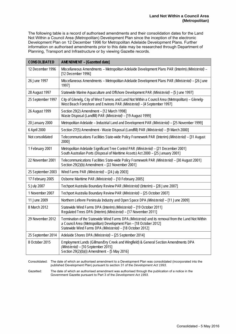
The following table is a record of authorised amendments and their consolidation dates for the Land Not Within a Council Area (Metropolitan) Development Plan since the inception of the electronic Development Plan on 12 December 1996 for Metropolitan Adelaide Development Plans. Further information on authorised amendments prior to this date may be researched through Department of Planning, Transport and Infrastructure or by viewing Gazette records.
CONSOLIDATED AMENDMENT – [Gazetted date]
12 December 1996 Miscellaneous Amendments – Metropolitan Adelaide Development Plans PAR (Interim) (Ministerial) – [12 December 1996]
26 June 1997 Miscellaneous Amendments – Metropolitan Adelaide Development Plans PAR (Ministerial) – [26 June 1997]
28 August 1997 Statewide Marine Aquaculture and Offshore Development PAR (Ministerial) – [5 June 1997]
25 September 1997 City of Glenelg, City of West Torrens and Land Not Within a Council Area (Metropolitan) – Glenelg-West Beach Foreshore and Environs PAR (Ministerial) – [4 September 1997]
26 August 1999 Section 29(2) Amendment – [12 March 1998] Waste Disposal (Landfill) PAR (Ministerial) – [19 August 1999]
20 January 2000 Metropolitan Adelaide – Industrial Land and Development PAR (Ministerial) – [25 November 1999]
6 April 2000 Section 27(5) Amendment - Waste Disposal (Landfill) PAR (Ministerial) – [9 March 2000]
Not consolidated Telecommunications Facilities State-wide Policy Framework PAR (Interim) (Ministerial) – [31 August 2000]
1 February 2001 Metropolitan Adelaide Significant Tree Control PAR (Ministerial) – [21 December 2001] South Australian Ports (Disposal of Maritime Assets) Act 2000 – [25 January 2001]
22 November 2001 Telecommunications Facilities State-wide Policy Framework PAR (Ministerial) – [30 August 2001] Section 29(2)(b) Amendment – [22 November 2001]
25 September 2003 Wind Farms PAR (Ministerial) – [24 July 2003]
17 February 2005 Osborne Maritime PAR (Ministerial) – [10 February 2005]
5 July 2007 Techport Australia Boundary Review PAR (Ministerial) (Interim) – [28 June 2007]
1 November 2007 Techport Australia Boundary Review PAR (Ministerial) – [25 October 2007]
11 June 2009 Northern Lefevre Peninsula Industry and Open Space DPA (Ministerial) – [11 June 2009]
8 March 2012 Statewide Wind Farms DPA (Interim) (Ministerial) – [19 October 2011] Regulated Trees DPA (Interim) (Ministerial) – [17 November 2011]
29 November 2012 Termination of the Statewide Wind Farms DPA (Ministerial) and its removal from the Land Not Within a Council Area (Metropolitan) Development Plan – [18 October 2012] Statewide Wind Farms DPA (Ministerial) – [18 October 2012]
25 September 2014 Adelaide Shores DPA (Ministerial) – [25 September 2014]
8 October 2015 Employment Lands (Gillman/Dry Creek and Wingfield) & General Section Amendments DPA (Ministerial) – [10 September 2015] Section 29(2)(b)(i) Amendment – [5 May 2016]
Consolidated: The date of which an authorised amendment to a Development Plan was consolidated (incorporated into the published Development Plan) pursuant to section 31 of the Development Act 1993.
Gazetted: The date of which an authorised amendment was authorised through the publication of a notice in the Government Gazette pursuant to Part 3 of the Development Act 1993.
Consolidated - 5 May 2016
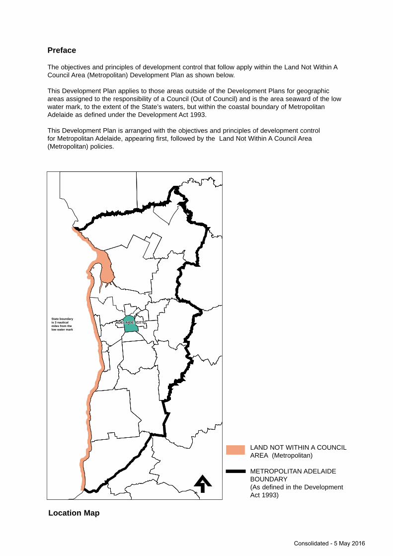
Preface
The objectives and principles of development control that follow apply within the Land Not Within ACouncil Area (Metropolitan) Development Plan as shown below.
This Development Plan applies to those areas outside of the Development Plans for geographicareas assigned to the responsibility of a Council (Out of Council) and is the area seaward of the lowwater mark, to the extent of the State’s waters, but within the coastal boundary of MetropolitanAdelaide as defined under the Development Act 1993.
This Development Plan is arranged with the objectives and principles of development control for Metropolitan Adelaide, appearing first, followed by the Land Not Within A Council Area(Metropolitan) policies.
LAND NOT WITHIN A COUNCILAREA (Metropolitan)
METROPOLITAN ADELAIDEBOUNDARY(As defined in the DevelopmentAct 1993)
Location Map
ADELAIDE (CITY)ADELAIDE (CITY)State boundary is 3 nauticalmiles from the low water mark
Consolidated - 5 May 2016

Consolidated - 5 May 2016
Land Not Within a Council Area (Metropolitan)
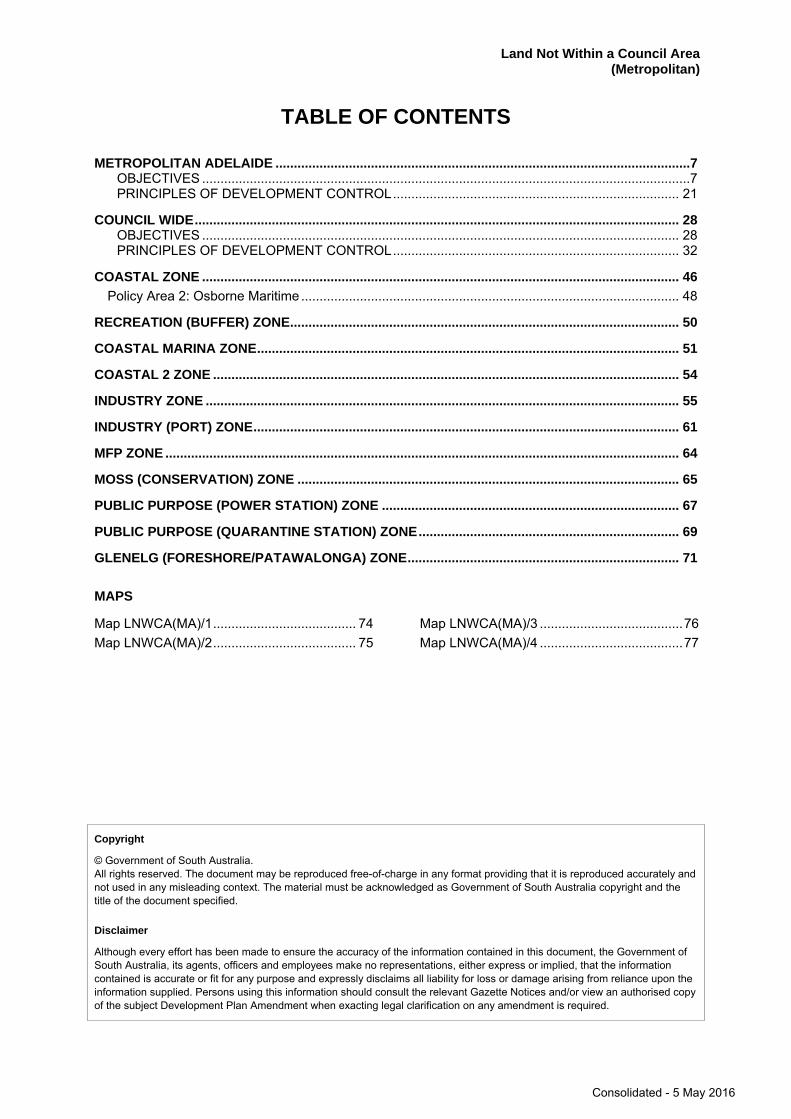
TABLE OF CONTENTS
METROPOLITAN ADELAIDE .................................................................................................................7 OBJECTIVES .....................................................................................................................................7 PRINCIPLES OF DEVELOPMENT CONTROL .............................................................................. 21
COUNCIL WIDE .................................................................................................................................... 28 OBJECTIVES .................................................................................................................................. 28 PRINCIPLES OF DEVELOPMENT CONTROL .............................................................................. 32
COASTAL ZONE .................................................................................................................................. 46 Policy Area 2: Osborne Maritime ....................................................................................................... 48
RECREATION (BUFFER) ZONE .......................................................................................................... 50
COASTAL MARINA ZONE ................................................................................................................... 51
COASTAL 2 ZONE ............................................................................................................................... 54
INDUSTRY ZONE ................................................................................................................................. 55
INDUSTRY (PORT) ZONE .................................................................................................................... 61
MFP ZONE ............................................................................................................................................ 64
MOSS (CONSERVATION) ZONE ........................................................................................................ 65
PUBLIC PURPOSE (POWER STATION) ZONE ................................................................................. 67
PUBLIC PURPOSE (QUARANTINE STATION) ZONE ....................................................................... 69
GLENELG (FORESHORE/PATAWALONGA) ZONE .......................................................................... 71
MAPS
Map LNWCA(MA)/1 ....................................... 74 Map LNWCA(MA)/2 ....................................... 75
Map LNWCA(MA)/3 ....................................... 76 Map LNWCA(MA)/4 ....................................... 77
Copyright
© Government of South Australia. All rights reserved. The document may be reproduced free-of-charge in any format providing that it is reproduced accurately and not used in any misleading context. The material must be acknowledged as Government of South Australia copyright and the title of the document specified.
Disclaimer
Although every effort has been made to ensure the accuracy of the information contained in this document, the Government of South Australia, its agents, officers and employees make no representations, either express or implied, that the information contained is accurate or fit for any purpose and expressly disclaims all liability for loss or damage arising from reliance upon the information supplied. Persons using this information should consult the relevant Gazette Notices and/or view an authorised copy of the subject Development Plan Amendment when exacting legal clarification on any amendment is required.
Consolidated - 5 May 2016

Consolidated - 5 May 2016
7 Land Not Within a Council Area (Metropolitan)
METROPOLITAN ADELAIDE
Introduction
The following policies for metropolitan Adelaide apply across the area within the boundary of the Land Not Within a Council Area (Metropolitan) Development Plan.
Background
Metropolitan Adelaide is bounded on the west by Gulf St. Vincent and on the east by the Mount Lofty Ranges which rise to over 700 metres. The city and suburbs lie between, built on the gently sloping Adelaide Plains, and backed by the steep and beautiful escarpment of the ranges.
To the north the land is flat, to the north-east gently undulating and to the south pleasant undulating land lies between the ranges and the sea. Although the native vegetation has been largely cleared from the plains, there are still significant areas of bushland in the ranges within a short distance of the city.
In the 1830s the South Australian Association was formed in England. An Act was passed and Colonel William Light was despatched to the new colony to lay out the first town. Late in 1836 Light selected a site astride the River Torrens ten kilometres inland from the coast. His plan of Adelaide with its wide streets and surrounding belt of parklands is widely acclaimed.
Light was also instructed to lay out the surrounding district and his framework of roads has subsequently become the main road system of the metropolitan area. The early scoffered settlements on the plains and along the coast have now coalesced to form one built-up area, with the main business area centrally located in the original settlements near the River Torrens.
As the State capital, Adelaide is the centre of government administration; it is the financial, commercial and transport centre, and is the principal focus for shopping, entertainment and cultural activities.
OBJECTIVES
Form of Development
Objective 1: Orderly and economic development.
Objective 2: A proper distribution and segregation of living, working and recreational activities by the allocation of suitable areas of land for those purposes.
The direction of the future expansion of the metropolitan area is influenced by the Mount Lofty Ranges and the sea, which restrict development to the east and west, and by the cost of providing water supply and sewerage services to hilly land and to low-lying coastal areas.
The future form and nature of the existing metropolitan area will be influenced by meeting housing choice in the metropolitan area. Current and anticipated demographic trends in the metropolitan area indicate population growth but a changing population structure, with falling dwelling occupancy rates and declining population in many areas, particularly in the inner and middle suburbs, will necessitate increasing dwelling density to maintain population levels.
While taking these trends into account, there are social, environmental and economic benefits to be gained from higher residential densities within the metropolitan area.
It is an essential element in the future development of Adelaide, to address concerns about increased housing demand, efficient use of urban infrastructure and population change. This can be achieved by increasing the number of dwellings that can be accommodated within the existing boundary of the metropolitan area, and arresting and perhaps reversing the decline in population which has been evident in many parts of the metropolitan area.
Consolidated - 5 May 2016
8 Land Not Within a Council Area (Metropolitan)
Objective 3: The proper location of public and community facilities by the reservation of suitable land in advance of need.
Substantial areas of land are required by the various public authorities responsible for transport, public services, and the provision of other public facilities. Land required for such public purposes should be available in the right place at the right time. This should be done by reserving the land for future acquisition to ensure that, in the meantime any private development does not hinder the purposes for which the land is reserved.
Objective 4: Maintenance of the long-term operational, safety and commercial aviation requirements of the Adelaide International Airport and Parafield Airport.
Land Division
Objective 5: Land in appropriate localities divided into allotments in an orderly and economic manner.
The large area of land needed and the cost of providing essential public services such as water and sewerage, make it essential that the development of the metropolitan area proceeds in an orderly and convenient manner, making full use of the State's economic resources. It is costly to provide services to scattered development caused by the haphazard and premature division of land.
Land should be divided at a rate based on the building demand to prevent premature division and scattered and haphazard development. Vacant land within the urban area should be developed in order to contain the spread of the urban area.
The selection of areas for expansion is influenced by a number of factors. These include physical restrictions, the need to preserve resources such as water, minerals and scenic features, and the lack of public services in certain areas, and the need to retain buffer areas and open spaces.
Residential Development
Objective 6: A compact metropolitan area.
This objective may be achieved through selective development of infill housing, redevelopment and refurbishment of existing housing, and use of vacant and underutilized land, with the aim of reducing the social, environmental and economic costs of urban development, and maximising use of the community investment in facilities and services in existing housing areas. While a compact form of development is generally desirable, recognition must be given to areas of particular character or amenity, or to specific constraint such as environmental or historical value, water catchment areas and areas of bushfire hazard.
Objective 7: A variety and choice of dwelling types to meet the needs and preferences of all sections of the community.
Residential development within metropolitan Adelaide should be based on a flexible approach to provision of a wide range of dwelling types.
Objective 8: Containment of housing costs through the encouragement of a full range of design and development techniques.
This can be achieved by measures such as the economical layout of residential development, the reduction of allotment sizes and street widths, the use of innovative servicing techniques, the encouragement of designs which use space efficiently and effectively, and the provision of medium-density residential development where appropriate. In addition, new building materials and energy saving devices can be used to reduce housing costs.
Objective 9: Safe, pleasant, convenient and efficient residential zones.
Consolidated - 5 May 2016
9 Land Not Within a Council Area (Metropolitan)
Achievement of this objective can be assisted by development that is well designed, and which maintains and where appropriate, enhances the residential character and amenity of the area into which it is to be sited. Residential development that is well designed takes into account factors such as building bulk and materials, privacy and access to sunlight. Sunlight access, for example, not only benefits amenity, but also is necessary to enable effective use of solar energy collection systems. These systems are affected by building and allotment orientation and by shadowing from buildings and trees, and accordingly, it is desirable to protect existing collectors and recognise potential for use on sites adjacent to a development site. Residential zones should provide primarily for residential uses. New non-residential activities should generally not be located in residential zones, and extensions of existing non-residential activities should only occur where there is no adverse effect on nearby residential activities.
Centres and Shops
Objective 10: Shopping, administrative, cultural, community, entertainment, educational, religious, and recreational, facilities located in integrated centres which are distributed rationally throughout the area of metropolitan Adelaide.
Objective 11: Centres established and developed in accordance with a hierarchy based on function, so that each type of centre provides a proportion of the total requirement of goods and services commensurate with its role.
Objective 12: A hierarchy of centres located in centre zones or areas.
Objectives 10, 11 and 12 apply to the groupings of facilities into centres and the location of those centres.
The grouping of a wide range of facilities in integrated centres will benefit the community by encouraging economic, and shared, use of facilities, providing a meeting place for communities, and encouraging ready access by both public and private transport.
The hierarchy of centres is based on the principle that each type of centre provides a proportion of the total community requirement for goods and services commensurate with its role.
Centres within the area of metropolitan Adelaide are of the following type:
(a) The Central Business Area of the City of Adelaide;
(b) Regional Centre;
(c) District Centre;
(d) Neighbourhood Centre; and
(e) Local Centre.
The degree to which the various facilities can be located within a centre will depend, among other things, upon the size of the centre, the specific policies relating to the centre, the implications of competing centres for the population being served, and the characteristics of the population to be served. Each development proposal for a centre should be evaluated against that centre's and other centres', defined roles in the centre hierarchy.
New development in centres should result in the expansion of the total range of retail goods and services available to the population to be served, have regard to the location and role of other existing and proposed centre zones, and be of a size and type which would not demonstrably lead to the physical deterioration of any existing centre zone or designated shopping area.
The identification of each zone in a hierarchy of centres should be such as to:
(a) cater for the existing and future population's shopping and community needs;
Consolidated - 5 May 2016
10 Land Not Within a Council Area (Metropolitan)
(b) provide a degree of choice in the location of centre facilities;
(c) be safely and readily accessible to the population to be served, particularly by public transport, and obviate the need for unscheduled large-scale traffic and transport works;
(d) have minimal adverse impact on residential areas;
(e) concentrate development on one side of a primary or a primary arterial, road, or one quadrant of a primary or primary arterial road, intersection and have minimal adverse impact on traffic movement on primary and primary arterial roads. Linear extension of centre zones or areas along primary, or primary arterial, roads is to be minimised;
(f) reflect the potential to rehabilitate or extend centre zones or areas, and make effective use of existing investment in public infrastructure, utilities and transport, any costs involved being offset by benefits to the population being served;
(g) be of a size and shape suitable for their functions, and provide car parking facilities:
(h) have regard to the maintenance of retail employment levels in the area; and
(i) have regard to the degree to which existing centres satisfy the above objectives.
The development of new centres may be staged, and specific areas may be set aside for community and other non-retail uses, with the total integrated development producing a character desired for that particular centre.
Objective 13: The central business area to provide the principal focus for the economic, social and political life of metropolitan Adelaide, and the State.
The central business area is located in the City of Adelaide.
Objective 14: Regional centres to function as the main centres outside the central business area for a full range of shopping, administrative, cultural, community, entertainment, education, religious and recreational facilities, as public transport interchanges and focus of public transport networks and public and private office development.
Regional centres are shown on the Plans for the relevant council areas, at Elizabeth, Modbury, Marion, Noarlunga and Port Adelaide.
In some instances the distribution of existing shopping development will be such that some centres, which provide a full range of other regional facilities, will be unable to develop the full range of shopping facilities envisaged for a regional centre.
The following list indicates the facilities which are appropriate in a fully developed regional centre:
Bank Church Cinema Civic Centre Commercial Development Community Health Centre Consulting Room Day Care Centre Department Store Discount Department Store Further Education Hospital Hotel/Tavern Indoor Games Centre Library Office (general, professional, governmental)
Parks Personal Service Establishments Playing Field Police Station Pre-school Primary School Restaurant Secondary School Service Station Special School Specialty Shop Supermarket Swimming Pool Tertiary Education Theatre
Consolidated - 5 May 2016
11 Land Not Within a Council Area (Metropolitan)
Objective 15: District centres served by public transport and including shopping facilities that provide mainly 'convenience' goods and a sufficient range of 'comparison' goods to serve the major weekly shopping trips, as well as a comparable range of other community facilities.
The size of a district centre and the range of facilities within it, may vary throughout the area of metropolitan Adelaide but should be related to the size and characteristics of the population it serves, The largest district centres should serve a population in the order of 60 000 people.
The following list indicates those facilities which are appropriate in a fully developed district centre:
Ambulance Station Bank Child Minding/Child Care Centre Church Cinema Civic Centre Club/Meeting Hall Commercial Development Community Health Centre Consulting Room Day Care Centre Discount Department Store Further Education Hospital Hotel/Tavern Indoor Recreation Centre
Library Offices (general, professional, governmental) Park Personal Service Establishments Playing Field Police Station Pre-school Primary School Restaurant Secondary School Service Station Special School Specialty Shop Supermarket Swimming Pool
Objective 16: Neighbourhood centres to include shopping facilities that provide mainly 'convenience' goods to serve the day-to-day needs of the neighbourhood, and a limited range of more frequently required 'comparison' goods as well as a narrow range of facilities. There are not likely to be administrative facilities in neighbourhood centres.
The size of a neighbourhood centre and the range of facilities within it may vary within the area of metropolitan Adelaide but it should be related to the size and characteristics of the population it serves. The largest neighbourhood centres should serve a population in the order of 10 000 people.
The following list indicates those facilities which are appropriate in a fully developed neighbourhood centre:
Bank Branch Library Child Minding/Child Care Centre Church Club/Meeting Hall Commercial Development Community Welfare Local Office Consulting Room Local Health Centre Office (to serve nearby residents)
Park Personal Service Establishment Playing Field Pre-school Primary School Restaurant Service Station Specialty Shop Squash Court Supermarket
Objective 17: Local centres to include shopping and local community facilities to serve day-to-day needs of the local community.
Local centres on arterial roads should comply with the same criteria as those for other local centres.
Objective 18: Retail showroom development should only be allowed outside of designated centres if it can be clearly demonstrated that it could be undesirable or impractical to locate them in the vicinity of designated centres.
Consolidated - 5 May 2016
12 Land Not Within a Council Area (Metropolitan)
Retail showrooms, trading in furniture, floor coverings, household appliances and other similar articles of bulky merchandise, require expensive indoor areas for the display of products and exhibit a lower parking demand than convenience shops. Retail showrooms complement the overall provision of facilities in centres and should be located on the periphery of those centres.
In inner areas, the designation of service retail zones for retail showroom development may be appropriate in the event that a centre location cannot be achieved. Such a zone should not be created in a linear fashion along arterial roads.
Objective 19: Retailing not consistent with facilities envisaged in a centre located and operated so as not to adversely affect any designated centre, commercial, business or residential, zones, or areas, and traffic movements on local, primary, and primary arterial roads.
The diversification of locations for retailing providing goods and services not compatible with the grouping of facilities envisaged for regional, district, and neighbourhood, centres may be considered so long as the integrity of the centre hierarchy is not compromised and the development is compatible with land uses in the locality.
Retail development of this kind should be evaluated having regard to:
(a) its locational and operational compatibility with existing shopping, business, commercial zones, or areas, including the nature of the goods and materials to be stocked, and the noise levels of vehicles and plant used on, and servicing, the site;
(b) its effect on adjacent residential development;
(c) the increased use of local and arterial roads;
(d) the adequacy of vehicular access and car parking; and
(e) the maintenance of building and site development standards required for centres.
Community Facilities
Objective 20: Appropriate community facilities conveniently accessible to the population they serve.
A sound education system and an adequate health service provide the basis for the social well-being of a community. Therefore, schools, hospitals, cemeteries and other institutions, must be located conveniently for the people they serve.
Primary schools should be within reasonable walking distance of children's homes, and so located that children do not have to cross main traffic routes on their way to and from school. State primary schools are usually located about one kilometre apart, each school serving a population of approximately 6500 persons.
The practical difficulties in meeting the standards for the siting of primary schools make the acquisition, or reservation, of sites well ahead of requirements particularly important.
Many kindergartens are associated with infant welfare centres. Sites should be about one kilometre apart, ensuring that a kindergarten is near every home.
Secondary school sites must be well drained and reasonably level, and should be served by public transport. Special attention is necessary to ensure the safety of pupils travelling by bicycle. State secondary schools are usually located about three kilometres apart, each school serving a population of between 15 000 and 20 000 persons.
Hospitals should be located where they can be reached conveniently by hospital patients, visitors and staff. Sites for major hospitals, therefore, should be acquired or reserved well in advance of requirements, and in locations convenient to the population they are to serve.
Consolidated - 5 May 2016
13 Land Not Within a Council Area (Metropolitan)
The siting of cemeteries and crematoria must take into account the convenience of persons attending funerals and visiting graves, and the effect on traffic of a large number of funerals.
The changing age structure of the population will affect the range of community facilities required, therefore flexibility should be a major consideration when considering the design, type and life of buildings.
Transportation (Movement of People and Goods)
Objective 21: A comprehensive, integrated, and efficient, public and private transport system which will:
(a) provide access to adequate transport services for all people, at an acceptable cost;
(b) effectively support the economic development of metropolitan Adelaide and the State;
(c) ensure a high level of safety; and
(d) maintain the options for the introduction of suitable new transport technologies.
Objective 22: A road hierarchy to form the basis of development controls and serve as a guide to the investment of road funds in order to ensure a safe and efficient traffic flow and to promote the saving of fuel and time. Arterial roads will provide for major traffic movements.
Objective 23: A network of roads, paths and tracks, to accommodate satisfactorily a variety of vehicular, cycle and pedestrian, traffic.
Objective 24: A compatible arrangement between land uses and the transport system which will:
(a) ensure minimal noise and air pollution;
(b) protect amenity of existing and future land uses;
(c) provide adequate access; and
(d) ensure maximum safety.
Objective 25: A form of development adjoining main roads which will:
(a) ensure traffic can move efficiently and safely;
(b) discourage commercial ribbon development;
(c) prevent large traffic-generating uses outside designated shopping/centre zones;
(d) provide for adequate off-street parking; and
(e) provide limited and safe points of access and egress.
Commercial Development
Objective 26: Commercial development located in suitable areas.
Commercial areas cater for wholesaling, storage, and associated, activities. Parts of these areas may be suitable for development that does not generate much traffic, such as car and boat sales yards, small offices, tyre sales outlets and premises which are used primarily for the fabrication, storage, and repair, of goods with only a small ancillary retailing area.
Consolidated - 5 May 2016
14 Land Not Within a Council Area (Metropolitan)
The layout of buildings should normally provide for offices and showrooms of high architectural standard to occupy the front of the site, with storage premises at the rear. In the suburbs, buildings should be set well back from the road frontage to allow for landscaping. Space should be provided on the site for car parking, the loading and unloading of vehicles, and the circulation of vehicles.
Attractive and spacious site layouts, with well-designed buildings, are important for storage warehouses. The buildings are usually large, so level, well drained, land with good bearing capacity is essential. Areas set aside for storage warehouses should be close to port, rail and road facilities, with heavy duty roads of sufficient width to service individual sites and railway sidings provided where possible.
The considerable amount of traffic associated with many wholesale warehouses makes it essential that points of access and egress receive careful attention, particularly when the site fronts a main road. The siting of warehouses near residential areas needs care because of the amount of traffic involved.
Industrial Development
Objective 27: An adequate supply of suitable and appropriately located land to accommodate current and projected industrial activities.
Industry requires reasonably level, well drained land, which can be supplied with the appropriate infrastructure and is readily accessible to labour and transport. In choosing suitable locations for industrial land it is also important to consider the effects of industry on surrounding land uses.
While supplies of industrial land are adequate in the short term, Metropolitan Adelaide’s stocks of good quality industrial land have been reduced over past years. Industrial land is a valuable economic resource and it is vital that new supplies of suitable, well located land for industry are provided in Metropolitan Adelaide and that land set aside for industry is not developed for other purposes.
Objective 28: Industrial land and activities protected from encroachment by incompatible land uses.
Land earmarked for industrial purposes requires protection from encroachment by incompatible land uses. In particular, residential land uses can encroach upon existing industrial activities over time. As residential development moves closer to these industries, the capacity of industry to operate properly or to expand can be threatened. Similarly, increases in residential densities close to industrial areas can also have implications for industry.
The potential conflicts between existing industry and encroaching non-industrial development, either by the take up of vacant land or through residential density increases, need to be assessed when rezoning land, particularly for residential uses, or when reviewing zone policies in adjoining areas.
Distances to existing industrial development need to be taken into account when considering the zoning of land for residential or other potentially sensitive land uses. The use of separation areas along zone boundaries and the management of these areas to mitigate impacts and minimise the potential for conflict between industrial land uses and other incompatible land uses, should also be considered when appropriate.
Objective 29: Development at the interface between industrial activities and sensitive uses that is compatible with surrounding activities, particularly those in adjoining zones.
Where industrial zones already adjoin residential areas, it is appropriate that those industrial activities with lower potential for off-site impacts be located on the periphery of industrial zones. Some types of commercial development are also suitable on the periphery of industrial areas as they can perform a separation role between housing and industry. Consideration should also be given to the appropriateness of, and design treatments required, for other land uses located in close proximity to industrial locations. Separation distances can be utilised as a trigger for more detailed assessment to ensure that impacts can be minimised.
Consolidated - 5 May 2016
15 Land Not Within a Council Area (Metropolitan)
Public Utilities
Objective 30: Economy in the provision of public services.
The most costly and difficult services to provide are water and sewerage. Investigations show that most of the land in the metropolitan area which can be supplied with these services economically, can also be supplied economically with electricity and gas, stormwater drainage, telephone, garbage collection and public transport services.
Routes of main transmission lines should be defined in advance of land division and the erection of buildings to ensure that buildings are clear of easements. Care is needed in the siting of sub-stations to ensure that the appearance of surrounding areas is not marred by unsightly switchgear and equipment. When conspicuous sites have to be chosen for technical reasons, the site should be large enough to allow for planting a screen of trees and shrubs.
Mining
Objective 31: The continued availability of metallic, industrial and construction, minerals by preventing development likely to inhibit their exploitation.
The minerals of greatest significance to the metropolitan area are those used for building and construction. South Australia has a scarcity of natural timbers for building construction, and is therefore particularly dependent on resources of clay and shale for brick manufacture, and sand and stone for concrete and mortar aggregate. Equally important are materials such as filling sand and quarry products used in road building and general construction. Transport costs of these bulky low-value products rise rapidly as the distance increases between the workings and the point of consumption, with a consequent increase in price to the consumer.
Quartzite and limestone used as coarse aggregate for concrete and roadworks, are confined to the Mount Lofty Ranges, particularly the western face, and to the area between Marino and Reynella.
Concrete sand is restricted to deposits at Golden Grove, Highbury and Maslin Beach. The variety of clays necessary for brick and pipe manufacture are won from many sources in the ranges and from Golden Grove and Maslin Beach. Filling and garden sand is supplied mainly from the Gawler River.
Although large reserves of most of these materials exist, they can be easily sterilized by other uses of the land. Workable deposits should therefore be kept free of building and other development so that the deposits are available when needed.
Of the significant deposits currently being worked, those which are most likely to be affected by urban development are shown as 'extractive industrial' on the plans for the various council areas. The remaining deposits, other than those already subdivided for building development, are included where possible in rural areas or are allocated for uses which would not preclude the eventual extraction of minerals.
Objective 32: The protection of the landscape from undue damage from quarrying and similar extractive and associated manufacturing industries.
It is not in the best interests of the community that land should be left derelict following the extraction of minerals, and wherever possible steps should be taken to reclaim the land and put it to a suitable use.
Although minerals may be extracted from a site for a considerable number of years, a plan showing proposals for the after-use of the site should form the basis of the working programme. It should give an indication of the depths and direction of working, access roads, support for abutting roads and adjoining land, disposal of waste and screening of plant and machinery by trees. While such a plan may be subject to changes due to unpredictable working conditions, it would ensure a close correlation between working and the after-use of the site.
Consolidated - 5 May 2016
16 Land Not Within a Council Area (Metropolitan)
Conservation
Objective 33: The conservation, preservation, or enhancement, of scenically attractive areas, including land adjoining water or scenic routes.
The character of the built-up area largely depends on the attractiveness of parks and recreation reserves, and every endeavour should be made to plant and develop reserves as soon as they become available. Reserves should be easily seen from adjoining roads, and housing development should not block out views or back onto reserves.
Tree planting should be encouraged, dwellings should be of good design and set well back from the roads. Advertisements should not mar the landscape and overhead services should be carefully sited against tree and hill backgrounds.
The watercourses with their natural vegetation are the most significant natural features on the Adelaide Plains. The trees and natural vegetation can add to the attractiveness of suburban areas and, wherever possible, these features should be incorporated in the layout of residential areas.
The land bordering watercourses should be reserved for public use. Buildings should be set well back, and front onto a road and reserve along a watercourse. The reserve could be used for public recreation and provide easy access for maintenance of the watercourse. The setting back of buildings from a watercourse reduces the need for costly engineering works to prevent erosion and flooding. In some instances it may be possible to retain privately owned orchards and market gardens along rivers by the use of open space proclamations.
Objective 34: The preservation of buildings or sites of architectural, historical, or scientific, interest.
There are many buildings and sites of architectural, historical, and scientific, interest in metropolitan Adelaide that warrant preservation. An awareness of their existence is the first stage in preservation, and lists are available prepared by statutory bodies and interested organisations.
The unique range of flora in the Aldinga scrub, the remaining sand-dunes at the mouth of the Onkaparinga River at Port Noarlunga, and belts of mangroves along the coast north towards Port Gawler, should be preserved for scientific purposes.
Objective 35: The retention of environmentally-significant areas of native vegetation.
Objective 36: The retention of native vegetation where clearance is likely to lead to problems of soil erosion, soil slip and soil salinization, flooding or a deterioration in the quality of surface waters.
Objective 37: The retention of native vegetation for amenity purposes, for livestock shade and shelter and for the movement of native wildlife.
Open Space
Objective 38: Adequate public parks and recreation areas conveniently located.
Open spaces are needed in a city for outdoor recreation, and all age groups must be catered for. The size of the open spaces must be adequate, and they must be located conveniently for the people who use them. Suitable land must be acquired or reserved long before the need becomes evident and long before funds for development are available. If such action is not taken, then the cost involved will be prohibitive as values rise, or the land will have been used for other purposes. Consequently, land acquisition should be programmed for a considerable number of years ahead.
Open spaces can be classified into four main groups in order to clarify requirements:
(a) Regional parks, of at least 200 hectares, situated within a reasonable driving distance of the built-up area.
Consolidated - 5 May 2016
17 Land Not Within a Council Area (Metropolitan)
(b) Major district open spaces, of at least 20 hectares, providing for all forms of recreation and within five kilometres of every home.
(c) Minor district open spaces, preferably of about ten hectares, serving the people living within about one kilometre radius of the site.
(d) Small local open spaces within short and safe walking distance of every home.
The function of regional parks is to provide the opportunity for active and passive recreation beyond the limits of the built-up area, and at the same time to preserve the natural character of the landscape and the flora and fauna. Parks of this kind are at Belair and Morialta Falls. The standard of provision should be at least four hectares per 1000 population.
The function of major district open spaces is to provide for active and passive recreation for large numbers of people. Each major district open space should be large enough to provide a full range of sports grounds, children's playgrounds, gardens and preferably a golf course. The size of minor district open spaces allows room for two full-sized ovals, facilities for tennis, bowls and other games, a children's playground, formal gardens and space for car parking.
Local open spaces should have facilities for some organized sport and children's play activities, in a park-like setting. The size of local open spaces can vary, but in practice many will be small, probably little more than half a hectare. The smaller areas can accommodate tennis courts or children's playgrounds while the large areas can provide for team games of a junior standard and practice pitches.
Children's playgrounds should be available within half a kilometre of every home, and situated so that children do not have to cross a busy road. Playgrounds should be about one half to one hectare in extent, and can be irregular in shape, although the whole of the playground should be visible from a public road. Sites should be attractive, and where possible should be incorporated with a larger park. The need for children's playgrounds is usually greater in new suburbs with a high proportion of newly married people. However, constant attempts should be made in the older suburbs to provide children's playgrounds, because of the number of children who could be living in flats.
Parks and gardens are required particularly for older people who desire a more passive form of recreation. Some form of local park or garden should be available within reasonable walking distance of every home. Parks spaced at approximately one kilometre intervals would mean a maximum walking distance of half a kilometre, but it may be difficult to obtain this distribution and at the same time provide reasonably sized areas. The site area should be not less than about one hectare, and maintenance problems can be reduced if parks are combined with areas for more active recreation.
Metropolitan Open Space System (MOSS)
Objective 39: A clearly defined and linked Metropolitan Open Space System of public and privately owned land of an open or natural character in and around metropolitan Adelaide which will:
(a) provide a visual and scenic contrast to the built urban environment;
(b) separate different parts of the metropolitan area;
(c) assist in the conservation of natural or semi-natural habitats and sites of scientific or heritage interest and re-vegetation;
(d) provide corridors for movement of wildlife;
(e) accommodate a range of active recreation and sporting facilities of regional or State significance, including facilities which may be used for national and international events;
(f) accommodate a range of passive recreation and leisure areas; and
Consolidated - 5 May 2016
18 Land Not Within a Council Area (Metropolitan)
(g) provide for the integration of stormwater management in association with recreation, aquifer recharge and water quality management.
Objective 40: The use of private land within the Metropolitan Open Space System for low-scale uses such as non-intensive agriculture, rural living or low-impact tourist facilities where the emphasis is on retaining or developing the open, natural or rural character and buildings are located and designed in such a way as to blend into the open character of the area.
Objective 41: The development of public land within the Metropolitan Open Space System for active and passive recreation, sporting facilities and conservation with emphasis on retaining the open, natural or rural character with wide landscaped buffers around the perimeter of areas where appropriate, areas of conservation significance retained in their natural state and buildings located and designed in such a way as to minimise their impact.
Objective 42: The development of open space recreation reserves through land purchases, contributions of open space, and exchanges of land.
Every opportunity should be taken to increase the extent of public open space within strategic locations of the Metropolitan Open Space System.
Means of encouraging this include:
(a) purchase of land by councils, other public authorities and community groups;
(b) encouraging developers who are obliged to provide public open space when land is divided, to fulfil that obligation by purchasing an equivalent area of land within the Metropolitan Open Space System in lieu of providing a public reserve within the land being divided;
(c) agreements with landholders regarding valuation of land; and
(d) land management agreements.
Appearance of Land and Buildings
Objective 43: The amenity of localities not impaired by the appearance of land, buildings and objects.
A city should be an attractive and pleasant place in which to live, as well as being healthy and convenient. If the city dweller is to enjoy looking at his surroundings, attention must be given to the aesthetic qualities of both natural and man-made features. The design of individual buildings should be of high standard and related to adjacent buildings.
Many roads through the suburbs are lined with commercial, residential and industrial development of varying qualities, with uninhibited advertising and a mixture of street signs, street furniture and overhead wires, all of which provide an unwelcome contrast to the attractiveness of the approaches to the city through the ranges. An improvement in the quality of development is highly desirable.
The face and the skyline of the Mount Lofty Ranges as seen from various points in the metropolitan area should not be spoilt by small-scale domestic development.
Coastal Areas
The metropolitan regional coastal policies that follow set a general framework for the preparation of council-wide objectives and principles of development control for any development which could affect coastal areas or be affected by coastal processes.
The policies also provide a framework for the local policies within specific coastal zones or any zone where development would affect the coast. Because of the variable nature of coastal areas, it is important local specific policies are based on a detailed analysis of each coastal area and its hinterland.
Consolidated - 5 May 2016
19 Land Not Within a Council Area (Metropolitan)
Objective 44: Manage metropolitan coastal areas to sustain or enhance the remaining natural coastal environment.
The metropolitan coast is an environmental and recreational asset of prime importance to the quality of life in Adelaide. Most of the easily accessible coastal frontage has been developed and, generally, the recreational value has always been recognised and therefore pedestrian accessibility has been maintained. However, the open space character however, has not and coastal processes have been interfered with, particularly between Moana and Outer Harbour. As well, pollution from rivers, creeks and drains is damaging the marine environment in many places along the whole metropolitan coast.
Much of the coast is an area which is subjected to the forces of waves, tides and sea-currents, particularly during storms. 'Soft' coasts develop a balance between the sea and the land which changes with the seasons, a so called dynamic equilibrium. For example, beach and sand dunes built-up during months of relative calm will be eroded during stormy seasons, only to be built-up again after the storms have passed. As well, wave action and currents are continually moving sand along the shore, usually resulting in a net drift of material in one direction. Development can directly or indirectly, interfere with these processes and result in permanent loss of beach and dunes, for example by changing surface and ground-water flows.
Not only may the shore environment be degraded, and the amenity and recreation use of the beach be lost, but the development which caused the problem may become at risk. Even though there are policies to avoid public funding for protection of private development, public costs are often incurred on emergency works and protection of affected public land. The protection measures themselves (eg sea walls) often cause further loss of the beach and detract from public enjoyment of the coast.
In other areas coastal processes may be naturally eroding soft cliffs. Development located too close to such cliffs not only puts itself at risk but poor design which increases stormwater run-off could aggravate the erosion.
Objective 45: Preserve and manage the environmentally-important features of coastal areas, including mangroves, wetlands, dune areas, stands of native vegetation, wildlife habitats and estuarine areas.
Where sea and land meet is a very active area for movement of water and sand or other matter. It is usually very rich in plants and animals, both sea and land, providing an important breeding ground for many species. Such a biologically diverse environment is important in sustaining the biological resource base, particularly of the sea. Areas of conservation significance should be protected from development and zoned accordingly. If necessary the conservation effectiveness of coastal areas can be enhanced by linking them to other natural environments with linear parks.
The area and shape of allotments in land division proposals can be important for facilitating the management of environmentally sensitive areas and minimising the impact of development on them. Linear features such as dunes and lagoons are best managed when in single ownership and conservation reserves best protected when abutting land is not closely divided.
Being at the receiving end of land drainage systems, the coast is continually at risk of being badly polluted. Experience has shown that not only does this pose a significant risk to marine life and sea-food resources, land animals including humans who consume contaminated sea-food suffer. Wetlands, often found behind sand dunes, and tidal flats not only provide a rich wildlife habitat, but are also now known to be a valuable natural treatment area for organic matter carried by rivers.
Objective 46: Preservation sites of heritage, cultural, scientific, environmental, educational or landscape importance.
Coastal areas often include sites of aboriginal heritage and the coastal areas were usually those first settled by the Nineteenth Century immigrants. Sea cliffs can provide valuable geological exposures and beaches are often a source of rich and varied biological material important for scientific and educational reasons.
Consolidated - 5 May 2016
20 Land Not Within a Council Area (Metropolitan)
The scenic value of the coast is important to its attractiveness to both beach-users and people on the sea. Even somewhat distant backdrops to the coast can affect the amenity. Development in zones covering any land clearly visible from the beach or nearshore waters should be subject to policies to reflect this.
Objective 47: Maintain and improve public access to and enjoyment of, the coast in keeping with other objectives.
Since the first surveys, the South Australian coast has been seen as a public resource for the enjoyment of all. The metropolitan beaches and inshore waters are a primary recreation area for Adelaide and an important element of the Metropolitan Open Space System. It is important that public access to the coast is maintained and improved in a way that is consistent with the achievement of the first five objectives. It is essential that development does not preclude or restrict public access along the coast and that conservation and public reserves are not damaged or alienated by the location or design of abutting development. Unless capable of dual purpose, conservation reserves should not be used for public access purposes or car parking and neither should they be regarded as expendable erosion protection areas. Where necessary, areas important to public recreation in coastal areas should be zoned accordingly.
Objective 48: Due recognition of and allowance for hazards to coastal development such as inundation by storm tides or combined storm tides and stormwater, coastal erosion and sand drift, including an allowance for changes in sea level due to natural subsidence and predicted climate change during the first 100 years of the development.
Though some areas of uplift relative to sea level are known, the most common situation is subsidence. Rates of subsidence are significant in some places, especially in low-lying areas where soft sediments may still be compacting. When estimating the probable changes in relative sea level in a locality over the life of a development, this should be taken into account as well as possible effects due to climate change. The allowance that should be made for climate change is discussed below.
If the coast is retreating, the foreshore, dunes, and wetlands contained in any coastal reserve could retreat also unless they are prevented by natural or man-made features. Hence any erosion buffer should be in addition to the coastal reserve.
Unstable sand dunes, land in the path of mobile dunes or close to soft erodible cliffs is also likely to be unsuitable for development.
Objective 49: To avoid the community incurring cost for the protection of private development or the environment from the effects of coastal processes.
Low-lying land which is now or in the future subject to inundation by storm tides or stormwater should not be zoned or developed for urban development unless environmentally sound mitigation and protection works are formally and securely guaranteed by council or the proponents of schemes.
Erosion mitigation works should only be considered in those instances where:
(a) a buffer cannot be provided;
(b) the works will not have an adverse effect on adjacent coastal areas and processes; and
(c) the works are guaranteed by the council or the proponent.
The storm tide, stormwater and erosion protection requirements need to be based on an anticipated rate of sea level rise due to global warming of 0.3 metres between 1991 and 2050. Development should also be capable of being protected against a further sea level rise, and associated erosion, of 0.7 metres between 2050 and 2100. This rise is based on the historic and currently observed rate of sea level rise for South Australia with an allowance for the nationally agreed most-likely predicted additional rise due to global climate change.
Consolidated - 5 May 2016
21 Land Not Within a Council Area (Metropolitan)
Applications for the development of land which is at risk from storm surge and stormwater flooding or erosion should contain:
(a) sufficient technical information to demonstrate that the proposed development will be protected from flooding or erosion;
(b) the design of any coastal protection measures which are to be included;
(c) an assessment of the effect of such measures on the beach and adjacent coast; and
(d) evidence, where appropriate, of financial guarantees or other arrangements to ensure that all future costs (including storm damage, future protection, environmental restoration and site restoration in the event of non-completion) will either be met by the developer or future owners or have been accepted as a future commitment by a local council or other appropriate agency.
While the above considerations are primarily applicable to broad-scale new developments, small, infill developments in established areas on or adjacent to the coast should also be controlled so they do not add to existing problems or conflict with future protection measures.
Objective 50: Protect the physical and economic resources of the coast from inappropriate development.
The need for, and opportunities for, location-specific developments such as harbours, jetties and marinas, mining, the harvesting of salt and fish or shell-fish farming (aquaculture), which all have particular physical and/or biological requirements, should be assessed before zoning for uses which would prevent or inhibit such development . There may also be unique features of particular attraction for tourists which require special consideration.
Objective 51: To use urban coastal zones only for development appropriate to a coastal location.
It is important that the coastal area zones for each council area clearly identify areas where non- residential uses, tourist and marina developments should be located, that all such developments should be located within such zones and be restricted to developments requiring a coastal location. The location and size of zones set aside for such development should be based upon the achievement of the above objectives for coastal areas and other logical planning criteria relating to orderly and economic development and to the provision of public utilities and community facilities.
Outdoor Advertisements
Objective 52: An urban environment and rural landscape not disfigured by advertisements.
Objective 53: Advertisements in retail, commercial and industrial urban areas, and centre zones, designed to enhance the appearance of those areas.
Objective 54: Advertisements not hazardous to any person.
PRINCIPLES OF DEVELOPMENT CONTROL
1 Buildings and structures should not adversely affect by way of their height and location the long-term operational, safety and commercial aviation requirements of Adelaide International Airport and Parafield Airport.
2 Buildings and structures which penetrate the obstacle limitation surfaces (OLS) should be designed, marked or lit to ensure the safe operation of aircraft within the airspace around the Adelaide International Airport and Parafield Airport.
Consolidated - 5 May 2016
22 Land Not Within a Council Area (Metropolitan)
Residential Development
3 Residential zones should be developed with housing to meet the needs of the metropolitan community.
4 Residential development should efficiently use infrastructure and services.
5 Residential development in residential zones adjacent to non-residential zones should be designed and sited to protect residents from any adverse effects of non-residential activities.
6 Non-residential development in residential zones should provide adequate protection for residents from air and noise pollution, traffic disturbance and other harmful effects on health or amenity.
7 Residential development specifically for aged or disabled persons should be located with adequate access to essential community services and facilities, including public transport, shops, health and welfare centres and meeting halls, and should not be located on sites where difficulties arise such as those caused by steep gradients.
8 Residential development should not create conditions which are likely to exceed the capacity of existing roads, public utilities, and other community services and facilities.
9 Development in a residential zone should not impair its character or the amenity of the locality as a place in which to live.
10 Residential buildings should be located and designed so as not to unreasonably impair privacy and access to incident solar radiation:
(a) for adjacent properties; and
(b) for each dwelling and private open space.
11 Landscaping of development in residential zones should:
(a) enhance residential amenity;
(b) screen storage, service and parking areas;
(c) provide protection from sun and wind; and
(d) not unreasonably affect adjacent land by shadow.
12 Dwellings should be supplied with adequate energy, water, waste disposal and drainage facilities to serve the needs of the prospective users.
13 Residential development should:
(a) not have a significant adverse effect on safety and amenity due to generation of through traffic;
(b) provide for safe and efficient distribution of traffic;
(c) provide for safe and convenient movement for pedestrians and cyclists, including aged, young and disabled persons;
(d) provide for easy access for emergency and essential service vehicles; and
(e) be designed to minimise the adverse effects of adjacent traffic movement.
Consolidated - 5 May 2016
23 Land Not Within a Council Area (Metropolitan)
14 Residential development should be appropriately designed to take account of the climatic and topographic conditions of the site.
15 Residential development should minimise the potential for personal and property damage arising from natural hazards including landslip, bushfires, and flooding.
Centres and Shops
16 Shopping development should be located as follows:
(a) A shop, or group of shops, with a gross leasable area of greater than 250 square metres should be located in a business, centre, or shopping zone, or area.
(b) A shop, or group of shops, with a gross leasable area of 250 square metres or less should not be located on an arterial road (refer to Council Structure Plan) unless located in a business, centre, or shopping zone, or area.
(c) A shop, or group of shops, with a gross leasable area of 250 square metres or less located outside a business, centre, or shopping zone, or area, should:
(i) not hinder the development or function of any business, centre, or shopping zone, or area; and
(ii) conform to the design, access, and car parking requirements for business, centre, and shopping zones or areas, set out in principles of development control numbered 17, 18 and 19 below.
17 Development or redevelopment within business, centre, and shopping zones, or areas, should meet the following criteria:
(a) Their location and assigned role in the centre hierarchy of designated centres and designated centre zones, or areas.
(b) The need to integrate facilities in the zone, or area.
(c) Staging of development within the centre and the needs for any future expansion of the zone, or area, as a whole.
(d) Multiple use of facilities and sharing of utility spaces.
(e) Attractive development, with a unified design of buildings and produce a close relationship between shops in a lively setting.
(f) Materials compatible with the natural features of the site and adjacent buildings.
(g) Acceptable micro-climatic conditions and degree of exposure in designing and orienting buildings, and locating open space and car parking areas.
(h) Development and operation of facilities within a zone, or area, compatible with adjoining areas. This should be promoted through landscaping, screen walls, centre orientation, location of access ways, buffer strips and transitional use areas.
(i) Signs designed in scale with the amenity of the area, and carefully located. Illumination from signs or floodlights should not spill over to adjacent areas.
(j) Access and car parking for residential areas located within centres separate from the access and car parking areas serving the other centre facilities.
(k) Integration of public transport requirements.
Consolidated - 5 May 2016
24 Land Not Within a Council Area (Metropolitan)
(l) Provision of retail showrooms for the trading of bulky goods on the periphery of centres, or in designated service retail zones in inner areas.
18 Provision for the movement of people and goods within business, centre, and shopping zones, or areas, should comply with the following:
(a) Development should not cause inconvenient and unsafe traffic and pedestrian movements or be likely to result in the need for significant expenditure on transport and traffic works, or facilities within, or outside, the locality.
(b) Development should be concentrated for pedestrian convenience and not allowed to extend unnecessarily along road frontages; (increasing the depth of development is a more desirable alternative).
(c) The separation of pedestrian and vehicle movements within zones or areas, is most desirable to ensure safety and convenience.
(d) Access to car parking areas should be designed not to cause congestion or detract from the safety of traffic on abutting roads.
(e) Adequate and convenient provision should be made for service vehicles and the storage and removal of waste goods and materials.
(f) Parking areas should be consolidated and co-ordinated into convenient groups, rather than located individually, and the access points minimised.
(g) Car parks should be orientated so as to facilitate direct and convenient access of pedestrians between them and the facilities they serve.
(h) On-site parking shall be determined having regard to:
(i) the amount, type and timing of movement generated by the use;
(ii) the design, location and configuration of parking spaces;
(iii) the ability of the site to accommodate the parking spaces;
(iv) the potential for shared use of parking spaces;
(v) the effect on surrounding activities;
(vi) specific in requests of cyclists; and
(vii) the availability of appropriate on-street parking.
(i) Retail showroom development should provide appropriate manoeuvring and circulation areas on the site, in order to accommodate trucks and trailer movements for the carriage of bulky products.
The location and design of centres and shopping development should ensure that all sources of noise, including refrigeration and air conditioning equipment, garbage collection and car parking, do not cause excessive or disturbing noise at neighbouring properties.
19 Landscaping should form an integral part of centre design, and be used to foster human scale, define spaces, reinforce paths and edges, screen utility areas, and generally enhance the visual amenity of the area.
20 Centres should be highly accessible to the population to be served, especially by public transport, where that applies.
Consolidated - 5 May 2016
25 Land Not Within a Council Area (Metropolitan)
21 Centres should have a minimal adverse impact on traffic movements on primary, or primary arterial, roads.
22 Centres should develop on one side of an arterial road, or one quadrant of an arterial road intersection. Where centre facilities, already straddle a primary, or primary arterial, road, or the intersection of two primary, or primary arterials, roads, development within them should:
(a) concentrate on one side of the primary, or primary arterial, road or one quadrant of the arterial road intersection; and
(b) minimise the need for pedestrian and vehicular movement across the arterial road, from one part of the centre to another.
23 Centres should have minimal adverse impacts on residential areas.
24 Centres should be so located as to make effective use of existing investment in public infrastructure, utilities, transport and other facilities, and any costs involved should be off-set by benefits to the population being served.
25 Centres should be located consistent with policies pertaining to adjoining council areas.
26 The development of centres should not result in the physical deterioration of any designated centre.
27 Shopping development which is more appropriately located outside business, centre or shopping, zones, or areas, should:
(a) be of a size and type which would not hinder the development or function of any business, centre, or shopping, zone or area, in accordance with the objectives and principles of development control for centres and shops, and the objectives and principles of development control for the appropriate zones, or areas;
(b) conform to the criteria above, and the design, access, and car parking requirements for business, centre, and shopping, zones, or areas, set out in principles of development control above;
(c) result in the expansion of the total range of retail goods and services presently available to the community;
(d) result in a maintenance of retail employment in the area; and
(e) not demonstrably lead to the physical deterioration of any designated centre.
Metropolitan Open Space System (MOSS)
28 Development should preserve and enhance the character and amenity of land within the Metropolitan Open Space System.
29 Publicly owned land within the Metropolitan Open Space System should be used to provide natural or landscaped open space, accommodate a range of public recreation, sporting and institutional facilities and uses and to accommodate stormwater management.
30 Publicly owned land within the Metropolitan Open Space System should also be used to conserve wildlife habitats and areas of natural vegetation, to allow for movement of wildlife, to conserve sites of scientific, cultural or heritage interest and for re-vegetation.
31 Privately owned land within the Metropolitan Open Space System should be used for rural activities and agriculture (but not intensive animal keeping), very low-density residential development, low-impact tourist, or sporting facilities, or conservation purposes.
Consolidated - 5 May 2016
26 Land Not Within a Council Area (Metropolitan)
32 Buildings and structures erected on land within the Metropolitan Open Space System should be designed, located and screened so as to be unobtrusive and not detract from the open natural or landscaped character of these areas.
33 When land fronting watercourses within the Metropolitan Open Space System is divided land adjoining the watercourse should become a public reserve.
34 The width of reserves abutting watercourses within the Metropolitan Open Space System should be sufficient to allow for flood control, stormwater management, retention of the riverine ecosystem and to provide areas of open space which can be used to accommodate a range of recreational and sporting facilities.
Outdoor Advertisements
35 The location, siting, size, shape and materials of construction, of advertisements should be:
(a) consistent with the desired character of areas or zones as described by their objectives;
(b) consistent with the predominant character of the urban or rural landscape; or
(c) in harmony with any building or site of historic significance or heritage value in the locality.
36 Advertisements should not detrimentally affect by way of their siting, size, shape, scale, glare, reflection or colour the amenity of areas, zones, or localities, in which they are situated.
37 Advertisements should not impair the amenity of areas, zones, or localities, in which they are situated by creating, or adding to, clutter, visual disorder and the untidiness of buildings and spaces.
38 Advertisements should not obscure views of attractive landscapes or particular trees or groups of trees.
39 The scale of advertisements should be compatible with the buildings on which they are situated and with nearby buildings and spaces.
40 Advertisements should be constructed and designed in a workmanlike manner.
41 Advertisements wholly or partly consisting of bunting, streamers, flags, windvanes, and the like should not detrimentally affect the amenity of areas, zones or localities in which they are situated.
42 Advertisements on buildings that have a single architectural theme but which contain a number of tenancies, should be attached and displayed so as to be co-ordinated with that theme.
43 Advertisements should not be erected in positions close to existing electricity mains so that potentially hazardous situations are created.
44 Advertisements should not create a hazard to persons travelling by any means.
45 Advertisements should not obscure a driver's view of other road vehicles, of rail vehicles at or approaching level crossings, of pedestrians and of features of the road such as junctions, bends, changes in width, traffic control devices and the like that are potentially hazardous.
46 Advertisements should not be so highly illuminated as to cause discomfort to an approaching driver, or create difficulty in his perception of the road, or of persons or objects on it.
47 Advertisements should not be liable to interpretation by drivers as an official traffic sign, or convey to drivers information that might be confused with instructions given by traffic signals or other control devices, or impair the conspicuous nature of traffic signs or signals.
Consolidated - 5 May 2016
27 Land Not Within a Council Area (Metropolitan)
48 Advertisements should not detract drivers from the primary driving task at a location where the demands on driver concentration are high.
Non-complying Development (Outdoor Advertisements)
49 The following kind of development is non-complying:
Advertisements which are located within 500 metres of the centre-line of any primary, arterial or secondary arterial road, tourist road, or scenic route, with the exceptions of:
(a) advertisements within municipalities; or
(b) advertisements within a 60 km/h or 80 km/h speed restriction within district councils, or areas not within a council area; or
(c) where the advertisement has an advertisement area of two square metres or less, and providing the message contained thereon relates entirely to a lawful use of land, the advertisement is erected on the same site as that use, and a total of no more than two advertisements would be erected on the site.
Consolidated - 5 May 2016
28 Land Not Within a Council Area (Metropolitan)
COUNCIL WIDE
Introduction
The objectives and principles of development control that follow apply to those areas outside of the Development Plans assigned to the responsibility of a council (Out of Council area) and is the area seaward of the low water mark, to the extent of the States waters, but within the length of the coastal boundary of Metropolitan Adelaide as defined under the Development Act 1993.
OBJECTIVES
The following objectives, and principles are additional to those for Metropolitan Adelaide.
Centres and Shops
Objective 1: A desired character in which:
(a) that part of the Old Port Reach between Jervois Bridge and Bower Road forms part of the proposed Western Regional Recreation Park within the Port Adelaide Centre; and
(b) the Park is developed as a major recreation area for both water and land based activities with a variety of sporting facilities together with picnic and fishing areas. Provision for the mooring of boats in the Old Port Reach may be contemplated in the future.
Waste Disposal (Landfill)
Objective 2: The orderly and economic development of landfill facilities in appropriate locations.
Objective 3: Minimisation of environmental impacts from the location, operation, closure and post management of landfill facilities.
Objective 4: Landfill facilities to be protected from incompatible development.
Coastal Development
The following objectives for metropolitan coastal development are based on, and are in addition to the Metropolitan Adelaide Coastal Policies as set out in the Metropolitan Adelaide Part in this Development Plan.
These broad objectives are for the control of any development which could affect coastal areas or could itself be affected by coastal processes, and as such, may be applicable to areas some distance from the shoreline. Thus they are applicable beyond, as well as within, the boundaries of any coastal zones within the council area.
Objective 5: Manage development in coastal areas to sustain or enhance the remaining natural coastal environment is sustained or enhanced.
Objective 6: Protect the coast from development that will adversely affect the marine and onshore coastal environment by pollution, erosion, damage or depletion of physical or biological resources, or by interference with natural coastal processes.
Objective 7: Development which does not interfere with environmentally important features of coastal areas, including mangroves, wetlands, dune areas, stands of native vegetation, wildlife habitats and estuarine areas.
Objective 8: Development which does not detract from or reduce the value of sites of ecological, economic, heritage, cultural, scientific, environmental or educational importance.
Consolidated - 5 May 2016
29 Land Not Within a Council Area (Metropolitan)
Objective 9: Preserve areas of high landscape and amenity value including stands of vegetation, exposed cliffs, headlands, islands and hill tops, and areas which form an attractive background to urban and tourist developments.
Objective 10: Development which maintains or enhances public access to coastal areas in keeping with objectives for protection of the environment, heritage and amenity by provision of:
(a) planned, easy to use public access to and along beaches;
(b) coastal reserves and lookouts;
(c) convenient and safe public boating facilities at selected locations;
(d) convenient vehicular access to points near beaches and selected points of interest; and
(e) adequate car parking.
Objective 11: Development only undertaken on land which is not subject to or can be appropriately protected from, coastal hazards such as:
(a) inundation by storm tides or combined storm tides and stormwater;
(b) coastal erosion; and
(c) sand drift.
Objective 12: Development located and designed to allow for changes in sea level due to natural subsidence and probable climate change during the first 100 years of the development. This change to be based on the historic and currently observed rate of sea level rise for South Australia with an allowance for the nationally agreed most-likely predicted additional rise due to global climate change.
Objective 13: Development which will not contribute, now or in the future, to public expenditure on protection of the development or the environment.
Objective 14: The protection of the physical and economic resources of the coast from inappropriate development.
Objective 15: Development associated with port activities protected from inappropriate development.
Objective 16: Non-residential development of a type or size which does not require a coastal site located in appropriate zones away from the coast.
Objective 17: Local-retail, recreational, tourist, marina and community facilities developments located in appropriate zones chosen to meet the objectives for the coast and specifically created for such developments.
Objective 18: Development of the marine environment and in particular the aquaculture industry:
(a) in an ecologically sustainable way;
(b) in a manner which recognizes other users of marine and coastal areas and ensures a fair and equitable sharing of marine and coastal resources;
(c) to conserve environmental quality, in particular water quality, and other aspects of the coastal environment including sea floor health, visual qualities, wilderness, ecosystems, and biodiversity;
Consolidated - 5 May 2016
30 Land Not Within a Council Area (Metropolitan)
(d) to minimise conflict between water and land based uses including:
(i) aquaculture;
(ii) wildfisheries;
(iii) recreational fishing;
(iv) passive and active recreation activities (eg. boating, skiing, sailing, swimming, diving, sightseeing, enjoyment of coastal wilderness);
(v) farming;
(vi) residential, other urban development, and holiday areas;
(vii) tourism;
(viii) industrial development;
(ix) defined national and conservation parks, and wilderness areas;
(x) mining and areas with significant mineral deposits
(e) to maintain adequate safety standards, including navigational safety;
(f) to minimise the risk of pollution from external sources and activities;
(g) so that onshore support facilities and activities are appropriately located;
(h) to maintain public access to the foreshore and coastal waters;
(i) to minimise adverse impact on the visual amenity of the coastal environment, and unspoilt views adjacent to the coast;
(j) to minimise any adverse impacts on sites of ecological, economic, cultural, heritage or scientific significance such as:
(i) Indigenous, Non-indigenous or natural Heritage sites;1
(ii) National Parks, Conservation Parks and reserves;
(iii) Recreation reserves;
(iv) Marine Parks and reserves;
(v) Sites of scientific importance;
(vi) Mineral reserves;
(vii) Areas of high public use;
(viii) Areas valued for their beauty or amenity; and
(ix) Breeding grounds for both marine and terrestrial species.
(k) in a manner which recognises the social and economic benefits to the community.
1 Note: Heritage sites are recorded under the Register of the Aboriginal Heritage Act, 1988, the Register of the Heritage Act, 1993, the Register of the Historic Shipwrecks Act, 1976 (Commonwealth of Australia), and the Register of the Historic Shipwrecks Act, 1981, (South Australia).
Consolidated - 5 May 2016
31 Land Not Within a Council Area (Metropolitan)
Regulated Trees
Objective 19: The conservation of regulated trees that provide important aesthetic and.or environmental benefit.
Objective 20: Development in balance with preserving regulated trees that demonstrate one or more of the following attributes:
(a) significantly contributes to the character or visual amenity of the locality;
(b) indigenous to the locality;
(c) a rare or endangered species;
(d) an important habitat for native fauna.
Significant Trees
Objective 21: The conservation of significant trees in Metropolitan Adelaide which provide important aesthetic and environmental benefit.
Trees are a highly valued part of the Metropolitan Adelaide environment and are important for a number of reasons including high aesthetic value, conservation of bio-diversity, provision of habitat for fauna, and conservation of original and remnant vegetation.
While indiscriminate and inappropriate significant tree removal should be generally prevented, the conservation of significant trees should occur in balance with achieving appropriate development.
Telecommunications Facilities
Objective 22: Telecommunications facilities provided to meet the needs of the community.
Objective 23: Telecommunications facilities located and designed to minimise visual impact on the amenity of the local environment.
Telecommunications facilities are an essential infrastructure required to meet the rapidly increasing community demand for communications technologies. To meet this demand there will be a need for new telecommunications facilities to be constructed.
The Commonwealth Telecommunications Act 1997 is pre-eminent in relation to telecommunications facilities. The Telecommunications (Low-impact Facilities) Determination 1997 identifies a range of facilities that are exempt from State planning legislation. The development of low impact facilities to achieve necessary coverage is encouraged in all circumstances where possible to minimise visual impacts on local environments.
Where required, the construction of new facilities is encouraged in preferred industrial and commercial and appropriate non-residential zones. Recognising that new facility development will be unavoidable in more sensitive areas in order to achieve coverage for users of communications technologies, facility design and location in such circumstances must ensure visual impacts on the amenity of local environments are minimised.
Renewable Energy Facilities
Objective 24: Development of renewable energy facilities that benefit the environment, the community and the state.
Objective 25: The development of renewable energy facilities, such as wind farms and ancillary development, in areas that provide opportunity to harvest natural resources for the efficient generation of electricity.
Consolidated - 5 May 2016
32 Land Not Within a Council Area (Metropolitan)
Objective 26: Location, siting, design and operation of renewable energy facilities to avoid or minimise adverse impacts on the natural environment and other land uses.
PRINCIPLES OF DEVELOPMENT CONTROL
Form of Development
1 Development should be orderly and economic.
2 Development in localities having a bad or unsatisfactory layout, or unhealthy or obsolete development should improve or rectify those conditions.
3 Land used for the erection of buildings should be stable.
4 Poorly-drained land should be raised at least 1.3 metres above the highest winter watertable before development takes place.
5 Development should not be undertaken on land liable to inundation by tidal, drainage or flood waters.
6 Septic tanks should:
(a) not be installed where the effluent is likely to lead to the pollution of surface or underground water; and
(b) be installed on allotments large enough to allow the disposal of the effluent within the allotment boundaries.
Land Division
7 Land should be divided in a manner appropriate to the intended use of the land.
8 The physical nature of land proposed to be divided should be suitable for the intended use of the land.
Movement of People and Goods
9 Development and associated points of access and egress, should not create conditions that cause interference with the free flow of traffic on adjoining roads.
10 Development should include appropriate provision on the site to enable the parking, loading, unloading, turning and fuelling of vehicles.
Commercial Development
11 Wholesaling, storage, transport and service industries should be located in commercial areas.
12 Commercial development should be of a high architectural standard and be set-back from the road frontage to allow for landscaping.
Industrial Development
13 Industrial development should be located in industrial areas.
14 Industrial development should be of a high architectural standard and set-back from the road frontage to allow for landscaping.
Mining
15 Known reserves of economically-workable mineral deposits should be kept free of development until such time as the deposits are able to be exploited.
Consolidated - 5 May 2016
33 Land Not Within a Council Area (Metropolitan)
16 Quarrying and similar extractive and associated manufacturing industries should not mar the landscape. Old structures should be removed and the natural cover of land restored after workings are finished.
17 Mining operations should be based on a rehabilitation plan to ensure a close correlation between the operations and the after-use of the site.
Waste Disposal (Landfill)
18 Landfill facilities should be located, sited, designed and managed to minimise adverse impacts on surrounding areas due to surface water and ground water pollution, traffic, noise, fumes, odour, dust, vermin, weeds, litter, landfill gas and visual impact.
19 Landfill facilities should not be located in existing or future urban, township, living, residential, commercial, centre, office, business, industry or institutional zones or environment protection, conservation, landscape, open space or similar zones, or in a Water Protection Area.
20 Landfill facilities should be appropriately buffered to minimise adverse impacts on the surrounding area and land uses.
21 Land uses and activities which are compatible with a landfill facility may be located within any separation distances established.
22 Land uses and activities which are not compatible with a landfill facility should not be located within any separation distances established.
23 Where appropriate, landfill facilities may include resource recovery facilities, provided there is a sufficient separation distance between potentially incompatible land uses and activities.
24 Landfill and associated facilities for the handling of waste should be located at least a distance of 500 metres from the boundaries of the landfill site. A lesser distance may be provided within the landfill site where the landfill facility is considered compatible with the surrounding area, land uses and activities so that an effective separation distance of 500 metres can be provided and maintained between the landfill facility and potentially incompatible land uses and activities.
25 The area of landfill operations on a site should:
(a) be located a minimum distance of 100 metres from any creek, river, inlet, wetland or marine estuarine area and not within the area of 1-in-100-year flood event; and
(b) not be located on areas with ground slopes of greater than 10 percent except where the site incorporates a disused quarry; and
(c) not be located on land subject to land slipping; and
(d) not be located within three kilometres of an airport used by commercial aircraft. If located closer than three kilometres the landfill facility should incorporate bird control measures to minimise the risk of bird strikes to aircraft.
26 The landfill site should be landscaped to screen views of the landfill facilities and operational areas.
27 Sufficient area should be provided on a landfill site to ensure on-site containment of potential ground water contaminants and for the diversion of stormwater.
28 Where necessary an acoustic buffer should be provided between any excessive noise generating part of the landfill facility and any development on an adjacent allotment to mitigate potential noise pollution.
29 Litter control measures which minimise the incidence of windblown litter should be provided on the site of a landfill facility.
Consolidated - 5 May 2016
34 Land Not Within a Council Area (Metropolitan)
30 Leachate from landfill should be contained within the property boundary of the landfill facility site and should not contaminate surface water or ground water.
31 The interface between any engineered landfill liner and the natural soil should be:
(a) greater than 15 metres from unconfined aquifers bearing ground water with a water quality of less than 3000 milligrams per litre of total dissolved salts; or
(b) greater than five metres from ground water with a water quality between 3000 milligrams per litre of total dissolved salts and 12 000 milligrams per litre of total dissolved salts; or
(c) greater than two metres from ground water with a water quality exceeding 12 000 milligrams per litre of total dissolved salts.
32 Surface water run-off from landfill should not cause unacceptable sediment loads in receiving waters.
33 Landfill activities that have a total storage capacity exceeding 230 000 cubic metres should sustainably utilize landfill gas emissions. For smaller landfill activities, if the sustainable utilization of the landfill gas emissions is not practically feasible then flaring is appropriate to avoid gases being vented directly to the air.
34 Chain wire mesh or pre-coated painted metal fencing to height of two metres should be erected on the perimeter of a landfill site to prevent access other than at appropriate site entries.
35 Plant, equipment or activities that could cause a potential hazard to the public within a landfill site should be enclosed by a security fence.
36 Landfill sites should not be located where access to the site using non-arterial roads in adjoining residential areas is required or likely.
37 Landfill facilities should be accessed by an appropriately constructed and maintained road.
38 Traffic circulation movements within the landfill facility should be adequate in dimension and construction to support all vehicles hauling waste and to enable forward direction entry to and exit from the site.
39 Suitable access for emergency vehicles to the landfill site should be provided.
40 A proposal to establish, extend or amend a landfill facility should include an appropriate Landfill Environment Management Plan that addresses the following:
(a) the prevention of ground water and surface water contamination;
(b) litter control, dust control, noise control, the control of fumes and odours, and sanitary conditions generally;
(c) the monitoring or management of landfill gas;
(d) fire safety;
(e) security;
(f) maintenance of landscaping and the general condition of the site; and
(g) the post closure monitoring and maintenance of the facility to ensure compatibility with the surrounding landscape and to enable a suitable after use of the site. This should include a final contour plan, surface water diversion and drainage controls, the design of the final cover, the monitoring of groundwater, surface water, leachate and landfill gas.
Consolidated - 5 May 2016
35 Land Not Within a Council Area (Metropolitan)
Conservation
41 Development should have the minimum effect on natural features, land adjoining water or scenic routes or scenically-attractive areas.
42 Natural vegetation should be preserved wherever possible and replanting should take place, wherever practicable.
43 The natural character of rivers and creeks should be preserved.
44 Development should not impair the character or nature of buildings or sites of architectural, historical or scientific interest or sites of natural beauty.
Appearance of Land and Buildings
45 The appearance of land, buildings, and objects should not impair the amenity of the locality in which they are situated.
46 Outdoor advertisements should:
(a) be confined to appropriate localities in urban areas; and
(b) be designed and sited having regard to the predominant character of the locality.
Coastal Areas
The following principles of development control are applicable to all development which could impact on coastal areas, affect coastal processes or be subject to effect or hazard from coastal processes now or in the future, whether or not the development is located in a designated coastal zone.
Environmental Protection
47 Development, including flood, erosion and wave protection measures, should not adversely affect the ecology of coastal areas, the seabed or coastal waters, by pollution, significant loss of habitat or interference with coastal processes or by other means.
48 Development should not be located in areas of delicate or environmentally sensitive coastal features such as sand dunes, wetlands or important remnants of native vegetation.
49 Development should not, nor be likely in the future to, adversely affect the ecology and stability of environmentally -sensitive coastal features.
50 Development should not be undertaken where it will create or aggravate coastal erosion, or where it will require coast protection works which cause or aggravate coastal erosion.
51 Land should only be divided in such a way that:
(a) it or subsequent development and use of the land will not adversely affect the management of the land, adjoining land or the coast;
(b) sand dunes, wetlands and remnant vegetation are maintained in single parcels, reserve for access purposes; and
(c) the number of allotments abutting directly onto the coast or a reserve for conservation purposes is minimised.
52 Development should be designed for solid or fluid wastes and stormwater run-off to be disposed of so that it will not cause pollution or other detrimental impacts on the marine and on-shore environment of coastal areas.
Consolidated - 5 May 2016
36 Land Not Within a Council Area (Metropolitan)
53 Effluent disposal systems incorporating soakage trenches or a similar system should be located not less than 100 metres or greater where it is necessary to avoid effluent migration onto the inter-tidal zone, the 100 metres to be measured from the mean high water mark adjusted for any subsidence for the first 50 years of development plus a sea level rise of one metre. Except where health commission standards can be met by a lesser set-back.
54 Development should preserve natural drainage systems and should not significantly increase or decrease the volume of water flowing to the sea. Where necessary it should incorporate stormwater management schemes including:
(a) onsite harvesting of water and land based disposal system;
(b) retention basins to facilitate settlement of pollutants and to regulate water flow; and
(c) infiltration.
55 Unavoidable stormwater and effluent outfalls should be designed and located so as not to conflict with the objectives for coastal areas and if discharging across a beach do so at beach level from properly constructed pipes or channels.
56 Development should not cause deleterious effect on the quality or hydrology of groundwater.
57 Development proposed to include or create confined, coastal waters (whether partially or wholly), including water subject to the ebb and flow of the tide, should ensure the quality of such waters is maintained at an acceptable level.
58 Development should not preclude the natural geomorphological and ecological adjustment to changing climate, sea level or other conditions. For example landward migration of coastal wetlands should not be prevented by embankments. Development should be designed to allow for new areas to be colonised by mangroves and wetland species and for removal of existing embankments where practical.
59 Marine aquaculture should be located, sited, designed, constructed and managed to be ecologically sustainable, to minimise interference and obstruction to the natural processes of the marine environment, and to allow maintenance of the environmental quality of the foreshore, coastline, ocean and ocean bed. Marine aquaculture should be developed and undertaken:
(a) in areas which will not contaminate the product for human consumption;
(b) a suitable distance from pollution sources including country townships, urban and residential areas, established shack areas, industrial development, stormwater or other drainage outlets, sewage treatment facilities and outfall;
(c) a sufficient height above the sea floor and in a manner to minimise seabed damage, and in areas with adequate water current to disperse sediments to prevent the build up of waste (except where waste can be removed);
(d) to avoid damage to sensitive ecological areas, creeks, estuaries, wetlands and significant seagrass and mangrove communities;
(e) to avoid the risk of pollution to and from external sources including any accidental discharge of pollutants;
(f) to ensure satisfactory removal and disposal of litter, disused material, shells, debris, detritus, faecal matter, and dead animals from the farm to prevent fouling of waters, publicly owned wetlands, or the nearby coastline;
(g) so as not to involve the discharge of human waste on the site, or any land adjacent, or into nearby waters (if required, sanitary facilities should be provided);
Consolidated - 5 May 2016
37 Land Not Within a Council Area (Metropolitan)
(h) to avoid adverse impacts to wildlife (marine and terrestrial, plants and animals), and on breeding grounds and habitats of native marine mammals and terrestrial fauna, especially migratory species;
(i) to minimise harm or destruction of marine predators such as seals, dolphins and birds;
(j) to facilitate relocation or removal of structures in the case of emergency such as oil spills, algal blooms and altered waterflows;
(k) at a suitable distance from any tidal creek to ensure that adverse impacts are minimised;
(l) of a sufficient standard of construction to ensure that structures can withstand normal marine conditions.
Preservation of scenic, heritage, amenity and other values
60 Development should not result in the disturbance or the devaluation of sites of heritage, cultural, scientific or educational significance.
61 Development within coastal areas should be designed and sited in sympathy with the natural and built character of its locality and be complementary in scale, height, bulk, materials and external colours to its surroundings.
62 Development which is proposed to be located outside of designated urban and tourist zones should be sited and designed so as not to adversely affect:
(a) the natural, rural or heritage character of the area;
(b) areas of high visual or scenic value;
(c) views from the coast, near-shore waters, public reserves, tourist routes and walking trails; or
(d) the amenity of public beaches by intruding into undeveloped areas.
63 Development within urban areas should maintain or improve the amenity of the locality by:
(a) preserving important views;
(b) not overshadowing the foreshore;
(c) incorporating and maintaining suitable landscaping; and
(d) enhancing or maintaining the recreational and open space character of the foreshore.
64 Marine aquaculture and other offshore development should:
(a) minimise adverse impacts on the visual amenity or natural character of the coast and foreshore, particularly in areas of outstanding beauty or areas of high public use;
(b) avoid adverse impacts on:
(i) National Parks, Conservation Parks and Conservation Reserves;
(ii) Marine Parks and Reserves;
(iii) Recreation Reserves;
Consolidated - 5 May 2016
38 Land Not Within a Council Area (Metropolitan)
(iv) Indigenous, Non-indigenous and natural heritage sites including shipwrecks2;
(v) Sites of scientific importance including geological monuments and habitats of rare species;
(vi) Mineral reserves;
(vii) Areas valued for their outstanding beauty or amenity.
65 Marine aquaculture and other offshore development should be located at least:
(a) 550 metres from a proclaimed shipwreck;
(b) 1000 metres seaward from the boundary of any reserve under the National Parks and Wildlife Act, unless a lesser distance is agreed with the Minister responsible for that Act.
66 Racks, floats and other farm structures associated with marine aquaculture or other offshore development should be as visually unobtrusive as possible, apart from those required by the relevant authority for navigational safety. Development should:
(a) blend visually with the environment and have a low profile;
(b) be constructed of non reflective materials;
(c) use uniform, subdued colours throughout a development, suited and in keeping with the local surrounding features;
(d) use feed hoppers which are painted in subdued colours, and suspended as low as possible above the water;
(e) design and locate structures in relation to surrounding features;
(f) position structures to protrude the minimum distance practicable above water;
(g) not jeopardise the attainment of visual amenity provisions by incorporating unnecessary shelters and structures above cages and platforms.
Maintenance of public access.
67 Development should maintain or improve public access to and along the foreshore except where operational requirements at ports renders this inappropriate.
68 Development adjacent to the coast should not be undertaken unless it has or incorporates an allowance for the provision of a public reserve, not including a road or any erosion buffer provided in accordance with principle of development control numbered 85, of at least 50 metres width between such development and the toe of the primary dune or the top edge of the escarpment, unless the development relates to small-scale infill development in a predominantly urban zone or to development associated with the operation of ports.
69 Development should provide for a public road and adequate car parking areas in appropriate locations between it and any coastal reserve.
70 Development which abuts or includes a coastal reserve for scenic, conservation or recreational purposes should be located and designed in such a way as to have regard to the purpose, management and amenity of the reserve and to prevent illegal incorporation of reserve land into private land.
2 Note: Heritage sites are recorded under the Register of the Aboriginal Heritage Act, 1988, the Register of the Heritage Act, 1993, the Register of the Historic Shipwrecks Act, 1976 (Commonwealth of Australia), and the Register of the Historic Shipwrecks Act, 1981, (South Australia).
Consolidated - 5 May 2016
39 Land Not Within a Council Area (Metropolitan)
71 Buildings on land abutting coastal reserves should be set-back from any boundary with the reserve a distance of at least eight metres or should be in line with adjacent development where this is greater.
72 Where a development such as a marina creates new areas of waterfront, provision should be made for public access along the waterfront and for public recreational use of the waters created.
73 Public access through sensitive coastal landforms, particularly sand dunes, wetlands and cliff faces, should be restricted to defined and properly constructed pedestrian paths.
74 Development should provide for safe and convenient access to the coast and beaches for disabled persons, where appropriate and so far as is practicable.
75 Roads for through-traffic should be located near, but not along, the foreshore.
76 Roads between allotments and the coastal reserve should not be through routes and should be designed for slow moving traffic, with adequate car parking.
77 Marine aquaculture and other offshore development should:
(a) be located to minimise adverse impacts on public access to beaches, public watercourses, or the foreshore;
(b) be located to take into account the requirements of traditional fishing grounds;
(c) in ocean waters be located a minimum of 100 metres seaward of high water mark;
(d) be located not to obstruct nor interfere with navigation channels, access channels, frequently used natural launching sites, safe anchorage areas, known diving areas, commercial shipping movement patterns or activities associated with existing jetties and wharves;
(e) be developed to maintain existing rights of way within or adjacent to a site;
(f) where possible use existing and established roads, tracks, ramps and paths to or from the sea.
78 Marine aquaculture access, launching and maintenance facilities wherever possible should be developed co-operatively, and co-located to serve the needs of the industry and community as a whole, and where necessary may be located on the foreshore.
Hazard risk minimisation
79 Development should not occur on land where the risk of flooding is unacceptable having regard to personal and public safety and to property damage.
80 For the purposes of assessing coastal developments the standard sea-flood risk level for a development site is defined as the 100-year average return interval extreme sea level (tide, stormwater and associated wave effects combined), plus an allowance for land subsidence for 50 years at that site.
81 Land should not be divided for commercial, industrial or residential purposes unless a layout can be achieved whereby roads, parking areas and adequate development sites on each allotment are at least 0.3 metres above the standard sea-flood risk level, unless the land is or can be protected in accordance with principle of development control numbered 84.
82 Commercial, industrial or residential development should only be undertaken where:
(a) building floor-levels are at least 0.25 metres above the minimum site level of principle of development control numbered 81 (i.e. 0.55 metres above the standard sea-flood risk level), unless the development is or can be protected in accordance with principle of development control numbered 84; and
Consolidated - 5 May 2016
40 Land Not Within a Council Area (Metropolitan)
(b) there are practical measures in accordance with principle of development control numbered 84 available to the developer, or subsequent owners, to protect the development against a further sea level rise of 0.7 metres above the minimum site level determined by principle of development control numbered 81.
83 Buildings to be located over tidal water or which are not capable of being raised or protected by flood protection measures in the future, should have a floor level of at least 1.25 metres above the standard sea-flood risk level.
84 Development which requires protection measures against coastal erosion, sea or stormwater flooding, sand drift, for the management of other coastal processes at the time of development or which may require protection or management measures in the future, should only be undertaken if:
(a) the measures themselves will not have an adverse effect on coastal ecology, processes, conservation, public access and amenity;
(b) the measures do not now, or in the future, require community resources, including land;
(c) the risk of failure of measures such as sand management, levee banks, flood gates, valves or stormwater pumping is appropriate to the degree of the potential impact of a failure; and
(d) adequate financial guarantees are in place to cover future construction, operation, maintenance and management of protection measures.
85 Development should be set-back a sufficient distance from the coast to provide an erosion buffer which will allow for at least 100 years of coastal retreat for single buildings or small-scale developments, unless:
(a) the development incorporates private coastal works to protect the development and public reserve from the anticipated erosion, and the private coastal works comply with principle of development control numbered 84; or
(b) the council is committed to protecting the public reserve and development from the anticipated coastal erosion.
86 Where a coastal reserve exists, or is to be provided in accordance with principle of development control numbered 68, it should be increased in width by the amount of buffer required.
87 The width of an erosion buffer should be based on:
(a) the susceptibility of the coast to erosion;
(b) local coastal processes;
(c) the effect of severe storm events; and
(d) the effect of a 0.3 metres sea level rise over the next 50 years on coastal processes and storms; and
(e) the availability of practical measures to protect the development from erosion caused by a further sea level rise of 0.7 metres per 50 years thereafter.
88 Where there is inadequate area to provide the necessary erosion buffer to development on land at risk from long-term coastal erosion, (for example small-scale infill development including land division), such development should not occur unless:
(a) the council has committed itself to erosion protection measures which may be necessary along this section of the coast;
Consolidated - 5 May 2016
41 Land Not Within a Council Area (Metropolitan)
(b) a legally binding agreement is included on the freehold certificate(s) of title(s) that protection measures will not be built and that any building will be transportable and will be removed when threatened by erosion or storm surge flooding; or
(c) a legally binding agreement is included on the freehold certificate(s) of title(s) that protection measures that comply with principle of development control numbered 84 for coastal development will be built by the land owner(s) when required.
89 Development should not occur where essential services cannot be economically provided and maintained having regard to flood risk and sea level rise or where emergency vehicle access would be prevented by a 100-year average return interval extreme sea level event, adjusted for 100 years of sea level rise.
90 Marine aquaculture development should minimise its impact on navigational safety and:
(a) be suitably marked for navigational purposes;
(b) be sited to allow an adequate distance between farms for safe navigation;
(c) be located at least 250 metres from a commercial shipping lane;
(d) comprise structures secured and/or weighted to prevent drifting;
(e) ensure that structures and materials used are maintained to prevent hazards to people and wildlife;
(f) provide for rehabilitation of sites no longer operational.
Development in appropriate locations
91 Development along the coast should be infill in existing developed areas or concentrated into appropriately chosen nodes and not be in a scattered or linear form.
92 Development of a kind or scale, for example commercial or large-scale retail, which does not require a coastal location and would not significantly contribute to the community's enjoyment of the coast should not be located in coastal areas.
93 Retail, service establishment and community facilities development should be of a local-centre size and should be located in appropriate nodal zones, conveniently spaced along the coast, and not in a scattered or linear form.
94 Formal recreational, tourist, marina and similar developments should be in nodal zones, appropriately located and spaced along the coast.
95 Development should be sited, designed and managed so as not to conflict with or jeopardise the continuance of an existing aquaculture development.
96 Marine aquaculture development should:
(a) be carried out in a manner which ensures a fair and equitable sharing of marine and coastal resources and minimises conflict between legitimate users of the marine resource, both commercial and recreational;
(b) not significantly obstruct or adversely affect:
(i) areas of high public use;
(ii) areas established for recreational activities;
(iii) areas of outstanding visual, environmental, commercial or tourism value;
Consolidated - 5 May 2016
42 Land Not Within a Council Area (Metropolitan)
(iv) sites used for recreational activities such as swimming, fishing, skiing and sailing and other water sports, including beaches.
97 The coastline and its visual amenity should not be significantly impaired by the onshore development of marine aquaculture storage, cooling and processing facilities. Where possible these facilities should be:
(a) located, sited, designed, landscaped and developed at a scale and using external materials to minimise any adverse visual impact on the coastal landscape;
(b) established in areas appropriately zoned and with appropriate vehicular access arrangements;
(c) developed to ensure that wastes are disposed of in a complete and effective system which is legally approved.
Regulated Trees
98 Development should have minimum adverse effects on regulated trees.
99 A regulated tree should not be removed or damaged other than where it can be demonstrated that one or more of the following apply:
(a) the tree is diseased and its life expectancy is short;
(b) the tree represents a material risk to public or private safety;
(c) the tree is causing damage to a building;
(d) development that is reasonable and expected would not otherwise be possible;
(e) the work is required for the removal of dead wood, treatment of disease, or is in the general interests of the health of the tree.
100 Tree damaging activity other than removal should seek to maintain the health, aesthetic appearance and structural integrity of the tree.
Significant Trees
101 Where a significant tree:
(a) makes an important contribution to the character or amenity of the local area; or
(b) is indigenous to the local area and its species is listed under the National Parks and Wildlife Act as a rare or endangered native species; or
(c) represents an important habitat for native fauna; or
(d) is part of a wildlife corridor of a remnant area of native vegetation; or
(e) is important to the maintenance of biodiversity in the local environment; or
(f) forms a notable visual element to the landscape of the local area;
development should preserve these attributes.
102 Development should be undertaken with the minimum adverse affect on the health of a significant tree.
Consolidated - 5 May 2016
43 Land Not Within a Council Area (Metropolitan)
103 Significant trees should be preserved and tree-damaging activity should not be undertaken unless:
(a) in the case of tree removal;
(1) (i) the tree is diseased and its life expectancy is short; or
(ii) the tree represents an unacceptable risk to public or private safety; or
(iii) the tree is within 20 metres of a residential, tourist accommodation or habitable building and is a bushfire hazard within a Bushfire Prone Area; or
(iv) the tree is shown to be causing or threatening to cause substantial damage to a substantial building or structure of value; and
all other reasonable remedial treatments and measures have been determined to be ineffective.
(2) it is demonstrated that all reasonable alternative development options and design solutions have been considered to prevent substantial tree-damaging activity occurring.
(b) in any other case;
(i) the work is required for the removal of dead wood, treatment of disease, or is in the general interests of the health of the tree; or
(ii) the work is required due to unacceptable risk to public or private safety; or
(iii) the tree is within 20 metres of a residential, tourist accommodation or habitable building and is a bushfire hazard within a Bushfire Prone Area; or
(iv) the tree is shown to be causing, or threatening to cause damage to a substantial building or structure of value; or
(v) the aesthetic appearance and structural integrity of the tree is maintained; or
(vi) it is demonstrated that all reasonable alternative development options and design solutions have been considered to prevent substantial tree-damaging activities occurring.
104 Development involving ground work activities such as excavation, filling, and sealing of surrounding surfaces (whether such work takes place on the site of a significant tree or otherwise) should only be undertaken where the aesthetic appearance, health and integrity of a significant tree, including its root system, will not be adversely affected.”
105 Land should not be divided or developed where the division or development would be likely to result in a substantial tree-damaging activity occurring to a significant tree.
Telecommunications Facilities
106 Telecommunications facilities should:
(a) be located and designed to meet the communication needs of the community;
(b) utilise materials and finishes that minimise visual impact;
(c) have antennae located as close as practical to the support structure;
(d) primarily be located in industrial, commercial, business, office, centre, and rural zones;
Consolidated - 5 May 2016
44 Land Not Within a Council Area (Metropolitan)
(e) incorporate landscaping to screen the development, in particular equipment shelters and huts; and
(f) be designed and sited to minimise the visual impact on the character and amenity of the local environment, in particular visually prominent areas, main focal points or significant vistas.
107 Where technically feasible, co-location of telecommunications facilities should primarily occur in industrial, commercial, business, office, centre and rural zones.
108 Telecommunications facilities in areas of high visitation and community use should utilise, where possible, innovative design techniques, such as sculpture and art, where the facilities would contribute to the character of the area.
109 Telecommunications facilities should only be located in residential zones if sited and designed so as to minimise visual impact by:
(a) utilising screening by existing buildings and vegetation;
(b) where possible being incorporated into, and designed to suit the characteristics of an existing structure that may serve another purpose; and
(c) taking into account existing size, scale, context and characteristics of existing structures, land forms and vegetation so as to complement the local environment.
110 Telecommunications facilities should not detrimentally affect the character or amenity of Historic Conservation Zones or Policy Areas, Local Heritage Places, State Heritage Places, or State Heritage Areas.
Renewable Energy Facilities
111 Renewable energy facilities, including wind farms and ancillary development, should be:
(a) located in areas that maximize efficient generation and supply of electricity; and
(b) designed and sited so as not to impact on the safety of water or air transport and the operation of ports, airfields and designated landing strips.
Wind Farms and Ancillary Development
112 The visual impacts of wind farms and ancillary development (such as substations, maintenance sheds, access roads and wind monitoring masts) should be managed through:
(a) wind turbine generators being:
(i) setback at least 1000 metres from non-associated (non-stakeholder) dwellings and tourist accommodation
(ii) setback at least 2000 metres from defined and zoned township, settlement or urban areas (including deferred urban areas)
(iii) regularly spaced
(iv) uniform in colour, size and shape and blade rotation direction
(v) mounted on tubular towers (as opposed to lattice towers)
(b) provision of vegetated buffers around substations, maintenance sheds and other ancillary structures.
Consolidated - 5 May 2016
45 Land Not Within a Council Area (Metropolitan)
113 Wind farms and ancillary development should avoid or minimise the following impacts on nearby property owners/occupiers, road users and wildlife:
(a) shadowing, flickering, reflection or glint
(b) excessive noise
(c) interference with television and radio signals and geographic positioning systems
(d) interference with low altitude aircraft movements associated with agriculture
(e) modification of vegetation, soils and habitats
(f) striking of birds and bats
114 Wind turbine generators should be setback from dwellings, tourist accommodation and frequently visited public places (such as viewing platforms) a distance that will ensure that failure does not present an unacceptable risk to safety.
Consolidated - 5 May 2016

46 Land Not Within a Council Area (Metropolitan)
COASTAL ZONE
Introduction
The objectives and principles of development control apply in the area which is three nautical miles seaward of the low water mark. They are additional to those expressed for the whole of the area.
The Coastal Zone also includes Policy Area 2 - Osborne Maritime as shown on Map LNWCA(MA)/4. More specific provisions apply to the Policy Area that are in addition to those for the Zone and for the whole of the area.
OBJECTIVES
Objective 1: Conservation, rehabilitation and improvement of the natural features of the coast.
Objective 2: Maintenance and improvement of the open space character and recreational opportunities of the coast.
Objective 3: Community facility development requiring a coastal site in appropriate locations.
Objective 4: Development of a recreational, tourist and institutional nature in appropriate locations.
Objective 5: Maintenance of safe and convenient vehicular, pedestrian and boating movements at the coast.
Objective 6: Maintenance of open space links with the various local and regional open space networks and corridors to ensure passive recreational linkages.
PROPOSAL
The State Government proposes to protect, restore, develop, manage and maintain the coast in accordance with the provisions of the approved Metropolitan Coast Protection District Management Plan.
PRINCIPLES OF DEVELOPMENT CONTROL
1 Development should be for the benefit and use of the public and not for private interests.
2 Development that does not require a coastal location should not be located in the zone.
3 Development should not diminish the ability of the public to use and enjoy the coast or to gain access to the foreshore, except where there is an unacceptable risk to public safety or to the security of defence related facilities.
4 Community facilities including shelters, boat ramps, public conveniences and kiosks, should be sited in convenient and accessible locations linked to the surrounding vehicular and pedestrian movement networks.
5 The provision of facilities should be related to the demand for such facilities so as to prevent oversupply and inappropriate siting.
6 Development located close to the coast should only be undertaken after proper and thorough justification of the benefits to the community.
7 Development, including dredging, within the Port of Adelaide (including Outer Harbor, Pelican Point, Osborne, Inner Harbor) should:
(a) minimise the potential for harm to the marine, estuarine and coastal environment, such as the spreading of pest plants and/or animals, and public health posed by the disturbance and removal of material;
Consolidated - 5 May 2016
47 Land Not Within a Council Area (Metropolitan)
(b) minimise the potential harmful effects of turbidity and sedimentation on the marine, estuarine and coastal environment; and
(c) ensure dredged materials are treated and disposed of in an appropriate manner.
8 The following kinds of development are non-complying in the Coastal Zone:
Agistment and holding of stock Agriculture Auction room Bank Billiard saloon Boarding house Builder's yard Bus depot Bus station Consulting room Detached dwelling Exhibition hall General industry (except where related to port functions or development within Policy Area 2 in
the nature of and/or ancillary to ship building, ship lifting/launching facilities, wharfing and berthing structures)
Gymnasium Hospital Hotel Light industry (except where related to port functions) Major public service depot Motel Motor race track Motor repair station Motor showroom Multiple dwelling Office Office and dwelling Petrol filling station Permanent sewage treatment plant Plant nursery Post office Private hotel Radio or tv studio Refuse destructor Residential club Residential flat building Road transport terminal Row dwelling Semi-detached dwelling Service industry Shop or group of shops with a gross leasable area greater than 250 square metres Special industry Squash court Stadium Theatre Timber yard Used car lot Warehouse Welfare institution
Public Notification
9 All kinds of development, except those designated as non-complying, associated with port activities at the Port of Adelaide (including Outer Harbor, Pelican Point, Osborne, Inner Harbor West and Inner Harbor East) are assigned to Category 2 notification.
Consolidated - 5 May 2016
48 Land Not Within a Council Area (Metropolitan)
Policy Area 2: Osborne Maritime
Desired Character Statement
A policy Area which provides an essential extension of existing and intended land based industries and activities primarily involved in or related to ship building and repair allied to national defence. This policy area provides strong linkages to the adjoining General Industry (2) Zone (Policy Area 49 - Osborne Maritime) within the Port Adelaide Enfield (City) Development Plan, which accommodates a range of land based activities, including the Australian Submarine Corporation.
Areas adjacent to the Australian Submarine Corporation’s Osborne site provide an opportunity to further expand and develop naval ship building facilities and technologies, with potential to maximise efficiency through the shared use of port facilities and infrastructure. On this basis, development within the Policy Area is intended to be limited to those essential to land based ship building, repair and maintenance operations such as gantry and loading structures, wharf structures, ship lifting and launching facilities and dredging operations.
While the shared use of port facilities and infrastructure should be encouraged, any further development into and/or over the Port Adelaide River should recognise and protect the environmental assets of the marine, estuarine and coastal environments and processes. Incursions into the Port Adelaide River should also minimise the potential disruption to other river users and their safety. Development within the Policy Area is likely to operate over extended hours and should be designed to minimise potential offsite impacts or nuisance to surrounding land uses and residential areas.
Introduction
The objectives and principles of development control that follow apply to that part of the Coastal Zone referred to as Policy Area 2 - Osborne Maritime, shown on Map LNWCA(MA)/4. They are additional to those expressed for the Coastal Zone and the whole of the out of council coastal area.
OBJECTIVES
Objective 1: An area that facilitates activities associated with land based ship building in the adjacent General Industry (2) Zone, Policy Area 49 - Osborne Maritime within the Port Adelaide Enfield (City) Development Plan.
Objective 2: Development that achieves a high standard of environmental and operational performance to support a long term presence in the area.
Objective 3: Minimise potential adverse impacts on the marine, estuarine and coastal environment and other surrounding land uses.
Objective 4: Environment and development protected from the disturbance of potential or actual acid sulfate soils.
Objective 5: Minimise potential impacts on other users of the Port Adelaide River and foreshore.
PRINCIPLES OF DEVELOPMENT CONTROL
Form of Development
1 Development should primarily comprise activities associated with ship building, such as gantry and loading structures, ship lifting/launching facilities, wharf structures and berthing operations.
2 No development, other than gantry and loading structures, ship lifting/launching facilities, wharf structures and berthing operations, or for flooding or erosion protection or control, should extend into or over the Port Adelaide River.
3 Development extending into or over the Port Adelaide River should not obstruct nor interfere with shipping and navigation channels.
Consolidated - 5 May 2016
49 Land Not Within a Council Area (Metropolitan)
4 Provision should be made for the shared use of facilities and structures so as to reduce the need for development extending into or over the Port Adelaide River.
Conservation
5 Development should avoid, as far as practicable, any adverse impacts on the marine, estuarine and coastal environment by way of:
(a) interference of natural riverine ecology and processes;
(b) loss of habitats of conservation significance, such as those of threatened or migratory species or marine ecosystems;
(c) contamination of marine, estuarine, riverine or other water quality; or
(d) spread of pest plants and animals.
Impact Minimisation and Hazard Management
6 Development should be sited, designed and operated to minimise risk of harm or nuisance to surrounding land uses and residential areas.
7 Development, including dredging, that may lead to the disturbance of acid sulfate soils should be managed in a way that minimises the potential for harm to the coastal, marine and estuarine environment and public health.
Consolidated - 5 May 2016
50 Land Not Within a Council Area (Metropolitan)
RECREATION (BUFFER) ZONE
Introduction
The objectives and principles of development control that follow apply in the Recreation (Buffer) Zone shown on Map LNWCA(MA)/1. They are additional to those expressed for the whole of the area.
OBJECTIVES
Objective 1: A zone which provides spatial, visual and auditory separation between incompatible land uses.
Objective 2: A zone accommodating a golf course with associated recreation facilities as the primary recreation activity.
The Recreation (Buffer) Zone should provide a useful buffer between the residential areas of North Haven and the Port of Adelaide and its expansion. It is intended that the buffer help to maintain the amenity of the adjacent residential areas and at the same time protect the operations of the port and related industries.
The portion of land in the zone north of Victoria Road should be developed as a densely planted but functional open space that will screen the industrial land to the north. The lands to the south of Victoria Road should accommodate golf course facilities, and potentially building up on the existing course.
PRINCIPLES OF DEVELOPMENT CONTROL
1 Development in the Recreation (Buffer) Zone should comprise a golf course, recreation and open space areas and associated facilities.
2 The following kind of development is complying in the Recreation (Buffer) Zone:
Golf Course
3 The following kinds of development are non-complying in the Recreation (Buffer) Zone:
Bank Bus depot Caravan park Concert hall Defence establishment Dog track Dwelling Electricity generating station Gas holder General industry Hotel Industry Motor race track Multiple dwelling Prescribed mining operations Port and port related activities (except navigational aids) Road transport terminal School Sewage treatment works Shop or group of shops, except a shop comprising a golf shop up to 200 square metres in area Show ground Special industry Stadium Used car lot
Consolidated - 5 May 2016
51 Land Not Within a Council Area (Metropolitan)
COASTAL MARINA ZONE
Introduction
The objectives, proposals and principles of development control that follow apply to the area referred to as the Coastal Marina Zone shown on Map LNWCA(MA)/3. They are additional to those expressed for the whole of the councils area or in the out of councils area.
OBJECTIVES
Objective 1: A zone that provides for marina and maritime development that focuses on boat launching and return and associated activities, including aquatic and marine related tourist developments.
Objective 2: A zone accommodating a range of boating facilities and activities associated with and in support of aquatic and marine related recreation and tourist development, including retail and boat storage.
Objective 3: Development of an off-shore boat launching facility and associated boat trailer and car park.
Objective 4: Development that contributes to the desired character of the zone.
DESIRED CHARACTER
The zone primarily covers the off shore land in the care and control of the West Beach Trust. This land and the adjacent on shore land currently accommodates the SA Sea Rescue Squadron and the Adelaide Sailing Club, provides an opportunity for development of a boat launching and return facility and other associated marine activities. Potential exists for the water and sea related clubs to be co-located in updated facilities and the substantial redevelopment of the area for boat launching, car parking and associated activities including retail and boat storage.
The broader locality is comprised of a range of recreation and tourist uses including public reserves, golf courses and driving ranges, tennis courts, sporting clubs and grounds, indoor sporting facilities, skate and BMX facilities, tourist accommodation, tourist developments and boating activities. It is envisaged that the area will be developed and maintained as a distinct and vibrant marine and recreation area.
PRINCIPLES OF DEVELOPMENT CONTROL
Land Use
1 The following forms of development are envisaged in the zone:
▪ aquatic and marine related tourist developments ▪ boat berth, jetty, pier and pontoons ▪ boat servicing facility (including fuel supply, power, water, effluent pump, toilets and
showers) ▪ coastal protection work ▪ emergency services facility ▪ lighting for night use of facilities ▪ loading and unloading facility ▪ marina ▪ maritime structures ▪ parking for vehicles and boats ▪ storage ▪ wastewater collection, storage and transfer facility.
2 Development listed as non-complying is generally inappropriate.
Consolidated - 5 May 2016
52 Land Not Within a Council Area (Metropolitan)
3 Development within the zone should be comprised primarily of boat launching and return facilities with parking and public access for provision for associated development such as a chandlery, boat servicing and storage, boat sales, fuelling facilities, water-based recreation club(s), aquatic and marine related tourist developments and an off-shore boat launching facility.
4 Ablutions, and store-rooms and similar uses should only occur where they are ancillary to and associated with boating activities or facilities in the zone.
5 Development should not be undertaken in this zone if it is classified as unacceptable in terms of Australian Standard 2021-1994 Section 2, Building Siting Against Aircraft Noise Intrusion.
6 Development which is classified as conditional in terms of Australian Standard 2021-1994 Section 2, Building Siting Against Aircraft Noise Intrusion should not be allowed unless aircraft noise attenuation, determined in accordance with Clause 3.3 of AS 2021-1994, is undertaken.
Form and Character
7 Development should not be undertaken unless it is consistent with the desired character for the zone.
8 Development should not create conditions which attract bird species that are likely to disrupt aircraft movements or result in increased risk of bird strike for aircraft using Adelaide International Airport.
9 The height of any development should not exceed the Obstacle Limitation Surface (OLS) of current and future runways.
10 Development should not result in external lighting which is likely to be detrimental to safe aircraft navigation.
11 Development should not impair the amenity of adjoining development or of any coastal area, or the public enjoyment of sporting and other recreational facilities in the locality.
12 Development should provide adequate access, manoeuvring, servicing and parking areas in accord with sound traffic management practices.
13 Development should maintain pedestrian access to and along the coast with provision for vehicular movement limited to that required to allow access to servicing requirements, boat sales, the off-shore and shore based boat launching facilities and associated clubs and facilities.
14 Pedestrian pathways should link tourist accommodation with other recreation and tourist facilities within the area.
15 Development including associated roads and parking areas, other than minor structures unlikely to be adversely affected by flooding, should be protected from sea level rise by ensuring all of the following apply:
(a) site levels are at least 3.30 metres Australian Height Datum;
(b) building floor levels are at least 3.55 metres Australian Height Datum; and
(c) there are practical measures available to protect the development against an additional sea level rise of 0.7 metres, plus an allowance to accommodate land subsidence until the year 2100 at the site.
16 Over water development other than boat berthing and servicing facilities, ancillary walkways and channel markers should have a floor area of at least 4.25 metres AHD to provide protection from coastal flooding to the year 2100.
Consolidated - 5 May 2016
53 Land Not Within a Council Area (Metropolitan)
17 The sea wall and sand pipeline adjacent to the foreshore shall be maintained so as to provide adequate protection from coastal erosion.
18 The following forms of development are non-complying in the Coastal Marina Zone:
Agriculture Auction room Bus depot Consulting room Hospital Industry, except boat repairs or marine associated activities Junk yard Motor repair station Prescribed mining operations Road transport terminal Stock sales yard Timber yard Warehouse Waste reception, storage, treatment or disposal Wrecking yard
Public Notification
19 All kinds of development that are envisaged in the zone are assigned as Category 1 Development in the Coastal Marina Zone.
Consolidated - 5 May 2016
54 Land Not Within a Council Area (Metropolitan)
COASTAL 2 ZONE
Introduction
The objective and principles of development control that follow apply in the Coastal 2 Zone shown on Map LNWCA(MA)/1. They are additional to those expressed for the whole of the area.
OBJECTIVE
Objective 1: A zone comprising beachfront and coastal vegetation with controlled public access and recreational facilities.
PRINCIPLES OF DEVELOPMENT CONTROL
1 Development should be for the benefit and use of the public and not for private interests.
2 Development that does not require a coastal location should not be located in the zone.
3 Development should not diminish the ability of the public to use and enjoy the coast or to gain access to the foreshore.
4 Development located close to the coast should only be undertaken after proper and thorough justification of the benefits to the community.
5 Community facilities including shelters, public conveniences and kiosks, should be sited in convenient and accessible locations linked to the surrounding vehicular and pedestrian movement networks.
6 The provision of facilities should be related to the demand for such facilities so as to prevent oversupply and inappropriate siting.
7 Development should minimise disturbance to coastal vegetation.
8 Sand harvesting operations for public purposes should limit nuisance to surrounding residents, ensure public safety and minimise any negative impacts on coastal vegetation.
9 The following kinds of development are non-complying in the Coastal 2 Zone:
Agistment and holding of stock Agriculture Bank Builder's yard Bus station Detached dwelling General industry Hotel Light industry Motor race track Multiple dwelling Prescribed mining operations Sewage treatment works Shop or group of shops, except a shop comprising a golf shop up to 200 square metres in area Special industry
Consolidated - 5 May 2016
55 Land Not Within a Council Area (Metropolitan)
INDUSTRY ZONE
Introduction
The objectives, proposals and principles of development control that follow apply in the Industry Zone shown on Map LNWCA(MA)/1. They are additional to those expressed for the whole of the area.
OBJECTIVES
Objective 1: Integrated and coordinated development supporting a range of industrial uses together with other related employment and business activities servicing the Greater Adelaide and interstate markets that generate wealth and employment for the State.
Objective 2: Provision of land for the maintenance and enhancement of the stormwater catchment, tidal flow and important habitat function of the Magazine Creek, Range wetlands, samphire and mangroves.
Objective 3: To protect existing and future development in low-lying areas from the following during the 1-in-100 year average return interval extreme sea level event:
(a) inundation by stormwater;
(b) inundation by seawater.
Objective 4: Development designed to take into account:
(a) anticipated sea level rise;
(b) land subsidence.
Objective 5: Provision for major logistics and manufacturing plants, high technology and/or research and development related uses, located to take advantage of existing and future road and rail infrastructure.
Objective 6: Development that contributes to the desired character of the zone.
DESIRED CHARACTER
The Gillman area will progressively develop into a major employment area accommodating a diverse range of industry, warehouse and transport / logistics land uses along with supportive employment uses that take advantage of its strategic location adjacent the port of Adelaide and important transport corridors. It is expected that large trucks including B double and triple road trains will require access to the Gillman industrial area. There is also scope for some small scale retail and service land uses primarily to serve the employment population in the policy area and surrounding area. These activities will be focussed within a local activity centre located centrally in the policy area and be small scale in nature.
It is expected that new development will improve areas where existing development is of a poor standard. In particular, all aspects of building design and site planning should ensure high quality presentation to arterial roads.
The Gillman and Dry Creek area provides a number of environmental functions. Not only does it regulate a large stormwater catchment but it also supports local flora and wildlife, including migratory birds, samphire, and mangroves and is adjacent the Adelaide Dolphin Sanctuary. Development in the zone will need to be undertaken in a manner that is cognisant of and consistent with the Objectives for this Sanctuary. Those areas identified for environmental management including areas of wetlands (Magazine Creek and Range Wetlands) in Figure 1 – Gillman Industrial Area, where not required for industrial or commercial uses, provide opportunity for the establishment of areas for the purpose of stormwater management and disposal, along with the potential for habitat rehabilitation of coastal
Consolidated - 5 May 2016
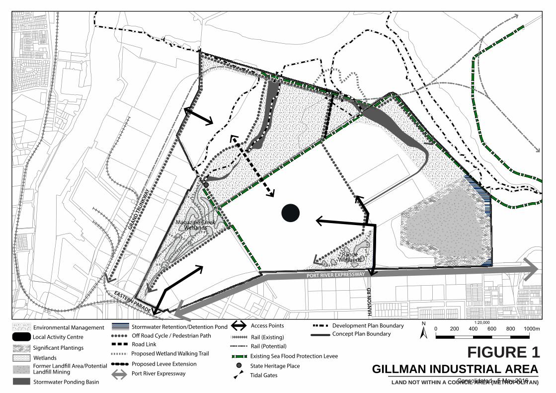
PORT RIVER EXPRESSWAY
GRAN
D T
RUN
KWAY
EASTERN PARADE
HA
NSO
N R
D
Concept Plan BoundaryEnvironmental Management
Local Activity Centre Off Road Cycle / Pedestrian Path
Proposed Wetland Walking Trail
Access Points
Rail (Potential)
Former Landfill Area/Potential Landfill Mining
Significant Plantings
Stormwater Retention/Detention Pond
Wetlands
Rail (Existing)Road Link
Magazine CreekWetlands
RangeWetlands
Stormwater Ponding Basin
Proposed Levee Extension
Tidal Gates
State Heritage Place
Development Plan Boundary
Existing Sea Flood Protection Levee
LAND NOT WITHIN A COUNCIL AREA (METROPOLITAN)
GILLMAN INDUSTRIAL AREAFIGURE 1
0 200 400 600 800 1000m±1:20,000
Port River ExpresswayConsolidated - 5 May 2016
57 Land Not Within a Council Area (Metropolitan)
vegetation native to the area. These areas may be considered as of potential environmental value and as they establish, provide improved wetland habitats and areas of open space, supporting the wider environmental significance of the region
The zone contains low-lying areas abutting and near to the coast that during extreme storm events are susceptible to inundation by stormwater or sea water and, in some instances, a combination of both. Existing seawater flood protection measures within the zone and within adjacent zones provide a degree of inundation protection to low-lying areas within the zone. These however require upgrading to provide an appropriate degree of inundation protection taking into account predicted sea level rise and land subsidence.
By virtue of the fact that the zone contains low-lying areas adjacent the coast, the potential for acid sulfate soils to be encountered exists. It is important that the disturbance of acid sulfate soils is avoided as disturbance can have harmful consequences for the marine and estuarine environment and can also cause damage to infrastructure and building foundations. Conditions likely to arise from the presence of coastal acid sulfate soils make it necessary for appropriate management and monitoring.
It is expected that development will recognise the existing land constraints and important functions by improving and enhancing their environmental qualities, as well as providing opportunities to integrate passive recreation through wetlands and fitness trails where possible.
It is important that the future division of land in the policy area is coordinated to provide for key vehicular and pedestrian / bicycle linkages and incorporate appropriately designed, located and timed infrastructure taking into account the regional stormwater catchment function of this location, the tidal flows function sought within the policy area, the implications of sea level rise on the extent of inundation, as well as the presence of acid sulphate soils and its potential impact on infrastructure.
Where development is located in proximity to the two buried high pressure gas transmission pipelines within the zone or in the adjacent Port Adelaide Enfield Council area, appropriate setbacks and design principles should be adopted to ensure that it complies with AS2885 (Pipeline Gas and Liquid Petroleum) so that minimum pipeline safety standards are achieved to safeguard the public and security of supply to users.
PRINCIPLES OF DEVELOPMENT CONTROL
Land Use
1 The following forms of development are envisaged in the zone:
▪ coastal protection works ▪ educational establishment in association with an envisaged use ▪ electricity substation ▪ filling of land and associated stockpiling suitable for land reclamation ▪ industry ▪ office ▪ prescribed mains ▪ road transport terminal ▪ service trade premises ▪ store ▪ stormwater detention/retention basin ▪ training facility ▪ warehouse.
2 Offices not ancillary to and associated with an envisaged use should only be established within the local activity centre identified in Figure 1 – Gillman Industrial Area.
3 Development listed as non-complying is generally inappropriate.
Consolidated - 5 May 2016
58 Land Not Within a Council Area (Metropolitan)
Form and Character
4 Development should not be undertaken unless it is consistent with the desired character for the zone.
5 Development should occur in accordance with Figure 1 – Gillman Industrial Area.
6 In areas where a uniform street setback pattern has not been established, buildings should be set back in accordance with the following criteria (subject to adequate provision of car parking spaces and landscaping between buildings and the road):
(a) buildings up to a height of 6 metres should be sited at least 8 metres from the primary street alignment;
(b) buildings exceeding a height of 6 metres should be sited at least 10 metres from the primary street alignment;
(c) where an allotment has two street frontages, no building should be erected within 3 metres of the secondary street alignment.
7 Those areas identified for environmental management in Figure 1 – Gillman Industrial Area should be established as areas for stormwater management and habitat rehabilitation. These areas should not be developed for industrial purposes unless it can be demonstrated that:
(a) there is sufficient land capable of managing the regional and local stormwater catchment function in this location;
(b) the land is not likely to be inundated by tidal flows as a result of the periodic opening of the tidal gates, taking into account long term sea level rise;
(c) it does not result in the removal of existing remnant samphire habitats or threaten the ability for expansion and inland migration of such habitats;
(d) the provision of a new or the expansion of an existing sea flood protection levee or sea wall infrastructure can be accommodated into the future.
8 Development should minimise adverse disturbance to the existing sea flood protection levee shown in Figure 1 – Gillman Industrial Area and should be designed and sited to ensure sufficient land is set aside to accommodate flood mitigation measures, including the creation of sea walls or sea flood protection levees, that will provide protection from stormwater and sea water flooding in a consistent and integrated manner.
9 Development should only occur where one of the following applies:
(a) the minimum site and floor levels are at least 3.7 metres AHD and 3.95 metres AHD respectively, to provide protection from coastal flooding to the year 2050 and it allows for the practical establishment of protection measures against a further sea level rise of 0.7 metres and land subsidence to the year 2100;
(b) a sea flood protection levee or sea wall has been constructed, which will provide the development with protection from coastal flooding to the year 2050, has a height of at least 3.7 metres AHD and is capable of being adapted to accommodate for a further sea level rise of 0.7 metres and land subsidence to the year 2100.
10 Development within 400 metres of the Epic Energy gas pipeline and 640 metres of the SEAGas transmission pipeline should include a detailed risk and safety assessment to ensure it complies with AS2885 (Pipeline Gas and Liquid Petroleum).
11 Development should provide adequate off-street car parking in accordance with the following table (whichever of the following two options produces the greater number of car parking spaces):
Consolidated - 5 May 2016
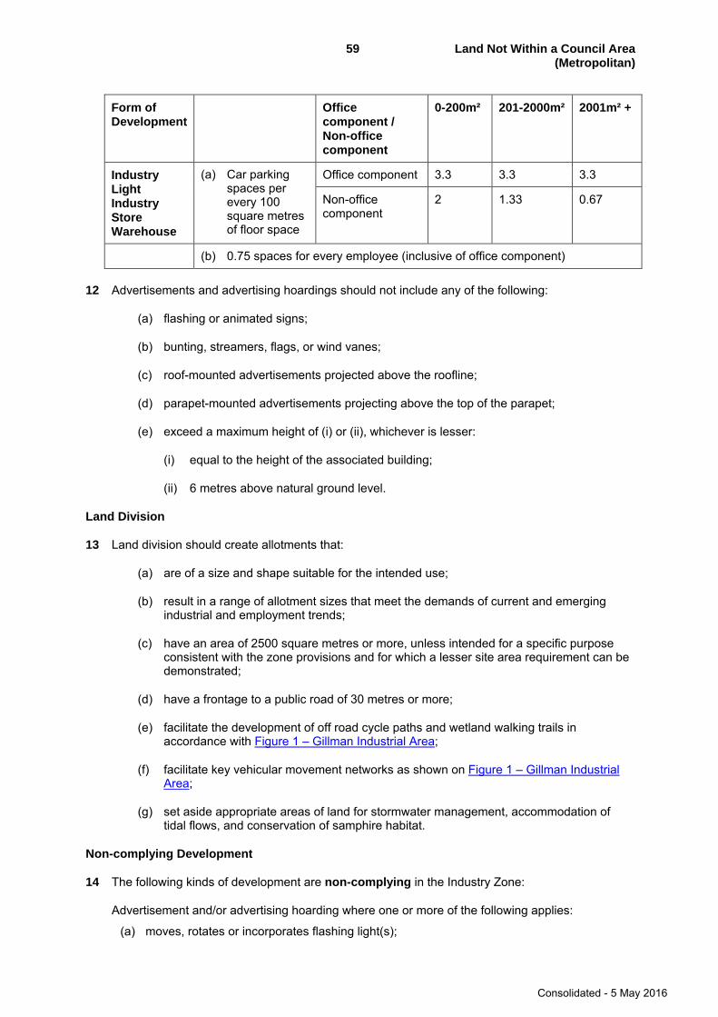
59 Land Not Within a Council Area (Metropolitan)
Form of Development
Office component / Non-office component
0-200m² 201-2000m² 2001m² +
Industry Light Industry Store Warehouse
(a) Car parking spaces per every 100 square metres of floor space
Office component 3.3 3.3 3.3
Non-office component
2 1.33 0.67
(b) 0.75 spaces for every employee (inclusive of office component)
12 Advertisements and advertising hoardings should not include any of the following:
(a) flashing or animated signs;
(b) bunting, streamers, flags, or wind vanes;
(c) roof-mounted advertisements projected above the roofline;
(d) parapet-mounted advertisements projecting above the top of the parapet;
(e) exceed a maximum height of (i) or (ii), whichever is lesser:
(i) equal to the height of the associated building;
(ii) 6 metres above natural ground level.
Land Division
13 Land division should create allotments that:
(a) are of a size and shape suitable for the intended use;
(b) result in a range of allotment sizes that meet the demands of current and emerging industrial and employment trends;
(c) have an area of 2500 square metres or more, unless intended for a specific purpose consistent with the zone provisions and for which a lesser site area requirement can be demonstrated;
(d) have a frontage to a public road of 30 metres or more;
(e) facilitate the development of off road cycle paths and wetland walking trails in accordance with Figure 1 – Gillman Industrial Area;
(f) facilitate key vehicular movement networks as shown on Figure 1 – Gillman Industrial Area;
(g) set aside appropriate areas of land for stormwater management, accommodation of tidal flows, and conservation of samphire habitat.
Non-complying Development
14 The following kinds of development are non-complying in the Industry Zone:
Advertisement and/or advertising hoarding where one or more of the following applies:
(a) moves, rotates or incorporates flashing light(s);
Consolidated - 5 May 2016
60 Land Not Within a Council Area (Metropolitan)
(b) projects above the roof line when roof mounted;
(c) when attached to a building, has any part projecting above the walls, fascia or parapet;
(d) displays third party content relating to services, messages or products that are not directly related to the primary activity on the site on which the advertisement is being displayed;
(e) has a height greater than 12 metres above natural ground level.
Amusement machine centre Caravan park Cemetery Community centre
Dwelling, except where it is:
(a) ancillary to and in association with industrial development;
(b) located on the same allotment.
Educational establishment, except where it is:
(a) ancillary to and in association with industrial development;
(b) located on the same allotment.
Entertainment venue Hall Horticulture Hospital Hotel Intensive animal keeping Landfill that constitutes solid waste disposal required to be licensed as a waste depot under the
Environment Protection Act 1993 Motel Nursing home Office, except where it is ancillary to and in association with industrial development located on
the same site Pre-school Place of worship Prescribed mining operations Racecourse Residential flat building Shop or group of shops, except where the gross leasable area is 250 square metres or less Showground Stadium Stock slaughter works Supported accommodation Telecommunications facility where located within 100 metres of any State Heritage Place listed
within the South Australian Heritage Register established under the Heritage Places Act 1993 Tourist accommodation Wrecking Yard
Public Notification
15 The following kinds of development are assigned to Category 1 in the Industry Zone:
Filling of land Land division
16 All kinds of development are assigned to Category 2 in the Industry Zone, except those designated as non-complying or Category 1 in the Industry Zone, or assigned to Category 1 in Schedule 9 of the Development Regulations 2008.
Consolidated - 5 May 2016
61 Land Not Within a Council Area (Metropolitan)
INDUSTRY (PORT) ZONE
Introduction
The objectives, proposals and principles of development control that follow apply in the Industry (Port) Zone shown on Map LNWCA(MA)/2. They are additional to those expressed for the whole of the area.
OBJECTIVES
Form of Development
Objective 1: A zone comprising land for the long-term growth of the port and accommodating activities dependent on a port-side location.
Objective 2: The selective use of land in a manner commensurate with the strategic and economic State significance of the zone for the handling of export and import commodities.
Objective 3: Land with direct water frontage being developed to accommodate only those activities which rely upon that water frontage.
The waterfront land encompassing Outer Harbor, the northern portion of the Lefevre Peninsula and the northern portion of the Port River north of Inner Harbor East is to accommodate immediate and long-term port activities. It is important that development within the zone, and particularly on that land with direct water frontage, should not adversely affect the ongoing strategic and economic function and role of the port as the States major import/export/transshipment facility. Accordingly, port related activities which do not require a direct water frontage should be sited in the inland portions of the zone.
PRINCIPLES OF DEVELOPMENT CONTROL
1 Development undertaken in the Industry (Port) Zone should be, primarily, activities dependent on a port-side location.
2 Only those activities which require direct frontage to the water should be located on the water fronting portions of the zone. These activities are limited to those functions of the port involving waterborne vessels and/or the movement of products or items from the water to the land and vice versa and may include: gantry and loading structures; wharf facilities and berthing operations; harbour installations and navigational aids.
3 Port activities which require location immediately adjacent the activities detailed in principle 2 include:
Transhipment facilities Customs operations Intermodal cargo transfer facilities Container terminals Bunker facilities Cargo handling facilities Storage areas used for the temporary holding of port cargo Ship repair facilities Offices associated with port activities where the office is ancillary to the port activity
4 Port related activities which should be sited inland include those activities which are engaged in the transporting, processing, making, storing or handling of products or items to be, or which have been, transported by ship.
5 Development adjoining the waterfront should incorporate, where possible, formal landscape plantings such as lawns and large trees to screen unsightly storage areas otherwise open to public view and enhance the appearance of the development and the waterfront and provide an amenity for employees on the site.
Consolidated - 5 May 2016
62 Land Not Within a Council Area (Metropolitan)
6 Buildings and structures should be constructed of good quality materials and maintained in good repair and condition.
7 Outdoor storage and/or work areas should be screened from public view.
8 Development should not pollute the water of Port Adelaide River.
9 Special industry should be located, designed and developed such that the industry present no danger to adjoining industry or any detrimental impact on nearby residential development or public open space.
10 The extent of port related activities and other industrial activities should not jeopardise the attainment of the objectives of the zone.
11 The following kinds of development are complying in the Industry (Port) Zone:
Berthing operation Coastguard station Fire station Gantry and loading structures Harbour installation Navigational aid Telecommunication towers, masts and monopoles (where the proposed development is located
greater than 30 metres from a residential zone) Telecommunications antennae Wharf facilities
12 The following kinds of development are non-complying in the Industry (Port) Zone:
Abattoir Agriculture Amusement machine centre Amusement park Auction room Billiard saloon Boarding house Bowling alley Builder’s yard Bus depot Caravan park Cemetery Concert hall Consulting room Crematorium Dance hall Detached dwelling Dog track Drive-in theatre Exhibition hall Fun fair Golf driving range Junk yard Landfill that constitutes waste disposal requirement to be licensed as a waste depot under the
environment protection act 1993 Motel Motor race track Motor showroom Multiple dwelling Prescribed mining operations Primary school Private hotel
Consolidated - 5 May 2016
63 Land Not Within a Council Area (Metropolitan)
Racecourse Residential club Group dwelling Intensive animal keeping Residential flat building Row dwelling Semi-detached dwelling Shop or group or shops with a gross leasable area of greater than 250 square metres Show ground Skating rink Stadium Stock salesyard Telecommunication towers, masts and monopoles located within (or within 100 metres of) a
heritage conservation or state heritage policy area, or within 100 metres of a state or local heritage listed item
Theatre Used car lot Welfare institution
Public Notification Categories
13 The following kinds of development are assigned to Category 1 in the Industry (Port) Zone:
Bunker facility Cargo handling facilities Container terminals Customs operations Harbor installations Intermodal cargo transfer facilities Navigational aids Offices associated with port activities where the office is ancillary to the port activity Ship repair facility Storage area used for the temporary holding of port cargo Telecommunication towers, masts and monopoles (where the proposed development is located
greater than 30 metres from a residential zone) Telecommunications antennae Transhipment facilities
14 All kinds of development, except those designated as Category 1 or non-complying, are assigned to Category 2 in the Industry (Port) Zone.
Consolidated - 5 May 2016
64 Land Not Within a Council Area (Metropolitan)
MFP ZONE
Introduction
The objectives, proposals and principles of development control that follow apply to the MFP Zone shown on Map LNWCA(MA)/1. They are additional to those expressed for the whole of the council area.
OBJECTIVES
Objective 1: The environmental enhancement of the MFP Zone by the decontamination and improvement of the ground, rubbish removal and tree planting, and the protection and improvement of the marine and estuarine environments adjoining the zone and rehabilitation of certain parts of the zone.
PRINCIPLES OF DEVELOPMENT CONTROL
Environment
1 Development should be innovative and environmentally sensitive.
2 Development should incorporate energy and water conservation approaches.
3 Development should positively contribute to the rehabilitation and improvement of the adjoining marine and estuarine environment and provide for mangrove retreat areas which may become necessary as a result of rising sea levels or natural processes and landscape buffer areas.
4 Earthworks, building construction and the operation of plant and equipment should not detrimentally affect adjoining areas by way of noise, air pollution or industrial hazards and should be undertaken so as to have minimal detrimental impact on the adjoining estuaries area.
Land Use and Development Requirements
5 Land intended for development, other than for open space recreation or public infrastructure, should be raised to at least 2.4 metres Australian Height Datum.
6 Development of, adjacent to, or in close proximity to a building or item of Aboriginal or European heritage significance should respect the historical character and integrity of the area or time and reflect the significance of the item within the locality.
7 The alteration, extension or intensification of existing uses should not occur unless in a manner that is consistent with the future land use of the zone and the protection of the adjoining estuarine environments, residential and industrial areas.
8 Development on Garden Island should be primarily for recreation and open space with the upgrading of existing recreational boating clubs, tourist, education and research uses. Land within Section 464, Hundred Plan 105800 (CR 5301/261) or Allotment Pieces 104 and 204 of Deposit Plan 55733 (CT 5811/474), may be suitable for a landfill.
9 Buildings on Garden Island should be of one- or two-storeys in height and designed with regard to the natural character and features of the area.
10 No development is complying either absolutely or conditionally in the MFP Zone.
Non-complying Development
11 The following kind of development is non-complying:
Landfill that constitutes solid waste disposal required to be licensed as a waste depot under the Environment Protection Act 1993, except on land within Sections 463 and 464, Hundred of Port Adelaide.
Consolidated - 5 May 2016
65 Land Not Within a Council Area (Metropolitan)
MOSS (CONSERVATION) ZONE
Introduction
The objectives, proposals and principles of development control that follow apply to the area referred to as the MOSS (Conservation) Zone shown on Map LNWCA(MA)/1. They are additional to those expressed for the whole of the councils area or in the out of councils area.
OBJECTIVES
Objective 1: The conservation, rehabilitation and improvement of the natural features of land, fauna, flora and the marine and estuarine environment as part of the Metropolitan Open Space System.
Objective 2: The development in appropriate locations of open space recreational, tourist, education and research activities which do not detrimentally impact on the natural features of the area or the estuarine and marine environment.
Objective 3: The continued provision of essential infrastructure to the power station and quarantine station on Torrens Island including road access, transmission lines and gas feed lines, but in a manner that will, in the long term, contribute to the conservation, rehabilitation and improvement of the zone.
Objective 4: The retention of historic and archaeological items and sites.
Objective 5: The maintenance of safe and convenient vehicular, pedestrian and boating movement in appropriate locations.
Objective 6: The provision of an open space system which links with the adjoining local and regional open space networks for the movement of animals and birds.
PRINCIPLES OF DEVELOPMENT CONTROL
1 The MOSS (Conservation) Zone is for conservation of the natural environment with recreational, tourist and education and research activities, developed in appropriate areas and managed in accordance with the management plan for the area.
2 Development should not detrimentally affect the marine and estuarine biota and ecosystems and should contribute to the zone's rehabilitation and improvement.
3 Development should make provision for the safe and efficient re-use or disposal of all wastes and stormwater received into or generated by the development.
4 Public access into mangrove and wetland areas should be restricted to nominated locations and be provided and managed in accordance with the management plan for the zone.
5 Land should not be divided except for the purpose of boundary redefinition to assist in the zone's management.
6 No development is complying either absolutely or conditionally in the MOSS (Conservation) Zone but the following forms of development are considered appropriate in the zone:
(a) the supply of power sources and transmission of power through the zone along existing easements;
(b) the provision and maintenance of an access road to the Quarantine Station;
(c) the provision of channel markers and other boating safety devices in the Port Adelaide River, Barker Inlet and Angas Inlet;
Consolidated - 5 May 2016
66 Land Not Within a Council Area (Metropolitan)
(d) recreation, recreation club, boat mooring, marina facilities and cooling water discharge from the Torrens Island Power Station in the Angas Inlet adjacent to Garden Island;
(e) the provision and maintenance of boardwalks and shelters, levees and other flood control structures at Mutton Cove, North Arm, North Arm Creek and Dry Creek; and
(f) the establishment of a buffer strip and landscaped swale for stormwater along the northern edge of Mutton Cove.
7 The following kinds of development are non-complying in the MOSS (Conservation) Zone:
Dwellings Exhibition Hall General Industry Gymnasium Hospital Intensive Animal Keeping Junk Yard Landfill that constitutes solid waste disposal required to be licensed as a waste depot under the
Environment Protection Act 1993 Motel Motor Repair Station Nursing Home Office Office and Dwelling Petrol Filling Station Permanent Sewage Treatment Plant Post Office Private Hotel Public Service Depot Radio or TV Studio Refuse Destructor Residential Club Road Transport Terminal Row Dwelling Service Industry Shops Skating Rink Special Industry Squash Court Stadium Stock Salesyard Theatre Timber Yard Transmitting Station Used Car Lot Warehouse Welfare Institution
Consolidated - 5 May 2016
67 Land Not Within a Council Area (Metropolitan)
PUBLIC PURPOSE (POWER STATION) ZONE
Introduction
The objectives, proposal and principles of development control that follow apply to the Public Purpose (Power Station) Zone shown on Map LNWCA(MA)/1. They are additional to, and more particular than, those expressed for the land not within the area of a council.
OBJECTIVES
Objective 1: A zone for the continued operation maintenance and essential development of the Torrens Island Power Station consistent with sound management and protection of the natural environment.
Objective 2: A zone for associated development relating to the production and utilization of energy, the utilization of waste products and education and research activities.
Objective 3: Accommodation of wind farms and ancillary development.
Wind farms and ancillary development such as substations, maintenance sheds, access roads and connecting power-lines (including to the National Electricity Grid) are envisaged within the zone and constitute a component of the zone's desired character. These facilities will need to be located in areas where they can take advantage of the natural resource upon which they rely and, as a consequence, components (particularly turbines) may need to be:
(a) located in visually prominent locations such as ridgelines;
(b) visible from scenic routes and valuable scenic and environmental areas;
(c) located closer to roads than envisaged by generic setback policy.
This, coupled with the large scale of these facilities (in terms of both height and spread of components), renders it difficult to mitigate the visual impacts of wind farms to the degree expected of other types of development. Subject to implementation of management techniques set out by general/ council wide policy regarding renewable energy facilities, these visual impacts are to be accepted in pursuit of benefits derived from increased generation of renewable energy.
Objective 4: The landscape rehabilitation of the sand mine and land fill areas north of the power station.
PROPOSAL
The Electricity Trust of SA proposes to continue the landscape rehabilitation of the sand mine and land fill areas north of the power station in a manner that contributes to the natural environment and the adjoining conservation areas.
PRINCIPLES OF DEVELOPMENT CONTROL
1 Development in the Public Purpose (Power Station) Zone should be for the generation and transmission of power, maintenance and storage activities and associated activities involved in the production and utilization of energy, the utilization of waste products (namely cooling water), education and research.
2 Development involving the production of energy should be consolidated around the existing power station in the southern portion of the zone.
3 Wind farms and ancillary development should be located in areas which provide opportunity for harvesting of wind and efficient generation of electricity and may therefore be sited:
(a) in visually prominent locations;
Consolidated - 5 May 2016
68 Land Not Within a Council Area (Metropolitan)
(b) closer to roads than envisaged by generic setback policy.
4 The northern portion of the zone should be rehabilitated and provided primarily as a landscape buffer area between the power station and the adjoining MOSS (Conservation) Zone.
5 Development in location, built-form and operation should be designed to reduce the impacts on the natural environment and the discharge of pollutants.
6 No development is complying either absolutely or conditionally in the Public Purpose (Power Station) Zone.
7 The following kinds of development are non-complying in the Public Purpose (Power Station) Zone:
Abattoir Agistment and Holding of Stock Amusement Park Boarding House Bowling Alley Caravan Park Concert Hall Dance Hall Detached Dwelling Drive-in Theatre Fun Fair Group Dwelling Hospital Intensive Animal Keeping Junk Yard Landfill that constitutes solid waste disposal required to be licensed as a waste depot under the
Environment Protection Act 1993 Multiple Dwelling Pre-school Primary School Retail Showroom Residential Flat Building Row Dwelling Semi-detached Dwelling Shop or group of shops Stadium Stock Saleyards
8 The following kinds of development are assigned to Category 2 in the Public Purpose (Power Station) Zone:
Wind farms and ancillary development such as substations, maintenance sheds, access roads and connecting power-lines (including to the National Electricity Grid) where the base of all wind turbines is located at least 2000 metres from:
(a) an existing dwelling or tourist accommodation that is not associated with the wind farm;
(b) a proposed dwelling or tourist accommodation for which an operable development plan consent exists;
(c) the boundaries of any Airfield, Airport, Centre, Community, Fringe, Historic Conservation, Home Industry, Living, Mixed Use, Residential, Settlement, Tourist, Township or Urban Zone, Policy Area or Precinct or any Heritage Area (including within the area of an adjoining Development Plan)
Wind monitoring mast and ancillary development
Consolidated - 5 May 2016
69 Land Not Within a Council Area (Metropolitan)
PUBLIC PURPOSE (QUARANTINE STATION) ZONE
Introduction
The objectives, proposal and principles of development control that follow apply to the Public Purpose (Quarantine Station) Zone shown on Map LNWCA(MA)/1. They are additional to, and more particular than, those expressed for the land not within the area of a council.
OBJECTIVES
Objective 1: A zone for the continued operation and essential development of the Quarantine Station.
Objective 2: A zone for education, research and tourist development consistent with sound management and protection of the natural environment.
Objective 3: The protection and conservation of heritage items.
PROPOSAL
The State Government proposes to carry out a heritage study of the Quarantine Station and, in consultation with the Commonwealth Government, implement measures for the protection and conservation of heritage items and natural environment.
PRINCIPLES OF DEVELOPMENT CONTROL
1 Development in the Public Purpose (Quarantine Station) Zone should be for the quarantine of animals, flora and other fauna, and associated breeding and research programmes.
2 Development in the form of education, research and tourist facilities should be encouraged in the medium to longer term.
3 Development should be consistent with sound management and protection of the natural environment and the heritage of the zone.
4 Development should not exceed two-storeys in height.
5 Development should provide buffers and limit access to the adjoining MOSS (Conservation) Zone.
6 No development is complying either absolutely or conditionally in the Public Purpose (Quarantine Station) Zone.
7 The following forms of development are non-complying in the Public Purpose (Quarantine Station) Zone:
Abattoir Amusement Park Boarding House Bowling Alley Caravan Park Concert Hall Dance Hall Drive-in Theatre Fun Fair Junk Yard Landfill that constitutes solid waste disposal required to be licensed as a waste depot under the Environment Protection Act 1993 Refuse Destructor Retail Showroom
Consolidated - 5 May 2016

70 Land Not Within a Council Area (Metropolitan)
Shop or group of shops with leasable areas greater than 100 square metres Stadium Stock Saleyards Transport Depot Warehouse
Consolidated - 5 May 2016
71 Land Not Within a Council Area (Metropolitan)
GLENELG (FORESHORE/PATAWALONGA) ZONE
Introduction
The objectives, proposals and principles of development control that follow apply to the area referred to as the Glenelg Foreshore and Patawalonga Zone shown on Map LNWCA(MA)/3. They are additional to those expressed for the whole of the councils area or in the out of councils area.
OBJECTIVES
Objective 1: A major tourist and recreational focus for Glenelg and the State including family entertainment facilities, amusements, a range of tourist accommodation facilities including a hotel and apartments, residential housing, marinas, ferry terminal and associated facilities, public plazas, and complementary retail and food outlets.
Objective 2: A range of tourism and accommodation facilities and activities associated with the Glenelg foreshore and environs.
Objective 3: Development that is integrated in function and complements the character of adjacent zones.
Objective 4: Retention of Colley and Wigley Reserves as focal public open space areas, maintained and landscaped for general public recreation.
Objective 5: Retention of Colley and Wigley Reserves and Patawalonga Recreation and Boat Haven Reserve as the focus of recreational activities.
Objective 6: Development of the Patawalonga Recreation and Boat Haven Reserve as an area for mooring, incorporating marinas, and use of boats with limited areas for the servicing and repairing of boats.
Objective 7: Conservation and improvement of the landscape features of the Patawalonga and the coast.
Objective 8: Development that contributes to the desired character of the zone.
Objective 9: Maintain the Patawalonga Recreation and Boat Haven Reserve as an area for mooring (incorporating marinas) and use of boats with limited areas for servicing and repairing of boats.
DESIRED CHARACTER
This zone covers an area along the Glenelg foreshore extending from Moseley Square in the south to the Michael Herbert (Wardlipulthu Waadlakatha) Bridge over the Patawalonga in the north and east to Colley Terrace and Adelphi Terrace. The zone has three main functions which are separated spatially including passive recreational uses, high density residential development, and visitor retail and entertainment uses.
The zone is a major seaside tourist and recreational focus for the City of Holdfast Bay and the State. It contains a variety of land uses including recreational, residential, a variety of tourist accommodation, retail, commercial, family entertainment, community, boating, marina and limited service industrial marine related land uses.
The zone contains the recreational focal point of Glenelg outside Moseley Square, being the Glenelg beach (between the Glenelg Jetty and breakwater) the entertainment facilities adjacent to the beach and Colley Reserve at the Holdfast Shores development, and associated entertainment venues and kiosks. The zone also contains community facilities such as the surf lifesaving club, the Glenelg Community Centre and public car parking underground and integrated with the Marina Pier complex.
Consolidated - 5 May 2016
72 Land Not Within a Council Area (Metropolitan)
New development should also have regard to the Glenelg Foreshore and Patawalonga Zone provisions as detailed in the Holdfast Bay Council Development Plan and shown on Map LNWCA(MA)/3.
Colley and Wigley Reserves are important open space areas within the zone and buildings and structures will enhance the appearance of these reserves (and the Patawalonga) and encourage their use for recreation.
Buildings and structures will be of a high standard of building material, considering the coastal environment and full lifecycle costs for maintenance and replacement, and designed with regard to external appearance, colours, siting and landscaping.
Development will integrate with adjacent public spaces to produce high quality public environments conducive to public activity, including walking and cycling, and having particular regard to personal safety, sunlight access and visual interest.
Retail, restaurant and entertainment uses will be integrated at ground level with public open spaces and pedestrian routes. Public amenities will be incorporated into the design of commercial and community development.
Public spaces will provide visual and tactile interest, the ability to sit or to participate, a sense of vitality and elements of public art.
A network of linked public pathways will provide public pedestrian and bicycle accessibility to and along the coast, reserves, and to key recreation and other facilities, and will be of a practical and usable width and level.
PRINCIPLES OF DEVELOPMENT CONTROL
Land Use
1 The following forms of development are envisaged in the zone:
- family entertainment facilities and amusements - ferry terminal and associated facilities - marina - public plaza - residential development - retail and food outlets on the southern side of the Patawalonga Basin - tourist accommodation, such as hotel and apartment.
2 Residential development should incorporate a range of dwelling sizes and types for permanent, temporary and tourist accommodation.
3 Stand-alone car parking buildings should not be developed within the zone.
Form and Character
4 Development should not be undertaken unless it is consistent with the desired character for the zone.
5 Buildings north of the Patawalonga Basin should not exceed three storeys in height above existing natural ground level.
6 Buildings south of the Patawalonga Basin should not contain more than six storeys above undercroft car parking and should not exceed a maximum building height of 28.5 metres above the finished plaza level.
7 The average minimum site area per dwelling should measure 80 square metres.
Consolidated - 5 May 2016
73 Land Not Within a Council Area (Metropolitan)
8 Development should not restrict public access to or along the beach, or reserve area frontages.
9 Basement or undercroft car parking areas and multi-level car parking areas should only occur where contained within commercial/apartment buildings.
10 All facilities associated with the supply and maintenance of public utilities should be underground or otherwise screened from view.
11 Shopping, commercial, entertainment, marine related and transport uses should have a floor space commensurate with catering for the reasonable needs of tourists, visitors, the boating community, and residents within the zone, and should complement the services and facilities along Jetty Road and Anzac Highway.
12 Retail, restaurant and entertainment uses should be integrated at ground level with public open spaces and pedestrian routes, and may extend in to these areas.
13 Public and community facilities should be located to conveniently serve visitors and local resident needs, including the provision of recreational facilities, open space, pedestrian walkways and spaces, boat ramp, beach access, public conveniences, required clubs, navigational aids, emergency service facilities and associated car parking. Public toilets should be incorporated into the design of commercial development.
14 The appearance of land, buildings, fencing and other structures should be of contemporary design, but not excessively ornate, with empathy for the traditional design elements of the locality and a style complementary to the coastal/seaside environment.
15 Construction of breakwaters and any channel to sea should include adequate sand management provisions to minimise or avoid adverse impacts on adjacent coasts and beaches, and to maintain a navigable channel appropriate to the intended use.
Land Division
16 Land division should facilitate uses and activities envisaged in the zone and safe and convenient pedestrian access to and along the entire coast and the Patawalonga.
Public Notification Categories
17 For the purposes of public notification all kinds of development within the Glenelg Foreshore and Patawalonga Zone are assigned Category 2 other than development which falls within Schedule 9 Part 1 of the Development Regulations.
Consolidated - 5 May 2016
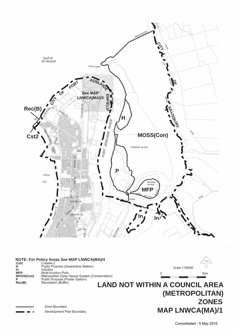
OLIVE
RROGERS RD
VICTORIA RD
VICT
ORIA
RD
LADY
GOW
RIE
DR
ST RAT HFIEL D TCE
GRAN
D TRU
NKWA
Y
CARNARVON AVE
ELDE
R R
D
GULFPO INTDR
JETTY RD
KATOOMBA TCE
MIDL
UNG A
TCE
NORTH ARM
PELIC
AN P
OINT
RD
RAILWAY
AVE
RAI
LWA Y
T CE
RAILW
AY
TCE
H
P
MFP
MOSS(Con)Cst2
Rec(B)
In
LARGS
BAY
TORRENS ISLAND
GARDENISLAND
Bridge
HIGHWAT ER
MA
RK
LOW
WATER
MAR
KPOINT GREY
Levee
Levee
levee
BREAKWATER
In
78
Gulf ofSt Vincent
POR
T A
DEL
AID
E R
IVER
See MAPLNWCA(MA)/3
OF
SALISBURY
OFPORT
ADELAIDE
CITY
CITY
ENFIELD
NOTE: For Policy Areas See MAP LNWCA(MA)/4 Cst2 H
MFP MOSS(Con) P Rec(B)
Coastal 2 Public Purpose (Quarantine Station)
In Industry Multi-function Polis Metropolitan Open Space System (Conservation) Public Purpose (Power Station) Recreation (Buffer)
Zone BoundaryDevelopment Plan Boundary
LAND NOT WITHIN A COUNCIL AREA (METROPOLITAN)
2km0
Scale 1:50000
ZONESMAP LNWCA(MA)/1
Consolidated - 5 May 2016
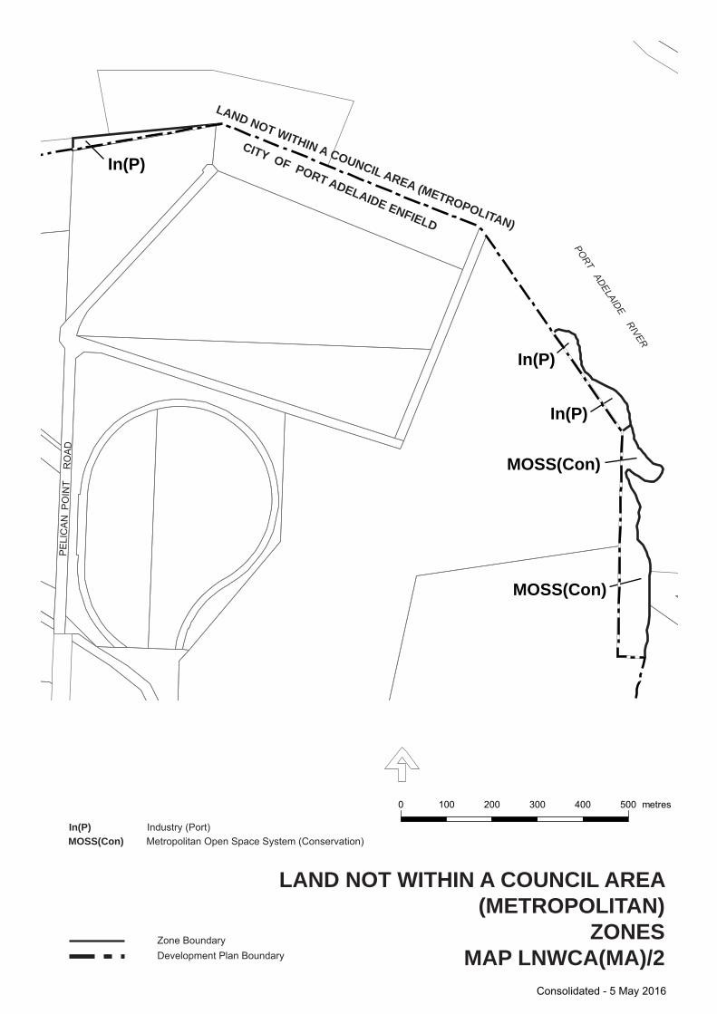
In(P)
In(P)
In(P)
MOSS(Con)
MOSS(Con)
0 100 200 300 400 500 metres
LAND NOT WITHIN A COUNCIL AREA(METROPOLITAN)
ZONESMAP LNWCA(MA)/2
In(P) MOSS(Con)
Industry (Port) Metropolitan Open Space System (Conservation)
Zone BoundaryDevelopment Plan Boundary
CITY OF PORT ADELAIDE ENFIELD
LAND NOT WITHIN A COUNCIL AREA (METROPOLITAN)
PORT ADELAIDE RIVERP
ELI
CA
N P
OIN
T
RO
AD
Consolidated - 5 May 2016
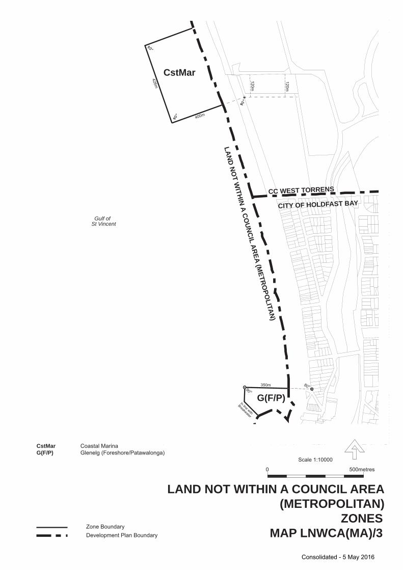
CstMar
G(F/P)
Gulf ofSt Vincent
CC WEST TORRENS
CITY OF HOLDFAST BAY
400m
426m
120m
120m
G(F/P) CstMar
Glenelg (Foreshore/Patawalonga) Coastal Marina
Zone BoundaryDevelopment Plan Boundary
LAND NOT WITHIN A COUNCIL AREA (METROPOLITAN)
500metres0
Scale 1:10000
ZONESMAP LNWCA(MA)/3
LAND NOT W
ITHIN A COUNCIL AREA (M
ETROPO
LITAN)
In line with
Breakwater
350m90 o
80 o
Consolidated - 5 May 2016
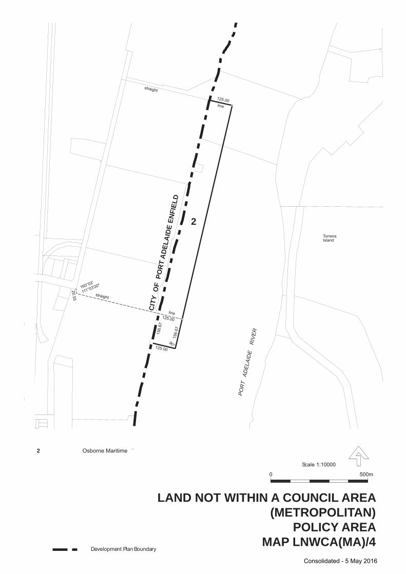
VE
ESTE
LLA
ST
Development Plan Boundary
500m0
Scale 1:10000
LAND NOT WITHIN A COUNCIL AREA(METROPOLITAN)
POLICY AREAMAP LNWCA(MA)/4
2
CIT
Y O
F P
OR
T A
DEL
AID
E EN
FIEL
D
POR
T A
DEL
AID
E
RIV
ER
TorrensIsland
2 Osborne Maritime
straight
line
160°03'
111°03'20"
20.55
125.00
125.00
straight
line
125.00
156.
67
156.
67
90°
Consolidated - 5 May 2016