Embed Size (px)
Citation preview

Land Navigation ILand Navigation I
04/20/23 3
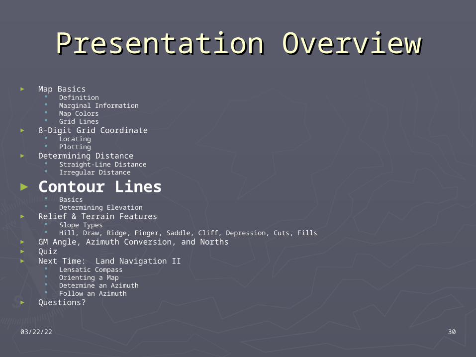
Presentation OverviewPresentation Overview► Map Basics
Definition Marginal Information Map Colors Grid Lines
► 8-Digit Grid Coordinate Locating Plotting
► Determining Distance Straight-Line Distance Irregular Distance
► Contour Lines Basics Determining Elevation
► Relief & Terrain Features Slope Types Hill, Draw, Ridge, Finger, Saddle, Cliff, Depression, Cuts, Fills
► GM Angle, Azimuth, and North► Quiz► Next Time: Land Navigation II
Lensatic Compass Orienting a Map Determine an Azimuth Follow an Azimuth
► Questions?
04/20/23 4
Presentation OverviewPresentation Overview
► Map Basics Definition Marginal Information Map Colors Grid Lines
► 8-Digit Grid Coordinate Locating Plotting
► Determining Distance Straight-Line Distance Irregular Distance
► Contour Lines Basics Determining Elevation
► Relief & Terrain Features Slope Types Hill, Draw, Ridge, Finger, Saddle, Cliff, Depression, Cuts, Fills
► GM Angle, Azimuth, and North► Questions?► Quiz► Next Time: Land Navigation II
Lensatic Compass Orienting a Map Determine an Azimuth Follow an Azimuth
04/20/23 5
Map BasicsMap Basics
►Definition: A map is a mathematically determined representation of the Earth’s surface systematically plotted to scale upon a plane surface.
04/20/23 6
Map Basics: Map Basics:
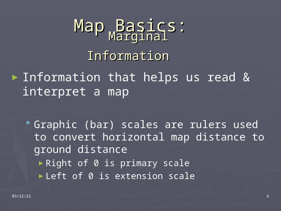
►Information that helps us read & interpret a map
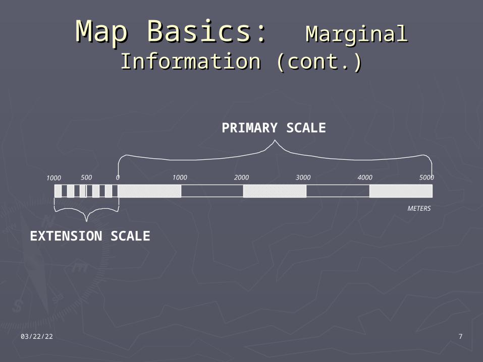
Graphic (bar) scales are rulers used to convert horizontal map distance to ground distance►Right of 0 is primary scale►Left of 0 is extension scale
Marginal Marginal
InformationInformation
04/20/23 7
Map Basics: Map Basics: Marginal Information Marginal Information (cont.)(cont.)
0 1000 2000 3000 4000 5000500
METERS
1000
PRIMARY SCALE
EXTENSION SCALE
04/20/23 8
Map Basics: Map Basics:
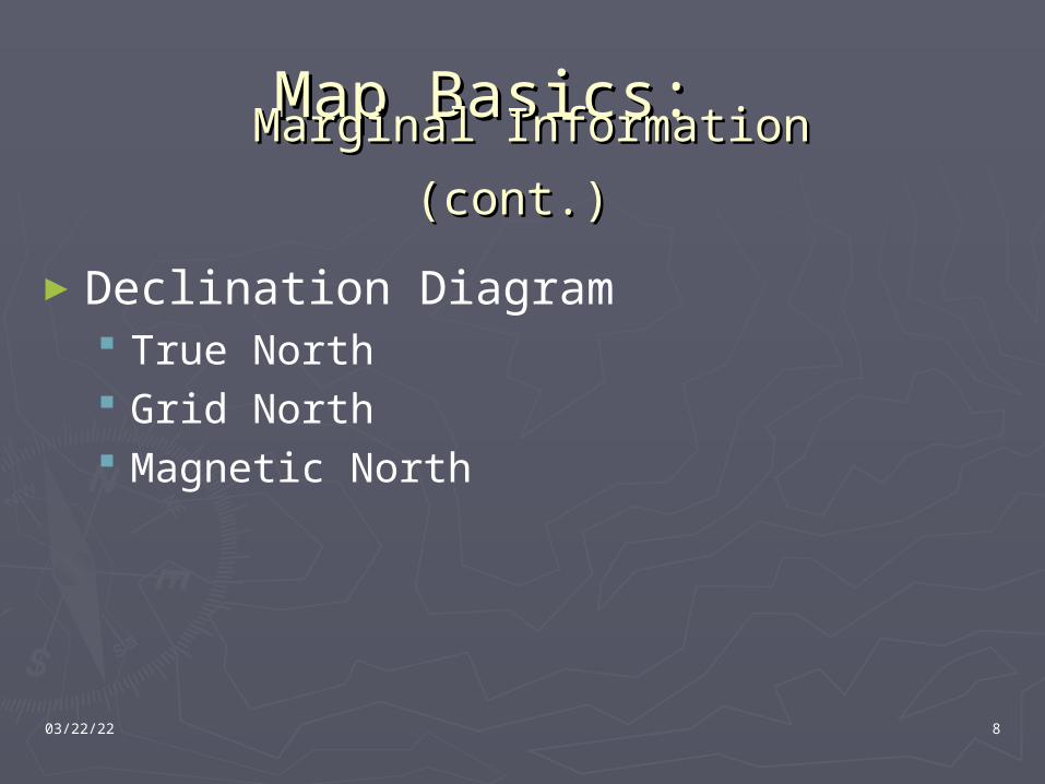
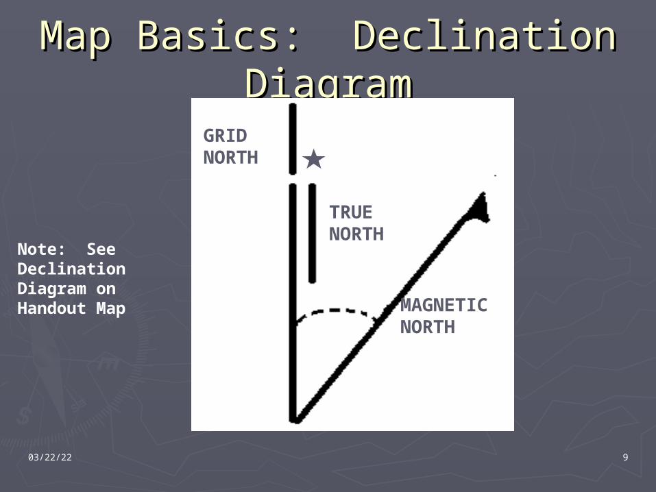
►Declination Diagram True North Grid North Magnetic North
Marginal Information (cont.)Marginal Information (cont.)
04/20/23 9
Map Basics: Declination Map Basics: Declination DiagramDiagram
MAGNETIC NORTH
TRUE NORTH
GRID NORTH
Note: See Declination Diagram on Handout Map
04/20/23 10
Map Basics: Map Basics:
►Legend Illustrates and identifies the topographic Illustrates and identifies the topographic
symbols used to depict prominent symbols used to depict prominent features on the map. Symbols on one features on the map. Symbols on one map may not mean the same things on map may not mean the same things on another mapanother map
Marginal Information (cont.)Marginal Information (cont.)
04/20/23 11
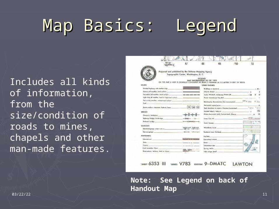
Map Basics: LegendMap Basics: Legend
Note: See Legend on back of Handout Map
Includes all kinds of information, from the size/condition of roads to mines, chapels and other man-made features.
04/20/23 12
Map Basics: Map Basics:
►Map Scales Representative Fraction is the scale of the map Representative Fraction is the scale of the map
which expresses the ratio of horizontal distance which expresses the ratio of horizontal distance on the map to the corresponding horizontal on the map to the corresponding horizontal distance on the ground:distance on the ground:►1:25,000 SCALE.1:25,000 SCALE.►1:50,000 SCALE1:50,000 SCALE►1:100,000 SCALE1:100,000 SCALE►1:250,000 SCALE1:250,000 SCALE
The smaller the number on the bottom, the The smaller the number on the bottom, the larger the scale of the maplarger the scale of the map
Marginal Information (cont.)Marginal Information (cont.)
04/20/23 13
Map Basics: Map Basics:
►Small scale mapsSmall scale maps - Maps that have a - Maps that have a scale of 1:1,000,000 and smaller. scale of 1:1,000,000 and smaller. These maps are used for general These maps are used for general planning and for strategically studies planning and for strategically studies at the higher echelons.at the higher echelons.
►The standardThe standard small scale map is small scale map is 1:1,000,0001:1,000,000
Map Scales (cont.)Map Scales (cont.)
04/20/23 14
Map Basics: Map Basics:
►Medium scale mapsMedium scale maps - Are maps of scales that - Are maps of scales that are larger than 1:1,000,000 but smaller than are larger than 1:1,000,000 but smaller than 1:75,000.1:75,000.
► These maps are used for planning operations, These maps are used for planning operations, including the movement and concentration of including the movement and concentration of marines and supplies.marines and supplies.
► The standard medium scale map is 1:250,000.The standard medium scale map is 1:250,000.
Map Scales (cont.)Map Scales (cont.)
04/20/23 15
Map Basics: Map Basics:
►Large scale mapsLarge scale maps - Are maps that are - Are maps that are 1:75,000 and larger.1:75,000 and larger.
►They are used to meet tactical, technical, They are used to meet tactical, technical, and administrative needs of the field and administrative needs of the field units.units.
►The standard Large scale map is 1:50,000.The standard Large scale map is 1:50,000.
Map Scales (cont.)Map Scales (cont.)
04/20/23 16
Map Basics: ColorsMap Basics: Colors
► Black: Man-made objectsBlack: Man-made objects Buildings, some roads, cultural, etc.Buildings, some roads, cultural, etc.
► Red: Main roadsRed: Main roads Also some special features Also some special features
► Blue: Water featuresBlue: Water features Lakes, rivers, ponds, ocean, etc.Lakes, rivers, ponds, ocean, etc.
►Green: VegetationGreen: Vegetation Forrest, orchard, etc.Forrest, orchard, etc.
► Brown: Relief featuresBrown: Relief features Contour lines.Contour lines.
04/20/23 17
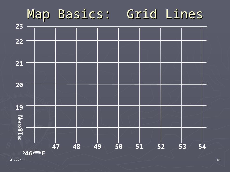
Map Basics: Grid LinesMap Basics: Grid Lines
► A series of straight lines intersecting at right A series of straight lines intersecting at right angles forming squaresangles forming squares
► Horizontal grid lines run grid west to grid eastHorizontal grid lines run grid west to grid east► Vertical grid lines run grid south to grid northVertical grid lines run grid south to grid north
► On most military maps a grid square is On most military maps a grid square is 1000X1000 meters1000X1000 meters
► Basic Rule: Read right on the vertical lines, Basic Rule: Read right on the vertical lines, then up on the horizontal grid linesthen up on the horizontal grid lines
04/20/23 18
Map Basics: Grid LinesMap Basics: Grid Lines
546000mE
38 1
8000
mN
19
20
22
21
23
47 48 49 50 51 52 53 54
04/20/23 19
Presentation OverviewPresentation Overview► Map Basics
Definition Marginal Information Map Colors Grid Lines
► 8-Digit Grid Coordinate Locating Plotting
► Determining Distance Straight-Line Distance Irregular Distance
► Contour Lines Basics Determining Elevation
► Relief & Terrain Features Slope Types Hill, Draw, Ridge, Finger, Saddle, Cliff, Depression, Cuts, Fills
► GM Angle, Azimuth Conversion, and Norths► Quiz► Next Time: Land Navigation II
Lensatic Compass Orienting a Map Determine an Azimuth Follow an Azimuth
► Questions?
04/20/23 20
8-Digit Grid Coordinate8-Digit Grid Coordinate
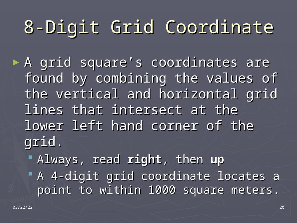
►A grid square’s coordinates are found A grid square’s coordinates are found by combining the values of the vertical by combining the values of the vertical and horizontal grid lines that intersect and horizontal grid lines that intersect at the lower left hand corner of the at the lower left hand corner of the grid.grid. Always, read Always, read rightright, then , then upup A 4-digit grid coordinate locates a point to A 4-digit grid coordinate locates a point to
within 1000 square meters.within 1000 square meters.
04/20/23 21
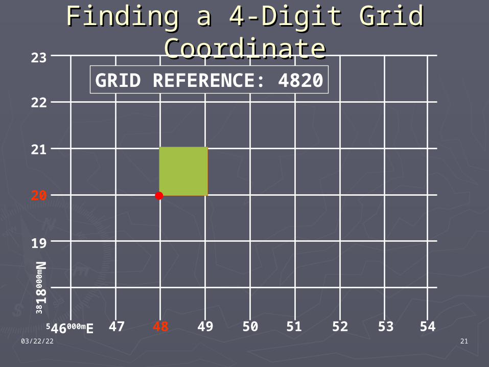
Finding a 4-Digit Grid Finding a 4-Digit Grid CoordinateCoordinate
546000mE
38 1
8000
mN
19
20
22
21
23
47 48 49 50 51 52 53 54
GRID REFERENCE: 4820
04/20/23 22
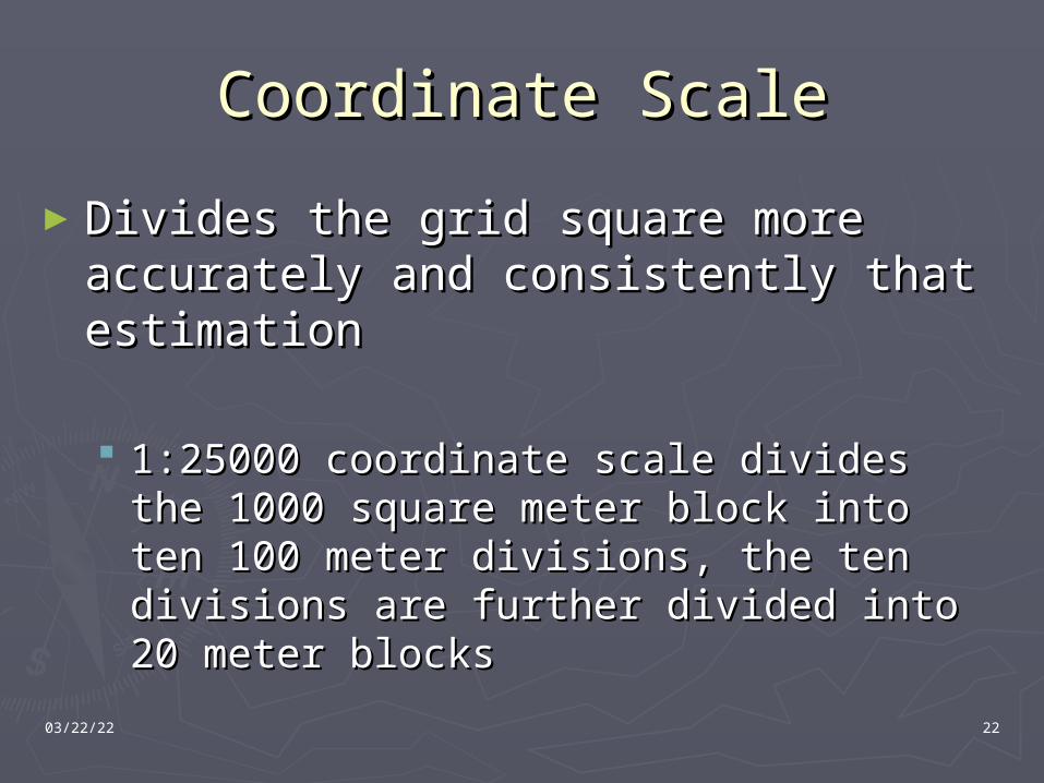
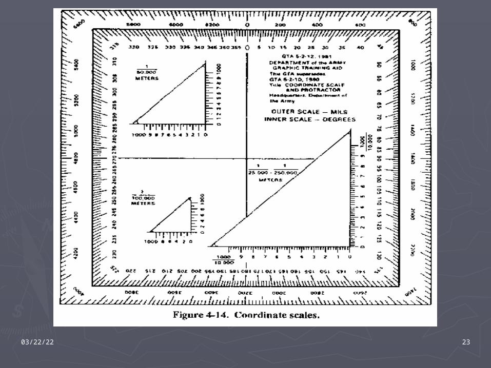
Coordinate ScaleCoordinate Scale
►Divides the grid square more Divides the grid square more accurately and consistently that accurately and consistently that estimationestimation
1:25000 coordinate scale divides the 1000 1:25000 coordinate scale divides the 1000 square meter block into ten 100 meter square meter block into ten 100 meter divisions, the ten divisions are further divisions, the ten divisions are further divided into 20 meter blocksdivided into 20 meter blocks
04/20/23 23
04/20/23 24
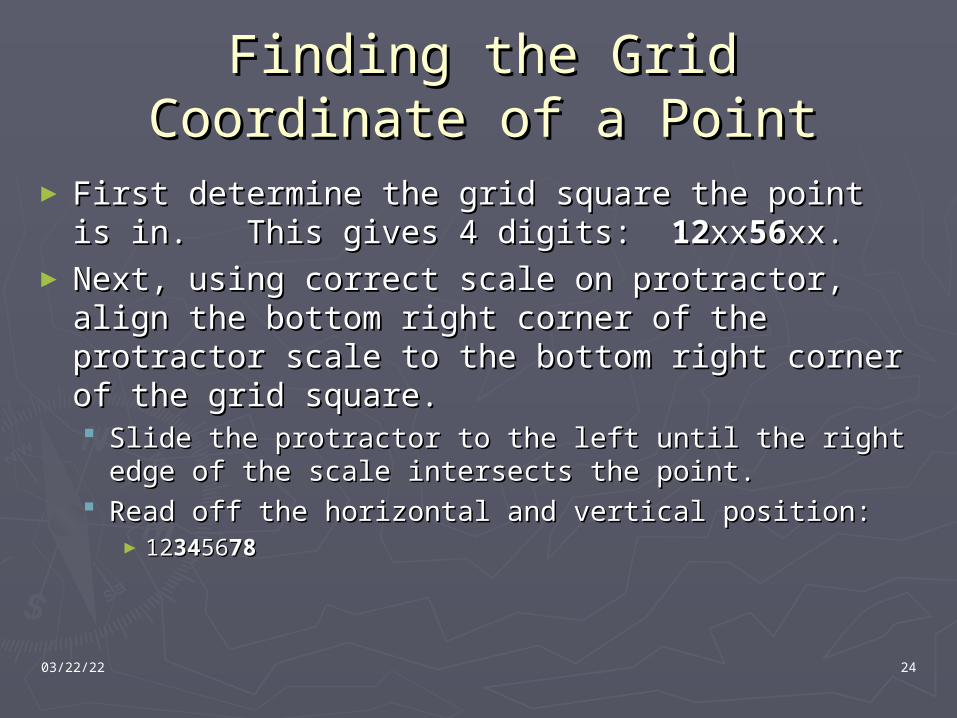
Finding the Grid Coordinate of Finding the Grid Coordinate of a Pointa Point
► First determine the grid square the point is First determine the grid square the point is in. This gives 4 digits: in. This gives 4 digits: 1212xxxx5656xx.xx.
►Next, using correct scale on protractor, align Next, using correct scale on protractor, align the bottom right corner of the protractor the bottom right corner of the protractor scale to the bottom right corner of the grid scale to the bottom right corner of the grid square.square. Slide the protractor to the left until the right edge Slide the protractor to the left until the right edge
of the scale intersects the point.of the scale intersects the point. Read off the horizontal and vertical position:Read off the horizontal and vertical position:
►1212343456567878
04/20/23 25
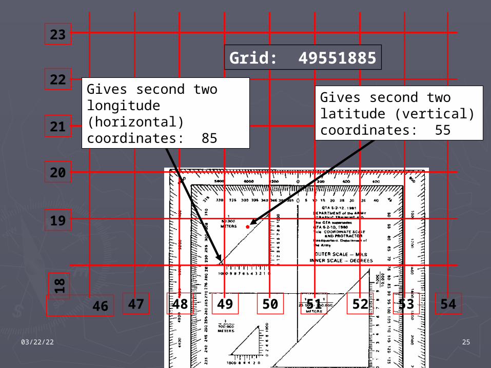
47 48 49 50 51 52 53 46
18
19
20
22
21
23
54
Grid: 49551885
Gives second two longitude (horizontal) coordinates: 85
Gives second two latitude (vertical) coordinates: 55
04/20/23 26
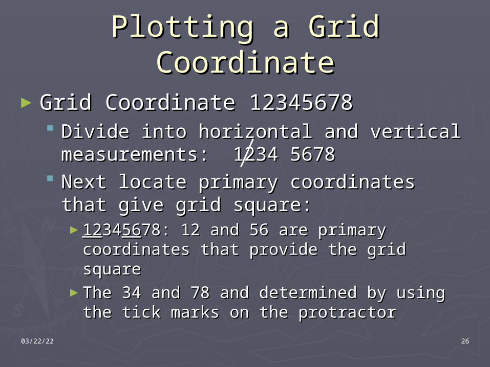
Plotting a Grid CoordinatePlotting a Grid Coordinate
►Grid Coordinate 12345678Grid Coordinate 12345678 Divide into horizontal and vertical Divide into horizontal and vertical
measurements: 1234 5678measurements: 1234 5678 Next locate primary coordinates that give Next locate primary coordinates that give
grid square:grid square:►12123434565678: 12 and 56 are primary coordinates 78: 12 and 56 are primary coordinates
that provide the grid squarethat provide the grid square►The 34 and 78 and determined by using the The 34 and 78 and determined by using the
tick marks on the protractortick marks on the protractor
04/20/23 27
Presentation OverviewPresentation Overview► Map Basics
Definition Marginal Information Map Colors Grid Lines
► 8-Digit Grid Coordinate Locating Plotting
► Determining Distance Straight-Line Distance Irregular Distance
► Contour Lines Basics Determining Elevation
► Relief & Terrain Features Slope Types Hill, Draw, Ridge, Finger, Saddle, Cliff, Depression, Cuts, Fills
► GM Angle, Azimuth Conversion, and Norths► Quiz► Next Time: Land Navigation II
Lensatic Compass Orienting a Map Determine an Azimuth Follow an Azimuth
► Questions?
04/20/23 28
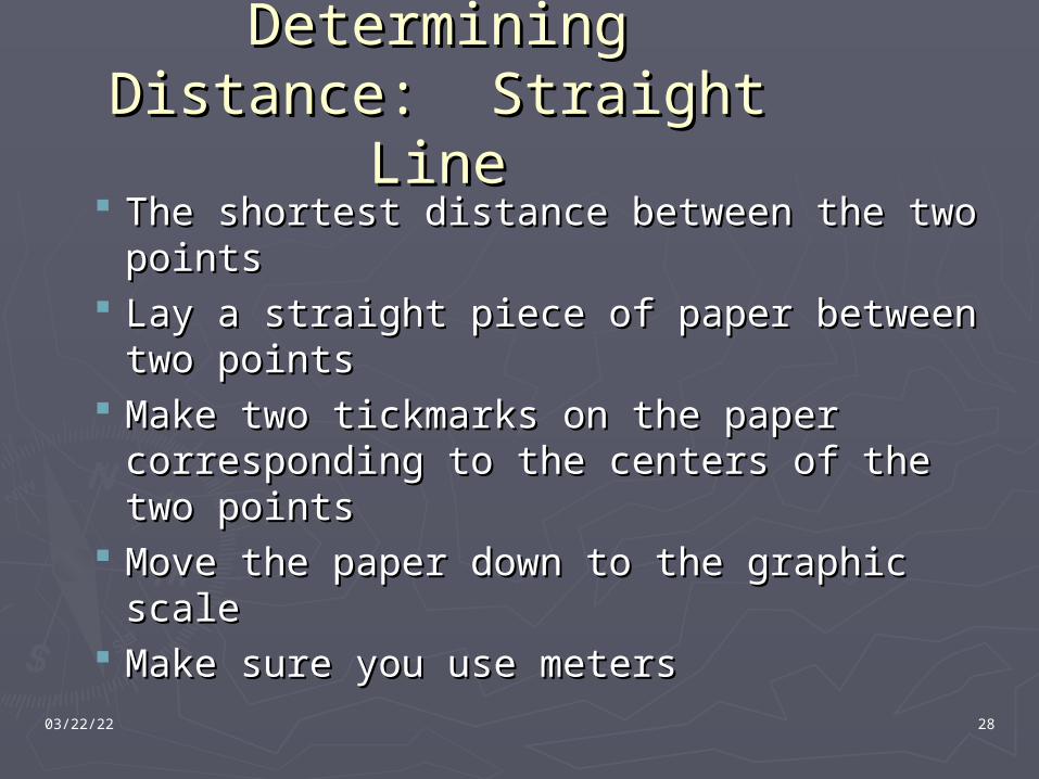
Determining Distance: Determining Distance: Straight LineStraight Line
The shortest distance between the two The shortest distance between the two pointspoints
Lay a straight piece of paper between two Lay a straight piece of paper between two pointspoints
Make two tickmarks on the paper Make two tickmarks on the paper corresponding to the centers of the two corresponding to the centers of the two pointspoints
Move the paper down to the graphic scaleMove the paper down to the graphic scale Make sure you use metersMake sure you use meters
04/20/23 29
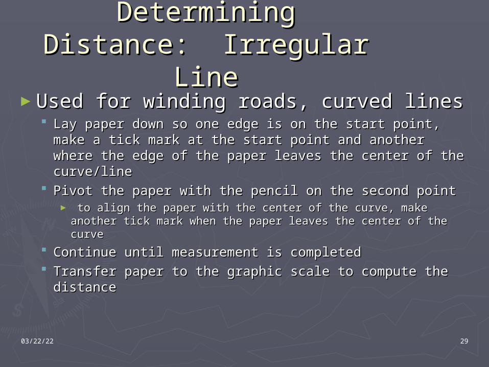
Determining Distance: Determining Distance: Irregular LineIrregular Line
►Used for winding roads, curved linesUsed for winding roads, curved lines Lay paper down so one edge is on the start point, make Lay paper down so one edge is on the start point, make
a tick mark at the start point and another where the a tick mark at the start point and another where the edge of the paper leaves the center of the curve/lineedge of the paper leaves the center of the curve/line
Pivot the paper with the pencil on the second pointPivot the paper with the pencil on the second point► to align the paper with the center of the curve, make another to align the paper with the center of the curve, make another
tick mark when the paper leaves the center of the curvetick mark when the paper leaves the center of the curve
Continue until measurement is completedContinue until measurement is completed Transfer paper to the graphic scale to compute the Transfer paper to the graphic scale to compute the
distancedistance
04/20/23 30
Presentation OverviewPresentation Overview► Map Basics
Definition Marginal Information Map Colors Grid Lines
► 8-Digit Grid Coordinate Locating Plotting
► Determining Distance Straight-Line Distance Irregular Distance
► Contour Lines Basics Determining Elevation
► Relief & Terrain Features Slope Types Hill, Draw, Ridge, Finger, Saddle, Cliff, Depression, Cuts, Fills
► GM Angle, Azimuth Conversion, and Norths► Quiz► Next Time: Land Navigation II
Lensatic Compass Orienting a Map Determine an Azimuth Follow an Azimuth
► Questions?
04/20/23 31
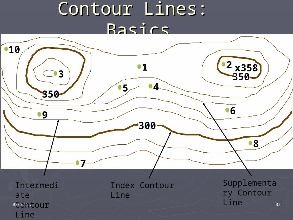
Contour Lines: BasicsContour Lines: Basics
A contour line is a line drawn on a map A contour line is a line drawn on a map representing an imaginary line on the ground representing an imaginary line on the ground along which all points are the same elevationalong which all points are the same elevation
Indicates the vertical distance above or below a Indicates the vertical distance above or below a base planebase plane
The vertical distance between two lines is the The vertical distance between two lines is the contour interval, found in the marginal datacontour interval, found in the marginal data
Every fifth line is an Every fifth line is an indexindex contour, it is shaded contour, it is shaded thicker and heavierthicker and heavier
The lines in between are The lines in between are intermediateintermediate contours contours Every line counted represents a change in Every line counted represents a change in
elevation equal to the contour intervalelevation equal to the contour interval
04/20/23 32
Contour Lines: BasicsContour Lines: Basics
350
350
300
1 23
45
6
7
8
x358
9
10
Index Contour Line
Intermediate Contour Line
Supplementary Contour Line
04/20/23 33
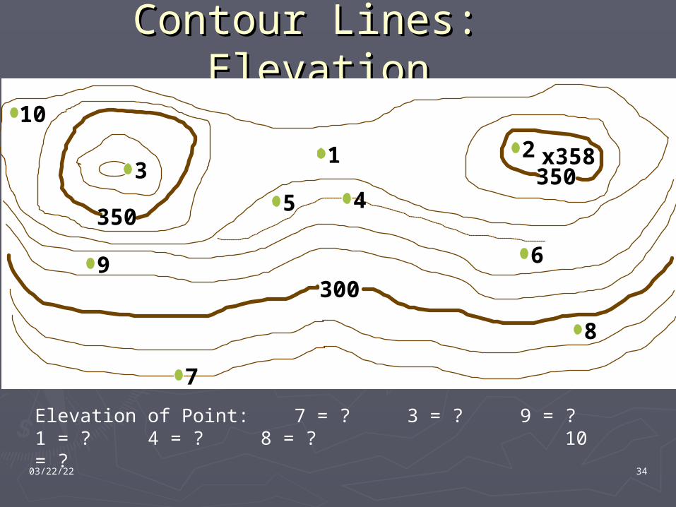
Contour Lines: Contour Lines: Determining ElevationDetermining Elevation
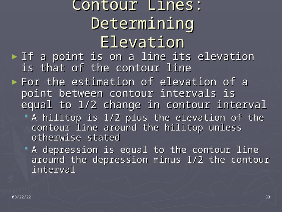
► If a point is on a line its elevation is that If a point is on a line its elevation is that of the contour lineof the contour line
►For the estimation of elevation of a point For the estimation of elevation of a point between contour intervals is equal to between contour intervals is equal to 1/2 change in contour interval1/2 change in contour interval A hilltop is 1/2 plus the elevation of the A hilltop is 1/2 plus the elevation of the
contour line around the hilltop unless contour line around the hilltop unless otherwise statedotherwise stated
A depression is equal to the contour line A depression is equal to the contour line around the depression minus 1/2 the around the depression minus 1/2 the contour intervalcontour interval
04/20/23 34
Contour Lines: Contour Lines: ElevationElevation
350
350
300
1 23
45
6
7
8
x358
9
10
Elevation of Point: 7 = ? 3 = ? 9 = ? 1 = ? 4 = ? 8 = ? 10 = ?
04/20/23 35
Presentation OverviewPresentation Overview► Map Basics
Definition Marginal Information Map Colors Grid Lines
► 8-Digit Grid Coordinate Locating Plotting
► Determining Distance Straight-Line Distance Irregular Distance
► Contour Lines Basics Determining Elevation
► Relief & Terrain Features Slope Types Hill, Draw, Ridge, Finger, Saddle, Cliff, Depression, Cuts, Fills
► GM Angle, Azimuth Conversion, and Norths► Quiz► Next Time: Land Navigation II
Lensatic Compass Orienting a Map Determine an Azimuth Follow an Azimuth
► Questions?
04/20/23 36
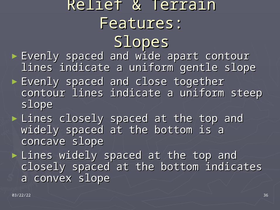
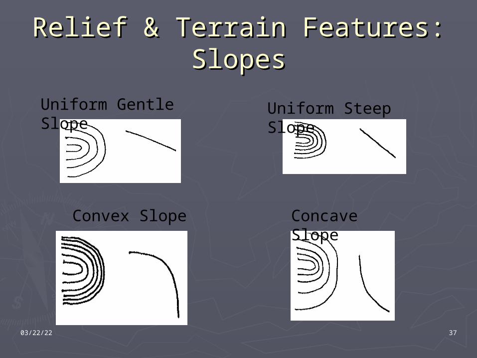
Relief & Terrain Relief & Terrain Features:Features:
SlopesSlopes►Evenly spaced and wide apart contour Evenly spaced and wide apart contour
lines indicate a uniform gentle slopelines indicate a uniform gentle slope►Evenly spaced and close together contour Evenly spaced and close together contour
lines indicate a uniform steep slopelines indicate a uniform steep slope►Lines closely spaced at the top and widely Lines closely spaced at the top and widely
spaced at the bottom is a concave slopespaced at the bottom is a concave slope►Lines widely spaced at the top and closely Lines widely spaced at the top and closely
spaced at the bottom indicates a convex spaced at the bottom indicates a convex slopeslope
04/20/23 37
Relief & Terrain Features:Relief & Terrain Features:SlopesSlopes
Uniform Gentle Slope Uniform Steep Slope
Convex Slope Concave Slope
04/20/23 38
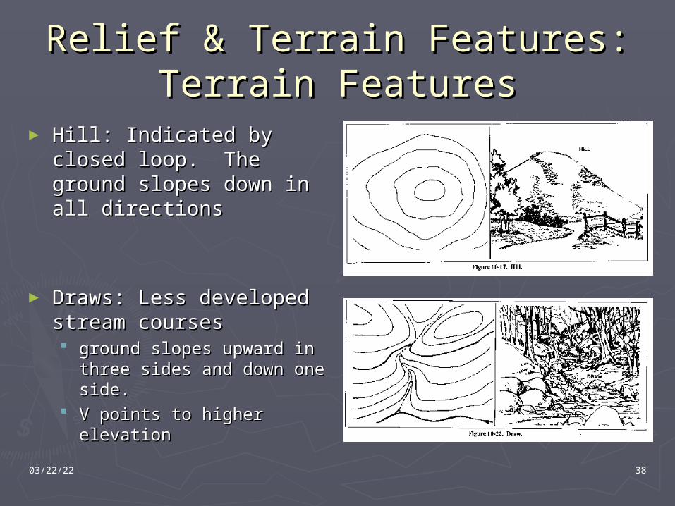
Relief & Terrain Features:Relief & Terrain Features:Terrain FeaturesTerrain Features
► Hill: Indicated by closed Hill: Indicated by closed loop. The ground slopes loop. The ground slopes down in all directionsdown in all directions
► Draws: Less developed Draws: Less developed stream coursesstream courses ground slopes upward in ground slopes upward in
three sides and down one three sides and down one side. side.
V points to higher V points to higher elevationelevation
04/20/23 39
Relief & Terrain Features:Relief & Terrain Features:Terrain FeaturesTerrain Features
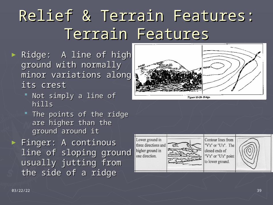
► Ridge: A line of high Ridge: A line of high ground with normally ground with normally minor variations along minor variations along its crestits crest Not simply a line of hillsNot simply a line of hills The points of the ridge The points of the ridge
are higher than the are higher than the ground around itground around it
► Finger: A continous line Finger: A continous line of sloping ground of sloping ground usually jutting from the usually jutting from the side of a ridgeside of a ridge
04/20/23 40
Relief & Terrain Features:Relief & Terrain Features:Terrain FeaturesTerrain Features
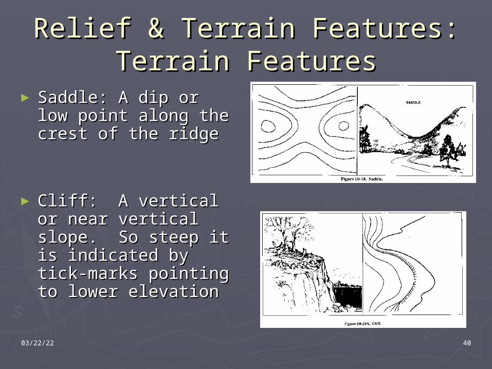
► Saddle: A dip or low Saddle: A dip or low point along the point along the crest of the ridgecrest of the ridge
► Cliff: A vertical or Cliff: A vertical or near vertical slope. near vertical slope. So steep it is So steep it is indicated by tick-indicated by tick-marks pointing to marks pointing to lower elevationlower elevation
04/20/23 41
Relief & Terrain Features:Relief & Terrain Features:Terrain FeaturesTerrain Features
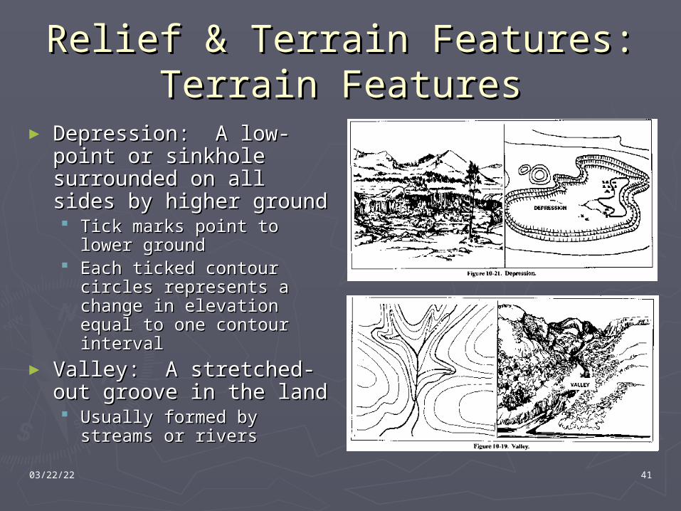
► Depression: A low-Depression: A low-point or sinkhole point or sinkhole surrounded on all sides surrounded on all sides by higher groundby higher ground Tick marks point to lower Tick marks point to lower
groundground Each ticked contour Each ticked contour
circles represents a circles represents a change in elevation equal change in elevation equal to one contour intervalto one contour interval
► Valley: A stretched-out Valley: A stretched-out groove in the land groove in the land Usually formed by Usually formed by
streams or riversstreams or rivers
04/20/23 42
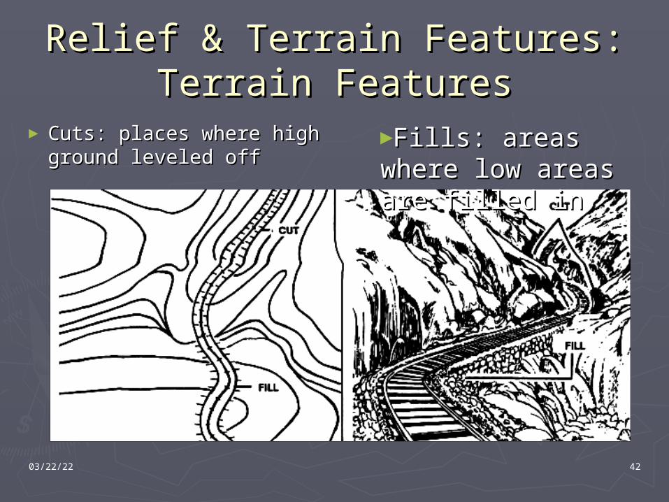
Relief & Terrain Features:Relief & Terrain Features:Terrain FeaturesTerrain Features
► Cuts: places where Cuts: places where high ground leveled offhigh ground leveled off
►Fills: areas where Fills: areas where low areas are filled low areas are filled inin
04/20/23 43
Presentation OverviewPresentation Overview► Map Basics
Definition Marginal Information Map Colors Grid Lines
► 8-Digit Grid Coordinate Locating Plotting
► Determining Distance Straight-Line Distance Irregular Distance
► Contour Lines Basics Determining Elevation
► Relief & Terrain Features Slope Types Hill, Draw, Ridge, Finger, Saddle, Cliff, Depression, Cuts, Fills
► GM Angle, Azimuth Conversion, and Norths► Quiz► Next Time: Land Navigation II
Lensatic Compass Orienting a Map Determine an Azimuth Follow an Azimuth
► Questions?
04/20/23 44
GM Angle, Azimuth GM Angle, Azimuth Conversion, and NorthConversion, and North
►Three NorthsThree Norths Grid-The vertical lines on the mapGrid-The vertical lines on the map Magnetic-Magnetic North in Hudson BayMagnetic-Magnetic North in Hudson Bay True-North PoleTrue-North Pole
►Declination Diagram shows the Declination Diagram shows the relationships between the three northsrelationships between the three norths
►Magnetic and Grid North are used to Magnetic and Grid North are used to determine GM (Grid-Magnetic) Angledetermine GM (Grid-Magnetic) Angle
04/20/23 45
AzimuthsAzimuths
►An azimuth is a directionAn azimuth is a direction►Defined as a horizontal angle Defined as a horizontal angle
measured clockwise from a baselinemeasured clockwise from a baseline►There are two types dealt withThere are two types dealt with
magnetic azimuths measured with true magnetic azimuths measured with true north as its basenorth as its base
grid azimuths measures with grid north as grid azimuths measures with grid north as basebase
04/20/23 46
Measuring AzimuthsMeasuring Azimuths
►Plot two coordinates on the mapPlot two coordinates on the map►connect them with a straight lineconnect them with a straight line►Place the index point pf the protractor Place the index point pf the protractor
on the point the azimuth its to be on the point the azimuth its to be measured frommeasured from
►Ensure the protractor grid lines are Ensure the protractor grid lines are parallel to N-S gridlines on a mapparallel to N-S gridlines on a map
►Where the line crosses the protactor Where the line crosses the protactor indicates azimuthindicates azimuth
04/20/23 47
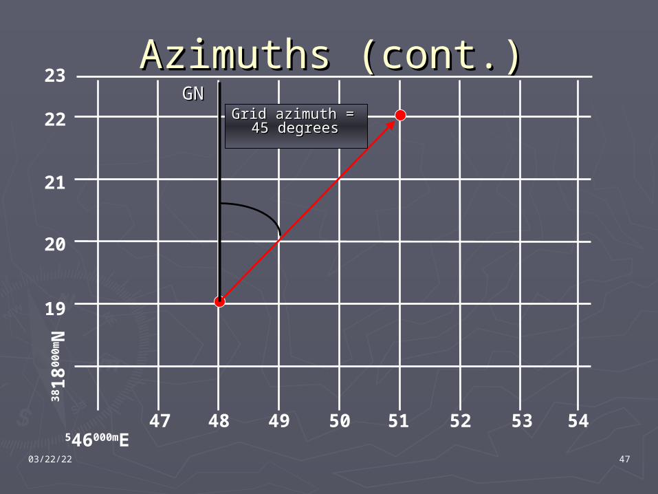
Azimuths (cont.)Azimuths (cont.)
546000mE
38 1
8000
mN
19
20
22
21
23
47 48 49 50 51 52 53 54
GGNN Grid azimuth = Grid azimuth =
45 degrees45 degrees
04/20/23 48
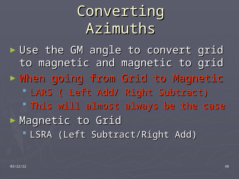
Converting AzimuthsConverting Azimuths
►Use the GM angle to convert grid to Use the GM angle to convert grid to magnetic and magnetic to gridmagnetic and magnetic to grid
►When going from Grid to MagneticWhen going from Grid to Magnetic LARS ( Left Add/ Right Subtract)LARS ( Left Add/ Right Subtract) This will almost always be the caseThis will almost always be the case
►Magnetic to GridMagnetic to Grid LSRA (Left Subtract/Right Add)LSRA (Left Subtract/Right Add)

Questions?Questions?
04/20/23 50
Presentation OverviewPresentation Overview► Map Basics
Definition Marginal Information Map Colors Grid Lines
► 8-Digit Grid Coordinate Locating Plotting
► Determining Distance Straight-Line Distance Irregular Distance
► Contour Lines Basics Determining Elevation
► Relief & Terrain Features Slope Types Hill, Draw, Ridge, Finger, Saddle, Cliff, Depression, Cuts, Fills
► GM Angle, Azimuth Conversion, and Norths
► Quiz► Next Time: Land Navigation II
Lensatic Compass Orienting a Map Determine an Azimuth Follow an Azimuth
► Questions?
04/20/23 51
QuizQuiz
► What is a map?What is a map?► What are the three types of North?What are the three types of North?
Explain what they represent.Explain what they represent.► What standard colors are used on a map?What standard colors are used on a map?
What do they represent?What do they represent?► Explain the 2 main types of contour lines.Explain the 2 main types of contour lines.► What is an 8-digit grid coordinate?What is an 8-digit grid coordinate?
How accurate is it is using a 1:25000 coordinate How accurate is it is using a 1:25000 coordinate scale?scale?
► Describe the four types of slope and what Describe the four types of slope and what they look like on a topographic map.they look like on a topographic map.
04/20/23 52
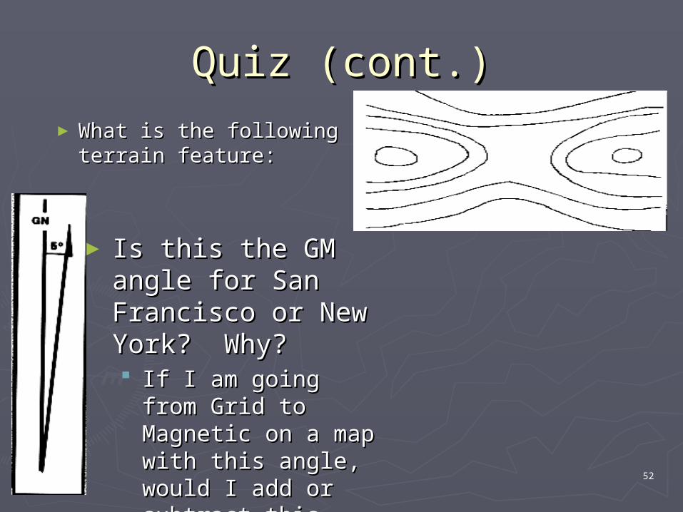
Quiz (cont.)Quiz (cont.)
► What is the following What is the following terrain feature:terrain feature:
► Is this the GM angle Is this the GM angle for San Francisco or for San Francisco or New York? Why?New York? Why? If I am going from If I am going from
Grid to Magnetic on Grid to Magnetic on a map with this a map with this angle, would I add or angle, would I add or subtract this angle?subtract this angle?
04/20/23 53
Next Time: Land Navigation Next Time: Land Navigation IIII
Lensatic Compass►Parts►Using during day►Using at night
Orienting a Map Determine an Azimuth Follow an Azimuth Pace Count