Embed Size (px)
Citation preview
3S p r i n g 2 0 0 9
environment (Shahid and Abdelfattah, 2008). Societal cooperation is a sensible approach to tackle land degradation problems, especially when the cause is not confined to a single landowner’s property. Human-induced land degradation in the Emirate of Abu Dhabi is of many kinds, including salinization in agricultural farms, soil compaction by off-road vehicles, loss of vegetation through uncontrolled overgrazing and land clearing. Anthropogenic activities ultimately lead to very poor wildlife habitat and ecosystem destruction. Natural causes of land degradation in the Emirate are drought (evaporation exceeds rainfall), wind erosion, and sand encroachment.
To sustain the land resources of Abu Dhabi Emirate, land degrada-tion is a matter of urgency and must be accorded greater significance on the environmental agenda. A legal framework should be created to protect these environmental assets. The present study aimed to charac-terize the major land degradation indicators in Abu Dhabi Emirate and suggest better conservation strategies and management options.
The Study AreaThe United Arab Emirates is located between 22°50¢ and 26° N
latitude and 51° and 56°25¢ E longitude at the southeastern tip of the Arabian Pennisula. Abu Dhabi is the largest Emirate of the United Arab Emirates, occupying 84% (77,000 km2) of the country’s land area. Abu Dhabi’s major ecosystems comprise the coast, numerous islands, mountainous areas, gravel plains, and sand desert (Boer, 1998). Nearly 80% of the Abu Dhabi Emirate area is desert; to the north and west is
Throughout history humans have used the environment to gain great economic rewards; however, many of the methods are now
being seen as unsustainable. Johnson and Lewis (1995) defined land degradation as the substantial decrease in either biological productiv-ity and/or usefulness of an area due to human interference. Chemical or physical land degradation is the result of a number of interrelated factors. It is often accelerated by persistent droughts in many develop-ing arid and semiarid countries. Land degradation is often attributed to human causes (Gray, 1999; Misak et al., 2002). Worldwide, it is esti-mated that nearly two billion hectares of biologically productive land have been rendered unproductive due to irreversible degradation (Vilanculos, 1994). The present rate of land degradation is estimated at 5 to 7 million hectares per year, suggesting that 0.3 to 0.5% of the world’s arable land is lost annually due to soil degradation (Dudal, 1975; FAO, 1983; Vilanculos, 1994). The world is losing 10 ha of arable land each minute—5 ha to soil erosion, 3 ha from salinity, and 2 ha by other degradation processes.
Land and soil are important components of Abu Dhabi Emirate desert ecosystems and of the wider environment in which all plants and animals live. Degradation produces pressures that result in the cur-rent state of land resources, with a negative impact on society and the
abstract
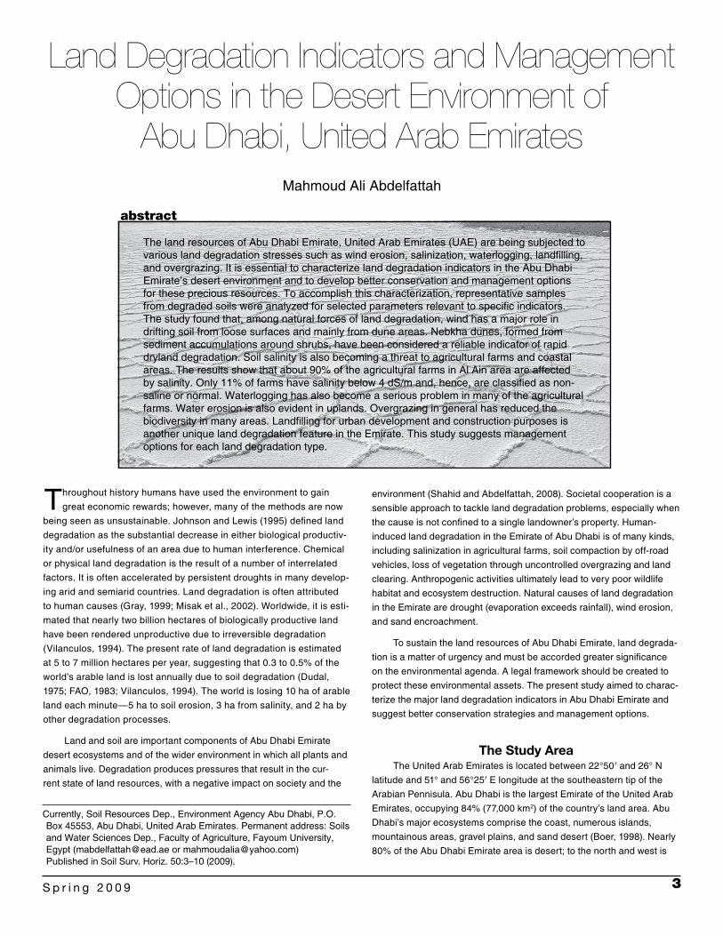
The land resources of Abu Dhabi Emirate, United Arab Emirates (UAE) are being subjected to various land degradation stresses such as wind erosion, salinization, waterlogging, landfilling, and overgrazing. It is essential to characterize land degradation indicators in the Abu Dhabi Emirate’s desert environment and to develop better conservation and management options for these precious resources. To accomplish this characterization, representative samples from degraded soils were analyzed for selected parameters relevant to specific indicators. The study found that, among natural forces of land degradation, wind has a major role in drifting soil from loose surfaces and mainly from dune areas. Nebkha dunes, formed from sediment accumulations around shrubs, have been considered a reliable indicator of rapid dryland degradation. Soil salinity is also becoming a threat to agricultural farms and coastal areas. The results show that about 90% of the agricultural farms in Al Ain area are affected by salinity. Only 11% of farms have salinity below 4 dS/m and, hence, are classified as non-saline or normal. Waterlogging has also become a serious problem in many of the agricultural farms. Water erosion is also evident in uplands. Overgrazing in general has reduced the biodiversity in many areas. Landfilling for urban development and construction purposes is another unique land degradation feature in the Emirate. This study suggests management options for each land degradation type.
Land Degradation Indicators and Management Options in the Desert Environment of
Abu Dhabi, United Arab EmiratesMahmoud Ali Abdelfattah
Currently, Soil Resources Dep., Environment Agency Abu Dhabi, P.O. Box 45553, Abu Dhabi, United Arab Emirates. Permanent address: Soils and Water Sciences Dep., Faculty of Agriculture, Fayoum University, Egypt ([email protected] or [email protected]) Published in Soil Surv. Horiz. 50:3–10 (2009).
4 S O I L S U R V E Y H O R I Z O N S
following explores in depth each of these indicators based on its signifi-cance occurrence over the study area.
1. Wind Erosion and Aeolian DepositsWind erosion is considered the major cause of irreversible land
degradation in the arid environment of Abu Dhabi Emirate where dry, noncohesive sandy soils, poor vegetation cover, strong wind, and hyper-arid conditions prevail. The dunes are not static but constantly moving. The wind erosion indicators are formation of fall dunes, block-ing of highways, dust storms (Fig. 1), nebkha features, reduction of waterways capacity due to fallen sand, exposure of a hardpan at the surface, and gravel lag. Nebkha dunes (Fig. 2) are considered a reli-able indicator for dryland degradation (Dougill and Thomas, 2002). Understanding the particle size distribution of typical desert soils assists in the identification of mechanisms of particles movement and in formulating necessary measures to reduce aeolian movement.
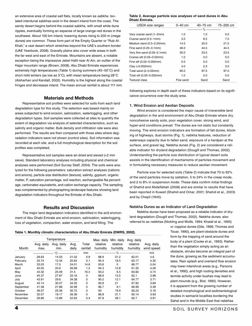
Particle size for selected soils (Table 2) indicate that 70 to 92% of the sand particles move by saltation, 5 to 24% in the creep mode, and 2 to 8% in suspension mode. These data confirm initial findings of Shahid and Abdelfattah (2008) and are similar to results that have been reported in Kuwait (Shahid and Omar, 2001; Shahid et al., 2003) and by Chepil (1945).
Nebkha Dunes as an Indicator of Land DegradationNebkha dunes have been proposed as a reliable indicator of dry-
land degradation (Dougill and Thomas, 2002). Nebkha dunes, also referred to as nebkhas (Nickling and Wolfe, 1994; Khalaf et al., 1995)
or coppice dunes (Gile, 1966; Thomas and Tsoar, 1990), are plant-obstacle dunes and form by the trapping of sand around the body of a plant (Cooke et al., 1993). Rather than the vegetation simply acting as an obstacle, shrubs become an integral part of the dune, growing as the sediment accumu-lates. Rain splash and overland flow erosion may lower intershrub areas (e.g., Parsons et al., 1992), and high rooting densities and termite activity under bushes may lead to plant mounds (e.g., Biot, 1990). However, it is apparent from the growing number of detailed morphological and sedimentological studies in semiarid localities bordering the Sahel and in the Middle East that nebkhas
an extensive area of coastal salt flats, locally known as sabkha. Iso-lated interdunal sabkhas exist in the desert inland from the coast. The sandy desert begins behind the coastal sabkha, with small white dune ripples, eventually forming an expanse of large orange-red dunes in the southwest. About 100 km inland, towering dunes rising to 200 m (mega dunes) are common. These form part of the Empty Quarter or “Rub Al-Khali,” a vast desert which stretches beyond the UAE’s southern border (UAE Yearbook, 2008). Gravelly plains also cover wide areas in both the far west and east of the Emirate. Mountains are absent, a notable exception being the impressive Jebel Hafit near Al Ain, an outlier of the Hajar mountain range (Brown, 2008). Abu Dhabi Emirate experiences extremely high temperatures (Table 1) during summers (45–50°C) and short mild winters (as low as 3°C), with mean temperature being 28°C (Alsharhan and Kendall, 2002). Humidity is the highest along the coastal fringes and decreases inland. The mean annual rainfall is about 111 mm.
Materials and MethodsRepresentative soil profiles were selected for soils from each land
degradation type for this study. The selection was based mainly on areas subjected to wind erosion, salinization, waterlogging, and other degradation types. Soil samples were collected at sites to quantify the extent of degradation via analysis of selected characteristics, such as salinity and organic matter. Bulk density and infiltration rate were also performed. The results are then compared with those sites where deg-radation indicators were not shown (control sites). Soil information was recorded at each site, and a full morphological description for the soil profiles was completed.
Representative soil samples were air-dried and sieved (<2 mm sieve). Standard laboratory analyses including physical and chemical analyses were performed (Soil Survey Staff, 2004). The soils were ana-lyzed for the following parameters: saturation extract analyses (cations and anions), particle size distribution (texture), salinity, gypsum, organic matter, P, saturation percentage, soil reaction, exchangeable Na percent-age, carbonates equivalents, and cation exchange capacity. The sampling was complemented by photographing landscape features showing land degradation indicators throughout the Emirate of Abu Dhabi.
Results and DiscussionThe major land degradation indicators identified in the arid environ-
ment of Abu Dhabi Emirate are wind erosion, salinization, waterlogging, loss of vegetation, compaction, water erosion, and land filling. The
Table 1. Monthly climatic characteristics of Abu Dhabi Emirate (DWRS, 2002).
Month
TemperatureTotal
rainfall
Max. daily relative humidity
Min. daily relative humidity
Avg. daily relative humidity
Avg. daily wind speed
Avg. daily max.
Avg. daily min.
Avg. daily
——————— °C ——————— mm ——————— % ——————— m/sJanuary 28.63 14.03 21.02 0.9 88.9 31.2 62.01 4.6February 33.74 12.34 20.64 0.1 95.4 18.5 63.17 4.32March 33.03 17.5 24.01 14.6 93.6 0 66.77 5.04April 40.05 20.6 26.69 1.2 94.3 12.8 61.35 4.26May 43.32 25.09 31.5 16.4 93.2 6.5 60.82 3.74June 45.37 27.87 33.16 0 88.9 13.5 62.1 3.98July 43.91 29.6 34.38 0 90.2 12.1 64.77 3.71August 43.14 30.07 34.35 0 90.8 21 67.82 3.69September 41.58 27.86 32.99 0 86.7 8.1 66.99 3.39October 39.57 25.06 30.72 0 93 19.9 65.23 3.16November 32.07 19.17 26.36 0 86.8 31.1 60.14 3.93December 29.66 15.89 22.63 0.4 87.8 28.1 62.7 3.91
Table 2. Average particle size analyses of sand dunes in Abu Dhabi Emirate.
USDA size ranges 0–40 cm 40–75 cm 75–200 cm————— % —————
Very coarse sand (1–2mm) 1.0 1.0 0.0
Coarse sand (0.5–1mm) 3.5 8.5 7.5
Medium sand (0.5–0.25mm) 14.5 20.0 21.5
Fine sand (0.25–0.1mm) 46.0 44.5 44.5
Very fine sand (0.05–0.1mm) 30.0 23.5 23.5
Coarse silt (0.05–0.02mm) 1.0 0.0 0.0
Fine silt (0.02–0.002mm) 0.0 0.0 0.0
Clay (<0.002mm) 4.0 2.5 3.0
Total sand (2–0.05mm) 95.0 97.5 97.0
Total silt (0.05–0.002mm) 1.0 0.0 0.0
Textural class Fine sand Sand Sand

5S p r i n g 2 0 0 9
Afforestation has been practiced on about 330,000 ha in Abu Dhabi Emirate. In addition, many green belts in urban areas and along roadsides have been established. The implementation of afforestation was consid-ered a preventive measure for some of the desert lands that are not yet degraded or are only slightly degraded. Forestry plantations are playing a great role in combating wind erosion and are presenting multiple bene-fits, such as hydrological balance, enhancement of environmental quality, improvement habitat restoration, and increasing aesthetic value.
2. Soil SalinizationSoil salinization, the process of soluble salt accumulation, is of
great concern on farms because it directly influences plant growth and yield reduction by increasing osmotic pressure of soil moisture caus-ing physiological drought, and indirectly by causing deterioration of soil medium. Due to the prevailing hyper-arid conditions in Abu Dhabi Emirate, the soil receives inadequate and irregular precipitation to effectively leach the salts from the soil profile. A soil salinity study of the agricultural farms in Al Ain area of southeast Abu Dhabi Emirate
are good indicators of wind erosion and deposition (e.g., Gunatilaka and Mwango, 1987; Nickling and Wolfe, 1994; Tengburg, 1994, 1995; Khalaf et al., 1995; Tengburg and Chen, 1998). In the desert environment of Abu Dhabi Emirate, nebkha dunes are very common in different sizes, heights, and shapes (Fig. 2). They also halt degradation through catch-ing drifted soil particles and reducing wind speed, thus protecting some area around them. Tables 3a and 3b present a complete morphological and analytical characterization of two sandy soils nebkha dunes, one is characterized as carbonatic mineralogy class (carbonatic, hyperthermic, Typic Torripsamments) and another as mixed mineralogy class (mixed, hyperthermic, Typic Torripsamments).
Stabilization of these soils is accomplished by reducing saltation. This reduction may involve binding surface soil particles through organic amendments, green manures, mulching material, or synthetic polymers to increase size of the aggregates above saltation range or stabilize the sand surface. Agricultural areas can also be protected by introduction of shelter belts and sand dunes stabilization through afforestation.
Fig. 1. Dust storms show the effect of wind erosion on drifting the soil surface (saltation).
Fig. 2. Nabkha dune, a dominant feature due to wind erosion.

6 S O I L S U R V E Y H O R I Z O N S
very strongly saline (>8000 ppm), indicating that irrigation water is likely a major source of salinity accumulation in the soil profile.
Coastal and Inland Salinity of Abu Dhabi Emirate
The coastal sabkha of Abu Dhabi Emirate stretches over 400 km. In this area, saline soils are the most common feature (Abdelfattah and Shahid, 2007; Abdelfattah et al., 2008b; Shahid et al., 2004). Locally these saline soils are known as sabkhas, a feature that can be found in coastal or inland areas. Coastal sabkhas are developed through sea water intrusion, followed by evaporation (Fig. 5 and 6). The largest area covered by an inland sabkha, Sabkhat Matti, occurs in the west-ern Abu Dhabi. Sabkhat Matti extends inland from the coast for about
showed that 43% of the farms have soils with salinity >9.4dS/m (>6000 ppm), and 26% of soils have salinity ranging from 6.25 to 9.4 dS/m (4000–6000 ppm) (Fig. 3). The salinity of about 90% of the farms falls into the saline class (Richards, 1954), and about 70% are in the range of salinity where yields of many crops are restricted (4–6 dS/m) or only tolerant crops result in satisfactory yields (8–16 dS/m). Only 11% of farms have salinity levels below 4 dS/m and, hence, are classified as non-saline or normal (El Bershamghy and Al Tamimi, 2003).
In irrigated agriculture, irrigation water is the primary source of salts. Irrigation leads to phenomenal enhancement of land productivity. However, if this important resource is mismanaged, it can cause soil degradation and increase salinization risk. Figure 4 shows the salinity of groundwater wells used for irrigation. The data reveal that the water salinity of 68% farms is
Fig. 4. Salinity of groundwater wells in Al Ain area.Fig. 3. Salinity of the agriculture farms in Al Ain area.
Table 3a. Morphological and analytical properties of mixed, hyperthermic, Typic Torripsamments and carbonatic, hyperthermic, Typic Torripsamments.†
HorizonLower depth
Munsell colorSand Silt Clay
Texture class
Gravels StructureConsistence
(dry)Stickiness Effervescence Boundary
Dry Moistcm ———— % ——— %
Mixed, hyperthermic, Typic TorripsammentsCk 15 10YR7/3 10YR3/4 97 2 1 Sand 0 SG S NS Strong CS2Cbik 65 7.5YR7/5 7.5YR5/5 96 3 1 Sand 0 SG S NS Strong CS2Cbk1 100 7.5YR5/6 7.5YR4/3 96.5 1.5 2 Sand 0 SG S NS Strong CS2Cbk2 150 7.5YR5/5 7.5YR4/3 96 1 3 Sand 0 SG S NS Strong CS2Cbk3 200 7.5YR5/5 7.5YR4/4 97 2 1 Sand 0 SG S NS StrongCarbonatic, hyperthermic, Typic TorripsammentsAk 25 2.5Y7/2 2.5Y6/3 92.5 4.5 3 Sand 0 SG S NS V CSBk 70 2.5Y7/2 2.5Y7/2 93 3 4 Sand 0 SG S NS V DSCk1 110 2.5Y7/3 2.5Y7/4 93 4 3 Sand 0 SG S NS V GSCk2 150 2.5Y7/3 2.5Y7/4 95.5 1.5 3 Sand 0 SG S NS V
† SG = single grain; S = soft; NS = nonsticky; DS = abrupt smooth; CS = clear smooth; GS = gradual smooth.
Table 3b. Analytical properties of mixed, hyperthermic, Typic Torripsamments and carbonatic, hyperthermic, Typic Torripsamments.†
Horizon Lower depth pHs ECe ESPCarbonates eq. <2 mm
Gypsum Olsen POrganic matter
Water retention(15 bar)
Saturation percentage
Bulk density CEC
cm dS/m —————— % —————— mg/kg % % g/cm3 cmol/kgMixed, hyperthermic, Typic TorripsammentsCk 15 8.3 1.1 3 22.8 0.0 0.151 0.38 3.7 25 1.30 3.122Cbik 65 8.2 0.4 3 23.3 0.0 0.090 0.03 3.9 26 1.60 2.182Cbk1 100 8.1 0.3 3 18.8 0.0 0.060 0.01 3.3 24 1.60 2.92Cbk2 150 8.3 0.5 1 18.7 0.0 0.044 0.07 3.6 26 1.60 1.862Cbk3 200 8.0 0.8 7 21.8 0.0 0.060 0.04 3.5 25 1.61 1.19Carbonatic, hyperthermic, Typic TorripsammentsAk 25 8.18 1.74 2.3 78.3 0.0 0.110 0.09 4.5 21 1.45 2.35Bk 70 8.23 2.89 3.72 76.5 0.0 0.060 0.45 3.7 20 1.62 1.38Ck1 110 8.02 9.26 11.4 71.4 0.0 0.70 0.29 3.8 22 1.54 1.56Ck2 150 8.18 11.3 14.0 73.5 0.4 0.50 0.37 3.4 19 1.56 1.81
† ECe = electrical conductivity of soil saturation extract; pHs = pH of soil saturated paste; ESP = exchangeable sodium percentage; CEC = cation exchange capacity.

7S p r i n g 2 0 0 9
Fig. 5. Hexagonal salt crust on the surface, an indication of salini-zation on the coastal area.
Fig. 6. Salt fibers in Abu Dhabi coastal area.
Fig. 7. (a) Thick hardpan on a farm affected by waterlogging. (b) Waterlogging in the agricultural farms. (c) Waterlogging affects the surrounding urban community.
Fig. 8. Combined effect of water and wind erosion. Fig. 9. Excavation for construction materials.

8 S O I L S U R V E Y H O R I Z O N S
120 km, and within Saudi Arabia it reaches a height of 40 m above sea level at its south-ern tip. Inland sabkhas occur in deserts where water accumulates in low-lying landscape posi-tions through seepage (i.e., from hydrological flow from surrounding areas) and evaporates, leaving a surface salt crust.
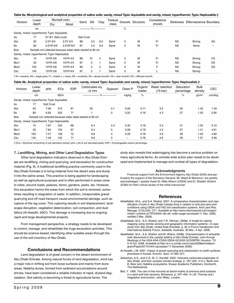
In the coastal area, gypsum and anhydrite are commonly found under the hyper saline con-ditions (Shahid et al., 2007; Abdelfattah et al., 2008a). These data show that the salinity reaches 28.8 dS/m compared with the inland sandy soils, which are within 4 dS/m (Tables 4 and 5). Saline soils identified in the coastal area of Abu Dhabi (Tables 6a and 6b) classify as Typic Haplosa-lids and Typic Aquisalids (Soil Survey Staff, 1999, 2003). Salinity and sodicity are extremely high in these coastal area soils, with EC exceeding 200 dS/m, indicating that land use is restricted to salt harvesting.
To manage the salinity problem in Abu Dhabi Emirate, an action plan needs to be developed to determine the best practices of soil reclamation and management. Aspects to the plan include the rec-ommendations for most suitable plant species, optimal irrigation requirements, and development of drainage conditions to achieve salin-ity control. The following are suggested as prerequisite research needed on salt-affected soils in Abu Dhabi Emirate:
characterization, mapping, and monitoring of salt affected soils• identification of causes and sources of salts• source of good quality irrigation water• investigation and development of proper leaching requirements and •
efficient drainage systemsselection of the optimal crops•
3. WaterloggingMany agricultural farms in Abu Dhabi Emirate suffer from waterlog-
ging, poor drainage conditions due to the presence of strong and thick hardpan at different depths (Fig. 7a), excessive use of irrigation water, and seawater intrusion. The most affected areas in Abu Dhabi are Al Ajban, Al Samha, Al Rahba, and Al Bahia (Dawoud and Abdelfattah, 2007). In many areas, water reaches the surface and causes suffocation of existing vegetation (Fig. 7b). The waterlogging problem is often cou-pled with a rise of salinity due to the absence of proper leaching. Also, it is important to note that waterlogging also affects the surrounding urban community around the affected agricultural farms (Fig. 7c).
Urgent corrective action is required to tackle the waterlogging prob-lems on affected farms. Management options are:
level the area to avoid stagnant water•
avoid areas with hardpan, or break (rip) hardpans if possible•
establish an efficient drainage system•
implement proper water consumption•
implement careful, appropriate reuse of collected drainage water•
4. Loss of VegetationRapid economic development of Abu Dhabi Emirate in the past
decade has inevitably left its scars on the natural environment. In gen-eral, vegetatative cover across the emirate is exceedingly sparse and
is generally dominated by a few (mainly invader) species that can be found in most of the desert. Together, overgrazing and the harsh cli-mate contribute to low vegetation cover, and large areas of barren land are commonly encountered in the saline coastal flats and the mobile sand dunes (Brown and Sakkir, 2004). El-Keblawy (2003) investigated species diversity and productivity within and outside of enclosures that prevent animal consumption of plants. He reported a greater species diversity and frequency inside the enclosure. These plants were more palatable and important range legumes (e.g., Crotalaria aegyptiaca and Indigofera articulata) and grasses (e.g., Pennisetum divisum, Stipa-grostis plumosa, and Panicum turgidum). These species were absent outside the enclosure, indicating the plants were not able to tolerate the current grazing intensity in the study area.
5. Compaction, Sealing, and CrustingSurface sealing, crusting, and compaction are the indicators of
land degradation in the Emirate desert. These features are common on soils that are calcareous, gypseous, and sandy. The compaction is accelerated during rainy seasons when soils are wet. Soils that are rela-tively heavy, cohesive, and rich in silt and dispersible clay contents are also vulnerable when leveled. Landfilling and leveling for infrastructure development is a common activity during this time of increasing urban development. The difference between noncompacted and compacted soils was assessed through bulk density and infiltration rate mea-surement. The control site had a bulk density of 1.15 g/cm3, while bulk density at the compacted site was much higher (1.66 g/cm3). Infiltration was 267 mm/h compared with 52 mm/h at the two sites, respectively.
6. Water ErosionMost of the desert environment of Abu Dhabi Emirate consists of
sand dune soils that absorb rainwater. Due to their very high infiltration rate and water storage capacity, no water erosion occurs in these areas. However, the soils that are more stable and cohesive (such as aeolian-ite and highlands) have shown signs of the combined effect of wind and water erosion (Fig. 8). Water erosion in Abu Dhabi Emirate is active only during the intensive rainy season, causing severe runoff flows in sloping landscapes in the form of rills and gullies. In flat areas, signs of sheet ero-sion are also noticable. The Ministry of Environment and Water has taken necessary steps to collect the runoff water from highlands in the dams in the northern emirates, a source of irrigation to the agricultural farms.
Table 4. Average physical and chemical properties of coastal sand dunes.
Depth ECe pHs ESPSaturation percentage
Water retention(15 bar)
CECBulk
densityPorosity
Organic matter
cm dS/m % cmol/kg g/cm3 ——— % ———0–30 1.74 8.8 2.3 24.0 3.8 1.26 1.609 39 0.0830–60 28.8 8.63 36.2 22.4 3.5 1.34 1.644 37 0.3860–110 9.26 8.02 11.4 21.2 3.3 1.65 1.532 42 0.38110–140 11.3 8.18 14.0 20.8 3.3 1.75 1.451 45 0.38
Table 5. Average physical and chemical properties of inland sand dunes.
Depth ECe pHs ESPSaturation percentage
Water retention(15 bar)
CECBulk
densityPorosity
Organic matter
cm dS/m % cmol/kg g/cm3 ——— % ———0–40 2.76 8.28 1.0 23.6 3.7 1.31 1.543 41 0.7840–75 2.77 8.13 1.18 22.8 3.6 1.22 1.618 38 0.78775–200 4.51 8.12 1.99 22.4 3.5 1.20 1.629 38 0.24
9S p r i n g 2 0 0 9
study also reveals that waterlogging has become a serious problem on many agricultural farms. An emirate-wide action plan needs to be devel-oped and implemented to manage and combat all types of degradation.
AcknowledgmentsFinancial support from the Environment Agency Abu Dhabi (EAD) and par-
ticularly the support of the Secretary General, Mr. Majid Al Mansouri, are greatly acknowledged. I greatly thank Dr. Mike Wilson (USDA) and Dr. Shabbir Shahid (ICBA) for their critical review of the initial manuscript.
ReferencesAbdelfattah, M.A., and S.A. Shahid. 2007. A comparative characterization and clas-
sification of soils in Abu Dhabi Coastal Area in relation to arid and semi-arid conditions using USDA and FAO soil classification systems. Arid Land Res. Manage. 21(3):245– 271. Available at http://www.informaworld.com/smpp/content~content=a779704000~db=all~order=page (accessed 11 Dec. 2008, verified 2 Mar. 2009).
Abdelfattah, M.A., S.A. Shahid, and Y.R. Othman. 2008a. A model for salinity mapping using remote sensing and geographic information systems—A case study from Abu Dhabi, United Arab Emirates. p. 92 In Forum handbookm 2nd International Salinity Forum, Adelaide, Australia. 30 Mar,–4 Apr. 2008.
Abdelfattah, M.A., S.A. Shahid, and M. Wilson. 2008b. Characterization of anhydrite soils discovered in the coastal sabkha of Abu Dhabi Emirate. Joint Annual Meetings of the GSA-ASA-CSSA-SSSA-GCAGS-GCSSEPM, Houston, TX. 5–9 Oct. 2008. Available at http://a-c-s.confex.com/crops/2008am/webpro-gram/Paper50710.html (accessed 11 December 2008).
Al-Awadhi, J.M. 2001. Impact of gravel quarrying and urbanization on earth surfaces processes in Kuwait. Environ. Geol. 41:365–371.
Alsharhan, A.S., and C.G. St. C. Kendall. 2002. Holocene carbonate-evaporates of Abu Dhabi, and their Jurassic ancient analogs. p. 187–202. In H.J. Barth and B. Boer (ed.) Sabkha ecosystems. Kluwer Academic Publishers, Dordrecht, The Netherlands.
Biot, Y. 1990. The use of tree mounds as bench-marks of previous land surfaces in a semi-arid tree savanna, Botswana. p. 437–450. In J.B. Thornes (ed.) Vegetation and erosion. John Wiley, London.
7. Landfilling, Mining, and Other Land Degradation TypesOther land degradation indicators observed in Abu Dhabi Emir-
ate are landfilling, mining and quarrying, and excavation for construction material (Fig. 9). A traditional landfilling practice commonly used in the Abu Dhabi Emirate is to bring material from the desert area and dump it into the saline areas. This practice is being applied for landscaping as well as agricultural purposes and is often performed in areas close to cities, around roads, palaces, farms, gardens, parks, etc. However, this excavation harms the areas from which the soil is removed, some-times resulting in stagnation of water. In addition, irresponsible gravel quarrying and off-road transport cause environmental damage, such as rupture of the lag cover. This rupturing results in soil displacement, land-scape disruption, vegetation deterioration, soil compaction, and dust fallout (Al-Awadhi, 2001). This damage is increasing due to ongoing rapid and large developmental projects.
From management perspective, a strategy needs to be developed to control, manage, and rehabilitate the huge excavation activities. This should be science-based, identifying other suitable areas through the use of the soil inventory of Abu Dhabi.
Conclusions and RecommendationsLand degradation is of great concern in the desert environment of
Abu Dhabi Emirate. Among natural forces of land degradation, wind has a major role in drifting soil from loose surfaces and mainly from dune areas. Nebkha dunes, formed from sediment accumulations around shrubs, have been considered a reliable indicator of rapid, dryland deg-radation. Soil salinity is becoming a threat to agricultural farms. The
Table 6a. Morphological and analytical properties of saline soils: sandy, mixed Typic Aquisalids and sandy, mixed, hyperthermic Typic Haplosalids.†
HorizonLower depth
Munsell colorSand Silt Clay
Texture class
Gravels StructureConsistence
(moist)Stickiness Effervescence Boundary
Dry Moistcm ———— % ———— %
Sandy, mixed, hyperthermic Typic Aquisalids
Az 17 5Y 8/1 (Salt crust) Salt Crust
Akz 50 2.5Y 6/4 2.5Y 5/4 88 3.5 8.5 Sand 0 M Fr NS Strong AS
Bz 80 2.5YR 5/6 2.5YR 6/4 87 4.0 9.0 Sand 0 M Fr NS None –
Bzw Sample not collected because water table started at 80 cm
Sandy, mixed, hyperthermic Typic Haplosalids
Akz 15 10YR 5/6 10YR 4/4 88 10 2 Sand 0 M Fr NS Strong CS
Bkz1 50 10YR 5/6 10YR 4/4 97 2 1 Sand 0 M Fr NS Strong DS
Bkz2 100 10YR 5/6 10YR 4/4 96 2 2 Sand 0 M F NS Strong DS
Ckz 140 10YR 5/6 10YR 4/4 97 2 1 Sand 0 M L NS Strong
† M = massive; SG = single grain; Fr = friable; L = loose; NS = nonsticky; AS = abrupt smooth; CS = clear smooth; DS = diffused smooth.
Table 6b. Analytical properties of saline soils: sandy, mixed Typic Aquisalids and sandy, mixed, hyperthermic Typic Haplosalids.†
HorizonLower depth
pHs ECe ESPCarbonates eq.
<2 mmGypsum Olsen P
Organic matter
Water retention(15 bar)
Saturation percentage
Bulk density
CEC
cm dS/m —————— % ————— mg/kg % % g/cm3 cmol/kg
Sandy, mixed, hyperthermic Typic Aquisalids
Az 17 Salt Crust
Akz 50 7.06 212 81 20 0.1 0.26 0.11 3.2 20 1.42 1.49
Bz 80 6.93 202 71 1 0 0.25 0.16 4.3 27 1.03 2.95
Bzw Sample not collected because water table started at 80 cm
Sandy, mixed, hyperthermic Typic Haplosalids
Akz 15 7.67 232 88 6.4 2.3 0.30 0.78 3.3 21 1.35 3.10
Bkz1 50 7.84 105 67 6.4 0 0.28 0.76 4.2 27 1.41 4.61
Bkz2 100 7.57 139 72 8.8 0 0.26 0.76 4.6 29 1.50 4.60Ckz 140 7.49 152 71 9.6 0 – 0.76 4.6 29 1.57 4.48
† ECe = Electrical conductivity of soil saturation extract; pHs = pH of soil saturated paste; ESP = Exchangeable sodium percentage.

10 S O I L S U R V E Y H O R I Z O N S
Misak, R.F., J.M. Al-Awadhi, S.O. Omar, and S.A. Shahid. 2002. Soil degradation in Kabd, Southwestern Kuwait city. Land Degrad. Develop. 13:403–415.
Nickling, W.G., and A.S. Wolfe. 1994. The morphology and origin of nabkhas, region of Mopti, Mali, West Africa. J. Arid Environ. 28:13–30.
Parsons, A.J., A.D. Abrahams, and J.R. Simanton. 1992. Microtopography and soil surface materials on semi-arid piedmont hillslopes, southern Arizona. J. Arid Environ. 22:107–115.
Richards, L.A. (ed.) 1954. Diagnosis and improvement of saline and alkali soils. USDA Handbk. 60. United States Salinity Lab. Staff, Riverside, CA.
Shahid, S.A., and M.A. Abdelfattah. 2008. Soils of Abu Dhabi Emirate. In The Ter-restrial Environment of Abu Dhabi. Environment Agency, Abu Dhabi, UAE.
Shahid, S.A., M.A. Abdelfattah, and K.R. Arshad. 2004. Soil survey for the coastline of Abu Dhabi Emirate. Volume I: Reconnaissance survey. Volume II: Soil maps. Environment Agency, Abu Dhabi, UAE.
Shahid, S.A., M.A. Abdelfattah, and M.A. Wilson. 2007. A unique anhydrite soil in coastal sabkha of Abu Dhabi Emirate. Soil Surv. Horiz. 48:75–79.
Shahid, S.A., and S.A.S. Omar. 2001. Causes and impacts of land degradation in the arid environment of Kuwait. p. 76–77. In E. M. Bridges et al. (ed.) Response to land degradation. Science Publishers, Enfield, NH.
Shahid, S.A., S.A.S. Omar, R. Misak, and H. Abo-Rezq. 2003. Land resources stresses and degradation in the arid environment of Kuwait. p. 351–360. In A.S. Alsharhan et al. (ed.) Desertification in the third millenium. Swets & Zeitlinger Publishers, Lisse, The Netherlands.
Soil Survey Staff. 1999. Soil taxonomy. A basic system of soil classification for making and interpreting soil surveys. USDA Agric. Handb. 436. U.S. Gov. Print Office, Washington, DC.
Soil Survey Staff. 2003. Keys to soil taxonomy. 9th ed. U.S. Gov. Print. Office, Washington, DC.
Soil Survey Staff. 2004. Soil survey laboratory methods manual. Soil Survey Invest. Rep. 42. USDA-NRCS, National Soil Survey Center, Lincoln, NE.
Tengburg, A. 1994. Nebkhas—their spatial distribution, morphometry, composition and age—in the Sidi Bouzid area, central Tunisia. Z. Geomorphol. 38:311–325.
Tengburg, A. 1995. Nebkha dunes as indicators of wind erosion and land degrada-tion in the Sahel zone of Burkina Faso. J. Arid Environ. 30:265–282.
Tengburg, A., and D. Chen. 1998. A comparitive analysis of nebkhas in central Tuni-sia and northern Burkina Faso. Geomorphology 22:181–192.
Thomas, D.S.G., and H. Tsoar. 1990. The geomorphological role of vegetation in desert dune systems. p. 471–489. In J.B. Thornes (ed.) Vegetation and ero-sion. John Wiley, London.
U.A.E. Yearbook. 2008. Ministry of information and culture. Trident Press Ltd., UK.
Vilanculos, M.F. 1994. Interlinkages of soil and land use using remote sensing and GIS, a case study of the Ping Valley, Chiang Mai, Thailand. M.Sc. thesis. ITC, Enschede, the Netherlands.
Boer, B. 1998. Ecosystems, anthropogenic impacts, and habitat management tech-niques in Abu Dhabi. Ph.D. diss. Univ. of Paderborn, Germany.
Brown, G. 2008. Flora and vegetation of Abu Dhabi Emirate. Marine and environ-ment of the UAE. In The terrestrial environment of Abu Dhabi. Environment Agency, Abu Dhabi.
Brown, G., and S. Sakkir. 2004. The vascular plants of Abu Dhabi Emirate. Internal report. Environmental Research and Wildlife Development Agency (ERWDA), Abu Dhabi, UAE.
Chepil, W.S. 1945. Dynamics of wind erosion. I. Nature of movement of soil by wind. Soil Sci. 60:305–320.
Cooke, R.U., A. Warren, and A.S. Goudie. 1993. Desert geomorphology. UCL Press, London.
Dawoud, M.A., and M.A. Abdelfattah. 2007. Waterlogging of agricultural lands in Al Ajbna, Al Sameh, Al Rahba and Al Bahia Al Gadida, the problems and sug-gested solutions. Internal report. Environment Agency, Abu Dhabi.
Dougill, A.J., and A.D. Thomas. 2002. Nebkha dunes in the Molopo Basin, South Africa and Botswana: Formation controls and their validity as indicators of soil degradation. J. Arid Environ. 50:413–428.
Dudal, R. 1975. Paddy soils. Int. Rice. Comm. News I 7(2):19–27.
DWRS. 2002. Online climatic data for Abu Dhabi Emirate. Available at http://www.das.ae/ (accessed 3 Jan. 2009, verified 2 Mar. 2009). Department of Water Resources Studies, DAS, UAE.
El-Bershamghy, A., and S. Al-Tamimi. 2003. Feasibility study on the “Use of saline water for agricultural production in Al-Ain Region. Unpublished Report of Min-istry of Agriculture and Fisheries Central Laboratories, Al-Ain, UAE.
El-Keblawy, A.A. 2003. Effects of protection from grazing on species diversity, abun-dance and productivity in two regions of Abu Dhabi, United Arab Emirates. p. 217–226. In A.S. Alsharhan et al. (ed.) Desertification in the third millennium. Swets & Zeitlinger Publishers, Lisse, The Netherlands,
FAO. 1983. Guidelines: Land evaluation for rainfed agriculture. Soils Bull. 52. FAO, Rome, Italy.
Gile, L.H. 1966. Coppice dunes and the Rotura soil. Proc. .Soil Sci. Soc. Am. 30:657–676.
Gray, L.C. 1999. Is land being degraded? A multi-scale investigation of landscape change in southern Burkina Faso. Land Degrad. Develop. 10:329–343.
Gunatilaka, A., and S. Mwango. 1987. Continental sabkha pans and associated nebkhas in southern Kuwait, Arabian Gulf. p. 187–204. In L.E. Frostick and I. Reid (ed.) Desert sediments: Ancient and modern. Geological Society Spec. Publ. 35. Blackwell, Oxford.
Johnson, D., and L. Lewis. 1995. Land degradation: Creation and destruction. Blackwell, Oxford.
Khalaf, F.I., R. Misak, and A. Al-Dousari. 1995. Sedimentological and morphologi-cal characteristics of some nabkha deposits in the northern coastal plain of Kuwait, Arabia. J. Arid Environ. 29:267–292.