Embed Size (px)
Citation preview
1+ Fisheries and Environment Canada
Forestry Service Service des forets
Land classification of the Lake Louise Study Area, Banff National Park
B.D. Walker, S. Kojima, W.D. Holland, and G.M. Coen
Northern Forest Research Centre. Edmonton, Alberta. Information Report NOR-X-160
LAND CLASSI F ICATION OF THE LAKE LOU ISE
STUDY AREA, BAN FF NATIONAL PARK
B. D. WALKER, S. KOJIMA, W.D. HOLLAND, and G.M. COEN
BANFF-JASPER BIOPHYSICAL LAND INVENTORY PROJECT
I N FORMATION REPORT NOR-X-1S0
APR IL 1978
ALBERTA INSTITUTE OF PEDOLOGY
PUBLICATION NO. M-7S-9
NORTHERN FOREST R ESEARCH CENTRE CANADIAN FORESTRY SERVICE
FISH E R I ES AND ENVIRONMENT CANADA
5320 - 122 STREET EDMONTON, ALBERT�CANADA
TSH 385

©1978 by Northern Forest Research Centre
Walker, B.D., S. Kojima, W.D. Holland, and G.M. Coen. 1978. Land classification of Lake Louise Study Area, Banff National Park. Fish. Environ. Can., Can. For. Serv. , North. For. Res. Cent. Inf. Rep. NOR-X-160 and Alberta Inst. Pedol. Publ. No. M-76-9.
ABSTRACT
The Lake Louise Study Area comprises about 107 km2 (41 mi2) in the vicinity of Lake Louise, Alberta, Canada. This study presents landform, soil, and vegetation information in map form at a scale of 1 :25 000 using a legend that integrates the three resource components in a holistic fashion. A four-level, hierarchical classification system based on generally accepted biophysical land classification guidelines was developed.
Levels 1 and 2, bioclimatic zone and bioclimatic subzone, express macro climatic trends reflected by general vegetation development. Two zones were recognized-the alpine zone characterized by alpine tundra vegetation and the subalpine zone characterized by Picea engelmannii-Abies lasiocarpa forests in climatic climax stands. The subalpine zone was subdivided into upper and lower subalpine subzones, the latter constituting about 90% of the Lake Louise Study Area.
Separations at the third level-the land system or "name" level-were based on landform characteristics such as parent material origin, textural group, and calcareousness or reaction group, and on landform surface expression. In addition, areas dominated by Gleysolic and Organic soils were differentiated from landscapes dominated by better-drained soils. Fluvial/alluvial landscapes dominated by Regosolic soils were separated from those dominated by Brunisolic and Podzolic soils. Seventeen biophysical land systems and six miscellaneous land systems were defined in the Lake Louise Study Area.
Biophysical map units, the fourth level, subdivide land systems based on significant changes in soil and/or vegetation patterns. Soils are identified as phases of subgroups in terms of Canadian soil taxonomy. The vegetation component of map units is defined by representative vegetation types. Thirty-four map units were defined in the study area and involve, in various combinations, 1 1 soil subgroup classes and 16 vegetation types.
In addition to the descriptions of land systems and map units and their landforms, soils, and vegetation, the report contains a brief discussion of soil and vegetation relationships, particularly those implying mesoclimatic trends that are affected by aspect, rain shadow, precipitation, and elevation.
RESUME
L' Aire d'etude du lac Louise s'etend sur environ 107 km2 (41 me ) dans Ie voisinage du lac Louise, Alberta, Canada. Cette etude represente les figures du relief, Ie sol et la vegetation sur des cartes a l'echelle de 1:25 000 avec legendes de ces trois ressources. C'est sur une classification biophysique generalement acceptee qu'on a fonde un systeme de classification hierarchique a quatre niveaux.
Les niveaux 1 et 2, soit la zone et la sous-zone bioclimatiques, expriment les tendances macroclimatiques refletees par Ie developpement de la vegetation en general. Deux zones sont identifiees: l'alpine, caracterisee par la vegetation de la toundra alpine et la zone subalpine, caracterisee par les forets de Picea engelmannii et d'A bies lasiocarpa, formant des peuplements climactiques. La zone subalpine fut subdivisee en haute et basse, cette demiere constituant environ 90% de l'aire d'etude ici traitee.
iii
Les demarcations au troisii�me niveau-Ies paysages-etaient fondees sur les caracteristiques du relief telles l'origine de la rochemere, Ie groupe de texture et Ie groupe "calcaire" ou de reaction chimique, puis sur l'apparence de la surface du terrain. De plus, les zones dominees par des sols a gley et organiques furent differenciees des pay sages domines par des sols mieux draines. Les paysages fluviaux/alluviaux do mines par des regosols furent separes de ceux domines par des brunisols et les podzols. Dix-sept paysages biophysiques et six paysages divers furent identifies dans Ie secteur d'etude du lac Louise.
Les categories biophysiques, Ie quatrieme niveau, subdivisent les pay sages d'apres les changements d'importance dans la configuration du sol et/ou de la vegetation. Les sols sont identifies comme etant des phases de sous-groupes selon les termes de la taxonomie pedologique au Canada. Les composantes de la vegetation sont Mcrites sur les cartes par types representatifs de vegetation. Les auteurs montrent 34 "taxons" qui comprennent, en diverses combinaisons, 11 classes de sousgroupes pedologiques et 16 types de vegetation.
En plus de la description des paysages, avec cartes montrant les figures du relief, les sols et la vegetation, ce rapport contient une breve discussion sur les relations sol-vegetation, en particulier celles qui impliquent les tendances mesoclimatiques influencees par l'aspect, "l'ombre de la pluie", les precipitations et l'altitude.
iv
TABLE OF CONTENTS
Page
INTRODUCTION . . . . . . . . . . . . . . . . . . . . . . . . . . . . . . . . . . . . . . . . . . . . . . . . . . . . . . . . . 1
GENERAL DESCRIPTION OF THE AREA ..................................... 1 Location and Physiography ............................................ 1 Bedrock Geology .................................................... 1 Geomorphology . . . . . . . . . . . . . . . . . . . . . . . . . . . . . . . . . . . . . . . . . . . . . . . . . . . . . 3
Noncalcareous Materials . . . . . . . . . . . . . . . . . . . . . . . . . . . . . . . . . . . . . . . . . 3 Cal.;areous Materials . . . . . . . . . . . . . . . . . . . . . . . . . . . . . . . . . . . . . . . . . . . . 3 Alluvial Deposits .............................................. 3 Silty Overlay ................................................. 3 Uncommon Landforms ......................................... 4
Climate. . . . . . . . . . . . . .. . . . . .. . .. . . . . . . . . . . . . . . . . . . . . . . . . . . . . . . . . . . . . 5 Vegetation . . . . . . . . . . . . . . . . . . . . . . . . . . . . . . . . . . . . . . . . . . . . . . . . . . . . . . . . . 5 General Trends of Soil Formation and Associated Vegetation .................. 9
District I: Spruce/Fir-Menziesia-Podzol............................ 9 District II: Spruce/Fir-Menziesia-Podzol/Brunisol ............... . . . . . 12 District III: Pine/Spruce-Shepherdia-Brunisol ....................... 12 District IV: Pine-Shepherdia-Luvisol/Brunisol . . . . . . . . . . . . . . . . . . . . . . . 14 District V: Larch- Vaccinium-Brunisol/Podzol .................. . . . . . 14 District VI: Dryas-Brunisol/Regosol .............................. 14 Subareal Processes ............................................. 14 Wet Soils .................................................... 17
Anthropogenic Activities . . . . . . . . . . . . . . . . . . . . . . . . . . . . . . . . . . . . . . . . . . . . . . 1 7
METHODOLOGY ......................................................... 1 7 Field Investigation ...... . . . . . . . . . . . . . . . . . . . . . . . . . . . . . . . . . . . . . . . . . . . . . 17 Analytical Methods .................................................. 19 Systematics (Legend) Methodology . . . . . . . . . . . . . . . . . . . . . . . . . . . . . . . . . . . . . . 20
Representative Vegetation Type. . . . . . . . . . . . . . . . . . . . . . . . . . . . . . . . . . . 21 Additional Mapping Separations and Procedures ...................... 22
LAND SYSTEM AND MAP UNIT DESCRIPTIONS ............................... 22 Bath (BTl, BT2) .................................................... 23 Corral Creek (CC1) . . . . . . . . . . . . . . . . . . . . . . . . . . . . . . . . . . . . . . . . . . . . . . . . . . . 25 Baker Creek (BK1, BK3) .............................................. 25 Panorama Ridge (PR2, PR3, PR5, PR6) . . . . . . . . . . . . . . . . . . . . . . . . . . . . . . . . . . . 28 Moraine Lake (ML1) ................................................. 30 Consolation Valley (CV1, CV2, CV3) .................................... 30 Ten Peaks (TP1 , TP2, TP3, TP4) ........................................ 32 Saw back (SB1, SB2, SB3) ............................................. 33 Dennis (DS1) ................ . . . . . . . . . . . . . . . . . . . . . . . . . . . . . . . . . . . . . . . 34 Bow Valley (BV1, BV2, BV3) .......................................... 34 Pipestone (PI1) . . . . . . . . . . . . . . . . . . . . . . . . . . . . . . . . . . . . . . . . . . . . . . . . . . . . . . 36 Altrude (ALl, AL2) . . . . . . . . . . . . . . . . . . . . . . . . . . . . . . . . . . . . . . . . . . . . . . . . . . 37 Bow River (BR1) .................................................... 39 Num-Ti-Jah (NTl, NT2) ....... , .. . . . . . . . . . . . . . . .. . . . . . . . . . . . . . . . . . . . . . 40 Larch Valley (LVl) .................................................. 40 Whitehorn (WH1, WH2) . . . . . . . . . . . . . . . . . . . . . . . . . . . . . . . . . . . . . . . . . . . . . . . 41 Redoubt (RDl) ..................................................... 42 Miscellaneous Land Systems. . . . . . . . . . . . . . . . . . . . . . . . . . . . . . . . . . . . . . . . . . . . 42
v
Page
CONCLUSIONS ON SOIL-VEGETATION RELATIONSHIPS ....................... 42
ACKNOWLEDGMENTS .................................................... 44
REFERENCES. . . . . . . . . . . . . . . . . . . . . . . . . . . . . . . . . . . . . . . . . . . . . . . . . . . . . . . . . . . . 44
APPENDIX A: VEGETATION TYPE DESCRIPTIONS ............................ 48
APPENDIX B: MAP UNIT DESCRIPTIONS AND ANALYTICAL DATA ........... ... 64
APPENDIX C: CANSIS RETRIEVAL MAPS AND DATA PRINTOUT . . . . . . . . . . . . . . . . 1 05
LIST OF TABLES
Table 1. Temperature and precipitation at Banff, Lake Louise, and Jasper 6
Table 2. Orthic Gray Luvisol in Bath land system ......................... . ... . .. 23
Table 3. Components of Corral Creek (CC1 ) map unit . . . . . . . . . . . . . . . . . . . . . . . . . . . . . 26
Table 4. Brunisolic Gray Luvisol in Panorama H.idge land system . . . . . . . . . . . . . . . . . . . . . 29
Table 5. Percolation and infiltration data for a trampled site and an untrampled site on Louise Creek fan. . . . . . . . . . . . . . . . . . . . . . . . . . . . . . . . . . . . . . . . . . . . . . . . . . . 39
LIST O F FIGURES
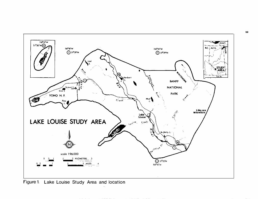
Figure 1. Lake Louise Study Area and location . . . . . . . . . . . . . . . . . . . . . . . . . . . ... . . . . . 2
Figure 2. Vegetation-soil "districts" of the Lake Louise Study Area .. ................ 1 1
Figure 3. Diagrammatic representation of an Orthic Humo-Ferric Podzol (A) and Degraded Eutric Brunisol (B) ......................................... . .... . . 1 3
Figure 4. Diagrammatic representation of an Orthic Gray Luvisol (A) and BrunisoIic Gray Luvisol (B) ...................................................... 15
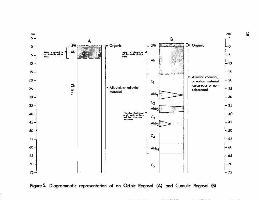
Figure 5. Diagrammatic representation of an Orthic Regosol (A) and Cumulic Regosol (B) . 1 6
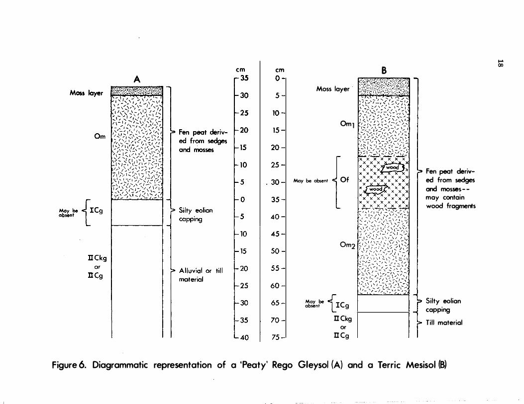
Figure 6. Diagrammatic representation of a 'Peaty' Rego Gleysol (A) and a Terric Mesisol (B) . . . . . . . . . . . . . . . . . . . . . . . . . . . . . . . . . . . . . . . . . . . . . . . . . . . . . . . . . . . . . 18
Figure 7. Diagrammatic cross section of lower elevations of the Bow River valley near vil-lage Lake Louise . . . . . . . . . . . . . . . . . . . . . . . . . . . . . . . . . . . . . . . . . . . . . . . . . . 24
vi
Figure 8. Diagrammatic cross section of Corral Creek (CC1 ) map unit; see Table 3 for com-
Page
ponent details ... . . . . . . . . . . . . . . . . . . . . . . . . . . . . . . . . . . . . . . . . . . . . . . . . . 26
Figure 9. Sketch block-diagram of a typical alluvial fan and surrounding area . . . . . . . . . . . 38
LIST OF PLATES
Plate 1. Silty (silt loam) surficial deposit, probably of eolian origin, overlying coarse-tex-tured colluvium derived from Miette Group bedrock ... . .. ... . . . . . . .. . . . ... 4
Plate 2. Upper subalpine "timberline" vegetation characterized by patches of krummholz subalpine fir (A bies lasiocarpa) in association with heath-dominated understory vegetation ..... . . . . . . . . . . . . . . . . . . . . . . . . . . . . . . . . . . . . . . . . . . . . . . . . . . . 7
Plate 3. Alpine larch (Larix lyallii) forests are usually associated with noncalcareous parent materials in the upper subalpine subzone .. ... .... ...... . . .... ... .... . ... 7
Plate 4. Engelmann spruce-subalpine fir (Picea engelmannii-Abies lasiocarpa) forests domi-nate lower slopes of the Bow River valley walls. . . . . . . . . . . . . . . . . . . . . . . . . . . . 8
Plate 5. Lodgepole pine (Pinus contorta) forests dominate the Bow River valley floor land-scape ..... " .......... .................. " . . . . . . . . . . . . . . . . . . . . . . . 8
Plate 6. Shrub thicket and herbaceous meadow vegetation is associated with poorly and very poorly drained soils on seepage discharge slopes and in depressions with high water tables, such as this narrow valley bottom . . . . . . . . . . . . . . . . . . . . . . . . . . . . 10
Plate 7. Alpine vegetation occurs on steeply sloping noncalcareous colluvium at high eleva-tions in the study area . . . . . . . . . . . . . . . . . . . . . . . . . . . . . . . . . . . . . . . . . . . . . . . 10
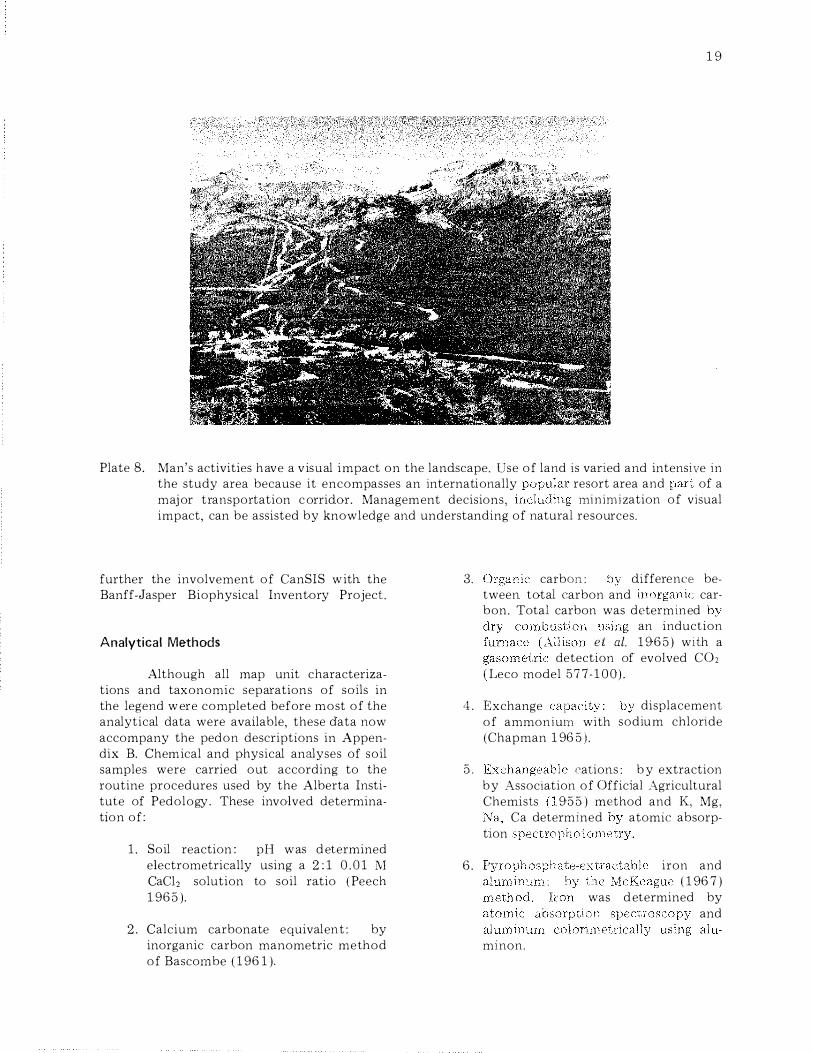
Plate 8. Man's activities have a visual impact on the landscape . . . . . . . . . . . . . . . . . . . . . . . 19
vii
PREFACE
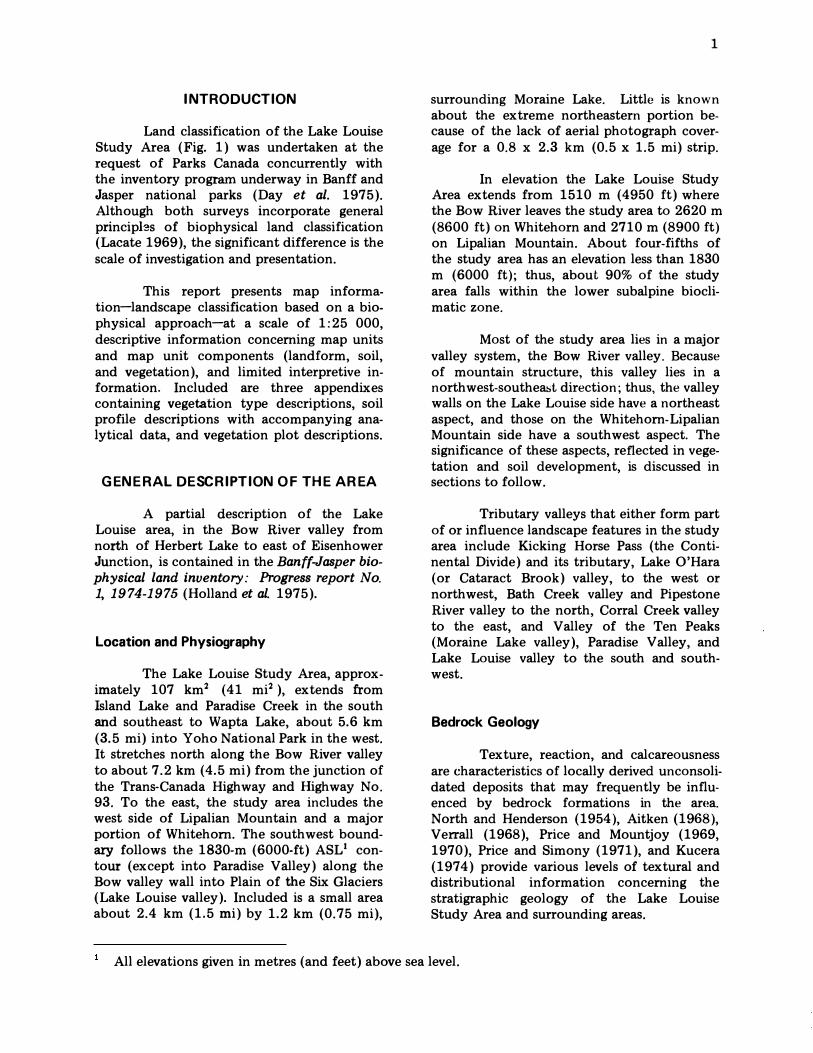
Human use of land in the vicinity of Lake Louise, Banff National Park is high, and the demand is increasing. Spectacular mountain scenery, numerous visitor and recreational facilities and services, and a major transportation corridor have created this pressure for management of national park land. Hence, the need for an integrated natural resource inventory.
Solutions to this conflict of interests are the responsibility of land use planners. Specific use interpretations and land use decisions fall outside the confines of this study. This document merely provides integrated landscape data, at the specified scale of 1 :25 000, that may serve as the basis for interpretation and decision making.
The research information in this report was collected and organized at an early stage (1974-75) of the ongoing land classification project for Banff and Jasper National Parks and presented to Parks Canada in April 1976 as an interim report. However, this in no way detracts from the accuracy of data presented; rather, new concepts in classifying or organizing the landscape and its components (vegetation, soils, landforms) have evolved. Consequently, the organization of information presented in this report is applicable only to the Lake Louise Study Area and is essen tiaUy incompatible with legends found in other Banff-Jasper project reports.
The Banff-Jasper biophysical land inventory project, initiated and funded by Parks Canada in 1974, is composed of three major agencies: The Alberta Institute of Pedology, University of Alberta; Northern Forest Research Centre, Canadian Forestry Service, Fisheries and Environment Canada; and the Soil Research Institute, Agriculture Canada. Additional information on wildlife and climate was supplied by the Canadian Wildlife Service and Atmospheric Environment Service. The landform-soil-vegetation portion of the inventory project, to be presented at a scale of 1:50 000, is slated for completion in 1981.
viii
I NTRODUCTION
Land classification of the Lake Louise Study Area (Fig. 1) was undertaken at the request of Parks Canada concurrently with the inventory program underway in Banff and Jasper national parks (Day et al. 1975). Although both surveys incorporate general princip13s of biophysical land classification (Lacate 1969), the significant difference is the scale of investigation and presentation.
This report presents map information-landscape classification based on a biophysical approach-at a scale of 1:25 000, descriptive information concerning map units and map unit components (landform, soil, and vegetation), and limited interpretive information. Included are three appendixes containing vegetation type descriptions, soil profile descriptions with accompanying analytical data, and vegetation plot descriptions.
GENERAL DESCRIPTION O F THE AREA
A partial description of the Lake Louise area, in the Bow River valley from north of Herbert Lake to east of Eisenhower Junction, is contained in the Banff-Jasper biophysical land inventory: Progress report No. 1, 1 9 74-1 975 (Holland et al. 1975).
Location and Physiography
The Lake Louise Study Area, approximately 107 km2 (41 mi2), extends from Island Lake and Paradise Creek in the south and southeast to Wapta Lake, about 5.6 km (3.5 mi) into Yoho National Park in the west. It stretches north along the Bow River valley to about 7.2 km (4.5 mi) from the junction of the Trans-Canada Highway and Highway No. 93. To the east, the study area includes the west side of Lipalian Mountain and a major portion of Whitehorn. The southwest boundary follows the 1830-m (6000-ft) ASL1 contour (except into Paradise Valley) along the Bow valley wall into Plain of the Six Glaciers (Lake Louise valley). Included is a small area about 2.4 km (1.5 mi) by 1.2 km (0.75 mi),
1
surrounding Moraine Lake. Little is known about the extreme northeastern portion because of the lack of aerial photograph coverage for a 0.8 x 2.3 km (0.5 x 1.5 mi) strip.
In elevation the Lake Louise Study Area extends from 1510 m (4950 ft) where the Bow River leaves the study area to 2620 m (8600 ft) on Whitehorn and 2710 m (8900 ft) on Lipalian Mountain. About four-fifths of the study area has an elevation less than 1830 m (6000 ft); thus, about 90% of the study area falls within the lower subalpine bioclimatic zone.
Most of the study area lies in a major valley system, the Bow River valley. Because of mountain structure, this valley lies in a northwest-southeast direction; thus, the valley walls on the Lake Louise side have a northeast aspect, and those on the Whitehorn-Lipalian Mountain side have a southwest aspect. The significance of these aspects, reflected in vegetation and soil development, is discussed in sections to follow.
Tributary valleys that either form part of or influence landscape features in the study area include Kicking Horse Pass (the Continental Divide) and its tributary, Lake O'Hara (or Cataract Brook) valley, to the west or northwest, Bath Creek valley and Pipestone River valley to the north, Corral Creek valley to the east, and Valley of the Ten Peaks (Moraine Lake valley), Paradise Valley, and Lake Louise valley to the south and southwest.
Bedrock Geology
Texture, reaction, and calcareousness are characteristics of locally derived unconsolidated deposits that may frequently be influenced by bedrock formations in the ar(�a. North and Henderson (1954), Aitken (1968), Verrall (1968), Price and Mountjoy (1969, 1970), Price and Simony (1971), and Kucera (1974) provide various levels of textural and distributional information concerning the stratigraphic geology of the Lake Louise Study Area and surrounding areas.
All elevations given in metres (and feet) above sea level.
116018'W €)SI"29'N
LAKE LOUISE STUDY AREA
o .5 I ---o .2 I
- --
� -0-
scale 1:96,000 3 KILOMETERS 5
--
_____ 3 -,MllES 4
Figure 1. Lake Louise Study Area and location
116010'W ED SI"29'N
'.
ED 5Io23'N 116olQ'W
NATIONAL PARK
I,.o�, .. r vy
.... / 6· ,6 (,
\,
.......... _ N.W.T.
B.C. i Al�;-'-'I"� : r,--JJ'� " ' \ <I' f--vl ) ?' . J \
r·J �. \ .
\ �\�-' \ �� .• STUDY\ , ' ·;"l.ARE,byi _. '-.. l'v� '
_. ,- . _ �,_._ . .l . ..... '-. U.S.A.
�
Over 80% of the study area (northeast portion) is underlain by Precambrian rocks of the Miette Group, the oldest sedimentary strata occurring in Banff National Park. This sequence consists of "slates, coarse, impure, immature sandstones or grits, and characteristic quartz-pebble conglomerates with an argillaceous matrix" (Aitken 1968). Quartzitedominated Lower Cambrian rocks of the Gog Group, exposed around Moraine Lake on the southeast side of Lake Louise valley and in a belt along the study area's west side, form lower to middle cliffs of the southern Bow Range mountain peaks. Capping these peaks and also underlying the northwest portion of the study area (Kicking Horse valley and northwest side of Lake Louise valley) are Middle Cambrian rocks of the Mt. White (limestone, siltstone, shale), Cathedral (limestone and dolomite), Stephen (limestone and shale), and Eldon (limestone and dolomite) formations.
Geomorphology
Surficial deposits in the Lake Louise Study Area have been studied by Rutter (1965, 1972), Kucera (1974), Holland et al. (1975), and Reimchen and Bayrock (1975). In the course of this investigation, modifications and additions to this information were made by members of the biophysical inventory team.
Noncalcareous Materials
Unconsolidated materials derived from Miette and Gog Group strata tend to be medium acid to neutral in reaction (calcareous and reaction classes according to Canada Soil Survey Committee 1973), nonlimey, and loam, sandy loam, or loamy sand in texture. Such deposits are local (near the source) and include glacial till (M)2, colluvium (C), and residual materials (R) in the Moraine Lake and Lake Louise (southeast side) valleys, and colluvium and residual materials on the slopes of Whitehorn and Lipalian Mountain. Terrain surface forms include fans (f), aprons (a),
3
inclined (i) and steep (s) slopes, veneers (v), and blankets (b).
Calcareous Materials
Unconsolidated materials originating from the calcareous Middle Cambrian formations but mixed with some acidic materials are moderately to very strongly calcareous and neutral to mildly alkaline. Most common is a "regionally" derived glacial till that mantles much of the Bow valley as ridged (r) moraine on lower slopes to inclined and steep moraine above. This till is finer textured and contains fewer coarse fragments (see map legend) than acidic, noncalcareous counterparts. Glaciofluvial (FG) deposits forming undulating (u) and level terraces (t) to inclined (i) slopes on or near the Bow and Kicking Horse valley floors are calcareous, as are locally derived colluvial (C) slopes on the northwest side of Lake Louise valley and in the Y oho National Park portion of the study area.
Alluvial Deposits
Alluvial (A) deposits are variable and often provide sharply contrasting landforms. Alluvial deposits originating from the acidic rock formations of the Slate Range [fan (f) and floodplain (u or 1) of Corral Creek] and the Bow Range [alluvial fans (Af) on the southwest side of the
' Bow River and along
Bath Creek] tend to be noncalcareous or weakly calcareous at considerable depth. Highly calcareous alluvial materials-notable examples include the Pipestone River fan and the upper Lake Louise fan or delta-are interpreted as originating from calcareous rock formations.
Silty Overlay
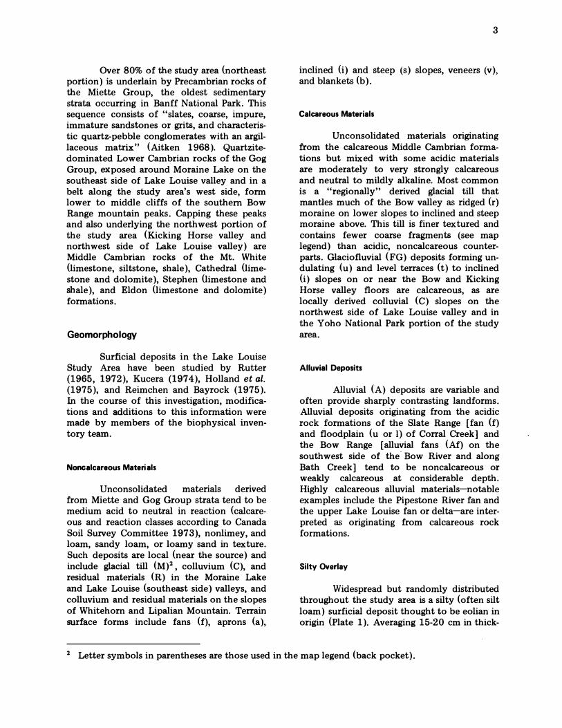
Widespread but randomly distributed throughout the study area is a silty (often silt loam) surficial deposit thought to be eolian in origin (Plate 1). Averaging 15-20 cm in thick-
2 Letter symbols in parentheses are those used in the map legend (back pocket).
4
Plate 1. Silty (silt loam) surficial deposit, probably of eolian origin, overlying coarse-textured colluvium derived from Miette Group bedrock. After an assessment of all relevant factors, land use decisions will, in most cases, be limited and/or controlled by the characteristics of only one of the two quite different materials.
ness (observed maximum thickness of 39 cm), this deposit is characterized by a medium acid to neutral reaction, a relatively low bulk density, and a fine abrasive feel attributable to a variable but moderate content of what is assumed to be volcanic ash. Least altered examples of this material can be found immediately below organic layers of many Peaty Gleysols and Organic soils. Also, a small area of silty material thought to be almost entirely volcanic ash was found on Lipalian Mountain.
Where vegetation is removed by human disturbance, the silty surface capping
results in dusty conditions during dry periods. When wet, these silty materials are slippery and highly susceptible to water erosion.
Uncommon landforms
Several somewhat unusual geomorphic features occur within the study area. Largest is a prominently ridged area (Corral Creek map unit) along the Bow River and BanffJasper Highway from village Lake Louise to about 2.5 km (1.5 mi) north of Herbert Lake. This landform features pronounced ridges of Miette Group bedrock overlain, usually on west slopes, by morainal blankets. Portions of the strongly calcareous, fine loamy till are in tum overlain by veneers of moderately to strongly calcareous, coarse loamy-skeletal to sandy-skeletal glaciofluvial materials. Deeper pockets of glaciofluvial gravels do occur, as evidenced by two gravel pits in the locality. Residual material and rock outcrops commoqly form ridge crests and east-facing escarpments. The long narrow depressions, affected by seepage and groundwater discharge, are occupied by organic materials and wet alluvium, except for the deepest one, which now contains the Bow River.
Of the two old landslides in the study area, the more renowned is the barrier that dams Moraine Lake at its outlet. Kucera (1974) provides a comprehensive discussion· of this feature, the origin of which has been debated for many years. A less conspicuous landslide (labelled TP4/g) occurs on the west side of Whitehorn at the northern boundary of the study area. Colluvium of this landslide is acidic and coarse textured, derived primarily from Miette Group slates that underlie the immediate area and form the source ridge crest of Whitehorn. Although lying on a steep slope, the landslide also has a hummocky internal relief with the steepest slopes remaining unstable and consequently unvegetated.
A fourth unique area is the valley bottom from Sink Lake to Wapta Lake in Yoho National Park. Here coarse-fragment-free, calcareous, glaciofluvial (loamy sand texture) and glaciolacustrine (silt loam texture) deposits, thought to be of ice-content origin, occur in association with glacial till. Subse-
quent postglacial downcutting by stream action affecting portions of this area and gravelly glaciofluvial materials to the east has produced rather unusual material-topographic combinations, for example, glaciofluvial gravels with 30-60% slopes. In addition, hummocky glaciofluvial areas occur in this vicinity and also north of Herbert Lake along the Banff-Jasper Highway.
Climate
Chapman (1952), Bailey (1962), and Holland et al. (1975) present data and discussion on the climate of the region. Table 1 compares temperature and precipitation for village Lake Louise, Banff townsite, and Jasper townsite (Environment Canada 1945-75). Some 63% of total precipitation falls as snow at Lake Louise, compared with 42% at Banff and 29% at Jasper. According to Koppen's climate classification (Trewartha 1957) Lake Louise has a Dfc climate (Cold Snowy Forest Climate with no distinct dry season; cool, short summer).
Unfortunately, there exist no data that characterize the macroclimatic (bioclimatic zones) and meso climatic (aspect, topography, etc.) variation within the Lake Louise Study Area. In lieu of such data, zonal and meso climatic trends are interpreted from vegetation and soil development.
Vegetation
The major portion (99%) of the mapped area (study area minus area with no photo coverage) is in the subalpine vegetation zone that is typically represented by closed climatic climax forests of Engelmann spruce (Picea engelmannii) and subalpine fir (Abies lasiocarpa). This zone is comparable to the Engelmann Spruce/Subalpine Fir Biogeoclimatic Zone in British Columbia (Krajina 1965, 1969) and has a cool, relatively dry, continental climate-Dfc climate in the Koppen system (Trewartha 1957). The lowest elevation in the study area (1510 m) is above the montane-subalpine zone boundary, which potentially ranges from 1300 m on northfacing slopes to 1500 m on south-facing
5
slopes, as inferred from the elevation of the boundary in the Banff townsite area. The subalpine zone in the study area extends upward to the alpine zone at approximately 2300 m.
Floristically, subalpine vegetation is characterized by the following species: Abies lasiocarpa, Picea engelmannii, Menziesia ferruginea var. glabella, Rhododendron albiflorum, Rosa acicularis, Salix vestita, Vaccinium scoparium, Arnica cordifolia, Carex concinna, C. scirpoidea, Comus canadensis, Elymus innovatus, Erigeron peregrinus, Linnaea borealis, Listera caurina, L. cordata, Lycopodium annotinum, Pyrola secunda, Trisetum spicatum, Barbilophozia hatcheri, Dicranum fuscescens, D. scoparium, Hylocomium splendens, Pleurozium schreberi, and Ptilium crista-castrensis.
The subalpine zone is divided into upper and lower sub zones based on climate as reflected by vegetation. Upper subalpine vegetation is characterized by krummholz dominated by subalpine fir (Plate 2) and by alpine larch (Larix lyallii) forests (Plate 3). Due to low temperatures, short growing season, and high snowfall, closed forests are generally replaced by krummholz and open forest vegetation. Alpine larch, however, is well adapted to the severe environment by its habit of shedding leaves during adverse periods. It is the only species that grows in tree form in the upper subalpine environment.
The lower SUbalpine subzone has a comparatively milder climate (higher temperature, longer growing season, and less snow) that permits better tree growth and the development of closed forests of Engelmann spruce and subalpine fir (Plate 4), and occasionally of white spruce (Picea glauca ) on alluvial habitats.
Frequent disturbances have prevented the vegetation from attaining the climax stage in many localities, and consequently, sera! vegetation is widespread. It is especially common in the main valley bottoms where lodgepole pine (Pinus contorta) forests (Plate 5) of fire origin are predominant. These stands are generally 80-90 years old and are considered to have resulted mostly from fires incident to
Table 1. Temperature and precipitation at Banff, Lake Louise, and Jasper
Month
Jan.
Feb.
Mar.
Apr. May
June
July
Aug.
Sept.
Oct.
Nov.
Dec.
Mean yearly
No. of years
BANFF: 51°11' N, 115°34' W elevation 1397 m ASL
Mean
daily temper
ature
of °c
13 -10.6
18 -7.8
25 -3.9
36 2.2
46 7.8 51 10.6
58 14.4
56 13.3
48 8.9
39 3.9
25 -3.9
17 -8.3
36 2.2
29
Mean precipi
tation
in. mm
1.3 33 1.2 30
1.0 25
1.4 36 1.8 46
2.5 64
1.7 43 2.0 5l
1.4 36 1.6 41 1.3 33 1.5 38
18.7 476
29
Snowfall in. cm
12 31
11 28
9 23
10 25
2 5
trace trace
o o
o o
2 5
8 20 10 25 14 36
78 198
29
42% of precipitation as snow
1 Extracted from Environment Canada. 1945-75.
LAKE LOUISE: 51°25' N, 116°10' W elevation 1534 m ASL
Mean daily
temperature
of °c
6 -14.4
12 -11.1
21 -6.1
33 0.6
43 6.1
49 9.4
55 12.8 52 11.1
45 7.2
36 2.2
20 -6.7 11 -11. 7
32 o
30
Mean precipi
tation in. mm
3.2 81
2.6 66
2.0 51 2.1 53 2.0 51
2.5 64
2.0 51 2.3 58 2.0 51 2.6 66 3.3 8 4 4.2 107
30.8 783
30
Snowfall
in. cm
32 81 26 66 20 51 18 46
6 15 1 3 o o
o o
2 5 17 43 32 81 41 104
195 495
30 63% of precipitation as snow
JASPER: 52°53' N, 118°04' W elevation 1661 m ASL
Mean daily
temperature
of °c
13 -10.6
19 -7.2
26 -3.3
38 3.3 48 8.9
54 12.2 59 15.0 57 13.9 50 10.0 41 5.0 26 -3.3 18 -7.8
37 3.0
25
Mean precipi
tation
in. m m
1.1 28 1 . 0 25
0.6 15
0.8 20
1.4 36 2.2 .56 2.0 51 2.2 56
1.4 1.1 1.2 1.3
36
28
31
33
16.3 415
25
Snowfall
in. cm
10 25
9 23
5 13
3 8
1 3
o o
o o
o o
trace trace
1 3 8 20
11 28
48 123
25 29% of precipitation as snow
0')

Plate 2.
Plate 3. Alpine larch rials in the
7
vegetation.
llol1caicareous parent mate-
8
Plate 4. Engelmann ) forests dominate lower fir-false azalea Type
(Type 6)
Plate 5. Lodgepole con torta) forests dominate the Bow River valley floor landscape. Associated features include th e glaciofluvial terrace along the Bow River, alluvial fans superimposed upon the terrace (center, foreground, and middle ground), and ridged glacial till benchland above the terrace.

railway construction and the operation of steam locomotives. However, the role of warmer, drier climate during this time in conditions more favorable for fires should not be overlooked. Many of these lodgepole pine forests will gradually change, via natural succession and after a considerable period of time, to Engelma.l'lH spruce-subalpine fir forests, barring further disturbances.
The nonforested vegetation types in the subalpine zone are attributed to edaphic conditions that prevent tree growth. These include shrub thickets and herbaceous meadows (Plate 6) developed on depressions and seepage discharge sites, chionophilous meadows associated with late-lying snow, grasslands on south-facing steep slopes and/or wind-exposed habitats, saxicolous vegetation on rock outcrops, and herbaceous meadows a.<;sociated with snow avalanche chutes. Such vegetation types are considered edaphic or
climax types, since they are more or less stable and are in equilibrium with the environment.
Only a small portion of the study area (Lipalian Mountain and Whitehorn) is in the alpine zone. Alpine vegetation (Plate 7) is characterized physiognomically by tundra communities of dwarf shrubs and herbs. Tree species occur only sporadically in krummholz patches. The climate is severe, with a very short growing season, and is classified ET in Koppen's system (Trewartha 1957). Characteristic species of this zone include Arenaria
obtusiloba, A. rubella, Carex nardina, C. nigri
cans, C. pyrenaica, Cassiope mertensiana, C.
tetragona, Crepis nana, Dryas octopetala var. hookeriana, Epilobium alpinum, Erigeron
aureus, Festuca brachyphylla, Haplopappus
lyallii, Juncus drummondii, Kobresia myo
suroides, Pedicularis contorta, Phyllodoce empetriformis, P. glanduliflora, Poa alpina,
P. arctica, Salix arctica, S. nivaiis, Saussurea
densa, Saxifraga oppositifolia, Sibbaldia pro
cumbens, Silene acaulis, and Taraxacum
lyratum.
Alpine vegetation exhibits an extreme-complex pattern of community composi
tion and structure because it reflects intricate micro environmental variation. In the alpine environment, small changes in environmental
factors as duration of snc)\v
soil c h aracteristics often result in vast in the
9
General Trends of Soil ciated Vegetation
and Asso-
Information on soil m the Rocky Mountain national m
the IJake I.Jouise 1S scarce. Lombard North Group Ltd. (1974) identified various "soil types" 111 Bow vaHey based primarily on broad textural groupings. Several "soil series" were identified for an area from Eisenhower ,Junction and Vermilion Pass to village Lake Louise Harris et al. (1973). Holland el af. (1975) presented a first approximation of soils and soil formation in the Bow from ,John-ston to Lake Louise.
The factors rial, climate, topography, have been discussed by many Effects and interactions of these
mate-
tive to soils found in m o untain areas of Alberta and British Columbia have also been documented va�'H::",.C 1971, Landals
Root and Knapik Knapik 1973, Knapik et
and Coen Coen and
and Knapik Sneddon et al.
aZ. 1973,
Holland 1 and Coen et al. 197 7).
Within the Lake Louise fuea, mesodimate and parent material h ave h ad the greatest effects on trends in soil development. The division of the study area into "districts" (Fig. 2) is done to different soil formation but the districts have not been incorporated into the hiprarchy
District I: Spfuce/Fir-114enziesia-Podzol
This district soils with maximum genetic development in the Lake Louise Area. to very
north- to northeast-facing slopes above 1670 m and shadE;d Mounts St. Piran and Niblock to the this district h as the coolest and moistest climate of the lower subalpine subzone. In particular, abundant snow-
10
Plate 6. S h rub thicket and h erbaceous m eadovl vegetation is associated with poorly and very poorly drained soils on seepage discharge slopes and in depressions with h igh water tables, such as this narrow valley bottom.
Plate 7. Alpine vegetation occurs on steeply sloping noncalcareous colluvium at high elevations in the study area. Note the complexity of alpine vegetation types.
� ED�
z oQ � == � «a. '"
� 9r Z � � �
...
'" '" � i '" '" w ... W M
� ;;;: 0 0 0 M
� '" ..!! 0 '" v '"
�
0 � 0
� �(]) £ z ;. '" 0 u;
� ·c ;:)
1 "0 N
:f "tI ,f
I I .S! .. .9! N c: CII � L :;: ........ CII v ;:) .. �
.� 0 .g Gi ]'2 � 0 iii::::;) �
11
� w � � >-c :::> li; w (,/) -:::> � 0 Q) ...... � « w >. � "'0 � :::::J -...... (j)
Q) .� :::::J .3 � � ...J Q) "0 "0 .c. ... 1 N -·c "tI ;:) ;:) ,f -� � 0 � -:::::. I I � :: � � .S! 'c en "C '> ;:) ! -... ;:) .. () CII � co ..c I I i- I I -:::::. �
� E � ..c � \I) :. I 1 :5 'c "'0 CII ;:) g \J .. 0.. \J co : Q. CII � ..c \I) '0 � I
CII en c: c: ii: ii: I c: 0 += � -Q) Q) � � � :t 'Q. N "0 .J:l � .J:l � 'Q. Q) ;:) .. -;( � C/) CII :::::J 8: Q) ::::;) u::
12
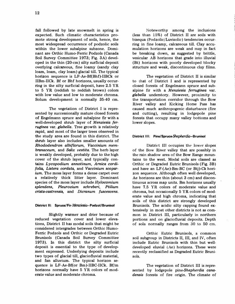
fall followed by late snowmelt in spring is expected. Such climatic characteristics promote strong development of soils, hence, the most widespread occurrence of podzolic soils within the lower subalpine subzone. Dominant are Orthic Humo-Ferric Podzols (Canada Soil Survey Committee 1973; Fig. 3A) developed in the thin (20-cm) silty surficial deposit overlying calcareous, fine loamy (sandy clay loam, loam, clay loam) glacial tilL The typical horizon sequence is LF-Ae-Bf(Bhf)-IIBCk or IIBm-IICk. Bf or Bhf horizons, usually occurring in the silty surficial deposit, have 2.5 YR to 5 YR (reddish to reddish brown) colors with low value and low to moderate chroma. Solum development is normally 35-40 cm.
The vegetation of District I is represented by successionally mature closed forests of Engelmann spruce and subalpine fir with a well-developed shrub layer of Menziesia ferruginea var. glabella. Tree growth is relatively rapid, and most of the larger trees observed in the study area are found in this district. The shrub layer also includes smaller amounts of Rhododendron albiflorum, Vaccinium membranaceum, and Salix vestita. The herb layer is weakly developed, probably due to the high cover of the shrub layer, and typically contains Lycopodium annotinum, Arnica cordifolia, Listera cordata, and Vaccinium scoparium. The moss layer forms a dense carpet over a relatively thick litter layer. Dominant species of the moss layer include Hylocomium splendens, Pleurozium schreberi, Ptilium crista-castrensis, and Dicranum fuscescens.
District II: Spruce/Fir-Menziesia-PodzoI/Brunisol
Slightly warmer and drier because of reduced vegetation cover and lower elevations, District II has modal soils that might be considered intergrades between Orthic HumoFerric Podzols and Orthic or Degraded Eutric Brunisols (Canada Soil Survey Committee 1973). In this district the silty surficial deposit is essential to the type of development expressed. Underlying deposits include two types of glacial till, glaciofluvial material, and fan alluvium. The typical horizon sequence is LF-Ae-Bf(or Bm)-IIBC-IICk. Bf/m horizons normally have 5 YR colors of moderate value and moderate chroma.
Noteworthy among the inclusions (less than 15%) of District II are soils with bisequa (Podzolic/Luvisolic) tendencies occurring in fine loamy, calcareous till. Clay accumulation horizons are weak and may in fact be breaking down, as suggested by brittle, vesicular AB horizons that grade into illuvial (Bt) horizons with poorly developed blocky structure and weak, discontinuous clay films.
The vegetation of District II is similar to that of District I and is represented by closed forests of Engelmann spruce and subalpine fir with a Menziesia ferruginea var. glabella understory. However, proximity to the transportation corridor through the Bow River valley and Kicking Horse Pass has caused much anthropogenic disturbance (fire and cutting), resulting in lodgepole pine forests that occupy many valley bottoms and lower slopes.
District III: Pine/Spruce-Shepherdia-Brunisol
District III occupies the lower slopes of the Bow River valley that are possibly in the rain shadow area of the Bow Range mountains to the west. Modal soils are classed as Orthic or Degraded Eutric Brunisols (Fig. 3B) and have an LF-(Ae)-Bm-BC (or Btj)-Ck horizon sequence. Although often well developed, Ae horizons are thin (about 3 cm) and discontinuous across map units. Bm horizons usually have 7.5 YR colors of moderate value and chroma, but occasionally 5 YR colors of moderate value and high chroma, indicating that soils of this district are strongly developed Brunisols. The acidic silty capping found extensively in most other districts is not as common in District III, particularly in northern portions and on glaciofluvial deposits. Depth of sola normally ranges from 30 to 50 cm.
Orthic Eutric Brunisols, a common soil subgroup in Districts II, III, and IV, often include Eutric Brunisols with thin but welldeveloped eluvial (Ae) horizons. These were recently reclassified as Degraded Eutric Brunisols.
The vegetation of District III is represented by lodgepole pine-Shepherdia canadensis forests of fire origin. The climate of
cm 5
o
5
10
15
20
25 May be absent
30
35
40
45
50
A IF w·�cl:�fl[·�;·�rili��f:�: Ae
- - - - - - - -
Bf
Bm or
:n Bm
- - - - - - - -- - - - - - -
III III III III III III III III III III III III II III III • III
III III III III III III • • • III III III III III III III III
III III II III III III III III III III III III III III III III III
III III III • .. III III • III III • III III III III III III
• I( • III III III III • III III III III III III III III III
IIBC __ :n Ck
or :n C
Organic
Silty eolian capping
May be absent
Al luvial. col luvial. or till material
B LFH rtill���! Ae ==�=��=�=�
. . III III • III III III III III � III III II III III II III III • III II. III III III III III
III III III III III • III III � •
•.
..
..
..
..
..
..
. I I( III III III III III III III
8m Ix III III • • III III III III I III III III III III III III • .. III III • III III III III III
III III III III III • III III .. III III III III III III III III
III III III III III III III III III III III III III III III III III
III .. III II III III III • • III III III III III III • III
III III III III III III III III III • If. III III III II III III
III III III III I( III III III III • III III III III III • III
II8C �1 ��
1-- - - -
lICk or
lIe
Organic
Si lty eol ian capping
Al luvial. col luvial. or till material
Figure 3. Diagrammatic representation of an Orthic Humo-Ferric Podzol (A) and Degraded Eutric Brunisol (8)
cm 5
o
5
10
15
20
25
30
35
40
45
50
..... CI)
14
this lower subalpine district appears to be slightly drier than in Districts I and II, possibly due to lower elevation plus the rain shadow effect of the Bow Range. These climatic conditions are favorable for fire and the establishment of lodgepole pine forests after disturbance. However, the occurrence of spruce (mostly hybrids of Engelmann spruce and white spruce) in the understory indicates that pine forests are being succeded by spruce.
The tree layer is dominated by lodgepole pine occasionally mixed with spruce. The shrub layer is generally dominated by Shepherdia canadensis, but may include Juniperus communis on steeper, drier, more exposed habitats. Major species of the weakly developed herb layer include Arnica cordifolia, Elymus innovatus, Linnaea borealis, Arctostaphylos uva-ursi, and Vaccinium scoparium. The moderately developed moss layer contains Hylocomium splendens, Pleurozium schreberi, Ptilium crista-castrensis, and Dicranum scoparium.
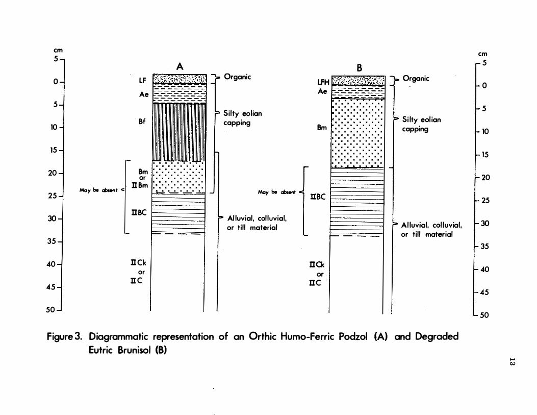
District IV; Pine-Shepherdia-luvisol /Brunisol
District IV occurs on south- to southwest-facing slopes at moderate to low elevations. Mesoclimatic conditions here are relatively warm and dry, and evapotranspiration is high. Modal soils include Brunisolic Gray Luvisols (Fig. 4B), although a few Podzolic Gray Luvisols also occur. The usual horizon sequence is L F-Ael-Bm-Ae2(or I1AB)-UBtlICk. Ae1, Bm. and Ae2 horizons are usually developed in the silty surficial deposit that occurs over much of the area. Bt horizons are normally weak and have weak, sub angular, blocky structure and thin clay skins along ped faces and in root channels. Clay increases of 10% over that of Ck horizons are not uncommon for these Bt horizons. The fine clay fraction also shows increases. Solum depths range from 30 to 50 cm in valley-bottom ridged moraines, and from 1 to 2 m on steeper morainal slopes that experience periodic seepage.
The vegetation of District IV is similar to that of District III. Physiographic position and a predominantly southwest aspect promote a drier climate than in Districts I and II in the lower subalpine subzone. Consequently,
higher rates of evapotranspiration occur, and lodgepole pine forests develop after fire.
District V: Larch- Vaccinium-Brunisol /Podzol
Soils and vegetation of the upper subalpine bioclimatic subzone belong to District V. Modal soils include Orthic Humo-Ferric Podzols and, in the timberline belt, Orthic Sombric Brunisols. Both are developed in acidic to neutral materials, usually colluvium. The silty surficial capping is fairly common. Bioclimatically, this subzone (district) is transitional between the alpine and subalpine zones. The soils are influenced by the cool temperatures and high precipitation (including late snowmelt) and thus have Bf or Bm horizons with strong colors, usually 5 YR with moderate value and moderate chroma. There is a change from Ae through Ahe to Ah (turfy) surface horizons with increasing elevation in this district. S0lum depths are variable, depending upon depth to bedrock, slope gradient, depth of surficial capping, etc. , but rarely exceed 35 cm.
The vegetation of District V corresponds to that of the upper subalpine subzone described above.
District V I : Dryas-Brunisol /Regosol
Soils and vegetation of the alpine bioclimatic zone constitute District VI. Orthic Regosols (Fig. 5A) developed in acidic materials, usually colluvium, occur on the steep slopes that characterize this zone. Orthic Sombric Brunisols occur on more stable sites. A silty surficial deposit can also be found on these more stable sites. The normal horizon sequence is LFH-Ah(turfy)-C, with solum development rarely exceeding 10 cm in depth. In addition to the turfy Ah horizons, Orthic Sombric Brunisols have brownish (10 YR colors) Bm horizons and sola rarely exceeding 25 cm in depth. The vegetation of District VI is that of the alpine zone described above.
Subareal Processes
Throughout all districts, localities occur that are undergoing or have recently
em 5
o LF
5 Ae
10
15 Bt
20 I I 25
30
35 Moy bo ...... .., BC �-or 40
45
Cca
P I I 50 I I I
Ck 55 I I
60
65
Organic
May be absent
Usually calcareous fine-loamy glacial till
Variable thickness
L
n BC
May occur at depths > 1 m n Ck
Organic
Silty eolian capping
em 5
o
5
10
15
20
25 Usual ly calcareous fine- loamy glacial � 30 til l
35
40
45
50
55
60
65
Figure 4. Diagrammatic representation of an Orthic Gray Luvisol (A) and Brun iso l ic Gray Lu v iso l (B) ..... at
cm 5 ...,
0 -1
5 -1
10
� 15
20 -I 25 -I 30 -1 35 -I 40 -I 45
� 50
:j 65
70 -I
75 ...J
LFH � 'UI:1I:' � { Ah o vor ICk-ness
Ck or C
A
I I
Organic �Y be Mlt or o voriab ick-ness
Alluvial. or colluvial material
���i�� ied =zons are var
B ,- L ;.:�.: .. :�': .. :,�.:,. \2���··:�,�?:.;:�.�5�t:� rganle FH r · · · ···t·: .. ·,,' : :n � 0 .
?I I Ah
t -Alluvial. colluvial.
C1
L or eolian material (calcareous or non-calcareous)
Ahb 1 1� C2 6. ... Ahb2
r C3 Ahb3F>- -
l ::b4 C5
Figure 5. Diagrammatic representation of an Orthic Regosol (A) and Cumulic Regosol (8)
cm .... 0') r- 5
� O
1- 5
t
10
15
� 20
I- 25 � 30
I- 35 � 40
t
45
50
[
55
60
65
t
70
75
undergone physical modification such as avalanching or flooding. Soils of such areas are Orthic or Cumulic }tegosols ( Fig. 5 ) that show little horizon differentiation other than welldeveloped Ah horizons in some cases. Portions of these localities have soils classified as relatively weak Orthic Eutric Brunisols. In such sites, deposition no longer occurs and has not occurred for perhaps more than 1 00 years. Associated vegetation is also affected by these geomorphic processes and includes herbaceous meadows, willow thickets, and open, immature forests.
Wet Soils
Poorly and very poorly drained soils are quite common throughout the study area, occurring in middle slope discharge (seepage) areas and water-accumulation depressions. Most common are the (Peaty ) Rego Gleysols ( Fig. 6A). Rego-Humic Gleysols with nearsurface Ahg horizons are common inclusions, particularly on southwest-facing lower slopes. Organic soils, relatively limited in areal extent, are usually Terric Mesisols ( Fig. 6B) and occupy the wettest positions in the landscape.
Although these wet soils do not fit the "district" concept, there are subtle trends attributable to aspect differences in the Bow River valley, particularly on middle to lower slopes. Areas mapped as CVl usually occupy cool, moist, northeast-facing slopes, as opposed to the relatively warmer southwestfacing slopes where CV3 normally occurs in discharge or water-accumulation areas. Respective patterns of soils (more Terric Mesisols than Rego Gleysols for CV 1 ; Rego and Rego Humic Gleysols greater than Terric Mesisols for CV3 ) and vegetation (mature to advanced, open spruce/fir forest with rock willow for CV1 ; intermediate to mature, open pine forest with dwarf birch for CV 3 ) reflect this mesoclimatic difference.
Organic layers of "Peaty" Rego Gleysols and Terric Mesisols are usually medium acid to neutral fen peats derived from mosses, sedges, and, to a lesser extent, wood fragments.
17
Anthropogenic Activities
The effects of man's activities on the Bow River valley are well documented by Nelson and Byrne (1969). A short discussion of the impact of humanity on the area is given by Holland et al. (1975). The Warden Service and other Parks personnel (pers. comm . ) have additional information.
Although some of the effects of mancaused fires and large-scale cutting are apparent to trained observers, they are probably not easily discerned by the average visitor to the park. Other man-made features, for example, the ski runs on Whitehorn, are highly visible (Plate 8).
METHODOLOGY
Inventory requirements for the overall inventory program (scale 1 : 50 000) are outlined in the terms of reference ( Day et al. 1 97 5 ). The main methodology is given in the Banff-Jasper bio-physical land inventory : Progress report No. 1, 1 974-1 975 (Holland et al. 1 97 5 ).
Field I nvestigation
Other than level of detail (number of site investigations per unit area), there was no difference in field investigation techniques between the 1 : 50 000 Banff National Park inventory and the Lake Louise Study Area inventory at 1 : 2 5 000.
The principal survey tool was a set of aerial photographs (scale of 1 : 1 5 000 to 1 : 20 000) taken in the late 1 960's. Field data collected in 1975 on soil investigation sites were entered on CanSIS (Canadian Soil Information System ) "Daily Field Sheet Record" forms or CanSIS "Detail Form : Field Description Input Document" forms (examples in Holland et al. 197 5 ). Most of the vegetation data from field plots examined in 1975 were entered on " Stand Description-Short Form" formats (example in Holland et al. 197 5 ), also intended for computer storage and handling by CanSIS. Holland et al. (1975) discuss
Moss layer
Oml
May be absent < Of
Om2
May be cf. C absent LI g n Ckg
or n Cg
8
l:��lr:�*�!�{�{!{iIll
Fen peat derived from sedges and mosses -may contain wood fragments
Silty eolian capping Till material
Figure 6. Diagrammatic representation of a 'Peaty' Rego Gleysol (A) and a Terrie Mesisol (8)
.... 00
1 9
Plate 8. Man's activities h ave a v is u al i mpact o n the landscape. Use o f land is varied and intensive in the study area because it encompasses an internationally resort area and of a m aj or transportation c orrid or. Managem ent decisions, minim i zation o f visual impact, can be assisted by knowledge and understanding of natural resources.
further the involvement o f CanSIS w ith the Banff-Jasper Biophysical Inventory Project.
Analytical Methods
Although all map unit characterizations and taxonomic separations of soils in the legend w er e completed before m o st o f the analytical data were available, these data now accompany the ped on descriptions in Appendix B. Chem ical and physical analyses of soil samples were carried o ut according to the routine procedures used by the Alberta Institute of Ped o l o gy . These involved determinatio n o f :
1 . Soil reaction : pH w as d etermined electrometrically using a 2 : 1 0 . 0 1 1\1 CaCh solution to soil ratio ( Peech 1 96 5 ) .
2. Calcium carbonate equivalen t : by inorganic carbon manometric m e th o d o f Bascombe ( 1 96 1 ).
3. carbon : di fference be-tween total carbon and car-bon. Total carbon was dE,term in ed
an induction et al. 1 9 6 5 ) with a
detection of evolved CO2 ( Leco model 5 77- 1 0 0 ) .
4 . Exchange displacement sodiu m chloride o f ammon i um with
(Chapman 1 96 5 ).
5 . cation s : b y extraction
6 .
b y Association o f Official Agricultural Chemists 9 5 5 ) method and K, Mg,
Ca determ ined atomic absorp-tion
m1non.
iron and B.""M�lC ( 1 96 7 )
was d etermined by and
20
7. Particle size distribution : by the pipette method of Kilmer and Alexander as modified by Toogood and Peters (1 953 ). Carbonates were not removed.
8. Available nutrients : determined by the methods used at the Alberta Soil and Feed Testing Laboratory, Edmonton. Available nitrogen (N) was estimated as nitrate-nitrogen extracted by 0.02 N CUS04 solution and determined photometrically using phenoldisulfonic acid. Available phosphorus (P) was extracted with a solution of 0.03 N Nfu F-0.03 N H2 S04 and determined by the HN03 -vanadatemolybdate colorimetric procedure (Dickman and Bray 1 940). Available potassium (K) was extracted with N Nfu OAc solution and determined by flame photometry.
Some profiles and horizons were subjected to the following field tests :
1 . Bulk density: by the soil core method. The samples were oven-dried and weighed. Calculations were based on field moist, gravel-free volume.
2. Percolation : by the method suggested by the Alberta Department of Manpower and Labor (1972). This consists of digging a hole to the desired depth and saturating for 24 hours before measuring the rate of drop of the water level in the hole.
3. Infiltration: by the double-ring method with a constant head apparatus as suggested by Adams et al.
(1957 ).
Further descriptions of these and alternative analytical procedures are contained in a manual by the Canada Soil Survey Committee (1976).
Systematics ( Legend) Methodology
Concepts of landscape systematics (legend) changed considerably over the 1 975
field season (Holland 1 976, Walker et al.
1976) from those developed in the 1 974 pilot year (Holland et al. 1975 ). For the overall park inventory these new concepts better fit both scale of mapping (1 : 50 000) and time allotment for the project.
In the interests of time, the classification system for the 1 : 50 000 park inventory was modified to apply to the 1 :25 000 inventory for the Lake Louise Study Area. The basic philosophy and rules governing map unit separations worked well at both scales. This does not mean that map units common to both inventories are interchangeable, however. Because of scale, map unit definitions for the 1 :25 000 inventory are more restricted, have narrower limits, and apply to the Lake Louise Study Area only. In addition, the lower limit of the upper suhalpine suhzone has been moved downward, and vegetation types have a different numhering (identification ) sequence in subsequent park inventory reports.
The biophysical land classification system for the Lake Louise Study Area is a four-level hierarchical system. From highest to lowest these levels are
1. Bioclimatic zones represent differences in macroclimate as expressed by vegetation. In the Lake Louise area there are two zones, represented by alpine and subalpine vegetation.
2. Bioclimatic subzones represent a further division of macroclimate as reflected by vegetation. In the Lake Louise Study Area the subalpine zone is divided into lower and upper subalpine suhzones. The lower limit of the upper subalpine subzone has been shifted downward in elevation (Walker et al. 1 976, Wells et al. 1 976) by the transfer of the Engelmann spruce/subalpine fir-grouse berry type to upper from lower subalpine vegetation, where it is grouped in this work.
3. Biophysical "names " (on legend) or
"land systems " are largely based on the physical features of the landscape and approximate the "land system"
level defined by Lacate (1 969 ) and Jurdant et al. (197 5 ). Objective and, to a lesser degree, subjective decisions concerning various features of surficial geologic materials (mode of origin, surface form, texture, calcareousness, and reaction) govern separations of land systems. Synthesis of information in the "Geologic Material Information" and "Profile Texture" columns of the map legend (back pocket) will give some insight into many of the groupings at this level. Symbols in the " Landform" column are defined in the landform classification system of Acton (1975). Criteria for defining land systems of alluvial (fluvial-F) materials are somewhat different than for other geologic materials because of the much greater local variability in characteristics of alluvial fan, terrace, and floodplain materials. For convenience, alluvial areas dominated by Regosolic soils (indicative of recent and/or current depositional activity and a high frequency of flooding) are given different biophysical names (land systems) than alluvial landscapes dominated by soils with more advanced development (Brunisols and Podzols). Wetland landscapes (dominated by Gleysols and Organic soils) are separated at the land system level. Synthesis of information in the " Subgroup Class" and "Drainage Class" columns of the legend will enable easy identification of wetland systems on the various geologic materials. A distinguishing feature of the Banff-Jasper biophysical land classification system is that land systems are basically conceptual groupings of biophysical map units rather than conceptual/cartographic groupings, as in earlier systems ( Lacate 1 969).
4. Biophysical "map units" depict soil and/or vegetation pattern variations within each land system. Included in criteria for such separations are min-or landform modifications. In soil classification hierarchy, soils of map units are identified and compared as " phases of subgroup classes". Classification to
21
the subgroup level follows the criteria of Canada Soil Survey Committee (1973). Vegetation is classified into types analogous to plant associations sensu Braun-Blanquet ( 1 932). One or more vegetation types, arranged in order of dominance, form the representative vegetation portion of a map unit.
Representative Vegetation Type
Map units often contain several vegetation types but can be characterized by a representative vegetation type or types. Representative types are relatively mature and stable (durable) in terms of plant succession, reflect model habitat conditions, and usually are dominant in the landscape. Occasionally the dominant vegetation type in a map unit is at an early stage of succession. In such cases, successionally more mature vegetation types are used to represent the vegetation of the map units. A similar procedure is followed for anthropogenic and severely disturbed vegetation associated with townsites, campsites, etc. Two or more (usually a maximum of three) vegetation types may be designated as representative for a single map unit in the following cases :
1. Map units composed of two or more distinct segments based on differing aspects (e.g., BTl ) or drainage situations (e.g. , BK1 ).
2. Map units with very complex geomorphology and relief (e.g. , CC1 ) that produce a complex of habitat conditions.
3. Map units spanning two or more relatively stable, mature vegetation types that occupy equal areas and are environmentally (e.g., TP2 ) and successionally (e.g., PR2) related. Such groupings reduce the number of map units and all simplify cartography.
The vegetation of alluvial (fluvial ) sites and avalanche slopes is composed of complex mosaics of vegetation types. No one or two types predominate, and all represent
22
habitat conditions that are maintained by geomorphic activity. Consequently, the vegetation component of such map units is represented by a vegetation type complex rather than a type or types (e.g., TPl , PIl l.
Additional Mapping Separations and Procedures
In addition to biophysical map units, the legend includes miscellaneous land systems, map unit modifiers, and spot symbols. Miscellaneous land systems and spot symbols can stand alone, but map unit modifiers must be used with biophysical map unit symbols. Miscellaneous land systems, separated according to various geologic features, apply to areas with less than 1 5% cover of higher plants.
In a number of cases a biophysical map unit and a miscellaneous land system are used together within a delineated area to indicate a complex situation (e.g., TPI + CR). This signifies that the miscellaneous feature is not a normal trait of the map unit (e.g. , BVI + RQ) or that the proportion of the miscellaneous feature exceeds defined limits (e.g., T:Pl + RQ). Regardless of the proportions of each, the map unit symbol always precedes the miscellaneous land system symbol. It is noteworthy that this order of dominance is the most common occurrence.
Spot symbols apply to various natural and man-made physical features (sometimes with vegetation implications) that are often too small to map and are not included in definitions of biophysical map units.
Map unit modifiers signify a kind of geomorphic erosion (usually active) and are based on the categories defined by Fulton et al. (1974) and Acton (1975 ). They are used on the map with biophysical map units modified by the indicated processes. Such modification is not a part of the central concepts of the affected map units; it indicates slight to significant alteration of the central concepts. This procedure helps maintain lower numbers of biophysical map units by eliminating new, infrequently mapped, erosion-modified units similar to existing ones. More specific information on individual map units and the implications of common erosional processes is presented in the map unit descriptions below.
LAND SYSTEM AND MAP U N I T D ESC R I PTI ONS
This report is accompanied by a map and legend in the back pocket containing the following information :
1 . Bioclimatic unit (expression of climate reflected by vegetation )
2. Kind of geologic material ( mode of origin)
3. Map unit name and symbol
4. Landform (mode of origin, surface form or shape)
5. Parent material reaction or calcareousness
6. Dominant slope class
7. Soil subgroup class (Canada Soil Survey Committee 1973)
8 . Dominant profile texture
9. Percentage of coarse fragments
1 0. Soil drainage class
1 1 . Representative vegetation type(s). (See Appendix A for details)
12. Vegetation physiognomy
Where possible, order of. dominance is indicated. Prevalent erosional modifiers (landform column) are also indicated where applicable. Other map information includes map unit modifiers, slope classes (dominant in each delineated area), and spot symbols.
The above information is not repeated in the following map unit descriptions except where it is necessary to draw attention to certain unit characteristics that affect interpretation for park use. In the descriptions to follow, central concepts and significant variations of the map units are presented. The representative soil sites (e.g., Site DA4083) and vegetation plots cited in the descriptions are in Appendix B.
23
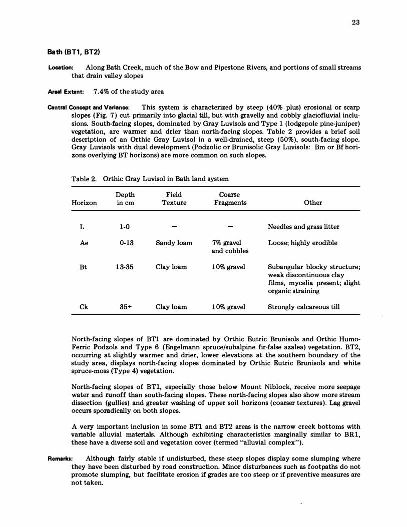
Bath (BT1, BT2)
Location: Along Bath Creek, much of the Bow and Pipestone Rivers, and portions of small streams that drain valley slopes
Areal Extent: 7 .4% of the study area
Central Concept and Variance: This system is characterized by steep (40% plus) erosional or scarp slopes ( Fig. 7 ) cut primarily into glacial till, but with gravelly and cobbly glaciofluvial inclusions. South-facing slopes, dominated by Gray Luvisols and Type 1 (lodgepole pine-juniper) vegetation, are warmer and drier than north-facing slopes. Table 2 provides a brief soil description of an Orthic Gray Luvisol in a well-drained, steep (50%), south-facing slope. Gray Luvisols with dual development (Podzolic or Brunisolic Gray Luvisols: Bm or Bf horizons overlying BT horizons) are more common on such slopes.
Table 2. Orthic Gray Luvisol in Bath land system
Horizon
L
Ae
Bt
Ck
Depth in cm
1-0
0-13
1 3-35
35+
Field Texture
Sandy loam
Clay loam
Clay loam
Coarse Fragments
7% gravel and cobbles
1 0% gravel
1 0% gravel
Other
Needles and grass litter
Loose; highly erodible
Sub angular blocky structure; weak discontinuous clay films, mycelia present; slight organic straining
Strongly calcareous till
North-facing slopes of BTl are dominated by Orthic Eutric Brunisols and Orthic HumoFerric Podzols and Type 6 (Engelmann spruce/subalpine fir-false azalea) vegetation. BT2, occurring at slightly warmer and drier, lower elevations at the southern boundary of the study area, displays north-facing slopes dominated by Orthic Eutric Brunisols and white spruce-moss (Type 4) vegetation.
North-facing slopes of BTl, especially those below Mount Niblock, receive more seepage water and runoff than south-facing slopes. These north-facing slopes also show more stream dissection (gullies) and greater washing of upper soil horizons (coarser textures). Lag gravel occurS sporadically on both slopes.
A very important inclusion in some BTl and BT2 areas is the narrow creek bottoms with variable alluvial materials. Although exhibiting characteristics marginally similar to BR1, these have a diverse soil and vegetation cover (termed "alluvial complex").
Remarks: Although fairly stable if undisturbed, these steep slopes display some slumping where they have been disturbed by road construction. Minor disturbances such as footpaths do not promote slumping, but facilitate erosion if grades are too steep or if preventive measures are not taken.
BK1
CV3 I
BK1 I '" 1 > 1
PR3
BTl I SKI Il: l d U 1
ffi I " PI! I , lU I WET I I
WiET DEPRESSION I I
>
I WET DEPRESS ION 1 � I I I DEPR. I I 1 1 I I
1 ;01"
� I I I I 1 I . '
I 1 . ' . . . . . . . . .c' . .:';;l1T
I I ' 0" Q . . . . ·0 : · · · · · · 0 " 0 " �7'l 0 . . . . . 0 . . . o . . o . . 09 /1.fJ
I I . . ' . . . . . , . . , .... · 0 iJ ' . " , 0 ' , · . O.fj o ' · ·,_<"0 · ··1)0 ° ' ·· ... 0· · o · !r
. . , . Pb" ':(1." ' . o.'fj;< ,d ,. �9't:i'·,g�·d· i;j�il!i? 'C\\\ - ''''0; 0 '' " D Q " ��
m�mri��'��h'.�:': .. �l:\��:;�:'�::';-'l'�J�r::5!Jid!J� 9: '�()�.li06<:ti!,jl�ij&·Aao:6�&Pli-:g'o i:i:6:h»,
_
g.;."'t]).�"i.o;;,� � � k!I� ___ .2.,Q.;d>-0'� LEGEND
B' -
o .5
Bedmck
Gloc;al ,m F?m Glaciofluvial _
.5 2 .5 DISTANCE FROM BOW RIVER (kilometers)
Alluvial fan h:':" ': ,;>:.j Approximate bound
. '
'. '
'. : .-ary /- - , - -
3 .5
2000
1900
-.... 1800 �
E
1 700 6 ;:: � w
1600 irl
1500
Figure 7. Diagrammatic cross section of lower elevations of the Bow River valley near vi l lage Lake Louise
�
25
Corral Creek. (CC1 )
Location: In the valley bottom along Highway 93 to about village Lake Louise and a small area near Betty Lake
Areal Extent: 4.3% of the study area
Central Concept and Variance: This system is described as strongly ridged, noncalcareous, Precambrian bedrock (Kucera 1974) exposed, in the main, on some ridge crests and nearly vertical east-facing slopes but overlain, usually on west-facing slopes, by a morainal (till) blanket or a glaciofluvial veneer over till ( Fig. 8). These three surficial materials (rock, till, and gravel) are so intimately associated that they cannot be mapped separately except at very detailed scales. The result is a diversity of soils, topography, and vegetation (Table 3).
Microenvironmentally, the CC1 unit is very complex. Vegetation Type 6a (lodgepole pinefalse azalea) dominates because of past disturbance and moist meso climatic position in the study area. Drier portions have Type 3 (lodgepole pine-buffalo berry), while more shaded, more moist positions (generally northeast-facing slopes) have Type 6 (Engelmann spruce/ subalpine fir-false azalea). Vegetation Type 14 (dwarf birch-needle rush) is more common than Type 1 0 (dwarf birch) in wet depressions.
Soils of map unit CC1 morphologically resemble those of adjacent map units. Orthic Eutric Brunisols are not unlike those of BK3 to the southeast. Orthic Humo-Ferric Podzols are similar to those of BV2 and PR2. Terric Mesisols resemble those of CV2. Rego Humic Gleysols, usually developed in recent alluvium, have a thin surface peat layer overlying a gleyed organo-mineral (Ahg) horizon that is not commonly found in wet soils of other units.
Remarks: Unconsolidated materials are, for the most part, quite stable with only minor subsur-face seepage problems. Depth of gravels and to bedrock must be considered when evaluating sites for certain activities (e.g., sewage treatment facilities). The silty surficial capping, of limited and sporadic areal extent, presents no significant problems for trail quality.
Topography presents the greatest use problems overall, particularly across the unit (southwest to northeast). Road or trail construction from northwest to southeast can follow a particular ridge since ridges are generally aligned parallel to the valley walls and Bow River. Bedrock outcrops and scarps would probably increase costs of such construction.
Wet depressions between ridges are the most ecologically fragile portions of CCl . The soils and vegetation cannot support most kinds of recreational use. Additionally, these habitats support a wide variety of wildlife, particularly birds and amphibians (D. Karasiuk, J.R. McGillis 1976, Canadian Wildlife Service, Edmonton, pers. comm. ).
Baker Creek (BK1 , BK3)
Location: Gently inclined glacial till area occupying lower slopes of the Bow Valley ( Fig. 7 ), but lying at elevations above the glaciofluvial plain (BV1 ) of the Bow River and generally separated from it by steep erosional scarps (BTl )
Area Extent: 18.5% of the study area
Central Concept and Variance: The BK system is defined as ridged moraine (glacial till) with Luvisols and Brunisols on well-drained ridge-crest and slope positions and Gleysols in long, narrow,
@ M b
. : ·�:i/2);79 Clo·c:;:e>oi' o. 0° (/0 ° g," O "r p' ''o/JY
-'
@ ,� ® 1 @ 1 CD I I M b I FG @
M b R r
Bedrock
I , I '\I
, I I
, I I, l II
I> o o tip> O G �oy , I ' 't>' OOQ./' .oO't> ,0 • ',OA· �"'"
r�"'.'!:':';"":!.�<-LI'!II': ''''i.,�"",:)<:,';.-.>t;....J.O'-<' O �O . " :('\0 0. OOO'\Y(?O¥-CJ; �<l (\O� ' O' ·"'.VIP, · o · or 'to
o o .{)oo ·O�/I.:i>"aO·/()O��� � C> '(1 o. ov0"cj �y .,'"
� ° '0'tJfJII'j).- r;o,p;.,:P��<;> · O ..... _QW-al t>;;� , 0 r\
Bedrock
@ I ® I @ 1.41 I I Mb I I I I
I ' .d?:� 'o W - . " I' 0 ot)'\)o:a " ''' ' . . � ' . . � �i-�� "'ll 0 0
tl oO�/ "-.:: .. �
.... I/) « 1650 !. z 0 i= � w .... w
w 1600 < � x 0 co: Q. Q. «
r 1 1 o 250 500
APPROXIMATE LENGTH IN METERS Figu re 8. Diagrammatic cross section of Corral Creek (CC 1 ) map unit ; see Table 3 for component deta i l s
Table 3 . Components o f Corrsl Cr�ek (CC1) map unit
Segment " ", f�" ""
( Refer to F i g . 8 ) Class
( 1 ) Glaciofluvial FGv / Mb Rap i d ly to well
over t i l l I drained
i ( 2) Ti l l slope Mb I
I We l l drained
i
( 3) Crests ( residual) Rr We l l drained
(4) Escarpments Rs Runo f f
( 5 ) Depress ions Nh & Al Poorly drained
Slope Chsrsc ter istic Gradients So11 ( s) (%)
1 0-45 Or thic Eutric Brunisols & Orthic Humo-Ferric Podzols
1 0-45 Orthic Eutric Brunisols > Orthic Humo-Ferric Podzols
4 - 1 0 Lithic Orthic Dystric Brunisols
>50 Bedrock scarps & outcrops
0-3 Terrie Mesisols &
Rego Humic Gleysols
"
Represents t i ve % Vege tat ion of
Type ( s ) Unit COIIBDents
6a > 3 , 6 3 5 On occasion extend to creat pos it ions . Deeper FG materials around gravel pits .
6a > 3 , 6 3 5 Extend to some crest posit ions ; upper slopes , slopes and crests may have silty capping .
3 > 64 , 6 5 Only some crests (narrow. higher) have so i l s in residual material .
6. esp. at toe 5 Some colluvium at toe of sCarp; of slope includes outcrops along ridge
crest s .
1 4 > 1 0 20 Usually long, narrow channels. some small streams and ponds.
-
N en
27
poorly drained depressions. Amplitude of internal relief (depression to ridge crest) is less than one-third of internal relief in map unit CCI . Also, dominant slope gradients (9-15%) are much more gentle in the Baker Creek system.
BK1 map unit has a distinct southwest aspect, whereas BK3 occupies relatively gentle , northeast-trending slopes or areas slightly farther north where precipitation may be slightly higher.
Well-drained portions (80%) of the BK1 map unit have Brunisolic Gray Luvisols (Site DA4083) as dominant, and Orthic Eutric Brunisols as subdominant soils. Inclusions of Podzolic Gray Luvisols and Orthic Humo-Ferric Podzols occur. The dominating vegetation type on these soils is lodgepole pine-buffalo berry (Type 1; Plot KS5025).
BK3 has a less pronounced ridged surface form than BKI. Hence, simple slopes predominate and narrow wet depressions are less frequent. Well-drained portions (about 90%) of the BK3 unit have as dominant soils Orthic Eutric Brunisols. Notable inclusions are Brunisolic Gray Luvisols (mostly to the south) and Orthic Humo-Ferric Podzols (mostly in northern parts). Vegetation Type 6a (lodgepole pine-false azalea) is characteristic, but inclusions of Type 3, to the south at lower elevations, and Type 6, at higher elevations, occur.
Poorly drained portions of both Baker Creek map units (20% or less in BK1, 10% or less in BK3) occupy long, narrow depressions that are too small to map at a scale of 1 :25 000. These channels receive seepage and runoff waters and are particularly wet in spring to early summer but considerably drier during the late summer. Most of them are miniature areas of CV3 and are dominated by Rego Gleysols (Site DA4085) and dwarf birch (Type 3) vegetation (Plot KS5032). Occurring infrequently are depressions that resemble the CV2 map unit and have Terric Mesisols and dwarf birch-needle rush (Type 14) vegetation. These depressions do not show conspicuous drying over the summer season.
Remarks: Stability of the fairly compact calcareous till dominating this system is usually good. There are, however, a few places where slumping has occurred or is in progress. Mass movement of material has occurred on portions of a high, very steep road cut near the lower end of the Whitehorn Ski Road. This is probably a result of subsurface seepage combined with an overly steep gradient on the road cut. A short distance south of the Lake Louise Study Area, Baker Creek has dissected BK1 till, producing a long, narrow winding creek channel with steep erosional slopes (BT System). Slumping, primarily solifluction (saturated earth flow), occurs periodically on some places along these steep slopes, particularly below the small wet depressions of the BK1 map unit.
An area south of village Lake Louise and labelled as BK3F* is unique. Its boundary roughly coincides with the area of potential landslide delimited and investigated by TES Research & Consulting Ltd. (1973). Although the area has unusual landscape features, it was felt that it best fit the BK3 concept. It is the steepest-sloping and wettest of the BK3 units. Some minor gullying has occurred. Apparently, subsurface seepage is the prime factor responsible for slope instability in this area. Wetness of the BK3F* area is evidenced by the common occurrence of gleyed Brunisols and the number of CV1 areas in the immediate vicinity. Although minor slope failure has occurred in BK3F*, the " F" primarily indicates potential slope failure (failed slopes defined by Fulton et al. 1974, Acton 1975, Reimchen and Bayrock 1975). The silty surficial capping occurs extensively over the Baker Creek units, influencing certain recreational uses (e.g., trail dustiness and slipperiness).
Soils and vegetation of wet depressions in both BK units cannot support most recreational uses. In addition, these small areas are quite important for most wildlife, in particular, browse for ungulates (Courtney et al. 1975) and forest edge for certain bird species (D. Karasiuk 1975, J. Woolford 1975, Canadian Wildlife Service, Edmonton, pers. comm.).
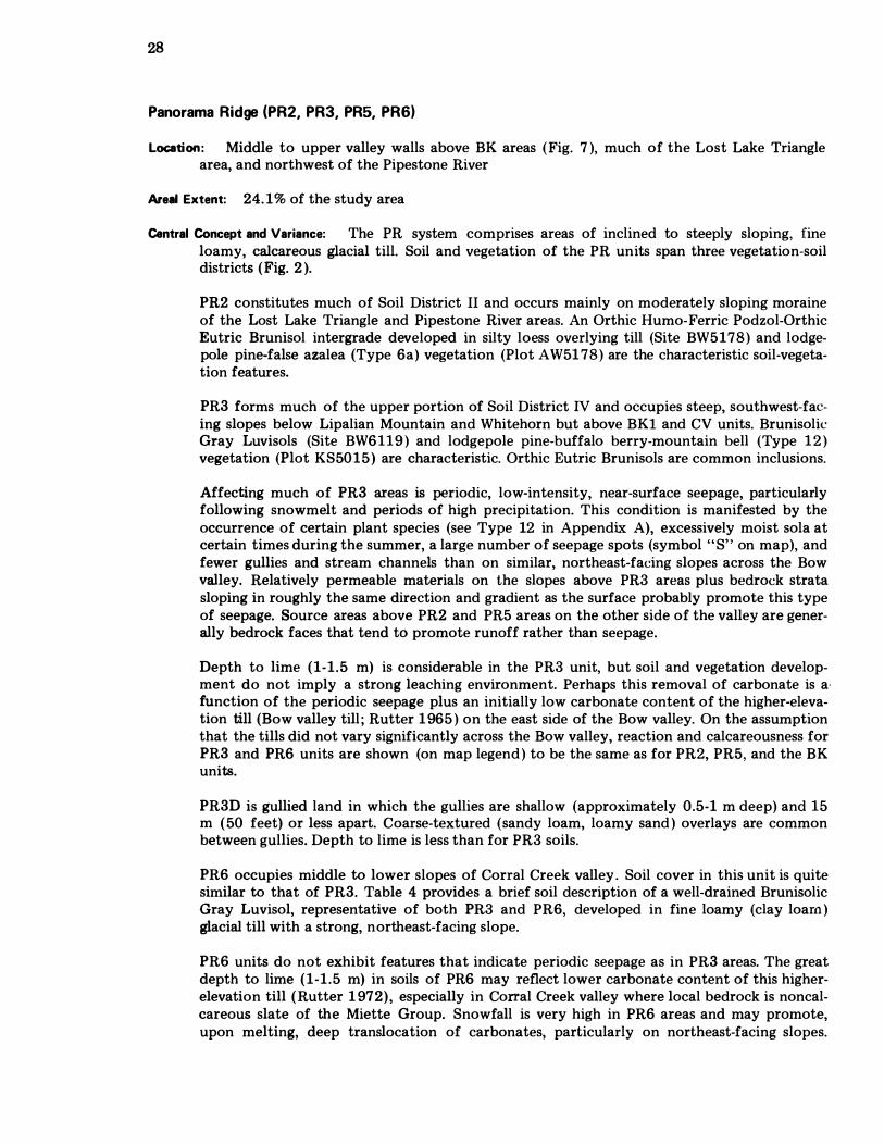
28
Panorama Ridge (PR2, PR3, PR5, PR6)
Location: Middle to upper valley walls above BK areas ( Fig. 7 ), much of the Lost Lake Triangle area, and northwest of the Pipestone River
Areal Extent: 24. 1% of the study area
Central Concept and Variance: The PR system comprises areas of inclined to steeply sloping, fine loamy, calcareous glacial till. Soil and vegetation of the PR units span three vegetation-soil districts ( Fig. 2 ).
PR2 constitutes much of Soil District II and occurs mainly on moderately sloping moraine of the Lost Lake Triangle and Pipestone River areas. An Orthic Humo-Ferric Podzol-Orthic Eutric Brunisol intergrade developed in silty loess overlying till (Site BW5178) and lodgepole pine-false azalea (Type 6a) vegetation (Plot AW51 78) are the characteristic soil-vegetation features.
PR3 forms much of the upper portion of Soil District IV and occupies steep, southwest-facing slopes below Lipalian Mountain and Whitehorn but above BKI and CV units. Brunisolie Gray Luvisols (Site BW6 1 1 9 ) and lodgepole pine-buffalo berry-mountain bell (Type 1 2 ) vegetation (Plot KS50 1 5 ) are characteristic. Orthic Eutric Brunisols are common inclusions.
Affecting much of PR3 areas is periodic, low-intensity, near-surface seepage, particularly following snowmelt and periods of high precipitation. This condition is manifested by the occurrence of certain plant species (see Type 12 in Appendix A), excessively moist sola at certain times during the summer, a large number of seepage spots (symbol " S" on map), and fewer gullies and stream channels than on similar, northeast-facing slopes across the Bow valley. Relatively permeable materials on the slopes above PR3 areas plus bedrock strata sloping in roughly the same direction and gradient as the surface probably promote this type of seepage. Source areas above PR2 and PR5 areas on the other side of the valley are generally bedrock faces that tend to promote runoff rather than seepage.
Depth to lime (1-1.5 m) is considerable in the PR3 unit, but soil and vegetation development do not imply a strong leaching environment. Perhaps this removal of carbonate is afunction of the periodic seepage plus an initially low carbonate content of the higher-elevation till (Bow valley till ; Rutter 1 965 ) on the east side of the Bow valley. On the assumption that the tills did not vary significantly across the Bow valley, reaction and calcareousness for PR3 and PR6 units are shown (on map legend ) to be the same as for PR2, PR5, and the BK units.
PR3D is gullied land in which the gullies are shallow (approximately 0.5-1 m deep) and 15 m ( 50 feet) or less apart. Coarse-textured (sandy loam, loamy sand ) overlays are common between gullies. Depth to lime is less than for PR3 soils.
PR6 occupies middle to lower slopes of Corral Creek valley . Soil cover in this unit is quite similar to that of PR3. Table 4 provides a brief soil description of a well-drained Brunisolic Gray Luvisol, representative of both PR3 and PR6, developed in fine loamy (clay loam ) glacial till with a strong, northeast-facing slope.
PR6 units do not exhibit features that indicate periodic seepage as in PR3 areas. The great depth to lime (1-1.5 m) in soils of PR6 may reflect lower carbonate content of this higherelevation till ( Rutter 1 972), especially in Corral Creek valley where local bedrock is noncalcareous slate of the Miette Group. Snowfall is very high in PR6 areas and may promote, upon melting, deep translocation of carbonates, particularly on northeast-facing slopes.
29
Table 4. Brunisolic Gray Luvisol in Panorama Ridge land system
Depth Field Coarse Horizon in cm Texture Fragments Other
LF 4-0 Partially humified needles and other plant debris
Ae 0-5 Fine sandy None Eluviated portion of silty loam eolian capping
Bm 5-16 Silt loam None Lower portion of silty eolian capping
IIAe 16-20 5% gravels Discontinuous horizon 5% stones
IIAB 20-29 5% gravels 5% stones
Iffit 29-69+ Clay loam 15% angular Subangular blocky structure; gravels prominent clay films in root 5% angular channels and on ped surfaces; stones quite dense
Vegetation of PR6, Engelmann spruce/subalpine fir-grouse berry (Type 5), indicates transition to the upper subalpine environment, with a few plant species typical of alpine environments.
PR5, the moistest and coolest of the PR units, belongs to Vegetation-Soil District I (Fig. 2). Dominant soils are Orthic Humo-Ferric Podzols developed in a silty capping overlying calcareous, clay loam to sandy clay loam glacial till (Site BW5179). Forested gullies are a common featUre of this unit. Soil development in gullies is quite similar to that of Site BW5179, but profile textures are usually coarser (sandy loam), particularly along gully margins. Dominant and quite uniform vegetative cover is provided by Engelmann spruce/subalpine fir-false azalea (Type 6 ). Areas extensively affected by avalanching (now inactive) are mapped as PR5A. These old avalanche tracks have essentially the same type of soils that occur in nonavalanched areas. Except for much smaller and more closely spaced trees, the vegetation type is the same as in undisturbed portions.
Remarks: Till of the PR units is quite similar to till of the Baker Creek system, but in most cases forms much steeper slopes. Thus, disturbances such as road and trail cuts promote some soil creep of upper horizons. The steeper slopes necessitate construction design that will minimize erosion by running water. Periodic seepage and the lack of carbonates in the surface 1-2 m cause a greater degree of material instability in PR3 areas than in other PR units. Evidence of instability and water erosion occurs along the Whitehorn Fire Road below the Whitehorn Teahouse. Similar problems may also occur in PR6 areas, but to a lesser degree because slope gradients are generally not as steep. Suitability of PR2 areas for recreational uses is very similar to BK1 and BK3 units.
30
Except for small seepage spots and disturbed open areas, the PR units, because of mature vegetation, are relatively unattractive for most forms of wildlife (D. Karasiuk 1 976, pers.
comm. ).
Due to their middle to upper valley wall position in the landscape, PR3, PR5, and PR6 areas are thought to play important hydrological roles within the study area. As well as the periodic seepage feature (PR3), these heavily forested slopes accumulate considerable amounts of snow during the winter and release it slowly as runoff and groundwater over the spring and early summer.
Moraine Lake (ML 1 )
Location: Forms the walls of tributary valleys (e.g., Valley of the Ten Peaks, Paradise Valley, and Lake Louise valley ) and medial moraine ridges separati ng these valleys from the Bo w River
valley
Areal Extent: 2.1% of the study area
Central Concept and Variance: Soil development in the MLI unit is considered equivalent to that in the PR2 units, but with a higher incidence of Orthic Humo-Ferric Podzols (Site BW4088). Vegetation and slope are similar to the PR5 unit-steep to very steep slopes with Engelmann spruce/subalpine fir-false azalea (Type 6 ; Plot KS5031 ). Forested gullies are common. The main difference lies in geologic material characteristics. MLI occurs in non- to weakly cal
careous, coarse-textured (sandy loam to loamy sand) glacial till as opposed to the ca1eareous, fine-loamy till of the PR units. Soils of MLI are also significantly more cobbly and stony. Codominant soils of MLI are classed as Orthic Dystric Brunisols because of low pH values « 5.5) throughout their sola.
Remarks: Although the till is very low in carbonates, the coarse texture and moderate coarsefragment content result in good stability of slopes. Disturbances such as road and trail cuts encourage minor soil creep of upper horizons, usually the silty surficial capping plus over
lying litter layer. However, the MLI unit appears to be susceptible to water erosion because -of coarse textures and several small streams occurring on these slopes. In addition, the fairly large numbers of quartzite stones and boulders, particularly in and adjacent to gullies, would affect trail construction costs.
MLI is relatively unsuitable for wildlife, but because of its position in the landscape, is probably important hydrologically.
Consolation Valley (CV1 , CV2, CV3)
Location: Middle to lower valley slopes between Baker Creek and Panorama Ridge un its (p.g., large CV3 area in Fig. 7 ); also associated with SKI, BK3, and Plt2 anms (p.g., small CV2 and CV 3 areas in Fig.- 7 )
Areal Extent: _ 1 1.3% o f the study area
Central Concept and Variance: The Consolation Valley map units encompass complex patterns of organic and mineral-gley soils with subdominant (less than 40%) drier soils. The small, commonly long and narrow depressions of CV2 and CV3 associated with BKI, BK3, and
31
PR2 map units are probably produced by discharge from local groundwater systems and collection of runoff waters. The larger CV areas that occur in lower to midvalley wall positions between inclined to steeply sloping moraine (PR units) and ridged moraine (BK units) may be produced by discharge from subregional or intermediate groundwater systems. In other words, recharge areas for the larger CV units probably are upper valley slopes and mountain tops. CV wetlands are minerotrophic (mineral-rich, slightly acid to neutral reaction). Relatively unaltered layers of the silty loessal capping are frequently found beneath the organic layers in the wet soils of all CV units.
North-south aspect and varying amounts of seepage water result in soil and vegetation differences among the CV units. CV1 occupies the cooler northeast-facing slopes and is characterized by relatively steep slopes (usually 10-20% overall gradient), a patchy, somewhat open forest (Engelmann spruce/subalpine fir-rock willow, Type 7 ; Plot KS5091, and wet soils dominated by Terric Mesisols (Site JT5004) with subdominant Rego Gleysols (Om-Ckg horizon sequence) developed in calcareous clay loam to sandy clay loam till. These two subgroups have a similar horizon sequence, but the organic soils (Terric Mesisols) have deeper accumulations (average 40-65 cm) of organic material. Short, very steep (25-40% slope gradient) slopes occupy about 20% of CV1 areas. These risers, a feature of past slope failure (rotational block slumping), have a variable soil cover (Orthic Eutric Brunisols, Orthic Regosols, and Gray Luvisols) and variable texture but a fairly uniform plant cover (Engelmann spruce/subalpine fir-false azalea, Type 6 ).
The CV3 map unit is slightly drier overall than CV1 because it usually occurs on southwestfacing slopes or in landscape positions where seepage decreases significantly during the summer season. Thus, CV3 areas are very wet in spring and early summer but drier than CV1 or CV2 units by early to mid-August. Wet portions (commonly about 70%) of CV3 units are dominated by Rego Gleysols (Om or Oh-Ckg horizon sequence ) and Rego Humic Gleysols (Om or Oh-Ckg horizon sequence) in calcareous fine loamy till and by the sparsely treed dwarf birch (Type 1 0 ) vegetation. Terric Mesisols may be found in the wettest positions. Organic layers in soils of CV3 units are slightly more humified than counterparts in CV1 and CV2 units. Dry portions of CV3 areas may be steep, short risers (a result of slope failure in the past) or slightly elevated, densely forested islands. These have a variety of soils (Orthic Eutric Brunisols are dominant) and profile textures (generally slightly coarser than in wet parts). Representative vegetation of dry parts is the lodgepole pine-false azalea (Type 6a) at higher elevations or the lodgepole pine-buffalo berry (Type 3) at lower elevations.
CV2 is considered the wettest of the Consolation Valley units over the summer period. CV2 areas are usually small, relatively level, treeless fens occurring within or adjacent to other CV units. Terric Mesisols (greater than 40 cm of fen peat) are the dominant soils (Site BW4077). Rego Gleysols, with surface organic horizons less than 40 cm in thickness, occur near the margins and in infrequent tree islands. Vegetation cover of CV2 units is fairly uniform and represented by dwarf birch-needle rush (Type 14; Plot KS5086). Drier segments, as described for the CV1 and CV3 units, do not occur in CV2.
Remarks: The soils and vegetation of the Consolation Valley system cannot support most kinds of recreational use. In addition, distribution, size, and shape of CV areas affect costs of development such as trails and roads because special construction techniques (raised beds, bridges) or rerouting may be required to minimize use impact.
Habitats provided by the CV units support a diversity of wildlife. In particular, browse and herbaceous forage for ungulates are abundant (Courtney et al. 1 975, D. Karasiuk 1 976, Canadian Wildlife Service, Edmonton, pers. comm. ). Transitional margins to adjacent forested map units may provide favorable habitat for some songbirds (J. Woolford and D. Karasiuk 1976, pers. comm. ). CV units probably provide favorable habitat for amphibians.
32
Ten Peaks (TP1, TP2, TP3, TP4)
Location: Middle to upper, steep valley walls in Lake Louise and Moraine Lake (Valley of the Ten Peaks) valleys and on Whitehorn and Lipalian Mountain
Areal Extent: 3.8% of the study area
Central Concept and Variance: Ten Peaks units occur on various landforms composed of noncalcareous, medium acid to neutral, loamy (usually sandy loam)-skeletal colluvial material. Lithologic sources for this colluvium include slates of the Miette Group on Whitehorn and Lipalian Mountain and slates plus quartzites of the Gog Group in Lake Louise and Moraine Lake valleys. TP units are forested, unless frequently avalanched, and belong to the lower subal
pine bioclimatic unit.
TPl encompasses shallow colluvium over bedrock, Orthic Humo-Ferric Podzols and Orthic Dystric Brunisols (mostly Lithic), and Engelmann spruce/subalpine fir-grouse berry (Type 5 ; Plot KS5148) or, less frequently, Engelmann spruce/subalpine fir-false azalea (Type 6) vegetation. Pockets of shallow, noncalcareous, fine loamy (loam, clay loam, or sandy clay loam ) till are common, as are outcroppings of local bedrock. The silty loessal capping is fairly common, though not as extensive as on the tills described in preceding pages, and promotes more advanced soil development (Orthic Humo-Ferric Podzols; Site BW Tower 8). Development in these Podzols is comparable to that in the Lost Lake Triangle area on PR2, BV2, and AL2 units. Consequently, TP units belong to Vegetation-Soil District II. Soil inclusions include Brunisolic and Podzolic Gray Luvisols (Site BW Tower 9) generally developed in the till pockets. Vegetation Type 5 is dominant and occurs on drier portions and at higher elevations. Type 6 occurs in moister and cooler sites, generally at lower elevations. In TPl areas where exposed bedrock exceeds 30%, the symbol TP1 + RQ is used.
TP2 encompasses thicker colluvial deposits of apron, fan, and steeply sloping landforms with forest cover. The silty surficial capping is not quite as widespread as in TP1 ; consequently, Orthic Humo-Ferric Podzols are not as common as in TPl . Orthic Dystric Brunisols and Orthic Humo-Ferric Podzols (similar to those described above but deeper) are designated as codominant soils. Engelmann spruce/subalpine fir-grouse berry (Type 5 ) and subalpine fir-gray willow-grouse berry (Type 5a) are representative vegetation types. Type 5a . occurs on slightly steeper, less stable slopes and has a partially open forest cover.
TP3 includes thick colluvial deposits on nonforested apron and fan landforms. In essence these are recently vegetated talus cones. Because of frequent avalanching and/or recent geomorphic stabilization, TP3 areas have a complex, shrub-dominated vegetation and juvenile soils. Shrubs, often willow, and herbs have variable cover depending on local site conditions. However, the richest and most diverse plant cover occurs on talus slopes situated below couloirs where intermittent streams have deposited alluvial material in the rubbly talus. The silty capping rarely occurs in TP3. However, the most significant feature of soils in TP3 is a thick, humus-rich Ah horizon at the soil surface. Dominant soils are Cumulic Regosols that have, below the surface Ah, buried Ah horizons or highly variable organic matter content with increasing depth-situations indicating periods of geomorphic deposition following periods of relative stability, plant colonization, and humus production and incorporation. The subdominant Orthic Regosols have, below the surface Ah horizon, a fairly uniform geologic material that is low in organic matter.
Patches of nonvegetated colluvial rubble (generally stony and bouldery with few fine earths)
that were too small to map individually as CR are included within the concept of TP3, provided that they do not exceed 30% of any TP3 area. TP3 areas with greater than 30% of colluvial rubble (talus) are mapped as "TP3 + T". Normally, TP3 areas have 15-20% colluvial rubble inclusions.
33
TP4 is a unique area of inclined and hummocky colluvium near the northern boundary on the west slope of Whitehorn. The more stable, forested portions (about 70%) have Orthic Dystric Brunisols and Engelmann spruce/subalpine fir-grouse berry (Type 5) vegetation. Very steep, unstable portions (about 30%) have Orthic Regosois, usually lacking thick, humus-rich, surface horizons and a sporadic plant cover that includes the tree, shrub, and some herb elements of Type 5. The overall appearance is one of an open but patchy forest occupying a steep, irregular slope.
Remarks: Colluvium of the TP units lacks carbonate and, therefore, the binding qualities imparted by it. However, TP units are dry and, in most cases, composed of angular rubbly material and fine earths (poorly sorted, loose mass of fine earths, gravels, cobbles, and stones)characteristics that compensate for lack of lime and impart some stability to TP landforms. Thus, most TP areas will support such things as trails, provided that proper design precautions against erosion by water are taken and that cuts for trail placement do not exceed the angle of repose (33-37° ). Stability is much lower in places with well-sorted, usually thin, flat, shaly or slaty fragments that have their long axes oriented downslope. Such situations occur more frequently in TP1 and TP4 than in TP2 and TP3 and should be avoided for most types of development. Nonvegetated areas usually have these unstable slopes or stony to bouldery colluvium lacking in fine earths. The latter condition affects costs of trail construction. Rockfall may also be expected on nonvegetated talus in portions of TP3. In general, TP4 is considered too unstable for most types of recreational development other than perhaps a well-placed and well-designed trail.
Because of their landscape position, TP1 and TP2 units probably are important hydrologically.
Some of the TP3 areas provide a rich and diverse plant cover favored by certain ungulates (McGillis et al. 1976). In addition, TP3 areas are favored by small burrowing mammals.
Sawback (881, 882, SB3)
Location: Northwest side of Lake Louise valley and at higher elevations in the Kicking Horse River valley west of the Great Divide
Areal Extent: 1 .7% of the study area
Central Concept and Variance: The Sawback system is very similar to the Ten Peaks system, but occurs instead on calcareous, fine-textured (loam to silt loam with 30-90% angular coarse fragments) colluvium that has originated from Middle Cambrian limestone, dolomite, siltstone, and shale formations.
SB1 is the forested counterpart of TP2, but due to the presence of calcium carbonates, has less advanced soils (Orthic Eutric Brunisols dominating over Orthic Regosols). The silty surficial capping is not extensive in SBl. Greater moisture retention, later snowmelt, and lower elevations probably allow for the dominance of Engelmann spruce/subalpine fir-false azalea (Type 6) vegetation rather than Type 5 as in TP2.
SB2, except for the parent material characteristics, is almost identical to TP3. Surface organo-mineral horizons (Ah) are perhaps better expressed and deeper in SB2 than in TP3. Lack of trees is the result of frequent snow-avalanche activity.
SB3 is the calcareous, finer-textured counterpart of TPl. However, pockets of till and exposed bedrock sites are less common, soil development is less advanced (Lithic Orthic
34
Eutric Brunisols greater than Lithic Orthic Regosols), and vegetation Type 6 ( Engelmann spruce/subalpine fir-false azalea) dominates.
Remarks: Colluvium of the SB system is more stable than that of the Ten Peaks system because of the high lime content and abundance of poorly sorted, angular coarse fragments. Trails located on these units are generally stable and in good condition. Very steep to extreme slopes can create some construction problems. Water erosion must be prevented, because the fine earths are easily removed. Road construction is not recommended for either the TP or SB units with thick colluvial deposits because slopes are too steep, and excessive undercutting (cut and fill construction techniques ) would be involved.
SBl and SB3 are hydrologically important (landscape position ) ; SB2 provides favorable habitat and forage for wildlife.
Dennis (OS1 )
Location: Between Wapta Lake and the Great Divide in the Kicking Horse River valley bottom
Areal Extent: 0.2% of the study area
Central Concept and Variance: The DS unit occupies small, level to moderately sloping, glaciolacustrine pockets that belong to ice-contact materials characterizing the valley bottom area between Wapta and Sink lakes. This calcareous, silt loam, coarse-fragment-free, glaciolacustrine material overlies calcareous, fine loamy glacial till. Orthic Eutric Brunisols with fairly well developed profile morphology are the dominant soils; lodgepole pine-false azalea (Type 6a) vegetation is representative. This unit falls into the Spruce/fir-Menziesia-Podzol-Brunisol District ( II). Additional information is contained in the Yoho National Park soils study (Coen et al. 1977).
Remarks: Good drainage and topography plus the binding qualities associated with lime-containing materials are features that imply a high potential for recreational development. However, this glaciolacustrine material may compact with high-intensity use and is probably moder- · ately susceptible to water erosion following disturbance. Any part of this material that is subject to subsurface seepage will solifluct. Examples of solifluction in very small pockets of glaciolacustrine material occur along Highway l A in Yoho National Park.
Bow Valley (BV1, BV2, BV3)
Location: In valley bottoms along the Bow River, through the Kicking Horse Pass area, and adjacent to the Corral Creek system
Areal Extent: 7.7% of the study area
Central Concept and Variance: The Bow Valley units encompass calcareous glaciofluvial materials of plain and terraced landforms, usually with a gently undulating internal relief. In ice-contact areas west of Kicking Horse Pass and north of Herbert Lake, hummocky glaciofluvial areas with a complex topography occur. Postglacial downcutting by stream activity has produced inclined and steeply sloping glaciofluvial landforms in the Kicking Horse Pass area.
Glaciofluvial material of BVl and BV2 is coarse loamy to sandy (sandy loam to loamy sand) and contains more than 50% coarse fragments that are usually dominated by gravels and
35
cobbles. Stones occur throughout and dominate the coarse fragment fraction in certain localities. Glaciofluvial material of BV3 has a loamy sand texture, but contains very few coarse fragments. It is associated with the ice-contact complex in Yoho National Park. All BV units have extensive, shallow, silt loam cappings of variable thickness. In BV1 the capping is thought to be of alluvial or alluvial-eolian origin and tends to have a higher bulk density than the eolian capping of BV2 and BV3.
BVl occurs in the southern part of the study area and belongs to Vegetation-Soil District III (Pine/spruce-Shepherdia-Brunisol). Soils and vegetation of BV1 reflect dry conditions. Orthic Eutric Brunisols (Site DA4077) are the dominant soils. Lodgepole pine-dwarf huckleberry (Type 2) vegetation is representative, although much disturbed vegetation and introduced plants occur. Small, wet areas of recent alluvium along the Bow River are included in the BVl map unit concept. BVl areas with bedrock outcrop inclusions (about 1 5%) are mapped as "BVl + RQ". These occur near the junction of the Trans-Canada and 1A Highways.
BV2 and BV3 belong to the more moist Spruce/fir-Menziesia-Podzol-Brunisol District (II). Land surfaces of these units are thought to be slightly older than the BV1 unit. Both soils and vegetation of BV2 and BV3 are distinctly more advanced. Vegetation of both units is represented by Type 6a (lodgepole pine-false azalea; Plot AW5177). Based on field examinations, the dominant soils of BV2 were labelled as Orthic Humo-Ferric Podzol-Orthic Eutric Brunisol intergrades. Chemical analyses indicate that these are in fact Orthic Eutric Brunisols (Site BW5l77). Except for slope and landform surface expression differences, BV2 and BV3 units are fairly uniform. Minor wet depressions are associated with hummocky glaciofluvial areas. Some of the BV2 delineations in the Lost Lake Triangle and Bath Creek areas represent immediate postglacial drainage channels that are elevated 30-50 m above presentday stream channels. Glaciofluvial materials in these channels overlie calcareous, fine loamy glacial till and, occasionally, hedrock.
Remarks: The level topography, abundance of gravels, and landscape position (valley bottom) are conducive to intensive development, especially road and railway construction. For much of their routes through the mountains the Trans-Canada Highway, Highway lA, and Canadian Pacific Railway are located on glaciofluvial terraces belonging to the BV system. Attendant problems include abandoned gravel pits and dumps and extremely high use associated with ease of access. Results of intensive use (e.g., loss of natural vegetation and revegetation difficulties) and the numerous management problems (e.g., attraction of certain wildlife species to herb species along roadways and railways) may be observed on the outskirts of village Lake Louise.
The coarse texture of glaciofluvial material becomes a disadvantage when associated with certain implications of high-intensity use. The BV units (especially BVl) tend to be relatively droughtly and, for this reason, are moderately difficult to revegetate following disturbance. This problem is amplified if limey material is brought to the surface. Sewage treat· ment and discharge systems are necessary in intensively used areas (settlements and campgrounds). If used for sewage disposal, the highly pervious glaciofluvial materials pose a pollution hazard. Consequently, more expensive sewage treatment installations such as clay-lined sewage lagoon systems are necessary on BV and most alluvial fan units. This highly pervious material also allows water table levels to fluctuate with the rise and fall of river levels.
Apparently the BV units are relatively unsuitable for ungulates other than as access, migration, and cover areas; part of this use is an indirect result of the highly desirable forage introduced by man along road and railway rights-of-way (D. Karasiuk 1976, Canadian Wildlife Service, Edmonton, pers. comm.).
36
Pipestone (P1 1 )
Location: At the mouth of the Pipestone River at village Lake Louise, near Moraine Lake, and in Yoho National Park between Wapta and Sink lakes
Areal Extent: 1 . 0% of the study area
Central Concept and Variance: The central concept for the Pipestone unit (PH ) is based on the alluvial fan located at the confluence of the Pipestone and Bow rivers at village Lake Louise (Fig. 7 ). This fan consists of gravelly, coarse-textured alluvium with a wavy or rolling surface expression that has, in more recent times, been overlain by coarse-fragment-free, silt loam to sandy loam, calcareous alluvium to produce a smoother surface. Many low knolls consist of gravels to the surface, but broader expanses of the finer-textured, nongravelly alluvium overlying coarser-textured, gravelly alluvium are more
" common. Hence, the materials are textur
ally described as being stratified. Small, abandoned stream channels are common in PH . Orthic and Cumulic Regosols (Site JT5003 ) dominate and are associated with frequent flooding involving deposition of alluvial material. These soils have essentially no horizon differentiation and are frequently highly calcareous to the surface. Some of the higher knolls have Orthic Eutric Brunisols developed in the gravelly alluvium. Because these areas are not subject to frequent flooding, they exhibit older surfaces in which soil development has occurred. Although extensively disturbed, the vegetation of PH is represented by a complex of shrubby vegetation types. Trees occur sporadically. Islands of lodgepole pine-buffalo berry (Type 3) vegetation (Site KS5138) occur and are most frequently associated with the Orthic Eutric Brunisols that occupy slightly elevated positions on the fan.
Included within the mapping concept of PH are the steep fans near Moraine and Sink lakes. Similarities between these and the PH described above end at soil subgroups (Orthic Regosols) and, to a lesser extent, vegetation (alluvial complex dominated by shrubs). They appear to be a combination of alluvial and colluvial materials. Coarse textures (sandy loam to loamy sand) and rounded to angular coarse fragments (gravels, cobbles, and stones) predominate. At Moraine Lake the very steeply sloping PH area overlies glacial till of the Moraine Lake unit and is noncalcareous. The very steeply sloping PIl unit near Sink Lake in Yoho National Park is moderately calcareous and slightly finer textured than the PIl unit at village Lake Louise. Both are subject to very frequent snow avalanching and have small,. unstable patches that lack significant plant cover.
Remarks: Most of the comments regarding the Bow Valley system also apply to the central PIl unit located in the Bow valley. In fact, most of the activity in and around village Lake Louise centers on this unit. Consequently, much of the natural vegetation has been disturbed. The greatest impact occurs first on the moss layer, then the herb layer, the shrub layer, and lastly the tree layer. Thus, close to village Lake Louise, the vegetation of the PIl map unit has been variously disturbed, resulting in a mixture of vegetational remnants. However, the PH unit is more difficult to revegetate than the BV units because of a high calcium carbonate content to the surface. Comments pertaining to coarse textures and resultant highly pervious soils for the BV units also apply to the Pipestone (PI) unit.
The very steeply sloping PIl alluvial fans in Moraine Lake valley and Yoho National Park react to use much like vegetated talus units (TP3 and SB2). Materials of these landforms are reasonably stable if properly managed, but slope steepness, frequent snow avalanching, and some rockfall are factors to be considered in development plans.
Altrude (All , Al2)
Location: Usually at the mouths of streams tributary to the Bow River or Bath Creek
37
Areal Extent: Although very important map units, ALl and AL2 account for only 1.6% of the study area
Central Concept and Variance: Basically, Altrude defines alluvial fans and aprons, positioned similar to PIl in Fig. 7, dominated by Brunisols or Podzols. This means that the frequency of flooding on such fans is very low compared to alluvial fans dominated by Regosolic soils (PH). On the basis of field observations, alluvial materials of the AL map units were thought to be noncalcareous and medium acid to neutral in reaction. However, analytical data indicate that a much wider range of alluvial material characteristics occurs. Thus, highly calcareous and alkaline alluvium also exists in the AL units but usually at depths greater than 1 m. Medium acid parent materials are probably the exception rather than the norm. Texturally, AL fans and aprons are randomly stratified but normally with greater than 35% coarse fragments (skeletal) and sandy loam fine earths. Figure 9 shows, in plan view, the shape and parts of a typical alluvial fan.
ALl is depositionally more recent than AL2. Orthic Regosols are subdominant and occur along present-day stream channels. Open, patchy forests, variants of Types 2 or 3, are associated with the Regosols. A herb layer dominated by grasses is characteristic in some cases. An abundance of cobbles and stones occurs in such positions on some of the steeper fans. More gently sloping fans (e.g., Corral Creek fan) may have few coarse fragments. Stretching from Regosol areas to the fan or apron margins are closed forests with Orthic Eutric Brunisols. Vegetation is represented by lodgepole pine-dwarf huckleberry (Type 2) or lodgepole pine-buffalo berry (Type 3).
AL2 is considered older and has more advanced soils and vegetation than ALl. Belts with Regosolic soils and open forest adjacent to present-day stream channels, typical of ALl, generally do not occur in AL2. The modal soil for AL2 is an Orthic Humo-Ferric PodzolOrthic Eutric Brunisol intergrade, comparable in development to the modal soils of BV2 and PR2. However, a wider range of development is allowed in the AL2 concept. Generally, Orthic Eutric Brunisols (Site JT5002) occupy fans in the south part of the study area. According to certain morphological features (mainly color), these Brunisols are more strongly developed than those of ALl. Weak Orthic Humo-Ferric Podzols are the norm for AL2 fans in the northwest part of the study area along Bath Creek. The presence of the silty eolian or alluvial-eolian capping plus the usual northeast aspect aid this type of comparatively advanced soil development. The cooler, moister environment also promotes more advanced vegetation, described as a complex of Types 4, 6, and 6a. Lodgepole pine-false azalea (Type 6a; Plot KS5050) and white spruce-moss (Type 4) are more prevalent in the southern portion of the study area. Engelmann spruce/subalpine fir-false azalea (Type 6) occurs more frequently on the steeper, northeast-facing AL2 areas in the northwest part of the study area. All three types may occur in varying proportions in AL2 areas.
Remarks: Alluvial fans, especially those with southerly aspects such as ALl, are highly desirable landscape units for human use. They are located along transportation corridors and near gravel supplies (BV units) necessary for construction, have streams suitable for domestic water supply, have gentle, easily managed slopes, and are aesthetically more pleasing than adjacent glaciofluvial terraces (BV units). Consequently, many campsites and concomitant facilities occupy alluvial fans such as those belonging to the Altrude system.
Problems caused by this intensive use include the destruction of moss, herb, and low shrub vegetation by trampling. Chemical (low carbonates) and physical (texture, consistence)
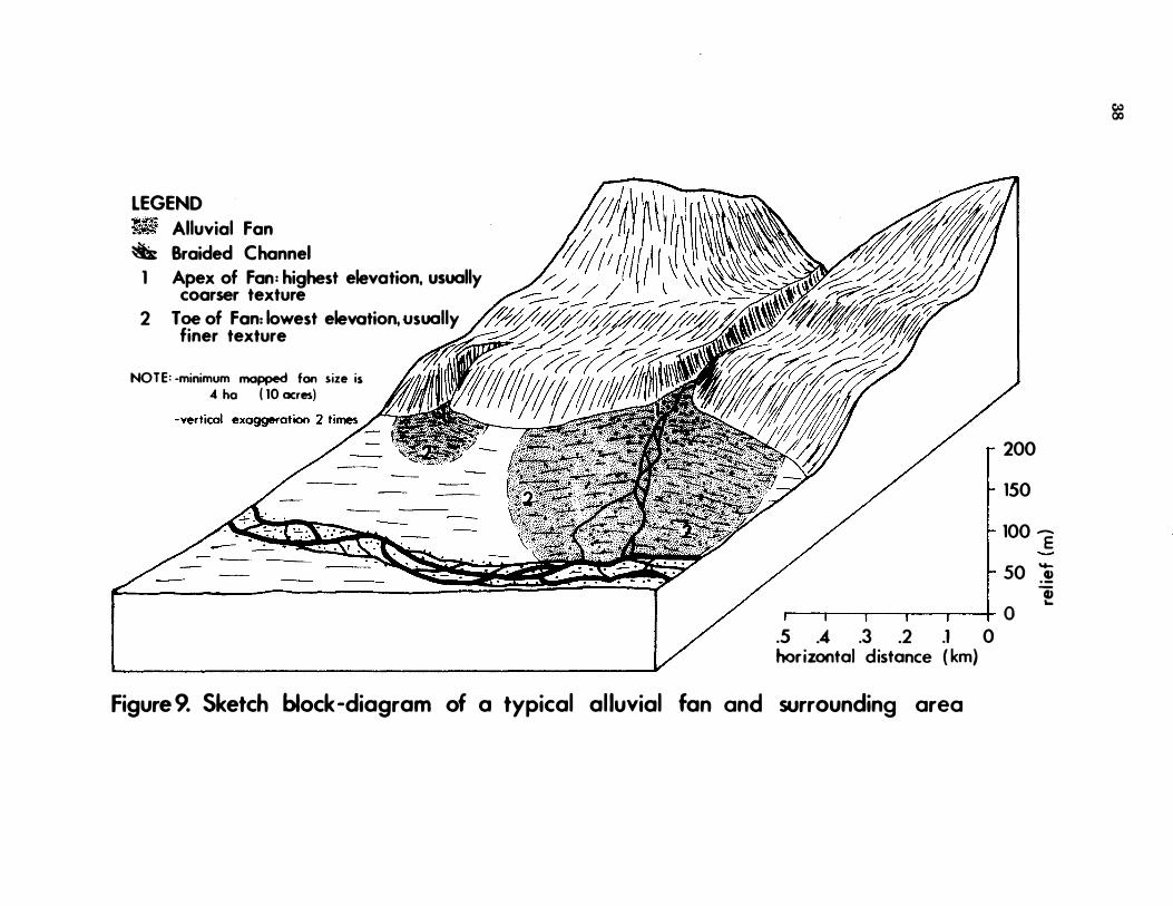
LEGEND 'iItlt'i • ;o,�, Alluvial Fan
� Braided Channel
1 Apex of Fan: highest elevation, usually coarser texture
2 Toe of Fan: lowest elevation, usually finer texture
NOTE: -minimum mopped fon size is .4 he ( 10 acres)
200
150
100 E ..... 50 .! Q) ... �-'--����--+I 0
.5 .4 .3 .2 .1 0 horizontal distance ( km)
Figure 9. Sketch block -diagram of a typical al luvial fan and surrounding area
�
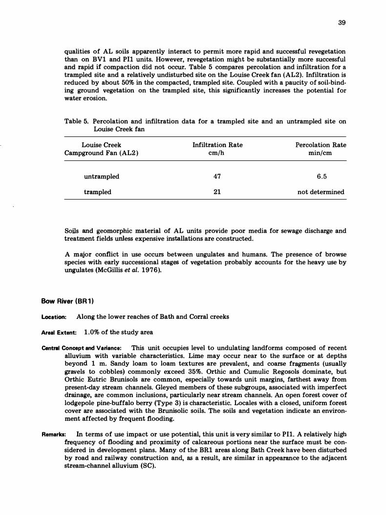
39
qualities of AL soils apparently interact to permit more rapid and successful revegetation than on BV1 and PIl units. However, revegetation might be substantially more successful and rapid if compaction did not occur. Table 5 compares percolation and infiltration for a trampled site and a relatively undisturbed site on the Louise Creek fan (AL2). Infiltration is reduced by about 50% in the compacted, trampled site. Coupled with a paucity of soil-binding ground vegetation on the trampled site, this significantly increases the potential for water erosion.
Table 5. Percolation and infiltration data for a trampled site and an untrampled site on Louise Creek fan
Louise Creek Campground Fan (AL2 )
untrampled
trampled
Infiltration Rate cm/h
47
21
Percolation Rate min/cm
6.5
not determined
Soils and geomorphic material of AL units provide poor media for sewage discharge and treatment fields unless expensive installations are constructed.
A major conflict in use occurs between ungulates and humans. The presence of browse species with early successional stages of vegetation probably accounts for the heavy use by ungulates (McGillis et al. 1976).
Bow River (BR 1 )
Location: Along the lower reaches of Bath and Corral creeks
Areal Extent: 1 .0% of the study area
Central Concept and Variance: This unit occupies level to undulating landforms composed of recent alluvium with variable characteristics. Lime may occur near to the surface or at depths beyond 1 m. Sandy loam to loam textures are prevalent, and coarse fragments (usually gravels to cobbles) commonly exceed 35%. Orthic and Cumulic Regosols dominate, but Orthic Eutric Brunisols are common, especially towards unit margins, farthest away from present-day stream channels. Gleyed members of these subgroups, associated with imperfect drainage, are common inclusions, particularly near stream channels. An open forest cover of lodgepole pine-buffalo berry (Type 3) is characteristic. Locales with a closed, uniform forest cover are associated with the Brunisolic soils. The soils and vegetation indicate an environment affected by frequent flooding.
Remarks: In terms of use impact or use potential, this unit is very similar to PIl. A relatively high frequency of flooding and proximity of calcareous portions near the surface must be considered in development plans. Many of the BR1 areas along Bath Creek have been disturbed by road and railway construction and, as a result, are similar in appearance to the adjacent stream-channel alluvium (SC).
40
Num-Ti-Jah (NT1, NT2)
Location: In valley-bottom positions adjacent to Wapta Lake, Lake Louise, and Moraine Lake and at the south end of the study area near the Trans-Canada Highway
Areal Extent: 0.4% of the study area
Central Concept and Variance: NT units encompass alluvial fans and deltas dominated by poorly drained soils and associated vegetation. Alluvium of NT fans ranges widely in characteristics : chemically from noncalcareous and acidic to highly calcareous and alkaline, and texturally from silt loam or silty clay loam to sandy loam and skeletal (up to 50% coarse fragments). Random stratification is normal and sometimes includes organic layers. Carbonate probably occurs in all NT alluvium, but sometimes at great depths, as in some Altrude (AL) fans. The outstanding feature of NT fans is their soil profile wetness.
The NTI unit is a complex of wet (about 70%) and dry (about 30%) portions. Wet portions are dominated by Rego Gleysols and Engelmann spruce/subalpine fir-rock willow (Type 7 ) vegetation. These occur in depressions generally central to toe portions of alluvial fans. Dry portions, occupying ground of higher relief and generally the apex portions of fans (Fig. 9), are dominated by Orthic Eutric Brunisols and lodgepole pine-buffalo berry (Type 3) vegetation. Intergrades of these vegetation types and soils (Gleyed Regosols and Brunisols ) are inclusions in the NTI map unit.
NT2 encompasses those fans lacking dry segments and is characterized by Rego Gleysols and a fluvial complex of vegetation types. The Rego Gleysols of this unit usually lack the surface organic accumulations common to CV and NTI units. The complex vegetation usually features willow (Salix glauca, S. barrattiana, S. scouleriana ) in a sparse shrub layer, and rushes (Juncus balticus, J. mertensianus) and other plants (Equisetum variegatum, Epilobium latifolium, Pinguicula vulgaris, Castilleja miniata ) in a sparse herb layer. Mosses are uncommon. An area labelled NT2/F located immediately south of Moraine Lake does not fit the NT concept, but is a complex of poorly drained soils in alluvial, recent morainal, and colluvial materials.
Remarks: Because of excessive wetness, NT areas will not support most types of recreational use. Besides featuring soils and vegetation that are easily damaged, Num-Ti-Jah units apparently provide forage and habitat for many forms of wildlife. NT2 units are actively accumulating alluvium and flood each year for much of the summer season.
Larch Valley ( LV 1 )
Location: Middle to upper mountain slopes on Whitehorn and Lipalian Mountain
Areal Extent: 0.2% of the study area
Central Concept and Variance: The Larch Valley unit (LVI ) represents the upper subalpine extension of PR6. It encompasses inclined to rolling landforms of fine-loamy (clay loam to sandy clay loam) glacial till in which carbonate occurs at depths of more than 1 m or is not abundant. Orthic Sombric Brunisols and Orthic Humo-Ferric Podzols are the dominant soils. Because
this unit occurs in a transitional belt between subalpine and alpine, the soils have both the advanced features of soils from the lower subalpine bioclimatic unit and the beginnings of the surface organo-mineral horizon (Ah ) that characterizes most alpine soils. Consequently, the soils of the LVI unit are quite complex and indude, as well as those mentioned above,
41
Orthic Dystric Brunisols and Degraded Dystric Brunisols. pH values greater than 5.5 in lower sola of some profiles mean that Orthic Eutric Brunisols and Orthic Melanic Brunisols also occur3 .
Alpine larch-grouse berry (Type 8) vegetation increases in abundance with increasing elevation, while subalpine fir decreases in abundance and takes on a krummholz form. Some herb species extend downward from the alpine bioclimatic unit.
Remarks: Stability of surficial geology is similar to that of PR6. However, LVl belongs to a climatically harsh subzone (upper subalpine) with a short growing season, high winds, and great temperature extremes. Because of such conditions, growth rates, regeneration, and revegetation following disturbance are relatively slow.
The upper subalpine setting of LV1 areas has an aesthetic attraction, probably because of the blending of alpine and lower sUbalpine vegetation and soil elements and the presence of alpine larch.
Ungulate use of LV1 areas is expected to be low (McGillis et al. 1 976). Although not yet evaluated, use by some small mammals may occur.
Whitehorn (WH1, WH2)
Location: Upper mountain slopes (approximately 2000-2400 m) on Lipalian Mountain and Whitehorn; high slopes above and southeast of Moraine Lake
Areal Extent: 1 .9% of the study area
Central Concept and Variance: The Whitehorn system represents the upper subalpine extension of the Ten Peaks (TP) system. Geologic material is the coarse loamy-skeletal, acidic to neutral colluvium derived from slates and shales of the Miette Group. Landform surface expression includes veneers, blankets, and steep slopes. Bedrock frequently occurs near the ground surface.
WHl is characterized by closed forest (alpine larch-grouse berry, Type 8), whereas WH2 has an open larch forest and commonly occurring krummholz subalpine fir (alpine larch-heather, Type 9). This latter type adjoins true alpine vegetation at higher elevations and, except for krummholz fir and larch trees, resembles alpine tundra.
Soils also reflect transitional conditions toward the alpine environment. With increasing elevation, Orthic Humo-Ferric Podzols decrease in abundance, whereas Orthic Sombric Brunisols, characterized by a surface, turfy, organo-mineral horizon (Ah) typical of alpine soils, increase in abundance and distinctiveness. Orthic and Degraded Eutric Brunisols are common inclusions in WH1, particularly near its lower elevational limits.
Remarks: Stability of geological materials is similar to that of the Ten Peaks units. When vegetation is removed or severely disturbed, instability and erosion occur, particularly where elongated, flat, coarse fragments are abundant and reasonably uniform in size.
Climatic harshness and aesthetics similar to LV1, are factors to be considered.
Wildlife use other than by certain small mammals is relatively low.
3 Soil taxonomy problems in the Brunisolic Order.
42
Redoubt ( RD1 )
Location: Upper slopes and mountain crests above 2400 m on Whitehorn, Lipalian Mountain, and Mount Babel
Areal Extent: 0. 6% of the study area
Central Concept and Variance: The Redoubt unit represents the alpine extension of the Whitehorn units. A mosaic of vegetation types, represented by alpine heather (Type 1 3 ), is characteristic. Both the tree and shrub layer are absent in alpine tundra vegetation. Orthic Sombric Brunisols are typical of more stable, gentler slopes. Orthic Regosols dominate steeper, somewhat unstable slopes. Up to 30% unvegetated (except for lichen cover) colluvial rubble is included in the RD1 concept. Both soil subgroups mentioned above are characterized by a turfy, organo-mineral horizon (Ah ) at the soil surface.
Remarks: Owing to very steep slopes and the nature of the geologic material, RDl areas tend to be somewhat unstable. Little is known about the ability of turfy alpine Ah horizons to withstand traffic. However, it is assumed that destruction of vegetation will promote wind and water erosion because the surfaces of alpine soils are bound by dense, relatively shallow root systems ( Retzer 1974).
Since alpine areas such as RD1 are relatively small in area and have certain plant species with distribution restricted to alpine and arctic environments, the RD1 unit is considered unique and aesthetically attractive.
Miscellaneous Land Systems
Consolidated limestone bedrock ( RL), consolidated acidic bedrock (RQ), colluvial rubble including fractured bedrock (Cr), rock plus colluvial rubble (R + CR), talus (T), and stream channel alluvium (SC) account for 2.2% of the Lake Louise Study Area. The unconsolidated units of this group are usually very coarse textured-fragmental to coarse loamy- or sandy-skeletal. In terms of geomorphic activity, miscellaneous systems composed of unconsolidated deposits ( CR, T, SC) are still actively accumulating materials. Because of geomorphic activity (flooding, mass wasting, avalanching), these landscapes are not well suited for recreational use. Bedrock units, if at lower elevations and having suitable topography, may be utilized for some types of recreational services.
CONCLUSIONS ON SOI L-VEGETATION RELATIONSHIPS
Survey information of landforms, soils, and vegetation in the Lake Louise Study Area was integrated into a biophysical resource inventory at a scale of 1 :25 000. As a result,
various trends in soil and vegetation development were discerned and ecological relationships suggested, particularly among soils, vegetation, and climate.
Subdivisions expressing the most generalized ecological relationships were based on vegetation patterns that imply macro climatic differences. Consequently, two bioclimatic zones (alpine and subalpine) and two bioclimatic subzones (upper and lower SUbalpine) were recognized.
" Alpine", as used in this report, refers to high-elevation areas covered by heath and cushion-plant-dominated, treeless, tundra vegetation indicative of polar (ET) climate (Ko ppen, as modified by Trewartha 1957) . Associated soils, namely Orthic Regosols and Orthic Sombric Brunisols, are characterized by a turfy, organo-mineral, surface horizon. In the Lake Louise Study Area, alpine areas are of very limited distribution (about 1 %) and are confined to steep slopes of noncalcareous, coarse loamy-skeletal colluvium.
The major portion (about 99% ) of the mapped area belongs to the subalpine zone that is best represented by closed forests of
Engelmann spruce (Picea engelmannii) and subalpine fir (Abies lasiocarpa). Such vegetation implies a Dfc climate (Koppen, as modified by Trewartha 1957 ).
The upper subalpine subzone, constituting a narrow belt (about 2% of the mapped area) between the alpine and lower subalpine zones, indicates climatic conditions that are transitional between the two zones. Closed to open forests of alpine larch (Larix lyallii) and subalpine fir (Abies lasiocarpa) with heath or low shrub understories are characteristic. Trees exhibit krummholz form and tend to develop "tree islands" at the upper limit of the subzone. Associated soils are well developed and show a range of features that reflect the transitional environment. Orthic HumoFerric Podzols and well-advanced Brunisols, usually Orthic Sombric Brunisols, are the most common soils and develop on moderate to steep slopes of weakly calcareous, loamy till and noncalcareous, coarse loamy-skeletal colluvium. The turfy, organo-mineral, surface horizon becomes more distinctive with increasing elevation.
About 97% of the mapped area belongs to the lower subalpine subzone that is best characterized by climatic climax forests of Engelmann spruce (Picea engelmannii) and subalpine fir (Abies lasiocarpa) with false azalea (Menziesia ferruginea var. glabella ) dominating the shrub layer, and Barbilophozia hatcheri the moss layer. Subdivisions of the subzone are based on trends in soil and vegetation development that suggest mesoclimatic differences. Topographic position in the valley and aspect appear to be the major factors affecting mesoclimate.
On steep, northeast-facing, high-elevation slopes in the Kicking Horse Pass section, Orthic Humo-Ferric and Ferro-Humic Podzols developed on calcareous, loamy till occur in association with the climatic climax vegetation (Engelmann spruce/subalpine fir-false azalea; Type 6 ). It is thought that high precipitation, late snowmelt, and shading (low evaporation) promote this type of development.
At slightly lower elevations on more gentle slopes or on other aspects, advanced
43
Brunisols and Orthic Humo- Ferric Podzols occur in association with vegetation Type 6 or an earlier successional stage, Type 6a (lodgepole pine-false azalea). This kind of soil-vegetation development occurs on most types of parent materials throughout the Lost Lake triangle and the Yoho National Park sections of the study area and as a belt immediately below upper subalpine vegetation in other portions of the study area.
Moderately developed Brunisols and a seral stage of vegetation represented by Pinus contorta-Picea engelmannii forests with a shrub layer dominated by Shepherdia canadensis (Type 12) are typical of lower subalpine environments along the Bow River valley floor. Such features might be attributable to a rain shadow effect and, in part, to somewhat coarser-textured parent materials such as calcareous, sandy-skeletal glaciofluvial deposits. Low-elevation portions of calcareous, loamy moraine (glacial till) also display this soil-vegetation development.
The Bow River valley floor to lower wall positions with a southwest aspect exhibit Luvisolic and Brunisolic soils in association with Pinus contorta-Shepherdia canadensis vegetation (Type 3) developed on calcareous, loamy glacial till. Relatively higher evapotranspiration is assumed to be the predominant environmental factor that promotes this kind of soil-vegetation evolution in the lower subalpine subzone. Noteworthy among units of this section are relatively steep slopes affected by seasonal subsurface seepage on Whitehorn and Lipalian Mountain.
Throughout the lower subalpine subzone there are soils and vegetation groupings whose development is controlled by recent or present-day geomorphic activity and poor drainage. Such soil-vegetation groupings have often reached an edaphic climax.
Regosols dominate recently stabilized colluvium (e.g., talus cones), colluvial slopes severely affected by periodic avalanche activity, and alluvial fans and plains subject to periodic flooding. Associated vegetation, labelled as avalanche or fluvial complex, is heterogeneous, usually with a shrub thicket physiognomy. The Regosols and associated
44
shrubby or open forest vegetation (less than 4% of the study area) are maintained in dynamic equilibrium by geomorphic activity.
Wetlands dominated by Gleysols and Organic soils have developed in environments controlled by groundwater discharge and runoff accumulation and occupy about 15% of the study area. Various types of shrub thicket and herbaceous meadow vegetation are associated with these poorly drained soils. Wetlands vary greatly in size and are most common in depressions on ridged, morainic benchland of the Bow River valley floor and at the major break in slope where this benchland adjoins the moraine-covered slopes of the valley wall. The distribution and pattern of wetlands are a significant factor in the planning of most developments within the Lake Louise Study Area.
Miscellaneous land systems--nonvegetated and/or nonsoil areas-account for 2.2% of the study area, most of them occurring adjacent to upper subalpine and alpine units. The remainder of the study area includes an area that had no air photo coverage (7.6%), waterbodies (2.7%), and man-made features such as pits, dumps, and lagoons (0.4%).
Soils and vegetation of the Lake Louise Study Area closely resemble those found along the Main Ranges of the southern Rocky Mountains as determined during ongoing investigations in the bioph ysical inventory of Banff and Jasper national parks. This information suggests the existence of a Main Ranges facies of temperate, cordilleran, continental climate. To the east, soil and vegetation development in the Front Ranges reflect warmer, drier conditions. Very similar soils and vegetation exist to th e west ( Coen et al. 1977), with minor differences suggesting a possible but subtle increase of maritime influence on climate.
ACKNOW LEDGMENTS
The survey of Banff and Jasper national parks is a joint project involving the Canadian Forestry Service (Northern Forest Research Centre), the Soil Research Institute,
and the Alberta Institute of Pedology. Team members responsible for operations in Banff National Park during 1975-76 were
Alberta Institute of Pedology-
Phil Epp, Pedologist Joe Tajek, Soil Technician Bruce D. Walker, Pedologist Alan Westhaver, Vegetation Technician
Canadian Forestry Service-
Doug Allan, Soil Technician Jake Dyck, Vegetation Technician W.D. Holland, Pedologist, Project
Leader Dr. S. Kojima, Plant Ecologist
Soil Research Institute-
Dr. G.M. Coen, Pedologist Dr. Julian Dumanski, Pedologist Dr. Bruce Kloosterman, Pedologist
The survey was funded hy Parks Canada. C. Zinkan and P. Benson of Parks Canada, Western Region, Calgary, have provided considerable assistance with problem areas and data requirements. To Parks Canada personnel in Banff National Park-especially A.S. Anderson, D.R. Donnelly, P.B. Kutzer, T. L. Ross, P. Whyte, and members of the Warden Service-the authors extend appreciation for assistance and cooperation in field operations.
The authors also acknowledge Pat Logan and I.G.W. Corns, Northern Forest Research Centre, and Dr. P.L. Achuff and Dr. R. E. Wells, Alberta Institute of Pedology, for editing the manuscri pt; Ed Heacock, Alberta Institute of Pedology, for drafting services; and members of the Northern Forest Research Centre steno pool.
R E FER ENCES
Acton, D.F. 1975. A landform mapping system for
Canadian soil surveys. Sask. Inst. Pedol.
Univ. of Sask. Saskatoon. Pub!. M26. 20
pp.
Adams, J.E., D. Kerkham, and D.R. Nielson. 1957. A portable rainfall-simulator infiltrometer and physical measurements of soil in place. Soil Sci. Soc. Am. Proc. 2 1 :47 3-476.
Aitken, J.D. 1 968. Pre-Devonian history of the southern Rocky Mountains. Pages 15-28 in Guidebook : Central Canadian Rockies and Foothills of Alberta. 16th Annual Field Conference. Alberta Soc. Pet. Geol. Calgary, Alberta. 184 pp.
Allison, L.E., W.B. Bollen, and C.D. Moodie. 1965. Total carbon. Pages 1 346-1 366 in C.A. Black et al. (eds. ). Methods of soil analysis, Part It Chemical and microbiological properties. Am. Soc. Agron. Madison, Wisconsin. Monogr. 9.
Alberta Department of Manpower and Labor. 1 972. Private sewage disposal. 5th ed. Plumbing Insp. Br. Edmonton, Alberta.
Association of Official Agricultural Chemists. 1 955. Official methods of analysis. 8th ed. Washington, D.C.
Bailey, H.P. 1 962. Koppen definitions of climatic types and their mapped representationssome remarks. Geogr. Rev. 5 2 : 444-447.
Bascombe, C.L. 1961. A calcimeter for routine use on soil samples. Chem. Ind., Part IL pp. 1826-1827.
Braun-Blanquet, J. 1 932. Plant sociology. (English translation of Pflanzensoziologie, 1928 ). Hafner Publ. Co. New York. 439 pp.
Canada Soil Survey Committee (C.S.S.C.). 1973. Proceedings of the ninth meeting of the Canada Soil Survey Committee. Univ. of Sask. Saskatoon. 355 pp.
---. 1 976. Manual on soil sampling and methods of analysis. Soil Res. Inst. Ottawa. 2 1 2 pp.
Chapman, H.D. 1 965. Cation exchange capacity. Pages 8 91-901 in C.A. Black et al. (eds. ). Methods of soil analysis, Part ll. Chemical and microbiological properties. Am. Soc. Agron. Madison, Wisconsin. Monogr. 9.
45
Chapman, J.D. 1 952. Climates of British Columbia after W. Koppen. Fifth B.C. Nat. Resour. Conf. Victoria, B.C.
Coen, G.M. and W.D. Hol land. 1 976. Soils of Water
ton Lakes National Park , Al bert.a. Environ.
Can., Can. For. Serv. , North. For. Res. Cent. Inf. Rep. NOR-X-64 and Alberta Inst. Pedol. Rep. No. S-73-33. Edmonton, Alberta. 1 16 pp. plus appendix and maps.
Coen, G.M., P.F. Epp., J. Tajek, and L. Knapik. 197 7 . Soil survey o f Yoho National Park, Canada. Alberta Inst. Pedo\. , Univ. of Alberta, Edmonton. Rep. No. S·77-37. 196 pp. plus appendixes.
Courtney, J., J.G. Stelfox, and J. R. McGill is. 1 97 5. Large mammal use of land systems and land types, summer 1974, Bow Valley, Banff National Park. Environ. Can., Can. Wild\. Servo Edmonton, Alberta.
Day, D., C. Zinkan, and G. Wickware. 1 975. A multi-disciplinary approach to resource inventory in National Parks. Parks Can., West. Reg. Off. Calgary, Alberta.
Dickman, S.R. and RH. Bray. 1 940. Colorimetric determination of phosphate. Ind. Eng. Chem. Anal. Ed. 1 2 :665-668.
Environment Canada. 1945-75. Monthly record, meteorological observations in Canada. Atmos. Environ. Servo Downsview, Ontario.
Fosberg, F.R. 1 967. A classification of vegetation for general purposes. Pages 73-120 in G.F. Peterken. Guide to the check sheet for IBP areas. Blackwell Scientific Publications. Oxford and Edinburgh. IBP Handb. No. 4.
Fulton, R.J., A.N. Boydell, D.M. Barnet.t, D.A.
Hodgon, and V.N. Ramptom. 1 974. Terrain mapping in northern environments. Pages 14-60 in Canada's Northlands : Proceedings of Technical Workshop. Environ. Can., Environ. Manage. Serv., Lands Dir. Ottawa. 298 pp.
Harris, S.A. , R. Hawes, R. Durrant, and A. Poole. 1 97 3. Report on the surficial deposits and soils of the Lake Louise-Eisenhower Junction area. Harris Environmental Research Ltd. Calgary, Alberta. 1 60 pp.
46
Holland, W.D. 1976. Biophysical classification of Banff and Jasper National Parks. Pages 221-237 in Proc. 1st Meet. Can. Comm. Eco!. (Bio-physical) Land Class. Petawawa, Ontario.
Holland, W.D., B.D. Walker, S. Kojima, D.T. Allan, and J. Dyck. 1975. Banff-Jasper biophysical land inventory : Progress report No. I ,
1974-1975. Environ. Can., Can. For. Serv., North. For. Res. Cent. Edmonton, Alberta. 80 pp. plus appendixes. Limited distribution.
Jurdant, M., D.S. Lacate, S.C. Zoltai,G.G. Runka, and R. Wells. 1 975. Biophysical land classification in Canada. Pages 485-495 in B. Bernier and C.H. Winget (eds. ). Forest soils and forest land management. Proc. 4th North. Am. For. Soils Conf. Les Presses de l'Universite Laval. Quebec.
Knapik, L.J. 1973. Alpine soils of the Sunshine area, Canadian Rocky Mountains. M.Sc. thesis. Dep. Soil ScL, Univ. of Alberta. Edmonton. 231 pp.
Knapik, L.J., G.W. Scotter, and W.W. Pettapiece. 1973. Alpine soil and plant community relationships of the Sunshine area, Banff National Park. Arct. Alp. Res. 5 :A161-A 1 7 0.
Knapik, L.J. and G.M. Co en. 1974. Detailed soil survey of the Mount Revelstoke summit area, with an environmental fragility rating system. Alberta Inst. Pedo!., Univ. of Alberta. Edmonton. Pub!. No. M-74-3 and Soil Res. Inst. Pub!. No. 504. 1 1 8 pp. plus maps.
Krajina, V.J. 1960. Can we find a common platform for the different schools of forest type classification? Sylva Fenn. 105 : 50-55.
----. 1 965. Biogeoclimatic zones and biogeocoenoses of British Columbia. Dep. Bot. , Univ. of B.C. Vancouver. Eco!. West. North Am. 1 :1-17.
----. 1969. Ecology of forest trees in British Columbia. Dep. Bot., Univ. of B.C. Vancouver. Eco!. West. North Am. 2 : ( 1 )1-147 .
Kucera, R.E. 1 974. Lake Louise-Moraine Lake, interpreting the mountain landscape. Evergreen Press. Vancouver, B.C.
Lacate, D.S. 1 969. Guidelines for bio·physical land classification. Call. Dep. Fish. For., Can. For. Servo Ottawa. Publ. No. 1 264. 6 1
pp.
Landals, A.G. and L.J. Knapik. 1 972. Great Divide Trail : An ecological study of the proposed route, Jasper National Park and vicinity. Can. Dep. Environ. , Can. Wildl. Servo Edmonton, Alberta. 2 5 1 pp.
Lombard North Group Ltd. 1 974. Trans-Canada twinning study. Calgary, Alberta. 223 pp.
McGillis, J.R., S. Ward, and J.G. Stelfox. 1 97 6. Summer use of land systems by large mammals; Bow valley, Banff National Park. Phase II: East Gate to Bow Summit ( 1 97 5 ). Environ. Can., Can. Wildl. Servo Edmonton, Alberta. 43 pp.
McKeague, J.A. 1 967. An evaluation of 0. 1 M pyrophosphate and pyrophosphate-dithionite in comparison with oxalate as extractants of the accumulation products in Podzols and some other soils. Can. J. Soil Sci. 4 7 : 95-99.
Nelson, J.G. and A.R. Byrne. 1 969. Fires, floods, and National Parks in the Bow Valley, Alberta. Pages 45-58 in J.G. Nelson and M.J. Chambers (eds.). Vegetation, soils and wildlife. Methuen. Toronto. 372. pp.
North, F.K. and G.G. L. Henderson. 1 954. Summary of the geology of the southern Rocky Mountains of Canada. Pages 1 5-81 in Guidebook : Fourth Annual Field Conference. Alberta Soc. Pet. Geol. Calgary, Alberta.
Peech, M. 1 965. Exchange acidity. Pages 905-9 1 3 in C.A. Black et al. (eds. ). Methods o f soil analysis, Part II. Am. Soc. Agron. Madison, Wisconsin. Monogr. 9.
Pettapiece, W.W. 197 1 . Land classification and
soils in the Rocky Mountains of Alberta along the North Saskatchewan River Valley. Alberta lnst. Pedol. , Univ. of Alberta. Edmonton. Publ. No. S-7 1 - 3 1 . 39 pp. plus maps.
Price, R.A. and E.W. Mountjoy. 1 969. Geology along the Bow River from west of Calgary to Lake Louise. Map in LA.R. Halladay and D.H. Mathewson (eds. ). A geological guide to the Eastern Cordillera along the TransCanada Highway between Calgary and Revelstoke ( 197 1 ). Alberta Soc. Pet. Geol. Calgary, Alberta 94 pp.
----.. 1 970. Geologic structure of the Canadian Rocky Mountains between Bow and Athabasca Rivers-a progress report. Pages 7-25 in J.O. Wheller (ed. ). Structure of the Southern Canadian Cordillera. Geol. Assoc. Can. Spec. Pap. No. 6.
Price, R.A. and P. Simony. 1 9 7 1 . Geology of the Lake Louise-Golden area. Map in I.A.R. Halladay and D.H. Mathewson (eds.). A geological guide to the Eastern Cordillera along the Trans-Canada Highway between Calgary and Revelstoke ( 1 97 1 ). Alberta Soc. Pet. Geol. Calgary, Alberta. 94 pp.
Reimchen, T.H.F. and L.A. Bayrock. 1975. Terrain analyses of Banff and Jasper National Parks. Report to Parks Canada, Calgary by Bayrock and Reimchen Surficial Geology Limited, Vancouver. 38 pp.
Retzer, J.L. 1 974. Alpine soils. Pages 7 7 1 -802 in J.D. Ives and R.G. Barry (eds.). Arctic and alpine environments. Methuen Co. Ltd. London. 999 pp.
Root, J.E. and L.J. Knapik. 1972. Trail conditions along a portion of the Great Divide Trail route, Alberta and British Columbia Rocky Mountains. Res. Counc. Alberta Rep. 7 2-5. 38 pp. plus plates and map.
Rutter, N.W. 1965. Surficial geology of the Banff area, Alberta. Ph. D. thesis. Vniv. of Alberta. Edmonton. 1 06 pp.
----. 1972. Geomorphology and multiple glaciation in the area of Banff, Alberta Geol. Surv. Can. Bull. 206. 54 pp.
Sneddon, J. L, L.M. Lavkulich, and L. Farstad. 1 972. The morphology and genesis of some alpine soils in British Columbia, Canada: I. Morphology, classification, and genesis; II. Physical, chemical, and mineralogical determinations and genesis. Soil Sci. Soc. Am. Proc. 36 : 100- 1 10.
47
Sukachev, V.N. 1958. (On the principles of genetic classification in biocoenology). Condensed translation of " 0 principi geneticeskoj klassifikatsii v biocenologii" by F. Raney and R.F. Daubenmire. Ecology 3 9 : 364-367.
----. 1960. Relationship of biogeocoenosis, ecosystem, and facies. Sov. Soil. Sci. 6 : 579·
584.
TES Research & Consulting Ltd. 1 973. Preliminary evaluation of landslide potential southwest slope of Bow River valley at Lake Louise townsite. Report to Parks Canada, Calgary. Restricted distribution.
Toogood, J.A. and T. W. Peters. 1 953. Comparison of methods of mechanical analysis of soils.
Can. J. Agric. Sci. 3 3 : 1 5 9· 1 7 1.
Trewartha, G. 1 957. Elements of physical geography. McGraw-Hill Book Co. New York.
Verrall, P. 1968. Observations on geological structure between the Bow and North Saskatchewan River. Pages 106- 1 1 8 in Guidebook : Central Canadian Rockies and Foothills of Alberta. 1 6th Annual Field Conference. Alberta Soc. Pet. Geol. Calgary, Alberta. 184 pp.
Walker, B.D., S. Kojima, G.M. Coen, and W.O. Holland. 1976. Biophysical land classification of Banff National Park. Progress report No. 2 ( 1 975-7 6 ). Environ. Can ., Can. For. Serv., North. For. Res. Cent. Edmonton, Alberta. Limited d istribution.
Wells, R.E. , I. Corns, and W.O. Holland. 1 97 6. Biophysical land classification of Jasper National Park. Progress report No. 1 . ( 1 97 5 -7 6 ). Environ. Can., Can. For. Serv., North . I<'OL Rps. C('nt.. J<;dmont.ol1, Allwrt.a. Lim·
itE'd distribution.
48
APPENDIX A
V EGETATION TYPE DESCRIPTIONS
Sixteen vegetation types were recognized in the Lake Louise area. The vegetation type, as used here, is an abstracted unit based on sample plots that have similar vegetation structure and species composition and occur in similar habitats. The types are defined by characteristic combinations of species' cover values and constancy. The vegetation type is thus comparable to the plant association (Braun-Blanquet 1932, as modified by Krajina 1960) or biogeocoenosis type (Sukachev 1958, 1960).
The names of the vegetation types are based on the characteristic species of each
Type No. : 1
layer. These species are not necessarily dominants; they may even have low cover, but they are indicative of the vegetation type by virtue of their nearly exclusive occurrence in the type. Each type was also given a short name for convenience. The physiognomy of each type is described on the basis of the structural type (e.g. , forest, shrub thicket) and, in some cases, the species composition. Fosberg's code (Fosberg 1967 ) is an internationally used vegetation classification system based on physiognomy, structure, and growth form.
Early, intermediate, advanced, and mature are the four categories used to subjectively describe successional stages of vegetation in relation to the assumed climax vegetation.
Name: Pinus contorta-Juniperus communis-Arctostaphylos uva- ursi-Lichen Type
Short Name: Lodgepole pine-juniper Type
Physiognomy: Lodgepole pine forest
Fosberg's Code: 1A17a
Characteristic Species:
Pinus contorta Juniperus communis Arctostaphylos uva-ursi Calamagrostis rubescens Carex concinna Elymus innovatus
Hedysarum sulphurescens Solidago decumbens Cladonia gracilis Cladonia rangiferina Peltigera canina Stereocaulon tomentosum
Description: This vegetation type occurs on xeric habitats on predominantly steep, south-facing slopes. The high rate of evapotranspiration caused by the slope and aspect regulates the development of vegetation. The tree layer is sparse and consists of small Pinus contorta. Development of the shrub and herb layers is moderate. Frequent occurrences of Juniperus communis and Arctostaphylos uva-ursi indicate the dry, open habitat conditions. The moss layer is moderately developed and dominated by lichen species. In general, species diversity of this type is low. This vegetation type is the edaphic climax of xeric habitats and is the only vegetation type in which Pinus contorta is self-perpetuating.
Successional Stage: Intermediate to advanced
Type No. : 2
Name: Pinus con torta-Vaccinium cGespitosum/Elymus innovatus Type
Short Name: Lodgepole pine-dwarf huckleberry Type
Physiognomy: Lodgepole pine forest
Fosberg's Code: lA17a
Characteristic Species:
Pinus contorta Picea glauca Juniperus communis Shepherdia canadensis Spirea luaida Carex concinna
Elymus innovatus Oryzopsis exigua Vaccinium cGespitosum Cladonia gracilis Peltigera can ina Stereocaulon tomentosum
49
Description: This vegetation type develops on glaciofluvial and alluvial terraces with a coarse alluvial parent material. The tree layer consists exclusively of even-aged (80-90 yr) Pinus contorta, indicating an early stage of secondary succession after disturbance. Tree growth is slow, reflecting dry habitat conditions. Tree size is small, ranging from 10-15 m in height and 8-15 cm dbh. The shrub layer is weakly developed, with scattered Shepherdia canadensis and Spirea lucida. Development of the herb layer is moderate, with Vaccinium caespitosum characteristically present. Other major constituents are Carex concinna, Oryzopsis exigua, and Elymus innovatus. Lichens such as Cladonia gracilis, C. rangiferina, Cetraria islandica, Peltigera canina, and Stereocaulon tomentosum are common.
Successional Stage: Early to intermediate
50
Type No. : 3
Name: Pinus contorta-Shepherdia canadensis-Vaccinium scoparium-Hyiocomium splendens Type
Short Name: Lodgepole pine-buffalo berry Type
Physiognomy: Lodgepole pine forest
Fosberg's Code: lA17a
Characteristic Species:
Pinus contorta Picea glauca I Shepherdia canadensis Vaccinium scoparium Calamagrostis rubescens Elymus innouatus
Arctostaphylos uva-ursi Arnica cordifolia Hylocomium splendens Pleurozium schreberi Ptilium crista-castrensis Peltigera aphthosa
Description: This vegetation type occurs extensively on gentle, south-facing slopes that are well drained and where snowmelt is early. The tree layer consists mainly of Pinus contorta, but Picea glauca1 is often present, indicating the direction of succession. The shrub layer is well developed, with Shepherdia canadensis dominant. Vaccinium scoparium is common, occasionally dominating the herb layer. Other major constituents of the herb layer include Calamagrostis rubescens, Elymus innouatus, Arnica cordifolia, and Arctostaphylos uva-ursi. The moss layer is moderately developed and dominated by Hylocomium splendens.
Successional Stage: Intermediate
1 Including hybrids of P. glauca and P. engelmannii.
Type No. : 4
Name: Picea glauca2 -Comus canadensis-Hylocomium splendens Type
Short Name: White spruce-moss Type
Physiognomy: White spruce forest
Fosberg's Code: 1A17a
Characteristic Species:
Picea glauca2 Comus canadensis Goodyera repens Linnaea borealis Pyrola secunda
Hylocomium splendens Peltigera aphthosa Pleurozium schreberi Ptilium crista-castrensis
51
Description: This vegetation type occurs at the lowest elevations in the study area in valley bottoms and has affinities with montane-zone vegetation. It occurs on mesic habitats of predominantly north-facing slopes where snowmelt is late and evapotranspiration is low. The tree layer consists chiefly of a dense, closed canopy of Picea glauca2 • Development of the shrub and herb layers is weak, and species diversity is low. Ribes lacustre, Shepherdia canadensis, and Viburnum edule occur sporadically in the shrub layer. Comus canadensis, Linnaea borealis, and Pyrola secunda are the major species of the herb layer. The moss layer is well developed and dominated by Hylocomium splendens followed by Pleurozium schreberi, Ptilium crista-castrensis, and Dicranum scoparium.
Successional Stage: Advanced
2 Including hybrids of P. glauca and P. engelmannii.
52
Type No. : 5
Name: Picea engelmanniilAbies lasiocarpa- Vaccinium scoparium Type
Short Name: Engelmann spruce/subalpine fir-grouse berry Type
Physiognomy: Engelmann spruce/subalpine fir forest
Fosberg's Code: l A1 7a
Characteristic Species:
Picea engelmannii Abies lasiocarpa Vaccinium scoparium Phyllodoce empetriformis Phyllodoce glanduliflora Erigeron peregrinus Arnica cordifolia Arnica latifolia
Deschampsia atropurpurea Pedicularis bracteosa Hieracium gracile Hylocomium splendens Pleurozium schreberi Dicranum scoparium Barbilophozia hatcheri
Description: This vegetation type is transitional between the lower and upper subalpine subzone. In this study, it is placed in the lower subalpine subzone. It occurs extensively at higher elevations. Occurrences of Phyllodoce empetriformis and P. glanduliflora indicate minor
influence of the alpine environment. The type is primarily a closed forest, but forms open forests as elevation increases. The tree layer consists of Picea engelmannii and A bies lasiocarpa. The shrub layer includes dwarf shrubs such as Vaccinium scoparium, Phyllodoce empetriformis, and P. glanduliflora, all of which strongly characterize this type. Development of the moss layer is moderate.
Successional Stage: Advanced
Type No.: 5a
Name: A bies lasiocarpa-Salix glauca-Vaccinium scoparium Type
Short Name: Subalpine fir-gray willow-grouse berry Type
Physiognomy: Subalpine fir open forest (krummholz)
Fosberg's Code: 1 G 13
Characteristic Species:
Abies lasiocarpa Picea engelmannii Salix glauca Achillea millefolium Elymus innovatus
Erigeron peregrinus Carex scirpoidea Trisetum spicatum Zygadenus elegans Vaccinium scoparium
53
Description: This vegetation type is potentially similar to Type 5, but occurs on steeper, less stable slopes. Because of instability and substrate coarseness, forests do not develop. Trees occur in scattered clumps and often take the krummholz form. The shrub layer is well developed and consists of Abies lasiocarpa, Picea engelmannii, and Salix glauca. The herb layer is well developed and rich in species. Vaccinium scoparium is dominant, followed by Carex scirpoidea, Elymus innovatus, and other herbs. The development of the moss layer is poor.
Successional Stage: Mature
54
Type No. : 6
Name: Picea engelmannii/Abies lasiocarpa-Menziesia terruginea var. glabella-Barbilophozia hatcheri Type
Short Name: Engelmann spruce/subalpine fir-false azalea Type
Physiognomy: Engelmann spruce/subalpine fir forest
Fosberg's Code: lA17a
Characteristic Species:
Picea engelmannii A bies lasiocarpa Menziesia terruginea var. glabella Rhododendron albitlorum Vaccinium scoparium Arnica corditolia Comus canadensis
Pyrola secunda Listera cordata Lycopodium annotinum Hylocomium splendens Pleurozium schreberi Barbilophozia hatcheri Peltigera aphthosa
Description: This type represents the major climax type of the study area and occurs on pre-dominantly north-facing slopes. It is probably associated with a large amount of precipitation and late snowmelt. Podzolic or strongly developed Brunisolic soils occur with this vegetation type in a relatively cool, moist environment. The tree layer consists of Picea engelmannii and Abies lasiocarpa. The shrub layer is well developed and overwhelmingly domi· nated by Menziesia terruginea var. glabella. The herb layer is weakly developed, with con
stant occurrences of Comus canadensis, Vaccinium scoparium, and Arnica corditolia. The moss layer is well developed.
Successional Stage: Advanced to mature
55
Type No. : 6a
Name: Pinus contorta/Picea engelmannii/Abies lasiocarpa-Menziesia ferruginea var. glabella-Barbilophozia hatcheri Type
Short Name: Lodgepole pine-false azalea Type
Physiognomy: Lodgepole pine forest
Fosberg's Code: lA17a
Characteristic Species:
Pinus contorta A bies lasiocarpa Picea engelmannii Menziesia ferruginea var. glabella Rhododendron albiflorum Shepherdia canadensis Vaccinium scoparium Arnica cordifolia
Comus canadensis Pyrola secunda Elymus innovatus Hylocomium splendens Pleurozium schreberi Dicranum fuscescens Peltigera aphthosa
Description: This is a seral type that will potentially develop to Type 6. It is distinguished from Type 6 by the dominance of Pinus contorta in the tree layer. The shrub, herb, and moss layers are similar to Type 6. It occurs primarily in valley bottoms where fires have been most frequent.
Successional Stage: Intermediate
56
Type No. : 7
Name: Picea engelmannii/Abies lasiocarpa-Salix vestita-Carex vaginata/Pedicularlis bracteosa-Tomenthypnum nitens Type
Short Name: Engelmann spruce/subalpine fir-rock willow Type
Physiognomy: Engelmann spruce/subalpine fir forest
Fosberg's Code: l A17a
Characteristic Species:
Picea engelmannii A bies lasiocarpa Salix vestita Betula glandulosa Ledum groenlandicum Carex capillaris Carex vaginata Anemone parvi{lora
Empetrum nigrum Erigeron peregrinus Parnassia palustris Pedicularis bracteosa Habenaria dilatata Stenanthium occidentale Aulacomnium palustre Tomenthypnum nitens
Description: This type occurs at the base of predominantly north-facing slopes in seepage areas. Due to the seepage, soils are saturated with water for most of the year, and evapotranspiration is low because of the aspect. Poor soil aeration impedes tree growth; trees occur only on microtopographical crests where the soils are better drained. This vegetation type, therefore, shows a mosaic pattern of forest and fen. The tree layer consists of Picea engelmannii and A bies lasiocarpa. The shrub layer is characteristically dominated by Salix vestita. The herb layer is well developed and floristically diverse. The moss layer is also well developed and dominated by Aulacomnium palustre and Tomenthypnum nitens. Because of continuous seepage, the soils are nutrient-rich, as indicated by presence of those species listed above.
Successional Stage: Advanced to mature
Type No.: 8
Name: Larix lyalliilAbies lasiocarpa- Vaccinium scoparium-Antennaria lanata Type
Short Name: Alpine larch-grouse berry Type
Physiognomy: Alpine larch forest
Fosberg's Code: 1A26
Characteristic Species:
Larix lyailii Abies lasiocarpa Antennaria lanata Arnica latifolia Carex nigricans Deschampsia atropurpurea Erigeron peregrinus
Pedicularis bracteosa Poa cusickii Poa nervosa Vaccinium scoparium Veronica alpina Luzula wahlenbergii Dicranum muhlenbeckii
57
Description: This type represents the upper subalpine subzone that occurs at altitudes of 1800-2000 m. The tree layer is dominated by Larix lyallii, which is the only species that maintains a tree form in the upper subalpine. It sheds its leaves during the winter. The shrub layer consists mostly of A bies lasiocarpa, which forms ktummholz. The herb layer is well developed. The moss layer is moderately developed and dominated by Dicranum scoparium and D. muhlenbeckii.
Successional Stage: Mature
58
Type No. : 9
Name: Larix lyallii/Abies lasiocarpa-Phyllodoce glanduliflora Type
Short Name: Alpine larch-heather Type
Physiognomy: Alpine larch parkland
Fosberg's Code: lD23
Characteristic Species:
Larix lyallii Abies lasiocarpa Arenaria capillaris Cassiope mertensiana Deschampsia atropurpurea Hieracium gracile Luzula wahlenbergii
Phyllodoce empetriformis Phyllodoce glanduliflora Poa alpina Potentilla diversifolia Anemone occidentalis Vaccinium scoparium Pedicularis con torta
Description: This type occurs at timberline at altitudes. of 2000-2300 m. The tree layer is practi
cally absent, as tree species form krummholz here. The shrub layer consists of Abies lasiocarpa and Larix lyallii krummholz. The herb layer is moderately developed ; the presence of heather plants such as Cassiope mertensiana, Phyllodoce empetriformis, and P. glanduliflora is characteristic. These plants indicate severe climatic conditions and environmental affinities to the alpine zone.
Successional Stage: Mature
59
Type No.: 1 0
Name: Betula glandulosa/Potentilla fruticosa-Carex aquatilis/C. leptalea-Tomenthypnum nitens/ Drepanocladus re{!olvens Type
Short Name: Dwarf birch Type
Physiognomy: Shrub thicket
Fosberg's Code: 1 M21
Characteristic Species:
Betula glandulosa (including some B. pumila ) Potentilla fruticosa Rubus acaulis Salix farrae Juncus balticus Carex aquatilis Aulacomnium palustre Carex leptalea Drepanocladus revolvens Deschampsia caespitosa Tomenthypnum nitens
Description: This vegetation type occurs in wet depressions. Poor soil aeration prevents tree growth. The shrub layer is well developed and characteristically dominated by Betula glandulosa (including B. pumila), Potentilla fruticosa, and Salix farrae. The herb layer is very well developed and floristically diverse, reflecting the rich nutrient status of such sites. The highest species richness of all types in the study area occurs in Type 10. Soils are mostly Gleysols with some Organics.
Successional Stage: Mature
60
Type No. : 1 1
Name: Elymus innovatus/Bromus pumpellianus/Myosotis alpestris Type
Short Name: Wild rye/brome grass Type
Physiognomy: Grassy meadow
Fosberg's Code: lM21
Characteristic Species:
Achillea millefolium Antennaria rosea Aster sibiricus Bromus pumpellianus Calamagrostis rubescens Cerastium arvense Elymus innovatus
Hedysarum sulphurescens Koeleria cristata Myosotis alpestris Oxytropis campestris Poa cusickii Potentilla {ruticosa Galium boreale
Description: This type occurs on steep south-facing slopes at high elevations. The soils are well-drained due to the steep slopes; a high rate of evaporation occurs due to the south aspect and wind exposure. A high frequency of avalanches maintains this noriforested vegetation. The tree and shrub layers are completely absent. The herb layer is well developed and dominated by grasses such as Elymus innovatus, Bromus pumpellianus, Calamagrostis rubescens, Koeleria cristata, and Poa cusickii.
Successional Stage: Advanced
61
Type No.: 12
Name: Pinus contorta/Picea engelmannii-Shepherdia canadensis-Stenanthium occidentale-Drepanoclad us uncinatus Type
Short Name: Lodgepole pine-buffalo berry-bronze bell Type
Physiognomy: Lodgepole pine/Engelmann spruce forest
Fosberg's Code: 1A17a
Characteristic Species:
Pinus contorta A bies lasiocarpa Picea engelmannii Arnica cordifolia Comus canadensis Pedicularis bracteosa Shepherdia canadensis
Stenanthium occidentale Thalictrum occidentale Vaccinium scoparium Viola orbiculata Drepanocladus uncinatus Pleurozium schreberi
Description: This vegetation type occurs on the middle portions of predominantly south-facing slopes. Although it shows vegetational affinities to Type 3, it represents slightly wetter habitats, as indicated by the presence of Pedicularis bracteosa, Stenanthium occidentale, Thalictrum occidentale, Viola orbiculata, and Drepanocladus uncinatus. Periodic seepage from melting snow or unusually high amounts of rainfall is expected in this type. The tree layer is dominated by Pinus contorta, but regeneration by Picea engelmannii is notable. The shrub layer consists mostly of Shepherdia canadensis and saplings of Abies lasiocarpa and Picea engelmannii. The herb layer is moderately developed. The presence of Drepanocladus uncinatus in the moss layer indicates occasional moist conditions.
Successional Stage: Intermediate
62
Type No. : 1 3
Name: Dryas octopetala/Salix arctica/Festuca brachyphylla Type
Short Name: Dryas tundra Type
Physiognomy: Alpine tundra
Fosberg's Code: 1H13
Characteristic Species:
Anemone drummondii Arenaria obtU8iloba Antennaria alpina Draba paysonii Dryas octopetala var. hookeriana Erigeron au reus Festuca brachyphylla JuncU8 drummondii
Phyllodoce empetriformis Pedicularis contorta Poa alpina Salix arctica Sedum stenopeta/um Se/aginel/a densa Sibbaldia procumbens Silene acaulis
Description: This vegetation develops under a severe alpine climate. It generally occurs on mesic habitats, but also frequently on south exposures where soils are slightly drier. The type has no tree or shrub layers. The herbaceous layer is well developed, dominated and characterized by dwarf woody plants such as Dryas octopetala var. hookeriana, Salix arctica, and occasionally Phyllodoce empetriformis. This vegetation type occurs in a small portion of the study area.
Successional Stage: Mature
63
Type No.: 14
Name: Betula glandulosalPotentilla fruticosa-Scirpus caespitosus-Drepanocladus revolvenslCam-pylium stellatum Type
Short Name: Dwarf birch-needle rush Type
Physiognomy: Fen with scattered shrubs
Fosberg's Code: 1M21
Characteristic Species.
Betula glandulosa Potentilla fruticosa Salix barrattiana Salix farrae Anemone parvifiora Antennaria pulcherrima Carex aquatilis
Carex leptalea Equisetum variegatum Pedicularis groenlandica Scirpus caespitosus Campylium stellatum Drepanocladus revolvens
Description: This vegetation type is similar to Type 10 but occurs in wetter habitats. As with Type 1 0, it represents minerotrophic conditions. Occasional marl deposits occur here. Due to poor soil aeration, tree growth is prevented. The shrub layer is moderately developed. The herb layer is well developed and rich in species. The moss layer is dominated by Drepanocladus revolvens, indicating wet, nutritionally rich conditions. Other major mosses include Campylium stellatum, Aulacomnium palustre, and Tomenthypnum nitens. Sphagnum spp. occur occasionally in this type.
Successional Stage: Mature
64
APPENDIX B
MAP UNIT DESCR IPTIONS AND ANALYTICAL DATA
Soil Profile Descriptions and Analytical Data
This appendix contains pedon and site descriptions that are representative of the soils of the more common map units or segments thereof. These descriptions, identified by a Soil Site Number, are arranged in the order in which they appear in the text. Physical and chemical data for each profile are prepresented following each soil description.
In some cases discrepancies will be found between textural classes in the description and those indicated in the analytical data. Textural classes in the descriptions are based on field (manual) texturing techniques, whereas those shown on the data sheets are based on particle size analyses. Textural class symbols are as follows :
C = Coarse when modifying S ; clay when used alone or modifying L
F = Fine
G = Gravelly
L = Loam or loamy
S = Sand or sandy
Si = Silt or silty
v = Very
These symbols can be combined in various ways (e.g. , VGLCS means very gravelly loamy coarse sand; SCL means sandy clay loam ) that are defined in most Canada Soil Survey Committee publications.
Vegetation Plot Descriptions
Vegetation plot descriptions accompany most of the pedon descriptions. Each plot description is representative of the vegetation of a map unit and of a vegetation type.
Descriptive information was obtained from plots located at or near soil sampling sites.
The plot description includes a listing of species by layer and cover class. The layers are:
AI : Tall tree layer, trees forming the uppermost layer of forest canopy.
A2 : Low tree layer, trees forming subdominant layer of forest canopy ; the lower limit is 5 m.
Bl : Tall shrub layer, woody plants from 2 to 5 m high.
B2 : Low shrub layer, woody plants less than 2 m tall, but excluding dwarf shrubs such as Vaccinium
scoparium, Empetrum nigrum, and Cassiope tetragona.
Ch : Herb layer, herbaceous plants regardless of height.
Cw : Herb layer, dwarf shrubs such as Vaccinium scoparium, Empetrum nigrum, and Cassiope te
tragona.
Db: Moss layer, mosses and liverworts.
DI : Moss layer, lichens.
Cover was assessed in the following six classes (after Braun-Blanquet 1 932 with a slight modification) :
Cover class 5: 7 5-100%
Cover class 4 : 50-7 5%
Cover class 3 : 25-50%
Cover class 2: 5-25%
Cover class 1 : 1-5%
Cover class + : < 1 %
Map Unit: BK1
Soil Site No. : DA4083
Location: (a) NTS Map Area: 82N/8E (b) UTM Grid Ref. : 1 1 U NG 5940 9520 (c) Air Photo No. : A20301-45
Elevation: 1690 m (5550 feet) ASL
Slope (Class), Position, Aspect: 5% (D), crest, WSW
Site Drainage; Soil Perviousness: Well to rapidly drained; moderately pervious
Landform : Mr (Ridged moraine)
Parent Material : Loamy moderately to strong calcareous till
Vegetation Type: 3 ; Plot KS5025
Soil Classification: Brunisolic Gray Luvisol
Horizon Depth (cm)
65
LF 4-0 Black (10YR 2/1 ml ) slightly to moderately decomposed organic material ; abundant, medium and coarse, random roots; contains some white mycelia ; abrupt, smooth boundary ; 3-4 cm thick.
Ae1
Bm
Ae2
I1Bt
IICk
0-2
2-12
12-17
17-31
31+
Light gray (10YR 7/1 d2 ) silt loam; weak, fine platy; friable; abundant, medium and coarse, random roots; estimated coarse fragments < 5%; broken boundary; 0-5 cm thick.
Light yellowish brown (10YR 6/4 d ) silt loam; single grain; friable; plentiful to few, very fine and fine, random roots; estimated coarse fragments < 1 0%; abrupt, wavy boundary; 7-12 cm thick.
Light gray to white (10YR 7.5/2 d ) silt loam; weak, fine platy to weak, medium subangular blocky; friable to slightly firm ; few, very fine, random roots; estimated coarse fragments 20%; abrupt, wavy boundary ; 3-6 cm thick.
Pale brown (10YR 6/3 d) clay loam to gravelly clay loam ; moderate, medium and fine subangular blocky; firm ; very few, very fine, vertical roots grading to no roots with depth ; estimated coarse fragments 20%; clear, smooth boundary ; 1 1-15 cm thick.
Light gray (10YR 7/2 d) loam; very firm ; estimated coarse fragments 30%; moderately effervescent.
1 m indicates Munsell color of moist soil
2 d indicates dry color
66
Plot description representative of BKI
Vegetation Type : 3
Plot No. : KS5025
Cover Cover
Layer Species Class Species Class
Al Pinus contorta 3
A2 Pinus contorta 3
BI Picea glauca +
B2 Shepherdia canadensis 5 Rosa acicularis + Juniperus communis 2 Lonicera dioica + Pinus contorta +
Ch Aster conspicuus 3 Carex concinna 1 Fragaria virginiana 2 Pyrola asarifolia + Elymus innovatus 1 Pyrola secunda + Linnaea borealis 1 Aster ciliolatus + Arnica cordifolia 1 Calypso bulbosa + Chimaphila umbellata 1
Cw Vaccinium scoparium 2 Arctostaphylos uva-ursi +
Db Pleurozium schreberi 3 Polytrichum juniperinum + Dicranum scoparium +
Dl Cladonia gracilis � Peltigera can ina + Peltigera aphthosa 2 Cladonia mitis + Stereocaulon tomentosum 2
Physical and chemical data for BKl (DA4083)
M E C H A N I C A L A N A L Y S E S
CF % Sand Texture
by Fine Class Horizon volume VCS CS MS FS VFS Totll1 Silt Clay Clay
LF
Ae1 <5 29 66 5 1 SiL
Bm < 10 2 7 6 8 5 SiL
Ae2 20 34 52 14 2 SiL
IIBt 20 26 35 39 10 CL
IICk 30 31 42 2 7 7 L
Org. pH C
CaC12 %
4 . 6 36 . 6
5 . 0 1 . 8
5 . 5 1 . 7
5 . 5 0 . 4
6 . 5 0 . 5
7 . 2
C H E M I C A L A N A L Y S E S
Exchangeable Cations me / 100 g
CaC03 % Na K Ca Mg TEC
0 . 1 1 . 8 31 . 3 6 . 5 70 . 2
0 . 1 0 . 1 4 . 1 1 . 2 8 . 7
0 . 1 0 . 1 3 . 6 1 . 0 13 . 3
0 . 1 0 . 1 4 . 2 1 . 5 5 . 6
0 . 1 0 . 2 9 . 7 3 . 4 13 . 3
24 . 0
Pyrophosphate Extractable
% Fe % Al
0 . 1 0 . 2
0) -.J
68
Map Unit: Wet depression in BKI
Soil Site No. : DA4085
Location: (a) NTS Map Area: 82N/8E (b) UTM Grid Ref. : 1 1 U NG 6500 8970 (c) Air Photo No. : A17781-131
Elevation: 1555 m (5100 feet) ASL
Slope (Class), Position, Aspect: 2% (BC), depression, E
Site Drainage: Soil Perviousness: Poorly drained; slowly pervious
Landform: Mr (Ridged moraine)
Parent Material : Loamy till
Vegetation Type: 10; Plot KS5032
Soil Classification: Peaty Rego Gleysol
Horizon
Om
Ckg
IICkg
Depth (cm )
36-0
0-12
1 2+
Moderately decomposed, minerotrophic peat; abundant, fine to medium roots; abrupt, wavy boundary ; 31-40 cm thick.
Very pale brown (10YR 8/3 d) silt loam; slightly sticky, nonplastic; abundant, very fine and fine roots; abrupt, wavy boundary; 5-18 cm thick.
Light gray (2.5Y 7/0 m) sandy loam; common, medium, distinct brownish yellow (10YR 6/6 m) mottles; sticky and slightly plastic; very few, fine roots; estimated coarse fragments 30%.
Comments: Cg horizon may be loess 'since it has a low bulk density and no coarse fragments. Depth to water table is approximately 36 cm from the ground surface.
69
Plot description representative of a wet depression in BK1
Vegetation Type : 10
Plot No. : KS5032
Cover Cover Layer Species Class Species Class
B1 Picea engelmannii +
B2 Betula glandulosa 2 Salix farrae + Potentilla fruiticosa 2 Picea engelmannii + Salix barra ttiana 2
Ch Carex aquatilis 4 Habenaria dilatata + Carex leptalea 2 Pyrola asarifolia + Carex gynocrates 2 Carex physocarpa + Scirpus caespitosus 2 Equisetum arvense + Equisetum variegatum + Erigeron peregrinus + Antennaria pulcherrima + Senecio indecorus + Parnassia fim briata + Pedicularis groenlandica + Dodecatheon radicatum + Juncus balticus +
Db Drepanocladus revolvens 5 Campylium stellatum 2
Physical and chemical data for wet depression in BKI (DA4085)
M E C H A N I C A L A N A L Y S E S
CF % Sand Texture by Fine Class
Horizon volume �S CS MS FS VFS Total S ilt Clay Clay
Om Ckg 19 7 5 6 1 SiL
IICkg 30 56 33 11 4 SL
Org . pH C
Cac12 % 6 . 4 38 . 6
7 . 0
7 . 0
C H E M I C A L A N A L Y S E S
Exchangeable Cations me /lOO g
CaC03 % Na K Ca Mg TEC
0 . 1 0 . 2 121 . 6 24 . 1 132 . 2
2 . 6 0 . 1 0 . 1 13 . 4 2 . 1 12 . 6
5 . 3 0 . 1 0 . 1 5 . 2 1 . 7 4 . 0
Pyrophosphate Extractable % Fe % A1
-.1 o
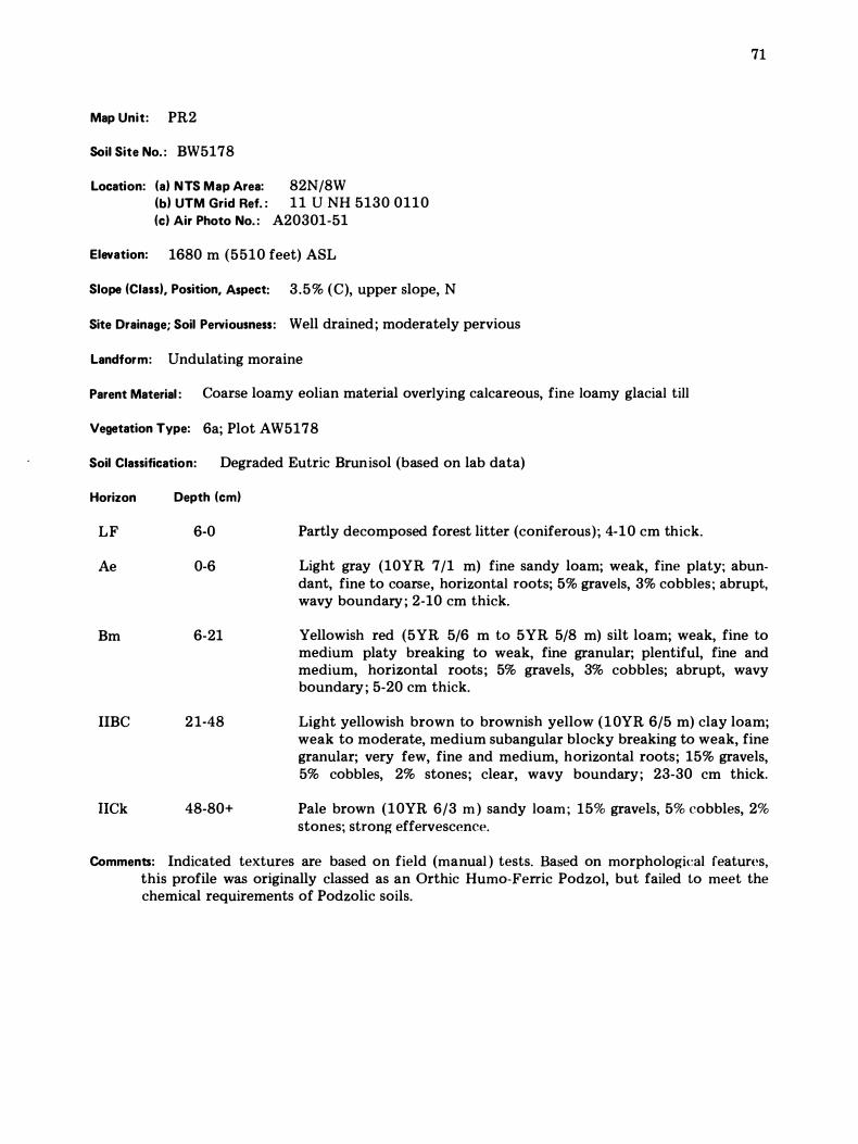
Map Unit: PR2
Soil Site No. : BW5178
Location: (a) NTS Map Area: 82N/8W (b) UTM Grid Ref. : 1 1 U NH 5130 0110 (c) Air Photo No. : A20301-51
Elevation: 1680 m (5510 feet) ASL
Slope (Class), Position, Aspect: 3.5% (C), upper slope, N
Site Drainage; Soil Perviousness: Well drained; moderately pervious
Landform: Undulating moraine
Parent Material : Coarse loamy eolian material overlying calcareous, fine loamy glacial till
Vegetation Type: 6a; Plot AW5178
Soil Classification: Degraded Eutric Brunisol (based on lab data)
Horizon Depth (cm)
LF 6-0 Partly decomposed forest litter (coniferous); 4-10 cm thick.
71
Ae 0-6 Light gray (10YR 7/1 m) fine sandy loam; weak, fine platy; abundant, fine to coarse, horizontal roots; 5% gravels, 3% cobbles ; abrupt, wavy boundary ; 2-10 cm thick.
Bm
IIBC
liCk
6-21
21-48
48-80+
Yellowish red (5YR 5/6 m to 5YR 5/8 m) silt loam; weak, fine to medium platy breaking to weak, fine granular; plentiful, fine and medium, horizontal roots; 5% gravels, 3% cobbles; abrupt, wavy boundary ; 5-20 cm thick.
Light yellowish brown to brownish yellow ( l OYR 6/5 m) clay loam; weak to moderate, medium subangular blocky breaking to weak, fine granular; very few, fine and medium, horizontal roots; 15% gravels, 5% cobbles, 2% stones; clear, wavy boundary; 23-30 cm thick.
Pale brown (10YR 6/3 m ) sandy loam ; 15% gravels, 5% cobbles, 2% stones; strong effervescence.
Comments: Indicated textures are based on field (manual ) tests. Based on morphological features, this profile was originally classed as an Orthic Humo-Ferric Podzol, but failed to meet the chemical requirements of Podzolic soils.
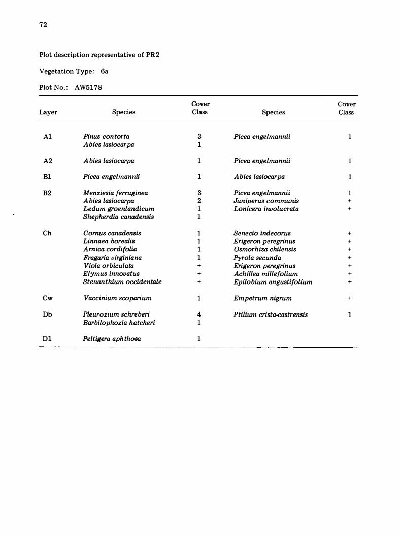
72
Plot description representative of PR2
Vegetation Type: 6a
Plot No. : AW5I78
Cover Cover Layer Species Class Species Class
Al Pinus contorta 3 Picea engelmannii 1 Abies lasiocarpa 1
A2 A bies lasiocarpa 1 Picea engelmannii 1
Bl Picea engelmannii 1 Abies lasiocarpa 1
B2 Menziesia ferruginea 3 Picea engelmannii 1 A bies lasiocarpa 2 Juniperus communis + Ledum groenlandicum 1 Lonicera involucrata + Shepherdia canadensis 1
Ch Comus canadensis 1 Senecio indecorus + Linnaea borealis 1 Erigeron peregrinus + Amica cordifolia 1 Osmorhiza chilensis + Fragaria virginiana 1 Pyrola secunda + Viola orbiculata + Erigeron peregrinus + Elymus innovatus + Achillea millefolium + Stenanthium occidentale + Epilobium angustifolium +
Cw Vaccinium scoparium 1 Empetrum nigrum +
Db Pleurozium schreberi 4 Ptilium crista-castrensis 1 Barbilophozia hatcheri 1
Dl Peltigera aphthosa 1
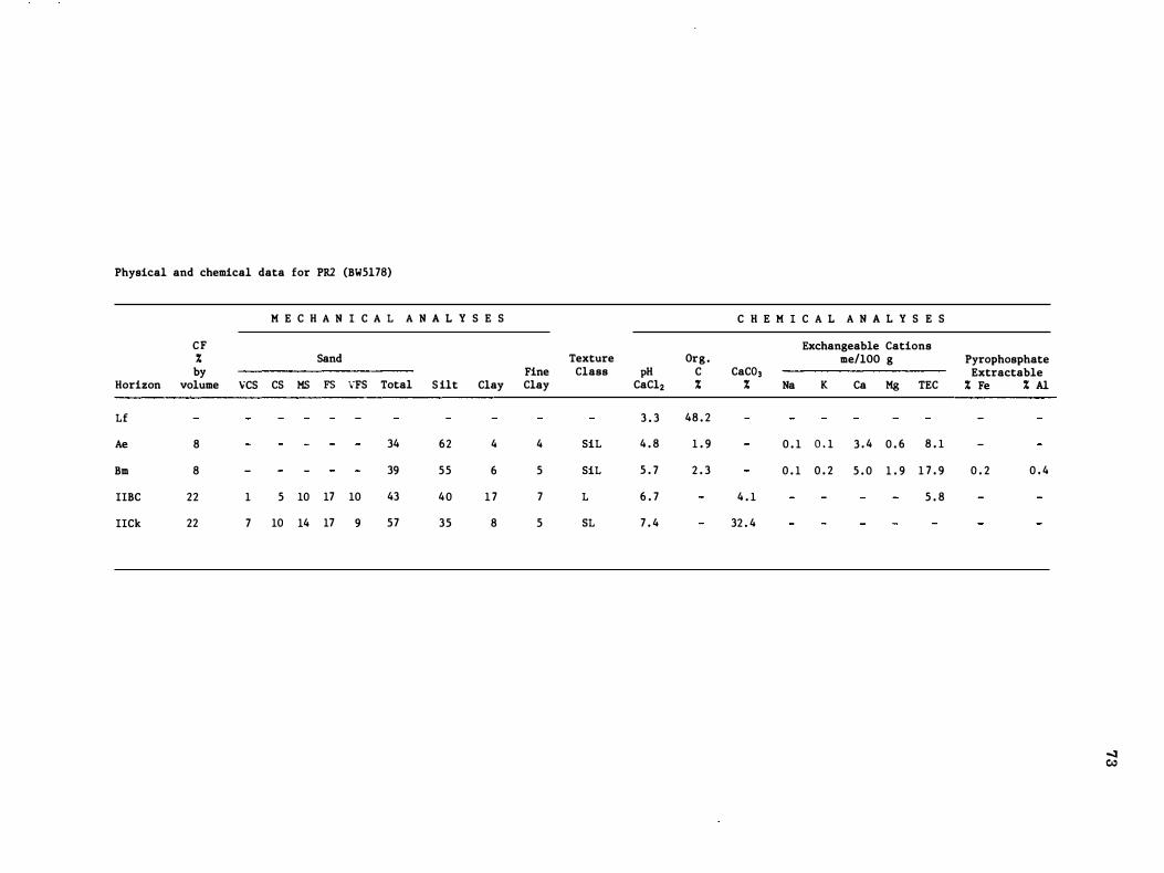
Physical and chemical data for PRl (BW5l78)
M E C H A N I C A L A N A L Y S E S
CF % Sand by Fine
Horizon volume VCS CS MS FS VFS Total S ilt Clay Clay
Lf
Ae 8 34 62 4 4
Bm 8 39 55 6 5
IIBC 22 1 5 10 17 10 43 40 1 7 7
IICk 22 7 10 14 17 9 57 35 8 5
Texture Org . Class pH C
CaCl2 % 3 . 3 48 . 2
SiL 4 . 8 1 . 9
SiL 5 . 7 2 . 3
L 6 . 7
SL 7 . 4
C H E M I C A L A N A L Y S E S
Exchangeable Cations me/lOO g
CaC03 % Na K Ca Mg TEC
0 . 1 0 . 1 3 . 4 0 . 6 8 . 1
0 . 1 0 . 2 5 . 0 1 . 9 1 7 . 9
4 . 1 5 . 8
32 . 4
Pyrophosphate Extractable % Fe % Al
0 . 2 0 . 4
� c."
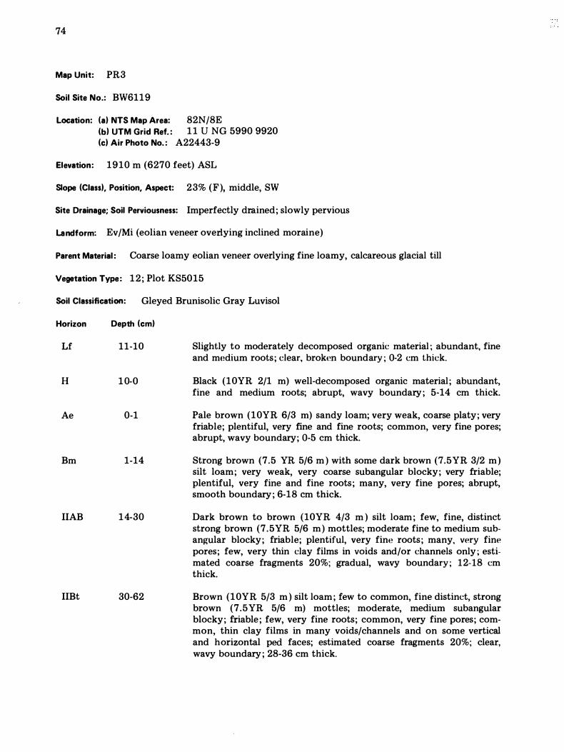
74
Map Unit: PR3
Soil Site No.: BW6119
Location: (a) NTS Map Area: 82N/8E (b) UTM Grid Ref. : 1 1 U NG 5990 9920 (c) Air Photo No. : A22443-9
Elevation: 1910 m (6270 feet) ASL
Slope (Class), Position, Aspect: 23% (F), middle, SW
Site Drainage; Soil Perviousness: Imperfectly drained; slowly pervious
Landform: Ev/Mi (eolian veneer overlying inclined moraine)
Parent Material : Coarse loamy eolian veneer overlying fine loamy, calcareous glacial till
Vegetation Type: 12; Plot KS5015
Soil Classification: Gleyed Brunisolic Gray Luvisol
Horizon
Lf
H
Ae
Bm
IIAB
IIBt
Depth (cm)
11-10
1 0-0
0-1
1-14
14-30
30-62
Slightly to moderately decomposed organic material ; abundant, fine and medium roots; clear, broken boundary ; 0-2 cm thick.
Black (10YR 2/1 m) well-decomposed organic material ; abundant, fine and medium roots; abrupt, wavy boundary ; 5-14 cm thick.
Pale brown (10YR 6/3 m) sandy loam; very weak, coarse platy; very friable; plentiful, very fine and fine roots; common, very fine pores; abrupt, wavy boundary; 0-5 cm thick.
Strong brown (7.5 YR 5/6 m ) with some dark brown (7.5YR 3/2 m) silt loam; very weak, very coarse subangular blocky; very friable; plentiful, very fine and fine roots; many, very fine pores; abrupt, smooth boundary ; 6-18 em thick.
Dark brown to brown (10YR 4/3 m ) silt loam ; few, fine, distinct strong brown (7.5YR 5/6 m) mottles; moderate fine to medium subangular blocky; friable; plentiful, very fine roots; many, very fine pores; few, very thin clay films in voids and/or channels only ; estimated coarse fragments 20%; gradual, wavy boundary ; 12-18 cm thick.
Brown (10YR 5/3 m ) silt loam ; few to common, fine distinct, strong brown (7.5YR 5/6 m) mottles; moderate, medium subangular blocky; friable ; few, very fine roots; common, very fine pores; common, thin clay films in many voids/channels and on some vertical and horizontal ped faces; estimated coarse fragments 20%; clear, wavy boundary ; 28-36 cm thick.
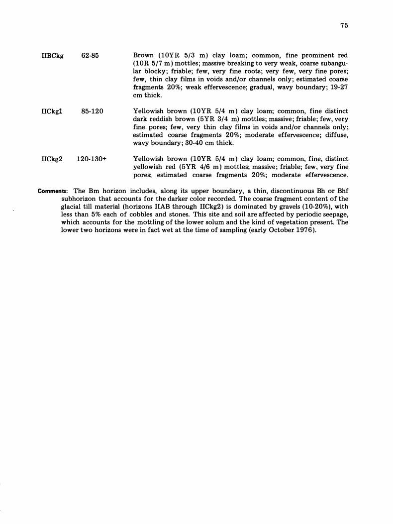
IIBCkg 62-85
IICkg1 85-120
IICkg2 120-130+
75
Brown (10YR 5/3 m) clay loam; common, fine prominent red (lOR 5/7 m ) mottles; massive breaking to very weak, coarse subangular blocky ; friable; few, very fine roots; very few, very fine pores; few, thin clay films in voids and/or channels only; estimated coarse fragments 20%; weak effervescence; gradual, wavy boundary; 19-27 cm thick.
Yellowish brown (10YR 5/4 m ) clay loam; common, fine distinct dark reddish brown (5YR 3/4 m) mottles; massive; friable; few, very fine pores; few, very thin clay films in voids and/or channels only ; estimated coarse fragments 20%; moderate effervescence; diffuse, wavy boundary ; 30-40 cm thick.
Yellowish brown (10YR 5/4 m ) clay loam; common, fine, distinct yellowish red (5YR 4/6 m ) mottles; massive; friable; few, very fine pores; estimated coarse fragments 20%; moderate effervescence.
Comments: The Bm horizon includes, along its upper boundary, a thin, discontinuous Bh or Bhf subhorizon that accounts for the darker color recorded. The coarse fragment content of the glacial till material (horizons IIAB through IICkg2) is dominated by gravels (10-20%), with less than 5% each of cobbles and stones. This site and soil are affected by periodic seepage, which accounts for the mottling of the lower solum and the kind of vegetation present. The lower two horizons were in fact wet at the time of sampling (early October 1976).
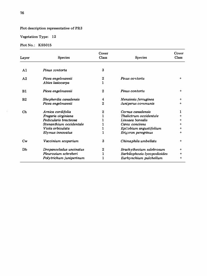
76
Plot description representative of PR3
Vegetation Type: 12
Plot No. : KS5015
Cover Cover Layer Species Class Species Class
Al Pinus contorta 3
A2 Picea engelmannii 2 Pinus co '1 torta + A bies lasiocarpa 1
Bl Picea engelmannii 2 Pinus contorta +
B2 Shepherdia canadensis 4 Menziesia ferruginea + Picea engelmannii 2 Juniperus communis +
Ch Arnica cordifolia 2 Cornus canadensis 1 Fragaria virginiana 1 Thalictrum occidentale + Pedicularis bracteosa 1 Linnaea borealis + Stenanthium occidentale 1 Carex concinna + Viola orbiculata 1 Epi�obium angustifolium + Elymus innovatus 1 Eri{;eron peregrinus +
Cw Vaccinium scoparium 3 Chimaphila umbellata +
Db Drepanocladus uncinatus 2 Brachythecium salebrosum + Pleurozium schreberi 1 Barbilophozia lycopodioides + Polytrichum juniperinum 1 Eurhynchium pulchellum +
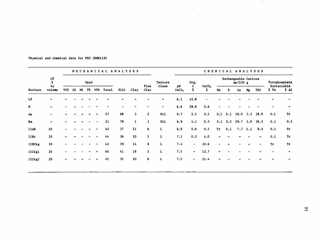
Physical and chemical data for PRJ (BW6ll9)
M E C H A N I C A L A N A L Y S E S C H E M I C A L A N A L Y S E S
CF Exchangeable Cations % Sand Texture Org. me /lOO g Pyrophosphate by Fine Class pH C CaC03 Extractable
Horizon volU111e VCS CS MS FS VFS Total Silt Clay Clay CaC12 % % Na K Ca Mg TEC % Fe % Al LF 6 . 1 42 . 8
H 6 . 6 28 . 8 0 . 6
Ae 2 7 68 5 2 SiL 6 . 7 2 . 5 0 . 5 0 . 1 0 . 1 19 . 0 3 . 3 18 . 9 0 . 1 Tr
Bm 21 78 1 1 SiL 6 . 9 4 . 1 0 . 5 0 . 1 0 . 2 29 . 7 5 . 9 36 . 5 0 . 1 0 . 2
IIAB 20 42 37 21 6 L 6 . 9 0 . 6 0 . 5 Tr 0 . 1 7 . 7 2 . 1 8 . 0 0 . 1 Tr
IIBt 20 44 36 20 5 L 7 . 1 0 . 2 4 . 0 0 . 1 Tr
II BCkg 20 42 39 14 6 L 7 . 4 10 . 6 Tr Tr
IICkgl 20 40 41 19 5 L 7 . 5 12. 7
IICkg2 20 45 35 20 6 L 7 . 5 11 . 4
-.1 -.1
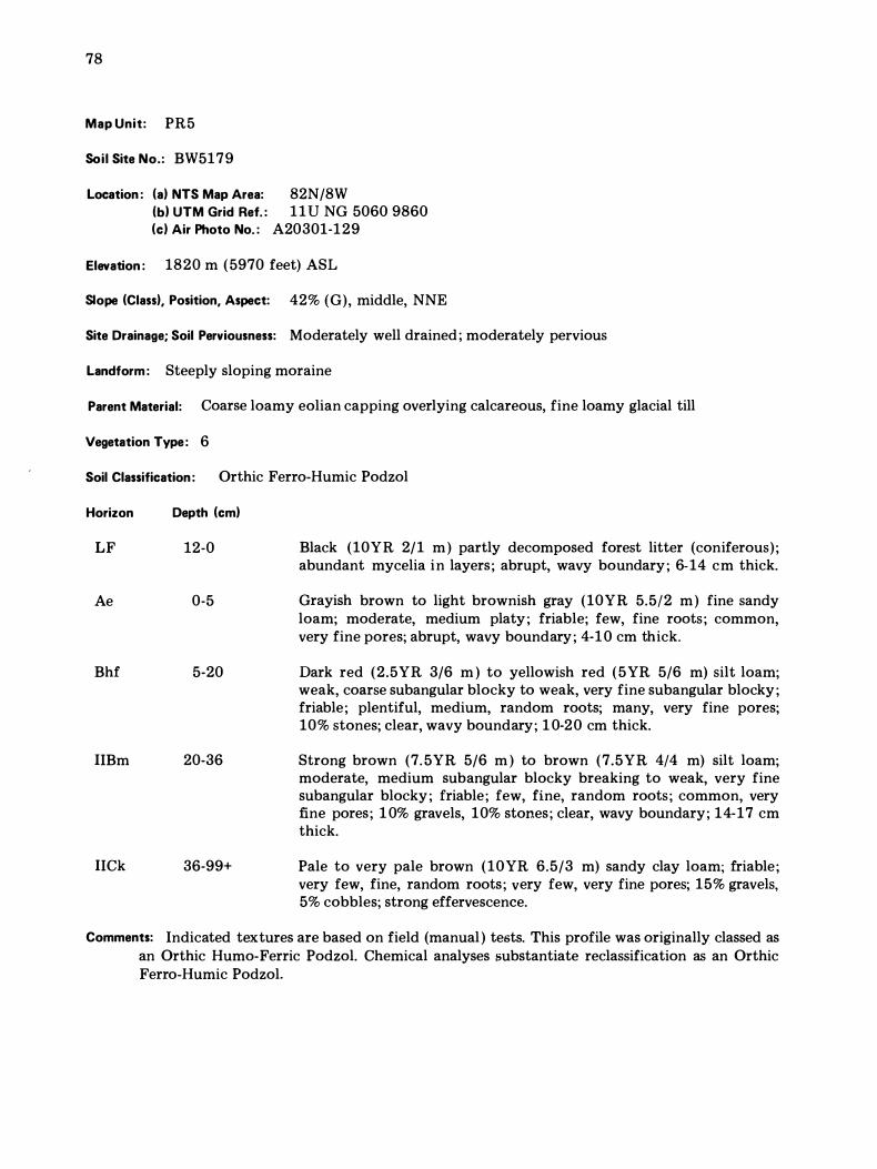
78
Map Unit: PR5
Soil Site No.: BW5179
Location : (a) NTS Map Area: 82N/8W (b) UTM Grid Ref. : 1 1 V NG 5060 9860 (c) Air Photo No. : A20301-129
Elevation : 1820 m (5970 feet) ASL
Slope (Class), Position, Aspect: 42% (G), middle, NNE
Site Drainage; Soil Perviousness: Moderately well drained ; moderately pervious
Landform : Steeply sloping moraine
Parent Material: Coarse loamy eolian capping overlying calcareous, fine loamy glacial till
Vegetation Type: 6
Soil Classification: Orthic Ferro-Humic Podzol
Horizon
LF
Ae
Bhf
lIBm
lICk
Depth (cm)
12-0
0-5
5-20
20-36
36-99+
Black (10YR 2/1 m ) partly decomposed forest litter (coniferous) ; abundant mycelia in layers; abrupt, wavy boundary ; 6-14 cm thick.
Grayish brown to light brownish gray (10YR 5.5/2 m ) fine sandy loam; moderate, medium platy ; friable; few, fine roots; common, very fine pores; abrupt, wavy boundary ; 4-1 0 cm thick.
Dark red (2.5YR 3/6 m ) to yellowish red (5YR 5/6 m) silt loam; weak, coarse subangular blocky to weak, very fine subangular blocky ; friable; plentiful, medium, random roots; many, very fine pores; 10% stones; clear, wavy boundary; 1 0-20 cm thick.
Strong brown (7. 5YR 5/6 m ) to brown (7.5YR 4/4 m) silt loam; moderate, medium sub angular blocky breaking to weak, very fine subangular blocky ; friable; few, fine, random roots; common, very fine pores; 1 0% gravels, 10% stones; clear, wavy boundary; 14-17 cm thick.
Pale to very pale brown (10YR 6.5/3 m) sandy clay loam; friable; very few, fine, random roots; very few, very fine pores; 15% gravels, 5% cobbles; strong effervescence.
Comments: Indicated textures are based on field (manual ) tests. This profile was originally classed as
an Orthic Humo-Ferric Podzol. Chemical analyses substantiate reclassification as an Orthic
Ferro-Humic Podzol.
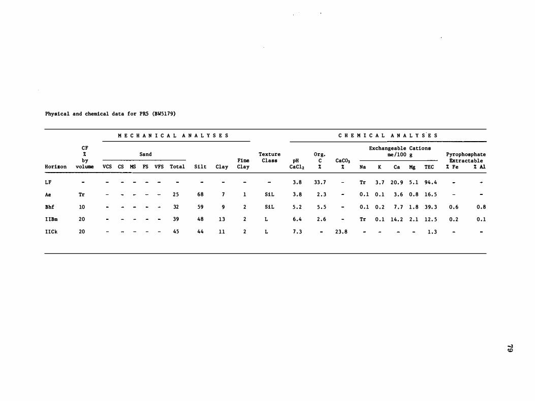
Physical and chemical data for PRS (BW5l79)
M E C H A N I C A L A N A L Y S E S
CF % Sand Texture by Fine Class
Horizon volume VCS CS HS FS VFS Total Silt Clay Clay
LF
Ae Tr 25 68 7 1 SiL
Bhf 10 32 59 9 2 SiL
IIBm 20 39 48 13 2 L
IICk 20 45 44 11 2 L
Org. pH C
CaC12 % 3 . 8 33 . 7
3 . 8 2 . 3
5 . 2 5 . 5
6 . 4 2 . 6
7 . 3
C H E M I C A L A N A L Y S'E S
Exchangeable Cations me /100 g
CaCO, % Na K Ca Hg TEC
Tr 3 . 7 20 . 9 5 . 1 94 . 4
0 . 1 0 . 1 3 . 6 0 . 8 16 . 5
0 . 1 0 . 2 7 . 7 1 . 8 39. 3
Tr 0 . 1 14 . 2 2 . 1 12 . 5
23 . 8 1 . 3
Pyrophosphate Extractable % Fe % Al
0 . 6 0 . 8
0 . 2 0 . 1
....::J c.o
80
Map Unit: ML1
Soil Site No. : BW 4088
Location: (a) NTS Map Area : 82N/8E (b) UTM Grid Ref. : 1 1 U NG 571 5 1905 (c) Air Photo No. : A17655-139
Elevation: 1905 m (6250 feet) ASL
Slope (Class), Position, Aspect: 26% (F), lower slope, ENE
Site Drainage; Soil Perviousness: Rapidly drained ; rapidly pervious
Landform: Mi (Inclined moraine)
Parent Material : Loamy-skeletal, medium acid to neutral till
Vegetation Type: 6 ; Plot KS5031
Soil Classification: Orthic Humo-Ferric Podzol
Horizon
LF
Ae
Bhf
IIBm
IIBC1
IIBC2
IICk
Depth (em)
4-0
0-6
6-12
12-32
32-57
57-90
90+
Black (10YR 2/1 m) slightly to moderately decomposed organic material ; abundant, medium and coarse, random roots; abrupt, wavy boundary ; 1-8 cm thick.
Light gray (10YR 7/1 d) silt loam; weak, medium to coarse platy ; very friable; abundant, medium and coarse, random roots; estimated coarse fragments < 1 0%; abrupt, wavy boundary; 3-12 cm thick.
Red (2.5YR 4/6 m ), near upper boundary, grading to strong brown (7.5YR 5/8 m), near lower boundary, gravelly silt loam; massive breaking to weak, fine granular; very friable ; abundant, medium and coarse, random roots; estimated coarse fragments 30%; abrupt wavy boundary; 2-11 cm thick.
Strong brown (7 .5YR 5/6 m) to reddish yellow (7.5YR 6/8 d) gravelly loamy sand ; massive ; abundant to plentiful, medium and coarse, random roots; estimated coarse fragments 50%; clear, wavy boundary ; 12-30 cm thick.
Very gravelly sandy loam ; single grain; friable to firm ; plentiful, fine and medium, random roots; estimated coarse fragments 60%; gradual, smooth boundary ; 20-30 em thick.
Very gravelly sandy loam to gravelly loamy sand ; single grain; hard; few, fine and medium, vertical roots; estimated coarse fragments 60%; clear, smooth boundary.
Yellowish brown (10YR 5/6 m) very gravelly loamy sand ; loose ; very few, fine, vertical roots; estimated coarse fragments 60%.
81
Comments: Yellowish red (5YR 4/6-4/6 m ) colors occur in the central portion of the Bfl horizon. Coarse fragments are dominated throu�out the profile by subrounded cobbles and stones with the exception of the Ae horizon, where gravels tend to dominate. Very weak effervescence occurs when 20% HCI is applied to some coarse fragments from the C horizon. Matrix material, away from coarse fragments, does not respond to HCI application. Lithologically, coarse fragments are dominated by quartzites. Surface stoniness in the immediate area is classed as exceedlingly stony (class 5). Subrounded, stone-size fragments dominate.
Plot description representative of ML1
Vegetation Type : 6
Plot No. : KS5031
Cover Cover Layer Species Class Species Class
A1 Picea engelmannii 3 A bies lasiocarpa 2
A2 A bies lasiocarpa 3 Picea engelmannii 2
B1 A bies lasiocarpa 2
B2 Menziesia ferruginea 4 A bies lasiocarpa 2 Rhododendron albiflorum 2
Ch Arnica cordifolia 1 Lycopodium annotinum + Listera cordata + Viola orbiculata +
Cw Vaccinium scoparium 2 Phyllodoce glanduliflora +
Db Pleurozium schreberi 4 Dicranum fuscescens 2 Barbilophozia hatcheri 3 Hylocomium splendens 1
D1 Peltigera aphthosa 2 Cladonia sp. 1
�
Physical and chemical data for MLl (BW4088)
M E C H A N I C A L A N A L Y S E S C H E M I C A L A N A L Y S E S
CF Exchangeable Cations % Sand Texture Org. me/IOO g Pyrophosphate by Fine Class pH C CaC0 3 Extractable
Horizon volume VCS CS MS FS VFS Total Silt Clay Clay CaC12 % % Na K Ca Mg TEC % Fe % Al
LF 4 . 5 41 . 3 Tr 1 . 6 23 . 1 5 . 6 69 . 5
Ae <10 1 2 3 10 9 25 69 6 1 SiL 3 . 8 2 . 4 0 . 1 0 . 2 0 . 8 0 . 4 1 3 . 4
Bhf 30 4 5 8 12 11 40 53 7 0 SiL 4 . 8 5 . 7 Tr 0 . 3 0 . 4 0. 3 36 . 2 0 . 4 1 . 0
IIBm 50 9 10 19 27 12 7 7 19 4 0 GLS 5 . 3 1 . 1 0 . 1 0. 1 0 . 8 0 . 0 7 . 8 0 . 1 0 . 2
IIBCl 60 8 13 19 20 9 69 28 3 0 GSL 4 . 9 0 . 0 0 . 1 0 . 5 0 . 0 3 . 5
IIBC2 60 9 14 2 3 2 2 8 76 17 7 1 GLS 5 . 4 0 . 0 0 . 1 1 . 4 0 . 3 2 . 7
IICk 60 9 14 24 2 3 9 79 16 5 1 GLS 7 . 1 14 . 6 Tr 0 . 1 3 . 3 0 . 5 1 . 7
83
Map Unit: CV1
Soil Site No.: JT5004
location: (a) NTS Map Area : 82N/8E (b) UTM Grid Ref.: 1 1 U NG 5770 9260 (c) Air Photo No. : 1 7655-145
Elevation: 1 980 m (6500 feet) ASL
Slope (Class), Position, Aspect: 1 8% ( F), upper, NE
Site Drainage; Soil Perviousness: Very poorly drained ; slowly pervious
landform: Sloping fen
Parent Material : Fen peat/calcareous coarse loamy till
Vegetetion Type: 7 ; Plot KS5091
Soil Classification: Terric Humic Mesisol
Horizon
Of
Om
Cg1
Oh1
Cg2
Oh2
Cg3
Depth (cm)
0-20
20-40
40-42
42-59
59-65
65-73
73-82
Very dark yellowish brown (10YR 2/2 m) hydromorphic humus; slightly decomposed ; mainly feathermoss; rubbed fiber 80% by volume ; clear, wavy boundary ; 1 7-20 cm thick; Pyrophosphate color 10YR 4/3.
Black (10YR 2/1 m) hydromorphic humus in moderately advanced stage of decomposition; derived mostly from mosses; rubbed fiber 10% by volume; abrupt, wavy boundary; 19-23 cm thick; Pyrophosphate color 10YR 6/4.
Yellowish brown (10YR 5/8 m) silt loam; massive; very friable; slightly sticky, slightly plastic; abrupt, wavy boundary ; 1-3 cm thick.
Black ( 10YR 2/1 m) hydromorphic humus in an advanced stage of decomposition; rubbed fiber 2% by volume; abrupt, wavy boundary; 16-20 cm thick; Pyrophosphate color 10YR 3/4.
Yellowish red (5YR 4/8 m) silt loam; massive; very friable; slightly sticky, slightly plastic; abrupt, wavy boundary; 5-10 cm thick.
Black (10YR 2/1 m) hydromorphic humus in high stage of decomposition; wood fragments 60% by volume; rubbed fiber 4% by volume ; abrupt, wavy boundary; 8-14 cm thick; Pyrophosphate color 10YR 3/3.
Gray ( 10YR 6/1 m) loamy fine sand; yellowish red mottles; massive; very friable; slightly sticky, nonplastic; noncalcareous; few coarse fragments; abrupt, wavy boundary; 7-12 cm thick.
84
Cg4 82-105+ Light yellowish brown (10YR 6/4 m) loamy fine sand; many, prominent strong brown (7. 5YR 5/8 m) and light gray (10YR 6/1 m) mottles ; massive; very friable; slightly sticky, nonplastic; noncalcareous.
Comments: Cg1 and Cg2 probably have a high content of volcanic ash.
Plot description representative of CV1
Vegetation Type: 7
Plot No. : KS5091
Cover Cover Layer Species Class Species Class
A1 Picea engelmannii 2
A2 Picea engelmannii 2 Abies lasiocarpa 2 Pinus contorta 2
B1 Abies lasiocarpa 2 Picea engelmannii 2
B2 Salix vestita 3 Salix farrae 1 Betula glandulosa 2 Potentilla fruticosa 1 A bies lasiocarpa 2 Menziesia ferruginea 1 Picea engelmannii 2 Salix barrattiana 1 Ledum groenlandicum 1 Lonicera involucrata +
Ch Carex vaginata 3 Viola renifolia + Carex scirpoidea 2 Senecio triangularis + Equisetum arvense 1 Trisetum spicatum + Erigeron peregrinus 1 Pyrola elliptica + Stenanthium occidentale 1 Linnaea borealis + Pamassia fimbriata 1 Polygonum viviparum + Anemone parviflora 1 Pedicularis bracteosa + Comus canadensis 1
Cw Vaccinium scoparium 2 Phyliocode glanduliflora 1 Empetrum nigrum 1 Kalmia polifolia 1
Db Hylocomium splendens 2 Drepanocladus uncinatus 2 Pleurozium schreberi 2 Sphagnum sp. 1 Aulacomnium palustre 2 Tomenthypnum nitens 1 Barbilophozia hatcheri 2 Dicranum sp. 1
Physical and chemical data for CVl (JT5004)
M E C H A N I C A L A N A L Y S E S
CF % Sand by
Horizon volume VCS CS MS FS VFS Total Silt Clay
Of
Om Cgl 39 55 6
Ohl
Cg2 2 1 7 2 7
Oh2
Cg3 15 2 7 21 42 10 82 14 4
Cg4 10 2 5 19 4 2 13 81 15 4
Texture Org . Fine Class pH C Clay CaC12 %
7 . 0 39 . 3
6 . 6 35 . 0
SiL 6 . 3 7 . 4
6 . 1 34 . 2
SiL 6 . 5 2 . 3
6 . 2 19 . 5
LS 6 . 7 0 . 0
LS 6 . 7 0 . 0
C H E M I C A L A N A L Y S E S
Exchangeable Cations me/100 g
CaC0 3 % Na K Ca Mg TEC
2 . 5
2 . 0
1 . 7
1 . 8
1 . 4
Pyrophosphate Extractable
% Fe % Al
00 (J1
86
Map Unit: CV2
Soil Site No. : BW4077
location : (a) NTS Map Area: 82N/8E (b) UTM Grid Ref. : 1 1 U NG 5570 9540 (c) Air Photo No. : A20301-163
Elevation: 1 770 m (5800 feet) ASL
Slope (Class), Position, Aspect: 2% (BC), middle, ESE
Site Drainage; Soil Perviousness: Very poorly to poorly drained ; moderately pervious
Landform: Fen
Parent Material : Sedge-moss peat/alluvial modified till
Vegetation Type: 14; Plot KS5086
Soil Classification: Terric Mesisol
Horizon
Om
Ahg
nCg
Depth (cm)
0-40
40-64
64+
Moderately decomposed organic material; plentiful , fine, vertical roots; abrupt, smooth boundary.
Silt loam; few thin bands of organic material (Om ) as above ; few, fine roots; increasing mineral content with depth ; abrupt, smooth boundary.
Gravelly sandy loam; very few, fine roots.
Comments: Ahg horizon probably composed of eolian or alluvial-eolian material with a high ash content.

87
Plot description representative of CV2
Vegetation Type: 1 4
Plot No. : KS5086
Cover Cover Layer Species Class Species Class
Al Absent
A2 Absent
Bl Absent
B2 Potentilla {ruticosa 2 Salix vestita + Betula glandulosa 2 Salix barrattiana + Ledum groenlandicum 1
Ch Carex leptalea 2 Pamassia fimbriata 1 Carex gynocrates 2 Polygonum viviparum 1 Juncus balticus 2 Equisetum aroense 1 Carex aquatilis 2 Pyrola asarifolia + Eriophorum angustifolium 1 Selaginella selaginoides + Equisetum variegatum 1 Anemone parviflora + Habenaria dilatata 1
Cw Oxycoccus microcarpus 2 Arctostaphylos rubra + Kalmia polifolia 1
Db Sphagnum sp. 3 Tomenthypnum nitens 2 Drepanocladus revolvens 2 Mnium sp. 2 Aulacomnium palustre +
Physical and chemical data for CV2 (BW4077)
Horizon
Om
Ahg
nCg
CF % by
volume
M E C H A N I C A L A N A L Y S E S
Sand
VCS CS HS FS VFS Total Silt Clay
5 10 18 18 7 58 33 9
Fine Clay
3
Texture Class
SL
pH CaC12
5 . 4
5 . 9
5 . 9
Org. C %
44 . 3
3 . 3
C H E M I C A L A N A L Y S E S
CaC03 % Na
Exchangeable Cations me/IOO g
K Ca Mg TEC
0 . 1 Tr 60 . 2 12 . 4 9 3 . 0
0 . 1 Tr 11 . 6 1 . 4 19 . 7
Tr Tr 3 . 8 1 . 3 4 . 4
Pyrophosphate Extractable % Fe % Al
�
Map Unit: TP1
Soil Site No.: BW Tower 8 (Lipalian )
Location: (a) NTS Map Area: 82N/8E (b) UTM Grid Ref. : 1 1 U NG 6190 9920 (c) Air Photo No. : A20145-157
Elevation: 2240 m (7350 feet) ASL
Slope (Class), Position, Aspect: 45% (G), middle slope, WNW
Site Drainage; Soil Perviousness: Well drained ; moderately pervious
Landform: Cv/Ri (colluvial veneer/inclined bedrock)
Parent Material : Loamy-skeletal colluvium/fissile bedrock/consolidated bedrock
Vegetation Type: 5 ; Plot KS5148
Soil Classification: Lithic Orthic Humo-Ferric Podzol
Horizon Depth (cm)
89
LF 1-0 Slightly to moderately decomposed organic matter; abrupt, broken boundary; 0-2 cm thick.
Bf 0-15
C 1 5-35
R1 35-45
R2 45+
Dark brown to brown (7.5YR 4/4 m ) gravelly silt loam ; structureless; very friable; abundant, micro and very fine, random and plentiful, medium and coarse, horizontal roots; estimated coarse fragments 45%; clear, broken boundary ; 0-33 cm thick.
Dark grayish brown to brown (lOYR 4/2.5 m) very gravelly loam to very gravelly silt loam ; friable; abundant, micro and very fine, random roots to 25 cm, very few, very fine roots below; estimated coarse fragments 70%; gradual, broken boundary ; 0-30 cm thick.
Fissile bedrock ; very few, very fine roots to 42 cm ; estimated coarse fragments > 90% with angular to thin flat cobbles and stones dominating; becomes more consolidated (less broken and cracked) with depth ; gradual, broken boundary; 0-15 cm thick.
Consolidated bedrock; starts at 0-60 cm from ground surface.
Comments: Bf has a low bulk density and a fairly high organic matter content. This horizon seems to be held together by abundant roots. Most cobbles and stones in the C horizon are crowned with "silt cappings". Below colluvial material, bedrock is very fissile and broken, but becomes increasingly consolidated (less cracks) with depth. Consolidated bedrock is exposed at the surface on the downslope side of the soil pit.
90
Plot description representative of TPl
Vegetation Type: 5
Plot No. : KS5148
Cover Cover Layer Species Class Species Class
Al Picea engelmannii 3
A2 Abies lasiocarpa 3 Picea engelmannii 2
Bl Abies lasiocarpa 2 Picea engelmannii 2
B2 Abies lasiocarpa 2 Picea engelmannii 2 Vaccinium membranaceum 2
Ch Arnica latifolia 2 Hieracium gracile + Erigeron peregrinus 1 Poa nervosa + Arnica cordifolia 1 Valeriana sitchensis + Lycopodium annotinum 1 Deschampsia atropurpurea +
Cw Vaccinium scoparium 4 Phyllodoce empetriformis 1 Phyllodoce glanduliflora 2
Db Barbilophozia hatcheri 4 Pleurozium schreberi 1 Dicranum scoparium 2
Dl Cladonia sp. 2 Peltigera aphthosa 1
Physical and chemical data for TPl ( BW Tower 8)
Horizon
Bf
C
CF % by
volume
45
70
H E C H A N I C A L A N A L Y S E S
Sand
V.CS CS HS FS VFS Total Silt Clay
7 8 6 7 10 38 5 3 9
9 10 6 6 5 36 50 14
Fine Clay
o
1
Texture Class
GSiL
VGSiL
pH CaClz
4 . 9
4 . 5
Drg. C %
3 . 7
C H E H I C A L A N A L Y S E S
CaCD s % Na
Exchangeable Cations me/ 100 g
K Ca Kg TEC
0 . 1 0 . 3 4 . 7 0 . 1 18 . 2
Tr 0 . 1 1 . 6 0 . 2 6 . 3
Pyrophosphate Extractable % Fe % Al
0 . 3 0 . 6
CoO ....
92
Map Unit: Soil inclusion in TP1
Soil Site No. : BW Tower 9 (Lipalian)
location: (a) NTS Map Area: 82N/8E (b) UTM Grid Ref. : 1 1 U NG 6200 9910 (c) Air Photo No. : A201 45-157
Elevation: 2270 m (7450 feet) ASL
Slope (Class), Position, Aspect: 25% ( F ), middle slope, WNW
Site Drainage; Soil Perviousness: Well to rapidly drained; moderately pervious
landform: Mi (Inclined moraine)
Parent Material : Loamy-skeletal till
Vegetation Type: 5 ; Plot KS5148 (see page 90)
Soil Classification: Podzolic Gray Luvisol
Horizon
LFH
Ahe
Bf
IIAB
IIBt
Depth (cm)
3-0
0-4
4-19
19-34
34-pit bottom (> 60)
Black (10YR 2/1 m) slightly to well decomposed organic matter; plentiful, medium to coarse, random roots; abrupt, wavy boundary; 3-10 cm thick.
Light brownish gray to light gray (10YR 6.5/2 d) silt loam ; structureless to weak, fine platy; very friable; plentiful, medium and coarse, random roots; estimated coarse fragments < 2%; abrupt, broken boundary; 0-5 cm thick.
Yellowish brown ( 1 0YR 5/8 d) silt loam; structureless to weak, fine platy ; very friable ; few, medium and coarse random roots; estimated coarse fragments 1 5%; abrupt, wavy boundary ; 8-17 cm thick.
Light gray to pale yellow ( 10YR 7/3 d) gravelly sandy loam ; weak, fine platy to single grain; friable ; very few, very fine roots; estimated coarse fragments 45%; abrupt, smooth boundary ; 13-18 cm thick.
Light yellowish brown to pale yellow (2.5Y 6.5/3 d) gravelly loam; massive breaking to strong, medium and fine blocky ; very firm; common, thin clay films on ped faces; estimated coarse fragments 45%.
Comments: The dry color given for Bf horizon is from crushed soil. In the field this horizon had a patchy appearance, with most of it being fairly bright in color. Therefore, most of this horizon meets the Bf definition. Coarse fragments in the AB and Bt horizons are dominated by gravels and cobbles. The Ahe and Bf horizons contain appreciable amounts of organic matter and have low bulk densities. This site occurs on a small bench with G topography above and below.
Physical and chemical data for a soil inclusion in TPl (BW Tower 9)
M E C H A N I C A L A N A L Y S E S
CF % Sand by Fine
Horizon volume VCS CS MS FS VFS Total Silt Clay Clay
Abe <2 2 2 2 16 12 34 56 10 2
Bf 15 8 6 4 6 12 36 5 6 8 1
IIAB 45 10 13 13 14 9 5 9 33 8 1
IIBt 45 7 8 7 9 7 38 36 26 7
Texture Org. Class pH C
CaC12 % SiL 4 . 0 4 . 0
SiL 4 . 7 4 . 0
GSL 4 . 4 0 . 3
GL 5 . 9 0 . 2
C H E M I C A L A N A L Y S E S
Exchangeable Cations me/100 g
CaC03 % Na K Ca Kg TEC
0 . 1 0 . 2 0 . 9 0 . 0 10 . 7
0 . 2 0 . 2 0 . 9 0 . 0 18 . 2
Tr 0 . 1 0 . 8 0 . 0 3 . 5
0 . 1 0 . 1 5 . 6 1 . 6 5 . 0
Pyrophosphate Extractable % Fe % Al
0 . 5 0. 7
to �
94
Map Unit: BVI
Soil Site No. : DA4077
Location : (a) NTS Map Area: 820/5W (b) UTM Grid Ref. : 1 1 U NG 7 330 8040 (c) Air Photo No. : A20300-49
Elevation : 1 450 m (4760 feet) ASL
Slope (Class), Position, Aspect: 2% (B), upper, NE
Site Drainage; Soil Perviousness : Rapidly drained ; rapidly pervious
Landform: FGt (Glaciofluvial terrace)
Parent Material : Coarse loamy fluvial veneer overlying coarse sandy-skeletal, calcareous glaciofluvial material
Vegetation Type: 2
Soil Classification: Orthic Eutric Brunisol
Horizon
LF
Ae
Bm
lICkl
IICk2
Depth (cm)
3-0
0-1
1-16
16-48
48+
Black (10YR 2/1 d) slightly to moderately decomposed organic material ; abundant fine to coarse; random roots; abrupt, wavy boundary; 2-5 cm thick.
Light gray (10YR 7/2 d) sandy loam; single grain; loose ; abundant, fine to coarse random roots; estimated coarse fragments < 10%; abrupt, broken boundary ; 0-2 cm thick.
Yellowish brown (10YR 5/6 d) loam; single grain ; soft; plentiful, fine and medium roots; estimated coarse fragments < 1 0%; clear, broken boundary ; 0-17 cm thick.
Yellowish brown ( 10YR 5/4 d) very gravelly sandy loam ; loose; few, fine roots; estimated coarse fragments 80% (gravels and cobbles); gradual, wavy boundary ; 17-48 cm thick.
Brown (10YR 5/3 d) very gravelly loamy sand ; loose; very few, fine roots ; estimated coarse fragments 80% (gravels and cobbles).
Comments: The continuity of the Bm horizon is broken only along a small section of the pit. Although this particular profile occurs outside the Lake Louise Study Area, it closely resembles soils of the BVI unit occurring within the study area, except that BVI soils in the Lake Louise Study Area have a greater stone content.
Physical and chemical data for BVI (DA407 7 )
M E C H A N I C A L A N A L Y S E S
C % Sand Texture by Fine Class
Horizon volume VCS CS KS FS VFS Total Silt Clay Clay
LF
Bm <10 46 49 5 1 SL
IICK! 80 7 7 16 7 3 VGLS
IICK2 80 81 17 2 2 VGLS
Org. pH C
CaC12 % 4 . 3 46 . 9
5 . 2 0 . 8
7 . 2
7 . 0
C H E M I C A L A N A L Y S E S
Exchangeable Cations me/IOO g
CaCO, % Na K Ca Kg TEC
0 . 1 2 . 0 2 2 . 4 6 . 5 55 . 8
0 . 1 0 . 1 2 . 0 0 . 3 8 . 1
16 . 0 Tr 0 . 1 10 . 6 1 . 9 4 . 7
22 . 2 Tr Tr 10 . 9 1 . 2 3 . 1
Pyrophosphate Extractable % Fe % A1
Tr 0 . 2
co 01
96
Map Unit: BV2
Soil Site No. : BW5177
Location: (a ) NTS Map Area: 82N/8W (b) UTM Grid Ref. : 1 1 U NG 5240 9960 (c) Air Photo No. : A20301-49
Elevation : 1605 m (5270 feet) ASL
Slope (Class), Position, Aspect: 1.5% (B), upper slope, NW
Site Drainage; Soil Perviousness: Rapidly drained ; rapidly pervious
Landform: Undulating glaciofluvial terrace
Parent Material : Coarse loamy eolian material overlying sandy-skeletal (gravelly), calcareous glaciofluvial material
Vegetation Type: 6a; Plot AW5177
Soil Classification: Orthic Eutric Brunisol (based on lab data)
Horizon
LF
Ae
Bm
IIBC
IICk
Depth (cm)
5-0
0-3
3-23
23-31
31-90+
Black (10YR 2/1 m ) partly decomposed forest litter (coniferous) ; abundant, fine and medium, random roots; abrupt, wavy boundary ; 2-8 cm thick.
Light brownish gray (10YR 6/2 m ) to light gray (10YR 7/2 m) sandy loam; weak, medium platy; friable; abundant, fine, oblique roots; common, fine pores; 5% cobbles; abrupt, wavy boundary ; 0-7 cm thick.
Yellowish red (5YR 5/6 m) silt loam; weak, medium subangular blocky breaking to very weak, very fine to fine granular; friable ; plentiful, fine, oblique roots; few, fine pores; 5% gravels, 5% stones; abrupt, wavy boundary; 1 2-30 cm thick.
Brown (7 .5YR 4/5 m ) gravelly sandy loam ; very weak, fine subangular blocky breaking to single grain ; friable ; plentiful, very fine, oblique roots; very few, very fine pores; 25% gravels, 1 0% cobbles, 1 0% stones; clear, wavy houndary ; 5-1 1 cm thick. Yellowish brown to light yellowish brown (1 0YR 5.5/4 m) gravelly loamy sand; single grain ; loose; 30% gravels, 1 5% stones, 1 0% cobbles; strong effervescence.
Comments: Indicated textures are based on field (manual) tests. Based on morphological features, this profile was originally classed as an Orthic Humo-Ferric Podzol but failed to meet the chemical requirements of Podzolic soils.
97
Plot description representative of BV2
Vegetation Type : 6a
Plot No. : AW5l77
Cover Cover Layer Species Class Species Class
Al Pinus contorta 3
A2 Picea engelmannii 1
Bl Picea engelmannii 2 Abies lasiocarpa 1
B2 Menziesia ferruginea 2 Shepherdia canadensis 1 Picea engelmannii 1 Ledum groenlandicum 1 A bies lasiocarpa 1
Ch Linnaea borealis 2 Pyrola secunda + Comus canadensis 2 Elymus innovatus + Arnica cordifolia 1 Epilobium angustifolium + Calamagrostis rubescens 1 Pyrola asarifolia +
Cw Vaccinium scoparium 2 Empetrum nigrum 1
Db Pleurozium schreberi 4 Poly trichum juniperinum + Barbilophozia hatcheri 2 Dicranum sp. + Ptilium crista-castrensis 1
Physical and chemical data for BV2 ( BW5l77)
M E C H A N I C A L A N A L Y S E S
CF % Sand by Fine
Horizon volume VCS CS MS FS VFS Total Silt Clay Clay
LF
Ae 5 4 7 26 2 7 14
Bm 10 9 11 11 10 9 50 4 7 3 3
IIBCk 45 8 13 13 12 9 55 34 11 7
IICk 55 28 19 10 9 6 72 26 2 2
Texture Org. Class pH C
CaC12 % 3 . 4 54 . 6
SCL 4 . 4 1 . 3
SL 5 . 4 1 . 6
GSL 6 . 7
GLCS 7 . 3
C H E M I C A L A N A L Y S E S
Exchangeable Cations me/100 g
CaC0 3 % Na K Ca Mg TEC
Tr 0 . 1 2 . 8 0 . 5 10 . 2
0 . 1 0 . 1 2 . 1 0 . 4 10 . 2
20 . 3 6 . 7
54 . 2
Pyrophosphate Extractable
% Fe % Al
0 . 1 0 . 2
c.o 00
99
Map Unit: PIl
Soil Site No. : JT5003
Location: (a) NTS Map Area: 82N/8E (b) UTM Grid Ref. : 1 1 U NG 5780 9690 (c) Air Photo No. : A20301-47
Elevation: 1 500 m (5090 feet) ASL
Slope (Class), Position, Aspect: 1.5% (B), lower, SE
Site Drainage; Soil Perviousness: Well drained ; moderately pervious
Landform: Alluvial fan
Parent Material: Gravelly coarse textured, stratified, calcareous alluvium
Vegetation Type: 3 ; Plot KS5138
Soil Classification: Orthic Regosol
Horizon
LF
Ahk
Ck
Bmkb
Ckb1
Ckb2
Ckb3
Depth (cm)
3-0
0-6
6-23
23-29
29-45
45-52
52-70+
Partly decomposed organic material derived mainly from needles of conifers and herbaceous litter; 1-4 cm thick.
Brown (10YR 5/3 m) silt loam; weak, fine granular; very friable; plentiful, fine roots; common, fine pores; moderately calcareous; clear, wavy boundary ; 5-7 cm thick.
Light yellowish brown ( 1 0YR 6/4 m) silt loam; weak sub angular blocky; very friable ; plentiful, medium roots; common, fine pores; moderately calcareous; abrupt, wavy boundary; 1 5-19 cm thick; charcoal present.
Yellowish red (5YR 4/8 m ) silt loam; moderate, medium subangular blocky; friable; plentiful, fine roots; weakly calcareous; clear, wavy boundary ; 5-7 cm thick; secondary carbonates in pores.
Brown (10YR 5/3 m) to yellowish brown (1 0YR 5/4 m) loam ; very weak, medium subangular blocky ; very friable; plentiful, fine roots; moderately calcareous; abrupt, wavy boundary ; 14-17 cm thick.
Brown (10YR 5/3 m ) fine sandy loam; structureless ; loose; abundant, fine roots; moderately calcareous; abrupt, wavy boundary ; 5-9 cm thick.
Brown (10YR 5/3 m) very gravelly coarse sandy loam; structureless; loose; strongly calcareous; 80% coarse fragments.
100
Plot description representative of portions of PH
Vegetation Type : 3
Plot No. : KS5138
Cover Cover Layer Species Class Species Class
Al Pinus contorta 3
A2 Pinus contorta 3
B1 Absent
B2 Shepherdia canadensis 2 Juniperus communis I Potentilla fruticosa 2 Salix glauca I
Betula glandulosa 2 Lonicera inuolucrata + Picea glauca I Rosa acicularis +
Ch Elymus innouatus 2 Anemone multifida + Fragaria uirginiana 2 Trisetum spicatum + Arnica cordifolia I Senecio indecorus + Astragalus alpin us I Gentiana amarella + Achillea millefolium I Pyrola secunda + Linnaea borealis I Epilobium angustifolium + Hedysarum sulphurescens 1 Calypso bulbosa + Oryzopsis asperifolia + Galium boreale +
Cw Vaccinium scoparium 1 Arctostaphylos uua-ursi 2
Db DrepanocLadus uncinatus 2 Pleurozium schreberi I
D1 Peitigera aphthosa +
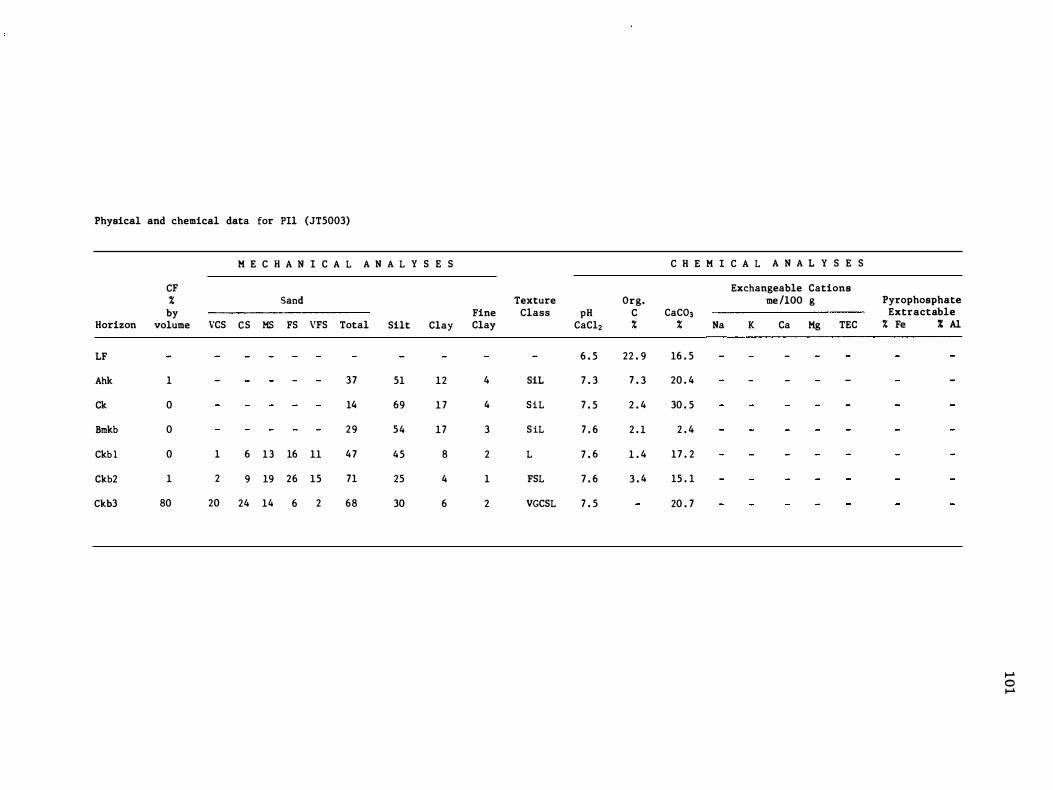
Physical and chemical data for PIl (JT5003)
M E C H A N I C A L A N A L Y S E S
CF % Sand
by Horizon volume VCS CS MS FS VFS Total Silt Clay
LF
Ahk 1 37 51 12
Ck 0 14 69 17
Bmkb 0 29 54 17
Ckb l 0 1 6 13 16 11 47 45 8
Ckb2 1 2 9 19 26 15 71 25 4
Ckb3 80 20 24 14 6 2 68 30 6
Texture Org. Fine Class pH C Clay CaC12 %
6 . 5 22 . 9
4 SiL 7 . 3 7 . 3
4 SiL 7 . 5 2 . 4
3 SiL 7 . 6 2 . 1
2 L 7 . 6 1 . 4
1 FSL 7 . 6 3 . 4
2 VGCSL 7 . 5
C H E M I C A L A N A L Y S E S
Exchangeable Cations me /lOO g
CaC03 % Na K Ca Mg TEC
16 . 5
20 . 4
30 . 5
2 . 4
17 . 2
15 . 1
20 . 7
Pyrophosphate Extractable % Fe % Al
� o �
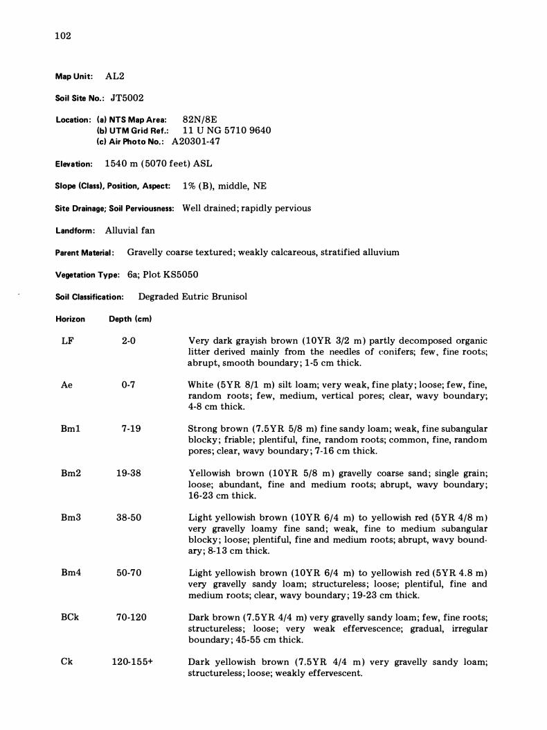
102
Map Unit: AL2
Soil Site No. : JT5002
Location: (a) NTS Map Area: 82N/8E (b) UTM Grid Ref.: 1 1 U NG 5710 9640 (c) Air Photo No. : A20301-47
Elevation: 1 540 m ( 5070 feet) ASL
Slope (Class I. Position, Aspect: 1 % (B), middle, NE
Site Drainage; Soil Perviousness: Well drained; rapidly pervious
Landform : Alluvial fan
Parent Material : Gravelly coarse textured; weakly calcareous, stratified alluvium
Vegetation Type: 6a; Plot KS5050
Soil Classification: Degraded Eutric Brunisol
Horizon
LF
Ae
Bm1
Bm2
Bm3
Bm4
BCk
Ck
Depth (cm)
2-0
0-7
7-19
19-38
38-50
50-70
70-120
120-155+
Very dark grayish brown (10YR 3/2 m ) partly decomposed organic litter derived mainly from the needles of eonifers; few, fine roots; abrupt, smooth boundary ; 1-5 cm thick.
White (5YR 8/1 m) silt loam; very weak, fine platy ; loose; few, fine, random roots; few, medium, vertical pores; clear, wavy boundary; 4-8 cm thick.
Strong brown (7.5YR 5/8 m) fine sandy loam; weak, fine subangular blocky ; friable; plentiful, fine, random roots; common, fine, random pores; clear, wavy boundary ; 7-16 cm thick.
Yellowish brown (10YR 5/8 m ) gravelly coarse sand ; single grain; loose; abundant, fine and medium roots; abrupt, wavy boundary; 16-23 cm thick.
Light yellowish brown (10YR 6/4 m) to yellowish red (5YR 4/8 m ) very gravelly loamy fine sand; weak, fine to medium subangular blocky ; loose; plentiful, fine and medium roots; abrupt, wavy bound· ary; 8-1 3 cm thick.
Light yellowish brown (10YR 6/4 m) to yellowish red (5YR 4.8 m) very gravelly sandy loam; structureless; loose; plentiful, fine and medium roots; clear, wavy boundary ; 19-23 cm thick.
Dark brown (7.5YR 4/4 m) very gravelly sandy loam; few, fine roots; structureless ; loose; very weak effervescence; gradual, irregular boundary ; 45-55 cm thick.
Dark yellowish brown (7 .5YR 4/4 m ) very gravelly sandy loam; structureless ; loose; weakly effervescent.
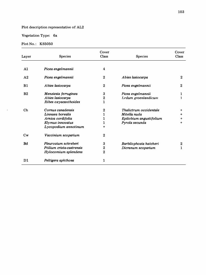
103
Plot description representative of AL2
Vegetation Type: 6a
Plot No. : KS5050
Cover Cover Layer Species Class Species Class
Al Picea engelmannii 4
A2 Picea engelmannii 2 Abies lasiocarpa 2
B1 A bies lasiocarpa 2 Picea engeLmannii 2
B2 Menziesia ferruginea 3 Picea engelmannii 1 A bies lasiocarpa 2 Dedum groenlandicum 1 Ribes oxyacanthoides 1
Ch Comus canadensis 2 Thalictrum occidentale + Linnaea borealis 1 MitelLa nuda + Arnica cordifolia 1 Epilobium angustifolium + Elymus innovatus 1 Pyrola secunda + Lycopodium annotinum +
Cw Vaccinium scoparium 2
Bd Pleurozium schreberi 3 Barbilophozia hatcheri 2 Ptilium crista-castrensis 2 Dicranum scoparium 1 Hylocomium splendens 2
Dl Peltigera aph thosa 1
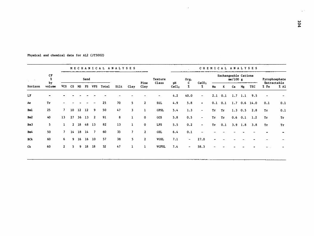
Physical and chemical data for AL2 (JT5002)
K E C H A N I C A L A N A L Y S E S
CF % Sand by Fine
Horizon volume VCS CS KS FS VFS Total Silt Clay Clay
LF
Ae Tr 25 70 5 2
Bml 25 7 10 12 12 9 50 4 7 3 1
Bm2 40 13 27 36 13 2 91 8 1 0
Bm3 5 1 2 18 48 13 82 13 1 0
Bm4 50 7 14 18 14 7 60 33 7 2
BCk 60 6 9 16 16 10 57 38 5 2
Ck 60 2 5 9 18 18 52 4 7 1 1
Texture Org. Class pH C
CaC12 % 4 . 2 40 . 0
SiL 4 . 9 5 . 8
GFSL 5 . 4 1 . 3
GCS 5 . 8 0 . 5
LFS 5 . 5 0 . 2
GSL 6 . 4 0 . 1
VGSL 7 . 1
VGFSL 7 . 4
C · H E K I C A L A N A L Y S E S
Exchangeable Cations me/IOO g
CaC0 3 % Na K Ca Kg TEC
2 . 1 0 . 1 1 . 7 1 . 1 9 . 5
0 . 1 0 . 1 1 . 7 0 . 6 14 . 0
Tr Tr 1 . 3 0 . 5 2 . 8
Tr Tr 0 . 6 0 . 1 1 . 2
Tr 0 . 1 3 . 9 1 . 8 3 . 8
2 7 . 0
58 . 3
Pyrophosphate Extractable % Fe % Al
0 . 1 0 . 1
Tr 0 . 1
Tr Tr
Tr Tr
.... o ,j:o.

APPENDIX C
CANSIS R ETRI EVAL MAPS AND DATA PR I NTOUT
The Lake Louise Study Area map and accompanying legend have been digitized in the cartographic file of the Canada Soil Information System (CanSIS), Soil Research Institute, Ottawa. This appendix contains exam-
105
pIes of the kinds of information retrieved from the biophysical map and legend. Areal distributions, both tabular and mapped, of map units (map index), geologic materials, and profile textures are presented by means of photoreduced computer maps and printouts. Retrieved information on landforms, reaction and calcareousness, percentage of coarse fragments, and slopes is also available.
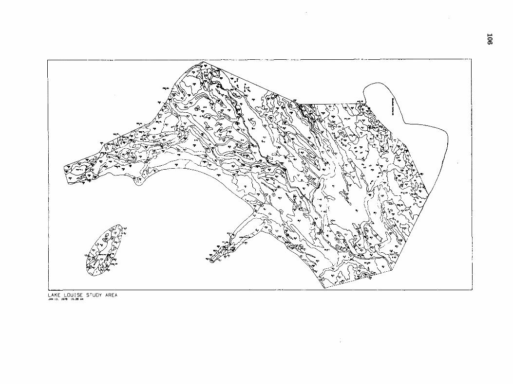
LAKE LOU I SE STU�Y AREA JAN 1 3 . 1;78 1 0. 28 AM
.... o 0)
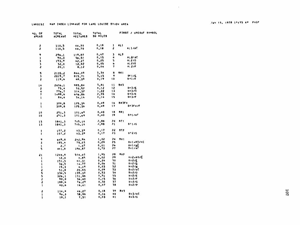
L NK O I � I I4AP I NDE x L I Nk A GE F OR L AKt LOU I SE S T uoy A R I' A .I A '" " . , e n e 1 1'1 1 ' 0:; A '" P A G F'
'40, OF T OT A L T O T A L T O T A L ' I RST I U N I DUF S Y MBOL "RtU ACRE AIiE HE C U Rl: S SO I4 I L E S
2 1 1 0 , 5 '''' . 1 0 0 , 1 8 I A L I 2 1 1 0 . 0:; 4 " . 7 0 n . III 2 A L I I lor 9 2 9 � , 1 1 ' 9 , 8 0 0 . 11 1 3 AL >' I 9 0 • .s 1 � . 5 ' o . I S 4 " L ill i e 3 1 '5 3 . " 1> 2 . 2 1 0 . 2 5 0:; A L V O 3 3 2 , 0 1 i . 9 2 O . O s & A L l i E
2 2 0 . 1 8 . 1 2 0 . 0 " 1 A L VF
I) 2 1 3') . 2 8 1> 4 . 0 11 3 . 3 " 8 II K I 3 2 0 1 '5 . 1 8 1 '5 . 7 1 3 . 1 5 .. tI� I I£. 2 1 1 " . & '"I . J'! 0 . 1 9 1 0 tl o( I lf
1 11 2 0 31» . I 9 8 5 . 8 u 3 . 8 1 I I 8 K 3
2 7 0:; . 11 J O . '5 ? 0 . 1 2 1 2 a W 3 /f, II 1 7& . 7 5 1 Q . } ? 1 . 22 ! l f:j � l /O
1 I II'!II . I> & 1'11» . 8 0 2 . 3 5 I II tI � 3 /E I 8 11 . 11 3 11 . 1 " 0 . 1 4 I S tl K 1 / F
1 0 " . 11 1 ;> 0:; . 1 " 0 . 11 9 I I> II K 3Flt
3 0 9 , 8 1 25 . 3 1> 0 . 11 9 1 1 S q F x /F
1 0 2'5 1 . 1 1 0 1 . � '! 0 . 11 0 1 8 fl R I
1 0 .to; 1 . 1 1 () 1 . & 9 0 . 11 0 1 9 B I) \ l A r
1 3 1 811 1 . 1 1 11 '5 . 1 11 ;> . e8 ;> 0 R T ' 1 1 1 8 1l 1 . 3 1 � S . 1 11 ':> . 8 8 ;> 1 B T I /G
1 ° 7 , 2 11 3 . 3 " 0 . 1 7 2 2 S T ? 1 0 7 . 2 11 3 . 39 n . ! 7 il l S T i! / G
9 b ll9 , S i! " � . 9 " 1 . 02 2 1l !'I V I 1 1 8 0:; . 41 7 5 . 0 \ 0 . 2 9 2 5 B v I + R D / A C
I 2 , 7 1 , 0 7 0 , 0 1 2& tl V I /4C 5 lib 1 . 11 I II b , 8 7 O , 7 1 n 8 v l I A r
2 1 1 2 11 � , 1l 5 0 4 , 4 0 1 . 9 0:; ;> 8 fl V ;>
I 1 2 , 0 1I , 8Ci 0 . 0 2 ;> 9 tlV2 tRIl/f I 1 5 1 , ':1 " 1 , 3 1 0 . 2 4 ' 0 B V i! /(. I 3 b , S 1 11 , 1 7 O , O b 1 1 B VVIi I 1 5 . 3 I> , 1 '1 O , O } 3 2 II v l Iti
2 5 1 . 8 ? O , 9 3 0 . 0 9 H B v 2 I A e ') 1 311 , S 1 3 '5 , l Q O . S l 3 4 8 v 2 i o 5 1 2 b . 1 1 3 1 . 90 n . ") l J O:; tl V l l E
2 9 0 , 0 3b , II 0 O . I S 3b B v 2 I F 2 1 8 8 , 1> 7 b , 2 '1 0 , 3 0 1 7 tl v l l G I 1I 0 , b 1 0 , 4 1 0 , 0 7 3 8 tl v V P
2 1 1 4 , 11 II b � 2 7 O . \ 8 3 9 II V'J I-' I 9 & , .s " . 9 1> o , l b 11 0 8 v 1 / A C 0 1 1 8 , 1 " ) t 0 , 0 ) li t B V } / G
-.J
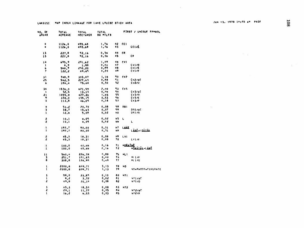
l NK O l 5 I HAP I ND ... l 1 NU IOE fOil L A K E lOU I SE S T I IOY AHfA _I A N , 1 . , 11 1 8 1 1l . ' S A " P A GF .... 0 00 NO, OF TOUl TOUl rUUl f rRST I UNJ QUF � YM80l
ARUS ACllEAGE Hf: C U RES Sg · HTlFS " I I Z • • O "'5'5 • • 8 1 , 1 11 liZ CC I " I I ZII . O 4 '1 15 . 11 8 1 , 7 11 11 3 t t l /E
U l Z 7 . 8 Il l . I II 0 , 1 0 GIl CR U lZ T . 1I II Z . 1 11 O . �II 115 e ll 1 11 1195 , 9 l l\ l . II Z 1 , 0 11 a D t V I
I 11 , 9 1 . 118 11 , 0 1 4 7 C V I /D b '5118 , 9 i n O . l O 0 . " 9 11 8 t V I /E
7 1 2Z . i? 0 11 . 11" 0 , '1 0 n e V I /F
J I 1 11 8 . 9 J O I . 0 1 I , I II " 0 t V ? 1! 5 S b i , S zn . b ' 0 , 8 8 '" C V V A C
b 1 8 b , II '7 i . II O O , 'S O 5 2 C v l l l>
3 11 1 � 3b , O b" I . SII ? , 1I 0 'i.! e n I 12 , S ! J . n O , ll b 'ill t V ] / A C
2 1 1 0 55 , 11 "21 . 1fl l , b5 5 5 t v 3 /0 9 J 1II , O D S . I '! 0 . S 3 " fI C V I /E 1 I I J . 8 11 • • 0 '1 0 , 1 8 5 1 t V l lf
II 5 1 , l '1 0 . 7 0 0 , 0 8 <; 8 DS I 3 3 8 . '7 1 5 . II J 0 , 0 7 'i 9 D 5 1 l A C I I l . 1I 5 . 0 8 O , O l 1>0 D � 1 1n
2 1 0 , 1 o , o'! O , O l fl 5 L 2 1 0 , I 11 . 0 '5 0 , 0 2 fill I.
I ' H , 7 8 0 . 0 0 0 , 3 1 1> 7 Lm 1 11 7 , 7 8 0 . 0 0 0 , 1 1 fltI l.i.ii.l QU.1it.
i? 115 , 1 1 8 . 3 1 0 , 0 8 1>9 L V I 2 11 5 , 1 1 8 . } 1 0 . 11 8 1 0 L V I IF
1 0 0 , 0 4 0 . 41 f1 0 , I II 7 1 "QiWlc. . . � _ _ 1 0 0 , 0 4 0 . 41 f1 n , \ 0 7 2 "CJU.Uit.-U.£'
1 1 ') b O , 1I Ub . 7 8 " , 8 8 1� ML I 3 2'5 1 , 7 1 0 1 . 8 ' O , 4 U 7 b M I I IF 8 1 0 e , 8 1 1 41 , 11 " 0 , 11 9 7 7 H I I /G
2 0 0 0 , 11 8 11 9 . 1 1 3 , 1 3 7 11 NO Z O O O . II 11 0 11 . 7 1 \ , I J 7 11 N n . P H O T o _r u v � R A � E
3 '1 9 , 0 2 1 . 8 " 0 , I 0 8 0 NT I I lI , o? 1 . 7 ? 0 . 0 2 8 1 1'l T l / A r i? 4 9 , 11 ? O . 1 4 0 , 08 8i? N T ! 10
1 4 5 , 1 1 8 . 3 0 0 , 0 8 1\ 3 N T Z Z Z 9 , I 1 1 . 7 7 o , ns 1\ 4 N T VA r. I I lI , l b . 5 1 0 , 0 3 I\!o N ' VF

LNKO I S I MAP I NDEX L I NK AGE F OR l AKE L OU I S! ST I JDY U£A .IA "J 1 1 , ; I H8 I II , V!; A M J.> ' CF 7
NO, OF T O T AL TnUL TOTAL ' IRST I uNI �UF S Y"'S"L ARt. A 5 AtREAGE HE C T ARES 811 M I L E S
2 11 7 5 . 11 ' O , &b o , I i! 11& P (II 7 5 , 8 H , lI b 0 , 1 2 8 7 P
II ('5 1 , 0 1 0 } , IJIJ 0 , 11 1 IJ O P I I I l U . ) IJ 4I . 4 0 O , H IJ I P t 1 I AC I 11 . 1 1 . 8 7 0 , 0 1 IJ 2 P T l IE 2 1 11 , 1 7 . 7 1 O , II } II I P T I IC
I II 358 1 , 5 I lI u II . 3 " 5 , b O IJ It PR<' I l l , lI 8 . 8 3 0 , 0 11 R 7 P � 2 +R L / r. I l l , 2 8 , !! 1 0 , 0 41 118 P II 2 +R Q /F I 11 8 , 7 111 . 1111 0 , 0 8 IJII P RVE I lO , II 11 . 11 1 0 , 0 11 1 0 0 P R2 /£,
1 1 a lll , O 11 1> 3 . 2 1 " , "1 7 1 0 1 P R l ID J II IJ8 , 7 e O I . 8 1 0 , 7 8 1 11 2 P lI l I F.
1 0 8 H , 8 ) 3 7 . 11 2 I . \ 1 1 0 3 P Ri lF It 11117 , 8 2 0 1 . 11 2 0 . 78 1 0 11 PR l IG
2 1 '5 , 11 & . 11 \ 0 . 0 1 l O S PRU 2 1 '5 , 11 b . 1I 1 G , O } 1 0 1t P � 2 1 /F
7 \ 11 5 7 , 5 5 8 11 . 8 ? 2 , 28 1 0 7 PR3 2 2 11 7 , 0 " " . " 1 0 , 3 11 1 0 11 P R � + R � / G 1 1 11 1 , 1 7 7 • !ill 0 , 1 0 l Oll P R 1 1£, 2 1I 1 1 , It 1 1>8 . 11 2 I , ll } 1 1 0 P II 1 /F 2 1 0 1 , 1 II J . lI n 0 , 1 1 I I I P II 1 IG
11 11 , 5 � " . 0 3 0 , 1 11 1 1 2 PRlA li b , S ' '' , 0 1 n , a 1 1 3 P R 1 A / e:
7S , I 10 . .. 0 0 , 1 2 1 1 11 PR �O 7 <; , 1 3 0 , 11 0 o , I l 1 1 5 P I1 1n / r.
1 5 1 7 , 8 I n 'l . 5 11 0 , 11 1 1 1 b PRt; 2 3 7 5 , " 1 'I 2 , I J 0 , 511 1 1 7 P � 5 / F I 1 1I 1 , Iil <; 7 , 1I ? 0 , <' 3 1 1 11 P I1 S /G
2 3 & I , b I O I> . B 0 , 0, 7 1 1 '1 PR5A I 1 1 , 11 ' 2 . 7 1 0 , 0 5 1 <' 0 P II S A /' I 3 3 0 , 2 I H , b l 0 , '5 2 1 <' 1 P II S l / r;
'5 lbll , lil I O l! . 0 I 0 , 11 2 l U PR b 2 1 3 11 , 1 5 " . 2 '1 n , 2 2 1 2 5 P l1 b /F 1 1 2 1 , 8 <; 1 . 72 0 , <' 0 1 24 P R It /G
7 I S 1 , Ci " 1 . 1 0 n , 25 1 2 ') R O I I 1 , 11 l , I1 1 0 , 0 2 1 2b R rl l / F 1 5 11 , 11 ? II , 1 0 0 , 1 0 I n �n l /G 3 1I 0 , b 3 b . b ll 0 , 1 5 1 28 � n l / H
3 5 '5 , 8 U . 5b O , O IJ 1 211 RQ ..... 0 �
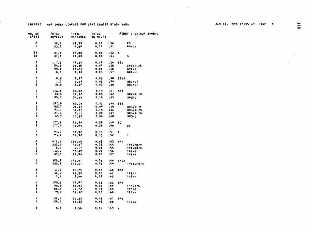
L NK 0 1 S 1 HAP J NO t: X L I NK AGE FOA L i t([ L O U I SE S T uD Y AAF. A J A '" I J . I ' H 8 I n , ,� A '" P A G F 1\ I-" I-" 0 N O . OF T O T AL T O U L TOUl ' I R S T I U N I QUF S Y HSnL
,AUS ACRUGE HE C U RU Sy M I L f' S 2 32 . 1 1 2 . " O . O tl 1 ' 0 If Q I 2 1 , 7 ' . S 8 0 . 0 11 l J l R Q + r. R
sa 11 7 . 0 " . O el 0 , 011 1 12 S ,8 11 7 . 0 1 'I . O el o , oa 1 3 ) S
r; 1 \ 7 . 2 U . 1I 0 0 , 1 ' I l il S 8 1 2 SII . I 2 1 . 811 0 , 0' 1 1 5 S A I + R L / G 2 11 5 , 1 1 8 . 2 1 0 , 0 11 I ll» SA 1 /G I 1 8 , 1 ' . 1 0 0 , 0 3 1 1 1 S A I / H
3 1 8 . l 1 . 1 7 0 , 0 ) 1 18 S8U I 1 , 7 O , oA 0 , 0 1 1 " Sf H A l' 2 I tI , tI o . oe! n , 0 3 1 11 0 8 8 1 A / r.
7 I h , l tl lI . q e 0 , ICI 1 11 1 882 ? J O , ' 1 2 . l ? 0 . 0 5 1 11 2 S Fl 2 + R t / '" 5 8 � . 7 3 11 . flt» 0 , 1 11 1 11 3 S A l IG
, 1 ' 7 , .. 11 0 . 0 0 0 , ' 1 1 11 11 S81 1 5 2 , 7 2 1 . ) 0 0 , 0 ' 1 11 � S A 3 + R I IF 3 c n , I '0 . 8 7 0 , 1 5 l l1 t1 S A ] +R L / G 2 2 1 . 3 8 . b l 0 , 0 11 1 11 7 S A 1 + R L / H 3 3 2 , '1 1 3 . 3 0 0 . 0 1» 1 11 8 S R 1 IG
2 1 1 7 . 11 7 1 . ' 0 0 . 2 8 1 11 '1 S C 2 1 1 7 . 11 7 \ . '1 & 0 . 28 I S O s r
7 '1 1 . 7 l Y . '" O . I S 1 '!it T 7 '1 1 . 1 ' 7 . '1 l 0 . 1 5 1 5 2 T
8 1I 1 0 . S l bo . o'l 0 . b5 I 'l l T P I 2 2 2 3 . t» '1 0 . 11 1 o , l S 1 5 11 T P I + C R / H 1 S . " 2 . t 7 0 . 0 1 I t; 5 T P I + R Q / H 3 1 3 2 . 2 '5 1 . 11 '1 0 . 1 1 I 'l l» T P I /G 2 11 '1 , 1 1 '1 . '1 11 0 , 0 8 1 0; 7 T P I IH
32 � . 2 I H . tl l 0 . 5 1 1 0; 8 T P I A 125 , 2 I H . b l 0 , '1 1 1 0; ' T P I A . r R /H
2 3 7 , 7 1 5 . 2 '1 D , O b I b O T P l» I 30 , 2 I l , 2 0 0 , 0 5 1 0 1 fI' i!l F I 7 . b 3 . 0 b 0 , 0 2 1 & 2 T P 2 I H
0 1 '1 5 , 2 T8 , c H 0 , 1 1 1 0 3 T P l 2 " b . 1I 1 1I . '1 l 0 , 0 8 I b ll T P 1 + T /G 3 b 8 , S n . 7 2 0 , 1 1 l o S T P J / G I 7 ' . ' 12 . 1 2 0 , t l l ob T P l /H
18 , 0 1 1 . 1 2 0 . 0 5 I b 7 T PII 28 . 0 1 1 . 1 2 0 , 05 1 0 8 T I' ll Iii
5 8 , 8 1 . 5. 0 , 0 2 1 0 '1 V
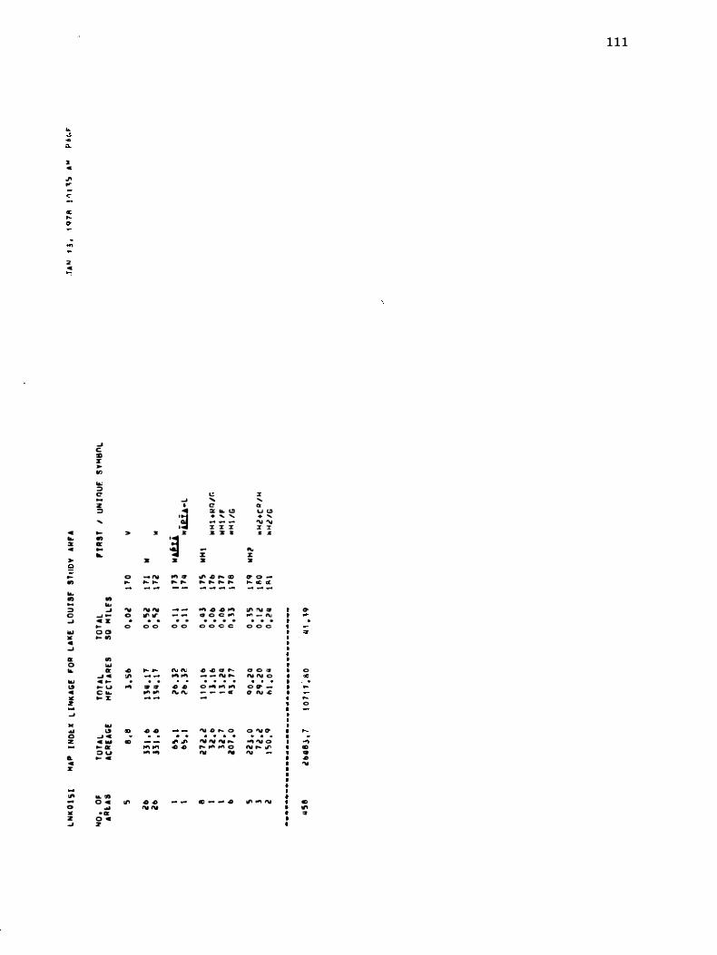
:a c '" ...
c
...
2 c
e ... X ..
,.. e � ...
... ... ... ::;) C � ... '" .. ....
Ct 0 0.-... 1.9 C " z ...s .. ... 0 z
.. e lI:
III -0 '" Z ...J
� C OIl r � on '"' ::;) C ... Z ::;)
....
0-... G: ... ...
... ... � ...s -e ll:
0-o a ... ..,
.., ... Ct � c c o-� u C o.. ... ::r;
... 1.9 .... e C OOl 0- 111: :;) u ... ..
... ", O e .. 0 111:
0 .. Z
>
0 ...
'" O 0
.c '"
o ...
GO GO
'"
:I:
,.
- '" .... ....
"' ''' 11' ''' . .
0 0
... ..
. . .. " ... ,.,
4 -0
... '" ... ...
-0 4 "' '''
.... •
:� ]I:
� :&
... " ... ...
- -• 0 0 0
" If', ... ...
4 #J "' ...
". ". .c 4
C ..... C! X o.- <lI . .... .....
X X X :& ,. a
-::r; :&
"' .o .... co .... .... ..... ....
""' .0 .0 '" � O C ..., . . . . o o c e
4I' ..I) Q' '''' - - � .... . . . . 0 ... "" .... _ _ _ c -
1"V .o P-. 0 "" rv "" .... � ""' ''''' o '" ...
., - - .0
x ..... .. u ... . ....
"' ... x :r .. Jl.
'" l: :a
"' 0 -"' ''' 11:
� !'\I ::t' ,", - ",
o • • 0 0 <:>
0 O ", "' ''' 0 0 ", _ O l\l .c:
0 "' ", ... ... 0
"' ... ." '"
"' ... '"
1 1 1
... ...
,.
0 '"
..
.... 0
...; GO " .c '"
GO II' ,.
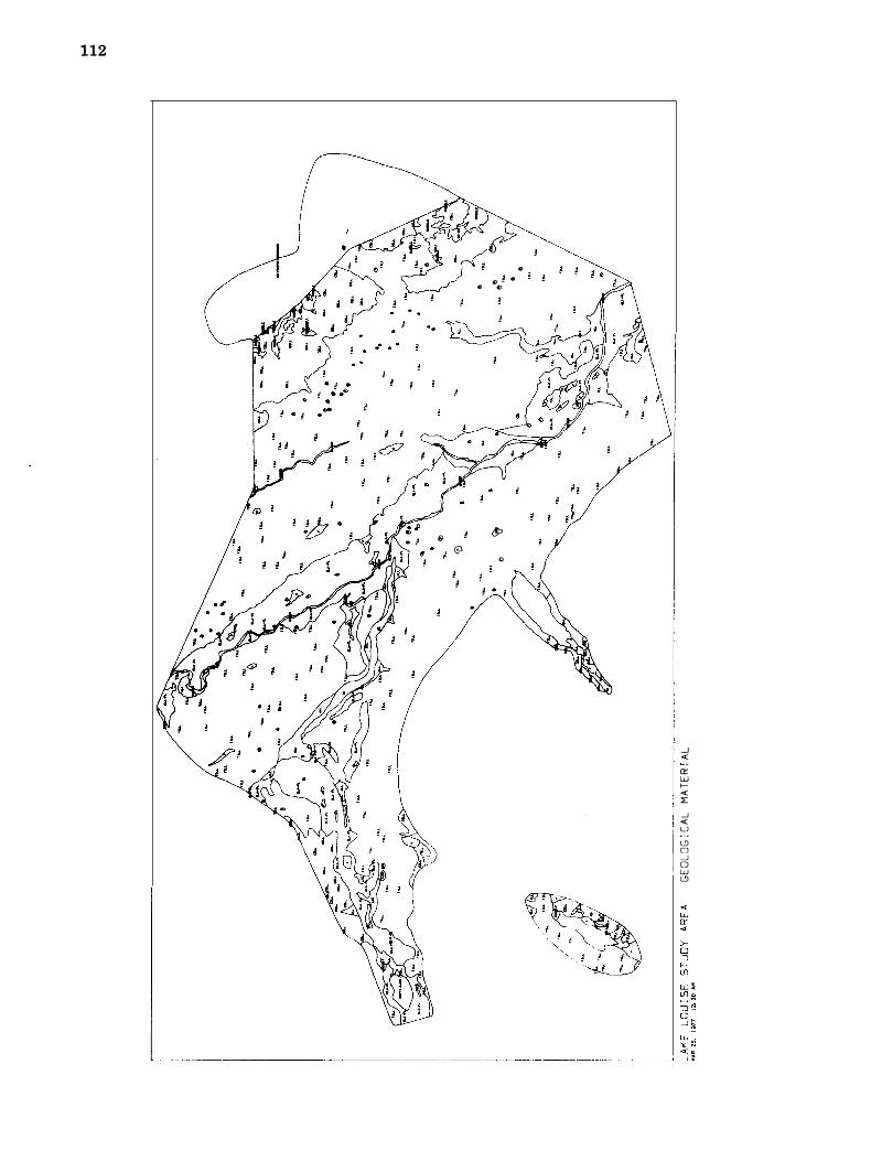
112
@ 6l I I
.. � .. .. . ., .,
� 0
I .
....J «: et:: w I«: :E ....J «:
I � CJ W L9
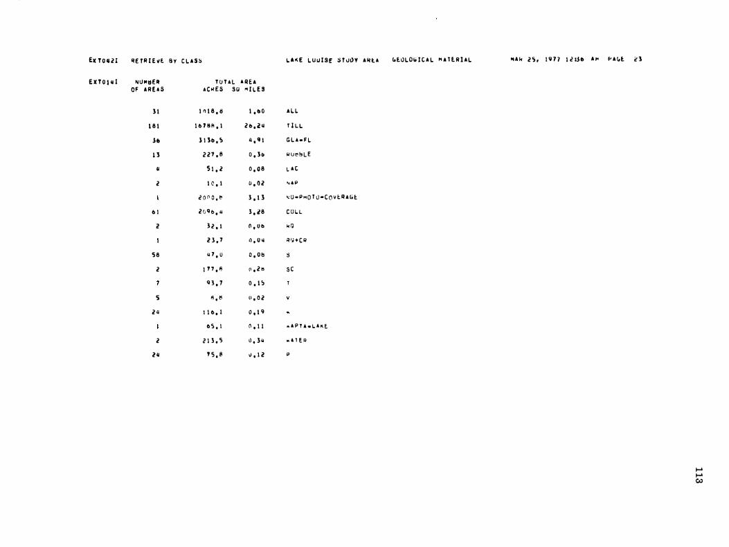
Elc T O ll 2 I �E TR I E vl B y C L A S S
E X T O I /j ! NU"'�ER T O T A L A R E A OF A R E A S A C � E S S(,! " I L E S 1 1 I n 1 8 , !! 1 , ., 0
1 8 1 1 0 f ll A , I 2 " , 2 /j
lb 1 l lo , !> " , 9 \ 1'$ 2 2 7 , 8 0 , 1 1>
" 5 1 , 2 0 , 0 8
2 I C , I 0 , 0 2
i o n O , '" 1 , 1 3
0 1 2 0 Q t> , " 1 , 28
i! l 2 , \ n , v o 2 3 , 7 tl , U /j
5 8 " 7 , 0 O , O b
2 1 1 7 , 1l (l , 2 t;
Q 3 , 7 0 . 1 ;
S � . tI u , 0 2
2 4 I 1 0 , 1 0 , 1 9
0 5 . 1 0 , 1 1
2 2 1 3 . 5 O , 3 /j
211 ' '5 , 8 v , l i!
L A � E L U u I S E S T u�Y A � t A
A U
T l L. L G L A - F L lIu�bLE L A C
" A I'
� u · P MO T 0 - C o v t A A (, t
C O L. L
k Q
'l 'H C II
S
s c
. A P T A _ L. A K E.
. A 1 E � p
blOLOb I C A L M A l l R I A L .. A I< 2 ') , 1 9 1 7 l i l.SI. A '" f' A C,t. <' 1
..... ..... CI.)
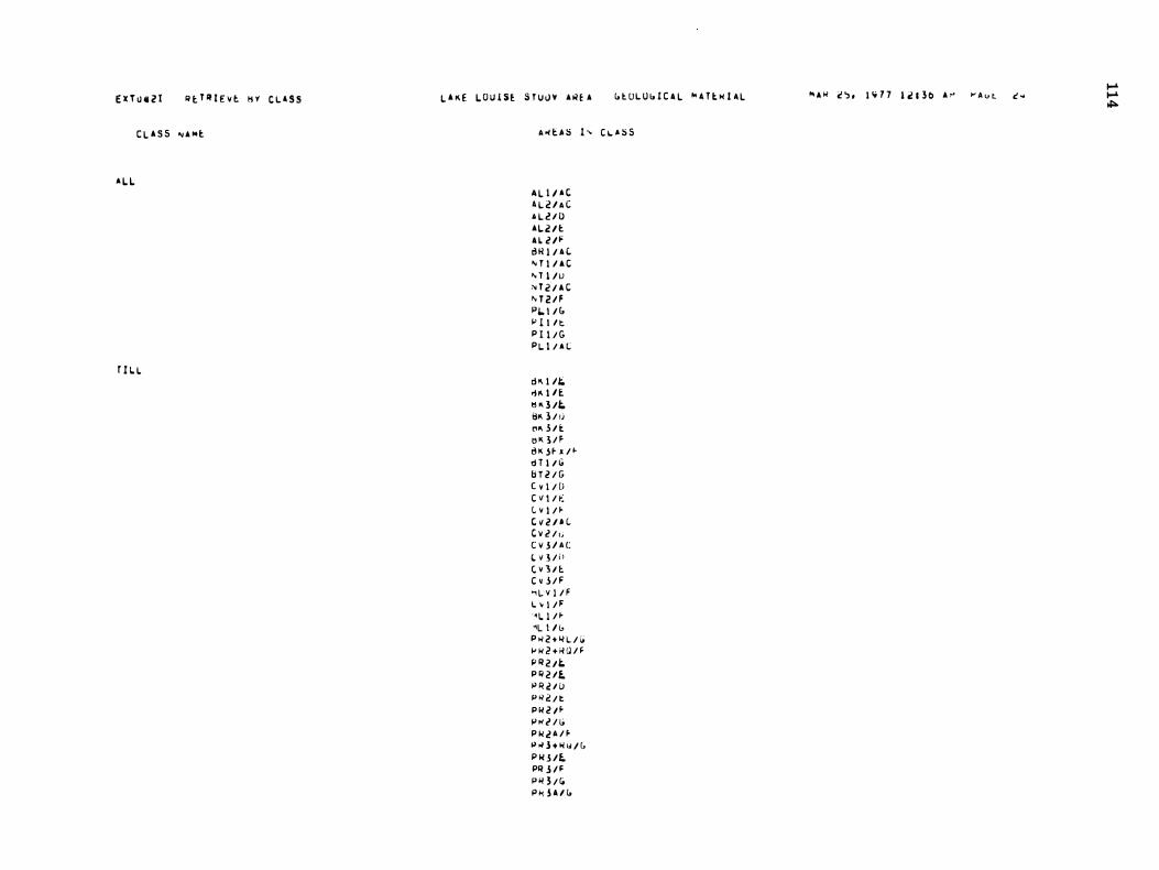
E X T O ll 2 1 � t T � I E v l � y C L A S S
C L A S S " A Nt
A L L
r IL. L
L A K E L O U 1 S � S T U � ¥ A � � A " t U L U " I C A L N . T l H ! A L
A � l A ::; 1 " C � A ::; S
A L I I A C A L V A C A L V a A L v t A L V � 0 " 1 / 6 (. '" T 1 1 A C "' T 1 / U " T 2 / A C " T 2 1 F p,"- 1 / & i" l i l t P I I / G P L I / A L
0"' 1 11;;. .j "' l n tl "' 3 /t. 8'" 3 / 1j ",1'1 l i t (j K l / F o K -S f- x / � tIT 1 1 10 b T 2 / G ( v i / D C V I / I: (. v I / � C v 2 l H C v 2 / ,; C V 3 / A C
(. V .! / i I C v J / t C d / F " l. v l / F L ' I / F ·'1. 1 / � "L I l l. P >< 2 + I( L / I; jJ ;; 2 + K Q / F >' R 2 I t. P � 2 1E. t> R C / lJ P >l 2 / t P I( 2 I fP w 2 / (; P ;; .! A / ft> >< 3 + � "' / (' P ;; 3 /E. PR 3 / F P ;; 3 / (O p � 3 A 1 "
" A � C � . 1 � 7 7 l i l 3 0 A � � A � � c � .... .... �
U T O U I RE T R I E vE � v e L A , S
(i L A .F L
�UBBLE
L A t
"' A P
"'O.PMO T O · C O V E R AGE
C OLl
L A K E L O u l 'E S T U D y A�� A
lt � l D I (i ItflS/P' PRS/G PRSA /f P R S A / tO PR� / F P R o / G
tl y h R W l A t 8 Y I /.&r. BY I l A C II V Z + N W /i. !l V i i' 8 V 2 lJi B V U.Ii 8 Y i! I A C 8 v 2 I 1> t h i l E B Y i! l F tl Y 2 I G tl Y i! lP BV 3 / G C t l /t l1 ij v i l F 3t1t1V 3 1 A t
e R
D s t l A C 0 8 1 / D
L
(i[OLOG I C 'L " A T E N I A L
N O . P M u T O · c o v E R A Gt
N D 1 / F R D I /G R D l / M S tl l +Nl / G SI:I t / G Sti l I " U U / G Slfi+ R I. / '" Sil i! / (i S 8 3 + R L /' S tl S + R L / G S II 3 + R L / " S Il 3 / G T P I +t ll / l1 T P h R l/ / M T P I /G T P I / M
" A R i!�, 1 . 7 7 1 i! 1 30 A� �AGE 25
.... .... C1I
E . T O . i l RE T " I E VE � Y £ L A S S
R Q
!! 1iI + C "
S
S C
v
�
d ' U -L A II !
N A T E .
,
E X T O I S I ' L O T T I T L E ! L ' � E � O u I S i S T U O Y A � E A
L A K E L O U ! SE S T U D Y A R � A
I
T P I A + t R / H T Pii!lf TPi!l11 T P l + T / G T P 3 /10 T P 3 / " T P Il /Ii " H I + R I U G " " I /F " H I /IO " " i+ C M / " " H i I G
R Q
Il W + C Il
s sc
v � ".UiU4-L z z ,
G E U L O G I C A L � A T E R I A L
G E OL O G I C A L M A T E R I A L M A R 2 5 , l q 7 7 I Z l l b AM � A�E Zb .... .... Q)
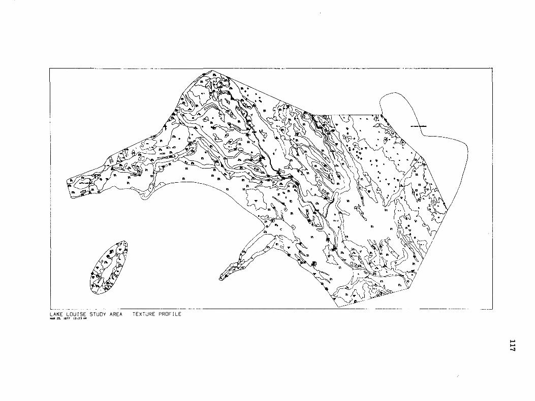
LAKE LOU I SE STUDY AREA MAR � IGn' 12,23 AM T E X TJRE PROF I LE
I-' I-' ...::a
.... f 1e T O ' 2 1 � E T R I E v t K Y C L A S S L A K E L U U I SE S T U D Y A R E A T E X T o,J l( E PWOf I L E M A R 2 !:1 , 1 9 7 7 1 2 1 l o A M "' A (' t. 1 7 .... (Xl E X T O l il l NU018EII T O T A L A R E A
O F A R E A S A C R E S sa M I L E S
II q 2 0 'J 5 . ) 3 . 1 2 S L
H I 9 11 7 5 . 7 1 5 . 11 4 S I L / C L -L
U I S II I . 3 il , I S S L. / S L. - S C L
1 0 1 7 3 0 . 2 2 . U S I L / C L.
11 1 'lII 5 0 . 5 3 . 8 11 S I L /S L. - L. S 2 1 1 4 . 4 0 , 1 t! S H . lL. S
I I 2 2 1 , 8 0 . 51> C R
115 I <I " II . !! 2 . 2 0 a R lo / C L
3 11 1 5 3 11 . (0 2 . " 0 C L. -L.
II 'J 1 . l 0 . 0 !! S I L.
2 115 . 3 0 . 0 8 S I L I L
1 0 2 '5 9 . 8 0 , 11 1 L. 2 0 0 0 , 6 3 , 1 1 �O-P�O T U -C O V t. R A G E
II 1 0 11 . 2 0 . 1 7 SL. -L. II 2'5 7 . 0 fI . " l 5 11.. -L.S 3 5 5 . S 0 . 0 9 !HI
5 8 01 7 . 0 1I . 0 S S
• 1 9 7 . 9 O . J 1 L - S I L
l I H . 1l 0 , 2 6 S C
., 9 3 , 7 0 . 1 5 T
5 8 . 8 0 , 0 2 v
2 /j \ I II . I 0 . 1 9 �
b 5 . 1 0 . 1 1 .. A P T ' - L A I( E
2 2 1 l . S 0 . ) 11 .. A T E �
II 1 1 2 0 . 0 1 . 7 0 L S / L
2 /j 7 5 . 6 O . l l P
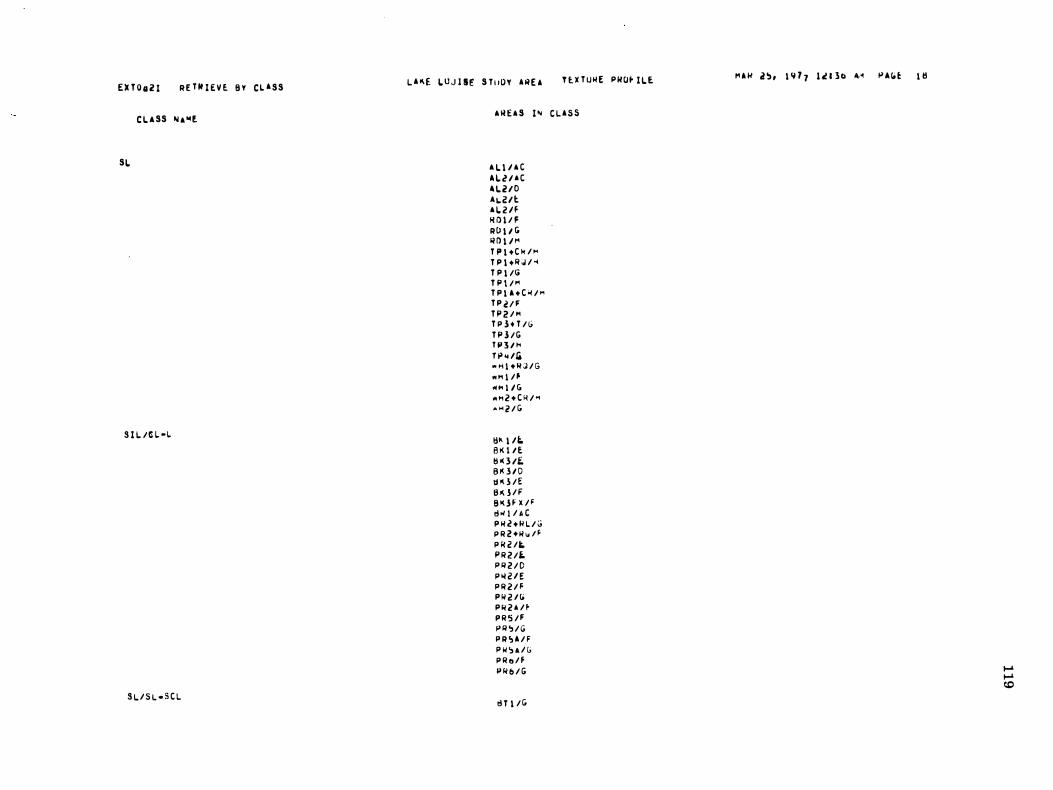
E lIT O ,l Z I R E T � I E V � B V C L A S S
C L A SS Ii A "4E
SL
S I I. / !! L -\.
S I. / S \. - S C L
L A � E L U J I SE S T I J O Y A A E A T l X T U H E P ItO� I L E
A lI E A S I " C L A S S
A L I I A C A L c? I A C 41.210 A�21t A I. 2 If It D l / F RO l l I> R D l I t" T P 1 + C k / " T P I + R i,l / -4 T P 1 /G T P I / " T P 1 A + C O< / P'1 T P U F T P 2 / " T P h T / G T P l / G T P 3 / " T p " I' " " I + H J / G .. .. I / � "'''' 1 1 (; .. ... 2 + C � / ... • ... Z / G
!:III 1 1" B K I IE. tl lI l /£. e n i D tj "' l / E S Q / F B ll j F X / F
� w l / A C P H c? + R L / G P R 2 + H � / F
P R 2 /1-. P R 2 /L P R 2 / D P Io/ 2 1 E P R 2 / F P H V " P H 2 ' / � P R 5 / F P R ,) / G P R � A / F P IoI , A / (; P R e / F P H II / G
� T 1 / G
M A N 2 � , 1 � 7 7 l i l 3� 4� � A � � 1 �
..... ..... r.t:J
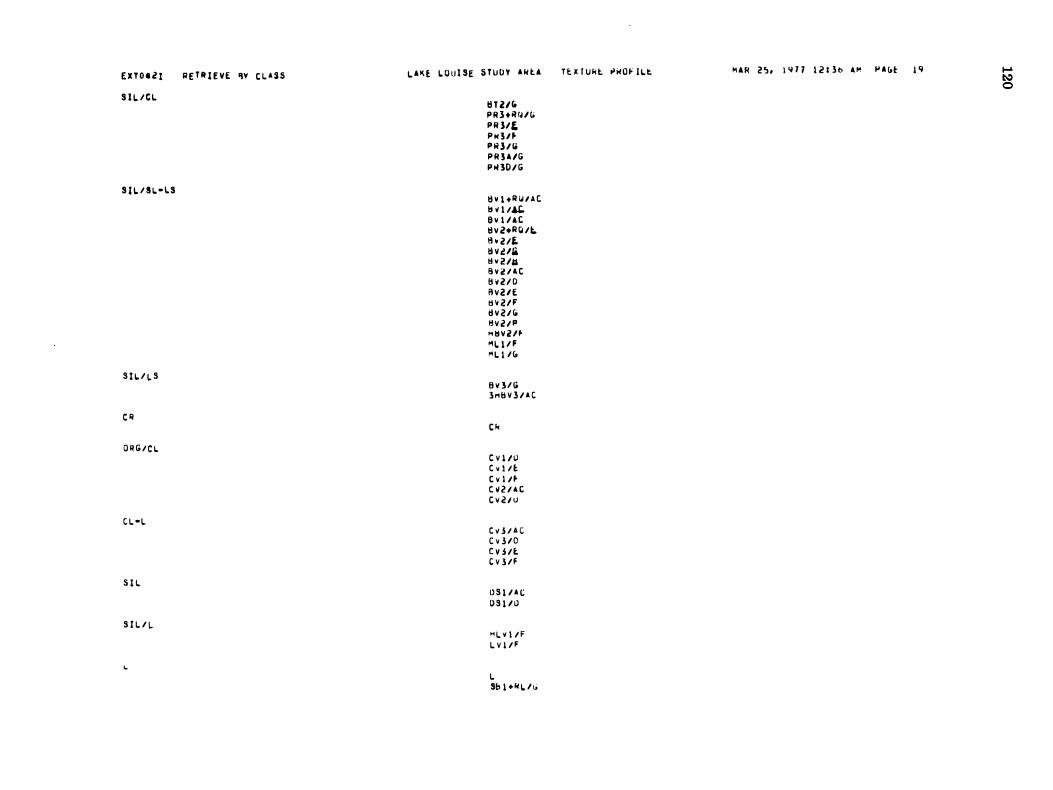
E X T O . Z I
S I L / C L
S I L / S L. - l S
S I L. / L S
e l/
O R G / C L.
C L -l
S I L
S I L / L.
�
R E T R I E V E �v C L A S S L ' � £ L O u i SE S T U D Y . � t . I H 2IfO P R 1 + R fU (; P R l/E. P N 3 / � P R l / 10 P R 3 A 1G P , HO / G
IlV 1 + I/ Ioi l A C lt � I /"" a v l l A C II V Z+Il(Ui;. I h UL II v u/& tlv 2 lU B V 2 / A t fj v U D Fl V U E lt v 2lF II V 2 I (; � v 2 I P H II V z n M l. l / F " L I /(;
B Y 3 / G l H S v 3 I A C
C k
e V i l \) C v l / E. t v I / � C 11 2 / 4 t C v V I)
C V 3 / A C C v 3 / 0 C H It. t V l / F
D S I I A C O S I /I) " l V I / F L V 1 / F
L Sb I +�l.Ili
T U I Ukt "wOf I L. I'. M A R 2 ') , l 'i 7 7 I Z I l t> A M � . (,� l q .... � o
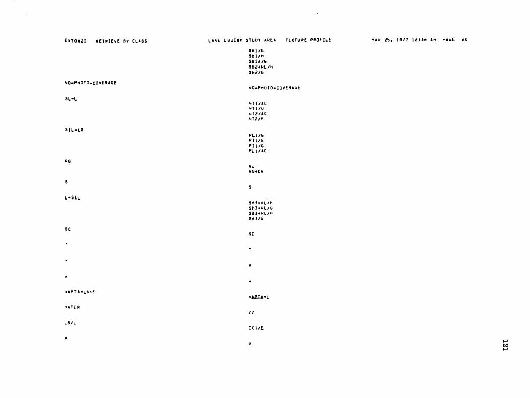
E X T O II Z I R E T R r E � E B v C L A S S
�O-PI10 T O _C O V ER A G E
8 1. -1.
8 1 l- 1. 5
Ii Q
8 l - S l l
S C
"
d P T A - L. 4 K E
. A T E R
L. S / I.
p
l A K t L U u l SE S T U D Y '�t A Stll /G 81 H /I1 811 1 A /t. 882+111. / .. 8 b 2 l G
n H U II E P"O� I l �
NO-P�O T O - C O v E II A <.t
" U I A C ... T l / f) .. 1 2 I A C " T 2 I �
Plo t I ii P l l / l P l I / G PI. I I A C
II ", II Q + C R
s S t H + � l H S tl 3 + � L / G S 8 l + � l / " 5 0:1 3 / 10
S t
v
�
"Ai..Ll-1. Z Z C t l lE,
p
M Ak l" I q l 7 I Z I $ b A M � A y£ c O
� � �