Embed Size (px)
Citation preview

1 Copyright © 2011, Oracle and/or its affiliates. All rights
reserved.
Land Administration and Management: Big Data, Fast Data, Semantics, Graph Databases, Security,
Collaboration, Open Source, Shareable Information Platform Steven Hagan, Vice President, Engineering

2 Copyright © 2013, Oracle and/or its affiliates. All rights reserved.
• Technology Trends in Data Creation, Maintenance, and Management
• Reliance on ‘big data’ technologies
• The right information at the right time
• Machine Processable descriptions of data.
• Semantic technologies will play an important role
• Skills and Training: train the individuals is at least five years
• Requirement for enhanced data management systems
Future Trends
United Nation Analysis – July 2013 Initiative on Global GeoSpatial Information Management

3 Copyright © 2013, Oracle and/or its affiliates. All rights reserved.
Spatial Technology Platform Evolution
• Compass, telescope, sexton, paper maps
• Mainframe computers
• GIS Systems, Workstations
• GeoEnabled Infrastructure:
LiDAR, Raster, Video, Sensors,
Mobile, Streams, Cloud Computing
• Industrial Quality Platform
Geographic Information Systems rely on the technology of the era
4 Copyright © 2013, Oracle and/or its affiliates. All rights reserved.
Land Administration and Management Workflow Inputs
• Paper-based
• Multiple GIS
• Multiple Databases
• Mobile, Web Based
and Crowd sourced
• Sensors
• Geo-referenced
Video, 3D, LiDAR
Outputs
• Central Government
• Regional, State, City
• Organizational and
Departmental
• Commercial Access
• Multiple Deliverables
– Paper
– Digital
– Real-time
– Demographic
– Free and Open Source
– Commercial for profit
• Big Data, Fast Data
Technologies
• Support ALL Data,
Versioning
• Full Spatial Support,
Persistent Topologies
• Semantics, Graph
Technologies
• Powerful Analytic
Capabilities
• On Premise, In
Cloud or Hybrid
Complete Platform
5 Copyright © 2013, Oracle and/or its affiliates. All rights reserved.
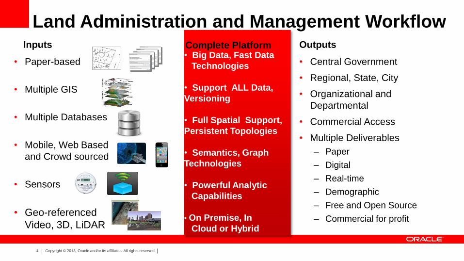
Global Digital Data Growth: Far Exceeds Storage Mfg Volume Growing leaps and bounds by 40+% YoY!
You Must Make Policy Decisions on What Data to Keep
Structured Data
Unstructured Data
2009 = .8 Zetabytes = .08 ZB Structured Data
= .72 ZB Unstructured Data 2020 = 35 Zetabytes = 3.5 ZB Structured Data
= 31.5 ZB Unstructured Data*
• Chart conservatively assumes a constant 9:1 ratio of unstructured data vs. structured data (based upon IDC’s estimate that 90% of all digital data is unstructured).
• Chart does not reflect IDC’s projection that unstructured data is currently growing twice as fast as structured data at the rate of 63.7% vs. 32.3% CAGR.
(1 Zetabyte = 1 Trillion Gigabytes)
LEGEND
Source: IDC Digital Universe Study, A Digital Universe Decade – Are Your Ready?, 2010

6 Copyright © 2011, Oracle and/or its affiliates. All rights
reserved.
7 Copyright © 2011, Oracle and/or its affiliates. All rights
reserved.
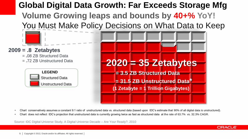
Rapid Evolution of Geospatial Technology: Drivers:
• BIG DATA GENERATION: – Terabytes, Petabytes, Exabytes, Zettabytes, Yottabytes
– Sensors, RFID, VIDEO, LIDAR, Raster, 3D, Internet Of Things
– SDIs, INSPIRE, Terrain and City Models
– Social Media, Tagged Data, History / Archive / Version Data
– Linked Open Data –- Persistent Relationships, Semantics, Ontologies
• BIG but Inexpensive Hardware:
– CLOUD Platforms – Public and Private
– More powerful – Clusters of Commodity Servers, Virtualization: = Greener
– Massively parallel database machines – Software Enablement – e.g. Hadoop
• BIG, FAST, SECURE Software –
– REAL TIME Analytics –Biggest value from fastest response – Streams and Events –- Spatially Aware System – no separate GIS
– Location Enable All Applications: ERP, CRM, Business Intelligence, Public Sectors
– CyberSecurity, Encryption, Privacy
– Support Standards – W3C, OGC, ISO, Wide Range

8 Copyright © 2011, Oracle and/or its affiliates. All rights
reserved.
• Data / Information –
– Volume is too much to store it all
– Velocity: Arriving too fast for humans – Must be Machine Processable
– Must use Real Time Filtering and Analytics
- This is the Big Data / Hadoop filtering & CEP - Complex Event Processing
- Set policies on what to keep
– Must share data among your many Organizations, enabling Aggregation
• Geography/Mapping/Location, Health Care, Statistics, Commerce, Taxation
– Sharing requires Interoperability and Semantics / Ontologies / LOD.
– Versioning is needed for History, Time dimension
Shareable, Repurposable Location Data

9 Copyright © 2011, Oracle and/or its affiliates. All rights
reserved.
Real-time Data Streams, Crowdsourcing
External Data Sources Transactional &
Operational Systems
Contents Repository
Databases
Web resources
Blogs, Mails, news Search, Presentation, Report,
Visualization, Query
Land Administration: Absorb All Data
Enterprise Data Management Infrastructure
GeoSpatial Documents
Se
cu
red
Historical
Records,
Archives
POIs
Demographics
Customer Data
Call Records
SMS
Workflow Initiation
Real-time Dashboards
Console Alerts
EV Grid Management
Automatic
Responses and
Publishing

10 Copyright © 2011, Oracle and/or its affiliates. All rights
reserved.
You Get Order And Efficiency Using Standards
• ISO – TC 211 – TC 204
• Open Geospatial Consortium
– Simple Features – GML – Web Services
• De-facto Standards – SHP, MGE, DXF, KML
• Professional Standards
– ISPRS, FIG, WMO
• Java, .NET, Flash
• TAGGED METADATA – agree on tags
SQL3/MM Spatial
"We intend to complete development for a new suite of tools for developing the next generation of
applications. And there are several interesting things with the next generation of tools, but
perhaps the single most interesting thing about them is that for the first time a major application
company is going to commit to an absolute standards-based development environment.“
– Larry Ellison

11 Copyright © 2013, Oracle and/or its affiliates. All rights reserved.
Ontology-driven Geospatial Applications -
Actionable Knowledge
• Simple Features
• GeoRaster
• Topology
• Networks
• Gazetteers
RDF & OWL Data Environmental
Monitoring
Utilities
National Map
Core Datasets
Disaster
Response
Spatial
Data
Geographic
Names
Raster
Data
• Data Integration
• National Map schemas
• Geographic names
• Temporal
• Naïve Geography
Application Ontologies

12 Copyright © 2013, Oracle and/or its affiliates. All rights reserved.
Graph Technology Needed: What terms to look for:
Buzzwords For Apps & Workflows
• Semantic Web
• W3C RDF/OWL/SPARQL
• Graph Data Management
• Social Network Analysis (SNA)
• Knowledge Discovery
• Knowledge Mining
• Big Data
• Taxonomy/Terminology Mgmt
• Faceted Search
• Inferencing / Reasoning
• Property Graphs
• Sentiment Analysis
• Text Mining
• NoSQL Database

13 Copyright © 2011, Oracle and/or its affiliates. All rights
reserved.
Collaborations: Tools – Understand Data Quickly
Discovery & Predictive Analysis
Problem Classification Sample Problem
Anomaly Detection
Given demographic data about a set of customers, identify customer purchasing behavior that is significantly different from the norm (Fraud?) . For Sensors, Events – problem? Good News?
Association Rules
Find the items that tend to be purchased together and specify their relationship – market basket analysis
Clustering Segment demographic data into clusters and rank the probability that an individual will belong to a given cluster. For customers / govt constituents, what do they want to know about?
Feature Extraction
Given demographic data about a set of customers, group the attributes into general characteristics of the customers F1 F2 F3 F4
14 Copyright © 2011, Oracle and/or its affiliates. All rights
reserved.
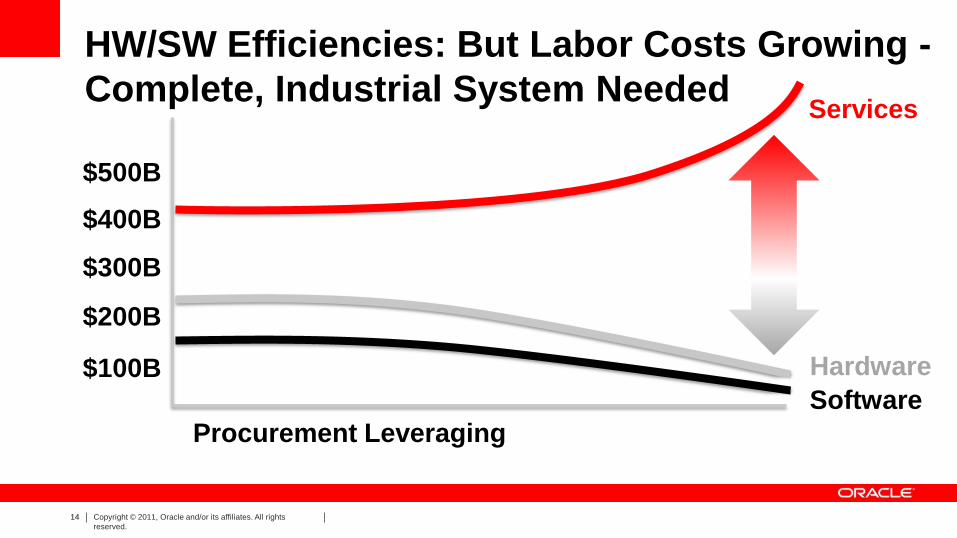
HW/SW Efficiencies: But Labor Costs Growing -
Complete, Industrial System Needed Services
Hardware
Software
Procurement Leveraging
$100B
$200B
$300B
$400B
$500B

15 Copyright © 2011, Oracle and/or its affiliates. All rights
reserved.
Time to Build Optimizations Maintenance
Open Source: Why Build a Land Mgmt System?
UN-GGIM: “train the individuals is at least five years”

16 Copyright © 2013, Oracle and/or its affiliates. All rights reserved.
Oracle Spatial and Graph
“Points” “Lines” “Polygons”
Rasters
Topologies
3D f1
f2 n1 n2
e1
e2 e3
e4
Network Graphs
Web Services
(OGC) Geocoding
Routing
RDF Semantic Graphs
Oracle Spatial and Graph Securely manage all spatial content
“Points”
Web Services
(OGC)
SPARQL End Point
Geocoding
Routing
Inferencing

17 Copyright © 2013, Oracle and/or its affiliates. All rights reserved.
Land Management Requires a Platform with:
Information Security and Privacy
Monitoring
Access Control
Encryption & Masking
Monitoring
•Configuration Management
•Audit Vault
•Total Recall
Access Control
•Database Vault
•Label Security
•Advanced Security
•Secure Backup
•Data Masking, Redaction
Encryption & Masking
Blocking & Logging
Oracle Database
18 Copyright © 2011, Oracle and/or its affiliates. All rights
reserved.
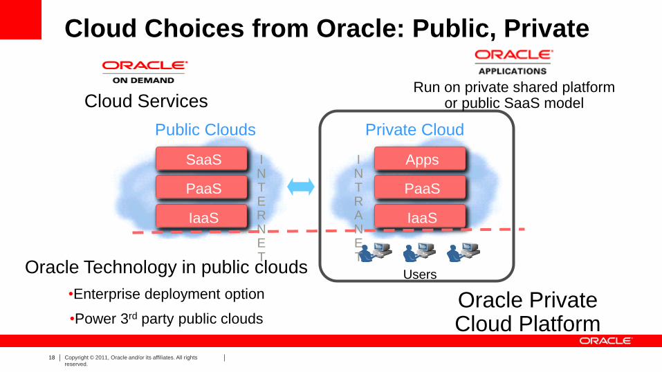
Cloud Choices from Oracle: Public, Private
Public Clouds
IaaS
PaaS
SaaS I N T R A N E T
Private Cloud
Users
IaaS
PaaS
SaaS I N T E R N E T
IaaS
PaaS
IaaS
PaaS
Apps SaaS
Oracle Technology in public clouds
•Enterprise deployment option
•Power 3rd party public clouds
Cloud Services Run on private shared platform
or public SaaS model
Oracle Private Cloud Platform

19 Copyright © 2011, Oracle and/or its affiliates. All rights
reserved.
Land Administration and Management
Best Success Requires Complete Platform
Deep
Analytics
Simplified IT
Big Data
Big & Fast Data
Volunteered
Geographic
Information
Sensors
Streaming Data
Geo-
referenced
Video,
3D, LiDAR
Simplified Spatial IT
Support for
Open Standards
Spatial Database,
Application Server,
BI, tools
Support by
Leading Partner
solutions
Spatially-
enabled
Engineered
Systems
Deep
Analytics
Real-time Spatial
Event Processing
Dense
Visualization
Spatial Analysis
On Premise,
On Cloud,
Shared
Services
On Premise,
On Cloud,
Shared
Services
Shared GeoSpatial Services
Location Aware Everything