Embed Size (px)
Citation preview
@4
Land
Acquisition
and Retained
Rights
Land issues form the central theme of
the Cumberland Island National Seashore story. Acquisition of Carnegie
and Candler land, defense against subdivision, and the negotiation of un-
usual and complex retained-use estates have politicized and complicated all
other management issues. Hence an understanding of how the National
Park Service acquired the island lands and the sacrifices it made to do so is
critical. This chapter describes the government acquisition of more than
140 individual tracts of land on the island, where and why retained estates
were granted, and the characteristics of the rights associated with those
estates.
National Park Service land acquisition policy developed over many
decades. During the early twentieth century, Congress and the presidents
created parks from the public domain, and land acquisition was simple. The
overwhelming majority of the property was already in federal hands. In
summer 1959 the Park Service fielded 188 parks totaling more than 20 mil-
lion acres. The inholdings (private lands) within those parks amounted
to only 32,000 acres. The agency chose to ignore inholdings unless their
owners threatened park resources or carried out activities contrary to park
purposes.
For parks established after July 1959, however, the agency changed its
land policy to prompt acquisition of all private lands. This change coin-
cided with its aggressive pursuit of new recreation parks in already settled
areas. Public land law expert Joseph Sax attributes this new policy to Park
Service officials who “view ultimate fee acquisition as a faithful response to
congressional policy and National Park history.”1 In some areas the Park
Service suspended land acquisition as long as local zoning remained re- 111
strictive. At Cumberland Island, however, because developers sought sub-
division, such a suspension was never an option.
During the primary period of land acquisition at Cumberland Island,
1970-84, the Park Service initially avoided condemnation in deference to the
original owners’ willingness to support the national seashore and sell their
lands cheaply. However, by the late 1970s the agency actively used this un-
popular tool. A June 1977 memorandum from Park Service acting director
Ira Hutchison explained the philosophy behind such actions:
More and more over the past several years there has been a notable reluc-
tance on the part of some field managers to pursue the acquisition of certain
inholding properties and to recommend and support legislation needed to
adjust park boundaries, based primarily on their view that this would create
an undesirable public relations problem with affected landowners and/or
community relationships.
We recognize that we cannot be totally unmindful of these relationships,
but we must also recognize that our primary responsibility is for the long-
range protection of park resources and park environment. We cannot com-
promise this duty and responsibility of our stewardship for the generations
yet unborn simply to make our job easier on a day-to-day basis.2
Thus land acquisition by any means, including condemnation, was both
policy and moral charge for the National Park Service as it approached
Cumberland Island.
Ultimately, the zealousness of this singular approach would be blunted
by considerations for the generosity of the Carnegie heirs, by vast price in-
creases, and by public antipathy to eminent domain and to the federal gov-
ernment in general. Indeed, by the late 1980s that antipathy made condem-
nation unacceptable to the public across the nation and to its congressional
representatives as well.
When the National Park Service began shopping for Cumberland Island,
its task seemed a simple one. A 1958 appraisal by Robert M. McKey showed
only nine owners of 23,683 acres of upland and marsh (the area now held by
the State of Georgia was not included). After a careful study of lands and
structures, McKey suggested a total value of $2,148,000. By far the largest
owner was the Trust for Lucy C. Carnegie, with 91 percent of the land and
86 percent of the appraisal value. In 1965, after the trust ended and the in-
dependent ownership of a tract by the Olsen family was recognized, the
agency still faced only twenty-five owners. A majority of them favored Park
112 Land Acquisition and Retained Rights
Service acquisition. Optimistic officials believed that standard retained-
estate contracts would see the seashore in fee simple government ownership
by the end of the century.3
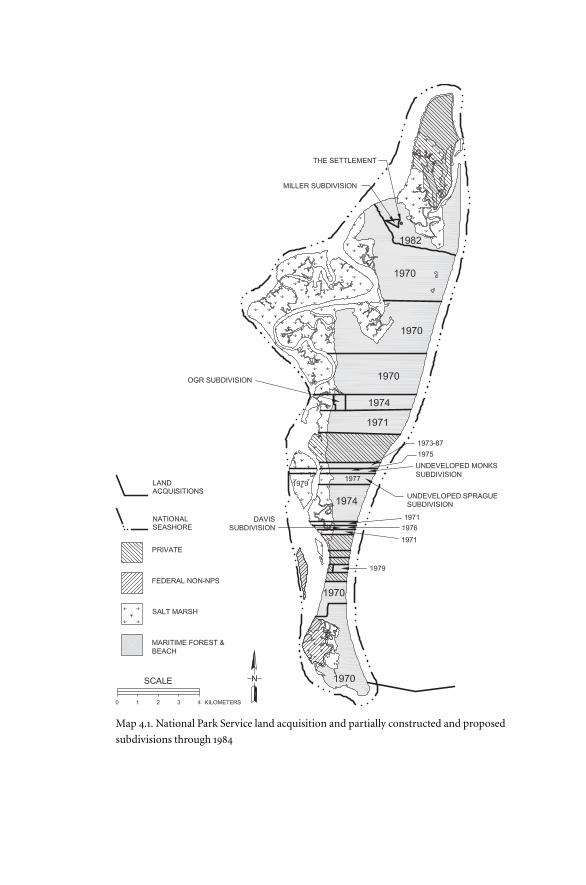
Over the next decade land acquisition would become vastly more com-
plicated. The number of landowners swelled by more than 100. Six subdivi-
sions would occur, including Fraser’s grand project and three by Carnegie
family members. Three of these would see residential construction (map
4.1). At the same time, the National Park Foundation, the organization
charged with acquiring lands for the future park with donated funds, set a
precedent by granting liberal but highly variable and complex retained es-
tates to the original owners. When the National Park Service assumed ne-
gotiations, both large and small landowners drastically raised their prices
and demanded equally generous retained rights.
Land Acquisition before 1973
When Congress established the National Park Foundation on December 18,
1967, its first major project was the acquisition of Cumberland Island with
Andrew Mellon Foundation money. Even as the new organization struggled
to organize, negotiations with Carnegie family landowners began. In order
to carry out these negotiations, the Park Service lent experienced land officer
George Sandberg to the project. The intense desire of all parties to make this
seashore a reality led Sandberg to offer more generous retained rights than
normal. Standard retained-rights agreements were for small parcels of land
to be held for either twenty-five years or the lives of the sellers. At Cumber-
land Island typical terms included larger parcels for either forty years or for
the lives of the sellers’ children. Each Carnegie or Candler family landholder
could secure one or more parcels for his or her piece of the island.4
Ironically the first landholder to sell was Charles Fraser. Embittered by
the rejection of his project, he lashed out at the Carnegies and Candlers
“who have this arrogant hostility toward the common man” and who de-
stroyed what he regarded as an environmentally sensitive island plan.5 On
September 29, 1970, Fraser sold his land in segments 5N and 4S to the Na-
tional Park Foundation for $799,500.6 He then took this money and devel-
oped a resort on nearby Amelia Island in Florida. This figure roughly
equaled his cumulative cost for land acquisition and development on Cum-
berland up to that time.
However, his sale came with a number of strings attached. First, he kept
Land Acquisition and Retained Rights 113
Map 4.1. National Park Service land acquisition and partially constructed and proposed
subdivisions through 1984
his two development sites, the 2-acre parcel at the present Sea Camp Visitor
Center and the nearby 38-acre parcel containing a campground he had
built, as retained forty-year estates. Stipulations in the agreement allowed
for construction of seven houses, selection of another 40 acres in place of
the above parcels if Fraser so desired, and the right to lease the houses for
not less then one week at a time.
Second, earlier agreements between Fraser and the heirs of Thomas
Carnegie II gave each of them a retained estate as well. Henry C. Carnegie
and friend James Bratton formed Cumberland Island Properties, claiming
two parcels totaling 10 and 5 acres, respectively, in segment 4S. These car-
ried the rights to build three houses. Gertrude Schwartz, as trustee for An-
drew Carnegie III, received a 7.5-acre estate in the same area that she later
traded for an equal-sized parcel of segment 1S near Old House Creek. Not
really interested in the island, she rented the property to a Ben Jenkins for
many years. Finally, Thomas Carnegie IV received a 7.5-acre estate in seg-
ment 4S on the shore of Cumberland Sound.7
The most avidly pro-seashore branch of the family, the heirs of Nancy
Carnegie Johnston, provided the second National Park Foundation acqui-
sition and set the tone for negotiations and retained-rights agreements
thereafter. Five heirs, Coleman, Thomas, and Marius Johnston, Margaret
Wright, and Lucy Graves held in common segments 3N and 5S. Thomas
Johnston’s portion was divided in thirds among his children, Margaret
Richards, Nancy Butler, and Thomas Johnston Jr. Segment 3N included the
Plum Orchard mansion. Over a span of three months in the fall of 1970,
these four grandchildren and three great-grandchildren of Lucy Carnegie
sold their land to the foundation for a combined $1,615,000. At the same
time, they donated Plum Orchard mansion outright along with $50,000 as
seed money for a fund to maintain it. This would have major management
implications for the future seashore.8
Sandberg negotiated a bewildering array of retained-right estates for the
Johnston group, including a 12-acre, forty-year estate along the main road
in segment 3N for Margaret Wright; small estates for the lives of Nancy But-
ler, Thomas Johnston Jr., and their spouses and “issue” adjacent to Plum
Orchard; and a similar arrangement for Margaret Richards and her family
near the ocean dunes on Duck House Road, also in segment 3N. Lucy
Graves negotiated two forty-year estates of 5 and 10 acres in segment 5S.
Later she too swapped the larger one for a plot in segment 1S between the
ocean dunes and the Main Road. Her smaller parcel contains The Grange.
Land Acquisition and Retained Rights 115
Coleman Johnston traded for a 40-acre parcel on the Brickhill River in seg-
ment 4N. Finally, Marius Johnston negotiated for $20,000 more than his
siblings received in lieu of a retained estate.9 All parties maintained rights to
drive the Main Road, occupy existing structures or build a new one within
ten years, gain access to and use the family cemetery, and debark at various
docks on the island. In 1979 Margaret Wright sold her 12-acre retained es-
tate with improvements to the National Park Service for $16,000.
As the Fraser and Johnston sales proceeded, pressure on the foundation
to acquire at least 60 percent of the island increased. The seashore bill had
reached a critical phase in Congress, and legislators wanted proof that the
land would be available for the new park unit. Coleman Perkins, owner of
4,100-acre segment 4N, was initially reluctant to sell. Perkins and his im-
mediate family, plus attorney and friend Thornton Morris, had formed
Table Point Company as a business operation. In April 1970 Table Point had
sold its timber rights to the Georgia-Pacific Corporation.
However, the promise of a huge 186-acre retained estate on Brickhill
River and Malkintoos (MacIntosh) Creek throughout the lives of all the
shareholders’ children induced Table Point to sell to the foundation for $1
million on November 2, 1970. Several weeks earlier Georgia-Pacific had ac-
cepted the inevitable and sold its timber rights to the National Park Foun-
dation for $19,500. Along with the many retained rights stipulated in the
contract, such as exclusive hunting, dock privileges, and Main Road and
cemetery use, Sandberg verbally promised the Table Point Company rights
to use Charles Fraser’s South Cut Road for beach access.10
The following spring the National Park Foundation culminated its
major purchases by concluding agreements with Mary Bullard and Mar-
garet Sprague for their thin strips of land in segments 2N and 2S. The land
totaled 1,500 acres, and the two granddaughters of Margaret Carnegie Rick-
etson received approximately $455,000 each. Margaret Sprague retained a
15-acre estate north of Greyfield in 2S while Mary Bullard chose a 10-acre es-
tate on former Perkins land between Plum Orchard and Table Point. Each
retained-right estate will last through the lives of the respective women’s
children.
The final acquisition by the National Park Foundation came after estab-
lishment of Cumberland Island National Seashore. In July 1973 Lucy Foster,
daughter of Lucy Carnegie Sprague Rice, donated 21 acres of land in two
parcels of segment 1N containing the Stafford house and The Chimneys.
She maintained exclusive, lifetime rights of use on both properties.11
In February 1973 the National Park Foundation donated 3,460 acres to
116 Land Acquisition and Retained Rights
Cumberland Island National Seashore and followed in December with
9,229 more. Negotiations were well under way with the Rockefellers for seg-
ment 3S, with Margaret Laughlin and her daughter Cynthia Cooper for 1S,
and with the Candlers for their High Point tract. As agreed, no one ap-
proached Lucy Ferguson. The first major project of the National Park Foun-
dation was a resounding success. It had acquired all of tracts 3N, 4N, 5N, 4S,
and 5S plus substantial portions of 2N and 2S.
These acquisitions, however, were not unqualified. The retained rights
were confusing and variable and would deeply affect management. Still, the
land was in Park Service hands, and the seashore was a political reality. At
this point the federal government was responsible for continuing land ac-
quisition in the young seashore.12
A Rash of Subdivisions
Despite the success of the National Park Foundation, the land acquisition
picture at Cumberland Island had a dark side. Well before the foundation
began negotiating and even before Charles Fraser entered the scene, cracks
appeared in the Carnegie family’s resolve to protect Cumberland Island
from development. Oliver Ricketson III, nephew of Lucy Ferguson, lived in
New Mexico and had little use for his two thin parcels in segments 2N and
2S. In what must have been a controversial move, he sold his 102-acre tract
in segment 2S on September 26, 1967, for $60,000.13
The buyer was one Robert Davis, sometime jockey and cowhand and
close personal friend of the Fergusons. Davis was no ordinary employee. He
is devotedly remembered by those who knew him. He was so close to Lucy
Ferguson that some family members resented his status as “adopted son.”
And he was an astute businessman. Friend and attorney Robert Harrison
later described his canniness for making money and said Davis “could buy
a piece of land and the minute he bought it, somebody else wanted it and
wanted it for more than he did.”14 So it was on Cumberland Island.
In 1968 he formed the Davis Land Company, subdivided his property
west of the Main Road into seventy-one lots and offered them on the mar-
ket for $4,000 each. It quickly became apparent that the desire for a shel-
tered getaway on the legendary rich man’s island was intense. Only tax con-
siderations forced Davis to slow his sales in the face of fierce demand. Prices
that rose to $6,000 in 1970 and $7,500 in 1972 had no effect on demand. By
July 1973 Davis held only four unsold tracts.15
Meanwhile his land east of the Main Road also brought money. In July
Land Acquisition and Retained Rights 117
1970 real estate broker Henry A. Crawford introduced Davis to a group of
Atlanta businessmen and doctors whom he represented. These investors
sought a ninety-nine-year lease to build and operate a motel. Like the small
landowners in the Davisville subdivision, they did not believe the seashore
legislation would pass, or if it did, that the provision allowing retained es-
tates only on structures initiated before February 1, 1970, would hold. The
lease was a curious one that showed Robert Davis’s business savvy. Lease
payments for the 14.5-acre parcel were set at $560 per month for the first two
years, $1,112 per month for the next three, and $2,224 per month for the re-
maining period of July 1975 through June 2069. Furthermore, lease in-
creases based on the Consumer Price Index could be added in the years
2000, 2025, and 2050. Thus the lease was affordable for the period during
which the fate of the seashore would be decided but worth much more if the
Park Service condemned the leased land.16
The great success enjoyed by Robert Davis spurred Oliver Ricketson III
to try the same scheme with his northern strip of land. In 1971 he formed
OGR, a New Mexico corporation, and began offering lots on both sides of
the main road. Although small individual purchases were made, most of the
land went to a relative few parties who in turn further divided their portions
and resold to friends or relatives. For example, the clerk of the Camden
County Commission, James E. Godley, bought 7.5 acres in September 1971
for $2,000 per acre. He then sold pieces to other county commissioners at
cost. That same month R. R. McCollum bought 5 acres for $10,000, and he
sold three parcels totaling half of the acreage to Robert Van Cleve, Martin
Gillette, and Riley Harrell Jr. for a total of $10,500 six months later.17
Unlike Davis, Ricketson’s company, OGR, also sold large parcels of land
to several individuals at $1,000 per acre. Florida land surveyor and specula-
tor Louis McKee bought the largest parcels, 30 acres of upland and 96 acres
of marsh. Originally employed by the Candlers, McKee became a familiar
figure in the Camden County land office, buying and selling parcels in all
the subdivided portions of Cumberland Island. Three weeks after buying
these two tracts, he conveyed them to three other people, Elinor Giobbi,
Heloise McKee, and Carnegie family member Nancy R. Copp. Each ob-
tained an undivided one-third of the marsh and sole ownership of a 10-acre
tract of upland.18
Lucy Ferguson also bought a large tract of 28 acres. She then sold 16 acres
at a slight profit to friend Wilbur Readdick and 12 acres at a loss to longtime
employee and close confidant J. B. Peeples. Both Readdick and Peeples sub-
118 Land Acquisition and Retained Rights
divided their land among family members and resold various portions af-
ter the seashore had been established.19
At the north end of the island, Laurence Miller and his aunt, Mary Miller,
developed a third subdivision on lands surrounding the Settlement. In the
years preceding creation of the seashore, the Millers had quietly added lands
from nonresident owners to their holdings. By 1972 they had accumulated
more than 100 acres. After passage of the seashore’s establishing act, Lau-
rence Miller platted fifty-four lots on 30 acres, all upland but with no coastal
access. Over the next two years, they sold clusters of lots plus other Miller
land to businessmen from Brunswick, Atlanta, and Camden County. Among
the buyers were Louis McKee and attorney Grover Henderson. The latter,
son of one of the original Davis subdivision buyers, bought one parcel for
himself and another with law partner Robert Harrison, also a Davisville
owner. Most of the lots measured one-half to two-thirds of an acre and sold
for $6,000. Grover Henderson also bought another tract independently,
traveling to Miami to buy a lot containing a small ramshackle “house” from
Thomas Lee, heir to one of the Settlement’s freed slaves.20 All of these pur-
chases created dismay and some panic among both the Park Service and
the Carnegie and Candler owners who had worked hard for the seashore’s
creation.
The National Park Service Takes Over
In 1973, as the National Park Service took up land negotiations, it faced this
vigorous subdivision as well as large tracts of unacquired Carnegie and
Candler property. The enactment of the seashore law had come too late for
Cumberland Island to receive an official budget for fiscal year 1973. To over-
come this setback, the Park Service reprogrammed approximately $500,000
for land acquisition and another $94,700 for administration from other
1973 projects nationwide. The Southeast Regional Office in Atlanta ap-
pointed its land specialist, William Kriz, to continue negotiating for Cum-
berland Island land.21
Immediately controversy arose over the Park Service’s land acquisition
priorities. With acquisition funds limited to $10.5 million by Congress, the
agency needed to choose its purchases wisely. Park Service officials decided
to negotiate options on the large parcels while construction continued to
take place in the subdivisions. The option procedure had been authorized
in an amendment to the Land and Water Conservation Fund Act on July 15,
Land Acquisition and Retained Rights 119
1968. With this method the buyer and seller agree on a price. The buyer pays
a portion of it to prevent sale of the land to anyone else and then later exer-
cises the option by paying the remainder of the price. The law required that
an option last a minimum of two years and that the option amount be cred-
ited to the total price. During 1973 the entire $500,000 land budget for Cum-
berland Island was devoted to options on large tracts of Carnegie land.22
This approach drew immediate criticism from a variety of sources in-
cluding Georgia governor Jimmy Carter and various newspapers in the
state. On October 12, 1973, Carter wrote to Secretary of the Interior Rogers
Morton that developers had increased the price of the land from the $500-
per-acre price that the Carnegie group offered to the $5,000 for less than
one-half acre being charged by subdivision developers. He pointed out that
“since the Act places a spending ceiling of $10 million on land acquisition
for the Seashore based on current appraisals of value, the actions of these
developers are not only likely to raise the price of certain parcels, but also
endanger the establishment of the entire island as a National Seashore.”
Carter also noted that large landholders, including the Candler, Ferguson,
and Rockefeller families, “are irate at what the others are doing to the island.
They refuse to negotiate with the National Park Service until the building
ceases.” He concluded by urging Morton to seek more acquisition funds and
to expedite land acquisition.23
As the governor continued to monitor the situation, more alarming in-
formation came to him. As the Park Service appraised and bought lots for
$14,000 per quarter-acre unit, Franklin Foster sold 5 acres in segment 1N to
developer Robert Davis for $63,000. Carter wrote this time to Georgia sen-
ator Sam Nunn, stating: “This five-acre tract is at least as valuable and, if ac-
quired by the lot, would cost in excess of $175,000. This one transaction
could cost the taxpayers over $112,000 more than originally anticipated by
the Park Service.” Meanwhile the Atlanta Journal and Constitution issued an
inflammatory article describing extensive construction.24 Outraged letters
from the public and environmental groups quickly added to the governor’s
complaints.
The National Park Service answered Senator Nunn with a detailed ex-
planation of its strategy. Acting associate director Lawrence C. Hadley
wrote that there were some seventy-five landowners at that time, but only
three owned “over 1,000 acres, two over 500, three over 300, and six in the
60 to 80 acre range.” The government, he reported, was negotiating on all
the larger parcels. Hadley then explained the logic of the Park Service ap-
120 Land Acquisition and Retained Rights
proach: “If a lot holder builds, for example, a $10,000 improvement on his
property, this will in all likelihood not cost the United States any more than
what he has spent on it, whereas, if $100 per acre in value through inex-
orable escalation is added to one of the larger tracts, there can easily be from
$300,000 to over a million dollars added to our cost. So it is really escalation
in land values that is skyrocketing, not the building on small lots. If 50 lots
were built on, less cost escalation would result than the appreciation in land
values on the larger tracts.”25
Secretary Morton, responding directly to Governor Carter, added that
larger owners were eligible for retained rights while these later landholders
were not. He explained that the structures on the small lots would be re-
moved and that the governor should not worry because “the land heals
quickly.” Furthermore, noted the secretary, the newspaper articles reported
“more activity is occurring than is actually the case.” The National Park Ser-
vice had observed only two new construction starts.26
In essence the Park Service strategy was a sound one, but land acquisi-
tion proved more difficult and vastly more expensive than anyone had ex-
pected. Although 1974 saw acquisition of Laughlin-Cooper segment 1S for
$2.4 million and the unsold OGR lands for $830,000, other large landhold-
ers including the Rockefellers and the Candlers backed away. Even worse,
two Carnegie family members belatedly attempted to subdivide and sell
their lands. Both were located in segment 1N.
Robert Monks, son-in-law of Lucy C. S. Rice, engineered the first at-
tempt to subdivide. Late in 1972 millionaire Monks, a failed Republican
candidate for the Senate from Maine, advertised lots for sale at a price the
Atlanta Journal and Constitution called “twenty times” the amount being
asked by owners selling to the National Park Foundation.27
The first to respond to Monks’s scheme was Democratic governor
Carter. Expressing his outrage, he warned buyers not to be gullible and fall
for vastly inflated prices for land that they would ultimately lose to the
federal government at “fair market prices.” In addition, he asked state offi-
cials to investigate possible fraud charges, calling Monks’s sales “an overt
attempt” to escalate land values by trying to create a subdivision without
roads, utilities, or any access to individual lots.28
Jekyll Island real estate agent Douglas Adamson, representing Monks,
retorted that the millionaire had the law on his side and, furthermore, that
land had sold on the island for $25,000 per acre. Where he got such a figure
is unknown. Certainly at that time no Cumberland Island land had sold for
Land Acquisition and Retained Rights 121
anywhere near that amount. Adamson also told potential buyers that the
National Park Service would acquire only 70 percent of the island. Gover-
nor Carter called that assertion “a false statement” and added that state
health officials “probably will not approve septic tanks on such tiny lots.”
Meanwhile the Park Service warned that whoever bought land could not
build on it and would lose it eventually. Apparently Monks thought better
of the plan, for he never sold any lots. In January 1975 the Park Service
bought his 324 acres for $754,400. Monks retained a twenty-five-year right
to the “Stafford Beach House” but conveyed it to his nephew and niece,
Franklin W. Foster and Lucy Carnegie Sprague Foster, shortly thereafter.29
Phineas Sprague, another heir of Lucy C. S. Rice, executed the last at-
tempt to subdivide a portion of the island in 1977. The preceding Septem-
ber, after negotiations reached an impasse, Superintendent Paul McCrary
recommended to Regional Director David Thompson that Sprague’s land,
along with more than a dozen smaller parcels, be condemned.30 Sprague re-
sponded by selling some land to Robert Davis, who began subdividing and
selling lots near the ocean beach. One member of the Carnegie family spec-
ulated that Davis was deliberately provoking the Park Service and worried
that it might lead to condemnation of all remaining private land. This time
the Park Service reacted with alacrity. On February 18, 1977, the agency is-
sued a “declaration of taking” against Sprague and the four purchasers
of his lots. This form of condemnation allows the government to assume
control of the disputed property at once. Subsequently, the agency paid
$3,648,499 to Sprague and another $84,405 to the others. No retained rights
were granted.31
In addition to these large and expensive land purchases, Charles Fraser
approached the Park Service in 1974 and asked to sell his two retained rights
at Sea Camp. The agency hired South Carolina appraiser H. Philip Troy to
appraise the estates. In his January 1975 report, Troy suggested, not very
subtly, that the government was being had. It had executed a transaction
“inversely comparable to the fabled purchase of Manhattan Island” by sell-
ing land that it could not use for forty years. Now, he added, the government
was preparing to pay a second time for the same 40 acres of land plus the
steep rise in their value over the previous four years. After getting this off his
chest, Troy assessed the retained-right contract as a forty-year leasehold and
appraised the two parcels at $570,850.32
When the agency reacted slowly, Fraser wrote to National Park Service
director Gary Everhardt and threatened extensive development. He pointed
122 Land Acquisition and Retained Rights
out his rights to choose an alternative 40-acre site and to build seven houses.
He described his plan to “‘stretch’ our 40 acres along the entire oceanfront
of tract 4 South, building each of the seven houses on a very wide, shallow
oceanfront site.” He and “a group of corporations” planned to commence
their construction within sixty days and to lease these properties on a
weekly basis. Finally, he wrote, “should our perception of Park Service lack
of interest not be correct, and if, in fact, the Park Service has the funds avail-
able to make such an acquisition and desires to do so at a fair price, we
would be willing to defer a bit longer.” In July 1975 the Park Service paid
Fraser’s Cumberland Island Holding Company $600,000 for relinquishing
its rights to the original holdings and granted another 2-acre retained right
on Cumberland Sound just south of Sea Camp.33
A postscript to this activity occurred in 1988. By that time Charles Fraser
had sold the Cumberland Island Holding Company to a group of investors
led by Richard Goodsell and attorney S. Larry Phillips. The latter contacted
the Park Service to complain about heavy visitor intrusion through the
company’s retained estate, which straddled the popular River Trail between
Sea Camp and Dungeness Dock. He suggested a swap of retained rights
again, this time to two existing houses plus 5 acres in the Davis subdivision
in segment 2S. After he threatened to exercise the company’s right to build
a “lodge” along the River Trail, the government again acquiesced and again
relocated that retained estate.34
By 1980 most of the remaining interests of the Thomas Carnegie II heirs
who originally had sold to Fraser ended. First, Thomas IV sold his retained
right back to the government in 1976 for a paltry $4,900. Meanwhile, Cum-
berland Island Properties, of Henry C. Carnegie and James Bratton, neg-
lected to build any residences on its 15 acres. Its agreement, like most on
Cumberland Island, required the retained-right holder to start construc-
tion of a residential structure within ten years of the National Park Foun-
dation purchase or lose the estate. A cryptic handwritten note jotted on the
Southeast Regional Office’s copy of the retained-right agreement states “not
used, not built, see next page, 10-year building requirement.” The Park Ser-
vice thus recognized the partnership’s failure to comply with the require-
ments of the retained right. Nevertheless, the seashore continued to list
Henry Carnegie and James Bratton as retained-rights holders until 1999
when the error was exposed.35
During these expensive acquisitions Lucy and Franklin Foster Sr. tried to
work out an arrangement to donate more land for the national seashore,
Land Acquisition and Retained Rights 123
but even this became complicated. In 1973 the Fosters offered more than 200
acres in installments over a period of years, obviously to benefit from tax
considerations. To their consternation the government insisted on negoti-
ating rather than simply accepting the gifts.
Franklin Foster Sr.’s complaints to the Atlanta Journal forced Park Ser-
vice land agent William Kriz to respond. In the first year of the Foster plan,
Kriz explained, they would donate 40 acres paralleling the ocean but the
beach itself would remain in their possession. But to the Park Service
anything less than its fee simple ownership of the beach was unacceptable
even though Foster promised access to the public. Eventually negotiations
calmed ruffled feathers, and the Fosters donated 212 acres in seven separate
gifts between 1973 and 1987, retaining rights of use on most. Ultimately,
Lucy Foster was the only Carnegie heir to donate land for the national sea-
shore other than a few acres that accompanied the Johnstons’ Plum Or-
chard mansion.36
Subdivisions Revisited
While the agency emphasized acquisition of large holdings, it also pursued
appraisals and negotiations with “new” owners in the three ongoing subdi-
visions. The Davisville group, first to buy onto the island and most active in
construction, drew the initial attention of Kriz and the National Park Ser-
vice. During and immediately after the congressional campaign to create
the national seashore, various lot owners maneuvered to cement advan-
tages wherever possible. Those who wished to keep their island property
built homes with hopes they could convince the government to relent and
let them stay.
Attorney J. Grover Henderson, who co-owned a Davisville property with
his mother, became their spokesman. He waged a media campaign blasting
the Park Service for discrimination against the small owner while allowing
the larger ones, the Carnegie and Candler families, to negotiate for retained
estates. He neglected to mention the provision in the seashore’s enabling act
that allowed owners who began construction of houses before February 1,
1970, to have such a right. The older owners had such structures and hence
the rights. Most subdivision occupants had no such construction by that
date and, therefore, no rights. The Florida Times-Union also quoted a Hen-
derson statement calling for conversion of the area to a national wildlife
refuge so the owners would be left alone and a “limited number” of visitors
124 Land Acquisition and Retained Rights
could still see the island.37 This campaign to protect new, local landowners
sold well in Camden County where people already harbored a growing dis-
like for the National Park Service.
Ultimately, the Davis subdivision went quietly, but by no means cheaply,
to the government. Acquisition began in earnest during 1974, and most
properties were in Park Service hands by early 1976. Prior to and during this
period, however, both local owners—most descended from families who
had known each other for generations—and speculators like Louis McKee
and Charles Fraser engaged in a blizzard of lot sales between themselves and
with other confederates on the mainland. For example, Davis sold three lots
to Richard Brazell for $18,000. In July 1972 Brazell sold lot 5 back to Davis
for $15,000. Three months later the lot was back in Brazell’s hands, and he
executed a sale and buyback with Jiles Hamilton. Finally, in July 1974 Brazell
sold lot 5 and another lot for $28,000 to the National Park Service. The gov-
ernment rewarded Brazell’s initial investment of $6,000 per lot with $14,000
per lot based on “current market value.” So many sales took place, usually
upping the price along the way, that some county residents passed through
the ownership histories of several lots and never negotiated with the gov-
ernment.38
Most Davisville owners received $14,000 for their .39-acre lots. Those
with more land received equivalent per-acre settlements. Those who had
built homes were able to demand much more. However, the most impor-
tant factor in the eventual settlement price was the ability of the owner to
stall negotiations and resist condemnation. The longer an owner kept his
land, all other factors being equal, the more elevated its price became.
Park Service appraiser Finis Rayburn calculated that the value of small
lots on the island rose 92 percent between May 1970 and October 1972, an
increase of 3.17 percent per month. He posited that the rate had slowed to 2
percent per month from October 1972 to his October 1973 appraisal of
William Rogers’s Davisville holding. Rayburn concluded that Rogers’s three
lots, plus improvements, were worth $65,000. Four months later the Park
Service paid William Rogers $76,350 for his 1.3 acres.39
In addition to land price inflation, a delay in selling gave an owner the
chance to increase the value by building a house. For example, Camden
County tax commissioner George Law rebuffed the Park Service on two lots
until March 1976. He received $15,000 per lot at that time. On another
Davisville lot, purchased from Louis McKee, Law built a home and refused
to sell at all. The Park Service filed for condemnation, and Law answered by
Land Acquisition and Retained Rights 125
demanding a jury trial. Local jurors awarded him $120,000 for his .39-acre
parcel and small house. The government unsuccessfully appealed before
paying the full amount to Law in June 1979.40
In the meantime, Robert Davis offered to sell his own remaining lands
within and adjacent to the subdivision, including the leased tract. In 1975 he
held 28.99 acres of upland and claimed 46.22 acres of marsh. Henry Craw-
ford had somehow become sole holder of the lease on the eastern parcel.
Thus, the sale required three separate components. First, Robert Davis held
fee title to the land. Second, Davis required reimbursement for the pro-
jected lease payments for the rest of the ninety-nine-year lease. Finally,
Crawford required payment in lieu of the money he expected to earn on the
commercial property.
The Park Service appraised the land at $385,000. Davis and Crawford
countered with a 56 percent higher figure of $602,000, three-fourths to
Davis and one-fourth to Crawford. On September 23, 1976, the government
paid $602,000 to the Davis Land Company for 29 acres of upland and a quit-
claim on 46 acres of marsh. When added to the nearly $350,000 he realized
from lot sales west of the road, Davis reaped at least $800,000 on land he had
bought for $60,000 nine years earlier.41
National Park Service officials faced the same pattern of land swapping
and recalcitrant owners at the OGR and Miller subdivisions as well. In a
later interview Laurence Miller Jr. admitted that “we knew the National
Park was comin[g] and we had no value on the land. You know land is val-
ued according to what is sold in the area. And nothin[g] had ever been sold
in the area [north end]. So in order to establish the value of the land, I sub-
divided some of it and I sold seven lots, I think. And by so doin[g] estab-
lished the value of the land.”42
At OGR, Louis McKee, various lawyers and real estate agents, former
Davisville owners, and what Superintendent Bert Roberts called “a ‘Who’s
Who’ of county government” waged a buying and selling spree like that in
the Davis subdivision.43 From Ricketson’s five original sales, new owners
subdivided into twenty-one lots. A month after county clerk James Godley
purchased 7.5 acres from OGR for $15,000 in September 1971, he sold 2.7
acres to County Commissioner George Hannaford for $5,480. Before the
end of the year, the latter then conveyed .82 acre to M. W. Hannaford for
$4,000. In January 1977 M. W. Hannaford sold his .82 acre to the United
States for $20,000. George Hannaford sold .72 acre to the Park Service for
126 Land Acquisition and Retained Rights
$13,000 during that same winter. Other lands resold by both Godley and
George Hannaford enjoyed similar increases. The six-year price rise from
Godley’s purchase to the 1977 sales exceeded 800 percent.44
New Appropriations and Condemnation
Of course, these rapidly escalating land prices for both large and small tracts
forced the Park Service to reach the enabling act’s limit on land acquisition
funds very quickly. As early as 1974 agency officials and Governor Carter be-
gan urging Congress to raise the spending limit for Cumberland Island
property. Eventually, Congress included an increase in the land acquisition
ceiling to $28.5 million in the National Parks Omnibus Bill of 1978 passed
during Jimmy Carter’s presidency.45 As is common with omnibus bills, the
near tripling of Cumberland Island’s land budget escaped close scrutiny
and criticism by legislators.
Armed with new funds, the Park Service became more aggressive in land
acquisition. Between 1978 and 1982 the agency condemned forty-one tracts
of land, primarily in the OGR and Miller subdivisions.46 Many owners re-
sisted, and the court costs and land prices were very high. A medical doctor,
Robert Van Cleve, unsuccessfully attempted to maintain his holding in the
OGR area by claiming he had built a clinic to serve island residents and vis-
itors.47 County politicians Robert Read and James Bruce and their relatives
lost their land. So, too, did Lucy Ferguson’s friends in the Peeples and Read-
dick families. However, most realized profits ranging from 800 to 1,400 per-
cent for their six to eight years of ownership.48
On the north end the Park Service not only condemned all the parcels
near the Settlement sold by Laurence Miller but all the Miller land as well.
However, in deference to her long life and considerably longer heritage on
the island, National Park Service land officials worked out a reserved estate
for Mary Miller and her family. Rather than paying the court-decreed
$125,000 for her remaining 84 acres, the agency paid $63,753 and allowed her
a retained estate on Fader’s Creek.49
The Park Service also pursued the lands held by the heirs of Olaf Olsen
and the Bunkleys. The Olsen lands were divided into two tracts. Virginia
Olsen Horton and family sold their 12.5 acres to the government in July 1977
for $136,930. Her brother, O. H. “Bubba” Olsen, held a second tract that he
refused to sell. The government condemned his property in late 1980, and
Land Acquisition and Retained Rights 127
he received $120,000 for 10.8 acres. A long list of Bunkley heirs split $90,000
for their 7-acre parcel after the agency condemned it in 1980. Only the Hor-
ton group, which included Bubba Olsen, received a retained right.50
At that same time a 1.1-acre tract on Fader’s Creek with a preexisting
structure purchased from the Millers by Louis McKee and the lot in the
Settlement owned by Grover Henderson became embroiled in a remarkable
series of events and exchanges that resulted in two more retained rights on
the north end of the island and another in the Davis subdivision. It began
with the arrival of a biology student and lifelong naturalist Carol Wharton
(née Ruckdeschel) on the island. For a time she managed to stay on the is-
land by working for the Candlers at their High Point estate. Around that
time she became romantically involved with surveyor Louis McKee. Subse-
quently McKee made her co-owner of some of his lands and heir to his es-
tate. On March 31, 1977, McKee and Wharton conveyed the tract on Fader
Creek to the Park Service, reserving life estates on it for each of them. A
month later Wharton quitclaimed her interest in that retained right to Mc-
Kee for $6,000.51
Events took a turn for the bizarre in late 1979. McKee and Carol Ruckde-
schel (having retaken her maiden name) still held joint ownership of an-
other property within the Settlement that McKee had purchased six years
earlier for $6,000. McKee quitclaimed his interest in this land to Ruckde-
schel and her parents during the Christmas holidays after she optioned this
land to the Park Service. In March 1980 Ruckdeschel sold this property to
the agency for $45,000 plus a retained right. Barely a month later, Carol
Ruckdeschel shot and killed Louis McKee.52
The episode is still clouded in mystery and some controversy. Apparently
Ruckdeschel became estranged from McKee. Robert Coram of the Atlantic
Weekly later reported that McKee physically abused her in the weeks before
the shooting. On April 17, 1980, while Ruckdeschel sat inside her Settlement
house with Peter DiLorenzo, a visiting hiker, McKee appeared and de-
manded entry. Ruckdeschel later stated that she feared for her safety and
would not allow him to enter. As he tried to break through the closed door,
she shot him in the chest. By the time rangers responded to her phone call,
McKee had died. The Camden County sheriff and park rangers took Ruck-
deschel and DiLorenzo to the sheriff’s office in Woodbine, where the hiker
corroborated her statement. A coroner’s jury cleared and released her with-
out charges the following day.53
Upon the death of McKee, the National Park Service presumed that his
128 Land Acquisition and Retained Rights
life estate on the Fader Creek property had ended. In an effort to remove
retained-rights holders from the historic settlement, the agency traded
rights with Grover Henderson and gave him rights to the Fader Creek par-
cel in August 1982. One year later Betty Johns, representative of the estate of
Louis McKee, quitclaimed all rights to the Fader Creek property back to
Ruckdeschel at no cost. On April 30, 1984, Ruckdeschel filed suit against
Henderson, claiming he had no right to the property and should never have
occupied it. The federal government, in turn, sued Ruckdeschel to quiet her
claim against the tract.54
The various legal maneuvers ultimately led to an agreement between
the three parties whereby Ruckdeschel maintained a retained right in the
Settlement adjacent to the old church and secured a right for herself and her
parents on the Fader Creek acre. Grover Henderson in turn relinquished the
latter property for a 1-acre plot in the Davis subdivision with a much better
house built a few years earlier by original Davisville buyer Alvin Dickey be-
fore the government condemned his property. Henderson also demanded
and received a better package of retained rights. The federal government
wound up losing a good deal of money and carrying three—not two—re-
tained-right estates.55
The Park Service also condemned one last large tract on the southern
end of the island during this period. Negotiations with all five Rockefeller
landholders reached an impasse by 1978. Government appraisers insisted
that an 80-acre parcel was worth about $250,000. Nancy Rockefeller and her
four children demanded a great deal more for their land in segment 3S near
the Sea Camp development area. Ultimately, the Park Service and the Rock-
efellers agreed to proceed to condemnation and let the court decide on the
land’s value. In a 1996 interview James Stillman Rockefeller Jr. stated that he
and his siblings “don’t know for sure why my piece was picked on,” but the
Park Service proceeded apace with prosecution of his case. Both Rockefeller
and Southeast Region lands specialist Tom Piehl speculate that his was a
“test case” to gauge the expense of further condemnation of the parcels of
the Rockefellers and other large landholders.56
In June 1979 the court condemned J. S. Rockefeller’s 62.6-acre tract but
ordered the Park Service to pay $1,126,080, five times its offer for the land
three years earlier. This huge settlement, coupled with the $3.65 million
court award granted to Phineas Sprague, scared the agency away from con-
demning the other parcels of Rockefeller land. Even with a new, much
higher land acquisition ceiling, these per-acre prices threatened the Park
Land Acquisition and Retained Rights 129
Service’s ability to afford the remaining private land on the island. J. S.
Rockefeller’s tract remains the only piece of original Carnegie land taken
from a family member who did not threaten subdivision or development.57
One reason the Park Service hesitated to spend much more money on
condemnation was the optimistic turn negotiations for the huge High Point
property had taken. It actually ranked third in a 1980 land acquisition pri-
oritization of the agency’s desired lands. However, the first two were unat-
tainable. First on the list was a mainland headquarters parcel at Point Peter
near St. Marys. But its purchase was mired in the controversial general
management planning under way at that time. Listed second were the two
Greyfield tracts. This served no purpose other than unnerving the Fergu-
sons because the agency continued to honor its promise not to bother Lucy
Ferguson.58
The High Point property consisted of nearly 2,200 acres. Negotiations
had proceeded fitfully since before the seashore’s establishment. Finally, the
Candlers signaled their interest in pursuing the sale. Congress allocated $10
million for the purchase, and the Trust for Public Lands took over direct ne-
gotiations. As the discussion proceeded under the glare of media attention,
however, a new factor entered the scene. With legislation for wilderness
pending in Congress, environmental organizations questioned the terms of
the proposed acquisition. The Wilderness Society opposed granting the
Candlers a “50 acre” retained estate around their compound in proposed
wilderness with rights to exclude the public. In response, Regional Director
Joe Brown pointed out that there were already eleven retained estates north
of Plum Orchard and that “it is unrealistic to expect that we can achieve
pure wilderness on the island until these rights have expired.”59 Presumably
this was meant to suggest that another retained right was a small price to
pay for acquiring such an important piece of land.
Both negotiations and the wilderness legislation proceeded into 1982
with the Candlers insisting on the exclusion of their estate from the wilder-
ness, environmentalists pushing for at least “potential wilderness” status,
and the Park Service looking for some middle ground. Eventually the
agency agreed to a complex package of retained rights including a 38-acre
estate, exclusive rights to adjacent docks, roads and beach access, the right
to post “No Trespassing” signs at the compound, and a price of $9.6 million.
These rights are to last until the death of the last of twenty-eight named in-
dividuals, some of them small children at the time of the sale. On January
20, 1982, High Point conveyed the lands to the Trust for Public Lands, which
130 Land Acquisition and Retained Rights
passed them to the National Park Service five days later. Nine months after
that, Congress established wilderness on the northern portion of the island,
setting up a whole new slate of management problems.60
Active private land acquisition halted after the January 1984 purchase of
a .12-acre plot in the Settlement from George Merrow, a descendant of a for-
mer slave. In twelve years the National Park Service had accepted, bought,
or condemned 149 tracts of private land totaling 18,687 acres for a combined
price of slightly over $23,843,700, well over double the original congres-
sional appropriation. Lucy Foster would donate three more parcels totaling
8 acres over the next three years. Five private owners, four Rockefellers and
Lucy Ferguson, still held title to more than 1,650 acres in seven tracts. Six of
those tracts spanned the island from sound to ocean. In acquiring land for
the seashore, the National Park Foundation and later the National Park Ser-
vice granted twenty-one retained estates ranging from twenty-five years to
the life of unborn children.61
Three other owners of large Cumberland Island properties, all public en-
tities, also continued to reject National Park Service overtures. The Depart-
ment of the Navy owned Drum Point Island, a low mound of dredge spoil
west of the Stafford property. Over the years vegetation had covered the is-
land, creating a visual buffer between Cumberland Island and the Kings Bay
military facility. The Park Service sought the 139-acre island in order to pre-
vent further dumping and maintain the vegetation screen.62
A similar but more troublesome threat faced the agency at Raccoon Keys
at the southwest end of Cumberland Island itself. There the U.S. Army
Corps of Engineers rebuffed the Park Service and continued to hold the 518-
acre tract as a potential site for future dredge spoils from the Intracoastal
Waterway. Both these properties remain in military hands today.63
The third government property owner was the state of Georgia. The state
owned all land below the mean high-tide line, all saltwater creeks, and ex-
tensive marshes west of the northern half of Cumberland Island. The en-
abling act required that the National Park Service could only obtain these
lands through donation. During the early years of the seashore, the agency
confidently expected the donation at any time. However, as the wilderness
planning proceeded, it became clear that the Park Service (in reality the
Wilderness Act) would not allow motorboats to access the beaches and
creeks. In February 1978 the Georgia Department of Natural Resources, re-
sponding to loud complaints from local mainland residents, announced it
would not turn over any lands unless the Park Service struck that require-
Land Acquisition and Retained Rights 131
ment from the proposed plan. Four years later Congress passed a wilderness
bill for the island. The state still maintains control of 13,820 acres of beaches
and inland waters.64
The Retained Rights
Twenty-one persons or parties received retained rights to twenty-four
pieces of property during the active land acquisition years. Margaret Wright
and Thomas Carnegie IV sold theirs back to the government. Charles Fraser
returned his two and accepted a new one and a large amount of money.
Robert Monks conveyed his property to the Fosters where it became part of
a single bundle of rights on all their donations. Finally, Cumberland Island
Properties, of Henry Carnegie and James Bratton, failed to satisfy contract
requirements and became a ghost entry on Park Service land records. By
1984, therefore, these arrangements had distilled down to seventeen parties
holding rights to eighteen pieces of land, with Marius Johnston having no
land while Lucy Graves and Carol Ruckdeschel each held two parcels (map
4.2). Each and every agreement differed in contractual obligations and per-
missions.65
In July 1975 Martin Baumgaertner of the Southeast Regional Office sum-
marized the retained rights on Cumberland Island granted by the National
Park Foundation.66 The description of retained rights below is drawn from
his document plus the deeds and retained-rights files of other island resi-
dents. It gives only a general sense of the rights and requirements men-
tioned because many variations of language and specifics exist within each
contract. Through the history of the national seashore, retained-rights
holders, the National Park Service, and other interested parties have ques-
tioned, challenged, or ignored many contract stipulations. The most com-
mon issues can be grouped into five areas: structures, docks, roads, beach
driving, and damage to park resources on or off various estates. Arguments
and contrasting interpretations have arisen over other specific stipulations,
but these five have dogged management of the seashore consistently for
more than thirty years.
The use of buildings for noncommercial, residential purposes is the
most fundamental element of a retained-right contract. Two types of stip-
ulations exist: the right to build one or more new dwellings on a piece of
property and the right to use and perhaps modify an existing one. Some
rights holders have both. Those who could build usually had a time limit
132 Land Acquisition and Retained Rights
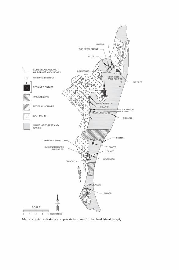
Map 4.2. Retained estates and private land on Cumberland Island by 1987
within which to do so, most often ten years. A number of controls on new
home construction are included in the contracts. First, each holder was lim-
ited to a maximum number of new dwellings. Second, some were limited by
dwelling size restrictions. Third, nearly all had height restrictions of forty
feet. Finally, some deeds specify the right to add support structures, includ-
ing sheds, fences, and corrals.
Those with structures in existence on February 1, 1970, can use them for
residential purposes. Indeed, the presence of these houses allowed the only
three outsiders, Henderson, Ruckdeschel, and the Goodsell-Phillips team,
to retain estates. The age and value of these dwellings varied from the
century-old Stafford mansion, to the ramshackle 1930s Trimmings house in
the Settlement (also on the National Register), to the Sea Camp house built
by Fraser in the late 1960s. Also governed by contract stipulations for the use
of existing buildings are various Davisville houses for which retained-rights
holders traded their original retained estates. The contracts usually, but
not always, stipulate that the homes cannot be substantially altered or ex-
panded, especially those in historic districts. In some cases the contracts
define who should pay for maintenance; in other cases they are silent.
One further provision, present in all but three of the contracts, states that
the holders can lease their “non-commercial, residential” property to any-
one they choose. In most cases leases must last at least one week. A few re-
quire ninety-day leases. This very commercial-sounding noncommercial
use means that most but not all of the holders can temporarily transfer most
of their other rights to anyone who rents their estate.
The matter of docks and island access is one of the most diverse and con-
fusing issues. Some contracts stipulate that the holder may use the “Main
Dock” at Dungeness. Others specifically deny its use. Still others are silent.
Many refer vaguely to “National Park Service docks,” others to assorted ex-
tant docks from one end of the island to the other. Some grant permission
to build a dock. Some are exclusive. Some are not. Many include a combi-
nation of these provisions. Furthermore, a couple of the contracts allow
their holders to “maintain navigability” in streams that flow through or
alongside their properties. The matter of use of the three existing airfields
plus any built by the Park Service in the future is equally diverse.
Cumberland Island contains a number of roads and a few trails that once
functioned as roads. The right to drive a vehicle over any or all of these
forms another highly variable issue. Use of the Main Road is universal al-
though the Schwartz holding allows use only from the estate to an unspec-
134 Land Acquisition and Retained Rights
ified dock. Other roads are more problematic. Contracts with the Johnston
branch usually stipulate freedom to use the Plum Orchard road. A few spec-
ify use of the road leading to the Duck House area (Richards estate). Most
are vague. The contract for Mary Bullard, in deference to her physical dis-
ability, allows her to drive a vehicle on any and all roads and trails. One or
two others seem to hint at similar rights. Most contracts are silent on road
use other than the Main Road.
Intimately associated with driving the roads and trails of Cumberland Is-
land are two specific issues: access to the beach and driving along the beach.
Unfortunately for later seashore managers, most contracts are silent on
both. Only Mary Bullard’s contract specifically stipulates the right to drive
on the beach. For the others one is left to decide whether the beach is, in fact,
a traditional “road.”
The final group of issues surrounding the retained-rights agreements
concerns the matter of resource protection. The National Park Service owns
this property. It has a right to expect that estate holders will protect the valu-
able natural and historic resources for which the seashore was established.
Nearly all contracts specify that residents or their assigns should not “com-
mit waste” or cut timber. In a few cases the minimum size of a living, off-
limits tree is specified. On the other hand, several contracts forbid cutting
trees except for “residential purposes,” but that phrase is left unexplained.
Some contracts invest their holders with rights to stabilize sand dunes and
develop a pathway to the beach but also forbid driving over nonvegetated
sand dunes.
Finally, some agreements call for maintenance of estate grounds in a
“neat” or “tidy” condition. Coleman Johnston’s contract carries a particu-
lar 1975 addition for protection of archaeological resources on his Table
Point estate. He agreed to check with Park Service officials and allow a pro-
fessional survey of this rich Indian site before building his new dwelling
and support structures.
The sum of these general and specific stipulations, their wildly diverse
applications between seventeen parties and eighteen estates, and the confu-
sion of meaning in the very words used in the contracts set the stage for
conflict among parties interested in the national seashore. Furthermore,
seashore managers soon realized that what these terse legal contracts state
and what the Carnegie and Candler heirs claim they were promised are two
very different things.
Looking at the saga of land acquisition at Cumberland Island, one is
Land Acquisition and Retained Rights 135
struck by the extraordinary prices paid for some land and the generous re-
tained rights granted, at least by Park Service standards. Essentially it was a
matter of desire. That desire began with the first seashore surveys in the
1930s. It swelled as the agency frantically assessed surviving coastal recre-
ation opportunities during the 1950s. Desire sharpened further with each
Park Service visit to the idyllic island.
After Congress established the seashore, desire drove the agency to seek
fee simple ownership of the entire island. Most Carnegie descendants re-
mained true to their pledges to sell at low cost to the government. However,
a few, coupled with many latecomers, sought to make money on the new
park. That desire for the island betrayed the Park Service. Cagey owners, old
and new, recognized that the agency would pay high prices to gain control
of paradise. That desire also led to exacting retained-rights agreements, far
more complicated and permissive than those present in other parks. Those
agreements quickly became and remain today the major management issue
of Cumberland Island National Seashore.
136 Land Acquisition and Retained Rights