Embed Size (px)
Citation preview

Cenozoic evolution of the Central Andes in Bolivia and northern Chile
S I M O N L A M B , LEONORE HOKE, LORCAN KENNAN & JOHN D E W E Y Department of Earth Sciences, University of Oxford, Parks Road, Oxford OX1 3PR, UK
Abstract: The Central Andes in Bolivia and northern Chile form part of a wide and obliquely convergent plate-boundary zone where the oceanic Nazca plate is being subducted beneath the continental South American plate. In the latest Cretaceous and Palaeocene, this part of the Central Andes formed a volcanic arc along what is today the forearc region of northern Chile, with a wide zone of subsidence, as much as 400 km wide, at or close to sea level behind the arc. In the Eocene, the central part of the behind-arc basin was inverted to form a zone of uplift (proto-cordillera), about 100 km wide and along what is today the western margin of the Eastern Cordillera of Bolivia. The Altiplano basin and an early foreland basin were initiated at this time, receiving sediment from the Eocene proto-cordillera. Subsequently, the proto-cordillera widened, as the rate of deformation increased and deformation spread westwards into the early Altiplano basin, and also eastwards towards the Brazilian Shield. In the Late Miocene, deformation essentially ceased in the Altiplano and Eastern Cordillera. An intense zone of shortening was initiated in what is today the Subandean Zone on the eastern margin of the Central Andes, deforming the Oligo-Miocene foreland basin. Shortening in the Subandean Zone accommodated both underthrusting of the Brazilian Shield and also bending of the entire mountain belt about a vertical axis. It is suggested that much of the distinctive Cenozoic tectonic evolution of this part of the Andes is related to pre-Andean strength inhomogeneities in the South American lithosphere.
The Andes are one of the largest active plate-boundary zones, forming a mountainous region which extends for over 5000 km along the western margin of South America (Fig. la) as a result of the subduction since the Cretaceous of the oceanic Nazca (or formerly Farallon) plate beneath the South American plate (Dewey & Bird 1970; Pardo-Casas & Molnar 1987). They show marked variation in tectonic style and evolution along their length, as well as several major changes in trend.
The Andes are highest and widest in the Central Andes of northern Chile and Bolivia, where the present-day relative plate conver- gence is roughly E N E - W S W at c. 85 m m a -1 (Fig. 1, DeMets et al. 1990). Here , there is a pronounced bend (Arica bend) in both the structural and topographic trends, which swing round from c. NW-SE, north of the bend, to c. N-S further south (Fig. l a). An active volcanic arc follows the western margin of the high Andes, and there is a zone of Cenozoic magmatism east of the arc, up to several hundred kilometres wide. Also, in this part of the Andes, there are thick continental sedimen- tary sequences, deposited during the Cenozoic
tectonic evolution. The region is well populated and easily accessible. For all these reasons, this is an extremely good place to study the develop- ment of wide zones of continental deformation.
We describe here the tectonic evolution since the Cretaceous of the Central Andes in northern Chile and Bolivia, based mainly on our own extensive field work, unpublished oil company data, and new geochronological, geochemical and palaeomagnetic data.
Physiographic and geological provinces The Andes between 16°S and 23°S form a wide region up to 800km wide and reaching ele- vations over 6000 m, bounded in the east by the Peru-Chile trench and in the west by the Amazon basin and Chaco plains (Fig. 1). Topographic cross-sections (Fig. lb) show that in detail there are several distinctive physio- graphic provinces. These provide a convenient way of describing the geology, because the tectonic evolution of each province has been generally distinct (Figs 1 & 2). Crustal-scale cross-sections through the Bolivian Andes are shown in Figures lc and 3.
From Burg, J.-P. & Ford, M. (eds), 1997, Orogeny Through Time, Geological Society Special Publication No. 121, pp.237-264.
237

238 S. LAMB E T A L.
(a)
85°W 65ow 60°W 10°S 10°S
15os --
20os --
25os - -
30os - -
--15°S
80°W 75ow I
2
I I 75°W
__20°S
70°W I I
N Fig. 2 I~
I I 70°W
--25°S
- - 30os
35os -- 35os
85°W 80ow 65ow 60ow
m Topography over 2000 m a.s.l.
(b) Western Eastern Cordillera Cordillera
F / ] Subandean orearc/Altiplano/ Zone
TAnc_~ ~ F°reland (Amazon B a s i n )
Chaco Plains
C sea level
B' B 0 -"- - (c) ~ 2 0 ~ . . ~
~ 80 1 0 0 | - , - , . . . .
0 200 400 600 800 Crustal thickness greater than 70 km 10~ (kin)
Fig . 1. (a) Tectonic setting of the Central Andes on the western margin of South America where the oceanic Nazca plate is being subducted beneath the South American plate in a roughly ENE-WSW direction at c. 85 mm a -~ (large arrow, DeMets et al. 1990). The position of the trench and depth contours of the Benioff zone are also shown (bold curves). The oceanic Nazca plate is oldest in the bend region of the trench with a Palaeocene age. The region of topography over 2000 m a.s.l, and also crustal thickness greater than 70 km in the Andes are shaded. Topographic cross-sections AA' and CC' are shown in (b). The box outline defines the region shown in Fig. 2. (b) Topographic profiles AA' and CC' (see (a) for location) define a mountainous zone up to 900 km wide, ranging from c. -6000 m in the trench to c. 4000 m in the Altiplano. Several physiographic provinces (Forearc, Western Cordillera, Altiplano, Eastern Cordillera, Subandean Zone, Foreland) can be recognized. (c) Crustal scale cross-section through the Bolivian Andes for an E-W transect at 20°S (BB 1 in (a))based on seismic data (after Beck et al. in press). Light shading defines original crustal thickness (c. 35 km) and dark shading shows the crustal thickening.
F o r e l a n d a n d S u b a n d e s
The foreland region along the eastern margin of the Central Andes, in the Amazonian basin and Chaco plains, is generally at an altitude of a few hundred metres above sea level (Fig. lb) . This is underlain by the Brazilian Shield, which has been a stable nucleus of South America since the Proterozoic (Litherland et al. 1986), and over- lain by up to 5km of Neogene sediments immediately east of the Andes in a foreland basin about 200 km wide (Fig. 3, unpublished oil company data). The topography increases to- wards the west in the foothills of the Andes, referred to as the Subandean Zone, which is about 100km wide and reaches altitudes over 1500 m, dominated by major valleys and ridges which follow the general structural grain (Fig. lb). The valleys follow synclines of Cenozoic sediment, separated by faulted anticlinal ridges of older Mesozoic and Palaeozoic sequences
(Figs 2 and 3). Seismic refraction (Wigger et al. 1993) and reflection data (unpublished oil company data) shows that the Subandes are part of a thin-skinned fold and thrust belt accommo- dating shortening above a basal d6collement at a depth of 7-10 km and dipping at 2-3 ° towards the west and southwest (Fig. 3). The Brazilian Shield has been underthrust beneath the Suban- dean Zone and Eastern Cordillera.
E a s t e r n C o r d i l l e r a
West of the Subandean Zone, the mountains rise progressively to altitudes over 4000m, in a region referred to as the Eastern Cordillera. This is up to 200 km wide and made up mainly of thick (up to 10km) sequences of Palaeozoic flysch-like deposits, with thin (<3 km) infolded Cretaceous and Cenozoic sequences. The most westerly parts of the Eastern Cordillera form a high spine, referred to in the north as the

CENOZOIC EVOLUTION OF CENTRAL ANDES 239
14'
15 ~
16'
70 ° 69 ° 68 ° 67 ° 66 ° 65 ° 64 ° 63 ° I ~ ~ I I i I I i
Peru
Salars Miocene Ignimbrites Oligo-Recent-] Pal-Eocene _l Sediments Pre-Cenozoic
Major Faults
Volcanoes of the Major Western Cordillera • Towns
[ 114 °
15 °
16 °
17']-i d Coroco~• . . . . . . . . . . . ~ i i i i ' 3 ~ . . . . . .......... C o c b a b a m b ~ .............. ~ "~ 17°
17 " ' I ........................... ~ ........................
1 9 ° ~ ~ k ~ . - - ~ ~ [Tambo ~ I "~ 4 '19 °
2 0 ' ~ ~ ~:~!i!iiiZililiJ, ~ ~ , ,V "¢ . ~ ^ ^ ^ ~ t ~I~i!i~̀i!i!iiiiiiiii!iiiiiiiiiiii!~ii!!;ii~!iii!ii~iiii~i~i~ii~ii~i:i:!~i!~!~iii~i~iiiii!ij!i!~ [iiii!i!~ ~ I "[20 °
AI 2 2 ° ~ i ~ i i i : ~ ~ , ~ , ~ \ q.9 ~ ~ - - ~ : ; ~ : i l / ~v -I 22 °
23' Argentina
200 kms 23 °
70 ° 69 ° 68 ° 67 ° 66 ° 65 ° 64 ° 63 °
Fig. 2. Map of the Central Andes in northern Chile and Bolivia (see Fig. 1), showing the distribution of Cenozoic and pre-Cenozoic sedimentary sequences and major structures. Major physiographic features are also shown, including the large salars in the Altiplano and Lake Titicaca. AA' and BB' show the line of a composite geological cross-section in Fig. 3. Line CC' shows the line of a schematic cross-section in Fig. 4a. Numbers refer to localities where various formations or rock units, mentioned in the text (see Figs 9 & 11), are defined: (1) Potoco, Huayllamarca, Turco, Tihuanacu Formations; (2) Cordillera Real graniotoids; (3) Camargo, Torotoro, Morachata/Viloma Formations; (4) Sail a, Tupiza Formations; (5) Quimsa Cruz granites (Mina Viloco and Mina Argentina bodies); (6) Petaca Formation; (7) Azurita Formation; (8) Totora, Huayllapucara, Caquiaviri, Tambillo Formations; (9) Challapata ignimbrite; (10) Mondragon, Bolivar, Parotani, Nazareno Formations; (11) Chilean precordillera ignimbrites; (12) Quebrada Honda Formation; (13) pre-Los Frailes ignimbrites; (14) Yecua, Tariquia Formations; (15) Crucero, Pomata Formations; (16) Los Frailes, Morococalla ignimbrites; (17) Umala Formation, Turco ignimbrite; (18) Perez ignimbrite; (19) Sucre-Tarabuco tufts; (20) Emborozu Formation and recent sedimentation.
Cordillera Real and Quimsa Cruz (Fig. 2), rising to over 6000 m where Palaeozoic, Triassic and possibly Cenozoic intrusive granitoid bodies outcrop. There is a marked change in vergence of structures east and west of the central part of the Eastern Cordillera. In the west, vergence is
mainly towards the west, whereas in the east vergence is towards the east (Fig. 3).
In the bend region, at c. 17.5°S, a series of Plio-Pleistocene basins occur within the Eastern Cordillera. These are bounded by ESE-trending normal faults with a sinistral strike-slip com-

240 S. LAMB ET AL.
A I I Arc I [Pr~.rnmhrinn
Altiplano
A 0 1 o - - ~ l l T . . . . . .
A ' B I I Eastern II Cordillera I I Overthrust of I I Triassic pluton
S u b a n d e a n Zone
Foreland Basin
B !
sea level
50
100km
Neogene sedimentary basins/volcanics
I ] Mainly Palaeozoic sequences
Precambrian basement
Hypothetical zone of ductile deformation
Major fault
Fig. 3. Composite crustal-scale geological cross-section through the Bolivian Andes (see Fig. 2), based mainly on unpublished oil company data. The principal features are the presence of thick Neogene sedimentary basins in both the Subandes and Foreland, and also the Altiplano region. Note the marked changed in vergence of structures east and west of the central part of the Eastern Cordillera. Precambrian basement has been underthrust beneath the Subandean Zone and Eastern Cordillera, and also outcrops on the western margin of the Altiplano (Troeng et al. 1994). A zone of distributed ductile deformation may occur at depth beneath the Altiplano.
ponent which comprise the Cochabamba Fault System (Fig. 2, Dewey & Lamb 1992; Kennan 1994; Kennan et al. 1995).
A l t i p l a n o
The Altiplano forms a c. 200 km wide region of subdued relief, west of the Eastern Cordillera, at an average altitude of c. 3800 m (Figs lb & 2). It is the second largest high plateau region, after Tibet, on Earth, and is essentially a region of internal drainage. Near La Paz the drainage has locally broken through to the Amazon basin. The vast salars of Uyuni and Coipasa, and also Lake Poopo, are the remnants of once extensive Pleistocene lakes (Servant & Fontes 1978). The Altiplano has been an important locus of sedimentation, where thick sequences of red- beds have accumulated in the Cenozoic (Figs 2 and 3).
Wes te rn Cordi l l era a n d Forearc
The Western Cordillera is the active volcanic arc along the international border between Bolivia
and Chile, and consists of spaced Miocene and Quaternary andesitic volcanoes and small vol- canic centres which have erupted through a poorly known sequence of Cenozoic, Cre- taceous and older rocks (Figs 2 and 3). Volcanic cones rise over 2000 m above the general land surface, reaching elevations over 6000 m.
The western margin of the high Andes comprises the Precordillera of northern Chile, which consists mainly of Precambrian basement rocks and Mesozoic sedimentary sequences and Cenozoic intrusive and extrusive rocks. A major fault system, which extends for hundreds of kilometres along the Precordillera and further south (Cordillera Domeyko), appears to have accommodated both sinistral and dextral stike- slip during the Cenozoic (Mpodozis et al. 1993; Reutter et al. 1993). The Precordillera slopes from c. 4000 m to an altitude of c. 1000 m, in a region mantled by Miocene ignimbrites (Figs 2 & 4a). The foot of this ignimbrite slope is a fiat region of younger Cenozoic deposits in the central depression of northern Chile (Figs 2 & 4a). The Atacama fault, which extends for hundreds of kilometres along the coastal parts of

CENOZOIC EVOLUTION OF CENTRAL ANDES 241
(a)
Coastal Range alluvial fans •
\ Atacama Fault ~ .
Central Volcanic Depression Precordillera Arc Altiplano
Progressive 'nested'
-4000m
Sea Level
(b)
,~ I k UPLIFT ~10km
1 HINGE
Fig. 4. Diagrams illustrating the Plio-Pleistocene kinematics of the western margin of the Central Andes in the forearc region of northern Chile. See section CC' in Fig. 2 for general location. (a) Early Miocene ignimbrites slope off from the Altiplano and Precordillera, dipping gently towards the Atacama Fault (active in the Plio-Pleistocene principally as a normal fault). A series of younger nested alluvial fans above the ignimbrite suggest progressive block tilting and down-cutting. (b) Block tilting of the western margin of the Central Andes appears to have accommodated uplift of the Altiplano relative to the coastal regions. The normal displacements on the Atacama and other faults may be second-order accommodation structures related to this tilting with overall convergence between the coast and the volcanic arc.
northern Chile as a high angle fault with a normal dip-slip component of motion, forms the western margin of this depression, separating it from the narrow coastal ranges which rise up locally to over 2000 m (Figs 2 & 4a). A zone of Cenozoic thrusting occurs south of 22°S in the Salar de Atacama region (Jolley et al. 1990, Fig. 2).
West of the coastal ranges, the topography slopes below sea level in the Pacific Ocean down to depths of 6 km in the Peru-Chile trench about 75km off-shore, forming a deformed crustal prism (Fig. lb) .
Lithospheric structure The lithospheric structure of the Central Andes can be constrained by both geophysical data (seismicity and gravity), and also geochemical evidence. In particular, a study of the helium isotopic signature of geothermal areas places constraints on processes near the base of the lithosphere.
Seismicity and gravity
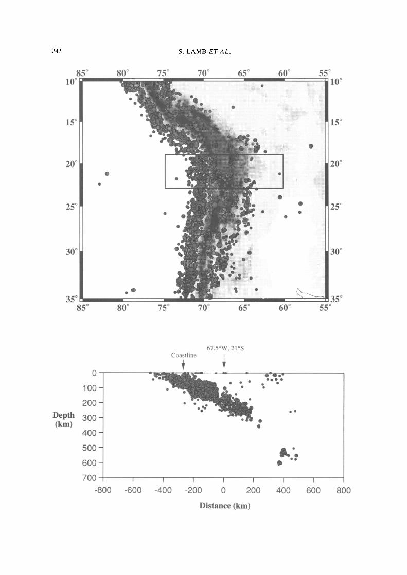
Figure 5a shows the epicentres of all earth- quakes between 1964 and 1992 in the Central Andes between 10°S and 35°S, shallower than 70 km and magnitude Mb > 4.0. The clear coinci- dence between the shallow seismicity and the topographic expression of the Central Andes, shows that the Central Andes are an actively deforming mountain belt. A projection of both shallow and deep focus earthquakes on to an east-west vertical cross-section in the vicinity of 20°S (Fig. 5b) shows that the bulk of the seismicity defines a Benioff zone which dips below the western margin of South America at c. 30 °, reaching depths greater than 600 km (Figs 1 & 5b). However, south of 27°S and north of 15°S, the Benioff zone flattens markedly, associ- ated with gaps in the volcanic arc.
Studies of seismicity, gravity and topography in the Bolivian Andes show that the crustal thickness beneath the Altiplano is up to 75 km thick (Fig. la and c, James 1971; Wigger et al.
242 S. L A M B E T A L .
8 5 ° 1 0 °
8 0 ° 7 5 ° 7 0 ° 6 5 ° 6 0 ° 5 5 ° 1 0 °
1 5 ° 1 5 °
2 0 ° 2 0 °
2 5 ° 2 5 °
3 0 ° 3 0 °
3 5 ° 8 5 °
3 5 ° 8 0 ° 7 5 ° 7 0 ° 6 5 ° 6 0 ° 5 5 °
D e p t h ( k i n )
0
1 0 0 -
2 0 0 -
3 0 0 -
4 0 0 -
5 0 0 -
6 0 0 -
7 0 0
- 8 0 0
I
- 6 0 0
6 7 . 5 ° W , 21°S Coastline
. u n i r J i a ~ l i ~ - • • . o . % o
. I q i e - • -
o o o
I I I I I
- 4 0 0 - 2 0 0 0 2 0 0 4 0 0
D i s t a n c e (km)
l
6 0 0 800

CENOZOIC EVOLUTION OF CENTRAL ANDES 243
70°W 6 8 ° W 6 6 ° W 64oW
14os
18°S }~ 18 °
22os ~ - 22os
I I"! ~'~::~"1 ~ ARGEN~HNA D,i A n t o f a g a s t a ¢ "
70°W 6 8 ° W 6 6 ° W 64°W
Elevated 3He anomaly Plio-Pleistocene basaltic volcanism
/ k Active volcano
lso L~ Depth contours of Benioff Zone
[ = - - - - ~ Helium profile
!14o S
18°S
fo)
0 200 400 600 800
elium sawgple ] ~ne of mantle elt generation
an Shield
,..1
lOOO km ~
Fig. 6. Diagram illustrating helium isotopic data and implications for lithospheric structure in the Central Andes of northern Bolivia and Chile, after Hoke et al. (1994b). (a) Map showing the region characterized by hot springs, mineral waters and sulfataras with an anomalously high 3He/4He ratio (normalized 3He/4He with respect to air >0.1). Also shown are the general regions of outcrop of monogenetic basaltic Plio-Pleistocene volcanism, the location of the active volcanic arc, and depth contours of the Benioff zone. Basaltic volcanism and elevated 3He/4He ratios occur in a wide region up to 300 km behind the arc. (b) Lithospheric-scale cross-section across the Central Andes (see (a) for location), showing the position of the subducted slab and structure of the overlying South American plate. The thickness of the South American lithosphere is partly based on an interpretation of the helium data and topography. The elevated 3He/4He ratios and basaltic volcanism are interpreted to be the consequence of behind-arc mantle melting. The broad consistancy of the helium data suggests a 'thinned lithosphere', c. 100 km thick, extending behind the volcanic arc and beneath the Altiplano and part of the Eastern Cordillera, with a zone of mantle melting at its base. The drop-off in the 3He/4He ratio further east is interpreted to mark the presence of the Brazilian Shield and 'thick' old lithosphere (see text).
1993; Dorbath et al. 1993; Zandt et al. 1994; Beck et al. 1996), and thins both east and west towards regions of normal continental crustal thickness of c. 35km in the Chilean forearc region and the Brazilian shield. However, there are also marked isostatic gravity anomalies. A negative isostatic anomaly east of the Suban- dean Zone suggests an excess of low density material, whereas a positive anomaly in the Subandean Zone and Eastern Cordillera sug- gests an excess of high density material (Lyon- Caen et al. 1985; Watts et al. 1995). This positive
- negative coupling of isostatic gravity anomalies is characteristic of regions where the lithosphere has marked flexural rigidity. Detailed modelling suggests a flexural rigidity for the lithosphere equivalent to an elastic thickness greater than 50 km in the bend region, decreasing to less than 25 km both north and south (Watts et al. 1995; Whitman 1995). Thus, the region of flexurally strongest lithosphere coincides with the old and 'cold' Brazilian Shield, where the base of the lithosphere might be expected to be at depths greater than 200 km (c. 1200°C isotherm). The
Fig. 5. (a) Map of the Central Andes showing the location of earthquake events between 1964 and 1992 shallower than 70 km and with magnitudes Mb > 4.0 (data taken from the IS catalogue). Shading defines general topography, becoming darker in higher ground. The bulk of the shallow seismicity occurs off-shore near the trench. Most of the remaining earthquake moment release occurs much further east in the Subandean Zone and Foreland region. (b) Seismicity between 1964 and 1992 in an east-west vertical cross-section between latitudes 19°S and longitude 23°W for events with Mb > 1.0 (see box in (a) for location). The section is centred on latitude 21°S and longitude 67.5°S. The bulk of the seismicity defines a Benioff zone, dipping at c. 30 ° to the east. The remaining moment release defines more diffuse deformation in the overlying plate.

244 S. LAMB ET AL.
simplest interpretation is that this shield area has been underthrust beneath the Subandean Zone in the bend region of the Bolivian Andes and is providing flexural support for the topographic load of the Andes in the Subandean Zone and at least part of the Eastern Cordillera. Flexing of the lithosphere has also created a foreland basin up to 5km deep and up to two hundred kilometres wide (unpublished oil company data) along the eastern margin of the Central Andes (Fig. 3).
H e l i u m i so tope s tud ies
Information about the lithospheric structure also comes from a study of helium emitted in geothermal springs. A recent helium isotope study right across the Central Andes in Bolivia and northern Chile (Hoke et al. 1993, 1994b) has documented an elevated 3He signature, greater than that typical for crustally derived helium. This zone extends for up to 400km from the Precordillera in the west, across the active volcanic arc and the Altiplano high plateau region to the western part of the Eastern Cordillera (Fig. 6a). In the absence of significant crustal sources of 3He, the most likely sources for the 3He are mantle melts present at depth. Therefore, the elevated 3He signature maps an extensive area of active mantle melt generation and concomitant subsurface basalt addition to the Andean crust (Hoke et al. 1993, 1994b), in a region where the crust is up to 75 km thick and the subducting slab is at depths of 100-350 km (Fig. 6b). Mantle melting is also suggested by the rare presence of small young olivine-bearing basaltic andesite volcanic centres throughout the Altiplano (Fig. 6a), with ages less than c. 5 Ma (Hoke & Lamb, unpublished data).
Hoke et al. (1994b) interpreted the elevated 3He signature in the volcanic arc to be a consequence of melting in the convecting asthe- nospheric mantle wedge between the subducting slab and overlying lithosphere, where dehy- dration of the downgoing slab may hydrate the overlying mantle and cause melting if tempera- tures are greater than ll00°C (see also Davies & Bickle 1991). This model explains sustained arc volcanism over tens of million years and implies that the base of the lithosphere beneath the arc is much shallower than the depth to the Benioff zone here (<120 km). A different mechanism of melting to that for arc volcanism is required to explain the presence of mantle melts at depth beneath both the Altiplano and western parts of the Eastern Cordillera (see discussion below). However, as both the observed 3I-Ie signature and topography are broadly constant right
across the width of the Altiplano and into the Eastern Cordillera (Fig. 6b), it is suggested here that the zone of thin lithosphere beneath the arc (<120 km thick) extends beneath the Altiplano and western part of the Eastern Cordillera where there is a significant mantle-derived contribution to the helium isotope signal (Hoke etal. 1994b; Hoke & Lamb 1994; Fig. 6b).
We interpret the transition to pure crustal helium isotope ratios in the Eastern Cordillera to mark the change to a thicker lithosphere (>200 km) and the western limit of underthrust- ing of the flexurally-strong Brazilian Shield beneath the Eastern Cordillera, defined by the gravity data (Fig. 6b). Thus, our proposed lithospheric structure for the Bolivian Andes, with a wide zone of thinned lithosphere beneath the Altiplano and western part of the Eastern Cordillera, is similar to that previously proposed for the Bolivian Altiplano (Isacks 1988), but differs from the model of Whitman et al. (1992) based on seismic data.
Cenozoic basin evolution and deformation Since the Cretaceous, the Andes in northern Chile and Bolivia have essentially formed part of a convergent plate margin, with the subduction of the oceanic Nazca plate (or Farallon plate) beneath the South American continent (Pardo- Casas & Molnar 1987). It is likely that this type of plate margin existed prior to the Cretaceous as well (Coira et al. 1982; Flint et al. 1993).
The stratigraphy and distribution of both Cretaceous and Cenozoic sedimentary basins, as well as Cenozoic intrusive and extrusive bodies, place constraints on processes occurring at the surface and deeper in the lithosphere. A composite crustal cross-section through the northern part of the Bolivian Andes shows the overall style of deformation and the location of the two principal regions of Cenozoic sedimen- tation in the Subandean and foreland regions and the Altiplano (Fig. 3). In the following sections, the structure and stratigraphy of sedimentary rocks are used to reconstruct the Cenozoic evolution of sedimentary basins and related deformation. The distribution of defor- mation and sedimentation, both in time and space, for a generalized east-west transect across the Andes in northern Chile and Bolivia at the latitudes 16°S to 22°S, is summarized in Fig. 7. The general history is one of a widening zone of deformation which commenced in what is today the Eastern Cordillera in the early Cenozoic, when most of the Bolivian Andes was near or at sea level. The extensive Altiplano basin formed as a region trapped between the

CENOZOIC EVOLUTION OF CENTRAL ANDES 245
TIME (/Via)
ARC EASTERN SUBANDES
FOREARC 1 ALTIPLANO [ CORDILLERA [
o ®Is ®
~ A ,,~\ L~S~'/~/4 ~ 2o ~ "
~ ://..¢
@ Numbered formations/localities
Coarse clastics
Medium/Fine clastics
Ignimbrite Cenozoic unroofing of ?Triassic Intrusives Angular unconformity
Folding /7/Thrusting
®IS S~ike-sHp
; k Andesitic • Mafic volcanism
Fig. 7. Diagram summarizing the distribution and timing of deformation and sedimentation in the Central Andes for a generalized east-west transect between the latitudes 16°S and 22°S. Numbers in circles refer to geological formations or localities, defined in Fig. 2 (see also Fig. 9).
uplifting Eastern Cordillera and the volcanic arc and received sediment for most of the Cenozoic. Also, Cenozoic sequences were deposited in local fault-bounded compressional basins within the Eastern Cordillera, and in a series of foreland basins further east. Formation names used in the following sections are those adopted by the Bolivian Geological Survey in their 1 : 100 000 and 1 : 250 000 geological map series.
Pre-Cretaceous, Cretaceous and early Palaeocene The backbone of most of the Bolivian Andes, especially in the Eastern Cordillera, consists of sequences of deformed Ordovician and Silurian flysch deposits, many kilometres thick. There is evidence for significant pre-Cretaceous defor- mation, but the nature and tectonic setting of this deformation is not well understood.
The volcanic arc in the Cretaceous was in the present-day forearc of northern Chile (Fig. 8; Campusano 1990). There is a marked angular unconformity at the base of the Cretaceous in the Eastern Cordillera and Altiplano in Bolivia. Open to tight folding, with limb dips up to 50 °, a
weak axial planar cleavage and extensive quartz veining are found in Palaeozoic flysch deposits beneath the Cretaceous throughout the Eastern Cordillera (for instance in the Cochabamba, Potosi and Camargo regions). They are trun- cated by Cretaceous conglomerates (La Puerta and Angostura Formations). The metamorphic grade of pre-Cretaceous rocks suggest that at least 5 km of pre-Cretaceous rocks were stripped off by erosion prior to Cretaceous deposition.
From fossil evidence (summarized in Riccardi 1988), most of the Cretaceous in Bolivia above the basal conglomeratic beds is Cenomanian and younger. Isopach maps of the Cretaceous se- quences in Bolivia define a general depocentre near the western margin of the Eastern Cord- illera (Fig. 8; unpublished oil company data). In detail, there are two sub-basins, referred to as the Sevaruyo and Maragua basins, where Cre- taceous sequences are up to 3 km thick (Riccardi 1988; Rouchy et al. 1993; unpublished oil company data), separated by a local 'high' that coincides with the southern extension of the Cordillera Real along the western margin of the Eastern Cordillera (Fig. 8). Local mafic vol- canism, including pillow lavas, could be associ-

246 S. LAMB E T A L .
Maastrichtian-Palaeocene (-60 Ma)
70°W 68°W 14oS ~ Lacustrine •
and ?marine '~ Source region and
A Arc • Basalts "v"i'::: ".'k.
16°S PE] U "' "?':'f'(?':i::'}..,':" ....
I8°S ~ ~
20°S
22°S
~ , n t o ~
70°W 68°W
66°W 64ow seddeP' !iiiiiiii!iii!i!iiii i!i!t transport ~':, BRAZILIAN.;,| alluvial ~'.'i SHIELD "':1 J":'iii!iii!i!iiiiii!i!i!i.
i~'~" " ~ / ~ , ~II Cruz
' ""):" {"~:':: :"? Sucre 0 ~ ~ Middle-Late ~ i : : : i ' Cr~t~eou, 20os ili sop.chs ii! ,sof ( ~ E o c e n e <l ] ~ ~ ( ~ uplift ] /
ARGENTINAX/ 2OO KM
I 66°W 64oW Fig. 8. Generalized palaeogeographic map for the Central Andes in northern Chile and Bolivia in the latest Cretaceous and earliest Cenozoic (c. 60 Ma). The position of the volcanic arc and main sediment source regions and basins and thrust front are plotted in their present location and are not palinspastically restored. Sediment transport directions are shown in their present-day orientations. Note general position of the axis of the Cretaceous basin, with palaeoflow towards this depocentre. The axis more-or-less coincides with the zone of Eocene uplift (see Figs 10 and 16).
ated with a small amount of lithospheric exten- sion concomitant with subsidence of the Cre- taceous basin (Soler & Sempere 1993). There is evidence for a marine trangression in the lower part of the Cretaceous sequence, where distinc- tive grey limestones occur (Miraflores For- mation). Maastrichtian sequences progressively onlap the margins of the sub-basins and here the Cretaceous sequences are much thinner (usually ~1 km). The lateral continuity and extensive outcrop of the Maastrichtian and Palaeocene lacustrine and possibly marine limestones and shales (Fig. 9, El Molino and Santa Lucia Formations, Gayet et al. 1991; Rouchy et al. 1993), preserved throughout the Eastern Cord- illera and Altiplano, demonstrate that most of the Bolivian Andes was a region of very subdued topography at or near sea level at this time. The active plate margin was a relatively narrow zone much further west, where thick Late Cretaceous
to Palaeocene clastic sequences were deposited in what is today the forearc region of northern Chile (Hartley et al. 1992; Flint et al. 1993).
Interestingly, the general axis of the Cre- taceous basins in the Eastern Cordillera co- incides with the region of most intense pre- Cretaceous shortening, where angular trun- cations at the Cretaceous unconformity are greatest.
P a l a e o c e n e to O l i g o c e n e
The volcanic arc in the Palaeocene and Eocene followed what is today the Precordillera in northern Chile (Figs 9 and 10, Campusano 1990). However, the apparent lack of arc volcanics in the age range 25Ma to 35Ma (Lahsen 1982; Campusano 1990), suggests that arc volcanism may have been limited in the Oligocene. This region also appears to have been the locus of deformation (Hartley et al. 1992). North-south horizontal shear has been described from the Cordillera Domeyko (Mpodozis et al. 1993) and the Chilean Precord- illera further north (West Fissure System, Reutter etal . 1993) in what appears to be a major arc-parallel fault zone extending for hundreds of kilometres. However, the large-scale kinematic significance of this fault zone is unclear, and Reutter et al. (1993) describe Eocene dextral strike-slip and Oligocene sinistral strike-slip motion, whereas Mpodozis et al. (1993) describe the converse with Eocene sinistral strike-slip and Oligocene dextral strike-slip motion. The total Cenozoic displacements across this fault zone have yet to be quantified.
There is evidence for Eocene deformation in a narrow zone much further east along what is today the western margin of the Eastern Cord- illera. Here, in the Cordillera Real, both K / A r mica ages (McBride et al. 1987; Farrar et al. 1988) and fission track apatite and zircon ages (Benjamin et al. 1987) indicate rapid cooling at ca. 40 Ma. Also, Farrar et al. (1990) document evidence for folding of the Cordillera Real between the youngest K/Ar resetting age of muscovite (c. 60 Ma) and biotite (c. 39 Ma). A fission track zircon age of 38 Ma from the Quimsa Cruz batholith, at the southern end of the Cordillera Real, also suggests Eocene cooling (Lamb & Hurford unpublished data). Marocco et al. (1987) describe folding on the western margin of the southern Eastern Cord- illera which may be Palaeocene in age, though the field relations and dating are not conclusive.
Evidence for uplift at this time also comes from the Cenozoic sedimentary record in both the Altiplano region and Eastern Cordillera.
CENOZOIC EVOLUTION OF CENTRAL ANDES 247
Corocoro-Corque Syncline 2
Eastern 1 Limb Western Umala Fm. -5 Ma Limb e e ~ C . . . . . . F m . -9Ma
P o m a t a F m ~ / - " i l . ~ - 1 0 . 5 M a Tambo Tambillo i T'I . ~ Region
Cordillera -~ts" / [ - 1 6 M a . ~ : ~ - | ~ Axis = + :, / I~:::::c::~ / .~ Tambo
[ • t'-:'-":"~ ~' ~ Tambillo AzuritaFm.eei~_. ~ • ~ '~ e e ~ " " " Volcanic --25Ma
~ I N - ~ - - - ~ Tambo Colorado
Andamarca ~¢ " ~ ' ~ " - ~ ~ ~ Tusque Fm, Tusque Fm" N N
El Molino and Santa Lucia Formations
5 Camargo
N
Conglomerates
[ ~ >60% sandstone, siltstone conglomeratic lenses Volcanics and volcaniclastic rocks <60% sandstone, siltstone conglomeratic lenses
[ ~ Fine sandstones, silLstones, shales
~ i ~ Limestones, thin sandstones, shales
Angular unconformity
• Dated sample Generalised sediment transport direction
Fig. 9. Diagram showing schematic Cenozoic stratigraphic sections for five localities in the Altiplano and Eastern Cordillera, defining the principal Cenozoic formations and the localities of dated volcanic horizons (Kennan et al. 1995; Lamb unpublished data). See Fig. 10 for locations of numbered sections. Generalized sediment transport directions (present-day orientation) are also shown, each based on numerous (15-100) measurements of rib and furrow or trough cross-bedding orientation. Note the change in sediment transport directions between sections 4 and 5. The latter defines the axis of Eocene uplift which resulted in a divergence of palaeflow, either into the Altiplano basin (section 4) or early foreland region (section 5).
Fossiliferous Cretaceous limestones (El Molino Formation, Gayet et al. 1991) and Palaeocene lacustrine deposits (Santa Lucia Formation, Gayet et al. 1991; Marshall & Sempere 1991) pass conformably into thick red-bed sequences (Fig. 9, Cayara, Tusque, Camargo and Potoco Formations). For instance, in the Camargo area of southern Bolivia, this transition can be traced along strike for over a hundred kilometres and is perfectly conformable. The basal part of the red-bed sequence (Santa Lucia Formation) consists of red siltstones with thin medium sandstone interbeds. Only c. 150m strati- graphically above the Maastrichtian limestones, conglomerates and thick coarse sandstones are well developed (Fig. 9, Camargo Formation). Similar transitions can be found further north near Torotoro, and also near Cochabamba (Kennan 1994), and also in the Altiplano near Corque, Tambo Tambillo and Tambo Colorado (Figs 2, 9 & 10).
The sediment source regions for these red-bed sequences can be defined with some precision from the pattern of sediment transport direc- tions. The centre of the Cretaceous to Palaeo- cene basin was inverted, so that the deepest part formed a narrow uplifting region (proto- cordillera) in the Eocene (Figs 8 & 10), which
shed sediment both to the east and west. The eastern sedimentary basins, outcropping be- tween Cochabamba and Camargo, and further south, formed the foreland basin for the Bo- livian Andes at this time, accumulating up to a kilometre of sediment derived from the west (Fig. 9). The proto-cordillera developed as a narrow isolated range in what is today the western part of the Eastern Cordillera, separ- ated from the active volcanic arc by a region several hundred kilometres wide in Bolivia (Fig. 10). Thus, the intervening region formed a large intermontane basin which is now preserved in the Altiplano region of the Bolivian Andes. Near Tambo Tambillo and Corque in the central Bolivian Altiplano, up to 5 km of Early Ceno- zoic continental sediments (Fig. 9, Tusque, Potoco, Tihuanaco, Huayllamarca and Turco Formations), transported partly from the East- ern Cordillera, were deposited in what appears to be the main depocentre of the Altiplano basin.
Late Ol igocene to Early Miocene
Undeformed Early Miocene ignimbrites (Baker & Francis 1978) show that north of the latitude 22°S, significant shortening deformation in

248 S. LAMB E T A L .
Eocene (35-55 Ma)
14°S
16°S
18°~
20°S
22°S
70°W 68°W 66°W 64ow
Sediment p"i ' i , ,SI~,IELD :i'| Source areas ~ transport ", ' , ' , ' , ' , ' , ' , ' , ' , ' , ' , ' , ' |
• ,,,,,,,,,,-,,,~ ,6os • PERU ~'-)6-~-'~q~ _ ~ ' , x ~ 4 , ~ " '% ' ; "~ ' ; ' ; : 1
Y . . . ~ i ~ v~..:<.. ~,,"% . . . . "1 ".'.'-'..': •
"':"11 Sucre ~ '
~ 20°S
22°S
70°W 68ow 66°W 64°W
Fig. 10. Generalized palaeogeographic map for the Central Andes in northern Chile and Bolivia in the Eocene (35-55 Ma), with the same conventions as Fig. 8. The location of numbered stratigraphic sections, illustrated in Fig. 9, are also shown. Note the development of two basins at this time, separated by a general axis of uplift on the western margin of the Eastern Cordillera. The western basin represents the early stages of the Altiplano basin. Palaeoflow is both towards the Altiplano basin, where several kilometres of early Cenozoic red-beds have accumulated, and an early foreland basin which presently outcrops in the Cochabamba, Torotoro and Camargo regions (see Fig. 2).
northern Chile ceased in the Early Miocene, though relative uplift of the Western Cordillera continued. South of 22°S, these ignimbrites have been internally shortened in a thrust belt (Jolley et al. 1990).
The first appearance of thick coarse con- glomeratic sequences in the Altiplano region occurred at c. 25 Ma (Kennan et al. 1995; Lamb unpublished data). These conglomerates (Azurita Formation) can be traced throughout the central Altiplano in a region extending at least 200km in a N-S direction (Fig. 9). However, there is marked variation in proven- ance for these conglomerates. The eastern outcrops, such as those near Corque, consist of Palaeozoic and Mesozoic clasts from the Eastern Cordillera. Further west, the clasts in the conglomerates consist mainly of metamorphic and igneous clasts derived from the west. The
metamorphic clasts are similar to Precambrian basement rocks, currently outcropping in the Western Cordillera and Precordillera of north- ern Chile (Troeng et al. 1994). In the centre of the Altiplano basin, near Corque and Tambo Tambillo, these conglomerates are conformable with the underlying early Cenozoic succession. However, both to the east and west, there is evidence for a marked angular unconformity. The angular unconformity, overlain by con- glomerates rich in metamorphic clasts, is ex- posed between the Uyuni and Coipasa salars (Eduardo Soria-Escalante pers. comm. 1993). Further east, near Lake Poopo, an angular unconformity is imaged in seismic reflection profiles (unpublished oil company information). The prominent reflector immediately above this unconformity may be equivalent to or very slightly younger than the c. 25 Ma conglomeratic horizons outcropping further west. Beneath the unconformity, sequences are folded and thrusted (Fig. 3).
The prominent angular unconformity and deposition of thick conglomeratic sequences, described above, indicates significant shortening throughout much of the Altiplano in the latest Oligocene and Early Miocene, while deposition continued in the central part of the basin. This coincides with fission track evidence for rapid cooling in the Quimsa Cruz pluton, on the western margin of the Eastern Cordillera be- tween 27 and 22 Ma (Lamb & Hurford, unpub- lished data). The distribution of Oligo-Miocene sedimentary sequences in the Bolivian Eastern Cordillera shows that local fault-bounded com- pressional basins also formed at this time, which locally lie with angular unconformity on older sequences. For instance, the red-bed sequences in the Salla basin on the western margin of the Eastern Cordillera were deposited between c. 30 Ma and 22 Ma (Marshall & Sempere 1991), and sequences near Tupiza are this age too (Fig. 2, Tupiza Formation, Herail et al. 1993b).
An important event in the Altiplano at c. 24 Ma (Hoke et al. 1994a; Kennan et al. 1995; Lamb unpublished data) was the emplacement of a laterally extensive extrusive-intrusive basaltic complex (Tambo Tambillo volcanic complex, Hoke et al. 1994a) which forms sills and volcanic centres with oceanic island basalt characteristics (Davidson & de Silva 1992) in a region of at least 1000 km 2 (Figs 9 & 10). The significance of this mafic volcanism is discussed below.
M i d - M i o c e n e
In the Early to Mid-Miocene, medium to coarse red-bed sequences were deposited right across
CENOZOIC EVOLUTION OF CENTRAL ANDES 249
14°S
Oligo-Miocene (15-30 Ma)
70°W 68°W 66°W 64ow
16°S 16°S
18°~ 18°S
20 ° 20°S
22°S
70°W 68oW 66°W 64ow
Fig. 11. Generalized palaeogeographic map for the Central Andes in northern Chile and Bolivia in the Oligo-Miocene (15-30 Ma), with the same conventions as Fig. 8. Note the widening of the uplifting regions in the Eastern Cordillera, compared to that in the Eocene, with the development of numerous small intramontane compressional basins accumulating several hundred metres of sediment. Also, the locus of sedimentation in the foreland region had migrated significantly further east. An intense phase of crustal shortening occurred in the Altiplano prior to 25 Ma, with widespread erosion in all but the centre of the basin. Subsequently, the Altiplano basin was rejuvenated with the accumulation of several kilometres of red-beds, derived both from the Western and Eastern Cordilleras. At this time, there is evidence for both silicic magmatism on the western margin of the Eastern Cordillera, and widespread basaltic volcanism in the Altiplano basin.
the Altiplano basin (Fig. 9, Totora, Huaylla- pucara, Corniri and Caquiaviri Formations), resulting in the rejuvenation of the Altiplano basin and nearly a doubling in the sedimentation rate compared to that in the Early Cenozoic (Figs 9 & 10). Eight kilometres of red-beds were deposited west of Corque, and several kilo- metres were deposited in the Lake Poopo area between 25 and 9 Ma. Synsedimentary defor- mation on the eastern margin of the Altiplano basin resulted in progressive folding of these sequences, with relative uplift of the regions even further east (Herail et al. 1993a; unpub- lished oil company data). At this time, a very
coarse conglomeratic sequence, with clasts of Cretaceous limestone up to a metre in diameter (Fig. 9, Tambillo Formation), was deposited in the Tambo Tambillo region and most likely derived from uplifted regions to the east.
In the Eastern Cordillera, younger sandy and conglomeratic sequences, dated at 17-20Ma, rest with marked angular unconformity on folded Cretaceous and Palaeozoic sequences in the Eastern Cordillera (Fig. 11), for instance near Cochabamba (Bolivar and Parotani For- mations, Gubbels etal. 1993; Kennan etal. 1995) and Potosi (Mondragon Formation, Sempere et al. 1989; Kennan et al. 1995), and Tupiza (Nazareno Formation, Herail et al. 1993b). The angular unconformity indicates shortening throughout the Eastern Cordillera prior to c. 20Ma, concomitant with rapid cooling of granitoid bodies on the western margin of the Eastern Cordillera, and also the rapid de- position in the Altiplano basin. Shortening continued after deposition of the 20Ma se- quences, as they are themselves gently folded.
High level shortening in the Eastern Cord- illera appears to have a concertina-style, accom- modated by kilometre- to tens of kilometre-scale folding and relatively high angle reverse fault- ing, with changes in vergence. No evidence for nappe-style deformation has been observed. Our examination of the so-called 'Calazaya Nappe' (Sempere et al. 1991; Baby et al. 1992a) on the western margin of the Eastern Cordillera near Uyuni, shows that this structure is an illusion created by the confusing interference of different trends of folding, young strike-slip faults and a pronounced angular unconformity at the base of the Cretaceous sequences.
The nature of the eastern front of the Andes in the Middle Miocene is not clear, though the deposition of Oligo-Miocene coarse conglomer- ates (Fig. 11, Petaca Formation, Sanjines & Jimenez 1976; Marshall et al. 1993) in the Subandean Zone suggests some sort of a foreland basin existed.
L a t e M i o c e n e to P I i o c e n e
In the forearc region and Precordillera of northern Chile, at c. 20°S-22°S, Early Miocene ignimbrites define a regional dip slope tilted less than 5 ° towards the west (Fig. 4a). The only evidence for significant younger deformation in this region is along the Atacama fault, which is a high angle normal fault which offsets Pliocene tufts (Fig. 4a, Naranjo 1987; Dewey & Lamb 1992), and also on the western margin of the volcanic arc, where high angle normal faults also offset Late Miocene and younger ignimbrites
250 S. LAMB ET A L.
LateMiocene-Pliocene (2-8 Ma) 70°W 68°W 66°W 64ow
L ~ ¢ ~ ' ~ ";"';'~'~'~'~'~;';';';';';':'; 14os~ ~ Sedimentary ~ Fault ~'~'~,'(,'(,~:~,"~(,'~,':,';] II ~ basins ¢ . "~'; BRAZILIAN.', Sednnent ~,,,, _ _ , 1 II ~ Source areas transport [" : ' , - - $I-IJ~l~l) - "'" I II ~ Ignimbrite A Ar~ & Ra~alt I:::::::::::::::::::::::::::
16°S
18°S
20°S
22°S
70°W 68°W 66°W 64°W
Fig. 12. Generalized palaeogeographic map for the Central Andes in northern Chile and Bolivia in the Late Miocene and Pliocene (2-8 Ma), with the same conventions as Fig. 8. The palaeogeographic reconstruction spans two main periods. Between 5 and 8 Ma, deformation in the Altiplano (see Fig. 16) resulted in uplift, erosion and breaching of the Altiplano basin, so that sediment was transported from the Altiplano region into the foreland basin. At the same time, extensive low relief peneplains developed in the Eastern Cordillera, which also ultimately drained into the foreland (San Juan del Oro and other surfaces). There were also widespread eruptions of ignimbrites on the western margin of the Eastern Cordillera (Los Frailes and satellite volcanic fields). Between 5 and 2 Ma, the Altiplano again became an internal drainage basin with the accumulation of generally thin fluvial and lacustrine sequences (,~500 m), with scattered basaltic volcanism. Deformation in the Subandean Zone may have increased river gradients in the Eastern Cordillera, resulting in downcutting and dissection of the San Juan de Oro and other peneplain surfaces (schematic drainage system shown).
and lavas (Fig. 4a). However, south of 22°S, Late Miocene ignimbrites west of the volcanic arc, have been deformed in a thrust belt in the Salar de Atacama region (Jolley et al. 1990), though the shortening is probably small ('~5 km).
The central part of the Altiplano basin started to shorten internally in the Late Miocene, during a period of a few million years. An angular unconformity, imaged in seismic reflection pro- files and exposed near Corque, is overlain by conglomeratic sequences which contain c. 9 Ma volcanic ashfall deposits (Crucero and Pomata
Formations, Lamb unpublished data). How- ever, the most intense phase of internal defor- mation occurred between c. 9 and 5 Ma, when Mid- to Late Miocene sequences (Fig. 9, Totora, Huayllapucara and Mauri Formations) were tightly folded and cut by thrust faults with displacements of up to several kilometres (Ken- nan et al. 1995; Lamb unpublished data; unpub- lished oil company data). Deformed sequences as young as 9Ma are overlain with marked angular unconformity by c. 5Ma ignimbrites (Umala Formation) which are only very gently folded, and c. 3Ma ignimbrites (Perez ig- nimbrite, Marshall et al. 1992) which are flat lying. The period of intense shortening prior to c. 5 Ma in the Altiplano marks the termination of the main phase of accumulation of sediments in the Altiplano basin. Subsequently, only a few hundred metres of Plio-Pleistocene sediments and volcanics accummulated, except locally in the region west of Oruro where more than a 1000 m may have been deposited (Fig. 12; unpub- lished oil company data).
In the Eastern Cordillera, regional flat-lying peneplain surfaces (Juan del Oro surface and others) developed since the Middle Miocene, with the local accumulation of sedimentary sequences as old as 12 Ma (McFadden et al. 1990). These are currently at altitudes between 2 and 4 km (Fig. 12, Servant et al. 1989; Gubbels et al. 1993; Kennan et al. 1995, 1997). Also, 12 Ma and younger ignimbrites are essentially fiat lying, including the c. 7 Ma extensive ignimbrites of the Los Frailes and satellite massifs in the western parts of the Eastern Cordillera, and c. 3Ma tufts which mantle the remains of peneplain surfaces throughout the Eastern Cor- dillera (Gubbels etal . 1993; Kennan et aI. 1995). Dissection of these surfaces occurred in the last 3 Ma, when the present drainage pattern was established. However, there is evidence for conjugate strike-slip faulting in the Eastern Cordillera and Altiplano, which offset Pliocene and younger strata (Dewey & Lamb 1992; Kennan 1994; Kennan et al. 1995; Lamb unpub- lished data). These faults are generally spaced at tens of kilometres with individual offsets of much less than 1 km and have accommodated shortening in an approximately east-west direc- tion, with concomitant north-south extension.
In the Subandean Zone, Miocene to Recent sequences up to 5 km thick (unpublished oil company data), deposited in a foreland basin related to deformation in both the Eastern Cordillera and Subandes itself, are intensely folded and faulted in an active thin-skinned fold and thrust belt which has accommodated c. 140km of shortening in the Bolivian bend region (Figs 3, 12, Baby et al. 1992b, 1993). The

CENOZOIC EVOLUTION OF CENTRAL ANDES 251
Subandean shortening
Benioff zone slip ~,/
70ow -'l- 10°S (a)
~0%~ Thrusting Strike-slip
Re~,afx,~ e 9 ~ate c~°~ '~e~ger~¢e "ae¢'°~ :l~ (b)
NAZCA ~ . ~ ~ 8-17 mm/yr PLATE ~ - - 35 °S 68-77 mm/yr Subandean
~- 70°W Benioff zone slip shortening
Negligible Plio-Pleistocene and active deformation
Subandean zone - intense deformation in last 5 Ma
General direction of thrusting
Fig. 13. Diagrams illustrating the partitioning of the relative plate convergence between the Nazca and South American plates at the latitudes of the Bolivian Andes. The total plate convergence vector for the Nazca plate relative to the South American plate is 85 + 5 mm a -1 at 076 _+ 5 ° (DeMets et al. 1990). The active and Plio-Pleistocene deformation is mainly partitioned into Benioff zone slip parallel to the plate convergence vector at 68-77 mm a -1, and deformation in the Subandes. (a) North of the bend, Subandean deformation appears to be partitioned into sinistral strike-slip at the back of the Subandean Zone and parallel to the general structural trend, and shortening in the Subandean Zone perpendicular to the structural trend (see text). (b) South of the bend, shortening in the Subandes may be more-or-less parallel to the plate convergence direction, though there is some evidence for dextral strike-slip within the Eastern Cordillera. The net deformation in the Subandean Zone and Eastern Cordillera results in shortening in a direction subparallel to the plate convergence vector at 8-17 mm a -].
exact t iming of the incept ion of deformat ion in the Subandean Z o n e is not clear, but it is certainly likely to have been most active in the last 5 Ma, when shor tening e lsewhere in the Andes of nor thern Chile and Bolivia was very small.
Plio-Pleistocene and active kinematics
E a r t h q u a k e m o m e n t release
Diffuse seismicity at depths less than 7 0 k m is found th roughout the Central Andes as pre- dominant ly thrust events (Fig. 5a, b) The total m o m e n t release for crustal events since 1960 accounts for less than 20% of the ins tantaneous relative plate convergence be tween the Nazca and South Amer i can plates (Dewey & Lamb 1992). This suggests that the bulk of the relative
plate convergence on this short t ime scale is taken up in the brittle crust as elastic and anelastic strain. However , D e w e y & Lamb (1992) suggest that the distr ibution of m o m e n t release might reflect the longer term part of active deformat ion on a t ime scale of tens of thousands to hundreds of thousands of years (cf. Jackson et al. 1995). The pat tern of ea r thquake m o m e n t release suggests that the relative plate mot ion has been accommoda ted in two principal zones, along the plate interface offshore and as more distr ibuted deformat ion much further east in the Andes . The net shor tening direct ion in both zones is approximately parallel to the relative plate convergence vec tor (Dewey & Lamb 1992). The bulk of shallow seismicity is found offshore near the plate interface (Fig. 5a, b), suggesting that 80-90% (68-77 m m a -1) of

252 S. LAMB E T A L .
(a) Model 1 Arc Eastern Altiolano t-',~,~,,~, SubAndes
(b) Model 2 (favoured) ca. 70 mm/yr ~ Arc Eastern ~......~15 mm/y~_._..~
. . . . . ~ Altiplano Cordillera ® , SubAndes
"~ "~'::~" "~" - ' - -Shield
Essentially rigid ~ Precambrian basement
Distributed ductile [ [ Lithospheric mantle deformation
Fault
Fig. 14. Cartoon lithospheric-scale cross-sections through the Central Andes in the vicinity of the Bolivian 'bend' illustrating the 2D Plio-Pleistocene and active kinematics. Surface deformation is partitioned principally between eastwards underthrusting of the Nazca plate at the trench and thin-skinned folding and thrusting in the Subandean Zone. The main uncertainty is how deformation in the Subandean Zone connects with Benioff zone slip to accommodate the overall plate convergence (see text). (a) In model 1, thin-skinned deformation in the Subandes connects with a deeper thrust which cuts the whole lithosphere, accommodating underthusting of the whole Brazilian Shield lithosphere. (b) In model 2, favoured in this paper, underthrusting of the Brazilian Shield in the Subandes is accommodated at depth beneath the western parts of the Eastern Cordillera and Altiplano by a zone of distributed ductile deformation. In this model, the Altiplano forms an essentially rigid lid.
the active relative plate convergence is absorbed along the plate interface during large events with slip parallel to the relative plate convergence vector (Fig. 6, DeMets et al. 1990; Dewey & Lamb 1992). The remaining c. 10-20% of the relative plate convergence or c. 8 to 17 mm a -1 of shortening is absorbed in the Andes (Fig. 13).
H o r & o n t a l k inemat ic s
A distinct zone of shallow thrust earthquakes follows the eastern foothills of the Andes in the Subandean Zone (Fig. 5a). The geometry of ramp structures on major thrusts (Roeder 1988), and also the direction of thrusting during earthquakes suggests that thrusting in the north- ern part of the Bolivian Subandes is nearly orthogonal to the trend of the Subandean Zone (Vega & Buforn 1991; Fig. 13). Further south (south of the Arica bend), thrust earthquakes
have slip directions ranging between orthogonal to the Subandean Zone to essentially parallel to the plate convergence direction (Vega & Buforn 1991; Dewey & Lamb 1992). In this case, the marked bend in the Subandean Zone in Bolivia implies a divergence in the shortening directions on the eastern margin of this part of the Andes (Fig. 13). This divergence appears to be accom- modated within the Andes by normal faulting, block rotations about vertical axes, and conju- gate strike-slip faulting in the Eastern Cordillera such as the Cochabamba Fault System (Fig. 2; Dewey & Lamb 1992; Kennan 1994; Lamb unpublished data).
Satellite images of the southwestern margin of the Bolivian Subandes, north of the bend where the Andes trend c. NW, show a pronounced NW-trending lineament which appears to offset rivers (Figs 2 & 13, Kennan 1994). This suggests young sinistral strike-slip motion, parallel to the

CENOZOIC EVOLUTION OF CENTRAL ANDES 253
general structural trend and at the back of the Subandean Zone in this region. This and fault plane solutions (Vega & Buforn 1991; Dewey & Lamb 1992) suggest that in detail the defor- mation in the Subandean Zone is partitioned into strike-parallel shear (sinistral strike-slip north of the bend) west of the purely com- pressional fold and thrust belt.
V e r t i c a l k i n e m a t i c s
If deformation in the Subandean Zone absorbs a significant fraction of the total convergence between the Nazca and South American plates, then this deformation must be kinematically linked to deformation throughout the thickness of the South American lithosphere. There are two end-member models (Fig. 14): (1) the basal ddcollement in the Subandean Zone extends into a narrow shear zone at depth which cuts the whole thickness of the lithosphere, and the Brazilian shield is effectively being subducted into the mantle beneath the Eastern Cordillera (Fig. 14a); or (2) the underthrusting of the Brazilian shield is absorbed by a zone of distributed shortening beneath the undeforming 'lid' of the Eastern Cordillera and Altiplano (Fig. 14b, Isacks 1988; Gubbels et al. 1993).
If the first model is correct, the Brazilian shield has been subducted into the underlying mantle and one might expect a west dipping Benioff zone beneath the Eastern Cordillera, for which there is no seismic evidence (Fig. 5b). Also, motion on such a lithosphere-scale thrust might be expected to result in regional tilting of the hanging wall in the Eastern Cordillera. The presence of regional and flat-lying Late Miocene peneplains in this region (Gubbels et al. 1993; Kennan et al. 1995, 1997) suggest that such tilting has not occurred. For these reasons, we favour the second model (Fig. 14b). In this case, 140 km of shortening in the Subandean Zone could generate c. 2 km of surface uplift in this region since the Late Miocene (Kennan et al. 1997).
Tectonic rotation Cenozoic deformation in the Bolivian Andes has been responsible for substantial rotations about a vertical axis of crustal blocks, relative to the South American plate. Palaeomagnetic work (MacFadden et al. 1990; Seanlon & Turner 1992; Macedo-Sanchez et al. 1992; Roperch et al. 1993; MacFadden et al. 1995; Lamb unpublished data) has defined three principal domains which can be characterized by particular regional rotations about a vertical axis (Fig. 15a). Local small block
rotations complicate the regional pattern of tectonic rotations. The rotations are observed in Cretaceous to Miocene sedimentary and vol- canic rocks, suggesting that all the rotation occurred in the last 20 Ma (Fig. 15b).
In the north, the Bolivian Andes are charac- terized by small regional anticlockwise ro- tations up to 20 ° , observed in Cretaceous to Late Miocene sediments and volcanics, right across the width of the Andes (Fig. 15a, Do- main la). Further south, a domain can be de- fined, also extending right across the Andes, in which regional clockwise rotations up to 20 ° are typical, observed in Cretaceous to Early Miocene sediments (Fig. 15a, Domain 2). Even further south, there is a domain, which again extends right across the width of the Andes, characterized by regional clockwise rotations up to 40 °, observed in Cretaceous to Late Miocene sediments and volcanics (Fig. 15a, Domain 3a).
These three principal domains can be ascribed to along-strike gradients in the shortening in the Subandean Zone, which has resulted in 'bend- ing' of almost the entire width of the Central Andes since the Late Miocene. Shortening in the Subandean Zone at a latitude of c. 17°S in the bend could be as high as 140km (Baby et al. 1993), while shortening further south near the Argentinian border may be c. 70 km (Baby et al. 1993). Thus, the average shortening gradient along the length of the Subandean Zone could accommodate a c. 15 ° clockwise regional ro- tation of the Bolivian Andes further east. Shortening gradients in the Subandean Zone, north of the bend, are poorly documented, but overall there seems to be a reduction in Subandean shortening in Peru, which could accommodate an anticlockwise rotation of the Andes further east.
In the Cochabamba area, in a region c. 100km by 100km, local clockwise rotations, between 20 ° and 45 ° , have been detected in Cretaceous sediments, within the general area of anticlockwise rotations (Fig. 15a, Domain 3b). These may be related to block rotation accom- modated by sinistral strike-slip on ESE-trending faults, active in the Miocene-Pliocene and accommodating the divergence in shortening round the pronounced bend in the Bolivian Andes (Fig. 2, Cochabamba Fault System).
In general, zones of tectonic rotation can be correlated with the general structural trend. However, regions of anomalous strike orien- tation, for instance in the Otavi syncline near Potosi, are not always associated with significant Cenozoic tectonic rotation and probably reflect the reactivation of pre-Cretaceous trends, which
254 S. LAMB E T A L .
(a)
.5°S
Co)
70 clockwise [
50 17°S °~'~.~ 30 ~ ~ 4-Domain3a+?3b
9°S ~ 10 ~ -,~-- Domain 2
-10 Domain 1
-30 - anticloekwise
!3°S 0 10 20 30 40 Age (Ma) 69ow 67°W 65°W 63°W
Ignimbrite ~ Salars/Lakes Cenozoic strata ~ Major fault Pre-Cenozoic ~ Rotation domain
boundary
Fig. 15. Diagram illustrating the distribution and timing of tectonic rotations about a vertical axis in the Central Andes of northern Chile and Bolivia. (a) Simplified geological map of the Central Andes in northern Chile and Bolivia showing the location of palaeomagnetic samples analysed for tectonic rotations in this study (Lamb unpublished data) and previous work (MacFadden et ai. 1990, 1995, Macedo-Sanchez et al. 1992; Roperch et al. 1993). Results can be used to define three principal domains. (b) Graph showing the regional rotation history for samples from various domains, shown in (a). Local small block rotation may perturb the general pattern. Domain 1 is characterized by anticlockwise tectonic rotations up to 20 ° in Miocene sedimentary rocks. Domain 2 is characterised by clockwise rotations up to 20 ° in Cretaceous and Miocene sedimentary and volcanic rocks. Domain 3a is characterized by clockwise rotations up to 40 ° for Miocene sedimentary and volcanic rocks. Domain 3b is characterized by clockwise rotations up to 40 ° in Cretaceous and younger sedimentary rocks.
differ from prevailing Andean trends (Lamb et al. 1993).
Magmatism Cenozoic magmatism in the Andes of northern Chile and Bolivia is not just confined to the volcanic arc, but occurs in a region several hundred kilometres wide, behind the arc. How- ever, in contrast to the andesitic-rhyolitic vol- canism along the volcanic arc, with its well- defined tectonic setting related to subduction of the oceanic Nazca plate, the origin of the magmatism in a wide region to the east of the arc is unclear.
V o l c a n i c arc
The narrow region of active andesitic arc volcanism follows the 100--150km depth con- tours of the Benioff zone and coincides with the anticipated melting zone at c. 120km depth where the hydrated mantle wedge above the subducting slab is expected to undergo the
transition from amphibolite to eclogite facies metamorphism (Davies & Bickle 1991). The precise location of volcanoes in the arc at different times during the Cenozoic has shifted from the Precordillera in the Early Cenozoic to locally up to 70 km east of the volcanic arc in the Miocene. This movement of the arc may reflect both shortening in the forearc and small changes in the geometry (e.g. flattening) of the Benioff zone through time.
Widespread ignimbritic eruptions within the volcanic arc are probably the result of crustal melting, triggered by the introduction of arc- related mantle melts at high levels in the crust.
A l t i p l a n o a n d E a s t e r n C o r d i l l e r a
Scattered Plio-Pleistocene mafic and potassium- rich volcanic centres are found throughout the Altiplano in a region up to 200 km wide east of the volcanic arc (Fig. 6, Davidson & DeSilva 1992; Hoke et al. 1993, 1994a, b; Hoke & Lamb unpublished data). Also, a major basaltic extru- sive-intrusive volcanic complex of Early

CENOZOIC EVOLUTION OF CENTRAL ANDES 255
Miocene age outcrops throughout the central and eastern Altiplano.
Cenozoic magmatism east of the volcanic arc is also characterized by high-level dioritic and granitoid intrusions and ignimbrites, emplaced during the Late Oligocene to Pleistocene (Ever- den et al. 1977; Grant et al. 1977; Schneider 1985; McBride etal. 1987; Miller 1988; Lavenu et al. 1989; Kennan et al. 1995; Lamb unpublished data) and found mainly in the western part of the Eastern Cordillera, and also the eastern margin of the Altiplano. Many of the large granitoid bodies in the Cordillera Real and Quimsa Cruz were once thought to be Cenozoic (McBride et al. 1987). However, recent geochronological and field studies suggest that most, and possibly all of these, have a Carboniferous to Triassic age (McBride et al. 1987; Miller 1988; Kennan et al. 1995; Jones and Lamb unpublished data).
The origin of the Cenozoic intrusive and volcanic (basalts and ignimbrites) magmatism in the Eastern Cordillera and Altiplano is unclear. We consider two processes: (1) crustal melting due to heating during phases of Cenozoic crustal shortening (shear heating) and/or thermal relax- ation after crustal shortening with a tens of million year time lag (England & Thompson 1984); (2) mantle melting. We believe that a combination of these two processes explains the observations best, though further ongoing work will test these preliminary conclusions. The timing of deformation and magmatism provides some support for the first model. For instance, a major phase of ignimbritic activity at c. 7Ma (Los Frailes Formation), may be the result of crustal melting during thermal equilibration after the major phase of shortening in the Eastern Cordillera around 25 Ma, with a 10- 20 Ma time lag. However, we postulate that the injection of mantle melts into the crust should be considered as an additional factor which trig- gered crustal melting and ignimbrite eruptions on the western margin of the Eastern Cordillera, as well as generating widespread mafic vol- canism in the Altiplano. A mechanism for mantle melting is discussed below.
C o n v e c t i v e r e m o v a l o f the basa l p a r t o f the l i t h o s p h e r e
The lithospheric structure of the Andes in Bolivia and northern Chile, inferred from the helium isotopic studies (Fig. 6b), with a zone of 'thin' lithosphere beneath the Altiplano and part of the Eastern Cordillera, requires a mechanism of lithospheric thinning. We believe that this thinning is a direct consequence of the convec- tive removal of the basal part of the lithosphere,
driven by the gravitational instability associated with a growing lithospheric root above a convec- ting asthenosphere (Houseman et al. 1981; Molnar et al. 1993; Platt & England 1993). In effect, the thickening of the lithosphere, as a consequence of lithospheric shortening, is counteracted by removal and thermal 'erosion' of the base of the lithosphere. However, it is not clear whether this has occurred gradually or catastrophically.
If a volatile-rich part of the lithospheric mantle (McKenzie 1989) was brought into contact with the convecting asthenosphere as a consequence of convective removal of the base of the lithosphere, a temperature increase sufficient to cause melting could be attained fairly rapidly by heat conduction from the adjacent 'hot' asthenosphere (McKenzie 1989; Platt & England 1993). This suggests the following possible scenario for the Central Andes. Shortening in the Bolivian Altiplano, between 10 Ma and c. 5 Ma, accelerated convec- tive removal of the basal part of the lithosphere in this region. This resulted in heating of the mantle metasomatic layer as the basal part of the lithosphere was replaced by 'hot' asthe- nosphere, triggering the generation of mantle melts at c. 5Ma and the release of mantle volatiles, including helium, in a wide region. We speculate that an earlier phase of widespread mafic volcanism in the central Bolivian A1- tiplano at c. 24Ma (Figs. 7, 9 & 11; Hoke etal . 1993, 1994a, b; Hoke & Lamb 1994; Kennan et al. 1995; Lamb unpublished data) may be related to an earlier phase of convective removal of the basal part of the lithosphere.
The model of convective removal of the base of the lithosphere will also cause surface uplift in isostatic response to the detachment of the dense lithospheric root and its replacement with buoyant hot asthenosphere (Molnar et al. 1993; Platt & England 1993), though as yet we cannot quantify the uplift expected in the Bolivian Altiplano.
Cenozoic crustal thickening It is clear that there is substantial crustal thickening beneath the Central Andes, com- pared to the crust further east in the foreland (Fig. la and c; James 1971; Wigger et al. 1993; Dorbath et al. 1993; Zandt et al. 1994; Beck et al. 1996). The history of crustal shortening and magmatism in the Central Andes, outlined in the previous sections, suggests that there has been a long term history of surface uplift in this region since the early Cenozoic from essentially sea level to average elevations of nearly 4000m
256 S. LAMB E T A L .
(a)
(b)
(c)
(d)
(e)
ARC Elevation ~ 0 - 6 0 Ma Trench ~ 1 ~
Proto-Alfiplano ~ 500m I
Trench ~ . ~ I - - - - - ~ I 35-55 Ma
~i']llllli,ii! Prom-Alfiplano- 1500m
I
Tr
' ~ Convective Removal ?
Proto-Alti.plano - 2500m v
Trench ~ 1 1 iilllili 5-10 Ma
Western Eastern Cordillera Cordillera I Altiplano ~ 4000m
~ . . / S ubandes
Trench
Convective Removal ?
Cenozoic sedimentary basins
[i:i!~i:i~ Cretaceousbas~] basementPre-Andean
Precambrian basement
Generalised sediment transport
Distribuled ductile deformation
,IllUIIIIIIIIII' Magmatic addition
Felsic volcanism and intrusions
Major fault

CENOZOIC EVOLUTION OF CENTRAL ANDES 257
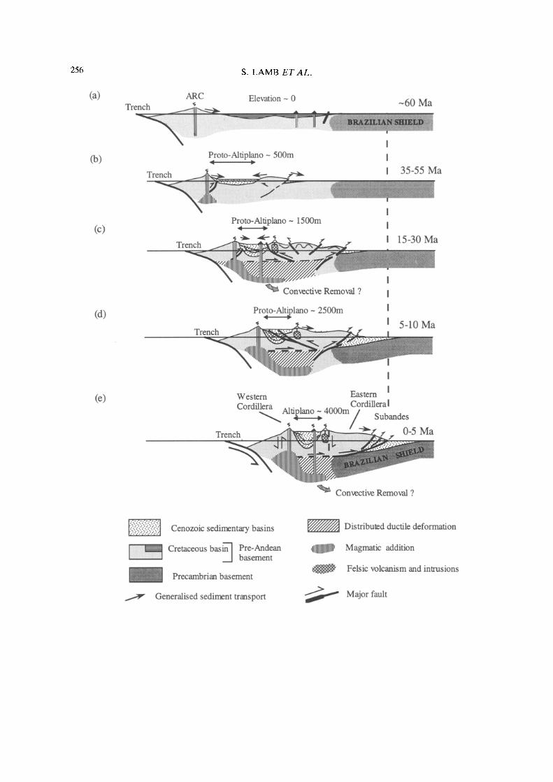
today (see Fig. 16). The approximate crustal cross-sectional area for an east-west section through the Central Andes at 20°S is shown in Fig. lc. If the crustal thickness throughout the Bolivian Andes at the end of the Cretaceous was similar to that in the Brazilian shield today (c. 34 km), then the area of the topography and crustal root is c. 1.7 x 10⁴km 2 (Fig. lc).
The existence of both the Altiplano basin and a substantial foreland basin shows that the shape of the crustal cross-section is partly a conse- quence of erosion and sedimentation within the Central Andes. The widespread preservation of Cretaceous sequences suggests that Cenozoic erosion has not stripped off more than a few kilometres thickness from the Eastern Cord- illera, though this may be greater north of the Arica bend. K/At cooling ages on micas and zircon fission track ages (McBride et aL 1987; Benjamin et al. 1987; Kennan et al. 1995; Lamb unpublished data) from Triassic granitoid intru- sives suggest that up to 10 km may have been locally stripped off from the western margin of the Eastern Cordillera. All this suggests that less than 0.1 × 10⁴ km 2 has been removed by erosion from the E - W crustal profile at 20°S (Fig. lc).
We consider two mechanisms of crustal thickening and their relative roles in contribut- ing to the Andean crustal cross-section: (1) crustal shortening; (2) magmatic addition.
Crustal shor ten ing
If the mass of the Andean crust is preserved, then crustal shortening will result in crustal thickening. If all the crustal root is a conse- quence of crustal shortening, then for an initial uniform crustal thickness of 34 kin, the crustal cross-section at 20°S (Fig. lc) suggests that c. 500 km of east-west Cenozoic crustal shorten-
ing are required. This calculation takes into account erosion but ignores the effects of density changes or crustal material transported into or out of the plane of the cross-section. Also, the crust beneath the Western Cordillera may have been much thicker at the beginning of the Cenozoic as a consequence of its Mesozoic evolution. If we just consider crustal thickening to the east of the Western Cordillera, then this part of the crustal root in Fig. lc could be generated by c. 375 km of shortening in this region.
Estimates of E - W Cenozoic shortening at c. 20°S, based on structural studies, are about 140 km in the Subandean Zone (Baby etal. 1993) and 140+20km in the Altiplano (this study; unpublished oil company data). Sheffels (1990) estimates a minimum shortening in the Bolivian Eastern Cordillera at roughly 18°S of about 140 km based on structural interpretations of the geology. However, Sheffels (1990) ignored the effects of a marked angular unconformity at the base of Cretaceous sequences in this region, so it is open to question whether this a minimum value. If we assume that Cenozoic tilting of Cretaceous strata throughout the Eastern Cord- illera is on average c. 35 °, then this tilting alone could accommodate a shortening of c. 30km. Also, the general spacing of major reverse faults with displacements of a few kilometres and truncating Cretaceous sequences, is c. 10km. Thus, reverse faulting would be expected to accommodate at the very least 20 km of shorten- ing across the Eastern Cordillera. In this case, Cenozoic shortening in the Eastern Cordillera is at least 50 km.
If we accept all the above shortening estimates at face value, this suggests a total shortening of about 320km across the Altiplano, Eastern Cordillera and Subandean Zone in the Cenozoic
Fig. 16. Cartoon cross-sections illustrating the generalised crustal evolution of the Central Andes in Bolivia and northern Chile in the last 60 Ma. Estimates of the average surface elevation for the proto-Altiplano region are also given. (a) In the latest Cretaceous, most of the Bolivian Andes formed a wide back-arc region of subsidence near sea level, associated with a minor amount of crustal thinning, bounded to the east by the rigid Brazilian Shield. (b) A narrow zone of uplift developed in the centre of the old Cretaceous basin, dividing the early Altiplano basin from an early foreland basin. (c) The zone of 'thick-skinned' deformation widened, resulting in thrusting of the Eastern Cordillera over the eastern margin of the Altiplano basin, and also towards the east in the foreland region. Numerous local fault-bounded compressional basins developed, and the foreland basin migrated further east. Widespread behind-arc basaltic volcanism in the Altiplano region may be associated with convective removal of part of the lithospheric mantle. (d) The Brazilian Shield began to impinge on the eastern margin of the Andes, with the initiation of a well-developed thin-skinned fold and thrust belt in the Subandean Zone. Shortening was also concentrated in the Altiplano, with a marked difference in vergence. (e) Subsequently, shortening has been concentrated in the thin-skinned Subandean Zone, accommodating underthrusting of the Brazilian Shield. Uplift of the Altiplano may be partly associated with crustal thickening in a ductile zone of deformation at depth. Widespread behind-arc Plio-Pleistocene volcanism may be associated with convective removal of the lower part of the lithosphere.

258 S. LAMB ET AL.
at c. 20°S, or about 85% of that deduced from simple crustal thickness calculations. Cenozoic shortening in the Western Cordillera and fore- arc has not been quantified, but is very small (<20 km) since the Early Miocene, and is likely to be much less than 100km since the early Cenozoic. Thus, the previous simple estimates suggest that E - W crustal shortening in the Andes at 20°S may not be sufficient to explain all the observed crustal thickness and additional significant mechanisms of crustal thickening cannot be ruled out by.
M a g m a t i s m
There has been widespread magmatic activity throughout much of the Central Andes during the Cenozoic. Extrapolating estimates of the volcanic arc production rate for the last 10 Ma in the Central Andes (Francis & Hawkesworth 1994), a possible volume of 80km 3 km -1 arc length of mantle melts may have been added to the surface in the volcanic arc during the Cenozoic. Mantle melt addition may be occur- ring in a wide region behind the arc (Hoke et al. 1993, 1994b). The model of convective removal of the basal part of the lithosphere, described previously (Hoke et al. 1993, 1994b; Hoke & Lamb 1994) suggests that basaltic addition to the crust is the result of melting of the lithospheric mantle. This may have happened twice in the Cenozoic, once during the widespread eruption of mafic volcanics in the central Altiplano at c. 24 Ma, and also during the Plio-Pleistocene.
The surface volcanism may only be a small fraction of the total melt addition to the crust. However, the small volume of surface volcanism in the region to the east of the volcanic arc, beneath the Altiplano and part of the Eastern Cordillera of Bolivia, suggests that any subsur- face melt additions to the crust here are likely to be less than that beneath the volcanic arc. If we assume that as little as 10% of the total melt addition reaches the surface (Aitcheson et al. 1993), then up to 800km 3 km -1 arc length of mantle melt may have been added to the crust beneath the arc during the Cenozoic, but less than this in the region further east. This would contribute a crustal root equivalent to a maxi- mum of 50 km of crustal shortening, for an initial crustal thickness of c. 34 km.
The above discussion suggests that mantle melt additions are not the most important mechanism of crustal thickening on a regional scale, probably contributing less than 15% to the total crustal thickening. However, locally be- neath the volcanic arc, this melt addition could be important, possibly accounting for as much as 40% of the crustal thickening here.
Summary of Cenozoic tectonic evolution
The Cenozoic tectonic development of the Central Andes in northern Chile and Bolivia is summarised here, based on the previous de- scriptions of the nature, timing and distribution of sedimentary basins, deformation and magma- tism. Five main stages are recognized in what is viewed overall as a continuous evolution of this part of the Andes. These are illustrated by the cartoon diagrams in Fig. 16.
(1) In the latest Cretaceous (Maastrichtian) and Palaeocene, the Central Andes at the latitudes of northern Chile and Bolivia formed a volcanic arc along what is today the Precord- illera in the forearc of northern Chile (Fig. 16a). Behind the arc, there was a zone of subsidence up to 400 km wide which was at or close to sea level. This formed a wide basin, receiving sediment both from the volcanic arc and also regions in the east. The general axis of this zone of subsidence more-or-less coincides with the region of greatest erosion prior to the Cre- taceous, where pre-Cretaceous deformation was most intense and Ordovician and Silurian flysch-type deposits are thickest. This suggests a complex history of alternating pre-Cenozoic basin formation and inversion.
(2) In the Eocene, the Cretaceous backarc basin was inverted and formed a narrow zone of uplift (<100km wide and referred to as the proto-cordillera), along what is today the west- ern margin of the Eastern Cordillera and several hundred kilometres east of the volcanic arc at that time (Fig. 16b). This-created a basin in what is today the Altiplano, which began to rapidly accummulate sediment derived partly from the uplifting proto-cordillera. Sediment was also shed to the east of the proto-cordiUera into a narrow foreland basin within what is today the Eastern Cordillera. It appears that strike-slip motion was accommodated in a laterally exten- sive fault system along the volcanic arc, though the sense of shear is uncertain.
Total crustal shortening in the Eocene is probably of the order of a few tens of kilometres, with average elevations in the proto-cordillera of c. 500 m (Fig. 16b).
(3) By the late Oligocene, the uplifting proto-cordillera had widened. Deformation spread westwards into the Altiplano basin as a west-verging fold and thrust belt, so that deposition was terminated in all but the centre of the Altiplano basin (Fig. 16c). Deformation also spread eastwards with the development of eastward verging structures (Fig. 16c). Defor- mation appears to be thick-skinned involving upright folding and relatively high angle reverse faults. Uplift and rapid unroofing of both the

CENOZOIC EVOLUTION OF CENTRAL ANDES 259
Western and Eastern Cordilleras caused a rejuvenation of the Altiplano basin, with the widespread development of conglomerates de- rived from both sides of the basin at c. 25 Ma. Deformation in the Eastern Cordillera also spread eastwards with widespread internal fold- ing and the development of a new foreland basin in what is today the Subandean Zone.
At c. 24Ma, there was widespread mantle melting beneath the Altiplano, possibly as a consequence of a phase of convective removal of the basal part of the lithosphere, which had been thickened to a critical point during earlier lithospheric shortening (Fig. 16c). Also, local intrusions and ignimbrites were emplaced on the western margin of the Eastern Cordillera. By 20 Ma, a number of local fault-bounded com- pressional basins existed throughout the Eastern Cordillera, accumulating sediments which rest with angular unconformity on older deformed Cretaceous and Palaeozoic sequences. How- ever, the main vergence of deformation appears to have been towards the west.
Total crustal shortening by the Middle Miocene was probably of the order of 200 km, with average surface elevations in the proto- Altiplano of c. 2000 to 2500 m (Fig. 16c).
(4) In the Late Miocene, the pattern of deformation in the Bolivian Andes changed markedly. Deformation essentially terminated in the Eastern Cordillera and was concentrated in the Altiplano region which started to shorten internally, probably around 9 Ma. The intense phase of shortening had ceased by 5Ma. Thermal re-equilibration after Oligo-Miocene crustal thickening on the western margin of the Eastern Cordillera may have triggered a major phase of ignimbritic activity at c. 7 Ma.
Total crustal shortening by the latest Miocene was probably of the order of 250 km (Fig. 16d).
(5) The cessation, between 9 and 5 Ma, of intense deformation in the Altiplano region may have coincided with the initiation of significant underthrusting of the Brazilian Shield and deformation in the Subandean Zone. Palaeo- magnetic data suggest that the main phase of regional rotation about a vertical axis in the Bolivian Andes is younger than c. 8 Ma. Thus, regional shortening gradients in the Subandean Zone since c. 8Ma accommodated a c. 10 ° clockwise rotation of the Eastern Cordillera and Altiplano south of the bend, and a c. 10 ° anticlockwise rotation north of the bend. A local increase in shortening gradients in the Suban- dean Zone in southern Bolivia seems to have accommodated an even larger clockwise ro- tation, up to 20 ° , in the same period.
The initiation of important shortening in the Subandean Zone may mark an important
change in vergence of deformation in the Bolivian Andes from a pronounced W-verging component prior to 5Ma to essentially E- verging subsequently. At this time, the second phase of mafic volcanism in the Altiplano commenced, possibly related to a second phase of convective removal of the basal part of the lithosphere as a consequence of Mid- to Late Miocene thickening. Shortening in the Suban- dean Zone during this period of c. 140 km brings the estimated total crustal shortening to around 400km, with average surface heights in the Altiplano of c. 4000 m (Fig. 16e).
Rates of deformation, sedimentation and erosion The previous description can be used to estimate rates of deformation in the Central Andes, though these estimates have large uncertainties which are difficult to quantify. The general picture is one of increasing rates of deformation towards the present, but on average only a small proportion (< 15 % ) of the relative plate conver- gence has been absorbed by shortening in the Andes. The bulk of the relative plate conver- gence has been accommodated by shear near the plate interface. Rates are comparable with those in other wide plate-boundary zones, such as the Central Asian collision zone (Lamb 1994).
The time-averaged rate of shortening over the entire Cenozoic history of Andean deformation is c. 10mma -1. Shortening strain rates were probably mainly low (c. 2 x 10 -8 a -1) for much of the early Andean deformation history, though increasing by an order of magnitude to c. 2 x 10-Ta -1 in the last 10Ma when defor- mation was concentrated in the Subandean Zone. Palaeomagnetic data suggests that the bulk of the bending about a vertical axis of the Bolivian Andes also occurred in the last 10 Ma, with rotation rates of 1-4 ° Ma -1.
Fission track age data suggests that average denudation rates have been locally as high as 0.2 mm a -1 on the western margin of the Eastern Cordillera. Likewise, average sedimentation rates in the Neogene range between 0.2 and 0.5 mma ~ in the Altiplano and foreland basins. Surface uplift rates in the Eastern Cordillera and Altiplano are difficult to estimate, but have probably been in the range 0.05-0.2mma -1 during the Cenozoic.
Discussion The overall picture of the Cenozoic tectonic evolution of the Andes in northern Chile and Bolivia is one of progressive shortening and crustal thickening on the western margin of the South American plate, above the subducting

260 S. LAMB E T A L .
(a)
15 ° S
20 ° S
\
NAZCA PLATE
70 ° W
fo)
25 ° S II
70 ° W
Central Andes west of Subandean Zone
Subandean Zone with well developed thin-skinned deformation
Brazilian Shield
Schematic contours of effective elastic thickness
25 kna (Te)
~10 °
Regional rotation about a vertical axis since the Middle-l_~e Miocene
Convergence (more, less)
Fig. 17. (a) Map of the Central Andes (after Watts et al. 1995) illustrating the possible relationship between bending, foreland shortening and lithospheric flexure. The impingement of the flexurally strong Brazilian Shield since the Late Miocene, illustrated by contours of effective elastic thickness, favoured the development of a thin-skinned fold and thrust belt in the bend region of the Bolivian Andes in the Subandean Zone, and the underthrusting of the Brazilian Shield. A larger proportion of the overall Andean shortening budget has been absorbed in this region, compared to the foreland regions further north and south, where deformation is more diffuse and involves basement. This has resulted in substantial bending of the whole Central Andes since the Late Miocene. (b) Schematic E-W cross-section through the Central Andes at ~ 18°S, showing the partitioning of Andean shortening since the Late Miocene into slip near the plate interface and underthrusting of the Brazilian Shield much further east.
Nazca plate. However, the causes of the way this has occurred are unclear, and any of the following may have played a role: the rate and direction of relative plate motion; nature of the subducted plate; mantle convection; strength inhomogeneities in the overlying South Ameri- can plate; body forces related to variations in crustal thickness; the distribution of pre-Andean sedimentary basins.
The apparent coincidence between the marked acceleration in relative plate conver- gence rate in the Eocene (Pardo-Casas & Molnar 1987) and the onset of deformation in the Bolivian Andes suggests a cause and effect relationship, especially if more rapid subduction results in an increase in average shear stresses on the plate interface. Likewise, another increase in relative plate convergence in the Late Oligo- cene may be related to the marked increase in tectonic activity in the Bolivian Andes at that time (Pardo-Casas & Molnar 1987; Sempere et al. 1990). The weak correlation between the long term position of features of the subducted
plate (aseismic ridges or age of oceanic crust) and Andean segmentation, suggests that these features do not play a major role in controlling Andean tectonics (Dewey & Lamb 1992).
We believe that strength inhomogeneties in the overlying plate, which are ultimately related to the thermal history of the South American lithosphere, have also played an important role in determining the tectonic evolution of this part of the Andes. For instance, the development of the proto-cordillera in the Eocene along the axis of the Cretaceous back-arc basin suggests that shortening was localised in a weak zone where the lithosphere was thinnest and possibly war- mest, as a consequence of the Cretaceous back-arc extension history. It is also interesting that the depocentre of the Cretaceous basin coincides with the region of most intense pre-Cretaceous folding and erosion.
Watts et al. (1995) have shown that there are marked spatial variations in the flexural strength of the lithosphere. They suggest that the most plausible distribution of flexural strength can be

CENOZOIC EVOLUTION OF CENTRAL ANDES 261
described by contours of effective elastic thickness that parallel and increase towards the region of outcrop of the Brazilian Shield and that this variation is a pre-Andean feature (Fig. 17). In this case, only part of the Bolivian Andes in the 'bend' region rests on flexurally strong lithosphere. The tectonic evolution of this part of the Andes, summar- ised in Figure 16, suggests that only in the last 10 Ma have the flexurally strongest parts of the South American lithosphere (elastic thick- ness >25km) been underthrust beneath the Central Andes, and it is in this period that the distinctive thin-skinned fold and thrust belt of the Subandean Zone developed (Fig. 17).
We suggest that the impingement of flexu- rally strong lithosphere in the Brazilian Shield on the eastern margin of the Bolivian Andes in the Late Miocene is causally related to the development of a thin-skinned zone of defor- mation, though the presence of thick Palaeo- zoic shale sequences in this region may also have helped to provide a weak drcollement. Prior to the Late Miocene, deformation in what is today the Eastern Cordillera may have been thick-skinned with concomitant defor- mation of the underlying lower parts of the lithosphere. The development of a major thin-skinned zone of deformation on the east- ern margin of the Bolivian Andes in the Subandean Zone also coincides with a marked increase in the rates of shortening in the Andes and also regional bending of the Cen- tral Andes about a vertical axis. Thus, it seems that once a thin-skinned fold and thrust belt developed, it absorbed more of the overall shortening budget in the plate- boundary zone, compared to the foreland regions further north and south where defor- mation is thick-skinned, involving basement (Fig. 17).
Finally, the mechanism of convective re- moval of the basal part of the lithosphere may have played a role in controlling the style of Andean deformation. Thus, the style of Plio- Pleistocene and acive kinematics proposed here for the Bolivian Andes (Fig. 14b), in which the Altiplano appears to have acted as a rigid 'lid' above a deforming lower lithosphere, may be a consequence of thermal weakening of the lower part of the lithosphere as it was replaced by 'hot ' asthenosphere during convec- tive removal. Also, surface uplift as a conse- quence of convective removal would tend to increase body forces on the eastern margin of the Andes, promoting deformation in the Subandean Zone (cf. Molnar et al. 1993). These effects have yet to be quantified.
R e f e r e n c e s
AITCHESON, S., FORREST, A. & ENTENMANN, J. 1993. Recharge -Assimilation -Fraction-Tapping ('RAFT') processes and magma enrichment in the Central Andes. In: Extended Abstracts: 2nd International Symposium, Oxford 1993, OR- STOM, 327-330.
BABY, P., SEMPERE, T., OLLER, J. & HERAIL, G. 1992a. Evidence for major shortening on the eastern edge of the Bolivian Altiplano: the Calasaya nappe. Tectonophysics, 205,155-169.
~ , HERAIL, G., SALINAS, R. & SEMPERE, T. 1992b. Geometry and kinematic evolution of passive roof duplexes deduced from cross-section balanc- ing: example from the foreland thrust system of the southern Bolivian Subandean Zone. Tec- tonics, 11,523-536.
- - , GUILLIER, B., OLLER, J., HERAIL, G., MONTE- MURRO, D. & SPECHT, M. 1993. Structural syn- thesis of the Bolivian Subandean Zone. In: Extended Abstracts: 2nd International Sym- posium, Oxford 1993, ORSTOM, 159-162.
BAKER, M. & FRANCIS, P. 1978. Upper Cenozoic volcanism in the Central Andes - ages and volumes. Earth and Planetary Science Letters, 41, 175-187.
BECK, S., ZANDT, G., MYERS, S., WALLACE, T., SILVER, P. & DRAKE, L. 1996. Crustal thickness variations in the Centra! Andes. Geology.
BENJAMIN, M., JOHNSON, N. & NAESER, C. 1987. Recent rapid uplift in the Bolivian Andes: Evidence from fission-track dating. Geology, 15, 680--683.
CAMPUSANO, Z. B. 1990. Kontinentale Sedimentation der Kreide und des Alttertiaers im Umfeld des subduktionsbedingten Magmatismus in der chilenischen Praekordillere (21°S-23°S). Berliner Geowissenschaftliche Abhandlungen, Reihe A, 123, Berlin.
COIRA, B., DAVIDSON, J., MPODOZIS, C. & RAMOS, V. 1982. Tectonic and magmatic evolution of the Andes of northern Argentina and Chile. Earth Science Reviews, 18,303-332.
DAVIDSON, J. P. & DE SILVA, S. L. 1992. Volcanic rocks from the Bolivian Altiplano: Insights into crustal structure, contamination, and magma genesis in the central Andes. Geology, 20, 1127-1130.
DAVIES, J. & BICKLE, M. 1991. A physical model for the volume and composition of melt produced by hydrous fluxing above subduction zones. Philo- sophical Transactions of the Royal Society of London, A335, 355-364.
DEMETS, C., GORDON, R. G., ARGUS, D. F. & STEIN, S. 1990. Current plate motions. Geophysical Journal International, 101,425-478.
DEWEY J. & BIRD, J. 1970. Mountain belts and the new global tectonics. Journal of Geophysical Re- search, 75, 2625-2647.
- - & LAMB, S. H. 1992. Active tectonics of the Andes. Tectonophysics, 205, 79-95.
DORBATH, C., GRANET, M., POUPINET, G. & MAR- TINEZ, C. 1993. A seismic study of the Altiplano and the Eastern Cordillera in Northern Bolivia:

262 S. LAMB ET AL.
new constraints on a lithospheric model. In: Extended Abstracts: 2nd International Sym- posium, Oxford 1993, ORSTOM, 7-10.
ENGLAND, P. & THOMPSON, A. 1984. Pressure- Temperature-Time Paths of Regional Metamor- phism I. Heat Transfer during the Evolution of Regions of Thickened Continental Crust. Journal of Petrology, 25,894-928.
EVERNDEN, J. F., KRIZ, S. J. & CHERRONI, C. 1977. Potassium-Argon ages of some Bolivian rocks. Economic Geology, 72, 1042-1061.
FARRAR, E., CLARK, A., KONTAK, D. & ARCHIBALD, D. 1988. Zongo-San Gaban Zone: Eocene foreland boundary of the Central Andean orogen, north- west Bolivia and southeast Peru, Geology, 16, 55-58.
~ , CLARK, m. & HEINRICH, S. 1990. The age of the Zongo pluton and the tectono-thermal evolution of the Zongo San-Gaban zone in the Cordillera Real, Bolivia. In: Abstracts, 1st International Symposium on Andean Geodynamics, Grenoble 1990, ORSTOM, 171-174.
FRANCIS, P. & HAWKESWORTH, C. 1994. Late Cenozoic rates of magmatic activity in the Central Andes and their relationships to continental crust for- mation and thickening. Journal of the Geological Society, London, 151,845-854.
FLINT, S., TURNER, P., JOLLEY, E. & HARTLEY, A. 1993. Extensional tectonics in convergent margin basins: An example from the Salar de Atacama, Chilean Andes. Geological Society of America Bulletin, 105,603-4517.
GAYET, M., MARSHALL, L. & SEMPERE, T. 1991. The Mesozoic and Palaeocene vertebrates of Bolivia and their stratigraphic context: a review. In: SUAREZ, R. (ed.) Fossiles y facies de Bolivia, 1. Revista Tecnica de Yacimientos Petroliferos Fiscales Bolivianos, 12,393-433.
GRANT, J. N., HALLS, C., AVILA SALINAS, W. & SNELLING, N.J. 1979. K-AT ages of igneous rocks and mineralisation in part of the Bolivian tin belt. Economic Geology, 74, 838-851.
GUBBELS, T. L., ISACKS, B. L. & FARRAR, E. 1993. High-level surfaces, plateau uplift, and foreland basin development, Bolivian central Andes. Ge- ology, 21,695-698.
HARTLEY, A., FLINT, S., TURNER, P. & JOLLY, E. 1992. Tectonic controls on the development of a semi-arid alluvial basin as reflected in the stra- tigraphy of the Purilactis Group (Upper Cre- taceous - Eocene) nor thern Chile. Journal of South American Earth Sciences, 5,275-296.
HERAIL, G., SOLER. P., BONHOMME, M. & LIZECA, J. 1993a. Evolution geodynamique de la transition entre l'Altiplano et la Cordillere Orientale au nord d'Oruro (Bolivie) - Implications sur le deroulement de l'orogenese andine. Comptes Rendus de l'Academie des Sciences de Paris, Serie II, 317,515-522. , OLLER, J., BABY, P., BLANCO, J., BONHOMME, M. G. & SOLER, P. 1993b. The Tupiza, Nazareno and Estarca basins (Bolivia): strike-slip faulting and thrusting during the Cenozoic evolution of the southern branch o f the Bolivian Orocline. In:
Extended Abstracts: 2nd International Sym- posium, Oxford 1993, ORSTOM, 191-194.
HOKE, L, HILTON, D., LAMB, S., HAMMERSCHMIDT, K. & FRIEDRICHSON H. 1993.3He evidence for a wide zone of active mantle melting beneath the Central Andes. In: Extended Abstracts: 2nd International Symposium, Oxford 1993, ORSTOM, 371-372. & LAMB, S. 1994. Lithospheric structure of the
Central Andes, constrained by 3He and geological data. In: Extended abstracts: Annual Conference of the Geological Society of Chile, Concepcion, Chile.
, LAMB, S. & ENTENMANN, J. 1994a. Comment on Davidson, J. & DE SILVA, S. In: Geology, 20, 1127-1130 (1993), Geology, 21, 1147-1149. , HILTON, D., LAMB, S., HAMMERSCHMIDT, K. & FRIEDRICHSON, H. 1994b. 3He evidence for a wide zone of active mantle melting beneath the Central Andes. Earth and Planetary Science Letters, 128, 341-355.
HOUSEMAN, G. A. , MCKENZIE, D. P. & MOLNER, P. 1981. Convective instability of a thickened boundary layer and its relevance for the thermal evolution of continental convergent belts. Journal of Geophysical Research, 86,6115-6132.
ISACKS, B. 1988. Uplift of the Central Andean Plateau and Bending of the Bolivian Orocline. Journal of Geophysical Research, 93,3211-3231.
JACKSON, J., HAINES, J. & HOLT, W. 1995. The accommodation of Arabia-Eurasia plate conver- gence in Iran. Journal of Geophysical Research, 100, 15,205-15,219.
JAMES, D. E. 1971. Andean crustal and upper mantle structure. Journal of Geophysical Research, 76, 3246--3271.
JOLLEY, E., TURNER, P., WILLIAMS, G., HARTLEY, A. & FLINT, S. 1990. Sedimentological responses of an alluvial system to Neogene thrust tectonics. Journal of the Geological Society, London, 147, 769-784.
KENNAN, L . 1994. Cenozoic tectonics of the Bolivian Andes. PhD thesis, University of Oxford.
~ , LAMB, S. & RUNDLE, C. 1995. K-AT dates from the Altiplano and Cordillera Oriental of Bolivia: stratigraphic and tectonic implications. Journal of South American Earth Sciences, 8,163-186. , - - & HOKE, L. 1997. High-altitude palaeosur- faces in the Bolivian Andes: evidence for late Cenozoic surface uplift. In: WIDDOWSON, M. (ed.) Palaeosurfaces: Recognition, Reconstruc- tion and Palaeoenvironmental Intepretation. Geo- logical Society, London, Special Publications, 120,307-324.
LAHSEN, A. 1982. Upper Cenozoic volcanism and tectonism in the Andes of northern Chile. Earth Science Reviews, 18,285-302.
LAMB, S. 1994. A simple method for estimating the horizontal velocity field in wide zones of active deformation - II. Examples from New Zealand, Central Asia and Chile. Geophysical Journal International, 119,313-337.
- - , HOKE., L. & KENNAN, L. 1993. Tectonic evolution of the Central Andes since the Cre- taceous. In: Extended Abstracts: 2nd Inter-

CENOZOIC EVOLUTION OF CENTRAL ANDES 263
national Symposium, Oxford 1993, ORSTOM, 207-210.
LAVENU, A., BONHOMME M. G., VATIN-PERIGNON N. & DE PACHTERE, P. 1989. Neogene magmatism in the Bolivian Andes between 16°S and 18°S: Stratigraphy and K/Ar geochronology. Journal of South American Earth Sciences, 2, 35--47.]
LITHERLAND, M., ANNELLS, R. N., APPLETON, J. D., BERRANGE, J. P., BLOOMFIELD, K., BURTON, C. C. J., DARBYSHIRE, D. P. F., FLETCHER, C. J. N., HAWKINS, M. P., KLINCK, B. A., LLANOS, A., MITCHELL, W. I., O'CONNOR, E. A., PITFIELD, P. E. J., POWER, G. & WEBB, B. C. 1986. The geology and mineral resources of the Bolivian Precambriam shield. British Geological Survey Overseas Memoir, 9.
LYON-CAEN, H., MOLNAR, P. & SUAREZ, G. 1985. Gravity anomalies and flexure of the Brazilian shield beneath the Bolivian Andes. Earth and Planetary Science Letters, 75, 81-92.
MCBRIDE, S., CLARK, A., FARRAR, E. & ARCHIBALD, D. 1987. Delimitation of a cryptic Eocene tectono-thermal domain in the Eastern Cordillera of the Bolivian Andes through K-At dating and 4°Ar-39Ar step-heating. Journal of the Geological Society, London, 144,243-255.
MCKENZIE, D. P. 1989. Some remarks on the movement of small melt fractions in the mantle. Earth and Planetary Science Letters, 95, 53-72.
MACEDO-SANCHEZ, O., SURMONT, J., KISSEL, C. & LAJ, C. 1992. New temporal constraints on the rotation of the Peruvian Central Andes obtained from palaeomagnetism. Geophysical Research Letters, 19, 1875-1878.
MACFADDEN, B. J., ANAYA, F., PEREZ, H., NAESER, C. W., ZEITLER, P. K. t~ CAMPBELL, K. E. 1990. Late Cenozoic paleomagnetism and chronology of Andean basins of Bolivia: evidence for possible oroclinal bending. Journal of Geology, 98, 541- 555. , ANAYA, F. & SWISHER III, C. 1995. Neogene paleomagnetism and oroclinal bending of the central Andes of Bolivia. Journal of Geophysical Research, 100, 8153-8167.
MAROCCO, R., SEMPERE, T., CIRBIAN, M. & OLLER, J. 1987. Mise en evidence d 'une deformation pale- ocene en Bolivie du Sud. Comptes Rendus de l'Academie des Sciences de Paris, 304, II, 18, 1139-1143.
MARSHALL, L. G. & SEMPERE, Z. 1991. The Eocene to Pleistocene vertebrates of Bolivia and their stratigraphic context: a review. In: SUAREZ, R. (ed.) Fossiles y facies de Bolivia, 1. Revista Tecnica de Yacimientos Petroliferos Fiscales Bolivianos, 12,631-652. , SWISHER III, C., LAVENU, A., HOFFSTETrER, R. & CURTIS, G. H. 1992. Geochronology of the mammal-bearing late Cenozoic on the northern Altiplano, Bolivia. Journal of South American Earth Sciences, 5, 1-19. , SEMPERE, T. & GAYET, M. 1993. The Petaca (Late Oligocene - Middle Miocene) and Yecua (Late Miocene) Formations of the Subandean - Chaco Basin, Bolivia, and their tectonic signifi-
cance. Documents du Laboratoire de Geologie de Lyon, France, 125,291-301.
MILLER, J. F. 1988. Granite Petrogenesis in the Cordillera Real, Bolivia and crustal evolution in the Central Andes. PhD thesis, Open University, Milton Keynes.
MOLNAR, P., ENGLAND, P. C. & MARTINOD, M. 1993. Mantle dynamics, the uplift of the Tibetan Plateau, and the Indian monsoon. Reviews in Geophysics, 31,357-396.
MPODOZIS, C., MARINOVIC, N. • SMOJE, I. 1993. Eocene left lateral strike-slip faulting and clock- wise block rotations in the Cordillera de Domeyko, west of Salar de Atacama, northern Chile. In: Extended Abstracts: 2nd International Symposium, Oxford 1993, ORSTOM, 225-228.
NARANJO, J. 1987. Interpretation de la actividad Cenozoica superior a lo largo de la zona de Falla Atacama, Norte de Chile. Revista Geologica de Chile, 31, 43-55.
PARDO=CASAS, F. & MOLNAR, P. 1987. Relative motion of the Nazca (Farallon) and South American plates since Late Cretaceous time. Tectonics, 6, 233-248.
PLATT, J. & ENGLAND, P. 1993. Convective removal of the lithosphere beneath mountain belts: thermal and mechanical consequences. American Journal of Science, 294,307-336.
REUTI'ER, K., CHONG, G. & SCHEUBER, E. 1993. The 'West Fissure' and the cordilleran fault system of northern Chile. In: Extended Abstracts: 2nd International Symposium, Oxford 1993, OR- STOM, 237-240.
RICCARDI, A. 1988. The Cretaceous System of Southern South America. Memoir of the Geological Society of America, 168.
ROEDER, T. 1988. Andean-age structure of Eastern Cordillera in the province of La Paz, Bolivia. Tectonics, 7, 23-39.
ROPERCH, P., FORNARI, M. & HERAIL, G. 1993. A paleomagnetic study of the Altiplano. In: Ex- tended Abstracts: 2nd International Symposium, Oxford 1993, ORSTOM, 241-244.
ROUCHY, J. M., CAMOIN, G., CASANOVA, J. & DECONINCK, J. F. 1993. The central palaeo- Andean basin of Bolivia (Potosi area) during the late Cretaceous and early Tertiary: reconstruc- tion of ancient saline lakes using sedimento- logical, paleoecological and stable isotope records. Palaeogeography, Palaeoclimatology, Palaeoecology, 105,179-198.
SANJINES, G. ,~ JIMENEZ, F. 1976. Communicacion preliminar acerca de la presencia de fossiles vertebrados en la formacion Petaca del area de Santa Cruz. Revista Tecnica de Yacimientos Petroliferos Fiscales Bolivianos, 4, 147-156.
SCANLON, P. ~ TURNER, P. 1992. Structural constraints on palaeomagnetic rotations south of the Arica bend, northern Chile: Implications for the Bo- livian Orocline. Tectonophysics, 205, 141-154.
SCHNEIDER, A. 1985. Eruptive processes, mineral# sation and isotopic evolution of the Los Frailes- KariKari region, Bolivia. DIC thesis. Imperial College, London.

264 S. LAMB ET AL.
SEMPERE, T., CHAVEZ, H. & PEREZ, M. 1989. Estudio sedimentologico preliminar de la parte superior de la formacion Mondragon en las cercanias de Lenas (Departamento de Potosi)" consecuencias geodinamicas. Actas del VIII Con- greso Geologico de Bolivia, La Paz, 273-278.
- - , HERAIL, G., OLLER, J. & BONHOMME, M. 1990. Late Oligocene - Early Miocene major tectonic crisis and related basins in Bolivia. Geology, 18, 496-949.
- - , BABY, P., OLLER, J. & HERAIL, G. 1991. La nappe de Calazaya: une preuve de raccour- cissements majeur gouvernes par des elements paleostructuraux dans les Andes boliviennes. Comptes Rendus de l'Academie des Sciences de Paris, Serie H, 312, 77-83.
SERVANT, M. & FONTES, J. C. 1978. Les lacs quater- naires des hautes plateaux des Andes Bolivien- nes. Premieres interpr6tations pal6oclimatiques. Cahiers ORSTOM. S~rie Geologie, 10, 9-23.
~ , SEMPERE, T., ARGOLLO, J., BERNAT, M., FER- AUD, G. & Lo BELLO, P. 1989. Morphogenese et soulevement de la Cordillere Orientale des Andes de Bolivie au Cenozoique. Comptes Rendus de l'Academie des Sciences, Paris, 309,417-22.
SHEFFELS, B. 1990. Lower bound on the amount of crustal shortening in the central Bolivian Andes. Geology, 18,812-815.
SOLER, P. 8£ SEMPERE, T. 1993. Stratigraphie, geoche- mie et signification paleotectonique des roches volcaniques basiques mesozoiques des Andes boliviennes. Comptes Rendus de l'Academie des Sciences de Paris, Serie H, 316,777-784.
TROENG, B., SORIA-ESCALANTE, E., CLAURE, H.,
MOBAREC, R. & MURILLO, F. 1994. Descubri- miento de basamento precambrico en la Cord- illera Occidental Altiplano de los Andes Bolivianos. Memorias del XI congreso geologico de Bolivia, 231-237.
VEGA, A. & BUEORN, E. 1991. Focal mechanisms of intraplate earthquakes in Bolivia, South America. PAGEOPH, 136,449-458.
WATTS, A., LAMB, S., FAIRHEAD, J. • DEWEY, J. F. 1995. Lithospheric flexure and bending of the Central Andes. Earth and Planetary Science Letters, 134, 9-21.
WHITMAN, D. 1995. Moho geometry beneath the eastern margin of the Andes, northwest Ar- gentina: constraints on the elastic thickness of the Andean foreland. Journal of Geophysical Re- search, 99, 15 277-15 289.
- - , ISACKS, B., CHATELAIN, J-L., CHIU, J-M. & PEREZ, A. 1992. Attenuation of high frequency seismic waves beneath the Central Andean plateau. Journal of Geophysical Research, 97, 19 929-19 947.
WIGGER, P., SCHMITZ, M., ARANEDA, M., Ascn, G., BALDZUHN, S., GIESE, P., HEINSOHN, W-D, MARTINEZ, E., RICALDI, E., ROWER, P. & VI- RAMONTE, J. 1993. Variation in the crustal struc- ture of the southern Central Andes deduced from seismic refraction investigations. In: REUTrER K-J., SCHEUBER, E. & WIGGER, P. (eds) Tectonics of the Southern Central Andes. Springer, Berlin, 23-48.
ZANDT, G., VELASCO A. t~ BECK S., 1994. Com- position and thickness of the southern Altiplano crust, Bolivia. Geology, 22, 1003-1006.