Embed Size (px)
Citation preview
The development of Oakland County’s trail system continues to expand our citizens’ access to the abundant natural and man-made features that make Oakland County a premier place to live, work, and play. The county has been blessed with over 1,400 lakes, more than any other county in the state, is home to the
headwaters of five major river systems and has over 89,000 acres of park and recreation lands. From our cosmopolitan cities and historic town centers to our rural and natural countryside, we have it all. This diversity has offered us many choices and the freedom to live in a setting which matches our desired lifestyle.
The trail network also promotes physical fitness by providing close-to-home opportunities for exercise plus an alternative means of transportation. Transportation and obesity related health care costs are critical issues facing our society.
I look forward to continuing to work with the Oakland County Parks Commission and members of the Oakland Trail Advisory Council to implement the vision of an Oakland County Trail Network.
L. Brooks Patterson,
Oakland County Executive
Paint CreekTrail
Clinton RiverTrail
HeadwatersTrails
Huron ValleyTrail
Oakland CountySheriff’s Office
Michigan Departmentof Transportation
Michigan Trails & Greenways Alliance
WaterTrails
Southeastern Michigan’s Hiking Michigan
Oakland County Business Round Table
MapSponsors
Road Commission forOakland County
Oakland CountyParks & Recreation
Polly AnnTrail
Lakes Community Trail
West BloomfieldTrail
Michigan Mountain Biking Association
Huron-Clinton Metroparks
Oakland Equestrian Coalition
WoodwardCorridor
League of Michigan Bicyclists
For Free Distribution Only
2008-2009E D I T I O N
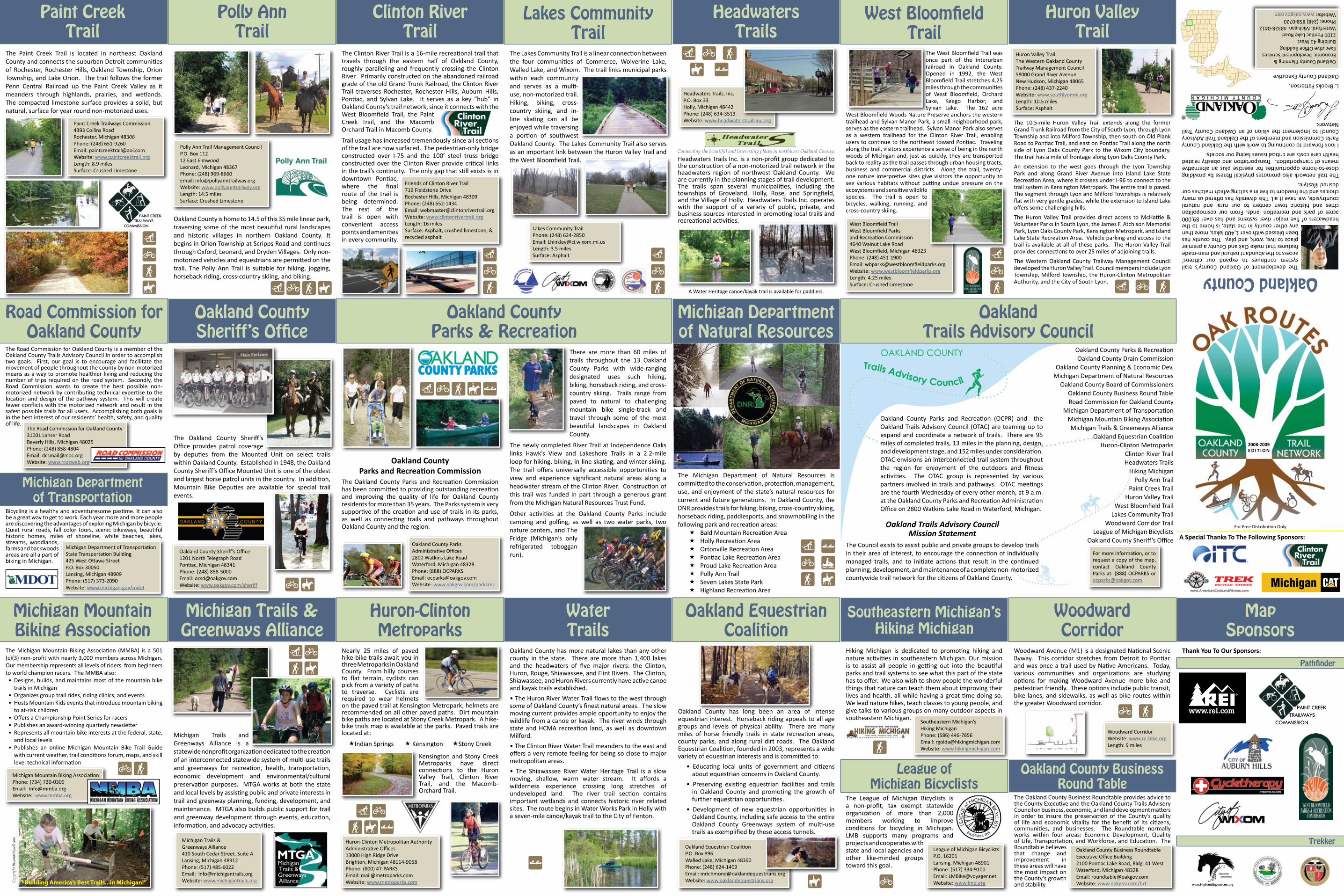
The Paint Creek Trail is located in northeast Oakland County and connects the suburban Detroit communities of Rochester, Rochester Hills, Oakland Township, Orion Township, and Lake Orion. The trail follows the former Penn Central Railroad up the Paint Creek Valley as it meanders through highlands, prairies, and wetlands. The compacted limestone surface provides a solid, but natural, surface for year round non-motorized uses.
Paint Creek Trailways Commission4393 Collins RoadRochester, Michigan 48306Phone: (248) 651-9260Email: [email protected]: www.paintcreektrail.orgLength: 8.9 milesSurface: Crushed Limestone
(GFÈ
Oakland County is home to 14.5 of this 35 mile linear park, traversing some of the most beautiful rural landscapes and historic villages in northern Oakland County. It begins in Orion Township at Scripps Road and continues through Oxford, Leonard, and Dryden Villages. Only non-motorized vehicles and equestrians are permitted on the trail. The Polly Ann Trail is suitable for hiking, jogging, horseback riding, cross-country skiing, and biking.
Polly Ann Trail Management Council P.O. Box 112 12 East ElmwoodLeonard, Michigan 48367 Phone: (248) 969-8660Email: [email protected]: www.pollyanntrailway.orgLength: 14.5 milesSurface: Crushed Limestone
(GFÈ
The Clinton River Trail is a 16-mile recreational trail that travels through the eastern half of Oakland County, roughly paralleling and frequently crossing the Clinton River. Primarily constructed on the abandoned railroad grade of the old Grand Trunk Railroad, the Clinton River Trail traverses Rochester, Rochester Hills, Auburn Hills, Pontiac, and Sylvan Lake. It serves as a key “hub” in Oakland County’s trail network, since it connects with the West Bloomfield Trail, the Paint Creek Trail, and the Macomb Orchard Trail in Macomb County.
Trail usage has increased tremendously since all sections of the trail are now surfaced. The pedestrian-only bridge constructed over I-75 and the 100’ steel truss bridge constructed over the Clinton River provide critical links in the trail’s continuity. The only gap that still exists is in downtown Pontiac, where the final route of the trail is being determined. The rest of the trail is open with convenient access points and amenities in every community.
Friends of Clinton River Trail719 Fieldstone DriveRochester Hills, Michigan 48309Phone: (248) 652-1434Email: [email protected]: www.clintonrivertrail.orgLength: 16 milesSurface: Asphalt, crushed limestone, & recycled asphalt
(GF
The Lakes Community Trail is a linear connection between the four communities of Commerce, Wolverine Lake, Walled Lake, and Wixom. The trail links municipal parks within each community and serves as a multi-use, non-motorized trail. Hiking, biking, cross-country skiing, and in-line skating can all be enjoyed while traversing a portion of southwest Oakland County. The Lakes Community Trail also serves as an important link between the Huron Valley Trail and the West Bloomfield Trail.
Lakes Community TrailPhone: (248) 624-2850Email: [email protected] Length: 3.5 miles Surface: Asphalt (
GF
Headwaters Trails Inc. is a non-profit group dedicated to the construction of a non-motorized trail network in the headwaters region of northwest Oakland County. We are currently in the planning stages of trail development. The trails span several municipalities, including the townships of Groveland, Holly, Rose, and Springfield, and the Village of Holly. Headwaters Trails Inc. operates with the support of a variety of public, private, and business sources interested in promoting local trails and recreational activities.
Headwaters Trails, Inc.P.O. Box 33Holly, Michigan 48442Phone: (248) 634-3513Website: www.headwaterstrailsinc.org
( G FÈ |
Connecting the beautiful and interesting places in northwest Oakland County.
The West Bloomfield Trail was once part of the interurban railroad in Oakland County. Opened in 1992, the West Bloomfield Trail stretches 4.25 miles through the communities of West Bloomfield, Orchard Lake, Keego Harbor, and Sylvan Lake. The 162 acre
West Bloomfield Woods Nature Preserve anchors the western trailhead and Sylvan Manor Park, a small neighborhood park, serves as the eastern trailhead. Sylvan Manor Park also serves as a western trailhead for the Clinton River Trail, enabling users to continue to the northeast toward Pontiac. Traveling along the trail, visitors experience a sense of being in the north woods of Michigan and, just as quickly, they are transported back to reality as the trail passes through urban housing tracts, business and commercial districts. Along the trail, twenty-one nature interpretive sites give visitors the opportunity to see various habitats without putting undue pressure on the ecosystems and sensitive wildlife species. The trail is open to bicycles, walking, running, and cross-country skiing.
West Bloomfield TrailWest Bloomfield Parksand Recreation Commission4640 Walnut Lake RoadWest Bloomfield, Michigan 48323Phone: (248) 451-1900 Email: [email protected]: www.westbloomfieldparks.orgLength: 4.25 milesSurface: Crushed Limestone
( G F
The 10.5-mile Huron Valley Trail extends along the former Grand Trunk Railroad from the City of South Lyon, through Lyon Township and into Milford Township, then south on Old Plank Road to Pontiac Trail, and east on Pontiac Trail along the north side of Lyon Oaks County Park to the Wixom City boundary. The trail has a mile of frontage along Lyon Oaks County Park.
An extension to the west goes through the Lyon Township Park and along Grand River Avenue into Island Lake State Recreation Area, where it crosses under I-96 to connect to the trail system in Kensington Metropark. The entire trail is paved. The segment through Lyon and Milford Townships is relatively flat with very gentle grades, while the extension to Island Lake offers some challenging hills.
The Huron Valley Trail provides direct access to McHattie & Volunteer Parks in South Lyon, the James F. Atchison Memorial Park, Lyon Oaks County Park, Kensington Metropark, and Island Lake State Recreation Area. Vehicle parking and access to the trail is available at all of these parks. The Huron Valley Trail provides connections to over 25 miles of adjoining trails.
The Western Oakland County Trailway Management Council developed the Huron Valley Trail. Council members include Lyon Township, Milford Township, the Huron-Clinton Metropolitan Authority, and the City of South Lyon.
Huron Valley TrailThe Western Oakland CountyTrailway Management Council58000 Grand River AvenueNew Hudson, Michigan 48065Phone: (248) 437-2240Website: www.southlyonmi.orgLength: 10.5 milesSurface: Asphalt
( G F
Oakland County
Oakland County Planning & Economic Development ServicesExecutive Office BuildingBuilding 41 West2100 Pontiac Lake RoadWaterford, Michigan 48328-0412Phone: (248) 858-0720Website: www.oakgov.com
OaklandTrails Advisory Council
Oakland County Parks and Recreation (OCPR) and the Oakland Trails Advisory Council (OTAC) are teaming up to expand and coordinate a network of trails. There are 95 miles of completed trails, 13 miles in the planning, design, and development stage, and 152 miles under consideration. OTAC envisions an interconnected trail system throughout the region for enjoyment of the outdoors and fitness activities. The OTAC group is represented by various partners involved in trails and pathways. OTAC meetings are the fourth Wednesday of every other month, at 9 a.m. at the Oakland County Parks and Recreation Administration Office on 2800 Watkins Lake Road in Waterford, Michigan.
Oakland Trails Advisory CouncilMission Statement
The Council exists to assist public and private groups to develop trails in their area of interest, to encourage the connection of individually managed trails, and to initiate actions that result in the continued planning, development, and maintenance of a complete non-motorized countywide trail network for the citizens of Oakland County.
Oakland County Parks & RecreationOakland County Drain Commission
Oakland County Planning & Economic Dev.Michigan Department of Natural Resources
Oakland County Board of CommissionersOakland County Business Round TableRoad Commission for Oakland County
Michigan Department of TransportationMichigan Mountain Biking AssociationMichigan Trails & Greenways Alliance
Oakland Equestrian CoalitionHuron-Clinton Metroparks
Clinton River TrailHeadwaters Trails
Hiking MichiganPolly Ann Trail
Paint Creek TrailHuron Valley Trail
West Bloomfield TrailLakes Community Trail
Woodward Corridor TrailLeague of Michigan Bicyclists
Oakland County Sheriff’s Office
For more information, or to request a copy of the map, contact Oakland County Parks at: (888) OCPARKS or [email protected]
Michigan Department of Natural Resources
The Michigan Department of Natural Resources is committed to the conservation, protection, management, use, and enjoyment of the state’s natural resources for current and future generations. In Oakland County, the DNR provides trails for hiking, biking, cross-country skiing, horseback riding, paddlesports, and snowmobiling in the following park and recreation areas: Bald Mountain Recreation Area Holly Recreation Area Ortonville Recreation Area Pontiac Lake Recreation Area Proud Lake Recreation Area Polly Ann Trail Seven Lakes State Park Highland Recreation Area
( |G .F È
Oakland CountyParks and Recreation Commission
The Oakland County Parks and Recreation Commission has been committed to providing outstanding recreation and improving the quality of life for Oakland County residents for more than 35 years. The Parks system is very supportive of the creation and use of trails in its parks, as well as connecting trails and pathways throughout Oakland County and the region.
Oakland County ParksAdministrative Offices2800 Watkins Lake RoadWaterford, Michigan 48328Phone: (888) OCPARKSEmail: [email protected]: www.oakgov.com/parksrec
(GFÈ|
There are more than 60 miles of trails throughout the 13 Oakland County Parks with wide-ranging designated uses such hiking, biking, horseback riding, and cross-country skiing. Trails range from paved to natural to challenging mountain bike single-track and travel through some of the most beautiful landscapes in Oakland County.
The newly completed River Trail at Independence Oaks links Hawk’s View and Lakeshore Trails in a 2.2-mile loop for hiking, biking, in-line skating, and winter skiing. The trail offers universally accessible opportunities to view and experience significant natural areas along a headwater stream of the Clinton River. Construction of this trail was funded in part through a generous grant from the Michigan Natural Resources Trust Fund.
Other activities at the Oakland County Parks include camping and golfing, as well as two water parks, two nature centers, and The Fridge (Michigan’s only refrigerated toboggan run).
The Oakland County Sheriff’s Office provides patrol coverage by deputies from the Mounted Unit on select trails within Oakland County. Established in 1948, the Oakland County Sheriff’s Office Mounted Unit is one of the oldest and largest horse patrol units in the country. In addition, Mountain Bike Deputies are available for special trail events.
Oakland County Sheriff’s Office1201 North Telegraph RoadPontiac, Michigan 48341Phone: (248) 858-5000Email: [email protected]: www.oakgov.com/sheriff GÈ
The Road Commission for Oakland County is a member of the Oakland County Trails Advisory Council in order to accomplish two goals. First, our goal is to encourage and facilitate the movement of people throughout the county by non-motorized means as a way to promote healthier living and reducing the number of trips required on the road system. Secondly, the Road Commission wants to create the best possible non-motorized network by contributing technical expertise to the location and design of the pathway system. This will create fewer conflicts with the motorized network and result in the safest possible trails for all users. Accomplishing both goals is in the best interest of our residents’ health, safety, and quality of life.
The Road Commission for Oakland County31001 Lahser Road Beverly Hills, Michigan 48025 Phone: (248) 858-4804 Email: [email protected]: www.rcocweb.org
Bicycling is a healthy and adventuresome pastime. It can also be a great way to get to work. Each year more and more people are discovering the advantages of exploring Michigan by bicycle. Quiet rural roads, fall color tours, scenic bikeways, beautiful historic homes, miles of shoreline, white beaches, lakes, streams, woodlands, farms and backwoods areas are all a part of biking in Michigan.
Michigan Department of TransportationState Transportation Building 425 West Ottawa StreetP.O. Box 30050 Lansing, Michigan 48909Phone: (517) 373-2090Website: www.michigan.gov/mdot
The Michigan Mountain Biking Association (MMBA) is a 501 (c)(3) non-profit with nearly 3,000 members across Michigan. Our membership represents all levels of riders, from beginners to world champion racers. The MMBA also:• Designs, builds, and maintains most of the mountain bike
trails in Michigan• Organizes group trail rides, riding clinics, and events• Hosts Mountain Kids events that introduce mountain biking
to at-risk children• Offers a Championship Point Series for racers• Publishes an award-winning quarterly newsletter• Represents all mountain bike interests at the federal, state,
and local levels Publishes an online Michigan Mountain Bike Trail Guide • with current weather, trail conditions forum, maps, and skill level technical information
Michigan Mountain Biking AssociationPhone: (734) 730-0309Email: [email protected]: www.mmba.org
GF
“Building America’s Best Trails...in Michigan!”Copy
right
Bry
anM
itche
ll.co
m
Michigan Trails and Greenways Alliance is a statewide nonprofit organization dedicated to the creation of an interconnected statewide system of multi-use trails and greenways for recreation, health, transportation, economic development and environmental/cultural preservation purposes. MTGA works at both the state and local levels by assisting public and private interests in trail and greenway planning, funding, development, and maintenance. MTGA also builds public support for trail and greenway development through events, education, information, and advocacy activities.
Michigan Trails &Greenways Alliance410 South Cedar Street, Suite A Lansing, Michigan 48912Phone: (517) 485-6022Email: [email protected]: www.michigantrails.org
(GFÈ
Nearly 25 miles of paved hike-bike trails await you in three Metroparks in Oakland County. From hilly courses to flat terrain, cyclists can pick from a variety of paths to traverse. Cyclists are required to wear helmets on the paved trail at Kensington Metropark; helmets are recommended on all other paved paths. Dirt mountain bike paths are located at Stony Creek Metropark. A hike-bike trails map is available at the parks. Paved trails are located at:
Indian Springs Kensington Stony Creek
Kensington and Stony Creek Metroparks have direct connections to the Huron Valley Trail, Clinton River Trail, and the Macomb-Orchard Trail.
Oakland County has more natural lakes than any other county in the state. There are more than 1,400 lakes and the headwaters of five major rivers: the Clinton, Huron, Rouge, Shiawassee, and Flint Rivers. The Clinton, Shiawassee, and Huron Rivers currently have active canoe and kayak trails established.
• The Huron River Water Trail flows to the west through some of Oakland County’s finest natural areas. The slow moving current provides ample opportunity to enjoy the wildlife from a canoe or kayak. The river winds through state and HCMA recreation land, as well as downtown Milford.
• The Clinton River Water Trail meanders to the east and offers a very remote feeling for being so close to major metropolitan areas.
• The Shiawassee River Water Heritage Trail is a slow moving, shallow, warm water stream. It affords a wilderness experience crossing long stretches of undeveloped land. The river trail section contains important wetlands and connects historic river related sites. The route begins in Water Works Park in Holly with a seven-mile canoe/kayak trail to the City of Fenton.
|
Oakland County has long been an area of intense equestrian interest. Horseback riding appeals to all age groups and levels of physical ability. There are many miles of horse friendly trails in state recreation areas, county parks, and along rural dirt roads. The Oakland Equestrian Coalition, founded in 2003, represents a wide variety of equestrian interests and is committed to:
• Educating local units of government and citizens about equestrian concerns in Oakland County.
• Preserving existing equestrian facilities and trails in Oakland County and promoting the growth of further equestrian opportunities.
• Development of new equestrian opportunities in Oakland County, including safe access to the entire Oakland County Greenways system of multi-use trails as exemplified by these access tunnels.
Oakland Equestrian CoalitionP.O. Box 996Walled Lake, Michigan 48390Phone: (248) 624-1409Email: [email protected]: www.oaklandequestrians.org È
Hiking Michigan is dedicated to promoting hiking and nature activities in southeastern Michigan. Our mission is to assist all people in getting out into the beautiful parks and trail systems to see what this part of the state has to offer. We also wish to show people the wonderful things that nature can teach them about improving their lives and health, all while having a great time doing so. We lead nature hikes, teach classes to young people, and give talks to various groups on many outdoor aspects in southeastern Michigan.
Southeastern Michigan’sHiking MichiganPhone: (586) 446-7656Email: [email protected]: www.hikingmichigan.com
The League of Michigan Bicyclists is a non-profit, tax exempt statewide organization of more than 2,000 members working to improve conditions for bicycling in Michigan. LMB supports many programs and projects and cooperates with state and local agencies and other like-minded groups toward this goal.
League of Michigan BicyclistsP.O. 16201Lansing, Michigan 48901Phone: (517) 334-9100Email: [email protected]: www.lmb.org
F
G
Woodward Avenue (M1) is a designated National Scenic Byway. This corridor stretches from Detroit to Pontiac and was once a trail used by Native Americans. Today, various communities and organizations are studying options for making Woodward Avenue more bike and pedestrian friendly. These options include public transit, bike lanes, and sidewalks, as well as bike routes within the greater Woodward corridor.
Woodward CorridorWebsite: www.m-bike.orgLength: 9 miles
G F
The Oakland County Business Roundtable provides advice to the County Executive and the Oakland County Trails Advisory Council on business, economic, and land development matters in order to insure the preservation of the County’s quality of life and economic vitality for the benefit of its citizens, communities, and businesses. The Roundtable normally works within four areas: Economic Development, Quality of Life, Transportation, and Workforce, and Education. The Roundtable believes that change and improvement in these areas will have the most impact on the County’s growth and stability.
Oakland County Business RoundtableExecutive Office Building2100 Pontiac Lake Road, Bldg. 41 WestWaterford, Michigan 48328Email: [email protected]: www.oakgov.com/brt
Thank You To Our Sponsors:
A Special Thanks To The Following Sponsors:
Huron-Clinton Metropolitan AuthorityAdministrative Offices13000 High Ridge DriveBrighton, Michigan 48114-9058Phone: (800) 47-PARKSEmail: [email protected]: www.metroparks.com
(GFÈ|
A Water Heritage canoe/kayak trail is available for paddlers.
Pathfinder
Trekker
www.HighlandEquestrians.org
PAINT CREEK
TRAILWAYS
COMMISSION
PAINT CREEK TRAILWAYSCOMMISSION
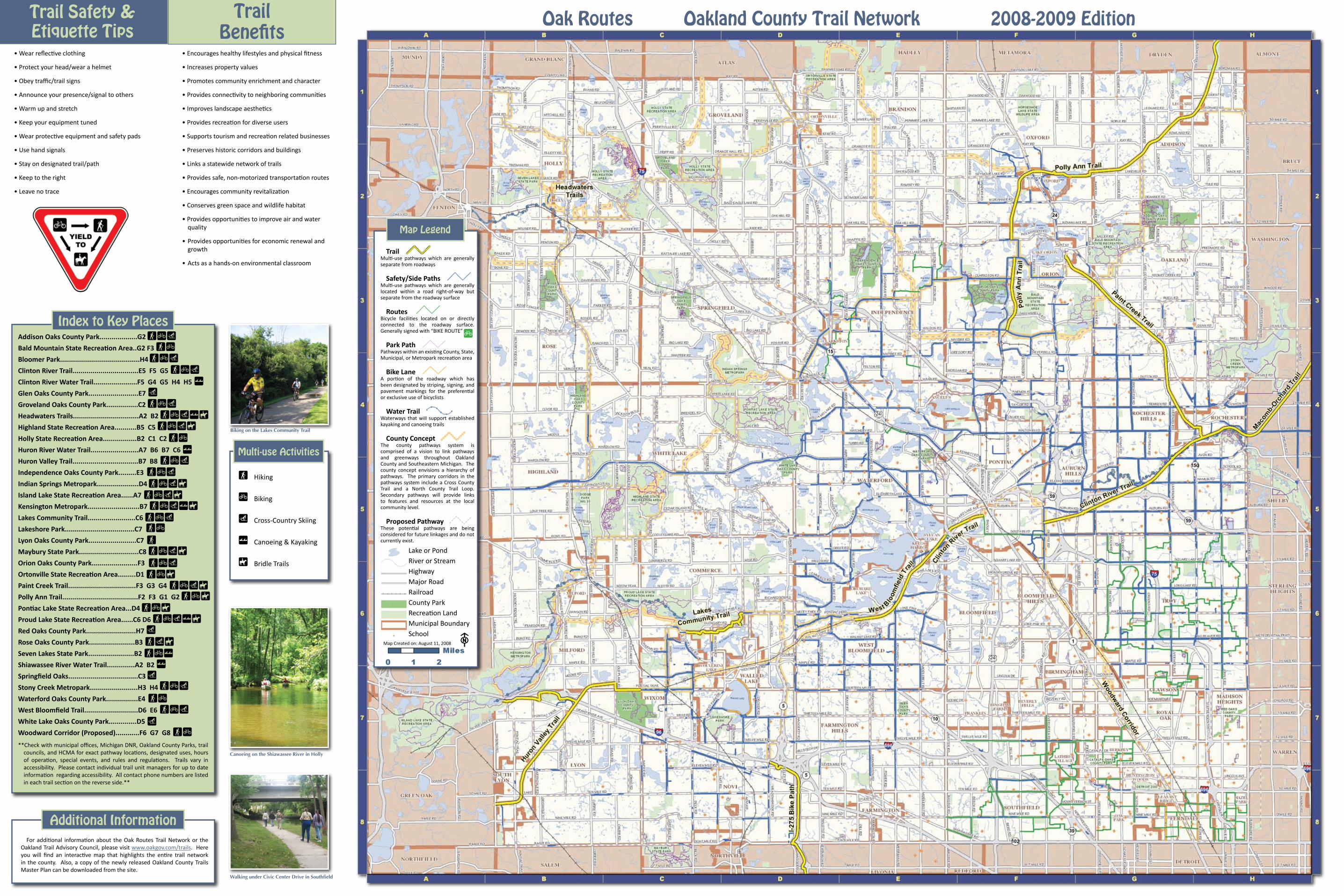
Trail Safety & Etiquette Tips
TrailBenefits
• Wear reflective clothing
• Protect your head/wear a helmet
• Obey traffic/trail signs
• Announce your presence/signal to others
• Warm up and stretch
• Keep your equipment tuned
• Wear protective equipment and safety pads
• Use hand signals
• Stay on designated trail/path
• Keep to the right
• Leave no trace
• Encourages healthy lifestyles and physical fitness
• Increases property values
• Promotes community enrichment and character
• Provides connectivity to neighboring communities
• Improves landscape aesthetics
• Provides recreation for diverse users
• Supports tourism and recreation related businesses
• Preserves historic corridors and buildings
• Links a statewide network of trails
• Provides safe, non-motorized transportation routes
• Encourages community revitalization
• Conserves green space and wildlife habitat
• Provides opportunities to improve air and water quality
Provides opportunities for economic renewal and • growth
Acts as a hands-on environmental classroom•
Addison Oaks County Park...................G2
Bald Mountain State Recreation Area..G2 F3
Bloomer Park........................................H4
Clinton River Trail.................................E5 F5 G5
Clinton River Water Trail......................F5 G4 G5 H4 H5
Glen Oaks County Park.........................E7
Groveland Oaks County Park................C2
Headwaters Trails.................................A2 B2
Highland State Recreation Area...........B5 C5
Holly State Recreation Area.................B2 C1 C2
Huron River Water Trail........................A7 B6 B7 C6
Huron Valley Trail.................................B7 B8
Independence Oaks County Park.........E3
Indian Springs Metropark.....................D4
Island Lake State Recreation Area......A7
Kensington Metropark..........................B7
Lakes Community Trail........................C6
Lakeshore Park...................................C7
Lyon Oaks County Park........................C7
Maybury State Park..............................C8
Orion Oaks County Park.......................F3
Ortonville State Recreation Area.........D1
Paint Creek Trail..................................F3 G3 G4
Polly Ann Trail......................................F2 F3 G1 G2
Pontiac Lake State Recreation Area...D4
Proud Lake State Recreation Area......C6 D6
Red Oaks County Park.........................H7
Rose Oaks County Park.......................B3
Seven Lakes State Park.......................B2
Shiawassee River Water Trail..............A2 B2
Springfield Oaks...................................C3
Stony Creek Metropark........................H3 H4
Waterford Oaks County Park................E4
West Bloomfield Trail...........................D6 E6
White Lake Oaks County Park..............D5
Woodward Corridor (Proposed)............F6 G7 G8
**Check with municipal offices, Michigan DNR, Oakland County Parks, trail councils, and HCMA for exact pathway locations, designated uses, hours of operation, special events, and rules and regulations. Trails vary in accessibility. Please contact individual trail unit managers for up to date information regarding accessibility. All contact phone numbers are listed in each trail section on the reverse side.**
Index to Key Places
F Hiking
G Biking
( Cross-Country Skiing
| Canoeing & Kayaking
È Bridle Trails
Multi-use Activities
FG(FG
FG(|
(FG(
FG(|ÈFG(È
FG|
FG(FG(FG(È
FG(ÈFG(|È
FG(
FFG(È
FG(FGÈ
FG(ÈFGÈ
FGÈFG(|È
(F(ÈFG|
|(
FG(
FG
FG
FG(
(
Oak Routes Oakland County Trail Network 2008-2009 Edition
TrailMulti-use pathways which are generally separate from roadways
Safety/Side PathsMulti-use pathways which are generally located within a road right-of-way but separate from the roadway surface
RoutesBicycle facilities located on or directly connected to the roadway surface. Generally signed with “BIKE ROUTE”
Park PathPathways within an existing County, State, Municipal, or Metropark recreation area
Bike LaneA portion of the roadway which has been designated by striping, signing, and pavement markings for the preferential or exclusive use of bicyclists
Water TrailWaterways that will support established kayaking and canoeing trails
County ConceptThe county pathways system is comprised of a vision to link pathways and greenways throughout Oakland County and Southeastern Michigan. The county concept envisions a hierarchy of pathways. The primary corridors in the pathways system include a Cross County Trail and a North County Trail Loop. Secondary pathways will provide links to features and resources at the local community level.
Proposed PathwayThese potential pathways are being considered for future linkages and do not currently exist.
Lake or PondRiver or StreamHighwayMajor RoadRailroadCounty ParkRecreation LandMunicipal BoundarySchool
Map Legend
G
Map Created on: August 11, 2008 F
FG(
FG
For additional information about the Oak Routes Trail Network or the Oakland Trail Advisory Council, please visit www.oakgov.com/trails. Here you will find an interactive map that highlights the entire trail network in the county. Also, a copy of the newly released Oakland County Trails Master Plan can be downloaded from the site.
Additional Information
Biking on the Lakes Community Trail
Canoeing on the Shiawassee River in Holly
Walking under Civic Center Drive in Southfield