Embed Size (px)
Citation preview
Lake Eyre Basin Springs Assessment
Lake Eyre Basin (South Australia): mapping and conceptual models of shallow groundwater dependent ecosystems
DEWNR Technical note 2015/22

Funding for these projects has been provided
by the Australian Government through the
Bioregional Assessment Programme.

Lake Eyre Basin Springs Assessment
Lake Eyre Basin (South Australia): mapping
and conceptual models of shallow
groundwater dependent ecosystems
Catherine Miles1 and Justin F. Costelloe2
Department of Environment, Water and Natural Resources
December, 2015
DEWNR Technical note 2015/22
1Miles Environmental Consulting
2Department of Infrastructure Engineering, University of Melbourne

DEWNR Technical note 2015/22 i
Department of Environment, Water and Natural Resources
GPO Box 1047, Adelaide SA 5001
Telephone National (08) 8463 6946
International +61 8 8463 6946
Fax National (08) 8463 6999
International +61 8 8463 6999
Website www.environment.sa.gov.au
Disclaimer
The Department of Environment, Water and Natural Resources and its employees do not warrant or make any representation
regarding the use, or results of the use, of the information contained herein as regards to its correctness, accuracy, reliability,
currency or otherwise. The Department of Environment, Water and Natural Resources and its employees expressly disclaims all
liability or responsibility to any person using the information or advice. Information contained in this document is correct at the
time of writing.
This work is licensed under the Creative Commons Attribution 4.0 International License.
To view a copy of this license, visit http://creativecommons.org/licenses/by/4.0/.
ISBN 978-1-925369-42-7
Preferred way to cite this publication
Miles CR and Costelloe JF, 2015, Lake Eyre Basin (South Australia): mapping and conceptual models of shallow groundwater
dependent ecosystems, DEWNR Technical note 2015/22, Government of South Australia, through the Department of
Environment, Water and Natural Resources, Adelaide
Download this document at: http://www.waterconnect.sa.gov.au

DEWNR Technical note 2015/22 ii
Foreword
The Department of Environment, Water and Natural Resources (DEWNR) is responsible for the management of the State’s
natural resources, ranging from policy leadership to on-ground delivery in consultation with government, industry and
communities.
High-quality science and effective monitoring provides the foundation for the successful management of our environment and
natural resources. This is achieved through undertaking appropriate research, investigations, assessments, monitoring and
evaluation.
DEWNR’s strong partnerships with educational and research institutions, industries, government agencies, Natural Resources
Management Boards and the community ensures that there is continual capacity building across the sector, and that the best
skills and expertise are used to inform decision making.
Sandy Pitcher
CHIEF EXECUTIVE
DEPARTMENT OF ENVIRONMENT, WATER AND NATURAL RESOURCES

DEWNR Technical note 2015/22 iii
Acknowledgements
The Lake Eyre Basin Springs Assessment (LEBSA) project received valuable guidance from the project Technical Reference
Committee members made up of members from various offices, departments and groups and of diverse backgrounds,
including the Department of Environment (DE), Bureau of Meteorology (BoM), Geoscience Australia (GA), Queensland
Department of Science, Information Technology, Innovation, and the Arts (DSITIA), the SAAL NRM Board and the South
Australian Department of Environment, Water and Natural Resources (DEWNR).
The LEBSA project has been delivered concurrently and in-conjunction with an equivalent project run by DSITIA, of which Keryn
Oude-egberink (DSITIA LEBSA PM) has been instrumental in providing feedback to the TRC and SA LEBSA project, and
guidance to the many DSITIA staff working on the project.
Overarching program guidance and coordination of SA and Qld LEBSA projects was provided by the Executive Steering
Committee members: Peter Baker (DE), Edwina Johnson (DE), Anisa Coric (DE), Kriton Glenn (GA), Tim Evans (GA), Phil Deamer
(BoM), Sarah van Rooyen (BoM), Brendan Moran (BoM), Tom Carrangis (DEWNR), Tim Ryan (DSITIA) and Keryn Oude-egberink
(DSITIA).
The DEWNR LEBSA project team comprised: Andy Harrison (Project Manager), sub-Project Manager (Danny Brock), Travis
Gotch, Ronald Bonifacio, Mel White, Dan Wohling, Mark Keppel, Dave Armstrong, Glen Scholz, Matt Miles, (DEWNR), with
Catherine Miles (Miles Environmental Consulting) and Katie Fels (Jacobs ).
The authors would like to thank the following people for their contributions to this project: Matt Miles, Lloyd Sampson, Mark
Keppel and Daniel Rogers (DEWNR) for technical input and review, Moya Tomlinson (DoE) for review of the draft report;
Shelley Fitzgerald (Spatial Ideation) for GIS assistance; Gayle Bruggermann (Jacobs) for conceptual model diagrams; Andy
Harrison (DEWNR) for project management; and Katharine Glanville and Don Butler (DSITIA) for sharing the work they are
undertaking in Queensland.

DEWNR Technical note 2015/22 iv
Contents
Foreword ii
Acknowledgements iii
Contents iv
Summary 1
1 Introduction 2
1.1 Overview of the Lake Eyre Basin Springs Assessment Project 2
1.2 Scope 2
1.3 Classification and definition of groundwater dependent ecosystems 4
1.4 Overview of aquatic ecosystem mapping, classification and groundwater dependency attribution in the Lake
Eyre Basin, South Australia 4
2 Arckaringa alluvial groundwater dependent ecosystems 6
2.1 Conceptual model 6
2.1.1 Geology and soils 6
2.1.1 Geomorphology 8
2.1.2 Depth to groundwater 8
2.1.3 Groundwater quality 10
2.1.4 Recharge 10
2.1.4.1 Regional recharge 10
2.1.4.2 Middle and lower reaches 10
2.1.4.3 Sandy reaches 11
2.2 Mapping 13
2.3 Groundwater dependent ecosystems 16
2.3.1 Waterhole groundwater dependent ecosystems 16
2.3.2 Riparian woodlands 16
3 Cooper (South Australia) groundwater dependent ecosystems 18
3.1 Overview 18
3.2 Riparian woodland groundwater dependent ecosystems 18
3.2.1 Conceptual model 18
3.2.2 Mapping 19
3.3 Waterhole groundwater dependent ecosystems 22
3.3.1 Conceptual model 22
3.3.2 Mapping 22
3.4 Evaporative influence groundwater dependent ecosystems 25
3.4.1 Conceptual model 25
3.4.2 Mapping 27
3.5 Other known and potential groundwater dependent ecosystems 29
3.5.1 Terminal lakes 29
3.5.2 Dune storage groundwater dependent ecosystems 29

DEWNR Technical note 2015/22 v
4 Conclusions 30
Appendices 32
A. Arckaringa groundwater dependent ecosystem attribute modifications 32
B. Groundwater dependent ecosystem attribute definitions 32
5 References 35
List of figures
Figure 1.1 Location of the LEB, coal basins and preliminary assessment extents (PAEs) in South Australia 3
Figure 2.1 Surface geology of the Arckaringa PAE 7
Figure 2.2 Interpreted phreatic groundwater contours for the Arckaringa PAE 9
Figure 2.3 Conceptual model of groundwater–surface water relationships in the Arckaringa sub-region 12
Figure 2.4 Map of aquifer geology and aquifer confinement for potential GDEs in the Arckaringa PAE 14
Figure 2.5 Map of confidence in water source attribution for aquatic ecosystems in the Arckaringa PAE 15
Figure 3.1 Potential woodland GDEs in the Cooper PAE 21
Figure 3.3 Conceptual model of evaporative influence GDEs in wet and dry phase 26
Figure 3.4 Potential evaporative influence GDEs in the Cooper PAE 28
List of tables
Table 1.1 Aquatic ecosystem mapping and classification undertaken for the Bioregional Assessment Programme 5
Table 3.1 Attribution of Cooper riparian woodland GDEs 19
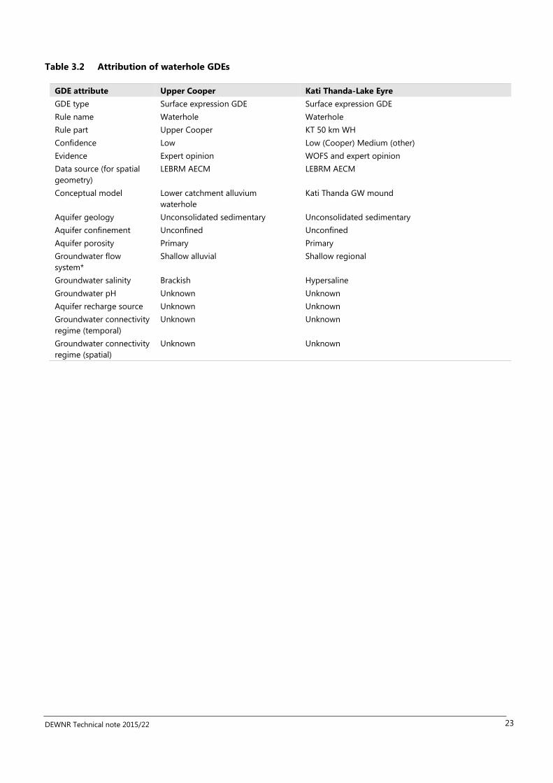
Table 3.2 Attribution of waterhole GDEs 23
Table 3.3 Attribution of evaporative discharge GDEs 27
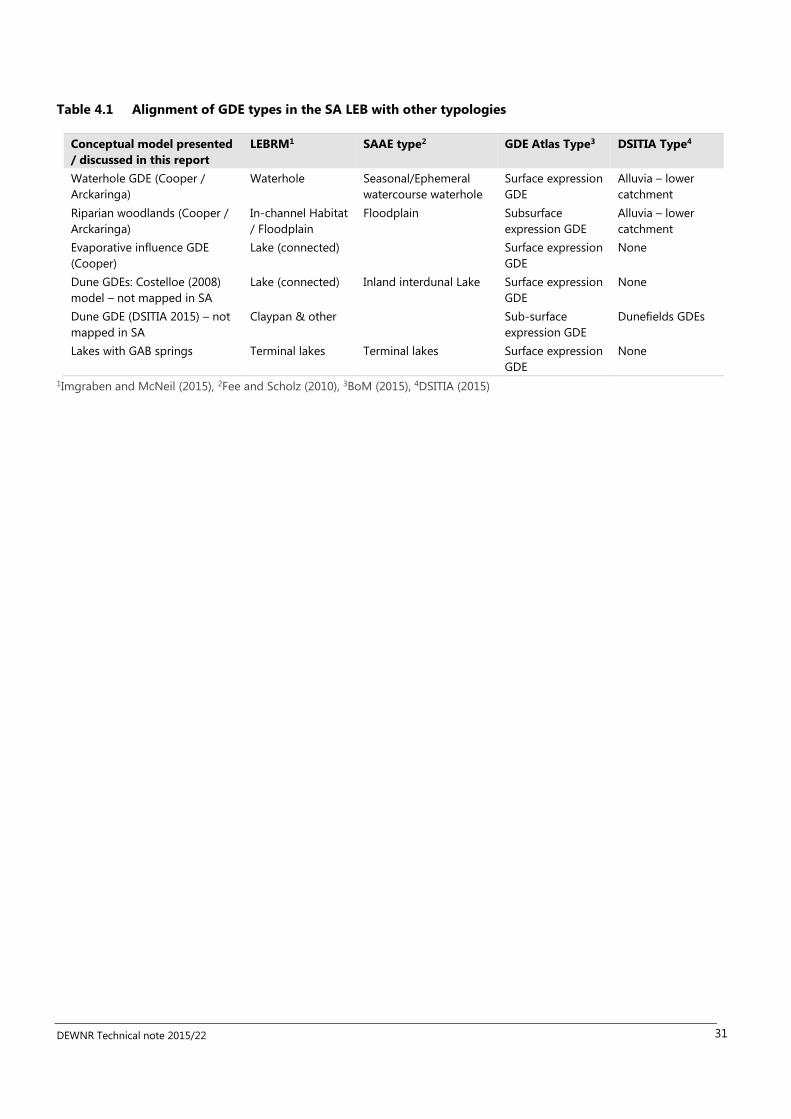
Table 4.1 Alignment of GDE types in the SA LEB with other typologies 31

DEWNR Technical note 2015/22 1
Summary
This project focusses on two preliminary assessment extents (PAE) (DEWNR 2014) of the Lake Eyre Basin in South Australia, the
Arckaringa and the Cooper. The project aims were to
1. Capture the state of knowledge about ecosystems dependent on shallow groundwater through conceptual models
and mapping, and
2. Trial the use of the Queensland groundwater dependent ecosystems (GDEs) mapping approach in South Australia.
Mapping of GDEs in the Arckaringa PAE was largely undertaken as part of a previous project (Miles and Miles 2015) that built
on South Australia’s Water Asset Database (WAD) for the South Australian Arid Lands region (Denny and Berens 2014).
Research into water sources accessed by trees and surface water–groundwater interactions in the Neales River catchment has
enabled the development of a relatively detailed conceptual model of GDEs for the Arckaringa PAE. Conceptual models for the
Cooper PAE are more general, with less supporting evidence.
The Cooper GDE mapping aimed, in so far as possible, to apply the Queensland GDE mapping approach, whilst building on
prior aquatic ecosystem mapping and classification. The Queensland mapping approach was used with the intent to achieve
cross border consistency in mapping, however, application of the Queensland GDE mapping approach to the SA portion of the
Cooper PAE was hampered by:
1. Lack of definitive spatial geometries to represent aquatic ecosystems
2. Lack of complementary spatial datasets of other features (such as vegetation, soils, depth to groundwater) necessary
to apply the mapping rules approach
3. Very little knowledge about shallow groundwater resources and water sources accessed by vegetation in the Cooper
PAE.
Therefore the results are considered preliminary. Despite the limitations, this work has demonstrated application of the
mapping-rule sets approach used in Queensland with consistent GDE classification applied in the South Australian portion of
the Cooper PAE (albeit with low confidence and limited extent). The mapping rule sets approach was found to be a useful
method but reliant on supporting spatial data that was not available in that area. Two key recommendations from the draft
report are that there needs to be improvement in the spatial data sets required to map GDEs, and on-ground investigations to
determine different groundwater dependent ecosystems and their degree of reliance on groundwater.

DEWNR Technical note 2015/22 2
1 Introduction
1.1 Overview of the Lake Eyre Basin Springs Assessment Project
This report is part of a series of studies forming part of the Lake Eyre Basin Springs Assessment (LEBSA) project. The LEBSA
project is one of three water knowledge projects undertaken by the South Australian Department of Water, Environment and
Natural Resources (DEWNR) to inform the Bioregional Assessment Programme in the Lake Eyre Basin (LEB). The three projects
are:
Lake Eyre Basin Rivers Monitoring (LEBRM)
Arckaringa Basin and Pedirka Basin Groundwater Assessment
Lake Eyre Basin Springs Assessment (LEBSA)
The Bioregional Assessment Programme is a transparent and accessible programme of baseline assessments that increase the
available science for decision making associated with potential water-related impacts of coal seam gas (CSG) and large coal
mining (LCM) developments. The coal-bearing Arckaringa, Pedirka, Cooper and Galilee basins (Figure 1.1) have been identified
as regions where CSG and LCM developments are likely to occur or increase in the future. Bioregional assessments are being
prepared in the LEB for the four coal regions to strengthen the science underpinning future decisions about CSG and LCM
activities and their impacts on groundwater quality, surface water resources and aquatic ecosystems.
The objective of the LEBSA project was to address knowledge gaps relating to the potential impacts of mining developments
on groundwater resources and assets across the LEB. In particular, the project aimed to characterise and attribute springs and
other GDEs that are critical for the maintenance of those assets (e.g. ecological, hydrogeological, hydrochemical), in a way that
is consistent across South Australia and Queensland.
The LEBSA project is being delivered by DEWNR for the South Australian areas of the LEB, with a similar project being run in
parallel by the Queensland Government Department of Science, Information Technology, Innovation and the Arts (DSITIA) for
Queensland areas of the LEB. The LEBSA project background, purpose, approach and links to the bioregional assessment are
described in more detail in DEWNR (2015a).
1.2 Scope
The South Australian LEBSA project is predominantly focused on improving the state of knowledge about springs dependent
on the deep groundwater of the Great Artesian Basin (GAB) (DEWNR 2015a). The project aims were to
1. Capture the state of knowledge about ecosystems dependent on shallow groundwater through conceptual models
and mapping, and
2. Trial the use of the Queensland groundwater dependent ecosystems (GDEs) mapping approach in South Australia.
This project focusses on two Preliminary Assessment Extents (PAEs) of the LEB in South Australia, the Arckaringa and the
Cooper, with the Cooper PAE included in order to extend mapping of groundwater dependent ecosystems being undertaken in
Queensland (DSITIA).

DEWNR Technical note 2015/22 3
Figure 1.1 Location of the LEB, coal basins and preliminary assessment extents (PAEs) in South Australia

DEWNR Technical note 2015/22 4
1.3 Classification and definition of groundwater dependent ecosystems
Understanding what water sources support aquatic ecosystems is a critical step to assessing potential risks to ecosystems from
CSG and coal mining developments. Water source is an attribute of the interim Australian National Aquatic Ecosystems (ANAE)
Classification Framework (AETG 2012a), but the classification of groundwater dependency is further refined in the Australian
GDE assessment framework (Richardson et al. 2011). Groundwater dependent ecosystems are defined as ‘ecosystems that
require access to groundwater on a permanent or intermittent basis to meet all or some of their water requirements so as to
maintain their communities of plants and animals, ecological processes and ecosystem services (Richardson et al. 2011 p. 1).’
Three types of GDEs are recognised in the national GDE assessment framework:
1. Aquifers and cave systems (subterranean)
2. Ecosystems dependent on the surface expression of groundwater
3. Ecosystems dependent on subsurface presence of groundwater (Richardson et al. 2011)
This project has focused on the second and third types of GDEs as there is insufficient knowledge about subterranean GDEs in
this region.
1.4 Overview of aquatic ecosystem mapping, classification and groundwater
dependency attribution in the Lake Eyre Basin, South Australia
There have been a number of efforts to map, attribute and classify non-GAB spring aquatic ecosystems in the LEB in South
Australia including as part of the LEB Rivers Assessment (e.g. Tunn and Cameron 2008), a trial of the guidelines for identifying
High Ecological Value Aquatic Ecosystems (AETG 2012b) and for the national GDE Atlas (BoM 2015). A first project undertaken
in preparation for the Bioregional Assessment Program was the collation of existing data-sets for the development of a Water
Asset Database (WAD) (Denny and Berens 2014). The WAD was further developed into a geodatabse as part of the LEBRM
project, with refinement of the spatial mapping of aquatic ecosystems in the Arckaringa PAE and application of the ANAE
classification (Miles and Miles 2015). This project has built on the LEBRM work to apply groundwater dependency attributes
aligned with the GDE Atlas to enable updating of the GDE Atlas and consistency with GDE mapping work being undertaken in
Queensland a part of the LEBSA project there. The LEBRM geodatabase was used as the main data source for this project, with
other data sources incorporated to refine the attribution (Table 1.1).

DEWNR Technical note 2015/22 5
Table 1.1 Aquatic ecosystem mapping and classification undertaken for the Bioregional Assessment
Programme
Program Project Sub-project
(product)
Main data
source
geometry
Additional datasets
incorporated (geometry
and attribution)
Spatial
format
Geographical
focus
National
Partnership
Agreement
Vulnerability
Assessment
(2013)
SAAL Water
Asset
Database
(Denny &
Berens 2014)
Statewide
wetlands, rivers
and springs
Other non-
aquatic
ecosystem water
assets (e.g
bores)
GDE Atlas
Local and expert
knowledge
Points
Lines
Polygons
Relational
database
Statewide
Water
Knowledge
Program
LEBRM
(2014)
Aquatic
Ecosystem
Classification
and Mapping
(Miles & Miles
2015)
Water Asset
database
Statewide and national
datasets (vegetation
structure, soil, landform
energy, IBRA)
Technical reports
Expert opinion
Polygon
shapefiles
(geo-
database)
Arckaringa
PAE (Neales &
Macumba
catchments)
Water
Knowledge
Program
LEBSA (2015) Cooper PAE
GDEs (Miles &
Costelloe
2015)
Aquatic
Ecosystem
Classification
and Mapping
(LEBRM)
Statewide data sets
(vegetation structure,
surface geology)
Technical reports
Expert opinion
Polygons
shapefile
(geo-
database)
Cooper PAE
(Cooper creek
catchment)

DEWNR Technical note 2015/22 6
2 Arckaringa alluvial groundwater
dependent ecosystems
The mapping and description of conceptual models of groundwater dependent ecosystems in the Arckaringa PAE builds on
the work of Miles and Miles (2015). Another project, the ‘shallow groundwater project’ (DEWNR 2015b), scheduled for
completion in early 2016 is focused on improving the understanding of ecosystems dependent on shallow groundwater in the
western rivers of the LEB. The shallow groundwater project will refine the conceptual model outlined below as well as mapping
the distribution of GDEs in the Arckaringa region.
2.1 Conceptual model
Conceptual models of non-GAB GDEs in the western rivers of the Lake Eyre Basin were based on literature and expert opinion
(Figure 2.3). There is very little data in the South Australian LEB on which to determine what ecosystems are groundwater
dependent (other than GAB springs), their attributes and the hydrogeological processes contributing to their existence.
The major factors determining the likelihood of GDEs forming are:
Geology and soil type
Geomorphology
Depth to groundwater
Groundwater quality
Recharge dynamics
2.1.1 Geology and soils
The surface geology of the region is predominantly composed of subcropping or outcropping, highly weathered Bulldog Shale.
Consequently, the regolith profile of the region is interpreted to be predominantly highly weathered residual bedrock, with
more recent transported alluvial sediments restricted to drainage channels. Outcropping and subcropping basement and JK
aquifer rocks are found within and in the vicinity of the Peake and Denison Inlier, which forms a chain of ranges within the
eastern portion of the area of investigation. These ranges are cut by the Neales River/ Peake creek river system (Figure 2.1).
The different geologies the rivers intersect are sediment sources for the alluvium and contribute to variable alluvium properties
(Wakelin-King, 2011, 2014). The Neales and Macumba Rivers show a general pattern, typical of most rivers, of the alluvial
sediments becoming finer grained along a downstream gradient. In addition, limited drilling also indicates that the alluvial
sediments become coarser with depth. For instance, the alluvial soils in middle (and potentially lower) reaches of the Neales
catchment consist of interlayered clays and silts overlying higher permeability sands and gravels (Costelloe et al., 2005b). In
some reaches the upper alluvium is more silty sand (e.g. Angle Pole to Cramps Camp) (Ryu et al., 2014), and coarse in the
Arckaringa and Lora Creeks (Wakelin-King, 2014). Macumba River catchment alluvial sediments are predominantly sandy.

DEWNR Technical note 2015/22 7
Figure 2.1 Surface geology of the Arckaringa PAE
Peake &
Dennison
Inlier

DEWNR Technical note 2015/22 8
2.1.1 Geomorphology
In the Neales catchment, in single channel reaches, deeper channel segments may cut down through the clays and silts to
intersect layers of higher permeability sands and gravels. These higher permeability deposits can outcrop in the channel banks,
but can also be concealed by a layer of clay lining the watercourse or waterhole (Costelloe et al., 2006). Multi-channel
segments are shallower and do not penetrate through the clay-silt layer, but the micro-relief of shallow channels and slight
rises create zones of differing soil water regimes (Costelloe et al., 2006). The channel morphology shows a general longitudinal,
downstream pattern, moving from multiple channel forms in the upper to mid reaches to more single channel forms in the
lower reaches (Wakelin-King, 2011, 2014). However, the channel forms also respond to particular changes in river slope and
valley containment that overprint this general pattern (Wakelin-King, 2011, 2014).
2.1.2 Depth to groundwater
The regional unconfined groundwater level is mapped as being between 10 to 30 m below ground surfaces close to drainages
over the Neales catchment, lower Peake sub-catchment and the Macumba catchment but this mapping is based on few data
points (Figure 2.2) (Miles et al. 2015). Except at a few locations, groundwater in the upper Peake (including Arckaringa)
catchment is deeper. However, the unconfined groundwater level mapping should be treated with caution as:
1. data are very sparse in the Neales-Peake and lower Macumba, particularly close to drainages (see Figure 2.2)
2. as noted below, the connectivity between regional and alluvial groundwaters is unknown.
In general, the depth to groundwater also follows a longitudinal downstream pattern, being deeper in the upper reaches and
shallower in the lower reaches as the rivers approach the regional low point of Kati Thanda-Lake Eyre North (). Complicating
this longitudinal pattern are the occurrences of probable perched aquifers at relatively shallow levels in the upper reaches.
Unpublished groundwater depth observations (see Figure 2.2 for locations) recorded in alluvial systems are:
0.7 m below the surface of the dry Ethawarra waterhole, a shallow waterhole on Hamilton Creek in the Macumba
catchment (Ryu et al., 2014); this is possibly a perched alluvial aquifer.
Approximately 5–6 m below stream base at Wintinna Homestead on Wintinna Creek, an upper tributary of Arckaringa
Creek. Other data from Figure 2.2 indicates that the water table is typically much deeper in these upper reaches.
Controls on the existence of perched alluvial aquifers are not well understood but may be facilitated by the existence
of coarser grained alluvial sediments underlain by relatively impervious basement (non-alluvial) sediments/rocks at
shallow depths.
Three to seven metres below the floodplain surface at sites in the mid-Neales River and mid-Peake Creek (Costelloe et
al., 2006). This groundwater is known to interact with waterholes and deeper primary channel section in these reaches.
In the lower reaches of the Neales River (i.e. by Tardetakarinna Waterhole at the junction of the Neales and Peake),
deeper pools in the river are groundwater fed and indicate that the depth to the watertable is only 2–3 m deep.

DEWNR Technical note 2015/22 9
Figure 2.2 Interpreted phreatic groundwater contours for the Arckaringa PAE
Note: although phreatic groundwater is ubiquitous across the landscape and is commonly represented by groundwater in Cenozoic forrmations, this surface does not necessarily imply continuous
groundwater movement between formations, nor is it completely restricted to Cenozoic formations. Source: Miles et al. 2015, figure 24
Ethawarra waterhole
Wintinna homestead
Middle reaches
Tardetakarrina
waterhole

DEWNR Technical note 2015/22 10
2.1.3 Groundwater quality
Alluvial groundwater in the mid-Neales is saline to hyper-saline except close to the banks of channelized sections (Costelloe et
al., 2005b). Close (<10–15 m) to the banks, the groundwater is flushed during flow events (Costelloe et al., 2008). Waterholes in
the mid-Neales which are known to receive groundwater (see below) become hypersaline soon after flow events cease and can
reach hypersaline levels (e.g. >70,000 mg/L TDS – twice seawater salinity) within 6-18 months. It is likely that all waterholes
downstream of Tardetakarinna receive groundwater and are hypersaline for most of the time (Costelloe, 2011; Ryu et al., 2014).
Groundwater in the lower Macumba catchment is shallow and may be saline, as seen in the lower Neales (Ryu et al., 2014). In
general, the groundwater salinity will show a similar downstream longitudinal pattern as the depth to groundwater, i.e. the
shallower the depth to groundwater the higher is its salinity. This is considered to be driven by evapo-concentration processes
where the groundwater is exposed to the surface, or near-surface environment, particularly in deeper ephemeral channels
(Costelloe et al., 2007). This process may also be facilitated by the presence of finer grained alluvial sediments that limit
infiltration and surface flushing but allow more capillary rise to the near-surface, compared to coarser grained alluvial
sediments.
Fresh groundwater was recorded below the surface of Ethawarra Waterhole (on the Hamilton Creek, Macumba catchment)
when it was dry in May 2013 (Ryu et al., 2014). Potable unconfined groundwater occurs around Wintinna Homestead and is
most likely alluvial perched groundwater recharged by the nearby Wintinna Creek (tributary of Arckaringa Creek). These limited
observations indicate that upper tributaries with coarse grained alluvial sediments, and the sand-dominant reaches of the
upper to mid Macumba catchment, can contain low salinity, alluvial groundwater. Otherwise, in the mid to lower reaches of the
Neales, the available data indicate that the unconfined groundwater is saline to hypersaline. For example, at Algebuckina
Waterhole, the groundwater within 100 m of the channel had a salinity of 13 000 mg/L TDS but a salinity of 32 000 mg/L TDS
approximately 200 m from the primary channel. The piezometric gradient of the groundwater was generally sloping away from
the waterhole except at very low surface water levels.
2.1.4 Recharge
2.1.4.1 Regional recharge
The direction of regional groundwater flow is from the margins of the LEB towards Kati Thanda-Lake Eyre (Keppel et al., 2013)
There are insufficient data to determine the degree of exchange between alluvial aquifers and regional groundwater but they
are likely to be well-connected, with the exception of probable perched alluvial aquifers in the upper reaches.
Sources of recharge to the regional groundwater are likely to be a combination of diffuse rainfall and streamflow recharge.
Love et al. (2013) found that diffuse recharge to GAB formations in the region is effectively zero under current climatic
conditions. In the Diamantina River catchment, Tweed et al. (2011) found that the stable isotope data from groundwater
outside of the Diamantina floodplain were consistent with diffuse recharge from large rainfall events (>100 mm/month) to the
unconfined regional groundwater. Fluvial recharge to unconfined groundwater has been observed by a number of studies. For
example, piezometric monitoring, groundwater–surface water modelling and hydrogeochemistry in the Neales catchment show
that fluvial recharge is occurring in the middle reaches (Costelloe et al., 2006; 2007). Fluvial recharge has also been observed in
the Finke River (Fulton et al., 2013) and Cooper Creek (Cendon et al., 2010). The contribution of the GAB to regional unconfined
groundwater is minimal, but there are zones of preferential discharge to the upper aquifer around springs and via fractures and
faults (Harrington et al., 2013).
2.1.4.2 Middle and lower reaches
The alluvium has been shown to be laterally recharged in some channelized reaches through the banks during flow events
(Figure 2.3). Where higher permeability layers outcrop in the banks, recharge occurs via these, but where waterholes are clay
lined then recharge may be limited or occur via macropores (cracks and tree roots) (Costelloe et al., 2006). The degree of
discharge and recharge in these reaches is likely to be controlled by the depth of the channel incision through the uppermost,
finer grained alluvial sediments.
Costelloe et al. (2006) found recharge to groundwater did not occur in unchannelised reaches, instead perennial floodplain
vegetation used all the water that entered the soil before it reached the groundwater. Additionally, floodplain Coolabahs
(Eucalyptus coolabah) have been shown to use all soil water recharged during floods and rainfall events (Costelloe et al., 2008),

DEWNR Technical note 2015/22 11
and therefore recharge is also likely to be limited on floodplains. For example, a study on the middle reaches of Cooper Creek
found recharge below floodplain clay soils to be <1 mm y-1 (Larsen, 2011).
2.1.4.3 Sandy reaches
In the sandier reaches (e.g Angle Pole to Cramps Camp near Oodnadatta) and gravelly reaches (e.g. upper Arckaringa near
Wintinna homestead) of the Neales and in the Macumba catchment there may be higher rates of recharge from river flows
(Costelloe et al., 2005b; Ryu et al., 2014). This is inferred by the presence of Red Gums (Eucalyptus camaldulensis var. obtusa) in
the Angle Pole to Cramps Camp reach of the Neales and through much of the Macumba, and by the observation of fresh
groundwater at Ethawarra Waterhole, and the presence of shallow stock bores, on Hamilton Creek of the Macumba catchment.
There are few direct observations of recharge behaviour in this region except for the mid-lower Neales (Costelloe et al., 2006)
and Finke River (Fulton et al., 2013).

DEWNR Technical note 2015/22 12
Figure 2.3 Conceptual model of groundwater–surface water relationships in the Arckaringa sub-region
Where GDEs exist in the upper reaches, the alluvial water table level is likely to be above the regional water table (perched or losing); in the lower reaches the alluvial water table may be level with or
below the regional water table (gaining), however the alluvial groundwater is prevented from discharging into some waterholes by a thick clay layer lining the channel. Diagram not meant to imply a
relationship between groundwater level and alluvium soil type.

DEWNR Technical note 2015/22 13
2.2 Mapping
The Arckaringa PAE (particularly the Neales and Macumba catchments) was the focus of a LEBRM project (Miles and Miles
2015) that aimed to improve the spatial mapping and attribution of aquatic ecosystems, building on the work undertaken for
the WAD project (Denny & Berens 2014) and aligning with the Interim Australian National Aquatic Ecosystems (ANAE)
classification framework (AETG 2012a) and South Australian Aquatic Ecosystem (SAAE) classification (Fee and Scholz 2010). A
component of the ANAE classification is the attribution of water source as surface water, groundwater or a combination (Figure
2.4). Miles and Miles (2015) expanded on the groundwater source attribution to provide more detail about the groundwater
source. This project has further broken down the groundwater classification to align with the Queensland GDE classification
(DSITIA 2015) and separate attributes for aquifer geology and confinement (see Appendix A)
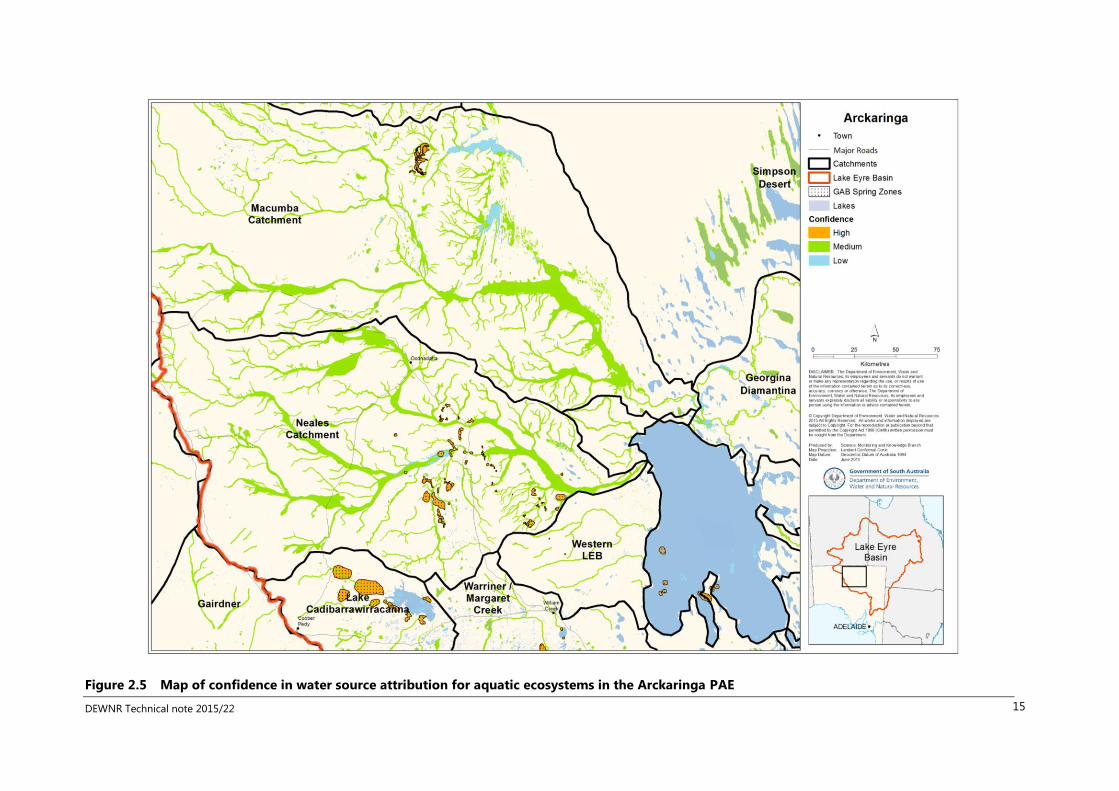
For each aquatic ecosystem, a confidence rating was applied and the method or information source documented. Whilst there
is little knowledge about groundwater dependence for most of the Arckaringa aquatic ecosystems, the hydrology and
hydrogeology of some sites in the Neales catchment have been studied, enabling water source to be attributed with medium
and high levels of confidence for select areas (Figure 2.5). However the confidence in the water source of aquatic ecosystems
over the rest of the region was rated as low. The GDE Atlas (BoM 2015) was considered unreliable in this region, due to
mapping many highly ephemeral streams that only hold water during a flow event as being reliant on the surface expression of
groundwater (moderate potential) and all woodland vegetation as being reliant on the subsurface expression of groundwater
(high potential). Remote sensing image analysis is commonly used as a method to map groundwater dependent ecosystems
over large areas (E.g. BoM 2015; White et al. 2014; Kellett et al. 2012); studies to date (White et al. 2014; BoM 2015; Kellett et al.
2012) have produced conflicting results in the Arckaringa PAE. Since the water source of aquatic ecosystems was attributed in
Miles & Miles (2015), additional analysis of MODIS imagery by White et al. (2014) has become available that indicates areas of
vegetation on the Arckaringa Creek floodplain that have a high likelihood of groundwater dependence. The results of White et
al. (2014) concur with and may refine the BoM (2015) GDE mapping but are in contrast to MODIS analysis presented in Kellett
et al. (2012) and on-ground results (Ryu et al. 2014). Combining remotely sensed image analysis with on-ground groundwater
investigation will be a priority for the shallow groundwater project (DEWNR 2015b) and will contribute to improved confidence
in GDE mapping the Arckaringa PAE.

DEWNR Technical note 2015/22 14
Figure 2.4 Map of aquifer geology and aquifer confinement for potential GDEs in the Arckaringa PAE
DEWNR Technical note 2015/22 15
Figure 2.5 Map of confidence in water source attribution for aquatic ecosystems in the Arckaringa PAE

DEWNR Technical note 2015/22 16
2.3 Groundwater dependent ecosystems
2.3.1 Waterhole groundwater dependent ecosystems
In the Neales catchment, four out of 22 studied waterholes are considered to receive significant groundwater inputs, these are
Baltacoodna, Warrawaroona, Peake Crossing and Tardetakarinna (Ryu et al., 2014). Of these, only the latter is permanently
maintained by groundwater while the others have prolonged persistence but will dry out after long (1–2 years) periods without
flow (Ryu et al., 2014). Saline, semi-permanent and potentially permanent waterholes exist downstream of Tardetakarinna
(McNeil et al., 2011; Ryu et al., 2014). A small trickle of moderate salinity (<6 400 mg/L TDS) groundwater inflow was observed
in the upstream end of Algebuckina Waterhole during severe drought conditions of October 2013. It is unlikely that the
observed flow would make a significant difference to the persistence of the main waterhole but would maintain small pools in
the rocky upstream end of the waterhole.
These hyper-saline waterholes are unique environments that for periods of time can support abundant, low diversity
assemblages of salt-tolerant fish [Lake Eyre Hardyheads (Craterocephalus eyresii) and Desert Gobies (Chlamydogobius eremius)
(McNeil et al., 2011)], invertebrates (Shiel et al., 2006) and algae (Costelloe et al., 2005a). McNeil et al. (2011) refer to these
waterholes as Polo-club refuges for fish as they are only suitable for a select few species. However, the salinities of these
waterholes can exceed conductivities of 96 000 mg/L TDS within 6–9 months of a flow event (Costelloe and Russell, 2014) and
these salinities exceed the tolerance of Lake Eyre Hardyheads and all but a few algal species. Riparian vegetation consists of
sparse salt-tolerant shrubs and groundcovers but Coolabah can occur on bank-top positions.
Waterholes in the Macumba catchment are not considered to be GDEs (see below).
2.3.2 Riparian woodlands
Red Gums (Eucalyptus camaldulensis ssp. obtusa) are known to occur in the Neales catchment from Angle Pole to Cramps
Camp (Ryu et al., 2014), in the upper Arckaringa Creek (Wakelin-King, 2014) and throughout the middle and upper Macumba
catchment. As a general hypothesis, the distribution of different riparian tree assemblages can indicate the groundwater
dependency of the riparian tree community but this is still to be confirmed by field observations. The following assemblages
are considered to indicate characteristic GDE conditions:
1. Red Gum woodland – accessible (i.e. shallow) groundwater of low to moderate salinity (e.g. <6 400-9 600 mg/L TDS).
Red Gum dominant riparian zones indicate particularly fresh groundwater
2. Coolabah dominant woodland – accessible (i.e. shallow) groundwater of moderate to high salinity (e.g. 6 400–32 000
mg/L). In mixed Red Gum–Coolabah assemblages, the Red Gums will only be in bank or bank top positions (accessing
fresh bank storage) while Coolabahs occupy bank top and floodplain positions (accessing more saline alluvial
groundwater). Reaches with sparse Coolabahs as the dominant tree type will typically have the Coolabahs around the
primary channels and they may be utilising only soil moisture supplied by streamflow and rainfall events.
3. Acacia spp. dominant woodland – deeper groundwater, possibly below the root zone (hence not a GDE). The
occasional Coolabah is common in Acacia dominant woodland but they occupy primary channel positions that have
higher availability of soil moisture.
In the Neales catchment, in reaches with hypersaline groundwater (close (<4 m) to the floodlplain surface, riparian Coolabah
woodlands are able to grow in channelized sections by using a mixture of soil water and groundwater, growing close to the
banks where lateral recharge freshens the groundwater (Costelloe et al., 2008). Riparian Coolabah woodlands on the lower
Macumba may also be supported by bank flushing, but this has not been investigated.

DEWNR Technical note 2015/22 17
Red Gums in the sandy reaches of the Macumba, upper Neales and Arckaringa may be accessing fresher groundwater (Ryu et
al., 2014), or may indicate zones of high run-off from surrounding catchments frequently filling relatively small volume of
alluviums (G. Wakelin-King (Wakelin Associates) 2014, pers. comm. 24 September). There has not been any research into water
sources accessed by Red Gums in the western LEB. One location where Red Gums occur in the Arckaringa (Figure 44 in
Wakelin-King (2014)) is approximately 500 m from a bore located above the floodplain where the depth to groundwater level
has been measured at 11 m. There are two other locations in these upper catchments where shallow groundwater is recorded,
but there are no records of vegetation at these sites.

DEWNR Technical note 2015/22 18
3 Cooper (South Australia) groundwater
dependent ecosystems
3.1 Overview
The Cooper GDE mapping aimed to apply the Queensland GDE mapping approach (DSITIA 2015) to the South Australian (SA)
portion of the Cooper PAE whilst building on the existing work of Miles and Miles (2015) and Denny and Berens (2014). The
Queensland GDE mapping methodology includes a structured workshop phase to capture local and expert knowledge termed
“walking the landscape.” Much of the consultation phase of “walking the landscape” was undertaken prior to this project as
part of consultation for the Water Allocation Plan (WAP) processes and NRM Water Asset Database project (Denny and Berens
2014). The Queensland GDE mapping approach uses the information gathered in the “walking the landscape” phase to develop
mapping rules that are applied using existing spatial data sets to determine likely GDEs.
The spatial geometry of the WAD (Denny and Berens 2014) was used and additional polygons were only added for the riparian
woodland GDEs (Section 3.2). Additional fields were added to the Miles and Miles (2015) geodatabase to create attributes
consistent with the Queensland GDE mapping (DSITIA) and the Queensland definitions were used in these fields (see Appendix
B). The values for water source and other attributes applied by Miles and Miles (2015) were not altered as part of this work
unless specific evidence was found in journal articles that increased confidence to high.
The Queensland mapping approach was used with the intent to achieve cross border consistency in mapping GDEs, however,
application of the Queensland GDE mapping approach to the SA portion of the Cooper PAE was hampered by:
1. very little knowledge about shallow groundwater resources and water sources accessed by vegetation in the Cooper
PAE
2. a lack of relevant and accurate data sets with which to apply GIS rules
3. multiple and overlapping spatial geometries of aquatic ecosystems.
Therefore the Cooper component of this project has focused on presenting conceptual models of GDEs that are likely to occur
in the region and then mapping them in so far as is reasonably practical with the available datasets. The results are considered
preliminary and require on-ground validation.
Shallow groundwater well data in the Cooper PAE are sparse and very high salinities (26 000 to 95 000 mg/L TDS) have been
recorded (Costelloe et al. 2009). Groundwater dependency has been the subject of very little research in the Cooper in SA and
is recommended as a priority for future investigations (Costelloe 2013).
As there is limited knowledge to identify what ecosystems are groundwater dependent with confidence, there is also limited
knowledge to determine what aquatic ecosystems are not groundwater dependent. Therefore all aquatic ecosystems other
than those identified through the mapping approach outlined below were assigned “Unknown” GDE Type.
Private industries operating in the Cooper PAE in South Australia have also been undertaking work in mapping GDEs but this
information was not available to be included in this work.
3.2 Riparian woodland groundwater dependent ecosystems
3.2.1 Conceptual model
The Riparian Woodland GDE conceptual model is consistent with the Queensland “Alluvia – lower catchment” conceptual
model (DSITIA 2015) and the riparian woodland component of the Arckaringa conceptual model presented in Section 2.1. A
key difference with the Arckaringa conceptual model is that groundwater close to the channel banks is sufficiently fresh to

DEWNR Technical note 2015/22 19
support riparian Red Gum woodlands in the upper reaches (upstream of the Coongie Lakes (on the North West Branch) and
Munjoorooanie Waterhole, north of Cuttapirie Corner, on the Main Branch (Gillen and Reid 2013)).
There is little specific data to support the application of this conceptual model in the South Australian Cooper catchment as
data on shallow groundwater and water sources accessed by riparian trees are scarce. However MODIS Enhanced Vegetation
Index analysis for the drought period of 2000–08 indicates riparian vegetation along the Cooper Creek from upstream of the
SA–Qld border down to the junction of the North West and Main branches as having a high likelihood of being groundwater
dependent (Figure 6.25 in Kellett et al. 2012).
Studies in more upstream reaches of the Cooper Channel Country (Cendon et al 2010; Larsen 2011) indicate the main
mechanism for recharge of the alluvial groundwater occurs when clay sediments lining channel banks are scoured during high
flows, resulting in zones of fresher groundwater immediately adjacent to channels and waterholes. Riparian trees may access
groundwater freshened by this recharge mechanism, as has been documented in the Neales and Diamantina catchments
(Costelloe et al. 2008). The occurrence of Red Gums lining the channels and waterholes of the more permanent upper reaches
may also be indicative of alluvial groundwater of sufficiently low salinity (i.e. below 40 000 S/cm; Mensforth et al. 1994) due to
more frequent flow events.
3.2.2 Mapping
A mapping rule was adopted from the Queensland “Alluvia – lower catchment” conceptual model (DSITIA 2015) Mapping Rule-
Set 01M: Quaternary alluvial aquifers with brackish, ephemeral groundwater connectivity regime and Mapping Rule-Set 01R:
Quaternary alluvial aquifers with saline, ephemeral groundwater connectivity regime. The key difference between 01R and 01M
is that the former has saline groundwater and was applied in the Georgina catchment, while 01M has brackish groundwater
and was applied in the Cooper catchment. It is likely that the 01M (brackish) rule would apply in the upper reaches in the
Cooper catchment in South Australia but that this should grade to 01R (saline) at some point moving downstream, possibly at
a point coinciding with the downstream extent of River Red Gums (Costelloe 2013; Gillen and Reid 2013).
Due to the limited extent of vegetation structure mapping in SA, this rule could effectively only be applied in discrete areas of
the Cooper PAE (Figure 3.1).
The vegetation structure attribution given in Miles and Miles (2015) was re-calculated for aquatic ecosystems in the Cooper
PAE using ESRI ® ArcToolbox Union to identify the parts of aquatic ecosystems that are mapped woodland and the adjacent
mapped woodland areas. The vegetation method field was attributed ‘Union SA_VEG_STRUCTURE GENFORMDESC’ and
confidence assigned ‘medium.’ All new woodland polygons not intersecting the alluvial geology were deleted. All woodlands
and woodland aquatic ecosystems intersecting alluvial geology were then assigned riparian woodland GDE attributes (as per
Table 3.1)
The results of this mapping (Figure 3.1) are similar to the mapping of sub-surface GDEs for the same region in the GDE atlas
(BoM 2015).
Table 3.1 Attribution of Cooper riparian woodland GDEs
GDE attribute Value
GDE type Sub-surface GW GDE
Rule name Qld LEB Alluvia
Rule part Qld LEB RS 01M – upper* Cooper
Qld LEB RS 01R – lower* Cooper, Macumba, Neales, Diamantina catchments
Qld LEB RS 01X – other
Confidence Low
Evidence EXTRAPOLATED FROM RULE
Data source (for spatial
geometry)
LEBRM AECM
SA woodland veg – LEBRM AECM for those polygons delineated by being
woodland alone
Conceptual model Riparian woodland
Aquifer geology Unconsolidated sedimentary

DEWNR Technical note 2015/22 20
GDE attribute Value
Aquifer confinement Unconfined
Aquifer porosity Primary
Groundwater flow
system*
Shallow alluvial
Groundwater salinity Qld LEB RS 01M: Brackish
Qld LEB RS 01R: Saline
Qld LEB RS 01X: Unknown
Groundwater pH Unknown
Aquifer recharge source Unknown
Groundwater connectivity
regime (temporal)
Unknown
Groundwater connectivity
regime (spatial)
Unknown
* The distinction between upper and lower Cooper catchment was defined as Coongie Lake on the North West Branch and Munjoorooanie
Waterhole on the Main Branch

DEWNR Technical note 2015/22 21
Figure 3.1 Potential woodland GDEs in the Cooper PAE
Note: size of the woodland GDEs has been exaggerated to be visible at this mapping scale
Coongie
Lakes Munjoorooanie
Waterhole

DEWNR Technical note 2015/22 22
3.3 Waterhole groundwater dependent ecosystems
3.3.1 Conceptual model
Research in the Cooper Channel Country has found that waterholes are lined with clay sediments that prevent interaction with
alluvial groundwater for the majority of the time, except during high flow events, during which the clays are scoured and
alluvial groundwater is recharged (Hamilton et al. 2005; Cendon et al. 2010; Larsen 2011). While Cendon et al. (2010) and
Larsen (2011) found the alluvial groundwater table was below the depth of the studied waterholes, the watertable becomes
increasingly shallow approaching Kati Thanda-Lake Eyre (Kellett et al. 2012) and therefore in SA the deeper waterholes may
intersect the watertable, particularly Cullyamurra waterhole, which is over 25 m deep (Costelloe 2013). Monitoring of surface
water levels at five sites on the Cooper in SA indicated that there is unlikely to be significant groundwater inputs but there
could be some groundwater connection (Costelloe et al. 2007; Costelloe 2013). However it is likely that the deeper waterholes
on the Cooper upstream of the junction of the Main and North West branches may receive some groundwater inputs, of which
fresh bank storage is likely to be a significant factor. Well data available on WaterConnect (Government of South Australia
2015) indicates shallow (15-40 m below ground level) brackish to saline groundwater occurs near to the Cooper Creek near
Innamincka, and a 10 m deep well2 adjacent to Cullyamurra waterhole which recorded groundwater with EC 242 µS/cm,
implying groundwater was encountered at less than 10 m.
The occurrence of waterhole GDEs in the SA upper Cooper is supported by remote sensing analysis presented in Kellett et al.
(2012), indicating the riparian vegetation is persistently healthy throughout drought periods. There no evidence supporting the
existence of waterhole GDEs in the middle reaches (downstream of the Main and Northwest Branch junction) but some
speculation that they may occur close to the western shores of Kati Thanda-Lake Eyre, as evidenced by the persistence of some
waterbodies in the Water Observations from Space (WOFS; Geoscience Australia 2015).
The Queensland alluvia–lower catchment conceptual model includes baseflow to watercourses, however there is limited
support to apply this model directly in the South Australian reach and the model presented for the Arckaringa PAE (Figure 2.3)
is more likely to apply, particularly with respect to bank storage processes.
3.3.2 Mapping
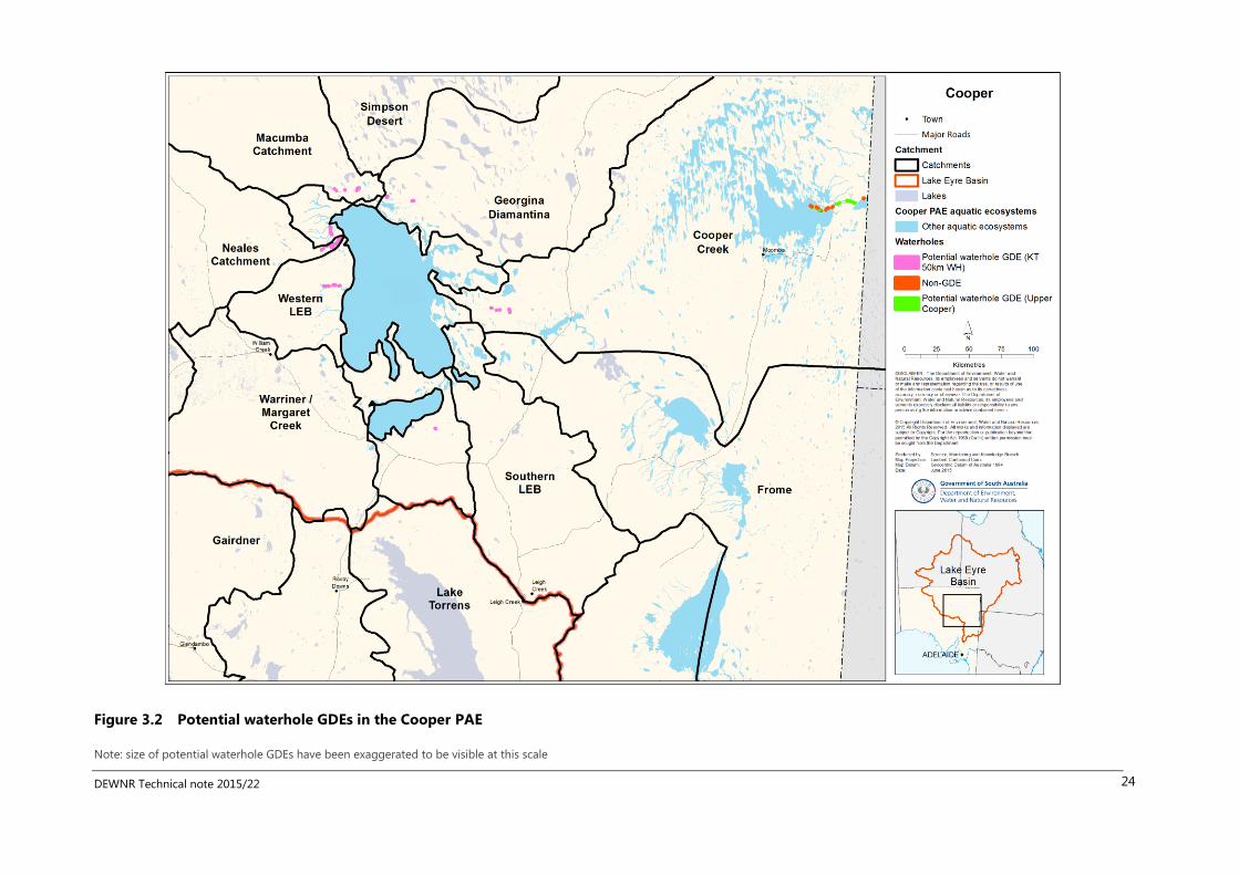
Waterhole: Upper Cooper: All waterholes with a cease to flow depth >5 m on the Cooper upstream of the Main Branch and
North West Branch junctions (as recorded in Costelloe (2013)) were manually selected by their asset name and assigned
surface expression GDE’s as per Table 3.2.
Waterhole: Kati Thanda 50 km buffer waterholes (KT 50 km WH): All waterholes within a 50 km radius of Kati Thanda-Lake
Eyre North and South were selected and assigned surface expression GDE attributes as per Table 3.2. Those waterholes in the
Cooper catchment were assigned a low confidence (compared with other catchments which were assigned medium) on the
basis that there are no known long lasting waterholes in the lower Cooper and the WOFS (Geoscience Australia 2015) does not
indicate the presence of persistent waterbodies.
Waterhole: Non-GDE: All other waterholes were assigned “Non GDE.”
The application of the above mapping rules (Figure 3.2) was reliant on aquatic ecosystems being classified as waterholes; this
was undertaken as part of previous mapping work that contributed to the WAD (Denny and Berens 2014). Miles and Miles
(2015) directed some effort towards improving the classification of waterholes as an aquatic ecosystem type in the Neales and
Macumba catchments, including manually classifying aquatic ecosystems. It was beyond the scope of this project to undertake
such a detailed check and correction of waterhole classification in the Cooper PAE due to the size of the area and complexity of
the spatial geometries. Therefore it is highly likely that the application of the “Waterhole” rules would have missed some
aquatic ecosystems to which the rules should have applied.
2 Obswell number 7042-14, drilled in 1957
DEWNR Technical note 2015/22 23
Table 3.2 Attribution of waterhole GDEs
GDE attribute Upper Cooper Kati Thanda-Lake Eyre
GDE type Surface expression GDE Surface expression GDE
Rule name Waterhole Waterhole
Rule part Upper Cooper KT 50 km WH
Confidence Low Low (Cooper) Medium (other)
Evidence Expert opinion WOFS and expert opinion
Data source (for spatial
geometry)
LEBRM AECM LEBRM AECM
Conceptual model Lower catchment alluvium
waterhole
Kati Thanda GW mound
Aquifer geology Unconsolidated sedimentary Unconsolidated sedimentary
Aquifer confinement Unconfined Unconfined
Aquifer porosity Primary Primary
Groundwater flow
system*
Shallow alluvial Shallow regional
Groundwater salinity Brackish Hypersaline
Groundwater pH Unknown Unknown
Aquifer recharge source Unknown Unknown
Groundwater connectivity
regime (temporal)
Unknown Unknown
Groundwater connectivity
regime (spatial)
Unknown Unknown
DEWNR Technical note 2015/22 24
Figure 3.2 Potential waterhole GDEs in the Cooper PAE
Note: size of potential waterhole GDEs have been exaggerated to be visible at this scale

DEWNR Technical note 2015/22 25
3.4 Evaporative influence groundwater dependent ecosystems
3.4.1 Conceptual model
Costelloe et al. (2009) presents evidence for a model of dynamic surface water–groundwater interaction occurring in some of
the Coongie Lakes complex. Groundwater is recharged through the lake beds during flood events. The resulting shallow water
tables result in the salinisation of the lake bed sediments due to capillary rise and evaporation during dry periods (Figure 3.3).
Recharge occurs mainly via cracks (macropores) in the clay lake sediments and, as cracking tends to be more pronounced the
longer the lake sediments are dry, recharge is also greater via this mechanism in less frequently inundated lakes and following
extended dry periods. Recharge via the cracks bypasses most of the soil profile, so there is limited flushing of salts from the soil
profile. However, if there are repeated wet events then recharge will occur via matrix flow and flush salt from the sediments to
the groundwater. Therefore more ephemeral lake bed soils are more saline, while more permanent lakes have fresher shallow
groundwater. The lakes are surrounded by more saline groundwater, and if significant recharge occurs, the subsequent rise in
the surrounding groundwater levels may impact the health and distribution of surrounding vegetation; it is unknown how far
the rise in the watertable extends away from the lake.
While this model does not indicate groundwater contributing water to the lakes or supporting surrounding vegetation as is
traditionally thought of a GDE, the contribution of evaporative discharge during dry phases contributes to the water quality of
these lakes and a gradation in salinity down catchment. These patterns are likely to influence the distribution of riparian and
surrounding floodplain vegetation, in addition to the algal seed-banks and zooplankton egg-banks that occurs in the lake bed
sediments (Costelloe et al. 2009). Therefore this model is presented as a surface expression GDE type, however further work
may be required to determine to what extent this process of evaporative discharge supports the ecological character of the
aquatic ecosystem.

DEWNR Technical note 2015/22 26
Figure 3.3 Conceptual model of evaporative influence GDEs in wet and dry phase

DEWNR Technical note 2015/22 27
3.4.2 Mapping
The lakes studied by Costelloe et al. (2007) and Lake Hope (on the basis of Costelloe 2013) were selected and attributed as per
Table 3.3 (Figure 3.4).
Table 3.3 Attribution of evaporative discharge GDEs
GDE attribute Value
GDE type Surface GW GDE
Rule name Lakes
Rule part Evaporative discharge
Confidence Medium
Evidence Journal article
Data source (for spatial
geometry)
LEBRM AECM
Conceptual model Evaporative discharge lakes
Aquifer geology Unconsolidated sedimentary
Aquifer confinement Unconfined
Aquifer porosity Primary and secondary
Groundwater flow system* Alluvial
Groundwater salinity Euryhaline
Groundwater pH Unknown
Aquifer recharge source Combined
Groundwater connectivity
regime (temporal)
Gaining/losing
Groundwater connectivity
regime (spatial)
Aseasonal, ephemeral

DEWNR Technical note 2015/22 28
Figure 3.4 Potential evaporative influence GDEs in the Cooper PAE

DEWNR Technical note 2015/22 29
3.5 Other known and potential groundwater dependent ecosystems
3.5.1 Terminal lakes
It has been proposed that Kati Thanda-Lake Eyre North and South and the Lake Frome to Lake Blanche complex of lakes are
zones of terminal discharge for the regional shallow groundwater (Kellett et al. 2012; Allison and Barnes 1985). While the
surface waters in these lakes dry out, the sediments remain saturated; this may be the result of a shallow groundwater table.
The watertable becomes increasingly shallow towards Kati Thanda-Lake Eyre (Kellet et al. 2012), and has been recorded at less
than one metre from the surface at Kati Thanda-Lake Eyre North (Ullman 1985) and Lake Frome (Allison and Barnes 1985). The
depth of the tertiary sediments of the lakes is unknown. Evaporative discharge of groundwater is likely to be a contributing
factor to the salinity of the lakes in addition to surface water inflows.
The GAB is artesian beneath the lakes, however there are GAB springs on the bed of Kati Thanda-Lake Eyre North and South,
Lake Blanche, Lake Callabonna and Lake Frome (Gotch 2013). Due to the difficulty of accessing these sites, nothing is known
about their hydrogeological structures, discharge rates or ecology. The presence of these springs could warrant classification of
the lakes as GDE (as they were classified in the WAD (Denny and Berens 2014)) however it is not clear to what extent the lake
ecosystems are dependent on this groundwater discharge. The springs could be refuges for species that colonise the lakes
when they fill, in which case the lake ecosystems may be relying on the springs. It is likely that the lakes exert a stronger
influence on the ecology of the springs (by providing hydrological connectivity between the springs and hydrological
disturbance with rising and falling lake levels and salinity).
In summary, there is potential that the salt lakes at the terminus of the LEB are a) a type of evaporative influence GDE, or b) are
dependent on GAB discharge, or both, however there remains significant uncertainty at this point and therefore lakes were
classified as ‘unknown’ GDE type for this project due to insufficient knowledge on which to classify the lakes.
3.5.2 Dune storage groundwater dependent ecosystems
Discharge of groundwater stored in dunes following major flood events to adjacent wetlands and waterholes is another type of
GDE that has been documented as occurring at a site in Goyders Lagoon in the Diamantina catchment (Costelloe 2008). In
Queensland, a conceptual model for another type of dune GDE (“Rule-Set 08C”) has been developed and mapped as occurring
in the Queensland portion of the Cooper PAE (DSITIA 2015). Both dune GDE types (Costelloe 2008 and DSITIA 2015) are highly
likely to occur in the Cooper PAE in dunefield regions, however the spatial data in SA is of insufficient resolution and coverage
to apply mapping rules.

DEWNR Technical note 2015/22 30
4 Conclusions
This report has presented the current state of knowledge about non-GAB groundwater dependent ecosystems in the
Arckaringa and Cooper PAEs of the LEB for the purposes of the LEB bioregional assessment. Pictorial conceptual models and
spatial mapping have been used to represent this knowledge.
The project has highlight significant gaps in knowledge about the distribution and processes driving ecosystems dependent on
shallow groundwater in both regions in South Australia. There is very little on-ground data for non-GAB groundwater resources
in both regions. Investigations into surface water–groundwater interactions and tree water use in the Neales River catchment
(Costelloe et al. 2005; 2006; 2008; Ryu et al. 2014) have advanced our knowledge base improving our ability to map and
understand GDEs in that region. Analysis of remotely sensed imagery has been used to map potential for GDEs in both regions
(White et al. 2014; Kellett et al. 2012; BoM 2015), however this has produced conflicting results, emphasising the importance of
on-ground data to ground truth these methods. Investigations currently underway in the Neales catchment and lower
Diamantina will further advance our knowledge in those regions but the Cooper PAE remains particularly poorly studied. With
large areas of the Cooper PAE currently used for petroleum production, and further exploration underway, industry may has
data and knowledge that could assist in mapping and understanding GDEs in the Cooper. There remain some significant data
issues for the Cooper PAE that limit the ability of agencies to assess the water-related impacts on GDEs from large coal mining
or CSG, should they be proposed, because there is high uncertainty about the distribution and processes driving GDEs. These
limitations are:
1. Multiple and overlapping spatial geometries for aquatic ecosystems
2. Lack of vegetation structure mapping over most of the Cooper PAE
3. Lack of shallow groundwater mapping.
Despite these limitations, this work has demonstrated application of the mapping rule sets approach used in Queensland
(DSITIA 2015) with consistent GDE classification applied in the South Australian portion of the Cooper PAE (albeit with low
confidence and limited extent). The mapping rule sets approach is a useful method but reliant on supporting spatial data. Two
key recommendations for GDE mapping are that there needs to be improvement in the spatial data sets used to map GDEs and
on-ground investigations to determine groundwater dependence of different aquatic ecosystems. Work by private industries
may be able to contribute to this as well as recent vegetation and soil surveys of Gillen and Reid (2013) and investigations into
shallow groundwater in the Neales catchment (DEWNR 2015b).
This report presents the conceptual understanding about non-GAB-dependent GDE types in the SA LEB; alignment of these
types with other classifications is shown in Table 4.1.
Further work to finalise the LEBSA and LEBRM data products will be to consolidate the aquatic ecosystem mapping data sets
the LEBRM (Miles and Miles 2015), LEBSA non-GAB GDE mapping (this project) with GAB spring wetland (Lewis et al. 2013,
White et al. 2015) and GAB diffuse discharge (Turner et al. 2015) mapping.
DEWNR Technical note 2015/22 31
Table 4.1 Alignment of GDE types in the SA LEB with other typologies
Conceptual model presented
/ discussed in this report
LEBRM1 SAAE type2 GDE Atlas Type3 DSITIA Type4
Waterhole GDE (Cooper /
Arckaringa)
Waterhole Seasonal/Ephemeral
watercourse waterhole
Surface expression
GDE
Alluvia – lower
catchment
Riparian woodlands (Cooper /
Arckaringa)
In-channel Habitat
/ Floodplain
Floodplain Subsurface
expression GDE
Alluvia – lower
catchment
Evaporative influence GDE
(Cooper)
Lake (connected) Surface expression
GDE
None
Dune GDEs: Costelloe (2008)
model – not mapped in SA
Lake (connected) Inland interdunal Lake Surface expression
GDE
None
Dune GDE (DSITIA 2015) – not
mapped in SA
Claypan & other Sub-surface
expression GDE
Dunefields GDEs
Lakes with GAB springs Terminal lakes Terminal lakes Surface expression
GDE
None
1Imgraben and McNeil (2015), 2Fee and Scholz (2010), 3BoM (2015), 4DSITIA (2015)

DEWNR Technical note 2015/22 32
Appendices
A. Arckaringa groundwater dependent ecosystem attribute modifications
The Groundwater source attributes from Miles and Miles (2015) were applied to the Aquifer geology and Aquifer confinement
fields as follows:
Groundwater source
(Miles and Miles 2015)
GDE aquifer geology GDE aquifer confinement
NA Not applicable Not applicable
Unknown Unknown Unknown
Alluvial Unconsolidated sedimentary Unconfined
Combined Unknown Unknown
Confined artesian Fractured and consolidated sedimentary Confined
Unconfined Fractured rock Unconfined
B. Groundwater dependent ecosystem attribute definitions
The following attributions were adopted from the Qld Cooper GDE mapping (DSITIA 2015)
GDE attribute Field name Valid options and definitions
GDE type GDE_TYPE Surface GW GDE – ecosystem dependent on the surface
expression of groundwater
Subsurface GW GDE – ecosystem dependent on subsurface
presence of groundwater
Non-GDE – known to not be a GDE
Unknown (/no data)
Rule name GDE_RULE_NAME Name of mapping rule
Rule part GDE_RULE_PART Part of mapping rule
Confidence GDE_CONF Confidence in GDE attribution (high, medium or low)
Evidence GDE_EVI Type of evidence supporting rule
Data source (for spatial geometry) GDE_DATA_SRC LEBRM AECM – LEB Rivers Monitoring Aquatic Ecosystem
Classification and Mapping (Miles and Miles 2015
SA Veg Structure – LEBRM AECM (additional polygons added
using the geometry of SA Vegetation Structure)
Conceptual model GDE_C_MODEL See Section 3
Aquifer geology GDE_AQ_GEOL Unconsolidated sedimentary
Fractured rock
Cavernous
Fractured and cavernous
Fractured and consolidated sedimentary
Unknown (/no data)
Aquifer confinement GDE_AQ_CONFIN Unconfined
Confined
Semi-confined
Unknown (/ no data)
Aquifer porosity GDE_AQ_POROSITY Primary
Secondary
Tertiary
Primary and secondary
Secondary and tertiary
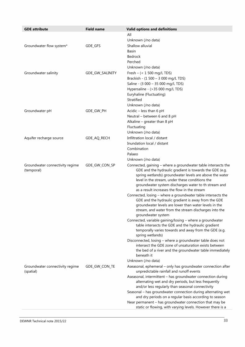
DEWNR Technical note 2015/22 33
GDE attribute Field name Valid options and definitions
All
Unknown (/no data)
Groundwater flow system* GDE_GFS Shallow alluvial
Basin
Bedrock
Perched
Unknown (/no data)
Groundwater salinity GDE_GW_SALINITY Fresh – (< 1 500 mg/L TDS)
Brackish - (1 500 – 3 000 mg/L TDS)
Saline - (3 000 – 35 000 mg/L TDS)
Hypersaline - (>35 000 mg/L TDS)
Euryhaline (Fluctuating)
Stratified
Unknown (/no data)
Groundwater pH GDE_GW_PH Acidic – less than 6 pH
Neutral – between 6 and 8 pH
Alkaline – greater than 8 pH
Fluctuating
Unknown (/no data)
Aquifer recharge source GDE_AQ_RECH Infiltration local / distant
Inundation local / distant
Combination
Palaeo
Unknown (/no data)
Groundwater connectivity regime
(temporal)
GDE_GW_CON_SP Connected, gaining – where a groundwater table intersects the
GDE and the hydraulic gradient is towards the GDE (e.g.
spring wetlands) groundwater levels are above the water
level in the stream, under these conditions the
groundwater system discharges water to th stream and
as a result increases the flow in the stream
Connected, losing – where a groundwater table intersects the
GDE and the hydraulic gradient is away from the GDE
groundwater levels are lower than water levels in the
stream, and water from the stream discharges into the
groundwater system
Connected, variable gaining/losing – where a groundwater
table intersects the GDE and the hydraulic gradient
temporally varies towards and away from the GDE (e.g.
spring wetlands)
Disconnected, losing – where a groundwater table does not
intersect the GDE zone of unsaturation exists between
the bed of a river and the groundwater table immediately
beneath it
Unknown (/no data)
Groundwater connectivity regime
(spatial)
GDE_GW_CON_TE Aseasonal, ephemeral – only has groundwater connection after
unpredictable rainfall and runoff events
Aseasonal, intermittent – has groundwater connection during
alternating wet and dry periods, but less frequently
and/or less regularly than seasonal connectivity
Seasonal – has groundwater connection during alternating wet
and dry periods on a regular basis according to season
Near permanent – has groundwater connection that may be
static or flowing, with varying levels. However there is a

DEWNR Technical note 2015/22 34
GDE attribute Field name Valid options and definitions
possibility that the flow could cease during long or
extreme conditions (e.g. rare or non-cyclic conditions)
Permanent – has groundwater connection that may be static
or flowing, with varying levels. However is predictably
connected to groundwater
Unknown (/no data)
*Note: DSITIA (2015) have further sub-attributes for these attributes

DEWNR Technical note 2015/22 35
5 References
AETG, 2012a, Aquatic Ecosystems Toolkit, Module 4: Aquatic Ecosystem Delineation and Description Guidelines, Australian
Government Department of Sustainability, Environment, Water, Populations and Community, Canberra.
AETG, 2012b, Aquatic Ecosystems Toolkit, Case Study 1: Lake Eyre Basin, Australian Government Department of
Sustainability, Environment, Water, Populations and Community, Canberra.
Bureau of Meteorology, 2015, Atlas of groundwater dependent ecosystems, Commonwealth of Australia, accessed on-line
15/04/15, http://www.bom.gov.au/water/groundwater/gde/map.shtml
Cendón DI, Larsen JR, Jones BG, Nanson GC, Rickleman D, Hankin SI, Pueyo JJ and Maroulis J, 2010, Freshwater recharge
into a shallow saline groundwater system, Cooper Creek floodplain, Queensland Australia. Journal of Hydrology, 392, 150-
163
Costelloe J, 2008, Draft Final Report: Updating and Analysis of the ARIDFLO water level data in the Lake Eyre Basin.
University of Melbourne, report to SA DWLBC, Adelaide
Costelloe J, 2011, Hydrological assessment and analysis of the Neales Catchment, Report to the South Australian Arid Lands
Natural Resources Management Board, Port Augusta.
Costelloe, J., Western, A.W. & Irvine, E.C. (2006) Recharge mechanisms in an arid zone river: effects of channelisation. In:
3rd Hydrology and Water Resources Symposium, Launceston, Tasmania.
Costelloe JF, 2013, Hydrological assessment and analysis of the Cooper Creek catchment, South Australia. Report by the
University of Melbourne to the South Australian Arid Lands Natural Resources Management Board, Port Augusta.
Costelloe JF, Grayson RB, McMahon TA and Argent RM, 2005b, Spatial and temporal variability of water salinity in an
ephemeral, arid-zone river, central Australia. Hydrological Processes, 19, 3147-3166.
Costelloe JF, Irvine EC, Western AW and Herczeg AL, 2009, Groundwater recharge and discharge dynamics in an arid zone,
ephemeral lake system, Australia. Limnology and Oceanography 54, 86-100
Costelloe J, Payne E, Woodrow IE, Irvine EC, Western AW and Leaney FW, 2008, Water sources accessed by arid zone
riparian trees in highly saline environments, Australia. Oecologia, 156, 43-52.
Costelloe J, Prowling J, Reid JRW, Shiel RJ and Hudson P, 2005a, Algal diversity and assemblages in arid zone rivers of the
Lake Eyre Basin, Australia. River Research and Applications, 21, 337-349.
Costelloe J F, Shields A, Grayson RB and McMahon TA, 2007, Determining loss characteristics of arid zone river waterbodies.
River Research and Applications 23: 715-731
Costelloe JF and Russell KL (2014) Identifying conservation priorities for aquatic refugia in an arid zone, ephemeral
catchment: a hydrological approach, 7(6): 1534–1544
Denny, M, and Berens, V, 2014, Water Asset Database and Knowledge Gap Summary, SA Arid Lands NRM Region, DEWNR
Report, Government of South Australia, through Department of Environment, Water and Natural Resources, Adelaide
Department for Environment, Water and Natural Resources (DEWNR), 2015a, Lake Eyre Basin Water Knowledge Projects
Summary Version 4, Government of South Australia through Department for Environment, Water and Natural Resources
Department for Environment, Water and Natural Resources (DEWNR), 2015b, Project Plan: Ecosystems dependent on
shallow groundwater systems in the Western Rivers catchments (Lake Eyre Basin)
Department of Science, Information Technology and Innovation (DSITIA), 2015, Lake Eyre Basin Springs Assessment Project:
Groundwater Dependent Ecosystem Report, Department of Science, Information Technology and Innovation, Brisbane.

DEWNR Technical note 2015/22 36
Fee B and Scholz G, 2010, Draft South Australian Aquatic Ecosystems Program – Stage Two Report. Development of a South
Australian Aquatic Ecosystems classification and its potential applications. Draft technical report, Government of South
Australia, through Department for Water, Adelaide.
Fulton S, Wohling D, Love AJ, Berens V, 2013, Chapter 3: Ephemeral river recharge, in Love, AJ, Wohling, D, Fulton, S,
Rousseau-Gueutin, P & De Ritter, S (eds), Allocating Water and Maintaining Springs in the Great Artesian Basin, Volume II:
Groundwater Recharge, Hydrodynamics and Hydrochemistry of the Western Great Artesian Basin, National Water
Commission, Canberra.
Geoscience Australia, 2015, Water Observations from Space, accessed on-line 20/04/15, http://www.ga.gov.au/scientific-
topics/hazards/flood/capabilities/wofs, Geoscience Australia, Australian Government
Gillen JS and Reid JRW, 2013, Vegetation and soil assessment of selected waterholes of the main and northwest channels of
Cooper Creek, South Australia, April-May 2012. A report by the Australian National University to the South Australian Arid
Lands Natural Resources Management Board, Pt Augusta.
Gotch T, 2013, Chapter 2: Spatial survey of springs, in Lewis MM, White D and Gotch T (Eds) Allocating Water and
Maintaining Springs in the Great Artesian Basin, Volume IV: Spatial survey and remote sensing of artesian springs of the
Western Great Artesian Basin. National Water Commission, Canberra.
Government of South Australia (2015) Waterconnect Groundwater data, accessed on-line 15/04/15,
https://www.waterconnect.sa.gov.au/Systems/GD/Pages/default.aspx#Unit Number
Hamilton SK, Bunn SE, Thoms MC and Marshall JC, 2005, Persistence of aquatic refugia between flow pulses in a dryland
river system (Cooper Creek, Australia). Limnology and Oceanography. 50 (3): 743-754.
Harrington GA, Smerdon BD, Gardner PW, Taylor AR aand Hendry J, 2013, Chapter 8: Diffuse discharge, in Love AJ, Shand P,
Crossey L, Harrington GA and Rousseau-Gueut P (eds) Allocating water and maintaining springs in the Great Artesian Basin,
Volume III: Groundwater discharge of the western Great Artesian Basin. National Water Commission, Canberra.
Kellett JR, Bell JG, Stewart GA and Ransley TR (2012) Chapter 6: Regional Watertable, In: Ransley TR and Smerdon BD (eds)
Hydrostratigraphy, hydrogeology and system conceptualisation of the Great Artesian Basin. A technical report to the
Australian Government from the CSIRO Great Artesian Basin Water Resource Assessment. CSIRO Water for a Healthy
Country Flagship, Australia
Keppel M, Karlstrom KE, Love AJ, Priestley S, Wohling D and De Ritter S, 2013, Allocating water and maintaining springs in
the Great Artesian Basin, Volume I: hydreogeological framework of the western Great Artesian Basin. In. National Water
Commission, Canberra.
Larson JR, 2011, Aspects of the contemporary and Quaternary hydrology of the Lake Eyre Basin, central Australia, Doctor of
Philosophy thesis, School of Earth and Environmental Sciences, University of Wollongong.
Lewis M, White D & Gotch T (eds), 2015, Allocating Water and Maintaining Springs in the Great Artesian Basin, Volume IV:
Spatial Survey and Remote Sensing of Artesian Springs of the Western Great Artesian Basin, National Water Commission,
Canberra.
Love AJ, Wohling D, Fulton S, Rousseau-Gueutin P and De Ritter S (Eds), 2013, Allocating water and maintaining springs in
the Great Artesian Basin, Volume II: Groundwater Recharge, hydrodynamics and hydrochemistry of the western Great
Artesian Basin. National Water Commission, Canberra.
McNeil DG, Schmarr DW and Rosenberger AE, 2011, Climatic variability, fish and the role of refuge waterholes in the Neales
River Catchment: Lake Eyre Basin, South Australia. Report by South Australian Research and Development Institute (Aquatic
Sciences to the South Australian Arid Lands Natural Resources Management Board.
Mensforth LJ, Thorburn PJ, Tyerman SD and Walker GR, 1994, Sources of water used by riparian Eucalyptus camaldulensis
overlying highly saline groundwater. Oecologia, 100, 21-28.

DEWNR Technical note 2015/22 37
Miles C and Miles MW, 2015, South Australian Lake Eyre Basin aquatic ecosystem mapping and classification, DEWNR
Technical report 2015/43, Government of South Australia, through Department of Environment, Water and Natural
Resources, Adelaide
Miles C, Keppel M, Osti A and Foulkes J (2015) Context statement for the Arckaringa subregion. Product 1.1 for the
Arckaringa subregion from the Lake Eyre Basin Bioregional Assessment. Department of the Environment, Bureau of
Meteorology, CSIRO, Geoscience Australia and Government of South Australia, Australia.
Richardson S, Irvine E, Froend R, Boon P, Barber S and Bonneville B, 2011, Australian groundwater-dependent ecosystem
toolbox part 1: assessment framework, Waterlines report, National Water Commission, Canberra
Ryu D, Costelloe J, Pipunic R and Su C-H, 2014, Rainfall-runoff modelling of the Neales River catchment. Department of
Infrastructure Engineering, University of Melbourne, Melbourne.
Shiel RJ, Costelloe JF, Reid JRW, Hudson P and Powling J, 2006, Zooplankton diversity and assemblages in arid zone rivers of
the Lake Eyre Basin, Australia. Marine and Freshwater Research, 57, 49-60.
Tunn Y and Cameron J, 2008, Wetland Mapping in the Lower Cooper and Georgina-Diamantina Catchments, Lake Eyre
Basin, Department for Environment and Heritage, Adelaide
Turner D, Clark K, White D and Lewis M, 2015, Mapping areas of Great Artesian Basin diffuse discharge, draft report by the
University of Adelaide to the South Australian Department of Environment, Water and Natural Resources.
Tweed S, Leblanc M, Cartwright I, Favreau G and Leduc C, 2011, Arid zone groundwater recharge and salinisation processes;
an example from the Lake Eyre Basin, Australia. J. Hydrol. 408, 257-275, doi:10.1016/j.jhydrol.2011.08.008
Wainwright P, Tunn Y, Gibson D and Cameron J, 2006, Wetland mapping, Channel Country bioregion, South Australia.
Department for Environment and Heritage, Adelaide
Wakelin-King G, 2011, Geomorphological assessment and analysis of the Neales Catchment. In. Report to the South
Australian Arid Lands Natural Resources Managment Board, Wakelin Associates, Melbourne.
Wakelin-King G, 2014, Geomorphology of Finke River and Arckaringa Creek: The Bedload Rivers. In. Report by Wakelin
Associates to the South Australian Department of Environment, Water and Natural Resources.
White D, Clarke K and Lewis M, 2014, Mapping groundwater dependent wetland and riparian vegetation with remote
sensing, Progress Report, School of Earth and Environmental Sciences, University of Adelaide.
White D, Schofield B and Lewis M, 2015, Wetland area mapping and flow estimation, draft report by the University of
Adelaide to the South Australian Department of Environment, Water and Natural Resources.