Embed Size (px)
DESCRIPTION
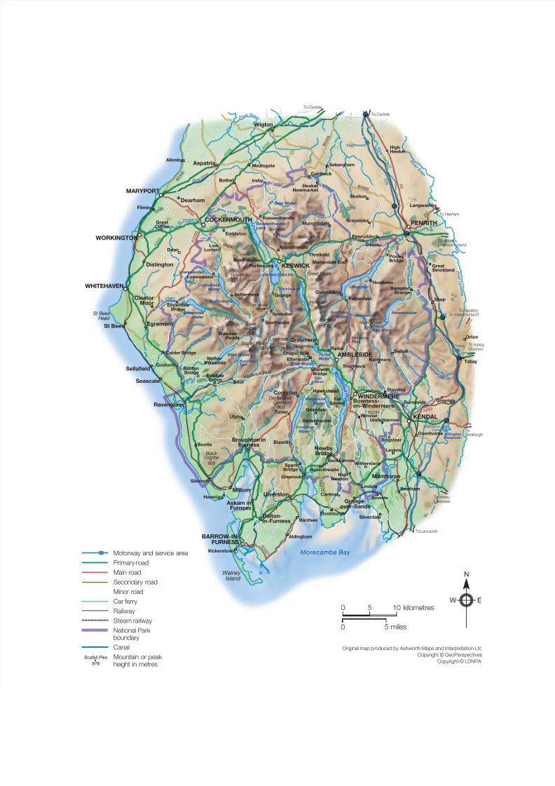
Lake District Map in Relief 2010
Citation preview
7/17/2019 Lake District Map in Relief 2010
http://slidepdf.com/reader/full/lake-district-map-in-relief-2010 1/1
Southwaite
Tebay
KillingtonLake
36
37
38
39
40
41
42
B 5 3 0 5
B 5 2 9 9
B 5 3 0 0
B 5 2 8 9
B5284
B 5 2 7 8
B 5 2 9 2
A 5 0 8 6
A 5 9 4
A 5 9 3
A 5 9 2
A 6 8 5
A 5 9 2
A 5 0 9 1
A 5 9 1
A 6
A 5 9 2
A 5 0 8 4
A 5 0 7 4
A 6
A 5
0 8 7
A 5 9
6 A 5 9
5
A 5 9 5
A 5 9 5
A 5 9 0
A 5 9 5
A 5 9 0
A 591
A 6 6
A 6 6
A 6
A 6 5
A 684
A5092
M 6
M 6
To Lancaster
To Kirkby Lonsdale
ToSedbergh
To Kirkby Stephen
To Appleby in-Westmorland
To Appleby in-Westmorland
To Hexham
To Carlisle
To Carlisle
KirkstonePass
H a r d k n o t t
P a s s
Honister Pass
W r y n o s e
P a s s
R . D e r we nt
R i v
e r E
d e n
R i v
e r P e t t e
r i l
R . G r e t a
R i v e r E l l e
n
R i v
e r
D e r w e n
t
R .
C o c
k e r
R. I r t
R . E he n
R i v e
r E s k
R i v e
r B l e n
g
R i v
e r D
u d d o n
R i v e r C
r a k
e
R .
W
i n s
t e
r
R . K e n t
R i v e r K
e n
t
R .
E a m o n
t
R i
v e r L
o w t h
e r
R i v
e r C a l d e w
R i v e r W a v e
r
R i
v e r L
y v e n n
e t
B o r r o
w d a l e
B e c k
R i v
e r S
p r i n
t
978902
950
931
803
899
892 873
868
733
856851
829
600
Scafell PikeBowfell
Helvellyn
Skiddaw
Old Man of Coniston
Great Gable
Pillar Fairfield
Blencathra
LangdalePikes
Great Dodd Grasmoor
High Street
Black Combe
Morecambe Bay
Walney Island
St BeesHead
Tarn Hows
Killington Reservoir
Hayeswater
Blea Water
Burnmoor Tarn
Bassenthwaite Lake
Over Water
Crummock Water
EnnerdaleWater
Loweswater
Buttermere
Derwe ntwa ter
Grasmere
Elter Water
EsthwaiteWater
Rydal Water
BrothersWater
W i n
d e r
m e r
e
Wast Water
ConistonWater
Thirlmere Ullswater
Haweswater
Hawkshead
Troutbeck
Kentmere
Sadgill
TorverUlpha
Backbarrow
BamptonGrange
Greystoke
Skelton
Mungrisdale
Threlkeld
Matterdale End
Glenridding
Howtown
Pooley Bridge
Patterdale
Penruddock
Dacre
GreatStrickland
Langwathby
HighHesket
Sebergham
Caldbeck
HesketNewmarket
Mealsgate
Bothel
Allonby
Flimby
Shap
Orton
GreatClifton
Dean
Calder Bridge
Gosforth
NetherWasdale
Boot
SantonBridge
EskdaleGreen
WasdaleHead
Bootle
Silecroft
Haverigg
Blawith
Satterthwaite
Grizedale
FarSawrey
Aldingham
Vickerstown
Bardsea
Flookburgh
Greenodd
SparkBridge Haverthwaite
Cartmel
Lindale
HighNewton
Witherslack
Levens
Brigsteer
Silverdale
Arnside
Beetham
Embleton
LowLorton
Braithwaite
Applethwaite
Portinscale
Grange
Seathwaite
Seatoller
Chapel Stile
Elterwater
Rydal
SkelwithBridge
Buttermere
Loweswater
EnnerdaleBridge
Bassenthwaite
Ireby
UnderbarrowWinster
Oxenholme
Burneside Grayrigg
Tebay
Staveley
Grasmere
Coniston
Newby Bridge
Bowness-on-Windermere
Ulverston
Askam inFurness
Grange-over-Sands
Dalton-in-Furness
Broughton inFurness
Millom
Ravenglass
EgremontSt Bees
CleatorMoor
Distington
Dearham
Wigton
Milnthorpe
Aspatria
Seascale
Sellafield
PENRITH
KESWICK
AMBLESIDE
WHITEHAVEN
COCKERMOUTH
WINDERMERE
BARROW-IN-FURNESS
KENDAL
WORKINGTON
MARYPORT
0
0 5 miles
5 10 kilometres
Original map produced by Ashworth Maps and Interpretation Ltd
Copyright © GeoPerspectives
Copyright © LDNPA
N
W E
Motorway and service area
Primary road
Main road
Secondary road
Minor road
Car ferry
Railway
Steam railway
National Park boundary
Canal
Mountain or peak height in metres
Scafell Pike
978