Embed Size (px)
Citation preview
Lake Atalanta Park:
Preserving a Community Center and Legacy
By
Jennifer Worth
Elisa Martin
Alison Stricklen

Intro to Geographic
Information Science Instructor Professor Paul Lowrey
Introduction/Background
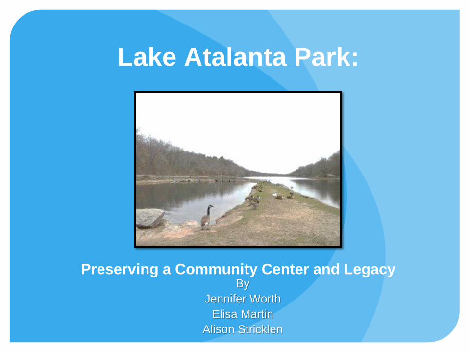
Construction of Lake Atalanta commenced in 1936 as a project of the Works Progress Administration, a New Deal agency aimed at stimulating economic growth and reducing unemployment during the Great Depression. The spring-fed lake was formed by the Prairie Creek Dam and initially used primarily as a fishing resource. By the late 1940's, however, the surrounding areas expanded to offer an abundance of recreational activities and included a picnic area, swimming pool, sporting goods shop, cafe, concession stand, and skating rink-- all forming what is now the Lake Atalanta Park region.
Introduction (cont)
To date, Lake Atalanta Park is still considered an urban fishing resource managed by Arkansas' Families and Community Fisheries Program. An exercise and nature trail, established in the late 1980's connects the park with downtown Rogers and highlights historical features that predate the lake itself. Since the closing of the Lakeside Restaurant in 1995, the other once beloved community recreational centers also began a slow decline and by 2014 all facilities were demolished sparing the park restrooms and pavilion on the south side.
Plans to revitalize the park and increase usage are underway. The City of Rogers began proposing improvements to existing features and the addition of new amenities in 2013. While some community members welcome the changes, others have concerns about the impact of construction on the park's ecology.
PROJECT OVERVIEW Statement of Need:
Lake Atalanta Park serves the city of Rogers, AR by promoting health, wellness, and a sense of community. Park maintenance and revitalization are important steps toward encouraging usage and expanding upon these services. Currently, community access to the park's spatial data regarding trails and recreational areas is limited. Furthermore, although ecological assessments and historical records are publicly available, visibility is reduced for those without the proper means to locate and view the information. Community stakeholders (i.e. residents, planning officials, and researchers) need up-to-date, accessible information about the park that will aid in raising awareness and in making decisions about the park's future.
Purpose of the Project:
The purpose of our project is to utilize geospatial technologies to integrate historical, ecological, and spatial data from Lake Atalanta Park to create an easily accessible, up-to-date story map that encourages community interest, increases patronage, and fosters environmental stewardship as well as provides a useful decision-making tool to planning officials and researchers.
COMMUNITY SERVICES
Communities Served Park users
Residents of Rogers, AR
Researchers and urban planners
Resources provided
We provided a web map with concise and
easily accessible information about Lake Atalanta
Park

COMMUNITY CONTACTS The Rogers Historical Museum
322 South 2nd Street
Rogers, AR 72756
(479)621-1154
Website: http://www.rogersarkansas.com/museum/
Email: [email protected]
The City of Rogers Planning & Transportation Department’s GIS team
301 West Chestnut
Rogers, AR 72756
(479)621-1186
Website: http://www.rogersarkansas.com/
Email: [email protected]
The City of Rogers Parks Department
113 North 4th Street
Rogers, AR 72756
(479)621-1117
Website: http://www.rogersarkansas.com/PARKS/
Email:[email protected]
ACKNOWLEDGEMENTS
We would like to express special thanks to John Burroughs
and Jennifer Sweet at the Rogers Historical Museum for
assisting us with research and providing historical
documents for our project.
Would would also like to give thanks to Jeff Austin from the
City of Rogers Planning & Transportation Department’s GIS
team for sharing spatial data.
This project would not have been possible without the
generosity, time, and resources shared by these
individuals.
CURRICULUM These are the course objectives utilized in our map
design:
Import, store, and manage geographical data from a variety of
sources.
Organize layers, including such tasks as layer activation,
hierarchy, and manipulation of layer display properties to
optimize visual effect.
Utilize skills to create a GIS product for analysis of local
problems, as a final group project
(EMPACTS component).
Symbolizing and classifying features for optimum map display
and analysis.
Generating new data sets through combining existing data
layers (geoprocessing).
Digitizing and editing new map features and their attributes.
Producing quality presentation maps from templates and other
resources.
Exploring and utilizing the growing capabilities of cloud GIS.

The tables below outline the processes, timeline and division
of labor used to complete the project.
METHODOLOGY
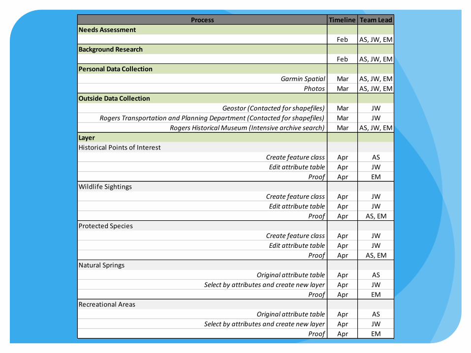
Process Timeline Team Lead
Needs Assessment
Feb AS, JW, EM
Background Research
Feb AS, JW, EM
Personal Data Collection
Garmin Spatial Mar AS, JW, EM
Photos Mar AS, JW, EM
Outside Data Collection
Geostor (Contacted for shapefiles) Mar JW
Rogers Transportation and Planning Department (Contacted for shapefiles) Mar JW
Rogers Historical Museum (Intensive archive search) Mar AS, JW, EM
Layer
Historical Points of Interest
Create feature class Apr AS
Edit attribute table Apr JW
Proof Apr EM
Wildlife Sightings
Create feature class Apr JW
Edit attribute table Apr JW
Proof Apr AS, EM
Protected Species
Create feature class Apr JW
Edit attribute table Apr JW
Proof Apr AS, EM
Natural Springs
Original attribute table Apr AS
Select by attributes and create new layer Apr JW
Proof Apr EM
Recreational Areas
Original attribute table Apr AS
Select by attributes and create new layer Apr JW
Proof Apr EM

Process Timeline Team Lead
Utilities:
Clark Pavillion; Pet Waste Station; Picnic Tables; Restrooms; Drinking Fountains
Original attribute table Apr AS
Select by attributes and create new layer Apr JW
Proof Apr EM
Walking Trails
Editing Apr AS
Roads
Geoprocessing: Clip Apr AS
High Quality Ecological Areas
Editing Apr JW
Geoprocessing: Clip Apr JW
Park Land Area
Import shape files Apr AS, JW, EM
Online Map
Configure Apr JW
Proof Apr AS, EM
Web Application
Configure Apr JW
Proof Apr AS, EM
Power Point
Template Apr AS
Slide Contributions Apr AS, JW, EM
Manage Apr EM
Proof Apr EM
Set Up Empacts Page
Contact and Scheduling May EM
Managing web information May EM
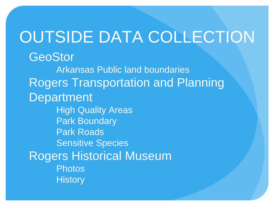
GeoStor Arkansas Public land boundaries
Rogers Transportation and Planning
Department High Quality Areas
Park Boundary
Park Roads
Sensitive Species
Rogers Historical Museum Photos
History
OUTSIDE DATA COLLECTION

We started by collecting data by GPS as we
drove around and walked parts of the trails at the
lake. Pictures were taken with both our phones
and a regular camera.
On another visit to Lake Atalanta we all
walked the trails on the south side of the property
and used GPS as well as our phones again.
We also met at the Rogers Historical Museum
to collect historical photos.
Several group meetings to work on our
EMPACTS project.
PERSONAL DATA
COLLECTION

We produced a map on ArcGIS.com, as well as a mapping
application for public use. Also produced was a webpage on the NWACC
East Lab website.
The group learned how to use a Garmin Etrex GPS and used
various phone mapping apps for additional data collection. Also the group
used a cloud database for sharing of data files. Also we gained additional
proficiency in ArcMap 10.1, specifically in editing and creating features,
working with appropriate coordinate systems, as well as making an
aesthetically pleasing layout.
The group formed several community contacts with the Rogers
Historical Museum and the Rogers Transportation and Planning
Department. As a group, we learned to be persistent in our
communications, and follow through with our data requests. When a
corrupted shapefile was sent to us, we respectfully informed the owner and
requested that it be re-sent.
Individually, we learned to communicate more effectively with one
another, we learned to trust each other as well as to value our own
opinions.
PROJECT RESULTS
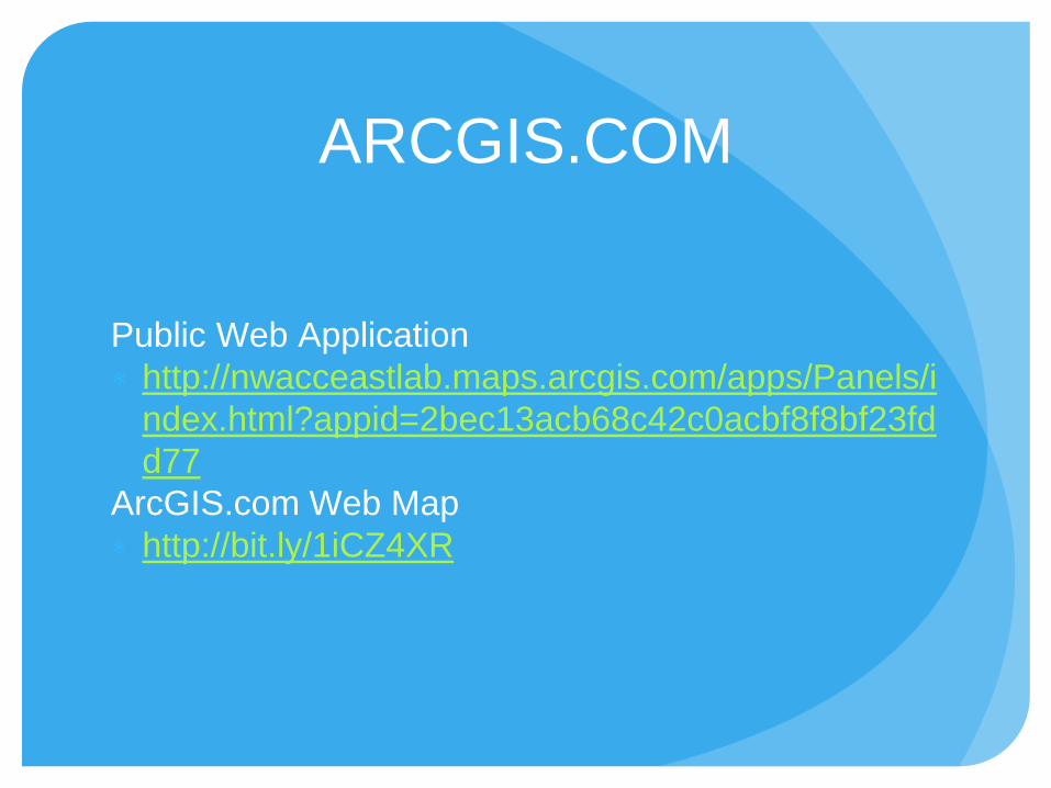
Public Web Application
∗ http://nwacceastlab.maps.arcgis.com/apps/Panels/i
ndex.html?appid=2bec13acb68c42c0acbf8f8bf23fd
d77
ArcGIS.com Web Map
∗ http://bit.ly/1iCZ4XR
ARCGIS.COM

References
Hales, J.F. (2008) The Fabulous 1960s in Rogers, Arkansas:
The People Life and Events During the Middle of the
Century That Made Rogers the Great City it is Today.
Rogers, AR: St. Joseph’s Ozark Press, LLC.
City of Rogers. (2014). ECOLOGICAL ASSESSMENT OF
LAKE ATALANTA ROGERS, BENTON COUNTY,
ARKANSAS. Fayetteville, AR: FTN Associates, Ltd.
The Trail Does Not End Here