Embed Size (px)
DESCRIPTION
Lac de la Chourique (Ibon D’Acherito) by the Brèche de Hanas, followed by the Lac D’Ansabere-
Citation preview
Lac de la Chourique (Ibon D’Acherito) by the Brèche de Hanas, followed by the Lac D’Ansabere- overview
Circular walks around Lescun are not that common, but this has to be the peach. This is the one the locals do. But not that often, so solitude and a remote mountain feeling are more or less guaranteed until arriving at the Lac D’Ansabere. Navigationally there are two challenges. The first is finding the way from the parking at Pont Lamary to the way-marked forest track at the beginning of the route and the second is locating the point where the austere path up to the Col de Laraille is abandoned for the less obvious and equally wild trail up to Hanas. Good visibility is essential. The range of terrain passed through encompasses everything but a mountain peak. It leads from beech and pine forest to arid valleys; from high mountain passes and ridges to sumptuous lakes and pastoral splendour. There is no duplication. The climb up to the brèche is exacting. But take it slowly and stick at it because what awaits is breath-taking!
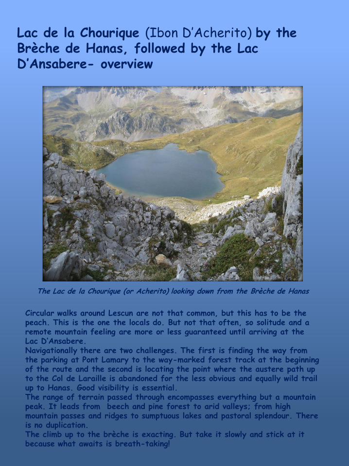
The Lac de la Chourique (or Acherito) looking down from the Brèche de Hanas
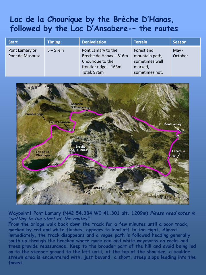
Lac de la Chourique by the Brèche D’Hanas, followed by the Lac D’Ansabere-– the routes
Start Timing Denivelation Terrain Season
Pont Lamary or Pont de Masousa
5 – 5 ½ h Pont Lamary to the Brèche de Hanas – 816m Chourique to the frontier ridge – 163m Total: 976m
Forest and mountain path, sometimes well marked, sometimes not.
May - October
Waypoint1 Pont Lamary (N42 54.384 W0 41.301 alt. 1209m) Please read notes in “getting to the start of the routes”. From the bridge walk back down the track for a few minutes until a poor track, marked by red and white flashes, appears to lead off to the right. Almost immediately, the track disappears and a vague path is followed heading generally south up through the bracken where more red and white waymarks on rocks and trees provide reassurance. Keep to the broader part of the hill and avoid being led on to the steeper ground to the left until, at the top of the shoulder, a boulder strewn area is encountered with, just beyond, a short, steep slope leading into the forest.
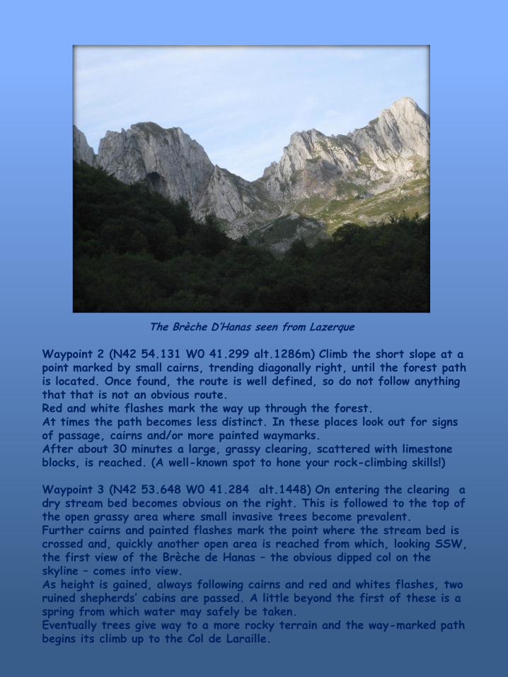
The Brèche D’Hanas seen from Lazerque
Waypoint 2 (N42 54.131 W0 41.299 alt.1286m) Climb the short slope at a point marked by small cairns, trending diagonally right, until the forest path is located. Once found, the route is well defined, so do not follow anything that that is not an obvious route. Red and white flashes mark the way up through the forest. At times the path becomes less distinct. In these places look out for signs of passage, cairns and/or more painted waymarks. After about 30 minutes a large, grassy clearing, scattered with limestone blocks, is reached. (A well-known spot to hone your rock-climbing skills!) Waypoint 3 (N42 53.648 W0 41.284 alt.1448) On entering the clearing a dry stream bed becomes obvious on the right. This is followed to the top of the open grassy area where small invasive trees become prevalent. Further cairns and painted flashes mark the point where the stream bed is crossed and, quickly another open area is reached from which, looking SSW, the first view of the Brèche de Hanas – the obvious dipped col on the skyline – comes into view. As height is gained, always following cairns and red and whites flashes, two ruined shepherds’ cabins are passed. A little beyond the first of these is a spring from which water may safely be taken. Eventually trees give way to a more rocky terrain and the way-marked path begins its climb up to the Col de Laraille.
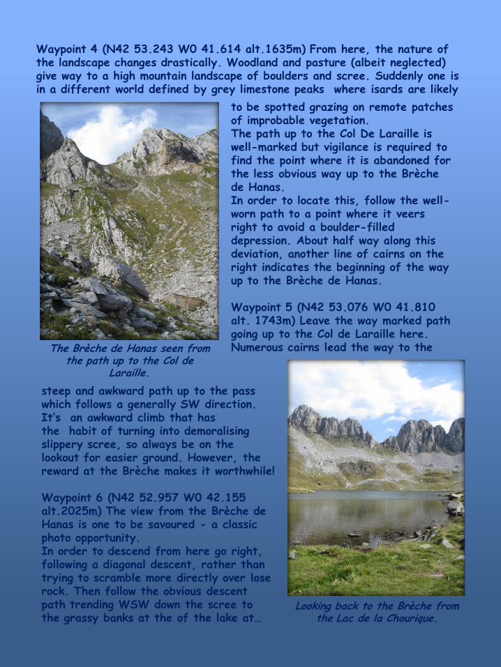
Waypoint 4 (N42 53.243 W0 41.614 alt.1635m) From here, the nature of the landscape changes drastically. Woodland and pasture (albeit neglected) give way to a high mountain landscape of boulders and scree. Suddenly one is in a different world defined by grey limestone peaks where isards are likely
to be spotted grazing on remote patches of improbable vegetation. The path up to the Col De Laraille is well-marked but vigilance is required to find the point where it is abandoned for the less obvious way up to the Brèche de Hanas. In order to locate this, follow the well-worn path to a point where it veers right to avoid a boulder-filled depression. About half way along this deviation, another line of cairns on the right indicates the beginning of the way up to the Brèche de Hanas. Waypoint 5 (N42 53.076 W0 41.810 alt. 1743m) Leave the way marked path going up to the Col de Laraille here. Numerous cairns lead the way to the The Brèche de Hanas seen from
the path up to the Col de Laraille.
steep and awkward path up to the pass which follows a generally SW direction. It’s an awkward climb that has the habit of turning into demoralising slippery scree, so always be on the lookout for easier ground. However, the reward at the Brèche makes it worthwhile! Waypoint 6 (N42 52.957 W0 42.155 alt.2025m) The view from the Brèche de Hanas is one to be savoured - a classic photo opportunity. In order to descend from here go right, following a diagonal descent, rather than trying to scramble more directly over lose rock. Then follow the obvious descent path trending WSW down the scree to the grassy banks at the of the lake at…
Looking back to the Brèche from the Lac de la Chourique.
Waypoint 7 (N42 52.812 W0 42.309 alt. 1875m) After a well-earned rest and possibly, a swim in this famously cold stretch of water go round the lake in either direction in order to reach the narrower SW end. From here there are fine views down the Hecho valley and further into Spain.
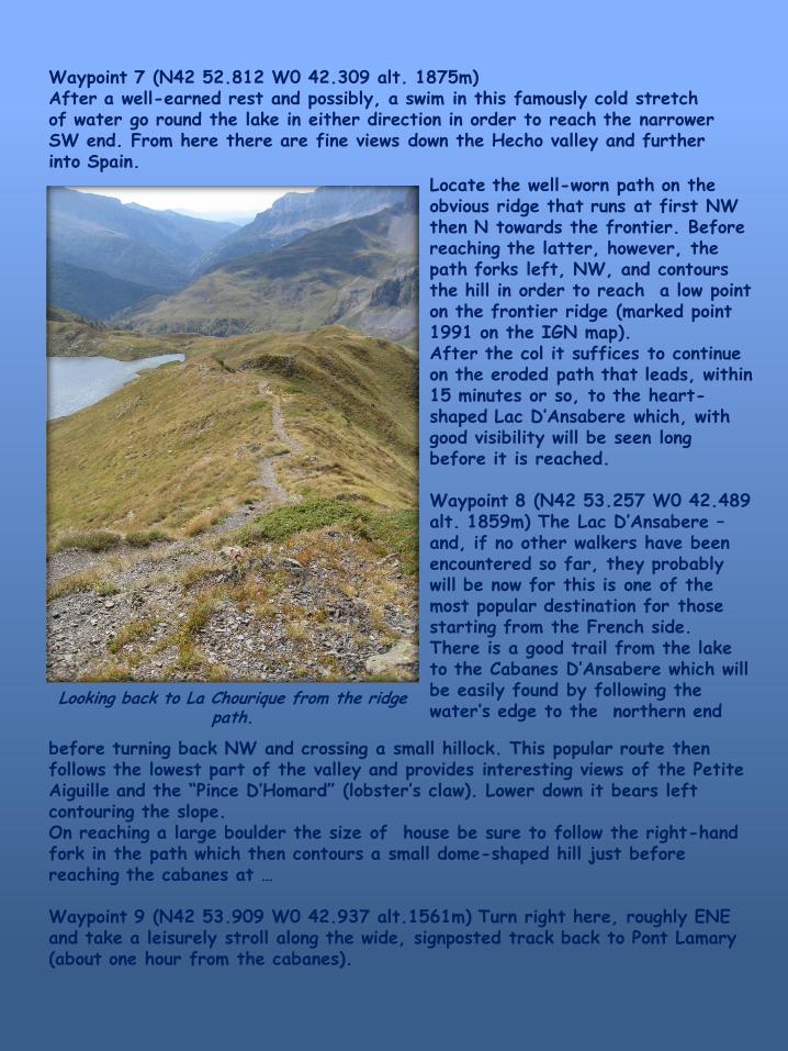
Looking back to La Chourique from the ridge path.
Locate the well-worn path on the obvious ridge that runs at first NW then N towards the frontier. Before reaching the latter, however, the path forks left, NW, and contours the hill in order to reach a low point on the frontier ridge (marked point 1991 on the IGN map). After the col it suffices to continue on the eroded path that leads, within 15 minutes or so, to the heart-shaped Lac D’Ansabere which, with good visibility will be seen long before it is reached. Waypoint 8 (N42 53.257 W0 42.489 alt. 1859m) The Lac D’Ansabere – and, if no other walkers have been encountered so far, they probably will be now for this is one of the most popular destination for those starting from the French side. There is a good trail from the lake to the Cabanes D’Ansabere which will be easily found by following the water’s edge to the northern end
before turning back NW and crossing a small hillock. This popular route then follows the lowest part of the valley and provides interesting views of the Petite Aiguille and the “Pince D’Homard” (lobster’s claw). Lower down it bears left contouring the slope. On reaching a large boulder the size of house be sure to follow the right-hand fork in the path which then contours a small dome-shaped hill just before reaching the cabanes at … Waypoint 9 (N42 53.909 W0 42.937 alt.1561m) Turn right here, roughly ENE and take a leisurely stroll along the wide, signposted track back to Pont Lamary (about one hour from the cabanes).
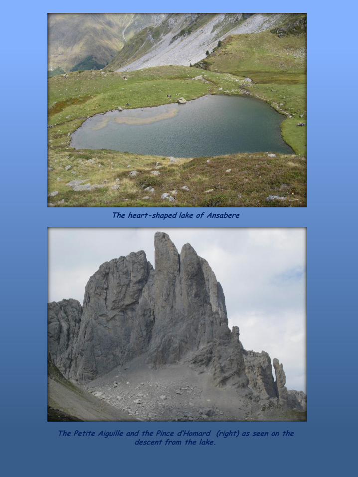
The heart-shaped lake of Ansabere
The Petite Aiguille and the Pince d’Homard (right) as seen on the descent from the lake.