Embed Size (px)
Citation preview
GEOG677 – Internet GIS University of Maryland at College Park
1
Lab Assignment 4 – ArcGIS Server
Due Date: 01/16/2014
Part I: Map Caching
Due to the relative large file size of geospatial data and also the limit of Internet speed, it can be
a challenge to display maps efficiently and fast through Web GIS applications. By servicing a set
of pre-rendered map images at pre-determined scale levels, map caching significantly improves
the speed and performance of map display. This not only reduces the computing load on the
server to free it up for other tasks, but also provides faster responses to the clients. Other benefits
include better cartographic quality and matching with industry standards. To learn more about
map caching, you should read this web page -
http://resources.arcgis.com/en/help/main/10.2/index.html#//01540000048q000000
Given a GIS project, the general procedures of map caching are:
1. Develop caching strategy
2. Author map document
3. Test with pilot project
4. Build the cache
5. Update as needed
There are a lot of details that you must pay attention to, especially the Step 1 and 2. About
properly creating a map document, we have already discussed in Lab 3. The bottom line is that
you must create the best map document you can because the quality of the web mapping product
depends on your effort at this stage. The map document will also affect the map caching process
(e.g. file sizes of the tile images). Therefore, the time spent at this step is definitely well worth it.
To create a good map document, you should pay attention to these factors:
Use adequate but simple symbols
Use appropriate scale ranges for map layers as well as labels
Prefer annotations to labels
Define transparency for polygon layers
Arrange the sequence of layers carefully
Only add necessary operational layers (you can always get the cached basemaps from
ESRI, Google Maps, etc.)
To develop a good caching strategy, you should think about how to address these questions:
Will you combine your cached services?
Which tiling scheme will you use?
What resources do you have?
Which clients will use your cached service?
What type of cache do you need?
What area of the map will you cache?
How will you keep your cache updated?
GEOG677 – Internet GIS University of Maryland at College Park
2
Specifically, there are a lot of valuable tips and tricks about developing a good caching strategy.
For that, you can refer to the lecture slides. You can also refer to this web page for more tips and
tricks -
http://resources.arcgis.com/en/help/main/10.2/index.html#/Tips_and_best_practices_for_map_ca
ches/0154000004q6000000/
Your tasks:
1. Use the data provided to create a GOOD map document (use the same data from Lab3)
2. Use the similar steps in Lab 3 to publish this map document into a service
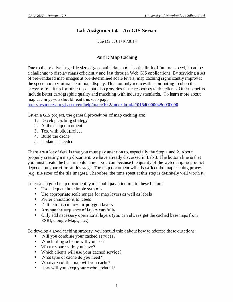
3. Before publishing it, you should check the “Cashing” tab in the Service Editor dialog
window and define the setting as shown in the image below.
4. For the Tiling Scheme, we will choose “ArcGIS Online / Bing Maps / Google Maps”.
Choosing ArcGIS Online/Bing Maps/Google Maps allows you to overlay your
cache tiles with tiles from these online mapping services. ArcGIS projects your
source map on the fly to the required coordinate system of this tiling scheme,
which is WGS 1984 Web Mercator (Auxiliary Sphere). Therefore, if you want to
increase performance when creating tiles, project your data and your data frame to
this coordinate system prior to publishing the service. (You can go back to the
map document and actually change the coordinate system.)
One advantage of the ArcGIS Online/Bing Maps/Google Maps tiling scheme is
that it is widely known in the web mapping world, so your tiles will match those
of other organizations that have used this tiling scheme. Even if you don't plan to
overlay any of these well-known map services, you might choose the tiling
scheme for its interoperability potential.
GEOG677 – Internet GIS University of Maryland at College Park
3
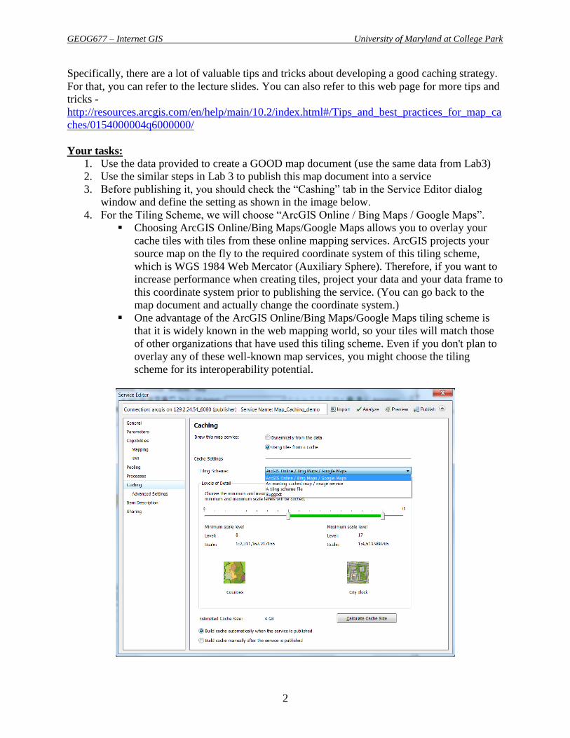
5. Click on the “Calculate Cache Size” button to estimate the size of map caching
This will give you a good idea about the stroage size needed on the server
for cached image tiles.
To save space on the server, let’s define the “Level of Detail” from level 6
to 10. Also choose “Fair” for the Estimate Quality.
6. Click on the “Advanced Settings” under Cashing tab.
To further reduce the size of the caching operation, you can define the “Area of
interest to cache:” by selecting the “PG_Cnty_Bnd” shapefile which you can
create it by yourself.
7. Finish the publishing process.
8. Find and then view this cached map service from the REST folder as a JavaScript API.
GEOG677 – Internet GIS University of Maryland at College Park
4
Part II: ArcGIS API for JavaScript
In Lab 3, you have already practiced some basics about ArcGIS API for JavaScript. However,
there are some changes since the V3.8 released on January 2, 2014.
http://blogs.esri.com/esri/arcgis/2014/01/02/arcgis-api-for-javascript-version-3-8-released/
To catch up on the latest development, you will have to check out these web pages:
Overview - http://help.arcgis.com/en/webapi/javascript/arcgis/
Tutorial - http://help.arcgis.com/en/webapi/javascript/arcgis/jstutorials/#intro_firstmap
Samples -
http://help.arcgis.com/en/webapi/javascript/arcgis/jssamples/#overview_samples
ArcGIS API for JavaScript Sandbox -
http://help.arcgis.com/en/webapi/javascript/arcgis/sandbox/sandbox.html?sample=map_c
reate
o This is a very useful web-based tool which allows you test/modify/learn all of
those sample codes. I would highly recommend you to use this tool to develop
your JavaScript APIs.
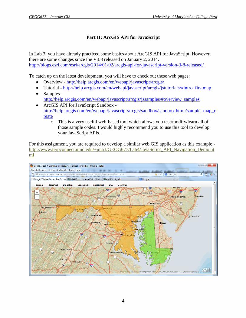
For this assignment, you are required to develop a similar web GIS application as this example -
http://www.terpconnect.umd.edu/~jma3/GEOG677/Lab4/JavaScript_API_Navigation_Demo.ht
ml

GEOG677 – Internet GIS University of Maryland at College Park
5
Your tasks:
You need to check out this specific sample -
http://help.arcgis.com/en/webapi/javascript/arcgis/jssamples/#sample/toolbar_navigation
Read the codes to have a better understanding and find out where you need to modify or
add codes.
You must add at least one operational layer using the map service that you published
before.
You also need to reset the map center according to the operational layer that you use.
o Note: In Google Maps JavaScript API, the map center is defined as (Latitude,
Longitude). However, in ArcGIS API for JavaScript, the map center is defined as
(Longitude, Latitude).
Use the ArcGIS API for JavaScript Sandbox to test the codes.
Publish the HTML file to Terpconnect server.
Part III: Getting to Know ArcGIS.com
Some of you probably have already used ArcGIS.com (http://www.arcgis.com ). But, if you have
not, you must learn how to use it because ArcGIS.com has become a very popular and widely
used tool for web GIS development today.
ArcGIS.com is basically a Web site for working with online GIS maps and applications. It is also
a cloud environment that allows you to create, store, and manage maps, apps, and data, and share
them with others.
The ArcGIS.com Web site is where professional GIS users share information with all kinds of
Web GIS users. The professional GIS community uses ArcGIS Desktop and Server to create and
publish rich maps and geographic information services that are mashed up and referenced in
Web maps. They can share their Web maps online with the ArcGIS community.
There are two types of accounts that you can create on ArcGIS.com: organizational account and
personal account.
With the ArcGIS Online personal account, you can:
Explore a web map in ArcGIS Online
Create an ArcGIS personal Account
Modify and save a web map
Add layers to a web map
Embed a web map
Make a web application
Add data interactively
GEOG677 – Internet GIS University of Maryland at College Park
6
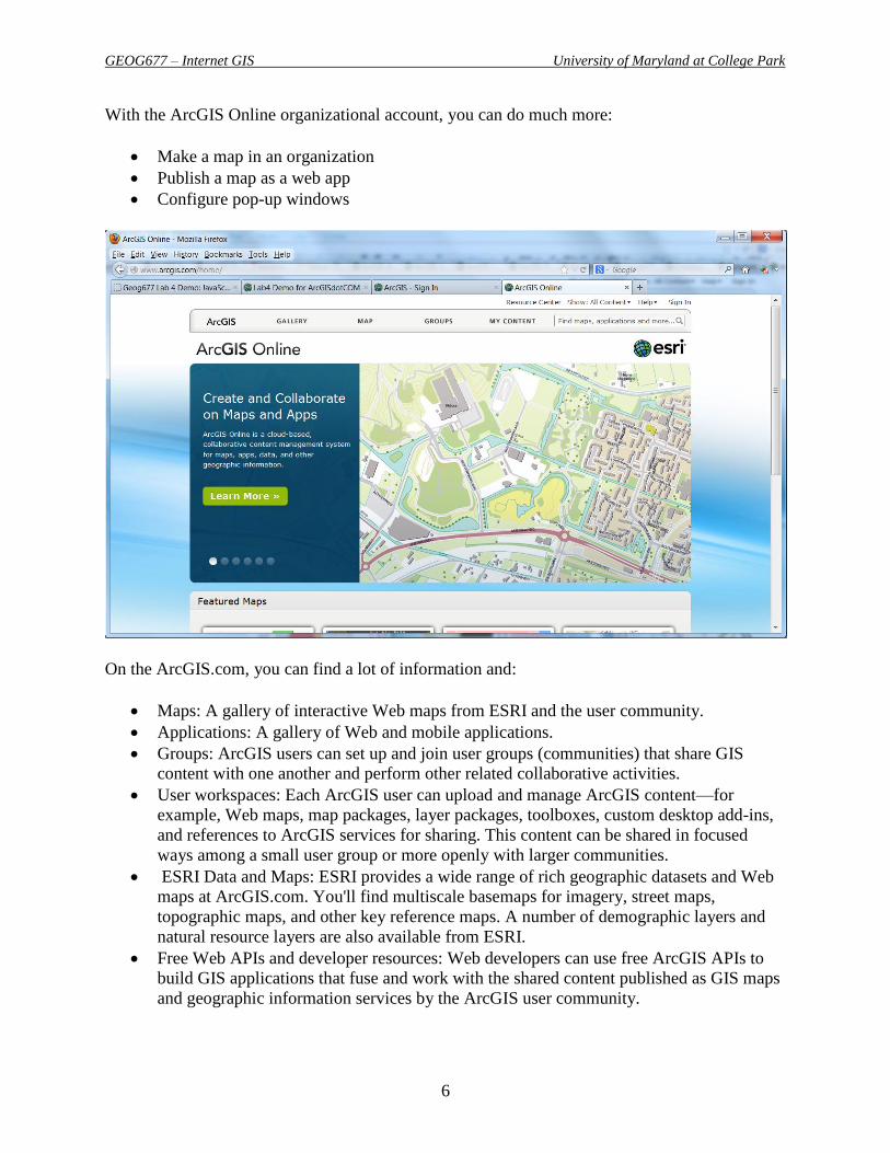
With the ArcGIS Online organizational account, you can do much more:
Make a map in an organization
Publish a map as a web app
Configure pop-up windows
On the ArcGIS.com, you can find a lot of information and:
Maps: A gallery of interactive Web maps from ESRI and the user community.
Applications: A gallery of Web and mobile applications.
Groups: ArcGIS users can set up and join user groups (communities) that share GIS
content with one another and perform other related collaborative activities.
User workspaces: Each ArcGIS user can upload and manage ArcGIS content—for
example, Web maps, map packages, layer packages, toolboxes, custom desktop add-ins,
and references to ArcGIS services for sharing. This content can be shared in focused
ways among a small user group or more openly with larger communities.
ESRI Data and Maps: ESRI provides a wide range of rich geographic datasets and Web
maps at ArcGIS.com. You'll find multiscale basemaps for imagery, street maps,
topographic maps, and other key reference maps. A number of demographic layers and
natural resource layers are also available from ESRI.
Free Web APIs and developer resources: Web developers can use free ArcGIS APIs to
build GIS applications that fuse and work with the shared content published as GIS maps
and geographic information services by the ArcGIS user community.
GEOG677 – Internet GIS University of Maryland at College Park
7
Search and discovery: You can use the search interface to search for and find GIS maps
and information that are shared at ArcGIS.com, served from a particular ArcGIS Server
Web site, or available on the World Wide Web.
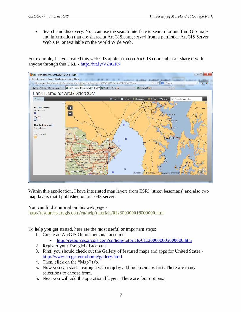
For example, I have created this web GIS application on ArcGIS.com and I can share it with
anyone through this URL - http://bit.ly/VZsGFN
Within this application, I have integrated map layers from ESRI (street basemaps) and also two
map layers that I published on our GIS server.
You can find a tutorial on this web page -
http://resources.arcgis.com/en/help/tutorials/01z300000016000000.htm
To help you get started, here are the most useful or important steps:
1. Create an ArcGIS Online personal account
http://resources.arcgis.com/en/help/tutorials/01z300000005000000.htm
2. Register your Esri global account
3. First, you should check out the Gallery of featured maps and apps for United States -
http://www.arcgis.com/home/gallery.html
4. Then, click on the “Map” tab.
5. Now you can start creating a web map by adding basemaps first. There are many
selections to choose from.
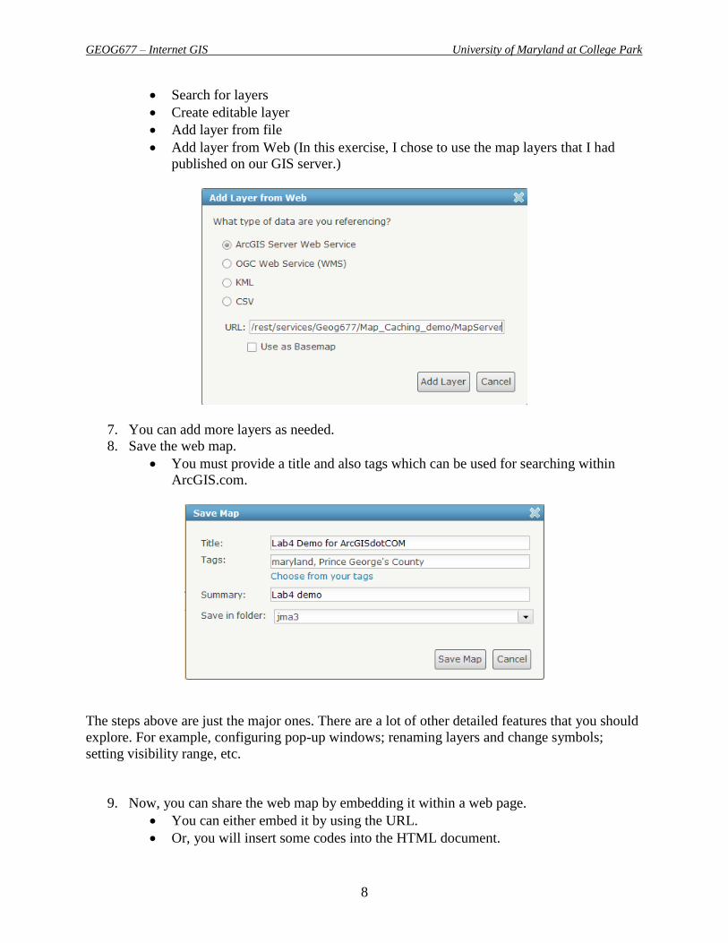
6. Next you will add the operational layers. There are four options:
GEOG677 – Internet GIS University of Maryland at College Park
8
Search for layers
Create editable layer
Add layer from file
Add layer from Web (In this exercise, I chose to use the map layers that I had
published on our GIS server.)
7. You can add more layers as needed.
8. Save the web map.
You must provide a title and also tags which can be used for searching within
ArcGIS.com.
The steps above are just the major ones. There are a lot of other detailed features that you should
explore. For example, configuring pop-up windows; renaming layers and change symbols;
setting visibility range, etc.
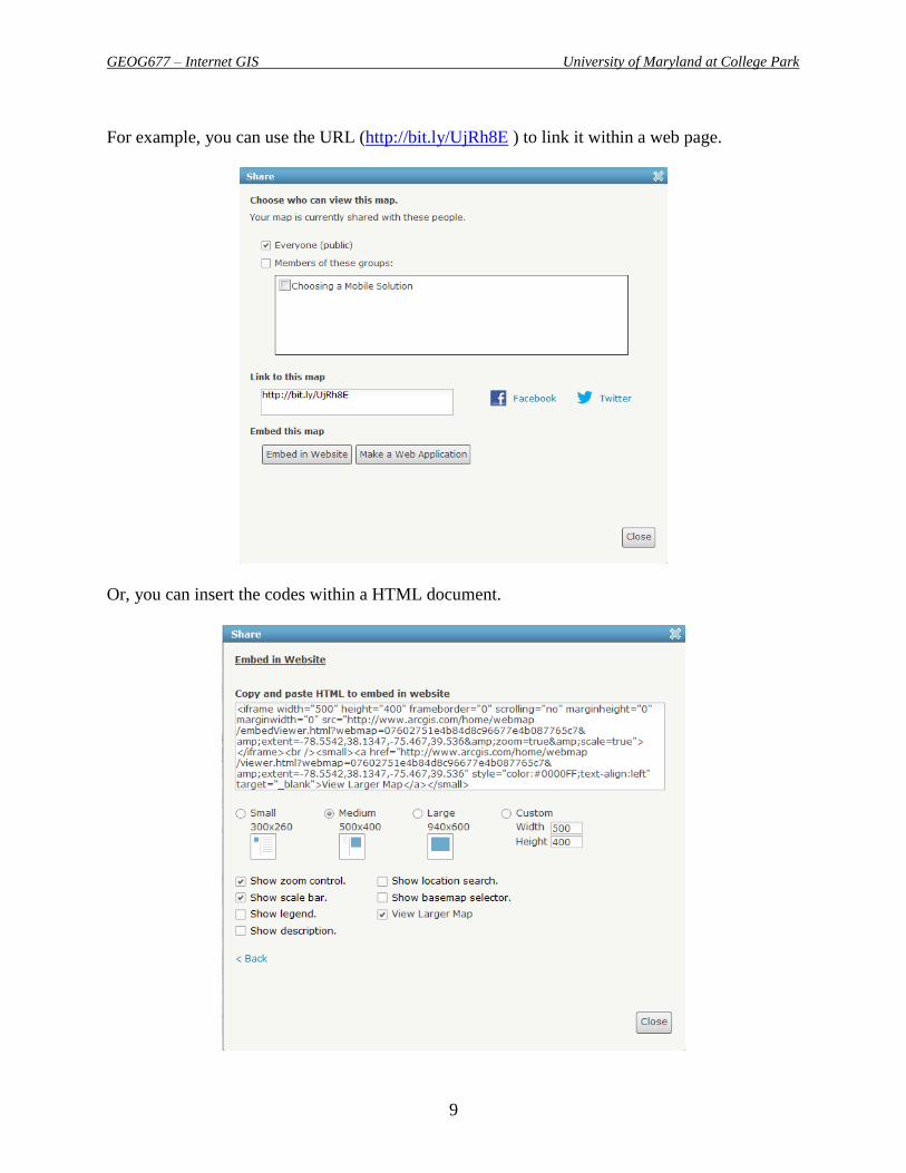
9. Now, you can share the web map by embedding it within a web page.
You can either embed it by using the URL.
Or, you will insert some codes into the HTML document.
GEOG677 – Internet GIS University of Maryland at College Park
9
For example, you can use the URL (http://bit.ly/UjRh8E ) to link it within a web page.
Or, you can insert the codes within a HTML document.

GEOG677 – Internet GIS University of Maryland at College Park
10
Here below is an example of the result -
http://www.terpconnect.umd.edu/~jma3/GEOG677/Lab4/ArcGISdotCOM_Embeded_Demo.htm
l
Your tasks:
You need to create a personal account on ArcGIS.com
Explore the resources and read the tutorials.
Create a web map
o Must add basemap(s)
o Must add operational map layers
Share the web map
o Must create a web site to embed the web map created from ArcGIS.com.
Note: You should create a Word document for the lab report. You should include the URLs of
those web pages and also a brief description followed by some screen shots.
As a reminder, you can be creative as long as your result meets the minimum requirements
indicated above.
----- THE END -----


![[Arcgis] Riset ArcGIS JS & Flex](https://img.pdfslide.us/doc/110x75/55cf96d7550346d0338e2017/arcgis-riset-arcgis-js-flex.jpg)


