Embed Size (px)
Citation preview
Revista Geológica de América Central, 49: 7-23, 2013ISSN: 0256-7024
LA YEGUADA VOLCANIC COMPLEX IN THE REPUBLIC OF PANAMA: AN ASSESSMENT OF THE GEOLOGIC HAZARDS
USING 40AR/39AR GEOCHRONOLOGY
COMPLEJO VOLCÁNICO LA YEGUADA, REPÚBLICA DE PANAMÁ: UNA EVALUACIÓN DE PELIGROS VOLCÁNICOS, MEDIANTE LA
UTILIZACIÓN DE DATACIÓN 40AR/39AR
Karinne L. Knutsena*, William I. Rosea, & Brian Jichab
aMichigan Technological University, Department of Geological and Mining Engineering and Sciences, 1400 Townsend Dr, Houghton, MI 49931, USA
bUniversity of Wisconsin, Madison, Department of Geoscience, 1215 W Dayton St, Madison, WI 53706, USA
*Corresponding author: [email protected]
(Recibido: 01/02/2013 ; aceptado: 26/11/2013)
ABSTRACT: La Yeguada volcanic complex is one of three Quaternary volcanic centers in Panama. To assess potential geologic hazards, new samples were analyzed using argon analysis (40Ar/39Ar ), and obtained the following: the most recent eruption occurred approximately 32,000 years ago at the Media Luna cinder cone; the youngest dated eruption from the main dome complex occurred 357 ± 19 ka, producing the Castillo dome unit; Cerro Picacho, a separate dacite dome 1.5 km east of the main complex is 4.47 ± 0.23 Ma; and the El Satro Pyroclastic Flow unit surrounds the northern portion of the volcanic complex is 11.26 ± 0.17 Ma. No Holocene (10,000 years ago to present) activity is recorded at the La Yeguada volcanic complex and therefore, it is unlikely to produce another eruption. The main geologic hazard at the La Yeguada volcanic complex is from landslides coming off the many steep slopes.Keywords: La Yeguada volcano, Panama volcanism, Media Luna cinder cone.
RESUMEN: El Complejo Volcánico La Yeguada es uno de los tres centros volcánicos cuaternarios en Panamá. Para evaluar los riesgos geológicos potenciales, se analizaron nuevas muestras utilizando el análisis de argón (40Ar/39Ar), y se obtuvo lo siguiente: la erupción más reciente ocurrió hace aproximadamente 32.000 años, en el cono de escoria Media Luna; la erupción más reciente del complejo principal, se produjo en el domo de Castillo, hace 357 ± 19 ka; Cerro Picacho, un domo dacítico separado 1,5 kilómetros al este del complejo principal, es de edad 4,47 ± 0,23 Ma; y el flujo piroclástico El Satro, que rodea la parte del norte del complejo volcánico, tiene una edad de 11,26 ± 0,17 Ma. Ninguna actividad del Holoceno (desde hace 10.000 años presentar) es registrada en el complejo volcánico La Yeguada y por lo tanto, es im-probable que produzca otra erupción. El principal riesgo geológico son los deslizamientos de los escarpes pronunciados. Palabras clave: Volcán La Yeguada, vulcanismo de Panamá, cono de escoria en Media Luna.
KNUTSEN, K.L., ROSE, W.I. & JICHA, B., 2013: La Yeguada Volcanic Complex in the Republic of Panama: An assessment of the geological hazards using 40Ar/39Ar geochronology.- Rev. Geol. Amér. Central, 49: 7-23.
8 REVISTA GEOLÓGICA DE AMÉRICA CENTRAL
Revista Geológica de América Central, 49: 7-23, 2013 / ISSN: 0256-7024
INTRODUCTION
Volcanic hazards in Panama are focused on three volcanic centers thought to be potentially active (Figure 1), but these volcanoes are not well studied. From August 2006 to March 2008, author Knutsen lived in western Panama as a Peace Corps volunteer and a student in the Masters International program at Michigan Technological University, which facilitated sampling and inspection of the hazards associated with the La Yeguada volcanic complex. Existing geochronologic data from La Yeguada (Defant et al., 1991,1992; Richerson, 1990), suggested an extremely wide (possibly un-likely) range of dates from Miocene to Holocene (23 million to <10,000 years ago). We sought to re-assess the age of the complex and evaluate the po-tential volcanic hazards, by dating seven samples using Argon Geochronology (40Ar/39Ar) methods.
REGIONAL SETTING
Panama is a product of the complex interac-tion of the Caribbean, Cocos, Nazca and South American plates (Coates, 1997; Hoernle, 2002; Mann et al., 2007;Wegner et al., 2011), with the subduction of the Nazca plate still occurring be-neath the Panamanian portion of the Caribbean plate. Forming the isthmus between Central and South America, the land mass of Panama is a land bridge for migrations of species, and its for-mation blocked the mingling of the Pacific and Caribbean/Atlantic waters, changing global ocean circulation and weather patterns.
La Yeguada volcanic complex (LYVC) is located in western Panama (8° 27.936’N, 80° 49.160’W) on the southern, Pacific slope of the Cordillera Central; the mountain range that forms a backbone through western Panama. The Cordillera Central is comprised of mainly Miocene (22-7 million years ago (Ma)) volcanics (Wegner et al., 2011, Coates, 1992, De Boer, 1988), and the younger peaks, less than 5 Ma, have come through these older deposits, and are all located on the southern slopes of the Cordillera Central (Defant et al, 1991, 1992). In the Veraguas Province, Calobre District, La Yeguada (sometimes referred
to as Chitra-Calobre) is one of three volcanoes in Panama that are considered potentially active Simkin & Siebert, 1994), the other two are Volcán Barú near the Costa Rica border, which is the tall-est peak in Panama at 3.374 m, and El Valle to the east (see Figure 1).
Tectonic setting
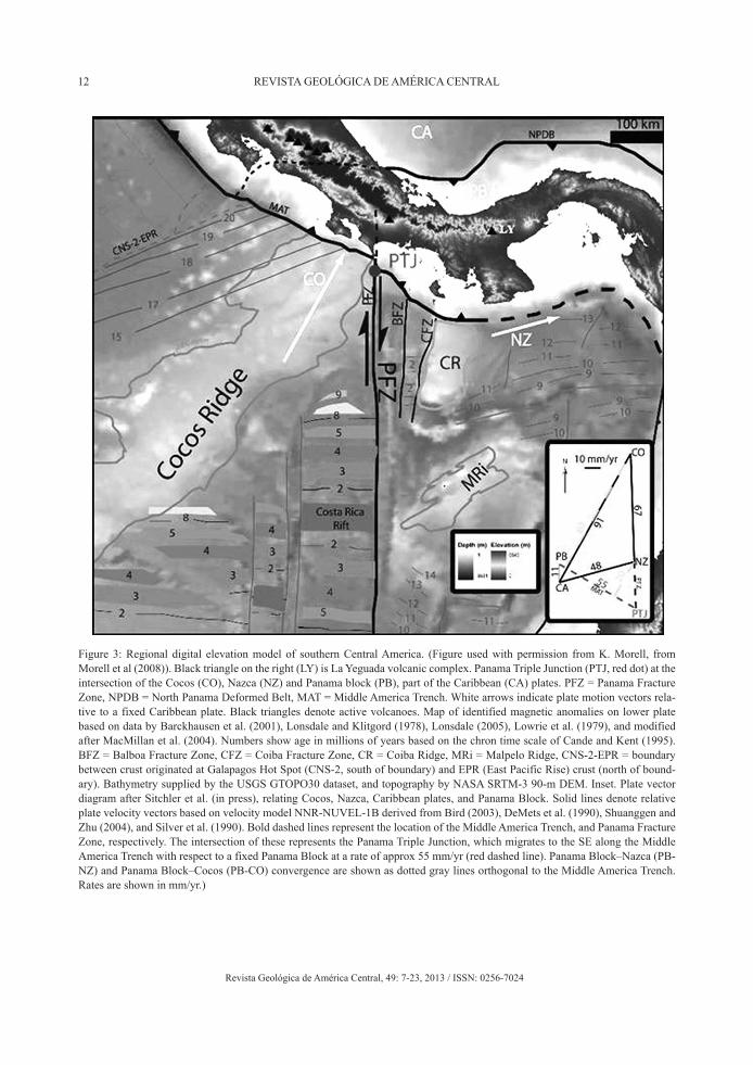
Panama is surrounded by micro–plate boundaries; on the Pacific Ocean side the Nazca and Cocos plates are subducting beneath the Caribbean plate, and a triple junction occurs to the south of the Costa Rica/Panama border (Figure 3). The Panama Fracture Zone runs north/south, separating the Cocos plate on the west from the Nazca plate on the east. All this subducts at the Middle American trench (Morell et al., 2008). Convergence of the North America and South America plates slowly compresses the Caribbean plate, and is more pronounced along its western edge in Central America, which contributes to the zone of deformation along the northern, Caribbean coast of Panama, thus separating the Panama block from the larger Caribbean plate (Hoernle et al., 2002, Morell et al., 2008).
The Central American volcanic front ends abruptly where subduction of the thick Cocos ridge below southern Costa Rica creates onshore uplift of the non-volcanic Talamanca mountain range (Figure 3). East of the Cocos ridge, the Panama Fracture Zone enters the Middle America trench south of the Costa Rica/Panama border. This cor-responds with onshore fracturing (Morell et al., 2008) and volcanic activity resumes with Volcán Barú in western Panama. To the east, there is another change in subduction style, due to more oblique subduction of the Nazca plate below the Panama block, leading to the mild volcanic activ-ity and seismicity witnessed in Panama (Coates, 1997). According to Morell et al. (2008) the tri-ple junction is migrating to the southeast along the trench at the rate of 55 mm per year, and as it slowly migrates, western Panama will experi-ence Cocos subduction similar to current activity below southern Costa Rica.

9KNUTSEN ET AL.: La Yeguada Volcanic Complex in the Republic of Panama...
Revista Geológica de América Central, 49: 7-23, 2013 / ISSN: 0256-7024
It is unclear where the exact termination of the Middle America trench is located, and how it intersects with the South America trench. The last known eruption in Panama occurred 400-500 years ago from Volcán Barú (Sherrod et al., 2007), while the most recent eruption from La Yeguada occurred approximately 32,000 years ago, and at El Valle the El Hato Ignimbrite Flow is known to be younger than 56,000 years based on stratigraphy, but likely is Holocene (<10,000 years) based on the fresh morphology in a tropical area. Compared to the active volcanic systems to the north along most of Central America, Panama has a much larger spacing between volcanic front volcanoes and a less frequent eruptive style. Therefore, most researchers consider it to be geo-logically separate from Central America (Carr et al., 2003, 2007).
La Yeguada volcanic complex (LYVC) setting
It is important to note that the LYVC covers a large area, much of it is quite difficult to ac-cess and therefore there are sampling gaps, which
could lead to sampling biases. Living in the area for almost two years allowed repeated excur-sions to the complex and having contacts with people who lived and worked in the area was very helpful, for example, knowing that once a week a delivery truck traveled to the east side of LYVC during the dry months helped access that area. However, the complex was mostly covered on foot and the southern and southeastern flanks were not examined nearly as well as the other ar-eas thus fewer samples were obtained from these difficult to access locations. The LYVC is easily accessible along its western edge, there is a new paved road to the town of La Laguna and is about an hour and a half drive from Santiago, the capital of Veraguas province. From La Laguna the road deteriorates badly and is not drivable in the rainy season, especially from October to December. Even when dry, few vehicles can navigate the road that goes to the northeast side of the complex to the village of San Jose.
The La Yeguada volcanic complex is com-prised of three separate domes forming a circle; Cerro Castillo to the west and south, Cerro Novillo to the east and Cerro Corero to the north. On the
Fig. 1: Map of Panama showing the three Quaternary volcanic centers and Panama City. From left to right: Volcán Barú, La Yeguada and El Valle. From Jules Verne Voyager (http://jules.unavco.org/Voyager/Earth).
10 REVISTA GEOLÓGICA DE AMÉRICA CENTRAL
Revista Geológica de América Central, 49: 7-23, 2013 / ISSN: 0256-7024
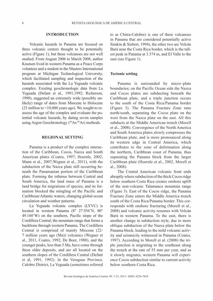
Fig. 2: Geologic map of the La Yeguada Volcanic Complex (Sources: Two topographic maps by the Instituto Geográfico Nacional; (1) Hoja 4041 III serie E762, La Yeguada, Edición 2-IGNTG, Panamá 1:50,000, and (2) Hoja 4041 IV Serie E762, Gatú, Edición 1-IGNTG, Panamá 1:50,000; Hillshade map courtesy of Universidad de Panamá, Departamento de Geofisica, Eduardo Camacho; Digital Elevation Model from Shuttle Radar Topography Mission (SRTM), US Geological Survey 2004 - source for this data set was the Global Land Cover Facility, www.landcover.org; Potassium/Argon (K/Ar) dates from Richerson (1990) and Defant et al. (1991).

11KNUTSEN ET AL.: La Yeguada Volcanic Complex in the Republic of Panama...
Revista Geológica de América Central, 49: 7-23, 2013 / ISSN: 0256-7024
geologic map (see Figure 2) Cerro Corero is its own unit (Tco), while Cerro Novillo and Cerro Castillo are both part of the Castillo unit (Tca). The highest peak is Cerro Castillo at 1 297 m. The Lake La Yeguada and the town La Laguna lie on the western edge of the volcanic complex, and the elevation in the town is 650 m (see Figure 2).
There are small hot springs and seeps located in the area along the Quebrada Media Luna River 1.3 km west of the cinder cone and in the Rio Las Guias approximately 4 km south of the LYVC (see Figure 2). In La Laguna, there have been reports of occasional “smokes’ or steam emitting from a vent along the northeastern flank of Cerro Corero (part of the LYVC). Investigation by au-thor Knutsen revealed that this spot is a small flat area covered by grasses and rocks, showing no evidence of hydrothermal activity or deposits at this time.
The area surrounding LYVC is classified as pre-montane wet forest, which consists of low-land and mid-elevation rain forest species (Bush, 1992), but most of the native vegetation is gone, replaced with large plantations of Caribbean Pine covering more than 2,000 hectares (Autoridad Nacional de Panama (ANAM)), weedy grasses and farmland. A portion of the LYVC is used for farming, some for shade grown coffee, but mostly for corn, beans, rice and other crops. Most of the soils in the area are degraded and poor, and much of the land is unsuitable for growing crops and is used for grazing cattle. The valley where Media Luna is located (both the town and the cinder cone), has a much richer soil, possibly because of the young volcanic material, and better sup-ports crops. Some of the moisture coming from the north over the Cordillera Central reaches this valley during the dry season, but does not reach the main volcanic complex area, which only gets moisture during the rainy season.
Historical record of Lake La Yeguada
Lake La Yeguada has existed for the past 14,000 years (Coates, 1997). Only a few other long-lasting lakes have been located in Central America, and have proved important for studying the effects
of the last ice age and how people, animals and plants migrated across the land bridge. A lake dating back to possibly 100,000 years ago filled the crater of El Valle, but the lake drained when a crack in the crater wall opened about 8,000 years before the present (BP). Pollen and phytoliths (sil-ica nodules from plants) from the lake cores of La Yeguada and El Valle record the descent of high-land species during the time of cooling of the last ice age, though no ice covered Panama. Unlike portions of the Caribbean coast in Guatemala and Belize, which were characterized by dry savannas during the last ice age, the data show that lowland Panama was continually forested during the en-tire period exposed by the lake cores. Changes in weather patterns and plant species are noted dur-ing the transition from the end of the last ice age (about 10,000 BP) into the present (Coates, 1997, Bush et al., 1992).
Several studies have been conducted at Lake La Yeguada (Piperno, 1991, 2003; Bush et al., 1992; Cooke et al., 2003). In Bush et al. (1992) two cores were obtained below the lake and ana-lyzed, and the 17.5 m core dates back to 12,200 BP. Neither the cores nor samples from outcrops along the lakeshore show evidence of any volca-nic products (D. Piperno, wrtn. comm., 2008). An eruption from the main part of the complex would necessarily leave a deposit in Lake La Yeguada, which lies at the foot of the western slope of Cerro Castillo. With low-level winds predominantly coming from the north, it is likely that a trace of an eruption from the Media Luna cinder cone, 10 km to the northwest, would also show up in the lake. Therefore, we conclude that the La Yeguada volcanic complex has not been active for at least the past 12,200 years, which is supported by the rock ages obtained through argon analysis.
Evidence from pollen and phytolith stud-ies show that humans have been using the land around Lake La Yeguada with slash and burn ac-tivity and planting maize, probably since 7,000 BP (Piperno, 2003). The same study shows that around 4,000 BP, the nearby land was mostly de-forested, with a subsequent decrease in agricultur-al usage. Phytolith and pollen samples in the lake cores show that around 350 BP a fairly mature
12 REVISTA GEOLÓGICA DE AMÉRICA CENTRAL
Revista Geológica de América Central, 49: 7-23, 2013 / ISSN: 0256-7024
Figure 3: Regional digital elevation model of southern Central America. (Figure used with permission from K. Morell, from Morell et al (2008)). Black triangle on the right (LY) is La Yeguada volcanic complex. Panama Triple Junction (PTJ, red dot) at the intersection of the Cocos (CO), Nazca (NZ) and Panama block (PB), part of the Caribbean (CA) plates. PFZ = Panama Fracture Zone, NPDB = North Panama Deformed Belt, MAT = Middle America Trench. White arrows indicate plate motion vectors rela-tive to a fixed Caribbean plate. Black triangles denote active volcanoes. Map of identified magnetic anomalies on lower plate based on data by Barckhausen et al. (2001), Lonsdale and Klitgord (1978), Lonsdale (2005), Lowrie et al. (1979), and modified after MacMillan et al. (2004). Numbers show age in millions of years based on the chron time scale of Cande and Kent (1995). BFZ = Balboa Fracture Zone, CFZ = Coiba Fracture Zone, CR = Coiba Ridge, MRi = Malpelo Ridge, CNS-2-EPR = boundary between crust originated at Galapagos Hot Spot (CNS-2, south of boundary) and EPR (East Pacific Rise) crust (north of bound-ary). Bathymetry supplied by the USGS GTOPO30 dataset, and topography by NASA SRTM-3 90-m DEM. Inset. Plate vector diagram after Sitchler et al. (in press), relating Cocos, Nazca, Caribbean plates, and Panama Block. Solid lines denote relative plate velocity vectors based on velocity model NNR-NUVEL-1B derived from Bird (2003), DeMets et al. (1990), Shuanggen and Zhu (2004), and Silver et al. (1990). Bold dashed lines represent the location of the Middle America Trench, and Panama Fracture Zone, respectively. The intersection of these represents the Panama Triple Junction, which migrates to the SE along the Middle America Trench with respect to a fixed Panama Block at a rate of approx 55 mm/yr (red dashed line). Panama Block–Nazca (PB-NZ) and Panama Block–Cocos (PB-CO) convergence are shown as dotted gray lines orthogonal to the Middle America Trench. Rates are shown in mm/yr.)

13KNUTSEN ET AL.: La Yeguada Volcanic Complex in the Republic of Panama...
Revista Geológica de América Central, 49: 7-23, 2013 / ISSN: 0256-7024
forest had regenerated (Piperno, 2003), which appears to correlate to the decline of indigenous populations following the Spanish colonization.
METHODS
Reconnaissance of the area began towards the end of 2006, collection of data and mapping started in February 2007, concentrating first in the Media Luna area, and field work was com-pleted by March 2008. A preliminary map of the complex was created by Richerson (1990), who named several units of the complex. His subdivi-sions have been kept here, so that the data he sup-plied on chemical composition and petrography/mineralogy can readily be part of the interpretive information.
The geologic map (Figure 2) was created using ArcGis, based on the geologic map in both Defant et al. (1991) and Richerson (1990), and used the following layers: two topographic maps, “La Yeguada” and “Gatu” from “Tommy Guardia” in Panama City; hillshade map cour-tesy of Instituto de Geociencias, Universidad de Panama; and the Digital Elevation Model (DEM) is from the Shuttle Radar Topography Mission. The geologic unit names are taken from Defant et al. (1991) and Richerson (1990) (see Figure 2).
Rock sample information
Seven samples were selected for 40Ar/39Ar geochronology and processed at the University of Wisconsin, Madison in the Rare Gas Geochronology Laboratory. Units to be dated were chosen to span the age range of the complex, focusing on the youngest (Media Luna), the main dome, and adjacent deposits. The seven sam-ples are; Media Luna, Castillo, Corero, Novillo, Picacho, the El Satro Pyroclastic Flow, and Mano de Pilon. However, the plagioclase in the Mano de Pilon sample was too altered to be dated, thus only six samples were actually processed.
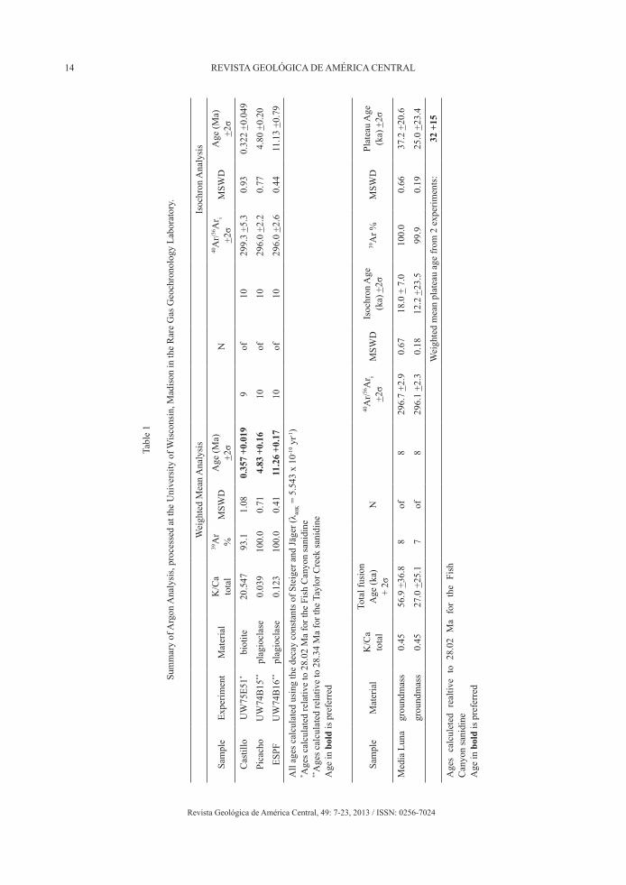
Phenocryst-free groundmass from the Media Luna sample was incrementally heated in a dou-ble-vacuum resistance furnace attached to a 300 cm3 gas clean-up line following the procedures of Jicha (2009). Argon isotope analyses were done using a MAP 215-50 mass spectrometer using a single Balzers SEM-217 electron multiplier, and the isotopic data was reduced using ArArCalc software version 2.5 (Koppers, 2002). Plagioclase from the El Satro pyroclastic flow and Picacho lava, as well as biotite from the Cerro Castillo dome were incrementally heating using a 25 W CO2 laser. The age uncertainties reported in Table 1 and Table 2 for each individual sample are the 2 sigma errors, and the decay constants used are those of Steiger and Jäger, 1977 (Min, 2000). Figure 5 is an age spectrum diagram for the Picacho sample.
RESULTS
Four new 40Ar/39Ar ages were obtained: Media Luna (32 ± 15 thousand years (ka)), Castillo unit (357 ± 19 ka), Picacho unit (4.83 ± 0.16 Ma), and the El Satro Pyroclastic Flow (11.26 ± 0.17 Ma) (Table 1). The Novillo and Corero samples were significantly altered and did not produce reliable dates. Table 2 compares the samples from this pa-per to the samples analyzed by both Defant et al (1991) and Richerson (1990).
Fig. 4: La Yeguada volcanic complex, view looking to the southwest. Cerro Corero is the most prominent peak from this view.
14 REVISTA GEOLÓGICA DE AMÉRICA CENTRAL
Revista Geológica de América Central, 49: 7-23, 2013 / ISSN: 0256-7024
Tabl
e 1
Sum
mar
y of
Arg
on A
naly
sis,
proc
esse
d at
the
Uni
vers
ity o
f Wis
cons
in, M
adis
on in
the
Rar
e G
as G
eoch
rono
logy
Lab
orat
ory.
Wei
ghte
d M
ean
Ana
lysi
sIs
ochr
on A
naly
sis
Sam
ple
Expe
rimen
tM
ater
ial
K/C
a to
tal
39A
r %
MSW
DA
ge (M
a)
+2σ
N40
Ar/36
Ar i
+2σ
MSW
DA
ge (M
a)
+2σ
Cas
tillo
UW
75E5
1*bi
otite
20.5
4793
.11.
080.
357
+0.0
199
of10
299.
3 +5
.30.
930.
322
+0.0
49
Pica
cho
UW
74B
15**
plag
iocl
ase
0.03
910
0.0
0.71
4.83
+0.
1610
of10
296.
0 +2
.20.
774.
80 +
0.20
ESPF
UW
74B
16**
plag
iocl
ase
0.12
310
0.0
0.41
11.2
6 +0
.17
10of
1029
6.0
+2.6
0.44
11.1
3 +0
.79
All
ages
cal
cula
ted
usin
g th
e de
cay
cons
tant
s of S
teig
er a
nd Jä
ger (
λ 40K =
5.5
43 x
10-1
0 yr-1
)* A
ges c
alcu
late
d re
lativ
e to
28.
02 M
a fo
r the
Fis
h C
anyo
n sa
nidi
ne**
Age
s cal
cula
ted
rela
tive
to 2
8.34
Ma
for t
he T
aylo
r Cre
ek sa
nidi
neA
ge in
bol
d is
pre
ferr
ed
Sam
ple
Mat
eria
lK
/Ca
tota
l
Tota
l fus
ion
Age
(ka)
+
2σN
40A
r/36A
r i +2
σM
SWD
Isoc
hron
Age
(k
a) +
2σ39
Ar %
MSW
DPl
atea
u A
ge
(ka)
+2σ
Med
ia L
una
grou
ndm
ass
0.45
56.9
+36
.88
of8
296.
7 +2
.90.
6718
.0 +
7.0
100.
00.
6637
.2 +
20.6
grou
ndm
ass
0.45
27.0
+25
.17
of8
296.
1 +2
.30.
1812
.2 +
23.5
99.9
0.19
25.0
+23
.4
Wei
ghte
d m
ean
plat
eau
age
from
2 e
xper
imen
ts:
32 +
15
Age
s ca
lcul
eted
rea
ltive
to
28.0
2 M
a fo
r th
e Fi
sh
Can
yon
sani
dine
Age
in b
old
is p
refe
rred
15KNUTSEN ET AL.: La Yeguada Volcanic Complex in the Republic of Panama...
Revista Geológica de América Central, 49: 7-23, 2013 / ISSN: 0256-7024
Petrographic inspection of Cerro Mano de Pilon and Cerro Picacho revealed that each sample is extensively altered, both containing de-graded amphibole and biotite, possibly devitrified glass, along with quartz and plagioclase. Picacho (4.83 ± 0.16 Ma) is a dacite, and the deeply weathered Mano de Pilon (undated) is either an andesite or dacite. Richerson (1990) calls Mano de Pilon a rhyodacitic pyroclastic deposit and notes that it appears to be Miocene because it is overlain by the El Satro Pyroclastic Flow (ESPF). Richerson (1990) noted that it is likely that as the younger peaks came up through the older ESPF, some of the ESPF unit was transported and now sits on top of the younger dome rocks. Within the Castillo unit (Tca) two samples are clearly weld-ed tuffs (Castillo 5b [KK040208-4] and Novillo [KK060208-3]), however there is no evidence to support that these are blocks of the ESPF. These welded tuff samples have well-preserved pyro-clastic flow features and are more likely sepa-rate events, which are commonly associated with andesitic and dacitic lava flows (Cas & Wright, 1988). The Knutsen sample of Mano de Pilon is not a welded tuff, and therefore the Richerson sample may be another example of a pyroclastic flow within the unit.
Many of the rocks surrounding La Yeguada and in the greater area are Miocene volcanics, mostly at or near Tortonian (11.6 to 7.2 Ma). The Richerson K/Ar samples b, g and h (see Figure 2) belong to the La Yeguada and Cañazas Formations
with ages of 10.53, 12.72 and 14.7 Ma respective-ly. Sample f, deemed a separate unit by Richerson but not large enough to distinguish on the map, has a K/Ar age of 7.15 Ma. Five 40Ar/39Ar ages were obtained by a German group (GEOMAR); two near Santa Fe, Veraguas to the west (8.7 and 10 Ma), two in the El Cope, Cocle area to the east (12.4 and 12.5 Ma), and one just northwest of Santiago, Veraguas (20.3 Ma) (K. Hoernle, wrtn. comm., 2008). It appears that volcanic output was more voluminous during the Miocene, with the subsequent decrease in volcanism a probable re-sult of the shift in subduction of a hotspot track from western Panama to southern Costa Rica, be-ginning the uplift of southern Costa Rica around 5 Ma (Hoernle et al, 2002). The 40Ar/39Ar age for the El Satro Pyroclastic Flow is also Tortonian (11.26 Ma) and not too different from the La Yeguada and Canazas units. It seems reasonable to assume that a larger dome existed at LYVC in the Miocene, and that the large alluvial fans and lava flows on the southern flank are likely associ-ated with this earlier period of volcanism.
Unfortunately, the Corero sample could not be dated, as this unit appears to be the youngest part of the main dome, and has a lava flow on the northeast corner that maintains a rough looking surface texture. This is the same area where steam reportedly comes out occasionally of a small hole as mentioned in section 2. The youngest eruption in the complex is from the Media Luna cinder cone (approx. 32 ± 15 ka (thousand years)), which is separate from the main dome (Figure 2).
Geologic map of La Yeguada volcanic complex
As noted earlier, the three peaks compris-ing the main volcanic center of La Yeguada are Cerro Castillo, Cerro Corero and Cerro Novillo. The opening of the crater is to the north/north-west, towards the town of El Satro. The El Satro Pyroclastic Flow (ESPF) is the largest unit and extends from the west, along the north, and to the east of the volcanic center and is much older (11.26 ± 0.17 Ma) than the three peaks (Castillo 0.357± 0.019 Ma). It is likely that this unit covered a much larger area than what is currently mapped,
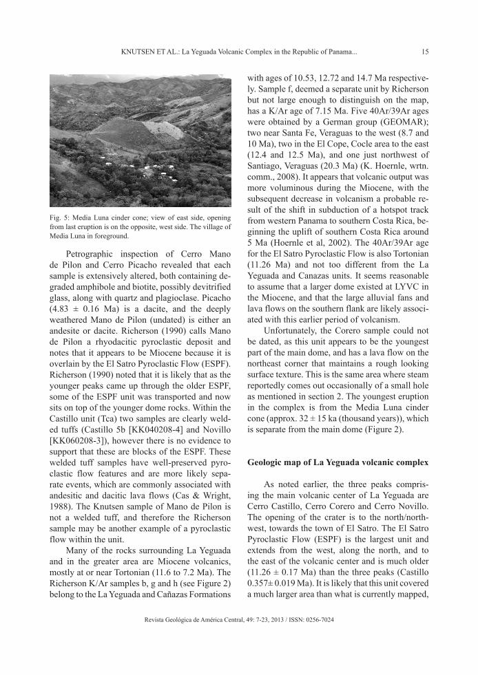
Fig. 5: Media Luna cinder cone; view of east side, opening from last eruption is on the opposite, west side. The village of Media Luna in foreground.
16 REVISTA GEOLÓGICA DE AMÉRICA CENTRAL
Revista Geológica de América Central, 49: 7-23, 2013 / ISSN: 0256-7024
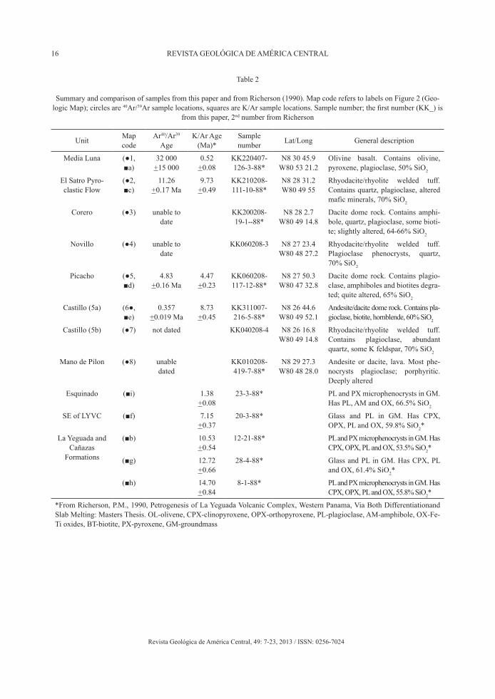
Unit Map code
Ar40/Ar39 Age
K/Ar Age (Ma)*
Sample number Lat/Long General description
Media Luna (●1, ■a)
32 000 +15 000
0.52 +0.08
KK220407-126-3-88*
N8 30 45.9W80 53 21.2
Olivine basalt. Contains olivine, pyroxene, plagioclase, 50% SiO2
El Satro Pyro-clastic Flow
(●2, ■c)
11.26 +0.17 Ma
9.73 +0.49
KK210208-111-10-88*
N8 28 31.2W80 49 55
Rhyodacite/rhyolite welded tuff. Contains quartz, plagioclase, altered mafic minerals, 70% SiO2
Corero (●3) unable to date
KK200208-19-1--88*
N8 28 2.7W80 49 14.8
Dacite dome rock. Contains amphi-bole, quartz, plagioclase, some bioti-te; slightly altered, 64-66% SiO2
Novillo (●4) unable to date
KK060208-3 N8 27 23.4W80 48 27.2
Rhyodacite/rhyolite welded tuff. Plagioclase phenocrysts, quartz, 70% SiO2
Picacho (●5, ■d)
4.83 +0.16 Ma
4.47 +0.23
KK060208-117-12-88*
N8 27 50.3W80 47 32.8
Dacite dome rock. Contains plagio-clase, amphiboles and biotites degra-ted; quite altered, 65% SiO2
Castillo (5a) (6●, ■e)
0.357 +0.019 Ma
8.73 +0.45
KK311007-216-5-88*
N8 26 44.6W80 49 52.1
Andesite/dacite dome rock. Contains pla-gioclase, biotite, hornblende, 60% SiO2
Castillo (5b) (●7) not dated KK040208-4 N8 26 16.8W80 49 14.8
Rhyodacite/rhyolite welded tuff. Contains plagioclase, abundant quartz, some K feldspar, 70% SiO2
Mano de Pilon (●8) unable dated
KK010208-419-7-88*
N8 29 27.3W80 48 28.0
Andesite or dacite, lava. Most phe-nocrysts plagioclase; porphyritic. Deeply altered
Esquinado (■i) 1.38 +0.08
23-3-88* PL and PX microphenocrysts in GM. Has PL, AM and OX, 66.5% SiO2
SE of LYVC (■f) 7.15 +0.37
20-3-88* Glass and PL in GM. Has CPX, OPX, PL and OX, 59.8% SiO2*
La Yeguada and Cañazas
Formations
(■b) 10.53 +0.54
12-21-88* PL and PX microphenocrysts in GM. Has CPX, OPX, PL and OX, 53.5% SiO2*
(■g) 12.72 +0.66
28-4-88* Glass and PL in GM. Has CPX, PL and OX, 61.4% SiO2*
(■h) 14.70 +0.84
8-1-88* PL and PX microphenocrysts in GM. Has CPX, OPX, PL and OX, 55.8% SiO2*
*From Richerson, P.M., 1990, Petrogenesis of La Yeguada Volcanic Complex, Western Panama, Via Both Differentiationand Slab Melting: Masters Thesis. OL-olivene, CPX-clinopyroxene, OPX-orthopyroxene, PL-plagioclase, AM-amphibole, OX-Fe-Ti oxides, BT-biotite, PX-pyroxene, GM-groundmass
Table 2
Summary and comparison of samples from this paper and from Richerson (1990). Map code refers to labels on Figure 2 (Geo-logic Map); circles are 40Ar/39Ar sample locations, squares are K/Ar sample locations. Sample number; the first number (KK_) is
from this paper, 2nd number from Richerson

17KNUTSEN ET AL.: La Yeguada Volcanic Complex in the Republic of Panama...
Revista Geológica de América Central, 49: 7-23, 2013 / ISSN: 0256-7024
and differences in coverage are explained by ero-sion, coverage by younger rocks and incomplete mapping of the peripheries of the complex. The Lake La Yeguada sits inside this unit, and just to the south of the lake the edge of the ESPF unit is evident in the steep drop along the road south of the town of La Yeguada. Defant et al (1991) and Richerson (1990) show the portion of ESPF on the eastern side of LYVC as a debris flow; howev-er we found no evidence of a large debris flow in this area. Most of the rock appears to be ESPF, of-ten deeply weathered, and occasional outcrops of unconsolidated material were noted, but seemed to be small, localized occurrences.
Based on hand samples and topography, it was decided to include Novillo in the Castillo unit as in Defant et al (1991) and Richerson (1990). The La Yeguada dome includes the Castillo unit (comprised of Cerro Castillo and Cerro Novillo) and the Corero unit; the maxi-mum width of the dome is just over 4 km, and the maximum length is about 4.5 km. Large fans come off of the dome to the south and though they may be a product of the LYVC, the mor-phology is distinct and an outcropping along the road south of the town of La Yeguada shows that at least a portion of this material appears to be older, more weathered lava, with re-worked volcanic sediments.
Looking at 3D images, along with the Digital Elevation Model and hillshade, a strong linear feature was noted and drawn in as an inferred fault on the map. It cuts across the dome, separating Cerro Castillo from Cerro Novillo and is probably contributing to the erosion seen inside the crater. Inside the crater, the rock is quite altered, few good exposures were found, and there is much sloughing of material off the rock walls. Along the trail to the top of Cerro Castillo the rocks are highly altered, and at about 1.040 m elevation
there is a section of centimeter scale banding, slop-ing steeply downhill. This is located near the crater edge and could be a result of faulting.
Media Luna cinder cone
The Media Luna cinder cone and its lava flow lie 10 km to the northwest of the main La Yeguada volcanic complex (see Figure 2). The small cone is geomorphologically clearly constructional, and only rises 100 m from the valley bottom, with the top at 700 m, and has a breached opening on the western side. The lava flow breached the cinder cone and follows the Media Luna valley to the east for 2.5 km until it merges with the Rio Chitra drainage, where it spreads out slightly and heads southwest for approximately another 1.5 km. The lava flow deposit is never more than 500 m wide along its entire length. The outline of the Media Luna lava flow was delineated by walking along the contact and carrying a GPS unit, except for two short segments where the continuation of the contact was obvious. In the southwestern por-tion of the lava flow, in the Rio Chitra, there is a distinctive contact between the flow and an older unit, with the flow showing columnar jointing. No outcrops of lava were found on the eastern side of the cinder cone in the village of Media Luna. Instead, the valley floor contains sediments, pos-sibly a result of damming of water behind the cone after emplacement.
La Yeguada stratigraphy
The town of La Yeguada lies in a relatively flat basin that has filled with volcanic sediments. A couple of outcrops in town show an approxi-mately 2.5 m section of small to large boulders

18 REVISTA GEOLÓGICA DE AMÉRICA CENTRAL
Revista Geológica de América Central, 49: 7-23, 2013 / ISSN: 0256-7024
within a fine matrix, which sits unconformably on top of fine-grained sedimentary layers. An outcrop along the road just south of the town of La Yeguada (N8 25.455, W80 51.344), near the hydro-electric station, exposes a larger sequence of sedimentary layers, composed of flat-lying, distinct layers of fine, to very fine grained mate-rial. Some of this material is re-worked volcanic deposits, for example the unit below the soil hori-zon contains abundant altered pumice fragments. Other units appear to be fine sands and muds with probable ash content, and there is a charcoal lens 3 m below the soil horizon, with a maxi-mum thickness of 10 cm and approximately 10 m wide. Below the charcoal, appears to be an old soil layer, with evidence of burrowing. At first, it was supposed that this outcrop would contain lake sediments and samples were sent to a laboratory to date any diatoms, but none were present.
Adakites
Defant et al. (1991) and Richerson (1990) refer to two separate periods of volcanism; rocks belonging to the “young group” are less than 5 Ma and tend to be dacites; and the “old group” which “consists of basalts and basaltic andesites as well as andesites to rhyolites” (Richerson, 1990). For both La Yeguada and El Valle, the term adakite was applied to the young group of rocks based on chemical composition (Richards, 2007) and was presumed to result from a change of style in sub-duction below the Panama block (Castillo, 2006). However, this designation does not apply to the 32,000 year old Media Luna basalt. Other studies have shown that from 4.5 ±0.17 to 0.1 ±0.08 Ma volcanism consisted of low volume alkaline and adakitic eruptions in western Panama (Lissinna, 2006), coinciding with the ages of the younger volcanism at LYVC.
The new ages obtained from both La Yeguada and El Valle verify that there is a gap in volcanism, with an older period ending approximately 5 Ma and then re-initiating around 350,000 years ago in the case of La Yeguada, and 30,000 to 100,000 years ago at El Valle (Hidalgo et al., 2009). Refer to Defant et al. (1991) and Richerson (1990) for
a detailed discussion on the composition changes that occur between the older and younger groups of volcanism.
Magnetism
Richerson (1990) reported data on ground-level paleomagnetic polarity tests, which showed that Cerro Corero and Cerro Picacho are posi-tively magnetized, while Cerro Castillo and Cerro Novillo are negative. At 4.83 Ma, Cerro Picacho belongs to the Sidufjall normal polarity subchron of the Gilbert Chron. However, Cerro Castillo has an age of 0.357 Ma, which puts it in the Brunhes normal polarity Chron and not during a reversed polarity event.
DISCUSSION
Geologic hazards of La Yeguada volcanic complex
The volcanic threat of a specific volcano can be estimated by a systematic methodology as pro-posed by Ewert et al. (2005). Using this method, the relative threat ranking of a given volcano is a product of its hazard score (including volcano type, eruption recurrence, style and frequency of eruptions, etc.) multiplied by its exposure score (humans and property at risk from a volcanic event). The hazard score is based in part on activ-ity younger than 5,000 years. There are five threat subdivisions ranging from very high to very low. Using this system applied to Panama only Volcán Barú has demonstrable significant volcanic threat, since it is the only Panamanian volcano with known activity in the past 5,000 years and also has a fairly high exposure score.
The La Yeguada volcanic complex is listed on the Smithsonian Global Volcano Program as one of the three possible active volcanoes in Panama; therefore it is important to assess the hazards posed by the LYVC, since many small communities surround the complex. At LYVC, the Media Luna cinder cone is the only young deposit with an approximate age of 32,000 years
19KNUTSEN ET AL.: La Yeguada Volcanic Complex in the Republic of Panama...
Revista Geológica de América Central, 49: 7-23, 2013 / ISSN: 0256-7024
ago. The hazards associated with cinder cone ac-tivity are localized and exposure score is also low. Monogenetic cones, such as Media Luna, typi-cally do not produce more than one eruption, and it is conceivable though statistically unlikely, that another cinder cone could erupt somewhere else in the area.
Central American volcanoes tend to be fairly short lived, often no older than a couple 100,000 years, and are characterized by bursts of activity with periods of quiescence (Escobar Wolf, 2007). The youngest obtained age at the main dome complex of LYVC is 357,000, which makes it un-likely that it will erupt again. The span of ages extending back into the Miocene suggests that the complex is the result of two or more distinct eruptive periods, or even several different collo-cated volcanoes. Referring to the volcanic threat analysis methodology of Ewert et al (2005), since there is no evidence for Holocene (<10,000 years) activity at the La Yeguada volcanic complex, we conclude that it is unlikely to erupt and its threat level at very low. The geothermal springs in the area seem to be very weak, and are unlikely sites for hazardous geothermal explosions. However, there is a serious threat posed by potential land-slides due to unstable slopes composed of altered to quite altered rocks, along with the steep slopes surrounding the complex. Further work or re-search should focus on mapping zones most prone to mass wasting.
Geologic hazards of other Panamanian volcanoes
El Valle
The town of El Valle at 500 m sits inside the caldera on a flat valley floor composed of lake sediments. Of the three Quaternary volcanoes in Panama, El Valle is the easternmost volcano and is composed mostly of andesites and dacites, which spans a smaller compositional range than the rocks at La Yeguada, where there are some ba-salts as well as rhyolites. The most recent eruption from El Valle is the El Hato pyroclastic flow, and was likely a caldera collapsing event resulting in an ignimbrite deposit that covers approximately
300 km2 (Hidalgo, 2007). The age of the El Hato deposit is estimated at 30 to 100 ka (Hidalgo et al. 2009), it overlies and is younger than, the 56,000 year old India Dormida dacite, and based on the preserved structures of the flow, it is likely to be Holocene in age. Because this young pyroclastic flow reached far to the south of the volcano and crossed the Pan-American Highway, and because of other units which are younger than 100,000 years, El Valle should be considered a potentially hazardous volcano.
Volcán Barú
Volcán Barú is the tallest of the three Quaternary volcanoes, at 3,374 m, and sits near the Costa Rica border in western Panama (Figure 1). Barú lies on the southern slope of the Cordillera Central, and has an impressively large dome complex that rises over 2,000 m above the populated valleys surrounding it. Spurred by a se-ries of volcanic tremors in 2005, the Panamanian government with the help of USAID, requested assistance from the U.S. Geological Survey to provide a hazard assessment of the volcano. USGS Open-File Report 2007-1401 (Sherrod et al, 2007), is an account of their findings.
Three, perhaps four, eruptions have occurred in the past 1,600 years, and include tephra fall-outs, pyroclastic flows and lahars (Sherrod et al, 2007). A large opening on the southwest side of the dome shows the pathway of a huge dome collapsing event that resulted in a large debris avalanche that crossed the current location of the Pan-American Highway, 30 km to the south. The terrain covered by the debris avalanche deposit has a distinct hummocky character and the de-bris avalanches there have been studied in detail (Herrick, 2011), and have reported a 14C age of about 8 ka for the youngest debris avalanche. The flanks of Volcán Barú are mostly forested, with forests continuing to the north, but to the south the land is fairly densely populated, and supports a rich soil with a cool climate that is an important economic center for vegetable crops and coffee plantations, as well as cattle grazing in the lower areas. Barú has by far the most potential of the
20 REVISTA GEOLÓGICA DE AMÉRICA CENTRAL
Revista Geológica de América Central, 49: 7-23, 2013 / ISSN: 0256-7024
three volcanoes of renewing volcanic activity, as well as the potential to cause considerable dam-age, and subsequently is better monitored with several seismometers in the area.
Caldera theory
It is suggested that the La Yeguada volcanic complex lies within a caldera based on several observations: 1) the roughly circular feature of the complex with arcuate topographic boundaries on its NE and SE margins that contain the peaks Cerro Mano de Pilon and Cerro Picacho, 2) the existence of a main dome complex within the caldera and domes along the edges mimics other known caldera settings, 3) the 11.26 Ma El Satro Pyroclastic Flow is a highly silicic welded tuff, an deposit commonly associated with eruptions from a caldera, and 4) Lake La Yeguada looks to lie within the moat section of the caldera. No detailed field geologic mapping was done to substantiate the presence of a caldera, and further investiga-tion is needed. A preliminary outline of the cal-dera boundary is shown on the geologic map (see Figure 2). As a result of the scatter of dates for La Yeguada, perhaps it is not so much a volcanic complex but a series of events separated by long repose times, so the idea of a caldera seems ques-tionable at least.
Other research
Due to the large area and ruggedness of the terrain, more sampling of the complex would be useful to get a complete picture of the geologic story.
This study only looked at the deposits near the LYVC and Media Luna, but there are other in-teresting volcanic deposits in the greater area and it would be useful to know if they are products of the LYVC or from older periods of volcanism. For example, there is an ignimbrite deposit exposed
in a river channel, located south of the town of Calobre, on the road between San Francisco and Calobre, roughly 20 km to the southwest.
In his thesis, Richerson (1990) mentions two other dacitic domes that this study did not exam-ine. One is the Montanuela dome located about 12 km to the east, and the other is the Esquinado dome, 13.5 km to the southwest. Richerson (1990) obtained a K/Ar date of 1.38 Ma for the Esquinado dome.
Several papers have referenced the fol-lowing paper; [Cooke, R. 1988 “Radiocarbon Dates on Ash Layer in the Laguna Yeguada, and from Oldest Deposits in a Small Lake formed by a Basaltic Lava Flow” (Preliminary Report), Smithsonian Institution (in preparation)]. Richard Cooke from the Smithsonian Tropical Research Institute in Panama, has worked extensively in the area surrounding the LYVC and Media Luna, and met with some of the geologists that have worked in the area, but never published the pa-per listed above (R. Cooke, wrtn. comm., 2008). Apparently, this paper suggested that the young-est eruption from the Media Luna cone may be 360 ± 80 years BP (before the present), based on a dated peat layer from the bottom of a lake near the cone. The hypothesis is that the lake was created by the damming of an old river channel by the last lava flow, and that this peat layer approximates the date of the last eruption. There is no evidence of Holocene eruptions to support this hypothesis.
CONCLUSIONS
Four new 40Ar/39Ar ages at the La Yeguada volcanic complex increase our understanding of its volcanic history, and allow for an assessment of the hazard potential of the complex. The most recent eruption at La Yeguada volcanic complex occurred approximately 32,000 years ago at the Media Luna cinder cone, while the most recent eruption at the main part of the dome occurred 357,000 years ago. We conclude that the most likely geologic hazard
21KNUTSEN ET AL.: La Yeguada Volcanic Complex in the Republic of Panama...
Revista Geológica de América Central, 49: 7-23, 2013 / ISSN: 0256-7024
at La Yeguada would be from landslides, and that an eruption in the near future is extremely unlikely. Looking at the three Quaternary volcanic centers in Panama and their potential hazards, Volcán Barú presents a moderate threat, El Valle a possible threat, and La Yeguada is not a threat.
At this time, the potential hazards for the com-munities in the area surrounding the complex are low. Subduction still occurs beneath Panama and therefore the potential exists for renewed activity in the area. It is recommended to install a seis-mometer, or ideally several, to understand the level of present earthquake activity and then be able to note if activity increases in the future. Residents in El Satro and La Laguna report that they have felt small earth movements in the recent past.
In the past few years, the network of seis-mometers has increased throughout Panama, deployed by the Geophysics department at the Universidad de Panama. Also, the Observatorio Sismico del Occidente de Panama run by Angel Rodriguez, works with the Civil Protection Agency (SINAPROC) in Panama to install, main-tain and update more seismometers in the country.
ACKNOWLEDGEMENTS
Research and graduate study costs for this work came from the US National Science Foundation through SGER grant EAR 0451447 and an OISE grant, PIRE 0530109.
The US Peace Corps, through a Masters International program provided living costs. Eduardo Camacho and Arkin Tapia Espinosa of the University of Panama, Department of Geosciences, provided help with maps and data. Guillermo Alvarado of the University of Costa Rica was an enthusiastic participant in some of the field work. Peter Redmond, Country Director of Peace Corps Panama, greatly supported the Masters International program. Chris Cushing of USAID was very helpful in furthering scientific research of the geologic hazards in Panama.
Special thanks to Rüdiger Escobar Wolf for his patience, knowledge and considerable assis-tance in creating the geologic map.
REFERENCES
AUTORIDAD NACIONAL DE PANAMA (ANAM), 2009: Reserva Forestal La Yeguada.- http://www.anam.gob.pa/index.php?option=com_content&view=article&id=343&Itemid=322&lang=es, [Consulted: January 15, 2012].
BUSH, M.B., PIPERNO, D.R., COLINVAUX, P.A., DE OLIVEIRA, P.E., KRISSEK, L.A., MILLER, M.C. & ROWE, W.E., 1992: A 14,300-yr paleoecological profile of a lowland tropical lake in Panama.- Ecological Monographs, 62(2): 251-275.
CARR, M.J., FEIGENSON, M.D., PATINO, L.C. & WALKER, J.A., 2003: Volcanism and geochemistry in Central America: Progress and problems.- Geophys. Monograph, 138: 153-174.
CARR, M.J., PATINO, L.C. & FEIGENSON, M.D., 2007: Petrology and geochemes-try of lavas.- In: BUNDSCHUH, J., & ALVARADO, G. (eds): Central America: geology, resources and hazards (volume 1).- Taylor & Francis, London: 565-590.
CAS, R.A.F. & WRIGHT, J.V., 1988: Volcanic successions modern and ancient; A geolo-gical approach to processes, products and successions.- 528 pp. Unwin Hyman Inc., London.
CASTILLO, P.R., 2006: An overview of adaki-te petrogenesis:- Chinese Sci. Bull. 51(3): 257-268.

22 REVISTA GEOLÓGICA DE AMÉRICA CENTRAL
Revista Geológica de América Central, 49: 7-23, 2013 / ISSN: 0256-7024
COATES, A.G., JACKSON, J.B.C., COLLINS, L.S., CRONIN, T.M., DOWSETT, H.J., BYBELL, L.M., JUNG, P. & OBANDO, J.A., 1992: Closure of the isthmus of Panama: The near-shore marine record of Costa Rica and Western Panama.- Geol. Soc. Amer. Bull. 104: 814-828.
COATES, A.G., 1997: Central America: A na-tural and cultural history.- 277 pp. Yale University Press, Newhaven.
COOKE, R., SANCHEZ HERRERA, L.A., ROCIO CARVAJAL, D., GRIGGS, J. & ISAZA AIZPURUA, I., 2003: The na-tive peoples of Panama in the sixteenth century: An archaeological and paleoeco-logical perspective of their social and cultural transformations (in Spanish).- Mesoamerica 45: 1-34.
DE BOER, J.Z., DEFANT, M.J., STEWART, R.H., RESTREPO, J.F., CLARK, L.F. & RAMIREZ, A.H., 1988: Quaternary calc-alkaline volcanism in Western Panama: Regional variation and implication for the plate tectonic framework.- J. South Amer. Earth Sci. 1(3): 275-293.
DEFANT, M.J., RICHERSON, P.M., DE BOER, J.Z., STEWART, R.H., MAURY, R.C., BELLON, H., DRUMMOND, M.S., FEIGENSON, M.D. & JACKSON, T.E., 1991: Dacite geneisis via both slab melting and differentia-tion: Petrogenesis of La Yeguada volca-nic complex, Panama.- J. Petrol. 32(6): 1101-1142.
DEFANT, M.J., JACKSON, T.E., DRUMMOND, M.S., DE BOER, J.Z., BELLON, H., FEIGENSON, M.D., MAURY, R.C. & STEWART, R. H., 1992: The geoche-mistry of young volcanism throughout Western Panama and Southeastern Costa Rica: An overview.- J. Geol. Soc. London, 149: 569-579.
ESCOBAR WOLF, R.P., 2007: Evolution of Volcán de Santa María, Guatemala: A 40Ar/39Ar, paleomagnetic and geochemical synthesis.- 66 pp. Michigan Technological University, Houghton, MI [Thesis M.Sc.].
EWERT, J.W. GUFFANTI, M. & MURRAY, T.L., 2005: An assessment of volcanic threat and monitoring capabilities in the United States: Framework for a national volcano early warning system.- 62 pp. US Geological Survey Open File Report 2005-1164.
HERRICK, J.A., 2011: Recurrent volumi-nous sector collapses at Volcán Barú, Panama.- 79 pp.- http http://servi-ces . l ib .mtu .edu/e td /THESIS/2011/Geological&MiningEng&Sci/herrick/thesis.pdf, Michigan Technological Univ., Houghton, MI [Thesis M.Sc.].
HIDALGO, P.J., VOGEL, T.A. & CURRIER, R.M, 2006: Silicic ignimbrites of El Valle Volcano, Panama; Comparison with silicic ignimbrites of the Central American volcanic arc.- Eos, Transactions, Amer.Geophys. Union, vol.87, Fall Meeting Suppl. V33C-0695.
HIDALGO, P.J., 2007: Petrology and geochemis-try of El Hato silicic ignimbrite, El Valle Volcano, Panama.- 218 pp. Michigan State Univ., Michigan [Thesis M.Sc.].
HIDALGO, P., VOGEL, T.A., CURRIER, R., LAYER, P., & ROONEY, T., 2009: The origin of El Hato silicic ignimbrite of El Valle Volcano, Panama: Evidence of deep fractionation processes.- Geol. Soc. Amer. Annual Meeting, Portland: 353.
HOERNLE, K., VAN DEN BOGAARD, P., WERNER, R., LISSINNA, B., HAUFF, F., ALVARADO, G. & GARBE-SCHONBER, D., 2002: Missing history (16-71 Ma) of the Galapagos hotspot: Implications for the tectonic and biological evolution of the Americas.- Geology, 30(9): 795-798.

23KNUTSEN ET AL.: La Yeguada Volcanic Complex in the Republic of Panama...
Revista Geológica de América Central, 49: 7-23, 2013 / ISSN: 0256-7024
JICHA, B.R., 2009: Holocene volcanic activity at Koniuji Island, Aleutians.- J. Volcanol. & Geothermal Res. 185: 214-222.
KOPPERS, A.A.P., 2002: ArArCALC—software for 40Ar/39Ar age calculations.- Comput. Geosci. 28: 605-619.
LISSINNA, B., HOERNLE, K., HAUFF, F., VAN DEN BOGAARD, P. & SADOFSKY, S., 2006: The Panamanian island arc and Galapagos hotspot: A case study for the long-term evolution of arc/hotspot interac-tion.- Geophysical Res. Abstracts, 8: 05106.
MANN, P., ROGERS, R.D. & GAHAGAN, L., 2007: Overview of plate tectonic history and its unresolved tectonic problems.- In: BUNDSCHUH, J. & ALVARADO, G., (eds): Central America: geology, resources and hazards (volume 1).- Taylor & Francis, London: 201-237.
MIN, K., MUNDIL, R., RENNE, P. R. & LUDWIG, K. R., 2000: A test for syste-matic errors in 40Ar/39Ar geochronology through comparison with U/Pb analysis of a 1.1-Ga rhyolite.- Geochim. Cosmochim. Acta, 64: 73-98.
MORELL, K.D., FISHER, D.M. & GARDNER, T.W., 2008: Inner forearc response to subduction of the Panama fracture zone, Southern Central America.- Earth and Planetary Sci. Letters, 265: 82-95.
PIPERNO, D.R., BUSH, M.B. & COLINVAUX, P.A., 1991: Paleoecological perspectives on human adaptation in Central Panama,
II The Holocene.- Geoarchaeology: An International Journal, 6(3): 227-250.
PIPERNO, D.R. & JONES, J.G., 2003: Paleoecological and archaeological im-plications of a late Pleistocene/early Holocene record of vegetation and climate from the Pacific coastal plain of Panama.- Quaternary Res. 59: 79-87.
RICHARDS, J.P. & KERRICH, R., 2007: Special paper: Adakite-like rocks: Their diverse origins and questionable role in metalloge-nesis.- Economic Geol. 102(4): 537-576.
RICHERSON, P.M., 1990: Petrogenesis of La Yeguada volcanic complex, Western Panama, via both differentiation and slab melting.- 133 pp, University of South Florida, Tampa [Thesis M.Sc.].
SHERROD, D.R., VALLANCE, J.W., TAPIA ESPINOSA, A. & MCGEEHIN, J.P, 2008: Volcán Barú: Eruptive history and volcano-hazards assessment.- 33 pp., U.S. Geological Survey Open-File Report 2007-1401.
SIMKIN, T. & SIEBERT, L., 1994: Volcanoes of the world: A regional directory, gazet-teer, and chronology of volcanism during the last 10,000 years [2nd ed.].- 368 pp. Geoscience Press Tucson.
WEGNER, W., WÖRNER, G., HARMON, R.S., & JICHA, B.R., 2011: Magmatic history and evolution of the Central American landbridge in Panama since Cretaceous ti-mes.- Geol. Soc. Amer. Bull. 123: 703-724.
© 2013 Universidad de Costa Rica. Revista Geológica de América Central is licensed under a Creative Commons Attribution-NonCommercial-ShareAlike 3.0 Unported License. More information: http://www.geologia.ucr.ac.cr/revista/revista-geol.htm