Embed Size (px)
Citation preview

LA GRANDE/ISLAND CITY CASE STUDY:INDIRECT LAND USE AND GROWTH IMPACTS
OF HIGHWAY IMPROVEMENTS
Final Report
SPR Project 327
by
ECONorthwestEugene, OR 97401
and
Portland State University
for
Oregon Department of TransportationResearch Group
200 Hawthorne SE, Suite B-240Salem OR 97301-5192
and
Federal Highway AdministrationWashington, D.C.
April 2001


i
1. Report No.
FHWA-OR-RD-01-16B
2. Government Accession No. 3. Recipient’s Catalog No.
5. Report Date
April 2000
4. Title and Subtitle
La Grande/Island City Case Study: Indirect Land Use And Growth Impacts 6. Performing Organization Code
7. Author(s)
Tom Sanchez and Terry Moore
8. Performing Organization Report No.
10. Work Unit No. (TRAIS)9. Performing Organization Name and Address
Center for Urban Studies ECONorthwestPortland State University and Eugene, OR 11. Contract or Grant No.
SPR 310/32713. Type of Report and Period Covered
Case Study 1980-1999
12. Sponsoring Agency Name and Address
Oregon Department of Transportation Federal Highway AdministrationResearch Unit and Washington, D.C. 20590200 Hawthorne SE, Suite B-240Salem, Oregon 97301-5192
14. Sponsoring Agency Code
15. Supplementary Notes
Also available for this study: A Guidebook for Estimating the Indirect Land Use and Growth Impacts of HighwayImprovements, Final Report and Appendices, and six case study reports (Albany, Bend, Corvallis, Grants Pass, LaGrande/Island City, and McMinnville).
16. Abstract
To improve environmental analysis of indirect land use impacts of highway capacity improvements, thisstudy analyzed the land use and growth patterns of 20 Oregon communities over 20 years. Using aGeographic Information System and aerial photos, growth patterns were categorized and mapped. Factorsrelated to land use and transportation were evaluated for their relationships to resulting growth patterns.These relationships were further investigated in six in-depth case studies of development prior to, during, andafter construction of a highway capacity improvement.
A guidebook was produced to provide guidance to ODOT staff for completing environmental analysis anddocumentation on indirect land use impacts of highway improvements, based on the findings of the study.One finding was that most highway capacity increases do not cause development to be dramatically differentfrom local land use plan guidance, or from what would have occurred in the absence of the highwayimprovement. In Oregon, local governments hold the tools to determine development patterns, using zoningand public utilities such as water, sewer and roads.
The guidebook is not a directive but a compilation of recommendations for a systematic look and consistentapproach to predicting the indirect land use impacts of highway improvements. Appendices A-F of thisreport provide background on the study findings, including the literature review, growth trends analysis andsix in-depth case studies. Also included in the appendices are a discussion of population and employmentforecasting issues and a summary of ODOT processes for project evaluation. This report is the full casestudy report for one community – La Grande/Island City.17. Key Words
highway capacity, land use & transportation, indirect impacts,environmental
18. Distribution Statement
Copies available from ODOT Research
19. Security Classification (of this report)
unclassified
20. Security Classification (of this page)
unclassified
21. No. of Pages
47
22. Price
Technical Report Form DOT F 1700.7 (8-72) Reproduction of completed page authorized

ii
SI* (MODERN METRIC) CONVERSION FACTORSAPPROXIMATE CONVERSIONS TO SI UNITS APPROXIMATE CONVERSIONS FROM SI UNITSSymbol When You Know Multiply By To Find Symbol Symbol When You Know Multiply By To Find Symbol
LENGTH LENGTH in inches 25.4 millimeters mm mm millimeters 0.039 inches in ft feet 0.305 meters m m meters 3.28 feet ft yd yards 0.914 meters m m meters 1.09 yards yd mi miles 1.61 kilometers km km kilometers 0.621 miles miAREA AREA in2 square inches 645.2 millimeters squared mm2 mm2 millimeters squared 0.0016 square inches in2
ft2 square feet 0.093 meters squared m2 m2 meters squared 10.764 square feet ft2
yd2 square yards 0.836 meters squared m2 ha hectares 2.47 acres ac ac acres 0.405 hectares ha km2 kilometers squared 0.386 square miles mi2
mi2 square miles 2.59 kilometers squared km2 VOLUMEVOLUME mL milliliters 0.034 fluid ounces fl oz fl oz fluid ounces 29.57 milliliters mL L liters 0.264 gallons gal gal gallons 3.785 liters L m3 meters cubed 35.315 cubic feet ft3
ft3 cubic feet 0.028 meters cubed m3 m3 meters cubed 1.308 cubic yards yd3
yd3 cubic yards 0.765 meters cubed m3 MASSNOTE: Volumes greater than 1000 L shall be shown in m3. g grams 0.035 ounces ozMASS kg kilograms 2.205 pounds lb oz ounces 28.35 grams g Mg megagrams 1.102 short tons (2000 lb) T lb pounds 0.454 kilograms kg TEMPERATURE (exact) T short tons (2000 lb) 0.907 megagrams Mg °C Celsius temperature 1.8 + 32 Fahrenheit °FTEMPERATURE (exact)
°F Fahrenheittemperature
5(F-32)/9 Celsius temperature °C
* SI is the symbol for the International System of Measurement (4-7-94 jbp)

iii
ACKNOWLEDGEMENTS
The authors would like to thank the staff at Island City, the City of La Grande, Union County,ODOT and members of a focus group that commented on a draft of the report and helpedsubstantially in interpreting the reasons for observed development patterns.
DISCLAIMER
This document is disseminated under the sponsorship of the Oregon Department ofTransportation in the interest of information exchange. The State of Oregon assumes no liabilityfor its contents or use thereof.
The contents of this report reflect the views of the authors, who are solely responsible for thefacts and accuracy of the material presented. The contents do not necessarily reflect the officialview of the Oregon Department of Transportation.
This report does not constitute a standard, specification, or regulation

iv

v
LA GRANDE/ISLAND CITY CASE STUDYINDIRECT LAND USE AND GROWTH IMPACTS
TABLE OF CONTENTS
1.0 INTRODUCTION............................................................................................................. 11.1 PURPOSE OF THIS REPORT ............................................................................................ 11.2 DESCRIPTION OF THE CASE STUDY HIGHWAY PROJECT ............................................. 11.3 METHODS ...................................................................................................................... 31.4 ORGANIZATION ............................................................................................................. 5
2.0 CONDITIONS BEFORE THE PROJECT .................................................................... 62.1 SOCIOECONOMIC CONDITIONS ..................................................................................... 62.2 LAND USE PATTERNS AND PLANS................................................................................ 6
2.2.1 Existing Land Use Patterns ...................................................................................... 62.3 LAND USE DESIGNATIONS............................................................................................ 92.4 TRANSPORTATION SYSTEM CHARACTERISTICS........................................................... 92.5 PUBLIC SERVICES AND UTILITIES .............................................................................. 112.6 PUBLIC POLICY ........................................................................................................... 112.7 ANTICIPATED PROJECT IMPACTS................................................................................ 13
3.0 CHANGES AFTER THE ANALYSIS WAS COMPLETED..................................... 153.1 SOCIOECONOMIC CONDITIONS ................................................................................... 153.2 LAND USE PATTERNS.................................................................................................. 15
3.2.1 UGB Expansions .................................................................................................... 163.2.2 Annexations............................................................................................................ 173.2.3 Zone and Plan Designation Changes...................................................................... 173.2.4 Development in the Study Area ............................................................................. 183.2.5 Value of Land and Improvements .......................................................................... 22
3.3 TRANSPORTATION SYSTEM CHARACTERISTICS......................................................... 233.4 PUBLIC SERVICES........................................................................................................ 263.5 PUBLIC POLICY ........................................................................................................... 27
3.5.1 Island City Land Use .............................................................................................. 273.5.2 Island City Economy.............................................................................................. 283.5.3 Island City Housing................................................................................................ 293.5.4 La Grande Central Business Zone Plan.................................................................. 29
4.0 CONCLUSIONS ............................................................................................................. 304.1 CHANGES: 1987 TO PRESENT ..................................................................................... 30
4.1.1 Socioeconomic Conditions..................................................................................... 304.1.2 UGB Expansions .................................................................................................... 304.1.3 Annexations............................................................................................................ 304.1.4 Zone and Plan Designation Changes...................................................................... 304.1.5 Development in the Study Area ............................................................................. 31

vi
4.1.6 Transportation System Characteristics ................................................................... 324.1.7 Public Services ....................................................................................................... 324.1.8 Public Policy........................................................................................................... 33
4.2 INTERPRETATION ........................................................................................................ 33
LIST OF TABLES
Table 2.1: Population in Island City, La Grande, and Union County, 1970–1987............................................... 6Table 2.2: Acres of Land in La Grande (1983) and Island City (1984) UGB Areas by Use ................................ 8Table 2.3: Traffic volume on the Wallowa Lake Highway, 1980–1987 ............................................................... 10Table 2.4: Traffic Data Reported in the EA .......................................................................................................... 11Table 3.1: Population in Island City, La Grande, and Union County, 1970–1998............................................. 15Table 3.2: Summary of Developed Acres by Location, La Grande/ Island City UGB, and Study Area, 1999 19Table 3.3: Number of Single-Family Dwellings by Time Period, LaGrande/Island City UGB and Study Area
........................................................................................................................................................................... 19Table 3.4: Commercial and Industrial Development by Time Period, La Grande/ Island City UGB and Study
Area .................................................................................................................................................................. 20Table 3.5: Development Activity in the Study Area since 1987 ........................................................................... 21Table 3.6: Value of Developed Single-Family Residential Lots, La Grande/Island City UGB and Study Area
........................................................................................................................................................................... 22Table 3.7: Traffic volume on the Wallowa Lake Highway, 1980–1998 ............................................................... 23Table 3.8: Level of Service and Traffic Volume at Wallowa Lake Highway Intersections, 1992 ..................... 23Table 3.9: Recommended Roadway Projects in the La Grande/Island City TSP, 1999 .................................... 25Table 4.1: Timeline of Events.................................................................................................................................. 31
LIST OF FIGURES
Figure 1.1: Project Location......................................................................................................................................... 2Figure 1.2: Project Location in Detail.......................................................................................................................... 2Figure 1.3: Case Study Method, in Concept ................................................................................................................ 4Figure 2.1: Existing Land Uses in the Project Area, 1986 ........................................................................................... 8Figure 2.2: Zoning in the Project Area, 1986............................................................................................................... 9Figure 2.3: Location of Residential and Business Displacements.............................................................................. 14Figure 3.1: UGB Expansions and City Annexations in Study Area, 1984 to 1999.................................................... 16Figure 3.2: Current Zoning in the Study Area............................................................................................................ 18Figure 3.3: Recommended Transportation Projects in the La Grande/Island City TSP, 1999................................... 25

1
1.0 INTRODUCTION
1.1 PURPOSE OF THIS REPORT
This case study is part of a larger study sponsored by the Oregon Department of Transportation(ODOT) to help it assess the land use impacts of future highway projects. Significant highwayimprovement projects that ODOT undertakes require Environmental Impact Statements, whichin turn require an assessment of the improvements on land use, in addition to otherenvironmental and socioeconomic impacts. The study consists of three research components anda final report. The three research components are:
• Literature Review. Review of state and national studies to summarize empirical estimatesof the relationship between highway and land use change, especially at the urban fringe.
• 20-Site Analysis. Analysis of historical aerial photographs and highway maps to show theassociation between highway improvements and land use changes over 20 years in 20Oregon cities.
• Case Study Analysis. More detailed analysis of highway projects in Oregon cities to try toexplain the reasons for the observed change in land use and highways.
This report is the case study analysis for the La Grande/Island City project only. It does nottry to generalize to other situations, or to integrate this case study with the other research. Twoother reports in this study draw on the results of this case study to make those generalizations:(1) the interim Case Study Report assembles all six of the case study reports prepared as part ofthis project under a single cover, and includes a summary and interpretation of their results; and(2) the Final Report and Appendices, “A Guidebook for Evaluating the Indirect Land Use andGrowth Impacts of Highway Improvements,” combines information from the literature review,the 20-site analysis, and the Case Study Report to prepare a guidebook for ODOT on howevaluate the potential impacts of its highway improvements on land use. The case study reportsare written as a stand-alone reports, so they repeat information in the Purpose, Methods, andOrganization sections.
1.2 DESCRIPTION OF THE CASE STUDY HIGHWAY PROJECT
This case study evaluates the land use impacts of improvements to a 1.42 mile section of OregonHighway 82 (the Wallowa Lake Highway) from approximately ¼ mile east of the Interstate 84(I-84) interchange (M.P. 1.20) to the Grande Ronde River bridge at the northern city limits ofIsland City (M.P. 2.62). Highway 82 is the major link between La Grande and the agriculturallyrich Grande Ronde Valley, including the outlying communities of Elgin, Imbler-Summerville,Cove, and Island City. Figure 1.1 shows the project’s location in Oregon. 1
1Figure 1.1 and 1.2 maps: Oregon Department of Transportation and Federal Highway Administration. 1986. Environmental
Assessment: Old Oregon Trail to Island City Unit Two, Wallowa Lake Highway Milepoints 1.3 to 2.62, Union County.

The project widened an existing tw(near the I-84 interchange) to the indowntown Island City, and to a thrAn at-grade railroad crossing was mof the roadway over the entire lengdetail, and indicates the location of
Fi
2
Figure 1.1: Project Location
o-lane highway to five lanes from the beginning of the projecttersection with the Cove Highway (Oregon Route 237) in
ee-lane roadway from that point to the Grande Ronde bridge.aintained and bicycle lanes were included on the shoulders
th of the project. Figure 1.2 shows the project location in the 5-lane and 3-lane portions of the project.
gure 1.2: Project Location in Detail

3
The five-lane section of the project provided four 12-foot travel lanes, a 16-foot turn median, and10-foot shoulders which accommodate bicycles, curbs, gutters, and sidewalks on the south sideof the highway. Sidewalks were constructed on both sides of the highway within the city limitsof Island City to the intersection with Cove Highway. The three-lane section of the projectprovides three 12-foot travel lanes (two southbound, one northbound), with 10-foot and 6-footshoulders, and a sidewalk on the west side. The Environmental Assessment estimated the projectcost as $2.3 million in 1986.
This project was the second part of a larger 2.4-mile long highway project originally proposed in1970. That larger project proposed to widen the Wallowa Lake Highway from Adams Avenue inLa Grande to the Cove Highway intersection in Island City. This larger project proposed threerealignments of Highway 82 northeast of the I-84 interchange that would have made the highwaycontinuous without the “jog” through downtown Island City. Each of these realignments wouldhave required a new river crossing and significant amounts of additional right-of-way, and twowould have bypassed Island City. Due to financial constraints and the controversy concerningroute alternatives, the Island City portion of the project was postponed. The La Grande portion ofthe project (1.3 miles) was completed in 1972.
An Environmental Assessment (EA) for the Island City portion of the project was completed in1986, and a Revised Environmental Assessment (REA) was issued in 1987. Project constructionwas completed in 1992.According to the EA, the purpose of the project was to provide a saferand more efficient highway, by widening the existing two-lane facility to four travel lanes with aleft turn median. Average daily traffic volume on the existing highway had exceeded designcapacity and was approaching 10,000 average daily traffic (ADT) in 1984, with a Level ofService rating “D.” Average daily traffic volume was projected to increase by 50% by 2004.Commercial activity, heavy commuter traffic between growing fringe communities, and trafficfrom three lumber and wood product plants near Island City were cited as sources of growinglevels of traffic congestion. Merging conflicts between this section and the previously widenedLa Grande section were also cited as a purpose and need for the project. This project wasexpected to reduce localized congestion, enhance traffic movements, and promote overall safety.
1.3 METHODS
As with most policy research, the intent of this case study is to be able to isolate the impacts (theeffects) that are uniquely attributable to a change in public policy. Figure 1.3 illustrates theconcept. The shaded box represents a world that does not exist but one that an analyst mustsomehow describe. It is a world that would have existed but for the introduction of the newpolicy. As it relates to this case study, the improvement to Highway 82 is the policy. The casestudy can document, to the extent the data allow, what happened after that policy (box on bottomright). Describing what would have happened without the improvement (the shaded box) is morespeculative. As applied to this case study, the method does not formally define a hypotheticalworld and compare it to an actual one. Rather, it relies on expert opinion about the contributionof the project to the changes observed between “Existing Conditions” (1987) and the “ActualWorld” (2000).

4
Existing Conditions
New Policy (Regulation, Facility,
Investment) Introduced
The (Hypothetical) World Without the
Policy
The (Actual) World With the Policy
Figure 1.3: Case Study Method, in Concept
The REA, issued in 1987, states that the project was located partially within the Urban GrowthBoundary (UGB) of La Grande (25%) and Island City (75%), and within the city limits of LaGrande (25%) and Island City (50%).
Land north of Highway 82, from milepoint 1.73 to 2.07, was unincorporated and under thejurisdiction of Union County. Access to this area is limited by a railroad track that runs parallelto the highway. Except for two private roads to farm residences, there are no crossings to thisarea off of the improved portion of Highway 82. Riddle Road, which is approximately 500 feetwest of the beginning of the project, crosses the railroad tracks to provide access to the area northof the highway.
The analysis in this case study focused on land use impacts within the Island City UGB and theportion of La Grande east of I-84 and north of Cove Avenue. The analysis describes land useactions in all of La Grande and Island City to establish the context for evaluating impacts in thestudy area. Including unincorporated areas of Union County would have meant adding a thirdjurisdiction to the process of data collection, coordination, and analysis, which was beyond theresearch budget for a single case study. Instead, this case study considers land use impacts inunincorporated areas of Union County to the extent that they could be documented with availabledata and comments by focus group participants.
The analysis in this report is both quantitative and qualitative. Sources for the description ofexisting conditions before the highway improvement include:
• The Environmental Assessment and Revised Environmental Assessment for the project
• The Comprehensive Land Use Plans for the City of La Grande and Island City
• Transportation System Plans (historic and current) for La Grande and Island City
• The Island City Strip Detailed Corridor Plan

5
• Interviews with staff at the City of Island City and City of La Grande
• Other planning-related documents.
This report uses the following sources to describe changes in land use:
• County property tax assessment data to identify the location, timing and value ofresidential development.
• Building permit and development data provided by city staff.
• Maps showing city limits, urban growth boundaries, and zoning/land use designations atvarious times.
• City planning documents that show changes in land use and identify public policy.
A focus group was used to assist with a qualitative assessment of changes caused by thetransportation project. The group consisted of staff from Island City and the City of La Grande,current and former ODOT staff, and a Wal-Mart representative. The purpose of the focus groupsession was to get comments on the preliminary conclusions made from review of secondarydata sources, and to gain insights into the public policy decisions and market factors thatcontributed to the observed development patterns.
1.4 ORGANIZATION
This report is organized as follows:
• Chapter 2: Conditions before the project describes socioeconomic, land use,infrastructure and transportation patterns in La Grande and Island City at the time theproject’s Revised Environmental Assessment was issued in 1987.
• Chapter 3: Changes after the Environmental Assessment describes socioeconomic,land use, infrastructure and transportation changes in the study area after the projectsRevised Environmental Assessment was issued in 1987.
• Chapter 4: Conclusions presents conclusions about the impact of the highway project onland use based on the data reviewed in Chapters 2 and 3.
6
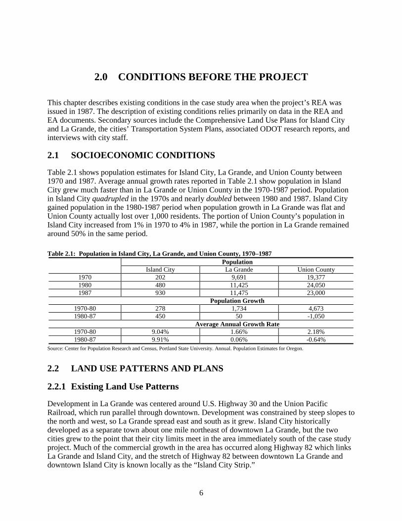
2.0 CONDITIONS BEFORE THE PROJECT
This chapter describes existing conditions in the case study area when the project’s REA wasissued in 1987. The description of existing conditions relies primarily on data in the REA andEA documents. Secondary sources include the Comprehensive Land Use Plans for Island Cityand La Grande, the cities’ Transportation System Plans, associated ODOT research reports, andinterviews with city staff.
2.1 SOCIOECONOMIC CONDITIONS
Table 2.1 shows population estimates for Island City, La Grande, and Union County between1970 and 1987. Average annual growth rates reported in Table 2.1 show population in IslandCity grew much faster than in La Grande or Union County in the 1970-1987 period. Populationin Island City quadrupled in the 1970s and nearly doubled between 1980 and 1987. Island Citygained population in the 1980-1987 period when population growth in La Grande was flat andUnion County actually lost over 1,000 residents. The portion of Union County’s population inIsland City increased from 1% in 1970 to 4% in 1987, while the portion in La Grande remainedaround 50% in the same period.
Table 2.1: Population in Island City, La Grande, and Union County, 1970–1987Population
Island City La Grande Union County1970 202 9,691 19,3771980 480 11,425 24,0501987 930 11,475 23,000
Population Growth1970-80 278 1,734 4,6731980-87 450 50 -1,050
Average Annual Growth Rate1970-80 9.04% 1.66% 2.18%1980-87 9.91% 0.06% -0.64%
Source: Center for Population Research and Census, Portland State University. Annual. Population Estimates for Oregon.
2.2 LAND USE PATTERNS AND PLANS
2.2.1 Existing Land Use Patterns
Development in La Grande was centered around U.S. Highway 30 and the Union PacificRailroad, which run parallel through downtown. Development was constrained by steep slopes tothe north and west, so La Grande spread east and south as it grew. Island City historicallydeveloped as a separate town about one mile northeast of downtown La Grande, but the twocities grew to the point that their city limits meet in the area immediately south of the case studyproject. Much of the commercial growth in the area has occurred along Highway 82 which linksLa Grande and Island City, and the stretch of Highway 82 between downtown La Grande anddowntown Island City is known locally as the “Island City Strip.”

7
The existing land use pattern in the project area was heavily influenced by the I-84/Highway 82interchange, which is about ¼ mile east of the beginning of the project. This interchange is theprimary interstate access point in the La Grande/Island City area, because it is located betweendowntown La Grande and Island City and it is the only full-access interchange in La Grande.The other freeway accesses in the area are the limited-access U.S. 30 interchange immediatelynorthwest of La Grande, and a full-access interchange about 1.5 miles southeast of downtown LaGrande. Development around the U.S. 30 interchange is constrained by steep slopes; theinterchange feeds into the street grid of downtown La Grande. The interchange southeast ofdowntown is in a rural area outside of the Urban Growth Boundary.
Highway 82 has substantially higher traffic levels than other roadways in La Grande except I-84,partially due to the interchange and also because Highway 82 connects La Grande to the GrandeRonde and Wallowa Lake valleys. La Grande is the agricultural, industrial, and commercial-service center of Union County and Wallowa County. Thus, traffic in the study area is generatedin part by land uses in areas served by the Highway 82. Truck and commuter traffic from lumberand wood products firms in La Grande, Island City, Elgin, and Wallowa County communitieswere identified as generating a major component of traffic in the project area.
The 15 years before the project was a period of commercial development along Highway 82between La Grande and Island City. The completion of I-84 and the Wallowa Lake Highwayinterchange in 1972 was the major impetus for that growth. Highway-related services clusterednear the interchange. The study area had experienced significant urbanization over the decadebefore project construction, moving from rural and residential uses to commercial activities.Island City’s 1984 Comprehensive Land Use Plan (comp plan) states that growth had beenlimited due to a lack of adequate public facilities, but this limitation was removed withinstallation of a centralized sewer system in 1982. The combination of freeway access, hightraffic levels, and the availability of buildable land helps explain why commercial developmenthas focused on the Island City Strip.
In terms of acreage, the bulk of land use conversions occurred around the Island City and LaGrande ends of the project. The EA states that commercial developments in the area were led byfarm supply and implement dealers, a car dealer, a steel distributor, a recreation vehicle servicebusiness, a truck repair firm, an irrigation pipe company, a wholesale grocer, and a safetyequipment outlet. Remaining undeveloped land was generally unused or occasionally used aspasture. Figure 2.1 shows existing land uses in 1986.
The EA describes the project as occurring in the urban-rural fringes of La Grande and IslandCity. According to the EA, land use in the project area was predominately commercial (70%),with some residential (20%) and unused or public uses (10%). Island City’s 1984 comp planstates that there were 130 acres in the city’s UGB designated for commercial use, and that 30 ofthese acres were vacant and available for development. A comparison of Figure 2.1 with Figure2.2 on page 9 (the 1986 zoning map) shows that most of the available commercial land in IslandCity was along the Wallowa Lake Highway corridor.

8
Figure 2.1: Existing Land Uses in the Project Area, 1986
Table 2.2 shows the acres of developed and vacant land by type in La Grande and Island City.This data represents land in the UGB areas of both cities in 1983 for La Grande and 1984 forIsland City. Land data for 1987 is not available, so the data in the table is the best measure ofdeveloped/vacant land before the project. Table 2.2 shows La Grande had substantially moredeveloped and vacant land than Island City.
Table 2.2: Acres of Land in La Grande (1983) and Island City (1984) UGB Areas by UseLa Grande Occupied Vacant Total
Commercial 210.0 116.0 326.0Industrial 219.0 205.0 424.0Medium-Density Residential 1,385.0 316.0 1,701.0High-Density Residential 179.0 54.0 233.0 Total 1,993.0 691.0 2,684.0
Island City Developed Buildable Total Gross AcresCommercial 120.6 6.5 127.1 127.1Industrial 7.3 0.0 7.3 7.3Surface Mining 46.7 0.0 46.7 46.7Low-Density Residential 64.9 66.0 130.9 205.1Medium-Density Residential 23.1 27.1 50.2 74.8Public 101.3 0.0 101.3 101.3Right-of-Way 79.0 0.0 79.0 79.0Urbam Reserve 2.0 77.4 79.4 120.0 Total 444.9 177.0 621.9 761.3
Source: McKeever/Morris & David Evans Associates. 1999. Final La Grande/Island City TSP Volume II, pp. B-18 and B-20.
Note: Total gross acres in Island City exceed the sum of developed and vacant acres by 139.4 acres. The reason for thisdifference is not documented in the source. The difference may include land constrained by environmental conditions (floodway,wetlands) or land planned for use as right-of-way.

9
2.3 LAND USE DESIGNATIONS
Figure 7 in the EA (reproduced as Figure 2.1) indicates that approximately 30% of the projectwas within the UGB of La Grande and 70% was within the UGB for Island City. The portion ofthe project within the La Grande UGB was also within La Grande’s city limits. The portion ofthe project within the Island City UGB was mostly within Island City’s city limits, except for a0.2-mile segment west of the city limits. The project area was predominantly zoned forcommercial uses. Only the area between the La Grande and Island City city limits, north of thehighway and across the railroad, was zoned as rural residential and farm residential. This area,however, had no access to the highway except for two private roads to farm residences. Zoningat the time of the EA is shown in Figure 2.2.
Island City’s 1984 comp plan found that about 176.5 acres of residential land were needed foranticipated population growth. 36.6 vacant acres of residential land were identified within thecity limits; the remaining 140 vacant acres needed were in the city’s 120-acre Urban Reservearea (see Figure 2.2) and other areas within the UGB but outside of the city limits.
Figure 2.2: Zoning in the Project Area, 1986
2.4 TRANSPORTATION SYSTEM CHARACTERISTICS
The Wallowa Lake Highway is the major link between La Grande and communities in theGrande Ronde Valley, including Elgin, Imbler-Summerville, Cove, and Island City.
The EA states that traffic volumes in the project area had exceeded design capacity of the two-lane highway. Commercial activity, heavy commuter traffic between growing fringecommunities, and traffic from three lumber and wood product plants near Island City were citedas sources of growing traffic congestion. Truck and commuter traffic generated by lumber and

10
wood products firms in La Grande, Island City, Elgin, and Wallowa County were a majorcomponent of traffic in the project area. Merging conflicts where the previously-widened five-lane section met the two-lane section were also cited as a need for the project.
Between 1982 and 1984, 17 accidents were reported along Highway 82 in the project area, with53% resulting in personal injury. The EA states that the accidents were largely attributable tocongestion tied to turning movements (29%) and rear-end collisions (41%). More than one-halfof the accidents occurred at intersections as motorists attempted to turn onto or off of thehighway. The resulting accident rate was 2.13 accidents per million vehicle miles traveled(MVMT), compared to a statewide rate of 1.24 accidents per MVMT for similar highways.
The EA did not report historic traffic volumes on the Wallowa Lake Highway. Historical datafrom ODOT in Table 2.3 for the project area shows average daily traffic volumes grew between1980 and 1987 at every measurement point except 0.1 mile northeast of I-84. Positive averageannual growth rates range from 0.2% to 3.6%, with the highest growth rates in the section northof the Cove Highway intersection. Table 2.3 also shows that traffic volumes generally declinefrom west to east, with a significant drop after the intersection with Hunter Lane. This drop intraffic volume suggests that the area served by Hunter Lane generates a significant amount oftraffic in the project area.
Table 2.3: Traffic volume on the Wallowa Lake Highway, 1980–1987Average Daily Traffic
Milepoint Description1980 1987
Average AnnualGrowth Rate,
1980-19870.99 0.1 mile northeast of Old Oregon Trail (I-84) 11,800 10,600 -1.5%1.17 0.01 mile northeast of Riddle Road 9,600 11,300 2.4%2.07 West city limits of Island City 8,400 9,100 1.2%2.29 0.01 mile west of “D” Street 8,300 9,700 2.3%2.40 0.01 mile west of Cove Highway (ORE 237) 8,100 8,200 0.2%2.42 0.01 mile north of Cove Highway (ORE 237) 6,100 7,800 3.6%2.62 North city limits of Island City 5,700 7,200 3.4%2.70 0.01 mile east of Hunter Lane 4,200 4,850 2.1%
Source: Oregon Department of Transportation. Annual. Traffic Volume Tables. Data provided by Stacy Shetler, [email protected].
Table 2.4 shows traffic data reported in the EA. This table shows that average daily trafficvolume was expected to grow by 50% between 1984 and 2004, which is an average annualgrowth rate of 2.05%. Traffic volume in 2004 was expected to be the same under the no-buildand build alternatives. Under the no-build alternative, increased traffic volumes would causelevel of service to decline from D to E,2 and average speeds would decline from 40 to 33 in thewestern portion and 30 to 23 in the eastern portion of the project area. Under the buildalternative, level of service would improve from D in 1984 to C in 2004, and average speedswould be maintained at 1984 levels.
2 Level of service indicates traffic flow conditions. For urban arterials, C indicates desired urban design level (stable flow), D
indicates acceptable urban design level (approaching unstable flow), and E indicates conditions that are acceptable only ifthey exist for short periods of peak traffic (unstable flow).

11
Table 2.4: Traffic Data Reported in the EAAverage Daily TrafficSection/Alternative Year Volume Trucks Speed
Levels ofService
M.P. 1.30 to 2.071984 9,100 610 40 D No-Build 2004 13,650 915 33 E
Build 2004 13,650 915 40 CM.P. 2.07 to 2.40
1984 9,100 610 30 D No Build 2004 13,650 915 23 E Build 2004 13,650 915 30 C
Source: Oregon Department of Transportation and Federal Highway Administration. 1986. Environmental Assessment: Old Oregon Trail toIsland City Unit Two, Wallowa Lake Highway Milepoints 1.3 to 2.62, Union County. Page 15, Table 1.
2.5 PUBLIC SERVICES AND UTILITIES
The EA states that portions of the project area were served by the La Grande or Island City sewersystems as of 1986. La Grande’s 1983 Comprehensive Plan states that the city’s sanitary sewersystem served the area within city limits and that property outside the city limits but inside theUGB may hook up with certain requirements. The City of La Grande operates a treatmentfacility that was designed as a regional facility to serve La Grande, Island City, the BaumIndustrial Park, and surrounding unincorporated areas.
According to Island City’s 1984 comp plan, the Island City Area Sanitation District completedconstruction and installation of a sewer system in 1982. The system was designed to serve allland within Island City’s UGB plus the Island City Industrial Park. The District purchasedenough treatment capacity from the City of La Grande to accommodate anticipated populationgrowth and commercial development, and recent expansions at the La Grande sewage treatmentfacility were designed to handle both La Grande and Island City’s projected growth.
According to the EA, improvements to Wallowa Lake Highway required relocation of 6-inch, 8-inch, and 18-inch sewer lines at various locations. A storm sewer system adjacent to the westernone-quarter of the project was extended to serve the entire length of the project. Improvementsalso required relocation of a natural gas line on the south side of the highway, and relocation ofpoles and lines carrying electric, cable television, and phone service (General Telephone wasexpected to bury their relocated lines).
The EA states that the project would also affect police, ambulance, and fire service. Under theno-build alternative, worsening congestion was expected to slow emergency response times andcreate additional traffic hazards for both emergency vehicles and standard highway traffic. Theproposed improvements were expected to reduce response times and improve safety by reducingcongestion levels in the project area.
2.6 PUBLIC POLICY
The project EA states that improvement of the Wallowa Lake Highway in the project area hadbeen a long-standing priority of local government and citizens. Active interest in promoting theproject by La Grande, Island City and Union County representatives dated back to before 1970.At a Highway Division corridor-design public hearing in 1970, the public and governmentagencies supported improving Highway 82 in Island City, but controversy about corridor

12
alternatives and financial constraints delayed design approval. Strong support for the alleviatingtraffic congestion and safety problems in the project area was expressed by local government andcitizens at periodic Six Year Highway Improvement Program public meetings.
Another formal public hearing on the proposed project was held in January 1987. Seven peopletestified orally at the public hearing and eight letters were received. The majority of those whotestified or submitted letters supported the project but voiced concerns about specific aspects ofthe project and its construction. Comments in opposition to the project questioned the need for afive-lane facility and expressed concern about the effect of the project on the livability of IslandCity. Three letters were received from public agencies or jurisdictions, and two comments werereceived as part of the project’s Intergovernmental Review Process. The REA stated that allcomments and letters were considered and addressed, and that ODOT would coordinate withlocal jurisdictions that submitted comments throughout project development and construction.
Both the La Grande and Island City comprehensive land use plans had been completed, adopted,and approved by the State Land Conservation and Development Commission at the time of theEA. La Grande’s 1983 comp plan specifically identified the project as needed, with a policystating “that the city support and encourage the improvement and widening of the State Highway#82 from La Grande to Island City.” Island City’s 1984 comp plan does not specifically refer tothe project, but the Island City Street Plan (an official part of the Island City ComprehensivePlan) showed the project on its future street development map.3
Island City’s 1984 comp plan states that “Island City anticipates substantial commercial andresidential growth during the planning period (1984 to 2000). Testimony presented during publicmeetings has expressed a general willingness to accommodate anticipated growth and plan forexpansion of urban level of services.” This statement was supported by several findings,including:
• Island City anticipates attracting new residents who would work in La Grande and theIsland City Industrial Park.
• The Island City Industrial Park has approximately 160 acres of vacant, available,industrially-zoned land with public sewer and water services. Island City is the closestcommunity to this industrial park, which is in an unincorporated area of Union County.
• The City of La Grande identified a need for medium density residential land beyond theircurrent city limits. Several factors support the assumption that Island City will receivenew residents who will be employed in La Grande:
• Land in the Island City urban growth area (UGA) is essentially flat, predominantlyoutside of flood hazard areas, and in large blocks of undeveloped property. Thesephysical characteristics make Island City well-suited for urban development.
• The Island City Sanitation District was designed to service and includes within itsboundaries the Island City UGA and its projection population.
• Island City offers a lower tax rate.
3 Oregon Department of Transportation and Federal Highway Administration. 1986. Environmental Assessment: Old Oregon
Trail to Island City Unit Two, Wallowa Lake Highway Milepoints 1.3 to 2.62, Union County. Page 23.

13
• Island City allows mobile homes as an outright use on individual lots establishedaccording to development standards.
• Many County residents or residents of outlying communities, i.e. Elgin, Cove, and Union,are migrating closer to their places of employment.
• Commercial development along the Island City strip (the south side of Oregon Highway82 from Adams Avenue in La Grande to McAlister Lane in Island City) has beenextensive over the past 15 years. With anticipated in-filling of vacant parcels and theability to hook up to public utilities substantial growth is expected.
La Grande’s 1983 comp plan stated that Union County had been classified by the State ofOregon as an economically distressed community. The unemployment rate was higher than thestate average and per capita income was lower. The comp plan presents extensive evidence ofeconomic problems in Union County, including a lack of industrial diversification, a lack ofsecondary processing for wood and agricultural products, and a lack of job opportunities forcounty residents. Based on this evidence, the comp plan states, “Therefore La Grande, being tentimes the largest city in Union County, is making every effort to accommodate both commercialand industrial needs while at the same time measuring these growth considerations againstresource considerations.”
La Grande’s plan also states that “the City strongly believes in destination-commercialdevelopment as opposed to strip development. There are several large acreages within thecommercially designated areas which will probably not develop until a major commercialbusiness takes the initial step to acquire and develop the site. …With La Grande serving as theretail trade center for two counties, it is reasonable and prudent to maintain the availability ofthese few large blocks of commercial property.”
The existing development pattern along the Wallowa Lake Highway was explicitlyacknowledged by La Grande’s comp plan: “The development along the Island City Strip is stripdevelopment to a degree, however it is very important to note that this “strip” has a beginningand an end in that it connects La Grande to Island City.”
2.7 ANTICIPATED PROJECT IMPACTS
The EA and REA did not report historic population or population forecasts, but statements inthese documents show that ODOT expected population growth and development in the projectarea to continue. The findings in the EA that support the build alternative clearly show this:
During the last decade, the majority of new developments in the La Grande areahave occurred along the “Island City Strip”, centering on the I-84 Interchange inthe vicinity of the proposed project. A shopping center, other retail businesses,and numerous highway-related developments have combined with growingindustrial/agricultural truck traffic and local commuter traffic, to generatesignificant increases in traffic volumes. Such developments are anticipated tocontinue in the future (particularly in the project area), further aggravating trafficcongestion and reducing safety.
The project was not expected to result in unplanned land use changes in the project area. Projectconstruction was expected to stimulate commercial development in the project area, but this
14
would be a continuation of existing trends. Local land use controls, particularly comprehensiveplans, were cited as the “chief ingredient” in controlling or mitigating the potential for futureland use and economic impacts as a result of the highway project.
Increased capacity from the project was expected to reduce traffic congestion and enhance trafficmovements, which would improve highway user safety. The reduced congestion and increasedsafety was expected to improve the economy of the area by facilitating both local and regionaltransportation functions of Highway 82. Increased circulation from the project would improveeconomic conditions in the project area by giving the area a competitive edge over other areas inLa Grande for future development growth. The project would also have regional economicimpacts by providing an improved link for commuters, timber, agricultural products, and othercommodities between La Grande and its rural areas to the northeast.
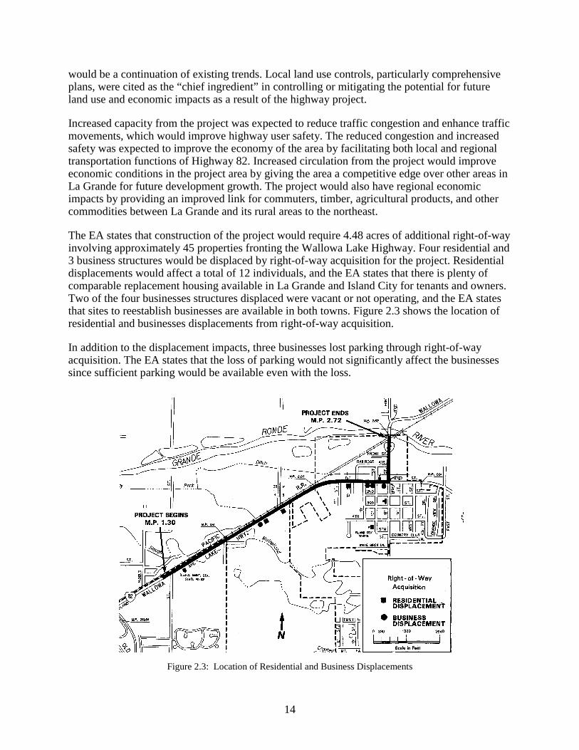
The EA states that construction of the project would require 4.48 acres of additional right-of-wayinvolving approximately 45 properties fronting the Wallowa Lake Highway. Four residential and3 business structures would be displaced by right-of-way acquisition for the project. Residentialdisplacements would affect a total of 12 individuals, and the EA states that there is plenty ofcomparable replacement housing available in La Grande and Island City for tenants and owners.Two of the four businesses structures displaced were vacant or not operating, and the EA statesthat sites to reestablish businesses are available in both towns. Figure 2.3 shows the location ofresidential and businesses displacements from right-of-way acquisition.
In addition to the displacement impacts, three businesses lost parking through right-of-wayacquisition. The EA states that the loss of parking would not significantly affect the businessessince sufficient parking would be available even with the loss.
Figure 2.3: Location of Residential and Business Displacements

15
3.0 CHANGES AFTER THE ANALYSIS WAS COMPLETED
This chapter discusses changes in land use, and in the variables that influence those changes, inthe period following issuance of the REA in 1987. The improvements to Wallowa Lake Highwaywere completed in 1992. Organization of this chapter is identical to that of Chapter 2: it beginswith a discussion of socioeconomic conditions, then discusses land use patterns, transportationsystems, capital improvements, and changes in public policy.
3.1 SOCIOECONOMIC CONDITIONS
The EA states that population growth was expected to continue, but a population forecast wasnot included in the analysis. Table 3.1 shows actual population growth in Island City, La Grande,and Union County in the 1970-1998 period. This table shows that population grew rapidly inIsland City between 1980 and 1987, but this rapid growth did not continue after projectinception. The average annual population growth rate in Island City was over 9% prior to 1987but was -0.1% in the 1987-1998 period (as the population declined by 10 persons). Populationgrowth in La Grande and Union County increased over the low (or negative) levels in the 1980-1987 period, but did not approach the growth rates experienced in the 1970s. Table 3.1 showsthat most of the net population growth in Union County occurred in La Grande.
Table 3.1: Population in Island City, La Grande, and Union County, 1970–1998Island City La Grande Union County
Population1970 202 9,691 19,3771980 480 11,425 24,0501987 930 11,475 23,0001998 920 12,795 24,400
Population Growth1970-1980 278 1,734 4,6731980-1987 450 50 -1,0501987-1998 -10 1,320 1,400
Average Annual Growth Rate1970-1980 9.04% 1.66% 2.18%1980-1987 9.91% 0.06% -0.64%1987-1998 -0.10% 0.99% 0.54%
Source: Center for Population Research and Census, Portland State University. Annual. Population Estimates for Oregon.
3.2 LAND USE PATTERNS
One of the key objectives of this analysis was to document land use changes in the study area(and more broadly, in the cities of La Grande and Island City) during two periods: betweenissuance of the FEIS and completion of the project (1987-1992), and after the project (1992-present). To determine changes in land use, a number of indicators were reviewed: (1) UGBexpansions and annexations, (2) zone and plan designation changes, (3) residential developmentproject approvals and recorded improvements, and (4) location of new development.
16
3.2.1 UGB Expansions
Ordinances amending La Grande’s 1983 Comprehensive Plan show three additions to the City’sUGB since 1987, totaling 12.9 acres, with 3.8 acres zoned Medium-Density Residential and 9.1acres zoned Rural Residential. In 1989, the City removed approximately 78 acres of landdesignated for Industrial use from the City’s UGB. None of these changes to La Grande’s UGBoccurred within the study area.
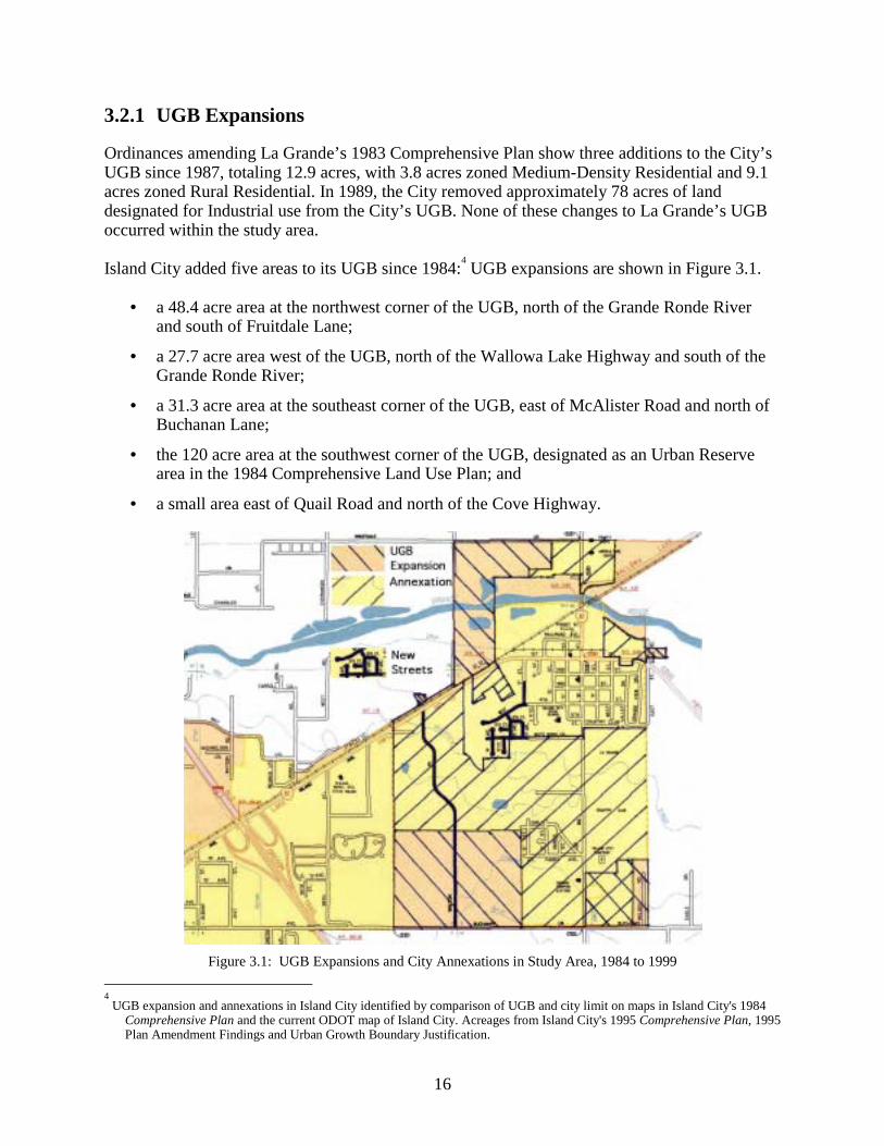
Island City added five areas to its UGB since 1984:4 UGB expansions are shown in Figure 3.1.
• a 48.4 acre area at the northwest corner of the UGB, north of the Grande Ronde Riverand south of Fruitdale Lane;
• a 27.7 acre area west of the UGB, north of the Wallowa Lake Highway and south of theGrande Ronde River;
• a 31.3 acre area at the southeast corner of the UGB, east of McAlister Road and north ofBuchanan Lane;
• the 120 acre area at the southwest corner of the UGB, designated as an Urban Reservearea in the 1984 Comprehensive Land Use Plan; and
• a small area east of Quail Road and north of the Cove Highway.
Figure 3.1: UGB Expansions and City Annexations in Study Area, 1984 to 1999 4 UGB expansion and annexations in Island City identified by comparison of UGB and city limit on maps in Island City's 1984
Comprehensive Plan and the current ODOT map of Island City. Acreages from Island City's 1995 Comprehensive Plan, 1995Plan Amendment Findings and Urban Growth Boundary Justification.
17
3.2.2 Annexations
Island City has annexed substantial areas within their city’s UGB since 1987. In 1993 the Citycompleted the “Four Area” annexation which included:
• the commercial area north of the Grande Ronde River along Hunter Road;
• an area at the southeast corner of the UGB, east of McAlister Road and north of CoveHighway;
• the Island City Cemetery and adjacent areas west of McAlister Road; and
• all of the area west of downtown Island City, south of the Wallowa Lake Highway, andnorth of the former Urban Reserve area. This area includes the area around the Wal-Martdevelopment.
In addition, Island City annexed the La Grande Country Club property at their request in 1996.
Figure 3.1 shows UGB expansions, annexations, and new street construction in Island City since1987. Staff at the City of La Grande said that La Grande has had only one small annexation since1987 and that annexation is currently under appeal.
3.2.3 Zone and Plan Designation Changes
A comparison of zoning as shown in the EA (see Figure 2-2) and Island City’s comp plan tocurrent zoning information from La Grande, Island City, and Union County shows that zoning inthe study area has remained substantially the same, with the following exceptions:
• Commercial to High-Density Residential: the City of La Grande re-zoned approximately55.3 acres from Commercial to High-Density Residential (R-3). The rezoned area issouth of the commercial strip along Island Avenue, on both sides of 26th Street, primarilynorth of E. Q Avenue, and bounded by I-84 to the west and the city limits to the east.Thirty-five of these acres were rezoned to reflect their use as a trailer court.
• Residential to Commercial, Neighborhood Commercial, and Business Park: The City ofIsland City extended the commercial zone along the Hwy 82 corridor southward alongboth sides of Walton Road, re-zoning land that was formally zoned for residential use.The commercial zone in this area was formally a strip extending 600’ south of IslandAve. The commercially-zoned area around Walton Road now extends 1,200’ to 2,400’south of Island Avenue. This rezoning was necessary to accommodate Wal-Mart, whichis located south of the former 600’ commercial strip on Island Avenue.
• Residential to Medium-Density Residential: Several parcels on or near Walton Road,south of the commercially-zoned area, were rezoned from Residential to Medium-Density Residential.
• Rural Residential to Industrial and Surface Mining: the area within Island City north ofthe railroad tracks and west of McAlister Lane/Hunter Lane was rezoned from Industrialto Surface Mining, reflecting it’s use as a gravel pit.
• Urban Reserve to Residential and Commercial. The former Urban Reserve Area in thesouthwest portion of Island City is primarily zoned for Low-Density Residential, with

18
portions in the northwest and southwest of this area zoned Business Park andCommercial and the portion between these two corners zoned for Medium-DensityResidential.
Current zoning in the study area is shown in Figure 3.2. This Geographic Information Systemdata was provided by the City of La Grande.
Figure 3.2: Current Zoning in the Study Area
3.2.4 Development in the Study Area
Table 3.2 shows developed acres within the combined La Grande/Island City UGB and in thestudy area for this report. Time periods for development were determined using the Year Builtreported in Union County assessment data. The Year Built data is not entirely reliable butprovides the best indicator of the timing of development that could be obtained for this study.
A lull in development activity in the 1987-1992 period between release of the EA andcompletion of the project can also be seen in Table 3.2. Only 59 acres were developed in thisperiod, compared to 228 after 1992. Total development in the study area was 29% ofdevelopment in the combined UGB area before 1987; this fell to 20% in the 1987-1992 periodand increased to 35% after 1992.
Further, Table 3.2 shows that the share of Industrial and Single-Family acres developed in thestudy area increased after 1992 over the level before 1987, increasing from 43% to 51% forIndustrial development and from 20% to 38% for Single-Family Residential.

19
The assessment data in Table 3.2 indicates that Commercial acres in the study area comprised73% of all Commercial acres in the urban area after 1992. This seems plausible from a fieldcheck of the study area – it appears that a substantial portion of recent commercial developmentin the La Grande/Island City has occurred in the study area. However, the assessment data showsthat 76% of commercial acres developed before 1987 are in the study area, and this does notseem plausible given the amount of commercial development in downtown La Grande. Thismeasure could reflect large-lot commercial development in the study area and may be higherthan the actual level of commercial development in the study area because assessment recordsfor commercial development outside of the study area lack data on use or year built.
Table 3.2: Summary of Developed Acres by Location, La Grande/ Island City UGB, and Study Area, 1999
Area/Period No Use Data Commercial IndustrialMultipleFamily
Residential
Single-FamilyResidential Total
UGB No Year 730 14 60 0 93 898 Before 1987 134 139 190 39 1,020 1,522 1987-1992 18 7 11 10 12 59 After 1992 56 21 31 1 119 228
Total UGB 939 181 293 50 1,244 2,706Study Area No Year 354 4 39 0 5 402 Before 1987 39 106 83 0 207 434 1987-1992 8 0 2 0 2 12 After 1992 4 15 16 0 45 80
Total Study Area 404 125 140 0 260 928Percent in study area No Year 49% 27% 65% 0% 5% 45% Before 1987 29% 76% 43% 0% 20% 29% 1987-1992 41% 0% 20% 0% 17% 20% After 1992 7% 73% 51% 0% 38% 35%
Total 43% 69% 48% 0% 21% 34%Source: Union County Assessment Data, 1999
The number of single family residences by year built in the combined La Grande/Island CityUGB area and the study area can be seen in Table 3.3. The data indicate that the study areaaccounted for approximately 8% of all single-family residences in La Grande/Island City before1987, but increased to 20% in the 1987-1992 and to 23% after 1992. The table shows a lull inresidential development in the 1987-1992 period and a substantially higher level of residentialdevelopment after 1992. Residential units after 1992 increased by 8% in La Grande/Island Cityand by 24% in the study area.
Table 3.3: Number of Single-Family Dwellings by Time Period, LaGrande/Island City UGB and Study AreaPeriod UGB Study Area Percent in Study Area
No year 238 15 6%Before 1987 3,488 271 8%1987-1992 45 9 20%After 1992 317 72 23%Total 4,088 367 9%
Source: Union County Assessment Data, 1999

20
Table 3.4 shows the tax lots, floor area, and acres of commercial and industrial development byarea and time period. For commercial development, this table shows the share of tax lots andfloor area in the study area after 1992 was substantially higher than the level before 1987, whilethe share of commercial acres was about the same. The increase in share of tax lots is probablydue to the addition of a large number of small commercial lots in Island City through annexationand UGB expansion, and the increase in the share of floor area probably reflects the developmentof Wal-Mart (which has a large floor area) in Island City.
For industrial development, Table 3.4 shows the share of tax lots in the study area increasedsubstantially after 1992, while the share of floor area remained roughly the same and the share ofacres increased slightly.
Table 3.4: Commercial and Industrial Development by Time Period, La Grande/ Island City UGB and StudyArea
LaGrande/Island City UGB Study Area Percent in Study AreaLand use/Year
Built Tax Lots Floor Area Acres Tax Lots Floor Area Acres Tax Lots Floor Area Acres
Commercial No Year 14 16,982 14 0% 0% 0% Before 1987 73 286,381 139 13 38,669 106 18% 14% 76% 1987-1992 7 68,761 7 0% 0% 0% After 1992 12 67,725 21 5 50,400 15 42% 74% 73% Total 106 439,849 181 18 89,069 121 17% 20% 67%
Industrial No Year 56 243,890 60 20 170,741 39 36% 70% 65% Before 1987 321 1,684,067 190 58 302,537 83 18% 18% 43% 1987-1992 11 53,832 11 5 7,060 2 45% 13% 20% After 1992 23 173,770 31 11 35,089 16 48% 20% 51% Total 411 2,155,559 293 94 515,427 140 23% 24% 48%
Source: Union County Assessment Data, 1999.
Table 3.5 shows specific development activity in the study area since 1987 from informationprovided by the City of La Grande and Island City staff. This table shows a considerable amountof commercial development activity in the study area. Most of the commercial development islocated in the Island City part of the study area, primarily along Highway 82 and Walton Road.
A field survey of the study area indicates that Wal-Mart is the largest development in Table 3.5.Wal-Mart is located on Walton Road approximately 600 feet south of Island Avenue. About ninecommercial developments are located near Wal-Mart on Island Avenue and Walton Road. Thesedevelopment occurred concurrent with or after the development of Wal-Mart, and include Shop-n-Kart, Taco Bell, Quiznos, Payless Shoes, Sears, Sea-Brite Dental, AC Power Sports, WaltonRoad Storage, and Perfect Look Hair Salon.
According to focus group participants, Wal-Mart considered several other sites in the areaincluding a site south of downtown La Grande on US 30, a site at 26th & Cove, and sites east ofIsland City. A key consideration for Wal-Mart was the parcel size, and visibility from I-5 mayhave also been an issue. A focus group participant suggested that there are limited sites withinthe UGB that met Wal-Mart’s size criteria, and that access was less important that the size of thesite. All of the focus group participants speculated that Wal-Mart would have selected that site inthe absence of the Highway 82 improvements.

21
Table 3.5: Development Activity in the Study Area since 1987City/Date Development Type/Business Name Location
La Grande New Development10/30/96 Earl Wells 3113 Cove Ave
9/23/98 La Grande Automotive 1505 26th Street6/1/99 Larry Colozzi Commercial Storage Buildings 3107 Cove Ave
9/14/99 Les Thurber Commercial Storage Buildings 1506 26th Street? Jehovah’s Witnesses Church North of 1505 26th Street
La Grande Expansion3/16/88 Buggy Bath Car Wash4/27/93 Eagle Truck 2106 26th Street2/23/94 Eagle Truck 2106 26th Street1/24/95 Sundowner MH Park 2813 East “Q” Ave3/10/97 Robert’s FORD 2906 Island Ave
5/5/97 Sundowner MH Park 2813 East “Q” AveLa Grande Partition/Subdivision
2/12/97 Roger Goodman 10100 Cove Ave6/2/97 Roger Goodman 26th and Cove Ave
3/18/98 Northeast Oregon Housing East of 26th Street at East “Q” AveIsland City New Development
4/92 La Grande Rural Fire Protection District Station 10206 S. McAlister Road9/92 Wal-Mart 11619 Island Ave9/92 Shop-n-Kart 11623 Island Ave9/92 Payless Shoes 11621 Island Ave3/93 Northwood Homes 11001 Island Ave6/95 Sears 10601 S. Walton Road
10/95 Island City Well #4 10809 S. Walton Road7/96 Island City Express Lube 10603 Island Ave7/96 Island City Express Car Wash 10603 Island Ave8/96 Frontier Motors 10705 Island Ave
11/96 City Hall 10605 Island Ave2/98 Palermos Restaurant 10303 W. First Street
10/98 Taco Bell 11625 Island Ave11/98 AC Power Sports 10701 S. Walton Road3/99 Walton Road Storage 10704 S. Walton Road5/99 Public Works facility 10202 S. “E” Street9/99 Sea-Brite Dental 11609 S. Walton Road
10/99 Quiznos 11621 Island Ave.11/99 Hudson’s Transmissions 10105 Fruitdale Lane
Island City Expansion3/92 D&B Supply 10101 E. First Street3/97 Bronson Lumber – Truss Plant 10503 N. McAlister Road9/97 Agriculture Service Center 10507 N. McAlister Road
Island City New Business or Renovation1/92 Logger Supply 10210 Wallowa Lake Highway
12/92 Bills Quik Mart 10101 W. First Street4/93 Bowman Trucking 61999 Quail Road8/93 Animal Health Center 10302 Wallowa Lake Highway6/95 Burger King 10102 N. McAlister Road7/95 Idaho Northern & Pacific Railroad Office 10102 N. “E” Street6/97 The Barn 10206 W. First Street
10/97 Certified Personnel 10101 N. McAlister Road11/98 Trotter’s Industrial Supply 10304 W. First Street4/99 Union ESD Student Center and Day Care 10214 Wallowa Lake Highway5/99 Island City Auto Brokers 10204 W. First Street5/99 Gas Connection 10502 W. First Street5/99 Pendleton Grain Growers 10406 W. First Street7/99 Eves Alterations 10207 W. First Street
11/99 Garden Market 10400 W. First Street5/00 Perfect Look Hair Salon 11621 Island Ave
Source: Provided by Michael Boquist, City of La Grande, and Judy Rygg, City of Island City.

22
About 15 of the commercial and industrial businesses listed in Table 3.5 are clustered indowntown Island City on First Street and N. McAlister Road (also referred to as Wallowa LakeHighway in addresses shown in the table). From a field survey of the study area it appears thatthese businesses are primarily located in buildings that were developed before 1987 – the listingsin Table 3.5 are primarily for expansions of existing businesses or renovations for existing ornew businesses. Another cluster of commercial development that occurred after 1987 in IslandCity is located around the Island City Hall, on Island Avenue between the development aroundWal-Mart and downtown Island City. The Island City Hall shares access from Island Avenuewith the Island City Express Lube and Car Wash, and Frontier Motors is immediately adjacent tothese uses.
Table 3.5 shows the only commercial development in the La Grande portion of Island Avenuesince 1987 was the expansion of Robert’s Ford. A field survey of the study area indicates thatthere is little or no vacant land on the La Grande portion of Island Avenue, and that all of thecommercial growth in the area probably occurred before 1987. Other commercial developmentin the La Grande portion of the study area occurred south of Island Avenue on 26th Street and onCove Avenue. Commercial storage buildings are the only new developments in this area. Inaddition to the development listed in Table 3.5, ODOT moved their office and maintenancefacilities to the La Grande portion of the study area in the early 1990s.
The only residential development activity in the study area since 1987 is located in La Grandearound 26th Street and E. Q Avenue, and on Cove Avenue. This activity includes expansion ofthe Sundowner Mobile Home Park. Two partitions of residential parcels and a subdivision wereapproved but have not developed.
3.2.5 Value of Land and Improvements
Table 3.6 shows the value of single-family residential lots sold in La Grande/Island City and thestudy area. This data, from Union County assessment records, shows that the average sales pricein the study area was substantially below that of the La Grande/Island City average before 1988.Average sales values in the study area were substantially higher than the La Grande/Island Cityarea in 1992 and 1994, and slightly less in 1996 (the only years for which there is sales data inthe study area). Average sales price data can be affected by the size and other characteristics ofthe lots included in the data – higher values in the study area may reflect larger lot sizes.
Table 3.6: Value of Developed Single-Family Residential Lots, La Grande/Island City UGB and Study AreaUGB Study Area
Year Number Average Sales Price Number Average Sales PriceBefore 1987 169 $40,035 5 $25,000
1988 2 $10,4001989 4 $24,2501990 6 $53,7421991 1 $74,5001992 6 $34,250 1 $77,5001993 17 $29,6011994 17 $21,825 2 $37,4151995 6 $14,8671996 12 $15,775 1 $13,5001997 8 $12,5141998 1 $5,000

23
3.3 TRANSPORTATION SYSTEM CHARACTERISTICS
Table 3.7 shows average daily traffic volumes on the portion of the Wallowa Lake Highway inthe study area for 1980, 1987, and 1998. The data show traffic volume increased substantiallybetween 1987 and 1998. Averaging the traffic volumes shown in Table 3.7 shows trafficincreased from 8,594 in 1987 to 11,625 in 1998, an increase of 3,031 or 35%. This increasetranslates to an average annual growth rate of 2.8%. The EA predicted traffic volume in thecorridor would increase from 9,100 in 1984 to 13,650 in 2004, a 50% increase and an averageannual rate of 2.05% (see Table 2.2).5 Based on the average annual growth rate it appears thatactual growth traffic volume is slightly ahead of predicted growth in the EA.
Table 3.7: Traffic volume on the Wallowa Lake Highway, 1980–1998Average Daily Traffic IncreaseMile-
point Description 1980 1987 1998 80-87 87-980.99 0.1 mile northeast of Old Oregon Trail (I-84) 11,800 10,600 17,300 -1,200 6,7001.17 0.01 mile northeast of Riddle Road 9,600 11,300 16,200 1,700 4,9002.07 West city limits of Island City 8,400 9,100 12,100 700 3,0002.29 0.01 mile west of “D” Street 8,300 9,700 11,100 1,400 1,4002.40 0.01 mile west of Cove Highway (ORE 237) 8,100 8,200 11,600 100 3,4002.42 0.01 mile north of Cove Highway (ORE 237) 6,100 7,800 9,500 1,700 1,7002.62 North city limits of Island City 5,700 7,200 9,400 1,500 2,2002.70 0.01 mile east of Hunter Lane 4,200 4,850 5,800 650 950
Average for milepoint 0.99 to 2.70 7,775 8,594 11,625 819 3,031Source: ODOT Annual. Traffic Volume Tables. 1980 & 1987 data provided by Stacy Shetler, ODOT ([email protected]). 1998data downloaded from www.odot.state.or.us/tdb/traffic_monitoring, 12/21/99.
Annual traffic volume data shows Average Daily Traffic (ADT) on the Wallowa Lake Highwayvaries from year to year, but volumes on the study area portion of the highway stepped up in1992 and remained higher than in previous years. Average ADT was 9.280 in the 1987–1991period and increased to 12,257 in the 1992–1998 period.
Development and increased traffic in the corridor led ODOT to commission the Island City StripDetailed Corridor Plan.6 This plan found that the Wallowa Lake Highway was operating atLevel of Service C–F between the I-84 westbound ramp and Walton Road. The Plan found thatcurrent traffic volumes on the highway were above the standards set for access management asset forth in the 1991 Highway Plan. Table 3-8 shows the Level of Service reported atintersections east of I-84.
Table 3.8: Level of Service and Traffic Volume at Wallowa Lake Highway Intersections, 1992Traffic Volume Level of Service
I-84 Westbound Ramps 15,800 FRiddle Road 15,800 E26th Street 14,800 EWal-Mart’s West Driveway Nr EWalton Road Nr C
Source: Kittelson & Associates. 1993. Island City Strip Detailed Corridor Plan, La Grande, Oregon. Prepared for the ODOT. December.
5 The Environmental Assessment did not indicate which milepoint or portion of the project corridor was used to measure or
forecast traffic volume.6 Kittelson & Associates. 1993. Island City Strip Detailed Corridor Plan, La Grande, Oregon. Prepared for the Oregon
Department of Transportation. December.
24
The Corridor Plan developed a forecast of transportation conditions in 2015 based on full build-out of land in the study area,7 which included most of the Island City UGB area as well as theportions of La Grande centered around the I-84/Wallowa Lake Highway interchange. Based onthis forecast, the Plan concluded that several transportation system improvements would berequired in the study area:
• Development of local street improvements to minimize traffic conflicts and offeralternative routes in the study area. Recommended improvements include:
• Aligning the Riddle Road (May Lane) intersection on the highway with 26th Street toeliminate “dog legging” of local traffic.
• Extension of May Lane east to Walton Road.
• Extension of Walton Road south to Cove Avenue. (Note: this project was completed in1993.)
• Development of new east-west roads parallel to the Wallowa Lake Highway, betweenWalton Road and 4th Street and between 26th Street and McAlister Road (with specificstreet alignments to be determined in the future).
• Median access control on Wallowa Lake Highway between Albany Street and 26th Street.
• Limit turns from Riddle Road onto the Wallowa Lake Highway to right turns only.
Statewide Planning Goal 12 requires all communities with populations over 2,500 to complete atransportation systems plan (TSP). A TSP identifies key transportation issues and transportationimprovements to address those issues. The cities of La Grande and Island City adopted aTransportation System Plan (TSP) for the two cities in 1999.8 This TSP includes transportationplanning goals relevant to this study, including
• Improving the local circulation system to reduce the community’s reliance on U.S. 30(Adams Avenue) and Oregon State Highway 82 (Island Avenue).
• Protecting the function of existing and planned roadways as identified in the TSP throughthe application of appropriate access management techniques. (Island Avenue isidentified as an Access Management Area in the TSP.)
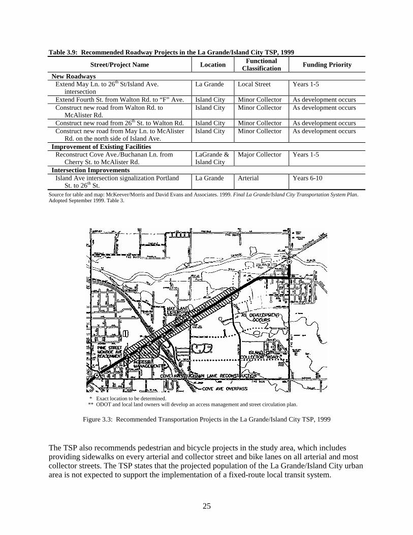
Table 3.9 shows the roadway projects recommended in the La Grande/Island City TSP in thevicinity of the Wallowa Lake Highway. These projects are designed to improve circulation asdevelopment occurs in the study area. Most of the projects in Table 3.9 are in the Island CityUGB and are designated for construction as development occurs. Only three projects in the tableare recommended for construction in a specific portion of the planning period: the extension ofMay Lane to align with 26th Street/Island Avenue intersection and the reconstruction of CoveAvenue/Buchanan Lane in years 1-5, and the signalization of intersections on Island Avenue inyears 6-10. Figure 3.3 shows the location of recommended projects in Table 3.9, as well as theIsland Avenue Access Management Area. 7 The Plan assumed full build-out as the basis for forecasting travel demand; this does not mean the Plan expects the area to be
fully developed by 2015.8 McKeever/Morris and David Evans and Associates. 1999. Final La Grande/Island City Transportation System Plan. Adopted
September 1999.
25
Table 3.9: Recommended Roadway Projects in the La Grande/Island City TSP, 1999
Street/Project Name Location FunctionalClassification Funding Priority
New RoadwaysExtend May Ln. to 26th St/Island Ave.
intersectionLa Grande Local Street Years 1-5
Extend Fourth St. from Walton Rd. to “F” Ave. Island City Minor Collector As development occursConstruct new road from Walton Rd. to
McAlister Rd.Island City Minor Collector As development occurs
Construct new road from 26th St. to Walton Rd. Island City Minor Collector As development occursConstruct new road from May Ln. to McAlister
Rd. on the north side of Island Ave.Island City Minor Collector As development occurs
Improvement of Existing FacilitiesReconstruct Cove Ave./Buchanan Ln. from
Cherry St. to McAlister Rd.LaGrande &Island City
Major Collector Years 1-5
Intersection ImprovementsIsland Ave intersection signalization Portland
St. to 26th St.La Grande Arterial Years 6-10
Source for table and map: McKeever/Morris and David Evans and Associates. 1999. Final La Grande/Island City Transportation System Plan.Adopted September 1999. Table 3.
* Exact location to be determined.** ODOT and local land owners will develop an access management and street circulation plan.
Figure 3.3: Recommended Transportation Projects in the La Grande/Island City TSP, 1999
The TSP also recommends pedestrian and bicycle projects in the study area, which includesproviding sidewalks on every arterial and collector street and bike lanes on all arterial and mostcollector streets. The TSP states that the projected population of the La Grande/Island City urbanarea is not expected to support the implementation of a fixed-route local transit system.

26
The TSP included the results of interviews with stakeholders in the La Grande/Island City area.These interviews identified several concerns with transportation conditions in the study area,including:
• Island Avenue was mentioned as one of the most congested points in the two cities.Conflicts between different users (local vs. through traffic) was identified as a majorproblem on Island Avenue.
• Respondents expressed concern about increasing traffic congestion due to commercialdevelopment along Island Avenue.
• The railroad tracks create access problems for areas north and west of Island Avenue.
• Northern La Grande needs better arterial access and access from Highway 82.
• Island Avenue provides the only eastbound access point to Interstate 84 in La Grande.
Figure 3.1 showed roads constructed in the study area since 1987. Walton Road was constructedin 1992, in part to serve the adjacent Wal-Mart development. According to focus groupparticipants, Wal-Mart funded construction of Walton Road from Island Avenue to the southernboundary of their property and the signal at the Island Avenue intersection. Remaining portionsof Walton Road were funded from TEA-21 and County funds, and ODOT funded the railroadcrossing to the north of the intersection. City of Island City staff indicated that ODOT funded thesignal and railroad crossing in exchange for future City funding of east-west roadways that willprovide alternative routes to Island Avenue. The railroad crossing at Walton Road and IslandAvenue is intended to serve future development north of the railroad tracks.
Walton Road was not included in the existing land use or transportation plans reviewed for thisstudy. Focus group participants indicated that ODOT and local jurisdictions recognized the long-term need for access to land in the area and for an alternative route between Island Avenue andBuchanan Lane. Wal-Mart was required to complete a traffic impact analysis, and focus groupparticipants indicated that Wal-Mart was required to partially fund construction of Walton Roadas a requirement for development. Island City staff reported that Walton Road was given itsname at the request of Wal-Mart.
3.4 PUBLIC SERVICES
The City of La Grande operates a sewage treatment plant that was designed as a regional facility,serving La Grande, Island City, the Island City Industrial Park, and surrounding unincorporatedareas. The Island City Area Sanitation District completed construction and installation of a sewersystem in 1982. The system was designed to serve all land within Island City’s UGB area,including the Urban Reserve area, plus the Baum Industrial Park. The District purchased enoughtreatment capacity from the City of La Grande to accommodate anticipated population growthand commercial development, and recent and planned expansions at the La Grande sewagetreatment facility are designed to handle both La Grande and Island City’s projected growth.
Island City operates a centralized water system which provides service inside the city’s UGBarea. According to the city’s 1998 Water Management and Conservation Plan, current waterneeds are primarily met by well #4 and an adjacent 750,000 gallon storage tank. Well #1 and anadjacent 106,000 gallon tank also provide capacity to the City’s water system, with two other

27
wells kept in backup status for emergencies.9 Island City has made substantial investments in itswater system to ensure sufficient water pressure and volume to meet anticipated growth needs.The 120-acre former Urban Reserve area (which is now within the Island City UGB) isparticularly well-served as a result of development of well #4 and the storage tank at the futureintersection of Walton Road and Emily Drive. The plan identifies Island City’s water accountsshowing the largest users. The large accounts are Wal-Mart (irrigation only), Wal-Mart (all usesexcept irrigation), Palermo’s Restaurant, Shop-n-Kart, Island City Express Car Wash, and TacoBell. All of these commercial accounts are recent developments in the Island City Strip.
According to focus group participants, Island City made a number of other infrastructureimprovements to accommodate Wal-Mart. Improvements were made to the sewer system toserve the site, but participants could not be more specific about the types of sewer improvementsthat were made. Participants reported that Island City did not have sufficient water systemcapacity to serve the site when construction began, so Island City entered into an agreement withthe City of La Grande for an intertie to La Grande’s system to provide service duringconstruction. Apparently, La Grande provided water service to the site for about a year beforeIsland City completed water improvements including well #4 and an adjacent water storage tankabout 1/3 of a mile south of the Wal-Mart site on Walton Lane.
3.5 PUBLIC POLICY
The City of Island City adopted an updated Comprehensive Plan in 1995. The city’s 1995Comprehensive Plan included findings and justification for the UGB expansions documentedearlier in this chapter. The plan also adopted plan classifications that are more refined than theResidential, Commercial, Industrial, and Public classifications included in the 1984 Plan. Newclassifications are Low-Density Residential, Medium-Density Residential, Business Park,Commercial, Neighborhood Commercial, Industrial, Surface Mining, Public/Greenway, and aRiparian Overlay for stream corridors, sloughs, and wetlands.
3.5.1 Island City Land Use
The Land Use Planning element of Island City’s 1995 Comprehensive Plan contains severalstatements and policies relevant to this study:
• Island City anticipates substantial commercial, light industrial, and residential growthduring the planning period (1994 to 2014). The community has expressed a generalwillingness to accommodate anticipated growth and plan for expansion of urban levels ofservice. (p. 4)
• Commercial development will be concentrated to strengthen existing commercialactivities. (p. 6)
• Commercial and medium density residential development will be located in areas whereaccess, service, and related facilities can best accommodate such development. (p. 6)
• Medium Density Residential, retail, and service commercial uses shall be allowed in theGeneral Commercial classification because of the existing mixture of uses.
9 Anderson-Perry & Associates, Inc. 1998. Water Management and Conservation Plan—Draft. Prepared for the City of Island
City. December.

28
3.5.2 Island City Economy
The Economy element of Island City’s 1995 comp plan contains the City’s rationale for the re-zoning of Residential and Urban Reserve areas to commercial designations, which is paraphrasedin the following points:
• The 1984 Comprehensive Plan projected the City’s population would grow to 2,127 by2000. While it is unlikely the City’s population will reach that level by 2000, that forecastis reasonable for 2014. The City has made the planning and financial commitments tosupport this population growth, including water, sewer, and street services for urban areasincluding the 120-acre Urban Reserve. The City’s estimated population was 750 in 1993.
• The City would like to maintain a job to resident ratio of 1:2 as a benchmark to ensure asound economy and tax base. In 1989, the City had a job to resident ratio of 1:1.9. Thisratio is likely to decrease because Union County is likely to attract more retired residents.This ratio should not be allowed to decrease significantly or Island City will becomemore of a bedroom community to La Grande.
• Due to recent increases in retail and service employment, Island City’s employment hasincreased significantly since 1989 and there is a need to provide additional buildablecommercial land.
• To attract employment in sufficient numbers to maintain a 1:2 job to resident ratio, IslandCity needs to allocate sufficient land to accommodate a total (existing and new) of 1,564jobs, or about four times the current employment level. Much of this need can be metthrough redevelopment of existing commercial and industrial land. However, sinceredevelopment is uncertain, Island City should allocate an additional 60 acres of businesspark and commercial property to meet long-term employment needs. At an average of 13employees per acre, 60 acres would accommodate 780 new employees.
• Island City currently has about 9 acres of vacant commercially-zoned land. This isinsufficient to meet current commercial growth needs, especially considering thepotential impact of the Wal-Mart. Therefore, the City is allocating about 11 additionalacres of vacant, buildable land for commercial development. The commercially zonedareas are located along main transportation arterials between Island City and La Grande,or along Walton Road.
• Land identified for industrial development in Island City and the Baum Industrial Park,combined with approximately 20 acres of Business Park land, is anticipated to meetindustrial needs for Island City.10 The new Business Park designation is targeted to meetthe needs for Union County’s probable growth sectors: Construction, Wholesale Trade,Retail Trade, Fire, Services, and Government.
Based on this rationale, Island City adopted policies to support further commercial and industrialdevelopment in the City, including:
10
The Plan does not explicitly state that the 20 acres of Business Park land is an additional allocation from land formally zonedfor residential development, but comparisons of zoning maps indicates this is so. Land zoned as Business Park is locatedsouth of the Wal-Mart development along Walton Road.

29
• Island City’s economic objective is to maintain the current ration of 1 job for every 2residents and will allocate sufficient buildable land to meet this objective.
• Public services shall be planned and made available to those areas zoned industrial andcommercial.
• The City will encourage additional industrial and commercial employment which iscompatible with existing uses by zoning land for those purposes.
• Commercial and industrial uses will be concentrated in those areas already committed tothose types of uses.
• Island City [will] work with the Island City Area Sanitation District to plan extension ofsewer facilities to encourage commercial and industrial development.
• Island City will make water system improvements to handle anticipated industrial andcommercial growth.
3.5.3 Island City Housing
The Housing element of Island City’s 1995 Comprehensive Plan states that the City has allocatedsufficient buildable land to meet it projected housing mix of 85% single family (includingmanufactured dwellings) and 15% multiple family (including duplexes). While no multiple-family housing existed in the City when the plan was adopted, increased in the cost of housingwere expected to increase demand for multi-family housing in the future. The 1995Comprehensive Plan included adoption of a R-E residential zone with a minimum lot size of ½acre for areas affected by Mulholland Slough.
3.5.4 La Grande Central Business Zone Plan
The City of La Grande is still using their 1983 Comprehensive Plan, but the City has madeseveral significant amendments to the Comprehensive Plan. In 1998 the City adopted a CentralBusiness Zone Master Plan that encourages a compact downtown of intensified uses withadditional retail and high density residential uses. Specific policies included in this Master Planinclude:
• Adoption of a Parking Overlay Zone that makes parking standards in the downtown andsurrounding areas equal and that removes parking requirements where space does notallow private lots.
• Adoption of a Residential Use Overlay that removes barriers to mixed residential andcommercial uses and increased residential densities near service and related facilities bypermitting vertical mixed use in several areas of the General Commercial Zoning Districtnear downtown.
• Formation of a Historic District and implementation of historic preservation measures.
• Providing pedestrian facilities and promoting bicycling, and increasing residentialdensities near services and goods, to potentially reduce automobile trips and increase airquality.

30
4.0 CONCLUSIONS
Chapter 2 describes the socioeconomic conditions, land use patterns and plans, transportationsystem characteristics, public services, and public policy at and before the time the REA wasissued in 1987. Chapter 3 describes the changes to these characteristics in the study area thatoccurred since the REA was issued. Chapter 1 notes, however, that the fact that changes occurredin the project corridor does not mean that the improvement of the Wallowa Lake Highwaycaused or even contributed to those changes. This chapter addresses that question: what role didexpansion of the highway play in the land use and other changes that occurred in the study area?
4.1 CHANGES: 1987 TO PRESENT
4.1.1 Socioeconomic Conditions
The EA states that population growth was expected to continue, but a population forecast wasnot included in the analysis. Population grew rapidly in Island City between 1980 and 1987, butthis rapid growth did not continue after project construction.
4.1.2 UGB Expansions
Ordinances amending La Grande’s 1983 Comprehensive Plan show three additions to the city’sUGB since 1987, totaling 12.9 acres. The city removed approximately 78 acres of landdesignated for industrial use from the UGB in 1989. None of these changes to La Grande’s UGBoccurred in the study area.
Island City added five areas to its UGB since 1984, totaling over 220 acres. These areas are nowprimarily designated for low-density residential uses, with some of these areas designated forcommercial and industrial uses.
4.1.3 Annexations
In 1993, Island City completed the “Four Area” annexation which included the area west ofdowntown along Island Avenue (including the area around Wal-Mart), both sides of McAlisterRoad north of Buchanan Lane, and the commercial area north of the Grande Ronde River alongHunter Road. The city also annexed the La Grande Country Club at their request in 1996. Theseannexations more than doubled the size of Island City.
Staff at the City of La Grande said that the city had only one small annexation since 1987 andthat annexation is currently under appeal.
4.1.4 Zone and Plan Designation Changes
Several areas adjacent or south of the case study project were rezoned concurrent with or afterproject construction:

31
• The Commercial zone along Island Avenue in Island City was extended south along bothsides of Walton Road in 1992. The rezoned area was formally designated for Residentialuse. This area is now the location of Wal-Mart and several other nearby businesses.
• Areas designated for Residential use along Walton Road, south of the commercial area,were zoned for Medium-Density Residential.
• A 55-acre commercially-zoned area in the La Grande portion of the study area waschanged to High-Density Residential.
• Most of the former Urban Reserve Area, which is bisected by Walton Road, is designatedfor Low-Density Residential, with portions designated for Commercial and Medium-Density Residential.
4.1.5 Development in the Study Area
Union County assessment data shows a lull in development activity in the La Grande/Island Cityurban area during the 1987-1992 period, between release of the EA and completion of theproject. Only 59 acres were developed in this period, compared to 228 after 1992. City of LaGrande and Island City staff provided information on development activity in the study areasince 1987. It shows a considerable amount of commercial development activity in the studyarea, primarily in the Island City portion of the study area along Island Avenue and WaltonRoad. Table 4.1 summarizes key developments in the study area.
Table 4.1: Timeline of EventsDate Event1970 2.4-mile long widening of the Wallowa Lake Highway from two lanes to five lanes proposed from
Adams Avenue in La Grande to the Cove Highway in Island City.1972 La Grade portion of proposed improvement (Adams avenue to Holmes Street) completed.1972 Completion of the I-84/Island Avenue interchange.1982 Island City Area Sanitation District completed sewage collection system serving Isalnd City and
Baum Industrial Park.1983 La Grande’s Comprehensive Plan identifies case study project as needed.1986 Environmental Assessment for case study project issued.1987 Revised Environmental Assessment for case study project issued.1992 Project construction completed.1992 Development of Wal-Mart, Payless Shoes and Shop-n-Kart.1993 Island City completes “Four Area” annexation.1993 Walton Road completed.1995 Development of Sears and Island City Well #4 on S. Walton Road.1996 Development of Island City Hall, Island City Express Lube/Car Wash, and Frontier Motors.1999 Development of AC Power Sports, Walton Road Storage, and Sea Brite Dental on S. Walton Road.
A field survey of the study area indicates that Wal-Mart is the largest development in the studyarea since 1987. Wal-Mart is located on Walton Road approximately 600 feet south of IslandAvenue. Nine commercial developments are located near Wal-Mart on Island Avenue andWalton Road; these development occurred concurrent with or after the completion of Wal-Mart.These developments include Shop-n-Kart, Taco Bell, Quiznos, Payless Shoes, Sears, Sea-BriteDental, AC Power Sports, Walton Road Storage, and Perfect Look Hair Salon.

32
Another cluster of commercial development occurred after 1987 around the new Island CityHall, located on Island Avenue between the Wal-Mart development and downtown Island City.This cluster includes the City Hall, the Island City Express Lube and Car Wash, and FrontierMotors. Around 15 of the commercial and industrial developments listed by city staff areclustered in downtown Island City on First Street and N. McAlister Road. From a field survey ofthe study area it appears that these businesses are primarily located in buildings that weredeveloped before 1987. The listings are primarily for expansions of existing businesses orrenovations for existing or new businesses.
There was only one commercial development in the La Grande portion of Island Avenue after1987. Commercial storage buildings were developed south of Island Avenue on 26th Street andon Cove Avenue. A field survey indicates that there is little or no vacant land on the La Grandeportion of Island Avenue, and existing buildings appear to have been built before 1987.
The only residential development activity in the study area since 1987 was the expansion of theSundowner Mobile Home Park. Two partitions and a subdivision were approved but have notdeveloped. These activities have occurred along 26th Street and Cove Avenue in the southeasternportion of the study area.
4.1.6 Transportation System Characteristics
Average daily traffic volumes on Wallowa Lake Highway increased by 35% between 1987 and1998, an average annual growth rate of 2.8%. The EA predicted traffic volume in the corridorwould increase at an average annual rate of 2.05%. Actual growth traffic volume is slightlyahead of predicted growth. Average daily traffic volumes on the Wallowa Lake Highway in thestudy area stepped up at the time of project completion and the opening of Wal-Mart, fromaround 9,000 ADT before 1992 to around 12,000 ADT after 1992
In 1992, Walton Road was constructed, in part to serve the adjacent Wal-Mart development.Walton Road was not included in existing land use or transportation plans, but focus groupparticipants reported that ODOT and local jurisdictions recognized the eventual need for accessto land in the area. The road was primarily funded by Wal-Mart and Union County, with ODOTsubsidizing the signal at the Walton Road/Island Avenue intersection and the railroad crossing tothe north of the intersection. The railroad crossing at Walton Road and Island Avenue is intendedto serve future development north of the railroad tracks.
Interviews with stakeholders for the 1999 La Grande/Island City Transportation System Planidentified Island Avenue as one of the most congested points in the two cities. Respondentsexpressed concern about increasing traffic congestion due to commercial development alongIsland Avenue.
4.1.7 Public Services
According to focus group participants, Island City extended water and sewer infrastructure toprovide service to Wal-Mart and the surrounding area. Island City developed a water well andreservoir (#4) on S. Walton Road in 1994. This well and reservoir is now the primary supplysource for Island City.
33
Focus group participants reported that Island City did not have sufficient water system capacityto serve the site so the city entered into an agreement for an intertie to the City of La Grande’ssystem for service during construction. About a year later, Island City completed improvementsto provide water to the site, including well #4 and the adjacent water storage tank.
4.1.8 Public Policy
The City of Island City adopted an updated Comprehensive Plan in 1995. The city’s 1995Comprehensive Plan included findings and justification for the UGB expansions documentedearlier in this chapter. According to the Plan, Island City anticipates substantial commercial, lightindustrial, and residential growth during the planning period (1994 to 2014). The community hasexpressed a general willingness to accommodate anticipated growth and plan for expansion ofurban levels of service. The Plan states that Island City’s economic objective is to maintain thecurrent ration of 1 job for every 2 residents, and Island City will allocate sufficient buildable landto meet this objective. Island City adopted goals and policies to support further commercial andindustrial development within their UGB and at the Baum Industrial Park northeast of the city.
4.2 INTERPRETATION
The Island City case study is an analysis of one project and its impacts. The narrow focus of theanalysis, and the methods used to conduct the analysis, imply inherent limitations in theconclusions. The conclusions that we draw from this analysis are unique to Island City and theWallowa Lake Highway project and should not be construed as universal – analysis of otherhighway projects in other communities may lead to a different set of conclusions.
While the data in this report shows a significant increase in development activity after thecompletion of the highway project, there is evidence that ODOT’s expansion of the WallowaLake Highway was not the only factor to affect the type or rate of development in the study areaand in the La Grande/Island City urban area. The evidence suggests that the development patternobserved in the study area today would be substantially the same without the highway project.This conclusion is based on several findings from our research:
• All of the development activity that occurred in the study area is located within the UGBof La Grande and Island City.
• Prior to the highway widening, Island Avenue was already developing into a commercialstrip, with auto-oriented uses such as a shopping center, fast-food restaurants, and servicestations from Adams Avenue east to the area around the I-84 interchange. La Grande’s1983 Comprehensive Plan acknowledged the strip development pattern betweendowntown La Grande and Island City.
• The existing strip development pattern on Island Avenue was primarily due to the I-84/Island Avenue interchange, high traffic levels on Island Avenue, and adjacent vacant landdesignated for commercial development. Island Avenue was the most likely location inthe La Grande/Island City urban area for auto-oriented commercial development becausethe I-84/Island Avenue interchange is the only full-access interchange in the urban area,the Avenue had higher traffic counts than other major arterials, and the area had availablevacant land designated for commercial development. This mix of conditions did not existanywhere else in the La Grande/Island City urban area.

34
• The most significant development in the study area was Wal-Mart. Focus groupparticipants indicated that Wal-Mart’s primary reason for locating along Island Avenuewas their need for a large parcel, access, and visibility from I-84. No other sites in the LaGrande/Island City urban area met these criteria. All focus group participants speculatedthat Wal-Mart would have selected the site in the absence of the improvements to IslandAvenue.
• The construction of Walton Road, the rezoning of surrounding land for commercial uses,and the extension of water and sewer services to the area allowed the developmentclustered around Wal-Mart. This development may be located to take advantage of thetraffic and visibility generated by Wal-Mart, but there is no evidence that the highwaywidening was the sole factor, or even a major factor, in these businesses’ locationdecision.
• Land use and public service plans did not explicitly foresee retail development at thescale of Wal-Mart and did not specifically include Walton Road or the extension of waterand sewer service to the area. However, the area where Wal-Mart located was withinIsland City’s UGB. Focus group participants indicated that local jurisdictions recognizedthe long-term need for new roads to provide access to the area, and for extension of waterand sewer service to serve future development in the area. Focus group participantsindicated that Wal-Mart’s decision to locate in the study area created the need for localjurisdictions to engage in more detailed planning for the surrounding area.
• According to the Environmental Assessment for the case study project, construction wasexpected to stimulate commercial development in the project area, but this would be acontinuation of existing trends. Local land use controls, particularly local comprehensiveplans, were cited as the “chief ingredient” in controlling or mitigating the potential forfuture land use and economic impacts as a result of the highway project.
• The public policies of La Grande and Island City encouraged commercial development inthe study area, and both cities worked to facilitate the development of Wal-Mart in thestudy area. According to focus group participants, little resistance to the development wasencountered in either community.
• The widening of Highway 82 was justified by deteriorating level of service and safetyconditions on the existing roadway, and the expectation that these conditions wouldworsen over time with additional development in the study area. While the plans for thisproject did not explicitly foresee retail development on the scale of Wal-Mart, they didrecognize that future development would occur in the study area that would create theneed for additional roadway capacity to maintain an adequate level of service and toreduce accident rates.
• Focus group participants agreed that Wal-Mart would likely have located in its currentsite even if the highway widening had not occurred. However, without the highwayproject, Wal-Mart may have needed to make improvements to the highway, such as turnlanes, to mitigate traffic impacts. According to focus group participants, there is noevidence that, in the absence of the highway widening, increased traffic generated byWal-Mart would have altered the development or prevented the development fromlocating near Island Avenue. Planning for the Wal-Mart development did not need tocomply with the Transportation Planning Rule (TPR) because Island City has apopulation of less than 25,000.

35
• Increased traffic in the study area, whether from the highway widening or thedevelopment of Wal-Mart, may have spurred renovation and new business location indowntown Island City. However, this activity occurred in structures that were developedbefore completion of the highway project, so this activity did not alter the pattern ofdevelopment in the study area.