Embed Size (px)
Citation preview

K W A L E M I N E R A L S A N D S K W A L E M I N E R A L S A N D S K W A L E M I N E R A L S A N D S
P R O J E C TP R O J E C TP R O J E C T
E N V I R O N M E N T A L A N D E N V I R O N M E N T A L A N D E N V I R O N M E N T A L A N D
S O C I A L I M P A C T S O C I A L I M P A C T S O C I A L I M P A C T A S S E S S M E N T A S S E S S M E N T A S S E S S M E N T
S U M M A R Y R E P O R T S U M M A R Y R E P O R T S U M M A R Y R E P O R T

This report should be referenced as:
Base Titanium Ltd (2012) Environment and Social Impact Assessment Summary Report
APRIL 2012

ENVIRONMENTAL & SOCIAL IMPACT ASSESSMENT SUMMARY REPORT 1
K W A L E M I N E R A L K W A L E M I N E R A L K W A L E M I N E R A L S A N D S P R O J E C TS A N D S P R O J E C TS A N D S P R O J E C T
CONTENTS
1 INTRODUCTION 3
2 THE ESIA PROCESS 6
3 STAKEHOLDER ENGAGEMENT 9
4 LEGISLATION AND BEST PRACTICE 10
5 ASSESSING ENVIRONMENTAL AND
SOCIAL IMPACTS
11
6 THE BIOPHYSICAL ENVIRONMENT 12
8 THE SOCIO-ECONOMIC ENVIRON-
MENT
16
9 THE MINING AREA 21
10 THE WATER SUPPLY 28
11 THE LIKONI SHIPLOADING FACIL-
ITY
32
12 THE ACCESS ROAD 36
13 THE TRANSMISSION LINE 39
14 ENVIRONMENTAL AND SOCIAL
MANAGEMENT SYSTEM
42
7 THE NATURAL ENVIRONMENT 14

2 ENVIRONMENTAL & SOCIAL IMPACT ASSESSMENT SUMMARY REPORT
K W A L E M I N E R A L K W A L E M I N E R A L K W A L E M I N E R A L S A N D S P R O J E C TS A N D S P R O J E C TS A N D S P R O J E C T
The Project is located in Msambweni District in Kenya’s
Coast Province. The Special Mining Lease (SML) site is
approximately 50km south of Mombasa, and 10km
inland from Msambweni town, on the Milalani Road
toward Shimba Hills town. The co-ordinates for the
Project location is approximately 4o18’ South and
39o27’ East.

ENVIRONMENTAL & SOCIAL IMPACT ASSESSMENT SUMMARY REPORT 3
K W A L E M I N E R A L K W A L E M I N E R A L K W A L E M I N E R A L S A N D S P R O J E C TS A N D S P R O J E C TS A N D S P R O J E C T
Base Titanium Limited (Base), a wholly owned
Kenyan subsidiary of Base Resources Limited, in-
tends to mine heavy minerals sands from the
Kwale deposit located in the Msambweni District,
Coast Province, Kenya. The Kwale Mineral Sands
Project covers two mining areas, namely the South
and Central Dunes. These dunes contain commer-
cially viable quantities of the heavy minerals il-
menite, rutile and zircon.
These minerals are essential in the manufacturing
of a wide range of commercial and household
products including:
• Pigments and paints
• Titanium metal
• Ceramics
• Toothpaste
• Sunblock
CURRENT STATUS
All material leases, licenses, permits and govern-
ment agreements necessary to allow development
of the Project to proceed are in place, including
the key Special Mining Lease (SML), environ-
mental permits and an Investment Agreement
with the Government of Kenya which provides a
range of government undertakings and fiscal in-
centives for the Project.
A Resettlement Action Plan (RAP) was prepared
for the Project in 2005. This covered the resettle-
ment of the households occupying the SML area
which encompasses the Project’s footprint. Fol-
lowing disclosure and consultation households
were resettled from the SML between 2006 and
2008. 381 households were resettled from within
the SML. A post-resettlement monitoring and au-
dit report was prepared in June 2011. RAPs were
also prepared for the Access Road and Water
Pipeline and Mukurumudzi Dam Site in August
2011. Households were resettled from these areas
in 2011 following disclosure and consultation with
the affected households. A post-resettlement
compliance audit of these programmes was un-
dertaken in February 2012.
INTRODUCTION 1
Key highlights of the Kwale Mineral Sands
Project
• Following its acquisition from Vaaldiam
Mining Inc. (previously Tiomin Re-
sources Inc.) in July 2010, Base now
owns 100% of the Kwale Mineral Sands
Project.
• The Kwale Mineral Sands Project repre-
sents an advanced development op-
portunity with all material approvals,
permits and licenses required for de-
velopment currently in place and a full
definitive feasibility study having been
completed.
• The Kwale Mineral Sands Project is ex-
pected to produce an average of
320ktpa, 80ktpa and 35ktpa of ilmen-
ite, rutile and zircon respectively over
the first 7 years of operation from the
higher grade Central Dune before de-
clining to an average of 185kpta,
52kpta and 24kpta over the subse-
quent 6 years from the South Dune.
• The estimated capital cost to develop
the Project is $256 million.
“Today Kwale is a flagship for a new era
of mining in Kenya. Commencement of
production from Kwale will make min-
eral resources Kenya’s fourth largest
export sector.”
Tim Carstens , Managing Director, Base
The Project enjoys a high level of Government and
community support. Importantly, the Government
of Kenya regards Kwale Mineral Sands Project as a
Project of national significance and is committed
to seeing it to development.

4 ENVIRONMENTAL & SOCIAL IMPACT ASSESSMENT SUMMARY REPORT
K W A L E M I N E R A L K W A L E M I N E R A L K W A L E M I N E R A L S A N D S P R O J E C TS A N D S P R O J E C TS A N D S P R O J E C T
The main components of the Project comprise: A) The
Special Mining Lease (SML) area which encompasses
the South and Central Dunes, Tailings Storage Facility
(TSF) and Processing Plant; B) the Mukurumudzi Dam;
C) a borefield and water pipeline; D) a 7.7km long ac-
cess road connecting the SML to the A14; and E) a
132kV transmission line connecting the Project site to
the Galu sub-station. The products will be transported
from the Project site to the Project’s Likoni Shiploading
Facility located in Mombasa’s Kilindini Harbour.
ENVIRONMENTAL & SOCIAL IMPACT ASSESSMENT SUMMARY REPORT 5
K W A L E M I N E R A L K W A L E M I N E R A L K W A L E M I N E R A L S A N D S P R O J E C TS A N D S P R O J E C TS A N D S P R O J E C T
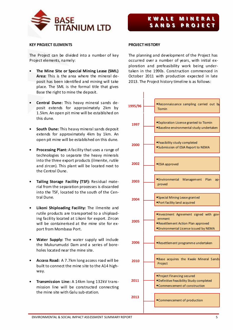
KEY PROJECT ELEMENTS
The Project can be divided into a number of key
Project elements, namely:
• The Mine Site or Special Mining Lease (SML)
Area: This is the area where the mineral de-
posit has been identified and mining will take
place. The SML is the formal title that gives
Base the right to mine the deposit.
• Central Dune: This heavy mineral sands de-
posit extends for approximately 2km by
1.5km. An open pit mine will be established on
this dune.
• South Dune: This heavy mineral sands deposit
extends for approximately 4km by 1km. An
open pit mine will be established on this dune.
• Processing Plant: A facility that uses a range of
technologies to separate the heavy minerals
into the three export products (ilmenite, rutile
and zircon). This plant will be located next to
the Central Dune.
• Tailing Storage Facility (TSF): Residual mate-
rial from the separation processes is discarded
into the TSF, located to the south of the Cen-
tral Dune.
• Likoni Shiploading Facility: The ilmenite and
rutile products are transported to a shipload-
ing facility located at Likoni for export. Zircon
will be containerised at the mine site for ex-
port from Mombasa Port.
• Water Supply: The water supply will include
the Mukurumudzi Dam and a series of bore-
holes located near the mine site.
• Access Road: A 7.7km long access road will be
built to connect the mine site to the A14 high-
way.
• Transmission Line: A 14km long 132kV trans-
mission line will be constructed connecting
the mine site with Galu sub-station.
PROJECT HISTORY
The planning and development of the Project has
occurred over a number of years, with initial ex-
ploration and prefeasibility work being under-
taken in the 1990s. Construction commenced in
October 2011 with production expected in late
2013. The Project history timeline is as follows:
1995/96
•Reconnaissance sampling carried out by
Tiomin
1997
•Exploration License granted to Tiomin
•Baseline environmental study undertaken
2000
•Feasibility study completed
•Submission of ESIA Report to NEMA
2002
•ESIA approved
2003
•Environmental Management Plan ap-
proved
2004 •Special Mining Lease granted
•Port facility land acquired
2005
•Investment Agreement signed with gov-
ernment
•Resettlement Action Plan approved
•Environmental License issued by NEMA
2006
•Resettlement programme undertaken
2010
•Base acquires the Kwale Mineral Sands
Project
2011
•Project Financing secured
•Definitive Feasibility Study completed
•Commencement of construction
2013 •Commencement of production

6 ENVIRONMENTAL & SOCIAL IMPACT ASSESSMENT SUMMARY REPORT
K W A L E M I N E R A L K W A L E M I N E R A L K W A L E M I N E R A L S A N D S P R O J E C TS A N D S P R O J E C TS A N D S P R O J E C T
An Environmental and Social Impact Assessment
(ESIA) is a tool used to assess the environmental
and social impacts associated with a major devel-
opment of this nature. Control measures for miti-
gating negative impacts and optimising positive
impacts are provided in an ESIA.
An ESIA is required under Kenyan law and is con-
sidered International Best Practice (IBP).
The ESIA follows a standard method as shown in
the flow diagram below.
PROJECT DEVELOPMENT
REGISTRATION
SCOPING
STAKEHOLDER ENGAGEMENT SCIENTIFIC STUDIES
ENVIRONMENTAL IMPACT REPORT
LICENSING
AUTHORITY REVIEW
THE ESIA PROCESS 2
EIA AND ESIA
The terms Environmental Impact Assess-
ment (EIA) and Environmental and Social
Impact Assessment (ESIA) are both used to
describe the process of identifying, estimat-
ing and evaluating the potential impacts of
proposed activities. The term ESIA has been
adopted by the international community to
stress the need to accord equal emphasis to
both the natural and the human environ-
ments when carrying out assessments.

ENVIRONMENTAL & SOCIAL IMPACT ASSESSMENT SUMMARY REPORT 7
K W A L E M I N E R A L K W A L E M I N E R A L K W A L E M I N E R A L S A N D S P R O J E C TS A N D S P R O J E C TS A N D S P R O J E C T
ESIA Reports approved by NEMA
• Volume 1: Terms of Reference
• Volume 2: The Public Participation Pro-
gramme
• Volume 3: Environmental Baseline Data
Report: Mine Site
• Volume 4: Key Issue Reports: Mine Site
• Volume 5: Baseline and Key Issue Re-
ports: Shiploading Facility Sites
• Volume 6: Environmental Impact Re-
port
• Volume 7: Summary Report (English)
• Volume 7: Summary Report (Swahili)
• Volume 8: Comments Report
• Volume 9: Additional Specialist Studies
THE KWALE MINERAL SANDS ESIA
Studies commenced in 1998 culminating in the
Project ESIA which was completed in 2000.
In July 2002 the National Environmental Manage-
ment Authority (NEMA) conditionally approved
the Project ESIA and an Environmental Impact As-
sessment (EIA) Licence was issued in June 2005.
The objectives of the ESIA are to:
• Identify all potential significant adverse envi-
ronmental and social impacts of the Project
and recommend cost effective measures for
mitigation.
• Identify all potential beneficial social and envi-
ronmental impacts of the Project and recom-
mend cost effective measures for enhance-
ment.
• Verify compliance with the environmental
regulations and relevant standards.
• Develop an Environment and Social Manage-
ment System to identify and address non-
conformities.
• Generate baseline data that will be used to
monitor and evaluate the mitigation measures
implemented during the Project life.
• Comply with Kenyan legislation including the
Environmental Management and Coordination
Act (1999) and the Environmental (Impact As-
sessment and Audit) Regulations (2003).
• Ensure that the Project complies with IBP
Standards, policies and procedures.
• Identify and quantify different categories of
Project Affected People (PAPs) subject to re-
settlement or compensation.
• Develop stakeholder engagement strategies
to encourage participation in identifying ad-
verse social impacts and associated mitiga-
tion.
The ESIA process is critical to ensuring that the
Project does not have a detrimental impact on
sensitive floral and faunal species, such as the
Shimba Hills Reed Frog Hyperolius rubromacu-
latus.

8 ENVIRONMENTAL & SOCIAL IMPACT ASSESSMENT SUMMARY REPORT
K W A L E M I N E R A L K W A L E M I N E R A L K W A L E M I N E R A L S A N D S P R O J E C TS A N D S P R O J E C TS A N D S P R O J E C T
Additional reports approved by NEMA
• Materials Handling and Shiploading
Facility Environmental Assessment
(2004)
• Access Road Alignment Alternatives
Environmental Assessment (2006)
• Cemetery Site Environmental Assess-
ment (2006)
• Addendum Water Supply Alternatives
Environmental Report (2007)
• Power Supply Alternatives Environ-
mental Assessment (2008)
• Water Supply Infrastructure Environ-
mental Assessment (2010)
• Mine Access Road Environmental As-
sessment (2011)
• Borrow Pits Environmental Assessment
(2011)
• 132kV Transmission Environmental As-
sessment (2012)
ADDENDUM ESIA
Subsequent to the original Project ESIA several
addenda reports have been prepared and ap-
proved by NEMA. These addenda cover Project
components and supporting infrastructure not
detailed in the original study. This has ensured
that all Project components have been assessed
and the approvals issued by NEMA.
SPECIALIST STUDIES
To support the development of the ESIA and to
inform the Project design, a number of specialist
studies have been undertaken over the last dec-
ade. These studies include the following assess-
ments:
• Social
• Health
• Traffic
• Ecosystem Services
• Visual
• Air Quality
• Soils and Land Use
• Ground and Surface Water
• Vegetation and Floristics
• Terrestrial and Aquatic Fauna
• Radiation
• Dust Modelling
• Noise Modelling
• Greenhouse Gas Modelling
A range of specialist studies were undertaken as part of
the ESIA. Th ese photographs show Base staff and spe-
cialist consultants undertaking macro-invertebrate
identification (below), seine net sampling (top right)
and groundwater studies (bottom right) in support of
these studies.

ENVIRONMENTAL & SOCIAL IMPACT ASSESSMENT SUMMARY REPORT 9
K W A L E M I N E R A L K W A L E M I N E R A L K W A L E M I N E R A L S A N D S P R O J E C TS A N D S P R O J E C TS A N D S P R O J E C T
STAKEHOLDER ENGAGEMENT 3
INTRODUCTION
Stakeholder engagement enables members of the
public to interact with the Project during the ESIA
phase and throughout the life of the Project.
Consultation for the Project has entailed two as-
pects. The first is the timely dissemination of in-
formation regarding the Project. This has been a
one way process of providing information to the
public through barazas (public meetings). The sec-
ond aspect has been the creation of processes to
allow the two-way free flow exchange of informa-
tion that gives stakeholders a chance to air their
concerns and have a voice in Project planning.
Both of these aspects will continue to play an im-
portant part in community relations during the
Project construction phase and into operations as
detailed in the Project’s Stakeholder Engagement
Plan.
COMMITTEES
In addition to the consultative fora, Base has es-
tablished a number of committees to act as an
interface between the Project and affected com-
munities. These include:
• Mining Project Liaison Committee: This com-
mittee acts as the primary channel of commu-
nication to affected stakeholders in the area.
• Likoni Liaison Committee: This committee
provides links to communities affected by the
Likoni Shiploading Facility and addresses social
issues relating to Base’s activities in Likoni.
• Kwale Liaison Committee: This committee
has been established to engage with commu-
nities affected by the transport corridor.
• Access Road and Water Pipeline Resettle-
ment Committee: This committee includes
representatives of those households being
resettled and economically displaced by the
access road and water pipeline.
• Mukurumudzi Dam Resettlement Committee:
This committee includes representatives of
those households being resettled and eco-
nomically displaced by the construction of the
Mukurumudzi Dam.
• Transmission Line Resettlement Committee:
A committee comprising representation of
households potentially affected by the trans-
mission line resettlement.
Stakeholder engagement and consultation during Pro-
ject disclosure for the ESIA process (below and left).

10 ENVIRONMENTAL & SOCIAL IMPACT ASSESSMENT SUMMARY REPORT
K W A L E M I N E R A L K W A L E M I N E R A L K W A L E M I N E R A L S A N D S P R O J E C TS A N D S P R O J E C TS A N D S P R O J E C T
The Project and the associated ESIA have been
developed in compliance with Kenyan legislation
and IBP guidelines as established by the Interna-
tional Finance Corporation (IFC) Performance
Standards on Social and Environmental Sustain-
ability, the Equator Principles, the IFC and World
Bank Group Environmental Health and Safety
(EHS) Guidelines and the International Labour Or-
ganization (ILO) standards.
Key legislation relevant to the Project
• The Kenyan Constitution, 2010
• The Environmental Management and
Coordination Act (Cap 8 of 1999)
• The Environmental (Impact Assessment
and Audit) Regulations, 2003
• The Environmental (Impact Assessment
and Audit) Amendment Regulations,
2009
• The Environmental Management and
Coordination (Waste Management)
Regulations, 2006
• The Environmental Management and
Coordination (Water Quality) Regula-
tions, 2006
• Environmental Management and Coor-
dination (Wetlands, River Banks, Lake
Shores and Sea Shore Management)
Regulations, 2009
• Environmental Management and Coor-
dination (Noise and Excessive Vibration
Pollution Control) Regulations, 2009
• The Water Act (Cap 8 of 2002)
• The Water Resources Management
Rules, 2007
• The Forests Act, 2005
• The Forest (Participation in Sustainable
Forest Management) Rules, 2009
• The Lakes and Rivers (Cap 409)
• The Mining Act (Cap 306)
• The Agriculture Act (Cap 318)
• The Occupational Safety and Health
Act, 2007
• The Energy Act, 2006
ENVIRONMENTAL LAW AND BEST PRACTICE STANDARDS 4
The Project will adhere to IBP by complying with:
IFC Performance Standards
The IFC Performance Standards provide guidance
to “avoid and mitigate adverse impacts and man-
age risk as a way of doing business in a sustainable
way”. They are an international benchmark for
identifying and managing environmental and so-
cial risk and have been adopted by many organisa-
tions as a key component of their environmental
and social risk management systems.
Equator Principles
The Equator Principles form a credit risk manage-
ment framework for determining, assessing and
managing environmental and social risk in project
finance transactions. Projects which fall under the
scope of the Equator Principles are evaluated
against comprehensive international performance
standards on issues such as labour and working
conditions, natural resource management, pollu-
tion prevention, impacts on indigenous people,
community health and safety and cross-cutting
themes such as gender and human rights.
EHS Guidelines
The EHS Guidelines are technical reference docu-
ments with general and industry-specific examples
of good international industry practice. They con-
tain the performance levels and measures that are
normally acceptable to lending institutions and
are generally considered to be achievable in new
facilities at reasonable costs by existing technol-
ogy.
ILO Standards
The ILO maintains and develops a system of inter-
national labour standards aimed at promoting op-
portunities for women and men to obtain decent
and productive work, in conditions of freedom,
equity, security and dignity. The main objectives
of the ILO are to promote rights at work, encour-
age employment opportunities, enhance social
protection and strengthen dialogue on work-
related issues. In support of these objectives, the
ILO has developed a number of policies which
identify appropriate ways to meet these objec-
tives.

ENVIRONMENTAL & SOCIAL IMPACT ASSESSMENT SUMMARY REPORT 11
K W A L E M I N E R A L K W A L E M I N E R A L K W A L E M I N E R A L S A N D S P R O J E C TS A N D S P R O J E C TS A N D S P R O J E C T
The Project will result in a number of impacts on
the biophysical, natural and social environment.
Such impacts can be either negative or positive.
The aim of the ESIA is to assess the range of nega-
tive and positive impacts, to determine if the Pro-
ject, on balance, promotes environmental, social
and economic sustainability.
In addition, assessing impacts allows the Project to
focus on the most important negative impacts and
to develop appropriate mitigation measures to
reduce these impacts, while actively promoting
positive Project spin-offs through enhancing posi-
tive and beneficial aspects.
To assess impacts, a matrix of criteria is used in-
cluding:
• The nature of the impact
• The spatial extent of the impact
• The duration of the impact
• The magnitude of impact
• The likelihood of the impact occurring
The combination of the above factors determines
the overall impact significance as per the Impact
Matrix below.
LIKELIHOOD Unlikely Likely Definite
High Benefit Moderate Major Major
Medium Benefit Minor Moderate Moderate
Low Benefit Negligible Minor Minor
Negligible Negligible Negligible Negligible
Low Impact Negligible Minor Minor
Medium Impact Minor Moderate Moderate
High Impact Moderate High High
MAGNITUDE
Key questions asked when assessing impacts
Negative and Positive Impacts
• Is the Project impact negative or posi-
tive?
• Who will be affected by the Project im-
pacts?
Magnitude
• How serious or beneficial is the Project
impact?
• How far will the Project impact extend?
• How long will the Project impact occur?
Likelihood
• What are the chances of the Project im-
pact occurring?
Mitigation
• Can negative impacts be reduced easily
using reasonable resources?
• Can positive impacts be enhanced?
ASSESSING ENVIRONMENTAL AND SOCIAL IMPACTS 5

12 ENVIRONMENTAL & SOCIAL IMPACT ASSESSMENT SUMMARY REPORT
K W A L E M I N E R A L K W A L E M I N E R A L K W A L E M I N E R A L S A N D S P R O J E C TS A N D S P R O J E C TS A N D S P R O J E C T
CLIMATE
The local climate is characterised by bimodal rain-
fall patterns with a long rainy season occurring
from March to July, and a short rainy season be-
tween October to December. The remainder of
the year forms part of the two dry weather cycles.
Average annual rainfall for the Project site is
1 400mm, however droughts and flooding are
fairly common in the area. The risk of long dry
spells are high with prolonged droughts recurring
about every 5 years.
Temperatures are warm at the Project site with an
average of around 25°C. Mean temperatures are
highest in the months of November to April. The
climate in the area is defined as semi- to sub-
humid.
AMBIENT AIR QUALITY
The Project site is entirely rural. Human activities,
especially vegetation burning and clearing of vege-
tation for agriculture, generates dust and smoke.
The local air quality is therefore considered to be
natural but not pristine.
GEOLOGY AND SOILS
The Kwale deposit is made up of ancient dunes
called the Magarini Sands which were deposited
after the intense erosion of the underlying sand-
stone. These dunes are poorly stratified and in-
clude a sequence of brown, red and pink soils be-
fore reaching the basement layer of sandstone.
The two areas of the Kwale deposit that will be
mined are the South Dune and the Central Dune.
The Central Dune is approximately 1.5km long by
1km wide and is located on the north-eastern ex-
tent of the mine area. The South Dune is approxi-
mately 4km long by 1km wide and is located on
the south-western extent of the mine area.
The Central and South Dunes contain a generally
high grade of heavy minerals with a heavy mineral
content of 5.7% and 3% respectively. The minerals
are generally located 20-30m below the surface,
resting on the sandstone substrate. These shallow
depths permit the minerals to be mined using
open pits.
The Central Dune pit will be mined over the first
seven years of the Project after which mining will
be shifted to the South Dune pit which will be
mined over the remaining six years of the Project
lifespan.
THE BIOPHYSICAL ENVIRONMENT 6
Schematic cross section showing the geology of the
Kwale area. The Kwale Mineral Sands deposit is made
up of the Magarini Formation. Groundwater for the
mine site will be abstracted from a dam constructed on
the Mukurumudzi River and boreholes installed into
the Gongoni Aquifer within the Pleistocene Sands.
ENVIRONMENTAL & SOCIAL IMPACT ASSESSMENT SUMMARY REPORT 13
K W A L E M I N E R A L K W A L E M I N E R A L K W A L E M I N E R A L S A N D S P R O J E C TS A N D S P R O J E C TS A N D S P R O J E C T
SURFACE WATER
Surface water drains in a trend from the western
hinterland towards the coast, via a number of riv-
ers and their associated tributaries. The Project
area falls mostly within the Mukurumudzi catch-
ment, but also extends into the smaller and sea-
sonal Kidongoweni and Mtawa catchments.
The Mukurumudzi River is perennial rising in the
Shimba Hills and flowing from the north-west to
the south-east, bisecting the Central and South
Dunes and draining into the Indian Ocean north of
Msambweni.
Stream flow in the area is largely governed by the
seasonal rainfall, but stream flow is also main-
tained by the discharge of numerous perennial
springs. Stream flow is significantly reduced or
entirely absent during dry seasons.
GROUNDWATER
East of the Project site is underlain by the Msamb-
weni aquifer. Water from this aquifer provides the
base flow to rivers in the area through the dis-
charge of local springs. Water in this aquifer does
not contain many minerals. A shallow aquifer,
heavily exploited for domestic and other uses, it is
often brackish and contains coliform bacteria.
Borehole 6 with generator supplying water for use in
road construction. It will serve th e mine site during
operations (below). The Mukurumudz River (right top,
middle and bottom).

14 ENVIRONMENTAL & SOCIAL IMPACT ASSESSMENT SUMMARY REPORT
K W A L E M I N E R A L K W A L E M I N E R A L K W A L E M I N E R A L S A N D S P R O J E C TS A N D S P R O J E C TS A N D S P R O J E C T
FLORA
Botanical surveys have been conducted over the
greater Project area (SML and surrounding areas)
as well as within the adjacent Gongoni and Buda
Forest Reserves. These surveys consisted of ex-
ploratory searches with all species found within a
specific area identified and recorded. The original
survey work conducted in 1999 has been supple-
mented by additional survey effort in 2011 and
2012. Selected specimens were taken and lodged
within the Kenyan National Herbarium.
Species of conservation interest have been identi-
fied according to the IUCN Red List of Threatened
Species. Within the greater Project area, 1 008
flora species have been recorded, of which 87 are
exotic or naturalised species and 76 are Threat-
ened species. The Gongoni and Buda Forest Re-
serves both contain a significant proportion of the
Threatened flora found within the region. Approxi-
mately 80% are found within Gongoni, 51% within
Buda and 91% are found within either Gongoni
and/or Buda (only 7 species identified in the
greater Project area are not present within the
forest reserves). Of the 76 Threatened species
identified, four are Critically Endangered, 22 are
Endangered and the remaining 50 are Vulnerable.
A further 15 species have been identified that are Near Threatened.
Biodiversity Hotspot Context
The Project is located within the Coastal For-
ests of Eastern Africa biodiversity hotspot. This
hotspot was originally part of the Eastern Arc
Mountains and Coastal Forests of Tanzania
and Kenya hotspot which was divided into two
hotspots in 2005 following a review of the
original biodiversity hotspots.
THE NATURAL ENVIRONMENT 7
Cantharellus platyphyllus (below) and Ceropegia spp.
(bottom right). Spatial extent of the Coastal Forests of
East Africa Biodiversity Hotspot (sourced from Conser-
vation International) (top right).

ENVIRONMENTAL & SOCIAL IMPACT ASSESSMENT SUMMARY REPORT 15
K W A L E M I N E R A L K W A L E M I N E R A L K W A L E M I N E R A L S A N D S P R O J E C TS A N D S P R O J E C TS A N D S P R O J E C T
AVIFAUNA
A total of 207 bird species have been recorded
within the greater Project area. This is considered
to be a reasonable level of biodiversity. Four IUCN
Red-listed Near Threatened species were identi-
fied in the area, but were not restricted to the
mine site.
Forested areas are considered to be of importance
as most of the bird species of conservation inter-
est are partially or entirely reliant on forests. This
includes forested areas along the Mukurumudzi
River and its tributaries and the neighbouring
Gongoni and Buda Forest Reserves.
MAMMALS
Forty-three mammalian species were recorded in
the greater Project area, which compares moder-
ately with the total number of expected species
(70). The diversity and density of wild mammals
was significantly lower than could be expected
and this is attributed to habitat destruction and
hunting.
Mammalian species of conservation interest are
likely to be restricted to the Gongoni and Buda
Forest Reserves, but may also be found in the for-
est remnants along the Mukurumudzi River and its
tributaries.
HERPETOFAUNA
Twenty-eight amphibian species and 41 reptile
species were recorded in the greater Project area.
The higher diversity of amphibian and reptiles spe-
cies was found to be largely restricted to wet-
lands, the Gongoni and Buda Forest Reserves, as
well as the Mukurumudzi River and its tributaries.
Two IUCN Red Listed Endangered amphibian spe-
cies were identified in the area. Although no cur-
rent IUCN Redlist report exists for reptiles, 10 spe-
cies within the area are likely to be classified as
either Threatened or Near Threatened.
The amphibian species of conservation interest
found in forest or wetland areas are likely to bene-
fit from increased habitat created by the establish-
ment of the Mukurumudzi Dam.
ICHTHYFAUNA
Five species of fish were identified at three sample
sites along the Mukurumudzi River. The samples
from the upper Mukurumudzi River showed the
highest species richness.
MACRO-INVERTEBRATES
Forty-four species of aquatic macro-invertebrates
were identified along the Mukurumudzi, Kidon-
goweni and Mtawa catchments. Macro-
invertebrate diversity was noted to be highest in
the Mukurumudzi River, with the seasonal Kidon-
goweni and Mtawa having a moderate and low
diversity respectively. The diversity of macro-
invertebrates has been used as an indicator of wa-
ter quality.
Bearded Pygmy Chameleon Rieppeleon brevicaudatus
(below) and the Sabaki Tilapia Oreochromis spilurus
spilurus (bottom right) collected during faunal studies
undertaken for the Project.
16 ENVIRONMENTAL & SOCIAL IMPACT ASSESSMENT SUMMARY REPORT
K W A L E M I N E R A L K W A L E M I N E R A L K W A L E M I N E R A L S A N D S P R O J E C TS A N D S P R O J E C TS A N D S P R O J E C T
ADMINISTRATIVE AND GOVERNANCE
The Project is situated in Msambweni District,
which lies in Kwale County in Coast Province. At
the local administrative level, locations are
headed by Chiefs, and are divided into sub-
locations overseen by a village elder or chairper-
son.
The Chief, through his village chairpersons and
elders, is responsible for general administration,
the distribution of land, maintenance of law and
order (settlement of disputes) and the develop-
ment of his/her settlement area/village. Decisions
in the settlements are made by the village chair-
person and the elders of the resident families.
Youth and women organisations are occasionally
consulted in decision making. In general village
decisions are presented by the elders to the com-
munity during a village assembly.
SETTLEMENT CHARACTERISTICS
The settlement pattern in the study area consists
mainly of scattered rural households or house-
holds that live elsewhere with some being eco-
nomically dependent on their plot in the study
area for their livelihoods. These households still
retain a hold on their plots by checking on them or
having younger family members or employees
remaining active on the plot.
POPULATION DEM OGRAPHICS
The 2009 National Population Census established
the population of the Kwale County to be 649 931
with a population density ranging from 89 to 123
inhabitants per km2 and an average household
size of 4.85 persons. Msambweni District has a
population of 288 393 inhabitants with a popula-
tion density ranging from 9 to 2 271 inhabitants
per km2 and an average household size of 4.85
persons.
CULTURAL HERITAGE
Most of the culturally important, sacred and his-
torical national heritage sites in the area are lo-
cated along the coast with many on private land.
They consist of mosque ruins, palaces, houses and
walls with gates and tombs, and “Kayas” or sacred
forests. There are no sacred sites located within
the footprint of the mining area or supporting in-
frastructure.
RELIGION
At the coast Islam is the dominant religion with
mosques in most villages. There are several tradi-
tional Christian churches based on the teachings
of local preachers. Indigenous religion, mostly
based on the idea of a supreme god, continues to
play a major part in the lives of many people with
sacrifices and rituals taking place.
THE SOCIO-ECONOMIC ENVIRONMENT 8
Typical traditional rural homesteads (bottom and
right).

ENVIRONMENTAL & SOCIAL IMPACT ASSESSMENT SUMMARY REPORT 17
K W A L E M I N E R A L K W A L E M I N E R A L K W A L E M I N E R A L S A N D S P R O J E C TS A N D S P R O J E C TS A N D S P R O J E C T
LIVELIHOOD STRATEGIES
Msambweni District is relatively densely popu-
lated. About 20% of the district is used for agricul-
tural purposes. The sugarcane development along
the Ramisi River, to the south of the SML area,
which was largely dormant for several decades, is
now being revived. Mixed subsistence farming oc-
cupies a further 15% of the land with cassava and
maize being the main crops. Other crops include
beans, cow peas, finger millet, pepper, pigeon
peas, rice, sim sim and sweet potatoes.
Programmes will be established to mitigate social
impacts primarily associated with improving agri-
cultural yields. This will ensure that households
affected by resettlement will be able to re-
establish crops for either subsistence or commer-
cial purposes. Alternative livelihood programmes
will also allow diversification into non-agricultural
skills.
EDUCATION
Primary schools in Kenya are funded by the gov-
ernment and are free. Parents are however, ex-
pected to pay a percentage of the fees for secon-
dary school, which can cost between KSh30 000 to
KSh60 000 per annum, depending on the grade.
There are few government secondary schools. The
majority of villages in the Project-affected areas
also have madrasas (Islamic schools) which are
attended by both boys and girls in addition to pri-
mary school.
Education levels are low amongst the affected
populations in the Mivumoni location with 31% of
the adult population aged 19 to 59 years, and 71%
of the elderly population aged 60 years and older
having not completed any level of formal educa-
tion. Among the affected households surveyed in
Kinondo location, 58% of the adult population
aged 19 to 59 years, and 91% of the elderly popu-
lation aged 60 years and older, have not com-
pleted any level of formal education.
Locally produced fruit and vegetables are readily avail-
able in markets in the area (belo w). Local children at-
tending classes at Kiruku Secondary School (top right).

18 ENVIRONMENTAL & SOCIAL IMPACT ASSESSMENT SUMMARY REPORT
K W A L E M I N E R A L K W A L E M I N E R A L K W A L E M I N E R A L S A N D S P R O J E C TS A N D S P R O J E C TS A N D S P R O J E C T
HEALTH PROFILE AND INFRASTRUCTURE
There are approximately 50 health facilities in the
Kwale area. Among the 27 health facilities that
offer all services, including curative, maternal child
health, family planning, etc., there are three hos-
pitals, one each at Msambweni, Kinango and
Kwale, a total of five Health Centres at Kikoneni,
Samburu, Shimba Hills, Tiwi and Vanga, 18 dispen-
saries and one public health centre at Ukunda.
Two private hospitals in Diani Beach offer a com-
prehensive range of services. Kwale District Eye
Centre Charity operates an eye clinic in Waa ap-
proximately midway between the mine site and
Likoni Shiploading Facility.
The County also has 17 community-based
“Bamako” pharmacies managed by Village Health
Committees with the assistance of community
health workers trained by the Ministry of Health.
The health facilities in the district do not meet the
requirements of the population because of the
low number of medical personnel and the sparsely
distributed facilities.
HOMESTEAD CHARACTERISTICS
A variety of house types exist in the district includ-
ing:
• The traditional Mijikenda house
• The Swahili house
• The modern or “up-country” house
In the greater Project area, most households are
built according to the traditional style and materi-
als. The number of structures increases to match
the growing population. In general, each dwelling
consists of several units with an average of three
rooms each. Most dwellings have an indoor
kitchen but very few have sanitation facilities.
The construction of improved sanitation facilities
in traditional houses will reduce health problems
leading to improved livelihoods.
Diseases and health issues in the District
• Communicable diseases linked to hous-
ing design:
• Tuberculosis (TB)
• Acute respiratory infection
• Leprosy
• Vector-related diseases:
• Malaria
• Filariasis
• Soil-, water- and waste-related diseases:
• Diarrhoeal diseases
• Cholera
• Typhoid fever
• Fungal skin diseases
• Intestinal parasites
• Schistosomiasis (Bilharzi a)
• Sexually Transmitted Infections (STIs)
• HIV
• Sexually Transmitted Infections (STIs)
• Hepatitis B
• Food-, and nutrition-related diseases:
• Malnutrition
• Anaemia
• Non-communicable diseases:
• Diabetes
• Hernia
The Kenya Red Cross Society operates in the area and
offers a number of services including first aid training
(top right). Teens Watch anti-drug walk in Ukunda to
raise funds to build a drug rehabilitation centre in
Msambweni District (bottom right).

ENVIRONMENTAL & SOCIAL IMPACT ASSESSMENT SUMMARY REPORT 19
K W A L E M I N E R A L K W A L E M I N E R A L K W A L E M I N E R A L S A N D S P R O J E C TS A N D S P R O J E C TS A N D S P R O J E C T
WATER SUPPLY
The availability and usage of water varies in differ-
ent parts of the area because of diverse environ-
mental conditions. Springs and rivers are impor-
tant sources of water in the coastal area.
Kwale has 22 rural and 4 urban water supply
schemes mostly regulated by the Coastal Water
Services Board and managed by the Kwale Water
and Sanitation/Sewerage Company. Of these 26
piped schemes, 20 are operational, leaving six non
-operational due to the lack of funds to run or re-
pair them.
In the County, about 25% of the population has
access to piped water while 30% relies on approxi-
mately 570 community boreholes and wells
equipped with hand pumps. About half of the
households in the County use water from unclean
sources and are exposed to the risk of contracting
water-borne diseases. The average water con-
sumption is about 4 000 litres per month per
household with an estimated cost of KSh330 per
month.
ELECTRICITY SUPPLY
Electricity is not extensively distributed in the
County. It was only available at main market cen-
tres like Kinango, Ukunda and Diani Beach. Recent
improvements have extended supply to Msamb-
weni and Shimoni areas through the Rural Electri-
fication Programme. Many parts of the County
and the hinterland areas remain with no electricity
supply. Electricity is mainly used for lighting and
cooking where available. Street lighting has re-
cently been installed in Ukunda.
REFUSE AND SEWAGE
The human settlements along the tourist beaches
have a refuse collection and disposal service,
while for most of the remaining population these
services are not provided. Usually, people have a
pit near their houses where they burn their refuse.
In the greater Project area, very few people have
toilets in their homes. Most households have pit
latrines, while others have no type of sewage dis-
posal system. Proper sewage services may greatly
increase the health and living standards of the
area.
School girls collecting water from a Afridev hand pump
installed on a community borehole (below). The supply
of electricity has recently been extended to Msamb-
weni and Shimoni areas through the Rural Electrifica-
tion Programme, for example through the extension of
the power to the Galu-sub-station (right).

20 ENVIRONMENTAL & SOCIAL IMPACT ASSESSMENT SUMMARY REPORT
K W A L E M I N E R A L K W A L E M I N E R A L K W A L E M I N E R A L S A N D S P R O J E C TS A N D S P R O J E C TS A N D S P R O J E C T
TELECOMMUNICATIONS
Mobile telephone services are available across
most parts of Kwale, Msambweni, Kinango,
Ukunda, Shimba Hills and Lunga Lunga. The stan-
dard trunk dialling facilities are available at Kwale,
Msambweni and Ukunda, while Kinango, Shimba
Hills, Lunga Lunga, Lukore and Shimoni are served
with manual exchange operations although these
services are unreliable.
The automation of telephone services in many
parts of the district is constrained by the lack of
electricity and is affected by vandalism. Many of
the rural market centres have no access to tele-
communications facilities.
There are two Post Offices, one in Kwale town and
one in Ukunda, and 14 Postal Agencies located at
Diani Beach, Kinango, Matuga, Waa, Tiwi, Msamb-
weni, Vanga, Kikoneni, Lunga Lunga, Shimba Hills,
Ngombeni, Samburu, Taru and Mackinnon Road.
ROAD INFRASTRUCTURE
The Kwale County has a road network of approxi-
mately 1 130km of which only 16% is of asphalt
standard. The coastal strip and the northern part
of the County are connected with asphalt roads
running from Mombasa—Lunga Lunga and Mom-
basa—Nairobi. The Mombasa—Lunga Lunga road
is the only heavily utilised road in the district. The
access road from the coast to Kwale town is as-
phalt. The other access roads are earth compacted
with open storm-water drains; their condition re-
mains poor, especially during the rainy season.
The A14 is a asphalt road running through the coastal
area connecting Mombasa to Lunga Lunga and beyond
to Tanzania (below). Electricity supply lines (right).

ENVIRONMENTAL & SOCIAL IMPACT ASSESSMENT SUMMARY REPORT 21
K W A L E M I N E R A L K W A L E M I N E R A L K W A L E M I N E R A L S A N D S P R O J E C TS A N D S P R O J E C TS A N D S P R O J E C T
The Mining Area includes the mine, processing
plant and tailings management facilities assessed
in the original ESIA approved by NEMA.
The Mining Area is considered limited to activities
located within the Special Mining License (SML)
area.
The mining facilities within the SML area consist of
the following functional units:
• Mining unit
• Processing unit comprising
• Wet Concentration Plant (WCP)
• Mineral Separation Plant (MSP)
• Tailings Storage Facility
• Product Storage
• Office, workshop and accommodation units
Each component is explained further in the follow-
ing sections.
THE MINING AREA 9
Wet concentrator pilot plant (right). The establishment
of the construction camp (below).

22 ENVIRONMENTAL & SOCIAL IMPACT ASSESSMENT SUMMARY REPORT
K W A L E M I N E R A L K W A L E M I N E R A L K W A L E M I N E R A L S A N D S P R O J E C TS A N D S P R O J E C TS A N D S P R O J E C T
THE MINING UNIT
The ore will be mined using a Dozer Trap Mining
Unit (DMU) method. The base of the DMU is
placed on a flat surface while the dozer trap sec-
tion is positioned against a mining face cut into
the side of the dune. Large tracked dozers push
the mineral-rich sands from the mining pit directly
to the DMU hopper.
The feed is drawn by gravity into the throat of the
DMU and onto a belt feeder. The belt feeder con-
veys the feed into a liquefier chute, then onto a
30mm screen to remove any oversize ore. The
undersize ore passes into a bin and is slurried for
pumping to the plant. The oversize ore will be
stored in the oversize stockpile and removed peri-
odically by mobile equipment to the appropriate
storage area. Where necessary, an excavator will
be used to maintain a clearway at the DMU
throat.
The ore will be excavated based on a grid pattern
comprising mining blocks. Each mining block is
based on a nominal 200m x 100m rectangular
area, modified to best fit around the perimeter of
the defined pit, with the DMU located at the base
of a mining block. As mining progresses, the DMU
will be relocated using an excavator and loader.
Any surplus ore left at the start of the move will
be moved forward to the next pit.
SITE PREPARATION WORKS
Prior to commencing mining, trees and vegetation
will be cleared to provide a six month cleared area
ahead of the mining operations. Tree-felling and
stockpiling will be carried out using a dozer and
excavator. Stockpiled timber and vegetation will
be loaded and hauled to designated safe locations
off the active mine areas using a loader with fork
and grapple attachment and dump trucks. Follow-
ing removal of vegetation, topsoil will be stripped
and stockpiled using a loader and truck fleet.
It is important that after stripping of the topsoil
that no debris remains that can foul the water and
feed pump suctions/impellers, block screens or
hinder recoveries in the concentrator. Hence strict
attention will be paid to grubbing and cleaning-up
root matter, particularly in densely vegetated ar-
eas.
A Dozer Mining Unit (DMU) in operation (below). Cata-
loging of mineral sands samples for analysis (left).

ENVIRONMENTAL & SOCIAL IMPACT ASSESSMENT SUMMARY REPORT 23
K W A L E M I N E R A L K W A L E M I N E R A L K W A L E M I N E R A L S A N D S P R O J E C TS A N D S P R O J E C TS A N D S P R O J E C T
PROCESSING — WET CONCENTRATOR PLANT
The Wet Concentrator Plant (WCP) separates the
heavy minerals from the coarse sands.
It consists of a number of screens through which
slurried ore is passed. Material greater than 4mm
in size is removed and discarded to tailings. The
ore then reports to a cyclone desliming unit, to
separate clay particles less than 45µm in size. A
flocculant is added to the clay to permit settling in
a thickener and is then discarded as tailings.
The remaining material is fed into a four-stage
spiral concentrator circuit which separates the
heavy minerals from the sand by centrifugal
forces. The heavy minerals are then fed into the
MSP for further processing, while the remaining
sand is dewatered and impounded in the TSF.
PROCESSING — MINERAL SEPARATION PLANT
The Mineral Separating Plant (MSP) separates the
target heavy minerals by gravity, magnetic and
electrostatic methods, using 5 circuits:
Feed Preparation Circuit
This circuit receives heavy minerals from the WCP
through an attritioner to break up aggregates, and
then a classifier to remove any remaining clay and
fines. The remaining heavy minerals are then di-
rected toward the Ilmenite Circuit.
Ilmenite Circuit
Heavy minerals from the Feed Preparation Circuit
are fed into a diesel fuelled Heavy Mineral Con-
centrator (HMC) fluid bed dryer to dry the slurry.
Thereafter, it is transferred to a Low Intensity
Magnetic Separation (LIMS) / Rare Earth Drum
(RED). These processes separate the ilmenite
based on its magnetic properties. The remaining
non-magnetic fraction is fed into the Rutile and
Zircon Circuits.
Simplified process flow diagram.

24 ENVIRONMENTAL & SOCIAL IMPACT ASSESSMENT SUMMARY REPORT
K W A L E M I N E R A L K W A L E M I N E R A L K W A L E M I N E R A L S A N D S P R O J E C TS A N D S P R O J E C TS A N D S P R O J E C T
Rutile Dry Circuit
Non-magnetic material is fed into a Rutile Fluid
Bed Reheater, which heats the materials to 110°C
prior to treatment by a series of High Tension (HT)
Separators. These separators divide the materials
based on electric conductivity.
The conductive portion of the material is the raw
rutile which is further processed via Rare Earth
Roll Magnetic Separators to remove any remnant
ilmenite from the final rutile product. The non-
conductive material is fed into the Wet and Dry
Zircon Circuits.
Wet Zircon Circuit
The non-conductive material from the Rutile Cir-
cuit is fed into a three-stage spirals circuit. These
spirals generate a wet zircon concentrate which is
fed into the Dry Zircon Circuit.
Dry Zircon Circuit
The wet zircon concentrate is fed into a Fluid Bed
Dryer to heat the feed material to approximately
100°C. Once this temperature is reached the
concentrate is treated via a series of HT
Separators and Induced Roll Magnetic Separator
(IRMS) to produce a final zircon product.
Office, Workshop and Accommodation Units
Support facilities will be established and include
offices for general administration, health and
safety, environment, social and training,
maintenance workshops for light and heavy
vehicles and machinery, laboratory facilities,
ablutions, security and warehousing.
During construction a camp comprising
accommodation, ablutions, a health and first aid
facility, mess, dining and recreational facilities will
be established at the mine site.
Kwale Mineral Sands Project Processing Plant (left) site
preparation (October 2012) and (below) nearing com-
pletion (September 2013). The Processing Plant com-
prises from left: Product storage and bulk loading facil-
ity (1), mineral separation plant (2), wet concentrator
plant (3) and thickeners (4).
1
2 3
4

ENVIRONMENTAL & SOCIAL IMPACT ASSESSMENT SUMMARY REPORT 25
K W A L E M I N E R A L K W A L E M I N E R A L K W A L E M I N E R A L S A N D S P R O J E C TS A N D S P R O J E C TS A N D S P R O J E C T
TAILING STORAGE FACILITY
The processing of heavy mineral sands produces
two distinct tailing streams — fine tailings (slimes)
containing a high proportion of clay-sized material
and coarse sand tailings.
A Tailings Storage Facility (TSF) will be developed
as part of the Project. The TSF will cover an area of
approximately 280ha and constructed to a maxi-
mum height of 46m. The TSF will be located to the
south of the processing plant.
The coarse sand tailings will initially be used to
construct the main impoundment wall of the TSF
after which they will be directed to the mine void
where they will be used to build walls and/or pro-
vide backfill. The fine tailings will undergo thicken-
ing before being impounded in the TSF and left to
consolidate over time.
Design of the Tailings Storage Facility (TSF) (below) and
typical mineral sands tailings (right).

26 ENVIRONMENTAL & SOCIAL IMPACT ASSESSMENT SUMMARY REPORT
K W A L E M I N E R A L K W A L E M I N E R A L K W A L E M I N E R A L S A N D S P R O J E C TS A N D S P R O J E C TS A N D S P R O J E C T
ASSESSMENT OF IMPACTS RELATED TO MINING,
PROCESSING AND ASSOCIATED ACTIVITIES IN THE
SPECIAL MINING LEASE (SML) AREA
The ESIA for the SML area identified the activities
which will be undertaken, and considered all the
potential social and environmental impacts of
each activity. The consequence and likelihood of
each potential environmental and social impact
was assessed and categorised. The assessment
included direct and indirect impacts, cumulative
impacts and whether the impacts will be of short
or long term duration.
Impacts before Mitigation
The establishment of the Project will likely result in
mostly minor or moderate impacts.
The majority of the potential negative impacts to
the social environment are moderate or high im-
pacts. The moderate impacts relate to increased
local tensions due to employment opportunities
and increased social pathologies due to the influx
of people into the area seeking employment. The
impacts with a high significance rating relate to
the relocation of people and the impact this will
have on their livelihoods, communal infrastructure
and social networks.
Environmental impacts of high significance relate
to the loss of natural resources. The surrounding
community use the natural resources for food,
construction and ethnobotanical purposes. The
loss of access to natural resources within the min-
ing area will likely result in an impact of high sig-
nificance. The Project will potentially result in the
loss of plant species and ecological diversity.
The establishment of the Project will also have
positive and beneficial impacts, one of the most
important being the creation of employment op-
portunities. The community will benefit from the
improved infrastructure associated with the mine
site and the economic development of the sur-
rounding area. The contribution of the Project to
the national and local economy is of benefit on a
national and local level. The soil in the area of the
TSF has low agricultural potential and the tailings
may increase the agricultural potential thus result-
ing in increase land-use potential.
Distribution of impacts before
mitigation
High Be nefits
Mode rate Benefits
Low Benefits
N eg ligible
Low I mpact
Mode rate Impact
High Impact
Mitigation and optimisation measures
• Develop and implement a RAP in accor-
dance with IBP.
• Undertake socio-economic monitoring of
affected households.
• Minimise the extent of vegetation clear-
ing, undertake the collection of seeds,
particularly of sensitive species.
• Preserve and stockpile topsoil.
• Minimise erosion through design criteria
and strategic management of cleared
areas.
• Design the TSF to meet international
technical and safety standards.
• Develop labour recruitment policies and
procedures to maximise the benefit to
local communities and minimise influx.
• Develop and implement a community
development programme.
• Develop and implement a programme
for biodiversity conservation.
• Develop a rehabilitation management
strategy that ensures the area is re-
turned to a condition post mining that
can support biodiversity and provide
natural resources to the surrounding
communities.
•••• Decommission mine infrastructure in
accordance with IBP.
The development of the Project will result in both
negative and positive impacts to the biophysical, natu-
ral and social environment. The majority of negative
impacts will have low or moderate consequence before
mitigation.

ENVIRONMENTAL & SOCIAL IMPACT ASSESSMENT SUMMARY REPORT 27
K W A L E M I N E R A L K W A L E M I N E R A L K W A L E M I N E R A L S A N D S P R O J E C TS A N D S P R O J E C TS A N D S P R O J E C T
Distribution of impacts after
mitigation
High Benefits
Mod erate Bene fits
Low Benefits
Negligible
Low Impact
Mod erate Impa ct
High Impact
Impacts after Mitigation
The majority of impacts will have a low or negligi-
ble effect after implementation of the recom-
mended mitigation measures during the design,
construction, operational and decommissioning
phases of the Project.
The incorporation of various environmental con-
siderations into the design, such as designing the
TSF to meet international technical and safety
standards and incorporating IBP recommenda-
tions into stack designs to minimise emissions,
contribute to ensuring that the significance of
negative impacts is reduced.
It is inevitable that people will need to be relo-
cated in order for the area to be mined. The im-
pact on the affected persons can be minimised
through the implementation of a RAP developed
in accordance with IBP guidelines. Base has devel-
oped and implemented a consultative RAP that
ensured affected households were given a fair and
equitable compensation package that has enabled
them to re-establish and improve their livelihoods
and that Base meets its Project responsibilities to
the affected communities. Community infrastruc-
ture, including schools, medical facilities and wa-
ter infrastructure have been provided by the Pro-
ject as part of the resettlement programme. The
Project’s Labour, Recruitment and Influx Manage-
ment Plan that aims to maximise benefits to locals
and minimise influx and is being implemented.
Control measures to minimise the impact of con-
struction activities have been established and are
being implemented. This includes the regular wa-
tering of cleared areas and implementation of
speed restrictions on Project sites to minimise
generation of construction related dust. The im-
plementation of health and safety standards will
minimise the impact of occupational and commu-
nity health and safety related incidents.
Over 65% of the negative impacts from the establish-
ment of the mining site will be of low significance fol-
lowing implementation of the recommended mitiga-
tion measures (top right). Health and safety standards
minimise the impact of occupational and community
health and safety incidents (middle and bottom right).

28 ENVIRONMENTAL & SOCIAL IMPACT ASSESSMENT SUMMARY REPORT
K W A L E M I N E R A L K W A L E M I N E R A L K W A L E M I N E R A L S A N D S P R O J E C TS A N D S P R O J E C TS A N D S P R O J E C T
INTRODUCTION
The make-up water demand for the Project is ap-
proximately 5Mm3 pa, or 14 000m3 pd, for the
first four years and around 8Mm3 pa, or 22 000m3
pd, thereafter.
Due to the bimodal rainfall and periodic dry cycles
that occur on the Kenyan coast, the Project will
establish a sustainable water supply.
A number of water supply options were assessed
by Addenda ESIA prepared in 2007 and 2010. It
was determined that the most sustainable options
would be the establishment of a dam on the Mu-
kurumudzi River, with a back-up supply from a
wellfield.
THE WATER SUPPLY 10
THE MUKURUMUDZI DAM
The dam will be built on the Mukurumudzi River
close to the current Kivumiro Weir site, located
between the South and Central Dunes. The dam
will have a wall height of 22m and a length of
347m. The dam has been designed to interna-
tional technical and safety standards. Provision
has been made for a spillway to accommodate a
1:500 year flood event.
The dam will cover an area of approximately
1.3km2 and have an estimated live storage of
8.8Mm3. The maximum water level has been set
at 58m above sea level.
The dam will comprise an earthfill embankment
and a clay core. The design includes a cut-off
trench to key the dam wall into underlying rock
and minimise seepage beneath the dam wall. The
cut-off trench will be backfilled with clay and com-
pacted. Concrete injection grouting into the base
will fill any voids in the soil and rock structure un-
derneath the dam wall. The embankment of the
dam will consist of compacted fill with a clay core
in the centre. Behind the clay core will be a filter
consisting of graded rock inside a geotextile mate-
rial membrane. The vertical filter will drain into a
horizontal filter at the base of the dam, emerging
at the toe drain which runs along the base of the
dam wall. A wearing rip-rap face on the upstream
slope of the dam will prevent wave erosion.
Water recovery from the dam will be via a dry
draw-off tower constructed within the dam. It will
have intakes at two levels — one close to the bot-
tom of the dam and one at the mid height of the
reservoir. The draw off tower will be connected to
the pump station by a draw-off culvert under-
neath the dam wall and will be accessed via the
service culvert. The draw off pipes in the service
culvert consists of two pipes each of 250mm di-
ameter. A pumping station will be constructed just
below the dam wall and just prior to the spillway
rejoining the river. This station will consist of two
sets of duty/standby pumps.
Key features of the Mukurumudzi Dam
• Water level: 58m asl
• Storage capacity: 8.8Mm3
• Surface area: 1.3km2
• Spillway capacity: 181m3 s-1
• Head of water going over spillway at
flood: 1.67m
• Net freeboard: 1.5m
• Spillway construction: Concrete channel
• Spillway size at mouth: 40m x 3.2m
• Spillway size at exit: 20m x 0.8m
• Spillway length: 281m
• Draw-off culvert size: 10.8m2 (including
both service and scouring culverts)
• Draw-off culvert length: 155m
• Draw-off tower height: 26m
• Draw-off tower plan dimensions: 3.4m x
3.0m
• Designed to international technical
safety standards including International
Commission on Large Dams (ICOLD) de-
sign standards
ENVIRONMENTAL & SOCIAL IMPACT ASSESSMENT SUMMARY REPORT 29
K W A L E M I N E R A L K W A L E M I N E R A L K W A L E M I N E R A L S A N D S P R O J E C TS A N D S P R O J E C TS A N D S P R O J E C T
BOREHOLE BACK-UP SUPPLY
Up to eight boreholes will be constructed in the
deeper confined part of the Msambweni aquifer
to provide a back-up supply of water in the event
of a prolonged drought. Each borehole will have
the capacity to supply on average 900m3 of water
per day for a backup water supply of 5 400m3 pd.
It is anticipated that only six boreholes will oper-
ate at a time, with two on standby. This equates
to a backup of 2Mm3 pa.
Four of the boreholes are placed along the edge of
the Gongoni Forest Reserve, one in the forest and
three are north of the forest. The boreholes lo-
cated within Gongoni Forest Reserve will be man-
aged in accordance with a Special Use Licence is-
sued by the Kenya Forest Service (KFS) to Base.
At each borehole there will be a pump with the
capacity to deliver water directly to the mine wa-
ter storage facilities at the mine site without any
intermediate tanks or pumps. In addition a moni-
toring piezometer will be drilled alongside each
production borehole.
WATER PIPELINE
The water will be pumped to the mine site via a
pipeline. A 10m easement will be established
along the pipe corridor to include the 11kV power
line and the access track to the boreholes. The
access track will be 3.0m wide on a 200mm layer
of compacted subgrade material. Between the
boreholes located in proximity to the forest the
11kV line will be routed underground via a direct
buried cable to minimise the disturbance to the
forest.
The Kilindini Formation and Msambweni Aq-
uifer
Immediately east of the mining area i s the
Kilindini Sand Formation. This formation
comprises a mixture of very fine to coarse
sands, calcareous sands and silts, loams,
clays and intercalated detrital limestone.
The Kilindini Formation is considered the
most promising water-bearing formation
within the Kenya south coast. The relatively
deep central part of this aquifer has potential
for sustainable large-scale abstraction.
The Kilindini Formation hosts the Msamb-
weni Aquifer with groundwater at a depth of
0-100m below the surface.
The Msambweni Aquifer runs parallel to the
coast, about 3km inland and approximately
4km from the mine site. The aquifer is sand-
wiched between the coral reefs at the coast
and the fine tertiary sediments inland. The
recharge of the aquifer is estimated to be in
the region of 34 500m3 pd.
The location of Borehole 2 sited on the edge of the
Gongoni Forest Reserve (right). The boreholes associ-
ated with the forest will be managed in accordance
with a Special Use License issued by Kenya Forest Ser-
vice (KFS) to Base.

30 ENVIRONMENTAL & SOCIAL IMPACT ASSESSMENT SUMMARY REPORT
K W A L E M I N E R A L K W A L E M I N E R A L K W A L E M I N E R A L S A N D S P R O J E C TS A N D S P R O J E C TS A N D S P R O J E C T
ASSESSMENT OF IMPACTS RELATED TO THE PRO-
JECT’S WATER SUPPLY
The impact assessment for the Mukurumudzi Dam
and borefield identified the activities which will be
undertaken and considered all the potential social
and environmental impacts of each activity.
Impacts before Mitigation
The most significant negative social impact for the
construction of the Mukurumudzi Dam is the re-
quired relocation of people. Approximately 97
households, essentially located in two villages, will
be relocated from the inundated and isolated ar-
eas. Relocation results in a number of social im-
pacts, including a disruption of social support net-
works, loss of livelihoods, cultural loss, loss of
communal infrastructure, etc. The construction of
the dam may lead to an influx of people into the
area seeking employment. This together with the
expected increase in contractor staff may lead to
an increase in disease and social pathologies in
the area which will have a high impact.
There are also a number of positive social impacts
associated with the construction of the dam. The
Mukurumudzi Dam will provide a stable water
resource for domestic and agricultural use,
thereby affording tangible social benefits which
would extend past the life of the mine.
Significant drawdown from the Msambeweni Aq-
uifer through abstraction of water from the bore-
field will likely have negative impacts on two of
the most important ecological systems within the
area namely the Gongoni Forest Reserve and the
Gazi Bay mangrove community. Drilling data
shows an aquitard present beneath the Gongoni
shallow aquifers and a programme of groundwa-
ter exploration and modelling work is currently
being implemented to gain a better understanding
of this relationship. Drawdown of the phreatic
aquifer would also have a negative impact on wet-
lands and ephemeral pans in the area that rely on
groundwater for base flow. These impacts would
all be of high significance.
High Ben efits
Mod erate Bene fits
Lo w Benefits
Negligible
Lo w Impact
Mod erate I mpa ct
High Imp act
The construction of the dam could impact on the
channel structure of the Mukurumudzi River and
lead to a loss of diversity in stream and riparian
biota. The damming of the water and a reduction
in downstream flow will also lead to changes in
ecosystem functions. An assessment of the Envi-
ronmental Water Requirements (EWR) of the Mu-
kurumudzi River was undertaken in 2011. This as-
sessment concluded that the river downstream of
the dam location was generally in a degraded
state due to human activities such as understory
clearing, uncontrolled livestock access to the river,
flow regulation and illegal sand extraction. The
degraded nature of the river resulted in limited
existing ecological values and hence the impact of
these impacts are limited.
Mitigation and optimisation measures
• Develop and implement a Water Man-
agement strategy.
• Develop and implement a RAP in accor-
dance with IBP.
• Develop and implement a ground and
surface water monitoring programme.
• Undertake socio-economic monitoring of
affected households.
• Design the dam to meet international
technical and safety standards.
• Abstract water within the limits set by
the Water Resources Management Au-
thority (WRMA).
• Develop labour recruitment policies and
procedures to maximise the benefit to
local communities and minimise influx.
• Undertake ecological monitoring at the
water supply sites to establish the effect
of water abstraction on the systems.
The establishment of the water supply for the Project
will result in a number of negative impacts of high sig-
nificance. There will also be a number of positive im-
pacts of high significance (right).

ENVIRONMENTAL & SOCIAL IMPACT ASSESSMENT SUMMARY REPORT 31
K W A L E M I N E R A L K W A L E M I N E R A L K W A L E M I N E R A L S A N D S P R O J E C TS A N D S P R O J E C TS A N D S P R O J E C T
Impacts after Mitigation
A number of mitigation and management control
measures have been proposed and developed
with consideration of legislative requirements,
international standards and commitments already
made by the Project through the environmental
approval process to date. The implementation of
these mitigation and management control meas-
ures reduces the environmental and social im-
pacts associated with the Project’s water supply to
medium or low.
People have been resettled in accordance with the
procedures and policies established in the consul-
tative RAPs prepared for this infrastructure. The
RAPs stipulate that people will be compensated in
a fair and equitable manner for assets and will be
assisted in their move to the host resettlement
site. Assistance takes the form of logistical support
and financial incentives. The RAPs include provi-
sion for affected households to benefit from tar-
geted community investment programmes. This
mitigation will reduce the social impacts while not
completely removing them.
The Project’s Social Monitoring Programme will
measure the incidence of disease and put in place
the requisite remedial measures to reduce the
impact to one of moderate significance.
Abstraction from the Msambweni Aquifer must be
within the defined abstraction pattern and volume
of the water permits. Adherence to these will re-
duce the impact to the Gongoni Forest Reserve
and Gazi Bay mangrove communities.
Impacts to the channel flow and ecology can not
be mitigated as the river channel will be flooded
leading to permanent change. However, the effec-
tive operation and release of the required envi-
ronmental flow releases from Mukurumudzi Dam,
as per the EWR, will reduce the impact to the river
downstream of the dam.
The implementation of health and safety stan-
dards will minimise the impact of occupational
and community health and safety related inci-
dents.
Ongoing water use monitoring and modelling and
associated ecological monitoring of the water sup-
ply systems and the surrounding areas will ensure
the impacts are managed through appropriate
control measures and management strategies.
Distribution of impacts after
mitigation
Hig h Benefits
Moderate Benefits
Low Benefits
Negligible
Low Impact
Moderate I mpact
Hig h Impact
Monitoring of the Mukurumudzi River will provide
information for management of the system (top right).
Over 50% of the negative impacts associated with the
Project’s water supply will be of low significance while
just under 30% will be of moderate significance follow-
ing implementation of mitigation measures (right).

32 ENVIRONMENTAL & SOCIAL IMPACT ASSESSMENT SUMMARY REPORT
K W A L E M I N E R A L K W A L E M I N E R A L K W A L E M I N E R A L S A N D S P R O J E C TS A N D S P R O J E C TS A N D S P R O J E C T
INTRODUCTION
Bulk ilmenite and rutile from the mine site will be
transported by road to Likoni and exported from
there by bulk carrier to their final destination. A
shiploading facility will be constructed to provide
capabilities for the storage and handling of these
products.
The facility will consist of:
• A steel framed shed for the storage of the bulk
minerals
• A wharf for berthing of ships
• A shiploading boom and conveyor belt for
loading of the ships
• Offices, ablution facilities and a maintenance
workshop
SITE L OCATION
The facility will be constructed adjacent to the
Kenya Ferry Services terminal on the south side of
Kilindini Harbour channel within Likoni town in the
Kilindini district of the Coast Province. On the
north side of Kilindini Harbour is Mombasa town.
Mombasa Port is a busy commercial port and is
the largest and busiest port on the East African
coast. Mombasa Port facilities include:
• 16 deep water berths • 2 bulk oil jetties (tanker berths) • 1 cased oil jetty
• 5 container berths • 2 bulk cement berths
• 2 lighterage and dhow wharves • 1 explosives jetty (handling lighters) • 2 dhow jetties at the “old port”
GEOLOGY
The shallow site geology comprises coral reefs of
the Pleistocene age. The lithology of these reefs
comprises fossil coral limestone. A shallow layer of
sub-soil and top soil overlay the geology of the
site.
THE LIKONI SHIPLOADING FACILITY 11
The planned d esign for the Project ’s Likoni Shiploading
Facility (top right). The site is located on the south
shore of Kilindi Harbour next to the Kenya Ferry Ser-
vices terminal (right middle and bottom).

ENVIRONMENTAL & SOCIAL IMPACT ASSESSMENT SUMMARY REPORT 33
K W A L E M I N E R A L K W A L E M I N E R A L K W A L E M I N E R A L S A N D S P R O J E C TS A N D S P R O J E C TS A N D S P R O J E C T
SOCIO-ECONOMICS
Likoni has a population of 176 426 and is largely
residential and considered a lower income and
lower middle class neighbourhood. The largest
sectors of employment are informal street vend-
ing, stone quarrying, and casual employment at
the port.
Mombasa is East Africa’s most important port
with Kilindini Harbour central to the region’s econ-
omy. Mombasa is also the centre of coastal tour-
ism in Kenya, with popular beaches to the north
and south. Access from Moi International Airport
in Mombasa to the south coast beaches is by the
Likoni Ferry. Other large industries include an oil
refinery west of Mombasa and the Bamburi Ce-
ment factory north of the city.
CURRENTS
Current circulations within Likoni channel are in-
fluenced by strong winds, with water being blown
to the north of the bay towards Mombasa and
away from Likoni. Current speeds are greater at
these times, reaching speeds of 200cm s -1. In sum-
mer the north east monsoon winds change direc-
tion with 50% blowing easterly, and the rest blow-
ing either south westerly or south. During this pe-
riod, fresh water discharges are less and current
speeds slower, resulting in any discharge effects
being more localised around discharge points.
In general currents flow along the middle channel
and hug the northern banks (the Mombasa side)
of the Kilindini Harbour and enter Port Reitz along
the northern bank, on the opposite side of the
channel to Likoni. During neap tides the currents
closely hug the southern side of the channel.
FAUNA AND FLORA
The shoreline in the immediate vicinity of the Lik-
oni Shiploading Facility encompasses five different
zones with distinct characteristics defined:
• Zone 1. Creek water area: The planktonic or-
ganisms inhabiting this area are mainly phyto-
plankton and zooplankton.
• Zone 2. Beach area: The beach area is pre-
dominantly sandy. Dominant organisms in this
area are Ghost Crab Ocypode spp.
(Ocipodidae).
• Zone 3. Inter-tidal zone: This zone is domi-
nated by Ulva species of seaweeds mainly U.
reticulata and U. fasciata growing on a rocky
substratum. The animals inhabiting the inter-
tidal area are crabs and gastropod shells.
• Zone 4. Rocky cliff: These occur on the upper
parts of the beach, and are made up of dead
corals. On this coral rag various species of
shrubs and trees grow. The lower part of the
rocky cliff is dominated by coral crabs Eriphia
smithi (Menippidae) and Grapsidae crabs,
which are embedded in the rock crevices. The
lower parts of the cliffs have Ulva spp. grow-
ing on them.
• Zone 5. Mainland: On the cliff edge and
mainland several species of trees and shrubs
are found. They are denser at the cliff edge.
A bulk cement birth on the Mombasa side of Kilindini
Harbour.

34 ENVIRONMENTAL & SOCIAL IMPACT ASSESSMENT SUMMARY REPORT
K W A L E M I N E R A L K W A L E M I N E R A L K W A L E M I N E R A L S A N D S P R O J E C TS A N D S P R O J E C TS A N D S P R O J E C T
Animals and birds will be disturbed by the con-
struction activities and will relocate to find other
habitats once the construction work commences.
There is a relatively impoverished faunal diversity
at the site due to the degraded nature of the plant
communities but some animals and a few birds
are known to frequent the area.
Impacts of potential moderate to high significance
on the marine environment relate to potential oil
spills associated with the shipping industry.
Distribution of impacts before mitigation
High Benefits
Moderate Ben efits
Low Ben efits
N egligible
Low Imp act
Moderate I mp act
High Impact
ASSESSMENT OF IMPACTS RELATED TO THE PRO-
JECT’S LIKONI SHIPLOADING FACILITY
The impact assessment for the Likoni Shiploading
Facility identified the activities associated with the
construction, operation and decommissioning of
the facility and considered all the potential social
and environmental impacts of each activity.
Impacts before Mitigation
The establishment of the facility at Likoni will in-
troduce a number of negative impacts relating to
the increased number of vehicles in the area.
These will pose a moderate risk to pedestrians and
other vehicles through the increased potential for
collisions. An increase in vehicular traffic will also
lead to an increase in dust and emissions to the air
in the form of vehicle exhaust fumes.
There will be increased levels of noise due to the
construction activities. The noise levels experi-
enced will be typical of that generated by earth
moving equipment during construction but will be
intermittent. The noise generated during the con-
struction phase will increase the ambient noise
level of the area and could impact on surrounding
residents and businesses. Of particular signifi-
cance is the Likoni School for the Blind located to
the west of the site which will most likely be im-
pacted by the increased noise.
The main impact to the terrestrial environment
will be from the clearance of vegetation including
grass and some trees to allow for site preparation
and establishment of the facility. The vegetation in
the area is typical of a disturbed site. Plant species
diversity is very low with mainly weedy and exotic
species being recorded. There are no species of
special concern.
The Likoni Shiploading Facility prior to construction
(top right). The majority of the negative impacts from
the construction and operation of the Likoni Shipload-
ing Facility will b e of moderate to low significance.
Increased employment opportunities will provide a
moderate positive impact (right).

ENVIRONMENTAL & SOCIAL IMPACT ASSESSMENT SUMMARY REPORT 35
K W A L E M I N E R A L K W A L E M I N E R A L K W A L E M I N E R A L S A N D S P R O J E C TS A N D S P R O J E C TS A N D S P R O J E C T
Distribution of impacts after
mitigation
High Be nefits
Mode rate Benefits
Low Benefits
N eg ligible
Low I mpact
Mode rate Impact
High Impact
Impacts after Mitigation
A number of mitigation and management control
measures have been proposed and developed
with consideration of legislative requirements, IBP
and commitments already made by the Project
through the ESIA approval process to date. The
implementation of these recommendations and
control measures reduces the impacts associated
with the Likoni Shiploading Facility to moderate or
low.
Provided the risks associated with vehicle acci-
dents are effectively managed by implementing
operating procedures and educational pro-
grammes, as well as installing various traffic calm-
ing and management structures (speed bumps,
pedestrian crossing with signage, etc.), impacts on
the social environment from increased traffic will
be acceptable given existing high traffic volumes.
The generation of noise by construction equip-
ment can be reduced but not prevented. The use
of modern, silenced and well-maintained plant at
all times, conforming to standards set out in legis-
lation will reduce noise levels. Noise abatement
measures should be established between the Lik-
oni School for the Blind and the Likoni Shiploading
Facility, such as a strategically placed wall and en-
suring limited apertures are located on the west-
ern end of the storage shed. These steps will en-
sure that the impact is reduced to one of moder-
ate significance.
Dust levels can also be reduced through the use of
standard dampening procedures during the con-
struction phase.
Ballast water is usually loaded into ships when
they have to sail empty in order to aid stability of
the ship in rough seas. Such water is usually dis-
charged outside the port of anchor as the ship
loads cargo. The ballast water may be contami-
nated with substances such as fuel hydrocarbons
or potentially invasive species. It is a breach of
regulations to discharge oil or any oily mixture
including sludge into the harbour waters and will
result in heavy penalties. Shipping regulations re-
quire exchange of ballast water in open ocean in
accordance with international maritime regula-
tions. Facilities exist at Mombasa Port for the
treatment of such wastes. The discharge of oil
contaminated water into the Kilindini Harbour
should therefore not take place except through
accidental discharge. Base staff will undergo train-
ing and be equipped to deal with any spill event.
Mitigation and optimisation measures
• Design the Likoni Shiploading Facility to
meet international technical and safety
standards.
• Implementation of an emergency re-
sponse plan in case of a spill.
• Routine environmental inspections dur-
ing construction.
• Implementation of a vehicle inspection
programme.
• Use noise dampening procedures during
construction and operation.
• Use well maintained equipment and ve-
hicles.
• Implement a traffic management strat-
egy for the operational phase.
Following the implementation of mitigation measures,
the majority of the negative impacts are reduced to
either moderate or low significance. In addition, a
number of impacts are now negligible and will essen-
tially have no impact.

36 ENVIRONMENTAL & SOCIAL IMPACT ASSESSMENT SUMMARY REPORT
K W A L E M I N E R A L K W A L E M I N E R A L K W A L E M I N E R A L S A N D S P R O J E C TS A N D S P R O J E C TS A N D S P R O J E C T
INTRODUCTION
In order for the Project to access the mine site for
construction and operational activities and to
transport the products and supplies between the
mine site and the Likoni Shiploading Facility and
Mombasa Port, an access road will be built con-
necting the existing A14 coastal highway to the
mine site.
A number of access road options were assessed
by Addenda ESIA prepared in 2006 and 2011. The
most suitable option was selected taking into con-
sideration distance between the mine site and the
A14 and ecological and social considerations with
the intent of minimising the impacts associated
with the construction and operation of the access
road.
ACCESS ROAD DESIGN
The access road will be a 7.7km long single car-
riageway. The road will be surfaced with a 50mm
layer of asphalt concrete. The carriageway will be
6m wide with a 1m shoulder giving the road a to-
tal width of 8m. The road reserve will be 40m
wide along the majority of its length.
The road will consist of a 150mm cement/lime
improved gravel base overlying a 175mm natural
gravel sub-base. The wearing course will consist
of a 50mm layer of asphalt concrete.
Base-course material for the access road will be
sourced from borrow pits adjacent to the A14
road.
THE ACCESS ROAD 12
Construction of the Project Access Road, March 2012.
Fill material being t ransported from a borrow pit (top),
concrete works for the construction of a pipe culvert
(second from top), placing of sub-base layers (third
from top) and trimming of side slopes in road cut
(bottom).

ENVIRONMENTAL & SOCIAL IMPACT ASSESSMENT SUMMARY REPORT 37
K W A L E M I N E R A L K W A L E M I N E R A L K W A L E M I N E R A L S A N D S P R O J E C TS A N D S P R O J E C TS A N D S P R O J E C T
ASSESSMENT OF IMPACTS RELATED TO THE PRO-
JECT’S ACCESS ROAD
The impact assessment for the access road identi-
fied the activities which will be undertaken and
considered all the potential social and environ-
mental impacts of each activity.
Impacts before Mitigation
The primary livelihood strategy of the communi-
ties living in the area is subsistence agriculture.
The road will require a 40m road reserve within
which all structures, crops and trees will be re-
moved. This will lead to a loss of productive land
within the footprint of the road reserve and have
an impact on livelihoods. This will lead to in-
creased pressure on surrounding land use as a
result of a loss of natural resources, e.g. firewood.
The construction of the road reserve will require
the relocation of people. Seven households and
one unused mosque have structures affected by
the construction of the access road while 79
households are economically affected.
There will also be an increase in ambient noise
and dust levels from both construction activities
and vehicles transporting goods to the mine site
and minerals to the Likoni Shiploading Facility and
Mombasa Port.
Distribution of impacts before
mitigat ion
High Benefits
Moderate Benefits
Low Benefits
Negligible
Low Impact
Moderate Impact
High Im pact
Positive impacts include improved road infrastruc-
ture.
During the construction phase vegetation will
need to be cleared for the selected road reserve.
The proposed access route passes through a mo-
saic of different vegetation types which have vary-
ing ecological values attached to them. Of highest
value is the secondary wooded grassland while
areas under cultivation have the lowest ecological
value. Their loss could also impact on faunal com-
munities which make use of the vegetation which
could lead to a reduction in faunal biodiversity.
The access road could disrupt the movements of
fauna and lead to increased mortality from colli-
sions with vehicles and predation due to increased
exposure.
Mitigation and optimisation measures
• Develop and implement a RAP in accor-
dance with IBP.
• Undertake socio-economic monitoring of
affected households.
• Develop labour recruitment policies and
procedures to maximise the benefit to
local communities and minimise influx.
• Minimise erosion through design criteria.
• Preserve and stockpile topsoil.
• Minimisation of vegetation clearance
through compliance with clearance
boundaries.
• Implement noise reduction measures.
• Implement dust control measures during
construction activities.
• Investigate the use of well maintained
equipment with noise reduction meas-
ures fitted.
• Implement of a traffic management
strategy for the operational phase.
• Implement health and safety standards
that minimise the impact of occupational
and community health and safety related
incidents.
• Implement speed control measures and
educational programmes on traffic safety
awareness.
The impacts of most significance relate to noise
and dust generated by construction activities and
the re location of households from the road re-
serve.

38 ENVIRONMENTAL & SOCIAL IMPACT ASSESSMENT SUMMARY REPORT
K W A L E M I N E R A L K W A L E M I N E R A L K W A L E M I N E R A L S A N D S P R O J E C TS A N D S P R O J E C TS A N D S P R O J E C T
Distribution of impacts after
mitigation
High Benefits
Moderate Benefits
Low Benefits
N egligible
Low Impact
Moderate Impact
High Impact
Attempts can be made to reduce the noise gener-
ated by construction and transport equipment, for
example by ensuring that they are serviced and
have noise reduction measures fitted. The use of a
noise reduction barrier such as a dense vegetation
bank or earth berm may be able to mitigate some
of the impact from increased ambient noise levels.
However their construction may be considered
visually obtrusive by residents.
The implementation of health and safety stan-
dards will minimise the impact of occupational
and community health and safety related inci-
dents.
No threatened floral species of conservation inter-
est have been found in the footprint of the access
road and the impacts to flora and fauna are con-
sidered to be low or negligible.
Impacts to faunal species from collisions with ve-
hicles are difficult to mitigate. The incidence of
collisions could be reduced by limiting the speed
of vehicles using the road.
Management measures will be put into place dur-
ing the construction phase to ensure that waste is
disposed of correctly. This will include staff train-
ing.
Impacts after Mitigation
A number of mitigation and management control
measures have been proposed and developed.
The implementation of these mitigation and man-
agement control measures reduces the majority of
the environmental and social impacts associated
with the construction and operation of the access
road to impacts of moderate or low significance.
People have been resettled in accordance with the
procedures and policies established in the consul-
tative RAP prepared for the access road. House-
holds which had structures directly affected by the
access road were given cash replacement value of
their affected structures. This enabled the af-
fected households to reconstruct their structures
on the unaffected areas of their plot. The house-
holds which were partially affected did not require
resettlement but were compensated for all assets
affected by the construction of the access road.
As the access road will have a asphalt concrete
surface dust emissions will be minimal post con-
struction. However, little can be done to mitigate
the increased dust levels that will be associated
with the construction of the access road. Standard
dampening down procedures will be employed to
control dust during construction.
Following the implementation of the recommended
mitigation measures, almost 50% of the impacts are of
low significance while 12% of the impacts are negligible
(below). Implementation of the recommended mitiga-
tion measures have the affect of minimising the im-
pacts associated with the activity, this includes clearing
of topsoil for stockpiling during the access road con-
struction (top left) and a consultative RAP process
(bottom left).

ENVIRONMENTAL & SOCIAL IMPACT ASSESSMENT SUMMARY REPORT 39
K W A L E M I N E R A L K W A L E M I N E R A L K W A L E M I N E R A L S A N D S P R O J E C TS A N D S P R O J E C TS A N D S P R O J E C T
INTRODUCTION
The Project requires a reliable power supply for
the operation of the mine and associated infra-
structure. The overall power demand for the Pro-
ject is estimated to peak at approximately 12mW.
Due to the unavailability of a power supply at the
mine site, Base in conjunction with Kenya Power
will construct a single 132kV transmission line con-
necting the mine site to the Galu sub-station.
Kenya Power will take ownership of the transmis-
sion line on completion of construction and will be
responsible for the operation of the transmission
line.
LOCATION OF THE TRANSMISSION LINE
The affected settlements along the route of the
transmission line include Ukunda Settlement
Scheme, Mwamua, Kiuzini, Mivumoni, Mtsanga-
tifu, Mtambwe, Kilole, Mbavu and Mwaweche.
TRANSMISSION LINE DESIGN
The transmission line will have a length of 13.9km
and will require a 30m wide wayleave corridor
affecting about 41.7ha of land.
THE TRANSMISSION LINE 13
The transmission line will have a nominal operat-
ing transmission voltage of 132kV and a highest
transmission voltage of 145kV. The nominal distri-
bution voltage at the mine site will be 11kV and
the frequency 50Hz. The transmission line will
have a capacity of at least 100MW. The mine site
only requires a supply of 12MW, however, the line
could potentially be used by Kenya Power at a
later date and the 100MW capacity matches the
incoming line from Rabai to the Galu sub-station.
The transmission line has a design life of 50 years.
The Galu sub-station (below). The engineering
design of one of the transmission line towers
(right).

40 ENVIRONMENTAL & SOCIAL IMPACT ASSESSMENT SUMMARY REPORT
K W A L E M I N E R A L K W A L E M I N E R A L K W A L E M I N E R A L S A N D S P R O J E C TS A N D S P R O J E C TS A N D S P R O J E C T
ASSESSMENT OF IMPACTS RELATED TO THE
132KV TRANSMISSION LINE
The impact assessment for the 132kV transmission
line identified the activities which will be under-
taken under the scope of work and considered all
the potential social and environmental impacts of
each activity.
Impacts before Mitigation
Social impacts of high significance relate primarily
to the acquisition of wayleave rights and the dis-
placement of people living on the land. A 30m
wayleave along the length of the transmission line
is required and will result in the displacement of
households within. The RAP identifies 41 house-
holds with living structures within the wayleave,
and 13 households with secondary or auxiliary
structures. These structures will need to be relo-
cated to areas outside the wayleave.
The transmission line will also impact on activities
taking place within the wayleave as activities
other than farming and grazing are restricted
within the wayleave. This impact is also consid-
ered to be of high significance as it could lead to
livelihood losses.
A beneficial impact from the construction of the
transmission line relates to the increased dispos-
able income locally due to the employment of lo-
cal people during construction of the line.
The majority of the environmental impacts arise
from the construction of the transmission line and
relate to the clearing of the wayleave and the ex-
cavation and construction of the tower founda-
tions.
Distribution of impacts before
mitigation
High Benefits
Moderate Benefits
Low Benefits
No Change
Low Impact
Moderate I mpact
High Impact
Clear-felling of the vegetation along the 13.9km
length of the transmission line will displace 41.7ha
of vegetation and could potentially lead to oppor-
tunistic establishment of weeds. Transport of
workers, equipment and materials to the con-
struction site may also disturb the vegetation.
Clearing of vegetation is not expected to have sig-
nificant negative impact on wildlife owing to the
short width of the wayleave and low wildlife den-
sity in the line route.
The clearing of vegetation can lead to other nega-
tive environmental impacts such as soil erosion,
and silting of nearby surface water bodies. These
impacts are not considered to be significant.
During the operational phase, electrocution and
collision affecting raptors and other birds are pos-
sible outcomes along the proposed transmission
line. Collision and electrocution incidences are
species specific. Raptors for instance are known to
have territories which may restrict their ranging
behaviour therefore reducing chances of power
line mortalities compared to waterfowl such as
cranes. Eagles are at low risk due to their solitary
behaviour compared to flocking birds like the
storks, cranes and vultures.
Impacts considered of high significance are
mostly social impacts (top right). Base staff work-
ing with the community to clea r vegetation. Simi-
lar activities will be carried out during the con-
struction of the transmission line (right).

ENVIRONMENTAL & SOCIAL IMPACT ASSESSMENT SUMMARY REPORT 41
K W A L E M I N E R A L K W A L E M I N E R A L K W A L E M I N E R A L S A N D S P R O J E C TS A N D S P R O J E C TS A N D S P R O J E C T
Distribution of impacts after
mitigation
Hig h Benefits
Mo derate Ben efits
Lo w Bene fits
No Ch ange
Lo w Impa ct
Mo derate Imp act
Hig h Impact
Impacts after Mitigation
A number of mitigation and management control
measures have been proposed and developed
with consideration of legislative requirements,
international standards and commitments already
made by the Project through the environmental
approval process to date. The implementation of
these mitigation and management control meas-
ures reduces the majority of the environmental
and social impacts from this transmission line to
moderate or low.
Social impacts after mitigation tend to be of low
or moderate significance. Kenya Power will ac-
quire the wayleave using its established proce-
dures under the Energy Act, Resettlement Policy
Framework (RPF) and the RAP which has been de-
veloped by Base. Kenya Power will compensate all
affected persons adequately.
To enhance the positive aspects related to poten-
tial employment opportunities, Base has devel-
oped a Labour, Recruitment and Influx Manage-
ment Programme. Under this Programme, staff
will be preferentially recruited from the local com-
munity and provided with skills training. An opera-
tional and community health and safety training
programme will also be implemented to reduce
negative social impacts.
The impacts to the terrestrial habitat from the
clearance of vegetation will be mitigated through
the use of environmental management proce-
dures. Within these procedures will be protocols
outlining the methodology for the clearance of the
vegetation. The Project’s Environmental Manage-
ment Plan — Construction together with the Envi-
ronmental Monitoring Programme will ensure that
impacts to the environment from accidental spill-
ages or incorrect disposal of waste is reduced or
eliminated.
The use of raptor platforms for roosting and nest-
ing and cable visual identifiers will reduce the inci-
dence of avifauna collisions.
Mitigation and optimisation measures
• Development and implement a RAP in
accordance with IBP.
• Undertake socio-economic monitoring of
affected households.
• Develop labour recruitment policies and
procedures to maximise the benefit to
local communities and minimise influx.
• Position towers to minimise impact on
sensitive areas.
• Where necessary use bird deflectors and
raptor platforms.
• Implement health and safety standards
that minimise the impact of occupational
and community health and safety related
incidents.
• Minimise vegetation clearance through
compliance with clearance boundaries.
Over 70% of the impacts from the transmiss ion
line will be of low significance after implementa-
tion of the mitigation measures, while approxi-
mately 27% will be of moderate signif icance (top
right). A tower of the incoming 132kV transmis-
sion line from Rabai to Galu sub-sta tion (right).

42 ENVIRONMENTAL & SOCIAL IMPACT ASSESSMENT SUMMARY REPORT
K W A L E M I N E R A L K W A L E M I N E R A L K W A L E M I N E R A L S A N D S P R O J E C TS A N D S P R O J E C TS A N D S P R O J E C T
The ESMS is based on the r ‘Plan-Do-Check-Act’
business performance improvement cycle. It util-
ises impact and risk assessment as a key tool
within the initial phases of the Project and
throughout the life of the Project to identify the
impact of the Project on the biophysical, natural
and social environment. The ESMS provides the
mechanism used by the Project for managing and
controlling these impacts.
The Project’s ESMS applies to all activities that
Base and all other parties under the operational
control of Base undertake in the construction, op-
eration and/or decommissioning of the Project.
ENVIRONMENTAL AND SOCIAL MANAGEMENT SYSTEM 14
INTRODUCTION
To give effect to Base’s environmental and social
policies an Environmental and Social Management
System (ESMS) has been developed for the Pro-
ject. It provides the context and framework for
systematic management of environmental and
social impacts in a manner that supports contin-
ual improvement in performance.
The ‘Plan-Do-Check-Act’ business performance im-
provement cycle.

ENVIRONMENTAL & SOCIAL IMPACT ASSESSMENT SUMMARY REPORT 43
K W A L E M I N E R A L K W A L E M I N E R A L K W A L E M I N E R A L S A N D S P R O J E C TS A N D S P R O J E C TS A N D S P R O J E C T
THE ‘BASE WAY’
Base’s approach to the environmental and social
management of the Project is guided by a core set
of principles collectively referred to as the ‘Base
Way’.
Corporate Policies
A series of corporate policies provide the
framework within which the Project operates.
These policies include:
• Environmental Policy
• Communities Policy
• Employment Policy
• Health and Safety Policy
• Security Management Policy
• Procurement and Supply Policy
ENVIRONMENTAL AND SOCIAL MANAGEMENT
SYSTEM
A number of plans and programmes are being de-
veloped to inform and guide the environmental
and social management of the Project from de-
sign, through construction and operations and
into closure and decommissioning.
The core of these plans and programmes is a
statement of environmental and social manage-
ment objectives and associated management
measures relevant to the scope of the individual
plans and programmes. They are live documents
that respond to changes in circumstances identi-
fied through the implementation of the ESMS.
A series of Environmental and Social Management
Plans (ESMPs) are being developed to further sup-
port the Environmental and Social Management
Plans prepared and approved by NEMA as part of
the Project’s ESIA and addenda reports.
Each plan is developed and informed by the fol-
lowing:
• Base’s corporate policies
• Base’s environmental and communities per-
formance standards
• Kenyan legislative requirements
• IBP standards, policies, procedures and guide-
lines
What are we?
.....a creative resource company that enriches our people, our communities in which we operate and
our shareholders.
What is Base Resources and what are we trying to build? What do others
see in us? How do we define ourselves?
Who are we?
• Tak ingpersonal responsibi lity for safety.
• Promoti ng a “can-do” approach.
• Self-improv ing and encourag ing others to do likewise.
The P otential o f P eop le.
The Pow er of the Team.
• Making commi tments and delivering.
• Empowering others.
• Working for the good of the whole.
Th e Va lue o f Resources.
• Being “c ost and return” consci ous.
• Finding ways to continuall y im prove.
• Balanci ng short-term with long-term objec tiv es.
We live by a set of core beliefs or principles that together form the “Base
Way”. This permeates every aspect of our business.
Absolu te Inte grity.
• No bri bes - ev er.
• Tel ling it how i t is.
• Confronting inappropriate behaviour in others.
Where are we going?
We will be the first thought of company when considering truly successful resource development in Africa.
Governments and communities will invite us in and employees will seek us out.
Others will seek to emulate us.
Our audacious goal is to be the pre-eminent African-focused mining
company by 2021.
The “Base Way”.

44 ENVIRONMENTAL & SOCIAL IMPACT ASSESSMENT SUMMARY REPORT
K W A L E M I N E R A L K W A L E M I N E R A L K W A L E M I N E R A L S A N D S P R O J E C TS A N D S P R O J E C TS A N D S P R O J E C T
Environmental and Social Management Plans
and Programmes
• Environmental Management Plan — Con-
struction
• Social Management Plan — Construction
• Stakeholder Engagement Management
Plan
• Community Health and Safety Manage-
ment Plan
• Mine Site Environmental and Social Man-
agement Plan
• Water Resources Management Plan
• Transport Environmental and Social Man-
agement Plan
• Likoni Shiploading Facility Operation En-
vironmental and Social Management Plan
• Conceptual Closure Plan
• Resettlement Action Plans
• Community Development Management
Plan
• Labour, Recruitment and Influx Manage-
ment Plan
• Social Monitoring Programme
• Environmental Monitoring Programme
• Biodiversity Conservation Programme
Stakeholder Engagement Management Plan
This outlines the objectives and strategies for on-
going stakeholder engagement throughout the life
of the Project.
Community Health and Safety Management Plan
This ESMP addresses the development of manage-
ment strategies and interventions for community
health and safety impact management during con-
struction, operation and closure.
Mine Site Environmental and Social Management
Plan
This ESMP applies to all activities undertaken by
Base and its Contractors during the operation of
the Project within the SML, including mining, proc-
essing and TSF management.
Water Resources Management Plan
The Water Resources Management Plan will en-
sure that all Project water resources are coher-
ently and responsibly managed during the opera-
tional phase of the Project.
Transport Environmental and Social Management
Plan
This ESMP applies to the product transport activi-
ties undertaken during the operation of the Pro-
ject.
Likoni Shiploading Facility Operation Environ-
mental and Social Management Plan
This ESMP applies to the activities undertaken
during the operation of the Project within the Lik-
oni Shiploading Facility, both land and marine
based.
Conceptual Closure Plan
The Conceptual Closure Plan describes the vision
for post-mining land form and land uses of the
mine site and Likoni Shiploading Facility and de-
scribes strategies and actions proposed to achieve
the desired post-mining outcomes. Alignment of
government, community and NGO stakeholders
expectations on post-closure land uses are ex-
pected to be key to the success of planning for
and implementation of site closure and decom-
missioning.
The ESMS includes a number of community and
environmental initiatives which have been devel-
oped by Base to ensure that Project benefits are
realised in accordance with the Project’s commit-
ments as laid out in the Special Mining Lease
agreement, Base’s policies and IBP.
Environmental Management Plan — Construc-
tion and Social Management Plan — Construction
These apply to all activities undertaken by Base
and its Contractors during the construction phase
of the Project. All Contractors working on the con-
struction of the Project will be contractually
bound to complying with these management
plans.

ENVIRONMENTAL & SOCIAL IMPACT ASSESSMENT SUMMARY REPORT 45
K W A L E M I N E R A L K W A L E M I N E R A L K W A L E M I N E R A L S A N D S P R O J E C TS A N D S P R O J E C TS A N D S P R O J E C T
RESETTLEMENT ACTION PLANS
The development of Resettlement Action Plans
(RAPs) is required as a consequence of the dis-
placement that will result from land acquisition
and easement rights. Base is committed to ensur-
ing that its actions, carried out through the RAPs,
do not result in the affected households being
worse off as a result of resettlement. This is in ac-
cordance with IBP and is subscribed to by Base as
a responsible developer.
Four RAPs have been prepared for management
of resettlement of people living on land directly
impacted by the Project. The four RAPs cover the
following development areas:
• SML area
• Mukurumudzi Dam
• Access Road and Water Pipeline
• 132kV Transmission Line
Key issues specifically addressed within each RAP
include:
• Alignment with previous RAPs
• Establishment of the institutional and legal
framework and mechanisms for implementing
involuntary resettlement
• Detailed socio-economic profile of Project Af-
fected Persons (PAPs)
• Participation of affected households in reset-
tlement planning
• Development of eligibility, evaluation and com-
pensation criteria
• Implementation of the Project’s grievance
mechanism • Implementation schedule, costs, monitoring and
evaluation procedures
Resettlement Guiding Principles
The core principle of resettlement is that no
one defined as Project-affected, should be
worse off after resettlement.
In addition, Base has adopted the following
sub-principles with respect to the resettle-
ment process:
• Resettlement must be avoided or mini-
mised
• Genuine consultation and participation
must take place
• A fair and equitable set of compensation
options must be negotiated
• Resettlement must take place in accor-
dance with legal requirements and IBP
• Vulnerable social groups must be specifi-
cally provided for
• Resettlement must be seen as an
“upfront” Project cost
• Resettlement should be undertaken as a
development that ensures that directly
affected communities benefit
• An independent monitoring procedure
must be established
• A grievance procedure must be imple-
mented
Participation of the affected individuals and commu-
nity in the RAP process is integral to ensuring its suc-
cess.

46 ENVIRONMENTAL & SOCIAL IMPACT ASSESSMENT SUMMARY REPORT
K W A L E M I N E R A L K W A L E M I N E R A L K W A L E M I N E R A L S A N D S P R O J E C TS A N D S P R O J E C TS A N D S P R O J E C T
COMMUNITY DEVELOPMENT MANAGEMENT
PLAN
Base’s current community development initiatives
have been based primarily on assisting local commu-
nities in supporting the following initiatives: • Education
• Health
• Water supply and sanitation
• Roads
• Sport, arts and cultural events
• Transportation
These will remain amongst the leading priorities for
inclusion in future, as well as:
• Agricultural extension programmes to enhance
farm productivity and promote food security
• Enhance micro-credit opportunities to promote
non-agricultural livelihoods
• Vocational training for induction into Base’s em-ployment or other organisations as the case may
be
• Provision of other social infrastructure compo-
nents such as:
• Market structures to improve commercial
potential of the agricultural sector • Religious structures
• Social halls
• Support sustainable economic development ac-
tivities
The Community Development Management Plan
has been prepared as part of the Project’s ESMS
and will undergo a consultative review with local
communities and stakeholders through the dis-
tricts designated committees. This will allow them
to prioritise the criteria and schedule develop-
ment projects in accordance with community de-
sires which will encourage ownership and sustain-
ability.
Livestock owners gain access to areas of the mine site
not affected by Project activities to graze their catt le
(top right). Donated books delivered to Ukunda Library
(middle right). Drilling and equipping a community
water supply in Kiruku (bottom right).

ENVIRONMENTAL & SOCIAL IMPACT ASSESSMENT SUMMARY REPORT 47
K W A L E M I N E R A L K W A L E M I N E R A L K W A L E M I N E R A L S A N D S P R O J E C TS A N D S P R O J E C TS A N D S P R O J E C T
LABOUR, RECRUITMENT AND INFLUX MANAGE-
MENT PLAN
The implementation of the Project will have a
number of potential impacts as a result of labour
and recruitment activities. To ensure that negative
impacts are mitigated and positive impacts en-
hanced and to assist in creating an environment that
is healthy, safe, efficient, productive, harmonious
and free of disruption and industrial disputes, Base
has developed a Labour, Recruitment and Influx Management Plan.
This plan sets out a number of labour practices, pro-
cedures and processes which will be adhered for the
Project, including compliance by all Contractors and Sub-contractors.
In addition to these practices and procedures, Base
has developed a number of initiatives towards re-
cruitment of local labour for the Project including
the development of a Labour and Business Manage-ment Database. This database is designed to link
Contractor requirements with resources available in
the local community.
Base has developed a formalised recruitment proc-ess, as detailed below, which has been explained to
communities.
Labour practices, procedures and processes
• Compliance with Base labour principles
and practices.
• The use of collective bargaining systems
to negotiate employee contracts, when
necessary.
• Project specific induction programmes.
• In-house human resource management
system and procedures appropriate and
adequate to Base standards.
• Preferential employment of local labour
and use of existing employees.
• Implementation of on-the-job training.
• The provision of accommodation in the
construction camp.
• The provision of transport for local la-
bour.
• Establishment of an on-site medical facil-
ity.
• Provision of a Strike Procedure to em-
ployees.
• Compliance with all the provisions of leg-
islation and labour agreements in place.
• Formalised demobilisation procedures.
• Promotion of labour harmony.

48 ENVIRONMENTAL & SOCIAL IMPACT ASSESSMENT SUMMARY REPORT
K W A L E M I N E R A L K W A L E M I N E R A L K W A L E M I N E R A L S A N D S P R O J E C TS A N D S P R O J E C TS A N D S P R O J E C T
SOCIAL MONITORING PROGRAMME
The social monitoring programme has been devel-
oped to ensure that Base complies with relevant
legislation and IBP thus meeting its Project obliga-
tions. It has been established to ensure that social
monitoring proceeds in a logical process and is
based upon the data that has been generated for
the Project.
The overall objectives of the Social Monitoring
Programme and its implementation are to:
• Ensure regulatory requirements are met.
• Check that impacts do not exceed Project
standards and other environmental and social
standards described in the various ESIA and
addenda reports.
• Verify predictions made in the Social Impact
Assessment by obtaining real time measure-
ments and observations.
• Verify that mitigation measures are effective
and implemented in the manner described in
the ESMPs and RAPs.
• Provide early warning of potential environ-
mental and social impacts.
• Inform future operations and to contribute to
continuous improvement in the management
of environmental and social issues related to
the Project.
What social aspects do we monitor?
• Socio-economic performance of impacted
households.
• In-migration and population changes.
• Educational and health facility usage.
• Engagement of vulnerable groups in in-
come generation / small businesses.
• Community grievances and complaints.
• Employment and human resources.
• Community health and safety e.g. pres-
ence of communicable diseases, traffic
accidents.
• Supply chain e.g. origin of contractors
and suppliers.
• Ecosystem services e.g. changes in natu-
ral resource availability.
• Community development schemes e.g.
support to local entrepreneurs.
How do we use the monitoring data?
• To provide early warning for site manage-
ment, to adjust mitigation measures on a
day-to-day basi s to suit evolving condi-
tions.
• To enable the Project to demonstrate
that mitigation measures and procedures
laid down in ESMPs are being followed
and operations are being conducted
within compliance limits.
• To provide formal assurance to Base and
third parties, such as the Kenyan regula-
tory authorities, that the Project is com-
pliant with regulations and agreed limits
and that relevant mitigation / enhance-
ment measures are being implemented.
Children attending Kiruku Secondary School.

ENVIRONMENTAL & SOCIAL IMPACT ASSESSMENT SUMMARY REPORT 49
K W A L E M I N E R A L K W A L E M I N E R A L K W A L E M I N E R A L S A N D S P R O J E C TS A N D S P R O J E C TS A N D S P R O J E C T
ENVIRONMENTAL MONITORING PROGRAMME
The Environmental Monitoring Programme has
been developed to ensure that Base complies with
relevant legislation and IBP and meets its Project
obligations.
A comprehensive Environmental Monitoring Pro-
gramme covering a number of applicable environ-
mental criteria has been developed by Base. The
Environmental Monitoring Programme has been
informed by Kenyan legislation and IBP guidelines
on environmental monitoring requirements and
recommendations for Projects.
The objectives of the Environmental Monitoring
Programme are to:
• Establish baseline environmental conditions.
• Identify any impacts to the environment thus
allowing early implementation of mitigation
and remedial measures.
Where required, Base and its specialist environ-
mental consultants will develop supporting docu-
mentation to demonstrate:
• Sample or data collection methods.
• Sample handling, storage and preservation.
• Sample or data documentation.
• Quality control.
• Data reliability (calibration of instruments,
test equipment, and software and hardware
sampling).
• Data storage and backup, and data protection.
• Interpretation and reporting of results.
• Verification of monitoring information by
qualified and experienced external experts.
The following environmental monitoring
programmes have been established:
• Water Resources Monitoring Programme
incorporating:
• Surface Water Flow and Quality Moni-
toring
• Groundwater Levels and Quality Moni-
toring
• Marine Water Quality Monitoring
• Wastewater and Stormwater Quality
Monitoring
• Natural Ecology Monitoring Programme
incorporating:
• Vegetation Monitoring
• Amphibian and Reptile Monitoring
• Aquatic Macroinvertebrate Monitoring
• Environmental Radiation Monitoring Pro-
gramme
• Meteorological and Air Quality Monitor-
ing Programme
• Noise Monitoring Programme
• Waste Monitoring Programme
Establishing environmental baseline data in the form of
avifauna (below top), flow rating curves (below bot-
tom) and installing a meteorological station at the
Mine Site (bottom right).

50 ENVIRONMENTAL & SOCIAL IMPACT ASSESSMENT SUMMARY REPORT
K W A L E M I N E R A L K W A L E M I N E R A L K W A L E M I N E R A L S A N D S P R O J E C TS A N D S P R O J E C TS A N D S P R O J E C T
BIODIVERSITY CONSERVATION PROGRAMME
Base is committed to achieving a net positive bio-
diversity impact and locating Project facilities such
that important habitats are protected and impacts
to species of conservation interest are minimised.
The Project is expected to have a number of po-
tential impacts on biodiversity but will also create
a number of opportunities for improving conser-
vation outcomes in and around the Project. The
Biodiversity Conservation Programme has been
established to exploit these opportunities and in-
cludes a number of diverse initiatives and activi-
ties.
For example, baseline surveys and monitoring is
being undertaken to identify species of conserva-
tion interest in the greater Project area and other
areas around the region. Based on the results
from these surveys, Base intends to develop a rare
and threatened flora propagation research pro-
gramme targeting species of conservation interest
to establish techniques that may be suitable for
use in revegetating Project impacted areas.
Base is also actively supporting the ongoing man-
agement of the coastal forest patches and explor-
ing opportunities to support conservation initia-
tives in the region.
Objectives of the Biodiversity Conservation
Programme
• Contribute to the biodiversity knowledge
base of the Kenyan south coast region.
• Conserve and protect existing areas of for-
est and high value habitat.
• Create new biodiversity conservation habi-
tats in rehabilitated areas.
Vegetation and florist sampling in the Special Mining
Lease (SML) (below) to identification species of conser-
vation concern or interest such as Synsepalum subver-
ticellata (top right) and Ficus faulknerae on Elaeis
(bottom right).

www.basetitanium.com